digital topographic maps for bosnia and herzegovina (7...
TRANSCRIPT

Digital Topographic Maps for Bosnia and Herzegovina
34
(7) GIS Data Creation in BiH
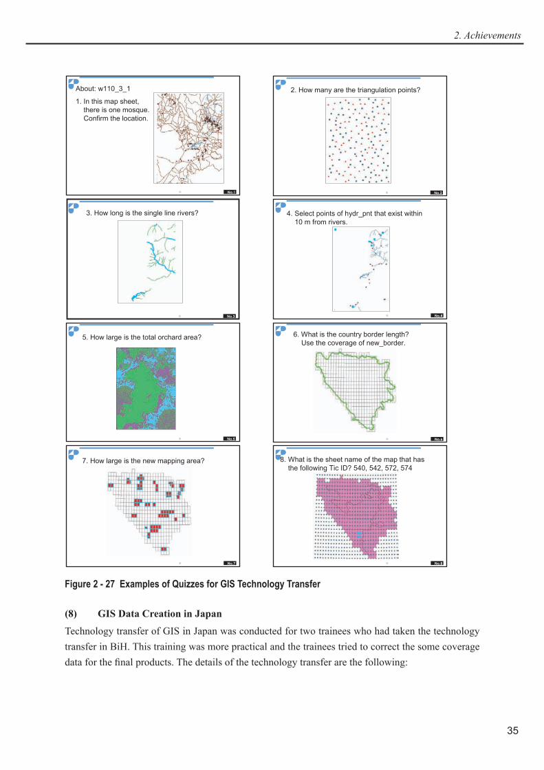
Technology transfer of GIS was performed for each counterpart agency, that is to say GIS Department of Republic Administration for Geodetic and Real Property Affairs in Bijelina and JP Geodetski Zavod in Sarajevo and successfully finished on schedule. During the technology transfer, JICA Distance Education CDs by Dr. Shunji Murai were sometimes used as complementary teaching materials and some quizzes were given to the trainees for better understanding. (See Figure 2 - 27.) The items of the technology transfer are mentioned after, and the details are described in the next section, Technology Transfer in Japan because the contents of both training are similar.
a. Subjects
1) Examples of GIS Projects2) Introduction of GIS (GIS Module 1 of JICA Distance Education CD)3) Hardware and Software for GIS (GIS Module 5 of JICA Distance Education CD)4) Study area explanation using Index coverage5) Objectives of the Study6) Coverage creation flow7) GIS data extraction (GIS Module 3 of JICA Distance Education CD)8) Abstract of GIS Data (GIS Module 2 of JICA Distance Education CD)9) Introduction of Arc/Info 810) Introduction of ArcCatalog11) Specifications of Coverage Data
i) Coverage schemasii) Layer Specifications
12) Empty Coverage Creation13) Introduction of ArcMap14) Spatial Analysis (GIS Module 7 of JICA Distance Education CD)15) Output of GIS Products (GIS Module 11 of JICA Distance Education CD)16) Coverage Creationi) Geo - coordination
ii) ArcEdit and Arctoolsiii) Topology creation
17) GIS Management (GIS Module 4 of JICA Distance Education CD)18) Plan for GIS Installation (GIS Module 6 of JICA Distance Education CD)19) Applications of Contour Coverage
i) Introduction of DTM (GIS Module 10 of JICA Distance Education CD)ii) DTM generationiii) Spatial extensioniv) 3D extension
20) X - Y Table Import21) DXF < - > Arc transformation22) Map Projection
35
2. Achievements
No.1
PASCO
PASCO CORPORATION 2004/12/15
About: w110_3_1
1. In this map sheet, there is one mosque. Confirm the location.
No.2
PASCO
PASCO CORPORATION 2004/12/15
2. How many are the triangulation points?
No.3
PASCO
PASCO CORPORATION 2004/12/15
3. How long is the single line rivers?
No.4
PASCO
PASCO CORPORATION 2004/12/6
4. Select points of hydr_pnt that exist within 10 m from rivers.
No.5
PASCO
PASCO CORPORATION 2004/12/6
5. How large is the total orchard area?
No.6
PASCO
PASCO CORPORATION 2004/12/6
6. What is the country border length? Use the coverage of new_border.
No.7
PASCO
PASCO CORPORATION 2004/12/6
7. How large is the new mapping area?
No.8
PASCO
PASCO CORPORATION 2004/12/15
8. What is the sheet name of the map that has the following Tic ID? 540, 542, 572, 574
Figure 2 - 27 Examples of Quizzes for GIS Technology Transfer
(8) GIS Data Creation in Japan
Technology transfer of GIS in Japan was conducted for two trainees who had taken the technology transfer in BiH. This training was more practical and the trainees tried to correct the some coverage data for the final products. The details of the technology transfer are the following:

Digital Topographic Maps for Bosnia and Herzegovina
36
Hardware Used : PC(Two desktops)
Used software: ArcGIS 8.3 (ArcInfo), ArcView 3.2
Used data: coverage and DXF format data that are under making in this study
3) Contents
(a) GIS:
1) How to check coverage
i) About describe commandii) Batch possessing of coverage checkiii) Tic checkiv) Schemas check
2) Practice of ArcEdit
Commands to learn;
Table 2 - 7 ArcEdit Commands LearnedCommand DescriptionWORKSPACE {work - space}W lists the current workspace or attaches to the workspace of the pathname to a
given workspace.ARCEDIT
AE
starts the ARCEDIT program; used to edit coverages.
EDIT <cover> specifies the coverage to be edited.DISPLAY <device> sets the display device. Usually input 9999 for the graphic display device.DRAWENVIRONMENT
DE
specifies which feature classes will be drawn for the edit coverage.
DRAW displays features specified in the current draw environment, coverages in the background draw environment, images and AP files.
EDITFEATURE
EF
specifies the feature class to be edited.
IMAGE adds an image to the background.SELECT selects features to edit.DELETE deletes all currently selected features from the edit coverage and all selected
records from the edit INFO file.ADD allows you to add new features to the current edit coverage and new records
to the edit INFO file.VERTEX draws and edits vertices on a selected arc.UNDO (also known as OOPS) undoes the most recent change to the features of the current edit coverage.SAVE saves changes made to an edit coverage or INFO file into itself or into a new
coverage or INFO file. QUIT terminates the current ARCEDIT session.
3) Practice of coverage check and repair
i) About build and clean commands
ii) The trainees finished to check and repair coverages of one map sheet.
4) AML programming
Example of AML directives
37
2. Achievements
Table 2 - 8 Example of AML Directives&WORKSPACE <workspace> sets the current workspace specification to another.&RETURN terminates an AML file or the current input source; or, if
encountered in a routine block, returns control to the statement following &CALL that invoked the routine.
&RUN <AML_file> {argument...argument} executes the specified AML file.&CALL <routine> transfers control to the statement following &ROUTINE having
the same routine label.&DO...&END delimits the beginning of a block of statements or directives to be
represented as a single action to the AML processor.& D O < i n d e x _ v a r i a b l e > < { : } = > <start_value> {&TO <end_value> {&BY <increment>}} {&UNTIL <expression> | &WHILE <expression>}
constitutes a variant of an &DO loop in which the block is repeated until its index variable falls outside a range of values or an &UNTIL or &WHILE expression evaluates to .TRUE. .
& I F < l o g i c a l _ e x p r e s s i o n > & T H E N <statement | directive> {&ELSE <statement | directive>}
&IF <logical_expression> &THEN
<statement | directive> {&ELSE <statement | directive>}
allows statements to be executed conditionally.
&ROUTINE <routine> delimits the beginning of a routine block.&ARGS <variable...variable>{:REST} allows one AML file to receive arguments passed by &RUN
which invoked the AML file.&SETVAR <variable> { {:} = } {value} creates and sets the value of AML vari - ables.&TYPE {message} prints a message at the terminal.
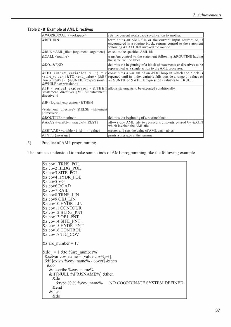
5) Practice of AML programming
The trainees understood to make some kinds of AML programming like the following example.
&s cov1 TRNS_POL&s cov2 BLDG_POL&s cov3 SITE_POL&s cov4 HYDR_POL&s cov5 VGT&s cov6 ROAD&s cov7 RAIL&s cov8 TRNS_LIN&s cov9 OBJ_LIN&s cov10 HYDR_LIN&s cov11 CONTOUR&s cov12 BLDG_PNT&s cov13 OBJ_PNT&s cov14 SITE_PNT&s cov15 HYDR_PNT&s cov16 CONTROL&s cov17 TIC_COV
&s arc_number = 17
&do j = 1 &to %arc_number% &setvar cov_name = [value cov%j%] &if [exists %cov_name% - cover] &then &do &describe %cov_name% &if [NULL %PRJ$NAME%] &then &do &type %j% %cov_name% NO COORDINATE SYSTEM DEFINED &end &else &do

Digital Topographic Maps for Bosnia and Herzegovina
38
6) DXF to Coverage, Coverage to DXF
The trainees tried the following exercises.
i) Exercise: dxf → coverage
Use a dxf file, 069_2_3.dxf.
First make a coverage, bldg_pnt by this dxf file. (Select code of 3522.)
Use JOINITEM command to join the code attribute.
Check the coverage, bldg_pnt by ArcMap
ii) Exercise: coverage → dxf
Use contour of W111_1_4. First make a dxf file (test.dxf) by this contour coverage. Check layer 1/ and elevation attributes of the dxf file by ArcCatalog or ArcMap.7) Project conversion
The trainees tried to do the conversion, GIS coverage projection - > Local Zone 6.
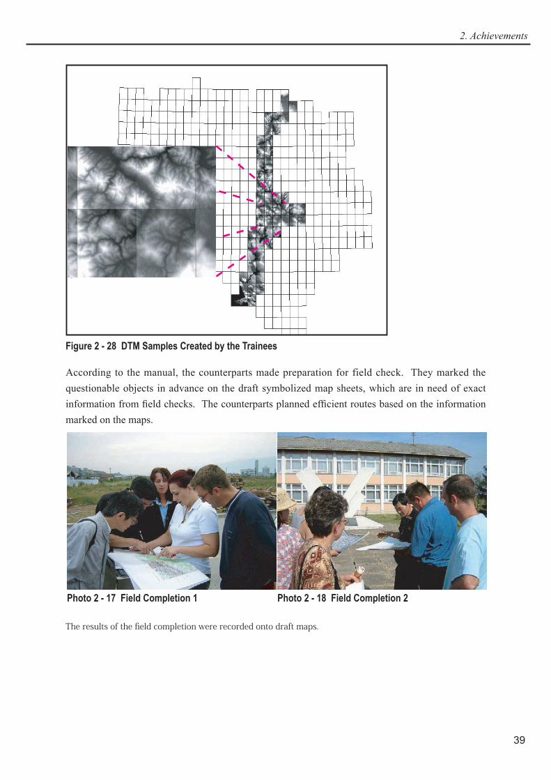
8) DTM 2/ generation, Spatial & 3D extension
During the training, the counterpart agency in BiH requested to create DTM (Digital Terrain Model) of several map sheets and the trainees created them. The created DTMs are showed in Figure 2 - 28.
&type %j% %cov_name% %PRJ$NAME% &end &end &else &do &type %cov_name% does not exist. &end&end
1/ layer: A usable subdivision of GIS dataset, generally containing map objects, for example roads, houses, rivers, vegetation, contour lines, etc.
2/ DTM, DEM: In this report, DTM is used for digital terrain model or Digital Terrain Model.
(9) Field Completion
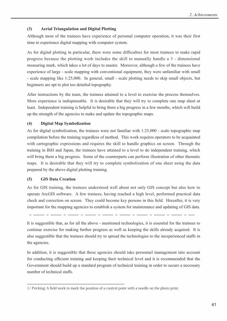
Training for field completion was conducted through OJT in BiH in the third phase from September to October 2004.
BiH counterparts, organizing five parties, performed field check under the supervision of the Team members. Each party comprised two counterparts and one driver. First, the counterparts made general schedules with which they could complete the whole required areas by the end of October, estimating man - days required for field works, check and compilation with collected source materials, and final compilation of the results.
39
2. Achievements
Figure 2 - 28 DTM Samples Created by the Trainees
According to the manual, the counterparts made preparation for field check. They marked the questionable objects in advance on the draft symbolized map sheets, which are in need of exact information from field checks. The counterparts planned efficient routes based on the information marked on the maps.
Photo 2 - 17 Field Completion 1 Photo 2 - 18 Field Completion 2
The results of the field completion were recorded onto draft maps.

Digital Topographic Maps for Bosnia and Herzegovina
40
Figure 2 - 29 Field Completion Results Marked onto Symbolized Draft Map
2 - 5 - 3 Evaluation
(1) Control Point Survey and Signalization of Control Point
Although some of the counterparts who participated in control point survey had been inexpe - rienced in GPS observation, they acquired the techniques during the mission.
As for signalization of control points, in spite of their elaborate works, many of the signals were damaged or missing because of a long time interval between the setting and aerial photographing. Some of the counterparts participated in inspection and repair of the signals. Through these works, the counterparts have learned appropriate size, shape, and color of signalization (three - white 1 m x 3 m wings placed in a radial pattern) for aerial photography at the photographic scale of 1:40,000.
After obtaining aerial photographs, about ten aerial signals were found unrecognizable on the photos and in need of pricking 1/ work. During the fi eld identifi cation, the Team members fi nished the pricking for these control points without counterparts due to limitation of the time. But pricking is an indispensable process for the future topographic mapping in BiH. Therefore, the Team gave instruction during the fi eld completion work in the third phase. Some counterparts have attained to a satisfactory level.
(2) Photo Interpretation and Field Identifi cation
As for aerial photograph interpretation and fi eld identifi cation, the counterparts, who had had little experience of these works, made remarkable progress with high level of understanding and speed of learning during the mission. The results acquired by them on double - enlarged photographs are regarded to be satisfactory for plotting.
41
2. Achievements
(3) Aerial Triangulation and Digital Plotting
Although most of the trainees have experience of personal computer operation, it was their first time to experience digital mapping with computer system.
As for digital plotting in particular, there were some difficulties for most trainees to make rapid progress because the plotting work includes the skill to manually handle a 3 - dimensional measuring mark, which takes a lot of days to master. Moreover, although a few of the trainees have experience of large - scale mapping with conventional equipment, they were unfamiliar with small - scale mapping like 1:25,000. In general, small - scale plotting needs to skip small objects, but beginners are apt to plot too detailed topography.
After instructions by the team, the trainees attained to a level to exercise the process themselves. More experience is indispensable. It is desirable that they will try to complete one map sheet at least. Independent training is helpful to bring them a big progress in a few months, which will build up the strength of the agencies to make and update the topographic maps.
(4) Digital Map Symbolization
As for digital symbolization, the trainees were not familiar with 1:25,000 - scale topographic map compilation before the training regardless of method. This work requires operators to be acquainted with cartographic expressions and requires the skill to handle graphics on screen. Through the training in BiH and Japan, the trainees have attained to a level to do independent training, which will bring them a big progress. Some of the counterparts can perform illustration of other thematic maps. It is desirable that they will try to complete symbolization of one sheet using the data prepared by the above digital plotting training.
(5) GIS Data Creation
As for GIS training, the trainees understood well about not only GIS concept but also how to operate ArcGIS software. A few trainees, having reached a high level, performed practical data check and correction on screen. They could become key persons in this field. Hereafter, it is very important for the mapping agencies to establish a system for maintenance and updating of GIS data.
It is suggestible that, as for all the above - mentioned technologies, it is essential for the trainees to continue exercise for making further progress as well as keeping the skills already acquired. It is also suggestible that the trainees should try to spread the technologies to the inexperienced staffs in the agencies.
In addition, it is suggestible that these agencies should take personnel management into account for conducting efficient training and keeping their technical level and it is recommended that the Government should build up a standard program of technical training in order to secure a necessary number of technical staffs.
1/ Pricking: A field work to mark the position of a control point with a needle on the photo print.
Digital Topographic Maps for Bosnia and Herzegovina
42
2 - 6 SeminarAccording to the original work plan of the Study, the Team, jointly with the Ministry of Civil Affairs organized a seminar to be held in the end of the final phase. It was held on September 28, 2005, at Hotel Grand, Sarajevo. This seminar was organized to announce the newly established digital topographic maps and to exemplify usages of the maps with the aim of cultivating potential map users.
The attendants include those concerned with the data usage from state and regional governments, public corporations, foreign organizations for international cooperation, foreign embassies, and several private sectors. The number of participants is ninety.
After the Team explained the new mapping products, Charge d’ Affaires of Japan handed over the catalogue of the products to the Minister of Civil Affairs.
After then, five speakers gave the following presentations mainly about application of the digital topographic map to specific fields.
Project of Digital Topographic Maps for Bosnia and Herzegovina
Eldin Donlagic, Faculty of Civil Engineering, University of Sarajevo
Demonstration of Level 25,000 Digital Spatial Data
Amira Kadic, JP Geodetski Zavod
Usage of Digital Maps scale 1:25,000 in the Process of the Humanitarian Demining in Bosnia and Herzegovina
Tarik Serak, Bosnia and Herzegovina Mine Action Centre
Preparation of Technical Study for the Project "Motorway on the Corridor Vc" using Digital Elevation Model
Selma Lukovac and Arijana Gacko, IPSA Institute
GIS Application to the Study on Sustainable Development through Eco - tourism in Bosnia and Herzegovina
Hidetoshi Kakiuchi, JICA Study Team
Finally the Team presented recommendations to the Government of BiH on the future topographic mapping and servicing. The recommendations are compiled in Chapter 5 of this report.