dgi 2015 - london, uk
TRANSCRIPT

®
Mobile, Sensors & Big Data- next steps in geo-standards
19 January 2015
Denise McKenzie
@spatialredCopyright © 2015 Open Geospatial Consortium

OGC®
Copyright © 2014 Open Geospatial Consortium
A bit about OGC

OGC®
Who are the OGC?
Copyright © 2014 Open Geospatial Consortium
Government
Commercial
Research Academic

OGC®
Example Government Members
– DSTL (UK) - DLR (Germany) - AGO (Australia) - NGA (USA)
– NOAA (USA) - NASA (USA) - USGS (USA) - USACE / AGC
– DISA (US) - DGIWG (NATO) - EUSC (Europe) - USAF Weather Agency
– NR Canada - MetOffice (UK) - DHS (US) - PM-ISE DNI (US)
– European Satellite Centre - Naval MET and Oceanography Command
– Abu Dhabi Police (UAE) - BRGM (France) - Ordnance Survey (UK)
– Norwegian Building Authority - Norkart - Dubai Municipality (UAE)
– Dept Science & Tech. (India) - European Space Agency
– Ministry of Land, Infrastructure and Transport (Korea) -Others…
– United Nations
• Over 100 Universities and Research institutes
http://www.opengeospatial.org/ogc/members

OGC®
Example OGC Commercial Members

OGC®
OGC Alliance Partners A Critical Resource for Advancing Standards
… and otherswww.opengeospatial.org/ogc/alliancepartners

OGC®
OGC’s Interoperability Approach
• Interoperability Program (IP) - a global, innovative, hands-on prototyping and testing program designed to accelerate interface development and validation, and bring interoperability to the market
• Specification Development Program – Consensus processes similar to other Industry consortia (World Wide Web Consortium, OMA, OMG, etc.).
• Communication & Outreach Program – education and training, encourage take up of OGC specifications, business development, communications, etc.
Rapid InterfaceDevelopment
StandardsSetting
MarketAdoption
© 2015 Open Geospatial Consortium

OGC
Mobile, Sensors & Big Data
The next flood of Big Data comes from mobile devices
– Human as a sensor
– Mobile and static sensors
– Social “sensors”

OGC

OGC
OGC MSTF
W3C
IETF
Standard
s
OASIS
Today’s Internet
The emerging Internet of things:-- indoor/outdoor location-- sensor webs-- building information models-- location apps-- location marketing-- smart grid-- social sensors
GeoWeb will expand to Internet of Things

OGC
OGC Standards for Mobile, Sensors & Big Data
• Points of Interest• Open GeoSMS• OWS Context• 3D Visualization• WPS
• GeoPackage• SensorWeb Enablement• ARML • IndoorGML
Graphic Source:

OGCCopyright © 2014 Open Geospatial Consortium
So what’s next?

OGC
Moving Features Encoding
• Moving Vehicles & Personnel• Defines an abstract model for encoding moving feature data• Demonstrated by Hitachi at the OGC TC meeting in Tokyo

OGC
ARML 2.0
• Encoding for mobile Augmented Reality• Draws from the KML standard
OGC
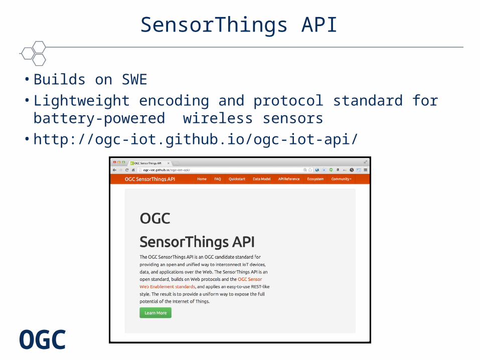
SensorThings API
• Builds on SWE• Lightweight encoding and protocol standard for battery-powered
wireless sensors• http://ogc-iot.github.io/ogc-iot-api/

OGC
W3C / OGC Spatial Data on the Web Working Group
• Location, Place, Linked-Data, Semantics, Time• Bringing location to everything on the web• http://www.opengeospatial.org/projects/groups/sdwwg

OGC
Testbed 11
• #OGCTB11• 3 Key Threads
– Cross- Community Interoperablity (CCI) (includes Aviation)– Urban-Climate Resilience (UCR)– Geospatial Enhancements for NIEM (Geo4NEIM)
• Sponsors and Participants from USA, Europe & Asia (Including DSTL UK)
• Demonstration at the June TC meetings in Colorado, USA

OGC®
Save the Date
• Come visit us at Mobile World Congress (March 2015)• Masterclasses in Barcelona at ICGC
– ARML– SensorThings– Geopackage
• Next OGC TC meeting in Barcelona – First F2F W3C/OGC Working Group
• June TC – Testbed 11 Demonstration (Colorado)• September TC – UK
– Location Powers: Citizens
• Location Powers: Mobile, Sensors & High Velocity (Nov)
®
Please keep in touch!
www.opengeospatial.org
© 2015 Open Geospatial Consortium
Denise [email protected]@spatialred
@opengeospatial
Open Geospatial Consortium (OGC)
http://www.youtube.com/user/ogcvideo