dexter construction company limited … · williamsdale quarry expansion, williamsdale, cumberland...
TRANSCRIPT

DEXTER CONSTRUCTION COMPANY LIMITED WILLIAMSDALE QUARRY EXPANSION,
WILLIAMSDALE, CUMBERLAND COUNTY, NOVA SCOTIA
Registration Document for a Class 1 Undertaking Under Section 9 (1) of the Nova Scotia Environment Assessment Regulations
October 2017

Environmental Assessment Registration Document for Williamsdale Quarry Expansion October 2017
ii
TABLE OF CONTENTS
INTRODUCTION .......................................................................................................... 1 THE UNDERTAKING ................................................................................................... 1
2.1 Description of the Undertaking ........................................................................ 1 2.2 Location ............................................................................................................. 2
SCOPE OF THE UNDERTAKING ............................................................................... 4 3.1 Purpose/Need of the Undertaking ................................................................... 4 3.2 Consideration of Alternatives .......................................................................... 4 3.3 Scope of the Environmental Assessment ....................................................... 4
PUBLIC INVOLVEMENT ............................................................................................. 5 4.1 Methods of Involvement ................................................................................... 5 4.2 Public Concerns ............................................................................................... 7 4.3 Future Steps ...................................................................................................... 7
DESCRIPTION OF THE UNDERTAKING .................................................................... 7 5.1 Existing Quarry Operations ............................................................................. 7 5.2 Future Quarry Operations ................................................................................ 8
DESCRIPTION OF THE ENVIRONMENT .................................................................... 9 6.1 Human Uses of the Environment ..................................................................... 9
6.1.1 Mi’kmaq ..................................................................................................... 9 6.1.2 Population and Economy ......................................................................... 10 6.1.3 Water Supply and Residential Wells ........................................................ 10 6.1.4 Land Use ................................................................................................. 10 6.1.5 Hunting and Trapping .............................................................................. 11 6.1.6 Forestry ................................................................................................... 12 6.1.7 Recreational, Commercial and Mi’kmaq Fishing ...................................... 12 6.1.8 Historical, Archaeological and Paleontological Resources ....................... 12 6.1.9 Parks and Protected Areas ...................................................................... 12 6.1.10 Recreational/Cultural Activities ............................................................ 14 6.1.11 Residential Use ................................................................................... 14 6.1.12 Commercial/Industrial Development .................................................... 14 6.1.13 Tourism and Viewscape ...................................................................... 14 6.1.14 Transportation ..................................................................................... 14
6.2 Biophysical Environment ............................................................................... 15 ENVIRONMENTAL IMPACTS, SIGNIFICANCE, AND MITIGATION ......................... 15
7.1 Assessment Approach and Methods ............................................................ 15 7.2 Valued Environmental Components .............................................................. 16 7.3 Impacts on Human Uses ................................................................................ 16
7.3.1 Mi’kmaq ................................................................................................... 16 7.3.2 Recreational Activities ............................................................................. 17 7.3.3 Tourism and Viewscape ........................................................................... 17 7.3.4 Recreational, Commercial and Mi’kmaq Fishing ...................................... 17 7.3.5 Archaeological/Cultural/Historical ............................................................ 18 7.3.6 Land Use and Value ................................................................................ 18 7.3.7 Transportation ......................................................................................... 18 7.3.8 Residential Use ....................................................................................... 18 7.3.9 Commercial/Industrial Use ....................................................................... 19

Environmental Assessment Registration Document for Williamsdale Quarry Expansion October 2017
iii
7.3.10 Agriculture ........................................................................................... 19 7.3.11 Water Supplies and Residential Wells ................................................. 19 7.3.12 Parks and Protected Areas .................................................................. 19 7.3.13 Resource Use—Forestry, Hunting & Trapping ..................................... 20
7.4 Biophysical Impacts––Impacts of the Project on the Environment ............ 20 7.4.1 Air Quality, Noise and Light ..................................................................... 20 7.4.2 Groundwater ............................................................................................ 20 7.4.3 Hydrology ................................................................................................ 21 7.4.4 Water Quality ........................................................................................... 21 7.4.5 Freshwater Aquatic Environments ........................................................... 21 7.4.6 Wetlands ................................................................................................. 22 7.4.7 Fish and Fish Habitat ............................................................................... 22 7.4.8 Flora and Fauna and Habitat ................................................................... 22 7.4.9 Species at Risk ........................................................................................ 23 7.4.10 Natural Areas & Wilderness ................................................................. 23
7.5 Other Undertakings in the Area ..................................................................... 23 IMPACTS OF THE ENVIRONMENT ON THE PROJECT .......................................... 35 CUMULATIVE IMPACTS ........................................................................................... 35
MONITORING ............................................................................................................ 36 PUBLIC CONSULTATION ......................................................................................... 36 PROJECT CLOSURE ................................................................................................ 36 APPROVAL OF UNDERTAKING .............................................................................. 36 FUNDING ................................................................................................................... 36 SIGNATURE OF CEO AND DATE ............................................................................ 36
FIGURES
Figure 1 – Project Location ............................................................................................... 2 Figure 2 – Site Location and Adjacent Land Uses ........................................................... 3 Figure 3 – Parks and protected areas in the vicinity of Williamsdale Quarry. ............. 13
TABLES
Table 1. Five-year cumulative summary of wildlife harvested in Cumberland County and Nova Scotia (2011 – 2016). ............................................................................... 11
Table 2. Valued Environmental Components (VECs) for Williamsdale Quarry Expansion............................................................................................................................. 16
Table 3. Potential interactions between project activities and operations and Valued Environmental Components (VECs) for Williamsdale Quarry expansion. .... 24
Table 4. Summary of impacts and mitigation on Valued Environmental Components, Williamsdale Quarry Expansion. ...................................................................... 25

Environmental Assessment Registration Document for Williamsdale Quarry Expansion October 2017
iv
DRAWINGS
Drawing 1 Site Location Plan (Appendix B) Drawing 2 Future Expansion Area (Appendix B)
APPENDICES
Appendix A Property Information • Joint Stock Certificate • Existing Industrial Approval • Quarry Survey Plan
Appendix B Drawings Appendix C Rock Sulphur Content Analysis Results Appendix D Biophysical Assessment Report (Envirosphere 2017) Appendix E Cultural Resource Management Report (CRM 2016) Appendix F Public Consultation Documentation

Environmental Assessment Registration Document for Williamsdale Quarry Expansion October 2017
1
INTRODUCTION
To better serve local market needs, Dexter Construction Company Limited (herein after referred to as “Dexter”) of Bedford, Nova Scotia is proposing to expand an existing quarry located at 1736 Wentworth-Collingwood Road in Williamsdale, Cumberland County, Nova Scotia. An approval to expand the quarry is required under the Nova Scotia Environmental Assessment Regulations. The registration of this Environmental Assessment (“EA”) is in response to Schedule A of the Environmental Assessment Regulations, Undertaking B.2., “A pit or quarry that is larger than 4 ha. in area for extracting building or construction stone.”
Dexter is a private Canadian company. It is incorporated under the laws of Nova Scotia and registered to do business in Nova Scotia under the Nova Scotia Corporations Registration Act. Dexter’s Registry of Joint Stock Certificate is attached in Appendix A “Property Information.” It is important to note that Municipal Enterprises Limited is the parent company of Dexter Construction Company Limited, which may be referred to within the appendices.
Address: 927 Rocky Lake Drive, P.O. Box 48100 Bedford, NS, B4A 3Z2 Phone: 902-835-3381
Proponent Contact: Gary Rudolph, P. Eng. 927 Rocky Lake Drive, P. O. Box 48100 Bedford, NS, B4A 3Z2 Phone: 902-835-6346
Consultant Contact: Mr. J. H. Fraser, M. A. Sc., P. Geo. H2O GEO Environmental Services Inc. Phone: 902-443-4227 (Office); 902-497-5597 (Cell)
It is noted that the quarry operates under an existing Industrial Approval (Approval No. 2009-068106), which was first issued in July 2009 and received by Mr. Dan Baillie (Dexter Construction Company Limited) from Mr. Brad Skinner Amherst Region District Manager, Nova Scotia Environment. This letter and Approval (NSE File # 92100-30) is also attached in Appendix A “Property Information”.
THE UNDERTAKING
2.1 Description of the Undertaking
Dexter proposes to expand its existing Williamsdale quarry for the production of aggregate, primarily used in the road and local construction industry. The proposed undertaking (“the quarry”) involves the expansion of an existing Nova Scotia Environment approved quarry from a less than four hectare permit area to a 31.3 hectare permit area. A plan showing the dimensions of the existing quarry is included in Appendix A. The proposed quarry boundaries are illustrated in Appendix B.

Environmental Assessment Registration Document for Williamsdale Quarry Expansion October 2017
2
2.2 Location
The site is located at 1736 Wentworth-Collingwood Road, in Williamsdale, Nova Scotia (PID #’s 25348863 and 25085994) in Cumberland County, Nova Scotia, 1:50000 NTS 11E12, 5047500 Northing, 434,200 Easting, UTM Zone 20, Air Photo 0905-0233 & 0905-0083, Sept. 15, 2014 (Figures 1 & 2 (below) and Drawing 1, Appendix B). The site is positioned within an un-zoned area east of Williamsdale, west of Highway #104 and south of the Wentworth-Collingwood Road. The quarry site that is being expanded has previously been developed as a result of quarrying and construction material processing activities.
The properties are owned by Purdy Resources Ltd. and leased to Dexter (Drawing 2, Appendix B).
Figure 1 – Project Location

Environmental Assessment Registration Document for Williamsdale Quarry Expansion October 2017
3
Figure 2 – Site Location and Adjacent Land Uses

Environmental Assessment Registration Document for Williamsdale Quarry Expansion October 2017
4
SCOPE OF THE UNDERTAKING
As noted previously, Dexter intends to expand the existing Williamsdale quarry for the continuing purpose of extracting and supplying aggregate for the road and local construction industry. The existing quarry has been in operation since 1998 under a NSE Industrial Approval for a less than four hectare quarry. The scope of this application is for expansion of the existing quarry to a 31.3 hectare permit area. A Study Area of approximately 62.2 hectares was initially investigated and subsequently reduced to the proposed 31.3 hectare permit area following a review of the study outcomes. The existing quarry face is between approximately 15 and 20 meters (m) in height and the disturbed area includes on-site related facilities including a scale house, sedimentation infrastructure, as well as an occasional portable asphalt plant, crushing, washing and stockpiling areas. During past operations, Dexter has extracted an average of approximately 25,000 to 50,000 tonnes of aggregate per year from the quarry when active. There are no off-site related support facilities, other than the provincial highway network.
It is Dexter’s intent to continue quarry operations on the property, using existing infrastructure. It is anticipated that future operations will involve the extraction of approximately 25,000 to 50,000 tonnes/year for the foreseeable future. However, the annual quantity will vary depending on local demand and associated project requirements.
3.1 Purpose/Need of the Undertaking
Dexter proposes to expand the existing Williamsdale quarry for the production of aggregate, primarily used in the road and local construction industry. The primary benefit will be to the people of Nova Scotia via the continued construction and maintenance of the Provincial highway system.
3.2 Consideration of Alternatives
Dexter operates rock quarries throughout Nova Scotia and Atlantic Canada and uses modern industry standard methodologies in all phases of the extraction, processing and delivery processes. Alternative processes are always being considered in terms of their efficiency, cost effectiveness and environmental mitigation advantages. Continuing operations of the Williamsdale quarry expansion will be assessed on an on-going basis to ensure that the best available techniques are being utilized in all phases of day to day operations.
3.3 Scope of the Environmental Assessment
The scope of the environmental assessment is in keeping with the Nova Scotia Environment document entitled “Guide to Preparing an EA Registration Document for Pit and Quarry Developments in Nova Scotia” as well as Dexter’s experience with respect to similar projects over the past several decades. The scope also takes into consideration that the quarry is, at present, operational, and subject to an existing Industrial Approval. The following sections of this document provide a description of the project and an overview of the human uses and biophysical features of the local environment; outlines the key “Valued Environmental Components” addressed by the EA document; and presents an evaluation and summary of the benefits and potential drawbacks to the environment during all phases of the proposed undertaking.

Environmental Assessment Registration Document for Williamsdale Quarry Expansion October 2017
5
PUBLIC INVOLVEMENT
4.1 Methods of Involvement
Dexter has engaged various public entities, as outlined below, and as the EA requirements do not include a direct public involvement program, public notification to date has focussed on notifying local officials of Dexter’s intent to file an EA application to expand the existing Williamsdale quarry. In this regard, the following persons have been briefed regarding the intent of this EA document:
STAKEHOLDER DESCRIPTION OF ENGAGEMENT SUMMARY
Ms. Kathleen Johnson Nova Scotia Environment
September 5th, 2017 – Notification email
Mr. Jamie Baillie MLA Cumberland County South
September 15th 2017 – Meeting
Warden Allison Gillis Cumberland County District #4
September 11th 2017 – Meeting
Councilor Barbara Palmer Cumberland County District #6
September 11th 2017 – Meeting
Chief Bob Gloade / Mr. Gerald Gloade / Ms. Shelly Martin Millbrook First Nation
April 12th 2017 – Notification letter August 2nd 2017 – Follow up email correspondence August 16th 2017 – Follow up email correspondence September 14th 2017 – Follow up email correspondence September 28th 2017 – Follow up notification letter October 13th 2017 – Scheduled Meeting
Chief Andrea Paul Pictou Landing First Nation (re. Franklin Manor)
April 12th 2017 – Notification letter September 28th 2017 – Follow up notification letter
Chief Paul James Prosper Paq’tnkek First Nation (re. Franklin Manor)
April 12th 2017 – Notification letter September 28th 2017 – Follow up notification letter
Ms. Jessica Seward / Mr. Joshua McNeely / Mr. Roger Hunka / Chief Grace Conrad Native Council of Nova Scotia
January 16th 2017 – Meeting April 12th 2017 – Notification letter September 26th 2017 – Meeting September 28th 2017 – Follow up notification letter
Ms. Twila Gaudet / Ms. Heather MacLeod-Leslie Kwilmu’kw Maw-klusuaqn Negotiation Office
April 12th 2017 – Notification letter September 28th 2017 – Follow up notification letter
Mr. David Mitchell Office of Aboriginal Affairs
April 12th 2017 – Notification letter September 28th 2017 – Follow up notification letter
Nova Scotia Environment
October 4th 2017 – Submission of EA Registration documentation October 11th 2017 – Official Registration for environmental assessment
Public Notices for the Registration
October 11th – Notification of Registration published in the Herald and Amherst Citizen / EA Registation documents distributed to Wentworth Learning Center, Oxford Town Hall, NSE Regional Office – Amherst / Online: www.gov.ns.ca/nse/ca

Environmental Assessment Registration Document for Williamsdale Quarry Expansion October 2017
6
Initially, on January 16, 2017, Dexter met with Ms. Jessica Seward and Mr. Joshua McNeely of the Native Council of Nova Scotia (NCNS) for a general discussion on the proposed Williamsdale Quarry Expansion Project. Dexter informed NCNS that initial environmental studies have been undertaken and that additional studies will be completed in the spring. Dexter also presented information regarding blasting (ANFO vs. Emulsion) and nitrate runoff (based on previous inquiries from NCNS during other initiatives). NCNS shared knowledge of the local area, including quality of the nearby Second River for salmon spawning. A follow up meeting, as requested by NCNS, to discuss additional details of the Project was held September 26, 2017, prior to the official registration of the EA. A hard copy of the EA Registration Document will be provided to NCNS on the registration date.
With respect to the First Nations Community, Dexter has followed the Proponent’s Guide: The Role of Proponents in Crown Consultation with the Mi’kmaq of Nova Scotia. In this regard Dexter has advised Chief Bob Gloade (Millbrook); Chief Andrea Paul (Pictou Landing/Franklin Manor) and Chief Paul James Prosper (Paq’tnkek/Franklin Manor) of Dexter’s intent to file the Registration Document for a Class 1 Undertaking under Section 9 (1) of the NS Environmental Assessment Regulations in a letter dated April 12, 2017. This letter includes all relevant information including:
– the proponents’ name and representatives,
– the project location,
– the type of work to be carried out,
– any potential short and long term impacts,
– project and regulatory timelines,
– an offer to provide all relevant reports, studies and reviews, and
– an offer to meet and discuss the project.
Dexter also copied this letter to Ms. Twila Gaudet and Ms. Heather MacLeod-Leslie of the Kwilmu’kw Maw-klusuaqn Negotiation Office (KMKNO), Mr. Roger Hunka of the Native Council of Nova Scotia and Mr. David Mitchell of the Office of Aboriginal Affairs. This letter is included in Appendix F.
In this regard, a follow-up letter was received by the Dexter Team on July 19, 2017 from the Millbrook First Nation requesting a meeting to discuss the scope of the project, potential environmental effects, and potential adverse effects on Aboriginal or Treaty Rights as well as a request to send any available reports regarding the project.
In response Dexter emailed the Millbrook First Nation (Ms. Shelly Martin, Mr. Gerald Gloade, & Chief Bob Gloade) on August 2, 2017 to follow up the letter of July 19, 2017, and suggest a potential meeting during the weeks of August 7th or 14th, 2017. No response was received as result of this email.

Environmental Assessment Registration Document for Williamsdale Quarry Expansion October 2017
7
Dexter again followed up the previous email with a second email dated August 16, 2017 to confirm Dexter's willingness to meet with Millbrook First Nation and requesting potential meeting dates that would be convenient. Correspondence with Millbrook First Nation on September 15, 2017 resulted in a meeting with Dexter scheduled to take place on October 13, 2017.
No concerns regarding the project have been received from the First Nations Community. Dexter is continuing the liaison process with the First Nations representatives, and followed up with all parties noted above regarding the newspaper announcement and viewing locations for the full EA document in a second notification letter sent on September 28, 2017. This letter is included in Appendix F. Dexter will provide any responses received from these agencies to NSE.
4.2 Public Concerns
During the nineteen years over which the quarry has operated, no public concerns regarding the project have been received. Dexter will document any concerns received during the public consultation portion of the EA process, and provide a copy to NSE.
4.3 Future Steps
The public will be notified of the EA Registration by an advertisement in the Chronicle Herald and the Amherst Citizen Record on October 11, 2017. A copy of the newspaper advertisement is included in Appendix F. During the development of the EA Registration, Dexter has been in contact with the Millbrook, Pictou Landing and Paq’tnkek First Nations’, KMKNO, Office of Aboriginal Affairs and the Native Council of Nova Scotia. Follow up was undertaken, and any comments or concerns noted have been addressed in this final EA document. Dexter has met with Nova Scotia MLA, Mr. Jamie Baille, Warden/Councillor (District # 4) Allison Gillis, and Councillor Barbara Palmer (District # 6) and provided them with an overview of quarry operations, details on the history of the Williamsdale Quarry, and discussed the EA process, as well as advised of the upcoming newspaper advertisements and indicated the EA document is available for review at the associated viewing locations.
DESCRIPTION OF THE UNDERTAKING
5.1 Existing Quarry Operations
The existing quarry operations involve blasting, crushing, washing and stockpiling of aggregate and associated trucking on an as required basis. In addition, a portable asphalt plant is occasionally situated on the property. The quarry has operated in accordance with an existing Industrial Approval (Approval No. 2009-068106), which was issued in July 2009 in a letter received by Mr. Dan Baillie (Dexter Construction Company Limited) from Mr. Brad Skinner, District Manager (Amherst), Nova Scotia Environment. This letter and Approval (NSE File # 92100-30) is also attached in Appendix A. It is noted that the quarry was first permitted in 1998 under IA No. 98-JAN-008. The quarry also operates in accordance with the Nova Scotia Pit and Quarry Guidelines. These Guidelines apply to all pit and quarry operations in the Province and provide separation distances for operations, including blasting, liquid effluent discharge limits, suspended particulate matter limits, sound level limits and requirements for a reclamation plan and security bond. Dexter is committed to the utilization of Best Management Practices in all phases of their operations, including the on-site management of air quality, greenhouse gas emissions, noise, dust, and water quality and will operate in accordance with applicable Federal and Provincial legislation and standards.

Environmental Assessment Registration Document for Williamsdale Quarry Expansion October 2017
8
Blasting, crushing, washing and trucking have occurred on an as required basis, however it is noted that blasting has occurred on an average of one to two times per year. As the quarry expands, surface water controls will be maintained and associated surface water monitoring will be implemented to ensure that surface water leaving the site meets all applicable water quality guidelines
With respect to the characteristics of the quarry bedrock, Dexter arranged for the collection and analysis of a rock sample for sulphur content to determine if the material was sulphide bearing. The results of this analysis yielded a sulphur concentration of <0.001 % (<0.03 kg H2SO4/tonne), which is well below the minimum (0.4 % S; 12.51 kg H2SO4/tonne) defined by NSE as sulphide bearing material and is therefore not acid producing. The laboratory results of this sample, and an associated lab duplicate, are included in Appendix C.
5.2 Future Quarry Operations
Dexter proposes to expand the Williamsdale quarry for the extraction, storage and removal of aggregate, primarily used in the road and local construction industry. This EA is focussing on current needs, but also future needs; therefore Dexter is requesting the EA approval for 31.3 hectares, which includes a production and operational footprint, storage (stockpiles) and provisions for surface water control.
Although totally dependent on local market conditions, it is anticipated, at this time, that future development will involve the production of approximately 25,000 to 50,000 tonnes of aggregate per year, for a period of approximately 20 to 40 years. The rock face would be initially constructed in a south-southwest direction from the existing face (Drawing # 2, Appendix B). Drawing # 2, Appendix B identifies the total 31.3 hectare expansion area.
Quarry operations will generally coincide with the road construction season; therefore it would be reasonable to anticipate seasonal operations within a similar time frame (April – December). The quarry will operate when and as required within the typical 32 week construction season, depending on local demand and project requirements. Dexter is committed to the utilization of Best Management Practices in all phases of their operations, including the on-site management of air quality, greenhouse gas emissions, noise, dust and water quality, and will operate in accordance with applicable Federal and Provincial legislation and standards.
Aggregate production would commence with drilling and blasting and is consistent with current operations. A qualified blasting contractor would conduct this work. The blasting contractor would be responsible for blast designs and methods in accordance with the General Blasting Regulations contained in the Nova Scotia Occupational Health and Safety Act, 1996. Blasting would also be conducted in accordance with the Pit and Quarry Guidelines. Blasting and noise level guidelines respecting the time of day/day of the week will be followed and blast monitoring will be conducted for every blast event. The existing Industrial Approval stipulates blasting control and monitoring requirements.
It is anticipated that aggregate excavation will not take place below the deep bedrock water table. A minimal amount of unconsolidated material and upper fractured bedrock water may be encountered; however this water, if encountered, will be directed to a surface water and sedimentation control system for treatment and controlled release.
The blasted rock will be excavated with an on-site excavator and processed by on-site portable crushing equipment. The various aggregate products will be stockpiled in designated areas within

Environmental Assessment Registration Document for Williamsdale Quarry Expansion October 2017
9
the quarry. Material, within the quarry, will be hauled and moved with a front-end loader. Products will be transported from the quarry via tandem and tractor trailer trucks to the Wentworth-Collingwood Roads and routed as necessary through the provincial highway and roadway network to support local projects. The number of trucks hauling aggregate will be determined on a job by job basis, but currently averages approximately 50 per week. Employment numbers are expected to remain consistent throughout the on-going operation. Drilling, blasting and trucking will require additional resources; however these activities are generally subcontracted on a job by job basis.
DESCRIPTION OF THE ENVIRONMENT
6.1 Human Uses of the Environment
6.1.1 Mi’kmaq
The Mi’kmaq maintain aboriginal claim to all of the landmass of Nova Scotia and the Province of Nova Scotia maintains a policy requesting that proponents of industrial development projects consult with the Mi’kmaq concerning proposed industrial projects and activities. Dexter Construction has contacted First Nations representatives concerning the present Williamsdale Quarry expansion project. The nearest Mi’kmaq community to Williamsdale is Millbrook First Nation, located approximately 50 kilometers southeast of Williamsdale; and the unoccupied Franklin Manor-22 Mi’kmaq reserve is in Cumberland County north of Parrsboro, approximately 42 km west of the study site. The 4.1 km2 Franklin Manor reserve is managed by two bands, Pictou Landing First Nation and Paq’tnkek First Nation.
The study area was once part of the greater Mi’kmaq territory known as Sipekne’katik, meaning ‘Where the Wild Potatoes Grow’. Typically lakes and watercourses would have been important transportation corridors, providing a resource base for the Mi’kmaq, their ancestors and predecessors prior to the arrival of European settlers (CRM 2016). Mi’kmaq would have used the general area of the site to various degrees such as for traditional use (e.g. gathering and hunting). Some Mi’kmaq records for the area show nearby rivers as being traditionally used for fishing, and a point east of the study area coincident with Sugarloaf Mountain has a traditional place name of Kini’skwatek, meaning “pointed mountain” (KMKNO from CRM 2016). River Phillip is known as Ksu’skipukwek meaning “flowing through hemlock” (KMKNO 2016 in CRM 2016). There are historical records of Mi’kmaq living in the vicinity of River Philip to Collingwood Corner from 1783 onwards (CRM 2016).
There are two Mi’kmaq tribal councils in Nova Scotia: the Confederacy of Mainland Mi'kmaq (CMM) and Union of Nova Scotia Indians (UNSI). CMM is a not-for-profit organization incorporated in 1986, whose mission is to promote and assist Mi’kmaq communities. The UNSI, created in 1969, was formed to provide a cohesive political voice for Mi’kmaq people. The Native Council of Nova Scotia (NCNS) represents Mi’kmaq people living off reserve. The NCNS is a self-governing agency located in Truro. The Office of Aboriginal Affairs in Nova Scotia estimates that approximately 35% of Mi’kmaq live off-reserve. The goal of NCNS is “to operate and administer a strong and effective Aboriginal Peoples Representative Organization that serves, advocates and represents our community.”
The Mi’kmaq Rights Initiative (Kwilmu'kw Maw-klusuaqn; KMK) also represents Mi’kmaq. The mission of KMK—whose name means, “we are seeking consensus.”—is “to address the historic and current imbalances in the relationship between Mi'kmaq and non-Mi'kmaq people in Nova Scotia and secure the basis for an improved quality of Mi'kmaq life.” KMK’s objective is to

Environmental Assessment Registration Document for Williamsdale Quarry Expansion October 2017
10
negotiate between the Mi’kmaq of Nova Scotia, the province and the Government of Canada, and operates from its main office in Millbrook. The Atlantic First Nations Environmental Network (AFNEN) is an environmental organization of Mi’kmaq communities and organizations. The CMM and UNSI are members and the Mi’kmaq Confederacy of PEI in Charlottetown is currently the acting coordinator. The AFNEN includes a representative from each Mi’kmaq organization and community interested in environmental issues. The Network meets regularly during the year through meetings, conferences, and the Internet to discuss environmental matters or concerns.
6.1.2 Population and Economy
Local economies in Cumberland County are tied primarily to agriculture and forestry, and their communities face some of the same challenges as elsewhere in rural Nova Scotia, including lack of economic growth and an aging population (Nova Scotia Open Data Portal 2016). Agriculture is dominated by wild blueberry harvesting. Oxford Frozen Foods, located in Oxford (the “blueberry capital of Canada”) 20 kilometers north of Williamsdale, operates a processing plant and 12,000 acres of blueberry land. They are the largest employer in Cumberland County, with over 1000 staff, and are the largest global supplier of quality frozen blueberries. Health care and social assistance, mineral resources, and construction are also significant sectors in Cumberland County providing important sources of income. Local residents of Williamsdale indicated that the majority of resident jobs are in mineral resource extraction, health care, and wild blueberry harvesting and processing. The annual median income for the County is $38,433 CDN—lower than the median family income for Nova Scotia ($73,900) (Statistics Canada Online 2017).
Cumberland County has a rural population of approximately 30,005 people, with a low population density of approximately 7.0/km2 (2016, Statistics Canada). The population has been slowly declining for the past several decades and has decreased 4.3% since 2011. Collingwood Corner is the nearest community, located west of the site, and the Town of Oxford (population 1190, located approximately 20 kilometers north) is the closest major centre. Springhill and Amherst (population 9,700) are approximately 13 and 33 kilometers northwest of Williamsdale respectively.
6.1.3 Water Supply and Residential Wells
Residents of the adjacent communities use both drilled and dug wells; however no drilled wells are located within 800 m of the quarry. Quarry activities are not expected to impact residential wells, as they are located at a sufficient distance to avoid impacts from quarry operations, in particular occasional blasting. Groundwater recharge generated by the quarry is of high quality (low conductivity and dissolved solids and neutral in pH). Little of the watershed that would serve dug wells for residences along Williamsdale-Collingwood Road, is sourced from the proposed expansion area and consequently dug wells in the area are not expected to be affected. A groundwater monitoring program will be established to verify if there are any changes in the water quality or quantity in the area. Best management practices for operations will be undertaken to eliminate the potential for any contamination of aquifers at the site. There are no municipal water supplies in the area.
6.1.4 Land Use
Land in the vicinity of the quarry is predominantly rural agricultural but includes forestry, agricultural, and commercial use (e.g. quarries) as well as permanent residences. Population density is low and a handful of residences are located along the Wentworth Collingwood Road. Main uses of land in the area include blueberry production, forestry, and maple sugar production

Environmental Assessment Registration Document for Williamsdale Quarry Expansion October 2017
11
(Map A-4). Most of the land in the vicinity of the Williamsdale Quarry is privately owned with several parcels of Crown land in the general vicinity (Map A-3).
6.1.5 Hunting and Trapping
Wildlife species characteristic of Cumberland County and Nova Scotia in general are expected to occur at the site, and lands in the vicinity of the Williamsdale Quarry is potentially used for hunting Black Bear and White-tailed deer, as well as for trapping various furbearer species (NS Significant Species & Habitats Database 2016). A summary of reported harvests for hunted game species in Cumberland County is presented in Table 1. Ruffed Grouse and muskrat are among the most trapped or hunted upland game and furbearer species within Cumberland County, with White-tailed deer, Snowshoe Hare and beaver also commonly hunted and trapped. Black Bear are common in the region, and Cumberland County has the highest calculated harvest of Black Bear for the province. Deer harvest in Cumberland County is fifth highest for the province.
Table 1. Five-year cumulative summary of wildlife harvested in Cumberland County and Nova Scotia (2011 – 2016).
Animal Cumberland Harvest
Provincial Harvest
(%) of Provincial Harvest
LARGE MAMMALS Deer (2010 – 2015) 3872 58,099 7.0 Black Bear (does not included snaring)
248 1737 12.0
UPLAND GAME Snowshoe Hare 5871 352,605 1.7 Ruffed Grouse 16,011 222,699 7.2 Ring-necked Pheasant 1695 23,604 7.2 FUR HARVEST Beaver 3103 22,114 14.0 Muskrat 16,745 82,662 20.3 Otter 132 2370 5.6 Mink 396 7424 5.3 Bobcat 269 4107 6.5 Fox 500 2585 19.3 Racoon 2003 11,197 17.9 Skunk 25 293 8.5 Squirrel 442 8269 5.3 Weasel 394 3742 10.5 Coyote 1106 10,347 10.7 Lynx 3 58 5.2 Marten 0 36 0.0 Fisher 176 815 21.6 Total Furbearers 25,294 156,019 16.2

Environmental Assessment Registration Document for Williamsdale Quarry Expansion October 2017
12
6.1.6 Forestry
Forestry is historically one of the main uses of land in Cumberland County. Presently, about 7.5% (approximately 540 individuals) of Cumberland County’s workforce is employed in forestry, agriculture, hunting and fishing (Nova Scotia Open Data Portal, 2017).
6.1.7 Recreational, Commercial and Mi’kmaq Fishing
Recreational fishing provides an important resource and pastime for residents of Cumberland County. Second River, which is less than one kilometre east of the quarry, is a tributary of River Philip which is an important river for Atlantic Salmon and other species. The watershed, in general, is used for recreational fishing, and Mi’kmaq in the area use the resource as well as for traditional fishing (CRM 2016). River Philip supports Atlantic Salmon, trout (rainbow, brown, and brook trout), and largemouth bass, and recreational fishing is permitted downstream from the Mountain Road Bridge (Spencer’s Bridge) in the Community of River Philip. There are no commercial fisheries in the vicinity of Williamsdale Quarry.
6.1.8 Historical, Archaeological and Paleontological Resources
The study area was once part of the greater Mi’kmaq territory known as Sipekne’katik, and Mi’kmaq would have used the area before European settlement in the late-1700s to early 1800s. A review of the Maritime Archaeological Resources Inventory (MARI) maintained by the Nova Scotia Museum of Natural History, determined that there are no registered archaeological sites within a one kilometre radius of the study area (CRM 2016). Based on the area being steeply sloped, the lack of any on-site water sources, no known Native land use, and a review of property history, the immediate study area has low potential for the occurrence of Pre-contact and/or early historic Native archaeological or historic Euro-Canadian archaeological resources (CRM 2016). Field reconnaissance confirmed the lack of Mi’kmaq or historic Euro-Canadian resources at the site (CRM 2016). With the exception of the CRM (2016) screening, no historical/cultural studies have been done, and there are no records of archaeological sites in the proposed expansion area, but there are sites both to the east and west (S. Weseloh-Mckeane, Coordinator, Special Places, personnel communication, 2016). Historic maps indicate possible settlement near the mouth of Second River (immediately east of study site) and at River Philip (northwest of the study site) (S. Weseloh-Mckeane, Coordinator, Special Places, personnel communication, 2016).
6.1.9 Parks and Protected Areas
Local residents and visitors to Cumberland County access lakes, rivers and forest areas in the vicinity of the quarry for outdoor recreation such as boating (e.g. kayaking and canoeing), camping, hiking, snowshoeing, swimming, as well as hunting and fishing (Nova Scotia Department of Environment, Online, 2017). There are wilderness or protected areas in the Cobequid Hills in the general vicinity of the quarry site, including: Portapique River Wilderness Area (pending designation for expansion); Economy River Wilderness Area (pending designation); Polly Brook Wilderness Area (designated); Slade Lake Protected Area (designated); and Steepbank Brook Nature Reserve (pending designation) (Figure 3).
Portapique River Wilderness Area is located in Cumberland and Colchester counties approximately six kilometers southeast of the quarry site. The Area covers 2,060 hectares and provides protection for old forests; habitat for a rare fish species (Blacknose Dace); source waters for the Portapique River—a significant salmon river—and represents the unique geological

Environmental Assessment Registration Document for Williamsdale Quarry Expansion October 2017
13
landscape of the Cobequid Highlands. This regionally significant wilderness area provides good opportunities for recreational use such as hiking and fishing. An additional 1,096 hectares are pending designation on the east, southeast and west boundaries of the existing wilderness area.
Economy River Wilderness Area is located in Cumberland and Colchester counties, less than 10 kilometers southwest of the quarry site. The existing designated area covers 6,063-hectares and there are an additional 5,747-hectares currently pending designation as wilderness area. The area encompasses the steep escarpment of the Cobequid Fault, significant waterfalls, flat hilltop features with occasional lakes, rare and uncommon flora, sensitive lichens, and species at risk fauna. This area is considered important recreationally as an excellent location for wilderness hiking and camping. It is linked with other trail systems via a footbridge above Economy Falls (Figure 3).
Of the remaining wilderness and recreational areas in the general vicinity of the Williamsdale Quarry, the newly designated Polly Brook Wilderness Area is northwest of the quarry and consists of a 781-hectare wilderness area in Cumberland County (Figure 3). The area is considered ideal for hiking and camping. A small nature reserve area surrounding Slade Lake in Cumberland County (Figure 3) is located approximately 16 kilometers northwest of the study site. Slade Lake Nature Reserve is a prime ecological area consisting of a forested area with karst topography (i.e. sink holes and vernal pools) and rare flora, including Eastern White Cedar, a Provincially-listed species at risk. Steepbank Brook Nature Reserve (203 hectares) is located in Cumberland County, approximately 14 km north-northwest of the quarry site (Figure 3). It encompasses a mixed forest area, which includes Eastern White Cedar, as well as small wetlands.
Figure 3 – Parks and protected areas in the vicinity of Williamsdale Quarry.

Environmental Assessment Registration Document for Williamsdale Quarry Expansion October 2017
14
6.1.10 Recreational/Cultural Activities
Local residents and visitors of Cumberland County occasionally access the surrounding forest, lakes and rivers within the vicinity of the quarry study site for outdoor recreation such as boating (e.g. kayaking and canoeing), camping, hiking and snowshoeing, swimming, as well as some hunting and fishing (Nova Scotia Department of Environment, Online, 2017). Existing woods roads and other small side roads allow woodland access (i.e. Second River Falls trail), and designated park reserves provide outdoor recreation opportunities (Figure 3). A series of waterfalls (Second River Falls and Great Falls) occurs on Second River about 1 km southeast and 3 km of the study area respectively and are destinations for hiking. Two local residents indicated that dog-walking is a common activity along roadways, and young people occasionally fish recreationally in the rivers (A. Brown; B. Halliday, personal communication, 2017). There are no notable recreation or cultural businesses in the area. Neighbouring wilderness areas and trail systems within emphasize the importance of outdoor recreation and nature appreciation for the area and in Nova Scotia.
6.1.11 Residential Use
Private single-family residences, cottages, and farms are present in an overall low density along main roads, with a number of residences concentrated along the Wentworth-Collingwood Road in the immediate vicinity of the site (Maps A-2 & A-3), reflecting the original population centre in the community of Jackson.
6.1.12 Commercial/Industrial Development
Aggregate and asphalt from the Williamsdale quarry is used locally, in particular for highway maintenance. Commercial establishments in the vicinity of the study area and neighbouring areas include Braggs Lumber Company Limited (1536 Wyvern Rd, Collingwood Corner, NS B0M 1E0), McCormick's syrup (820 Rodney Rd, Springhill, NS B0M 1X0), National Trailer Sales (3548 Windham Hill Rd, River Philip, NS B0M 1V0), and Doug Bragg Enterprises (96 Bragg Rd, Collingwood Corner, NS B0M 1E0). The Collingwood & District Volunteer Fire Department is also close by (70 Wentworth-Collingwood, Cumberland, Subd. B, NS B0M 1E0). Industrial development in the area mainly includes quarries, gravel pits, and blueberry fields.
A smaller quarry operated by Ray McCormick and Sons Ltd. is located between the Williamsdale quarry and the Wentworth-Collingwood Road; and a quarry operated by Chapman Brothers Construction Limited, is located on the Westchester Road approximately 8 km east of the quarry site. No other industrial developments are noted for the neighbouring area.
6.1.13 Tourism and Viewscape
The Wentworth-Collingwood Road is not a major tourist route but it is readily accessible from Highway 104 and its connections with the scenic Wentworth Valley may lead to more tourist use of the study area in future. Second River trail, which runs along the east side of the river, and Second River Falls located upstream is an attraction for hikers. The Williamsdale quarry is not visible from the Wentworth-Collingwood Road or from any side road in the vicinity.
6.1.14 Transportation
The Wentworth-Collingwood Road is a connector highway that runs east-west through the Cobequid Hills, in particular connecting the Williamsdale area and the quarry site with Highway

Environmental Assessment Registration Document for Williamsdale Quarry Expansion October 2017
15
104 on the east, and with the Springhill and Oxford area on the north. When the quarry is operating and transporting aggregate or finished asphalt, truck traffic volume from the quarry on the Wentworth-Collingwood Road increases, both increasing the likelihood of truck interactions with vehicles and wear on the highways. Transport of crushing and asphalt production equipment to and from the site prior to and after a production phase leads to short-term delays in traffic caused by the often slower-moving equipment. Heavy trucks moving through the area and trucks turning can be a hazard to local traffic, particular in sections of the highway approaching the quarry from the east, where there are sudden turns and valleys which reduce sight lines; while sightlines on approaches from the west are better due to the presence of an open work and aggregate storage area associated with the Ray McCormick and Sons Quarry. Traffic volumes on the Williamsdale Collingwood Road are expected to be low. The connecting Oxford-Wyvern highway (at Collingwood Corner), had only moderate average daily traffic volumes (ADT) in summer in 2007, 2013 and 2016 of 1,508, 734, and 1,480 vehicles/day respectively (NSTIR Traffic Volumes Data, Nova Scotia Open Data Portal 2017). Annual average daily traffic for that section was 1,130, 530, and 1,140 vehicles/day in those years respectively (Nova Scotia Open Data Portal 2017). Traffic is expected to be generally local. When in operation, the quarry will contribute truck traffic and some heavy equipment traffic (e.g. crushers, asphalt trucks etc.) in the vicinity of the site, typically in the summer / fall construction season, consistent with previous operational traffic activity.
6.2 Biophysical Environment
The biophysical environment includes all the features of the environment either physical or biological, that are in the vicinity of the Williamsdale quarry, and which are potentially impacted by it. Also included are impacts that physical and biological conditions can have on the project. The Biophysical Environment is summarized in the Biophysical Environmental Assessment of the Williamsdale Quarry Expansion (Envirosphere 2017) found in Appendix D. The potential interactions of the project with the biophysical environment are outlined in Sections 7.0 and 8.0, which follow.
ENVIRONMENTAL IMPACTS, SIGNIFICANCE, AND MITIGATION
7.1 Assessment Approach and Methods
Information for the assessment was obtained from consultants’ personal knowledge, from reviews of available information, and knowledge of the purpose and proposed design of the project. The environmental assessment follows Guide to Preparing an EA Registration Document for Pit and Quarry Developments in Nova Scotia (NSE September 2009) and uses assessment methodology typical for environmental assessment screenings of this kind. For this assessment a list of valued environmental components (VECs)1 (also known as VCs)2, and project activities and outcomes
1 Valued Environmental Components (VECs) are features or things in the environment, which are particularly important either ecologically, socially, economically or culturally. The environmental assessment addresses potential interactions of the project with each VEC identified, and assesses potential impacts. The process followed involves identifying all the activities or outcomes of the project, which interact with each VEC, and then determining and rating the magnitude of the impact in a standard way, in this case in a manner guided by standard approaches that have been developed for environmental assessments. 2 Valued Environmental Components (VECs) and Valued Components (VCs) are equivalent. Use of the acronym VC is occurring more commonly as a result of its use in environmental assessments carried out under the federal environmental assessment process under the Canadian Environmental Assessment Act (2012).

Environmental Assessment Registration Document for Williamsdale Quarry Expansion October 2017
16
for the expansion of the existing quarry were developed, and the potential for interactions of these activities with VECs was identified. Where interactions were identified, and there was potential for significant impacts if mitigation was not undertaken, mitigating actions or activities have been suggested that will avoid the impact or reduce it to acceptable levels before the project proceeds. The process ensures that all potentially significant impacts on VECs are identified and all potential impacts on them have been considered, and sufficient mitigation planned.
7.2 Valued Environmental Components
The list of Valued Environmental Components considered for the assessment, and interactions with project components, are presented in Table 2. The environmental effects and potential impacts of the project along with their significance and suggested mitigations are outlined in the following and are summarized in Tables 3 & 4.
Table 2. Valued Environmental Components (VECs) for Williamsdale Quarry Expansion.
Biophysical Socio-economic
Air Quality, Noise and Light Mi’kmaq Groundwater Recreation, Tourism & Viewscape
Hydrology Recreational, Commercial & Mi’kmaq Fishing Water Quality Archaeological, Cultural and Historical
Freshwater Aquatic Environments Land Use and Value Wetlands Transportation
Fish & Fish Habitat Agriculture Flora & Fauna & Habitat Residential Use
Species at Risk Commercial /Industrial Use Natural Areas & Wilderness Water Supplies & Residential Wells
Parks & Protected Areas Forestry, Hunting & Trapping
7.3 Impacts on Human Uses
7.3.1 Mi’kmaq
The Mi’kmaq maintain a general interest in all lands in Nova Scotia and claim they have never surrendered, ceded, or sold the Aboriginal title, and that they claim all of Nova Scotia. As co-owners of the land and its resources, they expect that any potential impacts to rights and title be addressed (T. Gaudet, KMKNO, personal communication 2014). Mi’kmaq occupied much of Nova Scotia prior to European contact, and lands were used to varying degrees for habitation, hunting and fishing. In more recent times, treaties made with the British and continued through Canadian law have maintained their rights. The location of the quarry, which is inland in Cumberland County along the north slope of the Cobequid Hills, including the valley comprised of River Philip and its tributaries, may have been used by the Mi’kmaq; however there is low potential for occurrence of archaeological resources at the site (CRM 2016).

Environmental Assessment Registration Document for Williamsdale Quarry Expansion October 2017
17
Williamsdale quarry will use land that would otherwise be occupied by terrestrial ecosystems and not likely to be used by Mi’kmaq, or by local residents. Best management practices will reduce any potential impacts quarry activities may have on water quality and quantity. The land area affected is small in relation to the available wildlife habitat in the area, and there are no significant cumulative effects of other activities in the area; consequently none of these effects are considered significant.
7.3.2 Recreational Activities
Recreational use and nature appreciation of the environment in the vicinity of the site consists principally of walking/hiking, camping, hunting, fishing, and general enjoyment of home-based recreation (e.g. gardening) as well as sight-seeing (e.g. use of Second River trail). River Philip which is used in fishing and water-based recreation, is removed and well-buffered from activities at the quarry. Except for homes located in the immediate vicinity of the quarry, operational noise and blasting would not be heard by locals and would be buffered by the forest cover along the Second River trail. Operations at the quarry would be cyclic, likely occupying several weeks to months annually during the construction season when the site is active, and the facilities are well maintained. Although quarry operations could likely be heard and residents would experience increased truck traffic and other effects of quarry operations, the frequency and scope of activities at the quarry is not expected to increase from past use, and any impact on normal activities of residents as a result of the proposed quarry expansion are expected to be negligible.
7.3.3 Tourism and Viewscape
The quarry would have little influence on tourism and viewscape. The property is located approximately one kilometer from the Wentworth-Collingwood Road, and is not currently visible from the highway; and access roads are nondescript and similar to other minor roads in the area. Truck and equipment traffic accessing and exiting onto the Wentworth-Collingwood Road, is expected to be the main interaction with tourists. This traffic is expected to be occasional, will be similar now as in the future, and would likely be only a minor impediment to tourist vehicle traffic in the area. The quarry access road entrance on the Wentworth-Collingwood Road (from the Ray McCormick and Sons quarry) has good sightlines from the west but is not as easily seen on approaches from the east, and is well maintained. Overall the impacts on viewscape and tourism are expected to be negligible.
7.3.4 Recreational, Commercial and Mi’kmaq Fishing
Fishing by visitors and local residents, including from Mi’kmaq communities in the area, may occur from time to time in East Branch River Philip and Second River, although the latter is not a prime fishing area. As the Williamsdale quarry has been in operation for many years, and the future scope of activities are not expected to change, no changes in flow regime or water quality in these waterways are expected as a result of the quarry operation. Water quality of the runoff from the quarry is likely to be good for salmonids including low turbidity and neutral pH, which would lead to good quality of waters downstream for fish. Even ‘flashy’ flows during sudden rainfall events are unlikely to result in significant changes in water quality such as increases in turbidity, and are not likely to impact downstream water quality significantly. Overall a negligible impact of the quarry on fishing is expected.

Environmental Assessment Registration Document for Williamsdale Quarry Expansion October 2017
18
7.3.5 Archaeological/Cultural/Historical
The land proposed for the quarry expansion has low potential for pre-contact and/or early historic native or European archaeological resources. Consequently the project is not likely to discover or disturb cultural/historical/archaeological features (CRM 2016).
7.3.6 Land Use and Value
Forestry, mixed agriculture, aggregate production, wildlife resources for hunting and trapping, as well as small rural-residential properties, are the major land uses in area. The land on the site is not good for agriculture, and aggregate production, forestry and blueberry production are among the only potential commercial uses of the area. The existing quarry does not interfere with access to adjacent blueberry fields and does not interfere with production. The area has a moderate value for wind energy extraction but the two uses could be accommodated, particularly after site restoration has been completed. Areas not required for the quarry will be preserved if possible to assist in maintaining forest ecosystems for forestry production, and to buffer adjacent areas from quarry activities. Quarry activities are not expected to impact existing residential, agricultural, industrial or conservation use of nearby areas. As the quarry has been in operation for many years and the scope and frequency of activities are not expected to change from past use, residential property values in the Williamsdale area are not expected to change significantly. The existing quarry has been operating at the site with little to no impact on the local residential and farm community, while providing economic development and a source of aggregate for local construction projects.
7.3.7 Transportation
The quarry generates a fluctuating low level of truck traffic on highways in the area, but activity levels are not expected to increase significantly, and consequently the quarry is not expected to change the existing traffic volumes significantly. Suitable advance signage along the highway to alert the general public and local farm operators, as well as the surrounding communities, particularly in the Jackson area where the road is winding and sightlines are relatively short, would help avoid dangerous situations. Overall the impact of the project on transportation and safety is expected to be minimal. Although movement of heavy equipment to the site for aggregate and asphalt production may lead to short-term delays, the duration will be less than experienced during typical roadwork projects and will be therefore insignificant.
7.3.8 Residential Use
Quarry activities can potentially interfere with normal use and enjoyment of nearby residential properties by creating background noise (truck and heavy equipment engines, back-up signals, engine brakes, generators, crusher operations), and through truck and equipment traffic, which some residents may find objectionable. The existing quarry is located approximately one kilometer from the Wentworth-Collingwood Road and is not visible from the road and the noise levels would be buffered to a degree. Normally, low levels of noise experienced by homes in the area resulting from low levels of traffic on the road, would likely be exceeded by noise from trucks entering and leaving the quarry and neighbouring quarries. The nearest residential property is located 1200 meters from the existing quarry site and residents of homes along the Wentworth-Collingwood Road in the vicinity of the quarry have indicated that there were no problems associated with the quarry, however engine-braking noise was noted. Activities at the quarry would be limited in time seasonally (approximately April to December) and during the day, although night-time operations, but not blasting, may be required under some circumstances. Traffic volumes from the site would

Environmental Assessment Registration Document for Williamsdale Quarry Expansion October 2017
19
be moderate, and high frequency of truck traffic would be an irregular occurrence, depending on the supply requirements for particular projects. Dust from operations is unlikely to reach residential areas. Dust generation could be moderate due to the exposed high location of the site, but measures to control dust will be implemented and the adjoining forest areas would act as a buffer between the quarry and offsite receptors. Quarry activities such as blasting, are not expected to impact residential wells, as they are located at a significant distance from the site. Most operations at the site occur during daylight hours. On rare instances when they are undertaken at night, activities will involve minimal additional lighting and noise, and will be unlikely to be a significant disturbance to local residents. The quarry includes signage with phone numbers and contact information should any members of the community wish to register complaints or concerns. A complaint resolution procedure will be put in place by Dexter Construction to address complaints and concerns.
7.3.9 Commercial/Industrial Use
There are no major commercial operations / businesses in the area with the exception of the adjacent Ray McCormick and Sons Ltd. Quarry and a commercial blueberry plant on the Wentworth Collingwood Road near the Highway 104 interchange. Activities at the quarry site will contribute to traffic at the adjacent quarry site, but not likely affect the operation to a significant degree. Blueberry operations including trucking will encounter increased truck traffic along the Wentworth Collingwood Road and congestion when the quarry is operating at peak capacity. The quarry contributes to net economic benefit in the community through supporting local trucking operations and providing access to aggregate and other quarry products.
7.3.10 Agriculture
Blueberry production, limited maple sugar production and hay production contribute to overall agricultural uses of the study area. The present quarry, and the adjacent Ray McCormick and Sons Ltd. Quarry presently operate in cooperation with local blueberry farmers, with shared access for properties. Development of the quarry will interact to a limited degree with the other uses, principally through use of roads, although traffic volumes are not expected to increase over present levels.
7.3.11 Water Supplies and Residential Wells
Residents of the adjacent communities use both drilled and dug wells; however no drilled wells are located within 800 m of the quarry. Quarry activities are not expected to impact residential wells, as they are located at a sufficient distance to avoid impacts from quarry operations, in particular occasional blasting. Groundwater recharge generated by the quarry is of high quality (low conductivity and dissolved solids and neutral in pH). Little of the watershed that would serve dug wells for residences along Williamsdale-Collingwood Road, is sourced from the proposed expansion area and consequently dug wells in the area are not expected to be affected. A groundwater monitoring program will be established to verify if there are any changes in the water quality or quantity in the area. Best management practices for operations will be undertaken to eliminate the potential for any contamination of aquifers at the site. There are no municipal water supplies in the area.
7.3.12 Parks and Protected Areas
The quarry site is sufficiently distant from Wilderness Areas in the Cobequid Hills (Portapique River and Economy River Wilderness areas) and is not on their watersheds, as to not interfere

Environmental Assessment Registration Document for Williamsdale Quarry Expansion October 2017
20
with them, or access to them. It is unlikely that noise from the quarry will reach these sites. There are no other parks or protected areas in the vicinity of the site.
7.3.13 Resource Use—Forestry, Hunting & Trapping
Use of the land for a quarry will remove the potential for logging the site for a long time, at least until after the quarry is closed and the land rehabilitated in future. Although the area occupied by the proposed expanded quarry is relatively small, the mature deciduous forest at the site is one of few remaining locations of natural vegetation in the local landscape, the remainder having been fragmented by agricultural activities and previous logging. Most of this forest, however, is not included in the proposed expansion area. The effect of the quarry on local landscape may be reduced by planning to retain some of the forest in buffers around the future pit areas. Apart from conservation importance, most of the site has been previously logged and the overall impact of the project on potential future economic returns from logging in the area is expected to be small.
7.4 Biophysical Impacts––Impacts of the Project on the Environment
7.4.1 Air Quality, Noise and Light
Quarry activities are not expected to change from the previous scope of operations; however various project activities have the potential to generate dust, combustion emissions, noise, and light. In particular, operation of heavy equipment (e.g. earth movers, crushers), rock drilling and blasting, operation of an asphalt plant, as well as onsite routine operations contribute to increased dust and particulate levels. Noise levels can impact human use and enjoyment of the environment. Dust emissions during the construction phase will be localized and short term, and are expected to be minimal from routine operations. Best management practices will be implemented to mitigate effects of dust emissions where necessary. Monitoring of airborne particulate emissions will be conducted at the request of NSE and in accordance with the Pit and Quarry Guidelines and the Nova Scotia Air Quality Regulations.
Exhaust emissions will be generated from the operation of vehicles and equipment. Given the scope of the planned operations, these emissions will be minimal (i.e. restricted to several pieces of heavy equipment, earth movers, trucks etc. as well as operation of crushers and asphalt plant), and will be localized and similar in type and amount to those produced during previous operations. Ambient air quality monitoring will be conducted at the request of NSE.
Noise levels from the expanded quarry are expected to be similar to those already produced at the site, since the operations are expected to be similar in size at a given time, and the company will ensure that they do not exceed those specified in the Nova Scotia Pit & Quarry Guidelines. Blasting is expected to occur infrequently (1-2 times per year).
Light during night-time operations particularly during times of low-hanging cloud and fog, can attract migrating birds traveling overland along an important route from the Gulf of St. Lawrence / Northumberland Strait lowlands to the Bay of Fundy and southern Nova Scotia. Measures can be taken to ensure use of directional lighting, which minimizes emanation of light upward and laterally over the horizon.
7.4.2 Groundwater
Activities associated with the project including forest clearing, grubbing and removal of overburden, and blasting, influence groundwater flow locally in the vicinity of the quarry, but are

Environmental Assessment Registration Document for Williamsdale Quarry Expansion October 2017
21
not expected to influence groundwater aquifers elsewhere on the property, or in adjacent areas. The amount of recharge area involved in project activities is extremely small in relation to the overall size of the aquifers in the Williamsdale area; and for the same reason, the effect on overall groundwater flow patterns will be small. The overall impact on hydrogeology at the site is therefore expected to be negligible.
7.4.3 Hydrology
Expansion of the quarry will result in an artificial and managed regime of surface water movement and runoff at the site, mainly near the quarry and entering the watershed of Second River and East Branch River Philip, east and northeast of the site. The permanent stream which flows across the site has been excluded from the proposed quarry expansion area, and a 30-meter forested buffer between the stream and active quarry area will be maintained. Regulatory approvals are not expected to be required for alterations to several small intermittent streams, and for flows from the active quarry in the ditch along the quarry access road. During expansion activities, runoff resulting from heavy rainfall or snow melt events occurring on exposed surfaces in the quarry and on access roads will be managed to avoid potential flashy runoff patterns and discharge of runoff into Second River. Runoff management practices will ensure acceptable environmental standards are met by adherence to the terms of the industrial approval for the quarry, and to minimize potential damage to local surface waters.
7.4.4 Water Quality
Water quality downstream of the site is important for fish habitat in the lower watershed, which includes Second River and East Branch River Philip. Quality of water leaving the site and entering surface or groundwater is high, due both to the onsite flow management and the low-contaminant characteristics of the bedrock, which is mainly igneous granites and basalt, and metamorphic rocks. Quarry rock is within acceptable limits for sulphur and acid-generating potential. Blasting is not expected to result in groundwater quality changes, particularly with efforts to reduce releases of other chemicals such as nitrates used in blasting. Forest clearing and grubbing activities can lead to releases of fines from the soil, resulting locally in elevated suspended sediment levels but slopes in the area are gradual. Release of other contaminants such as oils and lubricants from operating equipment, as well as contaminants which may be found in material, such as recycled asphalt, which may be stored at the site, will also be moderated by the lack of abrupt slopes, but is also expected to be mitigated by normal precautions on equipment operations and fuelling locations, and measures to reduce runoff from storage piles. Contaminants arising from operations of the quarry and entering surface waters are expected to be exceedingly low. All activities will conform to the Nova Scotia Environment Erosion and Sedimentation Control Handbook (NSE 1988) and the Nova Scotia Pit & Quarry Guidelines (NSE 1999). Impact of the quarry on water quality in adjacent streams and other waters is expected to be negligible.
7.4.5 Freshwater Aquatic Environments
A single permanent stream and a number of small surface flowages drain the site and the watershed is small, located entirely within the study area. These watercourses are not considered fish habitat although they are suitable for aquatic life, including aquatic insects and other invertebrates, as well as amphibians, which are food for birds and other animals in the local ecosystem. Waters from the site are a small component of the watershed of Second River located adjacent to the site. All surface runoff from the quarry will continue to be directed towards Second River, with quantities of runoff arising from the site in future expected to be approximately the same as at present, and will remain in the same watershed. The quarry is unlikely to generate

Environmental Assessment Registration Document for Williamsdale Quarry Expansion October 2017
22
significant quantities of contaminants or suspended sediments that could impact any downstream habitat.
7.4.6 Wetlands
Several small wetlands may be removed during expansion of the Williamsdale quarry. Some of the wetlands have been affected in past by logging (e.g. those which now occasionally dry out in summer), while others remain in largely a natural state. In each case, an approval for wetland alteration will be required from Nova Scotia Environment prior to expansion of the quarry into that area. At that time, a wetland delineation and functional assessment will be conducted on each wetland, and an arrangement made with the Province to compensate for wetland loss. Measures can be taken to mitigate the changes in hydrological regime (i.e. surface water runoff) resulting from the removal of wetlands, such as moderating flow by use of detention ponds, artificial stream channels, etc.
7.4.7 Fish and Fish Habitat
None of the proposed project activities will physically impact potentially fish bearing streams, including Second River, River Philip and its tributaries north and east of the project site. Blasting occurs infrequently at the site and is sufficiently separated from Second River to eliminate harm to fish. Water quality in runoff from the quarry will be monitored and is expected to continue to meet guidelines for maintenance of Freshwater Aquatic Life. All guidelines for activities and timing of blasting in the quarry will be followed. Overall the effects of the quarry construction and operations are expected to be negligible.
7.4.8 Flora and Fauna and Habitat
The existing terrestrial ecosystem (plants and animals) will be removed in areas covered by the footprint of the quarry. During development and use of the quarry, and after it has reached its useful life, the footprint will be remediated according to agreements made with the Nova Scotia government as a condition of quarry approval. Plant and animal communities that arise in remediated areas will likely differ to some degree from those at present; however a goal of remediation will be to ensure that conditions (e.g. soil types and topography) are reasonably similar to pre-existing types to allow development of normal plant communities for the area. During recovery and revegetation of abandoned areas, the forest succession will provide habitat for a moderate diversity of species. The removal of forest cover which is a feature of quarry development in general, is similar to forest cutting and road construction for logging, which affects local ecosystems to a moderate degree. Species affected include migratory birds and other wildlife species, many of which need undisturbed forest to live and reproduce naturally. Expansion of the Williamsdale Quarry will result in only a comparatively small reduction in the coverage of natural and mature forest stands in the area, and will have comparatively small impact on interior forest birds and wildlife. During operations, modified areas of the quarry offer potential nesting sites for bird species such as nighthawks, and bank swallows, and for other wildlife such as bats, that can occupy open areas, banks and rock faces. Interactions of the project with these and other wildlife can be mitigated by educating employees on the need to check for wildlife activity and nests before undertaking activities. Night operations and lights have various effects, including attracting migrating birds; and attracting insects which otherwise would need darkness to mate and reproduce—light pollution is considered to be an important factor globally in decline of songbird populations. Night operation lighting during migration periods (August-September) would attract migrating birds. Best management practices to mitigate potential influence of artificial light on behaviour of migratory birds will be implemented as necessary.

Environmental Assessment Registration Document for Williamsdale Quarry Expansion October 2017
23
7.4.9 Species at Risk
Several plant and songbird species with conservation status were observed within the proposed quarry expansion area, including: Tender Sedge (Carex tenera) (General NS Status: yellow; ACCDC: S2) and Yellow Ladies’-tresses (Spiranthes ochroleuca) (ACCDC: S3). Additionally, Blood Milkwort (Polygala sanguinea) (General NS Status: yellow; ACCDC: S2S3) was observed within the EA study area, however has been excluded from the proposed quarry expansion area. Eastern Phoebe and Canada Warbler, both species with conservation status, were also found at the site, although nesting was not observed. Best management practices regarding operations in the vicinity of these species, including adherence to recommendations from Provincial government specialists, will be employed to mitigate habitat impacts related to expansion of the quarry.
7.4.10 Natural Areas & Wilderness
Natural areas in the vicinity of the site are appreciated by locals and tourists alike, while forests at the site are important in supporting wildlife populations, and nearby undeveloped areas are appreciated by society as a whole, evidenced by their designation for parks and protected areas. The immediate vicinity of the Williamsdale Quarry is not pristine, having been used for agriculture, forestry, and aggregate extraction as part in the mix of activities in the area. Two Provincial Wilderness areas are relatively close to the site and the Second River trail and Second River Falls represent relatively pristine natural environments. Efforts shall be made to minimize the effects of the quarry—in particular to reduce traffic, noise, dust and light from quarry operations—to reduce interference with natural conditions in these areas. Activities at the quarry will be carried out with a view to minimizing impacts on the adjacent environments, natural and otherwise, and ensuring that as much as possible of the quarry is restored in the future. Restoration should also consider values important in conservation of biological communities and ecosystems, as well as changes in physical conditions that could affect those communities. Normal procedures such as dust control and light management will help to minimize impacts on natural and wilderness values at the site.
7.5 Other Undertakings in the Area
There are no major commercial operations/businesses in the vicinity with the exception of the adjacent Ray McCormick and Sons Ltd. Quarry and a commercial blueberry plant on the Wentworth Collingwood Road near the Highway 104 interchange.

Environmental Assessment Registration Document for Williamsdale Quarry Expansion October 2017
24
Table 3. Potential interactions between project activities and operations and Valued Environmental Components (VECs) for Williamsdale Quarry expansion.
Project Component
(potential interactions shown by ‘’)
General Category of VEC
Biophysical Socioeconomic
Air
Qua
lity,
Noi
se a
nd L
ight
Gro
undw
ater
& H
ydro
logy
Wat
er Q
ualit
y
Aqu
atic
Env
ironm
ents
and
W
etla
nds
Nat
ural
Are
as &
Wild
erne
ss
Fish
and
Fis
h H
abita
t
Flor
a &
Fau
na S
peci
es &
H
abita
t
Spe
cies
at R
isk
Mi’k
maq
Cul
tura
l/His
toric
al
Rec
reat
ion,
Tou
rism
&
Vie
wsc
ape
Res
iden
tial U
se
Agr
icul
ture
Rec
reat
iona
l, C
omm
erci
al &
M
i’km
aq F
ishi
ng
Wat
er S
uppl
ies/
Res
iden
tial
Wel
ls
Land
Use
and
Val
ue
Tran
spor
tatio
n
Com
mer
cial
/Ind
ustri
al U
se
Par
ks &
Pro
tect
ed A
reas
Fore
stry
Hun
ting
/Tra
ppin
g
CONSTRUCTION Site Acquisition and Infrastructure
Site Preparation, Clearing/Grubbing
Drilling Blasting Lights OPERATION Moving/Transporting Rock and Product
Crushing Washing Lights Site Runoff Management Portable Asphalt Plant Onsite Materials Storage Accidents (Fires/Oil & Fuel Spills)

Environmental Assessment Registration Document for Williamsdale Quarry Expansion October 2017
25
Table 4. Summary of impacts and mitigation on Valued Environmental Components, Williamsdale Quarry Expansion. VEC Project
Component Nature of Effect
Significance Nature of Impact
Mitigation Significance after Mitigation
BIOPHYSICAL COMPONENTS Air Quality, Noise & Light
Construction Noise and dust from heavy equipment during logging and grubbing.
Significant Negative Take measures to reduce equipment noise.
Not significant.
Drilling and blasting.
Significant Negative Monitor noise levels and undertake to avoid exceedances’ of regulatory levels.
Not significant.
Light from the quarry can be seen in neighbouring areas.
Significant Negative Use directional lighting with downward and lateral focus to minimize light leaving the quarry at night.
Not significant.
Operation Noise and dust from drilling and blasting; equipment for moving rock and aggregate; crusher; heavy equipment operation; Noise during trucking product to market.
Significant Negative Monitor noise levels and undertake to avoid exceedances’ of regulatory levels. Institute measures for dust control. Monitor and maintain asphalt plant to minimize emissions. Take steps to reduce noise sources such as engine braking.
Not significant.
Air-borne emissions from asphalt plant and finished asphalt during transport.
Negligible Negative Adequately cover hoppers and truck loads to minimize emissions. Avoid worker exposure to asphalt volatiles.
Not significant.
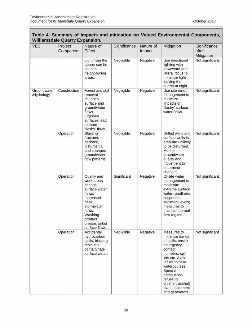
Environmental Assessment Registration Document for Williamsdale Quarry Expansion October 2017
26
Table 4. Summary of impacts and mitigation on Valued Environmental Components, Williamsdale Quarry Expansion. VEC Project
Component Nature of Effect
Significance Nature of Impact
Mitigation Significance after Mitigation
Light from the quarry can be seen in neighbouring areas.
Negligible Negative Use directional lighting with downward and lateral focus to minimize light leaving the quarry at night.
Not significant.
Groundwater/Hydrology
Construction Forest and soil removal changes surface and groundwater flows. Exposed surfaces lead to more ‘flashy’ flows.
Negligible Negative Use site runoff management to minimize impacts of ‘flashy’ surface water flows.
Not significant.
Operation Blasting fractures bedrock, disturbs till, and changes groundwater flow patterns.
Negligible Negative Drilled wells and surface wells in area are unlikely to be disturbed. Monitor groundwater quality and movement to determine changes.
Not significant.
Operation Quarry and work areas change surface water flows. Increased peak stormwater flows. Washing product creates turbid surface flows.
Significant Negative Onsite water management to moderate extreme surface water runoff and suspended sediment levels; measures to maintain normal flow regime.
Not significant.
Operation Accidental hydrocarbon spills; blasting residues contaminate surface water.
Negligible Negative Measures to minimize danger of spills; onsite emergency contact numbers, spill kits etc. Avoid refueling near watercourses. Special precautions refueling crusher, asphalt plant equipment and generators.
Not significant.

Environmental Assessment Registration Document for Williamsdale Quarry Expansion October 2017
27
Table 4. Summary of impacts and mitigation on Valued Environmental Components, Williamsdale Quarry Expansion. VEC Project
Component Nature of Effect
Significance Nature of Impact
Mitigation Significance after Mitigation
Water Quality
Construction Altered surface water flows and turbidity in watershed flowages.
Negligible Negative Erosion and sedimentation controls in work areas. Onsite water management to moderate surface water runoff and suspended sediment levels.
Not significant.
Operation Dust & suspended sediment from operations potentially enters local watershed. Chemicals (e.g. nitrates) from explosives entering runoff.
Significant Negative Onsite dust control, and water management to moderate surface water runoff and suspended sediment levels. Erosion & sedimentation controls. Closely monitor chemical residues after blasting.
Not significant.
Operation Water chemistry changes in runoff from materials stored on site.
Negligible Negative Best management practice allows leaving aggregate storage piles exposed to the environment. Monitor settling ponds; storm-water management.
Not significant.
Natural Areas & Wilderness
Construction & Operation
Presence of quarry, emissions, dust etc., detracts from public perception of wild quality of area.
Negligible Negative Area affected is small in relation to remaining natural areas; is not visible from roads and nearby natural environments; and landscape has been fragmented by previous agriculture and forestry, diminishing natural and
Not significant.

Environmental Assessment Registration Document for Williamsdale Quarry Expansion October 2017
28
Table 4. Summary of impacts and mitigation on Valued Environmental Components, Williamsdale Quarry Expansion. VEC Project
Component Nature of Effect
Significance Nature of Impact
Mitigation Significance after Mitigation
wilderness value of the vicinity. Attempt to minimize footprint, include buffer areas, and avoid damage to adjacent areas. Manage light, noise, and releases of dust.
Freshwater Aquatic Environments
Construction Occurrences of high suspended sediments and nutrient levels from grubbings, and locally diverted flows.
Negligible Negative Preserve wooded buffer areas adjacent to quarry; maintain wooded buffer on permanent stream as possible as quarry expands. On-site water management and sedimentation controls to moderate surface water runoff and suspended sediment levels.
Not significant.
Operation Changes in surface runoff quality and quantity. Reduced normal flows in watercourses adjacent to site.
Negligible Negative Maintain forested buffers. Onsite water management to moderate runoff off site. Minimize unvegetated areas.
Not significant.
Operation Higher ‘flashy’ peak flows and suspended sediment during activities.
Significant Negative Onsite water management to store sudden runoff. Preserve woodland in buffer areas of quarry.
Not significant.

Environmental Assessment Registration Document for Williamsdale Quarry Expansion October 2017
29
Table 4. Summary of impacts and mitigation on Valued Environmental Components, Williamsdale Quarry Expansion. VEC Project
Component Nature of Effect
Significance Nature of Impact
Mitigation Significance after Mitigation
Operation Runoff from access roads.
Negligible Negative Use of ditching and artificial channels, to carry peak flows and additional site runoff. Sedimentation controls.
Not significant.
Operation Releases of chemicals from blasting and runoff from materials stored on site.
Negligible Negative Isolate and treat runoff from work areas and stored materials piles.
Not significant.
Construction & Operation
Routine releases and accidental spills of hydrocarbons on site.
Significant Negative Provide pollution prevention and emergency measures.
Not significant.
Wetlands Construction Grubbing, road construction, pit preparation
Significant Negative Avoid work and/or development near wetlands and maintain buffers if possible. If damage is unavoidable, delineate wetlands and compensate for loss. Maintain natural hydrological regime of wetlands during construction.
Not significant.
Operation Dust, nutrient inputs from runoff, changes to hydrology, changes to forest communities.
Negligible Negative. Maintain a significant forest buffer; maintain hydrological regime.
Not significant.
Fish & Fish Habitat
Construction Change runoff patterns at site in local and adjacent watersheds.
Negligible Negative Sedimentation and flow controls on site runoff. Maintain forested buffer around quarry.
Not significant.

Environmental Assessment Registration Document for Williamsdale Quarry Expansion October 2017
30
Table 4. Summary of impacts and mitigation on Valued Environmental Components, Williamsdale Quarry Expansion. VEC Project
Component Nature of Effect
Significance Nature of Impact
Mitigation Significance after Mitigation
Operation Site runoff management and water use affects hydrological and groundwater regime.
Negligible Negative Ensure the runoff from the site is managed to prevent sudden flows to Second River.
Not significant.
Construction & Operation
Nominal releases of oils, hydraulic fluids etc. from operating equipment. Accidental spills of hydrocarbons on site.
Negligible Negative Maintain equipment to minimize loss of lubricants and fuels. Provide pollution prevention and emergency measures.
Not significant.
Operation Accidental spills into watercourses from truck highway accidents.
Negligible Negative Recommend truck traffic use safe driving practices and reduce speed in vicinity of quarry and Wentworth Collingwood Road Provide pollution prevention and emergency measures.
Not significant.
Terrestrial Flora & Fauna & Habitat
Construction Removal of Existing Communities
Negligible Negative Restore damaged and unused parts of the site (e.g. grubbings and waste rock piles) as soon as possible. Long-term site rehabilitation plan developed with NSE. Cut forest short term only as needed to expand quarry.
Not significant.

Environmental Assessment Registration Document for Williamsdale Quarry Expansion October 2017
31
Table 4. Summary of impacts and mitigation on Valued Environmental Components, Williamsdale Quarry Expansion. VEC Project
Component Nature of Effect
Significance Nature of Impact
Mitigation Significance after Mitigation
Construction & Operation
Accidental releases, contamination of habitat.
Significant Negative Provide pollution prevention and emergency measures & response capability. Remediate any permanent areas affected by spills.
Not significant.
Artificial light from operations influences movements of birds and insects.
Significant Negative Use directional lighting with downward focus to minimize light leaving the quarry.
Not significant.
Removal of potential forest and wildlife resource (i.e. wildlife habitat)
Negligible Negative Minimize footprint of quarry. Restore and rehabilitate areas not used. Leave mature standing trees where possible as nest cavities.
Not significant.
Quarry affects wildlife movement patterns and connectivity of habitats.
Significant Negative. Restoration should include consideration for wildlife movement through the restored site.
Not significant.
Species at Risk
Construction Plant species at risk in the proposed footprint of the quarry.
Significant Negative Survey for additional occurrences of species. Develop management plan. Minimize footprint and maintain as much natural (uncut) natural vegetation as possible.
Not significant.
Operation Sound from blasting can harm bats and birds.
Negligible Negative Implement best management practices to minimize impacts of blasting activity during breeding and migratory periods.
Not significant.

Environmental Assessment Registration Document for Williamsdale Quarry Expansion October 2017
32
Table 4. Summary of impacts and mitigation on Valued Environmental Components, Williamsdale Quarry Expansion. VEC Project
Component Nature of Effect
Significance Nature of Impact
Mitigation Significance after Mitigation
Light influences movements of species at risk birds migrating overland.
Significant Negative Use directional lighting with downward and lateral focus to minimize light leaving the quarry.
Not significant.
Open areas and grubbings piles occupied by nesting species such as nighthawks and bank swallows.
Significant Negative Educate personnel to look for bird life prior to activities; periodically conduct nesting bird survey at site to identify bird issues.
Not significant.
SOCIOECONOMIC COMPONENTS Mi’kmaq Construction
and Operation
Any land use conflicts with Mi’kmaq Right to Use Land
Significant Neutral Consult with Mi’kmaq in developing quarry.
Not significant.
Contamination and alteration of flow regime of streams may affect fish populations potentially used by Mi’kmaq.
Negligible Negative Employ surface water monitoring program. Use Best Management Practices for quarries. Avoid accidental releases of contaminants. Avoid vehicle accidents.
Not significant.
Archaeological, Cultural and Historical Significance
Construction Expansion may affect undiscovered artifacts.
Not significant
Negligible Unlikely that artifacts occur at site. Minimize project footprint. Inform authorities if any are found.
Not significant.
Recreation Construction & Operation
Quarry traffic & activities affects local light recreation (e.g. walking).
Not significant
Negative Users of road and Second River Trail, will be aware of activity at quarry but will not be otherwise impacted by it.
Not significant.
Tourism and Viewscape
Construction & Operation
Truck traffic interferes with tourist use of roads in area.
Negligible Negative Quarry cannot be seen from road. Ensure safe movement of trucks and
Not significant.

Environmental Assessment Registration Document for Williamsdale Quarry Expansion October 2017
33
Table 4. Summary of impacts and mitigation on Valued Environmental Components, Williamsdale Quarry Expansion. VEC Project
Component Nature of Effect
Significance Nature of Impact
Mitigation Significance after Mitigation
equipment on roads in vicinity.
Residential Use
Construction & Operation
Noise; light pollution; dust; odours; operation of trucks and transportation of heavy equipment.
Significant Negative Use best management practices to reduce disturbance to nearby residents. Inform residents about quarry operations. Provide community with safety information for truck traffic on Wentworth Collingwood Road
Not significant.
Agriculture Construction & Operation
Loss of potential growing area for blueberries; interference with movements of agricultural vehicles and implements
Negligible Negative Relatively small area affected compared with existing blueberry production. Use best management practices and communication to reduce disturbance to nearby blueberry farmers.
Not significant.
Recreational and Mi’kmaq Hunting and Fishing
Construction & Operation
Accidental hydrocarbon spills and blasting residues contaminate surface waters.
Negligible Negative Provide pollution prevention, emergency measures & response capability. Identify and control contaminant releases.
Not significant.
Construction Loss of forested area under quarry footprint.
Not significant
Negative Rehabilitate areas no longer needed for activity and future development. Minimize cutting outside quarry footprint.
Not significant.

Environmental Assessment Registration Document for Williamsdale Quarry Expansion October 2017
34
Table 4. Summary of impacts and mitigation on Valued Environmental Components, Williamsdale Quarry Expansion. VEC Project
Component Nature of Effect
Significance Nature of Impact
Mitigation Significance after Mitigation
Water Supplies & Residential Wells
Construction and Operation
Blasting potentially impacts local aquifers.
Not significant
Negative Develop monitoring plan in consultation with NSE.
Not significant.
Land Use and Value
Construction & Operation
Removal of potential forest and wildlife resource (e.g. forestry & trapping).
Not significant
Negative Small area affected relative to total land available. Minimize footprint of quarry. Restore and rehabilitate areas not used.
Not significant.
Transportation
Operation Wear on highway
Negligible Negative Current levels while moderate are not likely to increase.
Not significant.
Operation Collisions with trucks and equipment on Wentworth Collingwood Road.
Not significant
No Change Use good directional signs for slow moving vehicles, and speed policy in vicinity of quarry. Safety training for truck drivers.
Not significant
Industrial & Commercial Use
Operation Competition with other Quarries
Negligible Neutral Quarry operations are in a competitive environment; cooperate if possible.
Not significant.
Resource Use Forestry, Hunting & Trapping
Construction & Operation
Removes woodland; game habitat.
Not significant
Negative Relatively small area is used.
Not significant.
Parks and Protected areas
Construction & Operation
Exposure to noise and light pollution of Economy River Wilderness Area, Portapique River Wilderness area and other protected areas in the general area.
Not significant
Neutral Employ best management practices for all aspects of quarry operation, in particular control of light, dust and particulate emissions, and odours leaving the site.
Not significant.

Environmental Assessment Registration Document for Williamsdale Quarry Expansion October 2017
35
IMPACTS OF THE ENVIRONMENT ON THE PROJECT
The operating quarry will not be impacted in general by weather, including high rainfall and precipitation, through its nature and design, which includes site water management. Aggregate and other rock products stored at the site are stable under varying conditions of rainfall and wind. Integrity of any runoff management structures at the site must be maintained and appropriately designed to remove the possibility of catastrophic failure.
CUMULATIVE IMPACTS
All the potential impacts of the quarry operation (dust, noise, lights, blasting, traffic volume) may be compounded by the operations of the adjacent McCormick Quarry. The two quarries are comparatively small and produce relatively small aggregate volumes, and the expected rate of production is expected to remain at current levels. Light will be emitted from the two quarries, however their combined range of influence is comparatively small compared to the large areas of undeveloped land in the adjoining landscape, so overall the cumulative effects on bird migrations, and light visibility and light-shine in the area, are expected to be negligible. In future, however, construction and operation of quarries and pits, as well as wind farm development, could take place in the vicinity of the quarry. Development of other quarries in the vicinity is possible, although there are no confirmed projects at present. The area is also suitable for windfarm development. Any developments potentially affect the ecological integrity of the area, making it less suitable for conservation purposes and affecting the value of the protected areas near the site, and all should be undertaken with a view to minimizing the impact on the local natural environment.
