development plan 18-24 robertsons road & 16a robertsons ... · abn 48 966 120 921 acn 007 427...
TRANSCRIPT

Issued
Development Plan18-24 Robertsons Road & 16a Robertsons Road, Taylors Lakes
14 May 2018
Development VictoriaPrepared for
SJB Planning
Level 1, 80 Dorcas StreetSouthbank VIC 3006AustraliaT. 61 3 8648 [email protected] sjb.com.au
We create amazing places
Urban Design & Landscape
Traffic Engineer
Developer Version: 02Prepared by: AT Checked by: KT
Contact Details:
SJB PlanningLevel 1, 80 Dorcas StreetSouthbank VIC 3006Australia
T. 61 3 8648 [email protected]
SJB Planning Pty Ltd ABN 48 966 120 921ACN 007 427 554
At SJB we believe that the future of the city is in generating a rich urban experience through the delivery of density and activity, facilitated by land uses, at various scales, designed for everyone.
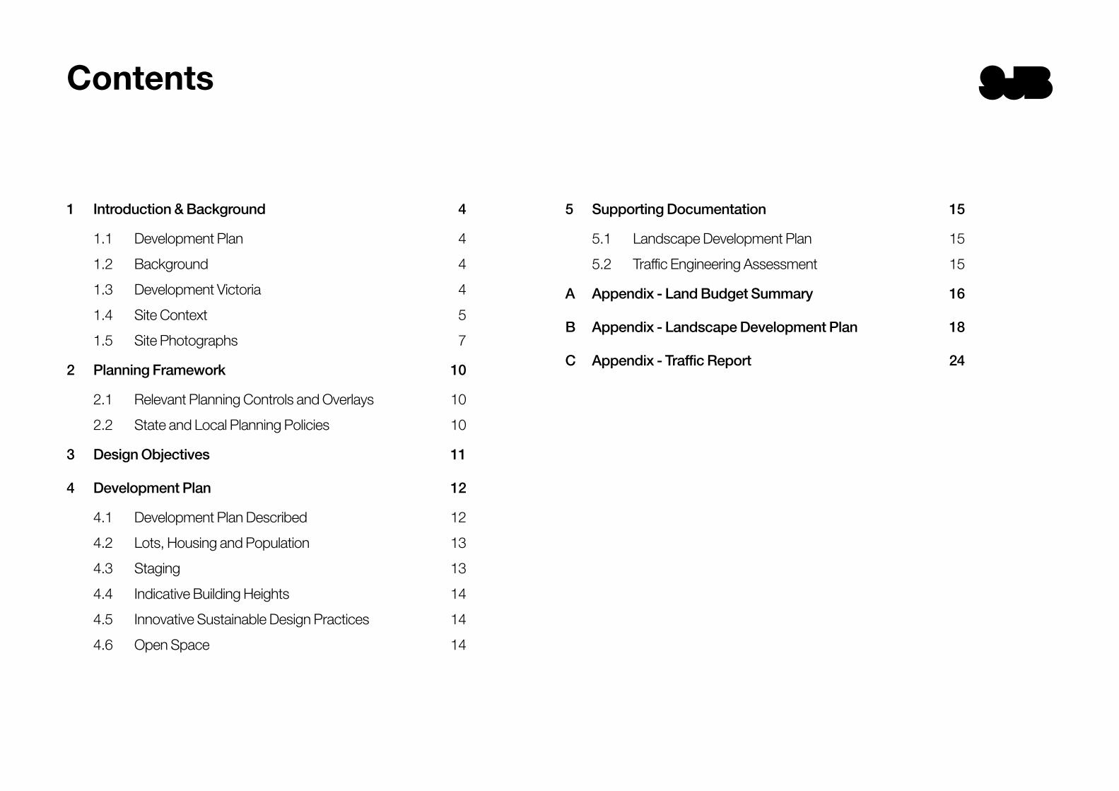
Contents
1 Introduction & Background 4
1.1 Development Plan 4
1.2 Background 4
1.3 Development Victoria 4
1.4 Site Context 5
1.5 Site Photographs 7
2 Planning Framework 10
2.1 Relevant Planning Controls and Overlays 10
2.2 State and Local Planning Policies 10
3 Design Objectives 11
4 Development Plan 12
4.1 Development Plan Described 12
4.2 Lots, Housing and Population 13
4.3 Staging 13
4.4 Indicative Building Heights 14
4.5 Innovative Sustainable Design Practices 14
4.6 Open Space 14
5 Supporting Documentation 15
5.1 Landscape Development Plan 15
5.2 Traffic Engineering Assessment 15
A Appendix - Land Budget Summary 16
B Appendix - Landscape Development Plan 18
C Appendix - Traffic Report 24
4 SJB
Introduction & Background 1 1.1 Development Plan
1.1.1 Purpose and Context
1.1.2 18-24 Robertsons Road & 16a Robertsons Road, Taylors Lakes Development Plan
1.2 Background
A Development Plan is a plan / map and supporting report (including possible separate supplementary material) which provides an outline of the way an area is intended to be developed.
A Development Plan outlines housing areas, road layouts and the locations of open space, community, retail and other land uses and facilities for a comprehensively planned development of land. This outline is detailed at subdivision and development stages, generally following the adoption of the Development Plan (noting in relation to this site the Responsible Authority does have the ability to consider and decide upon permit applications for subdivision, development and use in the absence of an approved Development Plan). The detail at subdivision and development stages may vary or ‘fine tune’ a Development Plan without changing its general intent (to the satisfaction of the Responsible Authority).
Objectives for the development of land and guidelines relating to the provision of infrastructure, facilities and services and other matters, may form part of a Development Plan.
The 18-24 Robertsons Road and 16A Robertsons Road (formerly 16A McCubbin Drive), Taylors Lakes Development Plan is a comprehensive report and map based on detailed investigations. These investigations included: Urban design; Open space and landscaping; Traffic Engineering; Infrastructure and servicing; and Strategic and statutory planning.
The Development Plan comprises two main parts: The plan / map – depicting a broad layout and
residential land use, road layout, open space networks and other elements;
The report – summarising existing conditions at Taylors Lakes and describing the plan and its implementation.
Development Victoria is a State government entity and developer that aims to deliver projects that will create and deliver economic and social value to Victoria.
They typically deliver projects of state significance, including the Melbourne Park and State Library Victoria redevelopments, as well as residential developments within greenfield and brownfield areas with the aim to provide a diverse range of housing options for Victorians.
With Victoria’s population set to hit 10 million by 2050 and demand for housing an issue for many Victorians, Development Victoria will help to meet the growing needs of the population.
1.3 Development Victoria
The site has historically been used for agricultural purposes and was originally purchased by the Department of Education and Training (DET) for future expansion but was never developed and currently remains vacant with limited vegetation. The site was subsequently purchased by Development Victoria for redevelopment.
The DET undertook a rezoning of the land which recently rezoned the land from a ‘Public Use Zone’ to a ‘General Residential Zone’ and applied a Development Plan Overlay. This is discussed further in Section 4.3.

5 SJB
Introduction & Background
The Development Plan site consists of approximately 9.1 hectares of land generally bounded by:
To the north-west by Robertsons Road
To the south-west by McCubbin Drive
To the north, east and south by existing residential development within the Neighbourhood Residential Zone.
Key features of the site and its immediate context include:The land generally falls from north to south and south-
east by approximately 3 metres.
The site is an infill site within an established urban area.
The site is currently vacant.
The site does not comprise any significant trees or vegetation.
The site has a side or rear interface with approximately 31 existing adjoining residential lots.
Further south-west, across McCubbin Drive, are conventional residential properties.
Further north-west, across Robertsons Road, is Overnewton Anglican College.
1.4 Site Context
1.4.1 The Subject Site
Copyright SMEC© 2017. This plan is based on preliminary information only and may be subject to change as a result of detailed site investigations, confi rmation by survey and formal Council/Authority.
0 20 40 60 80 100M1:2000 @A3 1:1000 @A1
Date Issued: 03/11/2017 | Revision: CSMEC Project Reference: 30042069L.00 Drawn by: J. Li | Checked by: C. Davis
Robertsons Road, Taylors Lakes
Site AnalysisUrban Design
Landscape ArchitectureTown Planning
WATERGARDENS RAILWAY STATION & TOWN CENTRE 1KM
WETLAND
DRAINAGE RESERVE
OVERNEWTOWN ANGLICAN COMMUNITY COLLEGE
RO
BE
RT
SO
NS
RO
AD
Mc C U B B I N
DR
I VE
L A N D S B O U R G H A V E N U E
TA
SM
AN
CR
ES
CE
NT
W E N T W O R T H D R I V E
SITE DRAINAGE
SITE DRAINAGE
SITE DRAINAGE
LEGEND
Proposed Development SiteBoundaryBus Route
School interface
fence interface
front interface
Figure 01: Site Analysis (source: SMEC)
NTS

6 SJB
Introduction & Background
10 MINUTE WALK
5 MINUTE WALK
5 MINUTE CYCLE
Overnewton Anglican Community College
MELBOURNE CBDSUNSHINE NATIONAL
EMPLOYMENTCLUSTER
MELBOURNE AIRPORT
MELBOURNE CBD VIA MARIBYRNONG
RIVER TRAILCopperfield College
Sydenham Hillside Primary School
Sydenham Catholic Regional College
Watergardens Train Sta�on
WATERGARDENS TOWN CENTRE
400m800m1.25km
RO
BE
RT
SO
NS
RO
AD
C A L D E R F WY
KI
NG
S
RO
AD
SY
DE
NH
AM
RO
AD
M E L T O N H W Y
0 100 200 300 400 500m1:10000 @A3 1:5000 @A1
Copyright SMEC© 2017. This plan is based on preliminary information only and may be subject to change as a result of detailed site investigations, con�rmation by survey and formal Council/Authority.
Robertsons Road, Taylors Lakes
Regional Context Plan
Date Issued: 21/02/2017 | Revision: ASMEC Project Reference: 30042069L.00 Drawn by: ER | Checked by: C. Davis
Urban DesignLandscape Architecture
Town Planning
5 Minute Neighbourhood
Walkable catchment400m = 5 minute walk
Walkable catchment800m = 10 minute walk
Cycle catchment1.25m = 5 minute ride15km/h
30 minute drive to CBDvia Calder / Tullamarine Highway
30 minute drive to airportvia Western Ring Road
On road cycle pathShared path
Figure 02: Local Context (source: SMEC)
NTS
1.4.2 Site Context
Taylors Lakes is located approximately 30km north-west of the Melbourne CBD within the City of Brimbank.
The subject site is located on the corner of Robertsons Road and McCubbin Drive within the suburb of Taylors Lakes. It is approximately 300 metres north of Melton Highway (Refer to Figure 3).
The site is very well located in terms of proximity to public open space, public transport, retail facilities and community facilities. Notably, the site is located on the edge of the Watergardens Principal Activity Centre which comprises a variety of supermarkets, shops, bulky good retailing, child care centre, restaurants and cafés.
Other amenities and facilities located proximate to the site include:
Overnewton Anglican College (across the subject site along Robertsons Road); Catholic Regional College Sydenham (1.5 kilometres to the south); Emmaus Catholic Primary School (1.7 kilometres to the south)
Keilor Lodge Reserve (500 metres to the north), Taylors Creek Reserve (450 metres to the south-west), Esplanade Reserve (1.2 kilometres to the south-west)
Watergardens Train Station (1.2 kilometres to the south), Bus Routes 421 (St Albans Station – Watergardens Station) along Robertsons Road and McCubbin Drive; and Bus Routes 462 (Watergardens Station – Caroline Springs) and 476 (Moonee Ponds – Plumpton) along Melton Highway.

7 SJB
Introduction & Background
Figure 03: Site Aerial (source: Nearmap)
Rober
tson
s Roa
d
Tasman Crescent
McCubbin Drive
Wentworth Drive
Drysdale Avenue
Landsbourgh Avenue
Tasman Crescent
2 1
34
5
6
7
89
10
12
11
13
14
15
16
1817
1920
21
22
24
23
Rober
tson
s Roa
d
NTS
1
2
3
1.5 Site Photographs

8 SJB
Introduction & Background
13
14
15
7
8
9
10
11
12
4
5
6

9 SJB
Introduction & Background
19
20
21
23
24
2216
18
17

10 SJB
2.1 Relevant Planning Controls and Overlays
Planning Framework 2 The subject site is located within the General Residential Zone – Schedule 1 (GRZ1) under the Brimbank Planning Scheme. The purpose of this zone includes: To implement the State Planning Policy Framework
and the Local Planning Policy Framework, including the Municipal Strategic Statement and local planning policies.
To encourage development that respects the neighbourhood character of the area.
To encourage a diversity of housing types and housing growth particularly in locations offering good access to services and transport.
A Development Plan Overlay – Schedule 17 (DPO17) also applies to the land (Clause 43.04). The purpose of the DPO17 is: To implement the State Planning Policy Framework
and the Local Planning Policy Framework, including the Municipal Strategic Statement and local planning policies.
To identify areas which require the form and conditions of future use and development to be shown on a development plan before a permit can be granted to use or develop the land.
To exempt an application from notice and review if it is generally in accordance with a development plan.
The DPO17 details the information that the Development Plan must include.
Pursuant to Clause 43.04-2, the Responsible Authority may grant a permit for subdivision, use or development of land before approval of a Development Plan provided that the Responsible Authority is satisfied that the subdivision, use or development will not prejudice the future use or development of the land for the purpose of the Zone or any other aspect of the Municipal Strategic Statement.
Planning MapZoning 5000
Disclaimer: This map is a snapshot generated from Victorian Government data. This material may be of assistance toyou but the State of Victoria does not guarantee that the publication is without flaw of any kind or is wholly appropriatefor your particular purposes and therefore disclaims all liability for error, loss or damage which may arise from relianceupon it. All persons accessing this information should make appropriate enquiries to assess the currency of data.
Map Scale 1:5,000November 15, 2017 6:14:14 PM
Legend
0 110 220 m.
Copyright © State Government of Victoria. Service provided by www.land.vic.gov.au
Map Centre - Melways 3 E11
Planning MapOverlays 5000
Disclaimer: This map is a snapshot generated from Victorian Government data. This material may be of assistance toyou but the State of Victoria does not guarantee that the publication is without flaw of any kind or is wholly appropriatefor your particular purposes and therefore disclaims all liability for error, loss or damage which may arise from relianceupon it. All persons accessing this information should make appropriate enquiries to assess the currency of data.
Map Scale 1:5,000November 15, 2017 6:14:52 PM
Legend
0 110 220 m.
Copyright © State Government of Victoria. Service provided by www.land.vic.gov.au
Map Centre - Melways 3 E11
Figure 04: Zoning
Figure 05: Overlays
2.2 State and Local Planning Policies
There is a high degree of State and local planning policy supporting future urban development of the subject land. In terms of the State Planning Policy Framework, this includes: Clause 11 – SettlementClause 12 – Environmental and Landscape Values Clause 15 – Built Environment and Heritage Clause 18 – TransportClause 19 – Infrastructure
In essence, these policies seek to ensure that a sufficient supply of land is available for the needs of existing and future communities. These policies also seek to facilitate sustainable development that takes full advantage of existing settlement patterns and investment in transport and communication, water and sewerage and social facilities and facilitate the orderly development of urban areas.
In terms of local planning policy support in the Brimbank Planning Scheme, this includes the following: Clause 21.02 – Key Land Use IssuesClause 21.04 – Strategic Land Use Vision Clause 21.05 – Natural Environment Clause 21.06 – Built Environment Clause 21.07 – Housing
All of the above local planning policies have been considered and addressed as part of the design development formulation of this Development Plan. Housing, environmental and infrastructure requirements have all been acknowledged and measures are in place to ensure that the Taylors Lakes development will be a high quality, well-designed and sustainable residential community that integrates into the existing residential fabric, responding to the direct residential interfaces and streetscapes. In particular, the needs of future residents have been the underlying consideration in the preparation of the Development Plan.

11 SJB
Design Objectives 3 The proposed Development Plan Map provides a structure to accommodate a sustainable community of approximately 173 new homes. It has been created with careful consideration of the context of the site and key interfaces with existing urban edges. These edges vary with both low and standard density housing and educational facilities.
With close proximity to Watergardens Town Centre and major road and public transport infrastructure this address will provide a new attractive and affordable housing product in Taylors Lakes. Key principles that have informed the design process include:
Contribute to a sense of place and cultural identity
The proposed development plan is designed to integrate into the existing street fabric of a broader existing master-planned framework. The existing provision of key infrastructure, quality streetscapes and carefully considered variety of built form have underpinned the vision for the site to promote a seamless transition of a new community within the surrounding network. This includes the provision of a structure to accommodate a wide variety of new homes. Street connection is provided into McCubbin Drive as a direct link and a short walk into the Town Centre containing retail, commercial, entertainment and public transport facilities.
Ensure living environments are functional, safe and attractive
The development plan is structured by a regular grid layout that gravitates towards McCubbin Drive with secondary links to Robertsons Road and Tasman Crescent. The simple structure provides manageable street lengths that promote low speed traffic environments and ease of way-finding. It also provides an efficient basis for packaging a wide variety of affordable housing solutions that are appealing and sought after. The promotion of habitable rooms overlooking streets will be a key principal in ensuring that passive surveillance over key frontages are maintained and that streetscapes are not dominated by garage doors.
Provide an integrated layout, built form and landscape
The key focus of the Development Plan is on maintaining direct links into the existing road network, particularly to the south. Key streets are proposed with wider pavements so that safe cycle passage can be maintained on street. Streets are oriented to maximise solar access into private gardens and living areas.
The proposal also provides an area that contains a well-proportioned local open space on McCubbin Drive that is easily accessed by existing residents.
Respond to and integrate with the surrounding urban environment
The layout connects residents to the existing street network allowing easy access to public transport, schooling, recreational activity and the Watergardens Town Centre. It is anticipated that the connection to McCubbin Drive will be the principal linkage for foot and vehicle traffic into the existing framework. A local street linking west to Overnewton College and east into Tasman Crescent is proposed as an alternative opportunity to connect the neighbouring community. This will provide circulation for local residents. The existing residential interfaces will be regulated with the provision of up to a maximum of 2 storeys.
Ensure that the layout allows for a compact and walkable neighbourhood
The intimate nature of the proposed development plan has not restricted the ability for this community to be highly connected to the existing neighbourhood and nearby major facilities. The provision of key links within the subdivision will promote the choice for residents to be able to move easily within the community and to key destinations.
Provide housing choice enabling appropriate siting, solar access, private open space, vehicle access and parking
Lot sizes are intended to be commensurate with the volume builders product. Allotments are oriented within the grids to ensure adequate solar access and also promote protection from the summer afternoon sun. The allotments are sized to ensure that private gardens and storage needs are not compromised and that a wide variety of affordable housing choice can be provided.
12 SJB
ACCESS STREET 2 - 18m
AC
CE
SS
STR
EE
T 2-
18m
AC
CE
SS
STR
EE
T 1
- 16
m
ACC
ESS STREET 1 - 16m
ACC
ESS STREET 1 - 16m
ACCESS STREET 1 - 16m
ACCESS STREET 1 - 16m
RO
BE
RT
SO
NS
RO
AD
PARK
EVIRD NIBBUCcM
STAGE 3
STAGE 4
STAGE 2
STAGE 1
Indicative Land Budget
Area (m²) Area (ha) % of Site % of NDA91,313 9.13 100%3,600 0.36 4%
Local Network Parks 3,600 0.36 4%64,285 6.43 70% 73%23,429 2.34 26% 27%
Local Access Roads 23,429 2.34 26% 27%87,713 8.77 100% 100%
Residential Lots 173 173 lots 37219.7 19.7
Roads
Lot Yield
Total Net Residential Area
Density
Total Site Area
Land Budget
lots/ha
Number of Lots Definition Avg. Size
(m²)
Residential (Saleable)
Open Space Network
Number of Lots
Lot width Number of Lots % Total
10.5 - 16m 37 21%10.5 - 16m 49 28%10 - 14m 42 24%10 -14m 29 17%12.5 - 14m 16 9%
173Total Lots
25m21
32m30m28m
Total Yield
Lot depth
Notation 1
Site BoundaryStage BoundaryInformal Bicycle Route
Legend
Copyright SMEC© 2018. This plan is based on preliminary information only and may be subject to change as a result of detailed site investigations, confirmation by survey and formal Council/Authority.
0 20 40 60 80 1001:2000 @A3 1:1000 @A1
Date Issued: 11/05/2018 | Revision: GSMEC Project Reference: 30042069L.00 Drawn by: S. Tran / J. Li | Checked by: C. Isfer
Robertsons Road, Taylors Lakes
Development Plan - Indicative Staging and Land BudgetUrban Design
Landscape ArchitectureTown Planning
1. Additional traffic calming measures will be required at the north east corner of the site with Tasman Crescent, likely to be a roundabout or a modified T intersection.
4 Development Plan
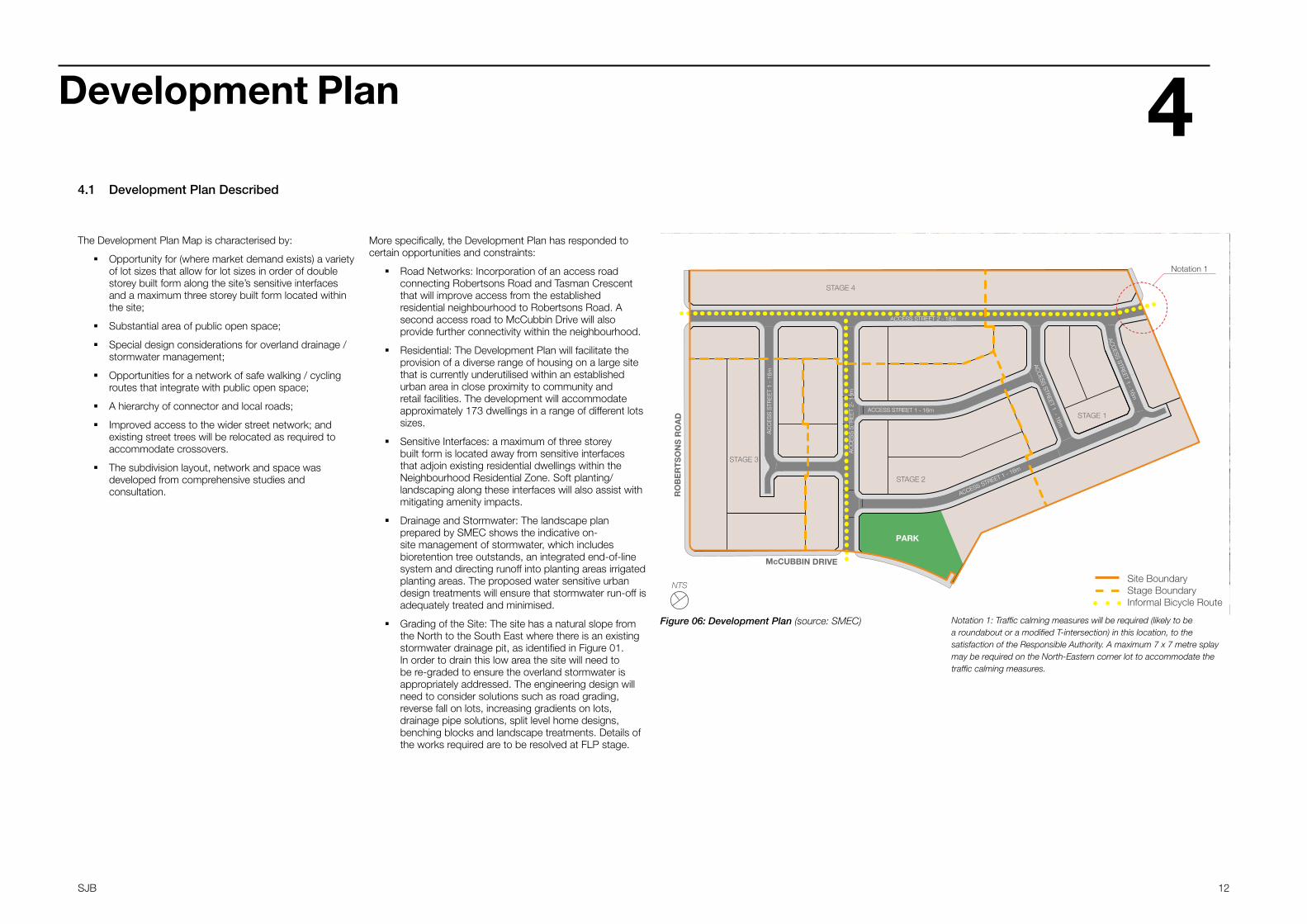
The Development Plan Map is characterised by:
Opportunity for (where market demand exists) a variety of lot sizes that allow for lot sizes in order of double storey built form along the site’s sensitive interfaces and a maximum three storey built form located within the site;
Substantial area of public open space;
Special design considerations for overland drainage / stormwater management;
Opportunities for a network of safe walking / cycling routes that integrate with public open space;
A hierarchy of connector and local roads;
Improved access to the wider street network; and existing street trees will be relocated as required to accommodate crossovers.
The subdivision layout, network and space was developed from comprehensive studies and consultation.
Figure 06: Development Plan (source: SMEC)
NTS
More specifically, the Development Plan has responded to certain opportunities and constraints:
Road Networks: Incorporation of an access road connecting Robertsons Road and Tasman Crescent that will improve access from the established residential neighbourhood to Robertsons Road. A second access road to McCubbin Drive will also provide further connectivity within the neighbourhood.
Residential: The Development Plan will facilitate the provision of a diverse range of housing on a large site that is currently underutilised within an established urban area in close proximity to community and retail facilities. The development will accommodate approximately 173 dwellings in a range of different lots sizes.
Sensitive Interfaces: a maximum of three storey built form is located away from sensitive interfaces that adjoin existing residential dwellings within the Neighbourhood Residential Zone. Soft planting/landscaping along these interfaces will also assist with mitigating amenity impacts.
Drainage and Stormwater: The landscape plan prepared by SMEC shows the indicative on-site management of stormwater, which includes bioretention tree outstands, an integrated end-of-line system and directing runoff into planting areas irrigated planting areas. The proposed water sensitive urban design treatments will ensure that stormwater run-off is adequately treated and minimised.
Grading of the Site: The site has a natural slope from the North to the South East where there is an existing stormwater drainage pit, as identified in Figure 01. In order to drain this low area the site will need to be re-graded to ensure the overland stormwater is appropriately addressed. The engineering design will need to consider solutions such as road grading, reverse fall on lots, increasing gradients on lots, drainage pipe solutions, split level home designs, benching blocks and landscape treatments. Details of the works required are to be resolved at FLP stage.
4.1 Development Plan Described
ACCESS STREET 2 - 18m
AC
CE
SS
STR
EE
T 2-
18m
AC
CE
SS
STR
EE
T 1
- 16
m
ACC
ESS STREET 1 - 16m
ACC
ESS STREET 1 - 16m
ACCESS STREET 1 - 16m
ACCESS STREET 1 - 16m
RO
BE
RT
SO
NS
RO
AD
PARK
EVIRD NIBBUCcM
STAGE 3
STAGE 4
STAGE 2
STAGE 1
Indicative Land Budget
Area (m²) Area (ha) % of Site % of NDA91,313 9.13 100%3,600 0.36 4%
Local Network Parks 3,600 0.36 4%64,285 6.43 70% 73%23,429 2.34 26% 27%
Local Access Roads 23,429 2.34 26% 27%87,713 8.77 100% 100%
Residential Lots 173 173 lots 37219.7 19.7
Roads
Lot Yield
Total Net Residential Area
Density
Total Site Area
Land Budget
lots/ha
Number of Lots Definition Avg. Size
(m²)
Residential (Saleable)
Open Space Network
Number of Lots
Lot width Number of Lots % Total
10.5 - 16m 37 21%10.5 - 16m 49 28%10 - 14m 42 24%10 -14m 29 17%12.5 - 14m 16 9%
173Total Lots
25m21
32m30m28m
Total Yield
Lot depth
Notation 1
Notation 2
Site BoundaryStage BoundaryInformal Bicycle Route
Legend
Copyright SMEC© 2018. This plan is based on preliminary information only and may be subject to change as a result of detailed site investigations, confirmation by survey and formal Council/Authority.
0 20 40 60 80 1001:2000 @A3 1:1000 @A1
Date Issued: 08/05/2018 | Revision: GSMEC Project Reference: 30042069L.00 Drawn by: S. Tran / J. Li | Checked by: C. Isfer
Robertsons Road, Taylors Lakes
Development Plan - Indicative Staging and Land BudgetUrban Design
Landscape ArchitectureTown Planning
1. Additional traffic calming measures will be required at the north east corner of the site with Tasman Crescent, likely to be a roundabout or a modified T intersection.
2. Drainage issues have been identified at the south east corner of the site. These will require engineering solutions, which will be addressed as part of the detailing of the design. Possible solutions may include: Engineering any dwelling on site to include detailing such as waffle slabs to a drain to the rear of the site, increase the gradient of the sites, amend the road design by lowering the RLs, creation of an easement through 40 Wentworth Drive.
Notation 1: Traffic calming measures will be required (likely to be a roundabout or a modified T-intersection) in this location, to the satisfaction of the Responsible Authority. A maximum 7 x 7 metre splay may be required on the North-Eastern corner lot to accommodate the traffic calming measures.
13 SJB
Development Plan
Brimbank Council’s population is forecasted to increase by 0.5% per annum, to the year 2026, based on projections prepared by Victoria in Future (2008). The population is projected to increase from approximately 174,746 people in 2006 to over 194,703 people in 2026.
The aim of the proposed mix is to meet market expectations but also encourage building streetscape outcomes that deliver a subtle sense of common neighbourhood design while providing visual interest and diversity across the development.
The development also meets planning goals in introducing diverse housing within an established urban area while sitting comfortably within the subdivision pattern.
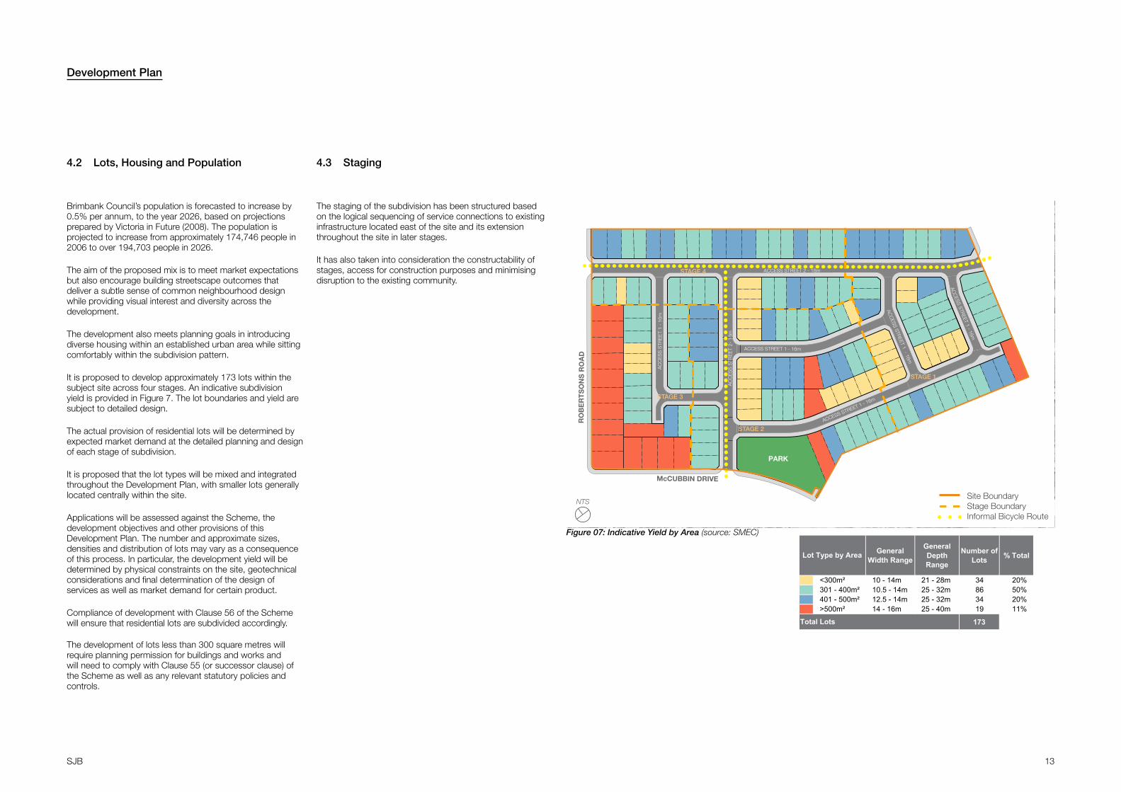
It is proposed to develop approximately 173 lots within the subject site across four stages. An indicative subdivision yield is provided in Figure 7. The lot boundaries and yield are subject to detailed design.
The actual provision of residential lots will be determined by expected market demand at the detailed planning and design of each stage of subdivision.
It is proposed that the lot types will be mixed and integrated throughout the Development Plan, with smaller lots generally located centrally within the site.
Applications will be assessed against the Scheme, the development objectives and other provisions of this Development Plan. The number and approximate sizes, densities and distribution of lots may vary as a consequence of this process. In particular, the development yield will be determined by physical constraints on the site, geotechnical considerations and final determination of the design of services as well as market demand for certain product.
Compliance of development with Clause 56 of the Scheme will ensure that residential lots are subdivided accordingly.
The development of lots less than 300 square metres will require planning permission for buildings and works and will need to comply with Clause 55 (or successor clause) of the Scheme as well as any relevant statutory policies and controls.
4.2 Lots, Housing and Population
Figure 07: Indicative Yield by Area (source: SMEC)
ACCESS STREET 2 - 18m
AC
CE
SS
STR
EE
T 2-
18m
AC
CE
SS
STR
EE
T 1
- 16
m
ACC
ESS STREET 1 - 16m
ACC
ESS STREET 1 - 16m
ACCESS STREET 1 - 16m
ACCESS STREET 1 - 16m
RO
BE
RT
SO
NS
RO
AD
PARK
EVIRD NIBBUCcM
STAGE 3
STAGE 2
STAGE 4
STAGE 1
Indicative Lot Breakdown
General Width Range
General Depth Range
Number of Lots % Total
<300m² 10 - 14m 21 - 28m 34 20%301 - 400m² 10.5 - 14m 25 - 32m 86 50%401 - 500m² 12.5 - 14m 25 - 32m 34 20%>500m² 14 - 16m 25 - 40m 19 11%
173
Lot Type by Area
Total Lots
Legend
Stage BoundarySite BoundaryInformal Bicycle Route
Urban DesignLandscape Architecture
Town PlanningProject Location, Suburb
Plan Title on this line
Copyright SMEC© 2018. This plan is based on preliminary information only and may be subject to change as a result of detailed site investigations, confirmation by survey and formal Council/Authority.
0 XXX XXX XXX XXX XXXm1:xxxx @A1 1:xxxx @A3
Date Issued: DD/MM/YYYY | Revision: XX SMEC Project Reference: 3004xxxxX.00 | Drawing: XX.XX Drawn by: N. Surname | Checked by: N. Surname
0 20 40 60 80 1001:2000 @A3 1:1000 @A1
Date Issued: 08/05/2018 | Revision: GSMEC Project Reference: 30042069L.00 Drawn by: S. Tran | Checked by: C. Isfer
Robertsons Road, Taylors Lakes
Development Plan - Indicative Lot YieldUrban Design
Landscape ArchitectureTown Planning
NTS
The staging of the subdivision has been structured based on the logical sequencing of service connections to existing infrastructure located east of the site and its extension throughout the site in later stages.
It has also taken into consideration the constructability of stages, access for construction purposes and minimising disruption to the existing community.
4.3 Staging
ACCESS STREET 2 - 18m
AC
CE
SS
STR
EE
T 2-
18m
AC
CE
SS
STR
EE
T 1
- 16
m
ACC
ESS STREET 1 - 16m
ACC
ESS STREET 1 - 16m
ACCESS STREET 1 - 16m
ACCESS STREET 1 - 16m
RO
BE
RT
SO
NS
RO
AD
PARK
EVIRD NIBBUCcM
STAGE 3
STAGE 4
STAGE 2
STAGE 1
Indicative Land Budget
Area (m²) Area (ha) % of Site % of NDA91,313 9.13 100%3,600 0.36 4%
Local Network Parks 3,600 0.36 4%64,285 6.43 70% 73%23,429 2.34 26% 27%
Local Access Roads 23,429 2.34 26% 27%87,713 8.77 100% 100%
Residential Lots 173 173 lots 37219.7 19.7
Roads
Lot Yield
Total Net Residential Area
Density
Total Site Area
Land Budget
lots/ha
Number of Lots Definition Avg. Size
(m²)
Residential (Saleable)
Open Space Network
Number of Lots
Lot width Number of Lots % Total
10.5 - 16m 37 21%10.5 - 16m 49 28%10 - 14m 42 24%10 -14m 29 17%12.5 - 14m 16 9%
173Total Lots
25m21
32m30m28m
Total Yield
Lot depth
Notation 1
Notation 2
Site BoundaryStage BoundaryInformal Bicycle Route
Legend
Copyright SMEC© 2018. This plan is based on preliminary information only and may be subject to change as a result of detailed site investigations, confirmation by survey and formal Council/Authority.
0 20 40 60 80 1001:2000 @A3 1:1000 @A1
Date Issued: 08/05/2018 | Revision: GSMEC Project Reference: 30042069L.00 Drawn by: S. Tran / J. Li | Checked by: C. Isfer
Robertsons Road, Taylors Lakes
Development Plan - Indicative Staging and Land BudgetUrban Design
Landscape ArchitectureTown Planning
1. Additional traffic calming measures will be required at the north east corner of the site with Tasman Crescent, likely to be a roundabout or a modified T intersection.
2. Drainage issues have been identified at the south east corner of the site. These will require engineering solutions, which will be addressed as part of the detailing of the design. Possible solutions may include: Engineering any dwelling on site to include detailing such as waffle slabs to a drain to the rear of the site, increase the gradient of the sites, amend the road design by lowering the RLs, creation of an easement through 40 Wentworth Drive.

14 SJB
Development Plan
4.4 Indicative Building Heights
Figure 08: Indicative Built Form Heights and Interafces (source: SMEC)
Copyright SMEC© 2018. This plan is based on preliminary information only and may be subject to change as a result of detailed site investigations, confirmation by survey and formal Council/Authority.
0 20 40 60 80 1001:2000 @A3 1:1000 @A1
Date Issued: 08/05/2018 | Revision: GSMEC Project Reference: 30042069L.00 Drawn by: S. Tran | Checked by: C. Isfer
Robertsons Road, Taylors Lakes
Development Plan - Building Height and Residential Interface PlanUrban Design
Landscape ArchitectureTown Planning
ACCESS STREET 2 - 18m
AC
CE
SS
STR
EE
T 2-
18m
AC
CE
SS
STR
EE
T 1
- 16
m
ACC
ESS STREET 1 - 16m
ACC
ESS STREET 1 - 16m
ACCESS STREET 1 - 16m
ACCESS STREET 1 - 16m
RO
BE
RT
SO
NS
RO
AD
PARK
EVIRD NIBBUCcM
Adjoining Existing Residential InterfaceExisting Residential Interface2 Storey Maximum Building Height3 Storey Maximum Building Height
Legend
NTS
Copyright SMEC© 2018. This plan is based on preliminary information only and may be subject to change as a result of detailed site investigations, confirmation by survey and formal Council/Authority.
0 20 40 60 80 1001:2000 @A3 1:1000 @A1
Date Issued: 08/05/2018 | Revision: GSMEC Project Reference: 30042069L.00 Drawn by: S. Tran | Checked by: C. Isfer
Robertsons Road, Taylors Lakes
Development Plan - Building Height and Residential Interface PlanUrban Design
Landscape ArchitectureTown Planning
ACCESS STREET 2 - 18m
AC
CE
SS
STR
EE
T 2-
18m
AC
CE
SS
STR
EE
T 1
- 16
m
ACC
ESS STREET 1 - 16m
ACC
ESS STREET 1 - 16m
ACCESS STREET 1 - 16m
ACCESS STREET 1 - 16mR
OB
ER
TS
ON
S R
OA
D
PARK
EVIRD NIBBUCcM
Adjoining Existing Residential InterfaceExisting Residential Interface2 Storey Maximum Building Height3 Storey Maximum Building Height
Legend
Figures 8 identifies the location of adjoining residential interfaces and provides an indication of maximum building heights. This does not preclude developments with building heights lower than the prescribed maximum such as single storey dwellings.
All lots with an interface to existing adjoining residential properties have a two storey maximum building height. Lots with a potential for taller building height (maximum of three storeys) have been located away from existing adjoining residential interfaces.
An indication of the potential maximum shadow impacts to existing secluded private open space areas the northern adjoining residential properties is provided in the supporting information. There are no additional shadow impacts to the adjoining northern residential properties.
A minimum four metre setback will be provided along lots fronting on to Robertsons Road and McCubbin Drive.
Development Victoria’s intention is to provide freehold allotments to the market, with the choice of home design to be given to the purchaser of each lot. As such, the ultimate building envelope cannot be determined at this stage. Final details of the building form will be subject to the relevant building permit and planning permit requirements.
4.5 Innovative Sustainable Design Practices
4.6 Open Space
A series of water treatment zones are being established at strategic locations including bioretention tree outstands within streetscapes and an integrated end-of-line system within the public open space. Further information is provided within the Landscape Development Plan.
The open space area is envisaged to be aesthetically pleasing and low maintenance, providing a high quality of landscape amenity that will stand the test of time and perform for existing and future generations.
The Landscape Development Plan provides a general outline of how / where public open space will be provided throughout the Development Plan area.
There is a generously sized park shown along the south of the site, adjacent to McCubbin Drive. The public open space is 3,600 square metres in area.
The provision of open space will have regard to Brimbank’s Open Space and Playground Policy and Plan (2016) and will suitably address wider community needs.

15 SJB
5.2 Traffic Engineering Assessment
Supporting Documentation 5 5.1 Landscape Development Plan
The Landscape Development Plan provides an indicative landscaping plan and guideline as well as a preliminary stormwater treatment strategy for the subject site. A variety of activities/elements are planned for the primary public open space adjacent to McCubbin Drive.
A copy of the Landscape Development Plan is enclosed in Appendix B.
The site is bounded by Robertsons Road to the north-west and McCubbin Drive to the south-west. Further north is Tasman Crescent, a local Council road that provides access to the residential development to the north.
Traffix Group was engaged to undertake observational surveys and turning movements at main intersections at morning and peak periods proximate to the site. The following observations were made:During the morning and evening peaks, minimal
queues and delays were observed at the Robertsons Road / McCubbin Drive roundabout.
At the Robertsons Road / Tasman Crescent / Overnewton College roundabout, queues were observed on the south leg between approximately 8.30-9am as a result of vehicles turning left into the school. Long queues were observed for a short period after 8.45am (11-18 vehicles at peak time) as a result of drop-off activity at the school. No queues or delays were observed after approximately 9am.
Queues (approximately 8 vehicles at peak time) were again observed on the south leg at the Robertsons Road / Tasman Crescent / Overnewton College roundabout as a result of school pick-up activity. No queues or delays were observed after approximately 3.45pm.
Indented parking along Robertsons Road in the vicinity of the school is heavily used during drop-off and pick-up periods.
It is not anticipated that the current traffic conditions observed will have any issues for site access during peak periods given that there are alternative access routes available to and from the wider road network. Peak periods for traffic generated by the site will not necessarily correspond with school drop-off or pick-up periods, particularly during the evening peak period which occurs much later than school pick-up period.
A copy of the Assessment by TraffixGroup is enclosed in Appendix C.
5.2.1 Existing Traffic Volumes
The following conclusions are made in the Traffic Engineering Assessment based on the surveys:The proposed road reservations are consistent
with what is required to accommodate appropriate carriageways, footpaths, services, etc. and appropriately facilitate all relevant user groups in accordance with relevant standards and current practice;
All relevant vehicles will be able to adequately access and circulate through the site including service and emergency vehicles subject to the appropriate design of intersections at the detailed design stage;
All roads will adequately accommodate pedestrians and informal bicycle provisions in accordance with the objectives of the Planning Scheme and current practice;
The proposed Development Plan provides sufficient opportunities to accommodate resident and visitor parking demands generated by future residential development of the site;
Traffic predicted to be generated by the proposed subdivision will be adequately accommodated by the internal road layout and proposed external access connections and will not have any unacceptable impacts on the operating conditions of the surrounding road network including Overnewton College during school drop-off and pick-up periods;
There are no traffic engineering reasons why the Development Plan should not be approved.
5.2.2 Summary of Traffic Assessment

AAppendix - Land Budget Summary

17SJB
ACCESS STREET 2 - 18m
AC
CE
SS
STR
EE
T 2-
18m
AC
CE
SS
STR
EE
T 1
- 16
m
ACC
ESS STREET 1 - 16m
ACC
ESS STREET 1 - 16m
ACCESS STREET 1 - 16m
ACCESS STREET 1 - 16m
RO
BE
RT
SO
NS
RO
AD
PARK
EVIRD NIBBUCcM
STAGE 3
STAGE 4
STAGE 2
STAGE 1
Indicative Land Budget
Area (m²) Area (ha) % of Site % of NDA91,313 9.13 100%3,600 0.36 4%
Local Network Parks 3,600 0.36 4%64,285 6.43 70% 73%23,429 2.34 26% 27%
Local Access Roads 23,429 2.34 26% 27%87,713 8.77 100% 100%
Residential Lots 173 173 lots 37219.7 19.7
Roads
Lot Yield
Total Net Residential Area
Density
Total Site Area
Land Budget
lots/ha
Number of Lots Definition Avg. Size
(m²)
Residential (Saleable)
Open Space Network
Number of Lots
Lot width Number of Lots % Total
10.5 - 16m 37 21%10.5 - 16m 49 28%10 - 14m 42 24%10 -14m 29 17%12.5 - 14m 16 9%
173Total Lots
25m21
32m30m28m
Total Yield
Lot depth
Notation 1
Site BoundaryStage BoundaryInformal Bicycle Route
Legend
Copyright SMEC© 2018. This plan is based on preliminary information only and may be subject to change as a result of detailed site investigations, confirmation by survey and formal Council/Authority.
0 20 40 60 80 1001:2000 @A3 1:1000 @A1
Date Issued: 11/05/2018 | Revision: GSMEC Project Reference: 30042069L.00 Drawn by: S. Tran / J. Li | Checked by: C. Isfer
Robertsons Road, Taylors Lakes
Development Plan - Indicative Staging and Land BudgetUrban Design
Landscape ArchitectureTown Planning
1. Additional traffic calming measures will be required at the north east corner of the site with Tasman Crescent, likely to be a roundabout or a modified T intersection.

Appendix - Landscape Development Plan B

19SJB
ACCESS STREET 2 - 18m
AC
CE
SS
STR
EE
T 2-
18m
AC
CE
SS
STR
EE
T 1
- 16
m
ACC
ESS STREET 1 - 16m
ACC
ESS STREET 1 - 16m
ACCESS STREET 1 - 16m
ACCESS STREET 1 - 16m
RO
BE
RT
SO
NS
RO
AD
PARK
EVIRD NIBBUCcM
Urban DesignLandscape Architecture
Town PlanningRobertsons Road, Taylors Lakes
Landscape Development Plan
Copyright SMEC© 2018. This plan is based on preliminary information only and may be subject to change as a result of detailed site investigations, confirmation by survey and formal Council/Authority.
Date Issued: 10/05/2018 | Revision: D1
SMEC Project Reference: 30042069L.00 | Drawing: LDP.1
Drawn by: N.Lamb | Checked by: A.Kiekebosch
Existing bus stop
Connector roads
View lines
Informal bicycle route
Pedestrian desire lines
The following principles will guide the development of the streetscape and public open space response for the development:
• Provide a streetscape treatment commensurate with the scale of the streets and which integrates with the surrounding context where desired;
• Capitalise upon dominant views into the open space and locate significant park elements at the junction of these views;
• Provide an area of public open space with a variety of elements which cater for a broad cross-section of the community;
• Cater for pedestrian desire lines through the park and to the bus stop;
• Locate active playground facilities and gathering spaces within the park away from residential interfaces, whilst ensuring sufficient passive surveillance;
• Provide a buffer to adjacent residential properties and fencelines via softscape planting;
• Integrate WSUD elements within the streetscape and open space where feasible and relevant; and
• Provide informal on-road bicycle connections through the development connecting to major connector roads and the public open space.
CAPITALISE UPON VISUAL CONNECTION FROM
WATERGARDENS TOWN CENTRE TO PUBLIC OPEN SPACE
CAPITALISE UPON VISUAL CONNECTION ALONG MCCUBBIN
DRIVE
INTEGRATE BUS STOP DESIRE LINES INTO PUBLIC OPEN SPACE DESIGNLegend
Landscape Development Principles
MCCUBBIN DRIVE
DRAINAGERESERVE
OVERNEWTONCOLLEGE
RO
BE
RT
SO
NS
RO
AD
WATERGARDENS TOWN CENTRE

20SJB
ACCESS STREET 2 - 18m
AC
CE
SS
STR
EE
T 2-
18m
AC
CE
SS
STR
EE
T 1
- 16
mAC
CESS STR
EET 1 - 16m
ACC
ESS STREET 1 - 16m
ACCESS STREET 1 - 16m
ACCESS STREET 1 - 16m
RO
BE
RT
SO
NS
RO
AD
PARK
EVIRD NIBBUCcM
Urban DesignLandscape Architecture
Town PlanningRobertsons Road, Taylors Lakes
Landscape Development Plan
Copyright SMEC© 2018. This plan is based on preliminary information only and may be subject to change as a result of detailed site investigations, confirmation by survey and formal Council/Authority.
*
*
PU
BLIC ART / SHELTERKICKABOUT AREA
PL
AY AREA 6-12 YEARS
PLA
Y AREA 0-5 YEARS
ENTRY GATEWAY
ACTIVE CORNER
0 10 20 30 40 50m
VIEWS
VIEWS
BUS
Indicative Public Open Space Landscape Program
PROVIDE VISUAL MARKER AT JUNCTURE OF KEY VIEWLINES INTO OPEN SPACE
BUFFER TO RESIDENTIAL INTERFACE AND SUBSTATION
ACTIVE PROGRAM LOCATED AWAY FROM SENSITIVE RESIDENTIAL INTERFACES BUT
IN VISUALLY PROMINENT LOCATION
Date Issued: 10/05/2018 | Revision: D1
SMEC Project Reference: 30042069L.00 | Drawing: LDP.2
Drawn by: N.Lamb | Checked by: A.Kiekebosch

21SJB
ACCESS STREET 2 - 18m
AC
CE
SS
STR
EE
T 2-
18m
AC
CE
SS
STR
EE
T 1
- 16
m
ACC
ESS STREET 1 - 16m
ACC
ESS STREET 1 - 16m
ACCESS STREET 1 - 16m
ACCESS STREET 1 - 16m
RO
BE
RT
SO
NS
RO
AD
PARK
EVIRD NIBBUCcM
Urban DesignLandscape Architecture
Town PlanningRobertsons Road, Taylors Lakes
Landscape Development Plan
Copyright SMEC© 2018. This plan is based on preliminary information only and may be subject to change as a result of detailed site investigations, confirmation by survey and formal Council/Authority.
Indicative Bioretention Outstand location
End-of-line Bioretention System
Indicative Bioretention Tree Outstand
The WSUD Strategy for the site is based upon three main opportunties:
• Bioretention Tree Outstands within streetscapes;
• An integrated, end-of-line system within the Public Open Space parcel to provide a landscape feature which also serves a stormwater treatment function; and
• Directing rainfall runoff into planting areas within the Public Open Space parcel.
These are subject to detailed engineering feasibility, cost considerations and Council approvals, and will be developed further as part of the Permit Application.
Legend
WSUD Strategy
Date Issued: 10/05/2018 | Revision: D1
SMEC Project Reference: 30042069L.00 | Drawing: LDP.3
Drawn by: N.Lamb | Checked by: A.Kiekebosch
MCCUBBIN DRIVE
WATERGARDENS TOWN CENTRE
DRAINAGERESERVE
OVERNEWTONCOLLEGE
RO
BE
RT
SO
NS
RO
AD

22SJB
ACCESS STREET 2 - 18m
AC
CE
SS
STR
EE
T 2-
18m
AC
CE
SS
STR
EE
T 1
- 16
m
ACC
ESS STREET 1 - 16m
ACC
ESS STREET 1 - 16m
ACCESS STREET 1 - 16m
ACCESS STREET 1 - 16m
RO
BE
RT
SO
NS
RO
AD
PARK
EVIRD NIBBUCcM
Urban DesignLandscape Architecture
Town PlanningRobertsons Road, Taylors Lakes
Landscape Development Plan
Copyright SMEC© 2018. This plan is based on preliminary information only and may be subject to change as a result of detailed site investigations, confirmation by survey and formal Council/Authority.
Streetscape Strategy
18m Road Reserve - Typical Cross Section 16m Road Reserve - Typical Cross Section
The streetscape network, through considered tree selection, will create a high degree of visual interest and reinforce street hierarchy. Large canopies will be considered to produce a connected landscape structure.
The Streetscape Strategy for the site is based upon the following principles:
• Provision of minimum 8m height canopy trees at nominal 10m centres / 1 tree per lot; and
• The provision of street tree species which are consistent with the scale of individual roads and the broader road hierarchy.
New Street Trees. Street tree species and hierarchy to be determined in consultation with Council’s Landscape Department.
Existing trees on McCubbin Drive and Robertsons Road may need to be removed and replaced in some instances dependent upon the final lot and driveway arrangement as well as required utility works.
Legend
Date Issued: 10/05/2018 | Revision: D1
SMEC Project Reference: 30042069L.00 | Drawing: LDP.4
Drawn by: N.Lamb | Checked by: A.Kiekebosch

23SJB
THIS PAGE HAS BEEN LEFT INTENTIONALLY BLANK

Appendix - Traffic Report C
25SJB
Traffic Engineering Assessment Proposed Development Plan at 16A & 18‐24 Robertsons Road, Taylors Lakes
Prepared for Development Victoria
May, 2018 G18771R‐01D
Traffic Engineering Assessment 16A & 18‐24 Robertsons Road, Taylors Lakes: Proposed Development Plan
G18771R‐01D
Traffic Engineering Assessment Proposed Development Plan at 16A & 18‐24 Robertsons Road, Taylors Lakes
Document Control
Issue No. Type Date Prepared By Approved By
A Draft 06/11/2017 B. Chisholm N. Woolcock
B Final 15/11/2017 B. Chisholm N. Woolcock
C Final 01/12/2017 B. Chisholm N. Woolcock
C Final 10/05/2018 B. Chisholm N. Woolcock
Traffix Template Version 1.1 – March, 2016
Our Reference: G18771R‐01D
COPYRIGHT: The ideas and material contained in this document are the property of Traffix Group (Traffix Group Pty Ltd – ABN 32 100 481 570, Traffix Survey Pty Ltd – ABN 57 120 461 510, Traffix Design Pty Ltd – ABN 41 060 899 443). Use or copying of this document in whole or in part without the written permission of Traffix Group constitutes an infringement of copyright.
LIMITATION: This report has been prepared on behalf of and for the exclusive use of Traffix Group’s client, and is subject to and issued in connection with the provisions of the agreement between Traffix Group and its client. Traffix Group accepts no liability or responsibility whatsoever for or in respect of any use of or reliance upon this report by any third party.

26SJB
Traffic Engineering Assessment 16A & 18‐24 Robertsons Road, Taylors Lakes: Proposed Development Plan
G18771R‐01D Page I
Table of Contents 1 Introduction .......................................................................................................................... 1
2 Proposal ................................................................................................................................ 1 3 Existing Conditions ................................................................................................................ 2 3.1 Development Site .......................................................................................................................... 2
3.2 Road Network ............................................................................................................................... 5
3.3 Public Transport ............................................................................................................................ 7
3.4 Existing Traffic Conditions ............................................................................................................. 8
4 Internal Traffic Matters .......................................................................................................... 9 4.1 Traffic Generation ......................................................................................................................... 9
4.2 Traffic Distribution ...................................................................................................................... 10
4.3 Intersection Analysis ................................................................................................................... 11
4.4 Road Cross‐Sections .................................................................................................................... 13
4.4.1 Local Access Street Level 2.......................................................................................................... 13
4.4.2 Local Access Street Level 1.......................................................................................................... 14
4.5 Access for Service and Emergency Vehicles ............................................................................... 14
4.6 Pedestrian and Cycling Access .................................................................................................... 15
4.7 Public Transport Considerations ................................................................................................. 15
4.8 Traffic Control ............................................................................................................................. 16
5 Car Parking Considerations .................................................................................................. 17 6 Bicycle Parking Considerations ............................................................................................. 17
7 External Access Considerations ............................................................................................ 18 8 Conclusions .......................................................................................................................... 19
List of Figures Figure 1: Locality Map ............................................................................................................................ 3
Figure 2: Planning Scheme Zoning Map ................................................................................................. 4
Figure 3: Robertsons Road (view northeast) .......................................................................................... 6
Figure 4: Robertsons Road (view southwest) ......................................................................................... 6
Figure 5: McCubbin Drive (view southeast) ........................................................................................... 6
Figure 6: McCubbin Drive (view northwest) .......................................................................................... 6
Figure 7: Tasman Crescent (view north) ................................................................................................ 6
Figure 8: Tasman Crescent (view east) ................................................................................................... 6
Traffic Engineering Assessment 16A & 18‐24 Robertsons Road, Taylors Lakes: Proposed Development Plan
G18771R‐01D Page II
Figure 9: Public Transport Map .............................................................................................................. 7
Figure 10: Predicted Traffic Distribution and Routes (Departures) ..................................................... 10
Figure 11: Predicted Traffic Distribution and Routes (Arrivals) ........................................................... 11
Figure 12: Local Access Street Cross‐Section (18m) ............................................................................. 13
Figure 13: Local Access Street Cross‐Section (16m) .............................................................................. 14
Figure 14: Bicycle Network & Bus Stop Locations ................................................................................ 15
Figure 15: Indicative Traffic Management Location ............................................................................ 16
List of Appendices Appendix A Proposed Development Plan
Appendix B Turning Movement Counts Summary
Appendix C Predicted Site Generated Peak Hour Traffic Volumes
Appendix D Predicted Post Development Peak Hour Traffic Volumes
Appendix E SIDRA Output

27SJB
Traffic Engineering Assessment 16A & 18‐24 Robertsons Road, Taylors Lakes: Proposed Development Plan
G18771R‐01D Page 1
1 Introduction
Traffix Group has been engaged by Development Victoria to undertake a traffic engineering assessment for the Proposed Development Plan at 16A & 18‐24 Robertsons Road, Taylors Lakes.
Schedule 17 to the Development Plan Overlay (DPO17) applies to the site. This document requires that a ‘traffic management report and car parking plan’ be prepared as part of the Development Plan which identifies:
Roads, pedestrian, cyclist and vehicle access locations, including parking areas, both internal and external to the site.
Any traffic management measures.
Location of and linkages to public transport.
Car parking rates for all uses, including visitor parking.
Provision for bicycle facilities.
Proposed staging plan (if relevant).
This report provides a detailed traffic engineering assessment of the internal road layout and access arrangements and the likely impacts on the surrounding road network of the proposed development. It also provides details to address the DPO17 requirements for a ‘traffic management report and car parking plan’ where relevant.
2 Proposal
The proposal is for a Development Plan for a residential subdivision at 16A & 18‐24 Robertsons Road, Taylors Lakes.
The development plan is to provide for approximately 173 residential allotments. Furthermore, the development plan is to include open space, roads and paths consistent with current practice.
Three (3) vehicle connections with the external road network are identified as follows:‐
an access connection with Robertsons Road at the site’s western boundary,
an access connection with McCubbin Drive at the site’s southern boundary, and
an access connection with Tasman Crescent at the site’s eastern boundary.
A copy of the proposed Development Plan, prepared by SMEC, is attached at Appendix A.
Traffic Engineering Assessment 16A & 18‐24 Robertsons Road, Taylors Lakes: Proposed Development Plan
G18771R‐01D Page 2
3 Existing Conditions
3.1 Development Site
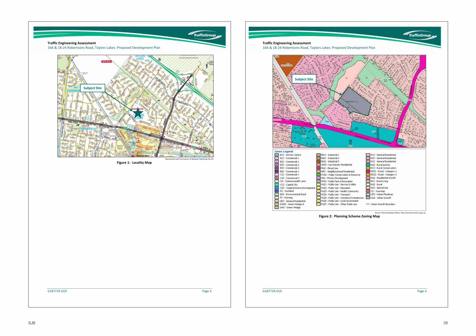
The subject site is located on the north‐eastern corner of the Robertsons Road and McCubbin Drive intersection in Taylors Lakes.
A locality plan of the site is presented at Figure 1.
The site is currently vacant land that was historically used for agricultural purposes.
The site has an existing gate along its Robertsons Road boundary which provides for maintenance vehicle access.
The subject site is zoned ‘General Residential Zone – Schedule 1’ under the Brimbank Planning Scheme as indicated in Figure 2.
Key land‐use in the nearby area include:
Overnewton Anglican Community College is located directly opposite the site on the northwest side of Robertsons Road,
Bunnings Warehouse and other bulky goods retailers are located on the northwest corner of the intersection of Melton Highway and Kings Road to the south of the site, and
Watergardens Shopping Centre is located on the southwest corner of the intersection of Melton Highway and Kings Road to the southeast of the site.
28SJB
Traffic Engineering Assessment 16A & 18‐24 Robertsons Road, Taylors Lakes: Proposed Development Plan
G18771R‐01D Page 3
Figure 1: Locality Map Reproduced with Permission of Melway Publishing Pty Ltd
Subject Site
Traffic Engineering Assessment 16A & 18‐24 Robertsons Road, Taylors Lakes: Proposed Development Plan
G18771R‐01D Page 4
Figure 2: Planning Scheme Zoning Map
Subject Site
Source: Planning Maps Online, http://services.land.vic.gov.au
29SJB
Traffic Engineering Assessment 16A & 18‐24 Robertsons Road, Taylors Lakes: Proposed Development Plan
G18771R‐01D Page 5
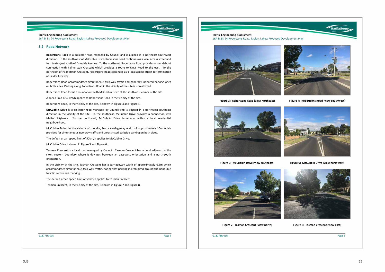
3.2 Road Network
Robertsons Road is a collector road managed by Council and is aligned in a northeast‐southwest direction. To the southwest of McCubbin Drive, Robinsons Road continues as a local access street and terminates just south of Drysdale Avenue. To the northeast, Robertsons Road provides a roundabout connection with Palmerston Crescent which provides a route to Kings Road to the east. To the northeast of Palmerston Crescent, Robertsons Road continues as a local access street to termination at Calder Freeway.
Robertsons Road accommodates simultaneous two‐way traffic and generally indented parking lanes on both sides. Parking along Robertsons Road in the vicinity of the site is unrestricted.
Robertsons Road forms a roundabout with McCubbin Drive at the southwest corner of the site.
A speed limit of 40km/h applies to Robertsons Road in the vicinity of the site.
Robertsons Road, in the vicinity of the site, is shown in Figure 3 and Figure 4.
McCubbin Drive is a collector road managed by Council and is aligned in a northwest‐southeast direction in the vicinity of the site. To the southeast, McCubbin Drive provides a connection with Melton Highway. To the northwest, McCubbin Drive terminates within a local residential neighbourhood.
McCubbin Drive, in the vicinity of the site, has a carriageway width of approximately 10m which provides for simultaneous two‐way traffic and unrestricted kerbside parking on both sides.
The default urban speed limit of 50km/h applies to McCubbin Drive.
McCubbin Drive is shown in Figure 5 and Figure 6.
Tasman Crescent is a local road managed by Council. Tasman Crescent has a bend adjacent to the site’s eastern boundary where it deviates between an east‐west orientation and a north‐south orientation.
In the vicinity of the site, Tasman Crescent has a carriageway width of approximately 6.5m which accommodates simultaneous two‐way traffic, noting that parking is prohibited around the bend due to solid centre line marking.
The default urban speed limit of 50km/h applies to Tasman Crescent.
Tasman Crescent, in the vicinity of the site, is shown in Figure 7 and Figure 8.
Traffic Engineering Assessment 16A & 18‐24 Robertsons Road, Taylors Lakes: Proposed Development Plan
G18771R‐01D Page 6
Figure 3: Robertsons Road (view northeast) Figure 4: Robertsons Road (view southwest)
Figure 5: McCubbin Drive (view southeast) Figure 6: McCubbin Drive (view northwest)
Figure 7: Tasman Crescent (view north) Figure 8: Tasman Crescent (view east)

30SJB
Traffic Engineering Assessment 16A & 18‐24 Robertsons Road, Taylors Lakes: Proposed Development Plan
G18771R‐01D Page 7
3.3 Public Transport
The site has good access to public transport services, including the following services that operate in the nearby area:
Bus Route 421 which operates directly past the site along Robertsons Road and McCubbin Drive and provides a service between St. Albans Railway Station and Watergardens Railway Station via Keilor Plains. This service typically operates every 40 minutes on weekdays.
Watergardens Railway Station is located on the northeast side of Sydenham Road, approximately 1km walking distance to the south of the site.
An additional seven (7) standard bus routes and two (2) NightRider bus routes operate via Watergardens Railway Station, approximately 1km walking distance to the south of the site.
Figure 9 below shows the public transport routes within the area nearby to the site.
Figure 9: Public Transport Map
Source: Public Transport Victoria, ptv.vic.gov.au
Subject Site
Traffic Engineering Assessment 16A & 18‐24 Robertsons Road, Taylors Lakes: Proposed Development Plan
G18771R‐01D Page 8
3.4 Existing Traffic Conditions
Traffix Group has undertaken peak period turning movement counts and observational surveys at the following intersections during both the AM and PM peak periods:
Robertsons Road & McCubbin Drive.
Robertsons Road & Tasman Crescent & Overnewton College access.
Turning movement counts were undertaken on Tuesday 7th February, 2017 between 8:00‐9:00am and 2:30‐6:00pm.
The AM peak hour occurred between 8:00‐9:00am. The PM peak hour occurred between 3:15‐4:15pm which coincides with the school pick‐up period of Overnewton College, whilst the commuter peak hour occurred between 5:00‐6:00pm.
A summary of the recorded peak hour turning movements during each of the peak hours is attached at Appendix B.
It is noted that Traffix Group previously undertook traffic counts at the same intersections in September, 2015 with similar turning movement volumes recorded and operating conditions observed.
During our traffic counts, we observed conditions at both intersections and also along Robertsons Road in general. A brief summary is as follows:
Robertsons Road/McCubbin Drive roundabout
During the AM period, there were minimal queues and delays observed. In particularl, small queues formed for small periods only and dissipated fairly quickly.
During the PM period, there were minimal queues and delays observed. Similarly, to the AM period, small queues formed for small periods only and dissipated fairly quickly.
The south was observed to generate minimal traffic.
The west leg provides access to a closed residential catchment that generates a relatively low amount of local traffic only.
Majority of movements are right‐turn (east to north) or left‐turn (north) which are non‐conflicting movements in terms of intersection priority.
Robertsons Road/Tasman Crescent/Overnewton College roundabout
Between approximately 8:30‐9:00am, queues on the south leg were observed as a result of vehicles turning left into the school. Long queues were observed for a short period after 8:45am (11‐18 vehicles at peak times) as a result of drop‐off activity within the school.
No queues or delays were observed after approximately 9am.
Between approximately 3:20‐3:40pm, queues (approx. 8 vehicles at peak times) were observed on the south leg as a result of school pick‐up activity.
No queues or delays were observed after approximately 3:45pm.

31SJB
Traffic Engineering Assessment 16A & 18‐24 Robertsons Road, Taylors Lakes: Proposed Development Plan
G18771R‐01D Page 9
We also observed that indented parking along Robertsons Road in the vicinity of the school is heavily used during both the drop‐off and pick‐up periods.
Whilst the Robertsons Road/Tasman Crescent/Overnewton College access roundabout has queuing on the south leg for short periods during school drop‐off/pick‐up periods only, this is not unexpected or uncommon for roads adjacent to schools. We don’t see there being any issues for site access during these periods given that there are suitable alternative access routes available to and from the wider road network. Furthermore, the peak periods for traffic generated by the site won’t necessarily correspond with the school drop‐off/pick‐up periods, particularly during the PM peak period which occurs much later that the school pick‐up period.
4 Internal Traffic Matters
4.1 Traffic Generation
The RTA Guide to Traffic Generating Developments (2002) (RTA Guide) sets out traffic generation rates based on survey data collected in New South Wales for a range of land uses. This guide is used by VicRoads and is generally regarded as the standard for metropolitan development characteristics.
The RTA Guide sets out the following weekday daily traffic generation rates:
standard residential dwellings = 9.0 per dwelling
medium density housing:
o Smaller units and flats (up to two bedrooms) = 4.0‐5.0 per dwelling
o Larger units and townhouses (three or more bedrooms) = 5.0‐6.5 per dwelling
However, the RTA Guide states that ... “The Australian Model Code for Residential Development (AMCORD) assumes a daily vehicle generation rate of 10.0 per dwelling, with 10% of that taking place in the commuter peak period. The use of these figures provides some allowance for later dual occupancy development.”
If we conservatively adopt a rate of 10 vehicle trip‐ends (vte) per day per allotment, then it is predicted that no more than 1,730 daily vehicle trip‐ends would be generated based on a development of 173 lots.
Council’s Engineering Guidelines and Specifications for the Design and Construction of Roads and Drainage Works specifies the following environmental capacity for the type of roads to be provided within the site:
Residential Access Street 1 – 1,000‐2,000vpd
Residential Access Street 2 – 2,000‐3,000vpd
Based on the above, we are satisfied the anticipated daily traffic volumes will be adequately accommodated by the proposed internal road network and cross‐sections discussed in more detail later in this report.
Based on our experience, it is appropriate to assume that 8% of the weekday daily volumes occur during the AM and PM commuter peak hours. This is consistent with case studies undertaken by Traffix
Traffic Engineering Assessment 16A & 18‐24 Robertsons Road, Taylors Lakes: Proposed Development Plan
G18771R‐01D Page 10
Group for outer metropolitan residential estates in Melbourne and also regularly adopted for traffic modelling undertaken for the preparation of Precinct Structure Plans.
However, for the purposes of our assessments we will conservatively assume that 10% of the weekday daily volume occurs during the AM and PM commuter peak hours which equates to 173 vehicle movements.
During the school PM peak hour we will conservatively assume that 8% of the weekday daily volumes are generated given our experience that residential traffic volumes are typically lower than the commuter peak hours. This calculates to 138 vehicle movements during the school pick‐up period.
4.2 Traffic Distribution
Based on our experience, we have adopted the following entry/exit proportions for site generated residential traffic during the AM and PM peak hours:
AM Peak Hour – 20% entry and 80% exit
PM Peak Hours – 60% entry and 40% exit
Based on review of the surrounding road network and intersections, we have estimated directional proportions to/from the surrounding road as shown in Figure 10 and Figure 11.
Figure 10: Predicted Traffic Distribution and Routes (Departures)
Subject Site
35%
5%
50%
10% 60%
40%
Reproduced with Permission of Melway Publishing Pty Ltd

32SJB
Traffic Engineering Assessment 16A & 18‐24 Robertsons Road, Taylors Lakes: Proposed Development Plan
G18771R‐01D Page 11
Figure 11: Predicted Traffic Distribution and Routes (Arrivals)
We have conservatively assumed that 50% of traffic travelling to/from the north would enter/exit the site via McCubbin Drive and therefore travel via the McCubbin/Robertsons Road roundabout. Similarly, we have conservatively assumed that 50% of traffic travelling to/from the south would enter/exit the site via Robertsons Road and therefore travel via the McCubbin/Robertsons Road roundabout.
However, in reality, less site generated traffic will actually be generated at each of the two roundabouts discussed above. This is partly because some traffic may use Tasman Crescent and largely because much less than 50% of traffic travelling to/from the north and south will actually travel through the roundabouts as conservatively assumed above
Based on the above, the conservatively predicted AM, PM school, and PM commuter peak hour traffic volumes generated by the development are attached at Appendix C.
4.3 Intersection Analysis
We have used SIDRA Intersection 7.0 to undertake an assessment of the performance of post‐development operating conditions of the following key intersections in the vicinity of the site:
Robertsons Road & McCubbin Drive.
Robertsons Road & Tasman Crescent & Overnewton College access.
SIDRA is a computer simulation package which assesses the operating performance of proposed intersections. A summary of the key outputs is as follows:
Subject Site
40%
50%
10% 60%
40%
Reproduced with Permission of Melway Publishing Pty Ltd
Traffic Engineering Assessment 16A & 18‐24 Robertsons Road, Taylors Lakes: Proposed Development Plan
G18771R‐01D Page 12
Degree of Saturation (DoS) – The ratio of traffic volume to maximum capacity for a particular turning movement.
Average Delay (Avg. Delay) – The average delay in seconds for a vehicle making a particular turning movement.
95th Percentile Queue (95% Queue) – The 95% percentile queue is the length in metres which 95 per cent of all observed cycle queues fall below (or 5% exceed) during the peak analysis period.
We have adopted SIDRA default input values for all parameters.
We have input into SIDRA the predicted AM, PM school and PM commuter peak hour post‐development traffic volumes at both roundabouts as attached at Appendix D.
A detailed output of the SIDRA analysis is attached at Appendix E with a summary provided following:
Robertsons Road and McCubbin Drive
AM ‐ A maximum average delay of 12 seconds and 95th percentile queue distance of 11m (less than two vehicles) for any leg of the roundabout.
PM School Peak Hour ‐ A maximum average delay of 12 seconds and 95th percentile queue distance of 11m for any leg of the roundabout.
PM Commuter Peak Hour ‐ A maximum average delay of 12 seconds and 95th percentile queue distance of 13m (approximately two vehicles) for any leg of the roundabout.
Robertsons Road/Tasman Crescent/Overnewton College
AM ‐ A maximum average delay of 10 seconds and 95th percentile queue distance of 10m for any leg of the roundabout.
PM School Peak Hour ‐ A maximum average delay of 11 seconds and 95th percentile queue distance of 7m for any leg of the roundabout.
PM Commuter Peak Hour ‐ A maximum average delay of 11 seconds and 95th percentile queue distance of 4m (less than 1 vehicle) for any leg of the roundabout.
For the Robertsons Road/McCubbin Drive roundabout, we are satisfied that this intersection will continue to operate with excellent conditions following development of the site as consistent with the SIDRA results, including during the school drop‐off and afternoon peak periods. In fact, we expect that vehicle movements generated by majority of the future allotments don’t need to travel through this roundabout given that residents have access to both Robertsons Roads and McCubbin Drive via the site’s internal road network.
For the Robertsons Road/Tasman Crescent/Overnewton College roundabout, the SIDRA output doesn’t accurately represent the existing operating conditions during the AM and PM school peak hour periods as per the discussion provided previously at Section 3.4. In particular, due to internal queuing/congestion within Overnewtown College, queues on the southwest leg of the roundabout are created for short periods during school drop‐off and pick‐up periods. Nevertheless, we don’t see there being any issues for site access given that there are suitable alternative access routes available to and from the wider road network and future residents will be able to avoid this intersection during the school drop‐off and pick‐up periods if desired. We also note that these queues at peak times did not

33SJB
Traffic Engineering Assessment 16A & 18‐24 Robertsons Road, Taylors Lakes: Proposed Development Plan
G18771R‐01D Page 13
extend as far as the proposed site access with Robertsons Road. In any case, queues during school peak periods will never impact the ability for vehicles to turn left out of the site onto Robertsons Road.
Based on the output of the SIDRA analysis and the above discussion relating to school drop‐off/pick‐up periods, we are satisfied that traffic predicted to be generated by the proposed development plan will be adequately accommodated by the surrounding road network and intersection including the Robertsons Road/McCubbin Drive and Robertsons Road/Tasman Crescent/Overnewton College roundabouts.
4.4 Road Cross‐Sections
All road reservations are to be provided to ensure the future characteristics of each street are in accordance with Clause 56.06‐8 of the Brimbank Planning Scheme and meet the objectives of Council’s Engineering Guidelines and Specifications for the Design and Construction of Roads and Drainage Works.
Each of the proposed road/street types are outlined below.
4.4.1 Local Access Street Level 2
There are two (2) Local Access Street Level 2s identified in the proposed internal road network which are to provide connections with the external road network.
These roads are shown to have 18m wide road reservations and will accommodate the cross‐section shown at Figure 12.
The proposed carriageway width of 7.5m for these roads can accommodate parking on both sides of the road and a single lane of through traffic. Alternatively, simultaneous two‐way traffic can be accommodated when vehicles are parked on one side of the road only.
Footpaths are to also be provided on both sides of all of these roads.
Figure 12: Local Access Street Cross‐Section (18m)
Traffic Engineering Assessment 16A & 18‐24 Robertsons Road, Taylors Lakes: Proposed Development Plan
G18771R‐01D Page 14
4.4.2 Local Access Street Level 1
The remainder of roads within the proposed Development Plan are to be local access roads with 16m wide road reservations and will accommodate the cross‐section shown at Figure 13.
The proposed carriageway width of 7.3m for these roads can also accommodate parking on both sides of the road and a single lane of through traffic. Alternatively, simultaneous two‐way traffic can be accommodated when vehicles are parked on one side of the road only.
Footpaths are to also be provided on both sides of all of these roads.
Figure 13: Local Access Street Cross‐Section (16m)
4.5 Access for Service and Emergency Vehicles
Adoption of the minimum carriageway widths for the various street types as discussed previously in this report will adequately facilitate relevant service and emergency vehicles and is consistent with the typical CFA requirements.
No permeant ‘dead‐end’ roads are proposed within the Development Plan layout. Although a number of ‘extended driveways’ are identified throughout the layout, these ‘dead‐ends’ are short (well less than 50m). As such, it would be appropriate for future residents to wheel their waste bins to the nearby through street for collection. These extended driveways are also in accordance with CFA requirements given that the ‘dead‐ends’ are to be less than 60m long.
Accordingly, we are satisfied that appropriate access is to be provided for emergency and service vehicles and no permanent turning treatments are necessary, noting that some consideration for temporary turning treatments may be required depending on development staging.

34SJB
Traffic Engineering Assessment 16A & 18‐24 Robertsons Road, Taylors Lakes: Proposed Development Plan
G18771R‐01D Page 15
4.6 Pedestrian and Cycling Access
Footpaths and informal bicycle provisions can be provided in accordance with the objectives of the Planning Scheme and current practice.
Footpaths are to be provided on both sides of the development’s internal roads. Furthermore, we understand that footpaths are to be provided within the open space identified in the southern part of the site.
The plan shown at Figure 14 (prepared by SMEC) identifies the two Access Street Level 2 streets as being bicycle routes. We are satisfied that bicycles can be appropriately and safely accommodated informally within the carriageway of each of these roads. Furthermore, bicycle activity can be adequately accommodated within the proposed carriageways throughout the remainder of the site in a fashion that is consistent with current practice.
Figure 14: Bicycle Network & Bus Stop Locations
4.7 Public Transport Considerations
Existing bus stops are located on both sides of Robertsons Road adjacent to the site.
As a result of new vehicle crossings being required for the proposed future allotments fronting Robertsons Road, the existing bus stop on the east side of Robertsons Road may need to be relocated, subject to approval by Public Transport of Victoria. This will be considered at the detailed design stage when vehicle crossings have been designed and we see no reason to suggest that a suitable outcome could not be achieved.
Traffic Engineering Assessment 16A & 18‐24 Robertsons Road, Taylors Lakes: Proposed Development Plan
G18771R‐01D Page 16
We are satisfied that the site has a satisfactory level of accessibility to existing bus services and also Watergardens Railway Station as outlined previously at Section 3.3.
4.8 Traffic Control
Clause 56.06‐7 of the Planning Scheme suggests that it is desirable for street blocks to be no more than approximately 240m long in order “to facilitate pedestrian movement and control traffic speed”.
The only road proposed within the Development Plan that is longer than 240m is the Access Street Level 2 which is to provide a connection between Robertsons Road and Tasman Crescent. We recommend that a traffic management device be considered at the intersection of the two Access Streets Level 2s as identified in Figure 15 to ensure that appropriate speed control objectives are achieved.
Although traffic calming is only necessary at one location under the Planning Scheme, it is acknowledged that Council may require additional traffic calming measures within the site.
All T‐intersections are to be appropriately aligned at 90 degrees and staggered where relevant. Standard unsignalised control should be provided for all T‐intersections. No cross‐intersections are identified within the site.
Figure 15: Indicative Traffic Management Location
Traffic Management Device
35SJB
Traffic Engineering Assessment 16A & 18‐24 Robertsons Road, Taylors Lakes: Proposed Development Plan
G18771R‐01D Page 17
5 Car Parking Considerations
The statutory resident car parking rates for a medium‐density residential development under Clause 52.06 of the Planning is as follows:
1 resident space to each one or two bedroom dwelling, and
2 resident spaces to each three or more bedroom dwelling.
Although the above rates aren’t specifically a requirement for the future development of the site given standard residential allotments are proposed, resident parking for the future allotments should be provided in accordance with the above rates as a minimum. This could be in the form of single or double garages for each dwelling (potentially with tandem parking), with suitable access arrangements to be provided.
Under Clause 56.06‐8 of the Planning Scheme, the requirement for a residential estate is at least one (1) on‐street parking space per two (2) lots for visitors.
All of the site’s internal roads are to be provided with a carriageway width of at least 7.3m which is sufficient to accommodate kerbside parking on both sides for visitors. Furthermore, visitor parking demands could also be accommodated along the streets adjacent to the site including Robertsons Road and McCubbin Drive, particularly for visitors of future allotments with frontages to these roads.
The location of vehicle crossings for each of the proposed allotments should be designed at the detailed design stage with the aim of maximising on‐street parking opportunities. Nevertheless, we are of the opinion that the Planning Scheme requirement of at least one (1) on‐street parking space per two (2) lots for visitors can be easily achieved throughout the internal roads and abutting the site along the existing streets.
Based on the above, we are satisfied that the proposed Development Plan provides sufficient opportunities to accommodate resident and visitor parking demands generated by future residential development of the site.
6 Bicycle Parking Considerations
Clause 52.34 of the Planning Scheme specifies bicycle parking requirements for new developments and changes in use.
The statutory bicycle parking rates for a ‘dwelling’ use that is four or more storeys is as follows:
1 resident space to each 5 dwellings, and
1 visitor space to each 10 dwellings.
There will not be a statutory bicycle parking requirement given the future development will be less than four storeys.
Nevertheless, we are satisfied that resident and visitor bicycles can be stored with the curtilage of each future dwelling consistent with the typical arrangements for similar developments.
Traffic Engineering Assessment 16A & 18‐24 Robertsons Road, Taylors Lakes: Proposed Development Plan
G18771R‐01D Page 18
We further understand that bicycle rails are to be provided in the park/open space identified at the southern boundary of the site which is excess of what would typically be provided for a residential subdivision.
We are satisfied that an appropriate provision of bicycle parking can be provided on the site.
7 External Access Considerations
Three (3) vehicle connections with the external road network are identified as follows:‐
an access connection with Robertsons Road at the site’s western boundary,
an access connection with McCubbin Drive at the site’s southern boundary, and
an access connection with Tasman Crescent at the site’s eastern boundary.
Each of these connections are to form unsignalised T‐intersections with the external road network.
The proposed vehicle access connections with Robertsons Road and McCubbin Drive are both suitably located when considering the surrounding road network and intersections.
The proposed vehicle connection with Tasman Crescent would assist to distribute traffic via various routes to/from the surrounding road network. We also note that this connection provides for a shorter route to access Kings Way to travel northbound towards the Calder Freeway and therefore provides benefits for future residents of the site.
A modified T‐intersection is the preferred arrangement for the proposed site connection with Tasman Crescent, noting it is anticipated that the existing traffic islands and line marking would need to be modified to accommodate the new intersection configuration. The existing north‐to‐east priority of Tasman Crescent should be retained to discourage the site’s internal road being used as a through route to access Robertsons Road. Alternatively, a roundabout could be considered for this intersection if desired by Council.
Whilst we acknowledge that queuing on Robertsons Road during the school drop‐off/pick‐up periods may encourage vehicles travelling to the north to travel via Tasman Crescent rather than using Robertsons Road, the queuing is only for a 15‐20 minute period for the overall peak hour. Accordingly, it is unlikely to divert that many vehicle trips, particularly when considering that most commuters would depart before the morning school drop‐off and arrive home after the afternoon pick‐up peak periods.
We are satisfied that the proposed access arrangements with the external road network will adequately facilitate all traffic that will ultimately be generated by the development site and that there will be no unreasonable impacts on the existing road network and intersections.

36SJB
Traffic Engineering Assessment 16A & 18‐24 Robertsons Road, Taylors Lakes: Proposed Development Plan
G18771R‐01D Page 19
8 Conclusions
Having undertaken a detailed traffic engineering assessment of the proposed Proposed Development Plan at 16A & 18‐24 Robertsons Road, Taylors Lakes, we are of the opinion that:
a) the proposed road reservations are consistent with what is required to accommodate appropriate carriageways, footpaths, services, etc. and appropriately facilitate all relevant user groups in accordance with relevant standards and current practice,
b) all relevant vehicles will be able to adequately access and circulate through the site including service and emergency vehicles subject to the appropriate design of intersections at the detailed design stage,
c) all roads will adequately accommodate pedestrians and informal bicycle provisions in accordance with the objectives of the Planning Scheme and current practice,
d) the proposed Development Plan provides sufficient opportunities to accommodate resident and visitor parking demands generated by future residential development of the site,
e) traffic predicted to be generated by the proposed subdivision will be adequately accommodated by the internal road layout and proposed external access connections and will not have any unacceptable impacts on the operating conditions of the surrounding road network including Overnewtown College during school drop‐off and pick‐up periods, and
f) there are no traffic engineering reasons why the proposed Development Plan should not be approved.
Traffic Engineering Assessment 16A & 18‐24 Robertsons Road, Taylors Lakes: Proposed Development Plan
G18771R‐01D
Appendix B Turning Movement Counts
Summary

37SJB
Robe
rtsons Roa
d, Taylors La
kes
AM Peak Existing
21 10 390
4617
920
0
013
211
010
912 30 14
00
00 0
0
30 158 2
618
1618
80
00
0
20
04
60
230
53 0
Subject S
ite
Robertsons Road
McCub
bin Drive
TasmanCrescent
Overne
wton
College
Tasm
an Crescen
t
Robe
rtsons Roa
d, Taylors La
kes
PM Peak Existing‐ Schoo
l Peak Ho
ur18 13 43
429
153
202
060
7816
117 15 7
00
00 0
0
15 91 06
4225
197
00
30
20
16
50
150
194 6
Subject S
ite
Robertsons Road
McCub
bin Drive
TasmanCrescent
Overne
wton
College
Tasm
an Crescen
t

38SJB
Robe
rtsons Roa
d, Taylors La
kes
PM Peak Existing‐ Com
muter Peak Ho
ur6 4 26
113
766
0
026
103
130
9 3 7
00
00 0
0
16 112 1
133
274
00
00
30
12
00
125
204 5
Subject S
ite
Robertsons Road
McCub
bin Drive
TasmanCrescent
Overne
wton
College
Tasm
an Crescen
t
Traffic Engineering Assessment 16A & 18‐24 Robertsons Road, Taylors Lakes: Proposed Development Plan
G18771R‐01D
Appendix C Predicted Site Generated
Peak Hour Traffic Volumes
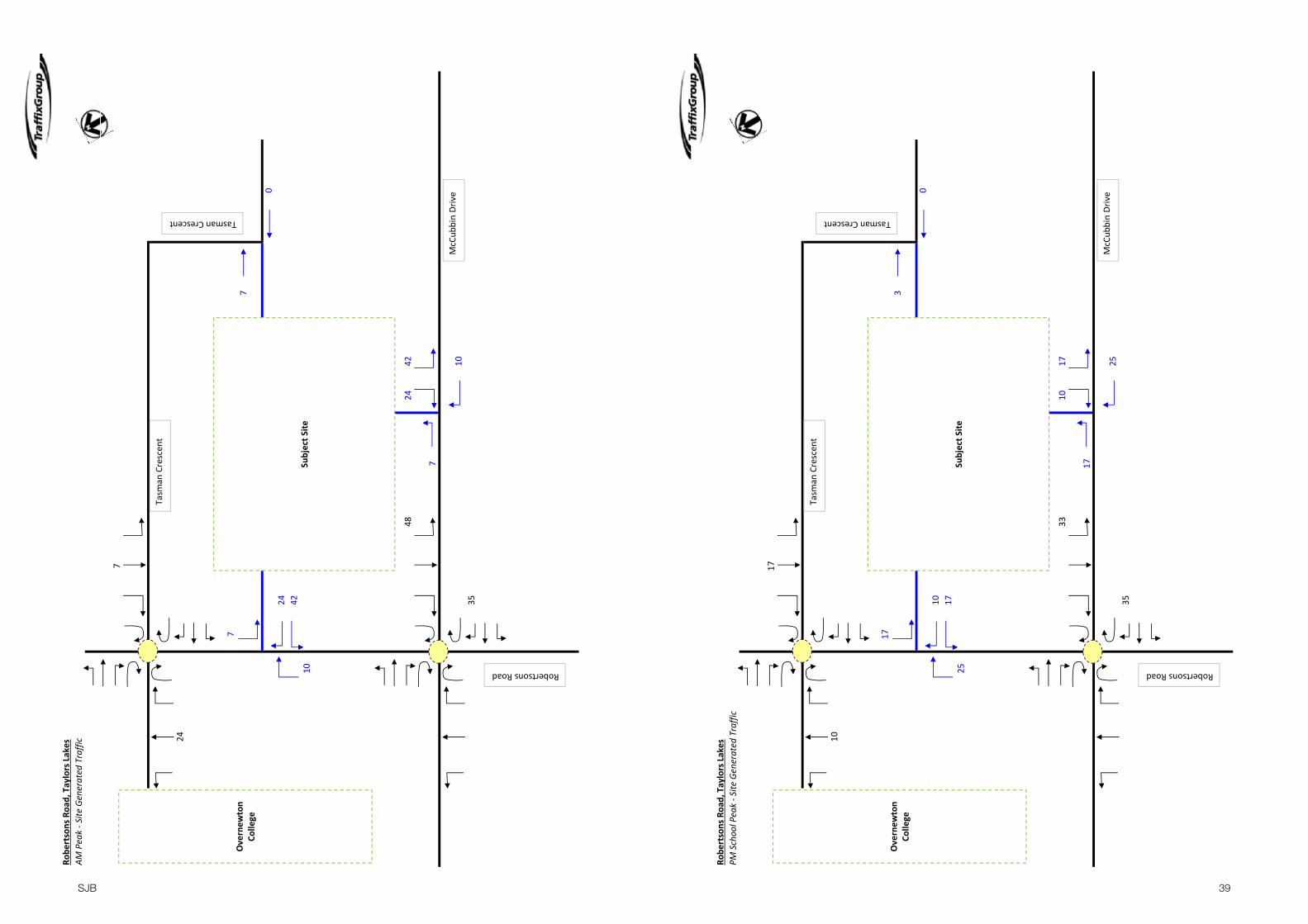
39SJB
Robe
rtsons Roa
d, Taylors La
kes
AM Peak ‐ Site
Generated
Traffic
7
24
77
024 42
10
4824
42
7
1035
Subject S
ite
Robertsons Road
McCub
bin Drive
TasmanCrescent
Overne
wton
College
Tasm
an Crescen
t
Robe
rtsons Roa
d, Taylors La
kes
PM Schoo
l Peak ‐ Site
Generated
Traffic
17
10
173
010 17
25
3310
17
17
2535
Subject S
ite
Robertsons Road
McCub
bin Drive
TasmanCrescent
Overne
wton
College
Tasm
an Crescen
t

40SJB
Robe
rtsons Roa
d, Taylors La
kes
PM Com
muter Peak ‐ Site
Generated
Traffic
21
12
213
012 21
31
4212
21
21
3143
Subject S
ite
Robertsons Road
McCub
bin Drive
TasmanCrescent
Overne
wton
College
Tasm
an Crescen
t
Traffic Engineering Assessment 16A & 18‐24 Robertsons Road, Taylors Lakes: Proposed Development Plan
G18771R‐01D
Appendix D Predicted Post Development Peak Hour Traffic Volumes

41SJB
Robe
rtsons Roa
d, Taylors La
kes
AM Peak ‐ P
ost D
evelop
ment
21 10 390
4618
620
0
013
213
410
912 30 14
77
024 42
10
30 158 2
618
1623
624
420
7
210
04
60
265
53 0
Subject S
ite
Robertsons Road
McCub
bin Drive
TasmanCrescent
Overne
wton
College
Tasm
an Crescen
t
Robe
rtsons Roa
d, Taylors La
kes
PM Schoo
l Peak ‐ P
ost D
evelop
ment
18 13 434
2917
020
2
060
8816
117 15 7
173
010 17
25
15 91 06
4225
230
1017
317
225
16
50
185
194 6
Subject S
ite
Robertsons Road
McCub
bin Drive
TasmanCrescent
Overne
wton
College
Tasm
an Crescen
t

42SJB
Robe
rtsons Roa
d, Taylors La
kes
PM Com
muter Peak ‐ P
ost D
evelop
ment6 4 26
113
976
0
026
115
130
9 3 7
213
012 21
31
16 112 1
133
211
612
210
21
331
12
00
168
204 5
Subject S
ite
Robertsons Road
McCub
bin Drive
TasmanCrescent
Overne
wton
College
Tasm
an Crescen
t
Traffic Engineering Assessment 16A & 18‐24 Robertsons Road, Taylors Lakes: Proposed Development Plan
G18771R‐01D
Appendix E SIDRA Output

43SJB
SITE LAYOUTSite: 1 [Robertsons Road & McCubbin Drive AM - Post]
New SiteRoundabout
SIDRA INTERSECTION 7.0 | Copyright © 2000-2017 Akcelik and Associates Pty Ltd | sidrasolutions.comOrganisation: TRAFFIX GROUP PTY LTD | Created: Wednesday, 15 November 2017 3:03:10 PMProject: P:\Synergy\Projects\GRP1\GRP18771\Analysis\Taylors Lakes Project - 2017.sip7
MOVEMENT SUMMARYSite: 1 [Robertsons Road & McCubbin Drive AM - Post]
New SiteRoundabout
Movement Performance - VehiclesDemand Flows 95% Back of QueueMov
ID ODMov
Deg.Satn
AverageDelay
Level ofService
Prop. Queued
Effective Stop Rate
AverageSpeed Total HV Vehicles Distance
veh/h % v/c sec veh m per veh km/hSouthEast: McCubbin Drive1 L2 1 0.0 0.242 4.6 LOS A 1.5 10.6 0.20 0.60 51.72 T1 56 0.0 0.242 4.8 LOS A 1.5 10.6 0.20 0.60 52.63 R2 279 0.0 0.242 8.3 LOS A 1.5 10.6 0.20 0.60 52.33u U 2 0.0 0.242 10.1 LOS B 1.5 10.6 0.20 0.60 52.9Approach 338 0.0 0.242 7.7 LOS A 1.5 10.6 0.20 0.60 52.4
NorthEast: Robertsons Road4 L2 249 0.0 0.261 5.5 LOS A 1.6 11.2 0.43 0.58 53.05 T1 17 0.0 0.261 5.6 LOS A 1.6 11.2 0.43 0.58 54.06 R2 19 0.0 0.261 9.2 LOS A 1.6 11.2 0.43 0.58 53.76u U 6 0.0 0.261 10.9 LOS B 1.6 11.2 0.43 0.58 54.3Approach 292 0.0 0.261 5.8 LOS A 1.6 11.2 0.43 0.58 53.1
NorthWest: McCubbin Drive7 L2 32 0.0 0.200 6.2 LOS A 1.1 7.7 0.49 0.60 52.68 T1 166 0.0 0.200 6.3 LOS A 1.1 7.7 0.49 0.60 53.59 R2 2 0.0 0.200 9.9 LOS A 1.1 7.7 0.49 0.60 53.29u U 1 0.0 0.200 11.6 LOS B 1.1 7.7 0.49 0.60 53.9Approach 201 0.0 0.200 6.4 LOS A 1.1 7.7 0.49 0.60 53.4
SouthWest: Robertsons Road10 L2 1 0.0 0.013 6.1 LOS A 0.1 0.4 0.47 0.60 51.311 T1 4 0.0 0.013 6.3 LOS A 0.1 0.4 0.47 0.60 52.212 R2 6 0.0 0.013 9.9 LOS A 0.1 0.4 0.47 0.60 52.012u U 1 0.0 0.013 11.6 LOS B 0.1 0.4 0.47 0.60 52.6Approach 13 0.0 0.013 8.5 LOS A 0.1 0.4 0.47 0.60 52.1
All Vehicles 843 0.0 0.261 6.8 LOS A 1.6 11.2 0.35 0.59 52.9
Site Level of Service (LOS) Method: Delay (SIDRA). Site LOS Method is specified in the Parameter Settings dialog (Site tab).Roundabout LOS Method: Same as Signalised Intersections.Vehicle movement LOS values are based on average delay per movement.Intersection and Approach LOS values are based on average delay for all vehicle movements.Roundabout Capacity Model: SIDRA Standard.SIDRA Standard Delay Model is used. Control Delay includes Geometric Delay.Gap-Acceptance Capacity: SIDRA Standard (Akçelik M3D).HV (%) values are calculated for All Movement Classes of All Heavy Vehicle Model Designation.
SIDRA INTERSECTION 7.0 | Copyright © 2000-2017 Akcelik and Associates Pty Ltd | sidrasolutions.comOrganisation: TRAFFIX GROUP PTY LTD | Processed: Wednesday, 15 November 2017 3:03:05 PMProject: P:\Synergy\Projects\GRP1\GRP18771\Analysis\Taylors Lakes Project - 2017.sip7

44SJB
MOVEMENT SUMMARYSite: 1 [Robertsons Road & McCubbin Drive PM School - Post]
New SiteRoundabout
Movement Performance - VehiclesDemand Flows 95% Back of QueueMov
ID ODMov
Deg.Satn
AverageDelay
Level ofService
Prop. Queued
Effective Stop Rate
AverageSpeed Total HV Vehicles Distance
veh/h % v/c sec veh m per veh km/hSouthEast: McCubbin Drive1 L2 1 0.0 0.305 4.9 LOS A 2.0 13.7 0.28 0.56 52.32 T1 204 0.0 0.305 5.0 LOS A 2.0 13.7 0.28 0.56 53.23 R2 195 0.0 0.305 8.6 LOS A 2.0 13.7 0.28 0.56 52.93u U 2 0.0 0.305 10.3 LOS B 2.0 13.7 0.28 0.56 53.5Approach 402 0.0 0.305 6.8 LOS A 2.0 13.7 0.28 0.56 53.1
NorthEast: Robertsons Road4 L2 242 0.0 0.257 5.0 LOS A 1.6 11.0 0.32 0.55 53.15 T1 26 0.0 0.257 5.2 LOS A 1.6 11.0 0.32 0.55 54.16 R2 44 0.0 0.257 8.7 LOS A 1.6 11.0 0.32 0.55 53.86u U 6 0.0 0.257 10.4 LOS B 1.6 11.0 0.32 0.55 54.4Approach 319 0.0 0.257 5.6 LOS A 1.6 11.0 0.32 0.55 53.3
NorthWest: McCubbin Drive7 L2 16 0.0 0.108 5.5 LOS A 0.6 3.9 0.40 0.54 52.88 T1 96 0.0 0.108 5.7 LOS A 0.6 3.9 0.40 0.54 53.89 R2 1 0.0 0.108 9.2 LOS A 0.6 3.9 0.40 0.54 53.59u U 3 0.0 0.108 11.0 LOS B 0.6 3.9 0.40 0.54 54.1Approach 116 0.0 0.108 5.8 LOS A 0.6 3.9 0.40 0.54 53.7
SouthWest: Robertsons Road10 L2 1 0.0 0.016 6.7 LOS A 0.1 0.5 0.53 0.61 51.311 T1 6 0.0 0.016 6.8 LOS A 0.1 0.5 0.53 0.61 52.212 R2 5 0.0 0.016 10.4 LOS B 0.1 0.5 0.53 0.61 51.912u U 1 0.0 0.016 12.1 LOS B 0.1 0.5 0.53 0.61 52.5Approach 14 0.0 0.016 8.6 LOS A 0.1 0.5 0.53 0.61 52.0
All Vehicles 851 0.0 0.305 6.3 LOS A 2.0 13.7 0.32 0.55 53.2
Site Level of Service (LOS) Method: Delay (SIDRA). Site LOS Method is specified in the Parameter Settings dialog (Site tab).Roundabout LOS Method: Same as Signalised Intersections.Vehicle movement LOS values are based on average delay per movement.Intersection and Approach LOS values are based on average delay for all vehicle movements.Roundabout Capacity Model: SIDRA Standard.SIDRA Standard Delay Model is used. Control Delay includes Geometric Delay.Gap-Acceptance Capacity: SIDRA Standard (Akçelik M3D).HV (%) values are calculated for All Movement Classes of All Heavy Vehicle Model Designation.
SIDRA INTERSECTION 7.0 | Copyright © 2000-2017 Akcelik and Associates Pty Ltd | sidrasolutions.comOrganisation: TRAFFIX GROUP PTY LTD | Processed: Wednesday, 15 November 2017 3:03:06 PMProject: P:\Synergy\Projects\GRP1\GRP18771\Analysis\Taylors Lakes Project - 2017.sip7
MOVEMENT SUMMARYSite: 1 [Robertsons Road & McCubbin Drive PM Com - Post]
New SiteRoundabout
Movement Performance - VehiclesDemand Flows 95% Back of QueueMov
ID ODMov
Deg.Satn
AverageDelay
Level ofService
Prop. Queued
Effective Stop Rate
AverageSpeed Total HV Vehicles Distance
veh/h % v/c sec veh m per veh km/hSouthEast: McCubbin Drive1 L2 5 0.0 0.280 4.6 LOS A 1.8 12.5 0.19 0.55 52.62 T1 215 0.0 0.280 4.8 LOS A 1.8 12.5 0.19 0.55 53.63 R2 178 0.0 0.280 8.3 LOS A 1.8 12.5 0.19 0.55 53.33u U 3 0.0 0.280 10.0 LOS B 1.8 12.5 0.19 0.55 53.9Approach 401 0.0 0.280 6.4 LOS A 1.8 12.5 0.19 0.55 53.5
NorthEast: Robertsons Road4 L2 122 0.0 0.138 5.1 LOS A 0.7 5.2 0.32 0.56 53.05 T1 2 0.0 0.138 5.2 LOS A 0.7 5.2 0.32 0.56 54.06 R2 35 0.0 0.138 8.8 LOS A 0.7 5.2 0.32 0.56 53.76u U 1 0.0 0.138 10.5 LOS B 0.7 5.2 0.32 0.56 54.3Approach 160 0.0 0.138 5.9 LOS A 0.7 5.2 0.32 0.56 53.2
NorthWest: McCubbin Drive7 L2 17 0.0 0.124 5.4 LOS A 0.6 4.5 0.37 0.52 53.08 T1 118 0.0 0.124 5.6 LOS A 0.6 4.5 0.37 0.52 54.09 R2 1 0.0 0.124 9.1 LOS A 0.6 4.5 0.37 0.52 53.79u U 1 0.0 0.124 10.8 LOS B 0.6 4.5 0.37 0.52 54.3Approach 137 0.0 0.124 5.6 LOS A 0.6 4.5 0.37 0.52 53.9
SouthWest: Robertsons Road10 L2 1 0.0 0.006 6.5 LOS A 0.0 0.2 0.51 0.58 51.411 T1 2 0.0 0.006 6.6 LOS A 0.0 0.2 0.51 0.58 52.312 R2 1 0.0 0.006 10.2 LOS B 0.0 0.2 0.51 0.58 52.112u U 1 0.0 0.006 11.9 LOS B 0.0 0.2 0.51 0.58 52.6Approach 5 0.0 0.006 8.4 LOS A 0.0 0.2 0.51 0.58 52.2
All Vehicles 703 0.0 0.280 6.1 LOS A 1.8 12.5 0.25 0.54 53.5
Site Level of Service (LOS) Method: Delay (SIDRA). Site LOS Method is specified in the Parameter Settings dialog (Site tab).Roundabout LOS Method: Same as Signalised Intersections.Vehicle movement LOS values are based on average delay per movement.Intersection and Approach LOS values are based on average delay for all vehicle movements.Roundabout Capacity Model: SIDRA Standard.SIDRA Standard Delay Model is used. Control Delay includes Geometric Delay.Gap-Acceptance Capacity: SIDRA Standard (Akçelik M3D).HV (%) values are calculated for All Movement Classes of All Heavy Vehicle Model Designation.
SIDRA INTERSECTION 7.0 | Copyright © 2000-2017 Akcelik and Associates Pty Ltd | sidrasolutions.comOrganisation: TRAFFIX GROUP PTY LTD | Processed: Wednesday, 15 November 2017 3:03:07 PMProject: P:\Synergy\Projects\GRP1\GRP18771\Analysis\Taylors Lakes Project - 2017.sip7

45SJB
SITE LAYOUTSite: 1 [Robertsons Road & Tasman Crescent AM - Post]
New SiteRoundabout
SIDRA INTERSECTION 7.0 | Copyright © 2000-2017 Akcelik and Associates Pty Ltd | sidrasolutions.comOrganisation: TRAFFIX GROUP PTY LTD | Created: Wednesday, 15 November 2017 3:05:52 PMProject: P:\Synergy\Projects\GRP1\GRP18771\Analysis\Taylors Lakes Project - 2017.sip7
MOVEMENT SUMMARYSite: 1 [Robertsons Road & Tasman Crescent AM - Post]
New SiteRoundabout
Movement Performance - VehiclesDemand Flows 95% Back of QueueMov
ID ODMov
Deg.Satn
AverageDelay
Level ofService
Prop. Queued
Effective Stop Rate
AverageSpeed Total HV Vehicles Distance
veh/h % v/c sec veh m per veh km/hSouthEast: Tasman Crescent1 L2 15 0.0 0.059 5.9 LOS A 0.3 2.0 0.44 0.58 52.42 T1 32 0.0 0.059 6.1 LOS A 0.3 2.0 0.44 0.58 53.43 R2 13 0.0 0.059 9.6 LOS A 0.3 2.0 0.44 0.58 53.1Approach 59 0.0 0.059 6.8 LOS A 0.3 2.0 0.44 0.58 53.1
NorthEast: Robertsons Road4 L2 21 0.0 0.204 4.8 LOS A 1.2 8.1 0.24 0.51 53.15 T1 196 0.0 0.204 4.9 LOS A 1.2 8.1 0.24 0.51 54.16 R2 48 0.0 0.204 8.5 LOS A 1.2 8.1 0.24 0.51 53.86u U 1 0.0 0.204 10.2 LOS B 1.2 8.1 0.24 0.51 54.4Approach 266 0.0 0.204 5.6 LOS A 1.2 8.1 0.24 0.51 53.9
NorthWest: Overnewton College7 L2 22 0.0 0.067 5.3 LOS A 0.3 2.4 0.35 0.60 52.08 T1 11 0.0 0.067 5.4 LOS A 0.3 2.4 0.35 0.60 52.99 R2 41 0.0 0.067 9.0 LOS A 0.3 2.4 0.35 0.60 52.69u U 1 0.0 0.067 10.7 LOS B 0.3 2.4 0.35 0.60 53.2Approach 75 0.0 0.067 7.4 LOS A 0.3 2.4 0.35 0.60 52.5
SouthWest: Robertsons Road10 L2 139 0.0 0.236 4.9 LOS A 1.4 9.6 0.28 0.51 53.311 T1 141 0.0 0.236 5.1 LOS A 1.4 9.6 0.28 0.51 54.312 R2 11 0.0 0.236 8.6 LOS A 1.4 9.6 0.28 0.51 54.012u U 9 0.0 0.236 10.4 LOS B 1.4 9.6 0.28 0.51 54.6Approach 300 0.0 0.236 5.3 LOS A 1.4 9.6 0.28 0.51 53.8
All Vehicles 700 0.0 0.236 5.8 LOS A 1.4 9.6 0.29 0.53 53.7
Site Level of Service (LOS) Method: Delay (SIDRA). Site LOS Method is specified in the Parameter Settings dialog (Site tab).Roundabout LOS Method: Same as Signalised Intersections.Vehicle movement LOS values are based on average delay per movement.Intersection and Approach LOS values are based on average delay for all vehicle movements.Roundabout Capacity Model: SIDRA Standard.SIDRA Standard Delay Model is used. Control Delay includes Geometric Delay.Gap-Acceptance Capacity: SIDRA Standard (Akçelik M3D).HV (%) values are calculated for All Movement Classes of All Heavy Vehicle Model Designation.
SIDRA INTERSECTION 7.0 | Copyright © 2000-2017 Akcelik and Associates Pty Ltd | sidrasolutions.comOrganisation: TRAFFIX GROUP PTY LTD | Processed: Wednesday, 15 November 2017 3:03:07 PMProject: P:\Synergy\Projects\GRP1\GRP18771\Analysis\Taylors Lakes Project - 2017.sip7

46 SJB
MOVEMENT SUMMARYSite: 1 [Robertsons Road & Tasman Crescent PM School - Post]
New SiteRoundabout
Movement Performance - VehiclesDemand Flows 95% Back of QueueMov
ID ODMov
Deg.Satn
AverageDelay
Level ofService
Prop. Queued
Effective Stop Rate
AverageSpeed Total HV Vehicles Distance
veh/h % v/c sec veh m per veh km/hSouthEast: Tasman Crescent1 L2 7 0.0 0.030 5.7 LOS A 0.1 1.0 0.41 0.56 52.42 T1 16 0.0 0.030 5.9 LOS A 0.1 1.0 0.41 0.56 53.43 R2 7 0.0 0.030 9.4 LOS A 0.1 1.0 0.41 0.56 53.1Approach 31 0.0 0.030 6.7 LOS A 0.1 1.0 0.41 0.56 53.1
NorthEast: Robertsons Road4 L2 21 0.0 0.186 4.9 LOS A 1.0 7.2 0.26 0.51 53.15 T1 179 0.0 0.186 5.0 LOS A 1.0 7.2 0.26 0.51 54.16 R2 31 0.0 0.186 8.6 LOS A 1.0 7.2 0.26 0.51 53.86u U 4 0.0 0.186 10.3 LOS B 1.0 7.2 0.26 0.51 54.4Approach 235 0.0 0.186 5.6 LOS A 1.0 7.2 0.26 0.51 54.0
NorthWest: Overnewton College7 L2 19 0.0 0.069 5.1 LOS A 0.3 2.4 0.30 0.59 52.08 T1 14 0.0 0.069 5.2 LOS A 0.3 2.4 0.30 0.59 53.09 R2 45 0.0 0.069 8.8 LOS A 0.3 2.4 0.30 0.59 52.79u U 2 0.0 0.069 10.5 LOS B 0.3 2.4 0.30 0.59 53.3Approach 80 0.0 0.069 7.3 LOS A 0.3 2.4 0.30 0.59 52.6
SouthWest: Robertsons Road10 L2 63 0.0 0.141 4.7 LOS A 0.7 5.1 0.20 0.51 53.311 T1 93 0.0 0.141 4.8 LOS A 0.7 5.1 0.20 0.51 54.312 R2 17 0.0 0.141 8.4 LOS A 0.7 5.1 0.20 0.51 54.012u U 12 0.0 0.141 10.1 LOS B 0.7 5.1 0.20 0.51 54.6Approach 184 0.0 0.141 5.4 LOS A 0.7 5.1 0.20 0.51 54.0
All Vehicles 529 0.0 0.186 5.9 LOS A 1.0 7.2 0.25 0.52 53.7
Site Level of Service (LOS) Method: Delay (SIDRA). Site LOS Method is specified in the Parameter Settings dialog (Site tab).Roundabout LOS Method: Same as Signalised Intersections.Vehicle movement LOS values are based on average delay per movement.Intersection and Approach LOS values are based on average delay for all vehicle movements.Roundabout Capacity Model: SIDRA Standard.SIDRA Standard Delay Model is used. Control Delay includes Geometric Delay.Gap-Acceptance Capacity: SIDRA Standard (Akçelik M3D).HV (%) values are calculated for All Movement Classes of All Heavy Vehicle Model Designation.
SIDRA INTERSECTION 7.0 | Copyright © 2000-2017 Akcelik and Associates Pty Ltd | sidrasolutions.comOrganisation: TRAFFIX GROUP PTY LTD | Processed: Wednesday, 15 November 2017 3:03:08 PMProject: P:\Synergy\Projects\GRP1\GRP18771\Analysis\Taylors Lakes Project - 2017.sip7
MOVEMENT SUMMARYSite: 1 [Robertsons Road & Tasman Crescent PM Com - Post]
New SiteRoundabout
Movement Performance - VehiclesDemand Flows 95% Back of QueueMov
ID ODMov
Deg.Satn
AverageDelay
Level ofService
Prop. Queued
Effective Stop Rate
AverageSpeed Total HV Vehicles Distance
veh/h % v/c sec veh m per veh km/hSouthEast: Tasman Crescent1 L2 7 0.0 0.018 5.1 LOS A 0.1 0.6 0.30 0.56 52.42 T1 3 0.0 0.018 5.2 LOS A 0.1 0.6 0.30 0.56 53.33 R2 9 0.0 0.018 8.8 LOS A 0.1 0.6 0.30 0.56 53.0Approach 20 0.0 0.018 6.8 LOS A 0.1 0.6 0.30 0.56 52.8
NorthEast: Robertsons Road4 L2 6 0.0 0.094 4.6 LOS A 0.5 3.3 0.17 0.48 53.55 T1 102 0.0 0.094 4.8 LOS A 0.5 3.3 0.17 0.48 54.56 R2 14 0.0 0.094 8.3 LOS A 0.5 3.3 0.17 0.48 54.26u U 1 0.0 0.094 10.0 LOS B 0.5 3.3 0.17 0.48 54.8Approach 123 0.0 0.094 5.2 LOS A 0.5 3.3 0.17 0.48 54.4
NorthWest: Overnewton College7 L2 6 0.0 0.034 5.1 LOS A 0.2 1.1 0.30 0.60 51.78 T1 4 0.0 0.034 5.2 LOS A 0.2 1.1 0.30 0.60 52.69 R2 27 0.0 0.034 8.8 LOS A 0.2 1.1 0.30 0.60 52.39u U 1 0.0 0.034 10.5 LOS B 0.2 1.1 0.30 0.60 52.9Approach 39 0.0 0.034 7.9 LOS A 0.2 1.1 0.30 0.60 52.2
SouthWest: Robertsons Road10 L2 27 0.0 0.116 4.5 LOS A 0.6 4.1 0.12 0.48 53.811 T1 121 0.0 0.116 4.7 LOS A 0.6 4.1 0.12 0.48 54.812 R2 14 0.0 0.116 8.2 LOS A 0.6 4.1 0.12 0.48 54.512u U 1 0.0 0.116 9.9 LOS A 0.6 4.1 0.12 0.48 55.1Approach 163 0.0 0.116 5.0 LOS A 0.6 4.1 0.12 0.48 54.6
All Vehicles 345 0.0 0.116 5.5 LOS A 0.6 4.1 0.17 0.50 54.1
Site Level of Service (LOS) Method: Delay (SIDRA). Site LOS Method is specified in the Parameter Settings dialog (Site tab).Roundabout LOS Method: Same as Signalised Intersections.Vehicle movement LOS values are based on average delay per movement.Intersection and Approach LOS values are based on average delay for all vehicle movements.Roundabout Capacity Model: SIDRA Standard.SIDRA Standard Delay Model is used. Control Delay includes Geometric Delay.Gap-Acceptance Capacity: SIDRA Standard (Akçelik M3D).HV (%) values are calculated for All Movement Classes of All Heavy Vehicle Model Designation.
SIDRA INTERSECTION 7.0 | Copyright © 2000-2017 Akcelik and Associates Pty Ltd | sidrasolutions.comOrganisation: TRAFFIX GROUP PTY LTD | Processed: Wednesday, 15 November 2017 3:03:09 PMProject: P:\Synergy\Projects\GRP1\GRP18771\Analysis\Taylors Lakes Project - 2017.sip7

sjb.com.au
We create spaces people love. SJB is passionate about the possibilities of architecture, interiors, urban design and planning. Let’s collaborate.
Level 1, 80 Dorcas StreetSouthbank VIC 3006AustraliaT. 61 3 8648 [email protected] sjb.com.au
SJB Planning