development of a web-based multi-criteria spatial decision support system for the assessment of...
TRANSCRIPT

Computers and Electronics in Agriculture 108 (2014) 46–57
Contents lists available at ScienceDirect
Computers and Electronics in Agriculture
journal homepage: www.elsevier .com/locate /compag
Development of a Web-based Multi-criteria Spatial Decision SupportSystem for the assessment of environmental sustainability of dairyfarms
http://dx.doi.org/10.1016/j.compag.2014.06.0090168-1699/� 2014 Elsevier B.V. All rights reserved.
⇑ Corresponding author at: Polytechnic Institute of Viana do Castelo, PraçaGeneral Barbosa 4900-347, Viana do Castelo, Portugal. Tel.: +351 258 809 610, +351239 851040/9; fax: +351 258 829 065, +351 239 824692.
E-mail address: [email protected] (S. Silva).1 Tel.: +351 239 851040/9, +351 239 790 500; fax: +351 239 824692, +351 239 790
514.
Sandra Silva a,b,⇑, Luís Alçada-Almeida b,c,1, Luís C. Dias b,c,1
a Polytechnic Institute of Viana do Castelo, Praça General Barbosa 4900-347, Viana do Castelo, Portugalb Institute for Systems Engineering and Computers, Rua Antero de Quental, N�199, 3000-033 Coimbra, Portugalc Faculty of Economics, University Coimbra, Av. Dias da Silva, 165, 3004-512 Coimbra, Portugal
a r t i c l e i n f o
Article history:Received 9 August 2013Received in revised form 24 June 2014Accepted 26 June 2014
Keywords:Multicriteria Decision AidGeographic Information SystemsSpatial Decision Support SystemsWeb MCDA Algorithm ServerELECTRE TRISustainability analysis
a b s t r a c t
The assessment of the environmental sustainability of agricultural infrastructures involves the use ofmultiple evaluation criteria and the analysis of geographical information. A Geographic Information Sys-tem (GIS) is a computer system capable of assembling, storing, analysing, and displaying geographicallyreferenced information. However, the GIS technology still suffers from several shortcomings due in largepart to a lack of capable analytical capacity of supporting spatial decision problems. The most commonsolution for GIS to evolve into an effective tool for decision support is to couple them with operationalresearch tools and in particular Multicriteria Decision Aid (MCDA). Due to the technological advancesin the field of information systems, there is a great need to research how to integrate GIS, MCDA, theInternet, modeling and databases aiming at creating Web Multicriteria Spatial Decision Support Systems(Web MC-SDSSs). A Web MC-SDSS methodological framework is proposed for a fully integrated system ofGIS and a specific MCDA method – ELECTRE TRI, through the construction of a Macro written in VisualBasic for Applications (VBA) in ArcGIS software. This macro interacts with a Web Algorithm Server forcomputing MCDA results. The developed Web MC-SDSS, named ELECTRE TRI in ArcGIS, is applied on acase study analysing the environmental sustainability of dairy farms in the Entre-Douro-e-Minho(EDM) Region.
� 2014 Elsevier B.V. All rights reserved.
1. Introduction
Spatial decision problems in agriculture and other areas oftenrequire that a large number of alternatives are evaluated basedon multiple criteria. Geographic Information Systems (GIS) are apowerful tool for analysing spatial data and establishing a processfor decision support. Multicriteria Decision Aid (MCDA) methodscan facilitate decision making in situations where several solutionsare available, various criteria have to be taken into account anddecision makers are in conflict (Dias et al., 2002).
The combination of spatial analysis with MCDA has allowed thecreation of Multicriteria Spatial Decision Support Systems(MC-SDSS), whose aim is to formulate and support spatial decision
problems. This process involves the use of geographical data, thedecision maker’s (DM) preferences and the manipulation of thedata and preferences according to specified decision rules (Sharifiand Retsios, 2004; Malczewski, 2006).
The integration of MCDA tools in GIS has been used in severalprojects and studies from different areas over the last twenty yearsas evidenced by the survey by Malczewski (2006). One of the mostremarkable features of the GIS-MCDA approaches is the wide rangeof decision and management situations in which they have beenapplied, such as environment/ecology, transportation, urban/regio-nal planning, waste management, hydrology, agriculture, forestry,geology, or site selection. Among some works, we highlight theworks of Joerin et al. (2001), Gilliams et al. (2005), Aydin et al.(2010), Marinoni (2004), Eldrandaly et al. (2005), Boroushaki andMalczewski (2008), Vogel (2008), applied in different areas. Inthese applications the flexibility in representing and analysing spa-tial information is particularly pertinent as it is assumed that about80% of the data used by decision-maker (DM) in decision processesare geographically interrelated (Worrall, 1991).

S. Silva et al. / Computers and Electronics in Agriculture 108 (2014) 46–57 47
Current developments in computational speed, storage vol-umes, World Wide Web (WWW) global access and software inte-grated development environments (IDE) provide opportunities todevelop SDSS exploring both the advantage of information dissem-ination for DMs and the integration of GIS-MCDA. One of the great-est benefits of using Web Services in spatial decision making is thepotential to overcome limited resources in terms of time, data andcommunication. The web enabled GIS facilitates decision makingand serves as a gateway for decision makers and general users toaccess the system conveniently and effectively.
The typical Web SDSS is a Web-based GIS, where GIS informa-tion implemented in World Wide Web environment (Google Maps,and others) and Open Source GIS software is used, where MCDAmethods are integrated. In this paper we develop a distinct WebSDSS: a Web-based Multicriteria Decision Aid in GIS software. ThisWeb MC-SDSS integrates an MCDA method which is solved by aWeb-based Algorithms Server that contains various MCDA tools,according to a clearly defined communication protocol. This inte-gration uses the ArcGIS commercial software as user front-end.The Web MC-SDSS interface created named ELECTRE TRI in ArcGISis a full integration of the MCDA outranking ELECTRE TRI methodand GIS through the construction of a macro written in Visual Basicfor Applications (VBA) programmed in ArcGIS 9.3 of ESRI. Thisinterface is capable of: (1) providing mechanisms for the input ofspatial data; (2) allowing representation of the spatial relationsand structures; (3) applying the analytical techniques of spatialand geographical analysis; (4) providing output in a variety of spa-tial forms, including maps; (5) performing sensitivity analysis.
The resulting Web MC-SDSS was developed to address a real-world case study of decision analysis to assess environmental sus-tainability of dairy farms in Portuguese region, although it can beapplied to other studies in different areas. Namely, the systemwas used to classify 1705 dairy farms in the Entre-Douro-e-Minho(EDM) Region according to environmental sustainability criteria.Seven environmental criteria were defined by three experts fromEnvironmental and Zoo-technic areas. The classification allowsdetermining which farms are sustainable from an environmentalperspective, which ones are not sustainable, and, as an intermedi-ate category, which ones are barely sustainable.
This paper is divided into five sections. Sections 2 and 3 offers abrief literature review regarding the Multicriteria Spatial DecisionSupport Systems, characterizing their types and directions of inte-gration of MCDA and GIS as well as integrations available in GISsoftware and the development of Web MC-SDSS. In Section 4, thecase study with description of problem and the criteria involvedas well as the characterization of the chosen method, ELECTRETRI, is presented. In Section 5, we introduce the MC-SDSS approach,enhancing the type of developed integration of GIS-MCDA, as wellas the created architecture of MC-SDSS. Finally, in Section 6 theconclusions that have been drawn from the study are presentedencouraging the opportunities for expanding the work.
2. Multicriteria Spatial Decision Support Systems
Finlay (1994) defines a Decision Support Systems (DSS) broadlyas ‘‘a computer-based system that aids the process of decisionmaking.’’ The basic idea of DSS is to provide a computer-basedframework that integrates database management systems withanalytical models and graphics to improve the decision-makingprocess. Spatial Decision Support Systems (SDSS) are a class ofcomputer systems in which the technologies of both GIS and DSSare applied to aid decision makers with problems that have a spa-tial dimension (Walsh, 1992).
GIS and MCDA are currently the two most common decisionsupport tools employed to solve spatial decision-making problems.
Some authors consider GIS itself as a form of SDSS. However, GIS iswidely recognised as a computer based system that combines spa-tial database management, geo-statistical analysis and mappingbut not more than that (Laaribi et al., 1996; Van der Meulen,1992; Malczewski, 1999). GIS can provide the decision makerswith spatial information but it does not provide any type of prefer-ence modelling for decision support. Conventional MCDA tech-niques are mostly non spatial in nature and are subject to theassumption that the area under consideration is spatially homoge-neous. This assumption makes such techniques unrealistic as, inmany cases, performance criteria vary across the space.
In recent years, to avoid the limitations of each system (GIS andMCDA) in the area of spatial decision support, the idea of integratingGIS with different MCDA modelling has emerged in different areas ofapplication such as: land suitability (Marinoni, 2004; Santé-Riveiraet al., 2008), route location (Jankowski and Richard, 1994), risk-based in natural hazards (Chen et al., 2001), bank branch closures(Zhao and Garner, 2001), land management (Joerin and Musy,2000), and location of undesirable facilities (Ferretti, 2011).
Abel et al. (1994) have identified three major advantages ofintegration: enhancing the evolution of GIS, improving the desiredlevel of usability, and enriching approaches to problem solving.Therefore, both GIS and MCDA can be made more useful and com-plete through their integration and the effort to combine thestrengths of these technologies would be mutually beneficial toboth communities as well as those participating in decision-mak-ing processes (Parks, 1993). The integration of decision makingtechniques designed to handle multicriteria problems within GIScan provide users with a valuable extension of the functionalityof GIS (Carver, 1991; Goodchild, 1992).
MC-SDSS integrate GIS based data processing and analysis tech-niques as well as MCDA. MC-SDSS provides a consistent frameworkthat allows combining spatial data and decision maker’s prefer-ences according to a selected decision rule. MC-SDSS tools offerunique capabilities for automating, managing and analysing spatialdecision problems with large sets of feasible alternatives and mul-tiple conflicting and incommensurate evaluation criteria.
The way the two components are integrated depends on(Ascough et al., 2002): (1) the MCDA models incorporated intothe MC-SDSS system (e.g., multiobjective versus multiattributedecision analysis techniques; (2) the decision making philosophybehind the design strategy (e.g., a system for supporting a single-user versus collaborative decision making); and (3) specific typesof decision problems concerned (e.g. environmental problems,planning problems, location, etc.).
Operationally, the integrated GIS-MCDA approach starts withthe problem identification, where the capabilities of the GIS areused to define the set of spatial alternatives and the set of criteria.Then, the overlay analysis procedures are used in order to reducean initially large set of alternatives into a small number of alterna-tives which are easily evaluated by using a multicriteria model.Finally, the drawing and presenting capabilities of the GIS are usedto present results (Chakhar and Martel, 2003). There is a large lit-erature on GIS-MCDA integration available (see Malczewski, 2006).
MC-SDSS can be classified according to the extent of integrationand the direction of integration of GIS and MCDA. Integration indi-cates the degree to which functions of software can be controlleddirectly by one another. It refers to the physical and logical connec-tion between the software packages in the system. There are fourpossible modes of physical integration of GIS and multicriteriaanalysis tools (Goodchild, 1992; Chakhar and Martel, 2003;Jankowski, 1995; Malczewski, 1999, 2006, 2010; Chakhar andMousseau, 2008): (i) no integration, (ii) loose integration, (iii) tightintegration, and (iv) full integration. The first mode was dominantuntil the late 80s, when GIS and multicriteria analysis were usedindependently, without any connection between them. The other

48 S. Silva et al. / Computers and Electronics in Agriculture 108 (2014) 46–57
three modes represent increasing levels of complexity and effi-ciency of integration (see Fig. 1).
The loose integration approach (also called MCDA-GIS indirectintegration in Chakhar and Martel, 2003) facilitates the integrationof GIS and MCDA techniques using a file exchange mechanism,named intermediate system (Jankowski, 1995; Malczewski,1999). It involves running MCDA models outside a GIS, using thelatter as a source of data and as a means of displaying the results.Separate tasks are performed in either system (GIS and multicrite-ria modeling system). The loose integration architecture is basedon linking three modules (GIS module, multicriteria techniquemodule and file exchange module), as seen in Fig. 1(a).
The tight integration approach (also called Built-in MCDA-GISmodels in Chakhar and Martel, 2003) are based on a single dataor model manager and a common user interface (Jankowski,1995). Thus, the two systems share not only the communicationfiles but also a common user interface (Fig. 1(b)). In this type ofintegration, a particular multicriteria analysis method is directlyadded to the GIS software. The multicriteria analysis method isan integrated but autonomous part with its own database.
The full integration (also called Complete MCDA-GIS integrationin Chakhar and Martel, 2003) yields itself to a complete GIS-multi-criteria analysis integrated system that has a unique interface anda unique database (Fig. 1(c)). Here, the multicriteria analysismethod is activated directly from the GIS interface as any GIS basicfunction. The GIS database is extended so as to support both thegeographical and descriptive data, on the one hand, and the param-eters required for the multicriteria evaluation techniques (Chakharand Mousseau, 2008) on the other. This approach requires a highlevel of knowledge of the GIS in question and considerable pro-gramming skills. ‘‘Macro language’’ in ArcGIS software facilitiesavailable in a proprietary GIS are used to couple with MCDA mod-els. To provide a full range of decision support functionalities theGIS system needs to be customized.
MC-SDSS can also be classified in terms of the direction of inte-gration. Four categories of approaches can be identified(Malczewski, 2006, 2010; Chakhar and Mousseau, 2008): (i) one-direction integration with GIS as main software, (ii) one-directionintegration with MCDA tool as main software, (iii) bi-directionalintegration, and (iv) dynamic integration. One-direction integra-tion provides a mechanism for importing/exporting informationvia a single flow that originates either in the GIS or MCDA software.In the bi-directional integration approach the flow of data/infor-mation can originate and end in the GIS and MCDA modules. Whilebi-directional integration involves one-time flow of information,dynamic integration allows for a flexible moving of informationback and forth between the GIS and MCDA modules according tothe user’s needs (Malczewski, 2006).
Some MCDA modules were developed in the commercial andopen source GIS software, in the 90s. Loose integration is the firstusage that has been made out of GIS and MCDA capable systems.In the last decade efforts have focused on the development of morecomprehensive solutions in order to couple MCDA and GIS tools in a
(a) (b)
GISIntermediate
SystemUser Interface User
interface
MCDA so�ware
User
GIS IntermediaSystem
User Inter
User
Fig. 1. Scheme modes of integration GIS and MCDA: (a) loo
single interface. These efforts were encouraged by the means pro-vided for preparing, compiling and running macros or plug-ins ondevelopment platforms, which allow writing application programswith programming languages such as Visual Basic, C, C++, Pythonand others (Sugumaran and Degroote, 2011). This approach enablesthe GIS evaluation functions to facilitate the spatial decision mak-ing with multiple criteria. The functions include: generation of deci-sion table, elicitation of decision-maker’s preferences, selection ofaggregation function, and sensitivity analysis (Jankowski, 1995).
The conceptual idea of combining GIS–MCDA is based on the useof GIS capacities to prepare a suitable platform for the use of MCDAmethods. Although numerous applications of GIS-based MCDAmethods have been reported in the literature, MCDA componentsare incorporated in only a few GIS programs (e.g. ARCGIS, IDRISI,ILWIS, QUANTUM, DECERNS, GRASS, Common GIS, etc.,) at the pres-ent time.
A considerable number of decision rules have been proposed inMCDA-GIS integration. The most common are Weight Summation/Boolean Overlay, Ideal/Reference Point, Analytical Hierarchy Pro-cess (AHP) and Outranking methods (ELECTRE and PROMETHEE)(Malczewski, 2006). As for the ELECTRE TRI method and their inte-gration into GIS software, we can cite the following examples:Sobrie (2011) and Sobrie et al. (2013) developed a plug-into imple-ment the ELECTRE TRI algorithm using Python programming lan-guage in QUANTUM software. This interface allows theinteraction between selection of alternatives, determining theparameters for the ELECTRE TRI and visualization of the resultsthrough a generation of a decision map out of a multicriteriamap, i.e. it is defined as a full integration GIS-MCDA interface(Sobrie and Pirlot, 2012). Boggia et al. (2011) implemented a mod-ule named r.mcda.electre for MCDA in GRASS software, written inC language. Chakhar and Mousseau (2009) have developed a proto-type created with the ArcGIS and the ELECTRE TRI method, usingVBA. The prototype allows creating criteria maps, inferring prefer-ence parameters for ELECTRE TRI, assigning spatial unit categories,and generating decision alternatives based on a planar subdivision.Mendas and Delali (2012) incorporate the ELECTRE TRI in ArcGIS toassessing land suitability for agriculture.
The use of MCDA methods to assess the sustainability of agri-culture is still scarce. Raju et al. (2000) implements a multi-criteriaanalysis for sustainable water resources planning using ELECTRETRI and other MCDA techniques. Antunes et al. (2011) presentthe development of a participatory multicriteria analysis processusing AHP and SMCE (Social Multi-Criteria Evaluation) for the eval-uation of irrigation management alternatives. Van Calker et al.(2006) apply MAUT for an economic, social and ecological assess-ment of sustainability, to Dutch dairy farms. Dantsis et al. (2010)use MAVT to evaluate and compare the level of sustainability offarms in two Greek regions. Gómez-Limón and Riesgo (2009) andSantos (2011) apply the AHP aggregation method in the evaluationof agricultural sustainability. Lebacq et al. (2013) review typologiesof sustainability indicators that have been developed at the farmlevel and present a case study to help users to select a set of indi-
(c)
GISStandard GIS
func�onsMul�criteria evalua�on func�ons
User Interface
te MCDA so�ware
face
se, (b) tight and (c) full (Chakhar and Mousseau, 2008).

S. Silva et al. / Computers and Electronics in Agriculture 108 (2014) 46–57 49
cators. The application of the ELECTRE TRI method developed inthis research to assess dairy farms is a novelty, further with theintegration of this method with GIS.
3. Web-based MC-SDSS
Rapid growth of the Internet over the past decade has openedup new ways to supply data, tools, models, and other informationto potential users. The Internet could become one of the mostimportant instruments for the process of spatial decision makingbecause of its distributed, time-independent and license free nat-ure. It provides decision makers with the opportunity to gatherinformation and it provides an ideal platform to increase the useand accessibility of spatial data.
Over the last fifteen years or so, a considerable research efforthas been made to integrate GIS capabilities and MCDA methodsin the context of the Internet (Menegolo and Peekham, 1996;Carver, 1999; Zhu and Dale, 2001; Rinner and Malczewski, 2002;Sikder and Gangopadhyay, 2002; Dragicevic, 2004; Hall andLeahy, 2006; Karnatak et al., 2007; Rao et al., 2007; Simão et al.,2009; Boroushaki and Malczewski, 2010). Rinner and Malczewski(2002) suggest that most of the first generation Web GIS–MCDAapplications focused on the technical aspects of GIS and MCDAintegration to address the analytical structure of spatial problems(Boroushaki and Malczewski, 2010). Most of the second generationWeb GIS-MCDA applications addressed the shortcomings of theanalytical structure by providing more comprehensive and sophis-ticated analytical modules (Rinner and Malczewski, 2002). Rinner(2003) summarizes research on Web-based Spatial Decision Sup-port Systems, with various examples of tools and applications.
The inclusion of MCDA techniques tools in GIS software can beaccomplished in two ways: (i) by programming a method similarto the work done on MCDA techniques insertion in the GIS soft-ware; (ii) or, through the use of algorithms of MCDA methodsalready developed in a server, which requires only programmingfor the definition of the parameters associated with the method(s)chosen. The latter way facilitates code integration in client applica-tions by providing data input/output communication protocols foreach of the functionalities offered. In this work, we opted for thesecond way of inclusion of MCDA techniques leveraging a WebAlgorithms Server. The proposed solution consists of installing anarray of algorithm servers, acting as a unique high-performancecomputer, linked to a worldwide web node and providing execu-tion time to the authorized users. The algorithm server is basedon a high level interface module that automatically generatesinputs for different MCDA algorithms, according to user objectivesand according to user inputs, not requiring any programming orspecific algorithm knowledge.
There are few Web-MCDA services available. A good example isthe Decision-Deck Project (http://www.decision-deck.org/) whichdeveloped an open-source generic Multiple Criteria Decision Anal-ysis software platform composed of various modular components.In this work, the Web Algorithms Server is a MCDA web-servicecreated by Kreation Research (http://kreation.dec.uc.pt/index.html). The following MCDA methods have already beenimplemented in this Algorithms Server: ELECTRE family methods,AHP, TOPSIS, Simple Weighted Method and General Use MixedInteger Linear Programming Solver. The typical end-user of thisplatform is an MCDA researcher, an MCDA consultant or a teacherin an academic institution.
The implementation of Web-MCDA in GIS (through an externalalgorithm server) has the following advantages:
� the availability of different MCDA algorithms;� the possibility of execution of various algorithms on the same
problem;
� it offers automatically to the user community, through the web,algorithm improvements, error corrections, and new function-alities that require no action from the algorithm server clients;� it rationalizes investments in hardware, avoiding the acquisi-
tion of expensive high performance machines and fare fast inobtained results;� it allows the efficient dimensioning of hardware and respective
features, in order to optimize processing loads;� the control access to data and GIS software functions and imme-
diate visualization of results.
This paper discusses an approach for developing a Web-basedMulticriteria Decision Aid (Web-MCDA) in commercial GIS soft-ware: ArcGIS version 9.3. The approach focuses on a frameworkfor building Web-based MC-SDSS for analysing and processing spa-tial data for spatial decision support using a Web Algorithm Servercontains various MCDA rules that enable the user to select theappropriate type of model to use for a particular task and performsensitivity analysis. The Web MC-SDSS implemented provides anenrichment of capacities of the GIS software using various methodsMCDA available via web service and provides an ideal platform fornon-experts to access the power and benefits of MCDA and GIStools. In this study we apply the Web MC-SDSS to a spatial multi-criteria decision problem: the environmental sustainability classi-fication of dairy farms in a Portuguese Region, using Web ELECTRETRI MCDA method in ArcGIS software.
4. Case study: Environmental sustainability classification ofdairy farms
4.1. Description of the problem and case study area
In recent years the pressure of external markets and agrarianpolicies, directives for the protection and animal welfare as wellas environmental quality and food security have influenced theactivity and the sustainability of some Dairy Farms. Environmentalsustainability involves making decisions and taking actions thatare in the interests of ‘‘maintenance of natural capital’’(Goodland, 1995), with particular emphasis on preserving ofhuman life and ecological systems. The preservation of ecosystemsin order to promote their maintenance and welfare of the popula-tion and animals, coupled with the sustainability of livestock pro-duction, demand a concerted action in order to perform a set ofanalyses and build a Multicriteria Spatial Decision support tool inorder to reflect upon the balance of different points of view takinginto account multiple criteria to capture the environmental aspectsinvolved. This study aims at assessing the environmental sustain-ability of this activity in the Entre-Douro-e-Minho (EDM) Region,which is the main Portuguese milk production area. The EDM areais characterized as the Primary Dairy Basin in the EDM Regionlocated in the Northwest Region of Portugal (Fig. 2) and it consistsof 10 counties: Viana do Castelo, Barcelos, Esposende, Póvoa deVarzim, Vila Nova de Famalicão, Vila do Conde, Santo Tirso, Trofa,Matosinhos and Maia. In this region there are 1705 dairy farmswhich are the subject of this study. They are particularly distrib-uted across the region of Vila do Conde, Póvoa de Varzim, Vila Novade Famalicão and Barcelos (Fig. 2). The total area of farms in thestudy measures 20,331 hectares (ha) and the average physicaldimension of the farms is 12 ha. There are 1705 dairy farms, withan average number of 61 dairy animals per farm.
4.2. Definition of environmental criteria
Three experts from Environmental, Agro-Economic and Zoo-technic areas are involved in the definition of the environmentalcriteria. In defining the criteria the experts take into account the

Fig. 2. Map of the spatial distribution of dairy farms.
50 S. Silva et al. / Computers and Electronics in Agriculture 108 (2014) 46–57
new rules for licensing bovine activity (Portuguese Decree-Law202/2005 that regulates the issue of managing different livestockeffluents), the Code of Good Agricultural Practices, Manual Fertil-ization of crops and Water Act, and European legislation and rec-ommendations. Data for these environmental criteria wereobtained from the survey developed during the implementationof the EDM Primary Dairy Basin Plan (POBLPEMD, 2007). The envi-ronmental criteria are summarized in Table 1.
An important factor is the farms’ compliance with legal require-ments whether environmental or food related, or those created forthe protection of soil and water. These requirements intend to pre-clude farms that, due to scarce resources and capabilities, and mis-use of methods and equipment, lead to contamination of crops andwaterways and production of unpleasant odors, among otherproblems.
Consumers and society in general have forced the introductionof new attitudes with regard to questions of dairy production inparticular, such as animal welfare and traceability, environmentalimpact and food safety. The costs associated with this activityare significant as the contribution to the greenhouse effect has tobe mitigated through trading emissions or carbon taxes.
4.3. Multicriteria method implementation: ELECTRE TRI
To assess the Sustainability Classification of Dairy Farms, basedon GIS and MCDA methods integration, we used a particular Out-
Table 1Environmental criteria and their objectives.
Environmental criteria Objective Name
Storage capacity of manure Maximize STORCAArea of application of manure in the soil Minimize AREAMAIncorporation in excess of nitrogen in the farm Minimize INCORPNTotal production of greenhouse gases Minimize PRODCO2Number of storage structures near water lines Minimize NEARWATIndividualized collection of rainwater Maximize ICOLRWATAnimal well-being Maximize ANIMWB
ranking Method, ELECTRE TRI (Yu, 1992). The outranking approachis based on pairwise comparisons between potential alternatives(also known as actions) using an outranking relation (Roy, 1996):one alternative outranks another if the former is considered ‘‘notworse than’’ (‘‘at least as good as’’) the latter. Outranking methodscope well with spatial decision problems since they: (i) permit toconsider qualitative evaluation criteria (in addition to quantitativeones); (ii) permit to consider evaluation criteria with heteroge-neous scales where the coding into one common scale is very dif-ficult or artificial; (iii) avoid the compensation between evaluationcriteria; and (iv) require fewer amount of information from thedecision maker (DM) (Chakhar and Mousseau, 2009).
For this study, the outranking approach seemed more appropri-ate because, although it is less familiar to decision makers (com-pared to a weighted sum) and it requires more configurationparameters, it presents the following two advantages: first of all,as a multicriteria assignment method, it sorts alternatives (dairyfarms) by preference-ordered categories. Indeed, in classificationof dairy farms, where various environmental aspects are at stake,it is often important to use known standards (reference profilesdefined in legislation) to define various categories of sustainability.This requires capability of evaluating each farm in absolute terms,not just in comparison with other peers, as well as the need toinclude evaluation aspects expressed in different units, using anytype of scales (including qualitative). The classification of a dairyfarm does not depend on the other dairy farm being evaluated,i.e., there is no need to compare the farms among themselves, itis only necessary to compare the farms to predefined categories.The second advantage is related to the fact that ELECTRE familymulticriteria methods refuse the possibility of total compensationbetween the alternative’s performances on the criteria. Thus it pre-vents that a farm with very good performance on some criterioncompensates a very poor performance on another criterion andachieves the best category despite that major weakness.
The ELECTRE TRI method provides a complete sorting of thealternatives of the set A into two or more ordered categories Ci,

S. Silva et al. / Computers and Electronics in Agriculture 108 (2014) 46–57 51
i = 1, . . . ,k, where C1 is the worst (less desirable) category and Ck thebest one. In order to define the categories ELECTRE TRI uses somereference alternatives (reference profiles) bi, i = 1, . . . ,k � 1, whichare usually different from the alternatives in A (i.e., categoryboundaries can be real or hypothetical alternatives). Each referenceprofile bi is simultaneously the upper bound of category Ci and thelower bound of category Ci+1. The assignment of each alternativea e A to a category Ci is done by comparing its value in each crite-rion to the reference profiles. In this work, the set of alternativesare dairy farms and the predefined categories consist of three sus-tainability levels, defined by the expert: Not Sustainable (Category1), Barely Sustainable (Category 2) and Environmentally Sustain-able (Category 3).
Two assignment procedures, optimistic and pessimistic, areavailable to analyse the way alternative a compares to the profiles,in order to determine its category. The pessimistic procedure aimsat assigning each alternative to the highest category for which thatalternative outranks its lower bound in the reference profile: abelongs to C1 if it does not outrank b1, it belongs to C2 if it outranksb1 but it does not outrank b2, and so on. The optimistic procedureassigns each alternative, a, to the lowest category for which thelower profile bi is strictly preferred to a. The result of these twoassignment procedures differs when the alternative a is incompa-rable with at least one profile bi (Yu, 1992).
The detailed algorithm and concepts of this method can befound, for instance in: Yu (1992), Roy and Bouyssou (1993),Mousseau and Dias (2004), and Figueira et al. (2005, 2010). Thisapproach requires the decision makers (DMs) to set some parame-ters in order to build the outranking relation that evaluates thealternatives. These parameters can be divided into preferenceparameters (relative importance coefficients of criteria or weights,thresholds and profiles) and the technical parameter (cuttinglevel). Taking into account the inaccuracies and uncertainties inthe performances of the alternatives, thresholds of indifferenceand preference were defined for each criterion. The indifferencethreshold (qi) indicates how much a value may differ from the pro-file’s value so that both be treated the same way. The preferencethreshold (pj) indicates a difference of values significant enoughto consider an alternative strictly preferred relatively to anotheron the respective criterion. The set of weight-importance coeffi-cients (wj) (such that
Pjwj ¼ 1) is used in the concordance test
when computing the relative importance of the coalitions of crite-ria being in favour of the assertion ‘‘a outranks bi’’. The set of vetothresholds (vj) is used in the discordance test; if for one criterionthe alternative is worse than the a category’s reference profile bya difference reaching or exceeding the veto threshold, the alterna-tive will not outrank the profile, no matter what the other values ofthe criteria for that alternative are. For the classification procedureit was also necessary to define a ‘‘cutting level’’ (k 2 [0.5,1]), indi-cating the percentage of the criteria (considering their weights)that must be in accordance in order to assign an alternative to aspecific category.
In this particular case study, the expert defined the parametersinvolved (see Fig. 5). This method required posing various ques-tions to the expert to define the different preference parameters.
5. A Web Multicriteria Spatial Decision Support Systemapproach: Implementation of ELECTRE TRI in ArcGIS
5.1. Architecture of Web MC-SDSS
The Web MC-SDSS developed has been characterized as a fulland dynamic GIS-MCDA integration mode, so the general structuredeveloped is based on Fig. 1(c), and further detailed in Fig. 3. Theinterface is totally integrated in a single system as any new GIS
function, making use a server algorithm for execution of the MCDAmethod (whose code is already pre-programmed) via the Internet.The users can access a web based front-end that acts as a high levelinterface to the MCDA methods included in the server.
The basic structure of developed MC-SDSS interface is com-posed by seven main components:
User interface: An interaction display component, which pro-vides a dialogue environment between the system and the users.
Standard GIS Functions (or geographical data management andanalysis tools): A data viewer component which permits users toaccess GIS data and information directly from their spatiallocations.
Spatial Data Base Management System: is used specially to man-age and store the spatial data.
Geographic Data Base: is the repository for the spatial anddescriptive data.
Multicriteria evaluation functions (or MCDA models): a dataselection/criterion weighting component, which allows users toselect and weight a set of constraint and criterion maps.
Model Management System: the role of this component is tomanage the different MCDA models. It contains different MCDAmethods and permits the user to select an appropriate model orfunction for the problem under study.
Interactive Spatial Decision Map: uses map-based structures inorder to provide an on-line visualization of the decision space,enabling the decision-maker(s) to appreciate visually how theresults are affected when one or several decision parameterschange.
This Web MC-SDSS works as follows: the user must register onthe web-MCDA to access the algorithms server that contains differ-ent MCDA methods. After this, the user can have direct access tothe resolution of a particular MCDA method by an input/output filesharing scheme using a web-based communication protocolbetween the interface developed and the server. Finally, using Arc-GIS software (or other GIS integrated development environment)users can develop, and imbed in applications, procedures thatestablish automatic communications with the algorithm server,allowing to fully integrate their functionalities as if they belongedto application code.
Spatial and descriptive data, associated to environmental crite-ria in study, are entered in the Geographic Data Base of ArcGIS. Thisinformation is aggregated to geographic location (coordinates) ofeach alternative in analysis and is available in Geographic DataBase. From this moment, it is possible to store and manage the spa-tial data via Spatial Data Base Management System. In addition, theuser has access to the set of tools, which are available in full-fledged GIS systems, the GIS Standard Functions. Typically, itincludes techniques and methods for exploratory data analysis,generating criterion maps, and alternative spatial patterns(Malczewski, 2010).
The fundamental consideration in designing this MC-SDSS is thecompatibility of the data constructed between the GIS model andthe MCDA modeling system. In this end, a grid based spatial con-struct provides a convenient data model for storing attribute datain tabular format (decision matrix) that can serve as data input forthe multicriteria modeling.
Multicriteria evaluation functions include tools for preferencemodeling, and multicriteria decision rules for evaluating a set ofalternatives and performing sensitivity analysis (Malczewski,2010). The MCDA tool was developed and integrated in the GISthrough Macros. ArcGIS provides Macros that can be used todevelop external programs/scripts as incorporated into it, usingprogramming languages such as VBA. The user enters the parame-ter values associated with a particular MCDA method, in this caseELECTRE TRI, through the User interface (Macro). This Macroincludes a generation of decision tables, elicitation of decision-

User Interface (GIS so�ware ArcGIS 9.3)
User Interface (Macro - developed in VBA language)
Spatial Data Base Management System
Interac�ve spa�al decision map
Geographic Data Base
ELECTRE TRI Parameters
Standard GIS Func�ons
Mul�criteria Evalua�on Func�on (ELECTRE TRI)
Spa�al and descrip�ve data
Model Management System
(Web-MCDA Server)
User
Fig. 3. Architecture of Web MC-SDSS.
Fig. 4. First module: Criteria and Information.
52 S. Silva et al. / Computers and Electronics in Agriculture 108 (2014) 46–57
maker’s preferences, selection of aggregation functions among theServer’s MCDA Algorithms and visualization of the results in maps.
The algorithm server (Model Management System) runs dis-crete methods by reading an input file in format required by pro-tocol communication. This MCDA method is applied and anoutput file is created, in the same format, with the results thatcan be presented in different ways depending on the associatedmethod.
The interface designed in the developed MC-SDSS provides adialogue environment between system and users. The develop-ment of the MC-SDDS is guided by the principle of ‘‘user friendli-ness’’ because dealing with spatial decision-making, with hugequantity of data and models may prove to be complex for users.For decision makers, the interface of the system is the only access
point to the database and models. The user interface needs to rep-resent two spaces: objective space and map space.
Details of the MC-SDSS architecture and the technical aspectsinvolved in its development are explained in detail in next section,with description of ELECTRE TRI in ArcGIS.
5.2. Macro-description of ELECTRE TRI in ArcGIS
ArcGIS is based on a common library of shared GIS softwarecomponents called ArcObjects. ArcObjects are sets of computerobjects specifically designed for programming with ArcGIS Desk-top applications. ArcGIS includes an integrated macro develop-ment environment, through Visual Basic for Applications (VBA)programming language that permits extending their functionality.

Fig. 5. Second module: Parameters of ELECTRE TRI.
S. Silva et al. / Computers and Electronics in Agriculture 108 (2014) 46–57 53
VBA, a simplified version of visual basic (VB), is one of manyobject-oriented programming languages. There are three main rea-sons for us to develop a program in a VBA macro in the ArcGISenvironment. (1) VBA macros in ArcGIS applications can use theArcGIS functionality to its full extent; (2) VBA macros can takeadvantage of global ArcGIS variables; (3) creating, testing anddebugging macros in the ArcGIS Visual Basic editor are the sameas in the VB development environment (Marinoni, 2004).
The developed Macro interface, named ‘‘ELECTRE TRI in ArcGIS’’,is a powerful visual spatial decision-aid tool, where the user inter-acts with a representation very similar to typical database dialogueinterfaces, indicates his/her preferences, manipulates spatialobjects and modifies/changes their descriptive attributes, adds/deletes other spatial objects, appreciates the effects of any modifi-cation affecting any preference parameter, etc.
The interface is characterized by four modules. Each module ofthe proposed conceptual framework is interconnected and pro-vides a group of functionally related capabilities; therefore the sys-tem must be a holistic and seamless environment.
I. Criteria and data information – Problem is set, input layer isdefined, criteria are specified and a spatial based table isconstructed, that provides a convenient data model for visu-alization of the data attributed in tabular format (decisionmatrix). Fig. 4 shows this first module.
The Web MC-SDSS developed is applied on a case study of sus-tainability of dairy farms in the EDM Region. All dairy farms are tobe sorted into three categories: Not Sustainable (Category 1), BarelySustainable (Category 2) and Environmentally Sustainable (Cate-gory 3). In this module, the user chooses the Input Layer withinthe current map document of ArcGIS and chooses the criteriainvolved in this layer. Next, the user can visualize the values asso-ciated with each criterion (decision matrix) and define the objec-tive for each of them. In ‘‘Objective’’ the user selects the sense ofincreasing preference on each criterion, i.e. whether it is a criterionthat has to be maximized or minimized.
II. Parameters of ELECTRE TRI – Sets the parameters of ELECTRETRI, defining the reference profiles, thresholds (indifference,preference and veto), weights and cutting level, that are
validate for macro developed. After defining the parameters,the algorithm input and output are generated based on apredefined syntax. Fig. 5 shows the second module.
In the case study, the objectives and parameters have beendefined by experts, taking into account known standards (refer-ences profiles defined in legislation) and their experience in theseareas of knowledge. It is possible to save the introduced parame-ters (Save parameters) or open others that have been alreadydefined (Load parameters).
III. ELECTRE TRI results – the interface of an output file is created,where alternatives are assigned to one of the three prede-fined categories. When the user clicks on Results (Table andMap) the classification table appears displaying the resultsaccording to the pessimistic and optimistic procedures ofELECTRE TRI. These results are added to the AttributeTable in ArcGIS, where the user can visualize the map.Fig. 6 shows the third module, which also displays a counttable of results, for each procedure.
IV. Sensitivity analysis – The next step is to carry out a sensitivityanalysis of the results of the previous stage. The Web MC-SDSS developed allows changing the cutting level and/orweights. Furthermore, it is possible to compare the resultsin the both Pessimistic and Optimistic procedures to analyseand compare results. It also allows building a table with thedifference in the number of categories between the pessi-mistic and optimistic procedure and get the differencemap. Fig. 7 shows the last module.
This MC-SDSS is characterized by a single interface, with asingle source of data shared by the two tools, GIS and MCDA,and the modifications by any part affect the results, for example:adding/deleting a criterion in the GIS affects MCDA results andmodifying parameters of MCDA method affects results displayed.The created interface enables interactive dynamic sessions withreal-time information exchange between the user and the sys-tem and facilitates communication and stakeholders participa-tion in decision making. A help button provides access to anexplanation about the characterization and usage of theinterface.
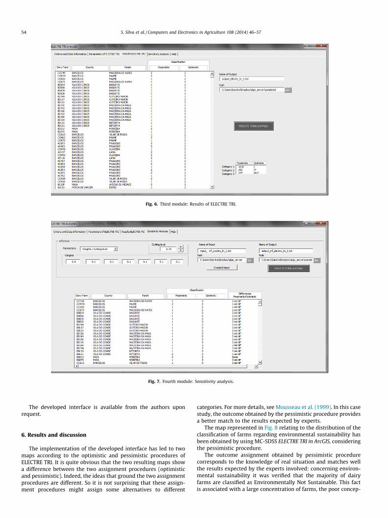
Fig. 6. Third module: Results of ELECTRE TRI.
Fig. 7. Fourth module: Sensitivity analysis.
54 S. Silva et al. / Computers and Electronics in Agriculture 108 (2014) 46–57
The developed interface is available from the authors uponrequest.
6. Results and discussion
The implementation of the developed interface has led to twomaps according to the optimistic and pessimistic procedures ofELECTRE TRI. It is quite obvious that the two resulting maps showa difference between the two assignment procedures (optimisticand pessimistic). Indeed, the ideas that ground the two assignmentprocedures are different. So it is not surprising that these assign-ment procedures might assign some alternatives to different
categories. For more details, see Mousseau et al. (1999). In this casestudy, the outcome obtained by the pessimistic procedure providesa better match to the results expected by experts.
The map represented in Fig. 8 relating to the distribution of theclassification of farms regarding environmental sustainability hasbeen obtained by using MC-SDSS ELECTRE TRI in ArcGIS, consideringthe pessimistic procedure.
The outcome assignment obtained by pessimistic procedurecorresponds to the knowledge of real situation and matches wellthe results expected by the experts involved: concerning environ-mental sustainability it was verified that the majority of dairyfarms are classified as Environmentally Not Sustainable. This factis associated with a large concentration of farms, the poor concep-

Not Sustainable (Category 1)
Barely Sustainable (Category 2)
Sustainable (Category 3)
0 5 10 15 202.5Kilometers
BARCELOS
VIANA DO CASTELO
MAIA
TROFA
SANTO TIRSOVILA DO CONDE
ESPOSENDE
VILA NOVA DE FAMALICÃO
MATOSINHOS
PÓVOA DE VARZIM
Fig. 8. Distribution of environmental sustainability classification of dairy farms (in pessimistic procedure).
S. Silva et al. / Computers and Electronics in Agriculture 108 (2014) 46–57 55
tion of the most dairy farms, the insufficient storage capacity ofmanure, the misuse of equipment and methods of spreading inthe soil and waterways that result in excess of incorporation ofnitrogen as well as production of greenhouse gases and unpleasantodors, among other problems.
This Web MC-SDSS permits development of a Sensitivity Anal-ysis in order to verify the robustness of the results. The main pur-pose in sensitivity analysis is to determine how the sorting isaffected by changes in some decision maker’s parameters. In thisWeb MC-SDSS it is possible to compare the results in the Pessimis-tic and Optimistic procedures before and after a change in theweights and/or cutting level (if user wants to change a larger num-ber of parameters it is better to reformulate them in ELECTRE TRI‘‘Parameters’’ module) and obtain a difference map between theseprocedures.
7. Conclusions
Spatial and multicriteria aspects of the studied problem led usto develop a Spatial Decision Support System. This system incorpo-rates ELECTRE TRI method into ArcGIS 9.3 of ESRI. The power ofthis method lies in the aggregation mode of decision-maker perfor-mances and the assignment of the potential alternatives to prede-fined categories. The developed system is of special importanceinsofar as it integrates GIS functionalities and MCDA methods ina single framework.
This paper presents a tool that integrates GIS and MCDA. GISwas used as the core of the integrated system and the MCDA mod-els were integrated to the GIS using the programming facilitiesprovided by the GIS software. The developed ELECTRE TRI in ArcGIS,VBA macro integrates all the components of a fully-integrated sys-tem: geographical data management and analysis tools, MCDA
models and user interface. It is a user-friendly interface for config-uration, prediction, visualization and analysis of the model out-comes in the same environment and thereby allowing anevaluation process which is uniform, transparent and demands lesstechnical effort from decision makers. The exploitation of graphicaldisplay potentialities of this system provides the decision makerwith information increasingly richer and easier to grasp. WithGIS, data may be available in a format which will be easily inter-preted, can be interactively displayed, is ready to digital processingand can be easily updated. The design and implementation of ELEC-TRE TRI in ArcGIS is an innovative conceptual framework for appli-cation of MCDA in spatial problems, with recourse to the algorithmserver for ELECTRE TRI method application.
Considering the case study, one notes the worrying situation inwhich many farms in the EDM Region are found regarding theirenvironmental sustainability. The interface allows analysing thegeographical distribution of the environmental sustainability clas-sification of dairy farms. Overall results show that MC-SDSS repre-sents valuable decision support tools by providing a platform forthe integration of information, models and methods necessary toassess the environmental sustainability of dairy farms. This MC-SDSS can be easily adapted to other applications in many areasand other MCDA Algorithm Servers.
This approach, however, still presents the following limitations:the centralized processing system requires an internet connectionat least to initialize the server and to obtain the results; and thedeveloped integration may no longer work if there are changes inthe communication protocol or if a particular method is no longeravailable on the server. However, this is compensated by the gainsin computer performance and the avoided time costs in code pro-gramming and debugging a MCDA method that others havealready developed and optimized.
56 S. Silva et al. / Computers and Electronics in Agriculture 108 (2014) 46–57
In the future, this research can be extended to the application ofother MCDA methods by: (i) using the communication protocol ofalgorithm server; (ii) inserting methods for eliciting the parame-ters of MCDA method chosen (Figueira and Roy, 2002; Dias et al.,2002); (iii) extending to other real problems to assess sustainabil-ity (or other context). This methodology can also be extended togroup decision-making domain by considering a group opinionand web-collaborative service. The current last version of ArcGIS(version10) includes compatibility for VBA, but ESRI announcedthe end of the support for VBA in ArcGIS Desktop in future ver-sions. In this case the VBA code developed can be migrated to.NET or re-written in Python language (the new programming lan-guage available to customize and extend ArcGIS).
Acknowledgement
The authors acknowledge support by FCT Program PEst-OE/EEI/UI0308/2014.
References
Abel, D.J., Kilby, P.J., Davis, J.R., 1994. The systems integration problem. Int. J.Geograp. Inform. Syst. 8, 1–12.
Antunes, P., Karadzic, V., Santos, R., Beça, P., Osann, A., 2011. Participatory multi-criteria analysis of irrigation management alternatives: the case of the Caiairrigation district, Portugal. Int. J. Agric. Sustain. 9 (2), 334–349.
Ascough II, J.C., Rector, H. D., Hoag, D. L. et al., 2002. Multicriteria spatial decisionsupport systems: overview, applications, and future research directions. In:Conference on Integrated Assessment and decision Support, Switzerland.International Environmental Modelling and Software Society 3, 175–180.
Aydin, N.Y., Kentel, E., Duzgun, S., 2010. GIS-based environmental assessment ofwind energy systems for spatial planning: a case study from Western Turkey.Renew. Sustain. Energy Rev. 14, 364–373.
Boggia, A., Greco, S., Massei, G., 2011. Implementation of multicriteria modules in ageographic information system. In: 74rd Meeting of the European WorkingGroup Multiple Criteria Decision Aiding (MCDA’74), HEIG-VD, Yverdon,Switzerland.
Boroushaki, S., Malczewski, J., 2008. Implementing an extension of the analyticalhierarchy process using ordered weighted averaging operators with fuzzyquantifiers in ArcGIS. Comput. Geosci. 34 (4), 399–410.
Boroushaki, S., Malczewski, J., 2010. ParcitipatoryGIS.com: a WebGIS-basedcollaborative multicriteria decision analysis. J. Urban Regional Inform. Syst.Assoc. 22 (1), 23–32.
Carver, S.J., 1991. Integrating multicriteria evaluation with geographicalinformation systems. Int. J. Geograp. Inform. Syst. 5 (3), 321–339.
Carver, S., 1999. Developing Web-based GIS/MCE: improving access to data andspatial decision support tools. In: Thill, J.C. (Ed.), Spatial Multicriteria Decision-making and Analysis. Ashgate, Aldershot, England, pp. 49–75.
Chakhar, S., Martel, J.M., 2003. Enhancing geographical information systemscapabilities with multicriteria evaluation functions. J. Geograp. Inform. Decis.Anal. 7, 47–71.
Chakhar, S., Mousseau, V., 2008. Multicriteria spatial decision support systems. In:Shekhar, Shashi, Xiong, Hui (Eds.), Encyclopedia of GIS. Springer, pp. 753–758.
Chakhar, S., Mousseau, V., 2009. Generation of spatial decision alternatives based ona planar subdivision of the study area. In: Yetongnon, K., Chbeir, R., Dipanda, A.(Eds.), Advanced Internet Based Systems and Applications, Lecture Notes inComputer Science, 4879, pp. 137–148.
Chen, K., Blong, R., Jacobson, C., 2001. MCE-RISK: integrating multicriteriaevaluation and GIS for risk decision-making in natural hazards. Environ.Modell. Softw. 16, 387–397.
Common GIS, 2013: <http://www.esds.ac.uk/international/support/commongis.asp>.
Dantsis, T., Douma, C., Giourga, C., Loumou, A., Polychronaki, E.A., 2010. Amethodological approach to assess and compare the sustainability level ofagricultural plant production systems. Ecol. Ind. 10, 256–263.
DECERNS SDSS, 2013: <http://www.decerns.com>.Dias, L., Mousseau, V., Figueira, J., Clímaco, J., 2002. An aggregation/disaggregation
approach to obtain robust conclusions with ELECTRE TRI. Eur. J. Oper. Res. 138,332–348.
Dragicevic, S., 2004. The potential of Web-based GIS. J. Geogr. Syst. 6, 79–81.Eldrandaly, K., Eldin, N., Sui, D., Shouman, M., Nawara, G., 2005. Integrating GIS and
MCDM Using COM Technology. Int. Arab J. Inform. Technol. 2 (2).ESRI ArcScripts, 2013: <http://arcscripts.esri.com>.Ferretti, V., 2011. A multicriteria spatial decision support system development for
siting a landfill in the province of Torino (Italy). J. Multicrit. Decis. Anal. 18, 231–252.
Figueira, J., Roy, B., 2002. Determining the weights of criteria in the ELECTRE typemethods with a revised Simos’ procedure. Eur. J. Oper. Res. 139, 317–326.
Figueira, J., Mousseau, V., Roy, B., 2005. Electre methods. In: Figueira, J., Greco, S.,Ehrgott, M. (Eds.), Multiple Criteria Decision Analysis: State of the Art Surveys.Springer, New York (Chapter 4).
Figueira, J.R., Greco, S., Roy, B., Słowinski, R., 2010. ELECTRE methods: main featuresand recent developments. In: Zopounidis, C., Pardalos, P. (Eds.), Handbook ofMulticriteria Analysis. Springer, New York, USA (Chapter 4).
Finlay, P.N., 1994. Introducing Decision Support Systems. Mass., NCC Blackwell;Blackwell Publishers, Oxford, UK Cambridge.
Gilliams, S., Raymaekers, D., Muys, B., Orshoven, J.V., 2005. Comparing multiplecriteria decision methods to extend a geographical information system onafforestation. Comput. Electron. Agric. 49, 142–158.
Gómez-Limón, J.A., Riesgo, L., 2009. Alternative approaches to the construction of acomposite indicator of agricultural sustainability: an application to irrigatedagriculture in the Duero basin in Spain. J. Environ. Manage. 90, 3345–3362.
Goodchild, M.F., 1992. Geographical information science. Int. J. Geograp. Inform.Syst. 6 (1), 31–45.
Goodland, R., 1995. The Concept of Environmental Sustainability. Annual Review ofEcology and Systematics 26, 1–24.
GRASS GIS, 2013: <http://grass.osgeo.org>.Hall, B., Leahy, M.G., 2006. Internet-based spatial decision support using open
source tools. In: Balram, S., Dragicevic, S. (Eds.), Collaborative GeographicInformation Systems. Idea Group Publishing, Hershey, pp. 237–262.
IDRISI GIS, 2013: <http://www.clarklabs.org>.ILWIS GIS, 2013: <http://www.ilwis.org>.Jankowski, P., Richard, L., 1994. Integration of GIS-based suitability analysis and
multicriteria evaluation in a spatial decision support system for route selection.Environ. Plann. B 21 (3), 326–339.
Jankowski, P., 1995. Integrating geographical information systems and multiplecriteria decision making methods. Int. J. Geograp. Inform. Sci. 9, 251–273.
Joerin, F., Musy, A., 2000. Land management with GIS and multicriteria analysis. Int.Trans. Oper. Res. 7, 67–78.
Joerin, F., Thériault, M., Musy, A., 2001. Using GIS and outranking multicriteriaanalysis for land-use suitability assessment. Int. J. Geograp. Inform. Sci. 15 (2),153–174.
Karnatak, H.C., Saran, S., Bhatia, K., Roy, P.S., 2007. Multicriteria spatial decisionanalysis in Web GIS environment. Geoinformatica 11 (4), 407–429.
Laaribi, A., Chevallier, J.J., Martel, M., 1996. A spatial decisions aid: a multicriterionevaluation approach. Comput. Environ. Urban Syst. 20 (6), 351–366.
Lebacq, L., Baret, P.V., Stilmant, D., 2013. Sustainability indicators for livestockfarming. A review. Agron. Sustain. Dev. 33, 311–327.
Malczewski, J., 1999. GIS and Multicriteria Decision Analysis. John Wiley & Sons,New York.
Malczewski, J., 2006. Review article GIS-based multicriteria decision analysis: asurvey of the literature. Int. J. Geograp. Inform. Sci. 20 (7), 703–726.
Malczewski, J., 2010. Multiple criteria decision analysis and geographic informationsystems. In: Figueira, J., Greco, S., Ehrgott, M. (Eds.), Trends in Multiple CriteriaDecision Analysis. Springer, New York, pp. 369–395.
Marinoni, O., 2004. Implementation of the analytical hierarchy process with VBA inArcGIS. Comput. Geosci. 30, 637–646.
Mendas, A., Delali, A., 2012. Integration of MultiCriteria Decision Analysis in GIS todevelop land suitability for agriculture: application to durum wheat cultivationin the region of Mleta in Algeria. Comput. Electron. Agric. 83, 117–126.
Menegolo, L., Peekham, R.J., 1996. A fully integrated tool for site planning using multicriteria evaluation techniques within a GIS. In: Rumor, M., McMillan, R., Ottens,H.F.L. (Eds.), Geographical Information. IOSA Press, Amsterdam, pp. 621–630.
Mousseau, V., Slowinski, R., Zielniewicz, P., 1999. ELECTRE Tri 2.0a, Methodologicalguide and user’s manual. Document no. 111 of LAMSADE.
Mousseau, V., Dias, L., 2004. Valued outranking relations in ELECTRE providingmanageable disaggregation procedures. Eur. J. Oper. Res. 156, 467–482.
Parks, B.O., 1993. The need for integration. In: Goodchild, M.F., Parks, B.O., Steyarert,L.T. (Eds.), Environmental Modeling with GIS. Oxford University Press, NewYork, pp. 31–34.
POBLPEMD, 2007. Plano de Ordenamento da Bacia Leiteira Primária do Entre Douroe Minho. Direção Regional de Agricultura de Entre Douro e Minho (‘Entre Douroe Minho’s Regional Development Plan for Dairy Farming’); Escola SuperiorAgrária do Instituto Politécnico de Viana do Castelo; Instituto para oDesenvolvimento Agrário da Região Norte; Universidade do Porto – CIBIO.153 pp.
QUANTUM GIS, 2013: <http://www.quantum.com>.Raju, K.S., Duckstein, L., Arondel, C., 2000. Multicriterion analysis for sustainable
water resources planning: a case study in Spain. Water Resour. Manage 14,435–456.
Rao, M., Fan, G., Thomas, J., Cherian, G., Chudiwale, V., Awawdeh, M., 2007. A Web-based GIS decision support system for managing and planning USDA’sConservation Reserve Program (CRP). Environ. Modell. Softw. 22 (9), 1270–1280.
Rinner, C., Malczewski, J., 2002. Web-enabled spatial decision analysis usingordered weighted averaging (OWA). J. Geogr. Syst. 4 (4), 385–403.
Rinner, C., 2003. Web-based spatial decision support: status and researchdirections. J. Geograp. Inform. Decis. Anal. 7 (1), 14–31.
Roy, B., Bouyssou, D., 1993. Aide multicritère à la décision: méthodes et cas.Economica, Paris.
Roy, B., 1996. Multicriteria Methodology for Decision Aiding. Kluwer AcademicPublishers.
Santé-Riveira, I., Crecente-Maseda, R., Miranda-Barrósa, D., 2008. GIS-basedplanning support system for rural land-use allocation. Comput. Electron.Agric. 63 (2), 257–273.
S. Silva et al. / Computers and Electronics in Agriculture 108 (2014) 46–57 57
Santos, J.C.S.M., 2011. Viabilidad de las explotaciones lecheras en un escenario dedesconexión del apoyo y condicionalidad: Un estudio de caso en el noroeste dePortugal. Ph.D. Dissertation, Universidad Politécnica de Madrid, Escuela TécnicaSuperior de Ingenieros Agrónomos.
Sharifi, M.A., Retsios, V., 2004. Site selection for waste disposal through spatialmultiple criteria decision analysis. J. Telecommun. Inform. Technol. 3, 1–11.
Simão, A., Densham, P.J., Haklay, M., 2009. Web-based GIS for collaborative planningand public participation: an application to the strategic planning of wind farmsites. J. Environ. Manage. 90 (6), 2027–2040.
Sikder, I.U., Gangopadhyay, A., 2002. Design and implementation of a Web-basedcollaborative spatial decision support system: organizational and managerialimplications. Inform. Resour. Manage. J. 15 (4), 33–47.
Sobrie, O., 2011. Implementation of the ELECTRE TRI multicriteria method in anOpen Source Geographical Information System. In: 73rd Meeting of theEuropean Working Group Multiple Criteria Decision Aiding (MCDA’73),University of Corsica.
Sobrie, O., Pirlot, M., 2012. Implementation of the ELECTRE TRI in an Open SourceGIS. European Working Group ‘‘Multiple Criteria Decision Aiding’’ Newsletter.Series 3, n 26, Fall 2012.
Sobrie, O., Pirlot, M., Joerin, F., 2013. Intégration de la method d’aide à la décisionELECTRE TRI dans un système d’information géographique open source. Rev. Int.Géomat. 23 (1), 13–38.
Sugumaran, R., Degroote, J., 2011. Spatial Decision Support Systems – Principles andpractices. Taylor & Francis Group.
Van Calker, K., Berentsen, P., Romero, C., Giesen, G., Huirne, R., 2006. Developmentand application of multi-attribute sustainability function for Dutch dairyfarming systems. Ecol. Econ. 57, 640–658.
Van der Meulen, G.G., 1992. Geographical information and decision support system.Comput. Environ. Urban Syst. 16, 187–193.
Vogel, R., 2008. A software framework for GIS-based multiple criteria evaluation ofland suitability. In: 11th AGILE International Conference on GeographicInformation Science, University of Girona, Spain.
Walsh, M.R., 1992. Toward spatial decision support systems in water resources. J.Water Resour. Plann. Manage. 109 (2), 158–169.
Worrall, L., 1991. Spatial Analysis and Spatial Policy Using Geographic InformationSystems. Belhaven Press, London (UK).
Yu, W., 1992. ELECTRE TRI: Aspects méthodologiques et manuel d’utilisation.Document du LAMSADE No. 74, Université Paris-Dauphine.
Zhao, L., Garner, B. J., 2001. Developing GIS Tools to Integrate MCDM models for theanalysis of bank branch closures. In: 6th International Conference onGeoComputation, University of Queens land, Brisbane, Australia.
Zhu, X., Dale, A.P., 2001. JavaAHP: a Web-based decision analysis tool for naturalresource and environmental management. Environ. Modell. Softw. 16 (3), 251–262.