development guidance factsheet
TRANSCRIPT

To undertake a multiple unit development, you will need to make a Development Application to Bundaberg Regional Council.
Depending on where your land is located and the size of the unit development, there are two assessment pathways...
Assessment ‘pathways’...Code assessable – Development application for planning approval needs to be lodged with Council and assessed against ‘codes’ in the planning scheme. Impact assessable – Development application for planning approval needs to be lodged with Council and is assessed against the whole of the planning scheme. The community needs to be made aware of these applications and any submitters have rights to appeal Council’s decision.
Lodging a development application To lodge a development application with Council, we recommend that you contact us to arrange a prelodgement meeting, or refer to our website for detailed planning scheme requirements.
Does the State government need to see it as well? The Queensland Government via the State Assessment Referral Agency is required to assess certain development if it will impact on things like native vegetation, coastal areas, heritage places and State transport infrastructure, amongst other things. It is recommended that you check State interests that may apply to your site via the Development Assessment Mapping System at planning.dsdmip.qld.gov.au/maps or by calling the local SARA office on 07 4331 5614.
Code assessable application:We generally support unit developments in these zones:
› Medium Density Residential Zone › High Density Residential Zone › Centre Zones
Impact assessable application:We would prefer not to see multiple unit development in most other zones, and therefore applications made in these areas are Impact Assessable. However, there are certain circumstances where multiple units are supportable in the Low Density Residential Zone and we recommend discussing this further with Council directly should this be something you are seeking to pursue.
Development Guidance Factsheet Bundaberg Regional Council has developed a series of factsheets to provide guidance on development. An important first step is finding out your site’s zoning and overlay information as this will help you determine the requirements that will apply. To do this, please visit bundaberg.qld.gov.au/interactive-mapping-system or contact Council on the details below. Our staff are more than happy to provide further assistance on mapping, and are also available to discuss your development further.
What are zones?A zone is a way of putting land into ‘categories’ about where certain uses can be established.
What are overlays? Overlays are maps that show important site features and constraints, for example flooding, bushfire, steep land, areas for coastal protection or with good quality agricultural land.
Contact Council 1300 883 699 between 8.15am to 4.45pm Monday to [email protected] 6 Auswide Building16 - 20 Barolin Street, Bundaberg (see website for other office locations) between 8.15am to 4.45pm Monday to Fridaybundaberg.qld.gov.au
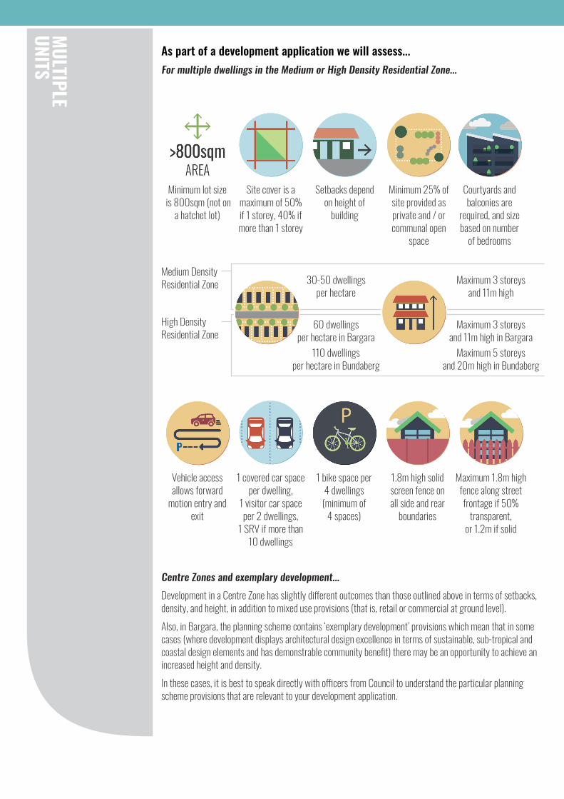
As part of a development application we will assess...For multiple dwellings in the Medium or High Density Residential Zone...
Centre Zones and exemplary development...Development in a Centre Zone has slightly different outcomes than those outlined above in terms of setbacks, density, and height, in addition to mixed use provisions (that is, retail or commercial at ground level). Also, in Bargara, the planning scheme contains ‘exemplary development’ provisions which mean that in some cases (where development displays architectural design excellence in terms of sustainable, sub-tropical and coastal design elements and has demonstrable community benefit) there may be an opportunity to achieve an increased height and density.In these cases, it is best to speak directly with officers from Council to understand the particular planning scheme provisions that are relevant to your development application.
Minimum lot size is 800sqm (not on
a hatchet lot)
Site cover is a maximum of 50% if 1 storey, 40% if more than 1 storey
Setbacks depend on height of
building
Minimum 25% of site provided as private and / or communal open
space
Courtyards and balconies are
required, and size based on number
of bedrooms
30-50 dwellings per hectare
60 dwellings per hectare in Bargara
110 dwellings per hectare in Bundaberg
Maximum 3 storeys and 11m high in Bargara
Maximum 5 storeys and 20m high in Bundaberg
Maximum 3 storeys and 11m high
1 covered car space per dwelling,
1 visitor car space per 2 dwellings,
1 SRV if more than 10 dwellings
Maximum 1.8m high fence along street frontage if 50%
transparent, or 1.2m if solid
1 bike space per 4 dwellings (minimum of
4 spaces)
Vehicle access allows forward
motion entry and exit
1.8m high solid screen fence on all side and rear
boundaries
Medium Density Residential Zone
High Density Residential Zone

The contents of this information sheet have been prepared in order to assist residents to understand the Bundaberg Regional Council Planning Scheme. This information is a general overview only. For full details in relation to the applicable provisions of the planning scheme that affect proposed development please refer to the Bundaberg Regional Council Planning Scheme.
The design of the unit development will also need to demonstrate...
Natural hazards/constraints are
shown on overlay mapping and may affect the ability to develop or nature of
development
Sloping sites need to meet specific
requirements
Amenity including minimising air
emissions, noise or lighting during
construction
Electricity infrastructure,
easements, transformers
Sunlight to adjoining open
space
On the site and surrounds, consideration needs to also be given to...
Significant trees and vegetation and
topographic features are retained
Connects to sewerage and water
infrastructure, provides stormwater
management and water for fire fighting
Includes variation in plan shape - curves,
steps, recesses, window treatments, balconies, terraces
and planting
Provides on-site storage and
collection of refuse
Contributes positively to
character of the street and locality
Integrates clothes drying facilities,
or screens clothes hanging facilities and air
conditioners
Responsive to setting and site
context and creates an attractive living
environment
Roof form reduces bulk and
provides a visually attractive skyline
Provides clear pedestrian entry and integrates car parks
into design
Landscaping provided in
accordance with specific design requirements