development and tidal flood risk - portsmouth · pdf filedevelopment and tidal flood risk...
TRANSCRIPT

Local Development Framework
Development and Tidal Flood Risk Statement of Common Ground
March 2011

You can get this information in large print, Braille, audio or in another language by calling 9268 8633.

Contents
1. Introduction .......................................................................................................................... 1 1.1 Context................................................................................................................................... 1
2. Policy context.......................................................................................................................4 2.1 Flood and Coastal Risk Management (FCRM) Policy............................................................. 4
Making Space for Water (Defra 2005) .................................................................................... 4 The Pitt report ........................................................................................................................ 4 FCRM contributions policy...................................................................................................... 5 Consultation: Reducing the Threat, Building Resilience, Empowering Communities ............. 5
2.2 Spatial Planning Policy........................................................................................................... 6
3. Portsmouth’s Approach to Development & Flood Risk..................................................... 7 3.0 Overview ................................................................................................................................ 7
Defining what is safe .............................................................................................................. 8 3.1 Assess – Defining the Scale of the Issue................................................................................ 9
PUSH Strategic Flood Risk Assessment ................................................................................ 9 Implications of SFRA findings............................................................................................... 10 New Risk maps to supplement 2007 SFRA.......................................................................... 10
3.2 Avoiding Flood Risk.............................................................................................................. 12 General Principles................................................................................................................ 12 Flood Risk in the Site Allocations Process – The sequential approach................................. 12 Taking account flood risk in strategic site allocations............................................................ 17 Taking account of flood risk in other site allocations work..................................................... 18 Flood Risk in Development Proposals – Sequential & Exception Testing at the Development Management stage............................................................................................................... 19
3.3 Substitute – the sequential test at site level .......................................................................... 22 3.4 Control - Delivering Coastal Defences.................................................................................. 24
Responsibilities .................................................................................................................... 24 Policy Framework................................................................................................................. 24 The Portsea Island Coastal Defence Strategy...................................................................... 25 Recommended Strategy....................................................................................................... 26 Costs.................................................................................................................................... 27 Implementation of the strategy ............................................................................................. 28 Portchester Castle to Emsworth Coastal Flood and Erosion Risk Management Strategy ..... 28 Funding Issues..................................................................................................................... 31 Controlling flood risk at site level .......................................................................................... 32
3.5 Mitigate Residual Risk.......................................................................................................... 33 Mitigation measures at site level........................................................................................... 33 Emergency planning............................................................................................................. 35
4 Conclusions........................................................................................................................ 36 4.1 Proposed policy.................................................................................................................... 36 4.2 Future partnership working................................................................................................... 37 4.3 Ongoing areas of work ......................................................................................................... 37
5. References.......................................................................................................................... 39
i

1234567891011121314
Figures Figure - EA flood zones December 2009 (left) and predicted 2115 (right) .................................... 2 Figure - The flood risk management hierarchy ............................................................................. 7 Figure - 2010 SHLAA sites in relation to current flood zones...................................................... 14 Figure - 2010 SHLAA sites in relation to predicted 2115 flood zones ......................................... 15 Figure - Potential Housing Sites identified through SHLAA update 2010.................................... 13 Figure - Employment sites and flood risk.................................................................................... 16 Figure - tidal flood risk considerations ........................................................................................ 18 Figure - table D.2 from Annex D of PPS25................................................................................. 22 Figure - Portsea Island Coastal Defence Strategy: Recommended Option for each flood cell.... 26 Figure - Portsea Island Coastal Defence Strategy: Estimated costs of preferred options ......... 28 Figure - preferred options for the three Portsmouth sections of the coast................................. 29 Figure - likely costs for the two strategies................................................................................. 30 Figure - the likelihood of public funding for the different frontages............................................ 31 Figure - Urban design solutions ............................................................................................... 32
ii

1. Introduction
1.1 Context
1.1.1 Being a coastal city brings with it a huge array of benefits and the city wants to make the most of its historic and deeply rooted connection with sea. This position is reflected in the vision for Portsmouth to become the premier waterfront city. However, the sea can also cause immense damage at times of extreme tides and weather, not only to the built fabric of the city, but also to people’s health, livelihoods and even lives. This threat cannot be ignored in the future planning of the city. The city council acknowledges the risk, and realises that any danger to people and property from flooding from the sea must be minimised. This paper sets out how the city council is doing this in developing the Local Development Framework.
1.1.2 Flood risk is arguably the biggest issue with regard to the future development of the city.
1.1.3 Portsmouth has a shoreline with a total length of 44 km. The Council is directly responsible for 23 km of Portsmouth’s coastline with the remainder in private ownership, predominantly owned by the Ministry of Defence. The open coast (8 km) is the southern and most exposed shoreline of Portsea Island. The eastern section of this frontage is protected by a wide storm beach that has been accreting over several years which now buries the flood defences with shingle. Much of the western section of the open coastline consists of promenades behind sea walls or historic fortifications that defend the area against erosion. The shingle beach, between Clarence Pier and the aquarium, is subject to storm erosion with predominant beach drift from east to west. To maintain the level of this beach it is re-nourished with recycled material. Portsmouth’s shoreline within Portsmouth Harbour and Langstone Harbour (36 km) is predominantly defined by well-maintained sea wall structures built to prevent coastal erosion and flooding from the sea.
1.1.4 The basic measure of flood risk from the sea is the mapping of the flood zones published by the Environment Agency (EA). They show in Zone 2 those areas that have a 1 in 1000 chance of flooding each year, and in Zone 3 those that have a 1 in 200 chance of flooding. Flood Zone 1 shows those areas at low risk of flooding. These maps are updated frequently, and the latest version can always be found on the Environment Agency’s website.
1.1.5 The current flood zones for Portsmouth are shown on the map below left. As the map illustrates, the flood zones cover 37% of the city’s land area. In 2009, this equated to 11,100 homes in Zone 2 and 14,600 in Zone 3, and affects major infrastructure, including:
° the railway and the 3 access roads onto Portsea Island, ° parts of the city centre, Gunwharf Quays and Southsea Town Centre, ° IBM’s European Headquarters and the major employment areas of the naval base,
the continental ferry port and the industrial estates on the eastern side of the city, ° The University of Portsmouth and Highbury and Portsmouth Colleges.
1.1.6 With climate change, the scale of the issue will only increase (see map above right). It is for this reason that addressing the issue of flood risk is such a major objective for the city. It is about the safety of existing and future residents and their property, and the sustainability of investment in the city into the future.
1

Figure 1 - EA flood zones December 2009 (left) and predicted 2115 (right)
1.1.7 Planned investment in the city is to take the form of around 400 new dwellings a year, 300,000m2 of new employment floorspace and 50,000m2 of new retail floorspace, as well as the necessary infrastructure to support this development.
1.1.8 In order to meet these targets, the city council has to consider the balance between the need for the additional development and the need to avoid putting more people and property at risk of flooding.
1.1.9 The overall goal is that people and properties, whether existing or yet to be developed, are safe from flooding.
1.2 This Paper
1.2.1 This paper sets out the city council’s approach to flood risk both in preparing its Core Strategy, and in dealing with development proposals in the future. It looks at the context in terms of policy requirements as well as the scale and location of development and what this means in terms of flood risk. It then goes on to consider Portsmouth’s approach to future development in light of flood risk, in its LDF work, in development management and in progressing proposed flood defence schemes.
1.2.2 It should be noted that tidal flooding is only one of a variety of forms of flooding that could affect the city. In particular, surface water flooding is an issue for Portsmouth given the limited capacity of the combined Victorian sewer system. This paper does not seek to deal with all forms of flooding, but concentrates on the approach to dealing with flooding from the sea. Other forms of flooding are dealt with in the council’s Infrastructure Delivery Plan.
1.2.3 The approach and this paper have been developed in a close working partnership between officers from Portsmouth City Council and the Environment Agency and represent the agreed common ground regarding development and flood risk in Portsmouth. It is
2

acknowledged that the two bodies will need to continue to work together to achieve the best possible developments in the light of flood risk. They key areas of future work are acknowledged in section 4.
3

2. Policy context
2.1 Flood and Coastal Risk Management (FCRM) Policy
Making Space for Water (Defra 2005)
2.1.1 Making Space for Water’ set out the government’s direction of travel in its strategy for flood and coastal erosion risk management in England. Chiefly, the approach involves taking account of all sources of flooding and embedding flood and coastal risk management across a range of Government policies. This direction of travel led to the publication of PPS25 in 2006 and its companion guide in 2008 (see below).
The Pitt report
2.1.2 Following the summer floods of 2007, Sir Michael Pitt was asked to undertake a comprehensive review of the lessons to be learned from these events. As well as lessons for emergency planning and dealing with flood events when they do happen, a key message from this review was that more needed to be done to reduce the risk of flooding, particularly through planning controls. Key recommendations in this regard were:
° There should be a presumption against building in high flood risk areas, in accordance with PPS25, including giving consideration to all sources of flood risk, and ensuring that developers make a full contribution to the costs both of building and maintaining any necessary defences.
° The operation and effectiveness of PPS25 and the Environment Agency’s powers to challenge development should be kept under review and strengthened if and when necessary.
° Householders should no longer be able to lay impermeable surfaces as of right on front gardens and the Government should consult on extending this to back gardens and business premises.
° The automatic right to connect surface water drainage of new developments to the sewerage system should be removed.
° Building Regulations should be revised to ensure that all new or refurbished buildings in high flood-risk areas are flood resistant or resilient.
° All local authorities should extend eligibility for home improvement grants and loans to include flood resistance and resilience products for properties in high flood-risk areas.
° Local authorities, in discharging their responsibilities under the Civil Contingencies Act 2004 to promote business continuity, should encourage the take-up of property flood resistance and resilience by businesses.
2.1.3 In June 2009 the government reported on progress towards implementing the recommendations of the Pitt report. This included a number of funding commitments, such as increases in government funding towards defences and completions of defence schemes. The report also highlighted that a long-term investment strategy has been published: the Environment Agency’s assessment of the costs and benefits of investment over the next 25 years given the latest projections of climate change. A new policy statement on appraisal of flood and coastal erosion risk management has also been published, to ensure better value for money in the investment decisions made.
4
FCRM contributions policy
2.1.4 The Environment Agency has produced a policy on external contributions to Flood and Coastal Risk Management (policy 284_09). This policy sets out new EA thinking on using external funding to bring forward infrastructure development and improve the FCRM outcome for the level of public investment. The incentive for potential contributors is that the priority score for schemes that attract external contributions will be increased.
2.1.5 Contributions can take a variety of forms, including single payments towards capital costs, commuted sums to future costs, a gift of land, or an agreement to carry out maintenance. Contributions can be from public or private sources.
2.1.6 Affecting future development proposals, the following policy principles are pertinent:
a) Developers must reduce the flood and coastal erosion risks that affect, or are caused by, their development. This must be done at their own expense. The developer will need to arrange and pay for the ongoing maintenance of the asset or service. Where these arrangements and contributions are not put in place, the EA will strongly advise the council against the development going ahead.
b) Developers can choose to rely on existing FCRM assets and services, where these are at the required standard. If they do so, they cannot be made to make a contribution to the maintenance of these assets and services. They can however be encouraged to make contributions to subsequent improvements and maintenance work for these defences.
Consultation: Reducing the Threat, Building Resilience, Empowering Communities
2.1.7 At the end of 2010, the EA and Defra jointly launched a consultation on a future national strategy for flood and Coastal Erosion Risk Management.
2.1.8 The proposed strategy aims to encourage more effective risk management by enabling people, communities, business and the public sector to work together to:
° ensure a clear understanding of the risks of flooding and erosion, nationally and locally, so that investment in risk management can be prioritised more effectively;
° set out clear and consistent plans for risk management so that communities and businesses can make informed decisions about the management of the remaining risk;
° encourage innovative management of flood and coastal erosion risks, taking account of the needs of communities and the environment;
° ensure that emergency plans and responses to flood incidents are effective and that communities are able to respond properly to flood warnings;
° help communities to recover more quickly and effectively after incidents.
2.1.9 The strategy will show how communities can be more involved in local risk management, co-ordinated planning and sustainability. It will also emphasise the need to balance national and local activities and funding.
2.1.10 In outlining the proposed approach to FCERM, the consultation document considers the level of risk and how it might change in the future, the risk management measures that may be used, roles and responsibilities, future funding and the need for supporting information.
5
The Environment Agency is developing the new strategy, and has produced the consultation document jointly with Defra to ensure that it reflects current Government policy.
2.2 Spatial Planning Policy
PPS25 (Development and Flood Risk)
2.2.1 The chief policy document regarding development and flood risk is Planning Policy Statement (PPS)25, along with its companion practice guide. PPS25 sets out the Government’s policies for development and flood risk. The aims of PPS25 are to ensure that flood risk is taken into account at all stages in the planning process to avoid inappropriate development in areas at risk of flooding, and to direct development away from areas at highest risk. Where new development is, exceptionally, necessary in such areas, the policy aims to make it safe without increasing flood risk elsewhere and where possible, reducing flood risk overall.
2.2.2 Specifically, PPS25 sets out clear guidance on the application of the ‘sequential approach and test’, which seek to guide development to areas at low risk of flooding, both at the forward planning as well as the development application stage. It also requires an ‘exception test’ for cases where it is not possible to locate the development in lower risk flood areas. This test must, amongst other things, show that the development is safe, and will remain so over its lifetime.
2.2.3 PPG25 also sets out the need for authorities to undertake Strategic Flood Risk Assessments to refine flood risk information available from the Environment Agency and to inform the authority’s approach to the issue.
PPS1 Supplement (Planning and Climate Change)
2.2.4 This PPS recognises the role of planning in dealing with climate change. In the UK, we are likely to see more extreme weather events, including hotter and drier summers, flooding and rising sea-levels. The PPS1 Supplement reiterates the messages in PPS25, that in planning for development, authorities should take into account sea level rise, flood risk and stability, and take a precautionary approach to increases in risk that could arise as a result of likely changes to the climate.
PPS12 (Local Spatial Planning)
2.2.5 This PPS sets out the principles of spatial planning. It states that spatial planning ensures that strategies can be fully cognisant of and play their part in respect of a number of issues, including flooding; It also sets out the need to show flood risk areas on the LDF proposals map.
6

3. Portsmouth’s Approach to Development & Flood Risk
3.0 Overview
3.0.1 Portsmouth’s approach follows the risk management hierarchy set out in PPS251. The aim of this approach is to avoid inappropriate development in flood risk areas and to locate development away from flood risk whenever possible. The approach the PPS suggests is to assess risk so it can be avoided and managed, and ultimately to ensure that development is safe.
Figure 2 - The flood risk management hierarchy
3.0.2 PPS25 requires flood risk to be taken into account at all stages of the planning process to avoid inappropriate development. This means using the hierarchy above at the same time as taking account of: ° the nature of flood risk; ° the spatial distribution of flood risk; ° climate change impacts; and ° the degree of vulnerability of different types of development.
3.0.3 The following sections set out how Portsmouth is using this hierarchy in its approach to development and flood risk, through its forward planning, development management, coastal defence and emergency planning decisions. In overview, it the approach is:
° To assess the level of flood risk. The starting point of developing the city’s approach was a thorough assessment of the scale of the issue in Portsmouth. This demonstrated that all four further levels of the flood risk hierarchy will be needed to ensure that future development in Portsmouth is safe.
° To avoid risk to new development by directing it wherever possible to the areas of lower risk, both across the city and within individual sites, and by requiring applicants to demonstrate that development will be safe over its lifetime
° To substitute wherever possible more vulnerable development types for less vulnerable types in areas of flood risk;
° To control risk by maintaining and improving its sea defences to a high standard, which will benefit existing and future buildings and their occupiers;
° To mitigate against residual risk by requiring development to incorporate flood resistance and resilience measures, as well as having in place effective emergency response procedures.
3.0.4 Central to this approach is an agreed definition between the Environment Agency and the city council as to what is considered to be ‘safe’ development in relation to flood risk.
1 Planning Policy Statement 25: Development and Flood Risk - Practice Guide 2009 http://www.communities.gov.uk/publications/planningandbuilding/pps25floodrisk
7

Defining what is safe
3.0.5 The city council and the Environment Agency agree that the ultimate aim is for people to be safe from flooding. Levels of safety will vary across different areas of the city, at different sites and over time, determine by a number of factors, including the standard of sea defence built and maintained. But just as importantly, whatever standard of flood defence is achieved, residual risk behind defences is a key part of considering what is safe. Factors such as: ° predicted flood level; ° duration; ° likely frequency; ° velocity of flood water; ° depth; and ° amount of warning time of flooding
will determine what measures need to be put in place for development to be made safe. These may be physical or non-physical measures (eg flood warning plans), or a combination of the two. For example, ‘safe’ could mean that people are safe in the building or that they are able to escape safely, either because there are dry access routes or there will be enough time to evacuate safely. What is safe will vary from site to site and vary depending of the flood vulnerability classification of the proposed development.
8

3.1 Assess – Defining the Scale of the Issue
3.1.1 PPS25 suggests that this should take the form of undertaking studies to collect data to understand what the flood risk is, chiefly in the form of flood risk assessments. At the plan making stage, this should take the form of a strategic flood risk assessment (SFRA), while at application stage, a site specific flood risk assessment (FRA) may be required to fully understand the level of risk and possible ways to address it.
PUSH Strategic Flood Risk Assessment
3.1.2 Strategic Flood Risk Assessments (SFRAs) are designed, amongst other things, to:
° Refine Environment Agency information on the probability of flooding; ° Consider how flood risk management infrastructure alters the frequency, impact,
speed of onset, depth and velocity of flooding; ° Consider the residual risk remaining even with flood risk management infrastructure in
place; ° Inform the location of development proposed in LDFs, as well as policies for the
management of flood risk; and ° Inform site-specific FRAs at the planning application stage.
3.1.3 Rather than discharge the duty to prepare an SFRA individually, the PUSH authorities jointly commissioned Atkins to undertake the SFRA. The Environment Agency was also a partner in steering the work of the consultants. The SFRA was completed in December 2007 and is now available at http://www.push.gov.uk/work/sustainability-and-socialinfrastructure/content-strategic-flood-risk-assessment.htm. A web based system was chosen in order to allow easy access to anyone who might need to use it. The bulk of the SFRA takes the form of GIS mapping, allowing users to view the information at various scales from the sub-regional to site level. The written report is also available on this website.
3.1.4 The findings of the SFRA made it clear that existing flood risk in the city was considerable, with 45% of existing dwellings lying in flood zones 2 and 3. It was also made clear that the housing number for the two cities would put development pressure on flood zone 3.
3.1.5 The mapping outputs of the SFRA added to existing Environment Agency flood zones maps, by creating maps of hazard levels, both assuming no defences and a breach in defences. These maps allow a more accurate assessment to be made of flood risk than is possible using the more basic EA undefended flood zones. Crucially, the SFRA also produced flood zone maps showing predicted sea level rise to 2115.
9

Implications of SFRA findings
3.1.6 The assessments showed early on that given the extent of the flood zones affecting the city, historic patterns of development and the limited amount of available developable land, reconciling the need for development and flood risk considerations would be a difficult task. Flood risk would only be able to be one of many considerations in determining where development should take place, and the Practice guide to PPS25 Development and Flood Risk (paragraph 2.9) supports this notion.
3.1.7 The city council realised that it would not be possible for it to follow the recommended approach of completely avoiding new development in areas at risk of flooding.
3.1.8 As well as protecting people and property from the risk of flooding, the city council equally has a duty to provide housing, jobs and facilities to meet the city’s needs, and to ensure that those sites and areas in need of regeneration are able to realise their full potential so that they can help the city move forward. If adaptation to climate change and the predicted rise in sea levels were the only issue, it is likely that the overall housing requirement for Portsmouth would be reduced so that development need not occur in the tidal flood plain. However, this approach would fail to recognise the amount of investment and development that already exists in the flood plain. The city is already home to thousands of people, businesses and their property, and it is unrealistic to abandon the areas at risk of flooding. The city council believes that these areas must be made safe for the sake of existing properties, and this approach will also benefit potential development sites. Not doing so would severely limit the city’s ability to realise the PUSH strategy for regenerating the city. In addition, concentrating development on brownfield sites in the older urban areas of South Hampshire provides the best solution in terms of mitigating further climate change through reducing the need to travel and meeting travel needs through the most sustainable modes.
3.1.9 The city council’s approach is therefore to seek to address flood risk as much as possible at the higher levels of the flood risk management hierarchy (‘avoid’ & ‘substitute’), while acknowledging from the outset that the lower levels of the hierarchy (‘control’ and ‘mitigate’) will also have to be relied upon to a substantial degree to ensure that development can go ahead and be safe over its lifetime.
New Risk maps to supplement 2007 SFRA
3.1.10 As described in the previous chapter, the key consideration in terms of development in flood risk areas is an understanding of what is safe. What is safe is influenced by the level of protection afforded by defences, but is also substantially affected the level of residual risk behind these defences, in case they should fail.
3.1.11 In order to determine the level of risk for sites in Portsmouth the Environment Agency and the city council are supplementing and updating the 2007 SFRA by further modelling and mapping.
3.1.12 The EA recommend that the following should be mapped to update the SFRA:
° The areas at risk now behind the existing defences (1:200 & 1:1000) ° The areas at risk behind the existing defences in 2115 if they are not improved (1:200
& 1:1000) ° The areas at risk in the event of a breach of the proposed defences in 2115.
10

° The areas at risk in the event of a 1:1000 overtopping event of the proposed defences in 2115.
3.1.13 The Environment Agency has completed a coastal flooding model (Portchester to Farlington Tuflow Model). This shows the risk of flooding today with existing sea defences (points 1&2). It does however not look at the raising of sea defences to 2115 standards of protection (points 3&4). This model will be re-run with new parameters i.e. higher sea walls to give a much better understanding of residual risk in key areas.
3.1.14 This information can upgrade the PUSH SFRA and can also be used by developers in their individual FRAs (see section 3.5) It will be used to make an assessment of whether a site can be safely developed, and if so what measures will be needed to make it safe, and will inform both the site allocations process, and decisions on planning applications.
3.1.15 It will allow a better understanding of:
° Maximum depths of flooding; ° Maximum velocities of flood water; ° Maximum flood hazards; ° Time of onset of flooding at sites; and ° Identification of rapid inundation zones.
3.1.16 The benefits of this work include:
° sound evidence for site allocations; ° sound basis for providing advice and making decisions on planning applications; ° supports the agreement between EA & PCC on defence provision in Cells 1 & 4 (i.e.
the agreement stated that FRAs assess the residual risk behind proposed defences). ° source of information for FRAs which it would not be proportionate to request of many
infill/windfall developments; ° a clear and consistent source of information for all developers; ° will allow a less precautionary approach to development, bringing benefits such as
reducing the scale of flood resilient and resistant building design, reducing the cost to develop in Portsmouth and less conflict between building design and flood risk.
11

3.2 Avoiding Flood Risk
General Principles
3.2.1 In order to avoid flood risk, PPS25 recommends using the sequential approach to site selection for development, so that development allocations are located in areas of least flood risk. Sustainability Appraisal is highlighted as a key way of achieving this. Flood risk can also be avoided at the development management stage through the application of the sequential test and the exception test.
3.2.2 Government guidance in PPS25 and the PPS25 Practice Guide does not intend to prevent all development on sites liable to flooding, accepting that some form of development may have to take place there. The focus is instead on minimising risks to people and property.
3.2.3 The guidance sets out that the overall aim of decision-makers should be to steer new development to Flood Zone 1. Where there are no reasonably available sites in Flood Zone 1, decision-makers should take into account the flood risk vulnerability of land uses and consider reasonably available sites in Flood Zone 2, applying the Exception Test if required. Only where there are no reasonably available sites in Flood Zones 1 or 2 should decision-makers consider the suitability of sites in Flood Zone 3, taking into account the flood risk vulnerability of land uses and applying the Exception Test if required.
3.2.4 Within each Flood Zone, new development should be directed first to sites at the lowest probability of flooding and the flood vulnerability of the intended use matched to the flood risk of the site ie higher vulnerability uses should be located on parts of the site at lowest probability of flooding.
Flood Risk in the Site Allocations Process – The sequential approach
3.2.5 Two key studies that have informed the site allocations process are the Strategic Housing Land Availability Assessment (SHLAA) & the Employment Land Review (ELR). They review availability of land for housing and employment uses, and form the first steps in identifying potential sites for allocation.
3.2.6 The SHLAA:
° identifies sites that have the potential for housing ° assesses how many units they could accommodate ° suggests a timeframe for when these sites could become available.
3.2.7 It takes the form of a written report with an appendix with information on each of the sites identified. Site information collected includes flood risk categorisation based on the EA Flood Risk maps and the PUSH SFRA hazard mapping. Due to the constrained number of potential sites on the initial long list of sites, sites in all flood zones were considered further for inclusion in the SHLAA.
12

3.2.8 Reviewing this information shows that 2666 potential units have been identified in flood zones 2 and 3. Due to predicted sea level rise, this figure increases to 3172 by the year 2115. The tables and maps below show the distribution of these sites. It should be noted that this is not the number proposed to be allocated. The SHLAA merely identifies potential sites, which then have to go through a process, including sustainability appraisal, to be allocated. Please see sections below on allocations of strategic and smaller sites.
Figure 3 - Potential Housing Sites identified through SHLAA update 2010
Total number identified: up to 7278
NB1 this excludes sites with planning permission
NB2 A range of numbers is shown for the strategic sites - the higher number relies on transport infrastructure to achieve it.
NB3 where sites, particularly large and strategic sites cross over flood zones, an assessment has been made as to which part of the site is most likely to be developed and the floodzone ascribed accordingly. Where development is likely to take place in both flood zones across the site, half the total number has been assumed for each zone.
Flood Risk 2010 No of Potential Dwellings
small sites strategic sites All SHLAA sites
Total Zone 1 1723 2339-2889 4062-4612
Zone 2 120 214-625 334-745
Zone 3 496 214-1425 710-1921
Total Zones 2 & 3 616 428-2050 1044-2666
Flood Risk 2115 No of Potential Dwellings
small sites strategic sites All SHLAA sites
Total Zone 1 1217 2339-2889 3556 - 4106
Zone 2 24 0 24
Zone 3 1098 428-2050 1526-3148
Total Zones 2 & 3 1122 428-2050 1550-3172
13
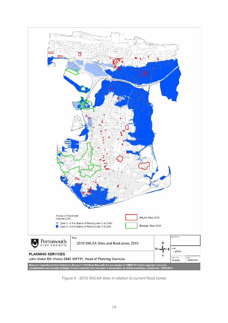
Figure 4 - 2010 SHLAA sites in relation to current flood zones
14

Figure 5 - 2010 SHLAA sites in relation to predicted 2115 flood zones
15

3.2.9 The Employment Land Review assesses the city’s employment land supply and identifies potential sites to meet future needs. The assessment of potential sites included a deliverability assessment, which took into account flood risk by reference to the flood zones. Flood risk was one factor of many in determining the deliverability score of sites.
3.2.10 For sustainability reasons, and due to the constrained land supply in the city, potential employment sites generally have to be found within existing employment areas. The map below shows that these existing areas overlap substantially with flood zones 2 and 3, and therefore the sites identified through the ELR also mainly lie in these zones.
Figure 6 - Employment sites and flood risk
16

3.2.11 In terms of allocations, the city council has sought to prioritise sites for allocation that are not at risk of flooding from the sea. However, the results of the SHLAA and the ELR show that the level of development expected for Portsmouth cannot be achieved in areas at low risk of flooding. After assessing the scale of the issue in the city it was soon clear that avoiding sites at risk of flooding completely would be impossible if the city council wanted even to attempt to meet its housing and employment land needs over the Core Strategy period This is particularly true for the few very large sites (the strategic sites and the large non strategic sites), as the city is reliant on these sites to meet its housing requirement.
3.2.12 In the LDF system, site allocations can be made in two places: strategic sites should be allocated in the Core Strategy, while smaller sites are generally made in a separate site allocations DPD.
Taking account flood risk in strategic site allocations
3.2.13 Portsmouth’s urban capacity relies to a substantial degree on its strategic sites. Almost 5000 of the 8,9002 homes planned from 2010 to 2027 are in its strategic sites. Up to 2050 of these units lie, or will lie, in flood zones 2 and 3 by 2115, in particular at Tipner and Horsea.
3.2.14 Given the built up nature of the city and the lack of large sites, there are no sequentially preferable sites that could accommodate the development proposed for these sites. The process for determining this is set out below.
Could the proposed No – the SHLAA has shown that there are no other available sites in strategic FZ1 that could accommodate the 2050 homes. Even considering development whether the proposed development could be alternatively located in allocations be Flood Zone 1 by breaking it down into a greater number of smaller located in FZ1? allocations rather than as large, strategic sites did not allow for this
number to be accommodated. The SHLAA identifies sites for a total of 7278 dwellings across all three Flood Zones, only just over 1200 of which are on non-strategic sites in FZ1 that remain there to 2115. All the sites identified are needed to meet the housing requirement and there is no additional scope for diverting numbers from the strategic sites.
Could the proposed No – the SHLAA has shown that there are no other available sites in strategic FZ2 that could accommodate the 2050 homes. Even considering development whether the proposed development could be alternatively located in allocations be Flood Zone 2 by breaking it down into a greater located in FZ2?
3.2.15 Given that these sites cannot be accommodated in lower risk areas, it must then be considered whether it will be possible to manage flood risk in other ways on these sites, as the allocation will only be deliverable where there is a reasonable prospect that the site can be made safe. The city council has concluded that as these sites are virtually self contained development sites, they are more capable of managing flood risk at lower levels of the hierarchy, substituting uses within the site, controlling flood risk through defences and site
2 8,900 is the upper end of a range of planned units ( 6,800-8,900 units). The higher number relies on investment in transport infrastructure to make strategic sites developable. See housing number consultation at http://www.portsmouth.gov.uk/living/19936.html
17

design and mitigating against residual risk at site level. The city council has therefore continued to pursue allocation of these sites for development.
Taking account of flood risk in other site allocations work
3.2.16 Flood Risk is taken into account in making non strategic site allocations in the following way:
3.2.17 The city council firstly identifies a long list of potential allocation sites from a variety of sources including the SHLAA, past permissions, pre-application discussions, council owned sites and visually identified sites.
3.2.18 It has been decided that the best way of appraising the suitability of sites for allocation is to put them through a sustainability appraisal in two stages. The first determines the general suitability of a site for allocation. The second stage then is a more detailed review of the site’s characteristics, to confirm its suitability for allocation and to help determine what land use a site is most suited for. In terms of flood risk, the stage two assessment for the flood risk criteria is a fuller assessment of the level of risk and the likelihood of development being able to be made safe.
3.2.19 The first stage includes a number of tidal flood risk considerations as shown in figure 7.
Figure 7 - tidal flood risk considerations in sustainability appraisal
3.2.20 Assessing these criteria allows the sequential approach to be taken. First only the sites that score well will be taken forward for further assessment. Only if this does not yield sufficient sites will sites with lower assessment scores be considered in a further round.
18

3.2.21 In order to give confidence that the sites allocated in the Portsmouth Site Allocations DPD will be deliverable in the light of flood risk, PCC and the Environment Agency have agreed that sites that reach stage 2 should undergo a flood risk assessment before they are allocated. This looks in more detail at the risk on the site than the Strategic Flood Risk Assessment, but will be less detailed than a Flood Risk Assessment that would be required at the development application stage.
3.2.22 Given the number of potential allocation sites PCC & the EA have agreed that the best approach is to assess a sample of sites, with a cross section of characteristics (location, type of development, land use, flood zones, flood hazard etc).
3.2.23 The Environment Agency and the City Council are working together to complete a set of sample assessments which consider:
° the proposed land use for allocation & site location; ° the nature of the flood risk; ° options for dealing with the risk, and their viability; ° off-site strategic measures; ° on-site strategic measures; ° on-site measures; ° adjacent off-site measures; ° preferred option(s); ° a conclusion on the deliverability of the site in the light of flood risk.
3.2.24 Sample sites have been selected so as to include a review of the worst case scenarios e.g. highest risk areas or sites with little flexibility in site layout. These assessments are showing that there is a reasonable prospect of them being made safe, giving the EA and PCC sufficient confidence for the remainder of the allocation sites.
3.2.25 Only those sites that have a reasonable prospect of being made safe at the development stage will be allocated. It should be noted, however, that detailed assessments will still need to be made at the planning application stage and flood risk issues will have to be addressed satisfactorily for development to be acceptable.
3.2.26 It is highly likely that insufficient sites will be identified through this initial process, and it may be necessary to repeat the process by including sites excluded for their category *A* rating on flood hazard. On these sites, the stage 2 assessment will be crucial, as this will determine whether these sites have a reasonable prospect of being made safe, and therefore whether they can be allocated.
Flood Risk in Development Proposals – Sequential & Exception Testing at the Development Management stage
3.2.27 The Sequential Test – PPS25 & the EA / PCC Flood Risk Protocol - the sequential test also plays an important role in assessing development applications in the light of flood risk. PPS25 requires applicants for new development proposed in areas at risk of flooding to comply with the sequential test, that is they must demonstrate that there are no other sites available at lower risk of flooding.
3.2.28 However, given the extent of the areas at risk of flooding in Portsmouth, there is a particular difficulty in the city in directing development to lower risk areas. The city council and the
19
Environment therefore developed a flood risk protocol to apply to certain types of development proposal in the city.
3.2.29 Portsmouth City Council’s approach to flood risk on unallocated sites is based on a protocol agreed between the Environment Agency and the city council in 2009.
3.2.30 As soon as PPS25 was introduced in December 2006, the number of EA objections to development applications in Portsmouth rose rapidly. The city council became concerned that the application of PPS25 would drastically reduce the city’s housing supply, as much of the supply is made up of small windfall sites, many of which lie in the tidal flood zones. It would be impossible for applicants to comply with the sequential test on small sites, and therefore the strict application of PPS25 in Portsmouth would lead to a radical reduction in residential permissions.
3.2.31 In May 2007, a meeting was therefore called to bring together PCC, the Government Office for the South East, the Department for Communities and Local Government (authors of PPS25) and the EA to review the intentions of the PPS and to discuss a way forward for Portsmouth. It was agreed that it is not PPS25’s intention to stop development in existing urban areas, and that a protocol should be developed between the council and the EA to agree how windfall sites in Portsmouth should be dealt with.
3.2.32 The protocol came into force in February 2009. It is an agreement between the EA and PCC which sets out the common goal of enabling safe development in the city, and agrees common principles for dealing with the sequential and exception tests in PPS25 on brownfield windfall sites in Portsmouth, regardless of size.
3.2.33 The PPS25 practice guide makes clear that where a specific area is identified for regeneration, there are large areas in flood zones 2 and 3, and development is needed in those areas to sustain the existing community, sites outside of those areas would not be reasonable alternatives (paragraph 4.18). As the South Hampshire Strategy identifies development in Portsmouth as key to the regeneration of the sub-region, this protocol accepted this principle as applicable to the whole of the city.
3.2.34 The protocol then utilised the information from the SFRA, which identifies the level of hazard in different areas of the flood zones, in four categories from low hazard to very high hazard, based on the depth and velocity of flooding. If the proposed development site lies in an area of low or moderate hazard, the proposed development will be considered acceptable in terms of the sequential test.
3.2.35 Based on these principles, the sequential test will be considered met on
° allocated sites and ° non-allocated sites in those parts of flood zones 2 & 3 that the SFRA shows as low or
medium hazard areas
3.2.36 The sequential test will not be required for minor development (as defined by PPS253) and for changes of use, including changes of use to residential.
3 p7 of March 2010 version of PPS25
20

3.2.37 The Exception Test - Any development which is justifiably located within an area of flood risk because it has passed the sequential test, must be demonstrated to be safe over its lifetime. Part of this is to apply the exception test where it is required by PPS25. Whether this applies depends on the proposed use and its acceptability in terms of table D3 in PPS25 (Flood Risk Vulnerability and Flood Zone compatibility).
3.2.38 According to the Portsmouth Flood Risk Protocol, parts A) ‘wider sustainability benefits’ and B) ’brownfield land’ of the exception test are deemed passed by all developments covered by the protocol, as the protocol only applies to brownfield development, and the whole city is considered in need of regeneration and so the development provides wider sustainability benefits.
3.2.39 The final part of the exception test (demonstrating that development will be safe) must be met through a site specific flood risk assessments for development proposals in flood zones 2 & 3 as part of the planning application. This assessment must demonstrate that the development is safe, and will continue to be safe over the lifetime of the development taking into account sea levels rise. Annex E of PPS25 sets out the minimum requirements for flood risk assessments.
3.2.40 The city council will expect the developer to minimise the potential damage to property and risk to people through design and layout (see more detail in section 3.5).
3.2.41 The policy proposed for the Core Strategy takes on board the principles trialled through the protocol. Once the core strategy is adopted, the protocol will cease to have effect.
3.2.42 In addition to the principles trialled through the protocol, the city council and the Environment Agency consider it important to reflect the likely effects of sea level rise in the future policy approach to flood risk in the city.
3.2.43 Flood Risk Assessments for Climate Change Scenarios - modelling of sea level rise predictions through the SFRA shows that over time, the extent of flood zones 2 & 3, particularly 3, is likely to increase. SFRA map sets are available for the climate change scenarios for 2025, 2055, 2085 and 2115. The city council and the Environment Agency consider it important for future scenarios to be taken into account fully in development management decisions.
3.2.44 PPS25 requires planning applications for development proposals of 1 hectare or greater in Flood Zone 1 and all proposals for new development located in Flood Zones 2 and 3 (see Table D.1, Annex D) to be accompanied by a FRA.
3.2.45 The requirements in PPS25, however, are minimum requirements (paragraph 13). Given the city’s vulnerability to flood risk and sea level rise, the city council and the Environment Agency consider that the requirement for flood risk assessment ought to be extended to take account of future risk. Therefore, the city council will require site specific flood risk assessment for developments currently in Flood Zone 1 that according to the SFRA will move into Flood Zones 2 or 3 in the future.
21
3.3 Substitute – the sequential test at site level
3.3.1 This stage of the flood risk hierarchy is about applying the sequential test within a site, and about substituting less vulnerable for more vulnerable development types in areas of flood risk. This approach will be taken wherever possible in making site allocations, and will also be used in development management decisions.
3.3.2 Using this approach requires firstly an identification of the variation of flood risk within the site, using the Flood Zone maps, the SFRA and / or a site level FRA. In determining the vulnerability classification of different land uses, the city council will refer to table D.2 in Annex D of PPS25, repeated in figure 8 for ease of reference.
Figure 8 - table D.2 from Annex D of PPS25
Essential ° Essential transport infrastructure (including mass evacuation routes) which Infrastructure
°
°
has to cross the area at risk. Essential utility infrastructure which has to be located in a flood risk area for operational reasons, including electricity generating power stations and grid and primary substations; and water treatment works that need to remain operational in times of flood. Wind turbines.
Highly ° Police stations, Ambulance stations and Fire stations and Command vulnerable
° ° °
°
Centres and telecommunications installations required to be operational during flooding. Emergency dispersal points. Basement dwellings. Caravans, mobile homes and park homes intended for permanent residential use. Installations requiring hazardous substances consent.
More ° Hospitals. vulnerable °
°
°
°
°
Residential institutions such as residential care homes, children’s homes, social services homes, prisons and hostels. Buildings used for: dwelling houses; student halls of residence; drinking establishments; nightclubs; and hotels. Non–residential uses for health services, nurseries and educational establishments. Landfill and sites used for waste management facilities for hazardous waste. Sites used for holiday or short-let caravans and camping, subject to a specific warning and evacuation plan.
Less vulnerable
°
°
Police, ambulance and fire stations which are not required to be operational during flooding. Buildings used for: shops; financial, professional and other services;
22

° ° ° °
°
restaurants and cafes; hot food takeaways; offices; general industry; storage and distribution; non–residential institutions not included in ‘more vulnerable’; and assembly and leisure. Land and buildings used for agriculture and forestry. Waste treatment (except landfill and hazardous waste facilities). Minerals working and processing (except for sand and gravel working). Water treatment works which do not need to remain operational during times of flood. Sewage treatment works (if adequate measures to control pollution and manage sewage during flooding events are in place).
water – ° Flood control infrastructure. compatible ° Water transmission infrastructure and pumping stations. development °
° ° ° ° °
° ° °
°
Sewage transmission infrastructure and pumping stations. Sand and gravel workings. Docks, marinas and wharves. Navigation facilities. MOD defence installations. Ship building, repairing and dismantling, dockside fish processing and refrigeration and compatible activities requiring a waterside location. Water-based recreation (excluding sleeping accommodation). Lifeguard and coastguard stations. Amenity open space, nature conservation and biodiversity, outdoor sports and recreation and essential facilities such as changing rooms. Essential ancillary sleeping or residential accommodation for staff required by uses in this category, subject to a specific warning and evacuation plan.
3.3.3 Where a site is large enough to contain a number of different risk or hazard levels, and where it makes sense in terms of other planning and urban design considerations, more vulnerable uses such as housing will be directed to the safer areas, while less vulnerable uses, such as open space, retail or employment development can be accommodated in the less safe areas.
3.3.4 On smaller sites that may only contain one building or not have any variation in terms of flood risk or hazard, uses can be directed to safer areas vertically, that is, more vulnerable uses will be directed to the upper floors of buildings.
23

3.4 Control - Delivering Coastal Defences
Responsibilities
3.4.1 The Department of Environment, Food and Rural Affairs (Defra) has overall policy responsibility for flood and coastal erosion risk in England. Defra funds most of the Environment Agency's flood management activities in England. It provides grant aid on a project by project basis to the other flood and coastal defence operating authorities (local authorities and internal drainage boards) to support their investment in capital improvement projects for managing flood and coastal erosion risk.
3.4.2 In April 2008, the Environment Agency became responsible for overseeing the management of all coastal flood and erosion risk in England. Under these arrangements the Environment Agency now:
° ensures that proper and sustainable long-term Shoreline Management Plans are in place for our coastline, and approves them on behalf of Defra (Department for Environment Food and Rural Affairs);
° allocates all flood and coastal erosion risk management capital funding.
3.4.3 The Environment Agency and the city council are the operating authorities for Portsmouth’s coastline and work in partnership to manage the coastal erosion and coastal flood risks to the city.
3.4.4 Operating Authorities have no legal duty to build and/or maintain coastal defences, but do have permissive powers that allow them to protect both people and property where it is economically, technically and environmentally viable to do so, and if it is affordable within national budgets.
Policy Framework
3.4.5 The local framework relating to flood and coastal erosion risk management is set by Shoreline Management Plans (SMPs) and Coastal Defence Strategies (CDS). Catchment Flood Management Plans (CFMPs) are also relevant, but these are related to pluvial flood risk and are discussed further in the drainage section of this paper.
3.4.6 SMPs are high-level, non-statutory, policy documents planning the future management of England’s coastline over the next 100 years.
3.4.7 Portsmouth’s coastline is covered by the North Solent SMP (2010), which covers the Solent’s mainland coastline between Selsey Bill in West Sussex to Hurst Spit in the New Forest. The North Solent SMP recommends a long-term policy of hold the line for all of Portsmouth’s frontages but also recognises that Farlington Marshes has the potential,
24

subject to the outcome of detailed ecological studies, to be fully or partially realigned from 2030.
3.4.8 At a more detailed level, Coastal Defence Strategies review economic, environmental and social issues associated with the coastline. The Portsmouth City Council led Portsea Island Coastal Strategy Study (PICSS) is well advanced and forms the backbone of coastal flood risk management planning for the city. The city’s mainland coastline is covered by the emerging Portchester to Emsworth Coastal Flood and Erosion Risk Management Strategy which is being led by the Environment Agency.
The Portsea Island Coastal Defence Strategy
3.4.9 This study sets out the proposals for a 100-year flood and coastal erosion risk management strategy for Portsea Island (excluding Whale Island).
3.4.10 The strategy area contains assets at risk of flooding with an estimated present value of £1.25 billion over the next 100 years if no coastal management activities took place. Assets at risk of flooding include:
° Over 9000 residential properties ° 950 commercial properties ° 117 MoD Properties ° HM Naval Base ° Historic Dockyards including the HMS Victory and Mary Rose ° Continental Ferry Port ° 15 areas of known landfill ° 2 main road arteries on and off Portsea Island ° The rail line ° 40 scheduled monuments and more than 450 listed buildings ° 70 sites of archaeological interest ° Key infrastructure such as local roads, rail links and utilities.
3.4.11 Portsea Island’s coastline extends over 27km in length, and incorporates a variety of different defence types, of which over 14km have an assessed residual life of less than 10 years. The study indicates that in 50 years time approximately 11.5km of the coastline will not be able to provide safe levels of flood risk management to the City due to the effects of predicted sea level rise.
3.4.12 The study concluded that Portsea Island consists of seven discrete flood cells5. Flood cells 1: Southsea and 2: Eastney have a low existing standard of protection and require improvements works to raise defence levels. Flood cells 3: Eastney Lake, 4: North Portsea Island, 6: Continental Ferry Ports and 7: HM Naval Base have an appropriate standard of protection now but need future improvement works due to sea level rise. Flood Cell 5: Tipner contains a large area of contaminated land and requires defence improvement works to protect against leaching of contaminants. All flood cells contain defences with a low residual life that require improvement works to protect against potential breach formation.
5 For a map, see p3 of: http://www.portsmouth.gov.uk/media/TRANS_coastalstratleaflet.pdf
25

Recommended Strategy
3.4.13 The following table gives an indication of the types of coastal defence options that may be required to manage the Coastal Flood and Erosion Risk Management to each of the seven flood cells around Portsea Island:
Figure 9 - Portsea Island Coastal Defence Strategy: Recommended Option for each flood cell
Flood Cell 1 – The preferred option is hold the line of defence and improve the standard Southsea (Old of protection to 0.5% APF* (Splash Wall). Works may consist of raising Portsmouth to sea walls, improving sea wall structural integrity and establishing Royal Marines sustainable methods of retaining beach materials. Barracks)
Flood Cell 2 – The preferred option is hold the line of defence and improve the standard Eastney of protection to 0.5% APF (Crest wall). ). Works may consist of raising (Langstone sea walls, improving sea wall structural integrity and establishing Harbour Entrance sustainable methods of retaining beach materials Channel)
Flood Cell 3 – The preferred option is to hold the line, sustaining the current standard of Eastney Lake protection (0.5% APF) to keep pace with predicted levels of sea level rise.
Works may involve raising sea wall and embankment crest heights and replacing some of the existing structures with enhanced defences.
Flood Cell 4 – The preferred option is to hold the line, sustaining the current standard of North Portsea protection (0.5% APF) to keep pace with predicted levels of sea level rise. Island Works may involve raising sea walls and embankment crest heights and
replacing some of the existing structures with enhanced defences.
Flood Cell 5 – The preferred strategy option is to maintain the existing level of defence. Tipner In this option, the standard of protection falls as predicted sea level rises
but it secures contaminated land against erosion and thereby prevents contamination of the harbour. This is the least cost option based on the site’s current use.
Flood Cell 6 – Continental Ferry Port
The preferred option is to hold the line, sustaining the current standard of protection (1.3% APF) against predicted levels of sea level rise.
Flood Cell 7 – HM Naval Base
The preferred option is to sustain the current standard of protection (0.5% APF) against predicted levels of sea level rise.
*APF = Annual Probability of Flooding
3.4.14 The city council took the Portsea Island Coastal Strategy Study to the Environment Agency’s National Review group in December 2009, where some changes were recommended. Further changes were suggested in July 2010. At the time of writing the Strategy was awaiting Defra’s approval of the Imperative Reasons of Overriding Public Interest (IROPI) for protecting people and property above the detrimental environmental impact to Langstone and Portsmouth Harbours.
3.4.15 The strategy proposes a programme of capital works to manage the coastal flood and erosion risk to Portsea Island. The strategy recommends that coastal flood and erosion risk management schemes are progressed within the next 5 to 10 years for Flood Cell 1: Southsea and Flood Cell 4: North Portsea Island due to the coastal defences’ low residual life and the potential consequences of a significant number of properties flooding in the
26
event of a breach. The strategy also recommends that a coastal defence scheme is progressed for Flood Cell 5: Tipner as a priority to secure the environmental interests of Portsmouth Harbour.
3.4.16 In 2010 Portsmouth City Council submitted a business case to the Environment Agency for Flood Defence Grant in Aid (FDGiA) to develop design options for coastal flood and erosion risk management schemes to Flood Cell 1: Southsea and Flood Cell 4: North Portsea Island.
3.4.17 Flood Cell 5: Tipner is a Strategic Development Site – it is currently undeveloped and does not meet the current national criteria for FDGiA. If the site was to be redeveloped the developer would need to improve the coastal defences, to make the site safe in terms of coastal flood and erosion risk. In the event that redevelopment of the site is not forthcoming the city council will need to take alternative approaches to managing the risk of contaminating Portsmouth Harbour.
3.4.18 Implementation of some of the strategies recommendation will depend upon Portsmouth City Council securing the necessary funds, and working together with partners, operating authorities, defence and land owners.
Costs
3.4.19 Costs have been estimated using the economics from the Portsea Island Coastal Strategy Study which used a base date of Quarter 2 2009 for:
° Capital works costs ° External fees (design and site supervision) ° Portsmouth City Council - Project Management costs ° Maintenance costs
3.4.20 Estimated Capital costs for the preferred strategic option for each of the flood cells are shown in the table below together with estimated future and maintenance costs over the 100-year strategy appraisal period. It is worth noting that all of the cost estimates include a 60% optimism bias as recommended in HM Treasury Green Book. It is anticipated that when the designs of schemes are developed, the estimated capital and maintenance costs are likely to be refined and substantially reduced.
27
Figure 10 - Portsea Island Coastal Defence Strategy: Estimated costs of preferred options
Flood Cell / Item (£k)
Flood Cell 1
Flood Cell 2
Flood Cell 3
Flood Cell 4
Flood Cell 5
Flood Cell 6
Flood Cell 7
Total
Responsible Authority
PCC FDGiA
Landowner / developer
Landowner / PCC
PCC FDGiA
MoD/ Developer
Landowner / PCC
MoD
Total Capital Cost 1st 10 Yrs
47,848 9,799 0 53,733 3,461 0 9,444
Total Build Cost (PVC) for 100yrs of strategy
57,447 16,367 4,719 46,419 5,323 13,332 10,737 154,345
Whole life cash cost with 60% contingency inc. maintenance but without inflation, or pre-StAR fees
136,469 40,247 9,438 95,622 11,997 43,439 34,361 371,753
Implementation of the strategy
3.4.21 Due to the uncertainties associated with climate change and any future changes to sea level rise guidance it is important that adaptability is designed as an integral part of any flood and coastal erosion risk management solution.
3.4.22 Publicly funded coastal defences will be maintained by the council funded from its coastal revenue budget. In order to keep future revenue costs down, capital schemes will be designed to incorporate low maintenance solutions.
3.4.23 Private owners will continue to be responsible for the maintenance of their own coastal defences. This maintenance will be monitored by the council in order to manage the coastal flood and erosion risks to wider communities.
3.4.24 Where a developer improves a coastal defence the future maintenance of the asset should be with the developer but this will need to be confirmed through a legal agreement.
Portchester Castle to Emsworth Coastal Flood and Erosion Risk Management Strategy
3.4.25 The defence strategy for the city’s coastline north of Portcreek is covered by a wider strategy for the coastline from Portchester to Emsworth, which is being prepared by the Environment Agency in partnership with Havant Borough, Portsmouth City, Fareham Borough, and Chichester District Councils.
3.4.26 The strategy area has been divided into seven frontages, three of which cover Portsmouth’s northern coastline. These frontages are:
° Portchester Castle to Paulsgrove ° Horsea Island ° M27 and Farlington Marshes
28

3.4.27 Partners and the public were consulted on a draft strategy in the spring of 2009. Following feedback from this consultation the strategy is being revised and is due to be completed in 2011. All information provided below has been taken from the draft strategy of 2009 and may be subject to change.
3.4.28 The draft strategy recommends that the vast majority of properties should be protected to their current standard or better. However, the draft strategy also recognises that securing Government funding for building and maintaining defences cannot be guaranteed.
3.4.29 The draft strategy makes recommendations to manage coastal flood and erosion risk in the short (0 – 20 years), medium (20 – 50 years) and long term (50 – 100 years). It does not propose detailed schemes, but sets out draft recommendations.
3.4.30 The following strategic options were considered initially for each section of the frontage:
° No Active Intervention – Do nothing (baseline option) ° Limited Intervention – Do minimum ° Hold the existing defence line ° Maintain ° Sustain ° Improve ° Managed re-alignment
3.4.31 Options appraisal considered the options’ effectiveness in addressing flood risk, including the long term sustainability in the light of sea level rise, construction considerations, cost benefit analysis, and social, economic and environmental impacts;
3.4.32 The preferred options in the draft strategy for the three Portsmouth sections of the coast are set out in figure 11 below:
Figure 11 - preferred options for the three Portsmouth sections of the coast
Frontage Preferred option Estimated whole life costs (£million)
Portchester Castle to Paulsgrove
Hold the line – improve; The existing defences at Portchester need to be improved to reduce flood risk. The condition of the defences along the Paulsgrove frontage is good, so improvement work will not be necessary for about 30 years. This option continues to offer protection to Portchester Castle, the recreation ground, residential and commercial properties.
20 yrs: 7 100 yrs: 22
Horsea Hold the line – maintain. The southern frontage of the island is owned and maintained by the Ministry of Defence (MoD). Portsmouth City Council maintains the defences along the western frontage. The island is reclaimed from the sea using landfill, and potentially contains contaminated materials, so it is important that it remains protected to prevent Portsmouth Harbour from pollution from the
20 yrs: 4.6 100 yrs: 19
29

old landfill site. The existing defences at Horsea Island provide a very high standard of protection and are in good condition. The current standard of protection should be maintained for the next 100 years. This will provide Port Solent Marina and HMS Excellent Defence Diving School with an appropriate level of protection from flood risk. This also reduces the risk of pollution to Portsmouth Harbour and the designated nature conservation sites through erosion of the landfill site.
Farlington M27: Hold the line – sustain; 20 yrs: 20.5 Marshes
The defences will need to be raised in Year 50 to ensure that the risk of flooding to the residential areas north of the M27/A27 does not increase.
Farlington Marshes: Maintain for about 10 years whilst long-term options are studied; A more detailed environmental study is currently looking at the long term impacts on the area of holding the line or realigning the existing defences. It is possible that some form of managed realignment will be required due to the costs associated with maintaining the existing defences. A sustainable location for the defences is needed to ensure that the flood risk to the residential areas north of the A27 does not increase. Managed realignment could create valuable tidal habitat for wildlife that would otherwise be lost from the harbour as sea levels rise. If realignment will cause a loss of existing habitat, then this would need to be recreated elsewhere within the Solent.
100 yrs: 38
3.4.33 Based on further work in 2010/11 to assess likely costs since the tables above were put together, the following likely cost picture emerges for the two strategies:
Figure 12 - likely costs for the two strategies
0-20 Years Present Value Cost (£k)
0-100 Year Present Value Cost (£k)
Reach 1 Portchester Castle to Paulsgrove 6,639 9,656
Reach 2 Horsea Island 3,500 5,023
Reach 3 M27 & Farlington Marshes 2,679 18,053
Flood Cell 1 Southsea 42,995 43,085
Flood Cell 2 Fraser Battery 9,799 16,367
Flood Cell 3 Eastney Lake 4,000 4,719
Flood Cell 4 North Portsea Island 36,942 37,135
Flood Cell 5 Tipner (no development) 3,462 5,324
Flood Cell 6 Continental Ferry Port 10,000 13,332
Flood Cell 7 HM Naval Base 9,444 10,737
Total 129,460 163,431
30

Funding Issues
3.4.34 Ideally, funding for the capital improvement and capital maintenance schemes for flood defences will principally be sourced from the Flood and Coastal Defence Grant in Aid. However, there is uncertainty over the availability of funds and therefore other sources of funding are also being explored. While Portsmouth is one of the places where defences would protect significant assets and therefore would bring good value for money, there is no guarantee that funding will be forthcoming, given the current budgetary climate. In addition, the mechanism for allocating national flood defence funding grants is currently being reviewed, creating further uncertainty.
3.4.35 However, it is still possible to broadly categorise the level of confidence on the likelihood of public funding of the different frontages, as follows:
Figure 13 - the likelihood of public funding for the different frontages
Category Flood Cells Commentary
Cells likely to be Portsea Island Cell 1 All cells would bring significant funded publicly Portsea Island Cell 4 benefits compared to the costs based on cost Portchester Castle to Paulsgrove involved The city council is therefore benefit analysis Farlington Marshes hopeful that public funding for theses
schemes will become available. As the chances of public funding increase if other contributions are made, CIL funding for part of these schemes will be explored.
Cells unlikely to be publicly funded – sources of alternative funding identified
Portsea Island Cell 2 Portsea Island Cell 5 Portsea Island Cell 6 Portsea Island Cell 7 Horsea M27 frontage
Third party contributions and funding from other sources will be pursued from the Ministry of Defence, Landowners, developers and Continental Ferry Port Operators. Landowners should continue maintenance of the Horsea Island & the M27 frontages. In the case of Tipner (Flood Cell 5) and Flood Cell 3, flood defences are needed to allow development to proceed. Here, the developer must fund the provision or provide the necessary defences directly.
Cells unlikely to be publicly funded – alternative methods of funding not yet identified
Portsea Island Cell 3 Alternative sources of funding: possibly developer contributions through CIL and PUSH level contributions
3.4.36 As well as landowners paying directly for some defences, it is envisaged that developer contributions will be the key mechanism for securing alternative sources of funding, rather than relying on uncertain grant funds. Flood defence spending will form a significant proportion of the city’s CIL regime. Sub-regional level contributions or other funding sources will also be explored.
31
3.4.37 The principal aim of PPS25 is that new development is made safe and that flood risk overall should be reduced where possible. If new development in the city contributes to funding for flood defences, it will be contributing to reducing flood risk in the city as a whole.
Controlling flood risk at site level
3.4.38 As well as strategic flood defences for the whole city, flood risk can also be controlled at site level.
3.4.39 Large sites may have to incorporate their own flood defence infrastructure. The strategic site at Tipner is one such example. Here, public funding of the defences is unlikely, so if the site is to be developed safely, the developer will have to provide flood defences or manage flood risk by land raising.
3.4.40 But on site flood risk management measures can also be integrated into smaller developments. However, on smaller sites in particular, flood risk management measures could have a significant impact on the townscape on a development sites. The urban design implications of the proposed measures must be taken into account in determining the most appropriate measures.
3.4.41 The examples below of schemes in Portsmouth show that design for flood risk does not have to be at the cost of good quality urban design.
Figure 14 - Urban design solutions
3.4.42 Further guidance on controlling flood risk at site level can be found in the chapter 6 ‘Flood Management by Design’ of the PPS25 Practice Guide.
3.4.43 On site flood risk management is not only necessary where strategic defences are lacking or are not built to a high enough standard. They can also be a way of dealing with the residual risk behind defences.
3.4.44 Flood defences reduce the likelihood of flooding, but they may be overtopped or even fail as a result of extreme loads. Flood risk for new developments would not usually be considered adequately managed through the provision of defences alone, there may still be a requirement for other mitigation i.e. resilience or resistance measures included within the building design.
32

3.5 Mitigate Residual Risk
3.5.1 The chief aim of this final level of the flood risk management hierarchy is to limit the damage done if a flood does occur. It is about dealing with the residual risk left after the other levels of the hierarchy have been considered. Even behind defences there is a residual risk of flooding which needs to be adequately understood and managed.
3.5.2 The residual flood risk behind a flood defence depends on:
° depth of flooding; ° speed of flow of flood water; ° local flow paths; ° speed of onset of the flood; ° distance from the defences (as distance from a defence typically has an effect on
velocities and the rate of onset of flooding); and ° duration of the flood and how water will be removed.
3.5.3 PPS25 recommends that mitigation measures should include flood risk assessments for development sites, which can help identify flood resistance and resilience measures. Emergency Planning, flood warning and evacuation procedures can also minimise risk to life in the event of a flood.
Mitigation measures at site level
3.5.4 In developments in flood zones 2 and 3, the city council will expect the developer to minimise the potential damage to property and risk to people through design and layout. While at this stage of the flood risk management hierarchy, flooding is not prevented, ensuring that people are safe on site or can escape safely, and flood resilient and resistant construction can minimise the damage caused in case of a flood.
3.5.5 In assessing the residual flood risk associated with overtopping or breaching of a flood defence, the following factors should be taken into account:
° how the flood defence infrastructure protecting an area might fail. ° the standard of protection and design freeboard of the flood defence; ° the potential of the defence to fail, including the condition of the flood defence and the
potential for human interference; ° the height of the flood defence structure and retained water levels compared to
ground levels. Generally the higher a defence is and the greater the depth of water it retains, the more serious and far-reaching the consequences of breaching will be;
° where breach(es) in the flood defences might occur, and their width; ° how long it would take for the operating authority and/or defence owner to close the
breach; ° how long it would take for water to drain from the flooded area following an
overtopping or breach event;
33

° the topography of the land and depth of the flooding behind the flood defence; ° the velocity of flood water flowing across the site following a breach or overtopping of
the defences; ° the lead time available before depth and velocity of flood water become hazardous to
people; and ° the capability of emergency planning to mitigate the risks identified.
3.5.6 These and other factors will determine the level of safety measures for people and flood resilience measures in buildings that are needed at the sites.
3.5.7 For example, if a site is likely to be inundated very slowly and to a low level, then the building itself may need few resilience measures, and a good emergency warning plan for the site will be sufficient. By contrast, sites that may be rapidly inundated, or sites where flood water levels are likely to be high, will have to ensure that there are safe escape routes and that the building itself is resilient to standing water, particularly if the water is likely to stay for an extended period. Flood risk to people may be mitigated through the design of the development, for example through raised floor levels, or designing in places of safety or temporary refuges.
3.5.8 The PPS25 practice guide recommends Appendix A3 in Construction Industry Research Information Association (CIRIA) (2004) Report C624 Development and flood risk – guidance for the construction industry for details of mitigation measures for flood risk management and the Acclimatise report Adapting to climate change – lessons for London for the London Climate Change Partnership (2006) for some useful overseas examples.
Mitigating Flood Risk on Site in flood Cells 1 and 4 of Portsea Island Strategy – Interim Position (2010)
3.5.9 In considering on site mitigation measures, the likelihood and possible severity of flooding will determine the nature of the measures. In areas protected by strategic defences, on site measures will have to be less intensive than in areas that do not benefit from strategic protection.
3.5.10 The city council is well advanced with its planning of strategic risk management measures, but uncertainty remains over funding (see section 3.4). However, some areas are substantially more likely to gain funding than others, and the Environment Agency and the City Council have agreed to reflect this in the way development applications are handled.
3.5.11 In August 2010, the two bodies agreed an interim position on how to deal with development applications in Flood Cells 1 (Southsea) and 4 (Portsea Island North) of the Portsea Island Coastal Defence Strategy. Cost-benefit ratios illustrate a sound economic case for improving Flood Risk Management Infrastructure in these areas, and the strategy has already gained funding to work up the detail of these schemes. The EA and the city council have therefore agreed to assume that, subject to certain conditions, the proposed Flood Risk Management Infrastructure in these areas will be provided to at least a 1:200 Standard of Protection by the time that it is required.
3.5.12 Taking account of this agreement means that developers in Flood Cells 1 and 4 may, in addition to assessing the benefit of existing flood defences, assess the benefit fo a 1 in 200 year standard of defence across the development lifetime. The residual risk mapping being
34

progressed by the EA and PCC (see section 3.1) will be helpful in this respect. Applying the agreement is likely to remove the need for over precautionary and costly on site mitigation measures in development proposals in these areas.
Emergency planning
3.5.13 The aim of any emergency response is to mitigate the effects of an incident on people, infrastructure and the environment and aid recovery. In June 2009 the city council published its Flood Response Plan. It focuses on the roles and responsibilities of the Council within the co-ordinated response of a number of agencies to an incident. The plan sets out trigger points for activation of the plan, different response levels for different types of flood events, priorities for action and action points for the council. The wider multi-agency response is being set out in a Multi Agency Flood Plan (MAFP), which is currently being developed. The council will keep its response plans under review to ensure the most effective response will be given in the event of a flood.
35

4 Conclusions
4.1 Proposed policy
4.1.1 Based on the approach set out in the preceding chapters, the following flood risk policy is proposed for the Core Strategy. Please note this also includes provisions for other forms of flooding, shown here greyed out.
P C S 1 1 f l o o d r i s k
The city council will reduce flood risk by following the flood risk management hierarchy set out in PPS25. The council will:
° Assess the level of flood risk in making allocations and considering development proposals, in particular by reference to strategic and site specific flood risk assessments.
° Avoid flood risk by: ˛ Taking a sequential approach to site allocations by prioritising those sites at a lower
risk of flooding ˛ Applying the sequential test to development applications, with the exception of
applications for minor development (as defined by PPS25) and for changes of use, including changes of use to residential. The sequential test will be considered met on
° Allocated sites ° Non-allocated brownfield sites in those parts of flood zones 2 and 3 that the
Strategic Flood Risk Assessment shows as low or medium hazard areas. ˛ Requiring the exception test to be met in line with PPS25, in particular the requirement
that development should be safe over its lifetime. ° Substitute less vulnerable development types for those incompatible with the degree of
flood risk wherever possible, both in making allocations and on individual development sites.
° Control flood risk by: ˛ Maintaining and improving the city’s flood defences ˛ Seeking contributions towards flood defences from development ˛ Where necessary, controlling flood risk on individual sites through on site flood risk
management measures ˛ Seeking opportunities to improve the capacity problems of the existing sewer system,
including through the promotion of a link between the east and west interceptor sewers.
˛ Permitting new developments only where the necessary surface water drainage, foul drainage and sewerage treatment capacity is available, or where additional capacity will be provided in time to serve any individual phase of the development without unacceptably reducing the level of service to existing users, or causing harm to the environment.
˛ Requiring surface water to be separated within the site and the post development rate of discharge of both surface and foul water to the combined system should be no greater than the existing rate.
° Mitigate the residual flood risk that remains after the above steps have been considered by: ˛ Ensuring that the design and layout of development minimises the risk to people and
damage to property in the event of flooding. ˛ Having in place effective emergency response plans
36

4.2 Future partnership working
4.2.1 This paper and the approach set out within it have been developed in partnership between the Environment Agency and Portsmouth City Council. Both parties are satisfied that the approach is the best way to ensure continued development in the city, while avoiding putting people and property at unacceptable risk of flooding.
4.2.2 However, setting out this approach and the core strategy policy is only the starting point, and continued partnership working will be essential in ensuring a workable approach to development and flood risk in Portsmouth.
4.2.3 The partnership approach created with Portsmouth over the last few years has worked effectively and the city council and the Environment Agency look forward to working closely together in the future. The Environment Agency is confident that Portsmouth is committed to reducing flood risk in the city to ensure a sustainable future.
4.3 Ongoing areas of work
4.3.1 This paper and the joint working arrangements used to produce it have set the direction of travel for dealing with development and flood risk in Portsmouth. However, the following areas of work need to be taken forward to refine the confidence the EA and PCC share regarding future development in areas of flood risk.
4.3.2 Residual risk mapping - as set out in section 3.1, the residual risk behind planned defences will need to be modelled, so that the risk to allocation and application sites from flooding can be better understood.
4.3.3 Benefits of additional mapping would include:
° Individual developers costs for FRA’s will be reduced; ° Improved confidence for inward investors; ° Residual Risk behind defences can be accurately quantified and development can
therefore be built in less precautionary manner; and ° Flood Warning can become an effective way to manage safety.
4.3.4 The EA recommend that the following should be mapped:
° The areas at risk in the event of a breach of the proposed defences in 2115. ° The areas at risk in the event of a 1:1000 overtopping event of the proposed defences
in 2115.
4.3.5 Discussions are taking place between the EA, PCC Planning and Coastal Engineers to move this forward.
4.3.6 Funding uncertainty - the coastal strategy for Portsmouth is well advanced and some flood cells have high cost benefit ratio scores that make them well placed to receive public funding. However, in the current climate of public spending cuts, funding for coastal defences across the board is extremely uncertain.
4.3.7 The city council and the EA have agreed that certain flood cells are very likely to be delivered in time (see section 3.5).
37

4.3.8 In addition, the city council is proposing developer contributions to its coastal defence strategy works as a major part of its Community Infrastructure Levy. This will help demonstrate that this infrastructure has a reasonable prospect of delivery. Howeer, in addition to this other sources of funding must continue to be explored.
4.3.1 Guidance to developers - this paper has set out the agreed approach between the city council and the Environment Agency on how to consider flood risk in dealing with new development. It will be necessary to set out more specific advice for developers to clarify what steps they will need to take to satisfy the city council that a proposed development will be safe over its lifetime.
4.3.2 Work on this SPD is to begin in the spring of 2011, with a view to completion of a draft prior to the Core Strategy examination.
4.3.3 Roles and responsibilities in light of new EA approach - during 2010, the EA changed their working practices to return greater responsibility to Local Authorities. In line with this, the city council will now be responsible for determining whether any particular package of measures on a site is acceptable, and whether a site can be considered safe to be developed. While the city council is ready to take this on, it is likely to continue to need guidance from the EA on interpreting such things as site specific flood risk assessments, particularly in the early stages of this arrangement.
4.3.4 It will therefore be necessary for the two teams to continue to work closely together to ensure that the new roles and responsibilities are properly understood, appropriate help and support is available on technical matters, and the right decisions continue to be made on flood risk matters.
38

5. References
Planning Policy Statement 25: Development and Flood Risk & accompanying Practice Guide http://www.communities.gov.uk/publications/planningandbuilding/pps25floodrisk
PUSH Strategic Flood Risk Assessment (SFRA) http://www.push.gov.uk/work/sustainability-and-social-infrastructure/content-strategic-flood-riskassessment.htm
Flood Risk maps on EA website: http://www.environment-agency.gov.uk/homeandleisure/floods/31656.aspx
Flood Risk Development Control protocol: http://www.portsmouth.gov.uk/media/DC_Flood_Risk_Protocol_Jan_2009.pdf
City Council Flood Response Plan: http://www.portsmouth.gov.uk/media/CCU_floodplan.pdf
North Solent SMP: www.northsolentsmp.co.uk
Portsea Island Coastal Defence Strategy http://www.portsmouth.gov.uk/living/3726.html
Portchester Castle to Emsworth Coastal Flood and Erosion Risk Management Strategy http://www.portsmouth.gov.uk/living/3726.html
Portsmouth IDP http://www.portsmouth.gov.uk/living/17833.html
Portsmouth Interim Position for Development in Cells 1 Southsea & 4 Portsea Island North
Consultation on a National Flood and Coastal Erosion Risk Management Strategy for England. https://consult.environment-agency.gov.uk/portal/ho/flood/fcerm/strategy
39
