development and implementation of the maroochy …€¦ · development and implementation of the...
TRANSCRIPT

Development and implementation of the Maroochy Waterways Management and Rehabilitation Plan Steve Dudgeon, David Moore and Mick Smith Maroochy Shire Council, PO Box 76 Nambour, QLD, 4560. Web: www.maroochy.qld.gov.au, Email: [email protected], [email protected] and [email protected] Abstract To strategically and proactively address the declining health of the Maroochy River, Maroochy Shire Council, in partnership with the community, undertook a unique combination of modelling sediment and nutrient sources, waterway assessments, and reach prioritisation to develop the Maroochy Waterways Management and Rehabilitation Plan. The plan is potentially the most progressive and cost effective approach to waterway management in Queensland and provides a rational basis for priority setting and resource allocation. The plan was developed in 2 stages. The first stage saw the development of an integrated catchment and estuarine model which allowed Council to run management scenarios and to assess the potential effect of nutrient and sediment loads on the estuary’s water quality. The second stage involved an extensive literature review, a community consultation program, a detailed bio-physical assessment of freshwater streams, and costed management options, and resulted in the development of the Maroochy Waterways Management and Rehabilitation Plan. Implementation of the plan saw council allocate $1.3 million towards riparian rehabilitation in 2005, as a component of the broader Maroochy River Recovery initiative. This is the largest allocation of funding for this type of work within Queensland, and to date has funded the planting of 100,000 native trees, installation of 20 kilometres of protective fencing and other waterway infrastructure, weed treatment and involved some 77 properties. Keywords Modelling, rehabilitation, riparian, stream, water quality Introduction Since 2001, the Healthy Waterways Ecosystem Health Monitoring Program (EHMP) has monitored and assessed the health of the Maroochy River and selected major tributaries. On average, the Maroochy estuary has received a health grade of D+, with monitoring results identifying elevated nutrients, low dissolved oxygen, elevated sewage nutrient signals, and poor riparian cover cited as contributing factors (EHMP, 2006). Catchment runoff and nutrient enriched runoff after summer rainfall were not being addressed by Maroochy Shire Council in a strategically planned manner. Similarly, it was difficult for the Council to invest in effective rehabilitation projects when areas providing the greatest potential benefit were yet to be identified. Modelling predictions highlighted that without protection and rehabilitation of Maroochy Shire’s waterways, our waterway health will decline over the next 10 years to a failing catchment system. With these issues in mind, Maroochy Shire Council set out to develop a Waterways Management and Rehabilitation Plan. The objective of the plan was to provide Council and its stakeholders with a rational basis for priority setting and resource allocation for protection and rehabilitation of the Shire’s waterways. Methods Modelling Two local models were developed and integrated to support management decision-making processes. The first model is a local Environmental Management Support System (LEMSS) (Searle, 2005) which includes a freshwater catchment model for predicting catchment-derived loads of total nitrogen (TN), total phosphorous (TP) and total suspended sediments (TSS) caused by particular land management practices (see Figures 1 and 2). The second model was an estuarine receiving water quality model (MIKE11), which simulates hydrodynamics, advection and dispersion and water quality (WBM, 2001). When integrated the two models provide a greater understanding of the potential impacts of both point and diffuse sediment and nutrient sources. The model results highlight that there is a marked difference in the relative contribution of nutrients
Wilson, A.L., Dehaan, R.L., Watts, R.J., Page, K.J., Bowmer, K.H., & Curtis, A. (2007). Proceedings of the 5th Australian Stream Management Conference. Australian rivers: making a difference. Charles Sturt University, Thurgoona, New South Wales.
67

to the river estuary in wet and dry seasons (Figure 3). In wet seasons, the catchment provides the main source of nutrients, while in dry years the Maroochydore Sewage Treatment Plant has a greater influence on water quality in the river.
Figure 1. Example of modelling scenario results (Total P) derived from the LEMSS. Developing the plan The Maroochy Waterways Management and Rehabilitation Plan (Maroochy Shire Council, 2005) took 18 months from inception to completion in late 2005. The plan’s project team consisted of council staff and private consultancy firms, who offered technical expertise in waterway planning and management. In addition, a community technical panel, comprising members representing various catchment and Landcare groups, was formed to provide local and technical input to the project. The steps undertaken to derive the plan are outlined in Figure 4.
Wilson, A.L., Dehaan, R.L., Watts, R.J., Page, K.J., Bowmer, K.H., & Curtis, A. (2007). Proceedings of the 5th Australian Stream Management Conference. Australian rivers: making a difference. Charles Sturt University, Thurgoona, New South Wales.
68

Figure 2. LEMSS estimate of annual Total P loads from the Petrie Creek sub-catchment under different climatic conditions.
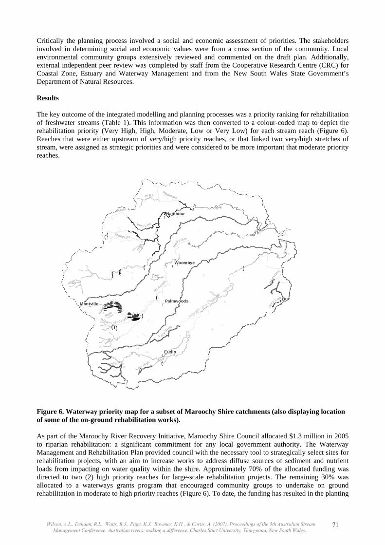
Figure 3. Modelling results displaying relative contributions of total P to the Maroochy River estuary. A conceptual model was developed (Figure 5) to identify existing and planned projects and knowledge gaps that may need to be addressed during the process. The planning team was able to link in with an existing modelling process and expand the model to include catchment management scenarios to inform the development of the plan. Previous local reports and data were extensively reviewed and field assessment was performed at 55 sites with 28 different environmental parameters being used to assess attributes the ecological condition of both aquatic and riparian habitats. A stream classification, based on geomorphic River Styles® and land management practices, was used to extrapolate data from the 55 sites to approximately 200 reaches of stream. Each reach was assessed and prioritised according to its ecological condition, threats to that condition, and recovery potential, and broad rehabilitation strategies were recommended to address these issues.
Wilson, A.L., Dehaan, R.L., Watts, R.J., Page, K.J., Bowmer, K.H., & Curtis, A. (2007). Proceedings of the 5th Australian Stream Management Conference. Australian rivers: making a difference. Charles Sturt University, Thurgoona, New South Wales.
69
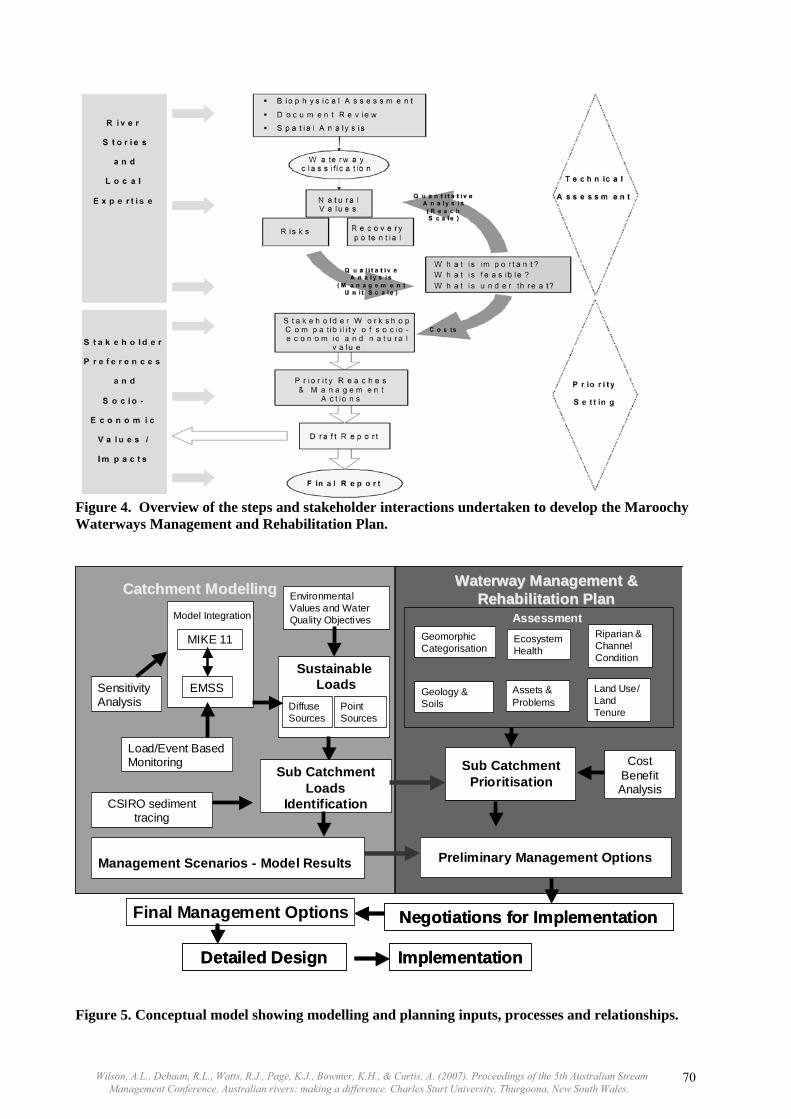
Figure 4. Overview of the steps and stakeholder interactions undertaken to develop the Maroochy Waterways Management and Rehabilitation Plan.
Negotiations for Implementation
Detailed Design
COMPLETE
AssessmentGeomorphic Categorisation
Ecosystem Health
Riparian & Channel Condition
Geology & Soils
Assets & Problems
Land Use/ Land Tenure
Sub CatchmentPrioritisation
Cost Benefit Analysis
Preliminary Management Options
Model Integration
MIKE 11
EMSS
Load/Event Based Monitoring
Sensitivity Analysis
SustainableLoads
Diffuse Sources
Point Sources
Environmental Values and Water Quality Objectives
CSIRO sediment tracing
Sub Catchment Loads
Identification
Management Scenarios - Model Results
WaterwayWaterway Management & Management & Rehabilitation PlanRehabilitation PlanCatchmentCatchment ModellingModelling
Implementation
Final Management Options
Page end
Negotiations for Implementation
Detailed Design
COMPLETE
AssessmentGeomorphic Categorisation
Ecosystem Health
Riparian & Channel Condition
Geology & Soils
Assets & Problems
Land Use/ Land Tenure
Sub CatchmentPrioritisation
Sub CatchmentPrioritisation
Cost Benefit Analysis
Preliminary Management Options
Model Integration
MIKE 11
EMSS
Load/Event Based Monitoring
Sensitivity Analysis
SustainableLoads
Diffuse Sources
Point Sources
Environmental Values and Water Quality Objectives
CSIRO sediment tracing
Sub Catchment Loads
Identification
Management Scenarios - Model Results
WaterwayWaterway Management & Management & Rehabilitation PlanRehabilitation PlanCatchmentCatchment ModellingModelling
Implementation
Final Management Options
Page endFigure 5. Conceptual model showing modelling and planning inputs, processes and relationships.
Wilson, A.L., Dehaan, R.L., Watts, R.J., Page, K.J., Bowmer, K.H., & Curtis, A. (2007). Proceedings of the 5th Australian Stream Management Conference. Australian rivers: making a difference. Charles Sturt University, Thurgoona, New South Wales.
70
Critically the planning process involved a social and economic assessment of priorities. The stakeholders involved in determining social and economic values were from a cross section of the community. Local environmental community groups extensively reviewed and commented on the draft plan. Additionally, external independent peer review was completed by staff from the Cooperative Research Centre (CRC) for Coastal Zone, Estuary and Waterway Management and from the New South Wales State Government’s Department of Natural Resources. Results The key outcome of the integrated modelling and planning processes was a priority ranking for rehabilitation of freshwater streams (Table 1). This information was then converted to a colour-coded map to depict the rehabilitation priority (Very High, High, Moderate, Low or Very Low) for each stream reach (Figure 6). Reaches that were either upstream of very/high priority reaches, or that linked two very/high stretches of stream, were assigned as strategic priorities and were considered to be more important that moderate priority reaches.
!(
!(!(
!(
!(
!(
!(
_̂̂_̂_ _̂̂_̂_̂_̂_̂_̂_̂_̂_̂_̂_̂_ _̂̂__̂̂_̂_
_̂̂_̂_̂_̂_̂_̂_
_̂̂__̂̂_ _̂̂_̂__̂̂_
_̂̂_̂_̂_̂_̂_̂_̂_̂_̂_̂_̂_̂_̂_
_̂̂_̂_
_̂̂_̂_̂_̂_̂_̂__̂̂_̂_̂_
_̂
_̂ _̂
_̂ _̂_̂̂_
_̂̂_̂_̂_̂_̂_̂_̂_̂_̂_̂_̂_̂_̂_̂_̂_̂_̂_̂_
_̂̂_ _̂_̂ _̂ _̂_̂̂_
_̂̂_̂_
_̂̂_̂_̂_̂_̂_̂_̂_̂_̂_̂_̂_̂_̂_̂_̂_̂_̂_̂_̂_̂_̂_̂_̂_̂_̂_̂_̂_̂_̂_̂_̂_̂_̂_̂_̂_̂_̂_̂_̂_̂_̂_̂_̂_̂_̂_̂_̂_̂_̂_̂_̂_̂_̂_̂_̂_̂_̂_̂_̂_̂_
_̂
_̂̂_̂_̂_̂_̂_̂_̂_̂_̂_̂_̂_̂_̂_̂_̂_̂_̂_̂_̂_̂_̂_̂_̂_̂_̂_̂_̂_̂_̂_̂_̂_̂_̂_̂_̂_̂_̂_̂_̂_̂_
!(!(
!(
!(
!(
!(
!(!(
!(!( !(
!(
!(!(
!(
!(
Eudlo
Woombye
Buderim
Nambour
Montville Palmwoods
Moderate
Ve ry H
igh
Moderate
L ow
Very Low
High
Moderate
High
oderate
Very
Low
Mod
erate
Mod
erate
Very High
Modera
te
H igh
Moderate
High
Very L
Hig
h
Very High
V
HighHig
h
Very High
Moderate
H
igh
Very High
High
Figure 6. Waterway priority map for a subset of Maroochy Shire catchments (also displaying location of some of the on-ground rehabilitation works). As part of the Maroochy River Recovery Initiative, Maroochy Shire Council allocated $1.3 million in 2005 to riparian rehabilitation: a significant commitment for any local government authority. The Waterway Management and Rehabilitation Plan provided council with the necessary tool to strategically select sites for rehabilitation projects, with an aim to increase works to address diffuse sources of sediment and nutrient loads from impacting on water quality within the shire. Approximately 70% of the allocated funding was directed to two (2) high priority reaches for large-scale rehabilitation projects. The remaining 30% was allocated to a waterways grants program that encouraged community groups to undertake on ground rehabilitation in moderate to high priority reaches (Figure 6). To date, the funding has resulted in the planting
Wilson, A.L., Dehaan, R.L., Watts, R.J., Page, K.J., Bowmer, K.H., & Curtis, A. (2007). Proceedings of the 5th Australian Stream Management Conference. Australian rivers: making a difference. Charles Sturt University, Thurgoona, New South Wales.
71

of more than 100,000 native trees, involved some 77 properties, seen the installation of 20 kilometres of protective fencing and numerous cattle crossings. Table 1. Distribution of priority reaches for riparian rehabilitation in the Maroochy Shire.
Mary River Sub-catchments Maroochy & Mooloolah River Sub-catchments
Priority
Number of reaches
Length (m)
Percent of catchment
length
Number of reaches
Length (m)
Percent of catchment
length Very high 12 114 968 36.8 13 62 192 15.4 High 8 62 932 20.1 21 130 456 32.3 Moderate 8 84 054 26.9 17 134 185 33.3 Low 1 50 373 16.1 5 37 878 9.4 Very low 0 0 0 6 38 243 9.5 Total 29 312 327 100 62 402 954 100 Discussion Council, in partnership with the community, now has a rational basis for allocating funds to protect and improve Maroochy Shire’s waterways. Modelled ecological health forecasts for the Maroochy River estuary indicate that by upgrading the STP (scheduled for completion in 2007) and increasing riparian buffers by 50% over the next 10 years will result in a C grade for either a wet, dry or average year. However, if Council and others fail to significantly invest and build on existing riparian buffers, an improvement in the health of the Maroochy estuary is unlikely. In a recent detailed riparian vegetation mapping, quantification, and cost analysis exercise, council identified that riparian vegetation existed along only 50% of waterways (using a 10m buffer). To achieve a continuous 10m riparian buffer and significantly reduce diffuse sediment loads entering our waterways, council would be required to plant 2.5 million trees and install and maintain 500km of protective fencing at an estimated cost of $26 million. Conclusion The planning and modelling process outlined above has allowed council to quantify pollutant loads from different sub-catchments, assign priority to stream reaches, and determine the amount of rehabilitation required to maintain and/or improve the waterways of the Maroochy Shire. Through the Maroochy River Recovery Initiative, Council has started implementing the recommended management actions in the Maroochy Waterways Management and Rehabilitation Plan and has embarked on the journey to rehabilitate the Maroochy River. Acknowledgments Council acknowledge the contributions and support of Hydrobiology Pty Ltd, Natural Solutions Pty Ltd (formerly 4Site Pty Ltd), WBM, Maroochy Landcare, Maroochy Waterwatch, Mary River Catchment Coordinating Association, Moreton Bay Waterways & Catchments Partnership, SEQ Catchments and QLD Department of Natural Resources and Water. References Maroochy Shire Council. (2005). Maroochy Waterways Management and Rehabilitation Plan prepared by
Hydrobiology Pty. Ltd. and 4Site Pty. Ltd., December 2005. EHMP. (2006). Ecosystem Health Monitoring Program (EHMP) for freshwater, estuarine and marine regions
of South East Queensland. Moreton Bay Waterways and Catchments Partnership Annual Technical Report 2004-05.
Searle, R. (2005). Modelling of runoff, sediment and nutrients loads for the Maroochy River catchment using EMSS. Cooperative Research Centre for Catchment Hydrology, Technical Report 05/08.
WBM. (2004). Maroochy Estuary Sustainable Loads Study – Supplementary Technical Report to Moreton Bay Waterways and Catchments Partnership.
Wilson, A.L., Dehaan, R.L., Watts, R.J., Page, K.J., Bowmer, K.H., & Curtis, A. (2007). Proceedings of the 5th Australian Stream Management Conference. Australian rivers: making a difference. Charles Sturt University, Thurgoona, New South Wales.
72