developing guidelines for incorporating managing … programming: transportation demand management...
TRANSCRIPT

Developing Guidelines for Incorporating Managing Demand into WSDOT Planning
and Programming: Transportation Demand Management Guidance for Corridor
Planning Studies
Final Report February 2016
FDOT PROJECT NO. GCB 1374 WA-RD-834-1
PREPARED FOR Washington State Department of Transportation
ii
TECHNICAL REPORT DOCUMENTATION PAGE 1. Report No. WA-RD 746.1 CUTR project 2117
2. Government Accession No.
3. Recipient's Catalog No.
4. Title and Subtitle Transportation Demand Management Guidance for Corridor Planning Studies
5. Report Date February 2016
6. Performing Organization Code
7. Author(s) Sara Hendricks, Philip Winters, Nevine Georggi, and Behzad Karimi Varzardoliya Email: [email protected]
8. Performing Organization Report No.
9. Performing Organization Name and Address
Center for Urban Transportation Research University of South Florida 4202 E. Fowler Av., CUT 100 Tampa, FL 33620 Tel: 813-974-3120
10. Work Unit No. (TRAIS)
11. Contract or Grant No. WSDOT Contract GCB 1374 (WA-RD-834.1)
12. Sponsoring Agency Name and Address
Washington State Department of Transportation Transportation Building, MS: 7372 Olympia, Washington 98504-7372
Project Manager: Karena Houser, Economic and Land Use Branch Manager
13. Type of Report and Period Covered
DRAFT final
14. Sponsoring Agency Code
15. Supplementary Notes
16. Abstract The Washington State Department of Transportation (WSDOT) regional planning programs address current and forecasted deficiencies of State highways through the conduct of corridor studies. This Guidance for the conduct of corridor planning studies is the product of a comprehensive evaluation of how to incorporate the consideration of Transportation Demand Management strategies into several business areas of the Washington State Department of Transportation (WSDOT). Corridor studies are an integral part of the transportation planning process, which support the State Highway System goals and objectives at the state and regional levels, as well as the vision for the corridor by the communities that the corridor serves. The Moving Washington approach recognizes the importance of using all the tools in the toolbox to cost effectively achieve the state transportation policy goals. This includes the mobility goal of maintaining the predictable movement of goods and people throughout the state of Washington. This Guidance describes a recommended approach to TDM strategies as part of least-cost planning for improving mobility. The Guidance asserts that all three methods: (1) managing travel demand, (2) optimizing traffic flow, and (3) accommodating travel demand by increasing capacity, should be used concurrently. This approach will advance the integration of TDM into the selected solutions aimed at reducing traffic congestion, providing mobility choices, enhancing transportation affordability, and meeting the State of Washington’s goals for reducing air pollution and greenhouse gas (GHG) emissions and improving community livability. This Guidance recommends use of a systematic process for identifying mobility needs, assessing existing TDM programs and resources, and evaluating potential TDM solutions against chosen performance metrics. 17. Key Word TDM, and Transportation demand management, and corridor planning
18. Distribution Statement
19. Security Classif. (of this report) none
20. Security Classif. (of this page) none
21. No. of Pages
64
22. Price

iii
DISCLAIMER
The contents of this report reflect the views of the authors, who are responsible for the facts and the accuracy of the data presented herein. The contents do not necessarily reflect the official views or policies of the Washington State Department of Transportation or the Federal Highway Administration. This report does not constitute a standard, specification, or regulation.

iv
TABLE OF CONTENTS
1.9.1 National Environmental Policy Act (NEPA) ................................................................................... 5 1.9.2 State Environmental Policy Act (SEPA) ........................................................................................... 6
2.2.1 Corridor Definition ............................................................................................................................. 8 2.2.2 Planning Time Horizon ...................................................................................................................... 8 2.2.3 Corridor Study Staffing ..................................................................................................................... 8 2.2.4 Corridor Vision .................................................................................................................................... 9 2.2.5 Corridor Study Scheduling ............................................................................................................... 9 2.2.6 Definition of TDM .............................................................................................................................. 9 2.2.7 Use of Screening or Threshold Performance Metrics ............................................................... 11 2.2.8 Use of Findings from the Corridor Sketch ................................................................................... 11
3.5.1 A Requirement for Consistency ..................................................................................................... 15 3.5.2 Review of Existing Local Regulations and TDM Programs ........................................................ 16
3.8.1 Screening (Threshold) Performance Metrics Direct the Problem Definition ....................... 19 3.8.2 “What is the problem? What is wrong?” ..................................................................................... 20
v
3.9.1 Need Statement Example ............................................................................................................... 22 3.9.2 Data and Analysis for Problem Definition and Need Statement ............................................ 22 3.9.3 Identifying Countermeasures ......................................................................................................... 23
3.12.1 Other Already-Reported Performance Metrics .......................................................................... 25
3.13.1 Economic Indicators as Alternative Performance Measures .................................................... 26 3.13.2 Accessibility as an Alternative Performance Measure .............................................................. 27
3.14.1 Apply the Findings from WSDOT’s Evaluation Using FHWA’s INVEST Criteria................... 28 3.14.2 Consider Using Congestion as a Disincentive ............................................................................. 29 3.14.3 Use the “No-Build” Alternative for TDM ..................................................................................... 30 3.14.4 Emphasis on Long Term Time Horizon Challenges Least-Cost Planning ............................... 30
3.16.1 Application of Existing TDM Models ............................................................................................ 33 3.16.2 TDM Cost and Benefit Data are Limited ...................................................................................... 36 3.16.3 Mobility Project Prioritization Process should be updated ...................................................... 36

vi
LIST OF TABLES
Table 3-1: Top Reasons Why CTR Work Site Employees Travel by SOV ............................................................. 22 Table 3-2: TDM Strategy Combinations to Support Mobility Performance Category ..................................... 33 Table 3-3: Input Requirements and Output Capabilities for Travel Efficiency Strategy Analysis
Tools and Models ......................................................................................................................................... 35 Table 4-3: Evaluation Criteria of Mobility Project Prioritization Process ............................................................ 37
LIST OF FIGURES
Figure 1: Prioritization Chart Example. ...................................................................................................................... 23

vii
ACRONYMS AND ABBREVIATIONS 3C Continuing, Comprehensive, and Coordinated AADT Annual Average Daily Traffic AVO Average Vehicle Occupancy AVR Average Vehicle Ridership BOD Basis of Design CBSM Community-Based Social Marketing CCAP Center For Clean Air Policy CCR Corridor Capacity Report CFA Contributing Factors Analysis COOP Continuity of Operations Plans CPDM Capital Program Development and Management CPPs Countywide Policies CSS Context Sensitive Solutions EIS Environmental Impact Statement GHG Greenhouse Gas HCS The Highway Capacity Software HOT High Occupancy Toll HSAP Highway Segment Analysis Program HSP The State Highway System Plan LCP Local Comprehensive Plans LEED Leadership In Energy & Environmental Design LODES Origin-Destination Employment Statistics LOS Level Of Service MAISA Multiagency, Interdisciplinary, and Stakeholder Advisory MC Monte Carlo MP3 Mobility Project Prioritization Process MPPs Multicounty Planning Policies MT³I Maximum Throughput Travel Time Index NEPA National Environmental Policy Act NHS National Highway System OD Origin-Destination Data , OFM Office of Financial Management PMT Passenger Miles of Travel PO Provocation Operation PSRC Puget Sound Regional Council PTD Public Transportation Division RAC Residential Area Characteristics Data RMGP Regional Mobility Grant Program RTPO Regional Transportation Planning Organization SEPA State Environmental Policy Act SHS State Highway System SHSP Strategic Highway Safety Plan STEAM Surface Transportation Efficiency Analysis Model
viii
TCM Transportation Control Measure TDMAP Transportation Demand Management Assessment Procedure TEG Transportation Emissions Guidebook TPO Transportation Planning Office TRIMMS™ Trip Reduction Impacts For Mobility Management Strategies TSM&O Transportation Systems Management And Operations UPO Urban Planning Office V/C Volume-to-Capacity VMT Vehicle Miles of Travel WAC Workplace Area Characteristics Data WSPTP Washington State Public Transportation Plan

1
1.1 Document Purpose
The Washington State Department of Transportation (WSDOT) regional planning programs address current and forecasted deficiencies of State highways through the conduct of corridor studies. This document was developed to serve as guidance for the WSDOT region’s transportation planners in the conduct of corridor studies, specifically addressing the use of transportation demand management (TDM) strategies. It describes a recommended approach to TDM strategies as part of least-cost planning for improving mobility. Use of this approach will advance the integration of TDM into the selected solutions aimed at reducing traffic congestion, providing mobility choices, enhancing transportation affordability, and meeting the State of Washington’s goals for reducing air pollution and greenhouse gas (GHG) emissions and improving community livability. This guidance recommends use of a systematic process for identifying mobility needs, assessing existing TDM programs and resources, and evaluating potential TDM solutions against chosen performance metrics.
The end result of the corridor study is that it will allow for consideration of recommendations in the allocation of implementation funds. Under the Moving Washington approach, the project must compete with other projects statewide for State funding. If selected, next steps may include the development of a corridor-wide project management and financial plan with associated performance standards, funding streams, and assignment of agency responsibilities. These responsibilities may include the implementation of TDM strategies and operational improvements and the phased completion of capital investments from the selected alternative. To be considered for federal funding, the project would need to be included in the Regional Planning Council’s Long Range Transportation Plan, and the proposed project would need to undergo an Environmental Assessment and Environmental Impact Statement (EIS) to satisfy requirements of the National Environmental Policy Act (NEPA).
1.2 Introduction to TDM
There are many varying definitions of TDM. Although many emphasize TDM’s use to reduce traffic congestion, the Federal Highway Administration (FHWA) defines TDM as a set of strategies aimed at maximizing traveler choices:
“Managing demand is about providing travelers, regardless of whether they drive alone, with travel choices, such as work location, route, time of travel and mode. In the broadest sense, demand management is defined as providing travelers with effective choices to improve travel reliability.” http://www.ops.fhwa.dot.gov/plan4ops/trans_demand.htm#_ftn1
TDM is commonly thought of as various forms of ridesharing, but it is a larger toolbox aimed at influencing travel behavior by means of several dimensions, including mode, route, day of week, time of day, trip frequency, trip length, and cost. TDM is most successful at changing travel behavior when there is a clear benefit valued by the traveler. This benefit also must be effectively communicated to a targeted travel market.
TDM strategies are comparatively low-cost with short delivery schedules and are intended to help travelers meet their transportation needs by providing options that change their travel behavior and return the system to more efficient operation. Exploring TDM strategies first, as part of a corridor study, helps ensure full use of the existing system before making higher-cost investments, often with longer implementation timetables, in system expansion.
One of the main obstacles for incorporating TDM into corridor planning includes measuring its performance. This can be addressed through the careful selection of baseline and contextual performance measures (as discussed in the “Guidance Documents: Information on WSDOT’s Practical Design Procedures” (November

2
2015), identifying the data needed to measure performance and assigning sufficient and continuing resources over time to properly collect and analyze performance data before and after TDM implementation. Depending on the TDM strategies selected, WSDOT may not have complete control of TDM program implementation and, as such, recognizes the importance of developing stronger partnerships with other stakeholders.
Another obstacle to incorporating TDM into corridor planning is the common understanding that whatever the reduction in motor vehicle trips achieved in the peak periods of congestion, the freed capacity will soon be absorbed by other trips as soon as the capacity is made available. It is important to keep in mind that the effect of latent demand is just as true for TDM as it is for transportation systems management and operations (TSM&O) strategies and capacity expansion. Especially in a planning environment that forecasts continued urban growth despite highway system resource constraints, travel delay is not anticipated to disappear. However, travel delay is recognized in TDM as a tool that can be used to change the timing, mode, and route of those who choose to travel during peak periods. TDM strategies provide the services, choices, and incentives to those travelers willing to make the change, because TDM is traveler-focused, not traffic-flow-focused. As travelers become better served by WSDOT’s investment in more choices that are developed to be just as effective (quick, reliable, convenient), if not more so, than driving alone, peak-period demand also will spread, providing greater service by the existing system.
TDM starts with understanding the needs of the many traveler markets in Washington State—where travelers come from and where they want to go and looking at entire trips from their origins to destinations and their travel requirements and constraints. This is different from the most common approach by WSDOT to address mobility, which is focusing upon traffic bottlenecks and striving to maintain traffic flow at a minimum of 70% of the posted speed limit.
Federal law requires a continuing, comprehensive, and coordinated (3C) MPO planning process, and successful TDM implementation requires the same approach. Highway safety requires continual investment in enforcement and education, and TDM requires ongoing information and public awareness campaigns. Highway capacity improvements after construction require continuing expenditures in maintenance, operation, monitoring, preservation, repair, resurfacing, and replacement, and TDM requires continual investment in travel market analysis, development, and implementation of policies, programs, services, and incentives, as well as performance monitoring and evaluation. This guidance offers recommendations for incorporating TDM into corridor planning studies as a complement to “Guidance Documents: Information on WSDOT’s Practical Design Procedures” (November 2015) and the “Washington State Public Transportation Plan, Draft” (October 2015).
1.3 Basic Outline of this Document
This document contains the following materials describing TDM in corridor planning:
• Statutory and planning framework • Major resources and references • WSDOT departments and external stakeholders involved in corridor planning • Corridor study scoping recommendations for management from a TDM perspective • Incorporating TDM into steps of conducting a corridor study
This document also contains several appendices with supporting materials:
• A: Mobility Gap Analysis Tool • B: TDM Analysis for Corridor Sketch • C: Overview of TDM in Washington State • D: Example of Policy Guidance at the Regional Level that May Relate to TDM • E: Social Marketing • F: Lateral Thinking Technique: Provocation Operation

3
• G: Washington State Public Transportation Plan: Goals, Strategies, and Performance Indicators • H: Compilation of Statewide Goals
1.4 Statutory and Planning Framework
The purpose of a corridor planning study is to identify potential long-range investments in State roadways that are aligned with federal, State, regional, and local planning efforts. The State’s multimodal transportation investments are funded through the funding package adopted by the Governor and the Washington legislature, known as Connecting Washington.1
These long-range investments often depend upon federal funding for implementation. As a result, the preferred alternative resulting from a corridor planning study must be aligned with the Long Range Transportation Plan of the metropolitan planning organization (MPO) or regional transportation planning organization.2 These long-range investments are multimodal, considering and incorporating transportation improvements for all modes as included in the State-owned and State-interest components of the Statewide Multimodal Transportation Plan.3 These investments also are consistent with the six-year transit plans of transit agencies serving the corridor, as well as the comprehensive plan transportation elements of local governments whose jurisdictions include portions of the study corridor. The local government comprehensive planning process is governed by the Washington State Growth Management Act, RCW 36.70A.
The results of corridor planning studies also identify and incorporate safety improvements to address the federally required Target Zero Strategic Highway Safety Plan (SHSP) that is part of the State Highway System Plan (HSP).4
Alternative transportation improvement scenarios identified in corridor planning studies are evaluated for their contribution toward achieving the six state transportation policy goals of Preservation, Safety, Mobility, Environment, Economic Vitality, and Stewardship established in State law RCW 47.04.280.
RCW 47.06.050 also requires that WSDOT first assess strategies to enhance operational efficiency of the existing system before expanding the system, and these strategies include TDM. The incorporation of TDM into corridor planning studies implements Moving Washington, WSDOT’s approach for making transportation investment decisions. Moving Washington calls for employing all three strategies of managing demand, operating the system efficiently, and adding capacity strategically and provides the foundation for Results WSDOT. Results WSDOT is WSDOT’s Strategic Plan that provides the vision, mission, values, goals, priority outcomes, and strategies that guide the work of WSDOT.5 Implementing the Moving Washington approach also makes use of the principles of least-cost planning and practical design.6
1.5 Major WSDOT Resources and References
The following are major WSDOT resources and other references used for this study:
• Guidance Documents: Information on WSDOT’s Practical Design Procedures (November 2015) http://www.wsdot.wa.gov/publications/fulltext/design/ASDE/Practical_Design.pdf
• SR 520 Multi-modal Corridor Planning Study (April 2013) http://www.wsdot.wa.gov/planning/Studies/SR520EastCorridor/ See also the SR 520 Bridge Replacement and HOV Program website at http://www.wsdot.wa.gov/Projects/SR520Bridge/
1 http://www.wsdot.wa.gov/Projects/Funding/CWA/. 2 See 23 USC §§134-135, and RCW 47.80.030. 3 See RCW 47.06.040. 4 See RCW 47.06.050. 5 http://www.wsdot.wa.gov/Secretary/ResultsWSDOT.htm. 6 http://www.wsdot.wa.gov/Projects/PracticalDesign/

4
• Demand Management for WSDOT Planning & Projects (Cotton, Leotta, Johnston, and Brady, Fall 2013)
• Community Engagement Plan (December 2015 update) http://www.wsdot.wa.gov/NR/rdonlyres/9A837BAE-2664-4597-AB85-B8A7318D3A6D/0/CommunityEngagementPlan.pdf
• Washington State Public Transportation Plan (Draft, October 2015) http://www.wsdot.wa.gov/Transit/TransportationPlan
• Demand Management—A Primer for Transportation Planners and Engineers http://www.wsdot.wa.gov/choices/demand
• Transportation Demand Management: A Guide for Including TDM Strategies in Major Investment Studies and in Planning for other Transportation Projects (August 1996) http://www.wsdot.wa.gov/NR/rdonlyres/DB7F61C3-C295-4127-81D8-250885A75455/0/TDMstrategiesforMajorInvestments.pdf
• Design Manual, M 22-01.12, Practical Design, Chapters 1100-1105 (November 2015) http://www.wsdot.wa.gov/publications/manuals/fulltext/M22-01/design.pdf
• Handbook for Corridor Capacity Evaluation (October 2014) • http://www.wsdot.wa.gov/publications/fulltext/graynotebook/CCR14_methodology.pdf • 2007 Transportation Planning Studies Guidelines and Criteria. M3033.00 (November 2007)
http://www.wsdot.wa.gov/NR/rdonlyres/8B2B613F-D6F1-4515-82E5-23417C7C321D/0/NovFinalTPSGC.pdf
• Regional TDM Action Plan 2013-2018 (PSRC 2013) • http://www.psrc.org/assets/9910/TDM_Action_Plan_july_2013.pdf?processed=true • Growth and Transportation Efficiency Centers (November 2008)
http://www.wsdot.wa.gov/NR/rdonlyres/8C3F6465-1E56-4F58-8CEB-7D5B3A735391/0/GTECFolioWEB.pdf
• Cost Estimating Methodology (Modeling TDM Effectiveness, Appendix C TEEM 2.0 Documentation (2004) http://www.ecy.wa.gov/programs/swfa/greenbuilding/pdf/gsaleed.pdf
• Incorporating Assumptions for TDM Impacts in a Regional Travel Model (TDMAP) (2010) http://www.wsdot.wa.gov/research/reports/fullreports/746.1.pdf
• National Cooperative Highway Research Program Report 708, A Guidebook for Sustainability Performance Measurement for Transportation Agencies (2011) http://onlinepubs.trb.org/onlinepubs/nchrp/nchrp_rpt_708.pdf
• Office of Transportation and Air Quality U.S. Environmental Protection Agency, Potential Changes in Emissions Due to Improvements in Travel Efficiency – Final Report (2011) http://www3.epa.gov/otaq/stateresources/policy/420r11003.pdf
• Federal Highway Administration, USDOT, Integrating Demand Management into the Transportation Planning Process: A Desk Reference, FHWA-HOP-12-035 (August 2012) http://www.ops.fhwa.dot.gov/publications/fhwahop12035/fhwahop12035.pdf
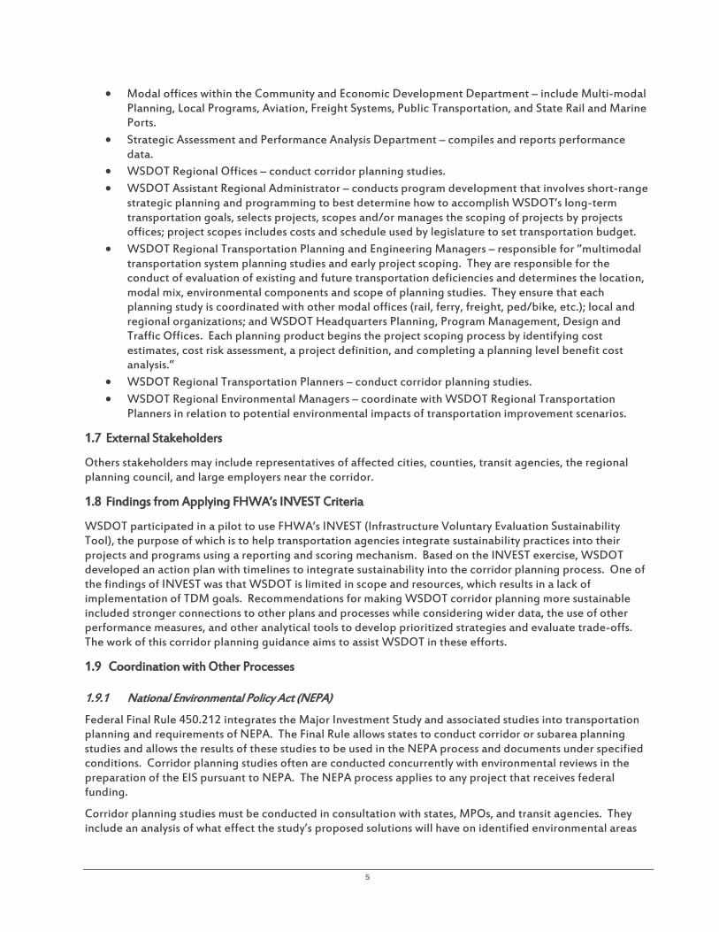
1.6 WSDOT Departments Involved in Corridor Planning
Many WSDOT departments may be involved in corridor planning:
• Capital Program Development and Management (CPDM) Office – responsible for the development, management, and delivery of projects and programs of projects; conducts project planning, scoping, programming, budgeting, and program delivery and is involved with scoping, budgeting and programming corridor planning studies.
• Systems Analysis and Planning – ensures that corridor planning efforts comply with federal and state requirements.
• Toll Division – proposes, builds, operates and processes toll collection on the Tacoma Narrows Bridge, SR 167 HOT lanes, SR 520, and the I-405 express toll lanes.
5
• Modal offices within the Community and Economic Development Department – include Multi-modal Planning, Local Programs, Aviation, Freight Systems, Public Transportation, and State Rail and Marine Ports.
• Strategic Assessment and Performance Analysis Department – compiles and reports performance data.
• WSDOT Regional Offices – conduct corridor planning studies. • WSDOT Assistant Regional Administrator – conducts program development that involves short-range
strategic planning and programming to best determine how to accomplish WSDOT’s long-term transportation goals, selects projects, scopes and/or manages the scoping of projects by projects offices; project scopes includes costs and schedule used by legislature to set transportation budget.
• WSDOT Regional Transportation Planning and Engineering Managers – responsible for ”multimodal transportation system planning studies and early project scoping. They are responsible for the conduct of evaluation of existing and future transportation deficiencies and determines the location, modal mix, environmental components and scope of planning studies. They ensure that each planning study is coordinated with other modal offices (rail, ferry, freight, ped/bike, etc.); local and regional organizations; and WSDOT Headquarters Planning, Program Management, Design and Traffic Offices. Each planning product begins the project scoping process by identifying cost estimates, cost risk assessment, a project definition, and completing a planning level benefit cost analysis.”
• WSDOT Regional Transportation Planners – conduct corridor planning studies. • WSDOT Regional Environmental Managers – coordinate with WSDOT Regional Transportation
Planners in relation to potential environmental impacts of transportation improvement scenarios.
1.7 External Stakeholders
Others stakeholders may include representatives of affected cities, counties, transit agencies, the regional planning council, and large employers near the corridor.
1.8 Findings from Applying FHWA’s INVEST Criteria
WSDOT participated in a pilot to use FHWA’s INVEST (Infrastructure Voluntary Evaluation Sustainability Tool), the purpose of which is to help transportation agencies integrate sustainability practices into their projects and programs using a reporting and scoring mechanism. Based on the INVEST exercise, WSDOT developed an action plan with timelines to integrate sustainability into the corridor planning process. One of the findings of INVEST was that WSDOT is limited in scope and resources, which results in a lack of implementation of TDM goals. Recommendations for making WSDOT corridor planning more sustainable included stronger connections to other plans and processes while considering wider data, the use of other performance measures, and other analytical tools to develop prioritized strategies and evaluate trade-offs. The work of this corridor planning guidance aims to assist WSDOT in these efforts.
1.9 Coordination with Other Processes
1.9.1 National Environmental Policy Act (NEPA)
Federal Final Rule 450.212 integrates the Major Investment Study and associated studies into transportation planning and requirements of NEPA. The Final Rule allows states to conduct corridor or subarea planning studies and allows the results of these studies to be used in the NEPA process and documents under specified conditions. Corridor planning studies often are conducted concurrently with environmental reviews in the preparation of the EIS pursuant to NEPA. The NEPA process applies to any project that receives federal funding.
Corridor planning studies must be conducted in consultation with states, MPOs, and transit agencies. They include an analysis of what effect the study’s proposed solutions will have on identified environmental areas

6
and socioeconomic areas considered under Title VI. The Final Rule states that the results of corridor or sub area studies may result in the following:
• Purpose and need or goals and objective statements • General travel corridor and/or general modes definition (highway, transit, or a highway/transit
combination) • Preliminary screening of alternatives and elimination of unreasonable alternatives • Basic description of environmental setting • Preliminary identification of environmental impacts and environmental mitigation
The NEPA regulations for any project receiving federal aid are found at 40 CFR 1500-1508. See also FHWA’s regulations applicable to federal-aid highway projects at 23 CFR 771.
Corridor planning studies sometimes can take two or more years to complete. Preliminary environmental studies begin early in the process. Often, the stated need for the planning study is traffic congestion. An example of the purpose of the planning study is to provide an efficient and functional transportation route through a corridor that will improve roadway capacity, mobility, and safety and improve regional connectivity.
A detailed EIS may be conducted concurrently with preliminary engineering design. The EIS evaluates alternatives, including a no-build alternative, with respect to impacts over a 20-year period. In coordination with multiple agencies, discipline reports are prepared detailing potential impacts, not only to transportation but also to land use and agriculture, communities and economic development, wetlands, fish and aquatic, vegetation and wildlife, water resources, geology and soils, hazardous waste, air and noise, visual impacts, cultural resources, impacts to parks and historic sites, and energy.
1.9.2 State Environmental Policy Act (SEPA)
WSDOT planning studies do not need to meet SEPA requirements. WSDOT projects, programs, actions, and activities are integrated through the Transportation Commission and Department Environmental Policy Act Rules.7 The SEPA Handbook and an environmental checklist can be found on the Washington Department of Ecology website.
T D M a n d E n v i r o n m e n t a l R e v i e w
In the conduct of an environmental review of the corridor and the potential impacts of alternative transportation improvement scenarios, TDM has the potential to lessen impacts on areas other than transportation, such as air quality and storm water management. For example, the reduction of motor vehicle miles traveled (VMT) as a result of a TDM program may measurably improve air quality. The reduction in impervious surface due to the delay in the need for capacity expansion as a result of TDM programs may measurably improve storm water management.
It is recommended that early involvement of the WSDOT regional planning staff, WSDOT Public Transportation Division (PTD) staff, and the WSDOT Regional Environmental Manager can help identify TDM strategies that may positively impact not only transportation but also performance for air quality and other topic areas, as will be detailed in the discipline reports developed for an EIS. This may inform the comparison of the alternative transportation improvement scenarios.
7 See WAC 468-12. See also RCW 43.21C, SEPA Rules, WAC 197-11.

7
2.1 Overview
In Washington State, six statutory transportation policy goals clearly outline expectations for transportation system performance. These are necessarily at a high level, and so at the corridor scale planning teams may need to dig deeper to understand performance gaps or problems. The corridor planning process thus starts with the identification of gaps or operational deficiencies along segments of the State Highway System (SHS). For example, identified mobility may be based on the use of the Highway Segment Analysis Program (HSAP), or other screening tools meant to quickly identify problem areas as a starting point. Other sources of information on any particular corridor segment may also be available, such as geographic data in WSDOT’s Community Planning Portal or a corridor summary report generated by the Capital Program Development and Management (CPDM) Division. Physical and operating characteristics of the corridor must be gathered, along with descriptions of adjacent land use, environmental issues, and major economic issues. Origin and destination (OD) travel characteristics where they exist will prove helpful, especially including seasonal changes, truck traffic, and history of collisions. Based upon available information and analysis, the WSDOT regional planning staff prepare the proposal for a Corridor Planning Study. Each proposal includes a narrative description of the corridor. The proposal also includes an articulation of the key questions and issues of the corridor that need to be resolved including a clear presentation of any performance gaps that exist or will be projected to occur over the planning time horizon, usually 20 years. Concerns and performance issues are identified as they relate to the State policy goals of preservation, safety, mobility, environment, economic vitality, and stewardship. The study proposal includes cost estimates for the proposed corridor planning study and an identification of community factors such as opportunities for partnership and the degree of support for the proposal by the regional transportation planning organization (RTPO) or MPO. The sources of data for the proposal also are identified. Each proposal is submitted by a designated WSDOT regional lead staff person, with the concurrence of the RTPO/MPO and the WSDOT Regional Administrator. The proposal is submitted to the Multimodal Planning Division Director for consideration.
Each WSDOT region submits multiple corridor planning study proposals, ranked in order of priority by the WSDOT region. They also must submit information about how the MPOs/RTPOs were involved in identifying the proposed studies and the MPO/RTPO’s degree of support for the WSDOT region’s highest-ranked priorities. The prioritized lists of corridor study proposals are submitted to CPDM at WSDOT headquarters by a deadline set prior to the development of a detailed budget proposal to develop a six-year statewide list. The WSDOT Region may also propose to invest in intensive engagement with other agencies’ studies, such as MPO subarea studies.
Corridor planning study proposals are reviewed internally by several divisions in WSDOT, including Public Transportation, Traffic Operations, and Design. The Multimodal Planning Division Director determines the study proposals to advance and fund as part of the biennial budgeting and planning program development (Statewide Planning & Research Work Program) with a recommended funding amount and description of any needed scope changes. The legislature itself may make planning study decisions independent of this process.
If funded, the corridor study proposal incorporates WSDOT policy direction such as Practical Solutions approaches, planning study guidance, and other relevant best practice resources such as National Cooperative Highway Research Program (NCHRP) Report 435, “Guidebook for Transportation Corridor Studies: A Process for Effective Decision-Making and WSDOT’s “2007 Planning Studies Guidelines and Criteria Report.” Most recently, WSDOT issued “Guidance Documents: Information on WSDOT’s Practical Design Procedures” (November 2015) (hereinafter referred to as “Practical Design Procedures”), the process of which has been developed for use in planning, scoping, and design.
8
2.2 Corridor Study Scoping Recommendations for Management at Regional and Headquarters Levels
2.2.1 Corridor Definition
There are 291 defined segments on the SHS, the termini of which have been established based upon certain criteria.
It is recommended during the scoping for a corridor study to examine the milepost-to-milepost definition of the corridor and its associated travel shed and study area to determine if it makes sense from the standpoint of travel patterns by the various travel markets using the corridor. It is recommended to identify other streets that influence corridor performance, such as those serving as parallel alternative routes. The corridor may be a system of streets and bike paths, for example, rather than one highway.
2.2.2 Planning Time Horizon
State law requires estimates of future travel demand using 10- and 20-year time horizons. Looking far into the future is necessary for planning large capital projects, but the uncertainty of long-term forecasting risks overdesign. For example, one of the uncertainties is understanding how connected vehicles and autonomous vehicles will affect the need for transportation capacity.
Short-term improvements and their potential positive effects also may be overlooked. TDM can be implemented in the short term, targeting TDM service improvements that also are least-cost, with impacts on future travel demand that may affect those estimates 10 and 20 years into the future.
A planning time horizon is determined as part of scoping a corridor study. For example, a study involving replacing a bridge may require a longer time horizon than other types of corridor studies.
It is recommended to establish interim planning time horizons to coincide with shorter- and mid-term TDM service delivery objectives associated with TDM programs. For example, TDM programs may be developed to initially extend the operational functionality of a bridge, then can later be expanded into construction mitigation strategies as initial phases of bridge replacement begin. Establishing interim planning time horizons for TDM recognizes and makes use of quick delivery capabilities of TDM and avoids thinking only in terms of setting TDM performance objectives to be achieved 20 or 30 years into the future. It also is recommended to initiate TDM strategies in the near term, with performance measured against the investment in the strategies. Changes in operation of the transportation facility as a result of TDM in the near term could be considered and incorporated into the estimation of future conditions.
2.2.3 Corridor Study Staffing
Developing alternative transportation improvement scenarios for the corridor that incorporate TDM will require the participation of WSDOT staff with expertise in TDM. The Washington State Public Transportation Plan (WSPTP), Draft (October 2015) includes demand management under the umbrella of public transportation that is broadly defined to include any form of transportation that is accessible and available to the public that does not involve a single person in a motorized vehicle. “Public” refers to access to the service, not to the ownership of the system providing the service (WSPTP, Draft, October 2015, p.15) The WSPTP lists examples of public transportation services and programs to include TDM. The WSDOT PTD has implemented TDM through the Commute Trip Reduction (CTR) Program, Growth and Transportation Efficiency Centers (GTEC), the Trip Reduction (Pay for Performance) Program (TRPP), and operation of the largest vanpool program in the U.S. As a result, the staff of the WSDOT PTD are a primary resource for WSDOT regional planners for TDM strategy identification in the corridor planning study process.
It is recommended that corridor study cost estimates include staff time from PTD for the duration of the corridor study.

9
2.2.4 Corridor Vision
The vision for the corridor should be informed by the needs of the local community.
It is recommended that, for purposes of all corridor studies, all WSDOT headquarters departments that play a role in corridor planning should participate in defining the essential elements contained within a corridor vision statement, establish a process for developing a corridor vision statement, and identify what entity makes a final determination of the corridor vision.
2.2.5 Corridor Study Scheduling
Federal law requires that lead agencies must give the public opportunity for involvement during the development of the purpose and need statement and for identifying the range of alternatives.
It is recommended, as part of the decision for scheduling in which biennium a corridor study is funded, to time the conduct of the corridor study, if possible, with the host local government’s comprehensive plan update, so that the public involvement process for the comprehensive plan update coincides with the corridor planning study.
This makes the best use of public meeting opportunities and has the benefit of updated information from the local government regarding updated population and employment estimates and projections and updates on existing and future land use and land development that may affect the corridor. Localities also may contain designated regional centers where transportation investments are to be concentrated and may have updates for subarea plans, town centers, and activity nodes. This is important to TDM in the collection of local community information regarding travel markets, OD information, and local comprehensive plan policy updates relating to the required TDM section of the transportation element.
Local governments also amend local regulations that implement the comprehensive plans to ensure that the regulations are consistent with comprehensive plan updates. Local regulations may implement TDM-related programs, including zoning overlays such as transit-oriented development (TOD) districts, subdivision ordinances with circulation and access requirements that provide more direct routes for pedestrians, parking ordinances, CTR ordinances, and others. As these regulatory instruments are updated and TDM-related program goals and objectives at the local level are updated, advantageous timing of the corridor study will enable the development of TDM program goals that are consistent with and supportive of local TDM programs.
2.2.6 Definition of TDM
The distinction between TSM&O and TDM is not sharply drawn. Sometimes the end result of this fuzzy distinction is for TDM to be overlooked. TDM tends to emphasize and target deliberate travel decisions planned by individuals in advance of the trip. Although the time frame of TSM&O strategies aimed at improving traffic flow is more instantaneous as motorists react to traffic controls and conditions, TDM works best as a package of programs, services, incentives, disincentives, and policies used in tandem with TSM&O and the physical multimodal capital facilities to promote the use of transit, vanpools, bicycling, and walking.
It is recommended that WSDOT regional and headquarters management who are responsible for scoping the corridor study develop a statement about TDM to promote a common understanding among WSDOT departments about the strategies included in TDM.

10
The SR 520 corridor study provided a comprehensive list of TDM strategy types for the corridor, as provided below. The list is not exhaustive but might be considered a good description of anticipated TDM strategy types for other future corridor planning studies.8
1. Vanpool promotion – market vanpools and offer subsidies and incentives for new vanpools.
2. Employer engagement – supplement existing commute trip reduction, GTECs, transportation management activities, and transit efforts with targeted investments at businesses that employ corridor residents; support employers who will improve commute efficiency by offering telework/compressed work week technical assistance as well as transit, carpool, and vanpool subsidies, priority parking for carpools and vanpools, and increasing single-occupant vehicle (SOV) parking fees at worksites.
3. Vanpool relocation – target outreach and incentives to existing vanpools to encourage them to move from overused park-and-rides to those that are underused to free up parking for new transit users; vanpools that move to underused park-and-rides stay in these locations because they are often more convenient.
4. Multimodal commute coaching, outreach, and incentives – employ community-based outreach and marketing programs (e.g., “Curb the Congestion,” “In Motion”) that provide individualized commute coaching and incentives to move people from SOV commutes to other modes.
5. Ridesharing – promote vanpools and carpools, provide ride matching assistance through Rideshareonline.com, develop and maintain ride share meet-up locations.
6. Transit improvements – add service where appropriate to support connections to rail and transit routes.
7. School trip management – work with schools to support increased walking, bicycling, school bus use, and parent ridesharing.
8. Bike to transit station – promote and support safe bicycling routes to rail/transit stations to create broader access to main commuter routes.
9. Employer/commute trip reduction programs – work with employers to promote commute options to employees through outreach, assistance, and incentives; identify key employers at destinations with whom to work to affect trips originating in the suburban community.
10. Residential-based trip reduction programs – use individualized and social marketing programs to educate and support households to make more efficient trip choices.
11. Personal travel assistance – establish a public outreach presence to assist travelers in making choices and using alternatives.
12. Incentives – provide incentives for travelers that use alternative modes being promoted in the corridor.
13. Non-motorized infrastructure improvements –make investments in bicycle and pedestrian infrastructure to improve access and safety for bikers and walkers.
14. Human service improvements – improve/expand human services transportation.
15. Land use policies – work with local governments to make land use policies, plans, and regulations more transportation-efficient; may include requirements for new development (such as limited parking, transit passes to residents, etc.).
WSDOT staff previously developed a PowerPoint presentation titled “Demand Management for WSDOT Planning and Projects” that provides an overview of the breadth of TDM and its relation to other approaches9.
It is recommended that all WSDOT staff who are responsible for the scoping of corridor studies and the implementation of corridor studies review the content of the PowerPoint presentation, “Demand Management for WSDOT Planning and Projects.”
8 Source: Washington State Department of Transportation, “SR 520 Multi-modal Corridor Planning Study,” April 2013, Chapter 6, pp. 184-185. 9 Cotton, Leotta, Johnston, and Brady, Demand Management for WSDOT Planning & Projects, WSDOT, Fall 2013.
11
2.2.7 Use of Screening or Threshold Performance Metrics
Threshold performance metrics are triggers for evaluation and are used in the WSDOT network screening process during priority programming to identify performance gaps for further investigation. When a threshold performance metric is triggered, a planning phase or scoping phase is begun to evaluate the location. This location evaluation information is provided to project development staff in the form of a planning document or scoping instructions.
The performance metrics used for screening purposes tend to direct the definition of the problem. Highway segments with mobility performance gaps are first identified in initial network screening using the HSAP to locate those segments operating under 70% of the posted speed limit. This definition of transportation service, as determined by the performance indicator, bears the risk of directing the solution of the problem—restoration of travel speed. Any initial screening of this nature may hide segments in the highway network with other types of mobility needs. Although traffic congestion and crashes are easily-observable problems, other mobility problems may be less visible, such as a lack of alternative transportation choices along the corridor. The WSDOT effort to conduct corridor sketches of all 291 segments on the SHS, instead of evaluating only segments with choke points, may avoid this issue of overlooking other types of mobility needs.
As long as restoring travel speed to 70% of posted speed limit remains the primary service indicator for the identification of deficiencies, the purpose and need for a corridor planning study will lean toward capacity enhancements to restore motor vehicle travel speed. This may be appropriate for some corridors. For example, vehicle throughput and travel speed may be appropriate indicators for freight movement on limited access facilities, but less so for other state roads of a different functional classification.
It is recommended to consider alternative ways to screen for performance gaps according to the entire traveler journey, by travel market and mode. For example, instead of travel speed at 70% of the posted speed limit, consider travel time on high-occupancy vehicle (HOV) lanes compared to SOV lanes. For optimizing the success of transit and demand management, travel time for HOV lanes and transit should be less than for SOV lanes, especially for reliability at 95th percentile.
Another screening performance metric to consider is accessibility. The Draft WSPTP defines access as “the degree to which a product, device, service, or environment is available to the public regardless of age, ability, or income” (p.65).
It is recommended to consider using the transit/auto accessibility ratio as a screening or threshold performance metric for some corridors, based upon their land use and transportation context.
2.2.8 Use of Findings from the Corridor Sketch
Corridor planning studies may result from the new “corridor sketch” process. The process of incorporating TDM considerations into this process starts with the end in mind—if the selected screening performance metric is travel speed, then the process will include a calculation of the number of vehicle trips that must be removed from the highway segment to restore, in the case of a high-speed limited access facility, 70% of the posted speed limit. This provides a sense of the order of magnitude of the problem and the level of intensity of the needed TDM strategies. For example, if the desire is to remove or shift a greater number of trips by relying upon TDM strategies, pricing strategies may have to be used. A Mobility Gap Analysis Tool is provided in Appendix A, which is an extension of the HSAP and MP3 tools.
The corridor sketch process provides an inventory of the presence of existing TDM efforts in the corridor, possibly from existing CTR work sites. Coordination with local partners will provide information about the existence of public transit service and other programs and incentives. The Longitudinal Employer-Household Dynamics (LEHD) data from the U.S. Bureau of the Census and its OnTheMap application will provide a quick high-level view of the magnitude and location of areas of population and employment relative to the corridor. Appendix B: TDM Analysis for Corridor Sketch, provides an overview of this process.

12
The kick-off efforts of the corridor planning study should benefit from the previous work of the corridor sketch, including a sketch outline of alternative TDM strategies to address the identified problem, purpose, and need. These TDM strategies may be related to existing programs in municipalities with CTR plans, existing awareness and incentives campaigns, and plans for improved transit service by the transit agency.
It is recommended to consider the results from the previous work of the corridor sketch as part of scoping the corridor planning study. The corridor sketch may include an outline of alternative TDM strategies to address the identified problem, purpose, and need. These TDM strategies may be related to existing programs in municipalities with CTR plans, existing awareness and incentives campaigns, and plans for improved transit service by the transit agency.

13
3.1 Review Results of Corridor Sketch
TDM analysis for corridor planning builds upon the corridor sketch. Although the corridor sketch planning process is intended to be a quick assessment by WSDOT regions of the problems and opportunities of providing transportation service within a corridor, it also is intended to point efforts in the direction of what will become WSDOT’s least-cost planning investments. These investments should serve the economic development goals, environmental targets, and community accessibility objectives articulated in the local comprehensive plan and the regional Long Range Transportation Plan. A corridor planning study is a more detailed undertaking that is derived from the corridor sketch process.
3.2 Public Participation Process
Community collaboration throughout the corridor planning process develops the community corridor vision; identifies performance gaps, concerns, opportunities, and impediments to achieving the vision; develops the problem definition and need statement and selection and prioritization of performance indicators; and explores alternative scenarios for the corridor and the criteria and their weighting for evaluating the alternative scenarios, based on meeting a sufficient benefit for the least cost. This also is an opportunity to identify opportunities for adjustments to zoning and the built form. Meeting with local officials, businesses, and the public also is an opportunity to collect information about perceptions of travel conditions along the corridor and their impacts. WSDOT recently issued its Community Engagement Plan (June 2015), which provides community engagement policy, guiding principles, and strategies.
3.3 TDM and Establishing the Corridor Planning Team
A chartering session kicks off a corridor-working group for establishing broad-based stakeholder involvement. The corridor-working group may be supplemented by or replaced with the Multiagency, Interdisciplinary and Stakeholder Advisory (MAISA) team. WSDOT’s Basis of Design for developing alternative transportation improvement scenarios incorporates the context-sensitive solutions approach, a collaborative project development model using a MAISA team.
Chapter 1100 of the Design Manual incorporates the intent of Executive Order 1028, Context Sensitive Solutions (CSS), which requires WSDOT employees to use a context-sensitive approach for all projects from early planning through construction and operation. The CSS approach is a project development model that is collaborative and interdisciplinary, involves all stakeholders, and considers the total context for the transportation improvement. Chapter 1100 incorporates E-1028 through the MAISA team, which provides recommendations for the need identification, context identification, design control selection, alternatives formulation, performance trade-off decision preferences, and alternatives evaluation. The MAISA team is assembled during the planning phase or corridor study phase.
The process for selecting a baseline performance metric for the Mobility performance category is informed by the MAISA team, which represents the views of partnering agencies, internal WSDOT departments, and community stakeholders. If a baseline performance metric that is not on the Baseline Metrics Shortlist is selected, then the Basis of Design (BOD) form must indicate the concurrence by the Regional Project Engineer, the Regional Planning Manager, and the Regional Traffic Engineer. The BOD form then is routed to the Regional Administrator, the Headquarters Assistant State Design Engineer, and the Headquarters Developer Services and Access Manager for approval.

14
According to the “Practical Design Procedures,” WSDOT MAISA team membership requires the following individuals, at a minimum:
• Engineer of Record • Regional Traffic Engineer, or delegate • Regional Planning Manager, or delegate • Regional Environmental Manager, or delegate
Based upon the particular circumstances of the project, the “Practical Design Procedures” also suggests considering including the following individuals:
• Regional Maintenance Manager/Area Superintendent, or delegate • Regional Program Manager, or delegate • Regional Local Programs Manager • Regional Landscape Architect • Regional executives • Regional or HQ Pedestrian and Bicycle Coordinator • HQ Freight Office designee • HQ Public Transportation designee
It is recommended that every corridor study that potentially involves the addition of strategic capacity should include a staff representative from PTD with expertise in TDM on the MAISA team. This individual will have knowledge about the many types of TDM programs and services presently implemented by WSDOT as well as knowledge about TDM programs of the host localities and work sites within the corridor study area that participate in TDM through the CTR Program.
Appendix C includes a summary of the TDM activities provided by PTD. It would be insufficient for State and local TDM experts to be called upon only to review and comment on MAISA team recommendations; someone with experience in TDM is needed to articulate aspects of the problem and need from the traveler perspective and develop alternative scenarios that include various levels of TDM program investments.
A lack of a common understanding of what TDM encompasses risks overlooking some of the tools in the TDM toolbox. In scoping for the corridor study, early discussions about the range of potential TDM strategies sets the stage for later development of alternative transportation improvement scenarios that include TDM and ensures that all selected TDM strategies are assigned to the appropriate WSDOT department as responsible for implementation.
It is recommended that WSDOT regional transportation corridor planners discuss and identify with the interdepartmental and interagency corridor planning team the range of TDM strategies and strategy combinations to promote a common understanding of the possibilities and the potential need for partnering across agencies. It also is recommended that a member of the local government staff with expertise in TDM participate on the MAISA team as a partnering agency where a corridor is located in designated urban areas with CTR ordinances and programs.
3.4 TDM and Establishing the Corridor Vision
The corridor study serves the vision for the corridor and is developed through a public participation process that guides the development of recommended improvements. The previous corridor sketch process already may have gathered some input regarding the vision for the corridor. The corridor planning study process is intended to be a continuation of a bottom-up approach, starting with local comprehensive planning that would articulate community priorities, as well as a public participation process to lend input to the definitions of the corridor vision, problems, and needs.

15
The Context Classification System from the “Context and Modally Integrated Design, WSDOT Design Manual Update” (July 2014) provides suggested trade-off categories that might represent one or more focus areas for the corridor vision, as follows:
• Local Accessibility • Pedestrian Connectivity and Safety • Network Operation • Segment Vehicular Capacity • Freight Mobility and Large Vehicular Accommodation • Bicycle Connectivity and Safety • Parking Accommodations • Maintenance Requirements • Speed Management • Support of Existing and/or Planned Land Use • Livability and Social Integration • Cultural/Historic Resources • Environmental/Natural Resources • Other categories established by the vision
This is important to the future selection of TDM strategies. The determination of the corridor vision will influence what TDM strategies are more appropriate to employ. In collaborative discussion with community partners, the determination of the modal priorities may redefine what and where the performance gaps are and what TDM strategies or combinations should be used. In addition to corridor planning efforts, these strategies also should be articulated in the local comprehensive plan transportation element as part of the state Growth Management Act requirements to address demand management.
It is recommended to seek local community input, with the aid of Context Classification System elements, to articulate the vision for the corridor.
3.5 TDM and Background Plan Review
3.5.1 A Requirement for Consistency
The corridor planning study’s proposed improvements are required to be consistent with federal resource agency plans, tribal plans, and the policies in the Washington Transportation Plan. In addition, it is possible that the Highway System Plan identifies the corridor as a priority corridor. The corridor study’s proposed improvements also should be consistent with the Highway System Plan, the Strategic Highway Safety Plan, State resource agency plans, all State modal plans, the transportation element of regional plans, and the land use, transportation, modal, public works, and environmental elements of the local government comprehensive plans and local transit plans.
A corridor planning study’s proposed improvements can pass the “consistency test” if consistency is interpreted to mean simply that the proposed improvements do not conflict with the other plans. However, no conflict from TDM can occur if there is no TDM programming to potentially cause conflict. For example, the WSDOT INVEST evaluation of three completed corridor studies found few quantifiable TDM goals, insufficient funding for TDM programs, and no TDM performance measurement. Instead, if consistency is construed to mean that the corridor planning study’s proposed improvements must actively support the other plans, then TDM programming should be included in proposed improvement alternatives, particularly where State, regional, and local plans contain TDM goals and objectives.
Local comprehensive plans go through a process of certification by the regional council or MPO with regard to the local plan’s consistency with countywide planning policies (CPPs), multicounty planning policies (MPPs), and the regional transportation planning organization’s or MPO’s regional plans.

16
Using the Puget Sound Regional Council (PSRC) as an example, the PSRC Policy and Plan Review Manual provides direction for the four counties, municipalities, transit agencies, and special services districts in the region. The Manual covers the areas of environment, earth and habitat, water quality, air quality, climate change, development patterns, regional design, health and active living, housing, economic development, public facilities and services, and transportation. Appendix D in this Guidance lists selected transportation directives from the Manual, which relate to the implementation of TDM. Because the local documents must address these items, this should result in the availability of explicit and ample direction from local government about the role of TDM in the development of the area in the vicinity of the corridor as well as the corridor itself.
Regions experiencing traffic congestion may be the same regions for which there are established urban growth areas, within which there are designated regional centers, and these locations may include State highway segments. Transportation investments of the local government are to be concentrated within the designated regional centers that have local employment and housing targets, as well as local mode split goals. In addition, there may be subarea plans within the designated regional centers, and there may be town centers and identified activity nodes.
Local plan development should reveal the difference between the vision for the future and existing baseline conditions. These differences constitute transportation service deficiencies that the corridor planning study should address. Addressing these items should result in the identification of alternative performance indicators and standards. For example, the local government may choose to develop a walkability audit conducted per defined subareas that have a distinct sense of place. Walkability level of service (LOS) might be a composite score of several indicators, weighted based upon community input. This also could be conducted for the performance measures of Accessibility and Transportation Choices.
Once the corridor study is underway, it is recommended that WSDOT seek opportunities to align corridor planning public outreach with local government comprehensive planning public participation processes for plan development. Transportation system performance should result from local and regional comprehensive plans, economic development goals, environmental targets, and community accessibility objectives.
3.5.2 Review of Existing Local Regulations and TDM Programs
The corridor planning study process is an opportunity to document the existing institutional structure for the achievement of TDM objectives (that should be contained in the local comprehensive plan) and for the delivery of TDM strategies. These may include local regulations such as zoning, a commute trip reduction ordinance targeted to work sites, a trip reduction ordinance targeted to conditions of new land development approvals, parking ordinances, and urban design standards that incorporate Leadership in Energy & Environmental Design (LEED) certifications. These also may include transportation management associations and local TDM services such as information campaigns, support programs, promotions and incentives for carpooling and vanpooling, alternative work arrangements, teleworking, walking, and bicycling.
Corresponding to local government TDM implementation activities, WSDOT could provide traveler incentives and services, such as:
• Incentivize provision of walkability infrastructure by the local government beyond minimum standards • Incentivize establishment of a trip reduction ordinance by the local government, targeted to land
development • Reinstate funding for TRPP and expand Regional Transit Mobility Grants, GTEC, and other existing
programs
WSDOT also provides technical support to local governments in the development of their CTR Plan as part of their CTR ordinance. CTR Plans are a means for local government to achieve their land use and transportation goals for managing growth. The CTR Plan update is a collaborative process among transit agencies, the RTPO, the public and private stakeholders.

17
It is recommended to seek opportunities to synchronize the corridor study public participation process with that for the update of development regulations (including the local CTR Plan of the local CTR ordinance) so that the goals and performance measures are consistent.
3.6 TDM and Existing Conditions
A corridor planning study includes an assessment of existing and future operating conditions and needs that are influenced by population and employment growth in the vicinity of the corridor and future land development.
Data collection can include traffic volumes, pedestrian and bicycle counts on non-motorized facilities, and data describing safety conditions along the corridor. These data may be collected by field observations along corridor segments, at intersections and at railroad crossings. Traffic data also are collected from municipalities. The list below includes other relevant data and is not exhaustive.
• Definition of study area of the corridor, including counties and municipalities, roadway network surrounding the corridor.
• Definition of corridor termini. • Identification of geographic barriers (i.e., rivers) and bottlenecks (i.e., tunnels, bridges). • Assessment of trip origins and destinations that include the state highway segment of interest,
including trip length. For example, trips greater than 30 miles in length may be candidates for vanpools. Trips less than 3 miles in length may be candidates for bicycling and walking.
• Assessment of trip purpose along the highway segment of interest. • Identification of study area forecast population and employment growth, specific to anticipated land
development within the study area during the planning horizon. These include designated urban growth areas per the Growth Management Act (RCW 36.70A), designated regional centers, and subareas.
• Description of physical and operating characteristics of the state roadway under study, including mode split, average vehicle occupancy (AVO), and Annual Average Daily Traffic (AADT), peak-period traffic volumes, directional traffic volumes, travel times, travel time reliability, percent of truck traffic, HOV lane usage, and other existing performance indicators.
• Description of physical and operating characteristics of the supporting roadway network. • Existing LOS standards on the highway segment and major roads in the study area, as established by
WSDOT, regional transportation planning organizations, and local governments. • Inventory of applicable local government regulations and initiatives, such as TOD, CTR ordinances,
parking management. • Inventory of regional multi-county planning policies. • Inventory of programmed transportation improvements, including capacity expansion, bicycle and
pedestrian facilities, HOV lanes, bus lanes, park-and-ride lots, transit centers, and TSM&O. • Inventory of existing and programmed public transit services in the corridor, including passenger rail,
bus rapid transit, and local service. • Inventory of existing and programmed TDM services, programs, incentives, and awareness campaigns,
including vanpools. • Identification and location of CTR work sites within the study area.
The goal of corridor planning has been to determine the best combination of strategies to restore the travel speed of a highway segment to its LOS standard. Travel speed can be measured on a segment-by-segment basis. Although data do exist, such as HOV usage, AVO, and passenger counts aboard transit vehicles, there currently is no consistent method to link and measure the impact of particular TDM programmatic efforts upon a particular highway segment of interest. CTR data do not contain the travel routes of individual employees, nor do the data enable tracking of changes of commute characteristics to individuals. For example, changes in performance from a particular work site could be due to employee turnover.
18
It is recommended to augment the CTR data collection program by establishing pseudo-codes as part of the CTR survey process to track changes in behavior at the individual level while preserving anonymity. These data should help determine correlation of strategies to behavior changes. Items could include questions about first and second choice commute routes to identify associations between TDM program efforts and its impact upon a particular highway segment. It also is recommended to validate CTR data by conducting vehicle counts or other observational studies for comparison.
3.7 TDM and Future Forecast Conditions
Planning should anticipate the introduction of autonomous vehicles and diversification of ride-hailing firms into actual rideshare providers as opportunities to change SOV mode user behavior.
3.8 TDM and Defining the Problem and Crafting the Need Statement Relative to the Corridor Vision
The definition of the problem and the wording of the need statement will influence the development of the solutions thereafter. Alternative transportation improvement scenarios in corridor planning are developed to address the baseline performance metric, which is selected to address the problem definition and need statement. Therefore, it is essential to carefully determine the problem and devise the need statement.
It is recommended that WSDOT regional planners consider whether the needs of all travel markets are being served, given FHWA’s definition of TDM that focuses on travel choices. The underlying problem that characterizes the need might be more than motor vehicle travel delay or high crash locations. The corridor vision may reveal deficiencies in other areas, such as accessibility, walkability, or the lack of transportation choices, which might result in a different purpose and need statement, the development of other transportation alternative improvement scenarios to analyze, and possibly different sets of TDM strategies.
Significant progress in addressing many of the transportation-related problems facing WSDOT today and in the future could be addressed by fostering seemingly simple changes in behavior. This change begins by gaining a better understanding of how people change and how to help them in their efforts to change via adopting a social marketing approach. Social marketing is not the same as social media (Twitter, Facebook, etc.); it is the systematic application of marketing, along with other behavior change concepts and techniques, to achieve specific behavioral actions for a social purpose. Social marketing combines theories of change with market segmentation research and systematic testing to yield the desired behaviors. Appendix E provides an overview of social marketing.
It is recommended that WSDOT region planners apply the social marketing techniques.
A good resource from McKenzie-Mohr can be found at http://www.cbsm.com/public/world.lasso.
WSDOT region staff may wish to seek the assistance of Public Transportation Division staff in the conduct of social marketing or consider hiring a consultant with expertise in social marketing.
WSDOT regional planners should seek PTD staff knowledge of travel markets in the corridor and information characterizing the traveler’s experience of the entire multimodal trip, including first and last mile. WSDOT regional planners also should consult with regional planning council staff that may have conducted demographic studies in the area of interest.
There are two types of need statements: baseline and contextual. A baseline need statement, according to the WSDOT Design Manual , M 22-01.12, Chapter 1101.02 (November 2015), is “the primary reason a project has been proposed at a location, and usually evolves from a WSDOT planning and/or priority array process which examines issues to be addressed at a location or through a program….To determine, develop, and refine the project’s baseline need(s), examine the conditions surrounding the original project identification, which was completed in the priority programming phase.” Baseline need statements for the Mobility performance category often have addressed problems such as congestion, unreliable freight delivery times, crashes, and street damage caused by heavy vehicles.

19
Contextual needs inform the performance trade-off discussion among identified alternative solutions. “Contextual needs inform the project about opportunities for optimizing design, provide for partnerships and modes, and ultimately determine the most optimal project alternative in conjunction with SEPA/NEPA processes.“ (1101.03[1]). Based on these descriptions, TDM strategies may have a role in fulfilling a contextual need, particularly those identified through public engagement and WSDOT partnerships with communities and local governments.
However, successful use of TDM strategies to reduce problems associated with the primary baseline performance needs will depend upon the extent to which TDM strategies are tailored to the mobility needs of the traveling public using the particular highway segment of interest. As a result, it is important in the problem definition and in the development of both the baseline and contextual need statements to explore the nature of travel demand along the segment so that PTD can develop a set of strategies that has the greatest chance of appealing to those motorists whose travel behavior WSDOT wants to change.
Although WSDOT’s interest in TDM primarily concerns the performance category of Mobility, it is important to remember in the evaluation of alternative solution scenarios that TDM also can have benefits for the other performance categories of Economic Vitality, Preservation, Safety, Environment, and Stewardship as well as two additional contextual performance metrics identified by WSDOT, Livability and Accessibility (“Guidance Documents: Information on WSDOT’s Practical Design Procedures,” November 2015, p. 28).
3.8.1 Screening (Threshold) Performance Metrics Direct the Problem Definition
Screening performance metrics were discussed above, regarding scoping the corridor study, and it also is important to emphasize here. This is because the problem and need, as better informed by an understanding of the travel markets, may point to using different performance metrics. Highway segments with mobility performance gaps are first identified in initial network screening using the HSAP to locate those segments operating under 70% of the posted speed limit. This definition of transportation service, as determined by the performance indicator, bears the risk of directing the solution of the problem—restoration of travel speed. Any initial screening of this nature may hide segments in the highway network with other types of mobility needs. Although traffic congestion and crashes are easily-observable problems, other mobility problems may be less apparent, such as a lack of alternative transportation choices along the corridor. The WSDOT effort to conduct corridor sketches of all 291 segments in the SHS, instead of evaluating only segments with choke points, may avoid this issue of overlooking other types of mobility needs.
As long as restoring travel speed to 70% of the posted speed limit remains the primary service indicator for the identification of deficiencies, the purpose and need for a corridor planning study will lean toward capacity enhancements to restore motor vehicle travel speed. Vehicle throughput and travel speed may be appropriate indicators for freight movement on limited access facilities, but less so for other State roads of a different functional classification.
It is recommended to consider alternative ways to screen for performance gaps according to the entire traveler journey, by travel market, and by mode.
The BOD worksheets are tailored for determining the design for a capital project for a specific highway segment or series of segments. According to WSDOT’s Handbook for Corridor Capacity Evaluation (October 2014), a highway segment is the distance between two in-pavement loop detectors. These detectors are placed roughly every ½ mile apart. Proposed capital improvements address performance gaps of the highway segment. This differs from TDM because TDM strategies generally are not capital projects; rather, they tend to be services and incentives that can alter travel behavior. Additionally, TDM focuses upon the entire trip of a traveler, not a highway segment. Consequently, definition of the problem and need in terms of TDM will take the form of the problem as experienced by the traveler across his or her entire multimodal trip, including the first and last mile, and not just a particular highway segment. Despite these problems of comparability, consideration of including TDM as part of developing need statements for a highway segment is discussed below.

20
3.8.2 “What is the problem? What is wrong?”
The problem as experienced by travelers who use a particular highway segment may be a combination of problems. The development of a problem and need statement requires factual data. One approach to capture this combination of problems in terms of TDM and translate it to the level of the highway segment unit of study is to develop a profile of travelers who pass through the highway segment. This may require WSDOT to fund a data collection and analysis program to include surveys of travelers who use the segment as well as those who live and/or work within the corridor.
WSDOT’s “Guidance Documents: Information on WSDOT’s Practical Design Procedures, Writing Effective Need Statements (November 2015) asserts:
“Under practical design, the goals of our transportation system are priority over the individual project.”
The Washington State Public Transportation Plan (WSPTP) describes system-wide transportation problems relating to the entire traveling public. The WSPTP is important to the discussion of TDM because TDM is characterized by WSDOT as within the realm of public transportation. To some degree, the problem and need characterizing an individual highway segment is shared by and contributes to problems identified at the system level in the WSPTP. These systemic problems identified in the WSPTP include the following:
• Increases in the older adult and special needs populations present an increasing need for transportation services that are not addressed simply by restoring motor vehicle travel speed. Presently, more than 30% of Washington’s population meets the criteria for special needs.
• There is inequitable access to jobs, goods, services, and community activities for people who do not drive.
• There is a lack of public transit service. Economic downturns dampen local sales tax revenue that is the source of 81% of transit agency funding. Unsustainable revenue sources constrain capital facilities that support transit. Costs are increasing for infrastructure construction that supports transit. The lack of grant sources for transit thwart transit service development as the demand for public transportation continues to increase.
• Rural communities are increasingly isolated from jobs and services by poverty and age. • The public health problem that a sedentary lifestyle generates is exacerbated by driving a car from the
home garage to the destination doorstep. • Washington State recognizes that the transportation system, including each of the 291 highway
segments of the State Highway System, affects the environment, climate change, and the use of nonrenewable fuels.
3.9 Recommendations for Contributing Factors Analysis
A Contributing Factors Analysis (CFA) may be conducted to define the problem. It may be useful for the CFA Team to include interdisciplinary staff from PTD, Local Programs, and other WSDOT departments, as well as staff from local government and the regional planning council. WSDOT regional planners should communicate the findings of the CFA to the community for dialogue, verification, and feedback.
The CFA used by WSDOT is a technique that helps identify the root cause of an identified problem, such as speed falling below 70% of the posted speed limit, so that stronger baseline and contextual need statements can be formulated and a better set of alternative transportation improvement scenarios can be developed. According to the Design Manual (1101.04), the CFA interdisciplinary team “evaluates the contributing factors associated with performance gaps in order to identify the common root reasons for each gap. In the transportation field, contributing factors are any geometric, operational, context-based, or human factor that can reasonably be attributed to a performance need through data analysis and engineering judgment.” TDM potentially can address contextual needs to improve the competitiveness of alternative solutions.

21
It is recommended that the CFA include a demographic study, to include a traveler survey, of the population with respect to mobility as it relates to age, special populations, those who do not drive, and affordability; accessibility to jobs, services, goods, and activities in the corridor by mode; and the quality and level of service of public transit in the corridor. The population should not be just those residing in the corridor but also those identified in the corridor sketch analysis, using LEHD data, the locations of concentrations of populations who travel to the corridor to work. Additionally, if the corridor contains significant regional institutional services, such as hospitals, colleges, and government services, then the population of interest should include all vulnerable populations (older adult, low income, special needs) region-wide, and a higher standard of multimodal mobility and access should be applied to the corridor. It also is recommended that PTD staff should serve on the CFA interdisciplinary team, as they have detailed knowledge that is different from other WSDOT departments about the current conditions of a community. The PTD can contribute to brainstorming ideas in the identification of contributing factors from a public transit and TDM perspective with regard to traveler mobility needs from the beginning to the end of the trip, as well as help in the development of the contextual needs statement.
Part of the CFA process includes communicating the findings with regard to the identification of contributing factors and root causes of the problem to all partners, stakeholders, and the community. This is an important opportunity for PTD staff to participate in community outreach, present findings, verify community needs, and speak with the community about mobility in an expanded manner. Community members may have a limited understanding of what mobility services WSDOT can deliver, and they may think WSDOT only constructs and widens roads, so that is all they might ask for. The community needs the opportunity to think about their mobility options in expanded terms.
Perhaps applicable to any context, the WSPTP describes the needs of the traveling public for transportation service from the traveler’s point of view, including SOV travelers. Positive customer experience qualities include “safe, seamless, pleasant, convenient, reliable, relevant, and understandable.”10
Any successful TDM service or incentive must directly appeal to a Washington citizen’s desire to travel and the manner in which he or she chooses to travel (e.g., by mode, route, time of day). The descriptions characterizing the elements of a positive customer experience are qualities that also must be available in any other modes of travel to make them competitive choices with SOV travel. In the development of an effective need statement, any of the customer service needs that are not fulfilled should be considered as a contributing factor and, perhaps, a root cause of the problem.
According to 2013 CTR data, the top reasons why CTR work site employees traveled by SOV include those listed in Table 3-1. This is not specific to a particular highway segment, but it provides a characterization derived from all CTR work sites of why travelers choose SOV. The top reasons are reframed into a problem statement and the applicable customer service elements are identified in parentheses.
It is important to note that the travelers describing their reasons above are a subset of the traveling public by trip purpose and affordability that WSDOT serves. Those surveyed were traveling to and from work and were SOV travelers. These travelers have the resources to choose to travel by SOV. For those surveyed who indicated, “I like the convenience of having my car,” the highway system delivers all the customer service goals to those who can afford to travel by SOV. However, trip counts of motor vehicle traffic along a highway segment might not capture desired trips not taken by those who cannot afford to drive. In fact, 14% of Washington residents live in poverty, 28% live near the federal poverty threshold, and 94% do not own a car (WSPTP 2015). In response to these conditions, it is suggested that transportation service affordability also is a need and should be included in the WSDOT Customer Service Goals.
10 WSPTP Customer Service Goal, p. 54.
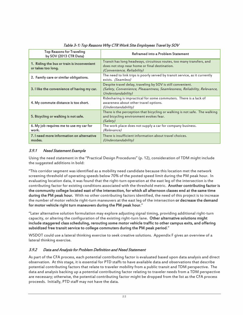
22
Table 3-1: Top Reasons Why CTR Work Site Employees Travel by SOV Top Reasons for Traveling by SOV (2013 CTR Data)
Reframed into a Problem Statement
1. Riding the bus or train is inconvenient or takes too long.
Transit has long headways, circuitous routes, too many transfers, and does not stop near home or final destination. (Convenience, Reliability)
2. Family care or similar obligations. The need to link trips is poorly served by transit service, as it currently exists. (Seamless)
3. I like the convenience of having my car. Despite travel delay, traveling by SOV is still convenient. (Safety, Convenience, Pleasantness, Seamlessness, Reliability, Relevance, Understandability)
4. My commute distance is too short. Ridesharing is impractical for some commuters. There is a lack of awareness about other travel options. (Understandability)
5. Bicycling or walking is not safe. There is the perception that bicycling or walking is not safe. The walking and bicycling environment evokes fear. (Safety)
6. My job requires me to use my car for work.
The work place does not supply a car for company business. (Relevance)
7. I need more information on alternative modes.
There is insufficient information about travel choices. (Understandability)
3.9.1 Need Statement Example
Using the need statement in the “Practical Design Procedures” (p. 12), consideration of TDM might include the suggested additions in bold:
“This corridor segment was identified as a mobility need candidate because this location met the network screening threshold of operating speeds below 70% of the posted speed limit during the PM peak hour. In evaluating location data, it was found that the right-turn operation at the east leg of the intersection is the contributing factor for existing conditions associated with the threshold metric. Another contributing factor is the community college located east of the intersection, for which all afternoon classes end at the same time during the PM peak hour. With no other contributing factors identified, the need of this project is to increase the number of motor vehicle right-turn maneuvers at the east leg of the intersection or decrease the demand for motor vehicle right turn maneuvers during the PM peak hour.”
“Later alternative solution formulation may explore adjusting signal timing, providing additional right-turn capacity, or altering the configuration of the existing right-turn lane. Other alternative solutions might include staggered class scheduling, rerouting some motor vehicle traffic to other campus exits, and offering subsidized free transit service to college commuters during the PM peak period.”
WSDOT could use a lateral thinking exercise to seek creative solutions. Appendix F gives an overview of a lateral thinking exercise.
3.9.2 Data and Analysis for Problem Definition and Need Statement
As part of the CFA process, each potential contributing factor is evaluated based upon data analysis and direct observation. At this stage, it is essential for PTD staffs to have available data and observations that describe potential contributing factors that relate to traveler mobility from a public transit and TDM perspective. The data and analysis backing up a potential contributing factor relating to traveler needs from a TDM perspective are necessary; otherwise, the potential contributing factor might be dropped from the list as the CFA process proceeds. Initially, PTD staff may not have the data.

23
It is recommended that participating in the problem definition process will help PTD staff formulate a list of data and analysis needs related to issues they may know anecdotally and which should be undertaken on a broader scale going forward. The CTR Program already has a rich dataset representing the participation and effects of CTR strategies targeted to commute trips at large work sites in designated urban areas. This is a good start and can be expanded from there if the PTD wants to address other trip purposes for TDM programs targeting neighborhoods, downtown areas, or other subsets of communities.
3.9.3 Identifying Countermeasures
The last step in the CFA process targets the underlying root causes of the problem by developing alternative transportation improvement scenarios “using proven countermeasures to address the baseline need and agreed-to contextual needs” (“Practical Design Procedures,” p. 59). There may be more than one underlying root cause, in which case the CFA process calls for prioritizing the countermeasures based on their benefit and ease of implementation.
As illustrated in the “Practical Design Procedures” (p. 66), the use of a prioritization chart helps rank identified countermeasures, with ease of implementation on the y-axis and anticipated benefit on the x-axis. Evaluating potential countermeasures helps distinguish those that are easier to implement and have higher anticipated benefits from those that are not.
The MAISA team develops and agrees upon definitions and ranges for “ease of implementation” and “anticipated benefit.” If least-cost planning were incorporated into the prioritization chart, the ranges for ease of implementation might be constrained by any limitations within which WSDOT must work. For example, there may be a limit on the budget available for countermeasures or there may be a directive for results to be achieved in the near term. With regard to anticipated benefit, the upper range for a high-anticipated benefit might be defined by the solution or set of solutions that is sufficient to address the problem and need and no more than that. This is to avoid over-designing. TDM-related countermeasures may help provide the sufficient solution on a limited budget.
Figure 1: Prioritization Chart Example. Source: Practical Design Procedures, Figure 14, p. 66.
3.10 TDM and Identifying Performance Measures
The WSPTP calls for moving toward an integrated multimodal transportation system with a focus on system performance. It also calls for performance measures that focus on the needs of the communities.
It is recommended to consider the entire trip as experienced by travelers when evaluating the relative merits of alternative proposed improvement scenarios identified in corridor planning studies and their associated performance metrics.
Making improvements to reduce travel time on a particular highway segment may be limited, but there may be other opportunities to reduce travel time along links of the other segments of the trip—for example,

24
partnering with the local government of the community to implement parking management policies that may reduce parking time and cost to HOV travelers.
Appendix G contains excerpts from the Draft WSPTP and lists goals, strategies, and performance indicators that can be considered in the selection of alternative performance indicators based upon the community’s corridor vision. Also included are additional suggestions for performance indicators and early actions.
The “Practical Design Procedures” call for selecting the baseline performance metric(s). The term “baseline” does not refer to existing conditions; a baseline performance metric characterizes the provision of the most basic need to be resolved by a proposed project. The baseline performance metric must be addressed by the preferred alternative. A Baseline Metrics Shortlist provides an interim resource for selecting baseline performance metrics on mobility, many of which are the same as performance metrics for reporting purposes used by the Office of Strategic Assessment and Performance Analysis in the “Gray Notebook” and the “Corridor Capacity Report” (CCR). The CCR reports on capacity performance on State highways, mass transit, passenger rail, and ferries.
Performance targets may have been developed in the corridor sketch and are reestablished in the corridor planning phase and reevaluated during the scoping and design phase. Performance targets may vary based upon the selected future context and design year and, as a result, may affect the selection of a preferred alternative.
The performance gap is the difference between a performance target and the current measured level of underperformance for a given metric. The performance gap(s) for the baseline need identifies what the proposed alternative should accomplish. “The intent is to best resolve the baseline performance gap(s), while balancing impacts/benefits to the contextual performance gap(s)” (“Practical Design Procedures,” p. 31). As a result, performance trade-off decisions will be necessary.
3.11 Two or More Performance Measures Require Setting Priorities
Different objectives will have different performance indicators. Use of two or more performance indicators complicates the process because new performance indicators might require a new data collection program. The “Practical Design Procedures” address use of more than one performance indicator and clearly indicate that the baseline performance indicator(s) take precedence over the contextual performance indicators. The evaluation of service improvement scenarios will depend on the relative importance of the objectives to guide the weighting of these indicators. Past corridor studies have used community input to assign weights to different criteria, reflecting community priorities.
It is recommended that WSDOT regional planners facilitate community dialogue about transportation performance indicators and the potential implications of priority setting that will lead to baseline performance indicators and contextual performance indicators that may influence how alternative scenarios are defined.
3.12 TDM Cost and Benefit Data are Limited
Limited cost data for TDM strategies are in the form of the total biennial funding amounts for TDM programs compared with measured results. Results are usually given in terms of travel behavior changes as measured across the region and not at the level of a highway corridor.
It is recommended that as WSDOT begins to accumulate more experience including multimodal solutions and TDM as part of corridor planning, such as implementing recommendations of the SR 520 Multi-modal Corridor Planning Study, the implementation should include funding for the development of a program of data collection and analysis to measure TDM program results along the corridor.
25
3.12.1 Other Already-Reported Performance Metrics
Other already-reported performance metrics that could be used for comparative purposes to quantify benefits of TDM alternatives include the following:
• Transit Passenger Miles of Travel (PMT) • Lane capacity savings • Transit ridership in a corridor • Daily emissions avoided due to transit use • GHG emissions avoided due to transit use • Daily vehicle miles of travel (VMT) avoided due to transit use • Park-and-ride percent occupancy • Transit emissions factors per trip • Accessibility—number of jobs reachable by transit by census tract during morning peak within the
average commute time of 28.5 minutes • Transit/auto accessibility ratio
There are many reported performance metrics for public transit. One option for setting performance targets for public transit is to determine what increase in transit ridership in a corridor would be needed to offset the need to build strategic capacity improvements. Lane-capacity savings is a ridership performance measure contained in the CCR (October 2015).
3.13 Commute Trip Analysis
Changes in travel time performance, congestion, reliability, emissions, and transit performance are reported in the CCR (October 2015) for 19 morning high-demand commute corridors in the Central Puget Sound region. These include the following:
• Travel time performance: - Travel time at posted speed - Travel time at maximum throughput speed - Average travel time at peak of morning commute (five-minute peak of commuter rush) (mean) - Maximum throughput travel time index (MT³I) - Peak-period percent change in VMT
• Congestion: - Duration of congestion—length of time average speed is below 45 mph - Cost of congestion per person per trip
• Reliability - Median (50th) percentile - 80th percentile: 80% of recorded travel times were shorter than this duration - 90th percentile - 95th percentile (allows commuters to plan a trip; equivalent to being late one day per month) - Change between 2012 and 2014
• GHG Emissions, pounds CO₂e - Emitted during peak period - Emitted person (based on vehicle occupancy observed on freeway in SOV lanes)
• Transit Commute Trip Analysis, 2012 compared to 2014 - Average transit ridership based on average maximum load during peak period - Travel times in minutes at peak of morning commute (includes off-highway travel such as exiting
to stop at a transit center and may not be directly comparable to private auto times that only include highway travel)

26
- Transit average time - Transit 95% reliable compared to Auto 95% reliable
• Ridership - Ridership (reported for the peak transit commute periods, 6:00-9:00 AM and 3:00-6:00 PM) - Passenger miles traveled - Lane capacity savings—measure of how many lanes worth of capacity transit ridership provides
during peak periods - Average percent of seats used (based on average maximum load of each bus or train trip and total
seats on bus or train. Individual trips could show a load greater than 100% if standing room only. Averaging load for each commute levels out this variation across multiple trips and may under-represent load of seats used during peak utilization of transit)
- Number of trips - Percent of trips over 90% capacity
• Emissions - Daily emissions avoided due to transit use - VMT avoided due to transit use
• HOV Lane Travel Time Performance compared to SOV Lanes - Travel times on route at posted speed - Travel times on route at maximum throughput speed - Average travel time at peak of morning rush, HOV lane compared to SOV lane - 95% reliable travel times: HOV lanes compared to SOV lanes
It is recommended to report the results of the CTR Program in the CCR to highlight the CTR’s contributions to congestion reduction, keeping TDM visible as part of the planning process, and as a reminder to consider TDM strategies. It also is recommended to focus not only on the Drive Alone Rate in CTR Program results, but also upon the increase in frequency of use of alternative transportation, as well as the success in transitioning travelers from one HOV mode to another mode of even higher occupancy. It may be more effective for three two-person carpools to join together into one vanpool than to convince two SOV travelers to share a ride. It also is recommended to make sure the performance metrics are understood by those whose efforts implement policies to support mode shift. For example, at a work site, increasing average vehicle ridership (AVR) from 1.1 to 1.2 does not translate well into the action needed to be taken at a work site. However, vehicles driven to the work site per 100 employees is easier to understand. For example, the inverse of AVR (multiplied by 100) is the number of motor vehicles driven to the work site per 100 employees. Increasing AVR by 10% (from 1.10 to 1.20) is the same thing as measuring 91 motor vehicles used per 100 employees and decreasing that to 83 motor vehicles used per 100 employees. The work site employee transportation coordinator will more easily understand that the goal is to remove 8 motor vehicles per 100 employees. Goals expressed in terms of reducing this number are more easily understood than goals to change AVR by 10%.
3.13.1 Economic Indicators as Alternative Performance Measures
As noted in WSDOT’s Handbook for Corridor Capacity Evaluation, economic indicators are metrics that affect travel behavior. Whereas economic indicators affect travel behavior, travel behavior also may affect economic indicators. For those shifting to HOV and transit without any time penalty (as a result of transit and TDM investments), these commuters enjoy commute cost savings that become disposable income. More disposable income spent on goods and services in Washington improves the standard of living and quality of life of its citizens, increases sales tax revenue, and advances the state’s economic vitality performance category.

27
WSDOT CTR data provide some evidence that people prefer to commute by SOV because of its greater convenience. Time savings is a measure of convenience, and the appendix of the CCR (October 2015) provides a comparison of peak-hour commute travel time by SOV, HOV, and transit for major corridors. The data indicate that, in several cases, travel time for SOV is less than for transit.
It is recommended that sufficient resources for more transit service with supporting TDM programs, services, and incentives are directed toward making travel time by transit comparable to or faster than SOV. This investment would result in more people riding transit, not only for its personal cost savings but also for its comparable convenience.
As SOV travel decreases, more capacity along the corridor would be freed, moving toward restoring maximum vehicle throughput. This approach also would save both transit and SOV travelers on the congestion cost for the daily commuter. For example, the recommended hourly-based travel cost estimation in dollars per hour (2008$) for a Central Puget Sound region commuter who drives an auto is $9.50 for vehicle operation and $12.40 for travel time, totaling $21.90 per hour for the first hour. In comparison, a King County Metro transit fare for an adult for a peak-hour, two-zone trip is $3.25 per trip, and the Everett-to-Seattle morning peak commute by SOV, for example, is 51 minutes. This totals approximately $20.04 per trip by SOV. By transit it is 68 minutes, totaling approximately $17.30 per trip by transit. With better transit service equalizing the travel time between transit and SOV, this would further reduce the cost of the trip by transit per hour to approximately $13.79 per transit trip. That is the equivalent of more than $3,000 per year savings for an SOV commuter who switches to transit (assuming 250 working days per year), which is newly available disposable income that could be funneled back into the Washington economy as transit commuters buy more goods and services in the state. This does not include the cost savings in travel time to the remaining SOV commuters due to the resulting freed corridor capacity.
It is recommended that WSDOT treat commuter cost savings for those who switch to public transit from SOV travel as an economic indicator of an increase in disposable income and subsequent increase in sales tax revenues.
Some of the economic indicator measures used by WSDOT include metrics for job impacts of highway projects, including direct job impacts, indirect job impacts, and induced job impacts. The Washington State Office of Financial Management (OFM) maintains a model for estimating the number of jobs created or saved due to highway construction projects (Handbook for Corridor Capacity Evaluation, October 2014).
3.13.2 Accessibility as an Alternative Performance Measure
WSDOT is developing additional performance metrics, not just for mobility, but also for other transportation service indicators that are important to the community. One of these is accessibility. In the Handbook for Corridor Capacity Evaluation (October 2014) chapter on “Accessibility Evaluation Methodology,” a discussion is presented about measuring accessibility or the ease of reaching valued destinations: “WSDOT uses a cumulative opportunities measure of accessibility for peak period commute to jobs. Essentially, it is a count of jobs reachable from each census tract or Traffic Analysis Zone in a study area, during the morning commuter rush and within a certain travel time.” This is the average commute time in the Seattle-Tacoma metropolitan statistical area, which is 28.5 minutes. The method uses speed data for each roadway length, including arterial and local streets from several sources, including speed data from GPS and Bluetooth pings gathered by private vendors. It also uses data from in-pavement loop detectors on highways. Jobs data and the regional transportation network model are supplied by the regional planning council. Transit travel time is calculated using transit service data from transit agencies and takes transit stop locations and average walking speed into consideration. The method does not include calculations for driving to a park-and-ride lot location to take transit. The transit/auto accessibility ratio is then calculated, with a value of 1.0 meaning that just as many jobs are accessible by transit as by personal automobile within the same average commute time.
The number of jobs reachable by transit from a census tract within the average commute time is helpful to serve as a baseline for planners to evaluate how to improve accessibility from that census tract by way of

28
improving key street network connections, transit service improvements, pedestrian/bicycle improvements, and the strategic location of more housing developments.
It is recommended that the transit/auto accessibility ratio be used to pinpoint census tract locations where TDM efforts should be directed to determine how to tip the balance toward a value of 1.0 or higher, so that more travelers with the choice to drive from that census tract will choose to ride public transit.
Because WSDOT’s mission is to provide transportation service to all of Washington’s citizens, those with special needs, as identified in the WSPTP, who may not drive a private auto require particular attention. These include individuals include older adults (a group that is growing due to aging baby boomers), youth, persons with disabilities, including military veterans, and low-income persons. These individuals need better access to jobs, education, retail, and community services. Tipping the balance of the transit/auto accessibility ratio toward 1.0 or higher will not only move SOV travelers to transit, thereby improving highway travel speed and reducing delay, but also will directly benefit those who do not drive.
It is recommended that the method for calculating accessibility be further developed to include calculations for driving to a park-and-ride lot location to access transit or other HOV transportation.
According to data from the 2014 American Community Survey, 16 percent of workers commute 45 minutes or longer but represent over 39 percent of aggregate travel time of all workers. If these long travel times were distributed proportionally under 45 minutes, then the average commute time would fall from 26 minutes to 19 minutes.
It is recommended that within TDM efforts, particular attention be concentrated to the subset of commuters with longer travel times who contribute not only to highway travel delay but also to a greater share of air pollutants, GHG emissions, and highway wear and tear. TDM strategies should be directed to help these commuters transition to teleworking or to use public transit or other HOV transportation. Such directed efforts will improve not only the baseline performance metric of travel delay but also improve performance in other categories such as environment and preservation. The performance results reported in the CCR (October 2015) indicate that park-and-ride lots are heavily used, already indicating a strong demand to use transit or to rideshare from origin locations not otherwise accessible by public transportation.
3.14 TDM and Developing Alternative Corridor Improvement Scenarios
3.14.1 Apply the Findings from WSDOT’s Evaluation Using FHWA’s INVEST Criteria
WSDOT participated in a pilot to use FHWA’s INVEST, the purpose of which is to help transportation agencies integrate sustainability practices into their projects and programs using a reporting and scoring mechanism. Based on the INVEST exercise, WSDOT developed an action plan with timelines to integrate sustainability into the corridor planning process. There were several key findings of the internal exercise conducted by WSDOT in its review and evaluations of three recent corridor studies, using FHWA’s INVEST process, as indicated below.
S e t t i n g T D M G o a l s a n d O b j e c t i v e s
It was found that for two of the three corridor studies reviewed, there were no quantifiable goals for TDM in the corridor and there was no connection between state and local TDM goals and TDM goal-setting for the corridor plans.
I m p l e m e n t i n g a T D M P r o g r a m
WSDOT distributes funding to several jurisdictions with CTR work sites to implement mandated TDM activities. Although localities and transit agencies conduct various TDM-related programs of different scales

29
and geographic scopes, these efforts may not necessarily align with the corridor. It was found that funding for TDM program implementation in the corridor studies reviewed was insufficient to cover a comprehensive program and insufficient to cover specific strategies listed in the corridor plans.
D e v e l o p i n g T D M P e r f o r m a n c e M e a s u r e s a n d M o n i t o r i n g P r o g r e s s
None of the studies directly referenced measurement. For two of the studies, it was concluded that resources needed for TDM program monitoring and measurement likely were not factored into the cost calculations for corridor improvements. The conclusion for all three corridor studies was that additional resources and agency support for measurement and monitoring are needed.
The State of Washington and cities have goals and objectives for reducing travel demand for the transportation network. The CTR Program also has goals to reduce drive-alone rate and vehicle miles traveled per employee at CTR work sites. Appendix H includes a compilation of statewide goals.
Progress in accomplishing statewide transportation system policy goals for public investments in transportation are reported by the Office of Financial Management in its Biennial Transportation Attainment Report, using established objectives, and performance measures. Many of these relate to TDM.
It is recommended, based upon the vision for the corridor and the established problem, need statement, and performance measures to consider alternative TDM strategies that also accomplish the established objectives and performance measures for achieving the statewide transportation policy goals of Safety, Preservation, Mobility, Environment, Stewardship, and Economic Vitality.
TDM strategies can contribute toward achieving all of these goals. All of the following are for Mobility:
• Reduce congestion on urban highways and arterials. • Reduce congestion by making systems more efficient. • Improve traffic flow through High Occupancy Toll (HOT) lanes. • Improve performance of HOV lanes. • Reduce the percentage of commuters who drive alone to work. • Increase on-time performance of Washington State Ferries. • Increase ridership and on-time performance of Amtrak Cascades Line. • Increase ridership on public transit. • Promote walking and biking to improve public health.
It is recommended to consider alternative TDM strategies that also accomplish the goals of the statewide CTR Program and of TDM programs of the host localities.
Local governments implement their comprehensive plans through regulations such as zoning, subdivision, parking, and CTR ordinances as well as negotiations and conditions regarding land development.
It is recommended in the development of alternative transportation improvement scenarios that incorporate TDM to develop strategies that support and reinforce local government TDM programs.
3.14.2 Consider Using Congestion as a Disincentive
On State roadway segments where the level of service is measured by the volume-to-capacity (V/C) ratio and the standard is higher than LOS “E,” there is the expectation of higher travel speeds during the peak hour than are necessary to maintain maximum passenger throughput. In the delivery of increased reliability of the movement of goods and people, as required by the State transportation policy goal, traffic congestion caused by higher volumes of commuters is routine, easy to anticipate, and reliable. Travelers can plan accordingly.

30
Non-routine traffic congestion, such as that caused by traffic collisions or special events, should be addressed with incident reduction strategies and special event planning.
Where maximum passenger throughput currently is not achieved, it is recommended that traffic congestion might be used as a powerful tool to disincentivize SOV travel. Combined with policies, incentives, programs, and services that make alternative travel modes competitive with SOV travel, this deliberate harnessing of traffic congestion can move corridor performance toward maximum passenger throughput.
3.14.3 Use the “No-Build” Alternative for TDM
In corridor planning studies, where there is the identification of corridor development alternatives that involve capacity building, the no-build alternative is used more as a “do nothing” alternative other than routine maintenance and minor repair. This is a lost opportunity; the do-nothing alternative is used as the reference against which other capacity-building alternatives are compared under conditions of the planning horizon year.
It is recommended that the no-build alternative is an opportunity to devise a program of TDM strategies. The first-build alternative should include TDM and TSM&O strategies. Build alternatives after that should include combinations of TDM and TSM&O strategies with graduated levels of capacity improvements.
3.14.4 Emphasis on Long Term Time Horizon Challenges Least-Cost Planning
State law requires estimates of future travel demand using 10- and 20-year time horizons. Looking far into the future is necessary for planning large capital projects but the uncertainty of long-term forecasting risks overdesign. Short-term improvements and their potential positive effects may be overlooked. TDM can be implemented in the short term, targeting TDM service improvements that also are least-cost, with impacts on future travel demand that may affect those estimates 10 and 20 years into the future.
It is recommended to develop scenarios that initiate TDM strategies in the near term with performance measured against the investment in the strategies. Changes in operation of the transportation facility as a result of TDM in the near term could be considered and incorporated into the estimation of future conditions.
3.15 Effects of Different Design Elements on Performance
The Practical Design Procedures is specifically intended to guide the development of facility design. In these procedures, Figure 15, “The Effects of Various Design Elements on Different Performance Categories,” describes, in table format, the effect of various design elements on mobility and safety performance outcomes for each of the modes, including pedestrian, bicycle, transit, auto, and freight. This table is not meant to be exhaustive, but illustrative of these relationships and how these may differ according to context. The context categories include:
• Urban/Suburban Arterials/Collectors • Rural Two-Lane Highways • Rural Multi-Lane Highways • Rural and Urban Freeways
These are the building blocks of the physical highway system according to function. The listed design elements for the Traveled Way, the Roadside, Bridges and Tunnels, Intersections and Interchanges, and Streetside can be evaluated for performance based upon the quantitative methodologies of the Highway Capacity Manual, but the table also notes that the quantitative method should be pertinent to the selected mobility performance metric.

31
It is recommended that if person throughput were the selected performance metric, lane allocation might be another design consideration. From Figure 1, “Managed Lane Types” of Practical Design Procedures, these would include HOV lanes, business access and transit lanes, exclusive transitways, and service lanes. Other features important to multimodal system development are bus stops, transit hubs, and park-and-ride lots. Listing these features in a table of design elements reminds designers that other operational alternatives are available, particularly to address vehicle capacity and passenger throughput.
Table 3-2 lists TDM strategy combinations to support the performance category of mobility and could be a companion to Figure 15 in “Practical Design Procedures.”
It is recommended that comparable information relating to TDM strategies could be compiled with regard to the performance categories, including Mobility. TDM strategies could be organized by services, incentives, policies/regulation, and capital facilities and could be considered relative to their impacts on various travel modes and selected based upon the particular corridor planning context, as described by traveler profile, trip purpose, and the OD locations related to corridor use.
3.16 TDM and Evaluation of Alternative Corridor Improvement Scenarios
Transportation analysis includes application of a travel demand model and traffic counts to estimate current conditions, conditions at the time of opening a new facility, and 20-year conditions. The travel model may be developed, or a modification of the regional travel demand model may be used. The model evaluates future traffic growth based on future population, employment, and land-use patterns. The model is applied to test the effectiveness of the various alternatives in accommodating future travel demand, reducing traffic congestion, and improving safety.
A traffic analysis of highway segments, interchanges, and intersections is conducted to measure the impact of the assigned traffic to the system. The regional planning council, in coordination with WSDOT, established the volume-to-capacity (V/C) ratio as the performance indicator, with adopted LOS standards for non-National Highway System (NHS) regionally-significant State highways. Screening exercises and other criteria may be applied to the proposed alternatives. Periodic public meetings are conducted where corridor alternatives are displayed, and attendees can talk with project staff and offer comments.
Forecast conditions include impacts upon peak-hour round-trip travel time, peak-hour VMT, peak hour congested vehicle hours, peak-hour total delay, and peak-hour congested travel speed. Transportation mitigation strategies for all alternative scenarios might include identifying the development of strategies to reduce overall peak-period traffic levels on the corridor. A more focused analysis of transportation planning, engineering feasibility, and environmental assessment narrows the field of alternatives under consideration based on identifying alternatives that are infeasible with respect to engineering standards, unreasonable costs, and/or unreasonable impacts. As alternatives are eliminated, more detailed transportation analysis may include the use of the Synchro software program to evaluate intersection LOS along the corridor and surrounding areas and the VISSIM microsimulation model.
A Level 1 screening process may be undertaken in conjunction with public meetings to review advantages and disadvantages of each alternative. A Level 1 screening analysis may involve a quantitative approach that includes identifying decision criteria and scoring each alternative using the criteria. A weighting exercise of values-based criteria may be conducted with participation from a community advisory committee. The results of the Level 1 analysis eliminate some alternatives from consideration, with the remaining alternatives brought to the Level 2 screening analysis. These alternatives may be evaluated as part of an Environmental Impact Statement.
In addition to the environmental and cultural impacts, the Level 2 screening process also may assess operations, safety, and travel time. The traffic analysis may apply different travel demand model analyses for each alternative in the horizon year as well as the baseline alternative. These may include an assessment of corridor travel time from the beginning to the end of the corridor. It may include a comparative analysis of peak VMT, congested vehicle hours traveled, and free-flow travel.

32
The VISUM travel demand modeling analysis can provide horizon year V/C ratios for the PM peak hour for the alternatives and identify the segments along the corridor where congestion is expected to occur. A select link analysis may be conducted to determine corridor traffic distribution for the alternatives. SYNCHRO and SIMTRAFFIC simulation modeling software packages may be used for analyzing intersections. The Highway Capacity Software (HCS) tools based on the Highway Capacity Manual may be used for intersection analyses, which are conducted for existing conditions and horizon year conditions for the baseline (no-build scenario) and the alternatives. Analysis results include ranking the alternatives based upon peak-period direction travel time, area-wide VMT, total vehicle hour delay reduction, and the number of congested segments with V/C ratios that perform below the LOS standard.

33
Table 3-2: TDM Strategy Combinations to Support Mobility Performance Category
Performance Category: Mobility – Passenger Throughput
Context: Traveler Profile
Context: Trip Purpose
Context: O/D Locations related to corridor use
TDM Strategy Mode Ped Bike Transit Other HOV
SOV Tele
Services
Community-based outreach X X X X X
Commute coaching X X X X X X
Ridematching assistance X X
Emergency Ride Home X X X X
Transit service improvements X X X X
Human services transportation X X X X
School trip management X X X X
Incentives
Vanpool promotion X
Targeted investments at businesses X X X X X
Transit subsidies X X
Relocate vanpools X
Policies/Regulation
Parking management X X X
CTR Program X X X X X X
Land use X X X X
GTEF X X X X X
Urban design X X X X X
Capital
Vans X X
Park-and-ride lots X X X X
HOV lanes X X
Business access and transit lanes X
Exclusive transitways X
Service lanes X X X Bicycle facilities (lanes, paths, parking, signals, queue jump, etc.)
X X
Pedestrian facilities X X
Bus stops X X X
Transit hubs X X X
3.16.1 Application of Existing TDM Models
The purpose of applying the TDM models is to estimate the motor vehicle trip reduction impact of the application of some selected combination of TDM strategies as well as to estimate other social benefits, such as air pollution reduction and reduction in fatalities.
A review of various TDM-related sketch-planning tools was conducted by EPA to help transportation planners and others make high-level or preliminary decisions prior to detailed analysis or to narrow the range of trip reduction options to be considered. ICF reviewed tools available for transportation control measure (TCM) analysis including the FHWA TDM Evaluation Model, the FHWA Surface Transportation Efficiency Analysis

34
Model (STEAM), and EPA COMMUTER model (a spreadsheet version based on the TDM Evaluation Model with emission impact module added). The reviewers found that the FHWA models required extensive inputs from the regional agencies for the baseline. Other sketch planning tools reviewed by ICF included Texas Transportation Institute’s TCM Analyst and the Transportation Emissions Guidebook (TEG), developed by the Center for Clean Air Policy (CCAP). These sketch-planning tools can be used to analyze a large number of strategies across multiple regions. According to ICF, “the TCM Analyst model is based on relatively old data, having been developed in 1994-95, and the CCAP TEG model is a less precise tool than either the EPA Commuter model or TRIMMS because it is based on rule of thumb guidance on TCM impacts obtained from literature and requires many more assumptions.” Below is a table summarizing the input requirements and output capabilities for various TDM related tools reviewed for EPA by ICF11.
(a) ICF selected Trip Reduction Impacts for Mobility Management Strategies 2.0 (TRIMMS™) for “its ability to handle synergies and substitution effects among TCMs in a robust way, using values of cross-elasticity between modes to calculate changes in mode shares. This assumes that the different mode choices are not independent of each other, but rather are interactive. For example, when financial incentives like fare subsidies are provided for the use of transit and higher parking fees or tolls are introduced for autos, TRIMMS can capture the combined VMT effects of the resulting shift in mode shares. The model also allows the user to capture the effects of TCMs in different timeframes by the use of short term and long term elasticities, as well as to distinguish peak and off-peak impacts at the regional scale.12”
(b) TRIMMS™ model (download from www.trimms.com) is a sketch planning tool that relies on current understanding of price and travel time elasticities and synergistic effects of various TDM strategies for analysis in order to estimate VMT changes resulting from defined future scenarios13. TRIMMS™ also operates at the worksite level or regional level using inputs and elasticity values pre-populated for nearly 100 metropolitan areas, including average mode shares, trip lengths and travel times by mode, and emission factors. TRIMMS’ outputs include changes in mode shares, trips, VMT, emissions and benefit/cost ratio. While many of the inputs are built into the model for nearly 100 metropolitan areas, the user may modify the inputs such as starting mode split and elasticities to reflect local conditions (e.g., CTR survey) or more current data (e.g., updated emission tables).
(c) In 2010, CUTR researchers developed a Transportation Demand Management Assessment Procedure (TDMAP) to incorporate TRIMMS™ 2.0 analytical capabilities into a regional travel demand model. TDMAP does so by (1) extracting mode split tables from the model; (2) processing the tables to be compatible with TRIMMS™ 2.0; (3) running the tables through TRIMMS analysis; and then (4) placing the table results back into the four-step model for distribution over the transportation network. TDMAP is not currently integrated with TRIMMS™ 3.014. TRIMMS™ 3.0 was released subsequent to ICF’s review of models. TRIMMS 3.0 was added to the earlier model and now estimates a wider range of emission pollutants and incorporates a new module that evaluates the impact of land use strategies on transit ridership. It retains a Monte Carlo (MC) simulation module for conducting sensitivity analysis. This sensitivity approach is useful for modeling TDM impacts where input values of significant uncertainty exist (e.g., short and long-term elasticities). This approach is also relevant when modeling the changes in cost externalities, given that per unit-cost estimates vary dramatically across studies15.
11 ICF International. (2011b). Analyzing Emission Reductions from Travel Efficiency Strategies: A Guide to the TEAM Approach. Washington, DC: United States Environmental Protection Agency. 12 ICF International. (2011a). Potential Changes in Emissions Due to Improvements in Travel Efficiency - Final Report. Washington, DC: United States Environmental Protection Agency. 13 Concas, S., & Winters, P. L. (2009, April). Quantifying the Net Social Benefits of Vehicle Trip Reductions: Guidance for Customizing the TRIMMS Model. Retrieved from National Center for Transit Research: http://www.nctr.usf.edu/wp-content/uploads/2010/04/77805.pdf 14 Winters, P. L., Hillsman, E. L., Lee, C., & Georggi, N. L. (2010). Incorporating Assumptions for TDM Impacts in a Regional Travel Demand Model. Olympia, WA: Washington State Department of Transportation. 15 Concas, S., & Winters, P. L. (2012, January). Estimating Costs and Benefits of Emissions Reduction Strategies for Transit by Extending the TRIMMS Model. Retrieved from National Center for Transit Research: http://www.nctr.usf.edu/wp-content/uploads/2014/11/77932.pdf

35
Table 3-3: Input Requirements and Output Capabilities for Travel Efficiency Strategy Analysis Tools and Models
Spreadsheet-Based Tools/Methods Models
Meta-
analysis
EPA COMMUTER
model TRIMMS
CCAP-TEG
TCM Tools
TCM Analyst
TDM Evaluation
Model STEAM
MARKAL- MACRO
NEMS TRAN
INPUTS
Population X X X
Per capita income
X
New vehicle sales X
Mode shares (no. of trips)
X X X X X X X X
Average vehicle occupancies by mode
X X X X X
Travel times by mode (in- vehicle and out-of-vehicle)
X X X X
Average trip costs by mode (including parking, fees, tolls, fuel costs, transit fares)
X X X X X X
Includes non-motorized trips
X X X X X X
Average trip lengths
X X X X X
Baseline regional VMT
X X X
Trip tables X X
Baseline vehicle speeds
X X X X
Vehicle fleet mix X X X X
Fuel price per gallon
X X X X
Average fuel economy
X X X
Emissions factors X X
OUTPUTS
Change in mode shares (no. of trips by mode)
X X X X X X
Change in travel time
X
Change in VMT X X X X X X X X X X
Change in emissions
X X X X X X X X X
Change in speeds X X
Fuel demand X X X
Benefits and costs
X X
36
3.16.2 TDM Cost and Benefit Data are Limited
Limited cost data for TDM strategies are in the form of the total biennial funding amounts for TDM programs compared with measured results. Results usually are given in terms of travel behavior changes as measured across the region and not at the level of a highway corridor.
It is recommended that as WSDOT begins to accumulate more experience including multimodal solutions and TDM as part of corridor planning, such as implementing recommendations of the SR 520 Multi-modal Corridor Planning Study, the implementation should include funding for the development of a program of data collection and analysis to measure TDM program results along the corridor.
3.16.3 Mobility Project Prioritization Process should be updated
The Mobility Project Prioritization Process (MP3) is used to carry out the State’s transportation policy goals. It accomplishes this by evaluating mobility projects from the WSDOT regions to choose the group of projects that provides maximum value and to justify program tradeoffs under budget constraints. According to the WSDOT Mobility Project Prioritization Process, Benefit/Cost Software User’s Guide (May 2000), value “is meant to encompass all the benefits of transportation improvements, including those that are not typically assigned a dollar value” (p.1).
Any project not in the HSP cannot be further evaluated for inclusion in the two-year budget request. Nevertheless, once it is in the HSP and once it is demonstrated that the project will not worsen air quality in a non-attainment area, then that project proceeds through further evaluation by undergoing a benefit to cost analysis (WSDOT Mobility Project Prioritization Process, Benefit/Cost Software User’s Guide, Dowling Associates, Inc. and Kittelson & Associates, May 2000). This reference is cited in the Handbook for Corridor Capacity Evaluation (October 2014).
WSDOT assesses potential mobility-related transportation projects based on the maximum throughput threshold to prioritize projects using the benefit to cost prioritization in the MP3. Types of demand management mobility projects that are evaluated by WSDOT using “before and after” type methodologies like MP3 include the following:16
• Increase transit service • Increase park-and-ride lot access and capacity • Encourage and incentivize commute trip reduction (use transit, vanpool, carpool, walk or bike,
telework, compressed work week) • Enhance alternate routes (opening new Joint Base Lewis-McChord gates, etc.)
A benefit-to-cost (b/c) analysis is conducted as part of the cost-efficiency criterion, shown in Table 3-3. In addition, other criteria for mobility evaluation are identified along with scoring procedures and weights assigned to those criteria. These were determined with input from State transportation officials and WSDOT personnel. The cost-efficiency criterion was weighted higher than all the others combined. It is not known if these criteria and weights are re-determined for each biennial. For the b/c analysis of the cost-efficiency criterion, the benefits are defined from a user perspective, and the costs are defined from a highway system perspective.
The Handbook for Corridor Capacity Evaluation (October 2014) identifies numerous other performance indicators for congestion measurement, which might be considered in evaluating the benefits and the costs. Although the benefits in the current b/c equation are from the user perspective, key congestion performance indicators from the handbook include many other categories such as transit trip analysis metrics, but these metrics are from a system perspective and not from a user perspective. Metrics from the perspective of the
16 Source: WSDOT, Handbook for Corridor Capacity Evaluation, October 2014, “Before and After Project Analysis Methodology,” p. 43.

37
transit system include transit ridership (average maximum load), transit passenger miles traveled, transit utilization (percent of available seats), and park-and-ride lot capacity and use.
Table 4-3: Evaluation Criteria of Mobility Project Prioritization Process
Criteria and Weights for the 1995-1997 Biennium
Criterion Weight Assigned
Cost efficiency (benefit/cost) 65% Community support 14% Environment
8% Wetland assessment Water quality and permitting Noise Land use 7% Modal integration 6% Total 100%
It is recommended that public transit metrics for benefits be considered from the user perspective, similar to the way the benefits to motorists are evaluated, and that WSDOT more widely define its customer base as the traveling public rather than drivers. It also is recommended that the evaluation criteria and assigned weights be reviewed by a stakeholder group that includes WSDOT staff from multiple departments, including PTD, and citizen input as part of the community engagement process for each corridor study.

38
Appendix A: Mobi l i ty Gap Analys is Tool
The intention of the Mobility Gap Analysis Tool, which was added to the HSAP, is to allow users the ability to estimate the required reduction in traffic volume to reach at least 70% of the posted speed limit. The instrument has two main parts. One part takes hourly volumes and operating-speed-to-posted-speed ratios from HSAP as its inputs and computes the number of vehicles needed to be removed and the new speed ratio as its main outputs. The outputs are generated separately for each direction for base and future years, as shown in Figure A-3. The second part does a sensitivity analysis over some input variables, including AVO, number of lanes, and time horizon (year). In addition, for each time horizon, it computes user benefits in U.S. dollars as a result of travel time saving and crash reduction.
DETAILED OVERVIEW
The top part of the added HSAP instrument consists of four tables, two tables for each direction for current and future years (see Figures A-1 and A-2). The first two tables are for the base year of each direction, and the last two are for future years. The first two columns of each table are inputs of the instrument. The first column displays the hourly traffic volumes, and the second column shows the ratio of operating speed to posted speed limit. Other columns display outputs of the instrument that are displayed after clicking the ”calculate” button located at the top of the instrument. The third column shows reduction factors that are equal to 1 by default. The reduction factors lie between 0 and 1, where 0 means 100% of vehicles must be removed and 1 means no vehicles need to be removed. If the operating-speed-to-posted-speed ratio is equal or greater than 0.70, then no vehicles need to be removed and the reduction factor remains equal to 1.
Figure A-3 shows how the tables look before and after calculation. Because of the complex design of the instrument, these calculations may take up to one minute to compute, and the computer’s monitor may quickly switch between Excel worksheets. Figure A-3 shows that the speed ratios at 8:00–9:00 AM and from 11 AM–8 PM are less than 0.70 (red numbers). After running the calculation, all the speed ratios become greater than 0.70. The calculation shows that a total of 12,317 vehicles must be removed over the 24-hour period to make sure that all speed ratios are greater than 0.70. The highest hourly number of vehicles to be removed occurs at 5:00–6:00 PM, with 2950 vehicles to be removed.
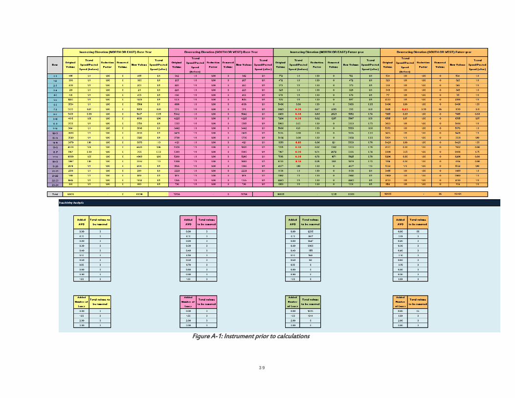
39
Figure A-1: Instrument prior to calculations

40
Figure A-2: Primary component of instrument

41
(a) before calculation (b) after calculation
Figure A-3: Before and after Calculations
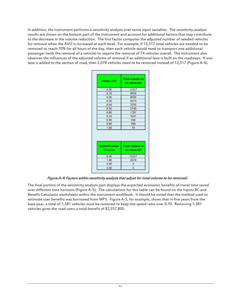
42
In addition, the instrument performs a sensitivity analysis over some input variables. The sensitivity analysis results are shown on the bottom part of the instrument and account for additional factors that may contribute to the decrease in the volume reduction. The first factor computes the adjusted number of needed vehicles for removal when the AVO is increased at each level. For example, if 12,317 total vehicles are needed to be removed to reach 70% for all hours of the day, then each vehicle would need to transport one additional passenger (with the removal of a vehicle) to require the removal of 74 vehicles overall. The instrument also observes the influences of the adjusted volume of removal if an additional lane is built on the roadways. If one lane is added to the section of road, then 2,078 vehicles need to be removed instead of 12,317 (Figure A-4).
Figure A-4: Factors within sensitivity analysis that adjust for total volume to be removed
The final portion of the sensitivity analysis part displays the expected economic benefits of travel time saved over different time horizons (Figure A-5). The calculations for this table can be found on the Inputs BC and Benefit Calculator worksheets within the instrument workbook. It should be noted that the method used to estimate user benefits was borrowed from MP3. Figure A-5, for example, shows that in five years from the base year, a total of 1,381 vehicles must be removed to keep the speed ratio over 0.70. Removing 1,381 vehicles gives the road users a total benefit of $2,557,805.

43
Figure A- 5: User benefits in USD as a result of travel time saved at each time horizon

44
Appendix B: TDM Analysis for Corr idor Sketch
The corridor sketch process is to be applied to all 291 identified State highway segments to quickly identify opportunities, constraints, and major issues. It is intended for the corridor sketch process to shift WSDOT’s current programming focus on highway capacity investments to a new approach that would develop integrated sets of demand management, operational improvements, and highway capital investment strategies. It is intended to build from existing local and regional capacity to manage demand and operate efficiently. The corridor sketch will focus on the purpose of the corridor and upon planning for economic and community development.
The intent of the corridor sketch process for each highway segment is for it to be accomplished by WSDOT regional staff within the span of a few days and to include high-level engagement of partners in the corridor to discuss the current and future vision for the corridor, identify current and future system needs, and develop sets of planned and potential strategies. Community engagement generally is not a quick process; however, it is necessary to establish and characterize the vision for the corridor, select alternative performance measures, and assess the potential to develop or expand TDM strategies. Because of the short time frame of the corridor sketch process (a few days), it is incumbent upon WSDOT regional staff who are conducting the corridor sketches to develop ongoing communication and collaboration with local agency partners so that the needed information can be collected, accumulated, and updated in advance and on an ongoing basis.
According to the WSDOT developers of the corridor sketch-planning tool, the ideal outcomes of a successful implementation of the corridor sketch plans include the following:
• Develop a new business process for planning and programming at WSDOT. • Develop a new framework for integrating public transportation and operations investments into the
programming of State transportation funds. • Inform State transportation grants by identifying accessibility needs for prioritization. • Identify new performance measures and consider them across applicable modes. • Identify performance gaps for a corridor segment now and in the future. • Integrate inputs from partners that affect corridor performance.
The corridor sketch workbook was developed by WSDOT to compile all the necessary information about the highway segment in one place to enable a quick assessment. It includes not only information about the physical attributes and operational characteristics of each highway segment, but also the community-derived vision for the corridor, its functional and access management classifications, local and regional special transportation considerations, corridor land use, an assessment of current performance and a summary of anticipated needs in the near future and mid and long terms, and performance expectations based upon the State’s transportation policy goals of preservation, safety, mobility, environment and economic vitality. The workbook also includes a section for the exploration of conditions relevant to TDM strategies.
The potential impact of TDM will depend on numerous conditions, including:
• Magnitude of motor vehicle trip reduction goal (e.g., will pricing be required?) • Prospects of shifting traffic temporally • Number of work site CTR programs within corridor • Number of work site employees who potentially can participate • Magnitude of investment in TDM programming and incentives
45
A series of questions is provided to assist in the exploration of the characteristics of the highway segment, to help gauge TDM strategy suitability, including the following:
• Is the corridor served by transit? • How many transit agencies provide service? • Are special services provided in this corridor? • Are there park-and-ride facilities available within five miles of this corridor? • How many park-and-ride facilities are there? • Are there shared-use facilities available along this corridor? • Are there missing links on any of these shared-use facilities that impact their use? • Are there active carpools/vanpools in this corridor? • Are there active commute trip reduction employers within the corridor? • Could employer-based demand management programs be added or strengthened (with strategies
such as subsidies for transit and vanpool, guaranteed ride home, showers for bicyclists, etc.)? • Could pedestrian crossings be added to increase walking?
In addition, several questions are aimed at estimating the magnitude of the problem as well as first steps in conceptualizing a TDM strategy. The questions below focus upon the State’s transportation policy goal of mobility and assume that the performance indicator of interest is travel speed, with the threshold defined as 70% of the posted speed limit. This performance indicator is suitable to high speed, limited access facilities, such as Interstate highway segments.
H o w m a n y p e a k p e r i o d t r i p s n e e d t o b e r e m o v e d a n d / o r r e l o c a t e d s p a t i a l l y o r t e m p o r a l l y t o m e e t t h e 7 0 % o f p o s t e d s p e e d l i m i t ?
This determines the order of magnitude or intensity of the TDM strategies that might be needed. For example, if large numbers of trips needed to be removed, then it is likely that significant incentives, disincentives, and/or pricing would be needed to meet the objective.
Estimation of the reduction in trips needed on the segment to restore 70% of posted speed limit can be accomplished by using the current Highway Segment Analysis Program (HSAP) and some additional spreadsheets of the Mobility Gap Analysis Tool in Appendix A, to identify trip reductions needed hourly. The estimation of these trips can be provided for different timeframes, including for existing conditions, near, mid, and long terms.
W h a t i s t h e t e m p o r a l d i s t r i b u t i o n o f t r a f f i c ( h o r i z o n t a l c u r v e p r o f i l e ) f o r t h e c o r r i d o r i n t h e p e a k d i r e c t i o n ?
This could identify potential for alternative work schedules such as compressed workweeks, staggered work schedules, flextime, etc., for shifting vehicle demand outside the peak.
The WSDOT travel time profile is displayed for the segment to identify predominant travel markets during the peak period and potential opportunities for shifting trips temporally. Can the peak be spread? How much reduction is necessary and when? What is the nature of the problem? For example, might these represent work or non-work trips? Use the temporal curves within the current version of HSAP or generate new temporal curves for corridor sketch segments.
The curve in Figure B-1 might describe work trip AM and PM peaks.

46
Figure B-1: WSDOT temporal curves illustrate the nature of peak-period travel
The curve in Figure B-2 might illustrate an area with high intensity retail, such as a shopping mall.
Figure B-2: WSDOT temporal curves illustrate peak-period trips
The curve in Figure B-3 might illustrate an area with large numbers of restaurants serving lunch hour traffic.
Figure B-3: WSDOT temporal curves illustrate peak period trips
47
A p p r o x i m a t e l y w h a t s h a r e o f c o m m u t e r s w h o w o r k i n t h e c o r r i d o r , w o r k f o r C T R e m p l o y e r s w i t h i n t h e c o r r i d o r ?
Large numbers of commuters in the CTR Program in the vicinity of the corridor could create more opportunity for success in altering travel behavior. The use of LEHD data to map locations of work sites and residences that are near the segment can identify mode potential based on spatial distribution. These data include Origin-Destination Employment Statistics (LODES), Origin-Destination data (OD), Residential Area Characteristics data (RAC), and Workplace Area Characteristics data (WAC) for selected Census blocks within the labor shed. By industry type, this may provide a more complete picture of the area, which will include not just the large employers who participate in the CTR Program, but all employers.
WSDOT’s most recent CTR data for CTR employment and the Census OnTheMap application and data within the application for total employment can be used.
The segment can be presented in its surrounding context, which can illustrate travel opportunity. For example, if the segment is in an urban mixed-use area and it serves many destinations, then showing an area within a radius of three miles from the segment might capture opportunities for bicycling. These 291 highway segments vary in length, so the map scales may differ, or there may need to be a series of maps.
Generating another smaller-scale map of the segment can include the labor shed, as defined by distances employees commute to their jobs in the vicinity of the segment. Locations of CTR employers located along the segment could be highlighted. Within this labor shed, various attributes can be illustrated, such as the extent of broadband connectivity. Dot density maps of residential locations can be generated.
A p p r o x i m a t e l y w h a t s h a r e o f C T R e m p l o y e r s i n t h e c o r r i d o r h a s m e t t h e i r C T R t a r g e t s ?
How much room for improvement remains? WSDOT’s CTR survey reports on multiple targets can be used, including the VMT goal and others.
A p p r o x i m a t e l y w h a t s h a r e o f p a r k i n g i s l o n g - t e r m p a r k i n g i n t h e c o r r i d o r ( e x c l u d i n g o n - s t r e e t m e t e r e d ) ?
Long-term parking is an indication of commuters who drive to work, park for nine hours or longer, then leave. Changing free parking to paid parking has been demonstrated to be one of the most effective strategies for changing travel behavior. This information would be found at the public works, planning, or transportation departments of the local government. If this information is unavailable, the next step is to explore the possibility that the local government conduct a parking inventory of privately- and publicly-owned parking. This is the first step to developing a parking management plan.
For example, the Puget Sound Regional Council seeks to explore the implementation of regional parking policies, the implementation of which creates multi-municipal coordination in the availability of parking supply and pricing so that differences in parking availability and pricing from one municipality to the next are minimized. Coordinated parking management also improves conditions for increasing the market and feasibility for expanded public transit services.
W h a t s h a r e o f e m p l o y e r s h a s c o n t i n u i t y o f o p e r a t i o n s p l a n s ( C O O P ) ?
An exact figure is unnecessary. The local government staff who work with Employee Transportation Coordinators of CTR work sites or who may have other local knowledge about the profiles of employers in the vicinity of the corridor may have a sense of the prevalence of COOPs. Especially during weather events, floods, or other emergencies, staying home may be required. Forward-thinking employers who prepare their workforce to work from home may already have the capability to institute a teleworking program on a more regular basis. Combined with the desire to reduce overhead, such as the cost of office space, instituting a TDM program to encourage and support teleworking may have the potential to reduce peak period commute trips.

48
A p p r o x i m a t e l y w h a t s h a r e o f w o r k e r s u s i n g t h e c o r r i d o r a r e k n o w l e d g e w o r k e r s ?
Knowledge workers may have job duties compatible for teleworking.
Figure B-4: Inflow/Outflow job counts

49
Figure B-5: Analysis shows 40% of residents travel more than 25 miles to work
Figure B-6: Analysis shows over 30% of workers live more than 25 miles away

50
Appendix C: Overview of TDM in Washington State
OVERVIEW OF TDM IN WASHINGTON STATE
There are many variations on the definition of TDM. FHWA defines it as a set of strategies aimed at maximizing traveler choices.
“Managing demand is about providing travelers, regardless of whether they drive alone, with travel choices, such as work location, route, time of travel and mode. In the broadest sense, demand management is defined as providing travelers with effective choices to improve travel reliability.” http://www.ops.fhwa.dot.gov/plan4ops/trans_demand.htm#_ftn1
TDM is commonly thought of as various forms of ridesharing, but it is a larger toolbox aimed at influencing travel behavior by various dimensions, including mode, route, day of week and time of day, trip frequency, trip length, and cost. TDM is most successful at changing travel behavior where there is a clear benefit valued by the traveler. This benefit also must be effectively communicated to a targeted travel market.
The Role of the WSDOT Public Transportation Division
By law, the duties of the WSDOT PTD include “strengthening policies for inclusion of transit and transportation demand management strategies in route development, corridor plan standards, and budget proposals” (RCW 47.01.330[2] [e]) and “recommending best practices to integrate transit and demand management strategies with regional and local land use plans in order to reduce traffic and improve mobility and access” (RCW 47.01.330[2] [f]). Therefore, the PTD has a clear leadership role to play in the development of corridor studies. The purpose of a corridor study is to determine the transportation facilities and services needs in anticipation of growth in the corridor for the next 20 years.
The Relationship of TDM and Safety
TDM also plays a role in helping achieve the goals of “WSDOT Target Zero, Washington State’s Strategic Highway Safety Plan 2030” (February 28, 2007):
• Reducing VMT and VT reduces exposure to risk. • Public transportation is one of the safest modes of transportation. • Reducing crashes reduces a source of non-routine traffic congestion.
WSDOT TDM PROGRAMS
TDM programming by WSDOT is administered through the WSDOT PTD. Current WSDOT TDM programs that also support public transportation include the following:
• Commute Trip Reduction (CTR) Program, with local jurisdictions that engage large employers • CTR Employer Tax Credit • Vanpool Investment Program • Regional Mobility Grant Program • Rideshareonline.com
CURRENT ROLES OF PUBLIC TRANSPORTATION DIVISION
The PTD manages both federal and State public transportation grants through the Consolidated Grant Program, the Regional Mobility Grant Program, and the Vanpool Investment Program, including project selection and funding distribution, and provides technical support for grant writing, budget preparation, contracting, financial tracking, performance and compliance monitoring and reporting. It also assists with vehicle purchases and asset management, provides training, develops the WA State Human Services Transportation Plan, and houses the staff that provides technical support to the CTR Program.

51
COMMUTE CHARACTERISTICS OF EMPLOYEES OF CTR WORK SITES
A critical component of WSDOT’s CTR Program is the data collected on employee commute characteristics from surveys administered to affected employers every two years. Additional resources for CTR Program staff would enable them to conduct further analysis on this wealth of data.
A quick compilation of certain 2013 CTR data shows that whereas SOV is the highest mode share of the CTR workforce, more than 46% use a non-SOV mode at least once per week. This means that opportunities exist for increasing frequency of use, not just shifting from SOV. While the drive-alone rate may stay the same, increasing the frequency of use of non-SOV modes by those who already use them is a way to further improve performance of the CTR Program. Data indicate that 53.7% of 249,213 employees in the 2013 CTR database commute by SOV only, 1 or more days per week; 15.8% who commute by SOV at least 1 day per week also use at least one non-SOV mode; and 30.5% use ONLY non-SOV modes. Additionally, the 2013 CTR data indicate that approximately 10.7% work on a 4/10 or 9/80 compressed work week schedule, as shown in Table C-1.
Table C-1: CTR Data Compressed Work Week Schedule Number Share
3 days per week 7,250 2.9% 4 days per week (4/10s) 17,708 7.2%
5 days per week 201,385 81.5% 7 days in 2 weeks 1,281 0.5%
9 days in 2 weeks (9/80) 8,710 3.5% No answer/blank 2,684 1.1%
Other (work schedule) 8,091 3.3%
The data also provide information on reported use and actual frequency for teleworking, shown in Table C-2.
Table C-2: CTR Teleworking Data CTR Survey Q10:
"How many days do you typically telework?” 1 day/week 3.4% 1–2 days/week 3.5% 2 days/week 1.6% 3 days/week 2.0% I don’t telework 70.7% No answer/blank 1.1% NULL 0.8% Occasionally, on an as-needed basis 16.9%
OTHER PROGRAMS OF THE PUBLIC TRANSPORTATION DIVISION
Vanpool Investment Program
The Vanpool Investment Program was funded biennially since 2003 by the State Legislature and is a partnership with public transit agencies. The PTD’s role includes the following:
• Report progress to the State Legislature. • Seek continued funding to expand the program. • Administer capital grants to public transportation agencies that operate the vanpool programs. • Conduct statewide marketing campaign, “Freewheeling”, (started in 2005), to provide marketing
materials and joint media purchases for public transit agencies (Promote Rideshareonline.com). • Provide technical support to local agencies to start and improve their vanpool programs. • Electronically gather data for monitoring and reporting.

52
• Develop vanpool program growth scenarios and investment levels to support them. • Forecast statewide vanpool needs.
Rideshareonline.com was first created by King County Metro, has grown statewide, and has spread to partners in Idaho and Oregon. WSDOT has been involved in the software update to increase functionality consistent with the Travel Options program concept, the WSDOT Construction Traffic Mitigation Program and WSDOT’s Traveler Information System. The update will enhance dynamic ridematching capability, provide for better tracking and bookkeeping, and enable employee transportation coordinators statewide to find ridesharing matches for their employees.
Construction Traffic Mitigation
The PTD also conducts construction traffic mitigation to maintain transportation system efficiency during construction and provide flexibility in how and when construction occurs to save time and money. Recent examples are I-405 and I-5. Construction mitigation activities on I-405 have included increasing transit services, public outreach to provide information about transportation alternatives, incentives to vanpools and carpools to use lesser-used park-and-ride lots to provide additional space for transit riders, and providing bike racks and lockers. Construction mitigation activities for I-5 included retiming traffic signals on alternative routes, adding capacity to Sounder commuter rail trains, and providing incentives to vanpool riders.
Regional Mobility Grant Program
The Regional Mobility Grant Program (RMGP) supports local efforts to improve transit mobility and reduce congestion on the most heavily-traveled roadways. Funded projects have included new transit services that connect urban centers, park-and-ride lots and expansions, new buses, and rush-hour transit service along congested corridors. Such a program supports WSDOT’s role as a partner in creating a multimodal system.
TDM within WSDOT Administrative Structure
Regardless that the realms of TDM and TSM&O overlap, they are administratively distinct within WSDOT. TSM&O is administered by the Traffic Operations Division under the Assistant Secretary of Engineering and Regional Operations, and TDM is administered by the PTD under the Assistant Secretary of Community and Economic Development. Furthermore, there is a separate Toll Division represented by its own Assistant Secretary. Finally, highway capacity improvement planning is conducted by the Capital Program Development and Management Division under the Assistant Secretary for Financial Administration. This distinction of WSDOT divisions that separately administer capacity planning, TSM&O, tolls, and TDM is important because determining the most effective and efficient combination of these four requires a collaborative process. It also requires WSDOT leadership to ensure that the outcome of the collaborative process is the best balance of the four. The Moving Washington approach recognizes the importance of using all the tools in the toolbox to achieve the State’s transportation policy goals cost effectively, which include the mobility goal of maintaining the predictable movement of goods and people throughout Washington. Moving Washington embraces system efficiencies through considering TDM as a means to preserve highway capacity while at the same time providing alternative transportation services.
This guidance asserts that all three methods—managing demand, optimizing traffic flow, and accommodating travel demand by strategically increasing capacity—should be used concurrently. The challenge, then, is to determine the right combination of the three that provides the minimum acceptable level of transportation service for the least cost. In a climate of fiscal constraint, least cost planning provides a means to use scarce resources most efficiently.
53
Appendix D: Example of Pol icy Guidance at the Regional Level that May Relate to TDM
PUGET SOUND REGIONAL COUNCIL: EXCERPTS FROM THE POLICY PLAN AND REVIEW MANUAL
Countywide policies (CPPs) must:
• Reduce the need for new projects and facilities through improved operations, system management and demand management strategies.
• Prioritize transportation investments that serve centers. • Connect centers to the multimodal network. • Provide direction for the development of “complete streets,” including transportation corridors that
pass through more than one jurisdiction. • Provide direction for travel options to driving alone and overall reduction of vehicle miles traveled. • Address the role of bicycling and walking as important travel modes by providing guidance for
improving non-motorized mobility and safe access.
Local comprehensive plans (LCP) must:
• Take demonstrable steps to reduce GHG emissions related to transportation. • Reduce need for new projects through improved operations, system management, and demand
management strategies. • Develop full standards for transportation facilities to improve travel for all users—including motorists,
cyclists, pedestrians, and the delivery of goods and services (i.e., “complete streets”). • Improve local street patterns for walking, biking, and transit use. • Address multiple modes of transportation in concurrency programs that factor in the movements of
people, goods, and services, and not only the movement of vehicles. • Emphasize alternatives to driving alone. • Increase proportion of trips made by alternatives to driving alone. • Establish goals for reducing driving alone (consistent with RCW 47.01.440 and RCW 70.235.020),
establish level of service standards that address people-moving capacity over vehicle movement, incorporate bicycling and walking as important travel modes by improving and adding facilities and reliable connections
Cities with designated regional centers must:
• Improve local street patterns within centers for walking, bicycling, and transit use, including smaller blocks (except in manufacturing industrial centers).
• Establish mode split goals for designated regional centers (DP Action 18). • Tailor concurrency programs for centers.
Transit agencies and other agency planning entities, including special service districts, must:
• Advance programs and services that reduce GHG emissions, including changes in fuels, technologies, and travel patterns.
• Improve multimodal connections for access to centers from areas that are adjacent. • Work with jurisdictions to develop full standards for streets and urban roadways to serve all users
(“complete streets”), improve local street patterns, for walking, biking, and transit use, incorporate bicycle and pedestrian travel as important modes by providing facilities and reliable connections.
• Work with jurisdictions to increase the proportion of trips made by alternatives to driving alone, develop plans, and programs that help to reduce driving alone.
• Improve connections among modes of travel.

54
• Prevent or minimize adverse impacts to lower-income, minority, and special needs populations. • Ensure mobility and access for people with special needs. • Work with jurisdictions to develop multimodal approaches to concurrency.

55
Appendix E : Social Market ing
Social marketing seeks to develop and integrate marketing concepts with other approaches to influence behaviors that benefit individuals and communities for the greater social good (International Social Marketing Association, 2013)17. Social marketing is a useful TDM planning approach to promote travel behavior change, and integrates several distinguishing features, which set it apart from other popular behavior change planning approaches, such as education campaigns. These features include a focus on socially beneficial behavior change, a strong consumer orientation, the use of audience segmentation techniques and the selection of target audiences, the use of marketing’s conceptual framework (marketing mix and exchange theory), the recognition of competition, and continual marketing research.
Similarly, community-based social marketing (CBSM) is the application of social marketing principles and techniques to change behavior at the community level to reduce their impact on the environment. CBSM efforts have been successfully used to influence behaviors such as recycling, energy and water conservation, and personal travel. Generally, the focus of a CBSM program is to remove barriers to an activity while simultaneously enhancing the activity’s benefits, and involves direct contact with community members. This process involves five steps: (1) select a socially beneficial behavior change; (2) identify barriers and benefits to an activity; (3) develop strategies that utilize “tools” that have been shown to be effective in changing behavior; (4) pilot the strategy; and (5) evaluate the strategy and make improvements suitable for wide-scale implementation in the community (McKenzie-Mohr, 2011)18.
Whereas traditional marketing is used to sell goods and services, social marketing and CBSM efforts strive to influence behavior change. Social marketers typically want to influence priority audiences to do one of four things: (1) accept a new behavior (e.g. bicycle to work); (2) reject a potentially undesirable behavior (e.g. purchase a vehicle); (3) modify a current behavior (e.g. decrease number of single occupancy vehicle trips); or (4) abandon an old undesirable behavior (e.g. texting while driving). Social marketers may also encourage a one-time behavior (e.g. purchase a fuel efficient vehicle) or the establishment of a habit and the prompting of a repeated behavior (e.g. riding transit at least 3 days per week). Additionally, the behavior change must benefit society.
Once a behavioral focus has been identified, formative research is conducted to identify the barriers and benefits of an activity to gain an audience orientation. Social marketers must first understand the audience, including their unique values, beliefs, aspirations, attitudes, perceptions, perceived benefits and barriers, self-efficacy, and current behaviors, and then work to develop and tailor products to meet the audiences’ specific wants and needs. Social marketers also understand that behavior change is influenced by a combination of factors, and study the broader social ecological factors that influence the consumer’s behavior; these include factors such as the environment (e.g. availability of public transit and safe places to walk), and social norms that persist (e.g. social status of owning/driving a vehicle).
Social marketing strategies are then developed that utilize “tools” that have been shown to be effective in changing behavior. Tools include attitudes, commitment, communication, convenience, education, feedback, framing, goal setting, incentives, norms, prompts, and social diffusion. Once a social marketing strategy(s) is chosen, it is pilot tested with a limited number of people in the community to test the effectiveness of the strategy. Formative evaluation is used during the implementation of the social marketing intervention to determine if the different aspects of the intervention are being received positively by the priority audience, and finally, summative evaluation is used at the completion of an intervention to determine if the program goals set for changes in behaviors, knowledge and attitudes were met.
17 International Social Marketing Association (ISMA). (2013). Social marketing definition. Retrieved from http://www.i-socialmarketing.org/social-marketing-definition#.VrjPJvkrLIU. 18 McKenzie-Mohr, D. (2011). Fostering sustainable behavior: An introduction to community-based social marketing (3rd ed.). New Society Publishers.
56
Appendix F: Lateral Thinking Technique: Provocation Operat ion
“You cannot dig a hole in a different place by digging the same hole deeper” Edward DeBono
Lateral thinking is concerned with the generation of new ideas and with breaking out of the concept “prisons” of old ideas.
PROVOCATION OPERATION (PO) technique uses an idea that does not exist in experience and has no truth value to foster movement toward creative solutions.
Step by Step Process:
1) Determine focus: Briefly describe problem or challenge.
a) Example: Large employer in suburban setting with free parking where employment growth is increasing parking demand such that it is exceeding supply. Employer doesn’t want to build more parking and its senior management is opposed to charging more than a nominal amount ($15-$20 per month) to manage demand.
2) List items taken for granted (for example, possible causes from cause and effects (fishbone) diagram.)
a) Example: Focus: Parking demand exceeds parking supply at suburban location. Take for granted:
i) More people need parking at site than we have spaces ii) Everyone arrives at the same time iii) Everyone prefers to drive their own car iv) Everyone should pay the same amount for parking
3) Create Provocation Operation statements (i.e., statements that have no basis in fact) based on one of the items taken for granted.
a) Escape: PO: No one pays the same amount b) Reversal: PO: Car parks employee c) Wishful thinking: PO: Wouldn’t it be nice if no one had to park?
4) Use PO statement to generate new ideas/solutions
a) Example: Using the Escape technique “PO: No one pays the same amount” leads to “No one pays the same amount every day”. This leads to an idea where a nominal monthly parking equivalent value ($20) would be collected on a different single day for each person. On the other days, the parking is free. On the days employees would be required to pay, they may opt to use a commute alternative, work from home, meet customers in the field, etc. If everyone chooses to avoid making a single $20 payment on their day by using an alternative then vehicle trips could be reduced about 5% each workday.

57
Table F-1: Creating Provocation Operation (PO)
What Do We Take for Granted? List what you take for granted
Method For Creating PO Technique For Creating PO Statements
Examples
Escape Provocation What we take for granted is removed, done away with, or made to disappear
PO Highways do not have cars
Reversal Provocation Reverse the normal direction of action
PO The transit agency pays the rider
Wishful Thinking Provocation Should be more of a dream than limited to objectives you would like to reach (e.g., increase transit share from 2% to 10%)
PO Wouldn’t it be nice if employee commute trips were a cost center for employers?

58
Appendix G: Washington State Publ ic Transportat ion Plan: Goals, Strategies , and Performance Indicators
The draft Washington State Public Transportation Plan (WSPTP) (October 2015) calls for five goals, each with associated strategies and early actions. These are preliminary and will be refined through a public review process. Excerpted from the Goals, Strategies, and Early Actions Matrix from the WSPTP (p. 54), the goals and those strategies and early actions that most relate to TDM are listed below. The WSPTP also identified performance measures currently available to measure achievement of the five goals, as well as performance measures to be developed. These also are excerpted from the Plan and listed in Table G-1 below.
For each of the WSPTP goals above, additional performance measures for consideration are listed below.
Potential Additional Performance Measures for Thriving Communities • Average number of steps walked per day per capita, as measured by pedometers • Average number of bicycle trips per week per capita • HCM 2010, reduction in D-factor (proportion of traffic in the peak direction during the peak hour of
the day) toward an ideal of 0.50 indicates as many travelers are going as are coming, smoothing traffic flow
Early Actions
• Land use planning that emphasizes mixed use and moves away from “bedroom communities”
Potential Additional Performance Measures for Access
• Density of bus routes • Hours of daily availability of transit service • Weekend/holiday transit service • Percentage of intersections in a subarea that are designed for pedestrians, bicyclists, and transit users • Broadband availability in a subarea • Availability of telecenters • Percentage of residents who can travel to key destinations within a 30-minute walk
Potential Additional Performance Measures for Adaptive Transportation Capacity • Participation in “SeeClickFix” or similar mobile app for crowd sourced customer feedback reporting
problems • Percentage broadband coverage • HCM 2010, reduction in K-factor (proportion of daily traffic occurring during the peak hour of the
day) that indicates a spreading of the peak period, smoothing traffic flow
Early Actions
• Increase broadband availability to enable more teleworking • Deployment of “SeeClickFix” or similar mobile app for crowd sourced customer feedback reporting
problems • Encouragement of staggered work hours, compressed work week

59
Table G-1: Goals, Strategies, and Early Actions Matrix, Excerpted from Draft WSPTP
Goal Strategies Early Actions
(by December 31, 2016) Performance Measures
Currently Available Performance Measures to be
Developed by WSDOT 1. Thriving Communities • Cultivate thriving communities by
supporting health, equity, prosperous economies, energy conservation and a sustainable environment through transportation
• Healthy people • Prosperity • Sustainable environment • Equity
• Align and coordinate transportation investments to support local comprehensive plans and community priorities, such as improving first and last mile pedestrian connections or connections between bus and ferries
• Continue to refine WSDOT’s practical solutions, least cost planning and other methodologies that integrate state and local planning, operations and investments to optimize transportation efficiency and quality
• Tons of GHGs caused by transportation
• Jobs created or sustained by transportation projects
• Percent increase in miles of trails
• Economic, environmental, and community benefits of public transportation
• Mode split by subarea • Costs of transportation as a portion
of household income • Air quality • Number and types of housing units
in proximity to public transportation
2. Access • Provide/sustain a transportation system
that allows people of all ages and geographic locations the ability to access jobs, goods, services, schools and community activities
• Availability • Affordability • Reliability • Connected system • Integrated planning and services
• Allow for system gaps and deficits to be more quickly identified and addressed—for example, during routine congestion, incident, emergencies and disaster response
• Develop park-and-ride policy with locals to address barriers to operation and management of park-and-rides.
• Promote partnerships between state and local and regional transit providers to improve capital facilities and infrastructure to enhance universal access to stations and stops
• Avoided annual hours of delay per traveler
• Drive-alone rate • Ridership and
percentage of trips on time for Washington State Ferries and Washington-sponsored Amtrak train service
• Transit ridership • On-time transit
performance
Public Transportation Dashboard: • Quality last mile/first mile transit
access • Special needs access • Reduced system gaps • Available transportation by subarea • Frequency of local transit • Access to public transportation by
race, disability and income • Access to human services and
schools • Access to jobs through means other
than driving alone 3. Adaptive Transportation Capacity • Use new technologies and partnerships to
make better use of existing transportation assets and meet changing customer needs
• Better real-time travel decisions • Expanded travel options • Enhanced construction mitigation • Retention of skilled workforce • Improved traffic flow • Improved safety • Reduced boarding delay
• Develop and implement integrated, multimodal system improvements that move more people in fewer vehicles and at least cost.
• Develop and make available multimodal transportation data to support innovation.
• Improve the quality and consistency of data sets and access to data to support innovation, agency partnerships and public-private partnerships; 25 non-lane widening strategies that are capital improvements and TSM&O are listed, which can improve capacity for freeways and arterials
• Toll lane usage • HOV lane usage • Improved flow
Adaptive Transportation Capacity Dashboard: • Increased capacity without
new/widened lanes • Technology adaptation

60
Goal Strategies Early Actions (by December 31, 2016)
Performance Measures Currently Available
Performance Measures to be Developed by WSDOT
4. Customer Experience • Enhance people’s transportation
experience by providing public transportation that is safe, seamless, pleasant, convenient, reliable, relevant and understandable
• Ease of use • Safety • Customer satisfaction • Value
• Increase consideration and use of multimodal options by piloting systems and programs to help the public better understand, consider and use multimodal options; support widespread adoption of proven approaches.
• Inventory and share information about innovative customer-focused solutions, such as fare and bicycle information, which can improve public transportation to make it a more attractive choice for the traveling public
• Encourage and seek additional investment in projects and programs that increase the use of multimodal options, improve public access to information, and enhance the customer experience
• Mode split for select communities
• HOV lane travel time advantage, peak hours, by corridor
• HOV lane reliability, peak hours, by corridor
• Fatalities and injuries by some transportation mode
• Ferry system passenger satisfaction
• Customer satisfaction for select providers
• Train travel time • Bus travel time
Customer Experience Dashboard: • Safety • Satisfaction • Usage by mode and market
5. Transportation System Guardianship • Protect, conserve and manage
Washington’s transportation assets in a manner that maximizes and sustains their value to the public, public transportation and the statewide transportation system
• Sustainable services and infrastructure • Reduced lifecycle cost • Cost effective • Improved access • Public understanding
• Test pilot service concepts to increase vehicle occupancy and use of public transportation, including transit, active transportation, ride-hailing, telework, and more
• Support efforts to develop and improve a dashboard that monitors Washington’s transportation system using multimodal performance indicators.
• Advocate for partners to enhance local revenue options with demonstrated need for additional funding capacity
• Percent of highway pavement in fair or better condition
• Percent of state bridges rated structurally deficient
• Percent of state ferry terminals in fair or better condition
• Capital project delivery performance
Guardianship Dashboard: • Public perception of condition and
needs of local and statewide transportation systems
• Improved system conditions • Funding priorities

61
Potential Additional Performance Measures for Customer Experience
• Public transit total travel (door-to-door) time vs travel time for same trip by car • Public transit total travel cost (door-to-door) per trip vs total travel cost by car for same trip • Percentage of public transit riders that are “choice” riders, as an indicator of the competitiveness of
public transit • Percentage increase in use of public transit by existing ridership
Early Actions
• Deploy multimodal trip planner mobile apps. • Put bus information on trail maps, trail information on bus schedules, etc. • Invest in better transit service for existing ridership
Potential Additional Performance Measures for Transportation System Guardianship
• Degree of enforcement of speed limits • Degree of enforcement of HOV lanes
Potential Parking Management Performance Measures
• Conduct of local government parking inventory, number of spaces, ownership, location, on-street/off-street, price, applicable taxes
• Conduct of parking management study • Adoption of parking management program • Coordination of parking management among neighboring jurisdictions • Adjustment of parking supply, location, price • Establishment of parking revenue control systems for auditing (VTPI, Parking Taxes, August 2013) • Establishment of a local government parking tax on residential and commercial owned parking • Use of parking tax revenues for public transit, pedestrian and bicycle amenities in vicinity of the taxed
parking • Extent to which cost of parking tax is passed on to motorists • Establishment of annual storm water fee per size of impervious surface • Establishment of park and ride lots • Number of park and ride spaces • Park and ride lot utilization
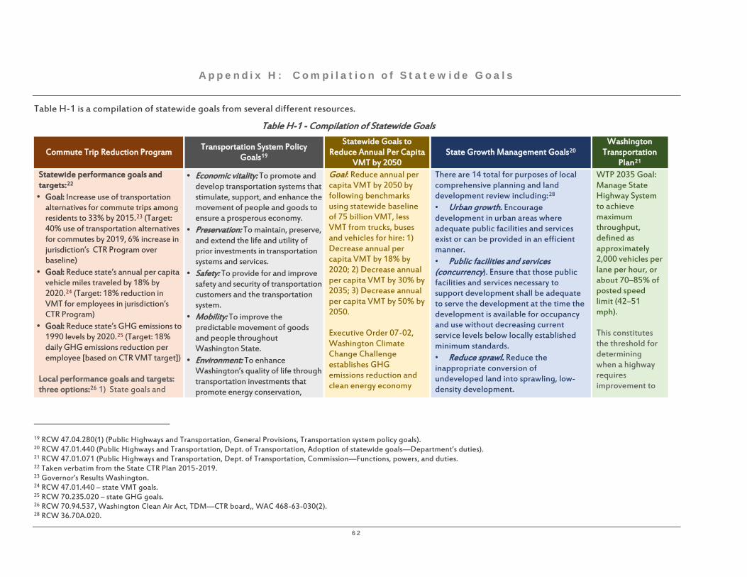
62
Appendix H: Compi lat ion of Statewide Goals
Table H-1 is a compilation of statewide goals from several different resources.
Table H-1 - Compilation of Statewide Goals
Commute Trip Reduction Program Transportation System Policy
Goals19
Statewide Goals to Reduce Annual Per Capita
VMT by 2050 State Growth Management Goals20
Washington Transportation
Plan21 Statewide performance goals and targets:22 • Goal: Increase use of transportation
alternatives for commute trips among residents to 33% by 2015.23 (Target: 40% use of transportation alternatives for commutes by 2019, 6% increase in jurisdiction’s CTR Program over baseline)
• Goal: Reduce state’s annual per capita vehicle miles traveled by 18% by 2020.24 (Target: 18% reduction in VMT for employees in jurisdiction’s CTR Program)
• Goal: Reduce state’s GHG emissions to 1990 levels by 2020.25 (Target: 18% daily GHG emissions reduction per employee [based on CTR VMT target])
Local performance goals and targets: three options:26 1) State goals and
• Economic vitality: To promote and develop transportation systems that stimulate, support, and enhance the movement of people and goods to ensure a prosperous economy.
• Preservation: To maintain, preserve, and extend the life and utility of prior investments in transportation systems and services.
• Safety: To provide for and improve safety and security of transportation customers and the transportation system.
• Mobility: To improve the predictable movement of goods and people throughout Washington State.
• Environment: To enhance Washington’s quality of life through transportation investments that promote energy conservation,
Goal: Reduce annual per capita VMT by 2050 by following benchmarks using statewide baseline of 75 billion VMT, less VMT from trucks, buses and vehicles for hire: 1) Decrease annual per capita VMT by 18% by 2020; 2) Decrease annual per capita VMT by 30% by 2035; 3) Decrease annual per capita VMT by 50% by 2050. Executive Order 07-02, Washington Climate Change Challenge establishes GHG emissions reduction and clean energy economy
There are 14 total for purposes of local comprehensive planning and land development review including:28 • Urban growth. Encourage development in urban areas where adequate public facilities and services exist or can be provided in an efficient manner. • Public facilities and services (concurrency). Ensure that those public facilities and services necessary to support development shall be adequate to serve the development at the time the development is available for occupancy and use without decreasing current service levels below locally established minimum standards. • Reduce sprawl. Reduce the inappropriate conversion of undeveloped land into sprawling, low-density development.
WTP 2035 Goal: Manage State Highway System to achieve maximum throughput, defined as approximately 2,000 vehicles per lane per hour, or about 70–85% of posted speed limit (42–51 mph). This constitutes the threshold for determining when a highway requires improvement to
19 RCW 47.04.280(1) (Public Highways and Transportation, General Provisions, Transportation system policy goals). 20 RCW 47.01.440 (Public Highways and Transportation, Dept. of Transportation, Adoption of statewide goals—Department’s duties). 21 RCW 47.01.071 (Public Highways and Transportation, Dept. of Transportation, Commission—Functions, powers, and duties. 22 Taken verbatim from the State CTR Plan 2015-2019. 23 Governor’s Results Washington. 24 RCW 47.01.440 – state VMT goals. 25 RCW 70.235.020 – state GHG goals. 26 RCW 70.94.537, Washington Clean Air Act, TDM—CTR board,, WAC 468-63-030(2). 28 RCW 36.70A.020.
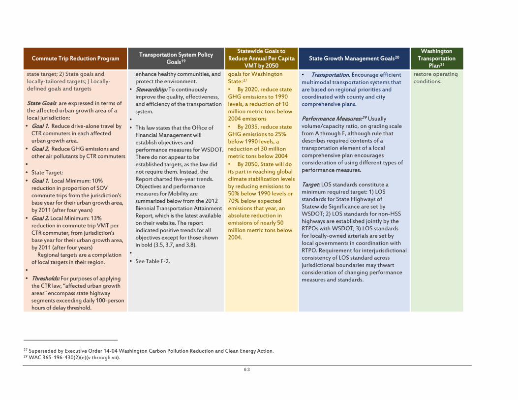
63
Commute Trip Reduction Program Transportation System Policy
Goals19
Statewide Goals to Reduce Annual Per Capita
VMT by 2050 State Growth Management Goals20
Washington Transportation
Plan21 state target; 2) State goals and locally-tailored targets; ) Locally-defined goals and targets State Goals are expressed in terms of the affected urban growth area of a local jurisdiction: • Goal 1. Reduce drive-alone travel by
CTR commuters in each affected urban growth area.
• Goal 2. Reduce GHG emissions and other air pollutants by CTR commuters
• • State Target: • Goal 1. Local Minimum: 10%
reduction in proportion of SOV commute trips from the jurisdiction’s base year for their urban growth area, by 2011 (after four years)
• Goal 2. Local Minimum: 13% reduction in commute trip VMT per CTR commuter, from jurisdiction’s base year for their urban growth area, by 2011 (after four years) Regional targets are a compilation of local targets in their region.
• • Thresholds: For purposes of applying
the CTR law, “affected urban growth areas” encompass state highway segments exceeding daily 100-person hours of delay threshold.
enhance healthy communities, and protect the environment.
• Stewardship: To continuously improve the quality, effectiveness, and efficiency of the transportation system.
• • This law states that the Office of
Financial Management will establish objectives and performance measures for WSDOT. There do not appear to be established targets, as the law did not require them. Instead, the Report charted five-year trends. Objectives and performance measures for Mobility are summarized below from the 2012 Biennial Transportation Attainment Report, which is the latest available on their website. The report indicated positive trends for all objectives except for those shown in bold (3.5, 3.7, and 3.8).
• • See Table F-2.
goals for Washington State:27 • By 2020, reduce state GHG emissions to 1990 levels, a reduction of 10 million metric tons below 2004 emissions • By 2035, reduce state GHG emissions to 25% below 1990 levels, a reduction of 30 million metric tons below 2004 • By 2050, State will do its part in reaching global climate stabilization levels by reducing emissions to 50% below 1990 levels or 70% below expected emissions that year, an absolute reduction in emissions of nearly 50 million metric tons below 2004.
• Transportation. Encourage efficient multimodal transportation systems that are based on regional priorities and coordinated with county and city comprehensive plans. Performance Measures:29 Usually volume/capacity ratio, on grading scale from A through F, although rule that describes required contents of a transportation element of a local comprehensive plan encourages consideration of using different types of performance measures. Target: LOS standards constitute a minimum required target: 1) LOS standards for State Highways of Statewide Significance are set by WSDOT; 2) LOS standards for non-HSS highways are established jointly by the RTPOs with WSDOT; 3) LOS standards for locally-owned arterials are set by local governments in coordination with RTPO. Requirement for interjurisdictional consistency of LOS standard across jurisdictional boundaries may thwart consideration of changing performance measures and standards.
restore operating conditions.
27 Superseded by Executive Order 14-04 Washington Carbon Pollution Reduction and Clean Energy Action. 29 WAC 365-196-430(2)(e)(v through vii).

64
Table H-2: OFM Mobility (Congestion Relief) Objectives and Associated Performance Measures30
Goal 3 Mobility: To improve the predictable movement of goods and people throughout the state.
Objective Performance Measure
3.1 Reduce congestion on urban highways and arterials in Seattle and Spokane
3.1 Annual Hours of Delay per Traveler on major corridors in greater Seattle and Spokane areas
3.2 Reduce congestion by making system more efficient.
3.2 Avoided Annual Hours of Delay per Traveler through operational or public transportation enhancements
3.3 Improve traffic flow through HOT lanes. 3.3 HOT Lane Use on SR 167
3.4 Improve performance of HOV lanes. 3.4 HOV Lane Use of Seattle-area network by person miles traveled (PMT)
3.5 Reduce percentage of commuters who drive alone to work.
3.5 Percent Drive-Alone Rate for commute trips
3.6 Increase ridership (ferries). 3.6 Ferry Ridership and percentage of trips on time for Washington State Ferries
3.6 Increase percentage of on-time trips (ferries).
3.7 Increase ridership (passenger rail). 3.7 Passenger Rail Ridership and percentage of trips on time for Washington and Amtrak-sponsored Cascades train service 3.7 Increase percentage of on-time trips.
3.8 Increase ridership in Puget Sound area. 3.8 Transit Ridership inside and outside Puget Sound area
3.8 Increase ridership in areas outside Puget Sound area.
3.9 Promote walking and biking to improve public health.
3.9 Percent Walking or Biking for Washington workers (ages 16 or older) commuting via biking or walking
30 Source: Office of Financial Management, State of Washington. “Washington’s Transportation System: Goals, Objectives and Performance Measures,” 2012 Biennial Transportation Attainment Report, October 2012, pp. 6-7, and 25-42.