developing australian spatial data policies Œ existing ... · developing australian spatial data...
TRANSCRIPT

Developing Australian Spatial Data Policies �
Existing Practices and Future Strategies
Renate Mason BE (Hons) UNSW
A thesis submitted in fulfilment
of the requirements for the degree of
Doctor of Philosophy
School of Geomatic Engineering The University of New South Wales
December 2000

ii

iii
Acknowledgements
It is almost impossible to thank all the people that helped and inspired me. Hence I
apologise if I left your name off the list below.
I especially like to thank the following people:
• To my mother Maria, although living a long distance away, thank you for your
great encouragement, without you I would not have finished this thesis.
• To my father August, who told me that there is no need to waste time in life and
that it is important to do a job well and get on with it.
• To my friend Mehreen, who supported me while doing her own PhD and helped
me greatly in completing my work.
• To my supervisor and co-supervisor Dr Ewan Masters and Professor John
Trinder, thank you for all your patience and your help throughout the research
and in completing this thesis.
• To the Faculty of Engineering at UNSW for the financial assistance.
• To the various support people within the School of Geomatic Engineering:
especially Philip and Brian.
• To all the respondents of the Spatial Data Survey and especially the pilot study
participants.
• To the following people:
o Graham Baker � Executive Officer of ANZLIC.
o Graham Stanton, Michael Mawn and colleagues � Department of Natural
Resources in Queensland.
o Ken Bullock � Office of Information Technology (OIT), part of the NSW
Department of Information Technology and Management (DITM).
o Greg Livingstone - South Sydney City Council
o All ANZLIC representatives � Andrew Burke, Ken Bullock, Stephen
Walsh, Andrew Jones, Vic Stephens, Bruce Thompson, David Dobson,
Rod Menzies, and Robert Twin.
Thank you all.

iv
For my family - Jessica, Jennifer and Andrew
You inspire me constantly to try my best. You made it all possible and worthwhile,
thank you.

v
Abstract
Organisations supplying spatial data need to consider such issues as pricing, technical
access to data, legal obligations, legal and technical protection of their data and
potential legal liability risks when supplying spatial data to users. Similar issues exist
for the development of Spatial Data Infrastructures (SDIs) at global, regional, national
and local level, except that SDIs need consistent spatial data policies to succeed, while
individual organisations do not. Such organisations should therefore consider their own
individual case and incorporate SDI requirements as much as possible. The
requirements of individual organisations and those of SDI may be in conflict because
SDIs call for consistent low spatial data pricing. While this may be acceptable for some
data providers, for others, it may be unacceptable, because they may need to rely on
income from the sale of the spatial data for their operation. However, no matter how
different individual policies are they all form part of an SDI.
This thesis analyses SDIs and current spatial data policy practices for Australia by way
of a Survey. It also describes and studies access and pricing policy issues. These issues
were defined and classed as the twelve significant factors to be considered when
developing spatial data policies. The factors are: SDI requirements; organisational
issues; technical issues; Governmental/organisational duties; ownership/custodianship;
privacy and confidentiality; legal liability, contracts and licences; Intellectual Property
Law; economic analysis; data management; outreach, cooperation and political
mandate; and users� choices, rights and obligations.
Legal issues include the management of legal liability and the protection of intellectual
property. Legal liability can be reduced but never totally eliminated by using legal risk
management strategies and good business practices. Intellectual property protection
affords the user exclusive use rights to his/her work; this thesis applies intellectual
property law to providers� spatial data and suggests the utilisation of copyright for
protecting spatial data. Finally, spatial data policies are defined and the spatial data
policy needs of individual groups are prioritised to assist organisations in the
development of spatial data access and pricing policies.

vi
Contents
Acknowledgements iii
Abstract v
Contents vi
List of Figures xiv
List of Tables xvi
List of Acronyms xvii
Chapter 1 � Introduction 1
1.1 Overview 1
1.2 Fundamental Issues Affecting Spatial Data Access and Pricing Policies 3
1.3 Research Objectives and Design 4
1.4 Thesis Structure 6
Chapter 2 � Global, Regional, National and State Spatial Data Infrastructures (SDIs)
7
2.1 Introduction 7
2.2 Global SDI and Associated Initiatives 10
2.2.1 GSDI 1996 Conference 11
2.2.2 GSDI 1997 Conference 15
2.2.3 GSDI 1998 Conference 16
2.2.4 GSDI 2000 Conference 21
2.2.5 Global Map (ISCGM) 22
2.2.6 SDTS, ISO TC 211 and Open GIS Consortium 22
2.3 Regional SDI's and Organisations 24
2.3.1 Europe 25
2.3.1.1 EUROGI 25
2.3.1.2 EGII 26
2.3.1.3 CERCO 27
2.3.1.4 GI2000 28
2.3.2 Asia and the Pacific 29
2.3.2.1 PCGIAP 29
Contents vii
2.3.2.2 ICSM 30
2.3.2.3 ANZLIC 30
2.4 National SDIs 33
2.4.1 United States of America (USA) - FGDC, NSDI 1990 34
2.4.2 United Kingdom (UK) - NGDF Management Board, NGDF 1996 36
2.4.3 Australia - ALIC, ASDI 1986 36
2.5 Summary and Conclusion 41
Chapter 3 � Australian Spatial Data Policies - A Survey of Existing Australian Practices
46
3.1 Introduction 46
3.2 Spatial Data Survey 46
3.2.1 Aim 46
3.2.2 Design 47
3.2.3 Respondent Groups 49
3.3 General Questions (Section Ι) 55
Question 1: Please indicate if you use spatial data, or provide spatial data to others, or both
57
Question 2: Does your Organisation use Geographic Information Systems (GIS)?
60
Question 2A: If your organisation does use GIS, how many people are working with the GIS?
61
Question 3: Does your organisation use a Trade Mark? 62
Question 3A: If yes, did you register that Trade Mark? 62
Question 4: Did you register your business name? 62
Question 5: Are you aware of any liability cases that arose from spatial data applications (eg. provision of inaccurate data)?
62
3.4 Spatial Data Providers (Section ΙΙ) 63
3.4.1 Data Quality 64
Question 1: What additional information do you provide with your spatial datasets you supply to others?
64
3.4.2 Data Access & Cost 66
Question 1: How do you provide access to your spatial datasets? (Hardcopy or Digital
66
Question 2: On what basis do you attempt to recover the cost of your various spatial datasets?
68

Contents viii
Question 3: What unit price do you charge for your spatial datasets? 70
3.4.3 Legal 71
Question 1: Do you use disclaimers? (e.g. Do not use the data other than as specified)
71
Question 2: Do you allow data users to distribute or sell your original datasets to others?
72
Question 3: Do you allow data users to distribute or sell your datasets that they added value to?
72
Question 4: What legal forms of protection do you utilise to protect your intellectual property in your spatial datasets?
72
3.4.4 Philosophical / Technical 75
Question 1: What is your organisational philosophy in regards to your own intellectual property in spatial data?
75
Question 2: What technical form of protection do you use to protect your spatial data?
78
3.5 Spatial Data Users (Section III) 78
3.5.1 General 79
Question 1: What type of spatial data do you acquire from other providers?
80
Question 2: How satisfied are you generally with provider�s datasets? 83
3.5.2 Data Quality 83
Question 1: Are the datasets you acquired from other data providers compatible with your own system without translation (eg. format)?
83
Question 2: Do data providers supply any of the following information with their dataset to you?
84
3.5.3 Data Access & Cost 85
Question 1: What do organisations that provide data to you charge for their datasets?
85
3.5.4 Legal 88
Question 1: Indicate what legal protection means are used by the data providers, from whom you buy or get data.
88
Question 2: Do you sell or distribute provider�s spatial data, in its original form, to others?
91
Question 3: Do you sell or distribute value added providers spatial data to others?
91
3.6 Conclusion 94

Contents ix
Chapter 4: Spatial Data Access, and Pricing 97
4.1 Introduction 97
4.2 Spatial Data Access and Pricing Issues 98
4.2.1 Technical Issues (3) 102
4.2.2 Governmental/Organisational Duties (4) 104
4.2.3 Ownership/Custodianship (5) 105
4.2.4 Economic Analysis (9) 108
4.2.5 Users� Choices, Rights and Obligations (12) 112
4.3 International Developments in the USA, UK, and Canada 113
4.3.1 USA 113
4.3.2 UK 116
4.3.3 Canada 118
4.3.4 Comparison � USA, UK and Canada 120
4.4 Australia and ANZLIC 123
4.4.1 Australian Capital Territory 125
4.4.1.1 Access and Pricing Policy 126
4.4.2 New South Wales 126
4.4.2.1 Access and Pricing Policy 127
4.4.3 Northern Territory 128
4.4.3.1 Access and Pricing Policy 129
4.4.4 Queensland 129
4.4.4.1 Access and Pricing Policy 130
4.4.5 South Australia 132
4.4.5.1 Access and Pricing Policy 132
4.4.6 Tasmania 133
4.4.6.1 Access and Pricing Policy 133
4.4.7 Victoria 134
4.4.7.1 Access and Pricing Policy 135
4.4.8 Western Australia 137
4.4.8.1 Data Pricing and Transfer Policy 139
4.4.9 Commonwealth 142
4.4.9.1 Commonwealth Access and Pricing Policy 142
4.4.10 New Zealand 143
Contents x
4.4.10.1 Access and Pricing Policy 144
4.4.11 Summary of Australian States/Territories, Federal Government and New Zealand Government Policies
146
4.5 Survey 147
4.5.1 Access - Data Providers 147
4.5.2 Cost Recovery - Data Providers 148
4.5.3 Cost Recovery � From a Data Users point of view 150
4.6 Conclusion 152
Chapter 5 � Legal Issues and Spatial Data 155
5.1 Introduction 155
5.2 Australian Law 156
5.2.1 Australian Law Structure 157
5.2.2 Court Structure 161
5.2.3 Law Reform 162
5.3 Liability 162
5.3.1 Contracts 163
5.3.2 Negligence 165
5.3.3 Spatial Data Examples and Case Law 167
5.4 Disclaimers 169
5.5 Legal Liability Awareness and Disclaimer Practices 171
5.5.1 Survey Results on Legal Liability 171
5.5.2 Disclaimer Survey Results 173
5.6 Legal Liability Risk Management 176
5.7 Conclusion 179
Chapter 6 � Intellectual Property Protection of Spatial Data 181
6.1 Introduction 181
6.2 Intellectual Property Law 181
6.2.1 Legislation 182
6.2.2 Common Law 183
6.2.3 Intellectual Property Law Administration 183
6.3 Patents 184
6.3.1 Obtaining a patent 186
Contents xi
6.3.2 National and International Requirements 187
6.3.3 Ownership and Owner�s Rights 188
6.3.4 Infringement and Remedies 189
6.4 Copyright 189
6.4.1 Copyright Basics 190
6.4.1.1 Material Protected by Copyright 190
6.4.1.2 Originality and Material Form 191
6.4.1.3 Expression of an Idea 191
6.4.1.4 Ownership of Copyright 192
6.4.1.5 Materials created with the aid of computers 192
6.4.1.6 Rights, Infringement and Remedies 194
6.4.2 Copyright of Maps 195
6.4.3 Databases 200
6.4.3.1 Maps (as spatial databases) and Databases (attribute) 203
6.4.4 Digital Agenda and the Internet 205
6.4.4.1 Internet Implications 205
6.4.4.2 Publishers of Internet material 206
6.4.4.3 Users of Internet material 207
6.4.4.4 Screen displays and Hyperlinks 208
6.4.5 Licences 208
6.4.6 Managing Copyright in Information 210
6.4.6.1 Copyright belonging to the organisation 210
6.4.6.2 Copyright belonging to others 212
6.5 International and National Intellectual Property Law Reforms 213
6.5.1 International 213
6.5.2 Australia 215
6.5.2.1 Databases 217
6.5.2.2 Digital data and computer screen issues 218
6.6 Survey 220
6.7 Conclusion 221
6.7.1 International Issues and the Internet 221
6.7.2 Australia 222

Contents xii
Chapter 7: Spatial Data Policy Issues and Strategies 225
7.1 Introduction 225
7.2 Access and Pricing Issues and Recommendations 225
7.2.1 SDI requirements 226
7.2.2 Technical Issues 229
7.2.3 Governmental / organisational duties 231
7.2.4 Ownership / custodianship 232
7.2.5 Legal liability issues and legal risk management strategies 232
7.2.6 Intellectual property protection of spatial data 233
7.2.7 Economic analysis 234
7.2.8 Spatial data users� choices, rights and obligations 235
7.3 Spatial Data Policy Definition 236
7.3.1 Spatial Data Survey Findings and The 10 Policy Issues 237
7.3.2 Spatial Data Policy Issues Priorities 239
7.4 Spatial Data Policy Examples 243
7.4.1 Federal Government Agencies 244
7.4.2 State Government Agencies in Western Australia 245
7.4.3 Local Government Councils 246
7.4.4 Private Enterprise 246
7.5 Spatial Data Policy Evaluation 247
7.6 Conclusion 254
Chapter 8 � Summary and Conclusions 256
8.1 Introduction 256
8.2 Evaluation of Objectives 257
8.3 Contribution 262
8.4 Research Questions 264
8.4.1 Standards and quality of spatial data 264
8.4.2 Access to spatial data 265
8.4.3 Pricing of spatial data 265
8.4.4 Legal issues such as Intellectual Property protection of spatial data 266

Contents xiii
References 267
Appendixes:
Appendix 1 � Spatial Data Survey Questionnaire and Covering Letter p.1-5
Appendix 2 � Samples of Respondent Numbers and Graphs of the Spatial Data Survey
p.1-14
Appendix 3 � ANZLIC - Core Metadata Elements p.1-10

List of Figures xiv
List of Figures
Figure 2.1: Spatial Data Infrastructures and their Coordinating Bodies 10
Figure 3.1: State Government - Spatial Data Provider, User or Both? 53
Figure 3.2: Local Government - Spatial Data Provider, User or Both? 53
Figure 3.3: All other Organisations - Spatial Data Provider, User or Both? 54
Figure 3.4: Summary - Spatial Data Provider, User or Both? 55
Figure 3.5: Type of Organisation 56
Figure 3.6: Type of Organisation per State/Territory 57
Figure 3.7: Spatial Data Provider, User or Both? 58
Figure 3.8: Organisations using GIS 60
Figure 3.9: Number of People using GIS in Organisations 62
Figure 3.10: Type of Organisation 63
Figure 3.11: Type of Organisation per State/Territory 64
Figure 3.12: Data Quality 65
Figure 3.13: Additional information provided with dataset 66
Figure 3.14: Data Access (Federal Government) 67
Figure 3.15: Data Access 68
Figure 3.16: Cost Recovery 68
Figure 3.17: Cost recovery per State/Territory 70
Figure 3.18: Unit Price 71
Figure 3.19: Legal Protection used for Intellectual Property 73
Figure 3.20: Legal Protections used by State Government Departments 74
Figure 3.21: Legal Protections used by Local Government Departments 74
Figure 3.22: Intellectual Property Policy for Spatial Data 75
Figure 3.23: Organisational Philosophy for State Government Departments 76
Figure 3.24: Organisational Philosophy for Local Government Departments 77
Figure 3.25: Organisational Philosophy for All other Organisations 77
Figure 3.26: Section III � Type of Organisation 78
Figure 3.27: Section III � Type of Organisation per State/Territory 79
Figure 3.28: Spatial Data Categories most commonly used 80
Figure 3.29: State Government - Spatial Data Categories most commonly used 81

List of Figures xv
Figure 3.30: Local Government - Spatial Data Categories most commonly used 82
Figure 3.31: All other Organisations - Spatial Data Categories most commonly used
82
Figure 3.32: Datasets Compatibility with Organisation�s System 83
Figure 3.33: Data Provider�s additional data provision as observed by Data User
84
Figure 3.34: Unit Price 86
Figure 3.35: Data provider�s unit price as observed by data user 87
Figure 3.36: Data provider�s unit price as observed by data user 87
Figure 3.37: Data provider�s unit price as observed by data user 88
Figure 3.38: Legal Protection 89
Figure 3.39: Legal Protection used by data providers observed by data users (State Government)
90
Figure 3.40: Legal Protection used by data providers observed by data users (Local Government)
90
Figure 3.41: Legal Protection used by data providers observed by data users (All other Organisations)
91
Figure 3.42 and Figure 3.43: Distribute original dataset versus distribute value added dataset (State Government)
92
Figure 3.44 and Figure 3.45: Distribute original dataset versus distribute value added dataset (Local Government)
93
Figure 3.46 and Figure 3.47: Distribute original dataset versus distribute value added dataset (All other Organisations)
93
Figure 3.48: Distribute original dataset (Summary of all responses) 93
Figure 3.49: Distribute value added dataset (Summary of all responses)? 94
Figure 4.1: Pricing model for WA 140
Figure 5.1: Law Structure Levels 157
Figure 5.2: Number of spatial data providers using disclaimers 173
Figure 5.3: Legal Liability Risk Management 177
Figure 6.1: Rockford�s Map (Source: 768 F2d 145) 198
Figure 6.2: Directory Service�s Map (Source: 768 F2d 145) 199
Figure 6.3 & Figure 6.4: The Kookaburra and The Paterson project homes (Sources: Advertising brochures from Eagle Homes Pty Ltd and Austec Homes Pty Ltd)
200
Figure 7.1: The Australian policy cycle (adapted from Bridgman and Davis, 1998)
248
List of Tables
xvi
List of Tables
Table 3.1: Entire respondent group & the two main groups, per questionnaire section
49
Table 3.2: Detailed respondent numbers for section Ι (General) 50
Table 3.3: Detailed respondent numbers for Section ΙΙ (Provider) 50
Table 3.4: Detailed respondent numbers for Section ΙΙΙ (User) 51
Table 3.5: Number of Respondents per State/Territory for Question 1 in Section Ι.
52
Table 3.6: Respondents per State/Territory in % for Question 1 in Section Ι. 52
Table 3.7: Summary of State, Local and Other Respondents per State/Territory for Question 1 in Section Ι
54
Table 4.1: Factors influencing Spatial Data Access and Pricing Policy Development
99
Table 4.2: Summary of Custodian�s and User�s Rights and Obligations 106
Table 4.3: Summary of Spatial Data Pricing Policies or Draft Policies for all Australian States/Territories and the Commonwealth, and New Zealand
146
Table 4.4: Data Access Question � Choice of items 148
Table 4.5: Data Providers - Basis for cost recovery 149
Table 4.6: Data Providers - Unit price charged 150
Table 4.7: Data users perspective � Unit price charged by provider 151
Table 5.1: Liability issues pointed out by respondents 172
Table 5.2: Main areas covered by disclaimers 175
Table 7.1: Spatial Data Survey Results (calculated response values are out of 10)
239
Table 7.2: Spatial Data Issues Priorities for all Subgroups 242
Table 7.3: Policy Evaluation of a Hypothetical Cost Recovery Example 252

List of Acronyms
xvii
List of Acronyms
ACT Australian Capital Territory
ALIC Australian Land Information Council (Note: now ANZLIC!)
ANZLIC Australia New Zealand Land Information Council
ASDD Australian Spatial Data Directory
ASDI Australian Spatial Data Infrastructure
AURISA Australasian Urban & Regional Information Systems Association
AUSLIG Australian Surveying & Land Information Group
CLRC Copyright Review Committee
DCDB Digital Cadastral Database
DNR Department of Natural Resources (Queensland)
DNRE Department of Natural Resources and Environment (Victoria)
DOI Department of Infrastructure (Victoria)
DXF Digital Exchange Format
ERIN Environmental Resources Information Network
FGDC Federal Geographic Data Committee
FOI Freedom of Information
GI Geospatial Information
GIS Geographic Information System
GPS Global Positioning System
IT Information Technology
NSW New South Wales
NT Northern Territory
OECD Organisation for Economic Co-operation and Development
OGC OpenGIS Consortium
Qld Queensland
SA South Australia
SDI Spatial Data Infrastructure
SDTS Spatial Data Transfer Standard
Tas Tasmania
UNCED United Nations Commission for Economic Development

List of Acronyms
xviii
USA United States of America
USGS United States Geological Survey
Vic Victoria
WA Western Australia
WALIS Western Australian Land Information System
WWW World Wide Web

1
Chapter 1 - Introduction
1.1 Overview
As more and more people become aware of existing and potential environmental
problems such as famine, natural disasters, and continuous reduction in natural
resources, all organisations responsible for collecting and managing spatial data should
consider how they could help reduce or solve these problems. Spatial data was
identified as a major factor in assisting sustainable development and environmental
management at the United Nations Conference on Environment and Development
(UNCED) held in Rio de Janeiro in 1992. Spatial information is useful to a broad range
of organisations. Many use spatial data for activities such as land use planning, land
management, land development and for fiscal purposes. As a result of these uses and the
consequent need to share spatial data and to avoid duplication of spatial data
acquisition, Spatial Data Infrastructures (SDIs) have commenced development. Since
SDIs and Geographic Information Systems (GIS) require numerous spatial datasets for
operation, many organisations, which collect spatial data, have had to consider their
policies for collecting and updating existing spatial databases, and providing access to
them.
Many government, utility and private organisations collect and maintain their own
spatial data without distributing it to others. Many of these costly exercises could be
reduced if spatial data are shared, since other organisations may have already collected
the same or similar spatial data. However, in order for organisations to share spatial
data, it must be transferable and useable on different computer systems and by different
applications. Hence, standards and detailed information about the fitness of the data for
a particular use are necessary. In addition, since a spatial data user must be able to rely
on the quality of spatial data, the data must be of suitable quality and up-to-date. If
spatial data quality and currency is not maintained, reliance on that spatial data could
lead to disasters. For example, the US Central Intelligence Agency (CIA) publicly
admitted that due to using outdated maps and analytical misjudgment, the Chinese
embassy in Belgrade was bombed by mistake during the recent Kosova conflict (ABC
news, 1999).

Chapter 1 – Introduction 2
Better utilisation of existing spatial data and the development of new spatial data are the
main purposes of SDIs. They aim to provide the necessary infrastructure for the
distribution of spatial data. SDIs are constantly growing in importance as the rapidly
developing delivery and communication mechanism of the Internet is accessible by
more and more people. It is therefore not surprising that, for example in the US,
President Bill Clinton formed an Executive Order 12906 in April 1994 to establish the
National Spatial Data Infrastructure (NSDI) in the USA. Australia is also developing an
SDI, the Australian Spatial Data Infrastructure (ASDI). The components of the ASDI,
as for most SDIs, include standards, technology, data policies and institutional
framework. Spatial data providers are afforded spatial data distribution mechanisms,
while spatial data users will benefit from the development of the standards. Data will be
distributed via a data clearinghouse, which is a form of search engine designed for the
dissemination of spatial data. Australia so far has established the Australian Spatial Data
Directory (ASDD), which provides a means for locating data, determining the data's
fitness for use via its metadata, and details of accessing the data. The standards to be
used include www (World Wide Web) communication protocols that enable a search for
geospatial data over the Internet, standards to enable data sharing and information on
the quality of a particular dataset.
For the ASDI to function effectively, it needs to be accepted by spatial data providers
and users. This should be possible if the ASDI is developed by both bottom-up and top-
down approach. This approach was suggested by David Rhind at the 1997 Global
Spatial Data Infrastructure (GSDI) Conference as a feasible step for developing the
GSDI. A top-down approach involves setting strategic goals, action plans, locating
resources, initiating projects, and monitoring and analyzing its progress. Governmental
departments or a consortium of interested parties generally undertake this stage. But for
these plans to work effectively it is also necessary for local bodies and individuals who
will be involved in implementing and using SDIs, to embrace the plans and be content
they are part of the process. This can be achieved in the bottom-up approach, where
individuals and local organisations are encouraged to share details on how to implement
and use SDIs, as well as benefits of providing data over the Internet.

Chapter 1 – Introduction 3
As the need for spatial data increases, many organisations find that when they attempt to
develop spatial data access and pricing policies, the associated issues are manifold and
complex. As SDIs provide the necessary infrastructure for access to spatial data, it is
mandatory for organisations to develop spatial data policies that facilitate SDI
development. The title to this thesis specifies spatial data policies, although the thesis
considers all spatial data policy issues to be part of an access and pricing policy.
1.2 Fundamental Issues Affecting Spatial Data Access and Pricing
Policies
In this thesis, reference will repeatedly be made to the spatial data policies of an
individual organisation, and the requirements of a national SDI. These issues are
considered as complementary. An individual organisation providing spatial data will be
a component of an SDI. Their plans to develop a spatial data policy will impact on the
national SDI. If their policies are incompatible with those of the SDI, then the SDI may
not function as effectively as it otherwise would. Therefore, to ensure the most efficient
operation of the SDI, it is necessary for the policy of that organisation to be developed
within the parameters of the SDI, by a top-down and bottom-up approach.
Factors currently retarding the development of SDIs and sharing of data are manifold
and include:
• lack of data;
• incompatible standards such as data transfer standards and including those for
metadata;
• incompatibility of existing spatial data pricing and access practices;
• commercial policies that inhibit data sharing;
• uncertainties in the use of copyright to protect spatial data; and
• lack of awareness of legal responsibilities and liabilities.
These factors need to be overcome in developing access and pricing policies.
Metadata is information about data. Metadata for example describes when the data was
created, by whom, its accuracy and reliability. It aims to provide a standard for a
consistent description of the content and fitness for use of a dataset. The Australia New

Chapter 1 – Introduction 4
Zealand Land Information Council (ANZLIC) has developed Metadata guidelines for
Australia and New Zealand defining the characteristics (core elements) of a dataset, but
there is currently a lack of adequate metadata.
Access to spatial data requires that the data are compatible with the computer system
and software application of the user. A spatial data provider must avoid legal liability
claims from misuse of their spatial data. As well, the organisation must be able to
prohibit unauthorized users gaining access to their spatial data and protect itself from
third parties using their data illegally. The existence of legal protections therefore needs
to be considered. It is also important for both the data provider and the data user to
know their rights and obligations. Since pricing of spatial data is a factor impacting on
access an organisation must consider the value of the spatial data to itself, as well as the
wider community. Finally, since the development of future strategies is influenced by
current practices, spatial data access, pricing, intellectual property protection and legal
liability must be investigated.
The purpose of this research is therefore to investigate current spatial data policies and
develop future policy strategies including the analysis of policy priorities for various
organisations, and a better facilitation of SDI development in an Australian context.
1.3 Research Objectives and Design
The aim of this thesis is to establish background material that will enable organisations
to develop spatial data access and pricing policies. The material will inform spatial data
providers as to the issues that are involved and the options that can be adopted. Often,
spatial data policies currently either do not exist at all, or are in a development phase.
Where they do exist, they are often incomplete, and/or vary in detail between different
Australian states, territories and locally within the states. To achieve the desired aim, the
thesis has the following objectives:
• Determine factors that influence SDI development at global, regional and
national level;
• Research SDI policy deficiencies and determine SDI requirements for Australia;

Chapter 1 – Introduction 5
• Survey existing practices and policies used by spatial data providers in Australia
for spatial data access and pricing, including the areas of metadata provision,
physical access, basis used for pricing, and legal protection;
• Summarise all issues involved in a spatial data access and pricing policy and
study international developments;
• Review current data access and pricing policies used by Australian jurisdictions
and New Zealand;
• Review the legal framework applicable to spatial data in Australia; discuss legal
liability issues in maps and databases, and review legal protection means against
potential liability claims;
• Review intellectual property laws relevant to spatial data and measure the spatial
data providers’ level of reliance on intellectual property law;
• Compose a summary of policy recommendations based on the research;
• Develop a Spatial Data Policy definition that facilitates SDI development.
Previous research on SDI development in an Australian context has usually
concentrated on the design and implementation of SDIs, and rarely on actual
performance measures of the ASDI or on individual policy formulation. The purpose of
the thesis is to investigate actual empirical spatial data policies employed, especially an
analysis of a quantifiable Australian situation and to provide direct guidance to spatial
data policy developers. The research will be unique in documenting current Australian
spatial data policy practices in the areas of spatial data access and pricing, including
legal protection of spatial data and legal liability awareness. These practices will be
analysed by way of a national spatial data industry survey. The thesis also aims to make
a unique contribution to the development of the ASDI. It will document the current
knowledge of intellectual property law applied to spatial data. Further it will consider
current national, regional and global SDI initiatives to not only determine spatial data
access and pricing policy issues, but also to enable the analysis of SDI development
deficiencies in the areas of data quality, access, pricing and legal issues, such as
intellectual property protection of spatial data. The ‘SDI requirements’ to overcome the
SDI development deficiencies will also be included in the spatial data policy strategies.

Chapter 1 – Introduction 6
As the thesis will develop some future strategies for spatial data policies, it will be very
useful to organisations developing or planning a spatial data policy, and it will thereby
make an original contribution to the spatial data industry.
1.4 Thesis Structure
The thesis is divided into 8 chapters. Chapter 2 reviews global, regional and national
Spatial Data Infrastructures (SDIs), including their developmental phases and identifies
their deficiencies. Chapter 3 analyses the outcome of the 'Australian Spatial Data
Survey' conducted as part of this thesis to evaluate quality, access, cost, and legal
protection of spatial datasets in Australia. The survey compares answers to all the
questions in the questionnaire from groups such as: Federal, State, and Local
Government Organisations and Private Organisations. Chapter 4 reviews spatial data
access and pricing issues, and evaluates and compares spatial data access and pricing
regimes within the Australian States, Territories and New Zealand. The chapter also
describes the progress of some of the major state government spatial data providers in
developing spatial data policies. Chapter 5 sets out the legal framework for Australia,
including legal liability issues and risk management, while Chapter 6 considers relevant
intellectual property rights applicable to spatial data. Chapter 7 analyses the information
given in Chapters 2 to 6 to develop a list of policy recommendations and to define
spatial data policies for federal, state, local government organisations and private
organisations. Chapter 8 finally evaluates how the research objectives given in this
chapter have been achieved and answers questions raised at the end of Chapter 2.
7
Chapter 2: Global, Regional, National and State Spatial Data
Infrastructures (SDIs)
2.1 Introduction
As the world’s economy and society’s values and needs change we are forced to
determine more efficient and effective ways to manage our finite resources. Spatial
information is one of the most fundamental elements underpinning efficient and
effective resource management. Many governments throughout the world believe that
for a better decision-making process we need access to reliable, accurate, standardised
and inexpensive spatial data, which can only be achieved by Spatial Data Infrastructures
(SDIs). SDIs are
“fundamentally about facilitation and coordination of the exchange and sharing
of spatial data between stakeholders from different jurisdictional levels in the
spatial data community” (Rajabifard and Williamson, 2001, p.1).
Spatial data infrastructures specify necessary standards and provide access technologies,
data policies, an institutional framework and the human resources required to manage
the infrastructure for the distribution and use of spatial data. These SDIs are not only
developing at the local level but also at global, regional, national and corporate level.
All SDI initiatives and the organisations managing them are faced with similar issues,
which are identified in this chapter. The corporate SDI level is argued by Chan and
Williamson (1999) as the lowest level in the hierarchy of SDIs worldwide. A corporate
SDI is the GIS used within an organisation. In an ideal corporate SDI, all data users of
the organisation share datasets and the GIS has successfully been implemented. The
researchers discovered that there are four patterns in which a GIS system develops, and
they argue the same applies to the development of all SDIs. The analysis of the patterns
of development revealed that no pattern guarantees successful GIS implementation.
Spatial data are information geographically linked to specific locations. Spatial data can
include topographic, property boundary, administrative boundary, geologic, natural
resources and demographic information. Property boundary information may be used by
a solicitor for the conveyance of property from one person to another. An exploration
Chapter 2 – Global, Regional, National and State Spatial Data Infrastructures 8
company may use geological information to determine potential mining sites for
minerals and the same data could be shared and used to identify geological water
sources. A government department may use natural resources information to restrict
access to rare natural resources. Spatial data are extremely important in many decision-
making processes and can be used and shared amongst many professionals including
lawyers, surveyors, engineers, geodesists, geologists, geophysicists, biologists,
scientists, farmers, explorers, street navigators, real estate agents and even marketing
personal. The importance and use of spatial data can also be highlighted by the fact that
much government held information are spatial to some extent. For example, 60% to
80% of all government held data in the UK are spatial to some extent (Coopers and
Lybrand, 1996). Effective and efficient spatial data use can only be achieved if spatial
data are shared via SDIs, as this
“can produce significant human and resource savings and returns.”(Chan et al
2001, p.3)
The literature on spatial data infrastructures (SDIs) and their challenges is abundant and
much has been written in the last decade. Some of this literature may be found in
Onsrud and Rushton (1995), Groot and McLaughlin (2000), Coleman and McLaughlin
(1998), Rhind (1997a), Masser (1998a), Tosta (1995, 1997), Longley et al (1999) in
Global Spatial Data Infrastructure (GSDI) Conference, Urban and Regional Information
Systems Association (URISA), Australasian Urban & Regional Information Systems
Association (AURISA), Mapping Sciences Institute (MSIA), and Geospatial
Information & Technology Association (GITA) publications amongst others. Apart
from the literature cited in the thesis text the author also undertook an extensive review
on SDI literature and included the review in the Bibliography at the end of the thesis.
In Australia the former Australian Land Information Council (ALIC) and now the
Australia New Zealand Land Information Council (ANZLIC) was established in 1986
with the responsibility to coordinate national and regional land-related issues including
spatial data infrastructures. SDIs incorporate a very broad area of research and involve
the resolution of many challenges such as political accountability, standards, public
access, intellectual property rights, and data protection. Some research on the issue of
public access to spatial data in Australia is coordinated through the funding by
AUSLIG’s (Australian Surveying and Land Information Group - Australia’s National

Chapter 2 – Global, Regional, National and State Spatial Data Infrastructures 9
Mapping Agency) Australian SDI Partnership Grants Program. This program funded
outreach projects to increase access to spatial data. Other research is guided by
ANZLIC’s and the Commonwealth Spatial Data Committee’s (CSDC) coordination
efforts (AUSLIG, 2000b).
SDI development started in Australia in the early 1980s and was largely driven largely
by environmental management needs, business needs, technological developments,
political decisions often triggered by economic rationalism and sustainable
development, and government policy (Williamson et al, 1998). A multitude of articles,
monographs and conference proceedings have appeared since that time and include
works by the following authors: Baker (1994), Bishop et al (2000), Chan et al (2001,
1999, 1995), Feeney et al (2000, 2001), Gelatly and Baxter (1995), Grant (2000),
Jacoby et al (2001), Mooney and Grant (1997), Rajabifard et al (2001, 2000a, 2000b,
1999) Ting and Williamson (2000), Williamson and Williamson et al (1997, 1998,
1999), Nairn (1998). These works often concentrate on the design and implementation
of SDIs but not so much on actual performance measures of the ASDI or on individual
policy formulation. This thesis will attempt to address these issues. Much literature
lacks empirical investigations especially an analysis of a quantifiable Australian
situation and provides little direct guidance to spatial data policy developers. The
formation of the text in Chapter 2 was largely a result of reviewing the research
undertaken by the above international and Australian national authors and as cited in the
text below.
The following sections aim to explain what global, regional, national and local spatial
data infrastructures exist, and what organisations control their development. This
chapter will point out the objectives of SDIs, their current development phase, and their
benefits. Finally, problem areas of SDIs will be discussed especially with regard to
spatial data standards, access, pricing and legal issues.

Chapter 2 – Global, Regional, National and State Spatial Data Infrastructures 10
Figure 2.1: Spatial Data Infrastructures and their Coordinating Bodies
2.2 Global SDI and Associated Initiatives
On top of the SDI hierarchy (Figure 2.1) is the Global Spatial Data Infrastructure
(GSDI). The GSDI is a global process that began in 1996 with the objectives to provide
policies and an organisational framework for global spatial data. These objectives
"Global"GSDI
Global Spatial DataInfrastructure
(GSDI SteeringCommittee)
"Europe"EGII
European GeographicInformation
Infrastructure(EUROGI)
American Countriessuch as the
United StatesNSDI
National Spatial DataInfrastructure
(FGDC)
Countries in Asia andthe Pacific such as:
AustraliaASDI
Australian Spatial DataInfrastructure
(ANZLIC)
StandardsTechnologyData Policy
Institutional Framework
Africa and the MiddleEast such asSouth Africa
NSIFNational Spatial
Information Framework(NSIF Task Teams)
Global, Regional and NationalSpatial Data Infrastructures
European Countriessuch as the:
United KingdomNGDF
National GeospatialData Framework
(NGDF ManagementBoard)
"Asia and the Pacific"APSDI
Asia and the PacificSpatial DataInfrastructure
(PCGIAP)
"Americas"SDI for the Americas
(Permanent Committeeon SDI for the Americas)
(CP IDEA)

Chapter 2 – Global, Regional, National and State Spatial Data Infrastructures 11
include data, standards, technologies, delivery mechanisms, human resources and the
financial means to achieve them. Four conferences have been organised so far. The first
was held in Bonn, Germany in 1996.
The GSDI will have a major input into regional, national and local spatial data
infrastructures. It will help, for example, to develop standards and establish policies.
Australia is a major player in developing the GSDI and has therefore influence over its
shaping. This involvement will also help Australia in its development of the national
spatial data infrastructure, so that it is in harmony with global developments. This is an
important step for Australia because there is a great need for an Australian Spatial Data
Infrastructure (ASDI).
Australia needs accurate and timely spatial data to base management decisions on. The
areas that would benefit mostly from the availability of accurate spatial data include
land administration, natural resources management, environmental management, better
future disaster predictions and disaster management. Many organisations across all
levels of government base their land administration decisions, such as the control of
land use or levying council rates or taxes, on similar spatial data. Hence significant
spatial data duplication costs are saved, or can be saved when spatial data are being
shared. Although spatial data are currently being shared to some degree, there is still
room for improvement. In addition, without adequate data standards data sharing is
impossible. To enable standardisation it is essential to guarantee interoperability,
transferability and user friendly data. This is one of the key components of the ASDI.
To demonstrate some of the positive and negative issues involved in establishing the
ASDI and also on a global basis, the four GSDI conferences held so far are described in
more detail.
2.2.1 GSDI 1996 Conference
The title of the first conference was ‘Emerging Global Spatial Data Infrastructure
(GSDI)’. It attracted 63 invited representatives from 20 participating countries. The
conference was organised by the following organisations: the European Umbrella
Organisation for Geographical Information (EUROGI), the German Umbrella

Chapter 2 – Global, Regional, National and State Spatial Data Infrastructures 12
Organisation for Geoinformation (DDGI), the Atlantic Institute (AI), the Institute for
Land Information and its Land Information Assembly (ILI/LIA), the Open GIS
Consortium (OGC), the US Federal Geographic Data Committee (FGDC) and the
Federation Internationale des Geometres - Commission 3 (FIG-COM3) (GSDI, 1996).
The President of the German Umbrella Organisation for Geoinformation (Deutschen
Dachverbandes für Geoinformation, DDGI) Klaus Barwinski, said at the end of the
opening session that all people on earth are visitors and that they must be careful with
all urban and rural planning activities to save the living space for our future generations.
The environment must be protected from disasters such as floods and pollution (Report,
1996). Hence the world population needs the best available information to base high
quality decisions on. Part of that information are spatial data, which, for example will
enable society to better predict future disasters and/or help in disaster management. Mr
Barwinski emphasised the need for a global spatial data infrastructure, which will only
be made possible through the cooperation between all nations around the world.
This conference established the need for a GSDI and determined that National Spatial
Data Infrastructures (NSDIs) needed developing, which when networked and used
together, would constitute the GSDI. The main aims of the conference were to minimise
duplication of national efforts and to develop standards needed to build national and
global spatial data infrastructures (Report, 1996).
At the time of this conference Australia was commencing the development of its NSDI,
as well as a joint SDI with New Zealand. The structure and development of other
national SDIs in countries such as the United States of America (USA) were also
studied at the conference. The US acknowledged that they were spending approximately
$4 billion annually on the collection, management and dissemination of spatial data.
The problems encountered with spatial data included difficulties in locating and
accessing data, as well as incomplete, out-of-date and undocumented data. These
problems forced the US to establish the Federal Geographic Data Committee (FGDC)
and to issue the National Spatial Data Infrastructure (NSDI) Executive Order No 12906
signed by President Clinton on the 11th of April 1994. By 1996 the FGDC had
established metadata services and a core dataset (Report, 1996).

Chapter 2 – Global, Regional, National and State Spatial Data Infrastructures 13
Two global projects, ‘Earthmap’ from the USA and ‘Global Mapping’ from Japan were
also presented. Both were in the definition phase, aiming to assist the decision making
process for sustainable development, by providing geospatial data.
On day two of the conference the participants were divided into groups to discuss the
following topics:
• Benefits of GSDI
• Potential GSDI Engineering Projects
• Political, Social Economic and Legal Issues
The following three sections summarise the outcome of these discussions (Report,
1996).
• Benefits of GSDI
The main benefits of a GSDI were found to be:
• the use of a common language and standards;
• it would enable better global operations (GPS based);
• aid the development of public safety, transport, environmental modelling;
• assist epidemiology;
• make land reforms more economically viable; and
• help to improve natural resources management.
In terms of intellectual and human capital, a GSDI would provide the mechanism for
more sustainable development.
On the other side of the spectrum there were the unanswered questions: Who pays for
the establishment of the GSDI and who reaps the benefits? What would be the common
language and standards used, and what would be the common look and feel of the data?
• Potential GSDI Engineering Projects
The Group discussed engineering aspects affecting the building of a GSDI. The group
suggested that initially a small task force should investigate engineering projects related
to GSDI building including network access to spatial data, describing what is required;
recommend solutions and the building of prototypes. These prototypes should be able to
demonstrate current capabilities and suggest areas where further research and

Chapter 2 – Global, Regional, National and State Spatial Data Infrastructures 14
development is needed. Three concrete actions were proposed: to establish a test site; to
publish metadata worldwide; and ensure that research on GSDI engineering projects
should not proceed in isolation.
• Political, Social Economic and Legal Issues
The worldwide collection of geospatial data is estimated to cost around $50 billion plus
annually (Rhind, 1996). Much of the data are in non-standard form. It is difficult to
define the actual size of the spatial data market, and to measure the public good
achieved when spatial data are accessible. The way in which the data can be accessed
varies; often the way users access data is different in theory than in practice. These
issues establish the need to analyse current policies used to distribute or provide access
to spatial data, globally and nationally in Australia. This analysis will help target
problem areas and enable the proposal of better and more cost effective data access
practices.
Political issues include the role that a government at federal, state or local level should
have in the collection, dissemination or exploitation of spatial data. Who does the data
belong to? When the taxpayer's money contributes to the spatial data collection, should
the government profit from the sale of that spatial data?
Governments need to be more efficient and hence develop cost effective policies or
increase revenue to cover some of their own operational costs. However policies that
lead to increases in government revenue often, as a byproduct, harm the protection of
the individual citizen’s privacy. Liability for incorrect data is also a concern for any
government that charges a fee for data.
What will work in one country may not work in another. For example spatial data are
freely available in the USA at the federal government level, and European countries
often charge on a cost recovery basis, while in Australia pricing policies vary, are often
outdated, or do not exist at all, especially at the local government level (Mason, 1999a).
In addition, what will work in one organisation, say a government organisation, may not
work for a private organisation.
Chapter 2 – Global, Regional, National and State Spatial Data Infrastructures 15
The conference established that laws and regulations have to be complied with, for
example statutory laws, public procurement laws or regulations, fair trading laws,
intellectual property laws, legal liability laws, public access laws, human right laws, and
data protection laws. Overall the conference participants concluded that to harmonise
law and policy in different countries was a major challenge and its outcome
unpredictable.
Following this first conference in 1996 the next GSDI 1997 Conference was held in
Chapel Hill, North Carolina.
2.2.2 GSDI 1997 Conference
Two theme papers were produced for discussion at this conference. Theme Paper one:
1. Identified a working definition for a GSDI;
2. Identified regional and global SDI's;
3. Provided GSDI's stakeholders needs, such as for the military, science and
environment, and international maritime community;
4. Developed a GSDI from 5 perspectives:
4.1. data-driven,
4.2. technology driven,
4.3. institutional,
4.4. market driven, and
4.5. application driven (Coleman and McLaughlin, 1998).
Theme Paper two dealt with the implementation of a GSDI (Rhind, 1997c).
Participants of the 1997 Conference agreed on the following findings and resolutions:
1. "The GSDI -- which encompasses the policies, organisational remits, data,
technologies, standards, delivery mechanisms and financial and human resources --
is critical to the attainment of substantial and sustainable development in both the
developed and developing countries of the world." (GSDI, 1997, Finding 1)
2. “GSDI is of vital importance to implementation of Agenda 21 of the Rio Summit
and to the multi-national environmental conventions …” (GSDI, 1997, Finding 2)

Chapter 2 – Global, Regional, National and State Spatial Data Infrastructures 16
3. To establish a GSDI, decision makers at the highest level (in business, government,
& academia) need to be involved, including the G7 countries and organisations such
as the UN, and World Bank.
4. All international bodies working on individual GSDI issues need to communicate,
coordinate and collaborate their efforts.
5. Need to foster education and research.
Various issues were resolved and participants at the 1997 conference established the
following needs:
1. An organisational nucleus.
2. Permanent Committees such as the PCGIAP are important to the success of a GSDI,
and there is a need to encourage the development of such groups where they do not
exist.
3. International standards. GSDI should include standards such as ISO/TC 211, but
also IT standards.
4. Translation of data without loss of data relevance.
5. GSDI should be in harmony with the individual nation’s political or legal systems.
(Brand, 1998a; GSDI, 1997).
2.2.3 GSDI 1998 Conference
The third GSDI conference was held in Canberra, Australia in November 1998. The
conference theme was "Policy and Organisational Framework for GSDI", with research
papers being presented on developing NSDI's, new SDI initiatives, and "Global Spatial
Data Infrastructure: Policy and Organisational Issues".
One of the conference papers (Masser, 1998b) examined and analysed existing national
SDI’s that could be classified as "First Generation of National Geographic Information
Strategies". The SDI countries included Australia, Canada, Indonesia, Japan, Korea,
Malaysia, Netherlands, Portugal, Qatar, United Kingdom, and United States. The
conclusion drawn from those SDI strategies was that even though many SDI’s differ
greatly, useful lessons for the future could be drawn from them. The reason why most
SDI’s differed was because of the individual SDI's developmental driving forces. It
would be difficult to conclude whether one development was better than another one.

Chapter 2 – Global, Regional, National and State Spatial Data Infrastructures 17
As all countries differed greatly in size, population and the way they are governed, no
SDI could be directly compared. However a comprehensive SDI approach seemed
easier and faster, as long as there were similar levels of strong commitment. Masser in
his introduction suggests that the success of the SDI’s in the medium to long term
“is likely to be coupled with the extent to which geographic information is
utilised in practice but also with respect to its impact on the economics of spatial
database creation and maintenance”.
He also pointed out that all countries with an SDI strategy were most likely to be part of
the next generation of SDI strategies including a number of developing countries in the
Asia and Pacific region. As well, a group of central and east European countries such as
the Czech Republic, Hungary and Poland would most likely be part of the next
generation.
Harlan Onsrud surveyed national and regional SDI’s around the globe to help determine
whether there are enough similarities between NSDI’s to be able to group them. The
second reason for the survey was to assess the need for a GSDI. In 1998 a summary of
responses from 22 nations were presented at this 3rd GSDI Conference. As the survey is
ongoing, another presentation was made at the 4th GSDI Conference in Cape Town,
South Africa, which included several new submissions (Onsrud, 2000).
Brand’s theme paper entitled "Global Spatial Data Infrastructure: Policy &
Organisational Issues" sorted various NSDI’s into different groups (Brand, 1998b),
identified as "Government oriented", "Business oriented", and "Umbrella oriented" type
spatial data infrastructure organisations.
Government type organisations established by the Government or a governmental
department have usually some official political recognition, and some resources to
develop them. Examples of government type organisations are the Conseil National de
l'Information Géographique (CNIG) from France, and the RAVI (Dutch Council for
geographic information) from The Netherlands.
Business type organisations, formed by various businesses, may be better resourced and
more productive than government type organisations, but that will largely depend on the
Chapter 2 – Global, Regional, National and State Spatial Data Infrastructures 18
level of the stakeholder's commitment. An example of this type is the OGC (OpenGIS
Consortium).
Umbrella type organisations could involve the whole global spatial data infrastructure
community, by representing all types of organisations. An example for this is EUROGI
(European Umbrella Organisation for Geographic Information). Regional type
organisations are umbrella organisations that involve the membership of some countries
in a particular region or continent.
Onsrud’s survey pointed out that a workable GSDI probably needs to have decentralised
geographic data clearinghouse nodes. He found that most countries plan to incorporate
metadata, clearinghouses, core data, and data standards into their NSDIs. He suggested
that if nations could agree on metadata standards, most NSDI datasets could be made
available on the Internet and hence the idea of a GSDI could be realised. Australia in
2000 has established an Australian spatial data clearinghouse concept. The Australian
clearinghouse is the environment that links the data provider with the data user. It
incorporates technical and institutional facilities, data brokerage and the data. The data
in the ASDI and its products will not be centralised, but will be made up of
decentralised core data nodes. Some metadata nodes have already been established and
can be viewed on the Australian Spatial Data Directory (ASDD) at:
http://www.environment.gov.au/net/asdd/ (ANZLIC, 2000h)
Onsrud’s survey also established that there are few similarities in the legal and
economic policies used by different nations, making it very difficult to combine these
policies in a GSDI. The policies also affect other types of data as well as spatial data,
and hence
“forums other than GSDI would appear to be more appropriate and productive in
resolving conflict in data policies among nations” (Onsrud, 1998b, Summary of
Responses – Implications of the Survey Results relative to a GSDI vision).
Other outcomes of the survey were that a total of 30+ nations are planning and
developing national infrastructures (Moeller, 1998). In Australia many data providers
have no clear policies on legal and economic issues (Mason, 1999a). However some
jurisdictions such as Queensland have revised their spatial data pricing policy because
their State Government has recognised that Government information is the property of

Chapter 2 – Global, Regional, National and State Spatial Data Infrastructures 19
its citizens (Mawn and Stanton, 1999). Queensland has, for example, reduced the
pricing of their digital cadastral data by up to 95%.
Brand's theme paper established the stakeholders, major challenges, goals, obstacles,
tasks and organisational models for a GSDI. Many of the obstacles are similar at the
local, national and regional spatial data infrastructure level. Most of them are still a
problem in 2000, and they include:
• “Lack of data;
• Lack of adequate metadata;
• Existence of policies that prevent sharing;
• Lack of access to communication networks;
• Lack of common standards;
• Lack of awareness at all levels local, national and regional;
• Lack of education;
• Lack of effective search engines;
• The impact of security;
• Lack of freedom of access;
• The issues surrounding pricing;
• The cost of data acquisition and/or conversion” (Brand, 1998b, Obstacles).
Following the three conferences a book was published to identify key elements of SDIs;
elaborate on SDI design; and identify best practices using case studies (Groot and
McLaughlin, 2000). The editors summarised the major issues affecting SDI design
implementation and maintenance as follows:
• Political accountability,
• operational responsibility (for the SDI initiative),
• public access,
• copyright and other intellectual protection rights,
• data protection and security,
• liability and privacy.
• Economies of SDI such as financing, pricing strategies, with data collection
being the most costly exercise (Rhind, 2000).

Chapter 2 – Global, Regional, National and State Spatial Data Infrastructures 20
• Standards such as computer and communication requirements, data model
standards, exchange standards, standards dealing with interoperability, and
quality management standards.
• Cultural factors are affecting SDI development and implementation. These
factors include human inequality in power and wealth; ways of dealing with
uncertainty; division of roles between men and women in society; and
relationships between individuals and groups (individualism versus
collectivism).
• Technology that is necessary to build and link the relevant databases
(clearinghouses) and the spatial data technology that enables data modelling.
• SDI architectures that define the SDI system whether it is inter-operable or a
distributed system and the components of such a system and of a clearinghouse.
• Spatial data issues such as framework data, which are generic versus application
specific data and other issues such as optimal data collection that arise when
data are being shared. Spatial data acquisition (and its various acquisition
technics) and display (an intersection of cartography, multi-media and animation
technology); and spatial data referencing systems (such as GPS versus
traditional reference systems create matching problems).
• Human resources requirements need to be addressed because of economic
pressures and technological advances, resulting in the need for reducing staff
numbers, and the need for highly trained professionals.
• Jurisdictional specific needs also determine SDI priorities and issues. SDI
development cannot only be shaped by policies, but also by the market (McKee,
2000).
One of the case studies covered Australia’s SDI, which reported that a significant push
to further develop the ASDI was achieved by a project undertaken by Public Sector
Mapping Agencies (PSMA), a consortium of Australian public mapping agencies at
federal and state/territory level. PSMA developed a digital spatial dataset covering the
whole of Australia for the Australian Bureau of Statistics (ABS). This spatial dataset
incorporates topographic and cadastral information. The main problems faced in the
project were inconsistent datasets from the individual state/territory bodies. Datasets

Chapter 2 – Global, Regional, National and State Spatial Data Infrastructures 21
were held in different systems, formats, specifications and various map coverages.
Grant (2000, p.262) concludes with a warning to policy makers and standard creators:
“all the proselytising in the world will not produce a SDI. Whilst essential for
the envelope onto which a geospatial data infrastructure will fit, it will not
happen without leadership, sound management, and a funding source.”
Mooney and Grant (1997) found as a result of the ABS project, that because of the lack
of national standards many other proposed national datasets were held back, but the
success of the ABS project indicated that not too much weight should be put on
standards. Standards may also change with time and may only be tested on real projects.
The authors suggested that the role of the federal government in surveying and mapping
should be to provide policy, co-ordinate the efforts of states, set appropriate standards,
and stimulate mapping programmes by the provision of funding where necessary.
2.2.4 GSDI 2000 Conference
The fourth GSDI Conference was held in Cape Town, South Africa between the 13-15
March 2000. Mrs Thoko Didiza, the Minister for Agriculture and Land Affairs, South
Africa, officially opened the Conference. Twenty four technical papers were presented
at the conference grouped into the following sessions: global visions; directions,
policies and institutional issues; North American perspective; case studies and progress
reports; technical strategies and considerations; and GSDI Africa. Three keynote papers
were presented at the conference, one on the global survey of national SDI activities;
the second from the United Nations Economic Commission for Africa and the third
from the United Nations Commission for Sustainable Development.
The GSDI Steering Committee met before the start and at the end of the conference. It
appointed one of their members to coordinate the submission to the UN Commission on
Sustainable Development, as drafted at the 3rd GSDI conference and expanded at the 4th
GSDI conference. The Steering Committee consists of the chair, vice chair, the past
chair, and representatives from the four regions of the world: Asia-Pacific, Europe,
Africa-Middle East and the Americas, being made up of members representing nations
and a cross section of GSDI stakeholders and consisting of nineteen members (GSDI,
1999).

Chapter 2 – Global, Regional, National and State Spatial Data Infrastructures 22
The GSDI Steering Committee is temporarily managing the GSDI development, while
also attempting to establish a permanent global umbrella organisation that can take the
GSDI into the future. It has established four working groups in the areas of operations,
technical, legal and economic, and communication and awareness, and aims to develop
a business case for SDI development as resolved at the 3rd GSDI conference, by
commissioning a scoping study. A business case for SDI development can be described
as identifying
“the economic, social, environmental and disaster management benefits that
could be achieved through development of national and regional SDI’s and the
global SDI” (AUSLIG, 2000a, p.iii).
The study report entitled ‘Scoping the business case for SDI development’ identifies the
scope and methodology for the business case, SDI key risk areas, terms of reference,
including a timetable and budget (AUSLIG, 2000a).
2.2.5 Global Map (ISCGM)
Global Map is an initiative of the International Steering Committee for Global Mapping
(ISCGM), which is encouraging all nations to work together in establishing open access
to global geographic information. Global map aims to provide vector data at a scale of
1:1,000,000 and raster data with a ground resolution of one kilometre. It aims to
facilitate the implementation of global geographic information needs in order to aid
environmental protection, natural disaster management and to encourage economic
growth (PCGIAP, 1999b). Global Map has eight themes: vegetation; elevation;
population centers; drainage; transportation; land cover; and land use. As of March
2000, seventy-seven countries are participating in Global Map and thirty-six countries
are considering participation (ISCGM, 2000).
2.2.6 SDTS, ISO TC 211 and Open GIS Consortium
To enable the transfer of spatial data from one computer system to another, standards
are required. For example, to transfer files such as CAD drawings the AUTOCAD dxf
industry standard is used. In the GIS environment the dxf format is not sufficient
because it only enables the transfer of the geometrical component of spatial data and not
the topology or other cartographic features of spatial data (Phillips et al, 1999).

Chapter 2 – Global, Regional, National and State Spatial Data Infrastructures 23
To enable the transfer of spatial data, the USA developed the Spatial Data Transfer
Standard (SDTS), which has to be used by all federal agencies in the USA. All other
stakeholders such as state and local governments, private enterprise, research and
academia have access to SDTS. SDTS for Australia and NZ was modified as AS/NZS
4270 parts 1 to 3 (1995) and part 4 (1998). This standard was not heavily used in the
past because of its complexity (Hesse, 1997). There is also AS 2482 (1989), used when
specific spatial information, existing at different scales, is to be exchanged. It specifies
the necessary format and coding of only digital point and vector geographic data
(Standards Australia, 2000). Both standards are still operational, however the latest
spatial data transfer standard developments are occurring at an international level. The
Australia New Zealand Land Information Council (ANZLIC - for more detail on
ANZLIC see 2.3.2.3) is presently participating in the work of ISO Technical Committee
(TC) 211 and the harmonisation of Australian standards with international standards.
The International Organization for Standardization (ISO) is an international body made
up of national standard bodies, such as ‘Standards Australia’, from 130 different
countries (ISO, 1999). ISO/TC 211 Geographic information/Geomatics, formed in
1994, aims to establish standards for digital spatial information linked with other
information technology standards and provide the structure for spatial data applications.
Thirty-three countries are represented on ISO/TC 211 (including Australia and New
Zealand) together with eighteen observing members, and numerous liaising
organisations and other internal ISO groups (ISO/TC 211, 2000). The technical
committee’s goal is to develop international standards that will encourage the use of
spatial information, increase the availability, access and sharing of spatial data, and
enable interoperability. To achieve their goal they cooperate with others and hope to
build the groundwork for SDIs. The committee aims to develop standards that, for
example, specify data management tools and methods, including the collection,
processing and transfer of spatial data. One important liasing organisation and key
player in the drive towards open spatial data standards is Open GIS Consortium Inc.
(OGC).
OGC was established in 1994 because of the need to solve problems caused by
incompatible spatial data transfers. OGC has many members that participate in building
Chapter 2 – Global, Regional, National and State Spatial Data Infrastructures 24
OGC interfaces that act as middleware between the spatial data provider and the spatial
data user. OGC does not produce transfer standards, but provides a formal structure
allowing technology users and technology providers to reach consensus on common
interfaces. It enables interoperability by providing interface specifications (OGIS,
2000). Software with interfaces that follow OGC’s specifications will enable automatic
map overlay manipulations using ordinary web browsers, regardless of map scale,
projection or coordinate system. Web mapping capabilities were achieved by
establishing a ‘Web mapping Testbed’ in Australia in May 1999. The Testbed enabled
the development of Open GIS Web Map Server Interface Specifications. These new
specifications are a breakthrough in web mapping and will most likely be adopted by
many people (AURISA Workshop, 2000).
2.3 Regional SDI's and Organisations
The second row of the hierarchy in Figure 2.1 shows existing Regional Spatial Data
Infrastructures. At the present time there are European, American, and Asia/Pacific
region initiatives, but no initiatives for Africa or the Middle East (Stevens, 2001).
Problem areas in the development of regional infrastructures will be described,
especially with regard to spatial data standards, access, pricing and legal issues for
Europe and the Asia/Pacific region.
At the regional level the main problems with data exchange between organisations are
security, cost recovery, copyright, non-standard data formats, metadata and the quality
of datasets.
“The most anticipated political barriers regarding the establishment of a regional
fundamental dataset includes access to datasets for security reasons, lack of
resources, national administrative boundaries as a data layer, and copyright
issues. Regarding technical barriers, the important issues are using different
standards, lack of technical expertise, lack of valid information, lack of
uniformity in dataset specifications, and differences in geodetic reference
frameworks and lack of basic infrastructure in the area of GIS” (Rajabifard and
Williamson, 2000, p.7).

Chapter 2 – Global, Regional, National and State Spatial Data Infrastructures 25
2.3.1 Europe
2.3.1.1 EUROGI
The European Umbrella Organisation for Geographic Information (EUROGI) is an
umbrella organisation that represents the interests of 18 national geographic information
associations and 1 pan-European sectoral organisation. EUROGI was formed in
November 1993 following a study commissioned by Directorate General XIII-E of the
European Commission. The study put forward the need for a unified European approach
in the use of geographic technologies. (EUROGI, 1999a)
EUROGI aims to provide accurate and detailed geographic information for Europe, to
encourage and improve the use of geographic information and new technologies such as
Global Positioning Systems (GPS) and Geographic Information Systems (GIS). The
sharing of geographic information, amongst EUROGI's members will enable them to
exchange data and share knowledge on research initiatives.
EUROGI has initiated many actions towards implementing its goal, by raising
awareness, encouraging greater use and sharing of geographic information,
implementing a European geographic information (GI) policy and facilitating the
development of the European Geographic Information Infrastructure (EGII). EUROGI
also takes part in the GSDI and encourages European countries to develop national GI
organisations.
Actions taken by EUROGI include:
1. Support of GI policy and development of EGII (defined on the next page)-
• Actions involve Letters of Support for GI2000, including approaches to the
European Parliament; reports, presentations and papers on issues such as cross-
border GI applications and EGII; organising workshops; involvement in GSDI,
NSDI's and LSDI's, and in European Commission projects.
2. Raising awareness of GI and technologies and sharing of knowledge between its
members and the European Commission -
• Raising awareness of GI and technologies is being supported by the provision of
GI Directories such as: GI People, GI Events, GI Job Offers, GI Job Seekers, GI
Industry, GI Publications and GI Data Description.
Chapter 2 – Global, Regional, National and State Spatial Data Infrastructures 26
• Sharing of knowledge amongst its members is encouraged via the EUROGI
Discussion Board, publication of EUROGI Members and their profiles,
EUROGI reports and communicating with various EUROGI observers, and
provision of links to other GI sites such as data producers, users, vendors, and
publishers.
3. Encouraging use of GI in Europe by improving access and availability of GI,
removing legal barriers and economic constraints and promoting the use of
standards.
4. Representing the European view in the development of GSDI and other SDIs.
2.3.1.2 EGII
The European Geographic Information Infrastructure (EGII) is being established by
EUROGI (EUROGI, 1998) which allows its members access to some national and
European geographic information. At this stage the EGII is not formalised, but
EUROGI is pressing its members to obtain official mandates and resources to officially
launch the EGII (Onsrud, 1998b)
Development of consistent data standards and metadata are on the EGII's agenda.
However at present, several different metadata standards are being used, thereby
causing difficulties. For example, the Multipurpose European Ground Related
Information Network (MEGRIN) uses Geographical Data Description Directory
(GDDD), while Geodan in the Netherlands uses European Spatial Metadata
Infrastructure (ESMI). EGII uses the following standards: CEN/TC287 and TC278 and
the draft ISO/TC211. MEGRIN is described within the next CERCO section.
Access to most datasets in Europe as of 1998 is provided via paper and electronic
catalogues, telephone calls, faxes and postal mailings (Onsrud, 1998b). The pricing of
spatial datasets is determined by the individual department or company’s policy,
resulting in a range of charges. Philosophies on spatial data as an asset within
government departments are unclear (Onsrud, 1998b). Legal problems are encountered
in the differing copyright laws and related regulations of EUROGI’s members.
Geographic data that has been developed at the European level include for example the
datasets "Seamless Administrative Boundaries of Europe" (SABE) and Road database.

Chapter 2 – Global, Regional, National and State Spatial Data Infrastructures 27
SABE was produced by MEGRIN by a public initiative and involved 19 national
mapping agencies. The road database, produced by Navtech, was a private initiative.
2.3.1.3 CERCO
Comité Européen des Responsables de la Cartographie Officielle (CERCO), founded in
1979, represents more than 30 national mapping agencies of nearly every European
country (CERCO, 1999a). CERCO aims to help the individual member nations meet
mapping and spatial data needs, including those of Europe, and takes a key role on
behalf of its members, in the development of the geospatial information industry in
Europe.
CERCO meets its objectives by promoting its members within the European Union and
its Commission, raising awareness of spatial data products and services from its
members and MEGRIN, supporting best practice and helping to define standards.
CERCO also meets its objectives by assisting MEGRIN in its development,
collaborating with the private sector and amongst members and studying members’
common issues and concerns.
CERCO has formed working groups dealing with common interest problems that have
the potential of being solved or improved. There are four working groups which deal
with: legal issues and organisational issues; geodesy framework; maintenance of digital
databases; and a work group on quality issues (CERCO, 1999b).
MEGRIN
Multipurpose European Ground Related Information Network (MEGRIN) was set up by
CERCO in 1993 with the aim to create and market pan-European geographic
information. Its income is derived from members’ financial contributions and the sale of
its commercial products.
MEGRIN's aim is being implemented by four main actions:
1. Develop and maintain a metadata service called Geographical Data Description
Directory (GDDD), which is freely available on the Internet
2. Harmonise national data held by its members.

Chapter 2 – Global, Regional, National and State Spatial Data Infrastructures 28
3. Collaborate with the European Commission in the definition and creation of pan-
European products.
4. Represent CERCO at conferences, workshops, symposia and in organisations such
as GSDI, ISCGM, and the Committee on GIS Infrastructure for Asia and the Pacific
(PCGIAP) (MEGRIN, 1999).
2.3.1.4 GI2000
GI2000 are consultation initiatives funded by the European Commission (Directorate
General (DG) XIII/E) to investigate European geographic information policies and
infrastructures. The first document was the "EGII policy document" produced in
December 1995. Subsequent documents expanded on the initial document. The most
recent one was released in 1998, ‘GI2000: Towards a European Policy Framework for
Geographic Information’ (EUROGI, 1999b). This document was presented to the
European Parliament (EP) and in September 1998 the Parliament was questioned about
progress in adopting the GI2000 document. Unfortunately political events and lack of
resources and understanding of the importance of geographic information (GI) within
the EC dampened the initiative, which finally died in October 1999 (Longhorn, 2000).
A new initiative is being undertaken by a group called COmission GI (COGI), which is
convened within the EC and managed by Eurostat, the Statistical Office of the European
Communities DG, in partnership with the Information Market Directorate of the
Information Society DG. Both are located in Luxembourg and only consist of EC staff
members. COGI is responsible for advising the EC on matters relating to GI and GI
systems. COGI has, as of March 2000, organised only one meeting, in November 1999,
while a second meeting, scheduled for February 2000, was postponed (Longhorn,
2000).
Longhorn (2000, p.7) believes that it is
“up to EUROGI, CERCO national GI associations, OGC Europe, AGILE (the
Association for GI Laboratories in Europe) and other organisations that collect,
rely on, use or create GI to help keep the GI policy alive while the Commission
reviews the options for creating a regional policy framework for GI via COGI.”

Chapter 2 – Global, Regional, National and State Spatial Data Infrastructures 29
Other projects focussing on information in general and not specifically on GI are carried
out under the INFO2000 program of the DG XIII/E. Early in 1999, for example, the DG
XIII/E released the "Green Paper on Public Sector Information in the Information
Society". This Green Paper discusses the use of information held by government
departments for the benefit of Europe’s citizens (INFO, 1999).
2.3.2 Asia and the Pacific
2.3.2.1 PCGIAP
The Permanent Committee on GIS Infrastructure for Asia and the Pacific (PCGIAP)
was established by the United Nations Regional Cartographic Conference for Asia and
the Pacific (UNRCC-AP) in 1994. PCGIAP membership consists of 55 nations
represented by the directorates of national survey and mapping organisations or
equivalent national agencies. The committee’s mission is to increase economic, social
and environmental benefits through the use of geographic information, by providing a
forum for its members. This forum aims to:
1. develop the Asia and the Pacific Spatial Data Infrastructure (APSDI) a regional
geographic information infrastructure;
2. assist in the development of the GSDI; and
3. share knowledge and take part in education, training and technology transfer.
The APSDI is defined by PCGIAP (1999a, Article 4) as:
a) "Institutional Framework which defines the policy, legislative and administrative
arrangement for building, maintaining, accessing and applying standards and
fundamental datasets
b) Technical standards which define the technical characteristics of fundamental
datasets
c) Fundamental datasets which include the geodetic framework, topographic data bases
and cadastral data bases
d) Technological framework which enables users to identify and access fundamental
datasets"
Data standards have not been adopted yet, however PCGIAP observes the development
of ISO TC 211 and the Global Map project.

Chapter 2 – Global, Regional, National and State Spatial Data Infrastructures 30
Access to data is planned via a network of APSDI data nodes, which would be
responsible for the distribution, management, maintenance and metadata records of their
own data. If the ‘Draft Policy for Sharing Fundamental Data’ (PCGIAP, 1999c) is
adopted by PCGIAP, then all members will need to have easy, efficient and equitable
access to fundamental spatial data where other factors do not hinder its use.
PCGIAP has no pricing policy. However Dato' Abdul Majid bin Mahomed (former
President of PCGIAP) (Onsrud, 1998b) expects that regional fundamental data will be
sold only for the cost of transfer. Legislation, administration and policies of PCGIAP
members vary greatly, thereby adding to the challenge of establishing an APSDI.
PCGIAP identified the possible inclusion of certain core datasets in the APSDI. These
datasets are: geodetic control, geographical place names, topographic/hydrographic
features and major administrative boundaries, but not cadastral data, as these are too
varied amongst PCGIAP's members.
2.3.2.2 ICSM
The Intergovernmental Committee on Surveying and Mapping (ICSM) was set up in
1988 by the Australian Prime Minister, state premiers and the Chief Minister of the
Northern Territory. ICSM members are the heads of Australia’s Commonwealth, State,
Territory and Defence surveying and mapping agencies and New Zealand. ICSM’s main
aim is to share information to avoid unnecessary duplication and to provide a forum that
will consistently approach surveying, mapping and charting issues for national
development and defence. Specialist working groups are investigating issues in areas
such as Geodesy, Geocentric Datum of Australia (GDA), Cadastral Data, Street
Addresses, Topography, Geographical Names in Australia, and Tides and Mean Sea
Level. One of ICSM’s most recent achievements has been the availability of the
GDA’94, and ICSM recommended its adoption by the year 2000 (ICSM, 1997).
2.3.2.3 ANZLIC
The Australia New Zealand Land Information Council (ANZLIC) was originally
established in 1986 as the Australian Land Information Council (ALIC) by agreement
between the Australian Prime Minister and the heads of the State governments. When

Chapter 2 – Global, Regional, National and State Spatial Data Infrastructures 31
New Zealand joined ALIC in 1991 as a full member it was renamed ANZLIC. ALIC
was formed to coordinate the management and sharing of land information in Australia
on a national basis, thereby allowing cost-efficient access to compatible land
information. ANZLIC now includes all Australian States/Territories and New Zealand.
ANZLIC’s delegates represent land information coordination agencies within their own
jurisdiction. These coordinating agencies include the Western Australian Land
Information System (WALIS), the Queensland Spatial Information Infrastructure
Council (QSIIC), and the Commonwealth Spatial Data Committee (CSDC).
WALIS now represents 27 State Government agencies that work with local government,
business, education and the community. WALIS enables its members to manage the
Western Australian land and geographic information on a state level. It aims to
coordinate the sharing of land information, making land information consistent and
promoting it to potential users. The land information held by WALIS members is not
centralised, but held by the individual members and networked for easy access to users
(WALIS).
QSIIC has representatives from the private and public sector and aims to provide the
general public with accurate, timely and reasonably priced datasets. These datasets will
be made more easily available, while still protecting confidentiality and privacy.
(QSIIC, 1999)
CSDC was formed in 1992 with the mission to coordinate Commonwealth Government
spatial data management. This coordination was necessary because of:
• The demands placed on spatial data by GIS;
• The need to avoid duplication of spatial data collection and management;
• The need to combine spatial data products;
• The need to form common approaches for issues such as data standards,
distribution, copyright, privacy and pricing; and
• The need for the Commonwealth to be represented on forums such as ANZLIC
(CSDC, 2000).

Chapter 2 – Global, Regional, National and State Spatial Data Infrastructures 32
ANZLIC’s delegates are responsible for gaining knowledge on the status of spatial data
in their individual jurisdictions, providing that knowledge to ANZLIC and promoting
and implementing ANZLIC’s strategies within their jurisdiction. Until April 1999
ANZLIC had an Advisory Committee, which was made up of all jurisdictions with the
responsibility to implement ANZLIC's strategic plan. Since April 1999 this Advisory
Committee has been discontinued and two standing committees now undertake the work
of the Council. One directs industry development and the other SDI. Ad hoc committees
are addressing strategic and policy issues (ANZLIC, 1998a).
ANZLIC communicates with other relevant organisations such as the Intergovernmental
Committee on Surveying and Mapping (ICSM), the Public Sector Mapping Agencies
(PSMA) consortium, the Registrars-General and the Valuers-General. ANZLIC also
aims to build links with coastal, marine and natural resources data custodians (ANZLIC,
1998a).
ANZLIC has guided and undertaken many developments in land information
management. They have developed standards and in future will provide a forum for
coordination and consultation. Below are some of their achievements, and documents
they have developed or commissioned:
• Spatial Data Infrastructure for Australia and New Zealand - A discussion paper
(ANZLIC, 1998c)
• Custodianship Guidelines (ANZLIC, 1998d)
• Metadata Guidelines (ANZLIC, 2000i)
• Report on Implementation of the Spatial Data Transfer Standard (SDTS) (ANZLIC,
1997) (ANZLIC, 1998b)
• Cost/Benefit Analysis – The investigation, undertaken by Price Waterhouse Urwick
(1995), determined a cost /benefit ratio for data usage of 4:1
• Research and Development Needs
• Others such as Training Needs; Street Addressing Guidelines; a Land Use Code
Draft; and the promotion of spatial data infrastructure (Irwin and Holland, 1996).
Chapter 2 – Global, Regional, National and State Spatial Data Infrastructures 33
2.4 National SDIs
National Spatial Data infrastructures (SDIs) are playing important roles in establishing
access and standards for spatial data within various jurisdictions. They also help in the
development of global, regional, national, state and local SDIs. They aim to help the
public in their decision-making process by providing access to fundamental datasets.
The main features all SDIs have in common (see Figure 2.1) are:
• Standards
• Technology
• Data Policy and
• Institutional Framework.
Coleman and McLaughlin (1998) found that apart from those four features another
important component is people, because they are and will be the key driving forces in
SDI’s development. They include spatial data providers and users, and other driving
forces such as academia.
Factors that will heavily influence or dictate the overall national SDI development are
manifold and numerous, but similar to the ones discussed in the GSDI section. In
addition, national politics, funding, and an improved data policy environment will
heavily influence or dictate the overall SDI development while politicians will be driven
by particular priorities (Dale and McLaughlin, 1999; Gelatly and Baxter, 1995). The
development of an NSDI will encounter political, organisational, and financial problems
rather than technical issues. Other problems include:
“ownership of data, copyright, licensing, data distribution, security of data,
liability for the deficiencies of data, and so on.” (O’Donnell and Penton, 1997,
p.224)
The most critical external influences to SDI development are: the world economy,
globalisation, environmental issues, the Information Highway and technology change
(O’Donnell and Penton, 1997; Williamson 1999, et al 1997).
Six key factors for the success of an SDI development are: awareness of spatial
information and SDIs; cooperation between the various users; the involvement of
politicians; knowledge about data availability; and accessibility to data and use of data
Chapter 2 – Global, Regional, National and State Spatial Data Infrastructures 34
(Rajabifard and Williamson, 2001). To enable a better facilitation of SDIs, cross-
jurisdictional projects and partnerships are heavily encouraged by ANZLIC to meet user
decision-making requirements and to support sustainable development objectives
(Feeney et al, 2001).
In the sections below, several national SDIs are described to provide comparisons and to
consider problem areas, especially with regard to spatial data standards, access, pricing
and legal issues.
2.4.1 United States of America (USA) - FGDC, NSDI 1990
The US National Spatial Data Infrastructure (NSDI) had its beginnings in 1990 when
the Federal Geographic Data Committee (FGDC) was set up in response to a Circular
A-16 issued by the Office of Management and Budget (OMB, 1990). This Committee
was tasked to coordinate the dissemination, sharing, and development of surveying,
mapping and other related spatial data. The so-called NSDI finally came into existence
because of the Executive Order 12906 signed by President Bill Clinton in April 1994.
The Order was titled "Coordinating Geographic Data Acquisition and Access: The
National Spatial Data Infrastructure" (Clinton, 1994).
The NSDI's vision incorporates metadata, a clearinghouse, data standards, core data and
a framework of data from different levels of government and private sectors. FGDC has
developed NSDI standards, demonstration projects such as metadata, framework and
clearinghouse development projects (Onsrud, 1998b).
Access to the data is provided via the clearinghouse. There is a difference in pricing
between government held data and commercial data. Federal government held data are
made available at cost of dissemination or less. Similar rules apply to most local and
state government held data, however some charge more than the cost of dissemination.
Thousands of public accessible datasets are available. Commercial providers of data are
encouraged to use the framework and policies of the NSDI, but their data does not form
part of the NSDI and is priced by the individual corporation (Onsrud, 1998b).

Chapter 2 – Global, Regional, National and State Spatial Data Infrastructures 35
Legal protection and restrictions in the use of datasets exist only for commercial data in
private and some local and state government hands. Commercial data providers can
choose to use legal protection such as copyright and/or licensing. Federal government
data and most state and local government data are available without any user restrictions
(Onsrud, 1998b).
Spatial data, when collected via public funding, are viewed by the American
Government as a national asset. Since taxpayer’s money contributed to most of its
collection it should be made freely available. This reason and the democratic need of an
open government are the guiding forces by which federal government departments
make their spatial data freely available. Data held by the private enterprise are rarely
free, or without ownership claims, and much of that commercial data incorporates
public data. More information on spatial data pricing are provided in Chapter 4.
Core data, also termed fundamental data, being developed for dissemination via the
NSDI includes: geodetic control, elevation and bathymetry, digital imagery, government
boundaries, land ownership, transportation and hydrography (rivers and lakes). Other
thematic data that are not core data are also made available through the NSDI.
Longhorn (1998) found that the FGDC and the NSDI do not have the impact at local
government level or with ‘legacy data’, as one would have hoped for. ‘Legacy data’ are
data that are already in existence, and most commonly stored in different formats,
thereby making it difficult to share or sell. In 1997 the FGDC tried to improve the NSDI
impact at the local government level and stated its vision for the NSDI as
"Current and accurate geospatial data will be readily available to contribute
locally, nationally, and globally to economic growth, environmental quality and
stability, and social progress" (FGDC, 1997, a solution)
Problems associated with the NSDI include complex metadata requirements, lack of
standard adoption, and time requirements0. Standards such as metadata standards and
others developed by the FGDC are often not implemented, firstly because of the cost
involved in doing so, and because there is no requirement for private data providers to
do so. Development of the NSDI and its adoption will take a long time, and the US is
still far from achieving its NSDI goals (NAPA, 1998).

Chapter 2 – Global, Regional, National and State Spatial Data Infrastructures 36
2.4.2 United Kingdom (UK) - NGDF Management Board, NGDF 1996
A UK Parliamentary Committee chaired by Lord Chorley in 1987 enquired into the
handling of Geographic Information (GI) and produced the ‘Report of the Committee of
Enquiry’ in 1987. This report recommended better dissemination, collection and
handling of GI and the creation of a national non-governmental GI association or
council. Even though the recommendations were rejected by the government of the day
(Masser, 1998b) the Association of Geographic Information (AGI) was established in
1988; in 1998 it had 1000 members (Longhorn, 1998).
The UK’s National Geospatial Data Framework (NGDF) commenced in 1996 with its
main objective to involve all members of the GI community in its development. Their
strategic approach involves collaboration, access to data and standards, and best practice
(Hobman, 1997). The NGDF will not provide spatial data products (Onsrud, 1998b), but
incorporate metadata guidelines, data standards, and probably core data. Investigations
have been made into transfer formats, communications protocols, and other SDI's
around the world. Metadata guidelines adhering to ISO's draft GI metadata standards
15046-15 were produced in June 1998 (NGDF, 1998).
Legal protection and restrictions apply to commercial data, which includes data held by
government agencies. Government agencies might be required to provide greater access
to spatial data because of Freedom of Information legislation (Onsrud, 1998b). Spatial
data are charged on a commercial basis from the private, and government enterprises.
As of 1998 the NGDF Management Board had not decided if core data was going to
form part of the NGDF. The UK has one of the most advanced digital mapping
capabilities in Europe, but GI technology is under-utilised due to spatial data pricing
policies. There is a real need for standards, interoperability, education, and training,
while uncertainties in copyright are issues that create problems (Longhorn, 1998).
2.4.3 Australia - ALIC, ASDI 1986
In Australia the Australian Surveying and Land Information Group (AUSLIG) is
involved in all levels of national land information issues and infrastructures and also in
international issues. This enables Australia to not only better shape its own
infrastructure so it is compliant with others, but also to be involved in shaping regional

Chapter 2 – Global, Regional, National and State Spatial Data Infrastructures 37
and global infrastructures. For example at the present time the General Manager of
AUSLIG is the Chair to the GSDI Steering Committee. ANZLIC’s executive officer,
the ICSM’s executive officer; and the PCGIAP’s director are all working out of
AUSLIG (AUSLIG, 1999a).
Development of the Australian Spatial Data Infrastructure (ASDI) began in 1986 when
ALIC (now ANZLIC) was formed with the responsibility to coordinate land
information management in Australia. ANZLIC is serviced out of AUSLIG.
“AUSLIG is the Commonwealth Government’s primary source of advice on
land information matters” (AUSLIG, 1999b, About AUSLIG).
AUSLIG’s main duties include the development and implementation of national land
information policies, standards, and infrastructures, and the management of maritime
boundaries, national mapping, geodesy programs, and remote sensing.
ANZLIC is responsible for coordinating the SDIs of the various member jurisdictions to
form the ASDI. The implementation of the ASDI is one of the main responsibilities of
AUSLIG. ANZLIC and the CSDC are promoting the ASDI, and the projects undertaken
by AUSLIG harmonise and complement ANZLIC’s and the CSDC’s activities. Drew
Clarke, the Chairman of ANZLIC's Standing Committee on Spatial Data Infrastructure
describes ANZLIC's vision of the ASDI as follows:
"ANZLIC's vision for the ASDI is a distributed network of databases, linked by
common policies, standards and protocols to ensure compatibility. Each
database will be managed by a custodian with the expertise and incentive to
maintain the database to the standards required by the community and
committed to the principles of custodianship." (Clarke, 1999, The ASDI)
The ASDI is made up of five components: the institutional framework; fundamental
datasets; technical standards and protocols; clearing-house networks; and promotion and
outreach. The new Geocentric Datum of Australia (GDA’94) will be used as the ASDI’s
spatial reference system, which is compatible with modern satellite-based positioning
systems (Blake, 1999).
The institutional framework addresses data, custodianship, pricing, maintenance, access,
industry development and community consultation. The first task of ANZLIC's new
Chapter 2 – Global, Regional, National and State Spatial Data Infrastructures 38
ASDI Standing Committee is to develop an implementation plan mainly concerned
with:
• Spatial data management standards;
• Identification of fundamental datasets and their custodians;
• Monitoring fundamental spatial data;
• Development of the ASDI;
• Spatial Data Clearinghouse; and
• Cooperation with related national initiatives (Clarke, 1999).
Some state infrastructures are making progress in their efforts to coordinate their spatial
data infrastructure initiatives. WALIS for example, is currently developing consistent
pricing policies for Western Australia (WA) (Clarke, 1999), while Queensland has
already reduced their digital cadastral data pricing by up to 95%, thereby recognising
their obligation to taxpayers.
Draft fundamental datasets have been identified and the National Land and Water
Resources Audit (NLWRA) will establish availability and quality of spatial data in
Australia by June 2001. The audit will develop metadata for spatial datasets held by
Commonwealth, State and Territory governments. WALIS has, for example, identified
four fundamental datasets that are reference datasets and/or needed for government
priorities such as emergency dispatch systems. These four datasets are:
• Geodetic Control network;
• Cadastre;
• Road centreline; and
• Street Address (Clarke, 1999).
Some committees and organisations in Australia have been involved in developing
spatial data standards and metadata guidelines not only for their own use but also for
others, examples are:
• ANZLIC supports the technical committee on geographic information standards of
Standards Australia and the international standard ISO TC211, thereby having some
control in standards development.

Chapter 2 – Global, Regional, National and State Spatial Data Infrastructures 39
• Metadata guidelines have been published by ANZLIC in 1996 and a second edition
is in preparation.
• GDA'94 is the new geocentric datum to be adopted by all jurisdictions in Australia
by 1 January 2000.
• An ASDI dataset compliance-testing model has been developed by the
Commonwealth and is available on the ASDI website.
• In Queensland for example the Digital Road Network Standard has been created and
is used to distribute the State's Digital Road Network to all State Government
agencies (Clarke, 1999).
Clearing-house networks and spatial data nodes are being implemented for the ASDI.
Management and promotion of the Australian Spatial Data Directory (ASDD) is
undertaken by AUSLIG, technical development of the search interface is done by the
Environmental Resources Information Network (ERIN), and Commonwealth and State
nodes that are under development are hosted by the Bureau of Rural Sciences (BRS).
Australia has made progress on its on-line mapping and therefore has been nominated as
the lead nation on Internet mapping for the GSDI technical working group. AUSLIG
has joined the Open GIS Consortium as a full voting member and established the
Australian WWW Mapping consortium (which has 24 industry, research and
government partners) to coordinate web mapping and provide national feedback to
OpenGIS.
AUSLIG, ERIN, NSW Department of Land and Water Conservation and Social Change
On-line have recently been successful with a proposal to the OpenGIS to implement an
Australian Web Mapping Testbed that demonstrates natural disaster response mapping
capabilities for two recent natural disasters in Australia. The first case is the cyclone
encountered in Cairns on the 11 February 1999. The second case is the Sydney
hailstorm on the 14 April 1999. The aim of these projects is to demonstrate the use of
Internet mapping techniques and linked databases for emergency responses (ASDI,
1999).
Chapter 2 – Global, Regional, National and State Spatial Data Infrastructures 40
Some spatial data or Internet standards have been developed or are developing. The
implementation of the Australian Spatial Data Directory (ASDD) the Clearinghouse
Network for example, has been based on the Z39.50 protocol, an Internet based
distributed directory architecture. Access to national spatial data in the ASDI will be
provided via the ASDD. The ASDD will not control all datasets centrally, but rather
individual datasets will be held and managed by individual custodians. At this stage the
ASDD provides metadata to spatial data, but in future it will also include on-line links
to the data itself.
As most jurisdictions in Australia have different pricing and licensing policies, the
ASDI’s aim is to accommodate different pricing and licensing regimes (Onsrud, 1998b).
Costs of datasets vary depending on the pricing applied by individual jurisdictions.
ANZLIC's draft national policy on spatial data recommends that environmental
management data should be made available at the average cost of transfer and most
jurisdictions follow that recommendation. ANZLIC also promotes the view that all
fundamental datasets should be made available at minimum cost. The CSDC is
presently developing a new access and pricing policy. While as of December 2000 no
information about that new policy was available, more information on access and
pricing for all States and Territories is provided in Chapter 4.
Core data that are and/or will be included in the ASDD are:
• Primary reference data - such as the Geodetic Control Network, the National
Geodetic Database, the Australian Height Datum.
• Administration data - such as Land Parcels/cadastre.
• Natural environment - such as soils, vegetation.
• Socio economic data - such as census collection, demography.
• Built environment - such as water supply, wastewater; telecommunications network.
• Other data such as river catchment/drainage area, geology, mineral resources
(ASDI, 2000).
Problems encountered in the implementation of the ASDI are pointed out above and
include the establishment of knowledge on the quality, access, cost and legal protection
of spatial datasets in Australia. This thesis will analyse current practices used by data

Chapter 2 – Global, Regional, National and State Spatial Data Infrastructures 41
providers to establish that knowledge. The analysis will be conducted by way of a
survey of spatial data providers and their data users.
2.5 Summary and Conclusion
Spatial data infrastructures are being developed at global, regional, national, state and
local levels to aid decision making for sustainable development and environmental
management. This chapter analysed various examples of SDIs to determine factors that
influence SDI development. Even though the thesis will concentrate on individual
Australian spatial data policy issues, it was important to gain an overall global view to:
• learn from experiences in other countries,
• to determine all relevant factors influencing SDI development and spatial data
policies, and
• to enable the incorporation of SDI requirements into any spatial data policy.
By comparing various SDI development initiatives at any SDI level (e.g. GSDI or
NSDI) in Chapter 2 it was found that all are faced with the same or similar issues and
challenges. These challenges are usually not so much of technical nature, but rather a
lack of policy, finances and management of spatial data, including such issues as
ownership, copyright and legal liability. External forces such as the world economy,
globalisation, environmental issues, the Information Highway and technology change
also heavily influence policies and SDI development. Hence factors that influence SDI
development, as documented throughout Chapter 2, are as follows:
1. External Forces (world economy, globalisation, environmental issues);
2. Organisational Issues (operational responsibility for the SDI initiative,
leadership at appropriate level, priorities, and human resources);
3. Technical Issues (standards, clearinghouse technology);
4. Governmental/Organisational Duties (legal, political, security);
5. Ownership/Custodianship;
6. Privacy and Confidentiality;
7. Legal Liability, Contracts and Licences;
8. Intellectual Property Law;
9. Economic Analysis (financing and pricing) ;

Chapter 2 – Global, Regional, National and State Spatial Data Infrastructures 42
10. Data management (data protection and security);
11. Outreach, Cooperation and Political Mandate; and
12. SDI Users’ Choices, Rights and Obligations.
From the investigation of Chapter 2 we can conclude that to improve the facilitation of
SDIs, common policies are required. These policies need to be consistent and for
Australia need to incorporate the following ‘SDI requirements’:
• Use of ANZLICs custodianship guidelines;
• Use of common ASDI standards, technology standards and metadata guidelines;
• Use of ASDI technology and access network (Clearinghouse) for displaying or
using data;
• Use of government policies, guidelines and laws where applicable;
• Greater security for the spatial data provider and user;
• Use of fundamental datasets if needed by the organisation;
• Promoting data sharing and access, and use of high quality data;
• Consistent and low spatial data pricing;
• Promoting spatial information and SDIs; and
• Awareness of new spatial information and SDI developments.
As the above twelve factors encompass such a large variety of issues, it is beyond the
scope of the thesis to deal with them all in detail. Most of these factors also need to be
considered when formulating an individual spatial data policy. More detail on these
factors influencing spatial data policy and brief descriptions of them are provided at the
beginning of Chapter 4.
Some of the main implementation challenges to be investigated in this research in more
detail can be summarised under the following headings:
• Standards and quality of spatial data
• Access to spatial data
• Pricing of spatial data
• Legal issues such as intellectual property protection of spatial data
Chapter 2 – Global, Regional, National and State Spatial Data Infrastructures 43
Standards and quality of spatial data
SDIs need national and international standards to allow data to be interoperable. This
enables the data to be exchanged and manipulated on any computer system, no matter
what the spatial data format is or what the software or hardware components are. SDIs
should include standards such as ISO/TC 211, be interoperable (which is being
addressed by actions within OpenGIS), and also include other Information Technology
(IT) standards. In Australia ANZLIC has made much progress on the development of
metadata and is involved in other national and international standard developments such
as the ISO/ TC211. Metadata guidelines were published in 1996, and even an ANZLIC
Metadata Entry Tool (version 5.0) is available free of charge (ANZLIC, 1999).
However, how much impact will these developments have on spatial data providers and
users from the academic, private and public background? Are most providers aware of
ASDI developments and do they follow the guidelines? Are data providers supplying
additional data with the spatial dataset, such as metadata or disclaimers? These are some
of the questions this research will consider by way of a Spatial Data Provider and User
Survey in Chapter 3.
Chapter 2 revealed a great need for consistent standards and easily accessible spatial
data of high quality. The survey in Chapter 3 will determine what additional data, data
providers provide with their dataset to establish any trends or inconsistencies.
Access to spatial data
One of the difficulties in providing public access to spatial data is not so much a
technological problem but rather an organisational and policy problem. It is difficult to
develop national policies when state and local spatial data access policies vary. Harlan
Onsrud found in his "Survey of National and Regional Spatial Data Infrastructure
Activities around the Globe" that access to most datasets in the European Geographic
Information Infrastructure (EGII) was provided via paper and electronic catalogues,
telephone calls, faxes and postal mailings (Onsrud, 1998b). What spatial data access
mechanisms do Australian spatial data providers use? Is it possible to share electronic
data, and are organisations prepared to do so? Chapter 3 will address these questions in
a survey, while Chapter 4 will analyse in detail the issues affecting spatial data access.

Chapter 2 – Global, Regional, National and State Spatial Data Infrastructures 44
Pricing of spatial data
Pricing of public spatial data is being heavily debated all around the world. America, at
the federal government level, has the policy to not charge for public data, while the
UK’s Ordnance Survey (UK’s lead national mapping agency) charges on a cost
recovery basis. The pricing of spatial datasets within the European Geographic
Information Infrastructure (EGII) is determined by the individual department or
company, resulting in different charges. The pursuit of philosophies that spatial data are
assets within government departments is therefore uncertain (Onsrud, 1998b). In
Australia, Queensland, for example, has recently reviewed its pricing policy for public
spatial data and reduced the cost of digital cadastral data by up to 95%. What is the
overall situation in Australia? What spatial data pricing policies do other Australian
States’ and Territories’ and New Zealand’s government spatial data providers’ use? Do
public data providers value their spatial data as revenue producing asset, or more as the
public asset that should be made freely available? These questions will be addressed in a
survey in the next chapter and further spatial data pricing issues will be discussed and
analysed in Chapter 4.
Legal issues such as Intellectual Property Protection of spatial data
Some major problems in establishing the GSDI occur because of difficulties in
harmonising laws in the areas of intellectual property, privacy, security and legal
liability. These problems may cause major hurdles that will take a long time to
overcome, and their outcomes are unpredictable. This thesis will consider some of these
areas from an Australian perspective. The main areas studied will be intellectual
property rights, and legal liability. Chapter 3 will address the situation in Australia by
way of a survey and then discuss the outcome and legal issues in more detail in
Chapters 5 and 6.
In summary the areas to be further investigated in this research include:
• Chapter 3 – A Survey to determine current practices in Australia with respect to
Metadata, access and pricing, legal liability risks and intellectual property protection
of spatial data.
• Chapter 4 – Discussion and analysis of spatial data access and pricing issues, which
incorporate legal liability risks and intellectual property protection of spatial data.

Chapter 2 – Global, Regional, National and State Spatial Data Infrastructures 45
• Chapters 5 and 6 – Discussion and analysis of legal liability risks and intellectual
property protection of spatial data in more detail.
• Chapter 7 – Definition of a spatial data policy and recommendations.
• Chapter 8 – Evaluation of the research objectives and answers to all the above
questions.
46
Chapter 3: Australian Spatial Data Policies – A Survey of
Existing Australian Practices
3.1 Introduction
Chapter 2 reviewed Spatial Data Infrastructures and pointed out their present status,
shortcomings and needs. On researching spatial data policy development for SDIs, it
was found that current practices must be analysed to enable the development of
consistent Australian spatial data policies necessary for the further development of
SDIs. This chapter will analyse current practices of spatial data policies by way of a
survey. The main areas to be covered in the survey are spatial data quality provisions
used by spatial data providers, spatial data distribution, spatial data pricing and legal
protection of intellectual property in spatial data.
Chapter 3 starts with an overview of the spatial data survey and then follows a similar
structure to the survey questionnaire that was mailed out to spatial data providers and
users (see Appendix 1). Section 3.3 covers the general questions to all respondents,
Section 3.4 covers questions addressed to spatial data providers, while Section 3.5
covers the questions to spatial data users.
3.2 Spatial Data Survey
3.2.1 Aim
The survey questionnaire was designed with the aim to determine current practices of:
• Standards and quality of spatial data: that is, what additional data is the data
provider supplying with the dataset (eg. Accuracy, Disclaimer, Metadata). How
satisfied is the spatial data user with their acquired dataset and what problems does
the user encounter?
• Access to spatial data: that is, how is access to datasets provided (eg. e-mail,
Hardcopy).
Chapter 3 – Australian Spatial Data Policies – Survey of Existing Practices 47
• Pricing of spatial data: that is, what is the basis of cost recovery, and do data
providers value their spatial data as a revenue-generating asset.
• Legal issues such as intellectual property protection of spatial data: that is, how
is legal liability exposure managed and what forms of legal protection are utilised
(eg. copyright, licences).
3.2.2 Design
The survey questions were designed with the aims listed above in Section 3.2.1. A lot of
help in devising a questionnaire was received from the Educational Testing Centre at
the University of New South Wales. Before the questionnaire design was finalised, a
pilot study was undertaken. The pilot questionnaire was first checked by the ANZLIC
Executive Officer and after slight alterations mailed to ten key people in the spatial data
industry and six responses were returned. The pilot group were asked to fill in the pilot
questionnaire and answer the following questions:
1. What are the most likely questions you would answer?
2. Would you prefer to answer the questionnaire in digital format and e-mail it
back or in Hardcopy?
3. What is the likelihood of you sending in a pricelist, sample contract, sample
licence agreement, and a list of disclaimers? If not, why not?
4. What is the likelihood of you returning the questionnaire? And if not, how could
I encourage you to participate?
5. What other issues do you think are important in the area of intellectual property
protection that do not seem to be addressed?
6. How relevant do you think this survey would be to the GIS industry?
7. What other issues do you think the GIS industry would be interested in
knowing?
The pilot enabled an analysis of the usefulness of the questionnaire and gave some
feedback on the design. All respondents to the pilot thought the survey would be very
relevant and timely, and one person suggested that the target audience should include
the whole spatial industry and not only the GIS industry. Four of the six respondents
specified they preferred the questionnaire in digital form and two out of those six
specified the questionnaire should be made available both in hardcopy and digital form.

Chapter 3 – Australian Spatial Data Policies – Survey of Existing Practices 48
Hence, the questionnaire was not only printed in hardcopy form, but also made
available as an interactive Internet website. With the help of the feedback from the pilot
group the questionnaire was changed and shortened.
Once the design of the questionnaire was completed, the spatial data survey was
conducted between October and December 1998. Many similar questions were
addressed to both data providers and data users to obtain answers from both
perspectives, and to determine the level of satisfaction of spatial data users with
supplied datasets.
A total of 6630 hardcopy questionnaires (sample questionnaire and cover letter, see
Appendix 1) were mailed out directly and by the Australasian Urban & Regional
Information Systems Association (AURISA), the Institution of Surveyors Australia
(ISA) and the Mapping Science Institute Australia (MSIA). More than 400 responses
were received with some organisations returning multiple responses. The questionnaire
was also available on the Internet, but only 29 Internet responses were received. The
total number of useful survey responses was culled to 379.
The questionnaire (see Appendix 1) was designed in 3 sections. The first section
covered general questions; the second was only to be answered by spatial data providers
and the third section by spatial data users that use other provider's spatial data. The
actual survey question being discussed will be displayed when it is analysed.
I. General Questions
The answers to the questions in the general section provide information as to whether
the responding organisations are data providers and/or data users, and whether they use
Geographic Information Systems (GIS).
II. Questions for Data Providers
The answers to this section provide information about spatial data quality provisions,
access and cost, legal protection and the philosophies of organisations towards their
spatial data as a form of intellectual property.

Chapter 3 – Australian Spatial Data Policies – Survey of Existing Practices 49
III. Questions for Data Users
A data user can be classified as someone that uses any other organisation's spatial data.
The answers to section III enable the analysis of the most commonly used spatial
datasets and the level of satisfaction of the spatial data user with them. The answers
provide information about the current practices of spatial data providers’ provision of
spatial data quality, access and cost, and legal protection from a spatial data users’ point
of view.
3.2.3 Respondent Groups
Many more responses were received from local government departments than any other
group; hence this thesis makes comparisons between the two main groups of ‘Local
Government’ and ‘All Other Organisations’. The actual numbers of respondents in each
group for the corresponding sections in the questionnaire appear below in Table 3.1.
The numbers of respondents vary, because respondents were asked to only answer the
sections relevant to them. Hence some answered all the questions, some only the
questions from one section and some, the questions from two Sections.
Table 3.1: Entire respondent group & the two main groups, per questionnaire section
Number of Respondents Group Sec. I.
(General)
Sec. II.
(Provider)
Sec. III.
(User)
1. Entire respondent group 379 (100%) 258 (100%) 338 (100%)
2. All Local Government Departments (= largest single group)
208 (55%) 117 (45%) 190 (56%)
3. All other Organisations 171 (45%) 141 (55%) 148 (44%)
Some questions with multiple choices required the respondent to tick more than one
item. The percentages for these questions have been calculated against the total number
of respondents, rather than the total number of check boxes. Hence the sum of the
percentages in corresponding graphs generally adds up to more than 100%, to indicate
the actual number of ticks. These cases are indicated on the individual graphs.

Chapter 3 – Australian Spatial Data Policies – Survey of Existing Practices 50
For a more detailed analysis, the entire respondent group is divided into 4 subgroups.
These are ‘Federal Government’, ‘State Government’ (includes Territories), ‘Local
Government’ and ‘All Others’. The detailed analysis also differentiates between
responses for the 8 different Australian States and Territories, from ‘State Government’
and ‘Local Government’ and ‘All Other’. Tables 3.2, 3.3 and 3.4 display the total
number of respondents per State/Territory for each of the 3 sections.
Because most of the responses were received from only 4 States, namely NSW, Qld,
Vic and WA, the analysis will concentrate on these states. However summaries will
indicate the total number of responses for all States/Territories.
Table 3.2: Detailed respondent numbers for section Ι (General)
Section I ACT NSW NT Qld SA Tas Vic WA Unknown Total
State G. 1 12 1 25 3 1 6 12 1 62
Local G. 0 70 4 47 17 9 29 28 4 208
All Other 1 26 1 27 8 0 17 12 3 95
Sub-total 2 108 6 99 28 10 52 52 8 365
Federal G. 14
Total 379
Table 3.3: Detailed respondent numbers for Section ΙΙ (Provider)
Section II ACT NSW NT Qld SA Tas Vic WA Unknown Total
State G. 1 9 1 23 2 1 6 12 1 56
Local G. 0 47 2 27 7 5 16 11 2 117
All Other 1 19 1 21 8 0 8 10 3 71
Sub-total 2 75 4 71 17 6 30 33 6 244
Federal G. 14
Total 258

Chapter 3 – Australian Spatial Data Policies – Survey of Existing Practices 51
Table 3.4: Detailed respondent numbers for Section ΙΙΙ (User)
Section III ACT NSW NT Qld SA Tas Vic WA Unknown Total
State G. 1 9 1 23 3 0 5 12 0 54
Local G. 0 65 3 44 16 7 27 26 2 190
All Other 1 24 0 20 7 0 14 12 2 80
Sub-total 2 98 4 87 26 7 46 50 4 324
Federal G. 14
Total 338
In the detailed analysis graphs, the State/Territory appear on the x-axis, while the
number of respondents appear on the y-axis, sometimes as actual numbers but mostly as
percentages. To enable a direct comparison between the different States, all total
numbers of responses per State/Territory were set to equal 100%. Hence individual
States/Territories trends can be read from those graphs but not the actual number of
respondents. To clarify the analysis, refer to the example below. Some of the actual
numbers of respondents per State/Territory are very small, and in these cases it is
assumed the respondent’s answers are a general trend for their State/Territory.
For example, Question 1 of the Survey asked respondents to indicate whether they are
‘Data Providers’, ‘Data Users’ or ‘Both’. The actual respondent numbers plus their
percentages per State/Territory appear below in Tables 3.5, 3.6 and 3.7. Figures 3.1, 3.2,
3.3 and 3.4 are the corresponding graphs. The number of respondents per State/Territory
for each respondent group appears in brackets behind the State/Territory on the x-axis.
Apart from this example all question respondent numbers are in Appendix 2 and most
relevant graphs appear in this chapter.

Chapter 3 – Australian Spatial Data Policies – Survey of Existing Practices 52
Table 3.5: Number of Respondents per State/Territory for Question 1 in Section Ι
Question 1: ACT NSW NT Qld SA Tas Vic WA Unknown Total
State G. 1 12 1 25 3 1 6 12 1 62
Data Provider \ 3 \ 1 \ 1 1 \ 1 7
Data User \ 3 \ 1 1 \ \ \ \ 5
Both 1 6 1 22 2 \ 5 12 \ 49
No Answer \ \ \ 1 \ \ \ \ \ 1
Local G. 0 70 4 47 17 9 29 28 4 208
Data Provider \ \ \ 1 \ \ 1 \ 1 3
Data User \ 18 1 18 9 2 12 15 1 76
Both \ 47 2 26 7 5 15 11 1 114
No Answer \ 5 1 2 1 2 1 2 1 15
All Other 1 26 1 27 8 0 17 12 3 95
Data Provider \ 2 1 5 1 \ 2 \ 1 12
Data User \ 7 \ 4 \ \ 8 2 \ 21
Both 1 17 \ 16 7 \ 6 10 2 59
No Answer \ \ \ 2 \ \ 1 \ \ 3
Table 3.6: Respondents per State/Territory in % for Question 1 in Section Ι
Question 1: ACT NSW NT Qld SA Tas Vic WA Unknown
State G. 100% 100% 100% 100% 100% 100% 100% 100% 100%
Data Provider \ 25% \ 4% \ 100% 17% \ 100%
Data User \ 25% \ 4% 33% \ \ \ \
Both 100% 50% 100% 88% 67% \ 83% 100% \
No Answer \ \ \ 4% \ \ \ \ \
Local G. 0% 100% 100% 100% 100% 100% 100% 100% 100%
Data Provider \ \ \ 2% \ \ 4% \ 25%
Data User \ 26% 25% 38% 53% 22% 41% 54% 25%
Both \ 67% 50% 56% 41% 56% 52% 39% 25%
No Answer \ 7% 25% 4% 6% 22% 4% 7% 25%
All Other 100% 100% 100% 100% 100% 0% 100% 100% 100%
Data Provider \ 8% 100% 19% 13% \ 12% \ 33%
Data User \ 27% \ 15% \ \ 47% 17% \
Both 100% 65% \ 59% 88% \ 35% 83% 67%
No Answer \ \ \ 7% \ \ 6% \ \

Chapter 3 – Australian Spatial Data Policies – Survey of Existing Practices 53
Figure 3.1: State Government - Spatial Data Provider, User or Both?
Figure 3.2: Local Government - Spatial Data Provider, User or Both?
State Government - Spatial Data Provider, User or Both?
0%
20%
40%
60%
80%
100%
120%
ACT (1)
NSW (1
2)
NT (
1)
Qld
(25)
SA (3)
Tas (1
)
Vic (6)
WA (1
2)
Unkno
wn (1)
State/Territory
Perc
enta
ges Data Provider
Data UserBothNo Answer
Local Government - Spatial Data Provider, User or Both?
0%
10%
20%
30%
40%
50%
60%
70%
80%
ACT (0)
NSW (7
0)
NT (
4)
Qld
(47)
SA (17)
Tas (9
)
Vic (29
)
WA (2
8)
Unk
nown (
4)
State/Territory
Perc
enta
ges Data Provider
Data UserBothNo Answer

Chapter 3 – Australian Spatial Data Policies – Survey of Existing Practices 54
Figure 3.3: All other Organisations - Spatial Data Provider, User or Both?
Table 3.7: Summary of State, Local and Other Respondents per State/Territory for Question 1 in Section Ι
Summary ACT NSW NT Qld SA Tas Vic WA
Un-
known Total
Data Provider 0 5 1 7 1 1 4 0 3 22
Data User 0 28 1 23 10 2 20 17 1 102
Both 2 70 3 64 16 5 26 33 3 222
No Answer 0 5 1 5 1 2 2 2 1 19
Check 2 108 6 99 28 10 52 52 8 365
All other Organisations - Spatial Data Provider, User or Both?
0%
20%
40%
60%
80%
100%
120%
ACT (1)
NSW (2
6)
NT (
1)
Qld
(27)
SA (8)
Tas (0
)
Vic (17
)
WA (1
2)
Unk
nown (
3)
State/Territory
Perc
enta
ges Data Provider
Data UserBothNo Answer

Chapter 3 – Australian Spatial Data Policies – Survey of Existing Practices 55
Figure 3.4: Summary - Spatial Data Provider, User or Both?
Throughout sections 3.3 to 3.5, two types of results are presented. The first is the two
main groups as per Table 3.1. The second is a more detailed analysis of four groups,
‘State Government’, ‘Local Government’, ‘All other’ per State/Territory and ‘Federal
Government’ agencies as given in Table 3.2, Table 3.3 and Table 3.4. To distinguish the
two types of results the following headings are used throughout Chapter 3:
��2 groups – Local Government vs All other Organisations
��4 groups – State, Local Government & All Other Organisations per
State/Territory and Federal Government
3.3 General Questions (Section Ι)
In this first section the figure of 379 respondents equals 100% of all the survey
respondents, while the number of respondents from local government departments and
from all other organisations is 208 (=55%) and 171 (=45%) respectively.
Summary - Spatial Data Provider, User or Both?
0
10
20
30
40
50
60
70
80
ACT (2)
NSW
(108
)
NT (6
)
Qld
(99)
SA (28)
Tas (1
0)
Vic (52
)
WA (5
2)
Unk
nown (
8)
State/Territory
Actu
al N
umbe
r of R
espo
nden
ts
Data ProviderData UserBothNo Answer

Chapter 3 – Australian Spatial Data Policies – Survey of Existing Practices 56
The breakdown of the participating organisations for section Ι is shown in Figure 3.5:
Figure 3.5: Type of Organisation (Note: Some respondents nominated more than one type of organisation, hence total
percentages add up to more than 100%).
The majority of survey respondents for section I are from Local Government
Departments (55%) followed by State Government Departments (16%) and then
Surveyors (10%). The rest are made up of Federal Government Departments, Utilities,
Spatial Data Distributors, Photogrammetry, Natural Resources, Environmental Group,
Engineering, Educational Institution and other.
Fourteen Federal Government agencies responded to the survey. The actual numbers of
responses per State/Territory for State-, Local Government and All Other agencies are
shown above in Table 3.2 and below in Figure 3.6.
Type of Organisation
2%
2%
1%
4%
3%
4%
10%
2%
16%
4%
55%
12%
0% 10% 20% 30% 40% 50% 60%
Educational Institution
Engineering
Environmental Group
Natural Resources
Photogrammetry
Spatial Data Distributor
Surveyor
Utilities
State Government
Federal Governement
Local Government
Other
Org
anis
atio
n
Percent
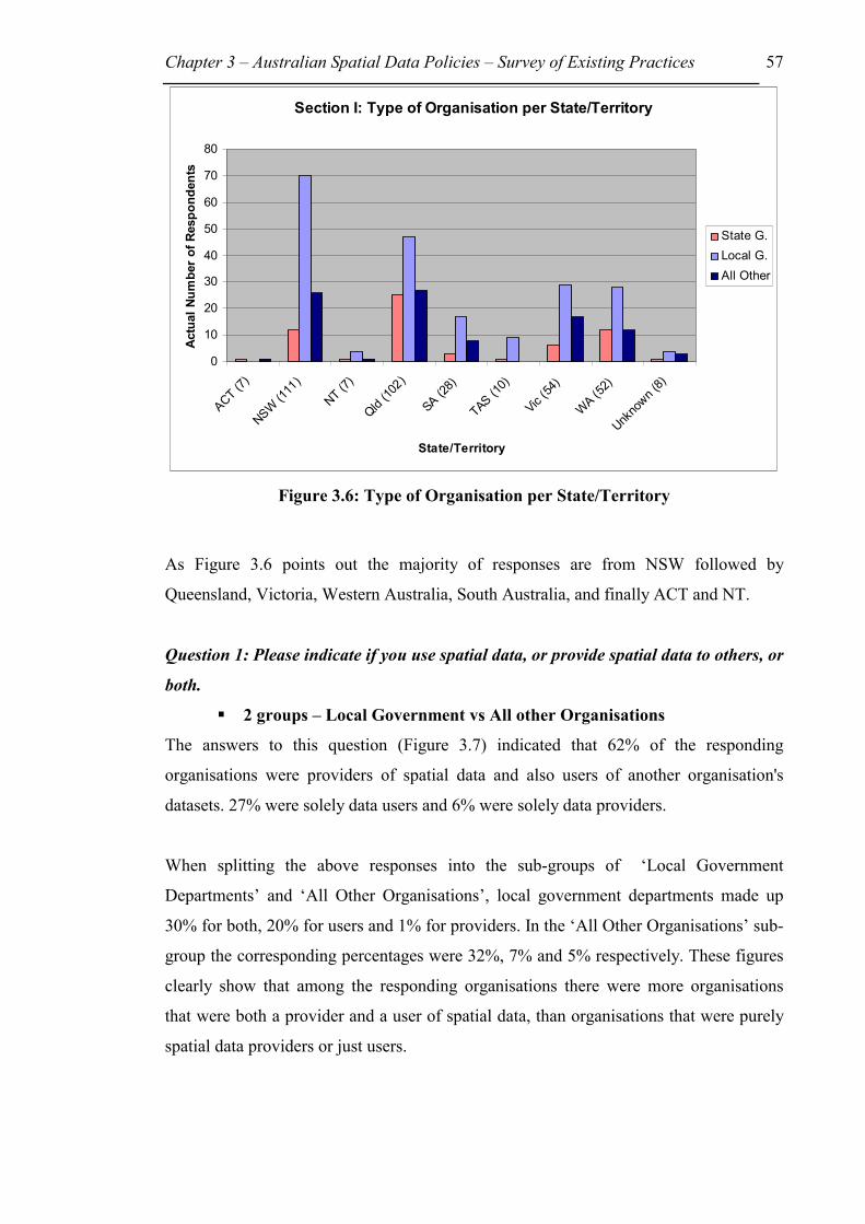
Chapter 3 – Australian Spatial Data Policies – Survey of Existing Practices 57
Figure 3.6: Type of Organisation per State/Territory
As Figure 3.6 points out the majority of responses are from NSW followed by
Queensland, Victoria, Western Australia, South Australia, and finally ACT and NT.
Question 1: Please indicate if you use spatial data, or provide spatial data to others, or
both.
��2 groups – Local Government vs All other Organisations
The answers to this question (Figure 3.7) indicated that 62% of the responding
organisations were providers of spatial data and also users of another organisation's
datasets. 27% were solely data users and 6% were solely data providers.
When splitting the above responses into the sub-groups of ‘Local Government
Departments’ and ‘All Other Organisations’, local government departments made up
30% for both, 20% for users and 1% for providers. In the ‘All Other Organisations’ sub-
group the corresponding percentages were 32%, 7% and 5% respectively. These figures
clearly show that among the responding organisations there were more organisations
that were both a provider and a user of spatial data, than organisations that were purely
spatial data providers or just users.
Section I: Type of Organisation per State/Territory
0
10
20
30
40
50
60
70
80
ACT (7)
NSW (1
11)
NT (7
)
Qld
(102)
SA (28)
TAS (10)
Vic (54
)
WA (5
2)
Unk
nown (
8)
State/Territory
Actu
al N
umbe
r of R
espo
nden
ts
State G.Local G.All Other
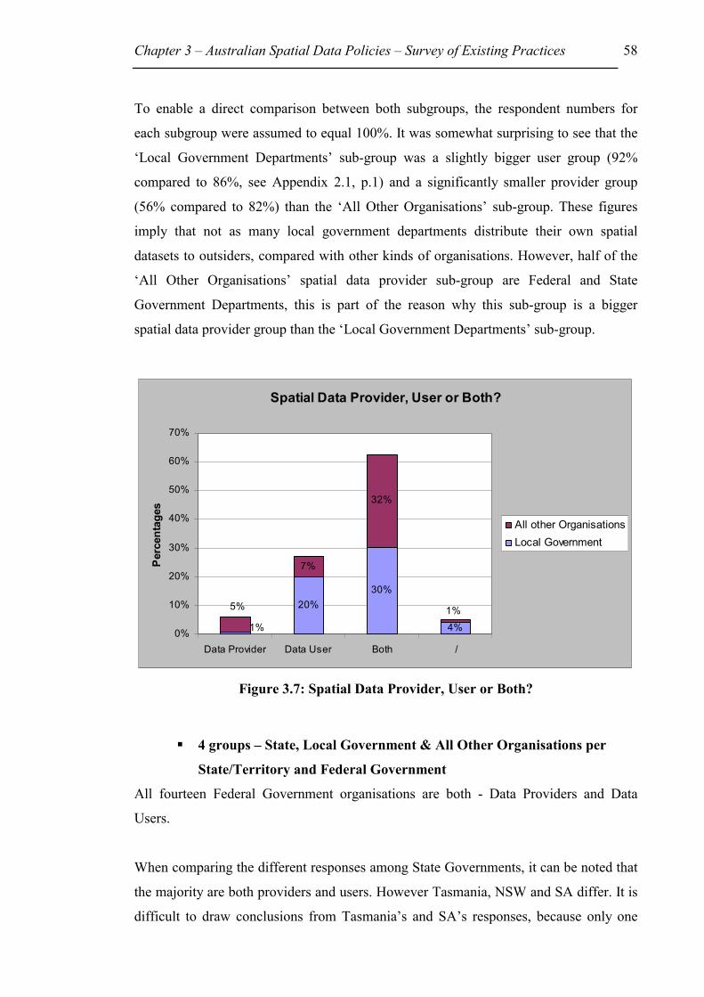
Chapter 3 – Australian Spatial Data Policies – Survey of Existing Practices 58
To enable a direct comparison between both subgroups, the respondent numbers for
each subgroup were assumed to equal 100%. It was somewhat surprising to see that the
‘Local Government Departments’ sub-group was a slightly bigger user group (92%
compared to 86%, see Appendix 2.1, p.1) and a significantly smaller provider group
(56% compared to 82%) than the ‘All Other Organisations’ sub-group. These figures
imply that not as many local government departments distribute their own spatial
datasets to outsiders, compared with other kinds of organisations. However, half of the
‘All Other Organisations’ spatial data provider sub-group are Federal and State
Government Departments, this is part of the reason why this sub-group is a bigger
spatial data provider group than the ‘Local Government Departments’ sub-group.
Figure 3.7: Spatial Data Provider, User or Both?
��4 groups – State, Local Government & All Other Organisations per
State/Territory and Federal Government
All fourteen Federal Government organisations are both - Data Providers and Data
Users.
When comparing the different responses among State Governments, it can be noted that
the majority are both providers and users. However Tasmania, NSW and SA differ. It is
difficult to draw conclusions from Tasmania’s and SA’s responses, because only one
Spatial Data Provider, User or Both?
20%30%
4%
7%
32%
1%
5% 1%
0%
10%
20%
30%
40%
50%
60%
70%
Data Provider Data User Both /
Perc
enta
ges
All other OrganisationsLocal Government

Chapter 3 – Australian Spatial Data Policies – Survey of Existing Practices 59
and three State Government Departments respectively answered the Survey. The trend
in NSW clearly differs. Half of the 12 organisations are both data users and providers, 3
are data providers and the remaining 3 are data users (Figure 3.1).
Local Government trends are more mixed with 5 out of 7 State/Territories responding
that more of their departments are ‘Both’ with percentages varying between 67% for
NSW down to 50% for NT. Next the ‘Data Users’ box received 41% of ticks for
Victoria down to 22% for Tasmania. Last, the solely ‘Data Providers’ group is overall
very small with only 3 out of 208 organisations being only data providers and not users.
The results for the other 2 out of 7 States, SA and WA are very similar. SA’s results
show that 53% are ‘Users’, 41% are ‘Both’, and 6% did not answer. For WA 54% are
‘Users’, 39% are ‘Both’ and 7% did not answer (Figure 3.2).
Responses of all other organisations indicated that the majority are ‘Both’, however
Victoria and NT are different. 47% of Victoria’s ‘All other Organisations’ said they are
‘Data Users’, 35% are ‘Both’, and 12% ‘Data Providers’, and 6% did not answer. NT
cannot be taken into account, because only 1 ‘All other Organisation’ answered the
survey (Figure 3.3).
In summary the main points that can be drawn from the answers to this question are that
Federal Government Departments are ‘Both’, data providers and users. The majority of
State, Local Government and All other Departments are also ‘Both’, data providers and
users, with 79%, 55% and 62% respectively. The main differences between those three
types of departments are that Local Government Departments are a bigger User Group
than ‘All other Organisations’ or State Government Departments with percentages of
37%, 22%, and 8% respectively. They are a smaller provider group than both the other
groups with percentages of 1% compared to 13%, and 11% respectively. This agrees
with the results given above under the heading ‘2 groups – Local Government vs All
other Organisations’. The actual respondent numbers plus their percentages for
Question 1 appear above in Tables 3.5, 3.6 and 3.7. Figures 3.1, 3.2, 3.3 and 3.4 are the
corresponding graphs.

Chapter 3 – Australian Spatial Data Policies – Survey of Existing Practices 60
Question 2: Does your Organisation use Geographic Information Systems (GIS)?
��2 groups – Local Government vs All other Organisations
From an analysis of the responses it was clear that a relatively high proportion of
organisations use GIS technology. In Figure 3.8, out of the 379 respondents 76% used a
GIS while 23% did not. The proportions were similar within the two sub-groups.
Figure 3.8: Organisations using GIS
��4 groups - State, Local Government & All Other Organisations per
State/Territory and Federal Government
Although only 14 Federal Government Agencies answered this survey they all use a
GIS.
State Government agencies gave similar answers. The following State respondents
answered ‘Yes’ (100%) to using GIS: ACT, NSW, NT, Tas, and WA. For Qld 84% of
the 25 respondents use a GIS, while 12% do not and 4% did not answer this question.
The numbers of responses from South Australia were small with 2 organisations stating
they use GIS and one does not. Six State Government agencies from Victoria answered
this question with five agencies using GIS and one not using GIS.
Local Government agency responses were quite different to State Government agencies.
The majority of responses for 6 out of 7 State’s (No ACT Local Govt answered this
Does your organisation use GIS?
24%
75%
1%0%
10%
20%
30%
40%
50%
60%
70%
80%
Yes No No Answ er
All otherOrganisationsLocal Government

Chapter 3 – Australian Spatial Data Policies – Survey of Existing Practices 61
survey) use GIS, the highest % being in Qld and the lowest in WA. The percentages that
follow are the individual State/Territory (‘Yes’, ‘No’) number of responses. Qld (89%,
11%), NSW (86%, 14%), Tas (78%, 22%), Vic (76%, 24%), SA (65%, 35%) and WA
(54%, 46%). Three Local Government respondents from the Northern Territory
answered No, while only 1 answered Yes.
For responses of ‘All other organisations’ there is only a clear trend in NSW, Qld, Vic,
and WA. The percentages that follow the individual States are in the following order
(Yes, No, No Answer). WA (83%, 17%) NSW (58%, 35%, 8%), Vic (53%, 41%, 6%)
Qld (52%, 44%, 4%).
In summary there are more Federal and State Government agencies using GIS than
Local Governments and All other organisations on a percentile basis. All 14 Federal
Government agencies use GIS. 89% of State Governments use GIS compared to 77% of
Local Government Agencies and only 59% of ‘All other Organisations’. The main
variation amongst State Government departments is that in most States the agencies use
GIS (100%), while for Qld 84% do. Around 75% of most Local Government
Departments use GIS, with the main outlier being WA, where only 54% use GIS.
Question 2A: If your organisation does use GIS, how many people are working with
the GIS?
The histogram in Figure 3.9 shows that there was a strong tendency for organisations
employing less than 10 people to use GIS technology, but there were some
organisations with large numbers of employees using GIS technology. It should be
noted that no differentiation was made between the type of GIS users, such as whether
they are expert users or not. Hence it is not possible to know what tasks are being
performed using the GIS, eg front counter display or complex analysis.

Chapter 3 – Australian Spatial Data Policies – Survey of Existing Practices 62
Figure 3.9: Number of People using GIS in Organisations
Question 3: Does your organisation use a Trade Mark?
Question 3A: If yes, did you register that Trade Mark?
Question 4: Did you register your business name?
The answers to these questions were either inconsistent or unknown to the respondent
and hence not included in the analysis. No problems were identified when the pilot
group answered these questions; hence they were left in the final questionnaire. These
questions originally aimed to determine general intellectual property protection used
within an organisation, but it was later found to be unimportant for this thesis.
Question 5: Are you aware of any liability cases that arose from spatial data
applications (eg. provision of inaccurate data)?
Only 10% of responding organisations were aware of legal liability cases, while 86%
were not (4% did not answer this question). Originally, the aim was to extend this
question to determine what problems and/or liability issues respondents had
encountered within their own organisation. A question similar to this was included in
the draft survey questionnaire, but because of confidentiality issues the results of the
pilot study group suggested that this question should be deleted.
Number of People using GIS in Organisations
4134
2319
122
11
0
20
40
60
80
100
120
140
1-5 6-10 11-20 21-50 51-100 >100
Number of People
Num
ber o
f Org
anis
atio
ns
All other OrganisationsLocal Government

Chapter 3 – Australian Spatial Data Policies – Survey of Existing Practices 63
3.4 Spatial Data Providers (Section ΙΙ)
��2 groups – Local Government vs All other Organisations
258 respondents answered section II of the questionnaire. 117 (=45%) of these were
local government departments and 141 (=55%) were from the ‘All Other Organisations’
sub-group.
The breakdown of the participating organisations for section 2 is shown in Figure 3.10:
Figure 3.10: Type of Organisation
��4 groups - State, Local Government & All Other Organisations per
State/Territory and Federal Government
When dividing the above 2 groups into 4 and separating the responses into
States/Territories, the types of organisations and the number of responses can be seen in
Table 3.3 and Figure 3.11. Because so many States or Territories have less than 10
Section II: Type of Organisation
1%
3%
1%
5%
4%
5%
14%
3%
22%
5%
45%
14%
0% 10% 20% 30% 40% 50%
Educational Institution
Engineering
Environmental Group
Natural Resources
Photogrammetry
Spatial Data Distributor
Surveyor
Utilities
State Government
Federal Government
Local Government
Other
Org
anis
atio
n
Percentages

Chapter 3 – Australian Spatial Data Policies – Survey of Existing Practices 64
respondents they were not used in the detailed analysis, except in overall summaries.
The only States used were NSW, Qld, Vic, and WA.
Figure 3.11: Type of Organisation per State/Territory
3.4.1 Data Quality
Data quality in the context of the questionnaire is not so much the actual quality of data,
such as data accuracy, but rather whether the data provider provides such additional
information with the dataset.
Question 1: What additional information do you provide with your spatial datasets
you supply to others?
This question was aimed at finding out how many organisations supply information
about their data, for example information about the accuracy of a dataset, or even
whether they are aware of what metadata is?
Section II: Type of Organisation per State/Territory
0
5
10
15
20
25
30
35
40
45
50
ACT (2)
NSW (7
5)
NT (
4)
Qld
(71)
SA (17)
Tas (6
)
Vic (30
)
WA (3
3)
Unk
nown (
6)
State/Territory
Num
ber o
f Org
anis
atio
ns
State G.Local G.All Other
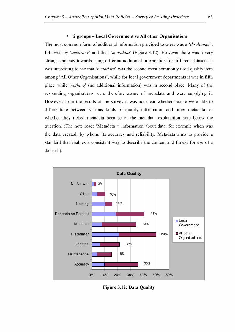
Chapter 3 – Australian Spatial Data Policies – Survey of Existing Practices 65
��2 groups – Local Government vs All other Organisations
The most common form of additional information provided to users was a ‘disclaimer’,
followed by ‘accuracy’ and then ‘metadata’ (Figure 3.12). However there was a very
strong tendency towards using different additional information for different datasets. It
was interesting to see that ‘metadata’ was the second most commonly used quality item
among ‘All Other Organisations’, while for local government departments it was in fifth
place while 'nothing' (no additional information) was in second place. Many of the
responding organisations were therefore aware of metadata and were supplying it.
However, from the results of the survey it was not clear whether people were able to
differentiate between various kinds of quality information and other metadata, or
whether they ticked metadata because of the metadata explanation note below the
question. (The note read: ‘Metadata = information about data, for example when was
the data created, by whom, its accuracy and reliability. Metadata aims to provide a
standard that enables a consistent way to describe the content and fitness for use of a
dataset’).
Figure 3.12: Data Quality
Data Quality
3%
36%
16%
22%
50%
34%
41%
16%
10%
0% 10% 20% 30% 40% 50% 60%
Accuracy
Maintenance
Updates
Disclaimer
Metadata
Depends on Dataset
Nothing
Other
No Answer
LocalGovernment
All otherOrganisations

Chapter 3 – Australian Spatial Data Policies – Survey of Existing Practices 66
��4 groups - State, Local Government & All Other Organisations per
State/Territory and Federal Government
No trends could be found when comparing the 4 different groups (see Appendix 2, p.2
and 3). Figure 3.13 shows all groups combined with actual numbers of respondents per
State/Territory below. When comparing the States with more than 10 respondents
(NSW, Qld, SA, Vic, WA) the main differences are as follows. WA emphasises the
provision of maintenance with their datasets, while NSW has maintenance as one of its
lower priorities. The order of priorities in Qld in providing additional information with
their dataset is ‘Disclaimer’, ‘Accuracy’, ‘Maintenance’ and ‘Depends on the individual
Dataset’. In NSW ‘Disclaimer’ is the most common, followed by ‘Depends on
individual Dataset’, and then ‘Accuracy’.
Figure 3.13: Additional information provided with dataset
3.4.2 Data Access & Cost
Question 1: How do you provide access to your spatial datasets? (Hardcopy or
Digital)
It was interesting to note that even with the rapid adoption of technology, the most
common way to access spatial data was still as ‘hardcopy over the counter or by mail’
Summary - Data Quality
0
510
1520
2530
3540
45
ACT (2)
NSW (7
5)
NT (4
)
Qld
(71)
SA (17)
Tas (6
)
Vic (30
)
WA (3
3)
Unk
nown (
6)
State/Territory
Actu
al N
umbe
r of T
icks
per
Box
Item
AccuracyMaintenanceUpdatesDisclaimerMetadataDepends on DatasetNothingOther

Chapter 3 – Australian Spatial Data Policies – Survey of Existing Practices 67
(83%), followed by having the data stored on ‘floppy disk’ (60%), ‘e-mailed’ (48%), or
stored on a ‘CD-Rom’ (46%) (see Appendix 2, p.4). There were however some
organisations that commented on wishing to implement 'downloading' and ‘viewing
only' via the World Wide Web (WWW) in the near future.
��4 groups - State, Local Government & All Other Organisations per
State/Territory and Federal Government
Some trends could be observed between the 4 different groups. For example, 11 out of
the 14 Federal government departments provided data on ‘CD-Rom’, followed by 10
each by ‘e-mail’ and ‘floppy disc’ and 9 by ‘hardcopy’ (Figure 3.14). Figure 3.15 shows
that for NSW, Qld, SA, Vic, and WA a similar pattern applies as noted above within the
2 groups. Therefore the demand for digital spatial data from a federal government
agency must be greater than from other sources.
Figure 3.14: Data Access (Federal Government)
Question 1: Federal Government
0
2
4
6
8
10
12
Download
Viewing
only
FTP
Floppy d
isk
CD-Rom
Hardcop
yFax
Tape
Depend
s on D
ataset
Other
Box Item
Actu
al N
umbe
r of T
icks
per
Box
Item

Chapter 3 – Australian Spatial Data Policies – Survey of Existing Practices 68
Figure 3.15: Data Access
Question 2: On what basis do you attempt to recover the cost of your various spatial
datasets?
43% of all respondents were recovering the cost of supply of their spatial datasets,
followed by 26% that did not try to recover their costs at all. However 34% said that
their basis for charging varied depending on the dataset itself (Figure 3.16).
Figure 3.16: Cost Recovery
Summary - Data Access
0
10
20
30
40
50
60
70
ACT (2)
NSW (7
5)
NT (4
)
Qld
(71)
SA (17)
Tas (6
)
Vic (30
)
WA (3
3)
Unk
nown (
6)
State/Territory
Actu
al N
umbe
r of T
icks
per
Box
Item
Download
Viewing only
FTP
Floppy disk
CD-Rom
Hardcopy
Fax
Tape
Depends on Dataset
Other
Cost Recovery
2%
12%
34%
16%
15%
43%
19%
11%
5%
26%
0% 10% 20% 30% 40% 50%
Do not
Cost of data storagemedium
Cost of dataacquisition
Cost of datamanipulation
Cost of supply,provision
Market value
Full cost recovery
Varies depending ondataset
Other
No Answ er
Local Government
All other Organisations

Chapter 3 – Australian Spatial Data Policies – Survey of Existing Practices 69
��4 groups - State, Local Government & All Other Organisations per
State/Territory and Federal Government
Out of the 14 Federal Government Departments, 8 specified they ‘Do not’ charge, and 5
charge for the ‘Cost of supply, provision’. However 4 specified the charge depended on
the individual dataset.
Among the State Government Departments the main charge is ‘Cost of supply,
provision’.
Local Government respondents indicated that for NSW and Qld the main charge is for
‘Cost of supply, provision’ (47%, 41%) then ‘Varies depending on dataset’ (45%, 37%)
and then ‘Do not charge’ (26%, 30%). For Vic it is firstly ‘Do not charge’ (50%),
followed by ‘Cost of supply, provision’ (25%), and then ‘Varies depending on dataset’
(19%). In WA most respondents indicated that their charging ‘Varies depending on
dataset’ (55%) followed by ‘Do not’ (36%) and then ‘Cost of supply, provision’ (18%).
In the All other organisations sub-group the main charges are ‘Cost of supply, provision’
plus ‘Full cost recovery’.
In summary (Figure 3.17) all three graphs for NSW, Qld and WA look similar with
‘Cost of supply, provision’ being the most commonly used approach to charging
followed by ‘Depends on dataset’ and then ‘Do not charge’. In NSW, ‘Do not charge’
was chosen before ‘Cost of data manipulation’. Vic varies in that most respondents
ticked ‘Do not charge’ followed by ‘Cost of supply, provision’ and then ‘Depends on
dataset’.

Chapter 3 – Australian Spatial Data Policies – Survey of Existing Practices 70
Figure 3.17: Cost recovery per State/Territory
Question 3: What unit price do you charge for your spatial datasets?
The highest number of respondents (34%) indicated that they charged for supplying data
on the basis of an ‘hourly rate’ for the labour involved, followed by 33% that said they
charged ‘per mapsheet’. For 29% the unit price charged also depended on the individual
dataset. A similar pattern applied to the ‘All Other Organisations’ sub-group, where an
‘hourly rate’ was charged by 22%, followed by the dependence of unit price on
individual datasets (17%). 15% answered that their unit price was charged ‘per
mapsheet’. In the ‘Local Government Departments’ sub-group, 17% of the responding
organisations charged ‘per mapsheet’, followed by 14% that did not charge at all and
then by 13% that charged on the basis of an ‘hourly rate’ for the labour involved
(Figure 3.18).
Summary - Cost Recovery
0
5
10
15
20
25
30
35
40
ACT (2)
NSW (7
5)
NT (4
)
Qld
(71)
SA (17)
Tas (6
)
Vic (30
)
WA (3
3)
Unk
nown (
6)
State/Territory
Actu
al N
umbe
r of R
espo
nden
ts Do notCost of data storage mediumCost of data acquisitionCost of data manipulationCost of supply, provisionMarket valueFull cost recoveryVaries depending on datasetOther

Chapter 3 – Australian Spatial Data Policies – Survey of Existing Practices 71
Figure 3.18: Unit Price
��4 groups - State, Local Government & All Other Organisations per
State/Territory and Federal Government
Out of the 14 Federal Government Departments, 8 specified they ‘Do not charge’, and 5
charge ‘Per mapsheet’, but 3 out of 14 specified the charge depended on the individual
dataset.
Amongst State Government departments or Local Government departments there were
no real trends.
3.4.3 Legal
Question 1: Do you use disclaimers? (e.g. Do not use the data other than as specified)
The majority of all respondents (64%) indicated that they used disclaimers, and about
one third (34%) stated that they did not.
Unit Price
3%
15%
23%
3%
7%
29%
7%
3%
33%
34%
25%
0% 5% 10% 15% 20% 25% 30% 35% 40%
Do not charge
Hourly rate
Per mapsheet
Per Megabyte of storage
Per certain scale map
Depends on dataset
Per parcel of land
Per polygon
Depends on user
Other
No Answer
Local Government All other Organisations

Chapter 3 – Australian Spatial Data Policies – Survey of Existing Practices 72
��4 groups - State, Local Government & All Other Organisations per
State/Territory and Federal Government
Out of the 14 Federal Government Departments 10 specified they do use disclaimers
while 4 do not.
Within the other sub-groups more organisations (NSW, Qld, Vic, WA) specified they
use disclaimers than not. The exception among State Government departments is
Victoria that answered 50% for Yes and 50% for No. Interestingly, WA for the sub-
group Local Governments has 8 out of 11 specifying they do not use disclaimers.
Question 2: Do you allow data users to distribute or sell your original datasets to
others?
Question 3: Do you allow data users to distribute or sell your datasets that they added
value to?
70% of all respondents said they did not allow data users to on-sell or distribute the
original dataset. However when data users added value to those datasets, the number of
respondents that did not allow users to distribute the ‘original plus value added’
decreased to 52%.
Question 4: What legal forms of protection do you utilise to protect your intellectual
property in your spatial datasets?
Overall it was most common not to use any form of legal protection (see Figure 3.19),
followed by ‘copyright’ and then ‘licences’. However since many respondents ticked
more than one item, it can be assumed that the legal form of protection chosen depended
on the individual dataset. More than half of all the local government departments
responding indicated that they did not utilise any form of legal protection, followed by
one quarter that relied on ‘copyright’. On the other hand, organisations in the ‘All Other
Organisations’ sub-group relied more heavily on ‘copyright’ protection (26%) followed
by ‘licences’ and no protection at all (each 20%) (see Appendix 2, p.9).

Chapter 3 – Australian Spatial Data Policies – Survey of Existing Practices 73
Figure 3.19: Legal Protection used for Intellectual Property (Note: More than one legal protection item was ticked on average and hence the total
percentages add up to more than 100%)
��4 groups - State, Local Government & All Other Organisations per
State/Territory and Federal Government
Out of the 14 Federal Government Departments 8 specified they use Copyright and/or
Licences. 3 departments ticked ‘None’ or ‘Others’.
State Government Departments for NSW and Qld specified they most commonly use
‘Copyright’, then ‘Licences’ and ‘Nothing’. Vic and WA differ. In Vic the highest
number of respondents indicated they use ‘Nothing’ followed by ‘Licences’ and then
‘Copyright’. In WA the highest number is for ‘Licences’ then ‘Copyright’ and then
‘Nothing’ (Figure 3.20).
Among Local Government Departments many more respondents indicated they use
‘Nothing’ to legally protect their datasets (Figure 3.21).
Legal Protection
3%
10%
1%
30%
39%
46%
0%
10%
20%
30%
40%
50%
None Copyright Licenses TradeSecret
Others NoAnsw er
All other Organisations
Local Government

Chapter 3 – Australian Spatial Data Policies – Survey of Existing Practices 74
Within the All other Organisations sub-group there is no visible trend (see Appendix 2,
p.11).
Figure 3.20: Legal Protections used by State Government Departments
Figure 3.21: Legal Protections used by Local Government Departments
Question 4: State Government
0%
10%
20%
30%
40%
50%
60%
70%
80%
NSW (9) Qld (23) Vic (6) WA (12)
State
Perc
enta
ges None
Copyright LicensesTrade SecretOthers
Question 4: Local Government
0%
10%
20%
30%
40%
50%
60%
70%
80%
NSW (47) Qld (27) Vic (16) WA (11)
State
Perc
enta
ges None
Copyright LicensesTrade SecretOthers
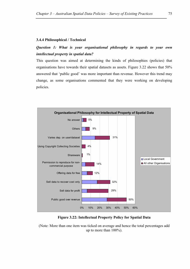
Chapter 3 – Australian Spatial Data Policies – Survey of Existing Practices 75
3.4.4 Philosophical / Technical
Question 1: What is your organisational philosophy in regards to your own
intellectual property in spatial data?
This question was aimed at determining the kinds of philosophies (policies) that
organisations have towards their spatial datasets as assets. Figure 3.22 shows that 50%
answered that ‘public good’ was more important than revenue. However this trend may
change, as some organisations commented that they were working on developing
policies.
Figure 3.22: Intellectual Property Policy for Spatial Data
(Note: More than one item was ticked on average and hence the total percentages add up to more than 100%).
Organisational Philosophy for Intellectual Property of Spatial Data
5%
9%
31%
4%
1%
14%
12%
32%
29%
50%
0% 10% 20% 30% 40% 50% 60%
Public good over revenue
Sell data for profit
Sell data to recover cost only
Offering data for free
Permission to reproduce for non-commercial purpose
Shareware
Using Copyright Collecting Societies
Varies dep. on user/dataset
Others
No answer
Local GovernmentAll other Organisations

Chapter 3 – Australian Spatial Data Policies – Survey of Existing Practices 76
��4 groups - State, Local Government & All Other Organisations per
State/Territory and Federal Government
Out of the 14 Federal Government Departments 12 specified ‘Public good’ was more
important than creating revenue.
For State Government Departments Qld, Vic, and WA had the largest number of ticks in
‘Public good over revenue’, considerably more than for ‘Selling data for profit’. NSW
on the other hand marked ‘Sell data for profit’ (6/9). It was usually followed by ‘Public
good over revenue’ (5/9). However the number of respondents was only 9 (Figure 3.23).
Local Government Departments indicated that Public good was far more important than
revenue. The second item selected was ‘Sell data to recover cost only’ (Figure 3.24).
All other Organisations answers indicated 68% of all the respondents sell their data to
make a profit (Figure 3.25).
Figure 3.23: Organisational Philosophy for State Government Departments
Question 1: State Government
0%
10%
20%
30%
40%
50%
60%
70%
NSW (9) Qld (23) Vic (6) WA (9)
State
Perc
enta
ges
Public good over revenueSell data for profitSell data to recover cost onlyOffering data for freeCopyleftSharewareUsing Copyright Collecting S.Varies dep. on user/datasetOthers
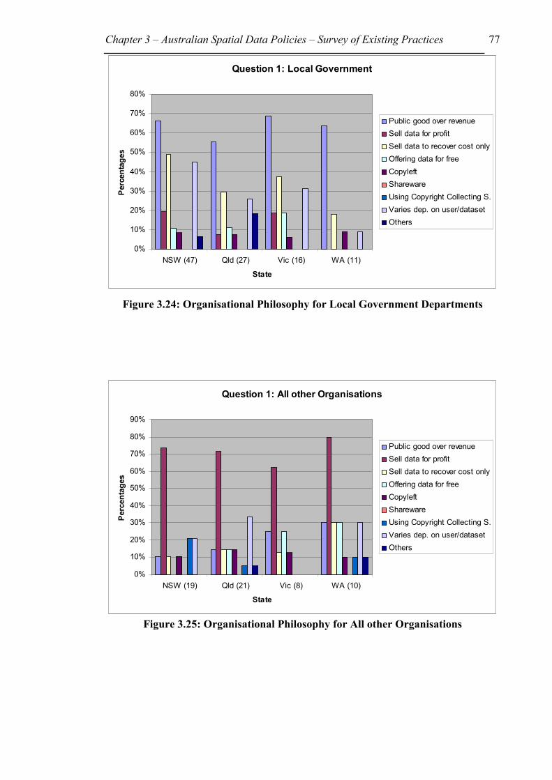
Chapter 3 – Australian Spatial Data Policies – Survey of Existing Practices 77
Figure 3.24: Organisational Philosophy for Local Government Departments
Figure 3.25: Organisational Philosophy for All other Organisations
Question 1: Local Government
0%
10%
20%
30%
40%
50%
60%
70%
80%
NSW (47) Qld (27) Vic (16) WA (11)
State
Perc
enta
ges
Public good over revenueSell data for profitSell data to recover cost onlyOffering data for freeCopyleftSharewareUsing Copyright Collecting S.Varies dep. on user/datasetOthers
Question 1: All other Organisations
0%
10%
20%
30%
40%
50%
60%
70%
80%
90%
NSW (19) Qld (21) Vic (8) WA (10)
State
Perc
enta
ges
Public good over revenueSell data for profitSell data to recover cost onlyOffering data for freeCopyleftSharewareUsing Copyright Collecting S.Varies dep. on user/datasetOthers
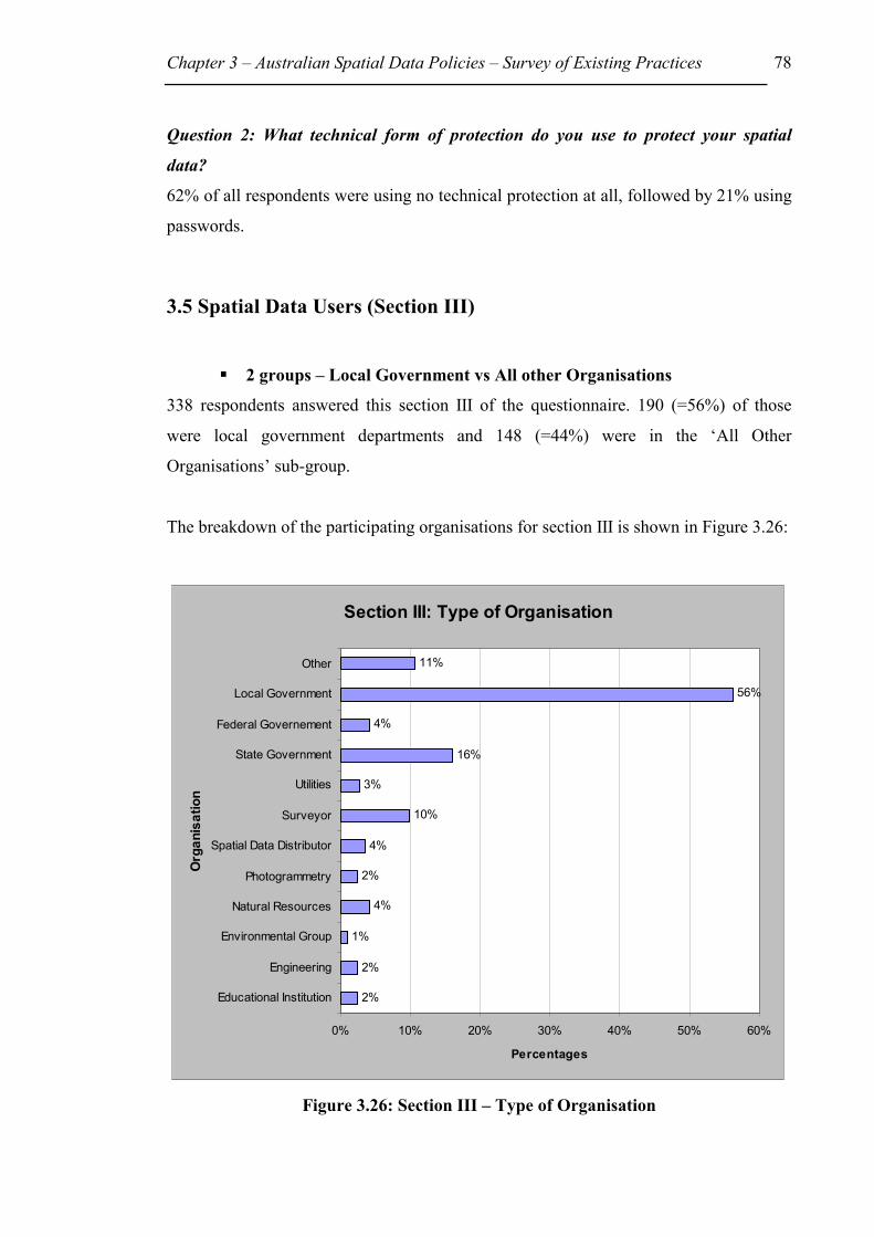
Chapter 3 – Australian Spatial Data Policies – Survey of Existing Practices 78
Question 2: What technical form of protection do you use to protect your spatial
data?
62% of all respondents were using no technical protection at all, followed by 21% using
passwords.
3.5 Spatial Data Users (Section III)
��2 groups – Local Government vs All other Organisations
338 respondents answered this section III of the questionnaire. 190 (=56%) of those
were local government departments and 148 (=44%) were in the ‘All Other
Organisations’ sub-group.
The breakdown of the participating organisations for section III is shown in Figure 3.26:
Figure 3.26: Section III – Type of Organisation
Section III: Type of Organisation
2%
2%
1%
4%
2%
4%
10%
3%
16%
4%
56%
11%
0% 10% 20% 30% 40% 50% 60%
Educational Institution
Engineering
Environmental Group
Natural Resources
Photogrammetry
Spatial Data Distributor
Surveyor
Utilities
State Government
Federal Governement
Local Government
Other
Org
anis
atio
n
Percentages
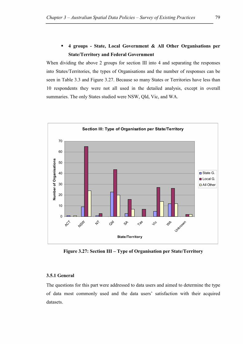
Chapter 3 – Australian Spatial Data Policies – Survey of Existing Practices 79
��4 groups - State, Local Government & All Other Organisations per
State/Territory and Federal Government
When dividing the above 2 groups for section III into 4 and separating the responses
into States/Territories, the types of Organisations and the number of responses can be
seen in Table 3.3 and Figure 3.27. Because so many States or Territories have less than
10 respondents they were not all used in the detailed analysis, except in overall
summaries. The only States studied were NSW, Qld, Vic, and WA.
Figure 3.27: Section III – Type of Organisation per State/Territory
3.5.1 General
The questions for this part were addressed to data users and aimed to determine the type
of data most commonly used and the data users’ satisfaction with their acquired
datasets.
Section III: Type of Organisation per State/Territory
0
10
20
30
40
50
60
70
ACTNSW NT
Qld SA Tas Vic WA
Unkno
wn
State/Territory
Num
ber o
f Org
anis
atio
ns
State G.
Local G.
All Other

Chapter 3 – Australian Spatial Data Policies – Survey of Existing Practices 80
Question 1: What type of spatial data do you acquire from other providers?
��2 groups – Local Government vs All other Organisations
Figure 3.28 shows that the most commonly used datasets by 76% of respondents were
‘Property Boundaries’, and ‘contours’ by 53%.
Figure 3.28: Spatial Data Categories most commonly used (Note: More than one type of spatial data category was ticked on average and hence
total percentages add up to more than 100%).
��4 groups - State, Local Government & All Other Organisations per
State/Territory and Federal Government
From the 14 Federal Government Departments, 11 use Hydrography, followed by 10
using Transport Network, and 8 Departments said they acquire Administrative Data,
Contours, Natural Resources and Utilities.
The most commonly used dataset among State Government Departments are the
‘Property boundaries’ (37, 69%) closely followed by ‘Administrative data’ (36, 67%)
and then ‘Ownership (cadastral) data’ (32, 59%). The number in brackets is the actual
Spatial Data Categories most commonly used
34%
16%
7%
53%
17%
15%
23%
5%
33%
50%
24%
76%
31%
31%
13%
4%
0% 10% 20% 30% 40% 50% 60% 70% 80%
Administrative
Buildings
Climate
Contours
Flora&Fauna
Geodetic
Hydrography
Maritime Navigation
Natural Resources
Ownership (cadastral)
Population
Property Boundaries
Transport Network
Utilities
Other
No answer
Local GovernmentAll other Organisations
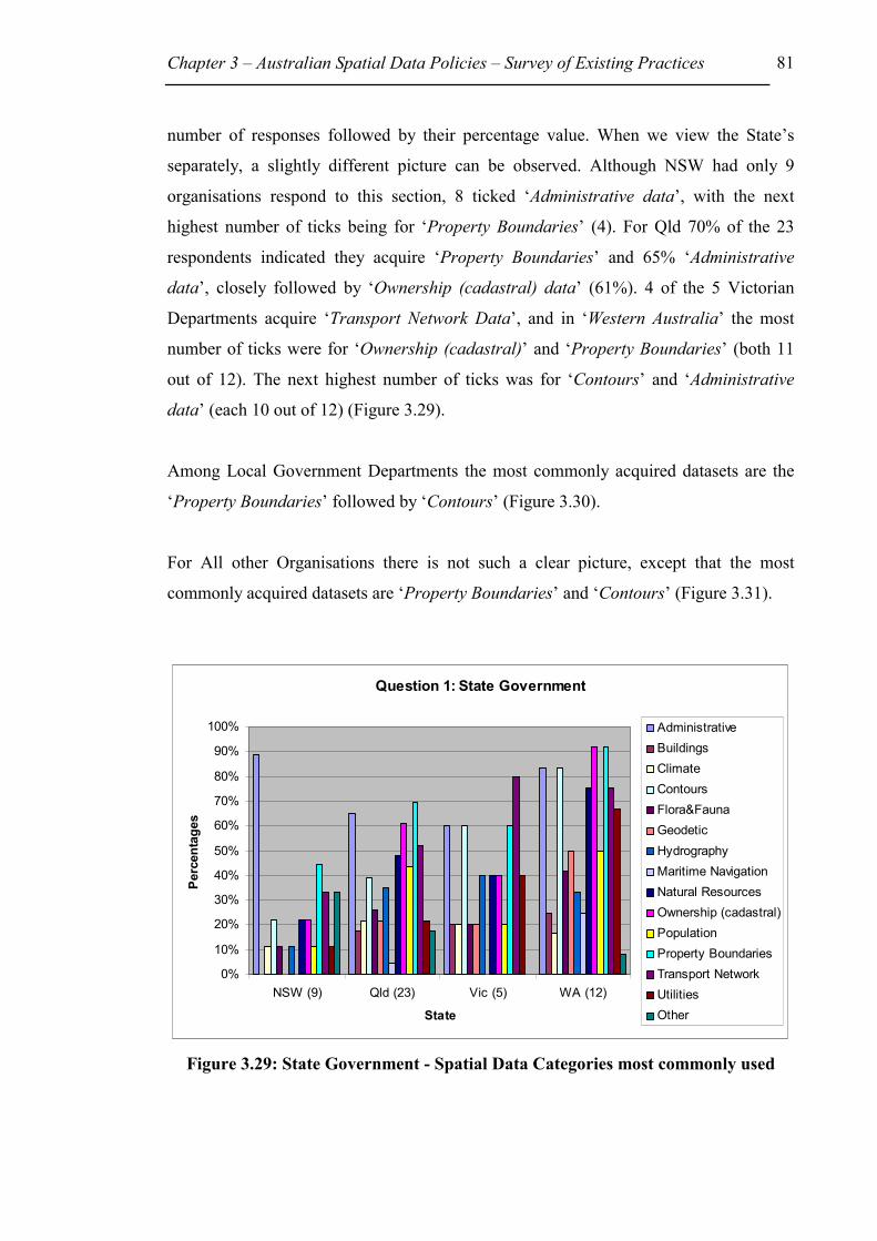
Chapter 3 – Australian Spatial Data Policies – Survey of Existing Practices 81
number of responses followed by their percentage value. When we view the State’s
separately, a slightly different picture can be observed. Although NSW had only 9
organisations respond to this section, 8 ticked ‘Administrative data’, with the next
highest number of ticks being for ‘Property Boundaries’ (4). For Qld 70% of the 23
respondents indicated they acquire ‘Property Boundaries’ and 65% ‘Administrative
data’, closely followed by ‘Ownership (cadastral) data’ (61%). 4 of the 5 Victorian
Departments acquire ‘Transport Network Data’, and in ‘Western Australia’ the most
number of ticks were for ‘Ownership (cadastral)’ and ‘Property Boundaries’ (both 11
out of 12). The next highest number of ticks was for ‘Contours’ and ‘Administrative
data’ (each 10 out of 12) (Figure 3.29).
Among Local Government Departments the most commonly acquired datasets are the
‘Property Boundaries’ followed by ‘Contours’ (Figure 3.30).
For All other Organisations there is not such a clear picture, except that the most
commonly acquired datasets are ‘Property Boundaries’ and ‘Contours’ (Figure 3.31).
Figure 3.29: State Government - Spatial Data Categories most commonly used
Question 1: State Government
0%
10%
20%
30%
40%
50%
60%
70%
80%
90%
100%
NSW (9) Qld (23) Vic (5) WA (12)
State
Perc
enta
ges
AdministrativeBuildingsClimateContoursFlora&FaunaGeodeticHydrographyMaritime NavigationNatural ResourcesOwnership (cadastral)PopulationProperty BoundariesTransport NetworkUtilitiesOther

Chapter 3 – Australian Spatial Data Policies – Survey of Existing Practices 82
Figure 3.30: Local Government - Spatial Data Categories most commonly used
Figure 3.31: All other Organisations - Spatial Data Categories most commonly
used
Question 1: Local Government
0%
10%
20%
30%
40%
50%
60%
70%
80%
90%
100%
NSW (65) Qld (44) Vic (27) WA (26)
State
Perc
enta
ges
AdministrativeBuildingsClimateContoursFlora&FaunaGeodeticHydrographyMaritime NavigationNatural ResourcesOwnership (cadastral)PopulationProperty BoundariesTransport NetworkUtilitiesOther
Question 1: All other Organisations
0%
10%
20%
30%
40%
50%
60%
70%
80%
90%
NSW (24) Qld (20) Vic (14) WA (12)
State
Perc
enta
ges
AdministrativeBuildingsClimateContoursFlora&FaunaGeodeticHydrographyMaritime NavigationNatural ResourcesOwnership (cadastral)PopulationProperty BoundariesTransport NetworkUtilitiesOther

Chapter 3 – Australian Spatial Data Policies – Survey of Existing Practices 83
Question 2: How satisfied are you generally with provider’s datasets?
34% were moderately satisfied, followed by 31% that were satisfied and 20% that were
neutral. However, it is worth mentioning that 10% of users were moderately
dissatisfied. Unfortunately, the survey did not seek to find out the reasons for any
expressed dissatisfaction.
3.5.2 Data Quality
Question 1: Are the datasets you acquired from other data providers compatible with
your own system without translation (eg. format)?
In Figure 3.32, 35% answered that the data providers’ datasets were not compatible with
their own system. However to most users this was not a major problem.
Figure 3.32: Datasets Compatibility with Organisation’s System
��4 groups - State, Local Government & All Other Organisations per
State/Territory and Federal Government
The order among Federal Government Departments is different to the above. Out of 14
respondents, 8 said the dataset is not compatible with their own system, and 6 said it is.
Compatible with Organisation's System?
52%
35%
8% 5%
0%
10%
20%
30%
40%
50%
60%
Yes No No Answ er Yes, No
All other Organisations
Local Government
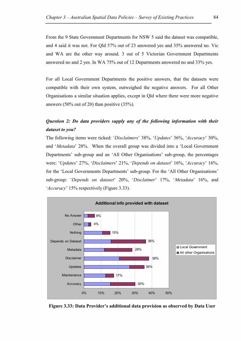
Chapter 3 – Australian Spatial Data Policies – Survey of Existing Practices 84
From the 9 State Government Departments for NSW 5 said the dataset was compatible,
and 4 said it was not. For Qld 57% out of 23 answered yes and 35% answered no. Vic
and WA are the other way around. 3 out of 5 Victorian Government Departments
answered no and 2 yes. In WA 75% out of 12 Departments answered no and 33% yes.
For all Local Government Departments the positive answers, that the datasets were
compatible with their own system, outweighed the negative answers. For all Other
Organisations a similar situation applies, except in Qld where there were more negative
answers (50% out of 20) than positive (35%).
Question 2: Do data providers supply any of the following information with their
dataset to you?
The following items were ticked: ‘Disclaimers’ 38%, ‘Updates’ 36%, ‘Accuracy’ 30%,
and ‘Metadata’ 28%. When the overall group was divided into a ‘Local Government
Departments’ sub-group and an ‘All Other Organisations’ sub-group, the percentages
were: ‘Updates’ 27%, ‘Disclaimers’ 21%, ‘Depends on dataset’ 16%, ‘Accuracy’ 16%,
for the ‘Local Governments Departments’ sub-group. For the ‘All Other Organisations’
sub-group: ‘Depends on dataset’ 20%, ‘Disclaimer’ 17%, ‘Metadata’ 16%, and
‘Accuracy’ 15% respectively (Figure 3.33).
Figure 3.33: Data Provider’s additional data provision as observed by Data User
Additional info provided with dataset
30%
17%
36%
38%
28%
36%
15%
4%
6%
0% 10% 20% 30% 40% 50%
Accuracy
Maintenance
Updates
Disclaimer
Metadata
Depends on Dataset
Nothing
Other
No Answer
Local GovernmentAll other Organisations

Chapter 3 – Australian Spatial Data Policies – Survey of Existing Practices 85
3.5.3 Data Access & Cost
Question 1: What do organisations that provide data to you charge for their datasets?
As shown in Figure 3.34, many respondents indicated that their charge for datasets
‘varied for individual datasets’ (38%). The most commonly used unit price for a dataset
was a ‘charge per mapsheet’ (31%), followed by a ‘charge per parcel of land’ (24%).
18% of users indicated that they were not charged at all for the datasets they obtained.
When compared with Question 3 in section II B there is an inconsistency in the answers.
In this section, the most common approach to charging for spatial data, used by spatial
data providers, was on an ‘hourly rate’ (34%), followed by charge ‘per mapsheet’
(33%), which are different to the spatial data users’ results for the same questions. It is
possible that this apparent anomaly occurred because the datasets referred to by spatial
data users were not necessarily the same datasets as the providers’ ones. Furthermore,
some datasets may be used by many more users than other datasets.

Chapter 3 – Australian Spatial Data Policies – Survey of Existing Practices 86
Figure 3.34: Unit Price (Note: More than one unit price item was ticked on average and hence the total
percentages add up to more than 100%).
��4 groups - State, Local Government & All Other Organisations per
State/Territory and Federal Government
When comparing the Federal Government Departments, 7 out of 14 indicated that their
data provider does not charge for the dataset, however 6 specified that it depended on
the individual dataset.
50 % of State Government Departments ticked that the unit price charged depended on
the individual dataset (Figure 3.35).
32% of all Local Government Departments indicated that the unit price they are charged
by the Data Provider depended on the individual dataset. 29% answered the unit price
was charged per map sheet and 28% said per parcel of land. Amongst the individual
States, 52% of all NSW Local Government Departments are charged ‘per parcel of
Unit Price
18%
8%
31%
7%
5%
38%
24%
10%
9%
20%
5%
0% 10% 20% 30% 40%
Do not charge
Hourly rate
Per mapsheet
Per Megabyte of storage
Per cetain scale map
Depends on dataset
Per parcel of land
Per polygon
Depends on user
Other
No answer
Local GovernmentAll other Organisations

Chapter 3 – Australian Spatial Data Policies – Survey of Existing Practices 87
land’ and 31% ‘per map sheet’ (Figure 3.36). All other Organisation’s responses can be
seen in Figure 3.37.
Figure 3.35: Data provider’s unit price as observed by data user
Figure 3.36: Data provider’s unit price as observed by data user
Question 1: State Government
0%
10%
20%
30%
40%
50%
60%
70%
NSW (9) Qld (23) Vic (5) WA (12)
State
Perc
enta
ges
Do not chargeHourly ratePer mapsheetPer Megabyte of storagePer certain scale mapDepends on datasetPer parcel of landPer polygonDepends on userOther
Question 1: Local Government
0%
10%
20%
30%
40%
50%
60%
NSW (65) Qld (44) Vic (27) WA (26)
State
Perc
enta
ges
Do not chargeHourly ratePer mapsheetPer Megabyte of storagePer certain scale mapDepends on datasetPer parcel of landPer polygonDepends on userOther

Chapter 3 – Australian Spatial Data Policies – Survey of Existing Practices 88
Figure 3.37: Data provider’s unit price as observed by data user
3.5.4 Legal
Question 1: Indicate what legal protection means are used by the data providers, from
whom you buy or get data.
Figure 3.38 shows that 63% of users stated that the most commonly used means of legal
protection by data providers was licences, 37% of those being from the ‘Local
Government Departments’ sub-group and 26% from the ‘All Other Organisations’ sub-
group (also see Appendix 2, p.12 to 14). These figures are different to the answers in
Question 4, Section II under the subheading 3.4.3. This is to be expected for the same
reason as explained for Question 1, Section III under the subheading 3.5.3, given
previously.
Question 1: All other Organisations
0%
10%
20%
30%
40%
50%
60%
70%
NSW (24) Qld (20) Vic (14) WA (12)
State
Perc
enta
ges
Do not chargeHourly ratePer mapsheetPer Megabyte of storagePer certain scale mapDepends on datasetPer parcel of landPer polygonDepends on userOther

Chapter 3 – Australian Spatial Data Policies – Survey of Existing Practices 89
Figure 3.38: Legal Protection (Note: More than one legal protection item was ticked on average and hence the total
percentages add up to more than 100%).
��4 groups - State, Local Government & All Other Organisations per
State/Territory and Federal Government
The results for all individual groups are very similar to the above results. For the
majority of State Government organisations the ‘Licences’ (70%) box was ticked most,
followed by ‘Copyright’ (46%) (Figure 3.39). These figures are similar for Local
Government Departments (66% and 52%) (Figure 3.40). Amongst All other
Organisations, NSW and Qld had the same number of boxes ticked for ‘Licences’ and
‘Copyright’ (50% of their responses), while for Vic and WA the order was ‘Copyright’
then ‘Licences’ (Vic 50%, 36%; WA 83%, 67%) (Figure 3.41).
Legal Protection
7%4%
0%
63%
51%
12%
0%
10%
20%
30%
40%
50%
60%
70%
None Copyright Licenses TradeSecret
Others No answer
All other OrganisationsLocal Government
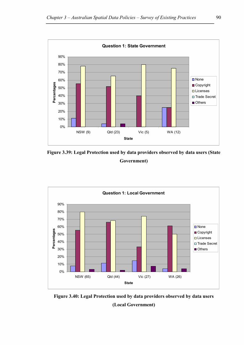
Chapter 3 – Australian Spatial Data Policies – Survey of Existing Practices 90
Figure 3.39: Legal Protection used by data providers observed by data users (State
Government)
Figure 3.40: Legal Protection used by data providers observed by data users
(Local Government)
Question 1: State Government
0%
10%
20%
30%
40%
50%
60%
70%
80%
90%
NSW (9) Qld (23) Vic (5) WA (12)
State
Perc
enta
ges
NoneCopyright LicensesTrade SecretOthers
Question 1: Local Government
0%
10%
20%
30%
40%
50%
60%
70%
80%
90%
NSW (65) Qld (44) Vic (27) WA (26)
State
Perc
enta
ges None
Copyright LicensesTrade SecretOthers

Chapter 3 – Australian Spatial Data Policies – Survey of Existing Practices 91
Figure 3.41: Legal Protection used by data providers observed by data users (All
other Organisations)
Question 2: Do you sell or distribute provider’s spatial data, in its original form, to
others?
Question 3: Do you sell or distribute value added providers spatial data to others?
70% of all respondents indicated that they did not distribute the original dataset they had
acquired. Once value was added the 70% dropped to 61%. The number of people selling
datasets in their original form was 14%. After adding value this figure rose to 25%.
Interestingly, when this question was directed to all data providers in Section 2, 70% of
all respondents said that they did not allow data users to on-sell the original dataset.
However after the user added value to the datasets, the data provider’s response
decreased to 52%. The statistics for the providers and users are similar. A large
proportion of users and providers do not allow original datasets to be on-sold. The small
proportion of value-added data that is on-sold by users possibly indicates that such
processing might be mainly for internal organisational use.
Question 1: All other Organisations
0%
10%
20%
30%
40%
50%
60%
70%
80%
90%
NSW (24) Qld (20) Vic (14) WA (12)
State
Perc
enta
ges
NoneCopyright LicensesTrade SecretOthers
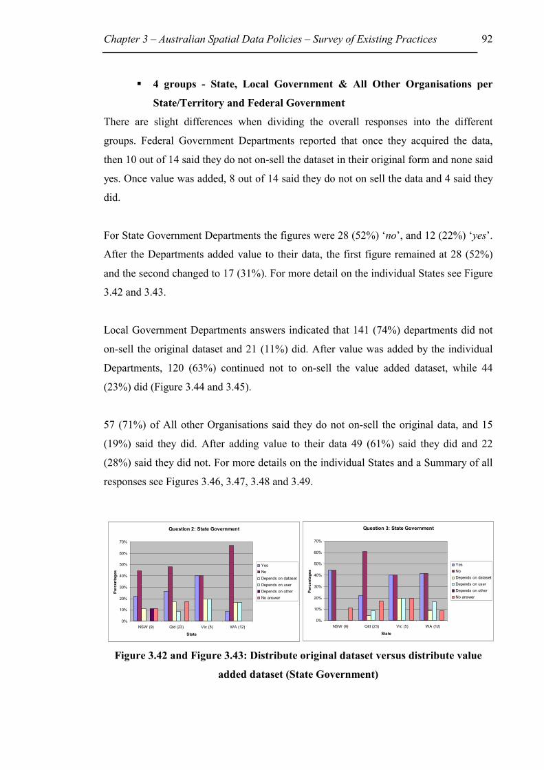
Chapter 3 – Australian Spatial Data Policies – Survey of Existing Practices 92
��4 groups - State, Local Government & All Other Organisations per
State/Territory and Federal Government
There are slight differences when dividing the overall responses into the different
groups. Federal Government Departments reported that once they acquired the data,
then 10 out of 14 said they do not on-sell the dataset in their original form and none said
yes. Once value was added, 8 out of 14 said they do not on sell the data and 4 said they
did.
For State Government Departments the figures were 28 (52%) ‘no’, and 12 (22%) ‘yes’.
After the Departments added value to their data, the first figure remained at 28 (52%)
and the second changed to 17 (31%). For more detail on the individual States see Figure
3.42 and 3.43.
Local Government Departments answers indicated that 141 (74%) departments did not
on-sell the original dataset and 21 (11%) did. After value was added by the individual
Departments, 120 (63%) continued not to on-sell the value added dataset, while 44
(23%) did (Figure 3.44 and 3.45).
57 (71%) of All other Organisations said they do not on-sell the original data, and 15
(19%) said they did. After adding value to their data 49 (61%) said they did and 22
(28%) said they did not. For more details on the individual States and a Summary of all
responses see Figures 3.46, 3.47, 3.48 and 3.49.
Figure 3.42 and Figure 3.43: Distribute original dataset versus distribute value
added dataset (State Government)
Question 2: State Government
0%
10%
20%
30%
40%
50%
60%
70%
NSW (9) Qld (23) Vic (5) WA (12)
State
Per
cent
ages
YesNoDepends on datasetDepends on userDepends on otherNo answer
Question 3: State Government
0%
10%
20%
30%
40%
50%
60%
70%
NSW (9) Qld (23) Vic (5) WA (12)
State
Perc
enta
ges
YesNoDepends on datasetDepends on userDepends on otherNo answer

Chapter 3 – Australian Spatial Data Policies – Survey of Existing Practices 93
Figure 3.44 and Figure 3.45: Distribute original dataset versus distribute value
added dataset (Local Government)
Figure 3.46 and Figure 3.47: Distribute original dataset versus distribute value
added dataset (All other Organisations)
Figure 3.48: Distribute original dataset (Summary of all responses)
Question 3: Local Government
0%
10%
20%
30%
40%
50%
60%
70%
80%
90%
NSW (65) Qld (44) Vic (27) WA (26)
State
Perc
enta
ges
YesNoDepends on datasetDepends on userDepends on otherNo answer
Question 2: Local Government
0%
10%
20%
30%
40%
50%
60%
70%
80%
90%
NSW (65) Qld (44) Vic (27) WA (26)
State
Perc
enta
ges
YesNoDepends on datasetDepends on userDepends on otherNo answer
Question 2: All other Organisations
0%
10%
20%
30%
40%
50%
60%
70%
80%
90%
NSW (24) Qld (20) Vic (14) WA (12)
State
Perc
enta
ges
YesNoDepends on datasetDepends on userDepends on otherNo answer
Question 3: All other Organisations
0%
10%
20%
30%
40%
50%
60%
70%
80%
90%
NSW (24) Qld (20) Vic (14) WA (12)
State
Perc
enta
ges
YesNoDepends on datasetDepends on userDepends on otherNo answer
Summary - Distribute Original Dataset?
0
10
20
30
40
50
60
70
80
ACT (2)
NSW (9
8)
NT (4
)
Qld
(87)
SA (26)
Tas (7
)
Vic (46
)
WA (5
0)
Unk
nown (
4)
State/Territory
Actu
al N
umbe
r of R
espo
nden
ts
YesNoDepends on datasetDepends on userDepends on otherNo answer

Chapter 3 – Australian Spatial Data Policies – Survey of Existing Practices 94
Figure 3.49: Distribute value added dataset (Summary of all responses)?
3.6 Conclusion
The survey confirmed that a high proportion of organisations in Australia provide
spatial data to other organisations as well as use spatial data from other organisations,
with parcel boundaries and contours being the most commonly used datasets. However,
the industry is still not as automated as might be expected. Hardcopy is still the most
common way of transferring spatial data.
People in the spatial data industry seem to be generally aware of metadata. Not
surprisingly, State and Federal Government Departments are the biggest providers of
metadata. It is interesting that the ‘All other Organisations’ appear to be greater
providers of metadata than local government departments.
A large proportion of respondents recover the cost of supplying their spatial datasets to
others. However, a significant number of respondents do not try to recover any cost.
Many respondents also indicated that there was no standard policy being applied with
regard to charging, as it often depended on the specific dataset. On the methods of
determining charges for data, respondents indicated that they follow different policies.
The highest number of respondents charged an hourly rate for labour costs, followed by
Summary - Distribute Value Added Dataset?
0
10
20
30
40
50
60
ACT (2)
NSW (9
8)
NT (4
)
Qld
(87)
SA (26)
Tas (7
)
Vic (46
)
WA (5
0)
Unk
nown (
4)
State/Territory
Actu
al N
umbe
r of R
espo
nden
ts
YesNoDepends on datasetDepends on userDepends on otherNo answer

Chapter 3 – Australian Spatial Data Policies – Survey of Existing Practices 95
a large number that base their charges on data units such as map sheets. Another
discovery was that not a single pricing policy was being applied for all spatial datasets
within an organisation, rather prices varied for specific datasets.
The survey was also aimed at determining the kinds of philosophies or policies that
organisations have towards their spatial datasets as assets. It is interesting that 50% of
the respondents answered that public good was more important than revenue. However,
at this stage it is unclear how this affects pricing and distribution policies. Also, this
trend may change, as some organisations commented they were working on policies for
intellectual property at the time of the survey.
The survey discovered the following deficiencies:
Standards and quality of data
• Lack of metadata
• Lack of compatible data
• Lack of satisfaction with quality of data
Access to spatial data
• Lack of efficient distribution in electronic form
Pricing of spatial data
• Lack of consistent pricing policy
• Lack of consistent philosophies towards spatial data
Legal issues such as intellectual property protection of spatial data
• Lack of knowledge on legal liability exposure and intellectual property
protection
• No legal protection
o Lack of policies on value-adding
The survey indicated that many organisations are now providing and using spatial data
and spatial technology, but the implications of easy and rapid copying of data using
modern technology seems not to have yet been fully considered. The implications of
these developments include the protection of spatial data assets. Because copying of
electronic data, for example on the Internet, is simple but hard to monitor, it would be
difficult to detect any breach of copyright. Standards are needed for the sharing and
Chapter 3 – Australian Spatial Data Policies – Survey of Existing Practices 96
dissemination of spatial data, so that the data can be uniformly shared across various
jurisdictions making use of modern technology. How is the quality of spatial data
controlled? What is the best practice for metadata provision? Who owns the copyright
to information, the collection of which is part funded by the taxpayer, but yet displayed
on the Internet all over the world? Who has to accept liability for errors in datasets?
How can the spatial data industry be regulated? In order to develop consistent spatial
data policies, some of these questions and issues need to be resolved.
Many of the responding organisations had no spatial data policies or no individual
policies for spatial data pricing and/or intellectual property protection of spatial data.
With large investments in data and technology, organisations providing spatial data
need to consider their data as an asset and to develop policies for appropriately
managing that asset. Even if they do not want to charge for the data, they still need to be
aware of legal liability implications and intellectual property rights.
In summary, the incorporation of SDI policy requirements (discussed in Chapter 2) in
individual policies is still in its infancy and therefore any organisation must develop
consistent spatial data policies that address SDI development deficiencies. Hence, the
way forward for this research is to establish spatial data policy guidelines that address
all SDI deficiencies, and spatial data policy issues relevant to individual organisations.
Chapter 2 identified the SDI implementation challenges on pages 41 and 42, and
grouped them under the headings: standards and quality of spatial data; access to spatial
data; pricing of spatial data; and legal issues such as intellectual property protection of
spatial data.
When an organisation develops an access and pricing policy, all the identified factors
are relevant and should be considered. However, some organisations may decide to
single out certain issues into separate policies. Chapter 4 will discuss and analyse all the
factors that influence an individual spatial data access and pricing policy.

97
Chapter 4: Spatial Data Access, and Pricing
4.1 Introduction
In order to develop strategies for new spatial data policies, Chapter 2 reviewed global
and national SDI problems and requirements while Chapter 3 investigated and reviewed
existing Australian policy practices. These reviews will not only help to determine and
overcome current problems, but also enable the development of policies that incorporate
SDI requirements. Two problem areas found in Chapters 2 and 3 are inconsistencies in
access to and pricing of spatial data. Access and pricing issues may be classified as:
• Issues involved in providing physical access to data, and
• Issues involved in the pricing and legal protection of data.
Physical access to digital spatial data, for example, may involve the provision of search,
retrieval and distribution facilities. Pricing on the other hand may incorporate such
issues as commercial versus non-commercial use. Legal protection may involve the use
of contracts and licences, and risk management. The issues vary greatly and make it
difficult for an agency to decide what their spatial data access policy should include. For
example, an agency may not only consider its own organisational spatial data needs, but
also other organisations’ requirements on a local, state-wide, national and even global
basis. Other local organisations may require datasets and are prepared to either pay for
the data or trade their own datasets if compatible. State-wide, national and global spatial
data may be required to deal with major environmental problems. However, the priority
weighting for each requirement may differ for each individual organisation.
Chapter 4 will firstly address all issues involved in a data access and pricing policy and
then study international developments. Following these issues is a description of the
access and pricing policy status for all ANZLIC members: the Australian
Commonwealth, States, Territories and New Zealand. Finally, the spatial data survey
results from Chapter 3 will be related to the information in this chapter to provide a
clear analysis of the situation in Australia.

Chapter 4 – Spatial Data Access and Pricing 98
4.2 Spatial Data Access and Pricing Issues
Before discussing individual policy issues the point should be made here, that many
policies and practices are the result of government mandates, which organisations have
to follow and these authoritative mandates do not necessarily aim to facilitate SDI
development.
Two opposing views on pricing are relevant to the discussion in this chapter: pricing for
full recovery of cost or minimal (or no) pricing. The issue of pricing is also associated
with the issue of access. Should access to spatial databases be open or restricted and in
what technical form should it be provided. Considering the large investments made by
companies to collect and manage their spatial databases, the decision as to whether the
databases should be sold, freely given away or an in between pricing structure used, is a
major issue.
Following are the twelve factors that influence SDI development, as documented
throughout Chapter 2 and summarised at the end of Chapter 2:
1. External Forces (world economy, globalisation, environmental issues);
2. Organisational Issues (operational responsibility for the SDI initiative,
leadership at appropriate level, priorities, and human resources);
3. Technical Issues (standards, clearinghouse technology);
4. Governmental/Organisational Duties (legal, political, security);
5. Ownership/Custodianship;
6. Privacy and Confidentiality;
7. Legal Liability, Contracts and Licences;
8. Intellectual Property Law;
9. Economic Analysis (financing and pricing);
10. Data management (data protection and security);
11. Outreach, Cooperation and Political Mandate; and
12. SDI Users’ Choices, Rights and Obligations.
Most of the above factors also influence individual spatial data access and pricing
policy development, however sometimes from a different perspective. External forces,
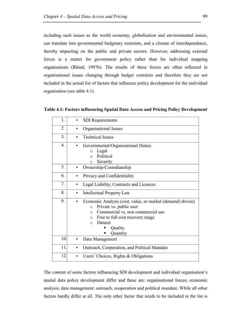
Chapter 4 – Spatial Data Access and Pricing 99
including such issues as the world economy, globalisation and environmental issues,
can translate into governmental budgetary restraints, and a climate of interdependence,
thereby impacting on the public and private sectors. However, addressing external
forces is a matter for government policy rather than for individual mapping
organisations (Rhind, 1997b). The results of these forces are often reflected in
organisational issues changing through budget restraints and therefore they are not
included in the actual list of factors that influence policy development for the individual
organisation (see table 4.1).
Table 4.1: Factors influencing Spatial Data Access and Pricing Policy Development
1. • SDI Requirements
2. • Organisational Issues
3. • Technical Issues
4. • Governmental/Organisational Duties o Legal o Political o Security
5. • Ownership/Custodianship
6. • Privacy and Confidentiality
7. • Legal Liability, Contracts and Licences
8. • Intellectual Property Law
9. • Economic Analysis (cost, value, or market (demand) driven) o Private vs. public user o Commercial vs. non commercial use o Free to full cost recovery range o Dataset
��Quality ��Quantity
10. • Data Management
11. • Outreach, Cooperation, and Political Mandate
12. • Users’ Choices, Rights & Obligations
The content of some factors influencing SDI development and individual organisation’s
spatial data policy development differ and these are: organisational forces; economic
analysis; data management; outreach, cooperation and political mandate. While all other
factors hardly differ at all. The only other factor that needs to be included in the list is

Chapter 4 – Spatial Data Access and Pricing 100
the ‘SDI requirements’. Table 4.1 displays the list of twelve factors that influence
spatial data access and pricing policy development. It is beyond the scope of this thesis
to examine all of these factors. Hence, this chapter will only examine technical issues;
governmental / organisational duties; ownership / custodianship; economic analysis;
and users’ choices, rights and obligations in detail. However, Chapter 2 studied SDI
requirements, and Chapters 5 and 6 will examine legal liability issues in spatial data and
Intellectual Property Law respectively and provide some policy guidelines. The sections
below briefly define all the factors in Table 4.1.
SDI requirements (1) – Spatial data infrastructure requirements as described in
Chapter 2 provide the spatial data policy maker with a list of issues and guidelines to
facilitate the implementation of SDIs. The requirements for Australia include: use of
ANZLICs custodianship guidelines; use of common ASDI standards, technology
standards and metadata guidelines; use of ASDI technology and access network
(Clearinghouse) for displaying or using data; use of government policies, guidelines and
laws where applicable; greater security for the spatial data provider and user; use of
fundamental datasets if needed by the organisation; promoting data sharing and access,
and use of high quality data; consistent and low spatial data pricing; promoting spatial
information and SDIs; and awareness of new spatial information and SDI developments.
Government and private agencies have to take local, national, and global spatial data
infrastructure needs and requirements into account when developing strategies and
individual policies to satisfy their own and especially local and national needs.
Organisational Issues (2) – Organisational issues include internal organisational,
behavioural and philosophical issues such as organisational resistance to data
dissemination or sharing, loss of control and whether the organisation should use a
wholesaler or sell the data directly to the user. It includes the need for a GIS/spatial data
policy champion that will take the necessary steps to move forward. Senior management
support is necessary to ensure sufficient financial support. An organisation must
prioritise their needs including an analysis of options available to increase their income,
if needed, even if this includes relying on revenue from selling their data. In that case
the organisation must determine whether their pricing and access policy supports the
strategic plan of the organisation.
Chapter 4 – Spatial Data Access and Pricing 101
Organisational issues from an SDI perspective, on the other hand, include such issues as
bringing together the relevant representatives into a new or existing organisation that
will take on the responsibility for the SDI initiative with the appropriate leadership;
seeking high level jurisdictional political support; develop, implement and monitor
priority SDI development issues; and develop training and education strategies for
human resources necessary to manage and operate SDIs.
Privacy and confidentiality (6) – By providing access to spatial data will the
individual’s rights to privacy be at risk? What can be regarded as confidential
information, when a government agency has to provide data under the Freedom of
Information legislation?
Legal Liability, Contracts and Licences (7) – If a data user uses data that is inaccurate
and contains errors, who is legally liable and to what extend? Legal liability for errors in
spatial datasets, use of contracts and licences are discussed in Chapter 5.
Intellectual Property Law (8) – What types of intellectual property rights are available
to protect spatial data from misuse or copying by third parties is discussed in Chapter 6.
Data Management (10) – This topic relates to how the organisation manages their data,
and how the data was collected, recorded, edited, analysed, managed, maintained or
how value was added to existing data. These matters are very important not only to
establish current metadata, but also to help decide what dataset will be most accurate
and should be made available because of potential legal liability risks. Organisationally
sensitive data may need to be managed differently than less sensitive data and perhaps
require strategies that ensure organisational security can be protected. The same
management needs apply to SDI implementation, except it is more likely that national
defence security is at risk rather than organisational security.
Outreach, Cooperation and Political Mandate (11) – Marketing and promoting
spatial data and SDIs are key issues in fostering market growth, ensuring better
utilisation of spatial data and SDIs, and improved data sharing. Hence it is in the best
interests of all policies to aid the outreach, by either financial or in-kind support.
Cooperation amongst agencies and Government support at high levels are also

Chapter 4 – Spatial Data Access and Pricing 102
necessary to further develop and direct SDIs into a future where spatial data will
become a necessity in managing sustainable development and greatly aid economic
growth.
Following is a more detailed description of spatial data access and pricing issues
relevant to technical issues; governmental / organisational duties; ownership /
custodianship; economic analysis; and users’ choices, rights and obligations.
4.2.1 Technical Issues (3)
Technical issues that need to be included when providing access to spatial data or data
sharing are standards, metadata, transfer protocols, security issues, and clearinghouses.
Standards and transfer protocols are necessary to enable data transfer to different
hardware and software systems. Internet protocols may also be important to enable
access to data on-line and to manipulate data remotely. Metadata will enable the spatial
data user to determine all characteristics of a dataset, such as how, when and by whom
the data was collected, its accuracy, scale, quality and content. Each of these
characteristics is described in a metadata guideline as core metadata elements. The
metadata guideline was published by ANZLIC in 1996 and 1997 (see Appendix 3) and
describes the type of information that should and/or can be included in metadata
statements. If access to data is being provided on-line, then security measures should be
considered to stop others from copying and/or manipulating the data.
Clearinghouses are being set up as part of spatial data infrastructures. The clearinghouse
in Australia will provide the environment that connects the data provider (custodian)
with the data user. The clearinghouse will incorporate technical mechanisms and
institutional arrangements such as standards and policies and intermediate data
providers such as service providers. Service providers may value-add and supply a
product to customers. Service providers include small, medium, and large national and
multinational companies, as well as single-person consultancies. However, an
organisation may raise the question, as to whether it wants to be part of the
clearinghouse, whether its data are to be considered confidential, or whether an
organisation would breach any laws by providing data on-line.

Chapter 4 – Spatial Data Access and Pricing 103
This thesis and the survey in Chapter 3 will not cover all technical issues, rather more
specifically metadata use. Metadata core elements as outlined in Appendix 3 cover such
dataset characteristics as spatial data quality and access.
Metadata – specifically data quality
Data Quality is important for data users to determine the usefulness of a dataset for a
particular purpose (ANZLIC, 2000i). It includes lineage, positional accuracy, attribute
accuracy, logical consistency and completeness. Lineage describes the source history of
the data and how it was produced. Positional accuracy describes the closeness of the
digital data to their true positions on Earth and includes horizontal and vertical
accuracy, and how the accuracy was determined. Attribute accuracy provides the
reliability of the descriptions of the dataset features such as, how the feature was
classified, and the accuracy of the database features (eg. % of misspellings and missing
data), and how the accuracy was determined. Logical consistency describes the
maintenance of the relationships between the individual data items in the dataset such
as, labelling of all points, correct intersection of lines at nodes, and overshoots or
undershoots. The data provider specifies that he/she has tested logical consistency and
for what purpose. Completeness points out how complete the coverages, classifications,
and verifications are. For completeness of coverage it answers questions like:
• Is the spatial data coverage complete for the entire dataset and at what
percentage (eg. 98% of all streets for a particular suburb are part of the dataset)?
• Are attribute data available for the entire dataset and at what percentage?
For completeness of classification it answers questions like:
• Is the classification restricted; such as must a lake be a certain size before it will
be included in the map at a scale of 1:100 000? Are clusters amalgamated?
For completeness of verification it answers questions like:
• What work was carried out to clarify the accuracies of the datasets, such as how
were the spatial and attribute accuracies of the data checked?
Metadata – Access (data available in what format, and access restrictions)
Metadata is also being used to inform the data user of the format of the dataset, as well
as access restrictions or legal prerequisites applying to the user. Legal prerequisites for
example may require the user to enter into a licence and/or royalty agreement, while

Chapter 4 – Spatial Data Access and Pricing 104
other access restrictions may be password requirements, or available network user
restrictions and whether or not payment is required. However, even if no restrictions
apply the spatial data provider should specify that.
4.2.2 Governmental/Organisational Duties (4)
As government departments collect spatial data in order to fulfil their administrative
duties it is unclear whether they have the right to sell that spatial data for profit or at the
cost of reproduction. Government departments have to obey regulations and laws in
fulfilling their political mandates and obligations. For example, NSW Government
agencies are required to deliver some of their services electronically. They then must
report the progress of their electronic delivery program to the Office of Information
Technology together with their IT Strategic Plan. They must also develop and document
principles and reasons for their pricing policies.
In the current economic climate, often driven by external forces such as a downturn in
the world economy, Governments expect their departments to reduce costs, operate
more efficiently, and even earn their own income by selling services. However, the
public perception is that because the public pays taxes they have a right to obtain the
data at a fair price (or for free), just as they use most roads for free. However, even this
aspect does not apply any more in many parts of the world.
A legal system is generally made up of statutes, professional standards, commonly
accepted behaviours, administrative rules and court decisions. The present legal
situation is not clearly defined when data sharing or selling occurs across different legal
jurisdictions. Case law does not necessarily deal with every possible situation but only
with individual cases. Hence case law only interprets the law where problems have
occurred. This means that it is often impossible to predict the court’s interpretation for a
particular situation.
Governmental departments can be held accountable if they fail to protect the public
information in their care, this information can also be referred to as public trust. If a
government department gives public trust away or sells it below market value, then it
can be viewed that they are neglecting their duty. However, governmental departments
Chapter 4 – Spatial Data Access and Pricing 105
exist to serve its citizens and therefore are obligated to provide them with a public
service, which may include access to spatial databases. The main question here is
therefore: Are the spatial databases part of the public trust, like roads or infrastructure?
Or is the provision of spatial databases a service to be given to citizens on request for
free or nearly free (King, 1995)? Even if the Government has a duty to provide access to
its information, there is no stipulation as to the form in which the information should be
provided. That is, should it be provided in hardcopy form, or machinery binary code? If
the Government incurs a financial loss by providing spatial data access should they be
allowed to charge an appropriate price? And if so, what constitutes an appropriate price?
4.2.3 Ownership/Custodianship (5)
The Commonwealth of Australia supports the principle of custodianship as developed
by the Australia New Zealand Land Information Council (ANZLIC, 1998d) and the
Commonwealth Spatial Data Committee (CSDC, 1995). The custodianship principle,
which applies to all fundamental spatial data collected by state governments, states that
custodians manage the spatial information as trustees for the community to enable the
integration of spatial information. Spatial data collectors become custodians of the data
they collect and they must satisfy the needs of the data user in regard to spatial data
accuracy, currency, storage and security. A custodian is the nominated body or person
that is responsible for managing and placing conditions on datasets. Custodian and user
rights and obligations are summarised in Table 4.2. A custodian is not necessarily the
legal owner or copyright holder to that data. However, the custodian should ensure
access to the data and protect the Commonwealth against claims from misuse of that
data, where possible relying on copyright law. The Commonwealth Guideline also
recognises that the extent of guideline adoption by any given agency or custodian may
depend on their particular situation, including their budgetary circumstances. (CSDC,
1995)
ANZLIC suggests that private sector organisations should consider these guidelines for
their own internal data management use, because the guidelines, based on experience
and good practice, provide a clear and common strategic approach to managing spatial
data (ANZLIC, 1998e). In support of this, ANZLIC’s (1998d) custodianship policy
states that:

Chapter 4 – Spatial Data Access and Pricing 106
“There are advantages in custodianship to be gained by agencies, government
and industry. In following the rules and responsibilities for custodianship as set
out in these Guidelines, a custodian agency is most likely to become the
preferred supplier for information under its custody. This is because it will have
the most accurate and reliable information. Custodianship provides a means of
accountability and reliability of source for designated information within
government. There can be increased confidence that the information within
government is accurate, complete, identifiable and accessible. Custodianship
also eliminates unnecessary duplication of capturing and maintaining spatial
information which allows funds previously spent on these activities to be
reallocated to higher priorities. For clients, custodianship lessens the confusion
regarding sources of accurate information; they can also receive more accurate
advice on the source, currency and completeness of the information.”
Table 4.2: Summary of Custodian’s and User’s Rights and Obligations
(as stated in CSDC, 1995; and ANZLIC, 1998)
Custodian’s Rights Custodian’s Obligations User’s Obligations, and Rights (see at end of list)
Establish marketing conditions within Government policy for the fundamental datasets in its care (eg. Promote data use).
Determine priorities for data capture, in consultation with stakeholders.
Advise custodian of any errors or omissions detected in the information received.
Establish formal agreements with value adding agencies, including royalty arrangements, and revenue sharing.
Manage the acquisition, storage and maintenance of data.
Advise custodian of future requirements for spatial data to assist the custodian in preparing collection and conversion plans.
Feedback on information quality, copyright and intellectual property.
Ensuring data security. Do not release the supplied spatial information to a third party unless covered by a licensing agreement specifying release criteria.
Charging for data, within Commonwealth policy.
Complying with standards. Where a user collects specific information on behalf of a custodian it shall do this according to the standard set by the custodian.

Chapter 4 – Spatial Data Access and Pricing 107
Provide metadata in accordance with guidelines.
Pass this information collected on behalf of a custodian back to the custodian for maintenance or storage, free of charge.
Provide quality statements regarding source, reliability, accuracy, completeness and currency of the dataset.
When producing spatial data products from custodian’s data, the user should consider the passing back of the data product to the custodian as part of their agreement for the use of the information.
Maintain the quality of the fundamental datasets assigned to them.
Do not sell information if collected on behalf of a custodian without first obtaining the permission of that custodian.
Facilitate data access and distribution, and ensure appropriate storage, maintenance, security and archival procedures for spatial information.
Users must always cite the source of the information when using the information in any way.
Safeguard the Government's interest in the use of its information through licensing agreements or letters of understanding to protect privacy and confidentiality and interpretation of the information.
Right: Once the user has completed its obligations to the custodian agency it has the right to use the information internally as it wishes.
Provide a level of appropriate security to protect the privacy of any personal data.
Right: The user should pass on to the custodian information that has been improved or upgraded as part of the process. The custodian should in turn ensure that the improved or upgraded information is made available to other users.
Consult with users. Avoid data duplication. Preserve the data over time. Comply with legislation.

Chapter 4 – Spatial Data Access and Pricing 108
It may be irrelevant whether private or government organisations assume custodianship
or ownership to the spatial datasets in their care. Whatever the case may be, clear rights
and obligations of the data provider and the data user must be defined.
4.2.4 Economic Analysis (9)
Digital spatial data can be retained and shared with others without reducing or changing
the quality of the original data. Copying digital spatial data is inexpensive and this
makes spatial data an easy to copy commodity in a commercial context. Hence, the
“easy to copy” phenomenon makes it difficult to stop third parties from obtaining the
data and on-selling it.
The increasing competition for public funding and decreasing budgets force federal,
state and local government agencies to seek revenue from their own investments and/or
business plan. This revenue is often necessary to fulfil government agency’s mandate
and to develop their systems and maintain their data. Spatial data are one of the assets
that some believe can be turned into an income producing governmental asset. Because
the private enterprise is able to establish a profit from selling spatial databases, some
government agencies believe they should not miss out. But how much can an agency
charge for a dataset?
The next few sections will analyse the issues affecting information pricing, including
the study of the spatial data benefit/cost ratio. These are:
• Benefit/cost ratio
• Cost, value, or market driven pricing
• Private versus public user
• Commercial vs. non commercial use
• Free to full cost recovery range
• Dataset considerations
o Quality
o Quantity
• Benefit/Cost Ratio
Chapter 4 – Spatial Data Access and Pricing 109
Benefit/cost ratios are important to measure the usefulness and commercial value of
spatial data. If the benefits far outweigh the costs, the data are valuable and should be
regarded as assets. The way in which benefit/cost ratios are determined vary and depend
on the available information. However, spatial data cost-benefits can be determined in
terms of the following considerations:
• Efficiency – (cost savings) brought about by its availability and use. Can be
determined by a comparison of different ways to reach a certain outcome, and
calculating the cost savings.
• Effectiveness – (benefits using spatial data) eg. Reduction of risk, better
decision-making, and improved outcomes. May be calculated as a measure on
user’s willingness to pay.
• Unanticipated benefits – benefits that can be predicted, or measured after the
event (Gillespie, 1992a, 1992b; Taupier, 1995).
In Australia Price Waterhouse undertook a benefits study between 1989 and 1994
commissioned by ANZLIC (Price Waterhouse Urwick, 1995). This study examined the
economic gains from developing, maintaining, improving and providing access to
spatial data infrastructure at a national level. As part of the review, they analysed the
benefit/cost ratio for data usage and determined the ratio to be approximately 4:1 over a
five-year period (1989 to 1994). Hence, for every dollar spent on spatial data production
a benefit of $4 was generated.
As a basis for their study, they used a cost effectiveness approach. This approach
defines the costs as:
• hardware, software, hardware and software maintenance,
• data-collection, purchase, entry, transfer and database maintenance,
• staff-training, support system, interface and system development,
• operating expenses like disks, paper.
The benefits are defined as the cost savings made by using competing methods for
achieving an objective. They are not individual benefits, but rather indicators that reflect
overall advantages that the data infrastructures provide. Benefits defined in a cost
effectiveness approach compare cost of the existing (or preferred) method with the next
best alternative.

Chapter 4 – Spatial Data Access and Pricing 110
• Cost, value, or market driven pricing
If an organisation knows the actual cost of producing their existing datasets, this cost
could be used as the actual price. However, before establishing the pricing the next
considerations should be: What value does spatial data have and what price is the
market prepared to pay? The first step is to determine how economic theory determines
the value of a commodity? According to Hirschleifer (1980) the value of a commodity
is determined by its scarcity and demand. Hence high scarcity and high demand produce
high prices, while the reverse applies to a commodity available in large quantity and
low demand. The collection of spatial data is costly, but once available digitally it can
be given away and kept by the original producer at the same time. Therefore digital
spatial data are not scarce and it will be difficult to determine the data’s values.
In market driven pricing, the seller will sell the information to the highest bidder, as in
an auction (King, 1995, p.264). Another option is to use average cost pricing. Average
cost pricing involves dividing the “cost of data collection and production” by the
“number of buyers”. To apply this pricing to spatial data would be unrealistic because it
is often difficult to determine how many buyers there will be and how the number of
buyers changes over time. If the number of buyers is known and this process followed,
partial or full cost recovery may be applied. However, the higher the price, the smaller
the number of users and hence a reduction in the social welfare would occur (Taupier,
1995, p.284; Onsrud, 1992). So the dilemma is, that if the price is too low the public
trust is considered to be under valued, while if the price is too high then the public treats
the charges as unfair and interprets it as denial of access (King, 1995, p.264). Taupier
writes that if one is of the opinion that the Government’s role is to maximise social
welfare, then low pricing of spatial data is appropriate (Taupier, 1995, p.284).
• Private versus public user
If the data provider is a government agency should they charge other government
agencies or community groups for the data? What spatial data pricing rates should be
applied to private enterprises; different rates could be used for research and
development, and spatial data service providers than for commercial or government
users. The charge could be made dependent on the type of user and/or the added
benefits the data provider could derive from the user. For example, if the user also had

Chapter 4 – Spatial Data Access and Pricing 111
spatial data that was of interest to the provider, the provider may obtain the data in
exchange. If the provider also worked through spatial data service providers, the
provider may charge the service provider significantly less for the data, but ask for
royalties from sales.
• Commercial vs. non commercial use
Even if the provider and the user are both government agencies, the provider may want
to base its pricing on the actual data use. For example, if the data are used commercially
at a certain rate, full cost recovery or a royalty may be applied. Non-commercial use
such as in education, research and community, and providing service providers with the
data may only attract minimal or no charge.
• Free to full cost recovery range
An organisation may choose to charge between nothing to full cost recovery for their
spatial datasets. For example, if the data are being used for environmental protection it
may be free or available at the cost of distribution, while if used for commercial
purposes, it may attract commercial rates.
• Dataset considerations
Datasets could be priced lower if the quality and quantity is low, and high if the quality
and/or quantity is high. The price charged could enable recovery of full or part costs
such as data collection, manipulation and maintenance or just maintenance. An
organisation must also consider the amount of data the provider is prepared to
disseminate to users and to what detail. If a community group wants access to only a
small amount of data, for example a map with all the local parks for a suburb, the
provider may decide to give them the data without any charge. If the other extreme is
the case, where a commercial organisation wants a whole database with all the various
themes and dataset layers, the provider may either not give that organisation all the
information and/or charge full cost recovery. The levels of detail provided may vary
depending on the user, or to what use the spatial data are to be put to.
Other important issues to consider are: The intervals of updates, weekly, monthly or
yearly. Rhind (1995, p.90) argues that different data suppliers will use different policies
that reflect the need and best interest of the individual organisations. So, in this regard it

Chapter 4 – Spatial Data Access and Pricing 112
may be difficult to develop national policies for all levels of government to follow.
Particularly those covering different industry sectors such as utilities or natural
resources.
4.2.5 Users’ Choices, Rights and Obligations (12)
A short-term view of a user may be that data should be free, but in the long term high
data quality may be far more important than the cost of acquiring it. Legal redress for
loss suffered because of errors found in the data may be very costly and time
consuming. If users are charged for spatial data, it is likely that they will be less
cooperative in supplying data themselves for free to a national data clearinghouse, to
support the notion of a National Spatial Data Infrastructure (Rybaczuk and Blakemore,
1995, p.94). The issue is whether it is more important to obtain a dataset of superior
quality, or a NSDI containing a large quantity of data but of low quality. A user must
make sure he/she complies with any instructions or legal statements given by the data
provider.
A user may have the view that easy access to government information is part of
democracy and freedom of information legislation. Easy access may be interpreted as
free or near free access. However as pointed out before, under governmental duties it is
debatable whether spatial data held by the Government needs to be free. Another issue
concerns the user’s right of free choice. As more spatial data becomes available on the
Internet, the demand for particular spatial datasets may decrease. If for example, a user
such as a scientist requires using spatial data to accurately model pollution effects on
particular regions but uses inaccurate spatial data (freely available on the Internet) it
will not be in the national interest. Hence it may not always be a choice of creating
income, but a matter of importance for the development of a nation.
Users may be allowed to on-sell original spatial data without any restriction or they may
be assigned such a right under licence with certain restrictions. Copies of value-added
data or newly derived products might be given to the custodian. It may also be in the
best interest of the custodian to ask the user to assess the quality of the spatial data.

Chapter 4 – Spatial Data Access and Pricing 113
Many spatial data access and pricing issues have been discussed in the last sections of
this chapter and provide background information for developing spatial data policies.
However before discussing some policies used in Australia the next section will
describe the problems other nations face.
4.3 International Developments in the USA, UK, and Canada
4.3.1 USA
As budgets decline in the USA, government agencies are forced to evaluate many
existing services and attempt to increase their efficiency and productivity. The USA
Federal Government has taken the lead to implement efficiency and productivity
improvements under the guidance of former Vice-President Gore and the National
Performance Review. Another initiative is the National Information Infrastructure (NII),
which seeks to develop a communication network of computers and databases to
provide USA citizens with vast amounts of information. Part of that Infrastructure is the
National Spatial Data Infrastructure (NSDI), which aims to promote optimal use of
geographic information in support of better decision-making. However, for the NSDI to
be successful, federal, state, local, private and public entities must collaborate. This
collaboration is extremely important between all jurisdictional levels and private entities
if policies are required to be adopted by all agencies. The past has shown that policies
developed at federal level and passed down lead to poor implementation and acceptance
by especially local jurisdictional levels (Tosta, 1997; Longhorn, 1998). Within the
NSDI there are four key activities. These are:
• standards (identification of necessary standards and their development),
• a framework of core spatial datasets to which others can be added,
• national spatial digital thematic maps, and
• a spatial data clearinghouse. (Matsunaga and Dangermond, 1995)
The Office of Management and Budget (OMB) produces federal information policies,
such as OMB Circular A-130, which guides federal information pricing practices. The
circular instructs agencies to make government information available at charges no
higher than the cost of dissemination, or less if the cost of dissemination creates a
barrier, to enable society to benefit economically. Another approach is to make

Chapter 4 – Spatial Data Access and Pricing 114
government information available via the Federal Depository Library Program, which is
a partnership between over 1400 libraries and the Federal Government. The Circular
also states that agencies should not restrict access by charging fees or royalties for the
reuse, resale, or re-dissemination of federal information dissemination products. Their
guide is based on various factors such as:
• Government information is a national resource,
• it provides the public with information about the Government’s activities, and
• it is created in support of Government’s operations (Matsunaga and
Dangermond, 1995).
In the USA, cost recovery is not easy because of open record laws (at federal level FOI).
Some States in the USA however have ignored open record laws and established cost
recovery programs under local ordinances, and await Federal Government responses
forcing them to amend their legislation (eg. Kansas, Ohio, and California) (Archer,
1995). Archer (1995) writes that no matter what pricing is applied to data, it is
imperative that the GIS user treats spatial data as a company asset and develops
company policies and procedures for its management. Otherwise valuable files could
easily be misplaced, damaged, sold or given away inappropriately. He also is of the
opinion that if data are available for free, then there is no incentive for further creation
of useful and accessible data and information systems, which the public and economy
can benefit from. This leads to governmental departments only considering what they
have to do at present and not to planning for a sustainable future.
Other States in the USA have amended their legislation to enable the sale of spatial data
for market fees. Arizona and Oklahoma agencies are charging market value if the data
are being bought for a commercial purpose. Government state agencies in Maine can
release GIS data under licence agreements and charge appropriately. Alaska for
example, revised its public open records laws in 1990 to authorise state and municipal
agencies to sell electronic services and products for a fee. That fee allows for the
recovery of a reasonable cost of the building and maintenance of a GIS or other public
information system, including recovery of the actual costs of providing the delivery of
the service. New regulations on implementing the law were adopted by the
Telecommunications Information Council in 1994, resolving a lot of the uncertainties in
the amended law. The largest private sector data vendor has said that as a result of the
Chapter 4 – Spatial Data Access and Pricing 115
new law many more datasets became available that were not accessible previously
(Brown, 1995). Alaska’s major GIS agency, the Department of Natural Resources
(DNR), charges for their data according to the new legislation. In the financial year of
1994 it received $39,000, about 1/3 of the agency’s cost of public access support. In
March 1994 they revised their fees and established a three-tier pricing scheme based on
the volume and type of data, and other costs. Initially the DNR included a spatial data
restriction with its standard contract, prohibiting the duplication of the data for resale or
distribution. But since copyright or licence protection of spatial databases were not
included in the amended open records law, and due to the limited usefulness of the data
to private firms, this restriction was later omitted. The DNR’s contract later read:
“To ensure distribution of the most current public information, please refer
requests for data or products to the Alaska Department of Natural Resources
Land Records Information Section.” (Brown, 1995, p.28)
USA Federal Government information policies recognise the benefits of widely
distributing (providing free or near free access) government held information as
opposed to any other form of cost recovery. Some of the benefits of the policies are:
• “More effective and efficient use of resources
• Sharing of information resources between agencies and user
• Reducing the duplication of efforts
• Promoting of education, learning and research
• Promotion of the public’s “right to know”
• Elimination of duplication of charges to the citizens
• Stimulation of innovation” (Matsunaga and Dangermond, 1995, p.44).
Some Departments in the USA have implemented free sharing arrangements via the
Internet such as the federal Department of Natural Resources (DNR) in Iowa. DNR
found that by handling user requests over the Internet they saved administration time,
reduced duplication of effort, and were more effective and efficient in using DNR
resources, hence stimulating innovation in the use of their databases. As a result, the
public’s “right to know” was fulfilled, and the accountability of Government to its
citizens improved. More time was also available for the development and maintenance
of DNR’s databases. Matsunaga and Dangermond believe that the federal experiences

Chapter 4 – Spatial Data Access and Pricing 116
provide a useful model for state and local governments to follow and improve on, when
implementing information policies. (Matsunaga and Dangermond, 1995)
Perritt (1995a) agrees in principle with Matsunaga and Dangermond in that
governments should not sell their datasets for more than the cost of dissemination. He
argues that local governments should not establish monopolies and exploit their
databases on the grounds of, for example FOI, copyright, First Amendment or unfair
competition. Instead they should allow equal access to public spatial data, to enable the
realization of the potential that new technology has to offer and to promote a variety of
sources of public information.
4.3.2 UK
In the UK the other extreme in pricing policies exists, compared to the USA Federal
Government. UK’s present and previous Governments expect governmental
departments to recover all their costs. One of the present UK Government’s major
policies outlines the importance of improving public services and reducing costs,
thereby regarding citizens and governmental departments as clients. If any
governmental activity can be better delivered and managed by the public sector, that
service should be contracted out to the private sector. The Government did not specify
what services only the state could provide (Rhind, 1995, 1998).
The Ordnance Survey (OS) is UK’s national mapping agency with the duty to maintain
the topographic mapping framework for Great Britain. Their main objectives are to
provide national spatial data coverage required for emergency purposes; mapping needs
as required by statutes and parliamentary regulations; producing commercially valuable
mapping services and products; and providing expert geographical advice to the
Government. OS must deliver its services as required by the user and minimize the cost
to the taxpayer.
In terms of cost recovery, the Ordnance Survey (OS) recovered 72% of its full
economic costs for the 1993/94 calendar year (In 1996/97, 93% (Rhind, 1998, p.6)).
These figures are astonishing because they were reached despite product price
reductions and savings in operating costs. The long-term goal of OS is to recover 100%

Chapter 4 – Spatial Data Access and Pricing 117
of the data production costs. The issues taken into account to develop their spatial data
charging regime were:
• Creation of data is expensive, and data maintenance can be as expensive as the
original collection.
• Ability to create and manage national dataset is a great skill, and those with the
skill have a competitive advantage, especially when the IP rights are in their
hands.
• Private sector data are usually derivatives of public sector data.
• For intellectual and economic reasons, one either tries to recover full cost, none
of the cost, or part of the cost.
• Where cost recovery is implemented the revenue will enable the establishment
of complete and high quality frameworks.
• Where only a few people benefit from the use of spatial data, it is fairer to apply
cost recovery and the user pays rather than the taxpayer.
• Cost recovery policies require public organisations to assess their spending and
priorities.
• In certain cases flat rates discriminate against those with lower purchasing
power.
o National and international legislation should overcome discriminate
charging.
• Changes in data access technologies may alter charging regimes (on-line access
enables larger numbers of small value transactions) (Rhind, 1995, p.91).
David Rhind, the Director General and Chief Executive of the OS in 1995 reported that
although it was difficult to demonstrate OS’s spatial data pricing regime, the main data
products were cheaper in 1995 than in 1992. Rhind also stated that the cost of data for
establishing a GIS in the city of Sheffield represented only 2-3% of the total cost, which
was not a major implementation hindrance. Britain, partly as a result of its pricing
regime, has a very good topographic coverage and 70% of Britain is mapped in great
detail at 1:1250 and 1:2500. Data maintenance and conversion of maps from hardcopy
into digital form are very costly, and it took OS about 20 years to complete the
conversion of their maps in 1995 (Rhind, 1998).

Chapter 4 – Spatial Data Access and Pricing 118
Distribution methods of OS products vary. Digital data are available from: OS directly;
through private sector contractors; and value-added resellers. Standard paper maps are
sold through retail outlets, while specialised mapping requests are dealt with by private
sector agents. As more value-added resellers use and incorporate OS data in their
products, it is becoming more and more important to use licensing to obtain a financial
return from OS’s products (Rhind, 1998). Rhind was of the opinion in 1995 that no
matter who owned OS or spatial data, that
“revenue generation from long-lasting datasets will require protection of the
Intellectual Property Rights arising from the expenditure of about USA $1
billion of taxpayers’ money over the last 20 years” (Rhind, 1995, p.85).
Intellectual Property rights are discussed in more detail in Chapter 6.
Rhind (1998) based his overall philosophy on cost recovery, on the experience of the
OS and other government survey and mapping organisations, and found that to be
successful the following requirements had to be met:
• Government’s policy must steer towards cost-recovery.
• Organisation must be accountable to the taxpayer.
• A customer focus must exist, and customer’s satisfaction and organisation’s
efficiency must be measured, and improved if necessary;
• The population must be aware of the existence of the mapping organisation, this
awareness must be measured and if necessary enhanced (eg. In Britain about
10% are aware of the OS)
• Intellectual Property Legislation must be adequate, and enforced.
• Commercial expertise in negotiation, pricing and value adding is necessary
• Historic costs of data acquisition must be viewed as sunk costs with cost
recovery only concentrating on on-going maintenance and associated expenses.
4.3.3 Canada
In Canada Freedom of Information (FOI) legislation applies, but commercially valuable
information is exempt. Information that is published or soon to be published is
considered available in the public arena and if a potential user wants access to that
information he/she must obtain it from the original published source (private or public).
For example the Federal Treasury Board published a “Guide for Government

Chapter 4 – Spatial Data Access and Pricing 119
Managers” in 1991 on the dissemination of database information. It informed managers
that the ongoing provision of information is expensive and should only be carried out, if
there is either a direct mandate (duty to inform) to do so, or if users are willing to pay
for the information. The provision of information requested by an individual should not
be subsidised by taxpayers (Archer, 1995; Dando, 1995). This means that Canadian
government departments only need to provide access to government held information, if
that information is not available from other sources.
Many agencies in Canada seem to have expended considerable effort into developing
their data-pricing. Geomatics Canada is a governmental agency within Natural
Resources Canada, and is responsible for the provision of national surveys, maps,
remote sensing information and technology and GIS expertise. Geomatics Canada
provides information as a public service to be used for national defence, governing, the
protection of Canadian sovereignty, sustainable economic development and
environmental protection. The philosophy of Geomatics Canada was not to adopt the
federal USA Government’s policy to provide data “free” or for the cost of delivery.
They also did not agree with the UK’s approach of fully commercialising the sale of
spatial data, because they believe that they should not function as a business. Their main
responsibility was towards the Canadians (Corey, 1998).
In 1996-97 the Mapping Services Branch of Geomatics Canada overall cost recovery
ratio (from topographic information and aeronautical charts and services) was 28% cost
recovery versus 72% public funding. Many agencies in Canada have now adopted a
partial cost-recovery model, where the users pay for part of the total cost of providing
spatial data, while the rest is funded by the general taxpayer. The extra funds help to pay
for part of the ongoing maintenance costs. Geomatics Canada’s partial cost-recovery is
based on the principle that user charges promote equity between the spatial data user
and the taxpayer. It also promotes a more business like approach, thereby increasing
customer service efficiency and accountability. For national initiatives the trend is to
cooperate with other federal government departments, levels of government, academic
institutions and industry to collect data (Corey, 1998).
Chapter 4 – Spatial Data Access and Pricing 120
4.3.4 Comparison – USA, UK and Canada
The USA’s FGDC and others such as the organisations OMB and legislation in the
USA advocate free or near free access to their spatial datasets. But as Nancy Tosta
queries:
“Will more data be made available if agencies operate on a cost-recovery basis?
Who supplies data for environmental or social decision-making that serves the
“public good”? Where are the lines between public and private sector
responsibilities and incentives for data production? Who is liable for the quality
of a geospatial dataset that is maintained by multiple agencies and made freely
available on the Internet? Does copyright protection encourage data production
and sharing? If public agency budgets for data development are decreased, will
private sector data provide the basis for public decision making?” (Tosta, 1995,
p.113).
On comparing the USA with the UK, Rybaczuk and Blakemore (1995, p.96) found that
there is no direct causal link between availability of information and the development of
intelligence in both the UK and the USA. Questions such as whether the Government
can develop an information market arise. However is it in the taxpayers best long term
interest for the private sector to develop those markets, as they are more interested in
short term profit taking and not long term national strategic needs (Rybaczuk and
Blakemore, 1995, p.100).
The plan to make governmental departments more effective and efficient, referred to as
“re-engineering”, is not progressing as fast as government officials in the UK and the
USA hoped for. Government does not only need to reduce staff and contract out, but
also examine organisational structures and governmental organisation’s missions,
especially on a whole-of-government basis (Rybaczuk and Blakemore, 1995, p.100).
They suggest that it is best to use a partnership between governmental agencies and the
private sector. For example, the OS has developed its partnership with the private sector
to widen its product base, without diluting its ownership of the intellectual property.
This example and some others given by Rybaczuk and Blakemore (1995), suggest that
the government can save money and receive increased level of service at reduced costs,
and the public value-added-value access to government information.

Chapter 4 – Spatial Data Access and Pricing 121
“Equity is held by the owner, risk off-loaded onto those best positioned to take
it, and benefits are shared. Such arrangement however can only be developed
where copyright is held.” (Rybaczuk and Blakemore, 1995, p.101)
As opinions and policies on data pricing differ across jurisdictions, it would be helpful
to list the advantages and disadvantages of data pricing.
Reasons not to charge for data, or at a minimal cost of reproduction:
1. Data are already paid for, hence charging the user would mean, charging a
taxpayer twice;
2. Cost of collection of revenue may be greater than revenue gain;
3. Maximum value to the citizenry comes from widespread use of the data through
intangible benefits. Free or near free data stimulates the market and encourages
economic growth;
4. Part of democracy. Citizens should have unrestricted access to information held
by the government, to promote an open government. Manifested in open record
laws.
5. Encourages data sharing. (Onsrud, 1998a, 1992)
Arguments against not to charge for data are as follows:
1. Dando argues that just because resources are obtained though public funding, it
does not give any taxpayer the right to use those resources (eg. a government’s
departments facilities, and user fees are not uncommon eg toll roads, park
admission).
2. Free data will weaken cost sharing agreements for data compilations and
management (Rhind, 1992, p.17).
3. Democracy did not create the right of access to government information, but
statute legislation such as the federal FOIA (Dando, 1995).
Reasons for charging:
1. Protection of the taxpayer, because only a few users acquire datasets.
2. Charging for the cost of collection, managing and packaging of data forces
organisations to prioritise, encourages private sector to compete, and enables
government to reduce taxes in subsequent years;
Chapter 4 – Spatial Data Access and Pricing 122
3. Governments are more prepared to part fund data collection if users are prepared
to contribute;
4. Users demand value for money and hence the data quality is usually higher if
data are provided for a price;
5. Charging for data will force buyers to buy only what they need;
6. Packaging, marketing and selling of data is costly (Rhind, 1995, 1992).
Arguments against charging:
1. Releasing government information for market fees does not contribute to an
open government;
2. Discourages sharing of data
Dando (1995) compares some of the arguments on both sides of the spectrum and
concludes that in some circumstances governments should be allowed to sell
information to recover costs for building and maintaining databases. He says that both
sides of the argument can be categorised under two themes:
• “The purpose and fundamental nature of open records laws and
• Who should benefit from government’s efforts to collect and organise
information” (Dando, 1995, p.32)
USA FOI legislation does not specify that the information must be provided in print,
and hence maybe the government could offer browsing facilities, but not copying. FOI’s
fundamental nature, according to some, is in agreement with the USA federal
government’s prohibition of using copyright to protect its intellectual property in their
data, and hence public records should be in the public domain. This view can be
overturned by all other State and Local Government Departments for whom that
prohibition does not apply. Many State and Local Government departments in the USA
even use copyright to protect government owned intellectual property when using a cost
recovery policy. (Dando, 1995)
If governmental departments were allowed to charge for their datasets at market prices,
then the revenues could be used to reduce taxes, or improve the services. As mentioned
previously, the Ordnance Survey (OS) in the UK recovers the cost of data, which allows
the government department to provide the service that the public wants. In addition, the
Chapter 4 – Spatial Data Access and Pricing 123
OS has the most advanced national digital basemap development in the world. Dando
(1995, p.35) writes in his conclusion that
“by permitting fees to be charged to those who directly benefit, governments
actually have an incentive to improve services and become more cost-effective,
while generating income that benefits the taxpayers in the jurisdiction, not just a
few selected users.”
In conclusion to this section 4.3 on International Developments this research found that
the Ordnance Survey in the UK could succeed with their cost recovery model, because
it not only has the world’s best available digital maps at large scale, but it also
advocates the importance of relying on Intellectual Property Rights to protect its assets
in their data. However, the cost of the historic spatial data that was collected and
manipulated before the cost-recovery model was introduced was not included, hence
making it easier to recover operational costs. If Australian organisations were to adopt
such a cost recovery model, it would be necessary to first measure whether the size of
the market had a significant impact. For example a small population in a rural region
may not support a cost recovery model, while the population of Sydney, perhaps,
would.
The Federal Government in the USA has the policy to provide data at the cost of
copying or less and the policy is strengthened by Intellectual Property Legislation (more
information is given in Chapter 6). This is in contrast to the UK, hence any potential
access and pricing policy will heavily depend on the policy of the Government in force
at the time. However, rather than adopting either extreme of the federal government
departments in the USA or the OS in the UK, organisations in Australia may want to
adopt a similar approach to the one used in Canada. Canada’s partial cost recovery
model could help pay for ongoing spatial data maintenance cost. This chapter will now
review what individual Australian States/Territories and New Zealand are doing in
regard to spatial data access and pricing.
4.4 Australia and ANZLIC
The Australian National Competition Policy (NCP) was newly introduced in 1995 and
forms part of the Federal Government’s reform. It aims to improve the efficiency of

Chapter 4 – Spatial Data Access and Pricing 124
governmental departments and to reduce costs at all levels of government. The NCP’s
framework provides government departments with the ability to improve
competitiveness and includes:
1. reform of legislation
2. implementation of government’s competitive neutrality in a contestable market
(neutrality in a contestable market requires government agencies to compete
fairly with the private enterprise by paying taxes and rates that the government
agency would normally be exempt from, only if their products are commercially
viable)
3. public monopolies reform (government should have no advantage)
4. no excessive price rises
5. application of competition laws
6. commitment to NCPs reforms in key infrastructure areas such as electricity and
gas, to improve efficiency, implement standards and protect the environment
(Commonwealth of Australia – The Treasury, 1997-98)
The NCP meant that government agencies were not allowed to use monopolistic market
powers, but instead had to compete with the private enterprise in an open market. Hence
any government agency should aim to increase access to governmental information and
remove any unfair advantages it has in comparison to the private enterprise.
In Australia the view of the Australia New Zealand Land Information Council
(ANZLIC, 1998d) is that spatial data collected by state government agencies forms part
of a State’s corporate resource. Each spatial data collector becomes custodian of the
data they collected and not the owner. The custodian has to make sure it satisfies the
needs of the data user in regard to spatial data accuracy, currency, storage and security.
Since there are numerous custodians involved in spatial data collection there is the need
for Federal Government support by way of a spatial data infrastructure. This
infrastructure will provide the data provider with the technical and administrative means
to distribute their datasets, and the spatial data user with standardised datasets and the
means to determine a spatial datasets potential usefulness. The Australian Spatial Data
Infrastructure (ASDI) is being developed at present and includes metadata standards and
the development of other standards and guidelines.
Chapter 4 – Spatial Data Access and Pricing 125
As ANZLIC and the CSDC are developing the ASDI, its concepts and systems, they
have to seek the cooperation of leading agencies in all States and Territories and New
Zealand, but also from local governments. This may prove to be more difficult than
envisioned. As mentioned in Chapter 2, a top down approach may not be successful,
because the individual States have their own jurisdictional powers and hence
considerable autonomy.
The next section will describe all ANZLIC members, including each Australian
State/Territory and Commonwealth and New Zealand. The main agencies and/or
coordinating bodies are explained, followed by a description of their current access and
pricing policy or draft policy aims.
4.4.1 Australian Capital Territory
The Australian Capital Territory’s (ACT’s) Government Agency for land information,
surveying and mapping is the ACT’s Land Information Centre (ACTLIC), consisting of
five units. These are the Office of the Chief Surveyor, the Spatial Data Management
unit, the Mapping Office, the Drafting Services unit and the Information Delivery unit.
ACTLIC organised the ACT Land Information Forum (ACTLIF) that is responsible for
coordinating spatial information within the ACT. The members to the forum are
executives and senior officers from across the ACT Government, comprising 21
organisations (ANZLIC, 2000a – ACT report).
ACTLIF’s vision is that the industry, community and others doing business in the ACT
should have easy and available access to integrated, relevant and reliable spatial
information. To realise that vision, their objective is to focus on ACCESS, where
ACCESS stands for Accessibility + Conformity + Content + Engagement + Sharing +
Sensitivity. This focus involves various strategies such as to:
1. “Coordinate and foster collaboration on spatial information infrastructure issues
across government, the private sector and the community.
2. Ensure appropriate and affordable access environments exist for spatial
information.
3. Ensure appropriate and reliable spatial information is available for use.

Chapter 4 – Spatial Data Access and Pricing 126
4. Ensure that people have the skills necessary to access and use the ACT Spatial
Information Infrastructure (ACTSII)” (ACTLIF).
ACTLIF is currently in recess. However The Department of Urban Services in close
cooperation with ACTLIC has developed a Geographic Information Management
(GIM) strategy for their department. This strategy aims to bring all geographic data held
in their department into one format. This process is being investigated by the Chief
Geographic Information Officer of the Department of Urban Services and NAVIGATE,
a spatial systems developer and GIS consultant (ANZLIC, 2000a – ACT report).
ACTLIC also established the Land Information Industry Group of the ACT region to
provide a forum for the public and industry to voice their opinion on GIS/LIS issues.
4.4.1.1 Access and Pricing Policy
The ACT has no overall government data access policy. However ACTLIC’s Spatial
data, unless confidential, is available for unrestricted access. Spatial data are not sold,
but licensed to the user. This means that the data always remains the property of the
ACT Government. Their pricing policy has recently been changed and the complete
cadastre for the ACT is available for use under licence for $2,000 (as of February 2000),
while previously priced at $25,000. Calculated as a price per parcel this equals 2c, but a
minimum charge of $200 applies. If a user wants to on-sell the data or value-add
products, a standard Value-Added Reseller agreement is required. The price for a data
licence is the cost of supply (ANZLIC, 2000a – ACT report; Menzies, 2000).
Infrastructure data are usually available by negotiation with the relevant authorities.
ACTLIC exchanges data with Stormwater, Electricity, gas (AGL), sewer and water
reticulation and Telecom (ANZLIC, 2000a – ACT report; Dobson, 2000).
4.4.2 New South Wales
New South Wales coordinates their geospatial information strategy through a whole-of-
government initiative. This initiative, manifested in the 1997 Information Management
and Technology (IM&T) Blueprint, does not only include geospatial information but all
government information, information technology and telecommunications.

Chapter 4 – Spatial Data Access and Pricing 127
Prior to the last New South Wales State election in March 1999, the Government
Information Management Board was coordinating Government’s IM&T strategies and
implementations. The Office of Information Technology (OIT) of the Premier’s
Department developed whole-of-government IM&T policies, strategies and guidelines
adopting international or Australian standards, wherever possible.
Since that election, the new Department of Information Technology and Management
(DITM) was formed to oversee the three geospatial information agencies and OIT: Land
Titles Office (LTO), Valuer Generals Office (VGO), and Land Information Centre
(LIC). These three agencies were merged into one business agency affective since the 1
July 2000. The new government agency is called Land and Property Information NSW
(LPINSW). DITM and OIT will develop spatial data management policies, which will
need to comply with whole-of-government policies.
OIT is for example working with various business or service groups to develop a
consistent on-line public access policy. At this stage information sharing strategies only
exist for particular areas, such as Health, Human Services, Criminal Justice and Natural
Resources. The natural resources strategy for example is called the NSW Natural
Resources Information Management Strategy (NRIMS). NRIMS is being developed and
implemented by the NRIMS Steering Group. Representatives on this group are the
heads of the major NSW Government natural resource and environmental agencies.
NRIMS strategies for their data access objective of maximising access to natural
resources information are:
1. “Establish and develop access to natural resources data;
2. Streamline administrative processes by addressing customers’ access issues of
data security, privacy, liability and pricing.” (NRIMS Strategy, 1999-2002)
4.4.2.1 Access and Pricing Policy
In order to make government information more accessible to the public, the NSW
Cabinet has requested DITM to develop a whole-of-government policy on information
access and pricing. This policy is necessary because of the need to have a
comprehensive and consistent policy framework, consistent and affordable pricing,

Chapter 4 – Spatial Data Access and Pricing 128
equitable public access, encourage data sharing, develop an information economy, and
support an information infrastructure.
The new access and pricing policy was finalised in 2000 and passed by the Treasury and
NSW Cabinet (Bullock, 2000). As of July 2000 the new policy was being send to NSW
government agencies for comment. The new heavily reduced pricing policies for
Queensland and New Zealand triggered the push for policy reform in NSW. “The
principles in the current draft Policy are along the lines of:
• Agencies must provide reasonable access to their information
• Agencies must make their public policy information freely accessible
• Agencies must maintain some form of directory of their collections of
information
• Agencies must clearly state the terms and conditions under which their
information can be used
• Agencies must price their information according to a number of bases, ranging
from avoidable cost to market price depending on a number of criteria
• Agencies must have a documented information pricing scheme.” (ANZLIC,
2000b – NSW report)
The new policy does not distinguish between specific uses for spatial data, but the
nature of the market. A government agency has to decide if the spatial data should be
free or available for a price. All government agencies in New South Wales must
develop and document principles and reasons for their pricing policies.
The Integrated Community Mapping and Information Support System (ICMISS) in
New South Wales forms part of the clearinghouse. ICMISS is the technology allowing
users access to directories such as the Natural Resources Data Directory (NRDD). Data
and directories are held decentralised by the data custodian but with one centralised
access point provided by ICMISS.
4.4.3 Northern Territory
The Department of Lands Planning and Environment (DLPE) is NT’s principal state
government spatial data agency. The NT Land Information Management Coordination
Chapter 4 – Spatial Data Access and Pricing 129
Group (LIMCG) coordinates spatial information policy, standards, projects and working
groups in NT. After a restructure at the end of 1999 LIMCG reports to the Information
Technology and Communications (IT&C) Sub-Committee consisting of key Chief
Executive Officers (CEOs).
The Department of Corporate and Information Services (DCIS) is responsible for a
whole-of-government approach to outsourcing IT services, information management
and IT standards development. Apart from the overall IT strategy the issue of GIS and
spatial data services is handled by DLPE. At the present time DLPE is developing
guidelines to enable implementation of a revised policy framework endorsed by the
Government in 1999. A primary focus is data access, pricing and licensing.
Overall the NT Government is committed to provide the public with the best available
service to maximise access to government information. The framework of policy and
guidelines is intended to ensure potential privacy and legal liability issues are
minimised.
4.4.3.1 Access and Pricing Policy
DLPE is reviewing their pricing guidelines at the present time, aiming for completion at
the end of 2000. The Access and Pricing Guidelines recognise commercial use versus
non-commercial use. The charging will most likely depend not only on the use but also
the user. Non-commercial use will attract the cost of transfer, while commercial use will
most likely attract commercial rates (Stephens, 2000).
4.4.4 Queensland
A whole-of-government, including private enterprise and the community, approach to
spatial data management and distribution for Queensland led to the creation of the
Queensland Spatial Information Infrastructure Strategy (QSIIS). Cabinet approved the
establishment of the Queensland Spatial Information Infrastructure Council (QSIIC), the
development of the Queensland Spatial Information Infrastructure (QSII) and the
necessary capital funding for the development in July 1997. (Fenwick, 1998)

Chapter 4 – Spatial Data Access and Pricing 130
QSIIC’s vision is to afford Queensland’s community with easy and available access to
relevant and reliable spatial information, thereby improving economic benefit. To
implement that vision their strategic goal is through better access, at an affordable price
for information, the information industry will grow.
4.4.4.1 Access and Pricing Policy
The Queensland Government’s Information Access and Pricing Standard No. 33
identified that the cost of information should be no more than the cost of provision,
unless there is a statutory charge applying to the provision of the information. The cost
of provision may include additional expenses to provide the service such as promotion
of data, staff labour costs for providing extra service, costs for external use such as
technical costs and user training, and operating costs. Cost of provision does not include
the costs of collecting and maintaining data or using the information within the agency.
(Queensland Department of Communication and Information, Local Government,
Planning and Sport – Information Standard 33, 1999).
Implementation of Standard No. 33 by the Department of Natural Resources (DNR)
commenced in July 1999 and is an ongoing process. The DNR is responsible for the
spatial management of various areas such as land, water, and native vegetation. The
digital cadastral database encountered the first price change. The cost for an annual
licence to use the digital cadastral database for the whole of Queensland was reduced
from $1.75million to $125,000, with rights to on-supply the data with no royalty
payments. DNR pricing regime does not differentiate between commercial and non-
commercial users, but rather spatial data uses.
“DNR pricing principles:
1. Contribution to Queensland – DNR pricing should support and contribute to
the goals of the State Strategic Plan and DNR Corporate Plan.
2. DNR pricing should not inhibit access to information for economic value adding
activity nor achievement of ecologically sustainable development.
3. Contribution to DNR – The aggregation of the “new” revenue stream to the
Department from the Pricing Framework should match that of the “old” revenue
total.

Chapter 4 – Spatial Data Access and Pricing 131
4. The Pricing Framework should ensure that access to information does not
undercut statutory revenue streams to Queensland Treasury (i.e. by private
providers offering discounted prices through brokering).
5. Contribution to customers – DNR pricing should be simple and easy to
understand for customers; pricing should be seen to be “fair” by customers – as
such, all customers should be viewed as equal and preferential treatment
avoided.
6. DNR pricing should be certain and predictable over the next 5 to 10 years to
provide distribution/brokers a reasonable planning environment.
7. Pricing should facilitate reasonable access to customers and members of the
community.
8. The pricing framework will align with the development of
distribution/brokerage arrangements, which enable the ultimate end user to
access products and service incorporating DNR information. DNR will provide
some retail presence to avoid “market failure” and ensure Community Service
Obligations are met.
9. Considerations within DNR – DNR product and service lines are rationalised
and aggregated into “like” categories using similar pricing points.
10. The provision of digital data is to be formalised under a Licence Agreement
containing pricing and conditions under which another party may use the data.
11. Pricing based on the apportionment of costs is the preferred method as it reflects
a more accurate usage of resources. For example, the cost of provision is based
on the full value of all resources used or consumed in providing a particular
products or service, average over the estimated total units of output” (Mawn and
Stanton, 1999, Appendix 1)
Mawn and Stanton (1999) conclude in a paper entitled “Information Pricing: Should we
give it away?” that pricing is only one component of an effective information access
strategy. Other important items are quality, accuracy and currency, ease of access and
use of data.

Chapter 4 – Spatial Data Access and Pricing 132
4.4.5 South Australia
The Government Spatial Executive Committee (GSEC) coordinates South Australia’s
Spatial Data strategies. All 10 State Government Departments have representatives on
GSEC who are typically divisional directors. GSEC has to report to Senior Management
Council, which consists of the Chief Executives from all State Government
Departments.
The Spatial Information Committee (SICOM) coordinates operational and technical
requirements and provides policy and technical advice to GSEC. SICOM provides the
forum in South Australia for the exchange and dissemination of spatial data within the
State. SICOM’s members meet every month and represent State, Commonwealth and
Local Government, academia, and the spatial private sector. South Australia launched
the Spatial Information Industry Program (SIIP) in 1997 as a whole-of-government
approach to reform state and local government, to develop a spatial industry with an
export focus and to improve community empowerment through increased access to
spatial information. SICOM, GSEC and SIIP are currently developing policy guidelines
in relation to spatial information access and delivery, however a number of issues
associated with privacy, ownership, custodial rights and standards still need to be
resolved.
4.4.5.1 Access and Pricing Policy
The Government Policy on Information Technology 2.9 of 1996 guides access and
pricing. However a whole-of-government GI access and pricing policy has not been
developed, although a draft that never became a State Government policy is being used
as a guideline (Jones, 2000). The cost of government data is to be determined as the cost
of data dissemination (cost of transfer). If however the data has been developed to meet
private use, the cost may be determined above the cost of recovery.
The philosophy behind charging at the cost of transfer is that it supports Governments
policy on making data easily available, and to make government data consistent through
new delivery mechanisms. Individual agencies determine their own pricing and access
regime. However transfer of data between government agencies involves generally few
restrictions. If data are being on-sold then data licence agreements may be used and

Chapter 4 – Spatial Data Access and Pricing 133
commercial rates charged. Infrastructure data held by public utilities is used internally
and not available to the public (ANZLIC, 2000c - SA report).
4.4.6 Tasmania
The Department of Primary Industries, Water and Environment (DPIWE) resulted from
an amalgamation in 1998 of the Department of Primary Industries and Fisheries and the
Department of Environment and Land Management. DPIWE was formed to lead
Tasmania in natural resources management and in sustainable development. DPIWE
consists of five units. Food, Agriculture and Fisheries; Resource Management and
Conservation; Environment, Planning and Scientific Services; Information and Land
Services; and Corporate Services. The Information and Land Services Division does
among other things provide policy and technical advice on land information. (DPIWE,
2000)
The Land Information Coordination Committee (LICC) is a forum that provides the
Government with expert advice on land information issues and coordinates land
information activities. The Cabinet has recently approved LICC’s role. Membership of
the committee consists of 10 representatives from 5 government departments. LICC is
responsible to develop strategies for the Land Information Infrastructure, to maintain it,
and to facilitate mechanisms for the exchange, access, awareness and use of Land
Information.
LICC established the Land Information System Tasmania (LIST). LIST is “A system
for the management and delivery of integrated land-related data about Tasmania”
(ANZLIC, 2000d – Tasmania report). LIST started to develop in 1998 and provides a
commercial website for public enquiry on land information for Tasmania. (Mahar,
1999)
4.4.6.1 Access and Pricing Policy
DPIWE is presently developing a new pricing policy, which should be available by the
end of 2000 (Twin, 2000). The main philosophy of the new pricing policy will be that
Chapter 4 – Spatial Data Access and Pricing 134
the department wants to encourage third parties to use and incorporate DPIWE data into
their own products, while still selling all of its own product ranges.
“Current data costs are determined on the basis of proportioning out the cost of
digital conversion over 10 user licences. The proposal, which is being put
forward for consideration, is that data licence costs should be determined based
on “cost of transfer” for all users. Where a user then produces a commercial
product using that data, an additional royalty charge is proposed. Special cases
for reduced fees will be considered by the Minister”, (Twin, 2000)
DPIWE uses “data share agreements” with local government agencies and selected
government business units. These agreements enable mutual sharing between
government departments at no data cost to all parties involved. At present the price for
spatial data is charged per mapsheet, but future charges will be based on a digital
quantity measure such as megabyte of information.
4.4.7 Victoria
Land Victoria provides Victoria’s whole-of-government coordination of GI. Land
Victoria, a division of the Victorian Department of Natural Resources and Environment,
manages land administration and geospatial information. One of Land Victoria’s
business groups is the Land Information Group, which is responsible for developing and
managing Victoria’s land information datasets, and for coordinating the development of
policies that will increase the use of geospatial information. As part of their role, they
have to cooperate with other government agencies to implement a State-wide strategy
for the introduction of GI systems and a geospatial data infrastructure to support the
land, property, natural resources industry and land information market.
Policies were formed as part of Victoria’s Geospatial Information Strategy “Building
the Foundations 1997-2000”. That strategy aims to provide access to geospatial
information for all Victorians. However some datasets such as infrastructure data, held
by the utilities, is generally not available due to privatisation and commercial-in-
confidence.

Chapter 4 – Spatial Data Access and Pricing 135
Land Victoria manages a whole-of-GI information website for Victoria called GI
Connections, in order to promote and stimulate growth of the Victorian GI market. GI
Connections contains GI products and services, data directories, map viewers, GI
suppliers, Industry Events, Policies and Standards.
The existing Victorian Geospatial Information Strategy Plan (VGIS, 1997-2000) is
currently being reviewed. The draft of VGIS 2000-2003 is available for comment and
can be considered as the current situation. The draft VGIS has various components such
a custody, metadata, spatial accuracy, access infrastructure and pricing. When the draft
VGIS is endorsed a new group called Data Custodians Group (DCG) will be formed.
This group will focus on operational and administrative activities, while the existing
group Geospatial Information Reference Group (GIRG) will continue in its role as
Government Strategic Adviser. (ANZLIC, 2000e - Victoria report)
4.4.7.1 Access and Pricing Policy
Victorias’ strategic plan specifies that access must and will not be limited by price
(VGIS, 2000-2003). Victoria’s online service delivery program focuses on Internet
access. Victoria’s Government geospatial information pricing policy aims to encourage
increased use by minimizing licence and delivery costs. Victoria’s pricing policy also
requires government agencies to gain sufficient revenue to maintain geospatial
information to the standard required by users, and to increase government’s
accountability and transparency. Commercial charging is up to the individual
organisation, while non-commercial charging is according to the above policies. The
cost of the licence to use cadastre, road network and topography for the whole state is
$2000 (Thompson, 2000). The same pricing regime is applied to the private and public
sector. Differences may only occur if geospatial information purchasers qualify for a
discount. A discount will be granted by way of a credit or a subsidy, and these will
apply in the following circumstances:
Credit applies if a purchaser contributes to datasets by way of providing extra data, key
data, or update information to a dataset. The amount credited and requirements to
qualify for credit are set out in the provider’s guidelines.

Chapter 4 – Spatial Data Access and Pricing 136
Subsidy applies if a purchaser buys the dataset for beneficial uses such as non-profit
environmental or educational; or for developing critical GI dataset markets, or
commercial applications advancing Victoria’s Government program; or if the data aims
to improve the Victorian communities quality of life. (GI Connections – Pricing Policy)
The geospatial data are not sold, but licensed to the user on an annual basis for a fee, on
either a commercial use or internal use licence. Commercial exploitation of geospatial
data attracts royalty payments. These payments are a percentage of the licence fee.
Value-added products are included in the pricing regime.
Prices for geospatial data licences are based on the volume and frequency of use. The
price incorporates a share of the real cost of maintaining the data. “Full cost” is charged
if the selling price is the same as the cost to the agency providing the information, plus
delivery or transfer cost.
“PL=PU*V*I where PL is the price of the licence
PU is the unit price of the information
V is the volume of information requested, and
I is the intensity of use.”
The cost of information (unit price PU) is the sum of various factors divided by the
estimated market. PU is the smallest amount of data and the lowest level of intensity of
use
“PU=(F+N+D+I)/T where PU us the unit price of the information
F is the government finance charge (=8% of the net asset
value)
N is the competitive neutrality cost, including private
sector rate of return, taxes and regulatory costs
D are direct costs such as maintenance, depreciation
I indirect costs such as corporate management and
accommodation costs
T estimated market (customers and concurrent users)”
If the price is reduced because of a subsidy or credit, it can be calculated as follows:
“PRL=PL-S or

Chapter 4 – Spatial Data Access and Pricing 137
PRL=PL-(S+A) or
PRL=PL-A where
PRL is the reduced price of the licence,
S is the subsidy, and
A is the credit.”
The price of supplying geospatial data is additional to either above calculated price:
“Ps=M+H where
Ps is the price for supplying GI,
M is cost of the medium by which the data are supplied, and
H is all remaining costs associated with supplying information.”
“A user’s share of the total licence fees is based solely on the user’s requirements,
expressed as a volume of the data and its intensity of use. An example of a unit of
volume is megabytes and intensity of use, the number of concurrent users of the data in
the purchasing organisation.” (GI Connections – Pricing Policy)
4.4.8 Western Australia
The Government of Western Australia coordinates its agencies’ land and geographic
information management through the Western Australian Land Information System
(WALIS). WALIS aims to enable access to land and geographic information for the
whole State. WALIS members consist of 27 State government agencies and works
closely with local government, businesses, education and the community (WALIS,
2000a).
All WALIS members have signed a Memorandum of Understanding (MoU), to identify
the commitments required to ensure that the benefits of sharing, cooperation and
collaboration are achieved. For example by signing the MoU, members agree that:
“All non-confidential agency land and geographic information will be made
readily available and accessible to all WALIS agencies at an appropriate fee
according to policies set by Cabinet.” (WALIS MoU)

Chapter 4 – Spatial Data Access and Pricing 138
WALIS was established on the principle that through cooperation and collaboration,
more can be achieved than through individual effort. Money could be saved by data
collection coordination and sharing. As part of this vision WALIS is creating an
information infrastructure, which will enable users to locate and access consistent and
comprehensive spatial datasets.
WALIS strategic directions from 1999 to 2001 define 4 objectives:
1. “To be accepted as meeting the needs of Western Australian for land and
geographic information.
2. Enable state-wide access to land and geographic information.
3. Ensure value for money in the acquisition and development of data.
4. Maintain, improve and protect the land information for the benefit of all
users.”
The first objective focuses on gaining acceptance by all Western Australians as meeting
their needs for land and geographic information. A submission is to be made to the WA
Cabinet recommending the establishment of a land and geographic information
infrastructure as a matter of policy. It involves strategies such as producing reports and
other publications, conducting surveys and organise WALIS discussion forums.
Objective number two involves improving access to information, which involves the
preparation of a new data pricing policy, which will be consistent with government
policies on net appropriations and competition, and improve data collection efficiencies.
Access will also be improved through WA Atlas for on-line mapping (launched by the
Minister for Lands on the 1st of March 2000) and Data Clearinghouse for acquiring data
on-line (when security and audit standards are satisfactory). The private sector will be
encouraged to become data brokers by way of a data broking policy. The WALIS data
directory “Interrogator” will continue to be published annually with options for online
updating to be investigated.
The data pricing policy was approved by Cabinet and came into effect on July 1, 2000.
Because of lower prices the policy is expected to encourage more local authorities to
use spatial data in their management and decision-making. (ANZLIC, 2000f - WA
report)

Chapter 4 – Spatial Data Access and Pricing 139
Access through the data clearinghouse is being tested. However organisations in WA
are resisting providing links to their data via the clearinghouse. This resistance occurs
because agencies are ill-informed and believe that by providing data via the
clearinghouse, they lose revenue. In times where government agencies are required to
increase revenue this would be a major impediment. Some agencies also perceive the
clearinghouse as a centralised data warehouse rather than a portal for users to access an
agency’s data on their site. This objection is being addressed through education
strategies.
The third objective involves reviewing WALIS policies, standards and data licensing
agreements. Data licensing agreements are currently being revised with the aim of
simplification, on-line provision and data leasing. WALIS aims to enable transfer of
information products among non-commercial groups without the custodian's approval.
However intellectual property and liability issues need resolving. The fourth objective
involves the continuous updating and quality improvement of the state’s land
information.
4.4.8.1 Data Pricing and Transfer Policy
This policy replaces the existing policy of February 1992. It aims to encourage use, and
sharing of spatial data, reduce barriers, discourage duplication, provide equity of access
and reduce costs of using spatial data held by WA Government agencies. The policy
only applies to existing data, and if any editing or transformation is necessary then the
data may attract extra charges.
Some of the main differences from the old policy will be that all WA state government
agencies as well as local government agencies are included in the policy and not only
those approved by the Minister of Lands. Extraction and distribution costs, include the
costs of providing facilities, offices, equipment and consumables needed to perform the
extraction and distribution. Pricing for non-commercial use depends on whether the data
could have been produced in a contestable market. The pricing model can be
demonstrated with the following diagram:
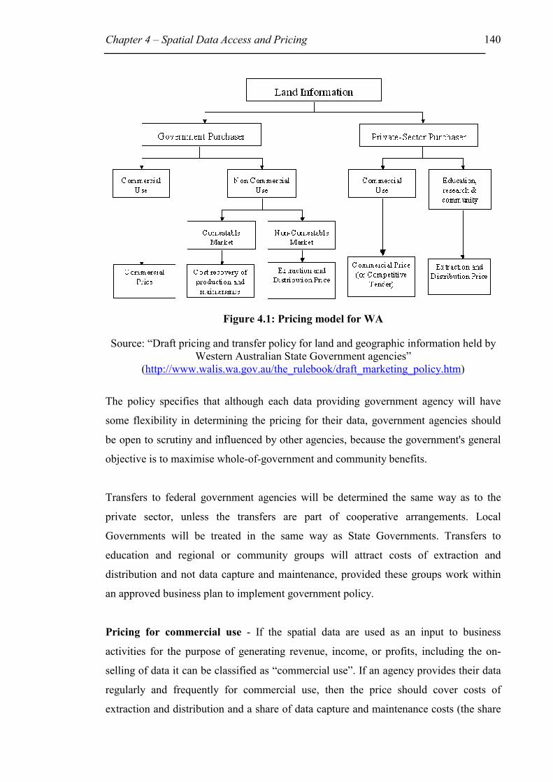
Chapter 4 – Spatial Data Access and Pricing 140
Figure 4.1: Pricing model for WA
Source: “Draft pricing and transfer policy for land and geographic information held by Western Australian State Government agencies”
(http://www.walis.wa.gov.au/the_rulebook/draft_marketing_policy.htm)
The policy specifies that although each data providing government agency will have
some flexibility in determining the pricing for their data, government agencies should
be open to scrutiny and influenced by other agencies, because the government's general
objective is to maximise whole-of-government and community benefits.
Transfers to federal government agencies will be determined the same way as to the
private sector, unless the transfers are part of cooperative arrangements. Local
Governments will be treated in the same way as State Governments. Transfers to
education and regional or community groups will attract costs of extraction and
distribution and not data capture and maintenance, provided these groups work within
an approved business plan to implement government policy.
Pricing for commercial use - If the spatial data are used as an input to business
activities for the purpose of generating revenue, income, or profits, including the on-
selling of data it can be classified as “commercial use”. If an agency provides their data
regularly and frequently for commercial use, then the price should cover costs of
extraction and distribution and a share of data capture and maintenance costs (the share
Chapter 4 – Spatial Data Access and Pricing 141
should be determined as a proportion of an estimated share of total use). If the data
provider only makes a once off or infrequent distribution, the provider can either charge
as above, or negotiate a higher price to maximise the returns to Government. However
the above policy can be altered to a lower or zero price if cooperative data transfer
arrangements can be made, as long as it is an efficient way for state government
agencies to obtain information for their own purposes.
Data for on-sellers (also referred to as data brokers) in private and public sectors must
be charged at prices determined by competitive tender or by negotiation, with the
objective to maximise revenues returned to Government. This policy will apply to the
on-selling of the original product, or a new value-added product derived from the
original product.
Pricing for non-commercial use by state and local government agencies – If there
are alternative sources in the market place that could produce and maintain the same
data, then the market is deemed contestable. If not, then the market is non-contestable.
Certain fundamental datasets that are necessary for governmental operations and cannot
be derived from other datasets are also considered non-contestable.
In a contestable market, prices should be based on recovery of costs of information
production and distribution. However if cooperative arrangements can be made, the
price can be lowered or changed to zero. Pricing in a non-contestable market will be
based on recovery of costs of extraction and distribution.
The cost of extraction and distribution will be based on the average cost of transfer and
will not include a share of collection or maintenance of data. The average cost of
transfer will include direct costs and a share of all overhead costs in providing the
distribution service. Direct costs are, for example: media, computer processing and
freight. Overhead costs include such items as labour, capital equipment and promotional
facilities.

Chapter 4 – Spatial Data Access and Pricing 142
4.4.9 Commonwealth
The need for coordination of Commonwealth spatial data management led to the
development of the Inter-departmental Steering Committee on Coordination of
Commonwealth Land-Related Data in 1983. With many teething problems and
changing committees and names, the final and at present existing Commonwealth
Spatial Data Committee (CSDC) was formed in 1992. This committee was to help
administer common Commonwealth agency approaches to data management issues
such as data standards, directories, distribution and pricing, avoid duplication, and
develop strategies to meet spatial data demands, integrate various datasets, and be able
to represent Commonwealth agencies on global, regional and national forums (CSDC,
2000).
The CSDC is comprised of a committee, a subcommittee that addresses policy
coordination and technical issues, and working groups for specific purposes. Some
working groups have been recently assigned to deal with components of the ASDI
implementation plan. These are the ASDD National Coordination Group (reviewing
strategic directions), the Clearinghouse Working Group (reviewing on-line access issues
and identifying clearinghouse standards), and the Fundamental Data Working Group
(identifying, auditing and recommending improvement to the fundamental datasets).
4.4.9.1 Commonwealth Access and Pricing Policy
CSDC developed the Commonwealth Public Interest Spatial Data Transfer Policy in
1995 to promote improved access to spatial data owned by the Commonwealth. That
policy determined that Commonwealth agencies charge at the cost of distribution.
CSDC policies are mere guidelines because the CSDC have no legislative powers.
Some Commonwealth agencies did not follow the guideline and made their data freely
available, for example the Environment of Australia (ANZLIC, 2000g –
Commonwealth report).
CSDC members identified that a whole-of-government binding approach was needed.
In 2001 a new policy is being developed with the aim of endorsement by the
Commonwealth Government. The new policy will embrace
• Identification of fundamental spatial datasets;

Chapter 4 – Spatial Data Access and Pricing 143
• Development of production, maintenance, provision of metadata, use of
appropriate technology and custodianship guidelines;
• Standards and transfer protocols;
• Access, pricing and copyright policy;
• Exchange of data between all levels of government and private sector for
commercial and non-commercial use;
• Recommend policy implementation requirements
• Monitor effectiveness of policy
4.4.10 New Zealand
New Zealand is not separated into different states and has therefore no need for
interstate coordination like Australia. New Zealand has a central government policy
framework covering spatial and non-spatial data. On examination of its NSDI concept,
New Zealand decided that there was no need, at this time, to have a specific central
government led NSDI initiative. However Land Information New Zealand (LINZ) will
monitor community needs and address any critical NSDI issues not addressed in the
government policy framework. LINZ, as the government's spatial referencing agency,
will provide user access to relevant, timely and accurate information, unless there are
privacy and/or confidentiality issues at stake (LINZ, 2000). LINZ does not provide
value-added information service (LINZ, 1999a).
LINZ, established in 1996 now comprises the core government functions of the former
Department of Survey and Land Information (DOSLI), the Land Titles Office (LTO),
the Office of the Valuer-General (OVG) and the government hydrographic purchase
function [ex Royal NZ Navy]. The State owned enterprise Terralink NZ Limited was
created in 1996 as the balance of the split of DOSLI and tenders for contestable LINZ
outsourced work (LINZ, 1999b). LINZ will provide the national spatial referencing
system and core spatial datasets. In terms of policy development LINZ will work with
the government control agencies, State Services Commission (SSC) and The Treasury,
to develop principles, guidelines and practices for managing government information
for New Zealand (LINZ, 2000). These all-of-government information management
responsibilities will reside with the E-Government Unit, being established within the
SSC on 1 July 2000.

Chapter 4 – Spatial Data Access and Pricing 144
Cabinet approved the New Zealand Government's policy framework for government
held information in April 1997. It agreed that government information should be easily
available. The policy framework established the following on data coverage, pricing,
ownership and quality:
• Coverage - All government data that is not subject to legislation confidentiality
or privacy issues should be released.
• Pricing -
o Free: for public policy purposes or if cost of dissemination is not feasible
or cost effective.
o Cost of dissemination: for public policy reasons and if cost of
dissemination is both feasible and cost effective.
o Cost of transformation: when cost of dissemination is appropriate and the
cost of transformation unavoidable, however cost of transformation must
be feasible and cost effective.
o Full cost: when information was created for commercial purposes, and
will not breach other pricing principles.
• Ownership - government produced information is owned by the government as a
steward (referred to as custodian in Australia) on behalf of the public. A steward
is responsible for implementing good information management practices.
• Quality - includes such issues as accuracy, relevancy, timeliness, consistency
and collection for the purposes it is intended. Government departments should
only collect the data that is necessary for their specified public policy,
operational business or legislative purposes.
4.4.10.1 Access and Pricing Policy
LINZ followed the government policy framework. On the 10/12/99 a new Cabinet
approved pricing regime for LINZ topographic data came into effect. The price for the
topographic dataset at a scale of 1:50,000 for the whole of New Zealand was heavily
reduced from $2million to $1,500. The DCDB is in the process of being amalgamated
with the titling system on the phase 1 Landonline to provide survey accurate data on-
line. The new survey accurate product replacing the DCDB is likely to be priced at a

Chapter 4 – Spatial Data Access and Pricing 145
level below that of the current DCDB, as a greater proportion of costs are already being
met by the users of the Landonline system (Walsh, 2000).
The arguments for a price reduction put to Cabinet varied. Previous topographic
information pricing was regulated through copyright and license fees. The old pricing
regime was set at a rate to recover the full cost of establishing the digital database from
manual records, divided by the estimated expected sales plus copyright fee. However
this high fee, set at $2million, prevented any client from buying the whole dataset.
LINZ was also continuously criticised for imposing fees that were not in line with
Government policy. Crown royalty payments were required for topographic information
and others derived from it, such as aerial photographs. These payments declined in the
1998/99 financial year, due to more spatial information being available at cheaper costs
over the Internet and some buyers paying royalty and others not. Prosecution of non-
compliance was difficult and the lack of legal precedent made it impossible to forecast
any outcome (Documentation provided by Walsh).
The new pricing regime is based on a cost of dissemination to retail agencies. Users can
access topographic information through retail agencies. The new pricing regime
abolishes Crown copyright payments and royalty charges. The cost of dissemination
should also further the development of the private sector.
“The benefits of the new pricing policy are already evident in facilitating
environmental management in NZ and in national research that is now being
undertaken by universities and Crown research agencies. The NZ Government
approach of pricing information at the cost of dissemination radically frees up
access to information and virtually eliminates burdensome compliance
procedures and costs. Information access polices, for data which remains at a
high price, in practice do little to improve effective access to that data” (Walsh,
2000).

Chapter 4 – Spatial Data Access and Pricing 146
4.4.11 Summary of Australian States/Territories, Federal Government and New
Zealand Government Policies
Table 4.3: Summary of Spatial Data Pricing Policies or Draft Policies for all
Australian States/Territories and the Commonwealth, and New Zealand
GI Pricing Regime
(range, non commercial to commercial use rate)
Applicable to non-commercial and commercial use?
ACT ** Licensed to user at cost of supply Both
NSW Cost of transfer to market value Varies
NT * Cost of transfer to market value Varies
Qld Cost of provision Both
SA ** Cost of transfer to above cost of transfer Varies
Tas * Licensed to user at cost of transfer Both
Vic Licensed to user at Cost of transfer plus maintenance
cost (for non-commercial use)
(commercial pricing – up to individual organisation)
Varies
WA Cost of extraction and distribution to cost of
extraction, distribution and share of: data capture and
maintenance cost
Varies
Federal * Existing policy – cost of distribution, but new policy
under development
Both
NZ Cost of dissemination Both
Note: * Policy under development
** No policy, but general current practice
Table 4.3, shows that all Australian States/Territories, their Federal Government and
New Zealand Government have either recently updated their access and pricing
policy/practice, or are working currently on new ones. Four out of the eight Australian
States/Territories namely New South Wales, Northern Territory, South Australia, and
Western Australia have different prices for different uses, which range between cost of
transfer for non-commercial use, to above cost of transfer (such as market value) for
commercial use. Cost of transfer is usually the cost associated with supplying the data

Chapter 4 – Spatial Data Access and Pricing 147
(cost of extraction and distribution) and includes such costs as staff costs, and user
training. The commercial use rates for NSW, NT, SA and WA are either set to include a
share of the data capture and maintenance cost or at market value.
Queensland’s information access and pricing standard no.33 determined that
governmental information should be sold at no more than the cost of provision (similar
to the cost of transfer). DNR, following this guideline, heavily reduced the price of their
Digital Cadastral Database (DCDB) for the entire State to the user directly and via data
brokers from $1.75 million to $125,000. The database is not sold, but rather licensed to
the user for a year. The Australian Capital Territory and Tasmania license their data to
the user at the cost of transfer, independent of the use. Victoria requires their
government agencies to supply governmental spatial data as a licence to use at the cost
of transfer plus some maintenance cost, applicable only to non-commercial use. If the
data are going to be used commercially each government agency has the right to charge
appropriately.
4.5 Survey
Following are discussions that relate the spatial data survey results, from Chapter 3, to
the information in this chapter, to enable a clear analysis of the situation in Australia.
4.5.1 Access - Data Providers
When the questionnaire (see Appendix 1) asked for the most commonly used data
access mechanisms, most data providers (83%) answered that they provided access as a
‘Hardcopy over Counter or Mail’. The 83% indicate that although technology is
available, the overall use of digital data is not as great as expected. This is somewhat
understandable, because many community uses would be for hardcopy street maps, or
hardcopy maps used in real estate, for reconnaissance, bushwalking. The overall choice
of items in the access question are given in Table 4.4:

Chapter 4 – Spatial Data Access and Pricing 148
Table 4.4: Data Access Question – Choice of items
Internet – E-mail CD – Rom
www – Download Hardcopy over Counter or Mail (maps)
www – Viewing only Facsimile
FTP Tape/Cartridge
Floppy disk
The next most commonly ticked choice was ‘floppy disk’ (60%), then ‘e-mail’ (48%).
‘Internet World Wide Web (www) download’ received 7% and ‘www-viewing’ only
12%.
The preferred access mechanism promoted by organisations such as ANZLIC is the
Internet via a data clearinghouse. This, according to the survey, may still take a while to
develop. However, many datasets are available in digital form as the second most
commonly ticked choice was ‘floppy disk’ followed by ‘e-mail’. This shows that
although digital data are available and potentially could be accessed via the Internet,
many organisations do not have clear data access policies. The reasons for this may be
that:
• the public are not demanding the data via the Internet;
• regulations and laws are unclear;
• data providers are worried about losing income or the IP rights to their data; or
• data providers are uninformed.
Many data providers may be working on these issues at present and feel that previously
there was no clear leadership in this area. As well, very often political mandates are
missing.
4.5.2 Cost Recovery - Data Providers
Survey respondents were asked two questions on cost recovery. The first addressed the
basis for cost recovery such as full cost recovery versus cost of supply. The second
question asked for the unit price charged. The outcome was that 43% of all respondents
ticked cost of supply, provision and 15 % Market value. Significantly 26% ticked the
box Do not.

Chapter 4 – Spatial Data Access and Pricing 149
Table 4.5: Data Providers - Basis for cost recovery
Basis for cost recovery Total
(258)
Federal
(14)
State
(56)
Local
(117)
Other
(71)
No % No % No % No % No %
Do not 67 26 8 57 15 27 39 33 5 7
Cost of Storage medium 14 5 0 4 7 4 3 6 8
Cost of data acquisition 29 11 0 9 16 2 2 18 25
Cost of data manipulation 50 19 3 21 13 23 14 12 20 28
Cost of supply, provision 111 43 5 36 32 57 46 39 28 39
Market value 38 15 2 14 12 21 4 3 20 28
Full cost recovery 42 16 1 7 7 13 10 9 24 34
Varies depending on dataset 88 34 4 29 16 29 48 41 20 28
Other 31 12 3 21 13 23 13 11 2 3
* The highest two percentage numbers are bold
Out of 14 responding Federal Government agencies, 8 (57%) ticked they do not recover
any cost, while 5 (36%) indicated they charge for the cost of supply, provision. Out of
56 State Governments, 57% answered cost of supply, provision and 27% Do not. For
Local Governments the figures were more closely related 39% Cost of Supply, provision
and 33 % Do not. More Federal Government agencies did not charge for data than the
ones that did charge. This was interesting because the recommended charge as per
commonwealth policy guideline was “cost of transfer”. The CSDC has recognised these
variations and is addressing them in 2001 by developing new guidelines.
The responses to the second question revealed that the most commonly used unit price
charged for datasets is based on an hourly rate (34%), followed by per mapsheet (33%)
and 25% ticked the box do not charge, but 29% indicated that their unit price depended
on the individual dataset, and 23% said it depends on the user.
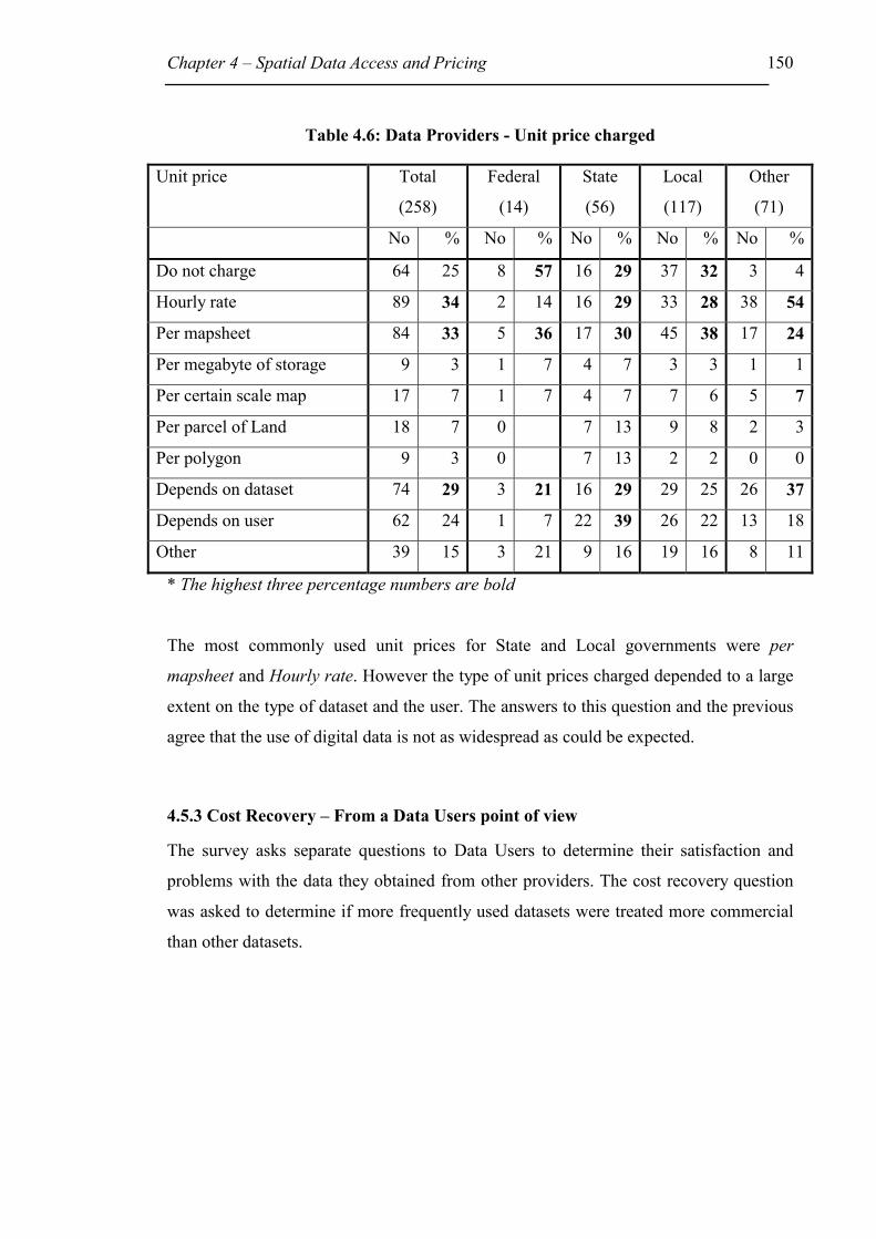
Chapter 4 – Spatial Data Access and Pricing 150
Table 4.6: Data Providers - Unit price charged
Unit price Total
(258)
Federal
(14)
State
(56)
Local
(117)
Other
(71)
No % No % No % No % No %
Do not charge 64 25 8 57 16 29 37 32 3 4
Hourly rate 89 34 2 14 16 29 33 28 38 54
Per mapsheet 84 33 5 36 17 30 45 38 17 24
Per megabyte of storage 9 3 1 7 4 7 3 3 1 1
Per certain scale map 17 7 1 7 4 7 7 6 5 7
Per parcel of Land 18 7 0 7 13 9 8 2 3
Per polygon 9 3 0 7 13 2 2 0 0
Depends on dataset 74 29 3 21 16 29 29 25 26 37
Depends on user 62 24 1 7 22 39 26 22 13 18
Other 39 15 3 21 9 16 19 16 8 11
* The highest three percentage numbers are bold
The most commonly used unit prices for State and Local governments were per
mapsheet and Hourly rate. However the type of unit prices charged depended to a large
extent on the type of dataset and the user. The answers to this question and the previous
agree that the use of digital data is not as widespread as could be expected.
4.5.3 Cost Recovery – From a Data Users point of view
The survey asks separate questions to Data Users to determine their satisfaction and
problems with the data they obtained from other providers. The cost recovery question
was asked to determine if more frequently used datasets were treated more commercial
than other datasets.

Chapter 4 – Spatial Data Access and Pricing 151
Table 4.7 Data users perspective – Unit price charged by provider
Unit price Total
(338)
Federal
(14)
State
(54)
Local
(190)
Other
(80)
No % No % No % No % No %
Do not charge 62 18 7 50 7 13 32 17 16 20
Hourly rate 26 8 1 7 11 20 9 5 5 6
Per mapsheet 105 31 5 36 9 17 56 29 35 44
Per megabyte of storage 23 7 1 7 5 9 8 4 9 11
Per certain scale map 17 5 1 7 2 4 9 5 5 6
Per parcel of Land 82 24 0 7 13 54 28 21 26
Per polygon 34 10 0 5 9 18 9 11 14
Depends on dataset 127 38 6 43 27 50 60 32 34 43
Depends on user 31 9 3 21 6 11 15 8 7 9
Other 67 20 1 7 15 28 41 22 10 13
* The highest three percentage numbers are bold
The most commonly used unit prices to users were per mapsheet. These figures are not
surprising because users most commonly used hardcopy maps. 50% of Federal
Government users did not have to pay at all. By comparing with the above, this may
indicate that because 57% of data providers do not charge, both federal providers and
users may collaborate and exchange data freely. This is a most welcome solution as far
as improving data quality and data range are concerned. A great percentage of users
paid a unit price per parcel of land. This agrees with the answers to a general question
that determined that 76% of users buy Property Boundary data and 50% Ownership
(cadastral) data.
The results of the survey are in agreement with the general trend of most ANZLIC
member’s policies to gravitate towards lower prices (see Table 4.3).

Chapter 4 – Spatial Data Access and Pricing 152
4.6 Conclusion
This chapter reviewed factors that influence spatial data access and pricing development
and found that they could be categorised under the following twelve headings:
SDI Requirements; Organisational Issues; Technical Issues; Governmental /
Organisational Duties; Ownership / Custodianship; Privacy and Confidentiality; Legal
Liability, Contracts and Licences; Intellectual Property Law; Economic Analysis; Data
Management; Outreach, Cooperation, and Political Mandate; and Users’ Choices,
Rights & Obligations.
All of the above categories are important for consideration by any government agency
before drawing up new strategies and policies that address spatial data access and
pricing. More detail was provided on only five of these categories, namely technical
issues, governmental/organisational duties, ownership/custodianship, economic analysis
and users’ choices, rights and obligations. With such a variety of factors it could be
understandable if an organisation ended up confused and only considered some of the
issues in their policy. The review of local and international initiatives in Chapter 4
showed the large variety of policies and practices being used. Often policies and
practices develop, despite the above factors, because organisations have to follow
government mandates, often without any consideration for aiding a better facilitation of
SDIs.
As suggested by David Rhind (1997c) an SDI will function and develop best if accepted
by spatial data providers and users alike, at all jurisdictional government levels and
private entities. This will most likely occur if bottom-up and top-down approaches are
followed. This observation agrees with the situation in the US where many Federal
Government directives failed their aim of adoption by other jurisdictional government
organisations, because their main approach was a top-down one. Hence various
jurisdictions may resent policies that were being handed down.
Sometimes an organisation may face a dilemma when trying to incorporate SDI
requirements and cost recovery strategies into their policy. Governmental organisations
must not only consider all the issues affecting spatial data access and pricing, but also
balance their own needs with, for example, broader national SDI needs. Individual
Chapter 4 – Spatial Data Access and Pricing 153
organisations have to adhere to various needs and priorities, hence it is inefficient to
draw up detailed guidelines applicable for all. A sensible strategy for the Government is
to develop general mandatory guidelines, such as given by the Australian National
Competition Policy, which addresses pricing objectives, standards, legal requirements
and national needs.
A good spatial data access and pricing approach was achieved by Canada. Their
philosophy was to use a partial cost recovery model. The users pay partly for the total
cost of providing spatial data, while the taxpayer’s only fund some of the cost. This is
the opposite to policies of federal government agencies in the USA, which provide
access to their data at low or no cost to its citizens, and copyright does not apply to
federal government held information (more on copyright in Chapter 6). Many state and
local government agencies in the USA do not follow the federal government agency’s
practice as was hoped for by the Federal Government. Instead, some state government
agencies charge the user market prices. The Ordnance Survey (OS) in the UK has gone
to the other extreme. The OS aims for a full cost recovery model. In 1997 they achieved
a 93% recovery of its full economic costs, and in addition they produce the worlds best
national digital basemap. So, all organisations and/or nations have to decide on what
model they prefer, can afford, would be accepted by its clients/citizens, and whether
they aim for quantity or quality in their spatial data.
The Federal Government in Australia is reviewing their access and pricing policy in
2001, but no information was available to see what strategy that policy will follow. The
current policy advises federal government agencies to price government data at the cost
of distribution (similar to cost of transfer). New Zealand’s prices are set equal for
commercial and non-commercial use at the rate of dissemination (similar to cost of
transfer), without any copyright payments or royalty charges. Following this policy
LINZ for example, heavily reduced the price for the topographic dataset at a scale of
1:50,000 for the whole state from $2million to $1,500. The benefits according to Walsh
(Senior Policy Analyst, Land Information New Zealand and ANZLIC Contact Officer
for New Zealand) were already evident. Access was more effective and environmental
management and national research are benefiting.
Chapter 4 – Spatial Data Access and Pricing 154
Table 4.3 summarises current or developing spatial data access and pricing policies to
demonstrate the individual Australian States/Territories, Commonwealth and New
Zealand’s commitment towards facilitating the development of SDIs. As most ANZLIC
members are moving towards lower pricing regimes they are aiming to aid SDI
development to some degree, but are still not totally meeting SDI requirements.
Australia compared with other countries tends to most commonly apply a partial cost
recovery model like Canada. A few departments in Australia reduced their data with the
hope that the income from the sale of a large volume of low priced data will equal the
sale of a small volume of highly priced data. However, the results will have to be
studied over time.

155
Chapter 5 – Legal Issues and Spatial Data
5.1 Introduction
Part of the overall spatial data access and pricing policy are the considerations that an
organisation must give to the legal risks involved when supplying spatial data to others
and the available legal protection for their spatial data. Legal risks associated with the
supply of spatial data to others may involve liability claims that may arise because a
user has relied on inaccurate spatial data, or misused data for purposes it was not
intended for and thereby suffered financial loss. Although an organisation can often not
avoid being sued, even if the organisation has done nothing wrong, it is of vital
importance that the organisation identifies potential legal risks and keeps them to a
minimum. Not only can an organisation suffer great financial loss when being sued, but
also its reputation and ‘good will’ can be at stake. Legal intellectual property protection
offers the spatial data provider with exclusive use rights to their datasets.
Chapter 5 firstly introduces the legal framework applicable to spatial data in Australia
and in particular discusses protection against liability claims. It then discusses legal
risks and liability issues in maps and databases. Disclaimers are then studied and a list
of disclaimers, collated from the 1998-99 Spatial Data Survey, is provided. Finally
assistance is given on how to reduce and manage legal liability risks. Chapter 6 will
describe intellectual property protection of spatial data.
This thesis does not intend to give legal advice to spatial data users and/or producers; it
is merely intended as background material for developing future strategies. The author
accepts no responsibility for any resulting action from reliance on this thesis. The law in
Australia changes regularly and legal advice should be sought from the relevant legal
body. The objectives of Chapter 5 and Chapter 6 are to assist agencies in their
assessment and use of spatial data risk management and intellectual property protection
and to develop some future strategies.

Chapter 5 - Legal Issues and Spatial Data 156
5.2 Australian Law
Australian law is derived from English law. On the 1 January 1901 the Australian
colonies joined together to form the Commonwealth of Australia and the colonies
became States. State and Commonwealth Parliaments develop legislation, which is
interpreted and applied by the courts (Tarakson, 1995).
Although English law arrived with the first fleet two centuries ago, Australia had been
populated much earlier. The first settlers of 1788 ignored local laws and rights of the
aboriginal people and declared Australia as being ‘terra nullius’ (Latin for ‘no-one’s
land’) and applied English law. Since that time the Australian legal system has evolved
taking into account Australian conditions. The mistake of declaring Australia as ‘terra
nullius’ was acknowledged by the High Court decision in the case of Mabo v
Queensland (No. 2) (1992) 175 CLR 1 in 1992. In this case the High Court decided that
the people of Murray Island in the Torres Strait continued to be owners of their lands,
thereby acknowledging Aboriginals land property rights before the arrival of English
law (Chisholm and Nettheim, 1997).
Currently English law does not have much presence in the Australian legal system.
However until 1986 the UK had the power to pass legislation to apply in any of the
Australian States or for Australia. This power finally vanished with the new Australia
Act 1986 (Cth) and the Australia Act 1986 (UK). Since that time the Australian
Parliaments and courts are in full control of Australian law. The only aspect of English
law that remains in affect is English case law. The law of other common law countries
including England remain persuasive (Chisholm and Nettheim, 1997).
Australia has a federal system of government and the Federal Government can only pass
laws within the scope of the Commonwealth Constitution. This can only be overcome if
the States voluntarily refer their legislative powers to the Commonwealth. The
Commonwealth for example has the ability to pass laws on defence, migration, and
customs duties. In some areas of law there is no clear-cut division between
commonwealth and state legislative powers. In such cases the Commonwealth law
prevails over State law (Tarakson, 1995).

Chapter 5 - Legal Issues and Spatial Data 157
5.2.1 Australian Law Structure
Figure 5.1 demonstrates the various levels in the Australian Law Structure. Most of
these are explained in more detail below.
Common Law (1)
Common Law (2)(Case Law)
Common Law (3)
Legislation(Parliament-made Law)
Criminal Civil
Equity Other Branchesof Law
Level One
Level Two
Level Three
Figure 5.1: Law Structure Levels
5.2.1.1 Level One
Common Law (1) - is a type of legal system. It was developed in England and passed
onto countries throughout the British Empire. Other types of legal systems around the
world are Civil law, Islamic law, Hindu law, Communist law and customary systems of
law such as Aboriginal law. Some regions such as Western Europe and Latin America
have a Civil law system. Civil law is a complete set of laws, or codes, that are
administered by judges (Cho, 1998).
5.2.1.2 Level Two
Common Law (2) - is created by the courts. Within the English and Australian legal
system the phrase “common law” is used to differentiate between the rules of law
developed by courts from those enacted by Parliament. Courts cannot make new rules at

Chapter 5 - Legal Issues and Spatial Data 158
random, but must interpret statutes and where not possible, decide according to similar
cases. Courts have to decide individual cases on their merits and evidence based on
other cases; this is known as the doctrine of precedent. Precedent must be followed in
accordance with the court hierarchy. Lower courts should follow decisions of higher
courts, and if a similar case was judged in a court of the same rank in different states,
the court’s decision can be influenced by the other, but need not follow it. Australian
courts decide a case on the evidence provided by the two sides through the process of
cross-examination. The judge is an observer and the lawyers, running the case, call
witnesses and examine them. The judge has to ensure that fair and proper legal
procedures are followed, decide on whether particular evidence is allowed in court and
decide, if there is no jury, on questions of what happened (Tarakson, 1995).
Legislation - is Parliament-made law in the form of Statutes and Acts. Australian
parliaments are made up of a lower house and an upper house, except for Queensland.
Queensland has only a single house that is called the Legislative Assembly. The lower
house is called the Legislative Assembly in the States and the House of Representatives
in the Federal Parliament. A State’s upper house is called the Legislative Council
(House of Review) and the Federal upper house is the Senate. Each level of
Government has a Queen’s representative - at state level, Governors and at Federal level
the Governor General. Legislation can either change existing laws or enact new ones.
Government, Opposition, Law Reform Commission, unions, media or other special
interest groups can propose legislative changes. If the Government agrees with those
changes, a Parliamentary Counsel’s Office lawyer will draft the legislation referred to as
a bill. Most bills start in the lower house and if passed progress to the upper house. Bills
are rejected, changed or approved. An approved bill must receive Royal Assent by the
Governor if it is a State bill, or Governor General if it is a Federal bill and then the bill
becomes an Act. The date of operation will be specified on the bill and either be the date
of assent, or as specified on the Act, or as proclaimed in the Government Gazette
(Tarakson, 1995).
Acts only deal with general requirements. The Parliament delegates the detailed rules
and regulations to people with the expertise to do so, for instance the Governor, local
councils, and statutory bodies (Tarakson, 1995).
Chapter 5 - Legal Issues and Spatial Data 159
5.2.1.3 Level Three
Common Law (3) - is a body of law distinct from Equity. This part of English law was
created by the older courts called “common law courts”. These courts dealt with crimes,
property, contracts and civil actions in “tort” (private wrongs such as trespass, nuisance
etc). Non-criminal matters attracted such remedies as returning property to a person or
to pay damages. These remedies were called private actions and were commenced in the
form of a writ (command issued in the name of the Crown). Writs today are issued by
courts and have different names, such as ‘summons’ or ‘applications’. Writs were
enforceable commands, either to be followed by the defendant or to be defended in
court. Where people suffered a wrong by another person, with no available writ or
inadequate writ, the person suffering the wrong could petition the Crown to act
(Chisholm and Nettheim, 1992).
Petitions were addressed differently depending on the situation. Petitions dealing with
injustices that could only be addressed by changing the law were considered by the
Crown in Council in Parliament. These formed the basis for the present legislative
procedures of the Parliaments. The Royal Council dealt with petitions disagreeing with
common law causes of action. The Royal Council referred most of those petitions to the
Lord Chancellor, who was one of the Crown’s leading ministers (Chisholm and
Nettheim, 1992).
Equity - Petitions considered by the Lord Chancellor fell under the body of law called
equity. The Chancellor decided the petitions on the basis of equity and good conscience,
because of the inadequate coverage of the law. This led to the development of rules of
equity distinct from the rules of common law. For example, the procedures and
obligations of holding property in trust for someone are covered by the rules of equity.
Today all courts apply both sets of common law and equity rules (Chisholm and
Nettheim, 1992).
Criminal compared to Civil Law - If someone strikes a person, that action can be dealt
with as a criminal offence, or a civil offence, or both. That person striking another can
be arrested and tried for crime of assault and/or sued for damages in a civil action for
the tort of assault (Tarakson, 1995; Chisholm and Nettheim, 1992).

Chapter 5 - Legal Issues and Spatial Data 160
A criminal matter is between the state and the individual. If a crime has been
committed, the court will sentence an individual accused of the crime if he/she is found
guilty. Most crimes are contained in statutes that set out the offences and prescribe
maximum and minimum penalties. The police on behalf of the state will take the
accused to court in an attempt to prove that the individual committed the crime. If found
guilty the criminal will be sentenced. However in criminal cases the accused can only
be found guilty if it is proved beyond reasonable doubt that he/she committed the crime
(Tarakson, 1995).
A civil matter is between two individuals, or entities such as companies, where one
takes the other to court. Civil law includes common law and equity. Civil remedies
include for example damages, injunctions, and accounts of profit. Civil cases deal with
issues such as neighbourhood disputes, personal injuries, and breach of contract. The
finding of guilt is not as stringent for a civil matter as it is for a criminal matter. Proof is
on the balance of probabilities (Tarakson, 1995). Some of the major categories of civil
law are tort and contract. Both derived from the old common law courts (Chisholm and
Nettheim, 1992).
Tort (French for wrong) - provides the plaintiff with remedies against unlawful
conduct. If the plaintiff proves that the defendant has conducted a tort thereby injuring
the plaintiff, the plaintiff can sue for damages or obtain an order to restrain the
defendant from such a conduct by way of an injunction. Matters that fall under tort
include, for example negligence, defamation, assault, and interfering with other people’s
property.
The law of contract deals with promises, which are usually commercial in nature.
Contract law is designed to enforce promises that have been breached. The law orders
parties to a contract to fulfil their promises, or in case of a breach of contract to
compensate the other party or parties for the loss they suffered because of the breach.
Constitutional and Administrative Law - The law governing the structure and
workings of the legal system, the system of government and the relations between the
citizen and the state is loosely known as “public law”. Public law includes constitutional
law and administrative law. Constitutional law deals with the characteristics and

Chapter 5 - Legal Issues and Spatial Data 161
functioning of the Australian Federal Constitution and the constitutions of the states.
Administrative law deals with accountability of public officials (Chisholm and
Nettheim, 1992).
There are many different branches of law that involve a combination of rules and
procedures and are derived from common law, equity and legislation. The monthly
publication Australian Current Law, for example, lists current legal developments
(branches of law) under 89 headings in alphabetical order, starting with Aboriginals and
Torres Strait Islanders to Workers compensation. It includes for example Contract,
Damages, Industrial Law, Intellectual Property, Negligence and Product Liability
(Chisholm and Nettheim, 1992, 1997).
5.2.2 Court Structure
Courts exist at federal and state levels. At the Federal level in hierarchical order there is
the High Court, the Federal Court, the Industrial Relations Court, and the Family Court.
At State level, the highest court is the Supreme Court, then the District/County Court
and the Local/Magistrates court (Territories have the Supreme Court and the
Local/Magistrates Court) (Tarakson, 1995).
The High Court hears appeals from Supreme Courts and the Federal Court and its
decision is final and binding on all lower courts. The High Court also decides on
constitutional matters. The Federal Court hears appeals from the Supreme Courts in
Federal matters, and deals with Federal laws. The Industrial Relations Court deals with
industrial matters. The Family Court deals with family matters such as divorce, property
settlement and custody and access of children (Tarakson, 1995).
Local/Magistrates Courts have no juries and are presided over by a magistrate. These
courts hear criminal and civil matter cases and sometimes family matters. Criminal
matters are either decided there or will go to a higher court. Civil matters will only be
heard if below a certain amount of money, otherwise they will be heard in the
District/County Court. Appeals go to the District or Supreme Court, depending on the
individual case (Tarakson, 1995).

Chapter 5 - Legal Issues and Spatial Data 162
5.2.3 Law Reform
As society and technology go through a process of change it is necessary for the
Australian legal system to alter at the same time. Political processes deal with the
necessary reform in case law and legislation. Law Reform Commissions and associated
bodies such as lawyer’s professional organisations, advisory councils, and special
interest groups lobby for change. The work of the law reform commissions is very
valuable and of high quality but according to Chisholm and Nettheim (1992), many
proposals remain unimplemented because of the politics and resistance to change by
Parliaments and bureaucracies.
As this thesis is investigating spatial data policy issues and strategies the next two
sections will be on protection against liability claims and use of disclaimers.
5.3 Liability
Legal liability may arise from the provision of inaccurate data. A data provider can
either be sued because of breach of contract or negligence. Liability will generally be a
civil matter, but may also be criminal. Civil liability relates generally to contractual
obligations or to negligent behaviour. Criminal liability is enforced by criminal courts
and is a matter between a state and the individual rather than between two individuals as
in a civil case.
Liability may also be of concern in privacy, which is not further considered here
(Perritt, 1995b). Liability issues in regard to anti-trust laws or freedom of information
laws or international jurisdictional effects are also not taken into account in this chapter.
Legal liability also occurs when any of the intellectual property rights have been
infringed. Intellectual property is discussed in Chapter 6. The next sections study
contractual liability, and negligence, followed by spatial data liability examples, and
disclaimers. Then legal liability awareness and disclaimer practices are analysed using
the results of the Survey from Chapter 3, and liability risk management strategies are
described.

Chapter 5 - Legal Issues and Spatial Data 163
5.3.1 Contracts
It is beyond the scope of this section to deal with contract law in detail. Hence no
contract terms or sample contracts applicable to a spatial data contract are included.
Only a general overview is given with regard to contractual liability.
Contractual duties and rights for all parties to a contract are set out in a contractual
agreement. A contract may be in writing or implied. An implied contract may be more
appropriate in case of selling goods or services. Courts and legislators have developed
appropriate rules for implied contracts. If however both parties to a contract want to
define their specific roles and terms, an expressed contract may be more appropriate.
Any party to a contract should be certain about their rights and responsibilities to a
contract before signing. To avoid legal disputes, any possible contingency needs to be
considered (Cho, 1998, p.60). An implied contract, if used in the sale of a computer
system, for example, may have the following implied terms
“the seller is the lawful owner of the system, that it is sold according to a
description and corresponds to that description, that the system is fit for a
particular purpose and is sold as such and that it is of a merchantable quality”
(Cho, 1998, p.67).
Contract terms introduced after the contract is binding can usually not be enforced. This
is why for example ‘shrink-wrap’ licences are most likely invalid (Cho, 1998, p.70;
Onsrud, 1999). In a shrink-wrap licence the product will have new contract terms
written on separate wrapping inside the package only seen by the purchaser when he/she
opens the box at home. For example, software disks may be wrapped and the new terms
introduced on the wrapping may specify that by breaking the seal the purchaser agrees
to the software licence terms. These terms may include for example that the laws in a
certain Country govern the agreement.
Contracts can have exclusion clauses that limit liability. These exclusion clauses are
further discussed in section 5.4 and are referred to as disclaimers. Legislators and courts
have developed rules protecting consumers and therefore not all clauses will be legally
enforceable. For example, if any party to a contract does not carry out their contractual
responsibilities, they cannot rely on any exclusion clause protection and this may also
give the other parties the right to terminate the contract altogether. If any disclaimers are
Chapter 5 - Legal Issues and Spatial Data 164
unjust the court can declare a contract invalid, or delete terms (Cho, 1998, p.69). In case
a breach of contract has occurred a basic principle in contract law referred to as “loss of
expectation” takes place. In a “loss of expectation” the injured party should be put back
into a position as if the breach had not taken place (Cho, 1998, p.88).
In order to reduce contractual legal liability exposure a formal set of guidelines should
be established, not only dealing with the transfer of data externally but also internally.
The set of guidelines should inform the staff of the organisation how to transfer data and
what precautions to take before transfer. These guidelines may include details on:
• Under what circumstances the data could be handed out – eg, if the data are
subject to freedom of information laws, or if privacy restrictions apply and what
forms are required;
• Restrictions as to use and/or user – eg, if use is for academic purposes the user
must sign a licence stating that the data, or any derived data will not be passed
on without the approval of the organisation it originated from. It might be in the
best interest of any organisation not to allow on-selling of data to third parties,
because if they are injured by reliance on the data the organisation could be held
liable;
• Standard forms and/or licences should be used when distributing data (Wright,
1994).
Licence or standard forms or webpage notices should clearly spell out what a data user
is and is not allowed to do with the data. It should for example spell out:
• restrictions on use
• restrictions on distribution to others and period of agreement, and
• copying of data (Wright, 1994)
To further limit liability the following should be included in a contract:
• Force Majeure – Neither party shall be at fault if a problem occurred, beyond
either parties control due, for example, to a flood, earthquake or riots.
• Inappropriate use – If the data are used in a way not intended, the provider
cannot be held liable.

Chapter 5 - Legal Issues and Spatial Data 165
• Limit the recoverable amount – The provider can limit the amount to be
recovered by the user if specified in the licence, that is liability for damages
shall be limited to the total fees paid by Licensee to Licensor. (Wright, 1994)
5.3.2 Negligence
In the case of negligent behaviour, liability arises when a person suffers loss because the
duty of care has been breached. Negligence is part of the law of torts. Classes of tort
also include such areas as strict liability, product liability, misrepresentation, intentional
harm and defamation (Onsrud, 1999, p.6). As negligence, misrepresentation and product
liability are the most applicable to spatial data, they are the only ones considered here.
Negligent behaviour is behaviour that breaches the duty of care. Duty of care means that
a person is not allowed to harm others or place them at risk. Negligence does not
necessarily involve intent, but failure to meet a degree of care. On breach of the duty of
care the plaintiff can sue the person that inflicted personal injury or property damage
with his/her product. Pure economic loss is usually not recoverable under this action
(Onsrud, 1999, p.6,7). If the defendant can prove that the plaintiff failed to take
precautionary measures, the defendant may only be partly liable.
Misrepresentation may be made negligently or fraudulently. Negligent
misrepresentation involves someone during the course of their business providing others
with false information. If the person providing the information did not take reasonable
care, that person is liable for the loss they caused others. If a person made the
misrepresentation fraudulently, meaning that someone intentionally provided another
person with false information, he/she may be liable for the loss caused to others
(Onsrud, 1999, p.7).
Product liability occurs if a defective product caused damages. In the case of spatial
data, the defective product may be providing inaccurate spatial data. If product liability
does not exist, and only negligence theory applies, producers can escape liability if they
can show that industry-wide standards are being met. Economic losses are usually not
recoverable under this provision, but direct injuries such as medical expenses or loss of
wages can be granted (Onsrud, 1999, p.8,9). In Australia the area of product liability is
Chapter 5 - Legal Issues and Spatial Data 166
addressed under Parts V and VA of the Trade Practices Act 1974 (Cth) and in each
state’s fair-trading legislation (Cho, 1998, p.122).
A disclaimer of responsibility, used to limit negligent behaviour, may have no effect
where the defendant is the only possible source of the information or advice (Davies,
1995). In this case the plaintiff has no other choice but to rely on the defendant’s
information and hence the defendant owes a duty of care to the plaintiff. The same
applies when the defendant uses a disclaimer to free him/herself of responsibility when
giving professional advice. In addition, if the defendant does not act in accordance with
a disclaimer they use, the disclaimer is ineffectual (O’Sullivan, 1994).
If a third party is involved, the courts sometimes deny that the defendant owes a duty of
care to the third party. In San Sebastian Pty Ltd v Minister Administering the
Environmental Planning and Assessment Act 1979 (1986) the court held that the
Minister (State Planning Authority) was not under a relevant duty of care to the third
party. The plaintiff sued the respondent for damages of loss due to alleged negligence
by the State Planning Authority (the Authority) and the Council of the City of Sydney
(the Council) in the preparation and publication of a plan for redevelopment of the
Woolloomooloo area. The respondent, according to the plaintiff, failed to warn the
plaintiff that the plan was to be abandoned. The High Court held that the defendant did
not owe a duty of care to the plaintiff because of the following three reasons:
1. the plan contained no feasibility statements stating any redevelopment was
feasible in accordance with the plan;
2. if defendant’s financial benefit was high enough, that would be sufficient to give
rise to a duty of care, however the defendant did not receive sufficient financial
benefit; and
3. since the plaintiff did not request the information from the defendant, there was
no duty of care existing (Davies, 1995).
Disclaimers used to limit tort liability attempt to prevent liability from arising, rather
than seeking to avoid the consequences of encountered liability as in contractual
disclaimers. These disclaimers are often used to avoid liability to third parties. There are
no rules as to how and where to use them, however they should be placed in prominent
positions and clearly spelled out (O’Sullivan, 1994).

Chapter 5 - Legal Issues and Spatial Data 167
In order to limit contractual and tort liability any organisation should not only use
contracts, disclaimers and spatial data transfer guidelines, but implement an overall
spatial data risk management strategy for the entire organisation, as described in section
5.6.
5.3.3 Spatial Data Examples and Case Law
Below are some examples that point out situations in which negligence does or could
apply. In a similar manner to tort law in the USA, Australia addresses restrictive trade
practices such as misleading or deceptive conduct and strict product liability in the
Trade Practices Act 1974. Strict product liability applies when for example injury has
been caused by defective information. Tort law requires proximity, which means that if
a third party was indirectly harmed by another party, that injured party has the right to
recover damages under the common law. In contractual liability privity is necessary,
which means that only parties to the contract have legal rights and liabilities under that
contract (Stewart et al, 1997).
The following case, on appeal from the Supreme Court of New South Wales at the High
Court of Australia, deals with tort negligence. This case, L.Shaddock & Associates Pty
Ltd and another v The Council of the City of Parramatta HC [1980-1981] 150 CLR
225, involved a developer and a Council. The developer’s solicitor applied to the
Council for a section 342 AS Local Government Act 1919 (NSW) certificate. This
certificate was being used for conveyancing to determine amongst other things whether
a particular piece of land was affected by, for example, a proposed road widening. In
this case the certificate made it clear that there was no road-widening proposal when in
fact there was. Upon reliance of the certificate the developer entered into a contract and
purchased the piece of land. The court found that the Council had a duty of care and
should have provided correct information. Hence the Council breached the duty of care
and were liable for the erroneous information. The court also decided that the Council
had to pay damages to the developer, an amount necessary to restore the developer to a
position he was in before the purchase, as if he had not made the purchase.
Chapter 5 - Legal Issues and Spatial Data 168
In Shaddock v The Council of the City of Parramatta the court decided that if a
professional body such as the Council gives advice that involves special skill, for a
business transaction, then the council has a duty of care to provide correct information.
If a person relies on that information, which is erroneous, and suffers damage, then the
Council is negligent in tort and has breached the duty of care.
Errors in maps can have catastrophic consequences, when people depend on them. For
example the CIA publicly admitted that due to using old maps and analytical
misjudgements, the Chinese embassy in Belgrade was bombed on the 7th May 1999 by
mistake during the recent Kosova conflict (ABC News, 1999). People’s lives were lost,
but who is responsible? In Remiga v United States 448 F. Supp 45 [1978] WD Mich, the
US Federal Government was found negligent because they had not accurately plotted a
broadcasting tower on an aeronautical chart. This resulted in a flight crew having a fatal
plane crash.
Poor design can lead to legal liability as well. In Aetna Casualty and Security Co. v
Jefferson and Co 642 F2d 339 (9th Cir.) [1981], the defendant Jefferson had mapped out
an instrument approach to an airfield correctly, but in a way confusing or inappropriate
for the user’s purpose. The instrument approach to an airport was mapped in an
aeronautical chart displaying two perspective views, one from above (plan view) and
the other from the side (profile view). Both views appeared to be of the same scale, but
in fact were different by a factor of five. The plane crashed because the pilot relied on
the graphical presentation believing both views to be of the same scale. The court held
that the chart was defective in graphical presentation and found the defendant liable, but
the crew was also partly held liable, because a professional should not only rely on what
he/she is told by a computer or chart, but also must use his/her professional judgement.
Maps used inappropriately or in ways never intended may also result in legal
liability, as in the case of Zinn v State 112 Wis. 2 nd. 417, 334 NW 2d 67 [1983]. A US
Geological Survey (USGS) map was used by a state agency to map property boundaries
along a lake. Land below Ordinary High Water Mark (OHWM) of that lake was public
property. The state claimed an area of private land based on a map whose scale was not
large enough for such detail. The property owner who believed that her property had
been inappropriately repossessed sued the state. The court held that the state was liable

Chapter 5 - Legal Issues and Spatial Data 169
because it had used an inappropriate map to define private properties (Lynch and Foote,
1999).
The Crown can be sued in contract or in tort like any other person, the only exception
being when an employee of the Crown performs a statutory duty. In this case the Crown
enjoys sovereign immunity, which affords it some protection against liability claims. If
Crown employees perform a statutory duty in good faith they are protected from
personal liability (Cho, 1998, p.110).
Private data providers are liable if reliance on their data harms someone. Difficulties
arise when data in Geographic Information Systems (GIS) is applied to new purposes.
As providers find it difficult to anticipate liability claims and problems that may occur,
they tend to consult lawyers on drawing up specialised contracts. These are especially
important in such areas as emergency dispatch systems, car navigation systems, and in
the placement of cables or pipes (Lynch and Foote, 1999).
5.4 Disclaimers
This section analyses disclaimer uses and their effectiveness. Many people in the spatial
data industry rely on disclaimer clauses to protect themselves against third parties
misusing any of their work. But do disclaimer clauses offer the protection the industry is
seeking? Disclaimer clauses can help limit legal liability. However they do not protect
the producer against any mistakes he/she made. Disclaimers can specify the standard of
care that has been taken in producing a product, and/or specify the purpose for use for a
product. They therefore can only inform the product user about the limitations of the
product and its intended use.
Disclaimers may offer the data provider more protection for economic damages, than
against liability for personal injury or wrongful death (Dansby 1993, p.11, quoted in
Cho, 1998, p.100). A disclaimer cannot override any contractual obligation but can be
used to state, for example, the spatial data’s intended use. If the spatial data are being
used inappropriately, the provider may be held negligent in case the user suffers
damages upon reliance of the data, and this can only be avoided if disclaimers are being
used that specify intended uses.
Chapter 5 - Legal Issues and Spatial Data 170
Harrison (1998) gives examples of the use of disclaimers. One example he cites is
where an Architect wants 1 metre (m) contours and then interpolates them to 0.05m
expecting any interpolated spot level to be accurate, when in fact the contours would
only be accurate to + or – 0.5m. He has suggested specifying the accuracy of the work,
for example: the information is only to be used at a scale accuracy of 1:100, or the tree
locations are only accurate to + or – 0.75m. In case digital spatial data was being
distributed on disc, he advised to use instruction files and a program tracking disk-
changes to have some response in case of legal defence. In addition to the instruction
file, a shrink-wrap licence could be included. This licence could bear the following seal:
“By breaking this seal you acknowledge that you will read the instruction file and abide
by the conditions contained therein and the copyright implied.” Shrink-wrap licences
however may not be valid if introduced after the purchase and sale of the product. No
new contract terms may be introduced after the contract was made.
Harrison (p.16) also gave examples of Disclaimers used by his surveying firm:
“On topographic detail plans:
1. Bearings and distances are by Title and /or Deed only. No boundary
investigation has been carried out.
2. Relationship of improvements to boundaries is diagrammatic only. Where
offsets are critical they should be confirmed by further survey.
3. Contours shown depict the topography: except at spot levels shown they do not
represent the exact level at any particular point.
4. Services shown hereon have been determined from visual evidence only. Prior to
any demolition excavation or construction on the site the relevant authority
should be contacted to establish detailed location and depth.
5. Australian Height Datum was established from SSM43560 (27-56m) at the
corner of Smith and Jones Street.
6. For north points, where Deposited Plans (DPs) are on Magnetic Meridian
(M.M.): ‘the bearings on these plan boundaries are from Land Titles Office
plans. They are on Magnetic Meridian. If accurate True North is required a
further survey would be necessary.’

Chapter 5 - Legal Issues and Spatial Data 171
Harrison continues to give examples of disclaimers used by his firm for building set out
sketches, pegouts and identification surveys, Draft Strata Plans, Subdivision Plans and
Drainage Plans. On plans of proposed layout, he suggests to use statements such as:
“Dimensions, areas, size and location of improvements are approximately only, subject
to final survey.” And when using contours “Contours shown on this plan are general
and are suitable only for the purpose of this application. No reliance should be placed
upon such contours for any purpose other than this application.” In summary he
suggests to first consider the risk involved in the work and then decide on the
appropriate disclaimer.
Elgin (1995) warns surveyors that they must state on the survey plans or maps what the
survey comprised and perhaps more importantly what the survey did not comprise. One
of the disclaimer clauses he gives is:
“The locations of underground utilities as shown hereon are based on above-
ground structures and record drawings provided to the surveyor. Locations of
underground utilities/structures may vary from locations shown heron.
Additional buried utilities/structures may be encountered. No excavations were
made during the progress of this survey to locate buried utilities/structures.
Before excavations are begun, the following offices should be contacted for
verification of utility type and for field locations: Telephone; Electricity, Water
and Sewer; Cable TV; Surveyor.” (Elgin, 1995, p.17)
5.5 Legal Liability Awareness and Disclaimer Practices
Before describing overall spatial data risk management strategies, this section will
analyse and summarise the results from the spatial data survey in Chapter 3 with regards
to legal liability and disclaimers. This brief summary aims to determine current legal
liability case awareness and disclaimer practices used amongst spatial data providers
and/or users.
5.5.1 Survey Results on Legal Liability
The spatial data survey discussed in Chapter 3, asked all respondents whether anyone
was aware of any liability problems resulting from issues such as the provision of

Chapter 5 - Legal Issues and Spatial Data 172
inaccurate data. 10% (37) answered that they were aware of legal liability cases, while
86% were not (4% did not answer this question). 6 % (23) of respondents specified and
described liability cases. These are included in Table 5.1 below.
Table 5.1: Liability issues pointed out by respondents
Questionnaire, Section I - Question 5: Awareness of any liability claims? 10% (37 respondents) answered yes, and 6% (23) gave examples
Mistaken geoid base for airborne geophysical survey resulted in legal action (Resolute Samantha vs World Geoscience Corporation Ltd), may have been settled out of court.
Liability of repair of damaged underground utilities, especially Telstra fibre optic.
We are ensuring our risk is minimised when supplying data. To date no cases.
A council taken to court in relation to a Local Environmental Plan zoning error.
Incorrect location or existence of utility assets.
User claimed that data was inaccurate? Water depth (spinal injury); Submerged rock (vessel damage).
As major provider of data that has property implications, the data has been challenged.
Survey company, Sydney, mid 80s. Inaccurate hydrographic surveys led to liability in engineering application.
Many around the world - see "GIS Law" Journal.
Incorrect design & construction from wrong DTM provided by surveyor.
Custodian liability.
Infrequent errors usually due to incorrect interpretation by users.
A disclaimer is attached to each map. The two contractual parties sign digital data contracts required by consultants.
Victorian Ambulance - Intergraph Public Safety.
Wrong setout of buildings.
Lawyer and Insurance.
Inaccurate or erroneous title information.
Errors in data give rise to claims arising from extra costs - particularly in design & construction spatial data.
Within government agencies, never gets to court.
Typically where data gets used for purposes other than originally intended (eg. accuracy data + - 1m, digital precision = - 0.001m).
Various cadastral reinstatements, Quarry volume calculations.
Issue of 149 certificates from council in error.
Copyright Infringement.

Chapter 5 - Legal Issues and Spatial Data 173
One of the liability issues pointed out by one of the respondents occurred in Victoria. A
company named ‘Intergraph Public Safety Pty Ltd’ was responsible for installing a new
computer aided ambulance dispatch service for the Victorian Ambulance. The contract
to Intergraph was awarded in 1993 and the way in which it was awarded led to
considerable controversy. One of the main problems was how Intergraph won the
tender, but also the longer response times of the new systems and provision of wrong
addresses led to a Royal Commission investigating the circumstances (ABC News
Online, 2000).
The results of the survey indicate that not many people are aware of the liability risks
involved when supplying spatial data, or that liability claims happen very infrequently.
However, people may not be aware of many liability risks or claims, because most
liability claims are settled out of court and no case studies or publication on the results
are available to the public.
5.5.2 Disclaimer Survey Results
Out of the 258 respondents, 64% are using disclaimers when providing spatial data to
users (Figure 5.2).
Figure 5.2: Number of spatial data providers using disclaimers.
Disclaimers
64%
34%
2%
0% 20% 40% 60% 80%
Yes
No
No Answer
Local GovernmentDepartmentsAll other Organisations

Chapter 5 - Legal Issues and Spatial Data 174
When dividing the respondents into subgroups of Federal, State and Local governments
and Private organisations, the providers that included disclaimers were 71%, 73%, 59%,
and 61% respectively. Hence Federal and State Governments are more likely to rely on
disclaimers than Local governments or other private providers such as Surveyors. On
cross-checking this question with the question on what additional information the
provider provides with the dataset, the outcome was that 64% of providers (163) used
disclaimers.
Out of the 163 disclaimer providers, 68 (42%) indicated that they supply metadata with
their datasets. These 68 are a large proportion of the total number of 89 Metadata
suppliers out of all providers (258). Percentage comparisons among the subgroups were
different to above. The number of Federal, State and Local governments and private
providers that include metadata were 79%, 55%, 18%, and 37% respectively. Hence
more Federal Government departments provide metadata than other subgroups.
Interestingly, local government departments were by far the smallest metadata
providers.
These figures show clearly that many people are either not aware of metadata, or
perhaps finding it too cumbersome or expensive to use. Studying the list below, as
could be expected, many disclaimer areas are similar to what should be included in
Metadata. Metadata in Australia, as recommended by ANZLIC, should include: dataset
information and description, data currency, dataset status, access, quality, contact
information, metadata date and other required metadata information. (See Appendix 3
for a description of these categories). The similarity of disclaimers and metadata
descriptions should be taken advantage of. Metadata statements could form part of a
contract when selling spatial data and therefore include more detail on disclaiming
liability. For example, in the ‘Metadata Guidelines’ from ANZLIC (1996, p67),
metadata for Ecological Vegetation Classes specifies quality - positional accuracy as:
Map errors of 0.5 mm to 3 mm, or 50 m to 300m are possible. This is very brief and if
used as a disclaimer could include: ‘The positional information is only accurate to + or
– 150 m real world position. If the information is being used for purposes requiring
better accuracy the data provider shall be free from all responsibilities’.
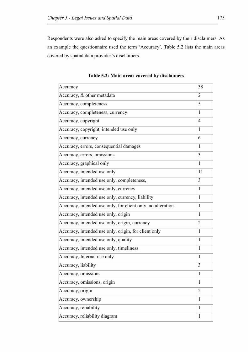
Chapter 5 - Legal Issues and Spatial Data 175
Respondents were also asked to specify the main areas covered by their disclaimers. As
an example the questionnaire used the term ‘Accuracy’. Table 5.2 lists the main areas
covered by spatial data provider’s disclaimers.
Table 5.2: Main areas covered by disclaimers
Accuracy 38
Accuracy, & other metadata 2
Accuracy, completeness 5
Accuracy, completeness, currency 1
Accuracy, copyright 4
Accuracy, copyright, intended use only 1
Accuracy, currency 6
Accuracy, errors, consequential damages 1
Accuracy, errors, omissions 3
Accuracy, graphical only 1
Accuracy, intended use only 11
Accuracy, intended use only, completeness, 3
Accuracy, intended use only, currency 1
Accuracy, intended use only, currency, liability 1
Accuracy, intended use only, for client only, no alteration 1
Accuracy, intended use only, origin 1
Accuracy, intended use only, origin, currency 2
Accuracy, intended use only, origin, for client only 1
Accuracy, intended use only, quality 1
Accuracy, intended use only, timeliness 1
Accuracy, Internal use only 1
Accuracy, liability 3
Accuracy, omissions 1
Accuracy, omissions, origin 1
Accuracy, origin 2
Accuracy, ownership 1
Accuracy, reliability 1
Accuracy, reliability diagram 1
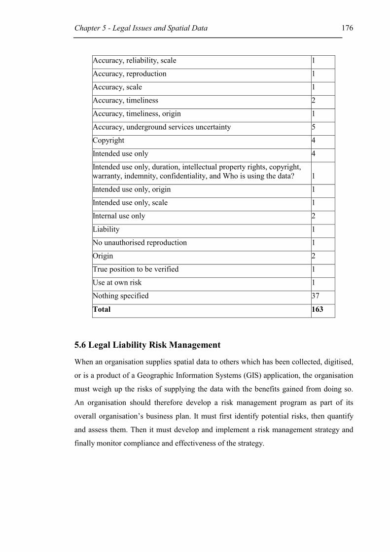
Chapter 5 - Legal Issues and Spatial Data 176
Accuracy, reliability, scale 1
Accuracy, reproduction 1
Accuracy, scale 1
Accuracy, timeliness 2
Accuracy, timeliness, origin 1
Accuracy, underground services uncertainty 5
Copyright 4
Intended use only 4
Intended use only, duration, intellectual property rights, copyright, warranty, indemnity, confidentiality, and Who is using the data? 1
Intended use only, origin 1
Intended use only, scale 1
Internal use only 2
Liability 1
No unauthorised reproduction 1
Origin 2
True position to be verified 1
Use at own risk 1
Nothing specified 37
Total 163
5.6 Legal Liability Risk Management
When an organisation supplies spatial data to others which has been collected, digitised,
or is a product of a Geographic Information Systems (GIS) application, the organisation
must weigh up the risks of supplying the data with the benefits gained from doing so.
An organisation should therefore develop a risk management program as part of its
overall organisation’s business plan. It must first identify potential risks, then quantify
and assess them. Then it must develop and implement a risk management strategy and
finally monitor compliance and effectiveness of the strategy.
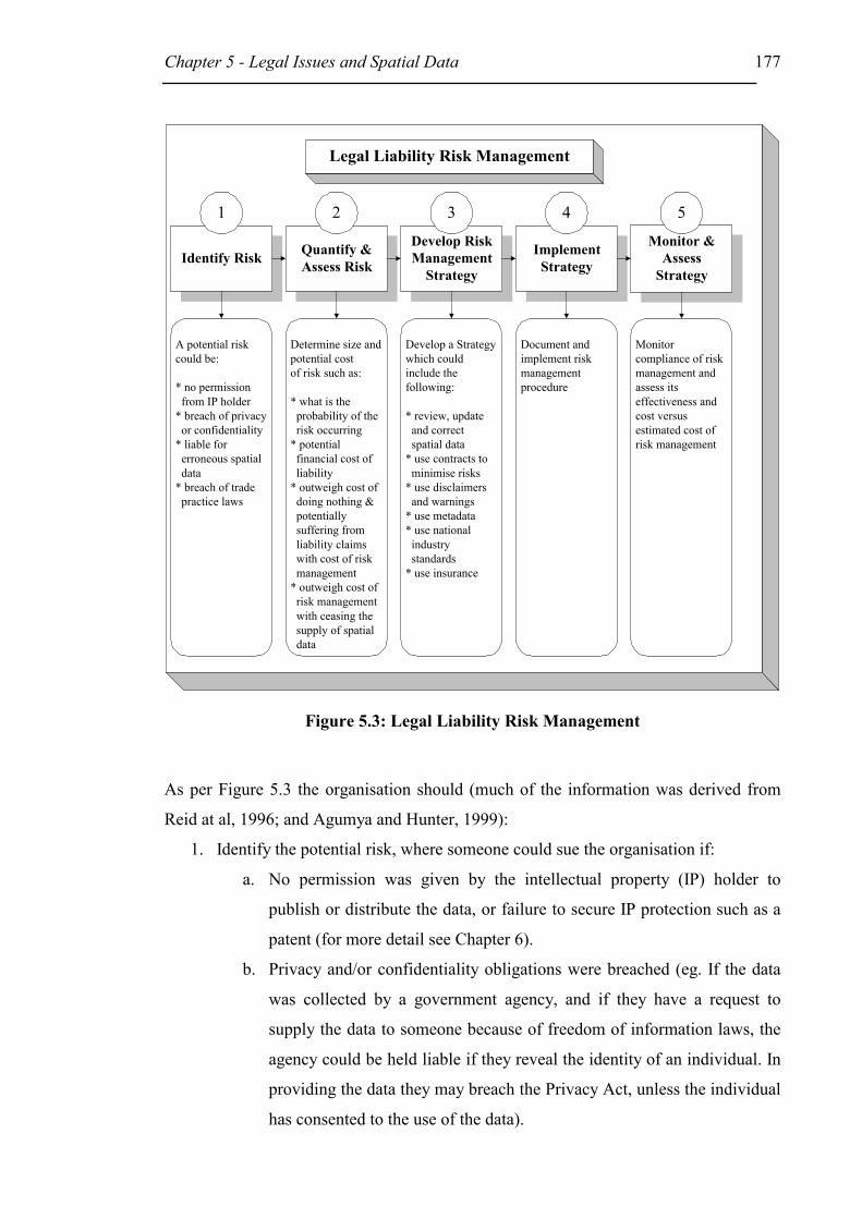
Chapter 5 - Legal Issues and Spatial Data 177
Identify Risk
Legal Liability Risk Management
Quantify &Assess Risk
Monitor &Assess
Strategy
ImplementStrategy
Develop RiskManagement
Strategy
A potential riskcould be:
* no permission from IP holder* breach of privacy or confidentiality* liable for erroneous spatial data* breach of trade practice laws
Monitorcompliance of riskmanagement andassess itseffectiveness andcost versusestimated cost ofrisk management
Document andimplement riskmanagementprocedure
Determine size andpotential costof risk such as:
* what is the probability of the risk occurring* potential financial cost of liability* outweigh cost of doing nothing & potentially suffering from liability claims with cost of risk management* outweigh cost of risk management with ceasing the supply of spatial data
Develop a Strategywhich couldinclude thefollowing:
* review, update and correct spatial data* use contracts to minimise risks* use disclaimers and warnings* use metadata* use national industry standards* use insurance
1 32 54
Figure 5.3: Legal Liability Risk Management
As per Figure 5.3 the organisation should (much of the information was derived from
Reid at al, 1996; and Agumya and Hunter, 1999):
1. Identify the potential risk, where someone could sue the organisation if:
a. No permission was given by the intellectual property (IP) holder to
publish or distribute the data, or failure to secure IP protection such as a
patent (for more detail see Chapter 6).
b. Privacy and/or confidentiality obligations were breached (eg. If the data
was collected by a government agency, and if they have a request to
supply the data to someone because of freedom of information laws, the
agency could be held liable if they reveal the identity of an individual. In
providing the data they may breach the Privacy Act, unless the individual
has consented to the use of the data).

Chapter 5 - Legal Issues and Spatial Data 178
c. The spatial data has errors, and if for example:
i. reliance on the spatial data causes harm;
ii. it is difficult to create the spatial data in the first place, meaning
that if the organisation had to use sufficient skill and judgement,
they are more likely to owe the user a duty of care;
iii. the standard of care is measured on detection and correction
procedures used by the organisation, if these do not exist the
organisation may be held liable for errors in spatial data;
iv. the provider receives significant financial benefit, it is more likely
that a duty of care applies; and
v. the organisation engages in misleading or deceptive conduct.
d. Breach of trade practice laws.
2. Quantify the risk by deciding how probable it is that a problem could occur.
What is the potential cost of suffering liability claims? Outweigh the cost of
doing nothing and perhaps suffering legal liability claims with the cost of
implementing risk management. Identify the benefits from the supply of spatial
data and compare them with the cost of implementing risk management
strategies.
3. Develop a strategy that can reduce, transfer, manage, and/or accept the risk.
However, if the cost associated with the risk is greater than the benefits of
continuing the activity, then that activity could be ceased. The strategy could for
example include the:
a. review, update and correction of spatial data
b. use of contracts to minimise risks
c. use of disclaimers and warnings
d. provision of metadata
e. use of national industry standards
f. use of insurance to limit or avoid legal risk
4. Document and implement risk management procedures.

Chapter 5 - Legal Issues and Spatial Data 179
5. Monitor compliance of risk management and assess its effectiveness and actual
cost versus estimated cost of risk management (Reid et al, 1996).
5.7 Conclusion
Liability exposure may be reduced through good communication, contracts and good
business practices, but can never be eliminated. Elimination of liability according to
Onsrud (1999) is neither possible nor desirable. The public and businesses need a way
to redress wrongs caused by relying on inaccurate or insufficient spatial data. Civil legal
liability arising from the use of inaccurate data may either be contractual or tortious
liability. Contractual liability requires privity while tort law requires proximity and not
privity. The examples in section 5.3.3 point out that not only errors in spatial data may
result in liability but also poor design and inappropriate use of spatial data. If the
creation of the spatial data required sufficient skill and/or the provider is the only
potential data provider, then the likelihood that a duty of care to others exists is greater.
The same applies if the provider received a sufficient amount of money for the spatial
data.
Using standards, such as technical and professional GIS standards, could reduce legal
liability. Technical standards are under development not only at local, national and
regional level, but also at the global level. At the national level the CSDC, ANZLIC and
ASDI are developing national standards in conjunction with bodies such as Standards
Australia for spatial data and metadata standards, and have, for example, produced the
policies on Custodianship and Metadata. At the global level the International
Organisation for Standardisation (ISO) and other global organisations are developing
global spatial data and metadata standards. Using detailed contracts and disclaimer
clauses as described above are also appropriate ways to reduce liability exposures. A
disclaimer, for example, would be very beneficial if used to point out the spatial data’s
intended or non-intended use and to safeguard the provider against third parties using
the data inappropriately.
The results of the survey indicate that either not many people are aware of the legal
liability risks involved when supplying spatial data, or liability claims happen very
infrequently. This may be because most liability claims are settled out of court and

Chapter 5 - Legal Issues and Spatial Data 180
usually no case studies or publication of the results are available to the public. However,
many organisations are aware of the risks involved, because 64% of all providers rely
on disclaimers, indicating the need to limit legal liability. As described in this chapter
the best way to limit liability is to implement a risk management strategy and monitor
its effectiveness.

181
Chapter 6 – Intellectual Property Protection of Spatial Data
6.1 Introduction
As described in the introduction to Chapter 5, an organisation supplying spatial data
must consider its legal risks when supplying spatial data to others and take appropriate
precautionary measures. In addition to these measures the organisation should be aware
of intellectual property rights held in their work and their obligations towards other
intellectual property right holders. Section 6.2 of this chapter describes Intellectual
Property Law, Sections 6.3 and 6.4 research intellectual property laws relevant to spatial
data such as patents and copyright. Section 6.5 addresses international and national
intellectual property reforms, while Section 6.6 gives a brief summary of the results of
the Spatial Data Survey related to intellectual property protection for spatial data.
6.2 Intellectual Property Law
Intellectual property is a collective term for the various legal rights vested in creations.
These rights, related to inventions such as computer software, are under statutory law:
copyright, circuit layout, patents, designs, trade mark, and plant breeder’s rights. Under
common law, intellectual property rights are extended to confidential information,
goodwill and commercial reputation.
The importance of intellectual property is well described by McKeough and Stewart
(1997, p.14) as:
“To the writer or composer or artist, their works may represent their livelihood,
while to publishers they represent potential profits. To industry, inventions
represent large investments of time and money - and the possible creation of
enormous wealth. To businesses generally, their reputation, their name and the
appearance of their goods represent their position in the market. Intellectual and
industrial stock in trade is just as important as buildings or other tangible
investments.”

Chapter 6 – Intellectual Property Protection of Spatial Data
182
6.2.1 Legislation
Following are the various intellectual property statutory regimes, under the legislative
responsibility of the Commonwealth Government, currently in force in Australia.
��Copyright protects the expression of information (ideas) but not the
information (idea) itself in an original work in material form. It applies
automatically, generally lasts for the life of the author plus 50 years and
is governed by the Copyright Act 1968 (Cth). Performers rights were
introduced in 1989 into the Copyright Act 1968 (Cth) in Part XIA.
They do not attract copyright as such because they are not fixed in
material form. The rights allow the performers to restrain or take action
against any unauthorised broadcast or recording of their performance.
��The Patents Act 1990 (Cth) grants patents for the exclusive right to
exploit an invention for a period of up to 20 years. In return the patent
holder (patentee) must publish details of the invention. However, for
example, one patent requirement is that if the patent details are published
before the application has been filed, the applicant has no right to gain a
patent. An application for a standard, or petty patent has to be made to
the Patent Office and depending on the commercial usefulness, novelty
and inventiveness they may or may not grant a patent. A standard patent
lasts for 20 years, a petty patent designed for appliances with a short
commercial exploitation lifetime lasts for up to 6 years.
��The Circuit Layouts Act 1989 (Cth) provides protection for integrated
circuit layouts (such as computer chips, silicon chip rather than stored
on floppydisc) and related purposes for up to 10 years in a copyright
manner.
��Designs, such as features of shape, article patterns that can be seen by
the eye, but that do not include construction methods, maps or plans, are
controlled by the Designs Act 1906 (Cth). In other words, design rights
protect the visual appearance of an article. The Act establishes a
registration system for designs of commercial products and a monopoly
may be granted for up to 16 years. Important issues may arise in
connection with the construction method or principle, which may qualify

Chapter 6 – Intellectual Property Protection of Spatial Data
183
for protection under the Copyright Act 1968 (Cth).
��Trade marks are signs including items such as names or labels; they
indicate the trader that provided a particular service or goods. In order to
gain registration under the Trade Marks Act 1995 (Cth) the proprietor
must use a mark that is distinct to his/her business and once registered
he/she is entitled to restrain another proprietor to use a substantial similar
or identical unregistered trade mark.
��The Plant Breeder’s Rights Act 1994 (Cth) provides for the granting of
proprietary rights to breeders of certain new varieties of plants and
fungi and for related purposes. The period of protection under the Act is
for 20 or 25 years and grants the breeder an exclusive right over their
varieties (McKeough and Stewart, 1997).
6.2.2 Common Law
Trade secrets and other confidential information may be protected against use by others
through the doctrine of breach of confidence (provided that information is confidential,
and has not been moved into the public domain). The same may be enforced by
contractual obligations of secrecy.
Goodwill between the agency and its clients may be protected by the tort of passing off.
This tort backs up and extends the trade mark protection by the Trade Marks Act 1995.
The tort of passing off establishes that it is unlawful for a person to “pass off”
something as being produced by him/her or being associated with something from
another person. Other important areas directly and indirectly impacting on intellectual
property are trade practices and fair trading legislation. These will not be considered in
this research.
6.2.3 Intellectual Property Law Administration
Intellectual Property policy making and administration is divided into 'Copyright' and
'Industrial Property'. Industrial property deals with such areas as patents, designs and
trade marks and is administered by IP Australia, a division of the Department of
Industry, Science and Resources (ISR). Copyright and Circuit Layout are administered

Chapter 6 – Intellectual Property Protection of Spatial Data
184
by the Attorney-General. There is no single Department responsible for policy making
in regard to overall intellectual property within the government. However the Federal
Government has established the Intellectual Property and Competition Review
Committee (IPCRC) in 1999, which is required to report on the effects Australia’s
intellectual property laws have on competition. The intellectual property rights to be
included are patents, trade marks, designs, copyright and electronic circuit layouts.
The Intellectual Property and Competition Review (IPCR) was established under the
Competition Principles Agreement, an inter-Governmental agreement that forms part of
the National Competition Policy (IPCRC, 1999). The IPCR Committee produced an
issues paper in September 1999 to stimulate public discussion. It examined the IP law
system and the National Competition Policy, and identified potential consistencies and
inconsistencies. Eighty written submissions were received with varying degrees of
complexity. The IPCR Committee decided to publish an Interim Report in April 2000 to
deal with identified issues within the terms of reference and they encouraged further
written comments (IPCRC, 2000). A final report on parallel importing under the
Copyright Act 1968 was submitted to Ministers on the 30 June 2000 and a final report
on all other matters on the 30 September 2000 (IPCR, 2000c).
The following two sections consider intellectual property rights relevant to spatial data,
such as patents and copyright, followed by an overview of international relationships
relevant to intellectual property, and IP law reforms nationally and internationally. The
last section gives a brief summary of IP question results from the Spatial Data Survey.
6.3 Patents
A standard patent (hereafter only referred to as patent unless otherwise specified), part
of the industrial property rights, gives the owner a monopoly generally lasting 20 years
(granted after 1 July 1995). Unlike copyright, that does not protect facts or information
itself, patents do. A patent gives its owner the right to legally enforce his/her rights to
exploit the invention. The patent regime is governed by the Patents Act 1990 (Cth) and
Patents Regulations, hereafter only referred to as the Act. The patent system is
administered by the Patent Office of IP Australia, a division of the Department of
Industry, Science and Resources (ISR) (McKeough and Stewart, 1997; IP Australia).
Chapter 6 – Intellectual Property Protection of Spatial Data
185
A patent may be granted for any new, inventive and useful device, substance method or
process. Certain creations cannot be protected using patents. These include artistic
creations, mathematical models, plans, schemes or other purely mental processes (IP
Australia, 1999).
Patents protect computer software methods that produce an artificially created end result
of economic utility (IP Australia, 1999). IP Australia explains that:
“the protection of such methods by correctly drafted patent claims means that
any “new” program, subsequently developed by another programmer, which
embodies those methods will still be an infringement of the patent.”
Usually if the software only produces the solution for a mathematical problem, the
software is not patentable. However if the software can be applied industrially such as
in the control of an industrial process in producing vulcanised rubber, it may be suitable
for a patent. Other patentable computer software examples are: software that is directed
to the operation of a computer for example to improve the speed of any parts, or
methods of electronic transactions, or the ability to monitor interactions of Internet sites
(IP Australia).
A patent cannot directly be used to protect information (McKeough and Stewart, 1997)
or spatial data. However if an information system or spatial data was used to develop an
industrially useful invention, it can become part of the patent protection for the
invention. An invention that provides an improved method and apparatus for producing
curved images in computer graphics displays for example has been patentable (IBM
Corp v Commissioner of Patents (1991) 22 IPR 417). In this case the Commissioner of
Patents refused a patent appeal on the grounds that the invention was not a “manner of
manufacture” and merely an algorithm that was not patentable. The plaintiff argued that
the invention involved more than an algorithm, because the production of the curve was
a product that when displayed was a physical thing having many uses. The Federal
Court of Australia upheld the appeal based on the finding that an algorithm was applied
to achieve the production of an improved curve image. The method of achieving that
was novel and inventive, and hence entitled the developers to the protection of the
patent laws.

Chapter 6 – Intellectual Property Protection of Spatial Data
186
Patent examples can be seen at the IPAustralia website, such as the patent information
about the Cochlear's Bionic Ear:
http://www.ipaustralia.gov.au/ip/examples/P_case2.htm.
Petty patents provide protection for small scale innovations such as small appliances
and accessories with a short commercial life. Protection period for a petty patent is a
maximum of 6 years, but it is much easier and cheaper to obtain than a normal patent. A
petty patent is accessed for novelty only in Australia rather than by international patent
standards (McKeough and Stewart, 1997).
Patents of addition may be obtained to protect improvements or modifications of the
original invention. If granted they will only last for the remaining period of the patent of
the original invention (McKeough and Stewart, 1997).
6.3.1 Obtaining a patent
If the information to be patented is published before the application for a patent, a patent
will not be granted. Hence, it would be advisable to use written confidentiality
agreements with involved parties such as employees, advisers or business partners (IP
Australia). Anyone may apply for a patent. However, the potential patent holder must be
either the inventor(s); be entitled to have the patent assigned to him/her (them); derives
title to the invention from either; or is the legal representative of a deceased person who
falls within one of the categories (McKeough and Stewart, 1997).
Processing of a Standard Patent Application only occurs if the applicant has filed a
patent request and the necessary accompanying documentation. A provisional
application, only describing the invention, is made where the applicant wants a ‘priority
date’ quickly. Thereafter the applicant has 12 months to lodge the complete application.
A complete application must fully describe the invention, include the best method of
performing it, and end with a claim defining the invention. Either lodging a complete
specification or a provisional application can lead to obtaining a priority date. If the
patent right is granted the priority date is the date on which the patent right starts
(McKeough and Stewart, 1997).

Chapter 6 – Intellectual Property Protection of Spatial Data
187
The examination of a patent application by a patent examiner will only occur if the
applicant makes a request to do so. For any creation to qualify for a patent, it must
comply with the Patent Act 1990 (Cth) requirements. The invention must be a “manner
of new manufacture” and must be novel and inventive. The acceptance of a patent
application is manifested in an advertisement in the ‘Australian Official Journal of
Patents, Trade Marks and Designs’. At the same time some documentation of the
application (creation) is made available to the public. Competitors can now examine the
application and oppose the granting of the patent within three months. The grant can
only be opposed on the following grounds: if the nominated person is not entitled to the
patent; if the invention is not a “manner of new manufacture”; or if the content of the
application does not meet statutory requirements. The Commissioner decides whether to
grant the patent or not.
When the Commissioner decides that the standard patent should be granted, the patent
will be sealed (granted). This must occur within 3 to 6 month of the acceptance
advertisement. The term of a standard patent is 20 years, prior to 1995 it was 16 years.
The start of the term is from the date the complete patent application including all
specifications was lodged. The relevant court or the Commissioner may revoke a patent
in part or fully (McKeough and Stewart, 1997).
6.3.2 National and International Requirements
For an invention to qualify for a patent it must be:
- A ‘manner of manufacture’, which is a legal term used to distinguish between
patentable inventions and non-patentable ones. McKeough and Stewart (1997,
p.294) interpret the meaning of ‘manner of manufacture’ as being the subject
matter of a patent claim that must have an industrial application and have been
invented rather than merely discovered;
- New;
- Be novel (new and not invented prior by someone else) and involve an inventive
step that is not necessarily obvious to someone within the field of the invention;
and
- Useful in that it will do what is claimed it will do (IP Australia, 1999).

Chapter 6 – Intellectual Property Protection of Spatial Data
188
To protect an invention internationally the same standard patent priority date can be
used for an application made overseas, if done within 12 months. There are two
different ways of applying for an international patent. The first is to apply directly with
the country or countries in which the patent(s) is (are) required. The other way is to
apply for an international patent and specify the required countries (IP Australia, 1999).
6.3.3 Ownership and Owner’s Rights
Exclusive rights given by the patent as defined in s13(1) of the Act, give the patentee
exclusive rights to exploit his/her invention or to assign these rights to another person.
“Exploit” is defined in the dictionary in Schedule 1 of the Act as:
“Exploit in relation to an invention, includes:
a) where the invention is a product – make, hire, sell or otherwise dispose
of the product, offer to make, sell, hire or otherwise dispose of it, use or
import it, or keep it for the purpose of doing any of those things; or
b) where the invention is a method or process – use the method or process
or do any act mentioned in paragraph (a) in respect of a product resulting
from such use;”
A patent may only be granted to the inventor, or a person assigned by the inventor or the
inventor’s legal representative. Ownership gives the patent holder the above exclusive
rights. As the inventor has the right to the patent and not necessarily his/her employer, it
may be necessary to have an employment contract defining the ownership of inventions
and assignment of any right to an invention made during the time of employment.
However, in the absence of a contract McKeough and Stewart (1997) state that courts
have tended to favour employer ownership, as long as the invention was derived as part
of the employees duties.
A patent right is part of a person’s property and can therefore be sold, leased,
mortgaged, given away or willed to another person. Exploitation of a patent is usually in
the form of licensing the use of the invention in other products for the return of a
royalty. A patent licence need not be in writing to be effective. The courts have
accepted implied licences for the public to use any product that incorporates a patent
invention (McKeough and Stewart, 1997).

Chapter 6 – Intellectual Property Protection of Spatial Data
189
6.3.4 Infringement and Remedies
A patent enables the holder of a patent to take action against others who have infringed
his/her exclusive rights such as making, hiring, selling, using or importing the invention
or authorise another person to do the same. Infringement occurs if any of the patent
owner’s exclusive rights have been breached.
Proceedings for Infringement may be started by the patentee or an exclusive licensee
and be heard by a court. Patent litigation is usually very costly and time consuming,
with an average typical cost of between $50,000 to $250,000, but can also be as high as
$1,000,000 (Prime Minister’s Science and Engineering Council, 1993 in McKeough and
Stewart, 1997). Remedies are set out in s 122(1). The courts may award the successful
plaintiff with an injunction against the defendant, and if so, choose either damages or an
account of profits.
Worldwide there are more than 30 million patents with about 7% of those in Australia.
Before applying for a patent it would be advisable to search the existing patents. The
overall estimated cost of a patent, including Patent Attorney fees is between $5,000 and
$8,000 and maintenance fees over a 20-year term are about $7,000 (IP Australia, 1999).
As pointed out above, a patent may not be granted for spatial data alone. However, if
the spatial data forms part of an industrial useful invention it can be protected as part of
the patent.
6.4 Copyright
This section on copyright presents firstly an overview of copyright as it applies to
spatial data, followed by an overview of current copyright law reform. The section does
not discuss copyright as a whole or ‘fair use’ of copyright, which relates to copying for
purposes such as teaching, research and study, but concentrates on specific copyright
issues related to spatial data as a map, or a database. This section also explores Internet
and digital problems, potential changes to the copyright legislation as recommended by
government advisory bodies, and national and international developments in copyright.

Chapter 6 – Intellectual Property Protection of Spatial Data
190
Copyright as part of Intellectual Property law offers legal protection over copyright
material to the copyright owner. Copyright can generally be defined as an exclusive
right to one’s own material, without fear that someone else will copy and/or use that
material unlawfully. Thus copyright is not a tangible property. The objective of this
section is to direct agencies in their assessment and use of spatial data copyright to
ensure that they will develop appropriate strategies. As the collection and maintenance
of spatial data is very costly it is important to consider what protection copyright can
offer for spatial data.
6.4.1 Copyright Basics
Copyright law in Australia is part of intellectual property law and the majority of it is
contained in the Copyright Act 1968 (Cth) (hereafter only referred to as the Act), with
its various amendments, and regulations, and in relevant court decisions that interpret
the Copyright Act 1968 (the common law). ‘Works’ and ‘subject matter other than
works’ enjoy copyright protection, if they are ‘original’ and satisfy other requirements
of the Act. The creator of the material enjoying copyright protection is classified as the
‘author’ and is usually the owner of the copyright.
Copyright in Australia is generally a right to profit from one’s own creation and is
meant to encourage development and to reward the creator for his/her efforts.
6.4.1.1 Material Protected by Copyright
Material that is protected by the Copyright Act 1968 (the Act) falls within one of two
classes, either ‘works’ or ‘subject matter other than works’. Works includes literary,
artistic, music, and dramatic works that must be expressed in material form, and other
subject matter covers broadcasting, cinematograph films, sound recordings and
published editions of works. A creation becomes a ‘work’ when it is first reduced to
writing or to some other material form (Section 22(1) of the Act).
There is no procedure required to gain copyright protection, provided the material falls
under the definition of the Copyright Act 1968 and qualifies for copyright protection.
However, it is advisable to note the widely recognised symbol of ©, date (year) of the
Chapter 6 – Intellectual Property Protection of Spatial Data
191
creation, and the name of the creator. This is required for protection in some overseas
jurisdictions under the provisions of the Universal Copyright Convention (UCC).
To better understand what is protected by copyright it may help to look at what
copyright does not protect. Generally these are ideas, facts, information, appearances,
and procedural information. Hence it is not for example the information that can be
protected, like names and addresses, but the form and expression of those.
6.4.1.2 Originality and Material Form
There is no need to be inventive to enjoy copyright protection, however the work must
be ‘original’ and the Copyright Council in its 1996 Guide Computer Software and
Copyright writes:
“... a computer manual is protected in the same way as a major novel, a drawing
of a piece of machinery is protected in the same way as a painting in the
National Gallery of Australia, an advertising jingle is protected in the same way
as the symphony.”
For a work to be ‘original’ it must have originated from its creator (called the author).
Furthermore a degree of skill, judgement and labour must have been applied and it must
not be a copy of someone else’s creation. It is not necessary for the material to be
inventive or novel. (Eldred, 1995)
In section 10(1) of the Act,
“‘Material form’, in relation to a work or an adaptation of a work includes any
form (whether visible or not) of storage from which the work or adaptation, or a
substantial part of the work or adaptation, can be reproduced;”
6.4.1.3 Expression of an Idea
Copyright protects only the expression of an idea and not the idea itself. McKeough and
Stewart (1997) describe the expression of an idea as ‘the form in which an idea is
clothed’. The point of expression of an idea versus the idea itself was made in
Donoghue v Allied Newspapers Ltd [1938] Ch 106. A journalist interviewed the
plaintiff about his racing career and this information was published in several articles.
The journalist also gained permission from the newspaper to publish condensed
Chapter 6 – Intellectual Property Protection of Spatial Data
192
versions in another paper. Donoghue, the interviewee, assumed he was the copyright
owner of the stories and that his copyright had been infringed. It was held that the
plaintiff only supplied incidents in his life, while the language was that of the
journalists. Hence the journalist was the author of the material in which copyright
subsisted and not Donoghue. Farewell J pointed out that there is no copyright in ideas
but in the particular form of language in which the information or idea is expressed.
6.4.1.4 Ownership of Copyright
The first owner of copyright in a work is the ‘author’ of that work (Section 35(2) of the
Act). The author is the person who puts information, facts, instructions or ideas into a
particular form. The person providing the idea (whether novel or not), but not the
expression, is usually not regarded as the author. The same applies to a mere scribe, that
person is not an author but the person dictating is.
Where two or more authors produce a collaborative work, with no possible separation of
each author’s contribution, each author will own an indivisible share of the copyright in
the work. No author may exercise the rights without the permission of the other authors.
(Australian Copyright Council, 1996)
Copyright in a work created by an employee (not a freelancer or independent
contractor), while carried out as part of the person’s duty of employment, is generally
owned by the employer. If the employer is the government, and if created under their
direction, the work will be owned by the government. It can sometimes be difficult to
determine which bodies are part of a government, especially where the creator of a
copyright work was a volunteer. In such situations it would be best to clarify copyright
ownership in an agreement. (Australian Copyright Council, 1996)
6.4.1.5 Materials created with the aid of computers
Where a work was created using word processing software, or an artistic work
(graphics, architectural plans, digital maps) using graphical software and a computer, it
is difficult to determine whether copyright applies. Firstly the work must be in material
form to be a work, further it must qualify for originality, which enables the attribution
of ownership, and ownership must be determined. What is the status of those three
requirements in a computer generated work? In Roland Corp v Lorenzo (1991) 22 IPR

Chapter 6 – Intellectual Property Protection of Spatial Data
193
245 at 252 Pincus J held that the text of a manual, created on a computer and saved onto
a disk, had been reduced to a material form. However it needed to be printed out to be in
‘material form’. If presented on the computer screen only it may not be classed as
material form.
In Autodesk Inc v Dyason (1992) 173 CLR 330; 22IPR 163, the majority of the judges
in the High Court said that a computer program would be ‘original’ if either the ‘set of
instructions’ are original or their expression are original. Originality can sometimes be
difficult to define and has a very low threshold. In computer software assisted work,
such as a digital map, produced by an operator without skill but with labour, the work
may not be ‘original’. If the digital map was however produced with enough skill,
labour and judgement it could be classed ‘original’.
The author, the potential copyright owner, of a work created with a computer is
generally the computer operator. However, if a new work is created through operating a
program or by using data gathered by another person, the operator may only claim
authorship if he/she has applied sufficient skill and labour. (Australian Copyright
Council, 1996) It is however difficult to determine what amounts to sufficient!
Works made by an expert system (called ‘computer-generated works’), like a
computerised satellite weather information system where no human intervention is
needed other than the initial programming, may not to be protected by copyright
because of the lack of originality. These works may generate their data remotely sensed
via satellite, and automatically analyse and display them as map images of vegetation,
geological formations or weather patterns. The United Kingdom protects these works
under the Copyright, Designs and Patents Act 1988 (‘CDPA’), which is the only
country so far to do so, by considering the ‘author’ as the person that has made the
necessary arrangements for the work to be created (Australian Copyright Council,
1996).
The Copyright Law Review Committee (1995) recommends an amendment to the Act
to include provisions for computer-generated material as a new form of subject matter,
and to define ‘computer generated’ as ‘generated by a computer in circumstances such
that there is no human author of the material’, and that the protection period is 25 years

Chapter 6 – Intellectual Property Protection of Spatial Data
194
from the end of the year in which the material has been made. The ‘author’ in computer-
generated material is the person who undertakes the arrangements needed for the
creation of the material. The CLRC recommended in its Draft report that the author
could be one of four parties.
a) the programmer or owner of the copyright in the programs that assisted in creation
of the work;
b) data provider;
c) computer/computer program user; or
d) computer/computer program owner.
6.4.1.6 Rights, Infringement and Remedies
The Copyright Amendment (Digital Agenda) Act 2000 (the CADA) became an Act
when it received its Royal Assent on the 4 September 2000. CADA is intended to
commence on 4 March 2001, unless proclaimed earlier. It amends the Copyright Act
1968 (Cth) to be in line with new communication technologies such as the Internet
(Attorney General’s Department, 2000b).
The Copyright owner of a literary, dramatic, musical and artistic work has the exclusive
right (set out in section 31 of the Act) to reproduce the work in material form, whereby
reproduction means photocopying, or making a computer readable digital version and
others. He/she also has the right to make the work available to the public and broadcast
the work or transmit it to subscribers. With the latest amendment act CADA, the right to
transmit the work to subscribers will be omitted and instead a technology neutral right
of ‘communicating the work to the public’ introduced. If the work is literary, dramatic
or musical, the copyright owner also has the right to perform the work in public and the
right to make an ‘adaptation’ (create a version) of the work. (Australian Copyright
Council, 1997). The copyright owner also has the right to sell or license his/her
copyright. In case the work is a computer program or a work recorded in a sound
recording, the owner can commercially rent the work
The duration of copyright is generally the life of the author plus 50 years (Section 33(2)
of the Act), however there are exceptions. For example, where the subject matter has
two or more authors, the duration is 50 years from the death of the last surviving author

Chapter 6 – Intellectual Property Protection of Spatial Data
195
(section 80 of the Act). If the work is not published while the author is alive, copyright
lasts for 50 years from the first publication (section 33(3) of the Act).
For certain purposes the user may qualify to use copyright material under the ‘fair
dealing’ provisions of the Copyright Act 1968 (Cth). These purposes include: for
research or study (s 40); reporting news (s 42); criticism or review (s 41); and giving
legal advice (s 43). The amount of copying is usually limited to no more than about one
chapter or 10% of the edition (whichever is greater). The CADA adds that the above fair
dealing provisions will apply to the new technology neutral communication right as
well. A newly introduced exception to the exclusive right of reproducing temporary
works will provide any Internet user with the ability to browse the Internet, thereby
obtaining copies of temporary works in the cache, without breaching copyright.
Infringement of copyright takes place when a protected work, or a substantial part
thereof, has been used in a way that is exclusive to the copyright owner, for example
reproducing or broadcasting a literary work without the permission of the owner. A
breach of copyright has also taken place when an unauthorised person authorises a
copyright breach.
Remedies that are available for infringement include injunctive relief and damages, or
an account of profits. If the infringement was commercial or involved distribution, then
criminal penalties may also be imposed. Damages include the loss in value caused by
the infringement, and/or loss of profit. Damages may also include punitive damages and
injury to reputation. To stop the importation of infringing copies of a work, Customs can
be notified (McKeough and Stewart, 1997).
6.4.2 Copyright of Maps
Maps, used by a variety of professions and the general public, are partly protected by
copyright, but which parts are often uncertain (Cho, 1995). According to the Australian
Copyright Council (1982), maps produced before the Copyright Act 1968 came into
effect, are protected as literary works under the Copyright Act 1911 section 204, and
can be copied under sections 49 and 50 (Jones and Prescott, 1995). Under the present

Chapter 6 – Intellectual Property Protection of Spatial Data
196
statutory Copyright Act 1968, maps can be protected as either literary work or artistic
work. Section 10(1) of the Act states that:
‘literary work’ includes:
a) a table, or compilation, expressed in words, figures or symbols (whether or
not in a visible form); and
b) a computer program or compilation of computer programs;
‘artistic work’ means:
a) a painting, sculpture, drawing, engraving or photograph, whether the work
is of artistic quality or not;
b) a building or a model of a building, whether the building or model is of
artistic quality or not; or
c) a work of artistic craftsmanship to which neither of the last two preceding
paragraphs applies;
but does not include a circuit layout within the meaning of the Circuit Layouts
Act 1989;
‘drawing’ includes a diagram, map, chart or plan;
A map can be a literary work, being the product of a compilation, or an artistic work,
being a drawing. A map will qualify for copyright protection if it fulfils the necessary
requirements as specified under ‘Copyright Basics’, no matter if the map is in hardcopy
or digital format. There are however uncertainties that can be demonstrated with the
help of some case law. The Copyright Act 1911 was applicable in the case Robinson v
Sands & McDougall Pty Ltd (1916) 22 CLR 124 (High Court) when maps were
protected as literary work under section 35(1) of the Act. The defendant had copied a
map belonging to the plaintiff but argued that the map was not an ‘original’ work
because it was created from pre-existing sources. Barton J considered the labour
involved in producing the plaintiff’s map and also the question of originality, and found
that a cartographer, applying his ability to produce a map presenting details differently
from previous maps, depending on the purpose it is used for, does enjoy copyright. The
word ‘original’ within sec.1(1) of the Copyright Act 1911 was found to mean ‘not
copied’, ‘not imitated’. Hence the plaintiff’s map was original for issues such as

Chapter 6 – Intellectual Property Protection of Spatial Data
197
appearance, size, style and draftsmanship and enjoyed copyright. The High Court
decided that the defendant’s map infringed copyright, because it had reproduced a
substantial part of the plaintiff’s original map. However the problem is knowing what
amount of information constitutes a ‘substantial part’ in a map. The court granted the
plaintiff an injunction, delivery of all copies of infringing maps, and an account of
profits.
As maps are pure graphical presentations of facts it is very uncertain if copyright applies
to the individual case. Following are two examples of where copyright did protect a
map. The first a case from the US Rockford Map Publishers Inc. v Directory Service
Company of Colorado, (1985) 768 F.2d 145 and the second from Australia Eagle
Homes Pty Ltd v Austec Homes Pty Ltd (1998) AIPC 91-385. The outcome for both
cases differs, because the situation in both cases is not alike.
Rockford Map Publishers Inc. v Directory Service Company of Colorado involved two
map publishers. Rockford, the plaintiff, claimed that Directory Service violated
copyright laws. Directory Service claimed that Rockford Maps were produced with little
effort and therefore their maps could not be copyrighted. Rockford’s maps show
location, size and ownership of parcels of land for rural counties. They start with aerial
photographs, trace topographical features onto their maps and use legal deed boundary
description (not in form of a map) to draw the boundary lines for each parcel of land.
Then the owner’s name is written inside the parcel and ownership changes are updated
from time to time. Directory Service used Rockford’s map as a template and compared
the information with official records, then drew their maps on a square grid without
topographical features. Rockford could tell that Directory Service used their maps as
templates because Rockford inserted traps into their maps. Out of 56 traps inserted into
various maps Directory Service copied 54. For example the maps below (Figure 6.1 &
Figure 6.2) include bogus middle initials along the column at 2400 E and read from top
to bottom spell Rockford.
This case was the first in the US District Court for the Central District of Illinois where
Baker J. found that copyright did exist in Rockford’s maps because they had searched
through the records and turned legal descriptions into maps. Directory Service maps
infringed Rockford’s maps copyright because they copied Rockford’s maps. Baker J

Chapter 6 – Intellectual Property Protection of Spatial Data
198
further said that for Directory Service not to infringe copyright they should have
assembled their own material as if there had never been a first compilation and then
used Rockford’s maps as a check on error only. He ordered Directory Service to turn
their material and maps over to the court, not to publish any more infringing maps, and
awarded Rockford statutory damages of US $250 and Attorney fees and costs of about
US $22,000. On appeal to the US Court of Appeals, Easterbrook J. upheld the decision
of the US District Court.
Figure 6.1: Rockford’s Map (Source: 768 F2d 145)

Chapter 6 – Intellectual Property Protection of Spatial Data
199
Figure 6.2: Directory Service’s Map (Source: 768 F2d 145)
Eagle Homes Pty Ltd v Austec Homes Pty Ltd involved two project home builders. The
plaintiff Eagle Homes claimed he owned copyright in the Floor Plans of two
‘Kookaburra’ homes, and that the respondent had breached Eagle Homes copyright by
advertising and building homes that were substantially similar to his own. The
defendant on the other hand claimed that no copyright existed in the ‘Kookaburra’
homes because they were not original artistic work. Further the defendant said he did
not reproduce a substantial part of the drawings. The Federal Court of Australia,
Branson J held that the ‘Kookaburra’ drawings were original artistic works and
copyright existed. The defendant’s work however did not infringe copyright because
project homes often contain common features. Branson J found that both Austec
Homes’s drawings did not amount to a reproduction of a substantial part and hence
dismissed the case. Below are architectural floor plans for one of the drawings involved
in this case. The ‘Kookaburra’ being one of Eagle Homes project homes and The
Paterson being one of Austec Homes project homes.

Chapter 6 – Intellectual Property Protection of Spatial Data
200
Figure 6.3 & 6.4 show the similarities in the two project home’s architectural plans.
Although they both are very similar, they do both contain many common features.
There are only certain logical positions for placing certain rooms.
Figure 6.3 & Figure 6.4: The Kookaburra and The Paterson project homes
(Sources: Advertising brochures from Eagle Homes Pty Ltd and Austec Homes Pty
Ltd)
Copyright protection becomes difficult if digital maps have been digitised from other
maps with third parties using the original maps and adding value to them. In this case, to
qualify for copyright protection ‘sufficient skill, labour and judgement’ must be applied
to the production of the derived data and if a substantial part of the original map was
digitised, the original map’s copyright owner approval may be necessary.
6.4.3 Databases
Databases in general, whether in digital form or in hardcopy form, may enjoy protection
under the Act defined as a literary work. It is difficult to determine whether a
compilation is original or not. The author must demonstrate that he/she has applied

Chapter 6 – Intellectual Property Protection of Spatial Data
201
some skill and labour in the selection and arrangement of the data to qualify for
copyright protection (Eldred, 1995).
Individual elements of a database may be protected by copyright if they qualify:
1. Individual records, like journal articles collated into a database. These may be
original themselves or substantial parts of original works.
2. Selection and/or arrangement of the data.
3. Material such as indexes not classified as entries, but that form part of the database.
4. Computer programs enabling manipulation of data in the database. (Australian
Copyright Council, 1996)
Data in a database may be protected separately from the program that uses it. This was
determined, but later overruled, in the case Data Access Corporation v Powerflex
Services Pty Ltd (1996) 33 IPR 194. In this instance, the court held that the error text
table in the software was not protected by copyright as a compilation. However, the
compression table in the software was protected by copyright as a ‘table’ (Australian
Copyright Council, 1996). In the same case, single words were each held to be a
computer program if they caused the computer to perform a specific operation
(McKeough and Stewart, 1997). The decision was overruled on appeal by the Full Court
(Powerflex Services Pty Ltd v Data Access Corporation, Federal Court of Australia, No
VG 295 of 1996, 4 June 1997, per Black CJ, Hill & Sundberg JJ). The Court held that
the words or commands used in Data Access’ Dataflex program were not themselves an
expression of a set of instructions, hence not a computer program as defined in Section
10(1) of the Act, and were therefore not protected by copyright. The Court also
overruled that the Powerflex program infringed copyright in the Dataflex macros, file
structures and function keys. However the court upheld the decision that the Dataflex
compression table was protected by copyright and Powerflex infringed the copyright.
Later still the case was appealed to the High Court and dismissed (Data Access
Corporation v Powerflex Services Pty Ltd, High Court of Australia, 30 September 1999,
[1999] HCA 49).
If copyright does exist in the data itself, the copyright in their compilation is separate
and can be held by another copyright owner. Furthermore, it is possible to enjoy
copyright in the compilation of computer programs, like those used in an operating
Chapter 6 – Intellectual Property Protection of Spatial Data
202
system, and separate for the individual programs as well. (Australian Copyright
Council, 1996).
It is difficult to determine in what circumstance copyright protection in databases would
apply because of the various interpretations in cases made by different courts. In
Sampson v Brokensha & Shaw Ltd (1935) 37 WALR 90 it was decided that copyright
did not apply to a compilation of prescribed forms. This also applied to Smith’s
Newspapers Ltd v Labour Daily (1925) 25 SR (NSW) 593 where it was held that a
listing of possible winners in horse races to be held the next day, was not covered by
copyright. In the case Fairfax (John) & Sons Pty Ltd. v Australian Consolidated Press
(1960) SR (NSW) 413 it was decided that copyright existed in a list of birth and deaths
announcements in a newspaper, while in Football League Ltd v Littlewoods Pools Ltd
(1959) 1 Ch 637, (1959) 2 ALL ER 546 it was also decided that copyright applied in a
chronological list of football match fixtures. (Eldred, 1995; Cho, 1995)
According to Karjala (1995), the arrangement, selection, and format in a database gives
the work sufficient originality. However, the more comprehensive the database (eg. as
in a compilation of various databases from different sources), the smaller the
opportunity to claim originality in the information’s ‘selection’ in the database. (Eldred,
1995)
If a compilation uses only insubstantial amounts of the original work, no copyright
infringement has taken place and the creator can enjoy copyright to the new work.
Under copyright law it is difficult to determine what amounts to a “substantial” part.
This is however crucial in determining whether copyright was infringed or not. There
are two rules to test for a “reproduction of a substantial part”:
1. Where a work does contain a markedly original feature this test applies to a
qualitative level even if the feature represents a very small portion of the overall
work, and
2. Where the work does not incorporate originality, the test applies to the amount that
has been copied, hence being a quantitative test (Stone, 1998).

Chapter 6 – Intellectual Property Protection of Spatial Data
203
6.4.3.1 Maps (as spatial databases) and Databases (attribute)
Maps can be considered as spatial databases. Spatial databases and attribute databases
are both classified as ‘databases’.
In the US, the courts like to use the ‘sweat of the brow’ doctrine to deal with databases
and prefer to reject the principles of the following Feist case. The ‘sweat of the brow’
doctrine refers to copyright owners labour in obtaining a compilation of facts that
should be recognised and protected. Feist Publications Inc v Rural Telephone Service
Inc (1991) 20 IPR 129 in the Supreme Court of the United States, is a case where the
Rural Telephone Service Company’s telephone directory was copied and added to,
without their permission by Feist Publications. Rural argued that their copyright in their
directory was infringed. However the court held that copyright protects the author’s
original expression, not the underlying fact or ideas. Factual compilations organised
alphabetically or by some other method lacking originality, are not protected simply on
the basis that it may take effort and expense to compile them. The ‘sweat of the brow’
doctrine, allowing protection for factual databases lacking originality, flouts basic
copyright principles by protecting underlying facts.
A similar case is Bell South Advertising and Publishing Co v Donnelly Information
Publishing Inc 999 F.2d. 1436, involving the copying of Yellow Pages in a telephone
book, where the outcome was very different. The court held that the plaintiff was
entitled to copyright in those elements of the work that demonstrated original
arrangement and coordination. In a case that involved maps, Mason v Montgomery Data
Inc 967 F2d 135 (5th Cir 1992), it was decided that those maps produced by the plaintiff
based on USGS maps and used, altered and modified by the defendant as part of its GIS,
did not enjoy copyright protection. (Cho, 1995) However the appeal court decided
differently and the court held, based on expert evidence, that the idea embodied in the
plaintiff’s maps could be expressed in a variety of ways, and that the selection process
was applied skilfully, and it was held that copyright subsisted in the plaintiff’s map.
Professor Karjala points out the problems with copyright in maps in his paper Copyright
in Electronic Maps (Karjala, 1995). He comes to the conclusion that the Feist case
caused great uncertainty in the US courts and the lower courts are trying to avoid the
legal implications that the case has. However he believes that the courts cannot, in the

Chapter 6 – Intellectual Property Protection of Spatial Data
204
long term, follow the strict copyright principles and the somewhat contradicting Feist
case. Eventually he thinks that we will see a diffusion of ‘originality’ in a work from the
extent that copyright protection offers, and this will agree with the ‘sweat of the brow’
theory.
It can be difficult to determine the copyright owner in a spatial database. This is
especially so, if the data originates from firstly digitising another map, then collecting
and adding spatial data, then reformatting, and then adding other providers datasets
(Cho, 1995). Digitising an original map is a form of reproduction and hence the
permission of the original map’s copyright owner is necessary. Then for a map to
qualify as a work it must be in material form. Secondly, it is necessary to demonstrate
some amount of skill, judgement and labour to qualify for originality. It is important to
add sufficient new material that has been selected skilfully to qualify for originality.
Thirdly, for the creator of the work to enjoy the ownership rights and hence be classified
as the ‘author’, it is necessary that the creator has demonstrated that the material
originated from him/her.
To demonstrate authorship can become difficult if one considers that the added data was
probably collected by a machine with human selection skill intervention, then perhaps
downloaded into the computer and manipulated. So, is it the data collector that enjoys
the ownership or the manipulator? If a machine did the collection and manipulation and
the images are automatically displayed there may not be enough ‘originality’ in the
creation itself, but in the computer software manipulating the creation. However the
CLRC made some suggestions in regards to that issue. This is discussed above under
the heading ‘Materials created with the aid of computers’. If the person who collected
the data demonstrated enough skill, judgement and labour to qualify for ‘originality’,
and if the same applies to the person who manipulated the system, and to the computer
software programmer, then all three will (if their material qualifies for copyright) have
separate copyright protection. If the work is the result of a collaborative effort, where
the individual authors contributions cannot be distinguished, the work will be a work of
‘joint authorship’.

Chapter 6 – Intellectual Property Protection of Spatial Data
205
6.4.4 Digital Agenda and the Internet
The Internet, a “network of networks” (Cavazos, 1994, p.4), includes various tools such
as electronic mail (e-mail), the world wide web (www), File Transfer Protocol (ftp),
Internet Relay Chat, Bulletin Boards, Newsgroups and others. The www and e-mail are
some of the most widely used facilities of the Internet (De Zwart, 1997, p.181) and they
are the main ones considered here.
With any material published on the Internet using the www or e-mail the question
arises: How are and will intellectual property rights be protected? Publications on the
Internet vary greatly from advertising to academic research papers. The Internet can be
used to transfer that information between users in different countries with various
jurisdictions. Any publisher and user of material on the Internet should therefore be
aware of implications derived from copyright law and general practice of using the
Internet.
Various actions have been taken against people and companies that have infringed
intellectual property law on the Internet. Cases dealing with infringement of intellectual
property law on the Internet include misuse of trademarks (MTV Networks v Curry,
1994) and challenging the process of linking between websites (Washington Post Co v
Total News Inc, 1997). More details of the last case is given later under the heading:
‘Screen displays and Hyperlinks’. The commonality in the above cases is that they all
attempt to re-shape the copyright law in regard to
“exclusive right of reproduction, transmission to subscribers to a diffusion
service and cable programming right to on-line content.” (Hughes, 1997).
Copyright applies to digital data transferred via a communication device, for example
the Internet, the same way as it does to paper copies of data. However, many Internet
users ignore copyright owner’s rights by copying or downloading their intellectual
property (Burley, 1996, p.26).
6.4.4.1 Internet Implications
Copyright infringement has taken place when any of the copyright owner’s exclusive
rights have been breached, for example the right to reproduce the work in a material
form or publish the work on the Internet. The storing of text on a floppydisc is a

Chapter 6 – Intellectual Property Protection of Spatial Data
206
reproduction and therefore a breach of copyright, unless the copyright owner’s
permission was obtained or the action falls under ‘fair dealing’. The same applies to a
printout of part of the work as long as that part is a substantial part of the work. A
substantial part is not necessarily a quantity measure but rather a quality one. Thus if the
reproduced part has no ‘originality’ it will most likely not be a substantial part of the
work and therefore not protected.
One implication for the Internet is that if a work has been downloaded and stored on
harddisc or floppydisc, an infringement has occurred, unless the copyright owner’s
permission was obtained or specified, or the amount was insubstantial. Before
displaying Internet material on a screen using a browser, that material is usually stored
in cache memory. At the present time, it is possible that this incidentally stored material
in cache constitute reproduction and hence infringement. However to qualify for
reproduction under copyright law the material must be in material form, and it is
arguable whether a temporary copy is in material form. The Copyright Law Review
Committee (CLRC) recommends exclusion of temporary copies protection under
copyright (Copyright Law Review Committee, 1995). This exclusion is now included in
the CADA (Attorney General’s Department, 2000b)
Any material once published on the Internet cannot simply be removed without being
copied, manipulated and plagiarised by any number of anonymous Internet users
anywhere in the world (Burley, 1996). There are even archives that take snapshots of
the Internet, because the average life expectancy of a document is only 75 days
(Henninger, 1998; Kahle, 1997; Internet Archive, at <http://www.archie.org>). The
Internet by nature therefore encourages the breach of copyright laws and both creators
and users of works available on the Internet should be cautious.
6.4.4.2 Publishers of Internet material
A publisher of copyright material on the Internet must either be the copyright owner or
have acquired the right to publish the material by licence or assignment. It may be
difficult to determine the author to a dynamic work, used in a GIS, that has been
compiled from existing copyright material, and from new material produced by a GIS.
In this situation, the copyright in the original individual material will stay with the
copyright owners. However, the GIS configuration as a compilation may qualify for

Chapter 6 – Intellectual Property Protection of Spatial Data
207
copyright protection and belong to the compiler. Any newly created material produced
by the GIS technology may also qualify for separate copyright, and will most likely
belong to the GIS analyst that customised the procedures to create that new material. If
the altered version incorporates a substantial part of the original then permission to use
the original is needed.
Altering digital material will require the permission of the copyright owner, if for
example:
• The original material was reproduced;
• The altered version is an adaptation; or
• The altered version reproduces a substantial part of the original (Australian
Copyright Council, 1997, p.13).
A list of links may be protected as a compilation, whereby the individual items of that
list would properly not qualify for copyright protection. A list generated by an Internet
search engine should be permissible to copy because that list was not created by a
person but a program, while a list created by an individual who applied some creativity
would not be permitted to copy because of the skill and labour applied.
Internet publishers who would like to warn users, from copying or downloading the
publishers material, should take necessary precautions by inserting clear notices as to
what Internet users are permitted to do with the material. A publisher may rely on
copyright by placing the Copyright symbol ©, year of the creation, and the name of the
author (s) (or owner (s) of copyright), including a note as to what users are allowed to
do with the material. To further restrict access, technological measures such as
encryption to inhibit downloading and/or printing may also be used.
6.4.4.3 Users of Internet material
In general if the copyright owner publishes copyright material on the Internet it can be
implied that the material is freely available to be browsed, but not necessarily to be
copied or downloaded. As a guide, if there is an expressed licence to do certain acts,
these should be followed. A particular site may also be published in a way that clearly
implies permission to print or download material. Otherwise, unless the use falls under

Chapter 6 – Intellectual Property Protection of Spatial Data
208
‘fair dealing’, the copyright owner’s permission is needed to print, download or
distribute the material to others.
6.4.4.4 Screen displays and Hyperlinks
Screen displays in the United States are protected under copyright law. In Australia,
however, that protection is unlikely because screen displays do not exist in material
form, one of the requirements of copyright law. In Germany the display on a screen may
constitute publication of the work and therefore the data is protected under copyright.
Hence it is important to keep in mind that various jurisdictions have different rules.
It is assumed by some people that Hyperlinks do not require the consent of the ‘to be
linked to site’. This view however may be inappropriate in some jurisdictions as can be
seen in the dispute between Shetland Times and the Shetland News (Scotland Times Ltd
v Wills, Scot Sess-Case 1996). Here both parties agreed that the News could only
hyperlink to the Times on the condition that each News link was featuring a logo and an
attribution (Henninger, 1998). Another case on the same issue
“involved an action by a major media organisation such as CNN, the
Washington Post and Time magazine against a web based news clearing house
(Washington Post Co v Total News Inc). This case was settled and the terms of
the settlement included signing a link licence, setting out the terms under which
a website can provide a link to another website” (Hughes, 1997).
6.4.5 Licences
Any intellectual property (IP) right such as a patent, or a copyright work can be dealt
with in the same way as any other tangible personal property. It can be assigned,
licensed, sold, included in a will, mortgaged or given away.
A patent or a copyright work owner may exercise their exclusive rights or permit others
to use those rights. This permission is classified as a licence and may be granted with
certain provisions such as the payment of a fee or royalty. Licensing is not a transfer of
ownership, but rather a use-right. Altering of the work by the licensee may be restricted
by the licensor, which is not possible with an assignment. The licences may be either
exclusive or non-exclusive or implied. The exclusive licence grants specified rights to

Chapter 6 – Intellectual Property Protection of Spatial Data
209
the licensee with special privileges that will not be granted to any other person. The
licensee has similar rights as the copyright owner has, for example to sue another person
for breach of an exclusive use.
Non-exclusive licences permit the licensee to exercise one or more of the IP owner’s
exclusive rights in a work, the same rights may or may not be granted to more than one
person. The licensor can grant the licence for a specified period and grant more than one
non-exclusive licence.
An implied licence in case of a copyright work may for example, be the use of
architectural plans after the architect’s engagement is terminated (McKeough and
Stewart, 1997, p.179). If the public wants to buy and use a product that incorporates a
patented invention an implied licence can be assumed.
Assignments may be limited or full, and once granted, ownership of the specified rights
is transferred. Once a full assignment has been made by the assignor the whole
copyright vests with the assignee. A limited assignment results for example in a separate
copyright for the purpose of being limited to one or more exclusive rights and/or a
particular place and/or time.
Exclusive licences and assignments must be in writing and signed by the copyright
owner. There are also two statutory licensing schemes that permit otherwise infringing
acts to be done on payment of a royalty fee. One is a full record keeping scheme, while
the other calculates an actual royalty based on the number of people potentially using
the licence.
Where copyright exists in a published book it is usually the publisher who has the
copyright assigned by the author. The publisher then deals with the commercialisation
of the book and usually pays the author royalties on the books sold. To gain permission
to take photocopies of a published literary work a licence from the Copyright Agency
Limited (CAL) should be obtained (Attorney-General’s Department, 1997, 2000a).
CAL is an Australian not-for-profit copyright collecting agency. Their role is to collect
fees on behalf of copyright owners by licensing the copying of works to the general
public.

Chapter 6 – Intellectual Property Protection of Spatial Data
210
Where the works are exploited by being played on air or photocopied it is difficult to
detect and impractical for users to pay the owners. This task is generally left to
copyright collecting agencies. These are usually non-profit organisations that license,
collect and distribute royalties on behalf of the copyright owners, only taking out the
administration costs. These societies will also represent copyright owners in litigation
cases where their member’s rights were infringed. In Australia these societies act on
behalf of the copyright owners in the areas of musical and literary works, and sound
recordings and film.
6.4.6 Managing Copyright in Information
6.4.6.1 Copyright belonging to the organisation
The management of copyright material held by an individual organisation involves the
identification of intellectual material, protection, commercialisation, record keeping and
monitoring infringements of copyright (Some of the material in section 6.4.6 was
compiled from information contained in: Department of Commerce and Trade WA,
1997; and from consulting work undertaken by the researcher for the NSW Government
in 1998 and printed here with their permission).
The relevant director or manager of an organisation and staff should be aware of their
agency's intellectual property and their exclusive rights to copyright material. They
should also be aware of the use of licenses in conjunction with selling their copyright
material, be aware of royalty collecting agencies and evaluate any risks associated with
making any claims against people infringing their copyright.
Identify and Check Type of Intellectual Property Material - The broad nature of
identification may imply that nearly all information that is created through human
endeavour in an organisation could have copyright protection applied to it. The
widespread use of copyright protection may therefore need to be matched to the
business and commercial objectives of any organisation. The commercial potential of
material may need to be identified as it may affect the type of intellectual property
protection that should be used. Note that patent and registered design protection cannot
be sought if the material has been moved into the public domain.

Chapter 6 – Intellectual Property Protection of Spatial Data
211
Once the intellectual material has been identified it should be protected by taking
advantage of the most suitable intellectual property protection. If a form other than
copyright is to be used, expert legal advice should be sought.
Protect the Material - To ensure copyright protection place on the material:
• a copyright symbol ©,
• year of the creation of that material, and
• name of the owner
It may also be advisable to give a notice in a conspicuous position that specifies the
circumstances when material can be copied.
Commercialise the Intellectual Property - An organisation may expect to collect
revenues from the use of their copyright material. Revenues can be generated from
direct sales or from royalties paid to a licensor, often calculated as a percentage of net
sales by the licensee. Licensing and collection of royalties can be administered by
organisations such as the Copyright Agency Ltd (CAL). However, the
commercialisation of material is broader than revenue collection and can be divided into
marketing, selling and licensing, which fall outside the scope of this research. It is
advisable to obtain expert commercial advice in these areas.
Record Keeping - In order to prove the ownership of copyright it is advisable to
archive an original copy of the material being protected. It may also be advisable to
keep a database of information relating to copyright material. The database could
include information such as creation of material, duration of protection, licenses, sales
and agreements.
Monitoring Infringement - Staff responsible for information should monitor the use of
that information by third parties. Responsible staff need to be aware of what constitutes
infringement and should know the appropriate action to take if infringement occurs. If
the organisation is registered with the Copyright Agency Ltd (CAL) most of the
copyright administration will be carried out by that organisation, which includes
collecting royalties, manage licensing, monitor copyright infringement and deal with
legal enforcement of copyright on behalf of its members.

Chapter 6 – Intellectual Property Protection of Spatial Data
212
Enforcing Copyright - Various steps are available for enforcing Copyright protection.
However, negotiation should be the first step in enforcing any privileges. Legal
enforcement of copyright is available and includes injunctive relief and damages, or
account of profit, and in some circumstances even criminal penalties may be imposed.
6.4.6.2 Copyright belonging to others
Managing other organisation’s copyright involves being aware of when that person’s
(organisation’s) copyright has been infringed. Staff in any organisation should be aware
of Copyright law requirements and what constitutes infringement. Procedures should be
put in place so that staff are not put in a position where they need to infringe copyright
to undertake their duties. Hence staff should be able to identify copyright material,
apply rules of infringement and negotiate the use of copyright material with others.
Identify Copyright Material - The ownership of Material used by an organisation
should be readily identified so that staff do not infringe copyright. The obvious
indicator of copyright is the presence of the copyright symbol, author and date of
authorship. However, any material that has been authored with 'a degree of skill,
judgement and labour' can in principle have a Copyright claim over it.
Apply rules of Infringement - Staff need to be aware of what constitutes copyright
infringement. It may be advisable to have in place an organisational structure that
identifies and records the use of copyright material so that the appropriate royalties can
be paid to the copyright owners. For some organisations this will be a requirement of
registration with for example the Copyright Agency Ltd (CAL).
Negotiate Use - The use of material that has Copyright protection needs to be
negotiated with the Copyright owner. In some cases, the owner will need to be
contacted directly. If the material is registered with Copyright Agency Ltd (CAL)
royalties may be paid through the (CAL).
Chapter 6 – Intellectual Property Protection of Spatial Data
213
6.5 International and National Intellectual Property Law Reforms
6.5.1 International
Australia’s intellectual property law reform is heavily influenced by international
organisations and agreements. These include the World Intellectual Property
Organisation (WIPO) and the Trade Related Aspects of Intellectual Property Rights
(TRIPS) agreement.
WIPO is an international inter-governmental organisation aiming to promote the
protection of intellectual property throughout the world through cooperation among
States. The Organisation is a member of the United Nations family of organisations.
WIPO's three main functions are:
1. Progressive development of international intellectual property law and technical
standards;
2. Assistance to developing countries; and
3. International protection registration systems.
Australia is a member of WIPO and a signatory to many WIPO international
agreements. These agreements require signatories to adjust their national IP laws to be
broadly compatible with the agreements. There are however no formal mechanisms to
force signatories to adhere to the agreements. WIPO agreements set minimum standards
rather than prescribing optimal forms of IP protection (IPCRC, 1999, p.7).
Two new treaties were developed in 1996, the WIPO Copyright Treaty (WCT) and the
WIPO Performances and Phonograms Treaty (WPPT). WCT adds to the 'Berne
Convention' of 1886, the major international copyright treaty for the protection of
literary and artistic works. These new treaties are direct responses to the issues raised by
digital technology. To enter into force, however, they each require ratification from 30
countries. As of the 15 October 2000, the Australian Government had not signed or
ratified these two treaties (WIPO, 2000), but has taken considerable action to support
the treaty’s aims. Computer programs (in whatever form) and databases (compilations
of data or other material) are included by the WCT as two subject matters being
considered as intellectual creations (IPCRC, 1999, p.33).
Chapter 6 – Intellectual Property Protection of Spatial Data
214
Apart from WIPO, the most important agreement in regard to international property
protection is the TRIPS agreement of 1 January 1995. This agreement created new rules
for the General Agreement on Trade and Tariffs (GATT) to protect intellectual property
and to govern disputes. The World Trade Organisation (WTO) was formed to oversee
the new regime of trade rules and to administer effective dispute resolution. As
Australia is a party to the WTO it had to adhere to the TRIPS agreement by 1 January
1996 (IPCRC, 1999, p.8).
The Internet, not owned by anyone, is governed by various societies that try to provide
standardisation and regulation. One of those is the Internet Society (ISOC), an
international group of researchers, users and academics that determine the network’s
infrastructure standards (Henninger, 1998, p.28). From an overall legal point of view
there are no regulations dealing with the Internet on an international basis. ECLIPS -
Electronic Commerce Law and Information Policy Strategies initiated by Charlie
Bender, Director of Ohio Super Computer Centre has however formed the Internet Law
and Policy Forum (ILPF) in order to develop policies on Internet usage (Sharpe, 1996,
p.1).
ILPF is sponsored by the major commercial organisations of the Internet and is a non-
governmental forum. It is addressing issues, which are otherwise difficult to solve on a
national level. These issues are intellectual property, security, privacy, taxation,
electronic payment and transactions, digital records management and transactions,
jurisdiction, taxation and the resolution of Internet disputes (Sharpe, 1996, p.1-3). There
are also some other international, regional and national bodies trying to develop the
legal framework for the Internet.
The Global Information Infrastructure Commission (GIIC) is an independent, non-
government initiative that was inaugurated in July 1995 at a meeting hosted by the
World Bank. They have been established because of the gap created by traditional laws
meeting the challenges of the Internet. The body’s aim is to cooperate with existing
bodies like the ILPF, WIPO and to force global cooperation between the private and
public sector in regard to the development of information, networks and services to
advance global economic growth education and quality of life. The focus is on the
Chapter 6 – Intellectual Property Protection of Spatial Data
215
following areas: Commerce, Health Services, Education, Publishing, Banking and
Finance (Sharpe, 1996, p.4).
The Organisation for Economic Co-operation and Development (OECD) is a Paris-
based inter-governmental organisation, with Australia being one of its members. The
purpose of OECD is to provide its 29 members with the ability to co-operate with each
other in order to achieve the highest sustainable economic growth in their countries and
improve the economic and social well-being of their populations. OECD advises its
members in order to help them develop policies. Their activities in the area of Science
Technology and Industry for example include the Forum on Internet Content Self-
Regulation held on the 25 March 1998 in France. One hundred and fifty participants
including several legal experts attended and discussed issues in the area of Internet
content self-regulation. An important theme was identified as the need for ongoing
education in Internet content self-regulation: of users, parents, teachers, and children
about using and taking responsibility for their use of technology; of policy makers; of
the business community; and finally of law enforcers. Their plans for 1998 were to
begin reviewing the progress of the individual member’s regulatory reform.
6.5.2 Australia
The need to approach law reform as a whole is being undertaken by the Australian Law
Reform Commission (ALRC, a). This Commission inquires into and reports on laws
referred to it by the Federal Attorney-General. It was established by the Law Reform
Commission Act 1973 with the aim to review and consider proposals for the systematic
development and reform of the law (ALRC, b). One of their responsibilities is to
examine issues of trade, intellectual property, and regional regulatory harmonisation
(Sharpe, 1996, p.5). Another review body, established by the Australian Federal
Government in 1999, is the Intellectual Property and Competition Review Committee
(IPCRC). The IPCRC had to review and report on the effects Australia’s intellectual
property laws have on competition. The IP rights to be included were patents, trade
marks, designs, copyright and electronic circuit layouts. The final reports were
submitted to Ministers in June and September 2000 (IPCR, c).
Chapter 6 – Intellectual Property Protection of Spatial Data
216
In the area of copyright law reform there are two bodies that make recommendations as
to how valid the copyright protection is at the present time. These bodies are the
Copyright Law Review Committee (CLRC) set up in 1983 to make recommendations to
the government on Copyright issues including Computer Software Protection, and the
Copyright Convergence Group (CCG) established in early 1994 to investigate copyright
use in the area of broadcasting and other electronic transmissions.
In October 2000, there are draft Copyright Amendments being passed through
parliament, which may be introduced later in 2000. The drafts are the Copyright
Amendment (Importation of Sound Recordings) Bill 1999, and the Copyright
Amendment (Moral Rights) Bill 1999 and they were introduced into Parliament on the
26 May 1999 and 8 December 1999 respectively (Attorney-General’s Department - e-
news, 2000; Parliament of Australia). The latest Copyright Act 1968 amendments are
being made by the Copyright Amendment (Digital Agenda) Act 2000 (the CADA),
which received its Royal Assent on the 4 September 2000 and will commence on the 4
March 2001. The CADA is concerned with digital problems, but the unresolved area of
databases is not being touched (Australian Copyright Council, 1997; IPCRC, 1999).
The CADA was a direct response to the World Intellectual Property Organisation
(WIPO) Copyright Treaty and WIPO Performances and Phonograms Treaty. There
were also two other recent international events that influenced Australia’s Digital
Agenda Bill. The passing of the Digital Millennium Copyright Act by the US Congress
in October 1998 and the adoption of a Directive on the Harmonisation of Certain
Aspects of Copyright and Related Rights in the Information Society by the European
Parliament and Council in May 1999 (Parliament of Australia).
The CADA will update copyright law with the focus to continually promote creativity
and at the same time allow reasonable access to digital copyright material by users. The
major changes of the CADA to the Copyright Act 1968 are:
• A technology neutral right of communication to the public: for example the new
right applies to works made available on the Internet, as well as works
transmitted or broadcast to the public; converting material from hard-copy to
digital copy and vice versa will also be covered by copyright.

Chapter 6 – Intellectual Property Protection of Spatial Data
217
• Exceptions, such as temporary copies via the Internet will be exempt from
copyright protection.
• Enforcement measures such as provision of civil remedies and criminal
sanctions against the manufacture and dealing in devices such as decoders
unlawfully, but not in using them by copyright owners.
• Carrier and ISP liability – to limit and clarify the liability of carriers and service
providers such as Internet Service Providers (ISP) for any copyright
infringement by its users.
• Retransmission of free-to-air broadcasts – provision of a statutory licence
scheme for the payment of remuneration to the right holders whose works are
contained in the retransmitted free-to-air broadcasts.
• Issues recommended by the CLRC.
• Review in three years to ensure that the appropriate balance between copyright
owners and users is maintained (Attorney-General’s Department - e-news,
1999a, b; Parliament of Australia)
6.5.2.1 Databases
Non-original databases according to the Australian Copyright Council are commercially
valuable, but are not the result of human skill, judgement and labour and therefore not
protected by copyright. GIS databases will either fall under the definition of ‘original’
or ‘non-original’ and may either qualify for protection under copyright as a compilation
or not. Copyright Act 1968 amendment recommendations were made by the CLRC in
1995 in its Computer Software Protection - Report. The CLRC recommends that
protection be afforded to “computer-generated material” as a new class of subject matter
other than works and the definition of the term computer-generated be added to the Act.
The author should be the person by whom arrangements necessary for the creation of
the material are undertaken. Term of protection should be 25 years from the end of the
year in which the material was made.
WIPO’s new approach to developing international standards for copyright protection led
to the establishment of the Standing Committee on Copyright and Related Rights
(SCCRR). The first meeting of SCCRR was held in Geneva in November 1998. In

Chapter 6 – Intellectual Property Protection of Spatial Data
218
regard to a possible new international protection for databases the SCCRR agreed that
WIPO should commission a study of the economic impact of such a protection on
developing countries (Attorney-General’s Department - e-news, 1999a). A second and
third meeting of SCCRR in Geneva in May 1999 and November 1999 respectively had
on its agenda possible additional protection for databases not protected by copyright,
but no progress was made. The fourth meeting was held in April 2000 in Geneva, but
databases were not on the agenda. European Countries in the European Community
(EC) have the EC database directive that provides protection for non-original databases,
while the USA has no agreement on the issue with several different bills being in
Congress (Attorney-General’s Department - e-news, 1999b).
In the EC original and non-original databases are protected under the Directive 96/9/EC
as of 31.12.1997. Both type of databases are protected under copyright and a bundle of
sui generis rights. The creation in the selection and arrangement of a database
(structure) is protected by copyright. If a database was established needing a lot of
work, money and effort it is protected by sui generis rights which do not extend to the
individual data items (SCCRR, 1998, p.7,8).
In Belgium no copyright was infringed when elements were extracted from a collection
of maps for inclusion into a geometrical database involving the process of vectorisation
(SCCRR, 1998, p.5). The US, as mentioned previously under maps, relies partly on the
‘sweat of the brow’ protection, affording copyright protection for non-original
databases, but only if sufficient skill, knowledge, labour, taste or judgement have been
applied. In Australia contractual protection is available, however a contract cannot be
extended to a third party outside the contract, and contractual protection would most
likely be insufficient on a global scale.
6.5.2.2 Digital data and computer screen issues
One requirement of copyrightable material is that it must be in material form, but as
mentioned previously it is debatable whether or not digital data is in material form
because it is not like a book or CD. It has the ability to move around without being
stored or printed, easily altered, or deleted. However if stored on a disk, according to the
case Roland Corp v Lorenzo (1991) 22 IPR 245, the digital data is in material form. It
should however be noted that the item was not part of the appeal, as pointed out in the
Chapter 6 – Intellectual Property Protection of Spatial Data
219
report at (1992) 23 IPR 376 (Australian Copyright Council, 1997). Viewing of or
listening to material on the computer may be copyrightable, because copyright applies
to various other non material forms, for example the screening of a film, performance of
a play or broadcast of music, outside the home (Australian Copyright Council, 1997).
The drawback for a GIS is that data used at home copied via the Internet may be
difficult to copyright. Material disseminated in form of a book or a videotape, is
copyrighted in such a way that when used in public the copyright owner’s permission is
needed, whereas when used in private it is not. So, permission is needed if screening a
film in a cinema, but not if viewing as a video at home (Australian Copyright Council,
1997). In the past, data had to be stored on discs to be sold, while now with e-mail or
the world wide web (www) these can be easily disseminated using the Internet to
everyone’s home. The view of the Australian Copyright Council (1997) is that where
copyrighted material is published, it is the responsibility of the person who makes the
material publicly available to get the permission to do so from the copyright owner.
Private use in the past occurred only on a small scale and it was largely commercial
users such as radio stations, clubs and television stations that greatly benefited from
playing music to the public and therefore only commercial users needed permission
from the copyright owner to play their music (assuming this attracted more people,
because of the additional atmosphere the music provided). However, habits such as
taping music or television material, or copying computer discs by private users has
become harmful, and in response, many countries applied levy fees on blank recording
material such as videotapes.
The displays on a computer screen should not be regarded as a reproduction in material
form, hence no copyright protection would apply, but this point is unclear. The
Copyright Law Review Committee (1995) recommended an amendment to the
Copyright Act 1968 in this regard to make it clear that screen displays do not constitute
a reproduction in material form. The CLRC also recommends that the Act be amended
to provide that the screen displays of a work stored in computer memory will not
constitute a public performance of that work.
Chapter 6 – Intellectual Property Protection of Spatial Data
220
WIPO’s international treaties specify that the reproduction right as set out in Article 9 of
the Berne Convention applies to digital material, and to the storage of a protected work
in digital form. Therefore it is up to the individual countries to deal with the
reproduction right issue (Australian Copyright Council, 1997). The EC’s overall view is
that permanent storage of digitised material is generally a reproduction. This also
applies to transient storage. Canada left it up the individual copyright owner as to what
part of their work they allowed users to browse through. Australia’s new CADA adds a
new exception to the exclusive right of reproduction. In the new exception, browsing or
viewing material on-line will not be breaching copyright.
6.6 Survey
Following is a brief summary of the Spatial Data Survey described in Chapter 3 related
to Intellectual Property protection used by spatial data providers. The Survey discovered
that there are more spatial data providers (out of all the providers) that do not use legal
protection for their spatial data, than those that do rely on a particular intellectual
property right. Out of the ones that do, the most commonly used intellectual property
right was copyright. When dividing the overall respondent group into four subgroups of
federal -, state -, and local government departments and all other providers, their
percentages for not using any legal protection were 21%, 25%, 57%, and 48%
respectively. Clearly the group least likely to seek intellectual property protection
through intellectual property rights such as copyright are local government departments,
followed by the all other providers subgroup. The four subgroup’s reliance on copyright
was 57%, 54%, 29%, and 41% respectively.
When the user respondents were asked the same question, what legal protection their
spatial data providers rely on, it was discovered that majority of spatial data providers
used copyright and/or licences. This was not surprising, because some users used the
same datasets, as opposed to all available datasets supplied by all providers, which were
used less frequently. The data users of the four subgroups of federal -, state -, and local
government departments and all other providers answered that 7%, 9%, 12% and 16%
respectively of data providers use ‘no legal protection’, while 43%, 46%, 52%, and
54% respectively use ‘copyright’ and 71%, 70%, 66%, and 50% respectively use
‘licences’. This could be an indication that the datasets referred to by spatial data users

Chapter 6 – Intellectual Property Protection of Spatial Data
221
were not necessarily the same datasets as the ones provided by the overall group of
providers. It is also very likely that some datasets are being used by many more users
than other datasets.
6.7 Conclusion
6.7.1 International Issues and the Internet
With such a variety of international agencies such as the Internet Law and Policy
Forum, Global Information Infrastructure, and Organisation for Economic Co-operation
and Development all developing policies with part of their agenda being intellectual
property law, and the World Intellectual Property Organisation aiming to promote the
protection of intellectual property throughout the world, it is difficult to determine
which policies will convey more benefits. The general perception is that the World
Intellectual Property Organisation’s definition of Intellectual Property is the most
globally accepted. However, in today’s age the harmonisation of intellectual property
laws has been driven by the desire to facilitate international trade. The TRIPS (Trade
Related Aspects of Intellectual Property Rights) agreement enables that combination of
intellectual property rights and trade.
In Australia, national bodies such as the Australian Law Reform Commission, the
Intellectual Property and Competition Review Committee, and the Copyright Law
Review Committee through their discussion papers and reports are trying to coordinate
national laws with international treaties. They are also endeavouring to deal with the
difficulties of making them relevant to delivery systems such as the Internet. Revisions
to international treaties take a long time and enforcement of intellectual property law on
an international level is also difficult.
On a national level it is important that Australia’s various industries that rely on some
form of electronic communication collaborate to enable the development of uniform
laws, regulations and standards in the area of intellectual property law and security.
Rather than forming new bodies, industries in Australia including the spatial data
industry, should join existing organisations such as ILPF or GIIC. Meanwhile it would
be best for most Internet users to put the copyright symbol, creator and year of creation

Chapter 6 – Intellectual Property Protection of Spatial Data
222
(and perhaps a copyright statement) on their intellectual creation. If creators do not want
it copied by unauthorised people they must either not use the Internet (eg. www and e-
mail) or use encryption devices.
Copyright applies to digital data transferred via a communication device (the Internet)
just as it does to any other paper copy, even though many Internet users ignore
copyright laws (Burley, 1996). Some people may assume that Hyperlinks do not require
the permission of the ‘to be linked to site’. This view may be false as evidenced in the
case Washington Post Co v Total News Inc 97 Civ 1190 (SDNY Feb 20 1997) (US). In
Australia the law on this issue has not been settled.
Developers and users of Internet material should be aware of:
1. International and national standards and regulations;
2. Their own exclusive rights and obligations under copyright law;
3. The security risks to information being transferred via the Internet, and where
appropriate take the necessary precautions to protect it, for example, by using
encryption; and
4. Hyperlinks to other sites may require the site owner’s consent and Meta-tags must
not breach laws such as trade marks law.
6.7.2 Australia
Intellectual property law rights such as patent law and copyright law may apply to
spatial data. However, it is difficult to predict in what circumstances. At present only
‘original’ databases can be protected under copyright legislation. In future, a separate
protection right such as the EC’s sui generis may be made available for non-original
databases.
Any organisation using and supplying information to others should manage their own
copyright and not infringe others. The management of the copyright material held by the
individual organisation involves the identification of intellectual material, protection,
commercialisation, record keeping and monitoring infringements of copyright.
Managing other organisation’s copyright involves developing procedures that will
prevent staff from breaching copyright and should include: identification of copyright

Chapter 6 – Intellectual Property Protection of Spatial Data
223
material; application of rules of infringement; and negotiation of the use of copyright
material with others.
Copyright, by its very nature, is an option requiring no formalities, generally lasts for
the life of the author plus 50 years, and can be used to protect maps, and databases.
There is however a problem with being able to forecast the decisions of the courts and
hence it is impossible to know which maps or databases are protected by copyright. In
many instances it may be a good idea to use some other additional protection. Future
new legislation may also provide further protection.
Works called ‘computer-generated works’, like a computerised GIS, where no human
intervention is needed other than the initial programming, appear not to be protected by
copyright because of the lack of originality. It is recognised that the ‘author’ of such a
work is the person that has made the necessary arrangements for the work to be created.
However, at present there is no case law to clarify the status of such computer generated
work, but the CLRC (1995) recommends for Australia to include a computer-generated
work as a new class of subject matter other than those existing works in the Act.
A map can be a literary work, being the product of a compilation, or an artistic work,
being a drawing. A map will qualify for copyright protection if it fulfils the necessary
requirements as specified under ‘Copyright Fundamentals’, no matter if the map is in
hardcopy or digital format. When new maps are created using copyrighted material,
with the owner’s permission, and are then enhanced, the new version should be
copyrightable if the enhancement involved sufficient skill, judgement and labour. The
protection of databases and their data is still a very controversial area, because it is
difficult to interpret the various cases decided by different courts.
The computer screen is used as a display media for digital work. One question in regard
to copyright is whether or not the computer screen can be classified as material form.
Further if it is used in a public place, does copyright infringement occur, and if so, who
is liable (Australian Copyright Council, 1996)? At present the answers to these
questions are unclear. However, the Copyright Law Review Committee (1995)
recommended an amendment of the Copyright Act 1968 to elucidate that a ‘screen

Chapter 6 – Intellectual Property Protection of Spatial Data
224
display’ is not a reproduction of a work stored in computer memory, nor a public
performance of it.
In a GIS pure data (facts) may be spatial or aspatial (for example demographic data).
Both spatial and aspatial data in this case do not qualify for copyright protection
because copyright only protects the ‘expression of a fact’ and not the fact itself. The
more creative the features of style or colour of maps are, the more likely that copyright
protection applies. However, what use is that protection if it only applies to the colours
chosen and not to the much more labour intensive surveying and plotting of boundaries
and contours? Karjala (1995, p.405) writes:
“Whether or not the preparation is costly or time consuming, the value of many
maps inheres in the factual information they contain and not in clever ways of
presenting that information.”
Copyright therefore may not protect commercially expensive components of GIS
databases and outputs.
The results to the Spatial Data Survey indicate that certain subgroups and those more
frequently used dataset providers rely more heavily on intellectual property protection
than others. In particular federal government departments and state government
departments were relying on copyright more than local government agencies and all
other organisations subgroups. Within the more frequently used datasets provided by
only a small group of providers, the overall reliance on ‘copyright’ and/or ‘licences’
(51% ‘copyright’, 63% ‘licences’ and 12% ‘use nothing’ (see Figure 3.38)) were much
higher than if provided on average less frequently (39% ‘copyright’, 30% ‘licences’,
and 46% ‘use nothing’ (see Figure 3.19)). To conclude, the survey results show that
specific data provider groups and individual organisations need more education on
intellectual property protection. They have no clear IP policies, and/or their overall
philosophy towards their spatial data differs to other providers. However, if an
organisation decides to legally protect their spatial data, all of the above-discussed
issues are very relevant and have far reaching implications in terms of intellectual
property protection.
225
Chapter 7: Spatial Data Policy Issues and Strategies
7.1 Introduction
As the thesis pointed out in Chapter 1 the purpose of this research is to compare current
spatial data policies and develop future strategies with the aim to facilitate SDI
development in an Australian context. An organisation intending to develop a spatial
data access policy should consider and prioritise all issues involved. This will then be
the basis for the development of the strategy. Firstly Chapter 7 puts forward a list of
policy recommendations and secondly it applies the findings of the thesis and the
Spatial Data Survey to determine the priorities for various levels of Government and
private industry, for developing strategies for access and pricing policy issues in
Australia. Thirdly examples are given that demonstrate how organisations deal with
policy issues and to relate the developed priorities to real examples. Finally policy
development theory and specific policy evaluation are described followed by a
simplified example.
7.2 Access and Pricing Issues and Recommendations
As could be expected, the Spatial Data Survey in Chapter 3 confirmed that a high
proportion of organisations in Australia not only provide spatial data but also use other
organisations’ datasets. This point is important when developing an access and pricing
policy, because these organisations should include cooperation arrangements for
transferring data between organisations in their policy.
As described in Chapter 4, spatial data access and pricing policies can cover many
issues, including:
• SDI requirements;
• Technical issues;
• Governmental / organisational duties;
• Ownership / custodianship;
• Legal liability, contracts and licences;
• Intellectual Property Law;

Chapter 7: Spatial Data Policy Issues and Strategies 226
• Economic analysis; and
• Spatial data users’ choices, rights and obligations.
All of these eight issues were described and analysed throughout the thesis. Following
is a brief summary of these issues and/or a recommended approach to their resolution.
7.2.1 SDI requirements
Chapter 2 of this thesis determined that although the individual elements and the
developments of many Spatial Data Infrastructures (SDIs) are different, they are all
faced with similar problems. These problems include, but are not limited to, inconsistent
or unsatisfactory standard adoption and insufficient or poor documentation of quality of
spatial data. Access and pricing of spatial data is often inconsistent, and many
organisations seem to lack awareness of SDIs and do not foster data sharing at all.
Unresolved legal issues such as potential legal liability risks associated with spatial data
and non-harmonious jurisdictional intellectual property protection of spatial data also
provide barriers to the SDI development. To overcome some of these problems, SDI
developments have to be implemented by both top-down and bottom-up approaches. All
levels of Government, the private enterprise and community groups should be involved
in the SDI development process. The already developed guidelines by ANZLIC and the
CSDC should be adopted where possible, but there is room for improvement. This
improvement will come in the form of feedback about problems associated with
implementing, managing and maintaining those policies. Therefore the development of
an SDI will be dynamic and the result of many individual policies and practices, and
will be potentially influenced by ANZLIC and CSDC policies. ‘SDI requirements’ from
the SDI perspective and not the individual policy perspective are therefore as follows:
• Organisational - a new or existing organisation, with relevant representatives,
needs to be responsible for the SDI initiative; leadership of such an organisation
should be at an appropriate level; the organisation has to develop SDI priorities
in conjunction with all potential user and producer groups, then implement and
monitor those priorities; and the organisation has to develop training and
education strategies for human resources necessary to manage and operate
SDIs.

Chapter 7: Spatial Data Policy Issues and Strategies 227
• Technical - Technical issues that need to be included when providing access to
spatial data or data sharing include standards, metadata, transfer protocols,
security issues and clearinghouses. SDI implementation requires common
standards including metadata and transfer protocols. Security measures to
protect providers’ data from manipulation and provide secure access to the user
need to be available. A clearinghouse needs to be able to link to any other
clearinghouse or spatial data directory.
• Governmental/Organisational Duties – these duties include their legal,
political, and national security obligations.
• Ownership/Custodianship – it would be advantageous if ownership or
custodianship rights and obligations are the same, but if not they must be clearly
defined.
• Privacy and Confidentiality - providing access to spatial data may put the
individual person’s right to privacy at risk, hence clear privacy laws are
necessary that are in harmony at all jurisdictional levels. There must also be
clear guidance on what constitutes confidential information, and what
information will have to be provided under the Freedom of Information
legislation.
• Legal Liability, Contracts and Licences – Legal liability concerns may be so
great that it stops potential data providers from sharing their data, hence clear
guidelines are necessary that spell out risks and their management. Contracts
and licences may also be used to manage legal risks and to define users and
providers rights and obligations.
• Intellectual Property Law – Harmonising laws are necessary on issues such as
intellectual property to give data providers the same legal rights to their spatial
data in all jurisdictions.
• Economic Analysis – SDI development requires funding from the various SDI
users and spatial data pricing should be low and consistent.
• Data management – Data management guidelines should define how to
collect, record, edit, analyse, manage, and maintain and store spatial data or
how value can be added to existing data. Definitions of quality in spatial data
and how to catalogue and file databases should also be included.
Chapter 7: Spatial Data Policy Issues and Strategies 228
• Outreach, Cooperation and Political Mandate – Marketing and promoting
spatial data and SDIs are key issues in fostering market growth, ensuring better
utilisation of spatial data and SDIs and will lead to greater awareness and data
sharing. Cooperation amongst agencies and Government support at high levels
are also necessary to further develop and direct SDIs into a future where spatial
data will become a necessity in managing sustainable development and greatly
aid economic growth. Hence financial support is needed for these objectives.
• SDI Users’ Choices, Rights and Obligations – If ANZLIC and CSDC
custodianship guidelines are adopted, SDI users’ rights and obligations are
defined, but if not, or insufficiently defined, user guidelines should be added.
• Common access and pricing policies are necessary that encourage data
sharing and access, and low spatial data pricing strategies should be used
where possible (=individual organisations’ policies).
Individual organisations’ spatial data access and pricing policies are necessary in SDI
development as the policies form part of the Infrastructure. These individual policies
however can sometimes pursue different goals than SDI development. For example:
• Access and pricing – An organisation may need to rely on an income from the
distribution of its spatial datasets to meet operational running costs, whereas for
an SDI to function, the data needs to be easily accessible with little or no
limitations. Hence no cost or low spatial data prices are required. A fee set too
high may be considered as restricting access.
• Sharing – A private organisation may not be interested in sharing its spatial data
with others because it is commercially confidential and if shared, will give
competitors the same advantages and ideas. For an SDI the more datasets that
are available for sharing, the better the range of datasets for different
applications.
Recommendation:
Despite the reluctance of some organisations to share data, to enable the incorporation
of SDI requirements into a spatial data policy, it is recommended that an organisation
should (as defined in Chapter 2 and extended with the results of the thesis):
• Use ANZLICs custodianship guidelines;
Chapter 7: Spatial Data Policy Issues and Strategies 229
• Use common ASDI standards, technology standards and metadata guidelines
and feed back any problems to standard organisers;
• Use ASDI technology and access network (Clearinghouse) for displaying or
using data and maintain access to own data;
• Use government policies, guidelines and laws where applicable;
• Provide security for the spatial data user;
• Use fundamental datasets if needed by the organisation;
• Collect, maintain and update spatial data appropriate for its intended use and of
high quality consistent with national spatial data specification;
• Promote data sharing and access, and use of high quality data;
• Store and index spatial data appropriately and consistently with national
specifications;
• Determine the prices of spatial data to be low and consistent in accordance with
state or national policies or guidelines;
• Use appropriate legal risk management and copyright strategies as described in
Chapters 5 and 6;
• Promote spatial information and SDIs or support their promotion; and
• Be aware of new spatial information and SDI developments.
7.2.2 Technical Issues
An important area covered in the thesis and in the spatial data survey was metadata.
Although the provision of metadata includes more than technical information, this
research considered the provision of metadata as part of standards and hence technical
issues. As described in Chapter 4 metadata describes the characteristics of a dataset and
includes quality and access statements.
Metadata – specifically data quality
As discovered in the Spatial Data Survey, many organisations are aware of metadata
and are supplying it to other organisations. The metadata question in the survey aimed
to determine what additional data providers supply with their data. The choices were:
Accuracy, Maintenance, Updates, Disclaimer, Metadata, Depends on Dataset, Nothing,
and Other. From the results of the survey, more providers rely on disclaimers (50%)
Chapter 7: Spatial Data Policy Issues and Strategies 230
than on the actual elements of metadata (34%). These percentages indicate that the
awareness of the metadata concept is not as great as could be hoped for, it is too costly
for organisations to provide metadata, and/or core metadata elements are not available
for the individual datasets. Although most of the choices in the survey question are
elements of metadata, the question did not aim to discover the actual awareness of
spatial data users and providers as to what core elements are part of metadata and which
individual ones they supply, but whether they are aware of the metadata concept and
whether they supply it.
Interestingly, when looking at the answers to the questions on legal issues, such as what
disclaimers data providers relied on and what main areas their disclaimers covered, the
research discovered that most disclaimer areas cover the same issues as core metadata
elements do. This indicates that most metadata elements could not only help to
introduce a common standard defining the usefulness and reliability of a dataset, but
also provide the data provider with a protection from third party liability claims as
described in Chapter 5, if the metadata can be used as a contract. This issue should be
further investigated in future research.
Metadata – Access (data available in what format, and access restrictions)
The survey questionnaire asked respondents to specify what technical access they
provide to their datasets. Interestingly, the majority of spatial data was still being
supplied as hardcopy over the counter or by mail (83%), followed by storing the data on
floppy disc (60%), e-mailed (48%) or stored on CD-Rom (46%). There were however
some organisations that commented on wishing to implement ‘down-loading’ and
‘viewing only’ via the World Wide Web in the near future. In addition, the survey was
undertaken between October to December 1998 and the situation could have changed
since then. However, this thesis and other current and former research indicate that there
is usually not a technological reason why organisations do not supply their data on the
Internet, but other unresolved issues such as:
• Lack of use of standards and lack of high quality data (including metadata);
• Lack of willingness to share data with others in digital form (part of
organisational issues, as briefly explained in Chapter 4);
• Lack of adequate spatial data access and pricing policies;

Chapter 7: Spatial Data Policy Issues and Strategies 231
• Unwillingness to follow SDI concept consistently;
• Lack of awareness and policy in many government agencies, education and the
private enterprise with regards to privacy, intellectual property protection, and
legal liability risks;
• Lack of awareness and policy on security of spatial data on the Internet;
• Lack of awareness on the economic values of datasets.
Recommendation:
The importance of standards and metadata has been pointed out in this research, and
hence in order to overcome the above problems, and enable data to be more easily
supplied and applied, it is recommended that an organisation should:
• Consistently use and comply with all relevant standards.
• Collect metadata for spatial datasets, consistent with ANZLIC metadata
guidelines, and update them;
o If more detailed metadata is required, that metadata should be collected
consistently for the whole organisation and follow internationally
supported standards (ed. Nebert, 2000);
• Provide metadata;
o so that the metadata can form part of the Australian SDI,
o it can be included in the Australian Spatial Data Directory (ASDD), and
o it can be included when spatial datasets are transferred.
• Supply metadata for inclusion in the ASDD.
7.2.3 Governmental / organisational duties
An organisation must adhere to statutory and political obligations when developing
access and pricing policies. In addition, government departments may need to proceed
with caution when developing access and pricing policies. Prices set too high may be
interpreted as limiting access, while if set too low, the public may interpret it as the
organisation neglecting their duty to take care of the public trust. A medium-pricing
regime may be the most appropriate for a governmental department. As the statutory
and political obligations vary for different States/Territories, and government agencies,
and private sector organisations in Australia, no list of recommendation is provided
here.
Chapter 7: Spatial Data Policy Issues and Strategies 232
7.2.4 Ownership / custodianship
It may be irrelevant whether private or government organisations assume custodianship
or ownership to the spatial datasets in their care. Whatever the case may be, clear rights
and obligations of the data provider and the data user must be defined.
Recommendation:
It is recommended that an organisation should:
• Decide on assuming ownership or custodianship for the data in their care;
• Follow ANZLIC custodianship guidelines; or
• Define clear provider and user rights and obligations.
7.2.5 Legal liability issues and legal risk management strategies
Anyone may be sued for legal liability, whether they have done something wrong or
not. However, knowing the rights of the organisation and effective ways to manage
liability exposure will help prevent claims. Before developing a legal liability
prevention strategy, an organisation should firstly analyse the potential risks and
develop strategies to limit those potential risks. The next steps include the
implementation and the evaluation of such strategies.
Recommendation:
It is recommended that an organisation should:
• Identify, quantify and assess its legal risk;
• Develop risk management strategy, such as
o Develop appropriate review, update, and correction strategies for its
spatial data,
o Use contracts to minimise risks,
o Use disclaimers and warnings,
o Collect and supply metadata,
o Use national standards,
o Take out insurance cover;
• Implement the strategy;

Chapter 7: Spatial Data Policy Issues and Strategies 233
• Monitor and assess this strategy.
7.2.6 Intellectual property protection of spatial data
Any organisation using and supplying information to others should consider managing
their own copyright, but must not infringe the copyright of others. Spatial databases
may be protected by copyright. However, there are uncertainties as to what types and
elements of a database will qualify for copyright protection. Although copyright does
not require any formalities to exist in Australia, it is best to specify that it is copyright,
the copyright owner, when the work was created and what the user is allowed to do with
the dataset. This is important, not only to notify users that copyright exists, but also for
copyright to apply internationally. As it is difficult to predict the decisions of a court as
to whether copyright applies, or whether a breach of copyright took place, it is best to
rely on some additional protection, such as licences and contracts and/or other means of
technical protection to prevent unauthorised copying.
The management of the copyright material held by the individual organisation involves
the identification of intellectual material, protection, commercialisation, record keeping
and monitoring infringements of copyright. Managing other organisation’s copyright
involves identifying copyright material, applying rules of infringement and negotiating
the use of copyright material with others.
Recommendation:
To manage intellectual property and copyright of data owned by an organisation, that
organisation should:
• Identify intellectual material and determine with the help of some criteria, such as
measuring the potential commercial value, whether to protect the information at all.
If the decision is yes, determine the best means of protection such as copyright, but
also check whether the material actually qualifies for protection;
• Apply protection to intellectual property, which in the case of copyright involves
displaying:
o the copyright symbol on the spatial data,
o the date (year) the spatial data was created,
o the creator’s name (if employee, the company name he/she works for), and
Chapter 7: Spatial Data Policy Issues and Strategies 234
o a clear statement specifying what a user is permitted to do with the spatial data.
• Be aware of potential rights and obligations
• Develop marketing, licensing and selling strategies
• Keep records of the intellectual material
• Monitor and negotiate infringement
In addition, an organisation must not infringe someone else’s rights. Staff in any
organisation should be aware of Copyright law requirements and what constitutes
infringement. Procedures should be put in place so that staff are not put in a position
where they need to or happen to infringe copyright to undertake their duties. Hence staff
should be able to identify copyright material, apply rules of infringement and negotiate
the use of copyright material with others. In addition to copyright, an organisation may
use contracts, licences, request royalties or other means of technical protection.
If an organisation decides not to rely on copyright protection, the least they should do is
to add disclaimer statements to all their spatial data, specifying for example, the spatial
data’s intended use, and scale to minimise potential legal liability claims.
7.2.7 Economic analysis
A study commissioned by ANZLIC determined that the economic gain from data usage
was about 4:1. Therefore, for every dollar spent on producing spatial data, $4.00 income
was generated. Hence an organisation developing a access and pricing policy need to
consider these financial benefits of spatial data, but also take into account the
advantages of data for environmental protection and preservation.
Recommendation:
When an organisation determines a pricing policy it is recommended that it should:
• Decide on the importance of the sale of spatial data to the organisation and
consider other advantages of the data such as its application for the protection of
the environment.
• Determine the pricing of the dataset, using cost, value or market driven pricing
o Cost - the actual cost of producing the data can include the collection,
display, manipulation and maintenance of the dataset.
o Value – difficult to determine, but depends on demand.

Chapter 7: Spatial Data Policy Issues and Strategies 235
o Market - the price can be based on whatever the market will bear.
• Consider pricing that differs for different users and/or uses
o a public user could pay less than a private user; as well if the data are
being used for non-commercial purposes it should cost less than if it is
used for commercial purposes.
• Decide on the pricing of a dataset after considering all questions, which may be
one of the following rates:
o No charge.
o Less than full cost recovery, based on an appropriate criterion such as
cost of supply.
o Full cost recovery.
• The data may be priced higher if it is high in quality and densely covers a
specific area, and priced low or at no cost if it is low of quality, but perhaps
covers a larger area.
• Decide on how much the organisation needs to recover and determine the
likelihood of selling the data.
7.2.8 Spatial data users’ choices, rights and obligations
As a taxpayer, a spatial data user may have the view that he/she has a right to free
access to government held information. However, it may not be in his or her best
interests to gain free access to the data, because the dataset may lack quality and
accuracy.
Recommendation:
It is recommended that an organisation providing spatial data must:
• Provide clear statements and warnings with their dataset to inform the user of
his/her rights and obligations as to what he/she is allowed to do with the dataset.

Chapter 7: Spatial Data Policy Issues and Strategies 236
7.3 Spatial Data Policy Definition
As pointed out above and in Chapter 4, an organisation providing spatial data should not
only consider the above eight issues when developing access and pricing policies but
also in addition the following four (briefly discussed in Chapter 4):
• Organisational issues;
• Privacy and confidentiality;
• Data management; and
• Outreach, cooperation and political mandate.
Hence, based on the previous Chapters 2, 3, 4, 5 and 6 priorities can be constructed to
meet an individual organisation’s needs, as well as broader ‘SDI requirements’, as given
in Section 7.2.1. As the thesis is heavily based on the Spatial Data Survey these
priorities have not been tested in this research. Future research should focus on
individual case studies analysing their access and pricing practices with respect to the
twelve policy issues (Table 4.1).
If the twelve policy issues are not applicable to a particular organisation, then the access
and pricing policies and the influences of the policies’ development for that organisation
need to be studied. An organisation may also have the following options, or mandates:
• Government mandates may influence or determine the policies and practices for
the organisation.
• An organisation may decide that considering all issues may be too complex and
hence choose to do nothing, that is either charge no fee for the data, or do not
provide access to the data at all.
• Implement a general approach; such as distribute the data at the cost of media
and $30.00 per hour staff time (for providing the information), while selling the
entire database for $2,000.
• An organisation may decide to charge royalties to service providers, such as
brokers and value-added-resellers, and supply the data to them for low fees.
• An organisation may decide that its infrequent sale of data does not warrant any
access and pricing policy and hence either not provide access to their data or
give them away for free.

Chapter 7: Spatial Data Policy Issues and Strategies 237
However, any organisation must know that even free data may attract liability claims
and hence any data should include at least some metadata, disclaimer, and copyright
statements.
Research undertaken by Johnson (1995) investigated access and pricing policies used by
six different counties in various states of the USA, which rely heavily on GIS. He
broadly categorised the six cases into either ‘open access policies’ or ‘cost recovery
policies’. For each category he had three cases. He discovered that only one of the three
recovery cases recovered significant funds. He concludes that:
“Many proprietary GIS agencies are likely to recover little funds, even when
expectations are very high. In many cases, GIS agencies may pursue cost
recovery, despite legal, practical and philosophical disincentives, and find few
benefits.” (Johnson, 1995, p.213)
This may lead people to think that the only way to supply spatial data to others is at no
charge, but a cautious approach is needed, because Johnson discovered that only one of
the three open access cases provides a high level of access, due to limited amounts of
data, or systems being under development, or because higher quality data are available
from the private sector. He writes that open access policies also have shortfalls in
efficiency and in proprietary partnerships.
Therefore, no particular policy should be followed blindly, and individual circumstances
need to be analysed. Technical access to spatial data may also heavily influence access
and pricing policies. It may not be worthwhile charging anything for the data, because
once the data are made available, for example, on the Internet, the cost of provision is
low and the cost of administration may be more than the revenue gained from the sales.
Once again disclaimers, copyright, licences and/or passwords may be used before data
are released, to limit access and liability exposure.
7.3.1 Spatial Data Survey Findings and The 12 Policy Issues
The results in Table 7.1 are a summary of the Spatial Data Survey, indicating current
practices generally adopted by the 4 different subgroups – ‘Federal Government’, ‘State
Government’, ‘Local Government’, and ‘Private Providers’ (refereed to as ‘all other

Chapter 7: Spatial Data Policy Issues and Strategies 238
organisations’ in Chapter 3). The table will be used to determine the importance of the
twelve policy issues to each subgroup. Before progressing, the 12 significant policy
issues are:
1. SDI requirements;
2. Organisational issues;
3. Technical issues;
4. Governmental / organisational duties;
5. Ownership / custodianship;
6. Privacy and confidentiality;
7. Legal liability, contracts and licences;
8. Intellectual Property Law;
9. Economic analysis;
10. Data management;
11. Outreach, cooperation, and political mandate; and
12. Spatial data users’ choices, rights and obligations.
Each response value in Table 7.1 has been calculated out of 10, although actual
respondent numbers were much larger. This can be interpreted as 8 out of every 10
Federal Government organisations, and 2 out of every 10 local government
organisations supplies metadata with their dataset to others (Item 1, Table 7.1). Hence
federal government organisations are a much higher provider group of metadata than
local government organisations.

Chapter 7: Spatial Data Policy Issues and Strategies 239
Table 7.1: Spatial Data Survey Results (calculated response values are out of 10)
Note: 7/6 means for item 2, that 7 out of 10 provided digital data, and 6 out of 10 provided hardcopies. Subgroups – response values Policy Issues No.
Federal Government
State Government
Local Government
Private Provider
Technical issues 1. Metadata 2. Digital Access /
Hardcopy 3. Download /
Viewing only
8 7/6 1/4
6 6/9 1/2
2 4/9 0/0
4 4/7 1/1
Legal liability issues and legal risk management strategies
4. Awareness of Legal liability cases (yes)
5. Use of disclaimers
1 7
1 7
1 6
2 6
Intellectual property protection of spatial data
6. (No/ copyright/ licences)
2/6/6
3/5/5
6/3/2
5/4/2
Economic analysis 7. Cost recovery
(No/ medium/ full)
4/4/2
2/6/2
3/6/1
0/6/4
7.3.2 Spatial Data Policy Issues Priorities
In order to predict the level of importance for any of the 12 spatial data policy issues
(listed p.238), Table 7.1 and the results of Chapters 2 to 6 are used. These predictions
are entered into Table 7.2, some entries in that Table are based on the values from Table
7.1 ranging between:
• 1 and 3 from Table 7.1 is regarded as low in Table 7.2
• 4 and 6 from Table 7.1 is regarded as medium in Table 7.2
• 7 and 10 from Table 7.1 is regarded as high priority in Table 7.2

Chapter 7: Spatial Data Policy Issues and Strategies 240
SDI requirements
As described before, SDIs need high quality, consistent and low priced datasets. Since 4
out of every 10 federal government organisations do not charge for their data, it is
assumed that their commitment to implement and support SDIs is medium. Private
enterprises most likely have to rely on the income from the sale of spatial data and
hence should be interested in acquiring data through an SDI. They will most likely not
provide spatial data for free or at a low cost, hence private provider’s contribution to the
supply of low cost data is interpreted as low (Item 7, Table 7.1).
Organisational issues
Organisational issues such as revenue needs and resistance to sharing can be seen to
affect all groups, and therefore are categorised as a high priority issue for all subgroups.
Technical issues
Technical issues include the use of standards and metadata. Although the issue of
standards other than metadata were not addressed in the Spatial Data Survey, their use is
very important, and should be given high priority.
Governmental / organisational duties
Governmental / organisational duties include legislative and political obligations that
must be followed by all, hence are of high priority.
Ownership / custodianship
Rights and obligations (responsibilities) of the owner or custodian, and the user must be
defined, hence this issue is of high priority to all.
Privacy and confidentiality
Although privacy legislation mainly applies to information held in the government
sector, a Privacy Amendment (Private Sector) Bill 2000 is currently going through
Parliament (Australian Privacy Commissioner, 2000) enabling people to make a
complaint if their personal privacy has been infringed by the private sector. Trade
secrets and confidential information must not be unlawfully released, or a breach of
confidence may apply. Therefore, if an organisation does not want to breach privacy or
release confidential information and be held liable, it must consider the issues involved

Chapter 7: Spatial Data Policy Issues and Strategies 241
and determine and eliminate potential risks. Therefore this issue deserves a high
priority.
Legal liability issues and legal risk management strategies
Although awareness amongst spatial data providers of actual legal liability claims is
low, the majority of providers appear to be aware of legal risks associated with the
provision of spatial data and rely on disclaimers. Hence the priority of resolving or
managing legal liability is medium to high (Items 4&5, Table 7.1).
Intellectual property protection of spatial data
The current use and reliance on Intellectual Property protection of spatial data is low to
medium, which is an area whose importance is under-estimated (Item 6, Table 7.1).
This thesis informs spatial data providers about the usefulness of copyright and the
exclusive rights associated with it.
Economic analysis
Economic analysis is rated as ‘low to medium’ by federal government agencies,
‘medium’ by state and local government agencies and ‘medium to high’ by private data
providers (Item 7, Table 7.1).
Data management
Data management refers to how an organisation collects, stores and maintains their
spatial data. This information is extremely important, not only to ensure a certain spatial
data quality can be guaranteed, but also to enable the documentation of metadata. Once
the data user receives the spatial data and its metadata, he/she can determine whether
the dataset is fit for his/her intended use. The provision of metadata and good data
management practices will also enable the data provider to avoid legal liability as
discussed above. Hence this item is assigned a high priority.
Outreach, cooperation, and political mandate
Marketing and promoting spatial data and SDIs are key issues in fostering market
growth, ensuring better utilisation of spatial data and SDIs, and improved data sharing.
Hence it is in the best interests of all individual policies to aid the outreach, by either

Chapter 7: Spatial Data Policy Issues and Strategies 242
financial or in-kind support. The same applies to cooperation and the necessary political
mandate and therefore this issue should be given high priority for all subgroups.
Spatial data users’ choices, rights and obligations
Spatial data users’ rights and obligations should also be high on any providers’ priority
list. A spatial data provider should not only inform the user of his/her rights and
obligations, but also be aware of the user’s level of satisfaction with the dataset. The
Spatial Data Survey for example discovered that 34% of users were ‘moderately
satisfied’, 31% were ‘satisfied’, 20% ‘neutral’ but 10% were ‘moderately dissatisfied’.
The question on whether the acquired spatial datasets were compatible with the users
system, resulted in 52% yes and 35% no answers.
Table 7.2: Spatial Data Issues Priorities for all Subgroups
Subgroups POLICY ISSUES Federal
Government State Government
Local Government
Private Provider
1. SDI requirements: high high medium low 2. * Organisational
issues high high high high
3. * Technical issues high high high high
4. * Governmental / organisational duties
high high high high
5. * Ownership / custodianship
high high high high
6. * Privacy and confidentiality
high high high medium to high
7. Legal liability issues and legal risk management strategies
high high medium medium
8. Intellectual property protection of spatial data
medium medium low low
9. Economic analysis low to medium
medium medium medium to high
10. * Data management high high high high 11. * Outreach, cooperate
& political mandate high high high high
12. * Spatial data users’ choices, rights and obligations
high high high high
* denotes derived from overall thesis
Chapter 7: Spatial Data Policy Issues and Strategies 243
Table 7.2 lists the priorities for each of the organisation-subgroups for the 12 significant
issues in developing a spatial data policy. The priorities were either derived from the
overall thesis investigation (marked with *) or from the Spatial Data Survey using the
information from Table 7.1. The next section relates the developed priorities to real
examples and demonstrates that organisations are actually dealing with some of the
issues in their policies.
7.4 Spatial Data Policy Examples
Apart from the broad 12 issues pointed out in this thesis the following issues will most
likely also influence any policy, as discovered by Johnson (1995) and reinforced by the
spatial data survey.
• Philosophy - Many philosophies are heavily influenced by external factors
and/or government mandates, which organisations are required to follow.
However, if the philosophy of an agency is foremost to serve the public, they are
more likely to use an open access policy. If the focus is more on efficiency and
government, the outcome is more likely to be cost recovery. The survey and
results of the thesis agree with the theory. For example 50 % of all respondents
indicated that ‘public good was more important than revenue’, 32% ‘sell data to
recover cost only’, and 29% ‘sell data for profit’. Therefore, more respondents
use or are moving towards ‘open access policies’ than ‘cost recovery policies’ in
Australia. However, when analysing the 4 subgroups, it was found that (the
order of percentages is as follows: % ‘public good over revenue’, % ‘sell data to
recover cost only’, % ‘sell data for profit’):
o Federal government – 86%, 29%, 21%;
o State government – 59%, 39%, 18%. At the time of the survey the only
State in Australia where more state government organisations answered
that they ‘sell data for profit’ rather than ‘public good over revenue’ was
NSW (67% ‘sell data for profit’ compared with 56% that answered
‘public good over revenue’, and 44% that answered ‘sell data to recover
cost only’), but when the new NSW access and pricing policies will
come into force this situation will most likely change;
o Local government – 62%, 38%, 13%;

Chapter 7: Spatial Data Policy Issues and Strategies 244
o Private providers – 15%, 17%, 68%.
• Policy champions and political mandate - An individual organisation may favour
a particular policy and hence may influence the development of a policy, or a
particular political support.
• Law - The legal situation in each individual case may push a policy in a
particular direction.
• Legal concerns may influence and determine policies - Doubt in the usefulness
and reliability of copyright may lead agencies to use contracts and disclaimers or
not sell or distribute data at all because of fear of potential legal liability claims.
The clarification in this thesis should help organisations in Australia to draw up
an appropriate plan.
Below is some information for each of the four subgroups used in the Spatial Data
Survey, to relate the priorities developed in this research to real examples.
7.4.1 Federal Government Agencies
Federal government agencies’ access and pricing policy developed in 1995 is presently
being updated. The charge for spatial data is set at the cost of distribution. As the policy
has no legislative power some agencies do not follow it. Environment Australia for
example makes some of their data freely available over the Internet. The proposed scope
of the new policy for federal government organisations includes:
1. determine fundamental datasets required to meet Commonwealth obligations,
2. develop whole-of-government guidelines,
3. maximise spatial data integration by defining technical and transfer standards
and protocols,
4. develop access and pricing policy for Commonwealth data,
5. deal with data sharing between all levels of government for commercial and
non-commercial use,
6. recommend administrative mechanisms of implementation,
7. monitor effectiveness of policy (ANZLIC, 2000g – Commonwealth report).

Chapter 7: Spatial Data Policy Issues and Strategies 245
7.4.2 State Government Agencies in Western Australia
Western Australia was chosen as an example because they were one of the few
Australian States that have already developed a new access and pricing policy. Their
new pricing and transfer policy, applicable to all state and local government agencies in
Western Australia, instructs government agencies on spatial data pricing and transfer.
The policy does not apply to information subject to statutory fees and charges. The new
policy includes the following recommendations:
1. Improve access and discourage duplication;
2. Private and commercially confidential data must not be released;
3. Rely on copyright to protect intellectual property. Other people’s and
organisation’s copyright must not be breached;
4. When distributing spatial data, licences or other agreements should be used
(these define rights of the licensee, and his/her obligations if the data are to be
used commercially and non-commercially), in addition metadata statements
should also be used. Agreements can be varied depending on user and type of
use;
5. Pricing should be determined by the custodian, for transfers to Federal, State and
Local Government agencies, the private sector and for research: also cooperative
arrangements should be possible;
6. Consider commercial versus non-commercial use, it does not matter whether use
of the data is in private or government sector, however the frequency of access
matters;
7. The present philosophy is to sell spatial data to data-brokers for maximum
return. However this is currently under review and may change;
8. Fundamental data are data that cannot be derived from other datasets, and they
are essential to the operation of a number of agencies, e.g. Geodetic Control
Network. This data are considered as being produced in a non-contestable
market;
9. Pricing in a contestable market should be at a rate of recovering costs of
information production and distribution.
10. State government agencies shall not compete with each other in providing the
same dataset, but rather agree on one set and cooperate on its marketing
(WALIS, 2000b).

Chapter 7: Spatial Data Policy Issues and Strategies 246
7.4.3 Local Government Councils
Local government Councils need spatial data, for example, to display the location of
Council’s assets, to determine rates to be paid by people living within the Council area
and to assist in developing, planning and controlling land use. In essence a local
government agency uses spatial data as a tool and not as a commodity to be distributed
to others. Hence it is very difficult to find any spatial data policies in use by local
government agencies. South Sydney Council, for example, does not receive many
requests for spatial data and hence does not need a comprehensive policy on spatial data
distribution (Livingstone, 2000). Local government agencies in NSW are governed by
the Local Government Act 1993 and other legislation. Part 2 of that Act deals with
access to information, and requires a Council to make certain information publicly
available. South Sydney Council is presently developing on-line access to their spatial
data via the Internet, hoping to improve internal Council management and external
access to digital spatial data. Pricing is currently set at, for example, $1.75 per land
parcel (digital) for 1 to 10 dataset layers (Livingstone, 2000).
7.4.4 Private Enterprise
A private provider will most likely be driven by revenue gain. If there is insufficient
profit, a private investor may not invest in a venture. A private organisation may be
interested in supporting the nation and the environment, but if there are no direct
benefits and only potential risks, the organisation will most likely not provide the
necessary support. Official regulations may be necessary to force private organisations
into providing consistent, for example spatial data pricing, approaches necessary for the
development of SDIs.
ERSIS Australia has a website selling spatial data and only a few datasets are free. For
example, a street file including parks and reserves, railways, water features, airports and
bridges for the Hunter region is available for about $2,200. That dataset was created
using Public Sector Mapping Agencies (PSMA) data. ERSIS uses a disclaimer below its
free data on its website that specifies the following:
“ERSIS does not warrant that the data contained on this page are free from
errors. ERSIS is not liable for any support or upgrades with respect to the data.
By downloading this data, the user agrees to release ERSIS, its employees,

Chapter 7: Spatial Data Policy Issues and Strategies 247
agents and contractors, and any person claiming under or through ERSIS, in
respect of all liability for loss, damage or injury, which may be suffered by it
arising from the use of the data. Copyright of the data remains with ERSIS
Australia. The data must not be sold; the user shall not commercialise the data or
any product or service derived from or incorporating the data, unless it has first
obtained the written consent of ERSIS. ERSIS may grant or refuse its consent in
its absolute discretion and may grant consent subject to any condition or
conditions whatsoever, including the payment of royalties.” (ERSIS, 1998)
The above examples only demonstrated that some organisations are addressing factors
that influence policy development, but it is yet to be seen what actual effects these
policies have on the facilitation of SDI. The next section will deal with how such spatial
data access and pricing policies can be evaluated in the future.
7.5 Spatial Data Policy Evaluation
Section 7.5 briefly describes what public policies are and how they develop. Then the
section points out how to implement policies and finally how such policies may be
evaluated by giving a simplified example.
Public policy is difficult to define and often policy is no more than whatever
governments choose to do or not to do. However some of its characteristics include:
• “Public policy is intentional, designed to achieve a stated or understood purpose;
• It involves decisions and their consequences;
• It is structured and orderly;
• It is political in nature;
• It is dynamic.” (Bridgman and Davis, 1998, p3)
Public policy can be the authoritative choice of a government; a hypothesis that
expresses the theories about cause and effect; and an objective of governmental action.
“Policy is essentially an expression of the political will of a government”
(Bridgman and Davis, 1998, p8).
The objective of the policies discussed in this research aim to improve data
management, data sharing, legal risk management and to facilitate SDI development.

Chapter 7: Spatial Data Policy Issues and Strategies 248
There is not much difference between private and public policies, except that private
policy makers cannot call on public resource or legal forcible constraint.
Policy development can best be described as a policy cycle that starts with identifying
issues followed by analysing and implementing policies to finally evaluating the policy
effects (Bridgman and Davis, 1998). This research has so far identified the issues,
analysed and recommended policies but not implemented and evaluated the policies,
which will be beyond the scope of this research. The research did not aim to develop
individual policies, but rather identify the issues and the necessary background material
for individual private and public organisations to develop policies that help to facilitate
SDI development and data sharing. However, the description that follows will clarify
what an organisation (public or private) can do to test (evaluate) their policy.
2
3
4 5
6
7
8 1 Policy Cycle 1. Identify Issues 2. Policy Analysis 3. Policy Instruments 4. Consultation 5. Coordination 6. Decision 7. Implementation 8. Evaluation
Figure 7.1: The Australian policy cycle (adapted from Bridgman and Davis, 1998)
The policy cycle (Figure 7.1) starts with identifying the issues, then the policy analysis,
identifying the policy instruments followed by consultation, coordination and decision
making, then implementing and finally evaluating the policy. The policy analysis aims
to provide decision makers with sufficient information about the policy problem so that
he/she can make an informed decision. The policy instruments in the cycle identify the
appropriate type of policy, eg. Law - using legislative powers, or adjustment to internal
operations. Consultation involves related agencies or parties and clients with a vested
Chapter 7: Spatial Data Policy Issues and Strategies 249
interest. Coordination is necessary if more than one organisation is involved, and needs
of funding a policy and agreement on common policies arise. The policy decision will
have to be made by senior management or by cabinet for a private and public policy
respectively. Next, the policy needs to be implemented, whereby the policy is expressed
through legislation or a program. Finally the policy must be evaluated to compare the
original objectives with the outcome, because the objectives may have drifted or the
goals may have been imperfect in the first instance. The evaluation must measure the
effects of the policy, which may lead to an adjustment or rethink of the policy design,
leading to reviewing the whole policy cycle again. (Bridgman and Davis, 1998)
Policy implementation approaches are very individualistic and depend on the situation
(Younis, 1990). A top-down approach suffers from omitting the reality of policy
modification; while a bottom-up may not be idealistic without the authority of
policymakers. Younis argues that a combined top-down and bottom-up approach in
policymaking is a worthwhile option to look at. David Rhind also suggested the
combined approach at the 1997 GSDI conference as a feasible step for developing a
GSDI. Implementation as in Figure 7.1 means to carry out, accomplish, fulfil, produce,
and complete a policy. Implementation is a process of interaction between the setting of
goals and actions geared to achieve them (Younis, 1990).
If a policy has been designed poorly it will fail on implementation, hence potential
implementation problems should be anticipated and used to improve the policy design.
Successful policy implementation requires a range of conditions according to Lewis
Gunn (1978, cited in Bridgman and Davis, 1990, p104):
1. no crippling external constraints,
2. adequate time and resources,
3. a suitable combination of resources at each stage,
4. a valid theory of cause and effect,
5. direct links between cause and effect,
6. a single implementation agency, or at least a dominant one,
7. understanding and agreement on the objectives to be achieved,
8. a detailed specification of tasks to be completed,
9. perfect communication and coordination,
10. perfect obedience.

Chapter 7: Spatial Data Policy Issues and Strategies 250
Unfortunately in a real world these idealistic conditions seldom happen, hence this
thesis recommends to firstly consult a group of specialists and those organisations
potentially involved in the policy implementation. This group should correct or add to
the recommended policies from this research. Then the policies should be implemented
in a pilot program testing them on government and private organisations, say two for
each subgroup. Finally evaluation of the policies should take place whereby the
evaluation will determine if the policy objectives have been met.
“Ideally policy evaluation provides politicians and citizens with an intelligent
basis for discussing and judging conflicting ideas, proposals and outcomes”
(Frank Fischer, 1995, p.2; as cited in Bridgman and Davis, 1990, p113).
Evaluation should be continuous throughout the whole policy cycle and it should follow
a standard format, whereby a steering group and evaluation team prepare terms of
reference for consideration. An evaluation strategy should measure and monitor policy
objectives and the findings should be analysed and recommendations made. Policy
evaluation in the case of a spatial data policy should determine if the policies are
appropriate, whether indeed these are necessary; whether these are efficient in meeting
their objectives, are effective, and whether the policies produce worthwhile results. Do
the outcomes justify the expense? Good spatial data policies can only be achieved if all
information is accurate; the policies are important enough; useful; original and its
implementation feasible (Nagel, 1990).
To develop an individual policy, objectives need to be defined, and strategies and
actions developed to meet those objectives. After implementing the strategies, the
policies need to be evaluated to establish if the original objectives have been met. In
more detail an organisation needs to:
• define its vision and mission with a clear statement of their business, which
provide the source for the organisation’s objectives,
• define realistic objectives,
• assign a strategy and key actions to reach the objectives,
Chapter 7: Spatial Data Policy Issues and Strategies 251
• after implementing the strategies and actions, measure the effects of the policy
and compare the effects with the objectives and readjust the policy design
accordingly (Kozub, 1991).
As this research thesis discovered, it is difficult to predict the actual policies potentially
adopted by organisations, they depend entirely on the individual organisation’s
mandates and priorities. The national spatial data survey conducted in this thesis also
supports this notion, as it revealed a wide variation in policies being used within the
spatial data industry. A hypothetical example of a policy evaluation could be:
An organisation wants or needs to employ an effective cost recovery strategy
that also aims to facilitate SDI development. Assuming the organisation is the
custodian of their data and that any cost recovery does not breach any
governmental / organisational duty. In addition it is assumed that reasonable
spatial data pricing will not hinder SDI development.
The potential outcome and evaluation of such a hypothetical example is given in Table
7.3. This example does not include all possible outcomes, as this could lead to a
convoluted exercise thereby defeating the purpose of a simple demonstration. Many of
the factors that influence policy development were grouped in the conclusion of Chapter
2 under: Standards and Quality of spatial data; Access to spatial data; Pricing of
spatial data; and Legal issues such as intellectual property protection of spatial data.
Table 7.3 below will use the same grouping of factors influencing individual policies:
• Standards and Quality
• Access
• Pricing
• Legal issues such as Copyright
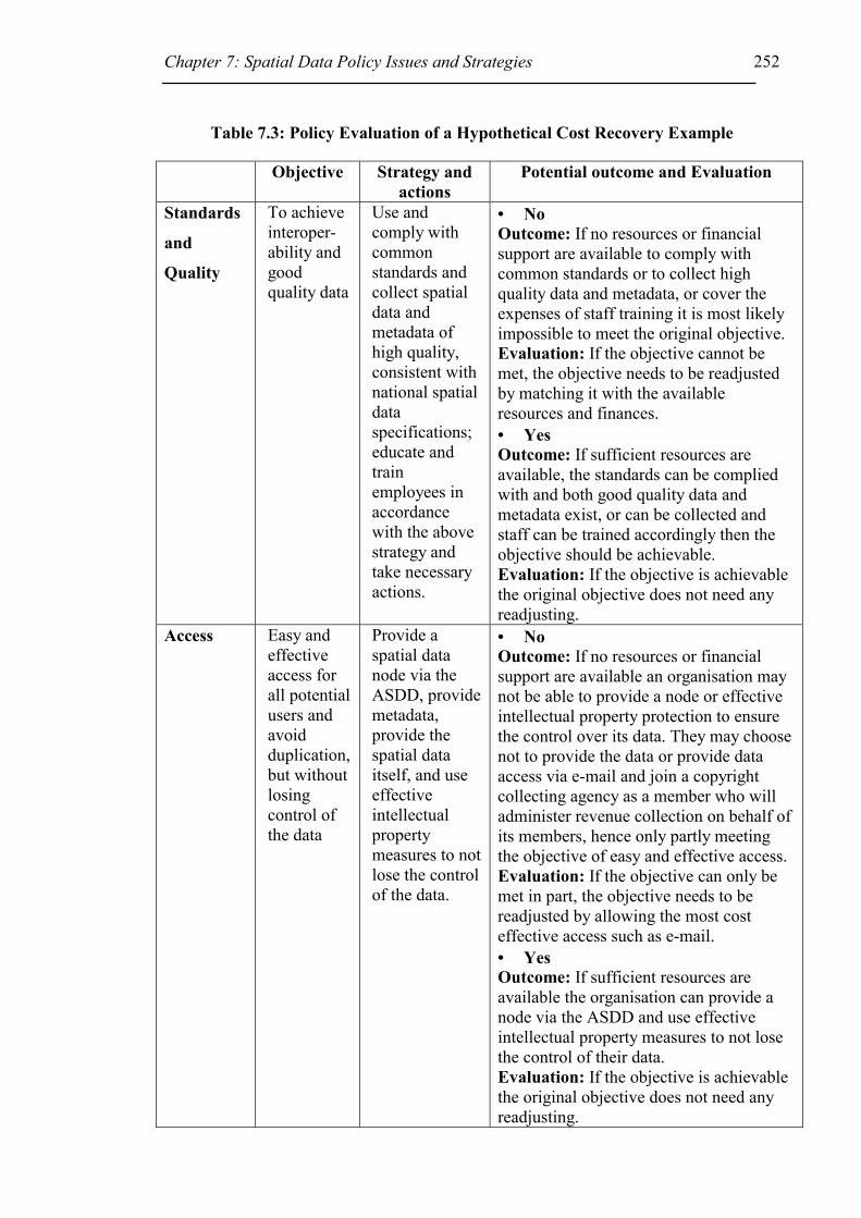
Chapter 7: Spatial Data Policy Issues and Strategies 252
Table 7.3: Policy Evaluation of a Hypothetical Cost Recovery Example
Objective Strategy and actions
Potential outcome and Evaluation
Standards
and
Quality
To achieve interoper-ability and good quality data
Use and comply with common standards and collect spatial data and metadata of high quality, consistent with national spatial data specifications; educate and train employees in accordance with the above strategy and take necessary actions.
• No Outcome: If no resources or financial support are available to comply with common standards or to collect high quality data and metadata, or cover the expenses of staff training it is most likely impossible to meet the original objective. Evaluation: If the objective cannot be met, the objective needs to be readjusted by matching it with the available resources and finances. • Yes Outcome: If sufficient resources are available, the standards can be complied with and both good quality data and metadata exist, or can be collected and staff can be trained accordingly then the objective should be achievable. Evaluation: If the objective is achievable the original objective does not need any readjusting.
Access Easy and effective access for all potential users and avoid duplication, but without losing control of the data
Provide a spatial data node via the ASDD, provide metadata, provide the spatial data itself, and use effective intellectual property measures to not lose the control of the data.
• No Outcome: If no resources or financial support are available an organisation may not be able to provide a node or effective intellectual property protection to ensure the control over its data. They may choose not to provide the data or provide data access via e-mail and join a copyright collecting agency as a member who will administer revenue collection on behalf of its members, hence only partly meeting the objective of easy and effective access. Evaluation: If the objective can only be met in part, the objective needs to be readjusted by allowing the most cost effective access such as e-mail. • Yes Outcome: If sufficient resources are available the organisation can provide a node via the ASDD and use effective intellectual property measures to not lose the control of their data. Evaluation: If the objective is achievable the original objective does not need any readjusting.

Chapter 7: Spatial Data Policy Issues and Strategies 253
Pricing Full cost recovery
After determining the commercial value of the data; price the data (include the direct cost of material and human resources to duplicate and deliver the information and a special service charge *); and develop marketing strategies and join beneficial partnerships.
• No Outcome: If no resources or financial support are available it may be difficult to market the data and therefore difficult to sell, hence a part cost recovery model may be necessary. Data exchange agreements may also be very beneficial to the organisation. Evaluation: If the objective can only be met in part, the objective needs to be readjusted by allowing a part cost recovery model. • Yes Outcome: If sufficient resources are available commercially valuable data should be marketed and sold for market value. Data exchange agreements may also be very beneficial to the organisation. Evaluation: If the objective is achievable the original objective does not need any readjusting.
Legal
issues such
as
Copyright
To legally protect the data against misuse by others, and minimise legal liability risk
Where data is commercially valuable protect the data with copyright and licences; define users’ rights and obligations; keep records; monitor and negotiate infringements; and do not infringe the rights of others.
• No Outcome: If no resources or financial support are available the organisation may not be able to administer legal issues or define users’ rights and obligations, but the organisation may become a member of copyright collecting agencies, thereby partly meeting the objective. Evaluation: If the objective can only be met in part, the objective needs to be readjusted, however an organisation needs to be aware of legal liability risks and should at least use disclaimers. • Yes Outcome: If sufficient resources are available the objective should be achievable. Evaluation: If the objective is achievable the original objective does not need any readjusting.
Notes:
• No signifies that the organisation has no or insufficient funds available to meet the objective, while Yes signifies that the organisation has sufficient funds to meet the objective.
• * an example of a service charge (= $64/hour) is to include the lifetime cost of the GIS, which includes the hardware, software, maintenance and personnel needed over a four-year system life (eg. $444,881.00);
Chapter 7: Spatial Data Policy Issues and Strategies 254
o four year system life ( = 4 years * 50 wks/year * 35 hrs/wk = 7000 hrs); and
o cost per hour = $444,881.00 / 7000hrs = $64.00 per hour (Lerner, 1992).
As described before, the vision and mission (or the factors that influence policy
development) of an organisation provide the source for the objectives (Table 7.3 column
2) of an organisation. The objectives in Table 7.3 were chosen based on policy needs.
Strategies and actions (Table 7.3 column 3) were assigned, based on best practices
recommended in this thesis, to meet those objectives. Then the objectives have to be
implemented and the potential effect of the policy (the outcome) has to be evaluated by
comparing the outcome with the original objective and if necessary the policy design
has to be adjusted accordingly (Table 7.3 column 4).
7.6 Conclusion
This chapter has developed spatial data policy issues priorities for four subgroups:
federal government organisations, state government organisations, local government
organisations, and private providers. These priorities were based on the analysis of the
12 major factors that influence individual policy development and discussed throughout
the whole thesis. The priorities differ for the four subgroups, hence only official
regulations may be able to standardise the different policies, but this principle may not
be in the best interests of everyone. Even if not all issues in a policy can be made
consistent to facilitate development of SDIs, it would at least be in everybody’s best
interest to follow and apply national standards to enable the exchange of spatial data.
Policy development is a continuous cycle that starts with identifying issues followed by
analysing and implementing policies to finally evaluating the policy effects. This
research recommends firstly consulting a group of specialists to determine a potential
group of organisations that should participate in a pilot program and both groups should
consider the policies recommended in this research. These two groups should then
correct and add to the policies recommended in this research according to their
individual needs. Then the policies should be implemented and finally evaluated to
determine if the policy objectives have been met. An evaluation strategy should
measure and monitor policy objectives and the findings should be analysed and
recommendations made.

Chapter 7: Spatial Data Policy Issues and Strategies 255
Organisations should consider all 12 policy issues (Table 7.2) discussed in this thesis,
when deciding on a spatial data policy. Further research is needed to compare and
monitor the two access and pricing models, classed as either ‘open access’ or ‘cost
recovery access’, and record their failures and successes over time. Further research is
also needed to firstly implement the recommended policies and secondly to evaluate
those policies, to analyse if they were appropriate, efficient and effective in meeting the
target objectives of this research. Exchange and collaboration agreements should be
used wherever possible to encourage cooperation amongst all levels of government and
the private sector. State or national government agencies have different needs to local or
private spatial data providers. However, society’s need for improved and easily
accessible data to solve environmental problems, its decline in natural resources, and
monitoring and reducing disaster problems remain the same.
256
Chapter 8 – Summary and Conclusions
8.1 Introduction
Realising the widespread use of spatial data, the need for Spatial Data Infrastructures,
and the existence of many different spatial data policies in Australia, the aim of this
thesis has been to determine existing spatial data policies used by spatial data providers
in the area of spatial data access and pricing, and to devise new spatial data access and
pricing policy strategies. To achieve the aims the thesis developed the following
objectives:
i. Determine factors that influence SDI development at global, regional and
national level (Chapter 2).
ii. Research SDI policy deficiencies and determine SDI requirements for
Australia (Chapter 2).
iii. Survey existing practices and policies used by spatial data providers in
Australia for spatial data access and pricing, including the areas of metadata
provision, physical access, basis used for pricing, and legal protection (Chapter
3, and relate the outcome of the survey to Chapters 4, 5, 6 and 7).
iv. Summarise all issues involved in a spatial data access and pricing policy and
study international developments (Chapter 4).
v. Review current data access and pricing policies used by Australian
jurisdictions and New Zealand (Chapter 4).
vi. Review the legal framework applicable to spatial data in Australia; discuss
legal liability issues in maps and databases, and review legal protection means
against potential liability claims (Chapter 5).
vii. Review intellectual property laws relevant to spatial data and measure the
spatial data providers’ level of reliance on intellectual property law (Chapter
6).
viii. Compose a summary of policy recommendations based on the research
(Chapter 7).
ix. Develop a Spatial Data Policy definition that facilitates SDI development
(Chapter 7).

Chapter 8 – Conclusions 257
Section 8.2 explains the results of the investigation of these nine objectives and Section
8.3 discusses the original contribution of the thesis to the area of Spatial Data
Infrastructures. Section 8.4 provides the answers to the research questions posed at the
end of Chapter 2.
8.2 Evaluation of Objectives
i. Determine factors that influence SDI development at global, regional
and national level
In Chapter 2 relevant factors that influence SDI development were found to be:
1. External Forces (world economy, globalisation, environmental issues);
2. Organisational Issues (operational responsibility for the SDI initiative,
leadership at appropriate level, priorities, and human resources);
3. Technical Issues (standards, clearinghouse technology);
4. Governmental/Organisational Duties (legal, political, security);
5. Ownership/Custodianship;
6. Privacy and Confidentiality;
7. Legal Liability, Contracts and Licences;
8. Intellectual Property Law;
9. Economic Analysis (financing and pricing);
10. Data management (data protection and security);
11. Outreach, Cooperation and Political Mandate; and
12. SDI Users’ Choices, Rights and Obligations.
ii. Research SDI policy deficiencies and determine SDI requirements for
Australia
Chapter 2 also found that SDI policy deficiencies were similar at the global, regional
and national levels. These deficiencies create problems similar to those faced by
individual organisations trying to develop access and pricing policies. Some of the main
problems with SDIs and faced by organisations developing access and pricing policies,
included:
• Poor quality of spatial data;
• Inconsistent standards, or standards not being adopted;
• Inconsistent access and pricing strategies; and

Chapter 8 – Conclusions 258
• Uncertain legal protection for spatial data.
From the research in Chapter 2 it was concluded that to improve facilitation of SDIs at
any level, common policies are required. These policies need to be consistent and for
Australia need to incorporate the following SDI requirements:
• Use ANZLICs custodianship guidelines;
• Use common ASDI standards, technology standards and metadata guidelines
and feed back any problems to managers of standards;
• Use ASDI technology and access network (Clearinghouse) for displaying or
using data and maintaining access to own data;
• Abide by government policies, guidelines and laws where applicable;
• Provide security protection and secure access to spatial data;
• Use fundamental datasets;
• Collect, maintain and update spatial data appropriate for its intended use and
ensure that its quality is consistent with national spatial data specifications;
• Promote data sharing and access, and use of high quality data;
• Store and index spatial data appropriately and consistently with national
specifications;
• Set the prices of spatial data to be low and consistent with state or national
policies or guidelines;
• Use appropriate legal risk management and copyright strategies as described in
Chapters 5 and 6;
• Promote the application of spatial information and SDIs; and
• Be aware of new spatial information and SDI developments.
iii. Survey existing practices and policies used by spatial data providers in
Australia for spatial data access and pricing, including the areas of
metadata provision, physical access, basis used for pricing, and legal
protection
The Spatial Data Survey described in Chapter 3 provides a very detailed picture of the
current practices used in the spatial data industry at the date of the Survey (conducted
October to December 1998). A few of the more significant conclusions are described
here.

Chapter 8 – Conclusions 259
There are many spatial data providers that do not adhere to any particular policy, but
often make their policies for spatial data access and pricing dependent on the individual
datasets. Metadata standards are being provided by 34% of data providers. Access to
spatial data is often provided in digital form, however the most common way users
received their data is as a hardcopy over the counter or by mail. With regard to pricing
many were charging ‘Cost of supply, provision’, except for federal government
agencies, where a majority of organisations were not charging at all. Surprisingly, legal
issues such as legal liability risks were seen to be more important to federal and state
government organisations than local government and private sector organisations.
Intellectual property protection of spatial data was not as important to most providers as
using disclaimers (64% used disclaimers). 46% added no legal statements to their data
while 39% stated that the data is subject to copyright protection.
iv. Summarise all issues involved in a spatial data access and pricing policy
and study international developments
Chapter 4 determined from literature review the factors that influence spatial data access
and pricing policy development and summarised them as:
• SDI Requirements
• Organisational Issues
• Technical Issues
• Governmental/Organisational Duties
o Legal o Political o Security
• Ownership/Custodianship
• Privacy and Confidentiality
• Legal Liability, Contracts and Licences
• Intellectual Property Law
• Economic Analysis (cost, value, or market driven)
o Private vs. public user o Commercial vs. non commercial use o Free to full cost recovery range o Dataset
��Quality ��Quantity

Chapter 8 – Conclusions 260
• Data Management
• Outreach, Cooperation, and Political Mandate
• Users’ Choices, Rights & Obligations
Research on local and international initiatives in Chapter 4 showed the large variety of
policies and practices being used. Often policies and practices develop, despite the
above mentioned factors, because organisations have to follow government mandates,
often without any consideration for aiding a better facilitation of SDIs. SDI
development challenges were found to be not so much of a technical nature, but rather a
deficit in policies, finances and in the management of spatial data, including such issues
as ownership, copyright and legal liability.
v. Review current data access and pricing policies used by Australian
jurisdictions and New Zealand
When comparing the various Australian jurisdictional members of ANZLIC including
New Zealand in Chapter 4, it was found that most have either recently updated their
access and pricing policy/practice, or are in the process of doing so. Four of the eight
Australian State/Territories have different approaches, depending on uses, and range
between ‘cost of transfer’ for non-commercial use and ‘above cost of transfer’, such as
market value, for commercial use. The overall trend for many state/territory authorities
is to reduce the price of their datasets. However, some charge above the cost of transfer
up to market value for commercial use (even if the user is a government organisation).
Some states/territories tend to encourage spatial data brokers and value-added-resellers,
while others prefer not to use them. Some may even license the use of the data rather
than sell the data.
vi. Review the legal framework applicable to spatial data in Australia;
discuss legal liability issues in maps and databases, and review legal
protection means against potential liability claims
Legal liability exposure may never be eliminated, but with the use of contracts,
disclaimers, standards (including metadata), good quality data management practices,
Chapter 8 – Conclusions 261
insurance and a good risk management strategy the exposure to legal liability for
incorrect or inadequate data will be reduced (Chapter 5).
vii. Review intellectual property laws relevant to spatial data and measure
the spatial data providers’ level of reliance on intellectual property law
Intellectual property protection, such as copyright can be utilised for the protection of
spatial data. Although difficult to predict its reliability, it is simple to use and does not
require any formalities. The ‘Spatial Data Survey’ discovered that more organisations
do not protect the intellectual property in their data than those that do (Chapter 6).
viii. Compose a summary of policy recommendations based on the research
Chapter 7 developed a summary of recommendations from the information and the
research in Chapters 2 to 6, under the following headings:
• SDI requirements;
• Technical issues;
• Governmental / organisational duties;
• Ownership / custodianship;
• Legal liability, contracts and licences;
• Intellectual Property Law;
• Economic analysis; and
• Spatial data users’ choices, rights and obligations.
ix. Develop a Spatial Data Policy definition that facilitates SDI development
Section 7.2 of Chapter 7 presents a list of policy recommendations to facilitate SDI
development and Table 7.2 prioritises the spatial data policy issues identified in Chapter
4 (Table 4.1) for the following four subgroups:
Federal Government Organisations, State Government Organisations, Local
Government Organisations and Private Organisations. The conclusions drawn from
Table 7.2 were that spatial data policy priorities differ significantly for the four
subgroups, and hence development of SDIs cannot be easily facilitated without the
development of official regulations or policy guidelines.

Chapter 8 – Conclusions 262
Section 7.4 relates the priorities developed in Table 7.2 to some real world examples in
Federal Government, state government, local government and private enterprise.
Section 7.5 discusses the theoretical development of policy and shows how this theory
could apply in an organisation seeking to employ a cost recovery strategy for their data.
8.3 Contribution
The list below gives an overview of the areas where this thesis makes an original
contribution to the facilitation of SDI. These areas are discussed further, below the list:
• Establishing what the spatial data policy issues are.
• Analysing and comparing SDI policy deficiencies with respect to individual
organisational access and pricing policy issues.
• Researching current Australian spatial data policy practices in the areas of
spatial data quality, access, cost, and intellectual property protection of spatial
data by way of a national survey. This information contributed significantly to
the development of future access and pricing policy strategies.
• Measuring the acceptance of existing ANZLIC guidelines such as the Metadata
Guideline.
• Assisting with reducing and managing legal liability risks, when providing
spatial data and documenting legal liability awareness and disclaimer practices.
• Reviewing and extending the current knowledge of intellectual property law
applied to spatial data, so that an organisation may know what intellectual
property law to use and how.
• Defining spatial data policies.
Establishing what the spatial data policy issues are – A comparison of national,
international, regional, and global spatial data policy issues lead to the formation of a
list of factors that influence SDI development. The author is not aware of these factors
ever being consolidated into a single coherent statement.
Analysing and comparing SDI policy deficiencies with respect to individual
organisational access and pricing policy issues – The author is not aware of such a
comparison being made previously in an Australian context.

Chapter 8 – Conclusions 263
Researching current Australian spatial data policy practices in the areas of spatial
data quality, access, cost, and intellectual property protection of spatial data by
way of a national survey. This information contributed significantly to the
development of future access and pricing policy strategies – One aim of the thesis
was to provide statistics on the types of spatial data policies employed in Australia, and
to analyse these statistics in order to provide direct guidance to spatial data policy
developers on spatial data policy strategies.
Measuring the acceptance of existing ANZLIC guidelines such as the Metadata
Guideline - Previous research on SDI development in an Australian context has usually
concentrated on the design and implementation of SDIs, and rarely on actual
performance measures of the ASDI or any ANZLIC guidelines. This research
discovered that there is generally a lack of metadata provision, although many people
seem to be aware of the functions of metadata. State, Federal and private organisations
provide more metadata than local government departments. The spatial data survey also
discovered that there is a lack of compatible data and that the provision and measure of
data quality is inconsistent. Access to spatial data is ineffective as there are still many
datasets not being distributed in electronic form. Although not a perfect measure of
guideline acceptance, this research indicates that more education on the usefulness of
metadata and other national guidelines is necessary.
Assisting with reducing and managing legal liability risks, when providing spatial
data and documenting legal liability awareness and disclaimer practices – The
strategies listed in Section 7.2.5 of Chapter 7 provide assistance in reducing and
managing legal liability risks for individual Australian organisations. The results of the
survey discovered that few people are aware of the legal liability risks involved when
supplying spatial data, or liability claims occur very infrequently. The analysis of
disclaimer practices indicated that 64% of all providers rely on disclaimers to limit legal
liability, compared with only 34% of data providers using metadata. A list of areas
covered by disclaimers, used within the spatial data industry, was compiled in Chapter 5
(Table 5.2). These areas were compared with metadata descriptions in Chapter 4
(Section 4.2.1), Chapter 5 and Appendix 3. This comparison lead to the discovery that
many disclaimer areas are similar to what should be included in Metadata.

Chapter 8 – Conclusions 264
Reviewing and extending the current knowledge of intellectual property law
applied to spatial data, so that an organisation may know what intellectual
property law to use and how - The current knowledge of intellectual property law
applied to spatial data was documented and the spatial data survey indicated that certain
data provider groups rely more heavily on intellectual property protection than others.
Overall intellectual property protection was found to be an area that is underutilized and
hence spatial data providers need more education on its benefits.
Defining spatial data policies – This research is original in providing direct policy
recommendations to spatial data policy developers to assist them in their individual
policy formulation. It also has applied its findings to establish policy priorities for
various jurisdictional government and private organisations, and formulated an example
of how an organisation may evaluate its policy.
8.4 Research Questions
The next four sections will answer the questions raised at the end of Chapter 2 under the
four headings:
• Standards and quality of spatial data
• Access to spatial data
• Pricing of spatial data and
• Legal issues such as Intellectual Property protection of spatial data.
8.4.1 Standards and quality of spatial data
• How much impact do the developments from ANZLIC, such as Metadata
standards have on spatial data providers and users from academic, private and
public background?
As about one third of data providers responded that they were supplying metadata, the
efforts of ANZLIC and other bodies involved in publicising and promoting the use of
metadata have had an impact. However the work to promote metadata still needs to be
continued.

Chapter 8 – Conclusions 265
• Are most providers aware of ASDI developments and do they follow the
guidelines?
This issue is hard to measure from the results of the Spatial Data Survey. However, as
spatial data prices are being reduced and metadata is being supplied, the answer to the
question is tentatively yes. More work is required to investigate this question.
• Are data providers supplying additional data with the dataset, such as metadata
or disclaimers?
The results of the survey show that many data providers provide metadata and
disclaimers.
8.4.2 Access to spatial data
• What spatial data access mechanisms do Australian spatial data providers use?
A majority of users request their data as ‘hardcopy over the counter or by mail’.
However, many providers supply the datasets in digital form, but only very few
providers use the Internet to distribute their spatial datasets.
8.4.3 Pricing of spatial data
• What spatial data pricing policies do other Australian States’ and Territories’
and New Zealand’s government spatial data providers use?
Most Australian States/Territory Governments have either recently updated their access
and pricing policy/practice, or are working on new ones. Four out of the eight
States/Territories have different prices for different uses, which range between cost of
transfer and market value. The general trend among the different State/Territory
government departments supplying spatial data, is to move to lower pricing regimes.
• Do public data providers value their spatial data as revenue producing asset, or
more as the public asset that should be made freely available?
50% of all spatial data providers specified that public good was more important than
revenue from the sale of spatial data, but the level of charging that applied was not
studied. The vast majority of federal government agencies (86%) specified that public

Chapter 8 – Conclusions 266
good was more important than revenue, while 68% of all private organisations specified
they sell their data for profit. It is therefore assumed that spatial data are valued to a
degree.
8.4.4 Legal issues such as Intellectual Property protection of spatial data
• What potential legal risks exist when providing spatial data to others?
Legal liability risks associated with the provision of spatial data to others may involve
liability claims that arise because a user has relied on inaccurate spatial data, or he/she
has used the data in a way it was not intended and thereby has suffered loss.
• How can an organisation protect its intellectual property in their spatial data?
By using copyright, and/or contracts, and/or licences and clear statements specifying
what the user’s rights and obligations are when using the spatial data.

References 267
References Note: All Internet links were checked on the 26/11/00.
ABC News (1999) ‘How it Happened’, ABC News.com: How NATO Hit Chinese Embassy. http://www.abcnews.go.com/sections/world/DailyNews/kosovo990510_chinahow.html
ABC News Online (2000) ‘Hearings begins for Victorian ambulance scandal’, ABC News Online, The World Today, http://www.abc.net.au/worldtoday/s93945.htm
ACTLIF ‘Australian Capital Territory Land Information Forum’. http://www.actlandinfo.org.au/index.htm
Agumya, A. and Hunter, G. (1999) ‘A Risk-Based Approach to Assessing the ‘Fitness for Use’ of Spatial Data’, Journal of the Urban and Regional Information Systems Association (URISA), Vol.11, No.1, Spring 1999, pp. 33-44.
ALRC (a) ‘Australian Law Reform Commission (ALRC)’, http://www.alrc.gov.au/
ALRC (b) ‘Australian Law Reform Commission (ALRC) – About Us’, http://www.alrc.gov.au/about.html
ANZLIC (1997) ‘Report on Implementation of Spatial Data Transfer Standard (SDTS)’, http://www.anzlic.org.au/sdts_sum.htm
ANZLIC (1998a) ‘Background Information on ANZLIC’, http://www.anzlic.org.au/background.htm
ANZLIC (1998b) ‘Australia New Zealand Land Information Council (ANZLIC) Home Page’, http://www.anzlic.org.au/index.html
ANZLIC (1998c) ‘Spatial Data Infrastructure for Australia and New Zealand – A discussion paper’, http://www.anzlic.org.au/anzdiscu.htm
ANZLIC (1998d) ‘Guidelines for Custodianship – Executive Summary’ http://www.anzlic.org.au/policy/custodn/exec_sum.htm
ANZLIC (1998e) ‘Guidelines for Custodianship – Contents’ http://www.anzlic.org.au/policy/custodn/contents.htm
ANZLIC (1999) ‘Metadata Working Group’, http://www.anzlic.org.au/metagrp.htm
ANZLIC (2000a) ‘ANZLIC Seminar, February 2000 – Jurisdictional Update Australian Capital Territory’, prepared by Rod Menzies. http://www.anzlic.org.au/archive/seminar/act_rpt.pdf
References 268
ANZLIC (2000b) ‘ANZLIC Seminar, February 2000 – Jurisdictional Update New South Wales’. http://www.anzlic.org.au/archive/seminar/nsw_rpt.pdf
ANZLIC (2000c) ‘ANZLIC Seminar, February 2000 – Jurisdictional Update South Australia’, prepared by Andrew Jones. http://www.anzlic.org.au/archive/seminar/sa_rpt.pdf
ANZLIC (2000d) ‘ANZLIC Seminar, February 2000 – Jurisdictional Update Tasmania’. http://www.anzlic.org.au/archive/seminar/tas.pps
ANZLIC (2000e) ‘ANZLIC Seminar, February 2000 – Jurisdictional Update Victoria ‘. http://www.anzlic.org.au/archive/seminar/vic_rpt.pdf
ANZLIC (2000f) ‘ANZLIC Seminar, February 2000 – Jurisdictional Update Western Australia’. http://www.anzlic.org.au/archive/seminar/wa_rpt.pdf
ANZLIC (2000g) ‘ANZLIC Seminar, February 2000 - Commonwealth report’. http://www.anzlic.org.au/archive/seminar/com_rpt.pdf
ANZLIC (2000h) ‘ANZLIC Clearinghouse Workshop’, 3-4 May, Adelaide, Australia. http://www.anzlic.org.au/news/workshop/index.htm
ANZLIC (2000i) ‘Core Metadata Elements’ Introductory to Metadata Guideline, http://www.anzlic.org.au/asdi/metaelem.htm
Archer, H.N. (1995) ‘Establishing a Legal Setting and Organisational Model for Affordable Access to Government Owned Information Management Technology’, published in Proceedings of the Conference on Law and Information Policy for Spatial Databases, Tempe, Arizona, October 28&29, 1994, edited by Harlan J Onsrud 1995, pp13-24.
ASDI (1999) ‘ASDI Activities Status Report @ 10 November 1999’, (Accessed 23/11/99) http://www.csdc.gov.au/asdi/whatsnew/asdistat.htm (no longer available)
ASDI (2000) ‘Fundamental Datasets - A CSDC Discussion Paper’, http://www.csdc.gov.au/csdcfd.htm
Attorney-General’s Department – e-news (1998), ‘The AGD e-news on copyright’, Issue 5 – December 1998, http://law.gov.au/publications/copyright_enews/issue5.html
Attorney-General’s Department – e-news (1999a), ‘The AGD e-news on copyright’, Issue 8 – July 1999, http://law.gov.au/publications/copyright_enews/issue8.html
Attorney-General’s Department – e-news (1999b), ‘The AGD e-news on copyright’, Issue 9 – September 1999, http://law.gov.au/publications/copyright_enews/issue9.html
References 269
Attorney-General’s Department – e-news (2000), ‘The AGD e-news on copyright’, Issue 13 – May 2000, http://law.gov.au/publications/copyright_enews/issue13.html
Attorney-General’s Department (1997) ‘Copyright Law in Australia’, October 1997, No 12.7, http://law.gov.au/publications/copyrightaus97.htm
Attorney-General’s Department (2000a) ‘Copyright Law in Australia’, January 2000, http://law.gov.au/publications/copyrightaus99.htm
Attorney General’s Department (2000b) ‘Copyright Reform: Copyright Amendment (Digital Agenda) Act 2000’ http://law.gov.au/publications/copyfactsheet/copyfactsheet.html
AURISA (2000) ‘Australian www Mapping Consortium’, AURISA Web Mapping Workshop, 31st May 2000, Sydney.
AUSLIG (1999a) ‘National and International Forums’, http://www.auslig.gov.au/sdi/forums.htm#nat
AUSLIG (1999b) ‘ABOUT AUSLIG’, http://www.auslig.gov.au//about.htm
AUSLIG (2000a) ‘Scoping the business case for SDI development’, Report produced on behalf of the GSDI by AUSLIG, March 2000, available at: http://www.gsdi.org/docs.html
AUSLIG (2000b) ‘Australian Spatial Data Infrastructure’, available at http://www.auslig.gov.au/asdi
AustLII ‘Australasian Legal Information Institute (AustLII)’, http://www.austlii.edu.au/
Australian Copyright Council. (1996) Computer Software & Copyright, A Practical Guide, No. 78, April 1996 revision.
Australian Copyright Council (1997) Copyright and the Internet, A Discussion Paper, No 93, April 1997.
Australian Copyright Council, ‘Australian Copyright Council’, http://www.copyright.org.au
Australian Privacy Commissioner (2000) ‘Privacy and the private sector’ http://www.privacy.gov.au/private/index.html
Bladen, V. ‘Cyperlaw - Legal Issues arising from use of the Internet’, http://msm.com.au/cyberlaw.html
References 270
Blake, S. (1999) ‘The Current Status of the Commonwealth Australian Spatial Data Infrastructure (ASDI) Implementation Activities’, Paper presented at AURISA 99 - The 27th Annual Conference of AURISA, Blue Mountains, New South Wales, 22-26 November 1999.
Brand, M. (1998a) ‘Global Spatial Data Infrastructure: Current Developments’, The Australian Surveyor, Vol.43 No.3, September 1998, pp 174 - 177.
Brand, M (1998b) ‘Global Spatial Data Infrastructure: Policy & Organisational Issues’, Paper presented at the 3rd GSDI Conference in Canberra, Australia, 17 - 19 November 1998, http://www.eurogi.org/gsdi/canberra/theme.html
Bridgman, P. and Davis, G. (1998) Australian Policy Handbook, Allen & Unwin, Sydney, Australia.
Brown, K. (1995) ‘A Review of Alaska’s Public Information Access Laws’, published in Proceedings of the Conference on Law and Information Policy for Spatial Databases, Tempe, Arizona, October 28&29, 1994, edited by Harlan J Onsrud 1995, pp25-31.
Bullock, K. (2000) e-mail message received by R. Mason on the 3/7/00.
Burley, S (1996) ‘Some Intellectual Property Aspects of the Internet’, The College of Law - Continuing Legal Education Seminar, 10 July 1996, Sydney, Australia, pp 21-39.
Cavazos, M. (1994) ‘Cyberspace and the law’, MIT Press, p 4.
CERCO (1999a) ‘Our Mission’, http://www.cerco.org/OUR_MISSION/Our_Mission.html
CERCO (1999b) ‘Our Work Groups’, http://www.cerco.org/OUR_WORKINGGROUPS/Workinggroups.html
Chan, T.O. and Williamson I.P. (1999) ‘Spatial data infrastructure management: lessons from corporate GIS development’, Proceedings of AURISA 99 - The 27th
Annual International Conference of AURISA, Blue Mountains, New South Wales, Australia, 22-26 November 1999.
Chan, T.O., Feeney, M., Rajabifard, A. and Williamson, I.P. (2001) ‘The Dynamic Nature of Spatial Data Infrastructures: A Method of Descriptive Classification’, GEOMATICA, Vol 55, No.1, pp. 65-72.
Chisholm, R and Nettheim, G. (1992) Understanding Law, Butterworths, Australia.
Chisholm, R and Nettheim, G. (1997) Understanding Law, Butterworths, Australia.
Cho, G. (1995) ‘Legal dilemmas in geographic information: Property, ownership and patents’, Journal of Law & Information Science, Vol.6 No.2, pp 193-207.
References 271
Cho, G. (1998) Geographic Information Systems and the Law – Mapping the Legal Frontiers, John Wiley & Sons, England.
Clarke, D. (1999) ‘Spatial Data Infrastructures - From Inspiration to Implementation’, Proceedings of AURISA 99 - The 27th Annual Conference of AURISA, Blue Mountains, New South Wales, 22-26 November 1999.
Clinton, W. (1994) ‘Executive Order 12906’, published in April 13, 1994, edition of the Federal Register, 59 (71), pp.17671-17674. See also link at: http://www.fgdc.gov/publications/documents/geninfo/execord.html
Cohen (1997) ‘GSDI: The Policy Imperative’, Keynote paper, Proceedings of the 1997 Conference on GSDI, Chapel Hill, North Carolina, 19-21 October 1997. http://www.gsdi.org/docs/cohen.html
Coleman, D., Groot, R. and McLaughlin J. (2000) ‘Human resource issues in the emerging GDI environment’, in Geospatial Data Infrastructure: concepts, cases and good practice, Oxford University Press, New York, USA, edited by Groot, R. and McLaughlin, J., pp. 233-244.
Coleman, D.J. and McLaughlin J. (1998) ‘Defining Global Geospatial Data Infrastructure (GGDI): Components, Stakeholders and Interfaces’, Geomatica, Canadian Institute of Geomatics, Vol 52, No2, pp129-144.
Commonwealth of Australia – The Treasury (1997-98) ‘Commonwealth National Competition Policy – Annual Report 1997-1998’
Commonwealth Spatial Data Committee (1998) ‘Spatial Data Infrastructure’ http://www.csdc.gov.au/asdi/index.htm
Coopers and Lybrand (1996) ‘Economic aspects of the collection, dissemination and linkage of government’s geospatial data’, Report published by Ordnance Survey, Southampton, May 1996.
Copyright Act 1968 (Cth) in AustLII’s Database at http://www.austlii.edu.au/au/legis/cth/consol_act/ca1968133/
Copyright Convergence Group. (1994) Highways to Change: Copyright in the new communications environment, Report, August 1994, Canberra.
Copyright Law Review Committee (1995) Computer Software Protection. Report, Commonwealth of Australia, Canberra.
Corey, M. (1998) ‘Digital Data, Copyright, Commercialization and Related Issues – A Canadian Perspective’, In D.R.F.Taylor, (ed). Policy Issues in Modern Cartography, Elsevier Science Ltd, UK. Printed in The Netherlands, pp29-46.
CSDC (1995) ‘Commonwealth Custodianship Guidelines 1995’, http://www.csdc.gov.au/ccg_intro.htm

References 272
CSDC (2000) ‘Background to the Formation of CSDC’, http://www.csdc.gov.au/csdc_bckgrd.htm
Dale P.F. and McLaughlin J.D. (1999) Land Administration, Oxford University Press, Oxford.
Dando, L.P. (1995) ‘A Case for the Commercialisation of Public Information’, published in Proceedings of the Conference on Law and Information Policy for Spatial Databases, Tempe, Arizona, October 28&29, 1994, edited by Harlan J Onsrud 1995, pp32-36.
Dansby, H. (1993) ‘Commentary: selling public GIS data’, GIS Law, Vol 1 No.4, pp. 18-19.
Davies, M. (1995) ‘Disclaimer of Liability and Assumption of Responsibility’, Torts, 2nd edition, Butterworths, Sydney, 332p.
Department of Commerce and Trade WA (1997) ‘Public Sector Intellectual Property Management Policy’, Policy prepared and published by the Department of Commerce and Trade, Perth, Australia.
De Zwart, M. (1997) ‘Keeping your Site Nice - Unfair Practices on the World Wide Web’, Australian Intellectual Property Journal, Vol.8 No.4, pp 181-191.
Dobson D.J. (2000) e-mail message posted on the 21/6/00.
DPIWE (2000) ‘Website of the Department of Primary Industries, Water and Environment’. http://www.delm.tas.gov.au/dpiwe/index.html
Eldred, P. (1995) ‘Geographic Information Systems and Copyright: Are we on the right road?’, WALIS News, Vol.6, March 1995, pp 13-18.
Elgin, R.L. (1995) ‘Surveyor’s Notes for Plats’, Point of Beginning (P.O.B.), August/September 1995, p.17.
ERSIS (1998) ‘ERSIS Data Mall’, http://www.datamall.com.au/ and http://www.datamall.com.au/free/Freedata.htm
EUROGI (1998) ‘Developing a Vision for the EGII – Geographic Information Infrastructure’, Report of the meeting of experts on 7-9 December 1998 at DG XIII/E Luxembourg, http://www.eurogi.org/forum/egii1298.html
EUROGI (1999a) ‘About EUROGI’, http://www.eurogi.org/objectives/eurorg.html
EUROGI (1999b) ‘European GI Policy Framework’, http://www.eurogi.org/forum/gi2000.html
References 273
Feeney, M., Rajabifard, A., Williamson, I. (2001) ‘Spatial Data Infrastructure Frameworks to Support Decision-Making for Sustainable Development’, Presented at the 5th Global Spatial Data Infrastructure Conference, Cartagena de Indias, Columbia, 21-25 May 2001.
Fenwick, T. (1998) ‘Implementing the Spatial Data Infrastructure – How is Queensland doing it and What’s happening at the national level’, ACTLIF conference 98’
Fischer, F. (1995) Evaluating Public Policy, Chicago, Nelson-Hall.
FGDC (1997) ‘A Strategy for the National Spatial Data Infrastructure’, FGDC, US Geological Survey, 590 National Centre, Reston, VA 20192, USA, pp 16. http://www.fgdc.gov/nsdi/strategy/strategy.html
Gelatly, C. and Baxter, P. (1995) ‘Measuring the Economic Benefits of Australian Land and Geographic Data Infrastructure’, Proceedings of AURISA 95 - The 23rd
Annual International Conference of AURISA, Melbourne, Australia, 20-24 November 1995.
GI Connections – Geospatial Information Victoria, Australia http://www.giconnections.vic.gov.au/index.htm
GI Connections – Pricing Policy http://www.giconnections.vic.gov.au/content/policy/pricing.htm
GIIC ‘Global Information Infrastructure Commission (GIIC)’, http://www.giic.org/
Gilbert & Tobin (1997) ‘Intellectual Property & the Internet - Quick Guide’, Gilbert & Tobin - Lawyers, http://www.gtlaw.com.au/pubs/ipandinternet.html
Gillespie, S. (1992a) ‘Test of digital benefit model’. National Mapping Division, U.S. Geological Survey, Reston, Virginia.
Gillespie, S. (1992b) ‘Digital benefits test’. National Mapping Division, U.S. Geological Survey, Reston, Virginia.
Grant, D. (2000) ‘The Public Sector Mapping Agencies of Australia’, in Geospatial Data Infrastructure: concepts, cases and good practice, Oxford University Press, New York, USA, edited by Groot, R. and McLaughlin, J., pp. 255-266.
Groot, R. and McLaughlin, J. (Eds) (2000) Geospatial Data Infrastructure: concepts, cases and good practice, Oxford University Press, New York, USA.
GSDI (1996) ‘Emerging Global Spatial Data Infrastructure (GSDI) Conference – Report’, 1st GSDI Conference report, 4-6 September 1996, Germany, available at http://www.gsdi.org
References 274
GSDI (1997) ‘Global Spatial Data Infrastructure Conference Findings and Resolutions’, Chapel Hill, North Carolina, 21 October 1997, http://www.eurogi.org/gsdi/gsdi97r.html
GSDI (1999) ‘GSDI Steering Committee’, http://www.gsdi.org/docs/people.html
Gunn, L.A. (1978) ‘Why is Implementation so Difficult?’, Management Services in Government, 33: pp. 169-176.
Harrison, B. (1998) ‘Disclaimers’, Azimuth, February 1998, p.16-19.
Henninger, M (1998) Keeping up with Internet developments, Workbook for workshop 2 July 1998, University of New South Wales, Sydney, Australia, pp 1-40.
Hesse, W. (1997) ‘GIS\WWW – What is the point?’, Symposium on GIS and the World Wide Web ‘97, Department of Geomatics, The University of Melbourne, Saturday,19th April 1997, http://www.sli.unimelb.edu.au/WWWSymp97/presentations/wedoit/index.htm
Hirschleifer, J. (1980) Price theory and applications. 2d ed. Englewood Cliffs, NJ: Prentice-Hall.
Hobman, L. (1997) ‘The National Geospatial Data Framework: from concept to reality’, Paper presented at GIS '97, Birmingham, 7-9th October 1997, available at: http://www.ngdf.org.uk/
Hoyle, A. Clark, E. Cho, G. (1997) ‘Intellectual Property Issues in the Development, Use and Commercialisation of Geographic Information Systems: An Australian Perspective’, Journal of Law & Information Science. Vol.8 No.1, pp 113-155.
Hughes T, (Gilbert & Tobin) (1997) ‘Regulation of the Net’, Gilbert & Tobin - Lawyers, (First appeared in Reform, Journal of the Australian Law Reform Commission, Issue 71 Spring 1997) http://www.gtlaw.com.au/pubs/regulationofnet.html
Hughes T, (Gilbert & Tobin) (1998) ‘Hidden Identifiers in Websites: Meta-Tags and Intellectual Property’, Gilbert & Tobin - Lawyers (First appeared in Internet Law Bulletin, March 1998) http://www.gtlaw.com.au/pubs/metatags.html
ICSM (1997) ‘The Intergovernmental Committee on Surveying and Mapping (ICSM)’, http://www.anzlic.org.au/icsm/index.html
ILPF ‘Internet Law and Policy Forum (ILPF)’, http://www.ilpf.org/
INFO (1999) ‘Green Paper on Public Sector Information in the Information Society’, http://158.169.50.95:10080/info2000/en/publicsector/greenpaper.html

References 275
IP Australia (1999) ‘IP Australia home page’, http://www.ipaustralia.gov.au/
IPCR (a) ‘Intellectual Property & Competition Review Committee (IPCRC)’, http://www.ipcr.gov.au/ipcr/
IPCR (b) ‘Media Release by Parliamentary Secretary to the Minister for Industry, Science and Resource, Warren Entsch on the 24th June 1999’, http://www.ipcr.gov.au/ipcr/MEDIA/INDEX.HTM
IPCR (c) ‘Intellectual Property and Competition Review – Proposed Timetable’, http://www.ipcr.gov.au/ipcr/TIME/INDEX.HTM
IPCRC (1999) ‘Intellectual Property and Competition Review – Issues Paper’, http://www.ipcr.gov.au/ipcr/ISSUES/index.htm
IPCRC (2000) ‘Intellectual Property and Competition Review – Interim Report’,. http://www.ipcr.gov.au/ipcr/interim/INDEX.HTM
Irwin, R.J. and Holland, P.R. (1996) ‘The role of the academic & research communities in Australia’s spatial data infrastructure’, Presented at the Annual Research Seminar, School of Geomatic Engineering, UNSW, November 1996.
ISCGM (2000) ‘Global Mapping Homepage’, http://www1.gsi-mc.go.jp/iscgm-sec/index.html
ISOC ‘Internet Society (ISOC)’, http://info.isoc.org/
ISO (1999) ‘Introduction to ISO’, http://www.iso.ch/infoe/intro.htm
ISO/TC 211 (2000) ‘Geographic information/Geomatics Organization’, http://www.statkart.no/isotc211/organizn.htm
Jarman, A.M.G. (1995) ‘Introducing Spatial Information Systems into Local-Level Government: Some priorities, problems and puzzles concerning organisational innovation’, Journal of Law & Information Science, Vol.6 No.2, pp 208-227.
Johnson, J.P. (1995) ‘Information Policy for Local Government Geographic Information Systems: Adoption, Implementation and results’, Masters Thesis of the Graduate School of Maine, Orono, Maine.
Jones, A. (2000) e-mail message received by R. Mason on the 23/6/00.
Jones, A. and Prescott D. (1995) ‘Digital Spatial Data and Libraries in Australia’, THE GLOBE, Journal of the Australian Map Circle, No. 42, 1995, pp 15-35.
Kahle, B (1997) ‘Preserving the Internet’, Scientific American, March 1997, http://www.sciam.com/0397issue/0397kahle.html
Karjala, D (1995) Copyright in Electronic Maps. 35 Jurimetrics Journal, Summer 1995, pp 395-415.

References 276
King, J.L. (1995) ‘Problems in Public Access Policy for GIS Databases’, published in Sharing Geographic Information, edited by Harlan J Onsrud and Gerard Rushton, Rutgers, The State University of New Jersey, New Jersey, USA, pp 255-276.
Kozub, N.E. (1991) ‘An Exercise in Strategic Planning: Development of a Data Policy for the Information Age’, Annual Conference of the URISA. San Francisco, CA, URISA, 4, pp. 39-49.
Lerner, N.B. (1992) ‘Developing a Successful Information Access Policy’, Annual Conference of the URISA. Washington, D.C., URISA, 4, pp. 79-85.
LINZ (1999a) ‘Information Management Policy’, General Manager Policy, November 1999.
LINZ (1999b) ‘Strategic business plan’, July 1999. http://www.linz.govt.nz
LINZ (2000) ‘Land Information New Zealand’s roles and responsibilities for a National Spatial Data Infrastructure (NSDI)’, General Manager Policy, March 2000.
Livingstone (2000) Greg Livingstone interviewed by Renate Mason on the 14th November 2000.
Longhorn, R.A. (1998) ‘Strategic Initiatives for the Global Spatial Data Infrastructure’, Paper presented at the 3rd GSDI Conference in Canberra, Australia. 17-19 November 1998, http://www.gsdi.org/canberra/ralstrat.html
Longhorn, R.A. (2000) ‘Regional Geographic Information Policy: Fact or Fiction – the case in Europe and lessons for GSDI’, Paper presented at the 4th GSDI Conference, Cape Town, South Africa, 13-15 March 2000, http://www.gsdi.org/docs.html#zero
Longley, P.A., M.Goodchild, D. Maguire, and D. Rhind (1999) Geographical Information Systems: Principles, Techniques, Applications and Management, 2 Volume Set, 2nd Edition, John Wiley & Sons, New York, US.
Lynch, M. and Foote, K.E. (1999) ‘Legal Issues Relating to GIS’, University of Colorado at Boulder, http://www.colorado.Edu/geography/gcraft/notes/legal/legal_f.html
Macauley, C. and Danko, D. (1999) ‘ISO 15046-15: An International Metadata Standard for Geographic Information’, Proceedings of AURISA99 - The 27th Annual International Conference of AURISA, Blue Mountains (NSW), Australia, 22-26 November 1999.
Mahar, A. (1999) ‘The six most important items on the Land Information System Tasmania (the LIST)’, presented at AURISA 99 – The 27th Annual conference of AURISA, Blue Mountains, New South Wales, 22-26 November 1999.

References 277
Marcovitz, J (1995) ‘[email protected] - ‘Owning a Bitchin’ Corporate Trademark as an Internet Address - Infringement?’, No.17, Cardozo L Rev, pp 85 & 86.
Mason, R. Masters, E. (1997) ‘Copyright and GIS: how does copyright apply to maps and databases in a GIS’, Proceedings of AURISA 97 - The 25th Annual International Conference of AURISA, Christchurch, New Zealand, 19-21 November 1997.
Mason, R. (1998a). ‘Protection from RAMM-Raiders’, GIS User, Issue 27, April-May 1998, South Pacific Science Press, pp 34-35.
Mason, R (1998b) ‘Australian Spatial Data Survey – Questionnaire’, The University of New South Wales – School of Geomatic Engineering, http://129.94.250.112/survey/questionnaire
Mason, R. and Masters, E. (1998c) ‘Intellectual Property Law, the Internet and Geographic Information Systems’, Proceedings of AURISA 98 - The 26th Annual International Conference of AURISA, Perth, Australia, 23-27 November 1998.
Mason, R. (1999a) ‘Australian Spatial Data Survey - Intellectual Property in Spatial Datasets’, Report on the Australian Spatial Data Survey, The University of New South Wales – School of Geomatic Engineering, March 1999, http://129.94.250.112/survey/report/
Mason, R. (1999b) ‘National Spatial Data Survey’, Azimuth, May 1999.
Mason, R. and Masters, E. (1999c) ‘Meeting the Challenge of Developing Spatial Data Policies: A Survey of Existing Australian Practices’, Proceedings of AURISA99 - The 27th Annual International Conference of AURISA, Blue Mountains (NSW), Australia, 22-26 November 1999.
Mason, R. and Masters, E. (2000a) ‘Developing a spatial data policy’, M&M, Issue 7 March- April 2000, South Pacific Science Press, pp 14-17.
Mason, R. and Masters, E. (2000b) ‘Spatial Data Policy Issues and Copyright’, Proceedings of GITA 2000 Conference, Sydney, Australia, 7-10 August 2000.
Masser, I. and Craglia, M. (1995) ‘The diffusion of GIS in Local Government in Europe’, Proceedings of AURISA 95 - The 23rd Annual International Conference of AURISA, Melbourne, Australia, 20-24 November 1995.
Masser, I. (1998a) Governments and Geographic Information, PA: Taylor & Francis, Bristol, London, UK.

References 278
Masser, I. (1998b) ‘The first Generation of National Geographic Information Strategies’, Paper presented at the 3rd GSDI Conference in Canberra, Australia. 17-19 November 1998, http://www.gsdi.org/canberra/masser.html
Masters, E. Mason, R. and Bullock, K. (1996) ‘The Importance of Documenting Quality’, Proceedings of AURISA 96 - The 24th Annual International Conference of AURISA, Hobart, Australia, 25-29 November 1996.
Matsunaga, K. and Dangermond, J (1995) ‘Promoting a Free Access or Minimal Cost of Dissemination Arrangement for Government-Held Geographic Information Systems Data’ in Proceedings of the Conference on Law and Information Policy for Spatial Databases, Tempe, Arizona, October 28&29, 1994, edited by Harlan J Onsrud 1995, pp39-51.
Mawn, M. and Stanton, G. (1999) ‘Information Pricing: Should We Give It Away?’, Presented at AURISA 99 - The 27th Annual Conference of AURISA, Blue Mountains, New South Wales, 22-26 November 1999.
McKee, L. (2000) ‘Who wants a GDI’, in Geospatial Data Infrastructure: concepts, cases and good practice, Oxford University Press, New York, USA, edited by Groot, R. and McLaughlin, J., pp. 13-24.
McKeough, J. and Stewart, A. (1997) Intellectual Property in Australia, 2nd ed., Butterworths, Sydney, Australia.
McNamara, P. (1999) ‘Surveyors Intellectual Property’, Azimuth, No 36 Dec.1998/Jan.1999, pp 13, 14.
MEGRIN (1999) ‘About MEGRIN – Overview’, http://www.megrin.org/ABOUT_MEGRIN/Overview.html
Menzies, R. (2000) Phone conversation on the 17/4/00 between R. Menzies and R. Mason.
Moeller (1998) ‘The First Generation of National Geographic Information Strategies and Survey of NSDI Activities around the Globe’, Slide presentation presented at the 3rd GSDI Conference in Canberra, Australia. 17-19 November 1998. http://www.gsdi.org/canberra/moeller/index.htm
Mooney, D.J. and Grant, D.M. (1997) ‘The Australian Spatial Data Infrastructure’, published in Framework for the World, GeoInformation International, Cambridge, UK, edited by David Rhind.
Nagel, S.S. (Ed) (1990) Policy Theory and Policy Evaluation – Concepts, Knowledge, Causes and Norms, Greenwood Press, Westport, CT 06881, US.

References 279
NAPA (1998) ‘Geographic Information for the 21st Century - Building a Strategy for the Nation’, Report from the National Academy of Public Administration, January 1998. Summary provided at http://www.eurogi.org/gsdi/canberra/naparepo.html
Nebert, D. (2000) The SDI Cookbook, Global Spatial Data Infrastructure (GSDI), available from: http://www.gsdi.org/pubs/
NGDF (1998) ‘Discovery Metadata Guidelines’, National Geospatial Data Framework (NGDF) Management Board, available at: http://www.ngdf.org.uk
NRIMS Strategy 1999-2002, ‘NSW Natural Resources Information Management Strategy 1999-2002’, http://www.nrims.nsw.gov.au/strategy.html
O’Donnell, J.H. and Penton, C.R. (1997) ‘Canadian Perspectives on the Future of National Mapping Organizations’, published in Framework for the World, GeoInformation International, Cambridge, UK, edited by David Rhind.
O’Sullivan, J. (1994) ‘Commercial and Finance Law: Disclaimers – Are they Effective?’, Journal of Banking and Finance Law and Practice, The Law Book Company Ltd, Vol 5 No 2 June 1994.
OECD ‘Organisation for Economic Co-operation and Development (OECD)’, http://www.oecd.org/
Office of Management and Budget, OMB Circular A-130 (1993), ‘Management of Federal Resources’, June 25, 1993.
OGIS (2000) ‘Open GIS Consortium, Inc. – Frequently Asked Questions (FAQs)’, http://www.opengis.org/FAQs.htm
OMB (1990) ‘Coordination of surveying, mapping, and related spatial data activities’, Circular A-16, Office of Management and Budget, Washington DC: Executive Office of the President.
Onsrud (1992) ‘In support of open access for publicly held geographic information’, GIS Law, 1, 1: 3-6.
Onsrud, H.J, and Rushton, G.(Eds) (1995) Sharing Geographic Information. Rutgers, The State University of New Jersey, New Jersey, USA, 508p.
Onsrud, H.J. (1998a) ‘Access to Geographic Information in the United States’, Free accessibility of geo-information in the Netherlands, the United States, and the European Community, Proceedings, Delft, Netherlands, Oct 2, 1998, pp33-41.

References 280
Onsrud, H.J. (1998b) ‘Survey of National and Regional Spatial Data Infrastructure Activities around the Globe’, Paper presented at the 3rd GSDI Conference in Canberra, Australia. 17-19 November 1998, http://www.spatial.maine.edu/~onsrud/GSDI.htm
Onsrud, H.J. (1999) ‘Liability in the Use of Geographic Information Systems and Geographic Datasets’, The University of Maine, Department of Spatial Information Science and Engineering, http://www.spatial.maine.edu/~onsrud/pubs/liabilityabstract40.htm (condensed version in Maguire, Goodchild, Rhind and Longley (eds) (1999), Geographic Information Systems: Vol 2 Management Issues and Applications, John Wiley and Sons, Inc., New York, pp.643-652).
Onsrud, H.J. (2000) ‘Global Survey of National Spatial Data Infrastructure Activities: 2000 - Update and Status Report’, Keynote paper, Paper presented at the 4th GSDI Conference, Cape Town, South Africa, 13-15 March 2000, http://www.spatial.maine.edu/~onsrud/GSDI.htm
Oosthuizen, P. (1994) ‘AISIST Spatial Information Systems Survey - by Price Waterhouse’, AURISA News, No.53, 1994, pp 14-15.
Parliament of Australia, Parliamentary Library - Bills Digests 1999-2000. ‘Copyright Amendment (Digital Agenda) Bill 1999’. Bills Digest No. 102 1999-2000, http://www.aph.gov.au/library/pubs/bd/bdalpha.htm
PCGIAP (1999a) ‘Chapter 2 Aims and Objectives. Article 4: Definition of GIS Infrastructure’, http://www.permcom.apgis.gov.au/pcstat.htm#a1
PCGIAP (1999b) ‘PCGIAP Publication No. 1: A Spatial Data Infrastructure for the Asia and the Pacific Region’, http://www.permcom.apgis.gov.au/tech_paprs/apsdi_cnts.htm
PCGIAP (1999c) ‘Draft Policy for Sharing Fundamental Data’, PCGIAP – Working Group 2, September 1999, available at: http://www.permcom.apgis.gov.au/
Peach, S. and Garlick, M. (Gilbert & Tobin) (1998) ‘Copyright and the digital agenda: An analysis of the proposed changes’, Gilbert & Tobin - Lawyers, http://www.gtlaw.com.au/pubs/copydigitalagenda.html
Pearce, D. (1998) ‘Media release on 11 September 1998’, http://www.agps.gov.au/customer/agd/clrc/clrc%20report/media_release.html (Accessed 16/10/98; link no longer available)
Perritt H.H. (1995a) ‘Should Local Governments Sell Local Spatial Databases through State Monopolies?’, Proceedings of the Conference on Law and Information Policy for Spatial Databases, Tempe, Arizona, October 27 & 29, 1994, pp52-72.

References 281
Perritt, H.H. (1995b) ‘Tort and Criminal Liability as a function of the Right to Control Content’, in Proceedings of the Conference on Law and Information Policy for Spatial Databases, Tempe, AZ (NCGIA, University of Maine, Orono, 1995).
Phillips, A. Williamson, I. Ezigbalike, C (1999) ‘Spatial Data Infrastructure Concepts’, The Australian Surveyor. Vol.44 No.1 June 1999, pp20-28.
Price Waterhouse Urwick (1993) ‘The Australian Spatial Information Systems Industry Survey’, 93p.
Price Waterhouse Urwick (1995) ‘Australian Land & Geographic Data Infrastructure – Benefits Study’, February 1995, 87p.
Prime Minister’s Science and Engineering Council (1993) The Role of Intellectual Property in Innovation, Vol.1, Strategic Overview, p 19.
QSIIC (1999) ‘Queensland Spatial Information Infrastructure Strategy’, http://www.qsiis.qld.gov.au/home/home.html
Queensland Department of Communication and Information, Local Government, Planning and Sport – Information Standard 33 (1999) ‘Information Access and Pricing’. http://www.dcilgp.qld.gov.au/index_comminfo.html?content=/comminfo/guidelines.html , http://www.dcilgp.qld.gov.au/comminfo/download/is33.pdf
Rajabifard, A. and Williamson, I.P. (2000) ‘Summary Report on Analysis of Regional Fundamental Datasets Questionnaire’, 15th United Nations Regional Cartographic Conference for Asia and the Pacific, E/CONF.92/L.13, Kuala Lumpur, Malaysia, 11-14 April 2000, 5p.
Rajabifard, A. and Williamson, I.P. (2001) ‘Spatial Data Infrastructures: Concept, SDI Hierarchy and Future Directions’, Proceedings of GEOMATICS’80 Conference, Tehran, Iran.
Reid, K. Clark, E. and Cho, G. (1996) ‘Legal Risk Management for Geographic Information Systems’, Journal of Law and Information Science, Vol 7 No.2 1996, pp169-207.
Report (1996) Emerging global spatial data infrastructure (GSDI) Conference - Report, 4-6 September 1996, Konigswinter, Germany, http://www.eurogi.org/gsdi/rapbonn.html
Report of the Committee of Enquiry (1987) HMSO (UK) ISBN 011 752015 2.
Rhind, D. (1992) ‘Data access, charging and copyright and their implications for geographic information systems’, International Journal of Geographic Information Systems, 6, pp13-30.
References 282
Rhind, D. (1995) ‘Spatial Databases and Information Policy: A British Perspective’, published in Proceedings of the Conference on Law and Information Policy for Spatial Databases, Tempe, Arizona, October 28&29, 1994 edited by Harlan J Onsrud 1995, pp82-92.
Rhind, D. (1996) 'Economic aspects of the collection, dissemination and integration of government's geospatial information', Proceedings of the Emerging global spatial data infrastructure (GSDI) Conference, 4-6 September 1996, Konigswinter, Germany.
Rhind, D. (Ed) (1997a) Framework for the World, GeoInformation International, Cambridge, UK.
Rhind, D (1997b) ‘Facing the challenges: redesigning and rebuilding Ordnance Survey’, published in Framework for the World, GeoInformation International, Cambridge, UK, edited by David Rhind, pp. 275-304.
Rhind, D. (1997c) ‘Implementing a Global Geospatial Data Infrastructure (GGDI)’, Proceedings of the Emerging global spatial data infrastructure (GSDI) Conference, 4-6 September 1996, Konigswinter, Germany.
Rhind, D. (1998) ‘National Mapping as a business-like enterprise’, In D.R.F.Taylor, (ed). Policy Issues in Modern Cartography. Elsevier Science Ltd, UK. Printed in The Netherlands.
Rhind, D. (2000) ‘Funding an NGDI’, in Geospatial Data Infrastructure: concepts, cases and good practice, Oxford University Press, New York, USA, edited by Groot, R. and McLaughlin, J., pp. 39-56.
Ricketson, S. (1994) Intellectual Property: cases, materials, and commentary. Butterworths, Sydney.
Rybaczuk, K. and Blakemore, M. (1995), ‘Selling government information. A comparative perspective on UK and USA developments’, Proceedings of the Conference on Law and Information Policy for Spatial, Databases Tempe, Arizona, October 28&29, 1994, edited by Harlan J Onsrud 1995, pp93-103.
SCCRR (1998) ‘First Session of the Standing Committee on Copyright and Related Rights (SCCRR) – Proposals and other submissions received form WIPO member states and the European community’, WIPO, Geneva, November 2 to 10, 1998. (available at: http://www.wipo.org/eng/meetings/1998/sccr_98/index.htm)
Sharpe, D (1996) ‘Internet Law and Policy Forum - Issues of Law and Policies in the Global Information Infrastructure: Meeting Public Concerns’, The College of Law - Continuing Legal Education Seminar, 10 July 1996, Sydney, Australia, pp 1-20.

References 283
Standards Australia (2000) ‘AS 2482-1989 Geographic information systems - Geographic data - Interchange of feature-coded digital mapping data’, http://www.standards.com.au/catalogue/script/Details.asp?DocN=stds000003573
Stephens (2000) e-mail message received by R. Mason on the 20/6/00.
Stevens, A.R. (2001) ‘Spatial Data Infrastructure: A Local to Global View’, UN Committee for Development Information (CODI) Conference - General Presentation, Addis Ababa, Ethiopa, 4-7 September 2001, GSDI publication, available at: http://www.gsdi.org/ under Presentations.
Stewart, K. Cho, G. and Clark, E. (1997) ‘Geographical Information Systems and Legal Liability’, Journal of Law and Information Science, Vol 8 No.1 1997, pp 84-112.
Stone, S (1998) ‘No infringement of copyright in architectural plans’, Australian Intellectual Property Law Bulletin, Vol.10 No.9, February 1998.
Tarakson, S. (1995) Everyday Law, The Federation Press, Sydney, 291p.
Taupier, R.P. (1995) ‘Geographic Information and Data Access in Massachusetts’, published in Sharing Geographic Information edited by Harlan J Onsrud and Gerard Rushton, pp277-291.
Thoen, B (1996) ‘Web Copyrights: Is anything clear?’, GIS World, February 1996.
Thompson, B. (2000) e-mail message received by R. Mason on the 21/6/00.
Tosta, N. (1995) ‘Data Policies and the National Spatial Data Infrastructure’, published in Proceedings of the Conference on Law and Information Policy for Spatial Databases, Tempe, Arizona, October 28&29, 1994, edited by Harlan J Onsrud 1995, pp106-113.
Tosta, N. (1997) ‘National Spatial Data Infrastructures and the Roles of National Mapping Organizations’, published in Framework for the World, GeoInformation International, Cambridge, UK, edited by David Rhind.
Trade Marks Act 1995 (Cth) in AustLII’s Database at http://www.austlii.edu.au/au/legis/cth/consol_act/tma1995121/
Twin, R. (2000) e-mail message received by R. Mason on the 28/6/00.
UN (1997) ‘Special Session of the General Assembly to Review and Appraise the Implementation of Agenda 21’ http://www.un.org/esa/earthsummit/ga97info.htm
United Nations (1998) ‘GIS Standards and Standardization: A Handbook’, United Nations, New York, 1998, 124p.
References 284
VGIS (1997-2000) ‘Victoria's Geospatial Information Strategic Plan - Building the Foundations 1997-2000’. http://www.giconnections.vic.gov.au/content/policy/strategy.htm
VGIS (2000-2003) ‘Victorian Geospatial Information Strategy 2000 – 2003’, Land Information Group, Land Victoria, Department of Natural Resources and Environment. http://www.giconnections.vic.gov.au/menupage/givic.htm#policy
WALIS (2000a) ‘What is WALIS?’ http://www.walis.wa.gov.au/what_is_walis/index.htm
WALIS (2000b) WALIS Pricing and Transfer Policies for land and geographic information explained’ available from http://www.walis.wa.gov.au/the_rulebook/policies.htm
WALIS ‘WALIS – What is WALIS’, http://www.walis.wa.gov.au/what_is_walis/index.htm
WALIS MoU – ‘Memorandum of Understanding’. http://www.walis.wa.gov.au/the_rulebook/memorandum_of_understanding.htm
WALIS Strategic Directions 1999 to 2001. http://www.walis.wa.gov.au/what_is_walis/strategic_plan/index.htm
Walsh, S. (2000) e-mail message received by R. Mason on the 30/6/00.
Williamson, I.P., Chan, T.O. and Effenberg, W.W. (1997) ‘Economic Rationalism in Managing Spatial Data Infrastructure - The Australian Experience’, Proceedings of URISA '97, Toronto, Canada, 21-23 July, 15p.
Williamson, I.P., Chan, T.O. and Effenberg, W.W. (1998) ‘Development of Spatial Data Infrastructures – Lessons learned from the Australian Digital Cadastral Databases’, GEOMATICA, Vol.52, No.2, pp. 177-187.
Williamson, I.P. (1999) ‘Future directions for Spatial Information Management in Australia – A Land Administration Perspective’, Proceedings of AURISA 99 - The 27th Annual International Conference of AURISA, Blue Mountains, New South Wales, Australia, 22-26 November 1999.
WIPO (2000) ‘Actions in respect of treaties administered by WIPO not yet in force’, http://www.wipo.int/treaties/ip/wipo-copyright/index.html available from – Section 1.
WIPO ‘World Intellectual Property Organisation (WIPO)’, http://www.wipo.org
Wiseman, A and Cant, S (1996) ‘Security on the Internet’, The College of Law - Continuing Legal Education Seminar, 10 July 1996, Sydney, Australia, pp 41-57.

References 285
Wright, S.G. (1994) ‘Limiting Contractual Liability in AM/FM/GIS Data Transfer Agreements’, Proceedings of AM/FM Conference XVII, Aurora: AM/FM International, 1994, pp. 685-693. http://wwwsgi.ursus.maine.edu/gisweb/spatdb/amfm/am94069.html
Younis, T. (Ed) (1990) Implementation in Public Policy, Hants Aldershot, Vt. Brookfield, Dartmouth Pub. Co., Gower Pub. Co..

References 286
Bibliography
Baker, G. (1994) ‘Towards a National Land Data Infrastructure’, Proceedings of AURISA 94 - The 22nd Annual International Conference of AURISA, Sydney, New South Wales, Australia, 21-25 November 1994.
Barwinski, K. (2000) ‘Step by Step towards a Global Spatial Data Infrastructure’, Paper presented at the 2000 GSDI Conference, Cape Town, South Africa, 13-15 March 2000.
Bishop, I.D., Escobar, F.J., Karuppannan, S., Williamson, I.P., Yates, P., Suwarnarat, K., and Yaqub, H. (2000) ‘Spatial data infrastructures for cities in developing countries: lessons from the Bangkok experience’, Cities, Vol 17, No.2, pp. 85-96.
Buehler, K. and McKee, L. (1998) ‘GSDI Business Model – Enabling GSDI via Technology Consensus and Initiatives’, Proceedings of the 3rd GSDI Conference in Canberra, Australia, 17-19 November 1998.
Chan, T.O. and Williamson, I.P. (1995) ‘Justification of GIS as an infrastructure investment – some observations regarding GIS management in Victoria’, Proceedings of AURISA 95 - The 23rd Annual International Conference of AURISA, Melbourne, Victoria, Australia, 20-24 November 1999.
Clarke, D. (1998) ‘GSDI Government Model – A Government-Based Model for Development of the GSDI’, Proceedings of the 3rd GSDI Conference in Canberra, Australia, 17-19 November 1998.
Clarke, D., Holland, P., Nairn, A., Swift, A. and Robertson, D. (1999) ‘The Contribution of the Global Map to a GSDI’, Paper presented at Australian Surveying and Land Information Group (AUSLIG), July 1999.
Craglia, M., Annoni, A. and Masser, I. (2000) ‘Geographic Information Policies in Europe: National and Regional Perspectives’, EUROGI - EC Data Policy Workshop, Amersfoort, 15 November 1999.
CSDC (2000) Commonwealth Spatial Data Committee (CSDC) website at http://www.csdc.gov.au/index.html
Feeney, M. and Williamson, I.P. (2000) ‘Researching Frameworks for Evolving Spatial Data Infrastructures’, Proceedings of SIRC 2000 - The 12th Annual Colloquium of the Spatial Information Research Centre, University of Otago, Dunedin, New Zealand. December 10-13th 2000. pp 93-105.
FGDC (2000) Federal Geographic Data Committee’s website at http://www.fgdc.gov
GSDI (2000) Global Spatial Data Infrastructure (GSDI) website at http://www.gsdi.org

References 287
Holland, P. (1999) ‘The Strategic Imperative of a Global Spatial Data Infrastructure’, Paper presented at the Cambridge Conference for National Mapping Organisations, Cambridge, United Kingdom, 19-23 July 1999.
Holland, P., Reichardt, M.E., Nebert, D., Blake, S. and Robertson, D. (1999) ‘The Global Spatial Data Infrastructure initiative and its relationship to the vision of a Digital Earth’, Paper presented at the International Symposium on Digital Earth, Beijing, China, 29 November – 2 December.
Holstein, L. (1996) ‘Land Registration Systems’, Sydney: lecture notes presented to Postgraduates in Land Administration’, University of New South Wales, August 1996.
Jacoby, S., Smith, S., Ting, L., and Williamson, I. P. (2001) ‘Developing a Common Spatial Data Infrastructure between State and Local Government - An Australian case study’, International Journal of Geographical Information Science. (In Press).
Lopez, X.R. (1996) ‘Stimulating GIS Innnovation Through the Dissemination of Geographic Information’, Journal of Urban and Regional Information Systems, 1996, 8(2): 24-37.
Masser, I. (2000) ‘What is a Spatial Data Infrastructure?’, Proceedings of the 4th Global Spatial Data Infrastructure Conference, Cape Town, South Africa 13-15 March 2000. http://www.gsdi.org/capetown/masser
Moeller, J. (2001) ‘Spatial Data Infrastructures: A Local to Global View’, Spatial Data Infrastructure General Presentation, GSDI publication, January 2001 available at: http://www.gsdi.org/ under Presentations
Nairn, A.D. (1998) ‘Commonwealth Government Initiatives to Support the Development of the Australian Spatial Data Infrastructure (ASDI)’, Proceedings of AURISA 98 - The 26th Annual International Conference of AURISA, Perth, Western Australia, 23-27 November 1998.
Onsrud, H.J., Johnson, J.P. and Winnechi J. (1996) ‘GIS Dissemination Policy: Two Surveys and a Suggested Approach’, Journal of Urban and Regional Information Systems, 1996, 8(2): 8-23.
PCGIAP (2000) Permanent Committee on GIS Infrastructure For Asia and the Pacific – website, http://www.permcom.apgis.gov.au
Pinto, J.K. and Onsrud, H.J. (1995) ‘Sharing Geographic Information Across Organizational Boundaries: A Research Framework’, In Onsrud, H.J. and Rushton G. (Eds) Sharing Geographic Information. Rutgers, The State University of New Jersey, New Jersey, USA, pp 44-64.

References 288
Rajabifard, A., Escobar, F. and Williamson, I.P. (2000) ‘Hierarchical Spatial Reasoning Applied to Spatial Data Infrastructures’, Cartography Journal, Vol.29, No. 2, pp.41-50, Australia.
Rajabifard, A., Williamson, I.P., Holland, P. and Johnstone, G. (2000) ‘From Local to Global SDI Initiatives: a pyramid to building blocks’, 4th Global Spatial Data Infrastructure Conference, Cape Town, South Africa, 13-15 March 2000, 11p.
Rajabifard A., Chan T.O. and Williamson I.P. (1999) ‘The nature of Regional Spatial Data Infrastructures’, Proceedings of AURISA 99 - The 27th Annual International Conference of AURISA, Blue Mountains, New South Wales, Australia, 22-26 November 1999.
Robertson, W. A. and Gartner, C. (1997) ‘The reforms of national mapping organizations: the New Zealand experience’, published in Framework for the World, GeoInformation International, Cambridge, UK, edited by David Rhind.
Ryttersgaard, J. (1995) ‘The Surveyor and Information Society, case study 1’, Geodetical Information Magazine 9 (5): 28-31.
Taylor, F. edt. (1998) Policy issues in Modern Cartography, Elsevier Science Ltd, UK, printed in The Netherlands.
Ting, L. and Williamson, I.P. (2000) ‘Spatial Data Infrastructures and Good Governance: Frameworks for Land Administration Reform to support Sustainable Development’, 4th Global Spatial Data Infrastructure Conference, Cape Town, South Africa, 13-15 March 2000, 13p.
Tosta, N. (1995) ‘National Spatial Data Infrastructures: Concepts and Challenges’, Proceedings of AURISA 95 - The 23rd Annual International Conference of AURISA, Melbourne, Australia, 20-24 November 1995.
Tosta, N. (1997a) ‘The U.S. National Spatial Data Infrastructure Experience’, Paper presented at the European Science Foundation (ESF) Conference, Geographic Information Research at the Millennium, GISDATA Final Conference, Le Bischenberg, France, 13-17 September 1997.
Tosta, N. (1997b) ‘Data Revelations in Qatar: Why the Same Standards Won’t Work in the United States’, Proceedings of the 2nd GSDI Conference in Chapel Hill, North Carolina, USA, 19-21 October 1997.
Wood, M. (1998) ‘GSDI Professional Model – The Example of the International Cartographic Association (ICA)’, Proceedings of the 3rd GSDI Conference in Canberra, Australia, 17-19 November 1998.

References 289
Table of Legal Cases
Aetna Casualty and Security Co. v Jefferson and Co 642 F2d 339 (9th Cir.) [1981] (US)
Autodesk Inc v Dyason (1992) 173 CLR 330; 22IPR 163
Data Access Corporation v Powerflex Services Pty Ltd (1996) 33 IPR 194
Data Access Corporation v Powerflex Services Pty Ltd, High Court of Australia, 30 September 1999, [1999] HCA 49
Eagle Homes Pty Ltd v Austec Homes Pty Ltd (1998) AIPC 91-385
Fairfax (John) & Sons Pty Ltd. v Australian Consolidated Press (1960) SR (NSW) 413
Feist Publications Inc v Rural Telephone Service Inc (1991) 20 IPR 129 in the Supreme Court of the United States (US)
Football League Ltd v Littlewoods Pools Ltd (1959) 1 Ch 637, (1959) 2 ALL ER 546
IBM Corp v Commissioner of Patents (1991) 22 IPR 417
L.Shaddock & Associates Pty Ltd and another v The Council of the City of Parramatta HC [1980-1981] 150 CLR 225.
Mabo v Queensland (No. 2) (1992) 175 CLR 1.
Mason v Montgomery Data Inc 967 F2d 135 (5th Cir 1992) (US)
MTV Networks v Curry 867 F Supp 202 (SDNY 1994) (US)
Oppedahl & Larson v Advance Concepts et al Civ No 97-Z-1592 (D C Colo, Dec 19, 1997) (US)
Powerflex Services Pty Ltd v Data Access Corporation, unreported, Federal Court of Australia (No VG 295 of 1996, 4 June 1997)
Remiga v United States 448 F. Supp 45 [1978] WD Mich (US)
Robinson v Sands & McDougall Pty Ltd (1916) 22 CLR 124 (High Court)
Rockford Map Publishers Inc. v Directory Service Company of Colorado, (1985) 768 F.2d 145 (US)
Roland Corp v Lorenzo (1991) 22 IPR 245 at 252
Sampson v Brokensha & Shaw Ltd (1935) 37 WALR 90
References 290
San Sebastian Pty Ltd v Minister Administering the Environmental Planning and Assessment Act 1979 (1986) 162 CLR 341 F.C. 86/068; 68 ALR 161, http://www.austlii.edu.au/cgi-bin/disp.pl/au/cases/cth/high%5fct/162clr341.html?query=%7e+san+sebastian
Scotland Times Ltd v Wills, Scot Sess-Case (10/24/96) 1 EIPLR 723 (11/1/96) (UK)
Smith’s Newspapers Ltd v Labour Daily (1925) 25 SR (NSW) 593
Washington Post Co v Total News Inc 97 Civ 1190 (SDNY Feb 20 1997) (US)
Zinn v State 112 Wis. 2 nd. 417, 334 NW 2d 67 [1983] (US)
Appendix 1
Spatial Data Survey Questionnaire and
Covering Letter
(Survey conducted between October and December 1998)

CONFIDENTIAL
1
Spatial Data Provider and User Survey
I GENERAL QUESTIONS (Section I)
1. (1) Please indicate if you use spatial data, or provide spatial data to others, or both. Note: A spatial dataset includes a layer, theme, an application or a map. ❒ Data Provider ❒ User ❒ Both Answer Sections I & II Answer Sections I & III Answer All Sections
2. (2) Does your organisation use Geographic Information Systems (GIS)? ❒ Yes ❒ No • If Yes, how many people are working with the GIS? ___________________________ • If Yes, how many GIS spatial datasets do you use (approximately)? Please specify the number of your own
datasets and those from other providers. Themes: ___________your own ___________other providers
Applications: ___________your own ___________other providers
Maps: ___________your own ___________other providers
3. (3) Does your organisation use a Trade Mark? ❒ Yes ❒ No
• If Yes, did you register that Trade Mark? ❒ Yes ❒ No
4. (4) Did you register your business name? ❒ Yes ❒ No
5. (5) Are you aware of any Liability cases that arose from spatial data applications (eg. Provision of inaccurate data)? ❒ Yes ❒ No • If Yes, please specify and if possible give reference. ____________________________________
_________________________________________________________________________________
_________________________________________________________________________________
6. (6) Could you please describe your organisation? ❒ Educational Institution ❒ Photogrammetry Government ❒ Engineering ❒ Spatial Data Distributor ❒ State Government ❒ Environmental Group ❒ Surveyor ❒ Federal Government ❒ Manufacturing Industry ❒ Utilities ❒ Local Government ❒ Natural Resources ❒ Other, please specify _____________________________
II DATA PROVIDER QUESTIONS (Section II)
A Data Quality 1. (7) What additional information do you provide with your spatial datasets you supply to others? (tick all that
apply) ❒ Accuracy ❒ Disclaimer ❒ Depends on dataset ❒ Maintenance ❒ Metadata ❒ Nothing ❒ Updates ❒ Other, Please specify _________________________________ Metadata = information about data, for example when was the data created, by whom, its accuracy and reliability. Metadata aims to provide a standard that enables a consistent way to describe the content and fitness for use of a dataset.
B Data Access & Cost 1. (8) How do you provide access to your spatial datasets? (Hardcopy or Digital) (tick all that apply)
Internet: ❒ File Transfer Protocol (ftp) ❒ Facsimile ❒ E-mail ❒ Floppy disk ❒ Tape/Cartridge World Wide Web (www): ❒ CD-Rom ❒ Depends on dataset ❒ Download ❒ Hardcopy over Counter or Mail (maps)
❒ Viewing only ❒ Other (please specify) ________________________________

CONFIDENTIAL
2
2. (9) On what basis do you attempt to recover the cost of your various spatial datasets? (tick all that apply)
❒ Do not ❒ Cost of data manipulation ❒ Full cost recovery ❒ Cost of data storage medium ❒ Cost of supply, provision ❒ Varies depending on dataset ❒ Cost of data acquisition ❒ Market value ❒ Other (please specify) _____________________________________________________________
3. (10) What unit price do you charge for your spatial datasets? (tick all that apply) ❒ Do not charge ❒ Per Megabyte of storage ❒ Per parcel of land ❒ Hourly Rate ❒ Per certain scale map ❒ Per polygon
❒ Per mapsheet ❒ Depends on dataset ❒ Depends on User (please explain)____________________________________________________ ❒ Others (please specify) ___________________________________________________________ Could you please send me a price list if convenient?
C Legal 1. (11) Do you use disclaimers ? (eg. �Do not use the data other than as specified�) ❒ Yes ❒ No
• If yes, could you please specify the main area�s these cover? (eg. Accuracy) __________________________________________________________________________________ _______________________________________________________________________________ Please send me examples if convenient?
2. (12) Do you allow data users to distribute or sell your original datasets to others? ❒ Yes ❒ No ❒ Depends ❒ Depends ❒ Depends on dataset on user on other If the answer is: Depends on dataset, user or other could you please explain your policy?
__________________________________________________________________________________
3. (13) Do you allow data users to distribute or sell your datasets that they added value to?
❒ Yes ❒ No ❒ Depends ❒ Depends ❒ Depends on dataset on user on other If the answer is: Depends on dataset, user or other could you please explain your policy?
__________________________________________________________________________________
4. (14) What legal forms of protection do you utilise to protect Your intellectual property in your spatial datasets?
(tick all that apply) ❒ None ❒ Licenses ❒ Trade Secret ❒ Copyright ❒ Others (please specify) _______________________________ If available and only if convenient could you please send a sample blank copy of a licence contract and copyright notice you use?
5. (15) If you ticked Licenses in Question 4, what type of Licence do you use? ❒ None ❒ Internal use ❒ Commercial use ❒ Government use ❒ Non-commercial use (Education) ❒ Others (please specify) ____________________________________________________________
6. (16) If you ticked Licenses in Question 4, what main points do you include in a spatial data commercial use licence? ❒ Applicable Law ❒ Licence breaches ❒ Ownership ❒ Description of spatial data ❒ Licence Duration & Termination ❒ Parties involved ❒ Dispute Resolution ❒ Licensee�s rights ❒ Royalties ❒ Indemnities ❒ Licensee�s responsibilities ❒ Type of agreement ❒ Others (please specify) _____________________________________________________________

CONFIDENTIAL
3
7. (17) How would you treat modified or derived work (spatial data) in a licence? __________________________________________________________________________________
__________________________________________________________________________________

CONFIDENTIAL
4
8. (18) Do you collect Royalties from users of your spatial data? ❒ Yes ❒ No
D Philosophical / Technical 1. (19)
What is your organisational philosophy in regards to your own intellectual property in spatial data? (tick all that apply) ❒ Public good over revenue ❒ Using Copyright Collecting Societies. ❒ Sell data for profit ❒ Varies depending on user or dataset ❒ Sell data to recover cost only ❒ Others (please specify) _______________________ ❒ Offering some data for free, while making income in other ways, such as advertising. ❒ Copyleft, permission to reproduce for a non-commercial purpose. ❒ Shareware, free to try the data but then buy. Traditionally not controlled, but at present timelocks are often included.
2. (20) What technical form of protection do you use to protect your spatial data? (tick all that apply) ❒ Encryption ❒ Passwords ❒ None ❒ Others (please specify) ____________________________________________________________
III DATA USER QUESTIONS (answer only if you use spatial data)
(Section III) A General Questions 1. (21) What type of spatial data do you acquire from other providers? Could you please estimate what proportion do
you have to add or change before the data can be used by your organisation? (eg. 0% = no change required) Name of Other Provider / Value added in % ❒ Administrative areas ____________________________________________________________
❒ Buildings ____________________________________________________________ ❒ Climate ____________________________________________________________ ❒ Contours ____________________________________________________________ ❒ Flora & Fauna ____________________________________________________________ ❒ Geodetic ____________________________________________________________ ❒ Hydrography ____________________________________________________________ ❒ Maritime navigation ____________________________________________________________
❒ Natural Resources ____________________________________________________________ (eg. Forest, water, minerals, soils, vegetation, agriculture, oil) ❒ Ownership (cadastral) ____________________________________________________________ ❒ Population ____________________________________________________________ ❒ Property Boundaries (Cadastral) _____________________________________________________ ❒ Transport Network ____________________________________________________________ ❒ Utilities (eg. Power, gas, communication) ______________________________________________ ❒ Other, Please specify ____________________________________________________________
2. (22) How satisfied are you generally with provider�s datasets? ❒ satisfied ❒ moderate satisfied ❒ neutral ❒ moderate dissatisfied ❒ dissatisfied
B Data Quality 1. (23)
Are the datasets you acquired from other data providers compatible with your own system without translation (eg. format)? ❒ Yes ❒ No • If No, could you please specify general problems and how you solved them? __________________________________________________________________________________
__________________________________________________________________________________
2. (24) Do data providers supply any of the following information with their dataset to you? (tick all that apply)
❒ Accuracy ❒ Disclaimer ❒ Depends on dataset ❒ Maintenance ❒ Metadata ❒ Nothing ❒ Updates ❒ Other, Please specify _________________________________ Metadata = information about data, for example when was the data created, by whom, its accuracy and reliability. Metadata aims to provide a standard that enables a consistent way to describe the content and fitness for use of a dataset.

CONFIDENTIAL
5
C Data Access & Cost 1. (25) What do organisations that provide data to you charge for their datasets?
❒ Do not charge ❒ Per Megabyte of storage ❒ Per parcel of land ❒ Hourly Rate ❒ Per certain scale map ❒ Per polygon
❒ Per mapsheet ❒ Depends on dataset ❒ Depends on User (please explain)____________________________________________________ ❒ Others (please specify) ____________________________________________________________ Could you please send me a price list if convenient?
D Legal 1. (26) Indicate what legal protection means are used by data providers, from whom you buy or get data. (tick all that
apply) ❒ None ❒ Licenses ❒ Trade Secret ❒ Copyright ❒ Others (please specify) _______________________________
2. (27) Do you sell or distribute providers spatial data, in its original form, to others? ❒ Yes ❒ No ❒ Depends ❒ Depends ❒ Depends on dataset on user on other If the answer is: Depends on dataset, user or other could you please explain your policy?
__________________________________________________________________________________
3. (28) Do you sell or distribute value added providers spatial data to others? ❒ Yes ❒ No ❒ Depends ❒ Depends ❒ Depends on dataset on user on other If the answer is: Depends on dataset, user or other could you please explain your policy?
__________________________________________________________________________________
Finally! Thank you very much for taking the time to fill in this survey and mailing sample contracts, disclaimers and price lists. The information you have provided will be treated as confidential and the results of this survey will be published, excluding any names, on the following webpage: http://149.171.229.214/survey/results Your Contact details: Your Name
Organisation
Section
State
Telephone
Fax
www webpage
Would you be happy for me to do any follow up? ❒ Yes ❒ No If you have any questions meanwhile don�t hesitate in contacting me. Please return the survey to: Renate Mason School of Geomatic Engineering The University of New South Wales SYDNEY 2052 AUSTRALIA
Ph: 9385 4187 Fax: 9313 7493 E-mail: [email protected]
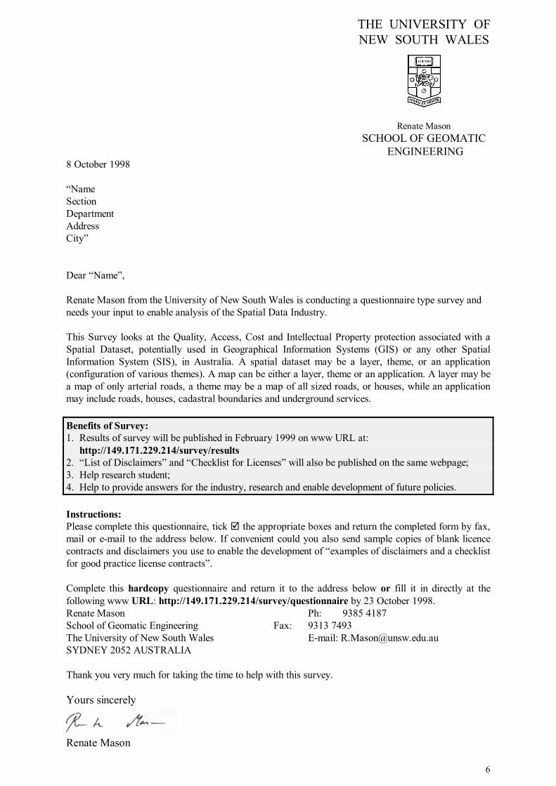
6
THE UNIVERSITY OF NEW SOUTH WALES
Renate Mason
SCHOOL OF GEOMATIC ENGINEERING
8 October 1998 �Name Section Department Address City� Dear �Name�, Renate Mason from the University of New South Wales is conducting a questionnaire type survey and needs your input to enable analysis of the Spatial Data Industry. This Survey looks at the Quality, Access, Cost and Intellectual Property protection associated with a Spatial Dataset, potentially used in Geographical Information Systems (GIS) or any other Spatial Information System (SIS), in Australia. A spatial dataset may be a layer, theme, or an application (configuration of various themes). A map can be either a layer, theme or an application. A layer may be a map of only arterial roads, a theme may be a map of all sized roads, or houses, while an application may include roads, houses, cadastral boundaries and underground services. Benefits of Survey: 1. Results of survey will be published in February 1999 on www URL at:
http://149.171.229.214/survey/results 2. �List of Disclaimers� and �Checklist for Licenses� will also be published on the same webpage; 3. Help research student; 4. Help to provide answers for the industry, research and enable development of future policies. Instructions: Please complete this questionnaire, tick ! the appropriate boxes and return the completed form by fax, mail or e-mail to the address below. If convenient could you also send sample copies of blank licence contracts and disclaimers you use to enable the development of �examples of disclaimers and a checklist for good practice license contracts�. Complete this hardcopy questionnaire and return it to the address below or fill it in directly at the following www URL: http://149.171.229.214/survey/questionnaire by 23 October 1998. Renate Mason Ph: 9385 4187 School of Geomatic Engineering Fax: 9313 7493 The University of New South Wales E-mail: [email protected] SYDNEY 2052 AUSTRALIA Thank you very much for taking the time to help with this survey. Yours sincerely
Renate Mason

0
Appendix 2
Samples of Respondent Numbers and
Graphs of the
Spatial Data Survey

App
endi
x 2
II. S
patia
l Dat
a Pr
ovid
er Q
uest
ions
A. D
ATA
QU
ALI
TY
Que
stio
n 1:
Add
ition
al in
fo p
rovi
ded
with
dat
a-se
t 2
gro
ups
Accu
racy
9336
%M
aint
enan
ce40
16%
Upd
ates
5622
%D
iscl
aim
er12
950
%M
etad
ata
8934
%D
epen
ds o
n D
atas
et10
541
%N
othi
ng41
16%
Oth
er27
10%
No
Answ
er9
3%To
tal
589
258-
589
-331
-128
%D
ata
Prov
ider
22Bo
th23
6To
tal
258
100%
LGR
est
Loca
l GAl
l oth
eAll
othe
r Org
anis
atio
nsAc
cura
cy26
67Ac
cura
10%
26%
Mai
nten
ance
1129
Mai
nte
4%11
%U
pdat
es17
39U
pdat
e7%
15%
Dis
clai
mer
5475
Dis
clai
21%
29%
Met
adat
a21
68M
etad
a8%
26%
Dep
ends
on
Dat
aset
4857
Dep
en19
%22
%N
othi
ng27
14N
othi
n g10
%5%
Oth
er11
16O
ther
4%6%
No
Answ
er5
4N
o An
s2%
2%To
tal
220
369
589
-103
-228
-40%
-88%
Tota
l11
714
145
%55
%10
0%
Dat
a Q
ualit
y3%
36%
16%
22%
50%
34%
41%
16%
10%
0%10
%20
%30
%40
%50
%60
%
Accu
racy
Mai
nten
ance
Upd
ates
Dis
clai
mer
Met
adat
a
Dep
ends
on
Dat
aset
Not
hing
Oth
er
No
Answ
er
Loca
lG
over
nmen
t
All o
ther
Org
anis
atio
ns
3DB7
324B
-060
A-6A
54.x
lsPa
ge 1

4 g
roup
sQ
uest
ion
1A
CT
NSW
NT
Qld
SATa
sVi
cW
AU
nkno
wn
Subt
otal
%A
CT
NSW
NT
Qld
SATa
sVi
cW
Ank
now
nFe
dera
l G.
1410
0%Fe
dera
l G.
Accu
racy
750
%Ac
cura
cyM
aint
enan
ce4
29%
Mai
nten
ance
Upd
ates
214
%U
pdat
esD
iscl
aim
er6
43%
Dis
clai
mer
Met
adat
a11
79%
Met
adat
aD
epen
ds o
n D
atas
et7
50%
Dep
ends
on
Dat
aset
Not
hing
00%
Not
hing
Oth
er4
29%
Oth
erSt
ate
G.
19
123
21
612
156
100%
Stat
e G
.10
0%10
0%10
0%10
0%10
0%10
0%10
0%10
0%10
0%Ac
cura
cy0
40
141
13
71
3155
%Ac
cura
cy0%
44%
0%61
%50
%10
0%50
%58
%10
0%M
aint
enan
ce0
30
41
02
50
1527
%M
aint
enan
ce0%
33%
0%17
%50
%0%
33%
42%
0%U
pdat
es1
30
71
03
60
2138
%U
pdat
es10
0%33
%0%
30%
50%
0%50
%50
%0%
Dis
clai
mer
15
113
21
36
032
57%
Dis
clai
mer
100%
56%
100%
57%
100%
100%
50%
50%
0%M
etad
ata
13
010
20
311
131
55%
Met
adat
a10
0%33
%0%
43%
100%
0%50
%92
%10
0%D
epen
ds o
n D
atas
et0
20
132
11
40
2341
%D
epen
ds o
n D
atas
et0%
22%
0%57
%10
0%10
0%17
%33
%0%
Not
hing
01
02
00
10
04
7%N
othi
ng0%
11%
0%9%
0%0%
17%
0%0%
Oth
er0
30
00
13
00
713
%O
ther
0%33
%0%
0%0%
100%
50%
0%0%
Loca
l G.
047
227
75
1611
211
710
0%Lo
cal G
.0%
100%
100%
100%
100%
100%
100%
100%
100%
Accu
racy
\9
06
33
41
026
22%
Accu
racy
\19
%0%
22%
43%
60%
25%
9%0%
Mai
nten
ance
\6
02
01
20
011
9%M
aint
enan
ce\
13%
0%7%
0%20
%13
%0%
0%U
pdat
es\
70
51
12
10
1715
%U
pdat
es\
15%
0%19
%14
%20
%13
%9%
0%D
iscl
aim
er\
250
172
45
01
5446
%D
iscl
aim
er\
53%
0%63
%29
%80
%31
%0%
50%
Met
adat
a\
50
82
12
30
2118
%M
etad
ata
\11
%0%
30%
29%
20%
13%
27%
0%D
epen
ds o
n D
atas
et\
230
82
38
40
4841
%D
epen
ds o
n D
atas
et\
49%
0%30
%29
%60
%50
%36
%0%
Not
hing
\10
14
22
43
127
23%
Not
hing
\21
%50
%15
%29
%40
%25
%27
%50
%O
ther
\4
11
10
30
111
9%O
ther
\9%
50%
4%14
%0%
19%
0%50
%A
ll O
ther
119
121
80
810
371
100%
All
Oth
er10
0%10
0%10
0%10
0%10
0%0%
100%
100%
100%
Accu
racy
14
112
1\
37
029
41%
Accu
racy
100%
21%
100%
57%
13%
\38
%70
%0%
Mai
nten
ance
14
04
1\
00
010
14%
Mai
nten
ance
100%
21%
0%19
%13
%\
0%0%
0%U
pdat
es1
40
71
\1
20
1623
%U
pdat
es10
0%21
%0%
33%
13%
\13
%20
%0%
Dis
clai
mer
010
110
3\
38
237
52%
Dis
clai
mer
0%53
%10
0%48
%38
%\
38%
80%
67%
Met
adat
a1
40
73
\3
80
2637
%M
etad
ata
100%
21%
0%33
%38
%\
38%
80%
0%D
epen
ds o
n D
atas
et1
100
45
\1
51
2738
%D
epen
ds o
n D
atas
et10
0%53
%0%
19%
63%
\13
%50
%33
%N
othi
ng1
20
31
\2
10
1014
%N
othi
ng10
0%11
%0%
14%
13%
\25
%10
%0%
Oth
er0
20
11
\1
10
68%
Oth
er0%
11%
0%5%
13%
\13
%10
%0%
Tota
l2
754
7117
630
336
244
100%
Acc
urac
y1
171
325
410
151
8633
%M
aint
enan
ce1
130
102
14
50
3614
%U
pdat
es2
140
193
16
90
5421
%D
iscl
aim
er1
402
407
511
143
123
48%
Met
adat
a2
120
257
18
221
7830
%D
epen
ds o
n D
atas
et1
350
259
410
131
9838
%N
othi
ng1
131
93
27
41
4116
%O
ther
09
12
21
71
124
9%
3DB7
324B
-060
A-6A
54.x
lsPa
ge 2

Que
stio
n 1:
Sta
te G
over
nmen
t
0%20%
40%
60%
80%
100%
120%
ACT (1)
NSW (9
)
NT (1
) Q
ld (23
)
SA (2)
Tas (1
)
Vic (6)
WA (1
2) Unk
nown (
1)
Stat
e/Te
rrito
ry
Percentages
Accu
racy
Mai
nten
ance
Upd
ates
Dis
clai
mer
Met
adat
aD
epen
ds o
n D
atas
etN
othi
ngO
ther
Que
stio
n 1:
Loc
al G
over
nmen
t
0%10%
20%
30%
40%
50%
60%
70%
80%
90%
ACT (0)
NSW (4
7)
NT (2
) Q
ld (27
)
SA (7)
Tas (5
) Vic
(16)
WA (1
1) Unk
nown (
2)
Stat
e/Te
rrito
ry
Percentages
Accu
racy
Mai
nten
ance
Upd
ates
Dis
clai
mer
Met
adat
aD
epen
ds o
n D
atas
etN
othi
ngO
ther
Que
stio
n 1:
All
othe
r Org
anis
atio
ns
0%20%
40%
60%
80%
100%
120%
ACT (1) N
SW (19)
NT (1
) Q
ld (21
)
SA (8)
Tas (0
)
Vic (8)
WA (1
0) Unk
nown (
3)
Stat
e/Te
rrito
ry
Percentages
Accu
racy
Mai
nten
ance
Upd
ates
Dis
clai
mer
Met
adat
aD
epen
ds o
n D
atas
etN
othi
ngO
ther
Que
stio
n 1:
Fed
eral
Gov
ernm
ent (
14)
0%10
%20
%30
%40
%50
%60
%70
%80
%90
%
Accu
racy
Mai
nten
ance
Upd
ates
Dis
clai
mer
Met
adat
a
Dep
ends
on
Dat
aset
Not
hing
Oth
er
Num
ber o
f tic
ks
3DB7
324B
-060
A-6A
54.x
lsPa
ge 3

B. D
ATA
AC
CES
S &
CO
ST
Que
stio
n 1:
Dat
a ac
cess
?2
grou
psLG
Res
tLo
cal G
All o
ther
Org
anis
atio
nsE-
mai
l12
548
%E-
mai
l48
%47
-47
18%
30%
Dow
nloa
d17
7%D
ownl
o7%
4-4
2%5%
View
ing
only
3012
%Vi
ewin
g12
%7
-73%
9%FT
P62
24%
FTP
24%
14-1
45%
19%
Flop
py d
isk
154
60%
Flop
p y60
%59
-59
23%
37%
CD
-Rom
118
46%
CD
-Ro
46%
37-3
714
%31
%H
ardc
opy
213
83%
Har
dco
83%
105
-105
41%
42%
Fax
7931
%Fa
x31
%38
-38
15%
16%
Tape
6726
%Ta
pe26
%15
-15
6%20
%D
epen
ds o
n D
atas
et74
29%
Dep
en29
%26
-26
10%
19%
Oth
er19
7%O
ther
7%9
-93%
4%N
o An
swer
31%
No
Ans
1%2
11%
0%To
tal
961
363
-360
258-
958
-703
-272
%-2
4624
3-9
5%-1
77%
Tota
l Pro
vide
r & B
oth
258
100%
117
-117
45%
55%
100%
Sum
mar
y - D
ata
Qua
lity
051015202530354045
ACT (2)
NSW (7
5)
NT (4
)
Qld
(71)
SA (17)
Tas (6
)
Vic (30
)
WA (3
3)
Unk
nown (
6)
Stat
e/Te
rrito
ry
Actual Number of Ticks per Box Item
Accu
racy
Mai
nten
ance
Upd
ates
Dis
clai
mer
Met
adat
aD
epen
ds o
n D
atas
etN
othi
ngO
ther
Dat
a A
cces
s
1%
29%
48%
7%12%
24%
60%
46%
83%
31%
26%
7%
0%10
%20
%30
%40
%50
%60
%70
%80
%90
%
E-m
ail
Dow
nloa
d
View
ing
only
FTP
Flop
py d
isk
CD
-Rom
Har
dcop
y
Fax
Tape
Dep
ends
on
Dat
aset
Oth
er
No
Answ
er
Loca
l Gov
ernm
ent
All o
ther
Org
anis
atio
ns
3DB7
324B
-060
A-6A
54.x
lsPa
ge 4

4 g
roup
sQ
uest
ion
1A
CT
NSW
NT
Qld
SATa
sVi
cW
AU
nkno
wn
Subt
otal
%A
CT
NSW
NT
Qld
SATa
sVi
cW
Ank
now
nFe
dera
l G.
1410
0%Fe
dera
l G.
E-m
ail
1071
%E-
mai
lD
ownl
oad
214
%D
ownl
oad
View
ing
only
643
%Vi
ewin
g on
lyFT
P7
50%
FTP
Flop
py d
isk
1071
%Fl
oppy
dis
kC
D-R
om11
79%
CD
-Rom
Har
dcop
y9
64%
Har
dcop
yFa
x2
14%
Fax
Tape
643
%Ta
peD
epen
ds o
n D
atas
et3
21%
Dep
ends
on
Dat
aset
Oth
er2
14%
Oth
erSt
ate
G.
19
123
21
612
156
100%
Stat
e G
.10
0%10
0%10
0%10
0%10
0%10
0%10
0%10
0%10
0%E-
mai
l1
30
130
12
90
2952
%E-
mai
l10
0%33
%0%
57%
0%10
0%33
%75
%0%
Dow
nloa
d0
30
10
01
10
611
%D
ownl
oad
0%33
%0%
4%0%
0%17
%8%
0%Vi
ewin
g on
ly1
30
20
12
30
1221
%Vi
ewin
g on
ly10
0%33
%0%
9%0%
100%
33%
25%
0%FT
P1
51
82
01
100
2850
%FT
P10
0%56
%10
0%35
%10
0%0%
17%
83%
0%Fl
oppy
dis
k1
70
171
13
101
4173
%Fl
oppy
dis
k10
0%78
%0%
74%
50%
100%
50%
83%
100%
CD
-Rom
16
016
21
311
141
73%
CD
-Rom
100%
67%
0%70
%10
0%10
0%50
%92
%10
0%H
ardc
opy
16
022
11
611
048
86%
Har
dcop
y10
0%67
%0%
96%
50%
100%
100%
92%
0%Fa
x1
30
81
13
60
2341
%Fa
x10
0%33
%0%
35%
50%
100%
50%
50%
0%Ta
pe1
60
102
12
60
2850
%Ta
pe10
0%67
%0%
43%
100%
100%
33%
50%
0%D
epen
ds o
n D
atas
et0
51
92
00
40
2138
%D
epen
ds o
n D
atas
et0%
56%
100%
39%
100%
0%0%
33%
0%O
ther
12
00
10
11
06
11%
Oth
er10
0%22
%0%
0%50
%0%
17%
8%0%
Loca
l G.
047
227
75
1611
211
710
0%Lo
cal G
.0%
100%
100%
100%
100%
100%
100%
100%
100%
E-m
ail
\19
011
24
73
147
40%
E-m
ail
\40
%0%
41%
29%
80%
44%
27%
50%
Dow
nloa
d\
10
10
10
10
43%
Dow
nloa
d\
2%0%
4%0%
20%
0%9%
0%Vi
ewin
g on
ly\
30
11
10
10
76%
View
ing
only
\6%
0%4%
14%
20%
0%9%
0%FT
P\
60
22
02
20
1412
%FT
P\
13%
0%7%
29%
0%13
%18
%0%
Flop
py d
isk
\23
015
35
84
159
50%
Flop
py d
isk
\49
%0%
56%
43%
100%
50%
36%
50%
CD
-Rom
\14
011
23
61
037
32%
CD
-Rom
\30
%0%
41%
29%
60%
38%
9%0%
Har
dcop
y\
441
257
414
91
105
90%
Har
dcop
y\
94%
50%
93%
100%
80%
88%
82%
50%
Fax
\17
011
41
23
038
32%
Fax
\36
%0%
41%
57%
20%
13%
27%
0%Ta
pe\
90
42
00
00
1513
%Ta
pe\
19%
0%15
%29
%0%
0%0%
0%D
epen
ds o
n D
atas
et\
81
71
31
41
2622
%D
epen
ds o
n D
atas
et\
17%
50%
26%
14%
60%
6%36
%50
%O
ther
\1
05
00
11
19
8%O
ther
\2%
0%19
%0%
0%6%
9%50
%A
ll O
ther
119
121
80
810
371
100%
All
Oth
er10
0%10
0%10
0%10
0%10
0%0%
100%
100%
100%
E-m
ail
113
19
3\
47
139
55%
E-m
ail
100%
68%
100%
43%
38%
\50
%70
%33
%D
ownl
oad
03
00
1\
10
05
7%D
ownl
oad
0%16
%0%
0%13
%\
13%
0%0%
View
ing
only
03
01
1\
00
05
7%Vi
ewin
g on
ly0%
16%
0%5%
13%
\0%
0%0%
FTP
15
01
3\
12
013
18%
FTP
100%
26%
0%5%
38%
\13
%20
%0%
Flop
py d
isk
115
112
3\
57
044
62%
Flop
py d
isk
100%
79%
100%
57%
38%
\63
%70
%0%
CD
-Rom
06
010
4\
26
129
41%
CD
-Rom
0%32
%0%
48%
50%
\25
%60
%33
%H
ardc
opy
112
114
6\
69
251
72%
Har
dcop
y10
0%63
%10
0%67
%75
%\
75%
90%
67%
Fax
06
14
0\
32
016
23%
Fax
0%32
%10
0%19
%0%
\38
%20
%0%
Tape
06
05
2\
14
018
25%
Tape
0%32
%0%
24%
25%
\13
%40
%0%
Dep
ends
on
Dat
aset
15
06
5\
15
124
34%
Dep
ends
on
Dat
aset
100%
26%
0%29
%63
%\
13%
50%
33%
Oth
er0
00
20
\0
10
34%
Oth
er0%
0%0%
10%
0%\
0%10
%0%
3DB7
324B
-060
A-6A
54.x
lsPa
ge 5
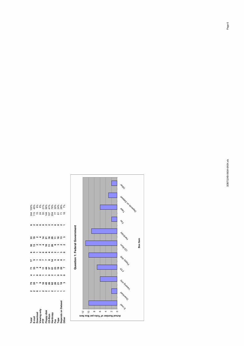
Tota
l2
754
7117
630
336
244
100%
E-m
ail
235
133
55
1319
211
545
%D
ownl
oad
07
02
11
22
015
6%Vi
ewin
g on
ly1
90
42
22
40
249%
FTP
216
111
70
414
055
21%
Flop
py d
isk
245
144
76
1621
214
456
%C
D-R
om1
260
378
411
182
107
41%
Har
dcop
y2
622
6114
526
293
204
79%
Fax
126
123
52
811
077
30%
Tape
121
019
61
310
061
24%
Dep
ends
on
Dat
aset
118
222
83
213
271
28%
Oth
er1
30
71
02
31
187%
Que
stio
n 1:
Fed
eral
Gov
ernm
ent
024681012
Downlo
adView
ing on
ly
FTP
Floppy
disk
CD-Rom
Hardco
py
Fax
Tape
Depen
ds on
Data
set
Other
Box
Item
Actual Number of Ticks per Box Item
3DB7
324B
-060
A-6A
54.x
lsPa
ge 6

Que
stio
n 1:
Sta
te G
over
nmen
t
0%20%
40%
60%
80%
100%
120%
ACT (1)
NSW (9
)
NT (1
)
Qld
(23)
SA (2)
Tas (1
)
Vic (6)
WA (1
2) U
nkno
wn (1)
Stat
e/Te
rrito
ry
Percentages
E-m
ail
Dow
nloa
dVi
ewin
g on
lyFT
PFl
oppy
dis
kC
D-R
omH
ardc
opy
Fax
Tape
Dep
ends
on
Dat
aset
Oth
er
Que
stio
n 1:
Loc
al G
over
nmen
t
0%20%
40%
60%
80%
100%
120%
ACT (0)
NSW (4
7)
NT (2
)
Qld
(27)
SA (7)
Tas (5
)
Vic (16
)
WA (1
1) U
nkno
wn (2)
Stat
e/Te
rrito
ry
Percentages
E-m
ail
Dow
nloa
dVi
ewin
g on
lyFT
PFl
oppy
dis
kC
D-R
omH
ardc
opy
Fax
Tape
Dep
ends
on
Dat
aset
Oth
er
3DB7
324B
-060
A-6A
54.x
lsPa
ge 7
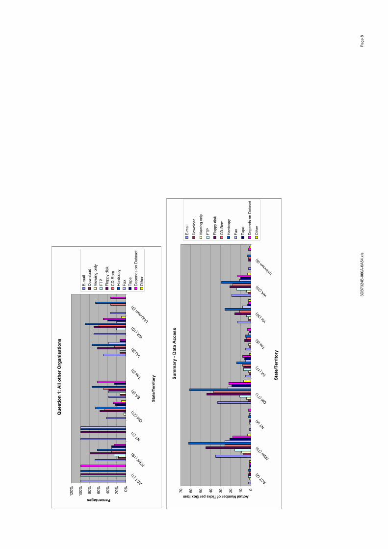
Que
stio
n 1:
All
othe
r Org
anis
atio
ns
0%20%
40%
60%
80%
100%
120%
ACT (1)
NSW (1
9)
NT (1
)
Qld
(21)
SA (8)
Tas (0
)
Vic (8)
WA (1
0) U
nkno
wn (3)
Stat
e/Te
rrito
ry
Percentages
E-m
ail
Dow
nloa
dVi
ewin
g on
lyFT
PFl
oppy
dis
kC
D-R
omH
ardc
opy
Fax
Tape
Dep
ends
on
Dat
aset
Oth
er
Sum
mar
y - D
ata
Acc
ess
010203040506070
ACT (2)
NSW (7
5)
NT (4
)
Qld
(71)
SA (17)
Tas (6
)
Vic (30
)
WA (3
3)
Unk
nown (
6)
Stat
e/Te
rrito
ry
Actual Number of Ticks per Box Item
E-m
ail
Dow
nloa
d
View
ing
only
FTP
Flop
py d
isk
CD
-Rom
Har
dcop
y
Fax
Tape
Dep
ends
on
Dat
aset
Oth
er
3DB7
324B
-060
A-6A
54.x
lsPa
ge 8

C. L
EGA
L
Que
stio
n 4:
Wha
t leg
al p
rote
ctio
n do
es y
our o
rgan
isat
ion
utili
se fo
r its
dat
aset
s? 2
gro
ups
Non
e11
846
%C
opyr
ight
10
139
%Li
cens
es77
30%
Trad
e Se
cret
31%
Oth
ers
2510
%N
o An
swer
93%
Tota
l33
325
8-32
4-7
5-2
9%To
tal
258
100%
All
LGR
est
Loca
l GAl
l oth
er O
rgan
isat
ions
Non
e11
867
51N
one
26%
20%
Cop
yrig
ht
101
3467
Cop
yrig
13%
26%
Lice
nses
7726
51Li
cens
e10
%20
%Tr
ade
Secr
et3
21
Trad
e S
1%0%
Oth
ers
2513
12O
ther
s5%
5%N
o An
swer
92
7N
o An
s1%
3%To
tal
333
144
182
Tota
l-7
5-2
7-4
8-1
0%-1
9%To
tal
258
117
134
Tota
l45
%55
%10
0%
4 g
roup
sQ
uest
ion
4A
CT
NSW
NT
Qld
SATa
sVi
cW
AU
nkno
wn
AC
TN
SWN
TQ
ldSA
Tas
Vic
WA
nkno
wn
Fede
ral G
.14
Fede
ral G
.N
one
321
%N
one
Cop
yrig
ht
857
%C
opyr
ight
Li
cens
es8
57%
Lice
nses
Trad
e Se
cret
00%
Trad
e Se
cret
Oth
ers
321
%O
ther
sSt
ate
G.
19
123
21
612
156
Stat
e G
.10
0%10
0%10
0%10
0%10
0%10
0%10
0%10
0%10
0%N
one
03
14
00
32
114
25%
Non
e0%
33%
100%
17%
0%0%
50%
17%
100%
Cop
yrig
ht
16
014
11
16
030
54%
Cop
yrig
ht
100%
67%
0%61
%50
%10
0%17
%50
%0%
Lice
nses
13
111
21
29
030
54%
Lice
nses
100%
33%
100%
48%
100%
100%
33%
75%
0%Tr
ade
Secr
et0
00
00
00
00
00%
Trad
e Se
cret
0%0%
0%0%
0%0%
0%0%
0%O
ther
s0
21
20
01
10
713
%O
ther
s0%
22%
100%
9%0%
0%17
%8%
0%Lo
cal G
.0
472
277
516
112
117
Loca
l G.
0%10
0%10
0%10
0%10
0%10
0%10
0%10
0%10
0%N
one
\22
216
53
117
167
57%
Non
e\
47%
100%
59%
71%
60%
69%
64%
50%
Cop
yrig
ht
\18
08
02
51
034
29%
Cop
yrig
ht
\38
%0%
30%
0%40
%31
%9%
0%Li
cens
es\
170
30
23
01
2622
%Li
cens
es\
36%
0%11
%0%
40%
19%
0%50
%Tr
ade
Secr
et\
10
10
00
00
22%
Trad
e Se
cret
\2%
0%4%
0%0%
0%0%
0%O
ther
s\
30
42
12
10
1311
%O
ther
s\
6%0%
15%
29%
20%
13%
9%0%
All
Oth
er1
191
218
08
103
71A
ll O
ther
100%
100%
100%
100%
100%
0%10
0%10
0%10
0%N
one
010
013
4\
34
034
48%
Non
e0%
53%
0%62
%50
%\
38%
40%
0%C
opyr
ight
1
81
74
\3
32
2941
%C
opyr
ight
10
0%42
%10
0%33
%50
%\
38%
30%
67%
Lice
nses
15
03
0\
04
013
18%
Lice
nses
100%
26%
0%14
%0%
\0%
40%
0%Tr
ade
Secr
et0
10
00
\0
00
11%
Trad
e Se
cret
0%5%
0%0%
0%\
0%0%
0%O
ther
s0
00
20
\0
10
34%
Oth
ers
0%0%
0%10
%0%
\0%
10%
0%To
tal
275
471
176
3033
624
4N
one
035
333
93
1713
211
545
%C
opyr
ight
2
321
295
39
102
9336
%Li
cens
es2
251
172
35
131
6927
%Tr
ade
Secr
et0
20
10
00
00
31%
Oth
ers
05
18
21
33
023
9%C
heck
499
688
1810
3439
530
3
Sect
ion
II: L
egal
Pro
tect
ion
3%
10%
1%
30%
39%
46%
0%10%
20%
30%
40%
50%
Non
eC
opyr
ight
Li
cens
esTr
ade
Secr
etO
ther
sN
o An
swer
All o
ther
Org
anis
atio
nsLo
cal G
over
nmen
t
3DB7
324B
-060
A-6A
54.x
lsPa
ge 9

Que
stio
n 4:
Fed
eral
Gov
ernm
ent
0%10
%20
%30
%40
%50
%60
%
Non
e (3
)
Cop
yrig
ht (8
)
Lic
ense
s (8
)
Tra
de S
ecre
t (0)
Oth
ers
(3)
Perc
enta
ges
Que
stio
n 4:
Sta
te G
over
nmen
t
0%20%
40%
60%
80%
100%
120%
ACT (1)
NSW (9
)
NT (1
) Q
ld (23
)
SA (2)
Tas (1
)
Vic (6)
WA (1
2) Unk
nown (
1)St
ate/
Terr
itory
Percentages
Non
eC
opyr
ight
Li
cens
esTr
ade
Secr
etO
ther
s
Que
stio
n 4:
Loc
al G
over
nmen
t
0%20%
40%
60%
80%
100%
120%
ACT (0)
NSW (4
7)
NT (2
) Q
ld (27
)
SA (7)
Tas (5
)
Vic (16
) W
A (11) U
nkno
wn (2)
Stat
e/Te
rrito
ry
Percentages
Non
eC
opyr
ight
Li
cens
esTr
ade
Secr
etO
ther
s
Que
stio
n 4:
All
othe
r Org
anis
atio
ns
0%20%
40%
60%
80%
100%
120%
ACT (1)
NSW (1
9)
NT (1
) Q
ld (21
)
SA (8)
Tas (0
)
Vic (8)
WA (1
0) Unk
nown (
3)
Stat
e/Te
rrito
ry
Percentages
Non
eC
opyr
ight
Li
cens
esTr
ade
Secr
etO
ther
s
3DB7
324B
-060
A-6A
54.x
lsPa
ge 1
0
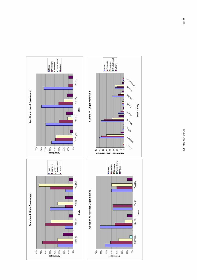
Sum
mar
y - L
egal
Pro
tect
ion
0510152025303540
ACT (2)
NSW (7
5)
NT (4
)
Qld
(71)
SA (17)
Tas (6
)
Vic (30
)
WA (3
3) U
nkno
wn (6)
Stat
e/Te
rrito
ry
Actual Number of Respondents
Non
eC
opyr
ight
Li
cens
esTr
ade
Secr
etO
ther
s
Que
stio
n 4:
Sta
te G
over
nmen
t
0%10%
20%
30%
40%
50%
60%
70%
80%
NSW
(9)
Qld
(23)
Vic
(6)
WA
(12)
Stat
e
Percentages
Non
eC
opyr
ight
Li
cens
esTr
ade
Secr
etO
ther
s
Que
stio
n 4:
Loc
al G
over
nmen
t
0%10%
20%
30%
40%
50%
60%
70%
80%
NSW
(47)
Qld
(27)
Vic
(16)
WA
(11)
Stat
e
Percentages
Non
eC
opyr
ight
Li
cens
esTr
ade
Secr
etO
ther
s
Que
stio
n 4:
All
othe
r Org
anis
atio
ns
0%10%
20%
30%
40%
50%
60%
70%
NSW
(19)
Qld
(21)
Vic
(8)
WA
(10)
Stat
e
Percentages
Non
eC
opyr
ight
Li
cens
esTr
ade
Secr
etO
ther
s
3DB7
324B
-060
A-6A
54.x
lsPa
ge 1
1

III. S
patia
l Dat
a U
ser Q
uest
ions
D. L
EGA
L
Que
stio
n 1:
Wha
t leg
al p
rote
ctio
n do
es y
our d
ata
prov
ider
util
ise
for h
is d
atas
ets?
2 g
roup
sN
one
4212
%C
opyr
ight
17
351
%Li
cens
es21
363
%Tr
ade
Secr
et1
0%O
ther
s14
4%N
o an
swer
227%
Subt
otal
465
338-
465
-127
-38%
Tota
l33
810
0%
LGR
est
Loca
l GAl
l oth
er O
rgan
isat
ions
Non
e23
19N
one
7%6%
Cop
yrig
ht
9974
Cop
yrig
29%
22%
Lice
nses
125
88Li
cens
e37
%26
%Tr
ade
Secr
et1
0Tr
ade
S0%
0%O
ther
s7
7O
ther
s2%
2%N
o an
swer
1210
No
Ans
4%3%
Subt
otal
267
198
Subt
otal
-77
-50
-23%
-15%
Tota
l19
014
8To
tal
56%
44%
100%
4 g
roup
sQ
uest
ion
1AC
TN
SWN
TQ
ldSA
Tas
Vic
WA
Unk
now
nAC
TN
SWN
TQ
ldSA
Tas
Vic
WA
Unk
now
nFe
dera
l G.
14Fe
dera
l G.
Non
e1
7%N
one
Cop
yrig
ht
643
%C
opyr
ight
Li
cens
es10
71%
Lice
nses
Trad
e Se
cret
00%
Trad
e Se
cret
Oth
ers
321
%O
ther
sSt
ate
G.
19
123
30
512
054
Stat
e G
.10
0%10
0%10
0%10
0%10
0%0%
100%
100%
0%N
one
01
01
0\
03
\5
9%N
one
0%11
%0%
4%0%
\0%
25%
\C
opyr
ight
0
51
122
\2
3\
2546
%C
opyr
ight
0%
56%
100%
52%
67%
\40
%25
%\
Lice
nses
17
015
2\
49
\38
70%
Lice
nses
100%
78%
0%65
%67
%\
80%
75%
\Tr
ade
Secr
et0
00
00
\0
0\
00%
Trad
e Se
cret
0%0%
0%0%
0%\
0%0%
\O
ther
s0
00
10
\0
0\
12%
Oth
ers
0%0%
0%4%
0%\
0%0%
\Lo
cal G
.0
653
4416
727
262
190
Loca
l G.
0%10
0%10
0%10
0%10
0%10
0%10
0%10
0%10
0%N
one
\5
25
51
41
023
12%
Non
e\
8%67
%11
%31
%14
%15
%4%
0%C
opyr
ight
\
361
296
19
161
9952
%C
opyr
ight
\
55%
33%
66%
38%
14%
33%
62%
50%
Lice
nses
\52
030
36
2013
112
566
%Li
cens
es\
80%
0%68
%19
%86
%74
%50
%50
%Tr
ade
Secr
et\
00
01
00
00
11%
Trad
e Se
cret
\0%
0%0%
6%0%
0%0%
0%O
ther
s\
20
11
02
10
74%
Oth
ers
\3%
0%2%
6%0%
7%4%
0%Al
l Oth
er1
240
207
014
122
80Al
l Oth
er10
0%10
0%0%
100%
100%
0%10
0%10
0%10
0%N
one
06
\4
1\
11
013
16%
Non
e0%
25%
\20
%14
%\
7%8%
0%C
opyr
ight
0
12\
103
\7
101
4354
%C
opyr
ight
0%
50%
\50
%43
%\
50%
83%
50%
Lice
nses
112
\10
4\
58
040
50%
Lice
nses
100%
50%
\50
%57
%\
36%
67%
0%Tr
ade
Secr
et0
0\
00
\0
00
00%
Trad
e Se
cret
0%0%
\0%
0%\
0%0%
0%O
ther
s0
1\
10
\1
00
34%
Oth
ers
0%4%
\5%
0%\
7%0%
0%To
tal
298
487
267
4650
432
4N
one
012
210
61
55
041
12%
Sect
ion
III: L
egal
Pro
tect
ion
7%4%
0%
63%
51%
12%
0%10%
20%
30%
40%
50%
60%
70%
Non
eC
opyr
ight
Li
cens
esTr
ade
Secr
etO
ther
sN
o an
swer
All o
ther
Org
anis
atio
nsLo
cal G
over
nmen
t
3DB7
324B
-060
A-6A
54.x
lsPa
ge 1
2

Cop
yrig
ht
053
251
111
1829
216
749
%Li
cens
es2
710
559
629
301
203
60%
Trad
e Se
cret
00
00
10
00
01
0%O
ther
s0
30
31
03
10
113%
Que
stio
n 1:
Fed
eral
Geo
vern
men
t
0%10
%20
%30
%40
%50
%60
%70
%80
%
Non
e (1
)
Cop
yrig
ht (6
)
Lice
nces
(10)
Tra
de S
ecre
t (0)
Oth
ers
(3)
Perc
enta
ges
Que
stio
n 1:
Sta
te G
over
nmen
t
0%20%
40%
60%
80%
100%
120%
ACT (1)
NSW (9
)
NT (1
) Q
ld (23
)
SA (3)
Tas (0
)
Vic (5)
WA (1
2) Unk
nown (
0)
Stat
e/Te
rrito
ry
Percentages
Non
eC
opyr
ight
Li
cens
esTr
ade
Secr
etO
ther
s
Que
stio
n 1:
Loc
al G
over
nmen
t
0%10%
20%
30%
40%
50%
60%
70%
80%
90%
ACT (0)
NSW (6
5)
NT (3
)
Qld
(44)
SA (16)
Tas (7
)
Vic (27
) W
A (26)
Unk
nown (
2)
Stat
e/Te
rrito
ry
Percentages
Non
eC
opyr
ight
Li
cens
esTr
ade
Secr
etO
ther
s
Que
stio
n 1:
All
othe
r Org
anis
atio
ns
0%20%
40%
60%
80%
100%
120%
ACT (1)
NSW (2
4)
NT (0
) Q
ld (20
)
SA (7)
Tas (0
) Vic
(14)
WA (1
2) Unk
nown (
2)
Stat
e/Te
rrito
ry
Percentages
Non
eC
opyr
ight
Li
cens
esTr
ade
Secr
etO
ther
s
3DB7
324B
-060
A-6A
54.x
lsPa
ge 1
3
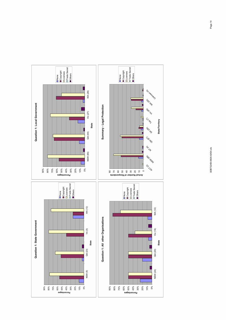
Que
stio
n 1:
Sta
te G
over
nmen
t
0%10%
20%
30%
40%
50%
60%
70%
80%
90%
NSW
(9)
Qld
(23)
Vic
(5)
WA
(12)
Stat
e
Percentages
Non
eC
opyr
ight
Li
cens
esTr
ade
Secr
etO
ther
s
Que
stio
n 1:
Loc
al G
over
nmen
t
0%10%
20%
30%
40%
50%
60%
70%
80%
90%
NSW
(65)
Qld
(44)
Vic
(27)
WA
(26)
Stat
e
Percentages
Non
eC
opyr
ight
Li
cens
esTr
ade
Secr
etO
ther
s
Que
stio
n 1:
All
oth
er O
rgan
isat
ions
0%10%
20%
30%
40%
50%
60%
70%
80%
90%
NSW
(24)
Qld
(20)
Vic
(14)
WA
(12)
Stat
e
Percentages
Non
eC
opyr
ight
Li
cens
esTr
ade
Secr
etO
ther
s
Sum
mar
y - L
egal
Pro
tect
ion
01020304050607080
ACT (2)
NSW (9
8)
NT (4
)
Qld
(87)
SA (26)
Tas (7
)
Vic (46
) W
A (50)
Unk
nown (
4)
Stat
e/Te
rrito
ry
Actual Number of Respondents
Non
eC
opyr
ight
Li
cens
esTr
ade
Secr
etO
ther
s
3DB7
324B
-060
A-6A
54.x
lsPa
ge 1
4

Appendix 3
ANZLIC – Core Metadata Elements(Available at: http://www.anzlic.org.au/asdi/metaelem.htm)
Core Metadata Elements
for Land and Geographic Directories in Australia and New Zealand
Following are the introductory sections to the ANZLIC Guidelines on Core Metadata Elements. The complete document is available by FTP. It contains detailed descriptions of each of the core metadata elements together with worked examples. To download the full document click here.
Background
Introduction
ANZLIC's Strategic Plan for 1994 - 1997 outlines strategies to achieve these objectives. The strategy to develop and implement a national land and geographic data directory system for Australia and New Zealand is designed, "to maximise community access to land and geographic information with due regard for issues of privacy and confidentiality." However, successful

implementation of a national directory will also contribute in part to the achievement of ANZLIC's other stated objectives.
Metadata is data about data. It is a description of the characteristics of data that has been collected for a specific purpose. If community access to land information is to be maximised, adequate descriptions of the characteristics of all geographically referenced datasets must be available and accessible to the community at large.
A Working Group was formed in April 1995 to work on the following tasks to improve community access to data:
❍ produce a Metadata Framework paper which identifies and defines the mandatory metadata elements of a national land and geographic data directory system, discussing creation, maintenance and directory custodianship issues;
❍ using the Metadata Framework paper, promote the concept of a national data directory system to help determine the priorities and issues for implementing a national directory;
❍ develop an implementation plan for a national data directory system, including procedures for transfer of metadata between jurisdictions and the national directory system;
❍ develop and circulate for comment, a discussion paper on national guidelines for developing land and geographic data quality, in a form suitable for developing into an Australia/New Zealand standard.
In addition to the above tasks, the Working Group was asked to advise on the feasibility, costs and benefits of developing a public domain, PC-based metadata entry software product to encourage the collection of metadata in the structure recommended by ANZLIC.
Policy on the Transfer of Metadata
In 1994, ANZLIC adopted a policy on the Transfer of Metadata. The Policy is intended to apply to the highest summary level of metadata (called core metadata) used in directory systems at the jurisdiction or national level, and not necessarily to all metadata. The Policy includes the following provisions:
❍ produce a Metadata Framework paper which identifies and defines the mandatory metadata elements of a national land and geographic data directory system, discussing creation, maintenance and directory custodianship issues;
❍ jurisdictions will contribute core metadata to the national directory at no cost; ❍ core metadata will be made available from the national directory to contributing
jurisdictions at no cost;

❍ mechanisms should be established by jurisdictions to allow any potential user to access core metadata freely and readily. This does not preclude the development of "add on" services on a fee-for-service basis.
This Policy is now under consideration in each ANZLIC jurisdiction.
Achievements of the Working Group
The discussion paper, "A Metadata Framework for Land and Geographic Data Directories in Australia and New Zealand" was produced by the ANZLIC Working Group on Metadata Standards in July 1995. The paper was circulated for comment throughout all jurisdiction land information coordination structures and to a reference group of industry representatives (180 names by December 1995).
The approach taken in the discussion paper was to define, for comment, a minimum number of core metadata elements that should be used in all high-level directories in Australia and New Zealand, as the basis of a nationally consistent directory system. The reason for defining a limited number of elements was to include only those elements that a user would need to consult in determining:
❍ whether or not any dataset exists on the required issue, subject or theme; ❍ what area, generally, is covered by the dataset; ❍ summary information about the content and quality of the dataset to assist the user in
deciding whether to inquire further; and ❍ a contact for getting further information.
Some 30 individuals and organisations provided feedback on the issues raised in the discussion paper. Respondents generally agreed that the establishment of metadata standards, and the setting up of a national metadata directory system for land information, are significant steps towards making geographic data more accessible.
A second draft of the paper, "Proposed Core Metadata Elements for Land and Geographic Data Directories: Version 1", was circulated for comment in December 1995. Feedback from the reference group highlighted the need for a comprehensive set of guidelines and worked examples, to specify the type of information expected for each of the core elements.
The extensive consultation process which began at the AURISA 94 conference has provided ANZLIC with the information needed to define the essential core elements of a national directory system for Australia and New Zealand. Guidelines to promote the creation of consistent descriptions of land and geographic datasets, and a run-time database tool designed to help agencies collect and format these records are key outcomes of the Working Group's activities.
Why ANZLIC is Concerned with Metadata
Levels of Metadata
Metadata for land and geographic information is required for a range of purposes and includes:
❍ detailed information about data collection methods, integration and analysis techniques applied to various components of source data to support the preparation of scientific reports;
❍ information about the accuracy of source datasets, processing history, and archival procedures to effectively manage and utilise data within custodian organisations;
❍ information about projection specifications, scale, and a data dictionary to accompany data transfers to other organisations;
❍ adequate descriptions of the content, quality and geographic extent of datasets so potential users of existing data can assess its suitability for other purposes; and
❍ summary descriptions of content and quality as well as contact information for inclusion in directory systems.
There is significant overlap in the type of information required for the above purposes. Data quality information is required for most purposes, but the degree of detail necessary varies. The metadata elements required to adequately describe different types of data also vary. For instance, some of the elements relevant to the description of climatic datasets are not relevant to the description of geoscience or marine datasets. The most detailed metadata and range of elements, however, is required for data management purposes within custodian organisations.
While metadata requirements vary significantly, a number of common core elements are needed for most purposes, regardless of the type of data or level of detail. Metadata required for the highest level directory systems, could be rolled up or summarised from more detailed levels of metadata held and maintained by data custodians.
These guidelines have been developed to promote a consistent standard of description for this small number of core metadata elements, that are generally common for all types of data and designed to indicate what data exists, its content, geographic extent, how useful it might be for other purposes and where more information about the data can be obtained. The purpose is to make information about all available data freely available so that existing data can be reused for other purposes if it is suitable, reducing the duplication of effort.
How the ANZLIC Approach compares with the FGDC Initiative
The US approach, developed by the Federal Geographic Data Committee (FGDC), specifies the structure and expected content of some 220 items (elements) which are intended to describe
digital geospatial datasets adequately for all purposes. The ANZLIC approach is deliberately less ambitious than what has been attempted in the US. Arguments advanced in support of the more modest objective rely on experience to date with the creation of high-level directories in Australia.
Users need a level of detail, clarity and accuracy in the metadata sufficient for them to judge whether or not to make further inquiries of the contact organisation responsible for a dataset. Maintaining a comprehensive directory, however, imposes a significant burden on custodians. Experience indicates that a balance needs to be struck between these two factors.
While ANZLIC has not adopted the US approach, the Australia New Zealand framework is, as far as possible, consistent with the guidelines on Digital Geospatial Metadata produced by the US FGDC and with the Australia New Zealand Standard on Spatial Data Transfer AS/NZS 4270. The reasons for this are:
❍ many organisations are already using these standards for their data management activities;
❍ some vendors of software are providing templates and other support to the implementation of the standards; and,
❍ these standards are being implemented in some discipline or theme areas where there is international exchange of metadata.
Expected Audiences
The audience for this publication includes all organisations and individuals throughout Australia and New Zealand, both government and private, that have an interest in the creation, management or use of geographically related data. It is designed to be useful for describing both digital and non-digital data.
While some of the target audience may use both geographic and non-geographic data, these guidelines have been developed to apply principally to the description of geographic data. Library catalogue systems are the key source of metadata for non-geographic data.
Why These Core Elements Have Been Chosen
The core metadata elements are described in Table 1. The elements listed are the result of an extensive consultation and review process undertaken by the ANZLIC Working Group on Metadata during the past 18 months. Core elements which relate to similar information have been grouped into categories. Details of the relationship between the elements is detailed in Figure 1. The Working Group has also prepared Guidelines and Worked Examples of the core elements.
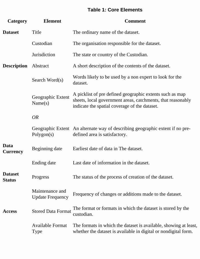
Table 1: Core Elements
Category Element Comment
Dataset Title The ordinary name of the dataset.
Custodian The organisation responsible for the dataset.
Jurisdiction The state or country of the Custodian.
Description Abstract A short description of the contents of the dataset.
Search Word(s) Words likely to be used by a non expert to look for the dataset.
Geographic Extent Name(s)
A picklist of pre defined geographic extents such as map sheets, local government areas, catchments, that reasonably indicate the spatial coverage of the dataset.
OR
Geographic Extent Polygon(s)
An alternate way of describing geographic extent if no pre-defined area is satisfactory.
Data Currency Beginning date Earliest date of data in The dataset.
Ending date Last date of information in the dataset.
Dataset Status Progress The status of the process of creation of the dataset.
Maintenance and Update Frequency Frequency of changes or additions made to the dataset.
Access Stored Data Format The format or formats in which the dataset is stored by the custodian.
Available Format Type
The formats in which the dataset is available, showing at least, whether the dataset is available in digital or nondigital form.

Access Constraint Any restrictions or legal prerequisites applying to the use of the dataset, eg. licence.
Data Quality Lineage A brief history of The source and processing steps used to produce the dataset.
Positional AccuracyA brief assessment of the closeness of the location of spatial objects in the dataset in relation to their true position on the Earth.
Attribute Accuracy A brief assessment of the reliability assigned to features in the dataset in relation to their real world values.
Logical ConsistencyA brief assessment of the logical relationships between items in The dataset.
Completeness A brief assessment of the completeness of coverage, classification and verification.
Contact Information
Contact Organisation
Ordinary name of the organisation from which the dataset may be obtained.
Contact Position The relevant position in the Contact Organisation.
Mail Address 1 Postal address of the Contact Position.
Mail Address 2 Aust and NZ: Optional extension of Mail Address 1.
Suburb or Place or Locality Suburb of the Mail Address.
State or Locality 2 Aust: State of Mail Address.
NZ: Optional extension for Locality.
Country Country of the Mail Address.
Postcode Aust:Postcode of the Mail Address. NZ: Optional postcode for mail sorting.
Telephone Telephone of the Contact Position.
Facsimile Facsimile of the Contact Position.
Electronic Mail Address Electronic Mail Address of the Contact Position.
Metadata Date Metadata Date Date that the metadata record for the dataset was created.
Additional Metadata
Additional Metadata
Reference to other directories or systems containing further information about the dataset.
Dataset and Description categories provide essential information about the content of the data, the agency responsible for its collection and maintenance, and the geographic area it covers. The
Search Word(s) element has caused concern for data providers who generally seek to use keywords that adequately categorise the specific content of datasets. The inclusion of this
element, however, is intended to make it easier for non-specialist users to search directories for information categorised under broad, general subject headings.
Data Currency and Dataset Status categories establish the time frame of the data described.
The Access category is intended to provide potential users of datasets with sufficient information to determine if the data is in a suitable format or able to be transformed for their purpose. Access to some data is restricted for a variety of reasons. However, it is important that the existence of these datasets and the constraints on their use for other purposes are clearly identified in directory systems.
The inclusion of Data Quality elements in the highest level directory systems has been the subject of a great deal of debate within the geographic information community. It is clear that the key elements identified — lineage, positional accuracy, attribute accuracy, logical consistency and completeness — have not always been well documented in the past. Also, the meaning of some of these elements has not been well understood and some may not be relevant to some dataset types.
It has been argued that these elements are only relevant to the more detailed levels of the directory system, however, a consensus view is that data quality information is critical to determining the usefulness of a dataset for a particular application. For this reason, the national directory system must provide some information about data quality, at least a summary or overview, at the highest level. If custodians are unable to provide information for these elements they should not leave the field blank. Statements such as "Not Relevant", "Not Documented" or "Not Known" should be used.

Contact Information provides address details for the contact position in the contact organisation that is responsible for delivery of the dataset to other users.
Metadata Date establishes currency of the directory entry.
The Additional Metadata element provides a link to the source of more detailed information about a dataset through specific theme directory systems, such as the Marine and Coastal Data Directory of Australia ("Blue Pages"), or individual agency level directories. These more detailed directories will often supply a technical contact for listed datasets.
The Need for a Metadata Transfer Format
This document refers, above, to ANZLIC's policy on the transfer of metadata between jurisdictions. Implementation of this policy would be a simple process if all agencies organised and managed their metadata using the same relational database management system. In reality, data producers and custodians have made individual choices of software tools available or have developed their own systems. Therefore, a simple generic transfer format or formats are proposed to facilitate the transfer of metadata between current and future directory systems.
Attachment 2 to the Metadata Guidelines contains some recommendations on metadata transfer formats. Those recommendations were prepared by a consultant, AUSDEC. The Metadata Working Group has developed those recommendations further and a revised Attachment 2 is now available by FTP.
NOTE: ANZLIC has now developed an SGML Document Type Definition (DTD) to conform to the ANZLIC Core Metadata Guidelines.
Standard Generalized Markup Language (SGML) became an International Organisation for Standardisation (ISO) standard in 1985. It is used to define the structure of electronic text files or documents. It is primarily concerned with structure and not with the content of the document.
Implementation Issues
Implementation Protocols for Jurisdictions
At its meeting in Wellington early in June 1996, ANZLIC adopted several Transfer and Implementation Protocols to promote and assist the adoption of the Core Elements in

jurisdictional directories and related activities.
A National Directory
Several years ago ANZLIC formally endorsed the National Directory of Australian Resources (NDAR) maintained by the National Resource Information Centre (NRIC) as the national metadata directory for Australia. No similar decision has been made in respect of a national directory for New Zealand although some theme directories are being developed there at a national level on discipline and environmental themes.
The environment has since changed in relation to high-level directories. For instance, considerable efforts have been undertaken in Queensland, Western Australia, New South Wales, South Australia, Victoria, New Zealand and in various organisations in the Commonwealth of Australia, to develop jurisdiction and theme-based directories which now must be reconciled both with ANZLIC's decision, and with the emerging consensus that high-level metadata directories should contain a common set of core elements to facilitate transfer.
There is a role for jurisdictional directories in addition to a national directory system; many users may never need a national picture of a particular theme or dataset type. The challenge is to create a sufficiently robust and responsive arrangement to provide a national picture of coverage of data without a user being forced to build up that picture from up to ten jurisdictional and multiple theme directories. Significant commitments have already been made to the collection and maintenance of jurisdictional directories. It would be quite impractical and improbable for the amount of collection and maintenance effort currently being applied to jurisdictional directories to be replicated at a national level in Australia. The objective therefore is to maximise the efforts being currently devoted to jurisdictional and thematic directories, and to develop a plan for linking these in a national directory system.
National directories for Australia and New Zealand (or, perhaps one Directory for both Australia and New Zealand) are needed and will emerge over the next few years and should ideally be accessible on-line and updated on-line, at least in part, via the Internet.
Development of a national directory system is the next main task of the ANZLIC Working Group on Metadata. Consultation with the user and information provider community will be carried out. The Working Group will be inviting several other agencies involved in metadata policy and theme directories, to join the Group to work on this development.
The Relationship between Theme Based and Jurisdictional Directories
Several sector or theme-based organisations are currently collecting metadata or considering doing so. Included among these activities is the Australian Coastal and Marine Directory project

(Blue Pages); a proposal by the Inter-governmental Committee on Surveying and Mapping for a national directory on the topography theme; and the Australian National Geoscience Information System (@NGIS).
There would be little benefit in theme-based metadata directories that contained only the highest level core elements. Development of such directories purely at this level of information is unlikely to occur as most theme directory endeavours will be collecting information at at least the Page 1 level. Nevertheless, In order to reduce duplication of effort and the collection burden on custodians, a degree of cooperation and collaboration, particularly in relation to the process of record collection, will be required between theme and jurisdictional initiatives over the next few years. The Working Group will be addressing this issue jointly with theme directory custodians over the next year. Ultimately, however, the information provided in both jurisdictional and theme directories should ideally be sourced from internal agency metadata directory systems. The proposed national directory system will be planned to provide for the maximum automation of this process.
ANZLIC has adopted a "Pages" concept as the basis for a national metadata framework where more general information is recorded at the highest level (Page 0) and additional information is recorded at lower levels (Page 1, Page 2). This concept is illustrated in Figure 2. In this concept, Page 0 consists of a set of mandatory core metadata elements sufficient to allow a user to locate all relevant and available data sets. To maintain consistency many elements are based on pre-defined selection lists, thus ensuring uniformity and the capability to exchange Page 0 metadata elements between directories. Page 0 metadata should be freely available to all users and would form the base for all directories.
Subsequent pages (i.e. Page 1, Page 2, etc.) provide the opportunity for data custodian agencies at the national, state, local government, academic, community or private industry levels to include additional information not required in Page 0. This additional information may be in the form of sub-elements of specific Page 0 core metadata elements or entirely new and unrelated metadata elements. However, in order to ensure uniformity, it is suggested that any new metadata elements should be consistent where possible with corresponding metadata elements in the FGDC Content Standards.
A conceptual indication of how the Pages Concept is the foundation of the national directory system is shown in Figure 3.
Implementation Within Jurisdictions
ANZLIC recommends that implementation of the core elements in Table 1 should commence for all new directories and for all new datasets from the date of this publication. It is, however, recognised that there is a major task ahead because datasets created in the past must also

eventually be included both in custodians' metadata management programs and in directories at all levels.
Where adequate descriptions do not exist for historic datasets, custodians should endeavour to record at least the core metadata elements when upgrade programs are undertaken. Agencies that use historic datasets as a source for further analysis should endeavour to recover metadata and provide upgrades to the information contained in existing directories.
Relationship to Metadata Management Within Agencies
The need to provide dataset descriptions for inclusion in geographic information directory systems is not the key reason why data providers need to maintain metadata about their datasets. A more compelling reason is to retain corporate knowledge of the characteristics of datasets that an agency uses. The most detailed level of metadata is needed to ensure the efficient management and effective utilisation of data within a custodian agency. Metadata required for the highest level directory systems and other potential uses can be summarised or rolled up from the most detailed level of metadata that should be held and maintained by data custodians.
Experience indicates that for many organisations, thorough documentation of dataset characteristics is not a priority. Good data management practices within an organisation are dependent on the continuous documentation of data characteristics and processing history throughout the course of a data collection or creation project.
ANZLIC encourages the use of existing data for other purposes wherever possible. This can only be achieved effectively if the characteristics and limitations of existing datasets are accurately known.
Review Program
Guidelines, frameworks and standards are not necessarily complete when they are initially released. Attempts at metadata collection and development of directories, and experiences gained in entering, editing, maintaining, and most importantly, using directories based on the framework, will inevitably reveal potential improvements. This is particularly likely in the case of a metadata directory framework that is aimed at such a wide, diverse and growing field such as spatially referenced information covering all kinds of land and geographic data.
The framework will need to be monitored and perhaps amended from time to time. The first review of the list of high-level core metadata elements is expected to be undertaken by the Working Group by June 1997. ANZLIC supports a national level approach to a review and monitoring process to address the performance and acceptance of the core elements and to determine whether further policies are required to accommodate theme directories and users.
The Environmental Resources Information Network (ERIN), a Commonwealth agency, has agreed to provide a listserver to discuss metadata issues within the community at large. Users of these guidelines for core metadata elements are encouraged to provide feedback on their experiences and any suggestions for improvement through this mechanism. Subscribe to this discussion forum by sending an email containing the message, "subscribe ozmeta-l", to [email protected].
Metadata Data Entry Tool
To assist with the implementation of these guidelines, ANZLIC has developed a run-time software tool to support the collection of metadata and to ensure consistent description of core metadata elements. This software tool, based on Microsoft Access, is available for use by dataset custodians throughout Australia and New Zealand.
The Data Entry tool may be used within organisations to manage the metadata database. Copies are available from Working Group members in the various jurisdictions and from the ANZLIC Secretariat. There is no charge for the Data Entry tool.
A reconciliation between the Guidelines for completion of each Core Element and the screens in the Data Entry tool appears in the full text of the document.
The digital version of this paper and the Guidelines and Worked Examples are available via this Web site. The Guidelines and Worked Examples are also available in the on-line help in the Data Entry tool.
Agencies wishing to customise the Data Entry tool for their own use, perhaps by adding agency specific fields, can be provided with additional notes to assist this. A developer's version of the Access database will be required.
Contact Information
Further enquiries about ANZLIC, the Metadata Guidelines or the Data Entry tool should be directed in the first instance to the ANZLIC Secretariat:
Secretary ANZLIC PO Box 2 Belconnen ACT 2616
Ph: +61-6-201-4299 Fax: +61-6-201 4366
E-mail: [email protected]
To subscribe to the Discussion Group, send an email message to:
with the following text in the message:
subscribe ozmeta-l
Get the Full Text
The foregoing are the introductory sections to the ANZLIC Guidelines on Core Metadata Elements. The complete document contains detailed descriptions of each of the core metadata elements together with worked examples. To download the full document click here
Back to Metadata Working Group
ANZLIC Secretariat
Statement on Copyright and Privacy
The contact point for this web is Graham Baker, [email protected] © 2000 ANZLIC
This page was last modified Thursday, 09-Nov-2000 09:58:46 EST.