developing a methodology for mapping local soil types along the buganda...
TRANSCRIPT
Feed the Future Innovation Lab for Collaborative
Research on Grain Legumes
Developing a methodology for mapping local soil types along the Buganda Catena, Uganda
Tenywa, M.M. O Semalulu, R Miiro, S S. Kyebogola, P. Kyomuhendo, CL Kizza,
JGM Majaliwa, J. Nampijja, AW. Lenssen, B. Miller, L. Burras and R.
Mazur
Feed the Future Innovation Lab for Collaborative Research on Grain Legumes
IntroductionFarmer’s knowledge on soil and landmanagement strategies is valuable for developingimproved technologies for sustainable soilfertility management for a specific purpose (e.g.increasing bean productivity);The correlation and communication betweenindigenous soil classification system (ISCS) andconventional classification (FAO-UNESCO-ISRIC,1990, US-Taxonomy) must be understood;This requires mapping the local soil types in a GIS.
Feed the Future Innovation Lab for Collaborative Research on Grain Legumes
Problem Statement Limited understanding of the Indigenous soil classification
system (ISCS) Inefficiency of extension workers in service delivery Communication barrier between extension workers and
farmers; Soils seeming to be complex and highly heterogeneous to
extension workers; Criteria used by farmers to classify soils into different
categories not documented; Underutilization of existing knowledge on soils (e.g. Catena
concept, FAO-UNESCO, US-Taxonomy); Transferability of science and technology (soil test kit,
fertilizers) limited; Inability to identify vulnerable soils that require specialized
management.

Feed the Future Innovation Lab for Collaborative Research on Grain Legumes
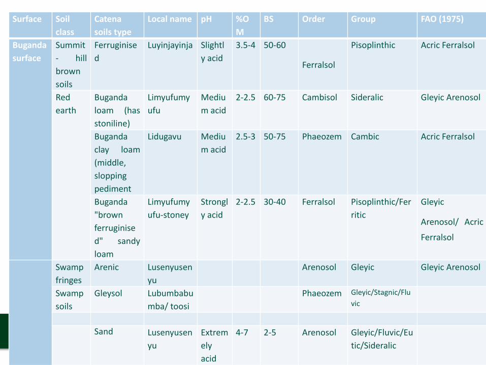
Catena Soil class Catena soils type Local name Transiliteration
FAO (1975)
Bugandacatena(Associated withExtensiveRemnantsof theBugandaSurface)
Summit- hillbrown soils
Ferruginised Luyinjayinja Stony AcricFerralsol
Red earth Buganda loam (hasstoniline)
Limyufumyufu
Reddish GleyicArenosol
Buganda clay loam(middle, sloppingpediment
Lidugavu Black AcricFerralsol
Buganda "brownferruginised"sandy loam
Limyufumyufu-stoney
Reddishstony
GleyicArenosol/AcricFerralsol
Swampfringes
Arenic Lusenyusenyu
Sandy GleyicArenosol
Swamp soils Gleysol Lubumbabumba/ toosi
Clayey
Feed the Future Innovation Lab for Collaborative Research on Grain Legumes
Surface Soilclass
Catenasoils type
Local name pH %OM
BS Order Group FAO (1975)
Bugandasurface
Summit- hillbrownsoils
Ferruginised
Luyinjayinja Slightly acid
3.5-4 50-60
Ferralsol
Pisoplinthic Acric Ferralsol
Redearth
Bugandaloam (hasstoniline)
Limyufumyufu
Medium acid
2-2.5 60-75 Cambisol Sideralic Gleyic Arenosol
Bugandaclay loam(middle,sloppingpediment
Lidugavu Medium acid
2.5-3 50-75 Phaeozem Cambic Acric Ferralsol
Buganda"brownferruginised" sandyloam
Limyufumyufu-stoney
Strongly acid
2-2.5 30-40 Ferralsol Pisoplinthic/Ferritic
Gleyic
Arenosol/ Acric
Ferralsol
Swampfringes
Arenic Lusenyusenyu
Arenosol Gleyic Gleyic Arenosol
Swampsoils
Gleysol Lubumbabumba/ toosi
Phaeozem Gleyic/Stagnic/Fluvic
Sand Lusenyusenyu
Extremelyacid
4-7 2-5 Arenosol Gleyic/Fluvic/Eutic/Sideralic
Feed the Future Innovation Lab for Collaborative Research on Grain Legumes
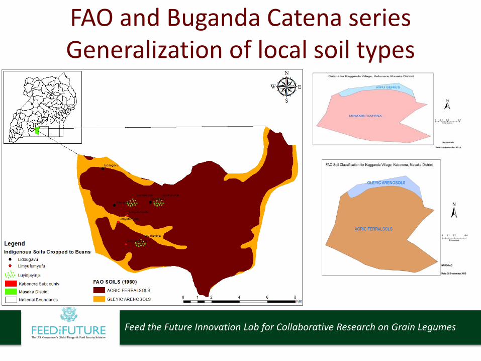
FAO and Buganda Catena series Generalization of local soil types
Feed the Future Innovation Lab for Collaborative Research on Grain Legumes
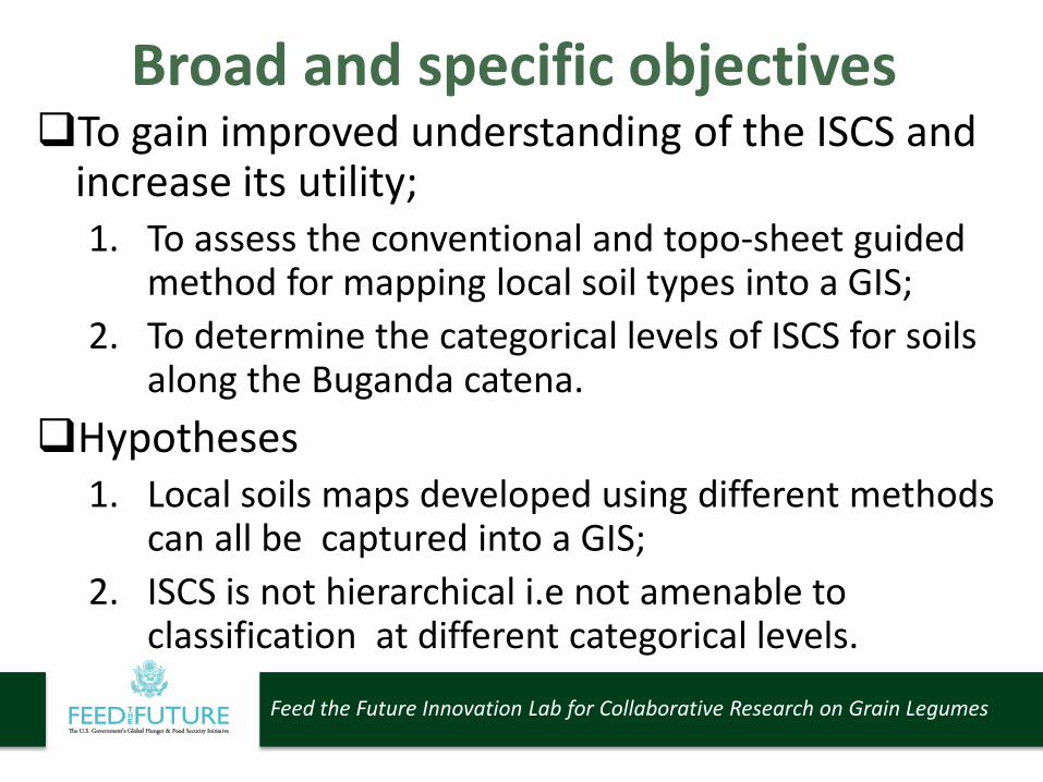
Broad and specific objectivesTo gain improved understanding of the ISCS and
increase its utility;1. To assess the conventional and topo-sheet guided
method for mapping local soil types into a GIS; 2. To determine the categorical levels of ISCS for soils
along the Buganda catena.Hypotheses
1. Local soils maps developed using different methods can all be captured into a GIS;
2. ISCS is not hierarchical i.e not amenable to classification at different categorical levels.
Feed the Future Innovation Lab for Collaborative Research on Grain Legumes
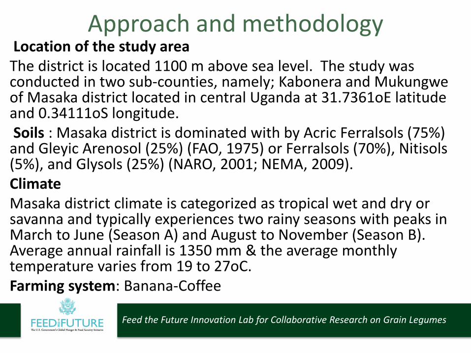
Approach and methodologyLocation of the study areaThe district is located 1100 m above sea level. The study was conducted in two sub-counties, namely; Kabonera and Mukungweof Masaka district located in central Uganda at 31.7361oE latitude and 0.34111oS longitude. Soils : Masaka district is dominated with by Acric Ferralsols (75%)
and Gleyic Arenosol (25%) (FAO, 1975) or Ferralsols (70%), Nitisols(5%), and Glysols (25%) (NARO, 2001; NEMA, 2009).ClimateMasaka district climate is categorized as tropical wet and dry or savanna and typically experiences two rainy seasons with peaks in March to June (Season A) and August to November (Season B). Average annual rainfall is 1350 mm & the average monthly temperature varies from 19 to 27oC.Farming system: Banana-Coffee

Feed the Future Innovation Lab for Collaborative Research on Grain Legumes
Feed the Future Innovation Lab for Collaborative Research on Grain Legumes
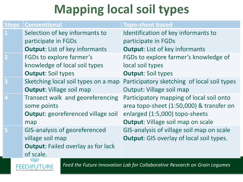
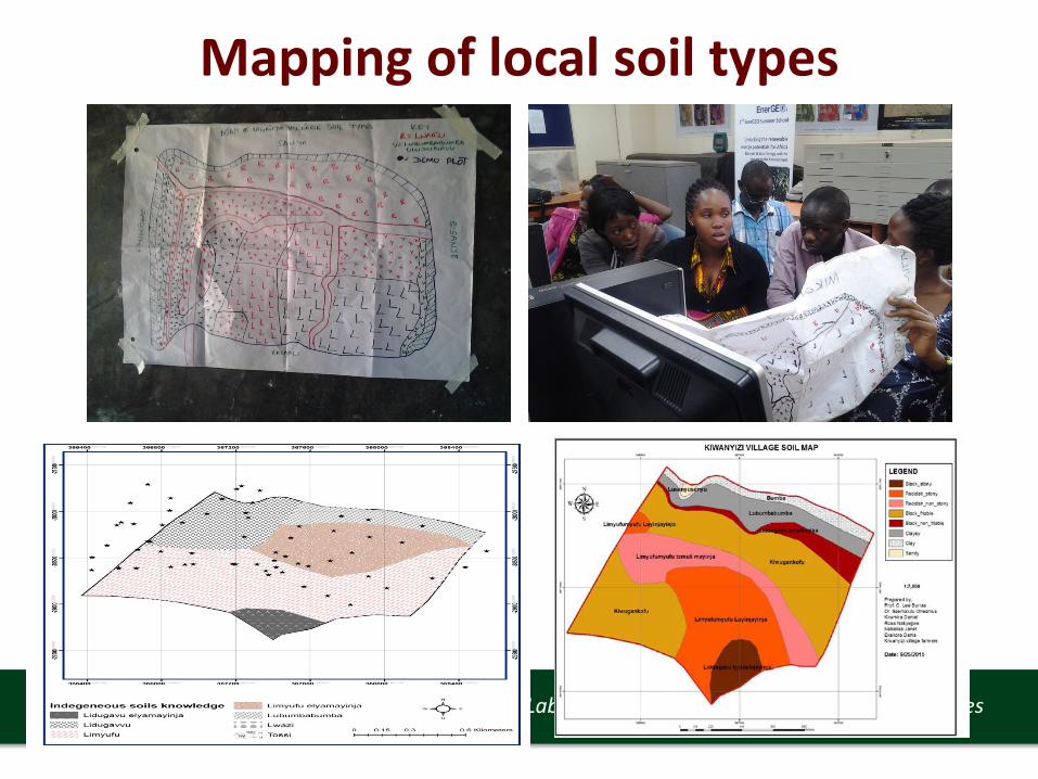
Mapping local soil typesSteps Conventional Topo-sheet based1 Selection of key informants to
participate in FGDsOutput: List of key informants
Identification of key informants to participate in FGDsOutput: List of key informants
2 FGDs to explore farmer’s knowledge of local soil types Output: Soil types
FGDs to explore farmer’s knowledge of local soil types Output: Soil types
3 Sketching local soil types on a mapOutput: Village soil map
Participatory sketching of local soil types Output: Village soil map
4 Transect walk and georeferencingsome pointsOutput: georeferenced village soil map
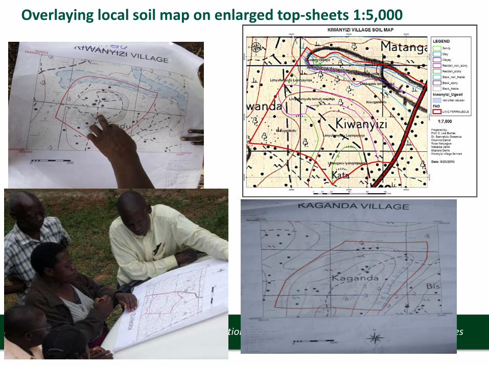
Participatory mapping of local soil onto area topo-sheet (1:50,000) & transfer on enlarged (1:5,000) topo-sheetsOutput: Village soil map on scale
5 GIS-analysis of georeferencedvillage soil mapOutput: Failed overlay as for lack of scale.
GIS-analysis of village soil map on scaleOutput: GIS overlay of local soil types.
Feed the Future Innovation Lab for Collaborative Research on Grain Legumes
Overlaying local soil map on enlarged top-sheets 1:5,000
Feed the Future Innovation Lab for Collaborative Research on Grain Legumes
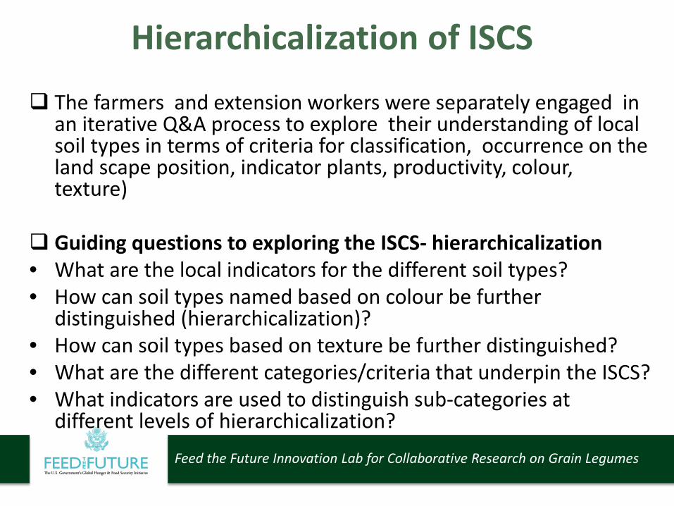
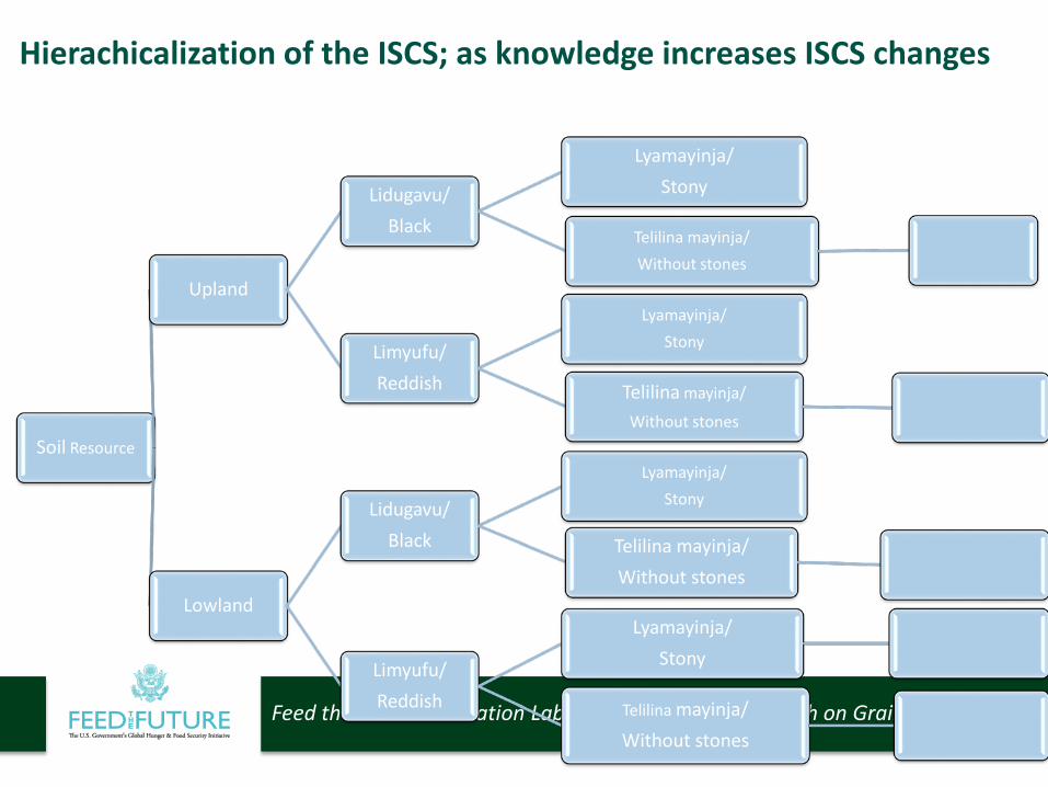
Hierarchicalization of ISCS
The farmers and extension workers were separately engaged in an iterative Q&A process to explore their understanding of local soil types in terms of criteria for classification, occurrence on the land scape position, indicator plants, productivity, colour, texture)
Guiding questions to exploring the ISCS- hierarchicalization• What are the local indicators for the different soil types?• How can soil types named based on colour be further
distinguished (hierarchicalization)?• How can soil types based on texture be further distinguished?• What are the different categories/criteria that underpin the ISCS?• What indicators are used to distinguish sub-categories at
different levels of hierarchicalization?
Feed the Future Innovation Lab for Collaborative Research on Grain Legumes
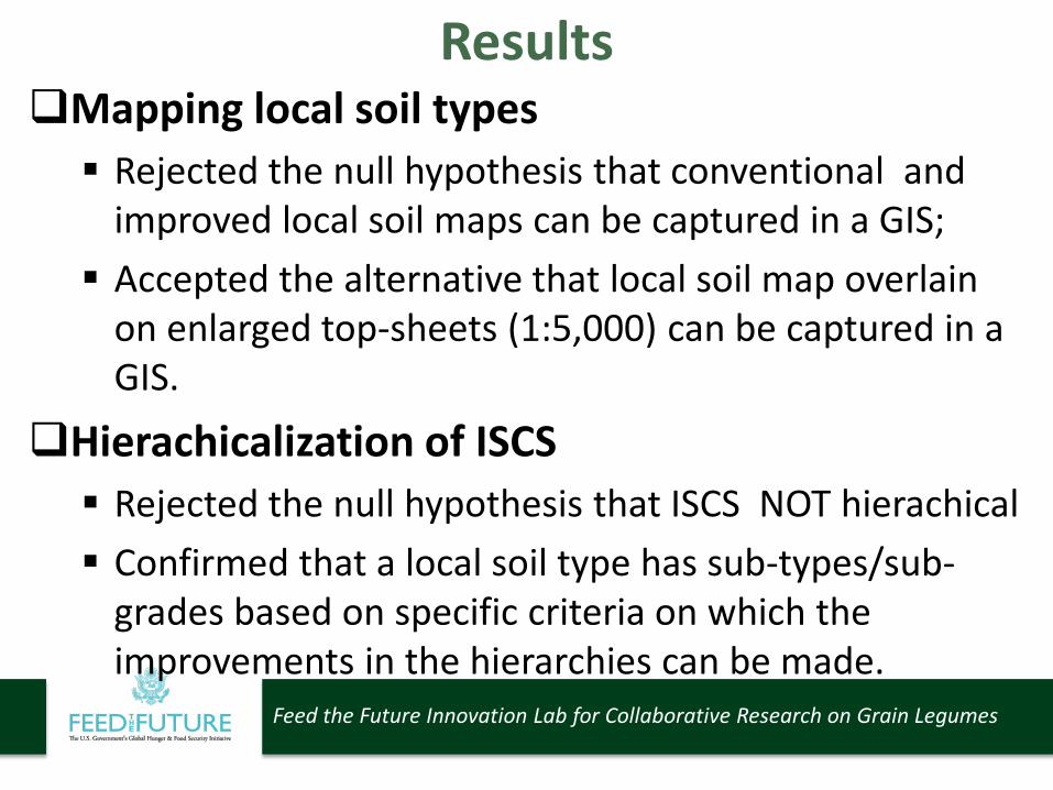
ResultsMapping local soil types Rejected the null hypothesis that conventional and
improved local soil maps can be captured in a GIS; Accepted the alternative that local soil map overlain
on enlarged top-sheets (1:5,000) can be captured in a GIS.
Hierachicalization of ISCS Rejected the null hypothesis that ISCS NOT hierachical Confirmed that a local soil type has sub-types/sub-
grades based on specific criteria on which the improvements in the hierarchies can be made.
Feed the Future Innovation Lab for Collaborative Research on Grain Legumes
Mapping of local soil types
Feed the Future Innovation Lab for Collaborative Research on Grain Legumes
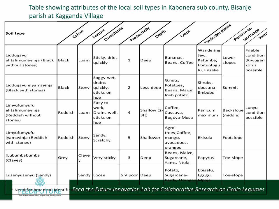
Soil typeColour
Texture
Consistency
Productivity
DepthCrops
*Indicator plants
Position on
landscape
Rema
Liddugavu elitalimumayinja (Black without stones)
Black LoamSticky, dries quickly 1 Deep
Bananas, Beans, Coffee
Wandering Jew, Kafumbe, Ebituntugulu, Enseke
Lower slopes
Friable condition (Kiwugankofu) possible
Liddugavu elyamayinja (Black with stones)
Black Stony
Soggy-wet, drains quickly, sticks on hoe
2 Less deep
G.nuts, Potatoes, Beans, Maize, Irish potato
Shrubs, obusana, Embubu
Summit
Limyufumyufu elitalimumayinja (Reddish without stones)
Reddish Loam
Easy to work, Drains well, sticks on hoe
4 Shallow (2-3ft)
Coffee, Cassava, Bogoya-Musa
Panicum maximum
Backslope (middle)
Lunyu condition possible
Limyufumyufu lyamayinja (Reddish with stones)
Reddish Stony Sandy, Scratchy,
5 Shallower
Agro-trees;Coffee, mango, avocadoes, oranges
Ekisula Footslope
[Lubumbabumba (Clayey)
Grey Clayey
Very sticky 3 DeepBeans, Maize, Sugarcane, Yams, Ntula
Papyrus Toe-slope
Lusenyusenyu (Sandy) Sandy Loose 6 V.poor DeepPotato, Sugarcane-hardy, Oranges
Ebisalu, Egugu, Mpoja
Toe-slope
* Need for botanical identification, Luyinjayinja (gravelly) got lost in the hierachicalization of the original major soil types
Table showing attributes of the local soil types in Kabonera sub county, Bisanjeparish at Kagganda Village
Feed the Future Innovation Lab for Collaborative Research on Grain Legumes
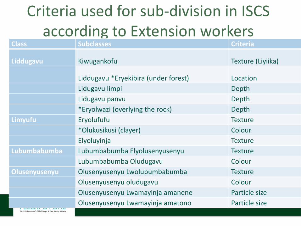
Criteria used for sub-division in ISCS according to Extension workers
Class Subclasses Criteria
Liddugavu Kiwugankofu Texture (Liyiika)
Liddugavu *Eryekibira (under forest) LocationLidugavu limpi DepthLidugavu panvu Depth*Eryolwazi (overlying the rock) Depth
Limyufu Eryolufufu Texture*Olukusikusi (clayer) ColourElyoluyinja Texture
Lubumbabumba Lubumbabumba Elyolusenyusenyu TextureLubumbabumba Oludugavu Colour
Olusenyusenyu Olusenyusenyu Lwolubumbabumba TextureOlusenyusenyu oludugavu ColourOlusenyusenyu Lwamayinja amanene Particle sizeOlusenyusenyu Lwamayinja amatono Particle size
Feed the Future Innovation Lab for Collaborative Research on Grain Legumes
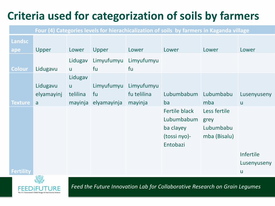
Four (4) Categories levels for hierachicalization of soils by farmers in Kaganda village
Landscape Upper Lower Upper Lower Lower Lower Lower
Colour LidugavuLidugavu
Limyufumyufu
Limyufumyufu
Texture
Lidugavuelyamayinja
Lidugavutelilinamayinja
Limyufumyufu elyamayinja
Limyufumyufu telilina mayinja
Lubumbabumba
Lubumbabumba
Lusenyusenyu
Fertility
Fertile black Lubumbabumba clayey (tossi nyo)-Entobazi
Less fertile grey Lubumbabumba (Bisalu)
Infertile Lusenyusenyu
Criteria used for categorization of soils by farmers
Feed the Future Innovation Lab for Collaborative Research on Grain Legumes
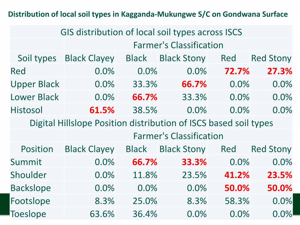
GIS distribution of local soil types across ISCSFarmer's Classification
Soil types Black Clayey Black Black Stony Red Red StonyRed 0.0% 0.0% 0.0% 72.7% 27.3%Upper Black 0.0% 33.3% 66.7% 0.0% 0.0%Lower Black 0.0% 66.7% 33.3% 0.0% 0.0%Histosol 61.5% 38.5% 0.0% 0.0% 0.0%
Digital Hillslope Position distribution of ISCS based soil typesFarmer's Classification
Position Black Clayey Black Black Stony Red Red StonySummit 0.0% 66.7% 33.3% 0.0% 0.0%Shoulder 0.0% 11.8% 23.5% 41.2% 23.5%Backslope 0.0% 0.0% 0.0% 50.0% 50.0%Footslope 8.3% 25.0% 8.3% 58.3% 0.0%Toeslope 63.6% 36.4% 0.0% 0.0% 0.0%
Distribution of local soil types in Kagganda-Mukungwe S/C on Gondwana Surface
Feed the Future Innovation Lab for Collaborative Research on Grain Legumes
GIS distribution of local soil types across ISCSFarmer's Classification
% Black Clayey Black Friable Black Black Stony Red Red StonyRed 0.0% 0.0% 0.0% 0.0% 72.2% 27.8%Upper Black 0.0% 0.0% 0.0% 100.0% 0.0% 0.0%Lower Black 9.1% 0.0% 81.8% 9.1% 0.0% 0.0%Valley Black 50.0% 25.0% 25.0% 0.0% 0.0% 0.0%Histosol 100.0% 0.0% 0.0% 0.0% 0.0% 0.0%
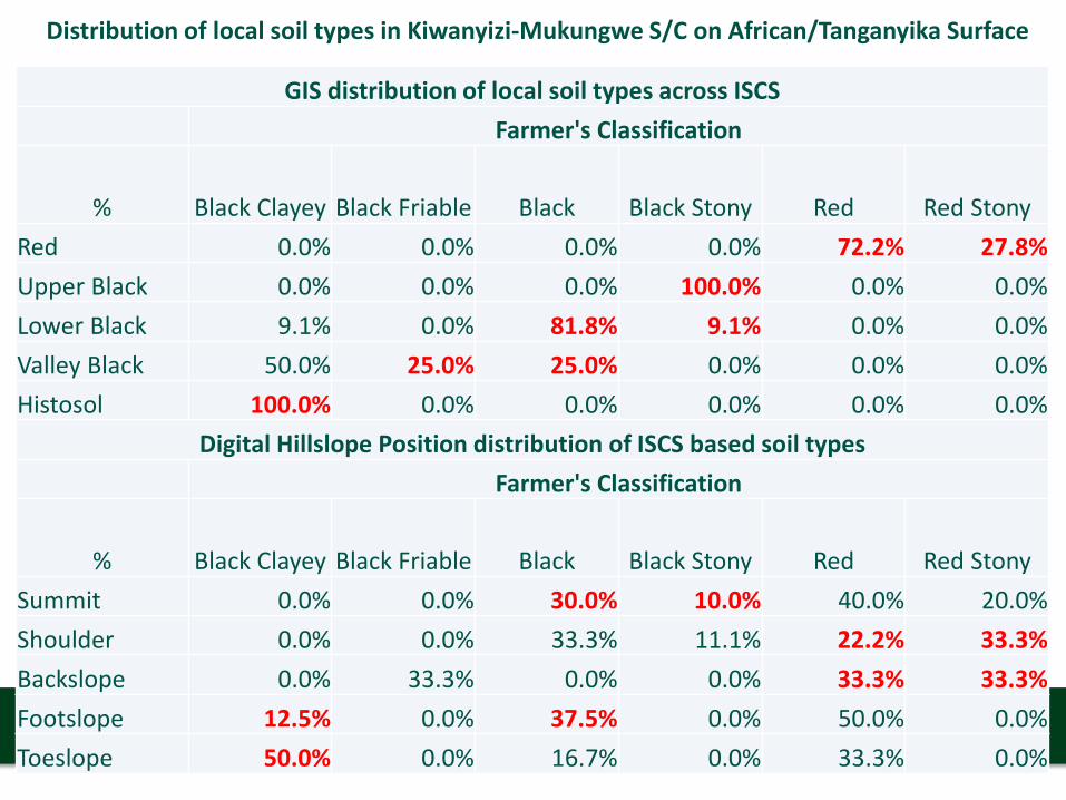
Digital Hillslope Position distribution of ISCS based soil typesFarmer's Classification
% Black Clayey Black Friable Black Black Stony Red Red StonySummit 0.0% 0.0% 30.0% 10.0% 40.0% 20.0%Shoulder 0.0% 0.0% 33.3% 11.1% 22.2% 33.3%Backslope 0.0% 33.3% 0.0% 0.0% 33.3% 33.3%Footslope 12.5% 0.0% 37.5% 0.0% 50.0% 0.0%Toeslope 50.0% 0.0% 16.7% 0.0% 33.3% 0.0%
Distribution of local soil types in Kiwanyizi-Mukungwe S/C on African/Tanganyika Surface
Feed the Future Innovation Lab for Collaborative Research on Grain Legumes
Soil Resource
Upland
Lidugavu/Black
Lyamayinja/Stony
Telilina mayinja/Without stones
Limyufu/Reddish
Lyamayinja/Stony
Telilina mayinja/
Without stones
Lowland
Lidugavu/Black
Lyamayinja/Stony
Telilina mayinja/Without stones
Limyufu/Reddish
Lyamayinja/Stony
Telilina mayinja/Without stones
Hierachicalization of the ISCS; as knowledge increases ISCS changes
Feed the Future Innovation Lab for Collaborative Research on Grain Legumes
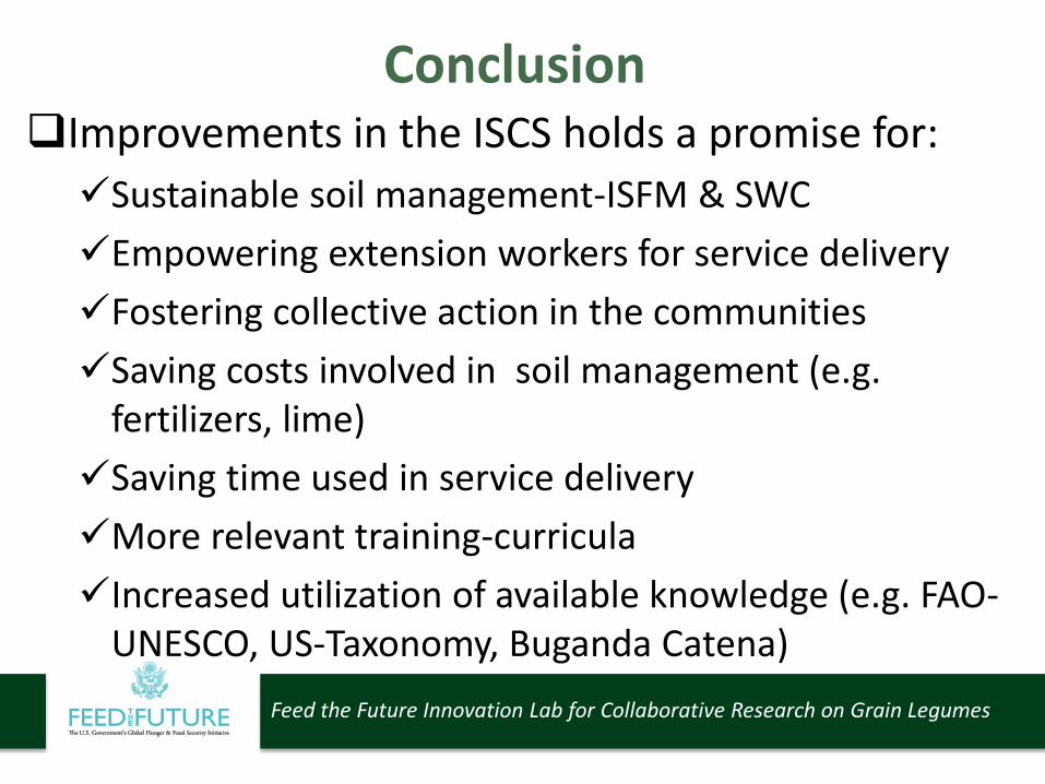
ConclusionImprovements in the ISCS holds a promise for:Sustainable soil management-ISFM & SWCEmpowering extension workers for service deliveryFostering collective action in the communitiesSaving costs involved in soil management (e.g.
fertilizers, lime)Saving time used in service deliveryMore relevant training-curriculaIncreased utilization of available knowledge (e.g. FAO-
UNESCO, US-Taxonomy, Buganda Catena)

Feed the Future Innovation Lab for Collaborative Research on Grain Legumes
Wayfoward• Validation of DEM- based ISCS predictions in
new areas• Dissemination of package of improved ISCS
tools (village soil map, block diagram & soil analytical data)
• Capacity development for extension workers to utilize ISCS package;
• Exploring Curriculum improvement to include ISCS

Feed the Future Innovation Lab for Collaborative Research on Grain Legumes
Acknowledgements
• Government of Uganda- Makerere University, NARO
• Feed the Future Legume innovation Lab• Local governments of Masaka and Rakai• Partner organizations• Bean Innovation Platform members
God bless you. Thank you