determination of current and potential soil erosion of chile eugenio gonzalez aguilo, ministerio de...
TRANSCRIPT

Determination of current and potential soil erosion of Chile
Executive Director EUGENIO GONZÁLEZ AGUILÓ. March 2012
Towards Global Soil Information: Activities within the GEO Task Global Soil Data

Chile Total Area : 75 mill. Ha
Arable land 5.1 million ha
Pastures 11.2 million ha
Forestry plantations 2.3 million ha
Natural forests 13.6 million ha
Length: 4,329 km long, equivalent to one
tenth of the circumference of the Earth.

Chile: environmental macroregions
Chilean Antarctica

Canadá
México
Unión Europea
Corea del Sur
América Central Salvador Costa Rica Guatemala Honduras Nicaragua
Nueva Zelanda Singapur
Malasia
China
Japón
Brunei
Australia
Turquía
Perú Panamá
Mercosur Argentina Brasil Paraguay Uruguay
India
Cuba
Colombia
EFTA Islandia Liechtenstein Noruega Suiza
Estados Unidos
Ecuador
Venezuela
Bolivia
P4
Natural Resources and Agriculture are fundamental for Chilean development
Chile has 22 trade agreements with 59
countries
90% World GBP & 63% world population

GENERAL PURPOSE
To determine current and potential soil erosion for territory of Chile using geomatics and remote sensing techniques.

OBJETIVOS ESPECÍFICOS
• Current and potential soil erosion maps. • Soil erosion geodatabase • Publications •Transferring data to partner institutions according to the national forest law and soil conservation system.
PRODUCTS

METHODS

Example: Maule Region

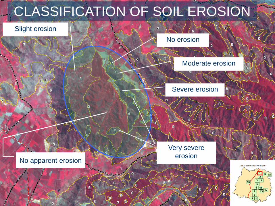
Severe Erosion
No Erosión
No apparent erosion
Slight Erosion
Very severe erosion
Moderate Erosion
INTERPRETATION OF SOIL EROSION
Santa Laura Valley
Slight erosion
Moderate erosion
No apparent erosion
Very severe erosion
Severe erosion
No erosion
CLASSIFICATION OF SOIL EROSION

Nationally, we see that the most eroded soils increase from south to north. An area of 36.8 million hectares, equivalent to 49.1% of the country have some degree of erosion.
North Zone (desert)

The sectors with higher current erosion problems leading the regions of Coquimbo, with 84% of eroded soil, Valparaiso, with 57%, and O'Higgins with 52% of the soils.
North Zone

Not all eroded soil is the product of human action. Most of the soil erosion in northern Chile due to natural causes.
Atacama Region

Like other sustainable uses, the native forest effectively protects the soil from erosive agents (water, wind and ice).
South Zone

Here we see soils topography of hills with slopes
of 30% to 50% In these conditions of slope, the planting to harvest the
soil is fullyexposed to water erosion processes
Araucania Region

Soils of mild to moderately undulating topography characteristic ofthe Los Rios, who maintain a permanent vegetation cover for agricultural use. Current exhibit slight to moderate erosion.
South Zone

Central Zone
Soil dominant characteristic of rolling hills and the coastal area of the Bío-Bío. Visualizes areas with sparse vegetation cover on soil with ahistory of use and management have created conditions for much ofthe soils present, today, severe to very severe erosion.

9,6%
11,1%
13,8%
14,8%9,2%
18,1%
22,8%
0,6%
SIN EROSIÓN
EROSIÓN LIGERA
EROSIÓN MODERADA
EROSIÓN SEVERA
EROSIÓN MUY SEVERA
EROSIÓN NO APARENTE
OTROS USOS
AREAS DE EXCLUSIÓN
PORCENTAJE (% ) DE SUPERFICIE DE SUELOS EROSIONADOS
RESULTS

Cartografía de Erosión Actual Región Maule
Cartografía de Erosión Actual Comuna de Pencahue
With this project the Ministry of Agriculture of Chile has a nationalgeo-referenced databases of eroded soils at the regional levelprovincial and communal.
RESULTS

- Update 1979 - 2009 (30 years) - Detailed information by region, province and commune. - Information more accurate results - Satellite Technology - compatibility SSOT - Effort and institutional support for professionals in regions. -General information about development programs and recovery of degraded soils.
CONCLUSIONS

A serious problem ..... forest fires In the current summer broke ll records of hectares affected by forest fires, many of them caused by human hands.

What are we doing…? 1) In the current summer broke
all records of hectares affected by forest fires, many of them caused by human hands.
2) It is developing a program for the recovery of degraded soils.
3) By law (Decree 701) is given a grant to fund the planting of forests of introduced species.
4) We are working to change driving habits in praise of the small agriculture sector, especially the goat breeders.

Thank you www.ciren.cl