determination of aquifer hydraulic parameters using single
TRANSCRIPT

Journal of Environment and Earth Science www.iiste.org ISSN 2224-3216 (Paper) ISSN 2225-0948 (Online) Vol.8, No.3, 2018
26
Determination of Aquifer Hydraulic Parameters Using Single Well Pumping Test Borehole Data within Boki Local Government
Area, Cross River State, South Eastern Nigeria Okon Ita A.1 Akaerue Emmanuel I.2 Felix IreK .P1* 1.Ministry of Water Resources, Cross River State, Nigeria. P.O. Box 1177, Calabar 2.Ebony and Ivory Int’l, University of Calabar, Cross River State, Nigeria.P.M.B 1115, Calabar Abstract Pumping test is done to determine the performance and efficiency of a well and also to characterize and parameterize the hydraulic properties of an aquifer. Twelve (12) drilled boreholes constructed within Boki Local Government Area were subjected to a number of pumping tests: Step drawdown, Constant discharge and Recovery tests to provide estimation of hydraulic parameters of the study area. The Cooper Jacob’s Straight-line Equation was used to analyze the pumping test results of drawdown with respect to time. This method was chosen because it is built upon the most simplified assumptions. The aquifer hydraulic properties were estimated from the pumping test by fitting mathematical models (type curves) to response data (water level changes) through computer software known as AQUIFER TEST. The result obtained shows that; Transmissivity ranges from 6.67 x 10⁻⁴m2/day to 2.50m2/day with average of 2.15 x 10⁻¹ m2/day. The hydraulic conductivity ranges from 5.13 x 10⁻⁵m/day to 1.67 x10⁻¹m/day with average of 1.59 x 10⁻² m/day. The borehole yield ( specific recharge) ranges from 1.30 l/s to 1.97 l/s. with the average of 1.50 l/s. while the specific discharge range from 8.02 x 10⁻⁴ m2/day to 11.157 m2/day with average of 1.387m2/day. The static water level ranges from 5.1m to 14.1m. The borehole drilled depth ranges from 22m to 54m. The saturated thickness of the aquifer ranges 13.8m to 42.3m. The litho-logs of the boreholes confirms that the estimated hydraulic parameters were obtained from semi confined highly weathered to fairly weathered migmatite saturated fractured basement aquifers (Aquitard). In comparison, Five boreholes (or 41.7% wells) had yield that ranges from 1.5 to 1.97 l/s above seven boreholes (or 58.3% wells) of lower yield that range from 1.3 to 1.5 l/s. Boreholes of higher yield have shallow water level and located on highly weathered and fractured basement within the high topography region of the study area. Because of the general low transmissivity values in the study area we recommend that all the boreholes should be installed at depth of at least three meters (3m) above the drilled depth. Also the mean yield value above 1.0 l/s of the boreholes indicate that the wells can sustained motorized pump over hand-pump and can produce more than 120 m3/day of groundwater. Keywords: Pumping-test, weathered, migmatite, hydraulic-parameters,transmissivity,boreholes/wells, Boki. 1. Introduction A pumping test is a field experiment in which a well is pumped at a control rate and water level response (drawdown) is measured in one or more surrounding observation/monitoring wells (Hamill and Bell 1986). Pumping tests are important and most effective tools that provide information on the hydraulic characterization of a borehole and aquifer parameters (Todd 1980; Turner et al 1991) Investigation shows that, detailed studies on pumping test data to evaluate derive aquifer parameters in Boki Local Government Area, Cross River State of South Eastern Nigeria has not been carried out. Therefore this reseach work provides some preliminary estimation of hydraulic parameters e.g. Transmissivity T, Hydraulic conductivity (k), Static Water Level (SWL), Discharge (Q), Drawdown(s), and Specific discharge (V) for wells in the fractured basement rocks within Boki Local Government Area in Cross River State Nigeria. Also it is geared at providing part of the frame work for planning, development and management of groundwater resources of the Basements aquifers in cross river state, Nigeria (Butt And Mcelwee, 1984) 2. The Study Area The study area is in Boki Local Government Areas in Cross River State Nigeria. It is located within longitude 8.76134 and 9.2436 East and latitude 6.05506 and 6.51062 North. Home of Cross River giant Gorillas. (Figure 1)

Journal of Environment and Earth Science www.iiste.org ISSN 2224-3216 (Paper) ISSN 2225-0948 (Online) Vol.8, No.3, 2018
27
Figure 1 :( a) Map of Cross River State showing the study Area (adapted from E.A. Amah and G.S Anam, 2016) (b) Sketch Lithology Map of the study (adapted from Edet et al, 2003) The area is characterized by cold and humid climatic conditions that are controlled by two seasons—wet (March–October) and dry (November–April). Annual precipitation is usually over 2,300 mm, while annual temperatures range between 21 and 300C. Average relative humidity for the area is about 88 (Martı´nez et al. 2008; Rapti-Caputo 2010; Riddell et al. 2010; Wagner and Zeckhauser 2011). The region has rainforest vegetation which consists basically of tall bulbous trees, and epiphytes. It is generally dominated by farmlands and forests. It is characterized by undulating topography, which has a relationship to its geology. The area is drained by streams that form a dendritic drainage pattern. Water supply in the area is obtained from shallow hand dug wells, boreholes as well as surface water. The area is made up of several agricultural villages which account for the dominant occupation of farming and hunting. Because of the arable nature of the place couple with intervention in the provision of potable water supply facilities by the Federal and State Government and donor support organization such as UNICEF/EU WSSSRP. The population of the study area has been on the increase thereby reducing poverty. 2.1 Brief Geology The area is underlain by the Precambrian Basement Complex and formed part of the basement complex of south-eastern Nigeria (Fig 1b). The Geological Survey of Nigeria (GSN) in the 1974 edition described the area as undifferentiated basement and in (2006) as granullite terrain. Other previous works on the geology of the study area are only available on regional basis such as; Regional aeromagnetic study of Oban and Obudu Precambrian Massifs (Iliya and Bassey (1993). Lineament analysis for groundwater exploration in the Precambrian Oban Massif and Obudu Plateau (Edet et al., 1994) and Ekwueme, (2003) The Precambrian Geology and Evolution of the southeastern Nigerian Basement Complex. The Precambrian basement rocks are crystalline and consist basically of migmatitic and granitic gneisses and schists with pegmatite intrusions in some locations. The gneisses are usually foliated with some pink feldspars and vary from fine hornblende, black to white with porphyroblastic feldspars. The predominant regional strike direction of these rocks is N–S, although some occasional NE–SW swings have also been reported (Ekwueme et al. 1995; Eseme et al. 2002; Odoh 2010). The post Cretaceous tectonic activities which originated from the adjoining Cameroun Volcanic Province (CVP) and other low grade metamorphism in the area caused serious fracturing of the basement rocks and deformation of the adjoining overlying Cretaceous lithostratigraphic units (Morreau et al. 1987; Benkhelil et al. 1975; Offodile 1975; Etuk et al. 2008). Hydrogeological, the study area is within the Southeast hydrogeological province of Nigeria/Cross River Basin Development Authority (Egboka, 1988) known for groundwater problematic zones. Besides, the problematic nature of the hydrogeology, rocks within the area acquired some important secondary properties like interconnected porosity, joints, fractures and folds which are very viable in hydrogeological studies because of

Journal of Environment and Earth Science www.iiste.org ISSN 2224-3216 (Paper) ISSN 2225-0948 (Online) Vol.8, No.3, 2018
28
their role in the storage and transmission of fluid (Okereke et al. 1998; Raju and Reddy 1998). Groundwater in the area is expected to occur where these rocks are highly weathered and in fractured zones. The aquifer setting in the area is complex and erratic. This is because it is a basement complex where Groundwater flow in fractured bedrock is controlled by the location, orientation and aperture of individual fractures as well as by the interconnectedness of the individual fractures into a network (Tiedeman and Hsieh, Ground Water 39:68-78, 2001). 3.0 Methodology Constant Rate Test was carried out in the study area to give information about the drawdown and aquifer properties resulting from specific pumping rate. Three (3) to six (6) hours constant discharge test was used since the yield is low and the boreholes are Hand pump boreholes and are meant to serve smaller population. The tests were carried out in some specific locations in the study area (Fig. 2), using the single well pumping test approach. The Jacob’s straight-line method was used to analyse the pumping test results of drawdown with respect to time in twelve existing boreholes in the study area in order to estimate Drawdown, transmissivity, storativity and specific discharge. This is because Cooper Jacob’s method is commonly used in hard rocks area and for single well pumping of aquifer test Prior to pumping, the well head was opened and the static water level was measured and recorded using calibrated Dip meter. The pump is then lowered to appreciable depth and Connect to the generator set. A known 20 liters volume of container was set in place to collect discharge and set stop watch to zero start time Pumping was then started, drawdown measured base on scheduled time on the data sheet. The time and water level discharge was Measure and record simultaneously. The exercise was done in two (2) phases namely: 1. Discharge and 2. Recharge/Recovery phase.
3.1 Discharge Stage During this stage, the well was pumped at a constant rate and the water level measured at intervals in the same pumped well (control well). Three (3) to Six (6) hours constant discharge rate was used since the yield is low and are served smaller population. 3.2 Recharge/Recovery Stage Here, the well was allowed to recover and the water level in the well measured at the same intervals as that of the
Figure 2: Sample Map of the Study Area, Boki.

Journal of Environment and Earth Science www.iiste.org ISSN 2224-3216 (Paper) ISSN 2225-0948 (Online) Vol.8, No.3, 2018
29
discharge. The time drawdown and the recovery curves were plotted for the various boreholes respectively. (Figure 5 – 15) 3.3 Analysis of Pumping Test Data The analysis of the pumping test data was done using the Theis solution. This solution was chosen in determining the aquifer parameters. This method was chosen because it is built upon the most simplifying assumptions. Here, the aquifer properties were estimated from the pumping test by fitting mathematical models (type curves) to response data (water level changes) using a procedure called curve matching. In particular, the curve matching technique of computer software known as AQUIFER TEST was used in this analysis. Theis (1935) residual drawdown method was used in this study based on the nature and type of data available (that is, single well pumping test data). This method is chosen because it gives assumptions that can be used to deduce aquifer characteristics based on data available. The draw downs can be calculated from this equation according to Theis, (1935) Cooper and Jacob (1946):
(1) The residual drawdown ‘s’, that is, the difference between the drawdown component due to continued pumping and the recovery component due to recharge is
ry mp ge (2) (Karanth, 1987), Where Q = discharge (m3/day) s = drawdown (m) rw= effective radius of the well/borehole in which the water recovery is measured t = time since pumping started
t’ = time since pumping stopped S = storage coefficient Assuming that the storage coefficient remains constant (during pumping = s’ during recovery) and u = r2s/4t is sufficiently small; the above equation is simplified to: ly (3) Since the value of t/t’ is chosen one log cycle part, Therefore:
(4) Hence; (5) Where, Q = constant discharge in m3/day and Ds’ = change in draw down in meters During the pumping test and after the test, data were collated and analysed to determine the following hydraulic parameters. The results are summarized in (Table. 1) 3.3.1 Specific discharge (V) The term specific discharge is applied when referring to whether the well provides an adequate water supply. Specific discharge is calculated by dividing pumping rate over drawdown (Q/∆S). The values range from 8.02 x 10⁻⁴m2/day to 11.157m2/day with average of 1.387m2/day (Table .1) 3.3.2 Hydraulic Conductivity (K) It is the quantitative measurement of permeability that is the ease in which water can pass through a unit thickness of an aquifer. Hydraulic conductivity K and Transmissivity T are related by the expression). T =Kb. Thus, K =T /b where b = saturated thickness of the aquifer. In this work the hydraulic conductivity ranges from 5.13 x 10⁻⁵m/day to 1.67 x10⁻¹m/day with average of 1.59 x 10⁻² m/day. (Table 1) 3.3.3 Transmissivity (T) Transmissivity (T) is estimated by fitting a straight line to drawdown on an arithmetic axis versus time on a logarithmic axis. Quantitatively T is obtained using the Equation:

Journal of Environment and Earth Science www.iiste.org ISSN 2224-3216 (Paper) ISSN 2225-0948 (Online) Vol.8, No.3, 2018
30
(6) Where Q is discharge and Δ(h-ho) = ΔS the change in drawdown.. Transmissivity (T) is the product of hydraulic conductivity and aquifer thickness, T = kb. It is the measure of the amount of water that that can be transmitted horizontally through a unit width by a full saturated thickness of the aquifer under a hydraulic gradient. The transmissivity values range from 6.67 x 10⁻⁴m2/day to 2.50m2/day with average of 2.15 x 10⁻¹ m2/day.(Table1) 3.3.3 Borehole Yield in litre per second (l/s) The yield of Basement complex of weathered granite ranges from ranges from 0.1 – 1 l/s while that of consolidated sediments such as sandstones and mudstones is between 0.1 – 4 l/s (Carter, 2006; Joseph and Olurenfemi 2012; Mushood And Olarewaju 2015). The minimum yield for a hand pump demand is about 0.3 l/s for a screen length of 5m (Carter, 2006). The yield in the study area ranges from 1.30 to 1.97 l/s. The average borehole yield in the area is 1.50 l/s (Table 1.). The indication is that the entire boreholes can sustain submersible pumps. 3.3.4 Storativity The storativity of an aquifer is quantitatively defined by Storativity (S) = 2.25Tt/r2, or S = Sb in a confined aquifer. It is the volume of water released from storage per unit surface area of the aquifer or aquitard per unit decline in hydraulic head. The storativity value for the study area was not estimated because of lack of observation wells. 4. Result and Discussion The borehole depth in the study area ranges from 22m to 54m meters and the static water level from 5.1m to 14.1m while the installed depth ranges from 21m to 53m. Indicating that the wells in the study area are shallow depth and this is similar to basement complex elsewhere in Nigeria, especially that of North Central Nigeria particularly in Abuja area (Olurunfemi M.O, And Faguyi S.A 1993; Edet A.E, Okereke C.S 1997; Akpan A.E., A.N Ugbaja, N.J. George 2013; Okogbue C.O And Omonona O.V. 2013; Jimoh M.O,2015) The results of the aquifer parameters calculated from the pumping test data from the various locations in the study area indicated that Kakubok Irruan has the highest transmissivity of 2.50 m2/day. Followed by Bajia I 1.47 x 10⁻⁴m2/day, Effigbo 2.08 x 10⁻²m2/day, and Bajia 2.08 x 10⁻²m2/day, While Biakwan has the lowest transmissivity of 6.667 x 10⁻⁴ m2/day(Figure 5.and Table 1).. The average transmissivity value is 0.12161m2/day. Also the hydraulic conductivity is highest in Kakubok Irruan with value of 0.167m/day followed by Bajia I 1.23 x 10⁻⁵ m/day, Effigbo 1.73 x 10⁻³ m/day and Bajia 1.75 x 10⁻³ m/day(Figure 3 and Table 1).. The average hydraulic conductivity in the study area is 0.01392 m/day. The discharge of water from the 12 wells under investigation in the study area varies from 1.30 to 1.97 l/s with average of 1.51 l/s. Among the 12 boreholes developed: 7(or 58.3% of the wells) had yield of 1.30 to 1.50 l/s, while 5(or 41.7 %) had yield that ranged from 1.5 to 1.97 l/s. The Wells with higher yield are located on highly weathered basement indicating the wells are more prolific and are associated with saturated fracture (Fig 4). The locations where Panya Bawop (1.60 l/s), Bajia 1 (1.97 l/s), Nkanacha (1.58 l/s), Abontakon (1.54 l/s) Abontakon 1 (1.67 l/s). Wells with higher yield have shallow water level that ranges from 5.1m to 11.9m. Bajia 1 has the highest yield of 1.97 l/s while Bajia has the lowest yield of 1.30 l/s. this indicate that Bajia 1 is the most prolific well in the Study Area. Factors such as topography, the thickness of weathered overburden, existence of fractures and their interconnectivity affected the yield in the study area. The well with higher yield presupposes that they are located on a higher topography (Tiedeman and Hsieh, Ground Water 39:68-78, 2001). The recharge rate of the wells in the study area ranges from 6.307 x 10⁻³ l/s to 0.158 l/s with average of 0.054 l/s compare with average discharge of 1.51 l/s. The specific discharge of the wells ranges 8.02 x 10⁻⁴ to 11.157 m2/day with average of 1.387 m2/day the average drawdown in the area ranges from 0.52m to 32.476m. In Kakubok Irruan the drawdown is below depth while Abontakon has the highest drawdown of 32.476m followed by Nkanacha 31.61m and Biakwan 21.26m. The lowest drawdown was in Bajia 0.52m and Effigbo 0.74m. 5. Conclusion Pumping test data and well completion reports of twelve (12) boreholes in part of Boki Local Government Area in Cross River State were obtained from the field using constant rate test method. In each case, the boreholes where pump at a constant rate for extended period of time and the water level and drawdown is monitored. The two stages involved in this method were discharge and recovery stage: during the discharge stage, the boreholes were pumped at constant rate and the water level measured at intervals in the same pumped or observation well (control well) while in recharge stage, the boreholes were allowed to recover and water level in the well measured at the same intervals as that of the discharge. Cooper Jacob’s equation of single well was used to compute for the derived aquifer parameters such as transmissivity, hydraulic conductivity, storativity, drawdown,

Journal of Environment and Earth Science www.iiste.org ISSN 2224-3216 (Paper) ISSN 2225-0948 (Online) Vol.8, No.3, 2018
31
and yield. This method was chosen because it is built upon the most simplifying assumptions . The results obtained shows that boreholes yields were greater than 1.0 and range between 1.30 – 1.70 l/s indicating this yield can sustained motorized pump and can produce more than 120 m3/day. The transmissivity, hydraulic conductivity and storativity were also computed and the values compared to other basement complex in other geological provinces in the country (Akaha And Promise 2008; Ishaku et al 2009; Hamidu et al 2016). Some of the values obtained were similar while others varied. For instance, the hydraulic conductivity of kakubok Irruan is 1.87 x 10⁻¹ m/day approximately 2.0 m/day similar to that of Ilorin area of Kwara State of North central basement complex (Sule et al 2013). 6. Recommendations i) Because of the low transmissivity value in the study area all the boreholes should be installed at depth of at least 3m above the drilled depth. ii) Since a handpump demand is about 0.25 l/s - 0.3 l/s, the average discharge of the boreholes in the study area is greater than 1.0 l/s indicating that all the boreholes can sustained motorized pump. Therefore motorized pump should be installed in all the boreholes instead of hand pumps, to optimize the water scheme. iii) The pumping test data obtained shows that deeper depths could be drilled to harness more reservoirs, or tap from deep seated fractures for more productivity and excellent yield. REFERENCES A.E. Edet , B.J.Merkel, D.E. Offiong (2003): Trace element Hydrochemical assessment of the Calabar coastal plain aquifer, Southeastern Nigeria using statistical methods. http://dx.doi.org/10.1007/s 00254-002-0738-1. © springer-verlag 2003 Akaha and Promise, A., 2008. Critical overview of transboundary aquifers shared by South Africa Hydrogeology Journal 16(6):1207-1214. Akpan, A. E., A. N Ugbaja,, & N. J., 2013. George, Integrated Geophysical, Geochemical and hydrogeological investigation of shallow ground water resources in parts of the Ikom-Mamfe Embayment and the adjourning in Cross River State, Nigeria. Environ. Earth Sci. Amah E.A and Anam G.S (2016): Determination of aquifer hydraulic parameters from pumping test data analysis: A case study of Akpabuyo coastal plain sand aquifers, Cross River State, S-E Nigeria. Journal nof Applied Geology and Geophysics, p-ISSN:2321-0982.volume4, issue1 ver.1, PP 01 – 08. www.iosrjournals.org Benkhelil M.G, Ponsard JF, Saugy L (1975) The Bornu-Benue Trough, the Niger Delta and its Offshore: Tectono-sedimentary reconstruction during the Cretaceous and Tertiary from geophysical data and geology. In: Kogbe CA (ed) Geology of Nigeria. Elizabethan Press, Lagos, pp 277–309 Butler, J.J., 1988. Pumping tests in nonuniform aquifers - The radially symmetric case. J. Hydrol., 101, pp. 15-30. Carter, R.C., Chilton, J., Danert, K. & Olschewski, A., 2014. Siting of Drilled Water Wells - A Guide for Project
Managers, Rural Water Supply Network (RWSN), St Gallen, Switzerland. Edet A.E, Okereke CS (1997) Assessment of hydrogeological conditions in basement aquifers of the Precambrian Oban Massif, southeastern Nigeria. J Appl Geophys 36:195–204 pii: 50926-9851(96)00049-3. Eduvie, M.O., Olabode, T. and Yaya, O.O., 2003. Assessment of Groundwater Potentials of Abuja and Environs. 29th. WEDC International Conference towards the Millennium Development Goals pp185-187. Egboka BCE, Uma KO (1988) Hydrogeochemistry, contaminant transport and tectonic effects in the Okposi-Uburu salt lake area of Imo State, Nigeria. Hydrol Sci J 31(2):205–221. Doi: 10.1080/ 02626668609491040 Ekwueme B.N (2003) The Precambrian geology and evolution of the Southeastern Nigeria basement complex. University of Calabar Press, Nigeria, p 135 Federal Republic Of Nigeria/National Water Resources Institute. 2009. National Code of Practice for Water Well Construction in Nigeria, National Water Resources Institute, Kaduna, Nigeria Hamidu H., S.W., Muhammad A. B. Garga, M. A., 2016. Kana Groundwater Potentials Estimation Of A Basement Terrain Using Pumping Test Data For Parts Of Sanga Local Government Area, Kaduna State, Northwestern Nigeria. Open Journal of Modern Hydrology, 6, 222-229. Hamil CL:AIRE (2 technical bulletins describe specific techniques, practices and methodologies currently being employed on sites in the UK within the scope of CL:AIRE technology demonstration and research projects. Ishaku, J.M, and Kwada, I.A Adekeye, J.I.D., 2009. Hydrogeological Characterization And Water Supply Potential Of Basement Aquifers In Taraba State, N.E. Nigeria. Nature and Science ; 7(3), ISSN 1545-0740. Joseph I. O. and O. O. Olorunfemi.. 2013. An assessment of groundwater resources in basement complex terrain Ofgwarinpa-Kafe area of Abuja Metropolis, Central Nigeria. Advances in Applied Science Research, 2012, 3 (1):393-398 Journal of African Earth Sciences 16 (3): 309-317. LIodyed, J.W., 198. Case-Studies in Groundwater Resources Evaluation: Oxford University Press.
Martı´nez AG, Takahashi K, Nu´n˜ez E, Silva Y, Trasmonte G, Mosquera K, Lagos P (2008) A multi-

Journal of Environment and Earth Science www.iiste.org ISSN 2224-3216 (Paper) ISSN 2225-0948 (Online) Vol.8, No.3, 2018
32
institutional and interdisciplinary approach to the assessment of vulnerability and adaptation to climate change in the Peruvian Central Andes: problems and prospects. Adv Geosci J 14:257–260 Morreau C, Regnoult JM, Deruelle B, Robineau B (1987) A new tectonic model for the Cameroon Line, Central Africa. Tectonophysics 139:317–334 Offodile ME (1975) A review of the geology and Cretaceous of the Benue Valley. In: Kogbe CA (ed) Geology of Nigeria. Elizabethen Press, Lagos, pp 375–376 Okereke C.S., Esu E.O., Edet A.E. (1998). Determination of potential groundwater sites using geological and geophysical techniques in Cross River State, SE Nigeria. Journal of African Earth Sciences 27(1):149-163 Okogbue C.O. and Omonona, O.V., 2013. Groundwater potential of the Egbe-Mopa basement area, central Nigeria, Hydrological Sciences Journal, 58:4, 826-840, DOI: 10.1080/02626667.2013.775445. Jimoh M. O., 2015. Aquifers Characterization in Agaie, North-Central Nigeria Using Electrical Resistivity Method and Borehole Lithologs. American Journal of Environmental Protection, vol. 3, no. 3 60-66. doi: 10.12691/env-3-3-1. Olorunfemi, M.O and Fasuyi, S.A., 1993. Aquifer Types and the Geoelectric/Hydrogeologic Characteristics of Part of the Central Basement Terrain of Nigeria (Niger State). Drill Depth in Basement Complex Terrain. A Paper Presented at the Preconference (NAH): 1-22. 78. Basement Complex/Sedimentary Transition Zone, Southwestern Nigeria. Raju NJ, Reddy TVK (1998) Fracture pattern and electrical resistivity studies for groundwater exploration.EnvironGeol 34(2–3):175–182 Riddell E.S, Lorentz SA, Kotze DC (2010) A geophysical analysis of hydro-geomorphic controls within a headwater wetland in a granitic landscape, through ERI and IP. J Hydrol Earth Syst Sci 14:1697–1713. doi:10.5194/hess-14-1697-2010 Theis, C.V., 1935. The relation between the lowering of the piezometric surface. Todd, K.D., 1980. Groundwater Hydrology. John Wiley and Sons New York 535pp.Trans.vol. 16, pp. 519-524, Wagner G, Zeckhauser RJ (2011) Climate policy: hard problem, softthinking. Clim Change. Doi: 10.1007/s10584-011-0067-z Woessner, T and Anderson, M. P., 2002. Using High Hydraulic Conductivity Nodes to Simulate Seepage Lakes. Journal NGWA: the Ground Water Association Volume 40, Pages 117–122. www.linkinghub.elsevier.com. Table 1: Summarized results of the evaluated hydraulic parameters of the boreholes in study area Borehole Location
Borehole Number
Total Depth(TD) (m)
Static Water Level (SWL) (m)
Aquifer Thickness (b = TD -SWL) (m)
Transmissivity (m2/Day)
Hydraulic Conductivity (k) (m/day)
Borehole Yield (l/s)
Specific Discharge (v) (m2/day)
Storativity Average Drawdown
Average Discharge (m3/day)
Recharge/Recovery Rate (l/s)
Agba II BHI 26 8.33 17.67 4.21 x 10⁻³ 3.51 x 10⁻⁴ 1.43 2.30 x 10⁻² 6.57x10⁻⁵ 3.37 123.00 0.158 Effigbo BHII 24 5.35 18.65 2.08 x 10⁻² 1.73 x 10⁻³ 1.40 1.14x 10⁻² 1.62x10⁻³ 0.74 120.96 0.0787 Kakubok Irruan BHIII 25 11.20 13.8 2.50 0.167 1.47 5.292 3.42x10⁻¹ Below Depth 127.008 2.71x 10⁻² Panya Bawop BHIV 22 5.12 16.88 3.31 x 10⁻² 2.76 x 10⁻³ 1.60 11.157 1.55 x 10⁻⁴ 12.39 138.240 4.x 10-2 Adagom Ekumba 1 BHV 43 14.08 28.92 3.27 x 10⁻⁴ 2.73 x 10⁻⁵ 1.40 1.79 x 10⁻² 3.51 x 10⁻⁵ 4.6669 120.960 1.05x 10⁻¹ Adagom Ekumba II BHVI 54 11.72 42.28 6.31 x 10⁻⁴ 4.51 x 10⁻⁵ 1.36 3.47 x 10⁻³ 4.97 x 10⁻⁶ 23.47 117.504 5.03x 10⁻² Bajia BHVII 49 9.61 39.39 2.10 x 10⁻² 1.75 x 10⁻³ 1.30 1.15 x 10⁻¹ 1.45 x 10⁻⁴ 0.52 112.320 6.307x 10⁻³ Bajia 1 BHVIII 50 11.08 38.92 1.47 x 10⁻⁴ 1.23 x 10⁻⁵ 1.97 8.02 x 10⁻⁴ 2.74 x 10⁻⁵ 2.42 167.616 1.48x 10⁻² Nkanacha BHIX 42 11.98 30.02 5.40 x 10⁻⁴ 4.50 x 10⁻⁵ 1.58 2.95 x 10⁻³ 6.8 x 10⁻⁵ 31.61 136.512 1.71x 10⁻² Biakwan BHX 45 10.16 34.84 6.67 x 10⁻⁴ 5.13 x 10⁻⁵ 1.35 3.81 x 10⁻³ 1.09 x 10⁻⁵ 21.26 116.640 7.72x 10⁻² Abontakon BHXI 42 9.32 32.65 3.74 x 10⁻³ 2.49 x 10⁻⁴ 1.54 2.85 x 10⁻⁴ 4.07 x 10⁻⁶ 32.476 133.056 4.29x 10⁻³ Abontakon 1 BHXII 30 9.78 20.22 3.74 x 10⁻³ 2.88 x 10⁻⁴ 1.67 2.05 x 10⁻² 2.34 x 10⁻⁵ 4.898 144.288 6.25x 10⁻²
Figure3: (a) Transmissivity Map of the Study Area (b) Hydraulic Conductivity Map of the Study Area.

Journal of Environment and Earth Science www.iiste.org ISSN 2224-3216 (Paper) ISSN 2225-0948 (Online) Vol.8, No.3, 2018
33
Figure 4: Litho-log of the twelve boreholes within the study area.
Figure 5: Time-drawdown and Time- recovery curve for the well at Bajia Community.
Journal of Environment and Earth Science www.iiste.org ISSN 2224-3216 (Paper) ISSN 2225-0948 (Online) Vol.8, No.3, 2018
34
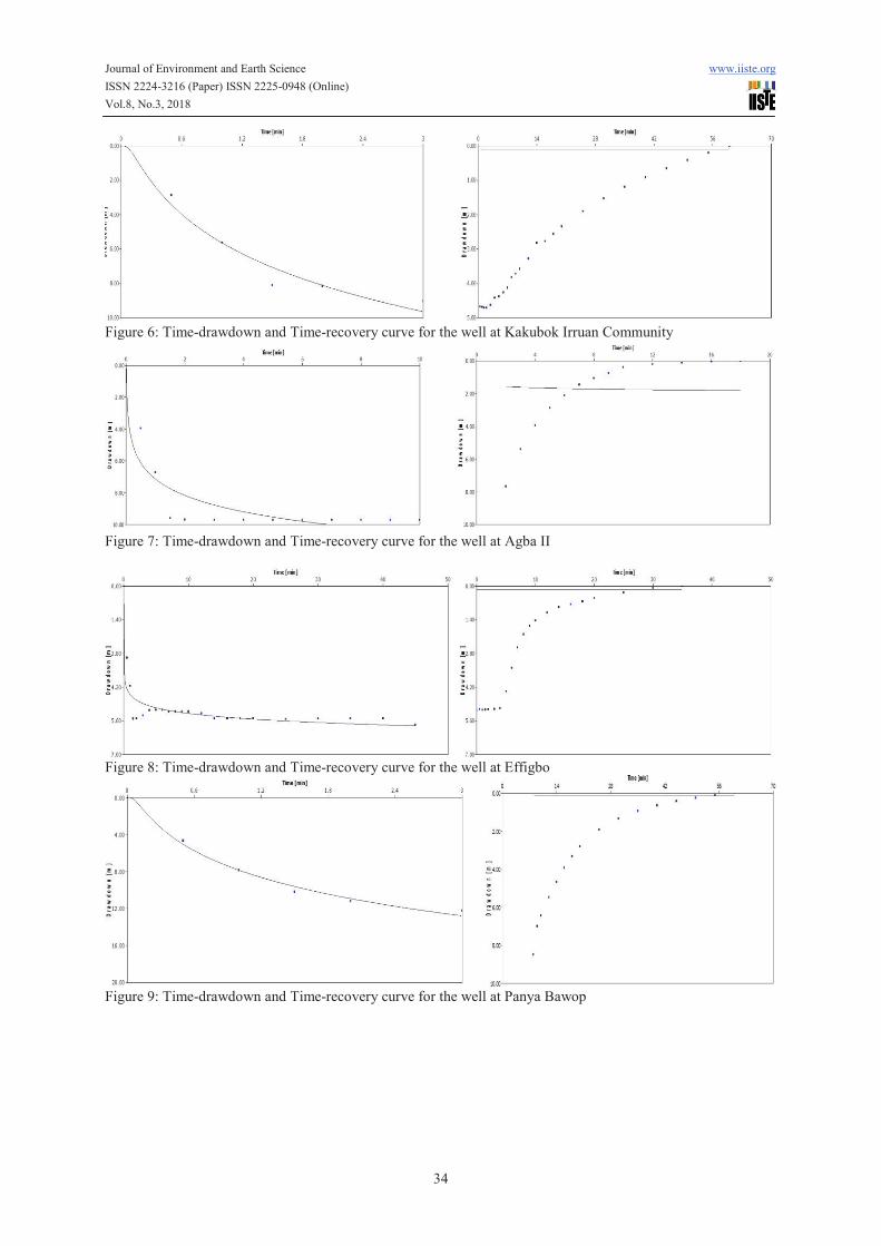
Figure 6: Time-drawdown and Time-recovery curve for the well at Kakubok Irruan Community
Figure 7: Time-drawdown and Time-recovery curve for the well at Agba II
Figure 8: Time-drawdown and Time-recovery curve for the well at Effigbo
Figure 9: Time-drawdown and Time-recovery curve for the well at Panya Bawop

Journal of Environment and Earth Science www.iiste.org ISSN 2224-3216 (Paper) ISSN 2225-0948 (Online) Vol.8, No.3, 2018
35
Figure 10: Time-drawdown and Time-recovery curve for the well at Adagom Ekumba I
Figure 11: Time-drawdown and Time-recovery curve for the well at Adagom Ekumba II
Figure 12: Time-drawdown and Time-recovery curve for the well at Bajia I
Figure 13: Time-drawdown and Time-recovery curve for the well at Nkanacha Community

Journal of Environment and Earth Science www.iiste.org ISSN 2224-3216 (Paper) ISSN 2225-0948 (Online) Vol.8, No.3, 2018
36
Figure 14: Time-drawdown and Time-recovery curve for the well at Biakwan Community.
Figure 15: Time-drawdown and Time-recovery curve for the well at Abontakon.