detailed profiling of the coral reefs in pulau aur, johor ... · detailed profiling of the coral...
TRANSCRIPT

101
DETAILED PROFILING OF THE CORAL REEFS IN PULAU AUR, JOHOR DARUL TAKZIM
Detailed Profiling of the Coral Reefs inPulau Aur, Johor Darul Takzim
Zulfigar Yasin & Aileen Tan Shau-Hwai
School of Biological Sciences, Universiti Sains Malaysia, 11800 Penang, Malaysia
ABSTRACT
Detailed profiling has been made on the coral reefs of Pulau Aur, Johor Darul Takzim,using SCUBA diving and underwater photography. Thirteen locations were surveyedaround the island, which comprised of Pulau Aur, Pulau Dayang, Pulau Lang and PulauPinang. Cross-sections of the reef profiles for survey locations are presented in thispaper.
Keywords: Coral reef profiling; Pulau Aur
IntroductionThe geographical location of Malaysia is in the centre of the Indo-West Pacific Region,a region with rich biodiversity. This region is considered to have the richest speciesdiversity of marine life in the world (Briggs, 1974). The coral reef of this region is consideredto have the greatest species assemblage in the world. However, very limited studies havebeen conducted on the coral reefs of this region. Several researchers have provideddescriptions and ecological information on the following reef areas; the east coast reefsof Peninsular Malaysia (Sheppard and Wells, 1988), the Straits of Malacca (Pillai andScheer, 1974), Kapas Island (De Silva et al., 1984), Tioman group of islands (Pillai andScheer, 1974), Redang Island (Ibrahim and Sidik, 1992; 1993; Kushairi, 1998) and BidongIslands (Mohd. Zaki et al., 1999). However, to date, no detailed report has been carriedout on the coral reefs of the southern islands of Peninsular Malaysia.
Pulau Aur is the outermost island amongst the islands located on the southeast ofPeninsular Malaysia, approximately 67km offshore from the town of Mersing, Johor. It islocated at the co-ordinates 2o 28’N and 104o 30’E in the South China Sea. It comprisesseveral islands namely Pulau Aur, Pulau Dayang, Pulau Pinang and Pulau Lang. A largepart of the island is rocky and covered by tropical rain forest and isolated coconutplantations. The main island is bordered by fringing reefs and the intertidal habitats aremade up of rocks, patches of mangroves as well as sandy shores.
The ecological assessment study carried out by Wetlands International showed thatPulau Aur has a rich marine biodiversity, with 114 coral species and 180 reef- associated

102
EKOSISTEM MARIN MALAYSIA: PENYELIDIKAN PANTAI TIMUR JOHOR DARUL TAKZIM
fish species. Out of these, four hard corals and 13 fish species are new records toMalaysia. Pulau Aur remains in a relatively pristine nature due to low human populationpressures and small-scale tourism development.
There have been several studies done on the marine macrobenthic fauna of thePulau Aur group of islands, for example the study on the diversity of sea cucumbers(Zulfigar et al., 2007) and giant clams (Tan, 2001), but till today, no description of thecoral reefs of Pulau Aur has been published. Therefore, this paper attempts to provide adetailed profiling of the coral reef in Pulau Aur, Johor.
Materials and MethodsThirteen locations were surveyed in Pulau Aur from 5 September to 12 September 2005.Table 1 and Figure 1 show the locations of the sampling sites. The survey was conductedusing scuba diving, and underwater photographs were taken. A detailed profile of thecoral reefs at Pulau Aur is given. It aims to provide a reef profile and the underwaterfeatures of the main reef areas around the islands. The specific features on a particulardive location may differ slightly, but the profiles summarised the reef characteristicsconcerned based on the many scientific surveys of the area.
Results and DiscussionThe location of the coral reefs are given in Figure 2 with the reef types described in Table2. Below is a detailed description of each of the island in the Pulau Aur group.
Pulau AurPulau Aur is the main island in the group. It has the largest area of reefs, which surroundmost of the islands. These reefs are exposed to both the Northeast and Southwest monsoon– the latter bearing the more extensive reef areas.
Although the coral cover on this island is wide, the reef is experiencing the negativeimpact of human development, with alga beds sometimes smother the coral and coverthe bottom.
On exposed areas (on the north and northeast) of the island where monsoonalwaves hit the coast – coral development in the shallow areas is stunted. In the south andsoutheast area where there are extensive subtidal reef flats pockets of good reefs remain(Figure 3). However, crown-of-torn infestations has taken its toll on the hard corals inrecent years where extensive colonies of the staghorn corals have been destroyed. Reefsat Teluk Kador (Figure 4) on the north point of the island contain pockets of high diversityareas.

103
DETAILED PROFILING OF THE CORAL REEFS IN PULAU AUR, JOHOR DARUL TAKZIM
TABLE 1: The Latitude and Longitude of the Sampling Locations in Pulau Aur Group,Johor Darul Takzim
Code Location name Latitude Longitude Max. divedepth (m)
D1 Pulau Dayang (Northwest) 2º 28’54.0" N 104º 29’55.8" E 12.7D2 Pulau Dayang (North) 2º 28’43.5" N 104º 30’11.8" E 12.0D3 Pulau Dayang – Rayner’s Rock 2º 28’55.0" N 104º 30’20.9" E 18.4D4 Pulau Dayang (North) – Teluk Jawa 2º 28’42.2" N 104º 30’15.3" E 11.0D5 Pulau Aur (North) 2º 28’20.2" N 104º 30’42.3" E 11.9D6 Pulau Aur (North) – Teluk Kador 2º 28’19.4" N 104º 30’46.8" E 11.6D7 Pulau Aur (East) 2º 27’32.4" N 104º 31’49.2" E 12.0D8 Pulau Pinang (West) – Tanjong Bercium 2º 26’17.6" N 104º 32’38.6" E 24.4D9 Pulau Pinang (West) 2º 26’17.6" N 104º 32’38.6" E 19.6D10 Pulau Pinang (Southwest) 2º 28’02.2" N 104º 32’39.3" E 18.5D11 Pulau Pinang – Pinnacles 1 2º 25’09.0" N 104º 31’59.9" E 18.4D12 Pulau Aur (Southwest) – Teluk Dalam to
Tanjong Jongkar 2º 26’03.7" N 104º 30’42.6" E 18.0D13 Pulau Lang -Tanjong Lang 2º 27’39.9" N 104º 29’08.1" E 9.5
FIGURE 1: The Sampling Locations in the Pulau Aur group, Johor Darul Takzim

104
EKOSISTEM MARIN MALAYSIA: PENYELIDIKAN PANTAI TIMUR JOHOR DARUL TAKZIM
TABLE 2: The Reef Types Commonly Found at Pulau Aur
Reef Type Location Description
Pulau Dayang (North)Pulau Dayang (North):
Teluk JawaPulau Aur (North):
Teluk KadarPulau Aur (Southwest):
Teluk Dalam toTanjong Jongkar
Pulau Lang:Tanjong Lang
Pulau Aur (East)Pulau Aur (North)Pulau Pinang (West):
Tanjong BerciumPulau PinangPulau Dayang:
Rayner’s Rock
Pulau Pinang:Pinnacles 1
Pulau Pinang(Southwest)
Fringing reef
Escarpment reef
Submerged reef
Patch reefs
Most of these reefs lie close to the sandybeaches and at the centre of bays on theislands. They fringe the shores that graduallyslope to the sea and typify most of the reefs atPulau Aur. A typical cross section of the reefcan be describes as an expanse of reef flat thatlies in the intertidal zone adjacent to theshoreline. This then gradually slopes to thereef edge where the gradient becomes steeper.At the bottom of the slope is usually sand. Therichest coral area is found near the reef edges.
These reefs are found next to steep rockyoutcrops. The outcrops often extend below thewaters surface. These escarpment reefs mayalso form on the rocky outcrops away from themain islands such as at Rayner’s rock near PulauDayang. Here encrustations of corals form onthe submerged substrates. Areas protectedfrom high wave impacts usually harbour thelarger and elaborate coral colonies. Below thiszone soft corals may predominate.
Several reefs at Pulau Aur lie away from theislands and form submerged reefs. These areassociated with rock formations that lie belowthe sea surface. The location of these reefs issometimes marked by fishermen or divers andthese peaks can sometimes be observed fromthe surface where sporadic colonies of hardcorals predominate. In the shaded and deeperlocations gorgonian sea fans and soft coralsform the main fauna. These reefs are oftensubjected to strong current.
Interspersed throughout the island group arepatch reefs. These are exemplified by coralrubble and coralline algae that are cementedtogether and form the main substrate. The reefsform patches that may lie in shallow as well asdeeper waters that determine the presence ofhard corals in the area. Patch reefs harbour theirspecial kind of fauna. Where algal and soft coralpatches are common, higher densities of thenudibranch mollusc are usually present.

105
DETAILED PROFILING OF THE CORAL REEFS IN PULAU AUR, JOHOR DARUL TAKZIM
Fringing reefs
Encampment reefs
Submerged reefs
FIGURE 2: Location and Types of Coral Reefs in the Pulau Aur group, Johor Darul Takzim

106
EKOSISTEM MARIN MALAYSIA: PENYELIDIKAN PANTAI TIMUR JOHOR DARUL TAKZIM
FIGURE 3: Teluk Dalam – Tanjung Jongkar
FIGURE 4: Pulau Aur – Teluk Kador
107
DETAILED PROFILING OF THE CORAL REEFS IN PULAU AUR, JOHOR DARUL TAKZIM
Pulau DayangPulau Dayang is located to the north of Pulau Aur. It is the second largest island of thegroup and separated by narrow straits. Within the straits, the water current can be strongespecially during the spring tides. The reef is characterised by beds of soft corals, seaanemones and some gorgonian sea fans on the slope. Reef development is poor exceptwithin some areas that lie between large granite boulders.
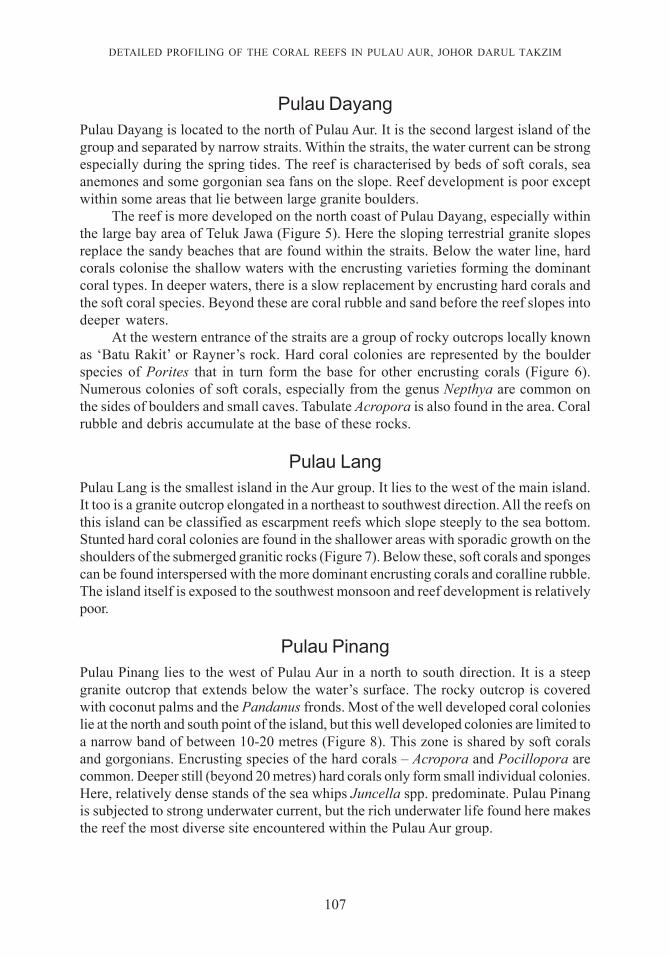
The reef is more developed on the north coast of Pulau Dayang, especially withinthe large bay area of Teluk Jawa (Figure 5). Here the sloping terrestrial granite slopesreplace the sandy beaches that are found within the straits. Below the water line, hardcorals colonise the shallow waters with the encrusting varieties forming the dominantcoral types. In deeper waters, there is a slow replacement by encrusting hard corals andthe soft coral species. Beyond these are coral rubble and sand before the reef slopes intodeeper waters.
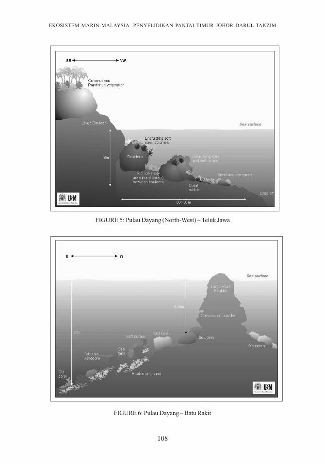
At the western entrance of the straits are a group of rocky outcrops locally knownas ‘Batu Rakit’ or Rayner’s rock. Hard coral colonies are represented by the boulderspecies of Porites that in turn form the base for other encrusting corals (Figure 6).Numerous colonies of soft corals, especially from the genus Nepthya are common onthe sides of boulders and small caves. Tabulate Acropora is also found in the area. Coralrubble and debris accumulate at the base of these rocks.
Pulau LangPulau Lang is the smallest island in the Aur group. It lies to the west of the main island.It too is a granite outcrop elongated in a northeast to southwest direction. All the reefs onthis island can be classified as escarpment reefs which slope steeply to the sea bottom.Stunted hard coral colonies are found in the shallower areas with sporadic growth on theshoulders of the submerged granitic rocks (Figure 7). Below these, soft corals and spongescan be found interspersed with the more dominant encrusting corals and coralline rubble.The island itself is exposed to the southwest monsoon and reef development is relativelypoor.
Pulau PinangPulau Pinang lies to the west of Pulau Aur in a north to south direction. It is a steepgranite outcrop that extends below the water’s surface. The rocky outcrop is coveredwith coconut palms and the Pandanus fronds. Most of the well developed coral colonieslie at the north and south point of the island, but this well developed colonies are limited toa narrow band of between 10-20 metres (Figure 8). This zone is shared by soft coralsand gorgonians. Encrusting species of the hard corals – Acropora and Pocillopora arecommon. Deeper still (beyond 20 metres) hard corals only form small individual colonies.Here, relatively dense stands of the sea whips Juncella spp. predominate. Pulau Pinangis subjected to strong underwater current, but the rich underwater life found here makesthe reef the most diverse site encountered within the Pulau Aur group.
108
EKOSISTEM MARIN MALAYSIA: PENYELIDIKAN PANTAI TIMUR JOHOR DARUL TAKZIM
FIGURE 6: Pulau Dayang – Batu Rakit
FIGURE 5: Pulau Dayang (North-West) – Teluk Jawa

109
DETAILED PROFILING OF THE CORAL REEFS IN PULAU AUR, JOHOR DARUL TAKZIM
FIGURE 8: Pulau Pinang – Tanjung Batu Bercium
FIGURE 7: Pulau Lang (North) – Tanjung Letak Pari

110
EKOSISTEM MARIN MALAYSIA: PENYELIDIKAN PANTAI TIMUR JOHOR DARUL TAKZIM
Rocky Outcrops and Submerged ReefsSouth of Pulau Aur are several submerged reefs known as ‘the Pinnacles’ to the localdiving community. These are boulder formations whose top lies below the waters surface.They are usually marked by fishermen or diving buoys. The top of ‘the Pinnacles’ doesnot support high coral cover with the occasional tabulate Acropora and encrusting speciesPorites and brain corals (Figure 9). Light levels are too low to maintain the developmentof dense coral colonies; instead, soft corals and sea fans predominate. Some of the seafan colonies are more than 2 metres across. Soft corals colonise the crevices on theboulders competing with the stinging hydroids and leather corals. At the base of thesestructures the main substrate is usually sand and rubble. Sea whips and soft coralspredominate as do the benthic fauna such as sea cucumbers and starfishes.
FIGURE 9: The Pinnacles (Pulau Aur)
111
DETAILED PROFILING OF THE CORAL REEFS IN PULAU AUR, JOHOR DARUL TAKZIM
ConclusionWith a detailed profiling of the coral reefs in Pulau Aur, the roles of the coral reefs inrelation to the flora and fauna of Pulau Aur can be analyzed and characterized.
AcknowledgementWe thank the Universiti Sains Malaysia’s Reef Research Group for their kind assistanceand support in the field studies. We would like to thank the Johor State Government andthe Marine Park Authorities for their support in making this research a success.
ReferencesBriggs, J.C. 1974. Marine Zoogeography. McGraw-Hill Co., New York, pp. 475.De Silva, M.W.R.N., Betterton, C. and Smith, R.A. 1984. Coral reef resources of the east coast of
Peninsula Malaysia. Coastal Resources of East Coast Peninsula Malaysia. An assessmentin relation to potential oil spills. Chua T.E. and Charles, J.K. (eds.). Penerbit UniversitiSains Malaysia, Pulau Pinang, pp. 57-90.
Ibrahim, M.H.M. and Sidik, J.B. 1992. Development Impact on Coral Reefs and Mangroves ofPulau Redang. WWF Malaysia Project MYS 223/91. WWF Malaysia, Selangor, p. 62.
Ibrahim, M.H.M. and Sidik, J.B. 1993. Development Impact on Coral Reefs and Mangroves ofPulau Redang. WWF Malaysia Project MYS 223/91. WWF Malaysia, Selangor, p.37.
Kushairi, M.R.M. 1998. The 1998 Bleaching Catastrophe of Corals in the South China Sea.Southern Asian Fisheries Development Centre (SEAFDEC), Department of Fisheries ofMalaysia, Kuala Terengganu, p.7.
Mohd Zaki, M.S., Okamoto, N. and Subarjo, M. 1999. Growth form and distribution pattern ofcorals around Bidong Islands. Proc. of the 10th JSPS Joint Seminar on Marine and FisherySciences,Malacca, Malaysia, pp 15-20.
Pillai, G.C.S. and Sheer, G. 1974. On a collection of scleractinia from the Straits of Malacca. Proc. 2nd
Int’l Coral Reef Sym., Brisbane 1: 445-463.Sheppard, C. and Wells, S.M. 1988. Coral Reefs of the World. Indian Ocean, Red Sea and Gulf. V2.
The IUCN Conservation Monitoring Centre, Cambridge, p.389.

0