desk based assessment - britannia archaeology ltd€¦ · britannia archaeology ltd was...
TRANSCRIPT

FLEET HOUSE, ADMIRALS WALK,
HAMPSTEAD, LONDON
DESK BASED ASSESSMENT
Report Number: 1011 March 2012

© Britannia Archaeology Ltd 2013 all rights reserved Report Number: 1011
FLEET HOUSE, ADMIRAL’S WALK,
HAMPSTEAD, LONDON
Desk Based Assessment
Prepared for: Mr Peter Rading
Fleet House Admirals Walk
Hampstead London
NW3 6RS
By: Matthew Adams BA AIfA
Britannia Archaeology Ltd
4 The Mill, Clovers Court, Stowmarket, Suffolk,
IP14 1RB T: 01449 763034
[email protected] www.britannia-archaeology.com
Registered in England and Wales: 7874460
Revised March 2013
Site Code
NA
NGR
526232 186069
Planning Ref.
NA
OASIS
NA
Approved By
Timothy Schofield
DATE
March 2013
Fleet House, Admirals Walk, Hampstead, London, NW3 6RS Archaeological Desk Based Assessment
3 ©Britannia Archaeology Ltd 2013 all rights reserved Report Number: 1011
DISCLAIMER The material contained within this report was prepared for an individual client and solely for the benefit of that client and the contents should not be relied upon by any third party. The results and interpretation of the report cannot be considered an absolute representation of the archaeological or any other remains. Britannia Archaeology Ltd will not be held liable for any error of fact resulting in loss or damage, direct, indirect or consequential, through misuse of, or actions based on the material contained within by any third party.

Fleet House, Admirals Walk, Hampstead, London, NW3 6RS Archaeological Desk Based Assessment
4 ©Britannia Archaeology Ltd 2013 all rights reserved Report Number: 1011
CONTENTS
ABSTRACT Page 3 1.0 INTRODUCTION & METHODOLOGY Page 6 2.0 METHODOLOGY Page 6 3.0 PLANNING BACKGROUND Page 8 4.0 ARCHAEOLOGICAL AND HISTORICAL SEARCH RESULTS Page 9 5.0 DISCUSSION Page 15 6.0 CONCLUSIONS & RECOMMENDATIONS Page 17 7.0 ACKNOWLEDGEMENTS Page 18 8.0 PROJECT ARCHIVE & DEPOSITION Page 18
BIBLIOGRAPHY Page 18 Appendix 1 HER Data Figure 1 Site Location Plan 1:500 Figure 2 GLHER Data – Monument Areas & Locations 1:10000 Figure 3 GLHER Data – Event Areas & Locations 1:10000 Figure 4 GLHER Data – Listed Buildings and Protected Squares 1:2000 Figure 5 Cartographic Sources 1764-1862 Figure 6 Cartographic Sources 1862-1945 Figure 7 Impact Assessment 1:2000 Figure 8 Site Visit Photographs

Fleet House, Admirals Walk, Hampstead, London, NW3 6RS Archaeological Desk Based Assessment
5 ©Britannia Archaeology Ltd 2013 all rights reserved Report Number: 1011
Abstract Britannia Archaeology Ltd was commissioned by Mr Peter Rading to undertake an Archaeological Desk Based Assessment at Fleet House, Admirals Walk, Hampstead, London, NW3 6RS (NGR: 526232 186069). Situated in the London Borough of Camden and within Archaeological Priority Area number 6 (Hampstead). Potential for subsurface archaeological remains prior to the late 19th century AD is low despite the site’s location to the west of Hampstead town centre. Historic maps show that the site remained undeveloped until the construction of Rickford Lodge in the late 1800s, and no archaeological sites were noted in the assessment area prior to this development. There is a high potential for the presence of archaeological remains associated with Rickford Lodge, however the basement of the existing building at the northern end of the site will have removed a large amount of material during its construction in the 1950s. This lowers the potential significantly. The proposed development will sit over the existing building’s footprint with a minor expansion of around 1 to 2m to the north, south and east. A new basement will also extend slightly to the north, east and south from its current location. The impact of the overall development will be minimal. Impact on the general setting will be negligible. The proposed development is of a similar size both vertically and horizontally to the existing building. The numerous surrounding listed buildings and structures are well screened by tall trees, hedges and high garden walls.
Fleet House, Admirals Walk, Hampstead, London, NW3 6RS Archaeological Desk Based Assessment
6 ©Britannia Archaeology Ltd 2013 all rights reserved Report Number: 1011
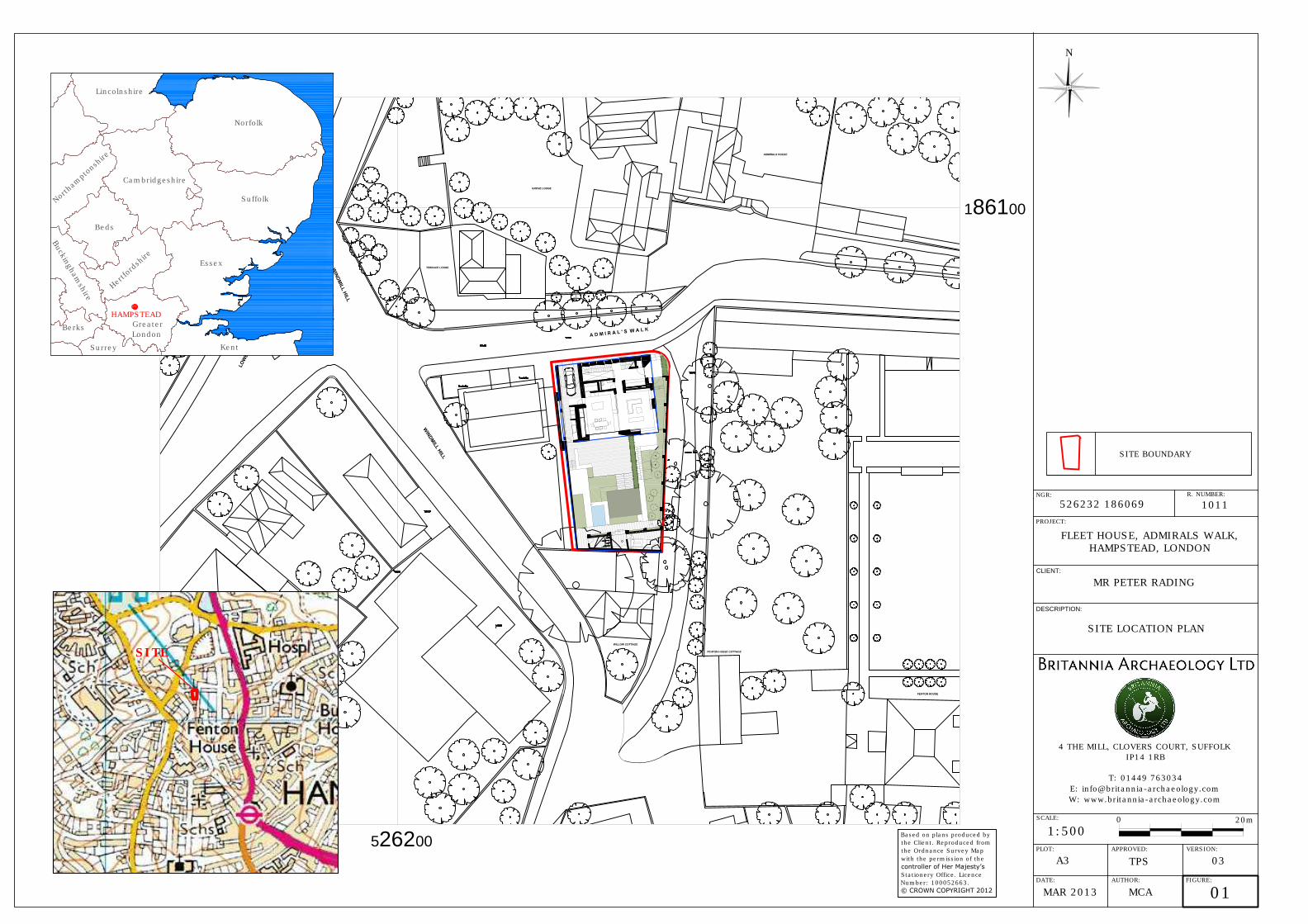
1.0 INTRODUCTION & METHODOLOGY 1.1 Project Background Britannia Archaeology Ltd was commissioned by Mr Peter Rading to undertake an archaeological desk based assessment of a site at Fleet House, Admirals Walk, Hampstead, London, NW3 6RS (NGR: 526232 186069), situated in the London Borough of Camden, in an Archaeological Priority Area (Number 6 Hampstead) and the Conservation Area of Hampstead (Fig. 1). This assessment will accompany a planning application for the proposed redevelopment of the site that involves the demolition of the existing two-storey cellared 1950s Fleet House, and the construction of a new two-storey cellared building over a slightly larger area than the previous dwelling. It has been commissioned to establish the presence of, or likely potential for, buried archaeological remains and the possible impact of the development on these remains. The assessment will also consider the setting of the new development in relation to existing listed buildings and known archaeological sites within the immediate area. 1.2 Site Description The site is located in the ‘village’ of Hampstead in the London Borough of Camden and lies 130m west of the High Street, close to the historic core of the settlement. It forms a roughly rectangular parcel of land, aligned north to south measuring 520m². The northern area of the plot contains a 1950s two storey cellared residential building, and the southern area comprises a brick terraced patio area and garden laid to grass with surrounding trees and bushes (Fig. 1). The site is bounded by Admiral’s Walk to the north, Broadside house and garden to the west, Willow Cottage to the south and a footpath and the walled garden for Fenton House to the east. It sits at approximately 125m AOD. The bedrock geology comprises Bagshot Formation Sand, a sedimentary shallow marine deposit laid down in the Palaeogene period. This deposit forms a 25m thick outcrop above the earlier Claygate Formation clay, silt, sand and London Clays and was instrumental in forming the localised high ground and Heath environment located to the north of Hampstead (British Geological Survey, BGS). 2.0 METHODOLOGY 2.1 Aims & Scope This report aims to assess all known information relating to subsurface and above ground archaeological remains within a 1km radius centred on the site, to identify the potential presence of archaeological remains that will be impacted upon during the development. It will also consider the impact of the development on the setting of existing archaeological sites and listed buildings in the immediate vicinity. This report will take

Fleet House, Admirals Walk, Hampstead, London, NW3 6RS Archaeological Desk Based Assessment
7 ©Britannia Archaeology Ltd 2013 all rights reserved Report Number: 1011
into consideration existing truncation from previous developments and the potential impact caused by the implementation of the proposed development plans and construction methods. A mitigation strategy may be instigated after consultation with the English Heritage Greater London Archaeology Advisory Service (EHGLAAS) archaeologist for the Camden Borough. 2.2 Research and Sources Historic Environment Record Office The Greater London Historic Environment Record Office (GLHER) was consulted and provided details of all data held within a 1km radius of the site. The GLHER database holds records of archaeological sites, scheduled monuments, listed buildings, finds spots, registered parks and gardens, protected wreck sites and battlefields. Due to the extremely high density of listed buildings within 1km of the site, the search area for listed buildings records was reduced to 100m following consultation with GLHER (1km returned over 700 listed buildings, 300 are recorded within a 500m radius). Documentary Sources Primary and secondary documentary sources were consulted via the GLHER, Camden Local Studies and Archives Centre, London Metropolitan Archives and the Archaeology Data Service (www.archaeologydataservice.ac.uk). All sources consulted are listed in the bibliography. Cartographic Sources A search of primary and secondary cartographic sources was undertaken via the Ordnance Survey, London Metropolitan Archives and Camden Local Studies and Archives Centre. Site Visit A site visit was undertaken on the 16th August 2012 and a photographic record compiled. The visit aimed to identify any existing earthworks or visible archaeological remains, establish the condition and character of the existing site and note its setting. Proposed site plans were consulted during the visit to assess the areas most at risk from the development. Presentation of Results The results of the research are presented by historical/archaeological period and are a synthesis of all data gathered that are relevant to the site. Not all of the data supplied by the GLHER is referred to in the report, however Appendix 1 contains a full table and brief description of the HER search results.

Fleet House, Admirals Walk, Hampstead, London, NW3 6RS Archaeological Desk Based Assessment
8 ©Britannia Archaeology Ltd 2013 all rights reserved Report Number: 1011
3.0 PLANNING BACKGROUND The archaeological assessment was carried out in accordance with guidance laid down by the National Planning and Policy Framework (NPPF, DCLD 2012) which replaced Planning Policy Statement 5: Planning for the Historic Environment (PPS5, DCLG 2010) in March 2012. Relevant regional planning policy for the Hampstead area is the London Plan (2011): Policy 7.3 and the relevant local planning policies include the Camden Core Strategy Local Development Framework (CCSLDP, 2010): Policy CS14b and the Camden Development Policies (2010): Policy DP25. 3.1 National Planning Policy Framework (NPPF, DCLG March 2012) The NPPF recognises that ‘heritage assets’ are an irreplaceable resource and planning authorities should conserve them in a manner appropriate to their significance when considering development. It requires developers to record and advance understanding of the significance of any heritage assets to be lost (wholly or in part) in a manner proportionate to their importance and the impact, and to make this evidence (and any archive generated) publicly accessible. The key areas for consideration are:
• The significance of the heritage asset and its setting in relation to the proposed development;
• The level of detail should be proportionate to the assets’ importance and no more than is sufficient to understand the potential impact of the proposal on their significance;
• Significance (of the heritage asset) can be harmed or lost through alteration or destruction, or development within its setting. As heritage assets are irreplaceable, any harm or loss should require clear and convincing justification;
• Local planning authorities should not permit loss of the whole or part of a heritage asset without taking all reasonable steps to ensure the new development will proceed after the loss has occurred;
• Non-designated heritage assets of archaeological interest that are demonstrably of equivalent significance to scheduled monuments, should be considered subject to the policies for designated heritage assets.
3.2 The London Plan (2011) On 22 July 2011, the Mayor of London published the replacement of the spatial development strategy for Greater London. The relevant section on Heritage management is Policy 7.3: Strategic
• A. London’s historic environment, including natural landscapes, conservation areas, heritage assets, World Heritage Sites, Scheduled Ancient Monuments and memorials should be identified, preserved and restored.
• B. Development should incorporate measures that identify, record, interpret, protect and, where appropriate, present, the site’s archaeology.

Fleet House, Admirals Walk, Hampstead, London, NW3 6RS Archaeological Desk Based Assessment
9 ©Britannia Archaeology Ltd 2013 all rights reserved Report Number: 1011
Planning decisions
• C. Development should preserve, refurbish and incorporate heritage assets, where appropriate.
• D. New development in the setting of heritage assets, and conservation areas should be sympathetic to their form, scale, materials and architectural detail.
3.3 Camden Core Strategy Local Development Framework (Adopted 2010): Policy CS14b Camden Council’s current development plan was adopted in 2010 and replaced the UDP from 2006. Policy CS14b states the Council’s position on archaeology and the built environment which is summarised as follows: Policy CS14b
• The Council will ensure that Camden’s places and buildings are attractive, safe and easy to use by: B) preserving and enhancing Camden’s rich and diverse heritage assets and their settings, including conservation areas, listed buildings, archaeological remains, scheduled ancient monuments and historic parks and gardens.
3.4 Camden Development Policies (2010): Policy DP25 This deals specifically with heritage and states the following in relation to archaeology:
• The Council will protect remains of archaeological importance by ensuring acceptable measures are taken to preserve them and their setting, including physical preservation, where appropriate.
4.0 ARCHAEOLOGICAL AND HISTORICAL RESEARCH RESULTS The following results are presented as a synthesis of all the data obtained from the sources detailed above (Section 2.0) and listed in the bibliography (Figs. 2-6). 4.1 Prehistoric (750000BC – 43AD) (Fig.2) Hampstead Heath is situated at one of the highest points at this longitude within the Thames Basin, it has a commanding view across the Thames Valley. Heathland areas are known to have been attractive for prehistoric settlers with high ground often containing evidence of funerary activity from the late Neolithic and Bronze Age periods. Evidence of prehistoric archaeology is sparse within the secondary sources, with general descriptions of Mesolithic communities living on the Heath around 7000BC (Richardson, 1985). However 11 separate records are held in the GLHER Office that include finds spots or archaeological sites within 1km of the proposed development, some of which are recorded as substantial areas of activity.
Fleet House, Admirals Walk, Hampstead, London, NW3 6RS Archaeological Desk Based Assessment
10 ©Britannia Archaeology Ltd 2013 all rights reserved Report Number: 1011
There were no GLHER records relating to prehistoric sites within 300m of the assessment area and nearly all of the in-situ prehistoric remains were located on the Heath to the north, with the exception of a Palaeolithic ‘pointed hand axe’ (MLO17761) recovered 360m to the south (Fig. 2). Six of the records (MLO17762, MLO17853, MLO18039, MLO17763, MLO17769 and MLO17766) are assigned to a general ‘prehistoric’ phase and comprise finds scatters of struck flint debitage, flint tools and pottery. One record (MLO17853) describes the presence of a prehistoric earthwork at the site of Jack Straw’s Castle which lies 347m north of the assessment area. Further records identify three dated sites. These include a sample of Mesolithic sediment from the spring line on the Heath (MLO 78159), a Mesolithic axe head, a polished Neolithic axe/adze head and a substantial Mesolithic occupation site (MLO18038) located 908m north-west where 12500 items of struck flint and 10000 of burnt flint were recovered during an excavation by Hendon and District Archaeological Society (HADAS). No evidence of Bronze Age or Iron Age activity has been recorded in the area. 4.2 Romano-British (43AD – c. 410AD) (Fig. 2) The Romano-British period marked a significant change in development for the wider area with Londinium becoming a major settlement and administrative centre. Hampstead’s proximity to London and the road to Verulamium (St. Albans) known later as Watling Street (now Edgware Road A5), would suggest a reasonable potential for Romano-British settlement activity, however the evidence is generally sparse. There are no Romano-British sites recorded in the immediate vicinity. The closest is located 100m to the south-west at Mount Vernon Hospital, Frognal Rise, where residual third century AD pottery was recovered from medieval pits during an evaluation and subsequent excavation (ELO9095-96) undertaken by MoLAS in 1995 and 1996 (MLO 66259). All remaining sites were over 300m away, generally in an easterly direction, except for the projected route of another Roman road noted on the west of the Heath (MLO 18051). A total of seven recorded sites and find spots are present within 1km, the most significant relates to a cist burial (MLO 17798) located 487m east at Well Walk. Burnt human bones were found inside a large urn along with a smaller urn and pitcher. Four other vessels and two lamps were also recovered from this site. The remaining records suggest a moderate indication of background activity: three coins, one of Marcus Aurelius (161AD – 180AD) and two of Victorinus (268AD – 270AD) (MLO 17797 and MLO 18045), two glass beads (MLO 17786) and a yellow and white flange rimmed pottery vessel (MLO 18044). 4.3 Anglo-Saxon (Early medieval) (c.410AD – 1066AD) (Fig. 2)

Fleet House, Admirals Walk, Hampstead, London, NW3 6RS Archaeological Desk Based Assessment
11 ©Britannia Archaeology Ltd 2013 all rights reserved Report Number: 1011
The withdrawal of Roman authority in Britain in the early 5th Century AD and the dominance of the Anglo-Saxons in the south and east of England led to significant changes in settlement distribution. London eventually re-emerged as an important town in the 7th century AD, but the focus of settlement initially shifted outside of the walled town to the Strand, returning back within the walls in later centuries. Conversely St. Albans declined dramatically despite it being an important Roman town within the area. Settlement patterns persisting throughout Iron Age and Roman Britain did not necessarily continue into the Anglo-Saxon period. Hampstead can trace its origins back to the Anglo-Saxon period, the name is a corruption of the Old English (Anglo-Saxon) ham-stede literally meaning ‘home stead’ (Mills, 2003). There are no Anglo-Saxon sites recorded in the immediate vicinity, the closest activity lying 909m to the north-west. Documentary evidence from the 10th century AD (MLO 17901) suggests that the boundaries of Hampstead were defined in the Charter of King Edgar (c.968AD) between Watling Street in the south-west, Cucking Pool in the west, Sandgate (now North End) in the north and Foxhanger (now Haverstock Hill) in the east (Elrington et al, 1989). A further amendment of this boundary was presented in the Charter of King Æthelred (986AD) which later sources interpret as: ‘from Sandgate the boundary ran east to Bedegar's styvic leage, possibly a hog or cattle run, thence to Deormod's wic or farm, to Middle Hampstead, and along the hedge to the rush leage’ (Elrington et al, 1989). Hampstead has two entries in the Domesday Book showing that a small settlement was present at the end of the Anglo-Saxon period. The entries detail the population and wealth of the settlement as 7 households (1 villager, 5 smallholders and 1 serf) with 3.5 ploughlands (1.5 Lord’s plough team and 1 man’s team) and woodland for 100 pigs. St Peter’s Abbey, Westminster is listed as the Lord in 1066, by 1086 it shared the Lordship with Ranulf Peveral (Randulf de Peverel) who had the minority share in what is now the Belsize area. The GLHER Office holds only one other record for this period within 1Km. Excavations by the Hendon and District Archaeology Society (HADAS) in 1976 (which also found the large quantities of Mesolithic flint) recovered abraded Anglo-Saxon pottery and excavated a hearth used for charcoal burning (MLO 17802). Sparse archaeological evidence for Anglo-Saxon occupation is perhaps attributable to limited excavations in the area of the later medieval manorial demesne which is also potentially the centre of earlier Anglo-Saxon activity. The documentary evidence and etymology of Hampstead suggests at least some limited settlement activity during this period. 4.4 Medieval (1066 AD – 1540 AD) (Fig. 2) The medieval period in Hampstead is better represented in both primary and secondary sources. London became an important city and the de facto capital of Britain after the Norman invasion in 1066. Hampstead’s Domesday Book entries are technically medieval in date, however they give details of the state of the settlement at the end of the Anglo-Saxon period, revealing an established settlement of seven households in slight decline after the Norman invasion.

Fleet House, Admirals Walk, Hampstead, London, NW3 6RS Archaeological Desk Based Assessment
12 ©Britannia Archaeology Ltd 2013 all rights reserved Report Number: 1011
The settlement grew during the 12th and 13th centuries, but much of the land belonging to the demesne was lost to freehold estates including Kilburn Priory and the ‘Hospital of St. James for Leprous Women’ which became Eton College Estate in 1449 (Richardson, 1985). By 1312 the village had 40 dwellings, six freehold houses and the manorial demesne at the centre of the parish was located approximately 500m to the south of the assessment site and south-west of the modern core of Hampstead (Elrington et al, 1989). The GLHER records show one medieval site in the immediate vicinity. A watching brief (ELO9153) at Fenton House Cottages and stable yard, 45m to the south-east, recorded a medieval patterned floor surface (MLO16936). There are no further medieval sites noted close to the proposed development, which lies to the north of the manorial area located in Frognal. Admirals Walk was probably on the edge of the settlement/manorial complex in part of the outlying field systems or the extensive woods for the demesne. The 1km search contained 13 records for this period, six of which relate to the course of medieval roads (MLO23436, MLO17883, MLO17827, MLO17829, MLO17834 and MLO17828) which are also shown existing on the post-medieval maps (Figs. 5 & 6). The last two roads survive as Spaniard’s Road which runs across the Heath to Highgate and as Hampstead High Street (becoming Charing Cross Road) which is still the main road to London. Archaeological fieldwork records three sites including a watching brief at Fenton House (ELO9153). The evaluation and subsequent excavation (ELO9095-96) at Mount Vernon Hospital, Frognal Rise (MLO66260) located 100m to the south-west, recorded a medieval colluvial layer containing several sherds of pottery with date ranges between 1080 – 1500 and 1150 – 1500. This was the same evaluation and excavation conducted by MoLAS described in the Romano-British section. A watching brief (ELO6993) at 59 Frognal, located 548m to the south-west of the assessment site (MLO98223), identified a medieval garden soil layer associated with 13th – 14th century occupation activity. The remaining records detail finds spots, the closest to the assessment site being a medieval costrel (MLO17824) found 220m to the south-east at Holly Hill. Two separate records relate to the discovery of a 13th century Papal Bull seal (MLO17806 and MLO26639) from a document issued by Pope Innocent IV. 4.5 Post-medieval and Modern (1540AD – Present) (Figs. 2–6) Hampstead is well represented in primary and secondary sources during the post-medieval and modern periods and the growth of the town from small settlement to its present size and disposition is clearly chronicled. Many of the maps consulted were produced between 1540 and 1946 with the assessment site being clearly identifiable on most (Figs. 5 & 6). The town grew substantially in the early to middle post-medieval period when wealthier London residents bought up properties to use as recreational residences to take advantage of the ‘good air and waters’; health benefits that were

Fleet House, Admirals Walk, Hampstead, London, NW3 6RS Archaeological Desk Based Assessment
13 ©Britannia Archaeology Ltd 2013 all rights reserved Report Number: 1011
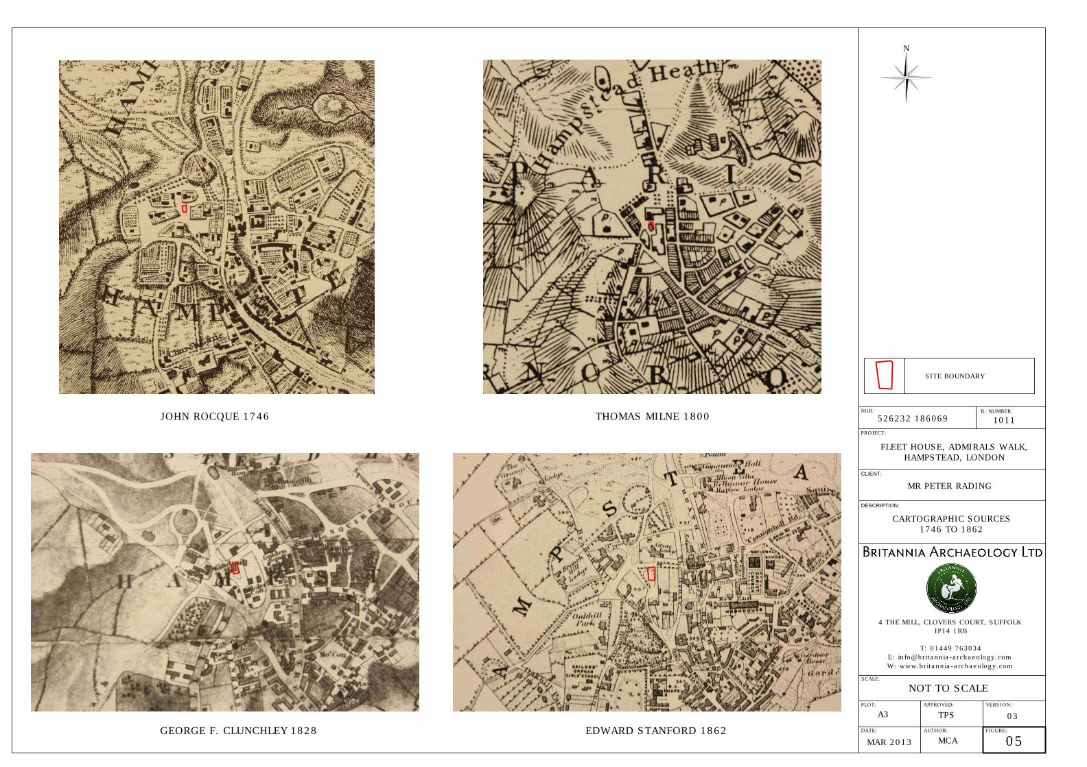
actively promoted (Richardson, 1985). This led to a permanent poor population and transient affluent population. Substantial development occurred in the mid to late 19th century especially in the southern area of town, partly due to the railway station opening but also as a result of the lifting of development restrictions placed on the demesne area of Hampstead by the will of Sir Thomas Maryon Wilson (Elrington et al, 1989). The historic maps consulted show that the assessment site was completely free of buildings until at least 1869 (Figs. 5 & 6). Substantial buildings are illustrated around the site on the earliest map (1746), but a specific plot or field is not assigned until the 1800 map which shows an open roughly triangular area of land which today is split into three plots. Maps from the mid-19th century suggest that trees and possibly a pond or landscaped park/garden were present, but by 1869 the first edition map records an open field with trees. A 100m search for listed buildings in close proximity to the site detailed 18 results, all of which date to the 17th and 18th century suggesting that the area underwent significant development in this period (Fig. 4). The most significant result lies 7m to the east on the neighbouring property and is described as the garden gates, railings and walls to Fenton House (DLO15809), dating from the 17th century. Fenton House gardens contain four listed statues and a cistern from the 18th century AD (DLO15805). Fenton House Garage (DLO15806) is also listed as the old coach house and coachman’s cottage and dates from 1673, and is located 43m to the south-east. A large plot of land immediately north of the assessment site contains Grove Lodge (DLO15775) and the GLHER record describes it as a 17th century semi-detached house. The early Rocque map (1746) reveals a relatively small building, but by the Stanton map of 1862 Grove Lodge is shown as a large building positioned in the south of the plot. Today it is split into three listed buildings representing differing stages of development. One is still called Grove Lodge, Netley Cottage (DLO16471) is an 18th century farmhouse, but the most notable building is Admiral’s House (DLO15773). Originally constructed in 1680, but much altered in the 19th century, this building gives the street its name which was changed in 1949 from The Grove because of its association with Admiral’s House. It contains railings, gun emplacements and a weatherboard quarter deck penthouse designed to imitate the wooden quarterdeck of a naval ship. The house inspired the main residence in the Disney film Mary Poppins, but the highest ranking naval occupant was only a Lieutenant (Fountain North) with the supposed creator, Admiral Matthew Barton, actually living on Rosslyn Hill (Wade, 1984). A 17th century garden wall associated with Netley Cottage (DLO16472) is also listed. Terrace Lodge (DLO15772), an 18th century villa, is located in south-west corner of the same large plot as Grove Lodge. Archaeological investigations within the 1km search area also suggest substantial development in the 17th and 18th century. The nearest significant archaeological site (100m south-west) is the Mount Vernon Hospital evaluation (ELO4095) and excavation (ELO9096) at Frognal (run by MoLAS). A drain, wall, pit and ditch dating to the 17th and
Fleet House, Admirals Walk, Hampstead, London, NW3 6RS Archaeological Desk Based Assessment
14 ©Britannia Archaeology Ltd 2013 all rights reserved Report Number: 1011
18th centuries and a cess pit and associated timber structure with a date range of 1480 to 1600 were recorded. Further archaeological fieldwork records eight additional sites with 17th to 18th century dates (ELO3299, [MLO59926-28, MLO59204], ELO7732, ELO6994, ELO7993, ELO4127, ELO8837 and ELO3078). These archaeological investigations recorded similar features to the Mount Vernon excavation comprising mainly 17th to 18th century walls, brick drains and waste dumps. These sites mostly lie over 300m to the south-west, south and south-east of the assessment area. Seven 18th century listed buildings are located between 50m and 100m from the assessment site (DLO16468, DLO16469, DLO16470, DLO16183, DLO15610, DLO16172 and DLO16177). These buildings can be identified on all but the earliest cartographic sources. A group of five 18th century AD lamp posts (DLO16473) are also listed. Little in the way of 19th century archaeology has been excavated, mainly because many off the 18th and 19th century buildings still exist. The number of parks and gardens recorded for this period is indicative of an established affluent Victorian town and four protected squares (DLO35371, DLO35373, MLO102510 and DLO35089) are noted in the search area, including one at Holly Bush Hill/Windmill Hill (DLO35089), located 140m to the south of the site. Two large 18th and 19th century AD Parks (MLO59270 and MLO102787) are also recorded to the north on the Heath at Kenwood House and Golders Hill, both lying at around 900m to the north and north-east. The 2nd Edition Ordnance Survey Map (1919) (Fig. 6) shows a relatively large building called Rickford Lodge present on the assessment site in the first decades of the 20th century. It is not present on the 1st Edition Ordnance Survey Map (1869), and would have been constructed at some point in the intervening years. The later London County Council Municipal Maps of London (1930 and revised 1935) show Rickford Lodge situated on the plot before World War II, but by the mid-1950s it had been replaced with the existing Fleet House and Broadside House (Fig. 6). The assessment site is one of the few areas in Hampstead where 19th century archaeology is likely to be present and the building footprint is very much within the assessment area at the northern end of the plot. Documentary sources regarding Rickford Lodge are sparse, however an entry in the London Gazette dated 27th February 1912 (issue number 28585, P1465) listed the occupier as Ellen Harriott May (wife of Admiral Sir William Henry May). The LMA held one photograph of Rickford Lodge, however this was actually of Willow Cottage which was built to the south of the Lodge and still exists. The GLHER records show one potential post-medieval archaeological site close to the assessment area detailed as a conservatory attached to a two-storey building over a coach house (MLO57615), and listed only for buildings at risk purposes.
Fleet House, Admirals Walk, Hampstead, London, NW3 6RS Archaeological Desk Based Assessment
15 ©Britannia Archaeology Ltd 2013 all rights reserved Report Number: 1011
A single modern entry is recorded for a World War II Anti-Aircraft Battery (MLO68332) located 880m to the north-west. The Bomb Maps dating to 1945 show that the assessment site was not bombed during the War and no bombs fell within 300m. 4.7 Site Visit (Fig. 8) A site visit was undertaken by the author on 16th August 2012 to determine the current state of the assessment area, to investigate the presence of any surface or potential subsurface archaeological remains and to ascertain the current level of truncation. Fleet House is a 1950’s building located in the northern area of the plot, a landscaped garden and terraced patio is present in the southern area. Light wells extend out around a meter from the rear wall of the building clearly identifying the subsurface basement and contributing to the truncation of potential remains in the northern half of the assessment area. The patio is raised approximately 1m above the garden and joins the rear of the building, the garden is flat and well maintained with no obvious archaeological structures or earthworks observed. 5. DISCUSSION 5.1 Archaeological Potential Information on the archaeology in the immediate area of the assessment site is relatively sparse, due mainly to a low level of archaeological investigation in the locality. The wider area is quite well represented showing human activity within 1km from the lower Palaeolithic to the modern periods. Evidence suggests a relatively low level of activity until the early medieval period with a steady increase until the 19th century, after which there was substantial and rapid development. Given the research results, there is a low potential for the presence of prehistoric features or finds. Similarly there is also a low potential for features or finds dating to the Romano-British period. The Anglo-Saxon origins of Hampstead mark an increase in activity in the wider area, however the site lies outside the manorial complex and was probably considered part of the Heath until relatively recently. Finds and features from this period are sparse in both the immediate and wider area, despite a good level of documentary evidence. Therefore there is a low potential for Anglo-Saxon finds and features on the assessment site. The results show a significant increase in activity during the medieval period in Hampstead, especially in the latter half. A site recorded only 45m to the south, records settlement activity notably a patterned floor surface. Nearly all the remaining medieval sites recorded are present to the south of the assessment area which is likely to be

Fleet House, Admirals Walk, Hampstead, London, NW3 6RS Archaeological Desk Based Assessment
16 ©Britannia Archaeology Ltd 2013 all rights reserved Report Number: 1011
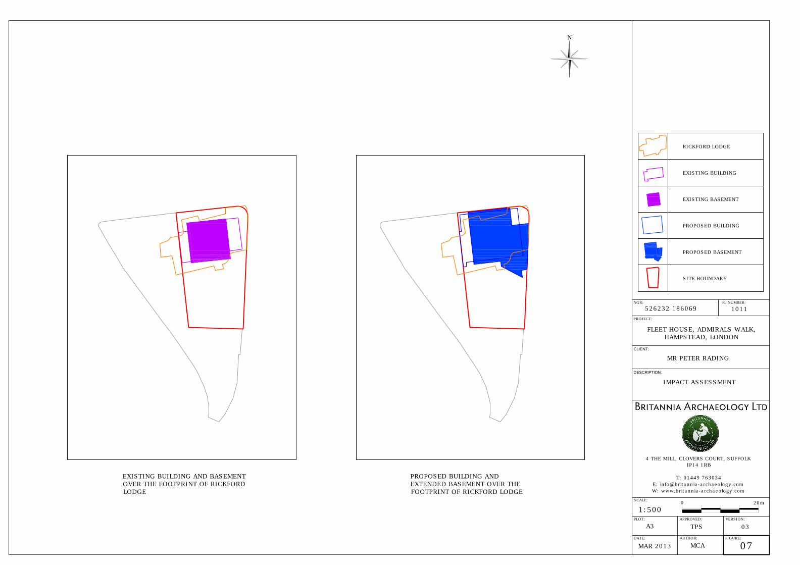
located on the periphery of this activity. The first maps show that the site was undeveloped and it is likely that it this has remained the case throughout the medieval period. It is possible that the area was part of the demesne field systems or woodland that lay between the manorial complex and the agricultural fields. Therefore the potential of archaeological features and finds from this period is low. The post-medieval and modern periods saw rapid development in the wider area of Hampstead. The site is very close to 17th and 18th century structures with Fenton House garden wall just 7m from the site boundary, across a public footpath. However the cartographic sources clearly show that the assessment site, and the wider plot of land it resides within, remained undeveloped until at least the late 19th century when Rickford Lodge was constructed. It is possible that a pond or landscaped park/garden was present on the site between 1828 and 1869. The potential for post-medieval finds and features on the assessment site is high with emphasis on late 19th and early 20th century remains due to the presence of Rickford Lodge. 5.2 Existing and Proposed Impact (Figs. 7 & 8) Existing Impact Construction of Rickford Lodge in the late 19th century would have had a significant impact on any surviving underlying archaeological deposits. The building extended beyond the existing and proposed development building footprints. If Rickford Lodge contained cellars or basements then the likelihood of any surviving pre-19th century remains are slim, however details of its construction are not known and archaeological remains may survive between the footings. Fleet House was constructed in the 1950’s and contains a subsurface basement covering an area of around two thirds of its current first floor footprint. The basement is excavated to around 3m below the existing ground level. Light wells for the basement are located to the south of the building and also truncate the existing ground to some extent (Fig. 9). A substantial brick patio extends several metres into the back garden and the footings for this have probably also impacted on subsurface archaeology. The garden to the rear appears untouched by any development and covers roughly half the existing plot. The demolition of Rickford Lodge and subsequent construction of Fleet House (particularly the basement excavations) are likely to have damaged/removed archaeological deposits within its footprint. The potential for preservation of subsurface archaeology, especially relating to Rickford Lodge in the southern half of the plot is therefore high while the potential to the north is low. Proposed Impact Proposed construction plans involve the demolition of Fleet House and the construction of a slightly larger two-storey building over the existing footprint. The rear of the building will extend roughly 1m – 2m further to the south and also extend to the north forming a boundary with the road.

Fleet House, Admirals Walk, Hampstead, London, NW3 6RS Archaeological Desk Based Assessment
17 ©Britannia Archaeology Ltd 2013 all rights reserved Report Number: 1011
The basement is to be enlarged to the east and north taking in more of the proposed first floor footprint and remaining at a depth of around 3m below current ground level. The garden area is to remain at its current level and a similar raised patio area between the garden and house will replace the existing construction. Extension of the basement area to the north and east will cause significant truncation to an additional 100m² of ground not already truncated by the existing basement. This area of additional truncation may still contain remains associated with Rickford Lodge, which are of relatively low archaeological importance given their recent date and existing documentation (Fig 6). However the impact of the basement on any surviving remains would be high. Impact on Setting Fleet House will be replaced by a more modern structure of similar size and dimensions. The new structure will remain at the same elevation, the extension to the boundary wall and its realignment to give a continuous façade with the adjacent property are much more in keeping with the surrounding 18th and 19th century buildings, than the existing layout. The architects have incorporated Georgian design features present within buildings in the immediate vicinity, also colours for the proposed building have been taken into consideration (Stanton William, 2013). Although many of the buildings are in close proximity to each other, Admirals Walk and its environs are well screened by trees, tall hedges and walls. The small roads have retained a village lane quality. Admirals House and Grove Lodge across the road are obscured from view by tall trees. Willow Cottage to the rear is obscured by a 2m high timber fence approximately 17m from the proposed building and Fenton House Garden to the east by a high wall and trees that line the footpath running to the site. There will therefore be a negligible impact on the setting of the surrounding historical listed buildings and gardens. 6. CONCLUSIONS AND RECOMMENDATIONS 6.1 Conclusions There is a low potential for the survival of archaeological remains before the middle to late 19th century, and a high potential for late 19th and early 20th century AD associated with Rickford Lodge. This conclusion is partly drawn from the low level of archaeological investigation in the immediate vicinity of the site, but also from the known level of truncation by the basement of the existing building and from earlier truncation associated with the construction of Rickford Lodge. The limited extension of the basement area to the north and east poses the greatest risk to subsurface archaeological remains. It is likely that archaeology from the late 19th – early 20th century AD will be encountered. The garden will not be reduced below the

Fleet House, Admirals Walk, Hampstead, London, NW3 6RS Archaeological Desk Based Assessment
18 ©Britannia Archaeology Ltd 2013 all rights reserved Report Number: 1011
existing levels except for the new basement courtyard (Fig. 7) and the stepped garden levels which will replace the existing terrace at this location. 6.2 Recommendations Given the results of the assessment and the proposed plans, it is unlikely that the development will encounter undisturbed archaeological remains predating the late 19th century. The basement extension may encounter some remains associated with Rickford Lodge, however much of the subsurface archaeology will already have been removed when the existing house and basement were constructed. After consultation with EH(GLAAS), it is unlikely that further work would be recommended if the plans remain as they are. However this may be subject change once the proposals have been submitted and fully reviewed. 7.0 ACKNOWLEDGMENTS Britannia Archaeology Ltd would like to thank Mr & Mrs Rading for funding the project and for allowing access to their property and garden. We would also like to thank Paula Trindade of Stanton Williams and Kate Matthews of First Plan for their help and assistance. We are also grateful to Dr Kim Stabler of English Heritage Greater London Archaeology Advisory Service for her input and advice. 8.0 PROJECT ARCHIVE & DEPOSITION A full archive will be prepared for all work undertaken in accordance with guidance from the Selection, Retention and Dispersion of Archaeological Collections, Archaeological Society for Museum Archaeologists, 1993. Arrangements will be made for the archive to be deposited with the relevant museum or the GLHER Office. Bibliography Barton N. 1993, The Lost Rivers of London: A Study of Their Effects Upon London and Londoners, and the Effects of London and Londoners on Them, Historical Publications Ltd Camden Borough Council, 2010. Core Strategy and Local Development Framework (LDF) Elrington, C. R (Ed). Baker, T. Bolton, D. Croot, P. 1989. A History of the County of Middlesex: Volume 9, Victoria County History Greater London Archaeology Advisory Service. 2009. Standards for Archaeological Work

Fleet House, Admirals Walk, Hampstead, London, NW3 6RS Archaeological Desk Based Assessment
19 ©Britannia Archaeology Ltd 2013 all rights reserved Report Number: 1011
Institute for Archaeologists. 2011. Standard and Guidance for Archaeological Desk Based Assessments. London Gazette, 1912 (issue number 28585, P1465) London Mayor’s Office 2009. The London Plan: Spatial Development Strategy for Greater London Mills, A D. 2003. Oxford Dictionary of British Place Names. OUP Department for Communities and Local Government, 2012. National Planning Policy Framework (NPPF) Richardson, J. 1986, Hampstead One Thousand AD986-1986, Historical Publication Ltd Stanton Williams, First Plan, Ian Keen. 2012. Fleet House Pre-Application Advice Request Thompson, FML. 1974, Hampstead: building a borough Wade, C. 1984, Streets of Hampstead, Camden Historical Society Weinreb, B. and Hibbert, C. (ed), 1995. The London Encyclopedia. Macmillan Cartographic Sources John Rocque, 1746 Thomas Milne, 1800 George F Crunchley, 1828 James Wild 1848–1849 Edward Stanford 1862 Edward Weller 1862 1st Edition Ordnance Survey Map 1869 London County Council Municipal Map of London 1930 London County Council Municipal Map of London Revised 1935 Bomb Damage Map (2nd Edition Ordnance Survey Map 1919) 1945 Websites:

Fleet House, Admirals Walk, Hampstead, London, NW3 6RS Archaeological Desk Based Assessment
20 ©Britannia Archaeology Ltd 2013 all rights reserved Report Number: 1011
The British Geological Survey (Natural Environment Research Council) – Geology of Britain Viewer - www.bgs.ac.uk/opengeoscience/home.html?Accordion2=1#maps English Heritage PastScape www.pastscape.org.uk Archaeological Data Service (ADS) www.ads.ahds.ac.uk English Heritage National List for England www.english-heritage.org.uk/professional/protection/process/national-heritage-list-for-england DEFRA Magic http://magic.defra.gov.uk/website/magic

Fleet House, Admirals Walk, Hampstead, London, NW3 6RS Archaeological Desk Based Assessment
21 ©Britannia Archaeology Ltd 2013 all rights reserved Report Number: 1011
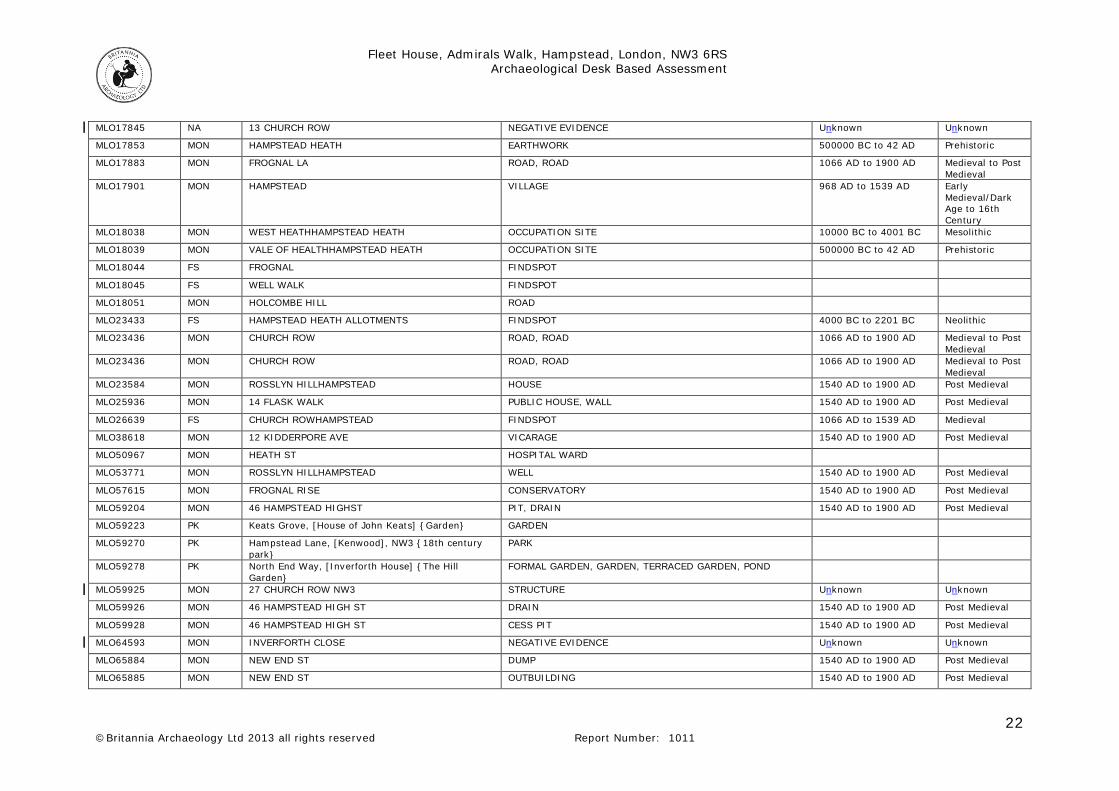
APPENDIX 1 – GLHER DATA Monument ID
Record Type
Name Monument Type Date Range
Period Range
MLO11911 MON MOUNT VERNON MEDICAL COLLEGE 1540 AD to 1900 AD Post Medieval
MLO14366 MON Rosslyn House (Site of) HOUSE
MLO14366 MON Rosslyn House (Site of) HOUSE
MLO16936 MON 10 THE GROVE FLOOR 1066 AD to 1539 AD Medieval
MLO17316 MON NORTH END HOUSE 1540 AD to 1900 AD Post Medieval
MLO17752 FS HAMPSTEAD HEATH NEAR THE VIADUCT FINDSPOT 10000 BC to 4001 BC Mesolithic
MLO17761 FS HAMPSTEAD FINDSPOT, FINDSPOT 500000 BC to 10001 BC
Palaeolithic
MLO17762 FS WEST HEATHHAMPSTEAD HEATH FINDSPOT 500000 BC to 42 AD Prehistoric
MLO17763 FS HAMPSTEAD HEATH FINDSPOT, FINDSPOT, FINDSPOT 500000 BC to 42 AD Prehistoric
MLO17766 FS VALE OF HEALTHHAMPSTEAD HEATH FINDSPOT 500000 BC to 42 AD Prehistoric
MLO17767 MON HAMPSTEAD HEATH PIT
MLO17769 FS HAMPSTEAD HEATH NEAR VIADUCT, ABOVE PONDS FINDSPOT 500000 BC to 42 AD Prehistoric
MLO17770 FS REDINGTON RD FINDSPOT 10000 BC to 4001 BC Mesolithic
MLO17786 FS HAMPSTEAD FINDSPOT
MLO17797 FS VALE OF HEALTH FINDSPOT
MLO17798 MON WELL WALK BURIAL, CIST
MLO17802 MON WEST HEATHHAMPSTEAD HEATH HEARTH 410 AD to 1065 AD Early Medieval/Dark Age
MLO17806 FS PERRINS LACORNER OF FINDSPOT 1066 AD to 1539 AD Medieval
MLO17811 MON FROGNAL LA (CORNER OF ) MANOR HOUSE 1540 AD to 1900 AD Post Medieval
MLO17821 MON HAMPSTEAD CHURCH 1066 AD to 1539 AD Medieval
MLO17824 FS HOLLY HILL FINDSPOT 1066 AD to 1539 AD Medieval
MLO17827 MON FROGNAL WAY ROAD, ROAD 1066 AD to 1900 AD Medieval to Post Medieval
MLO17827 MON FROGNAL WAY ROAD, ROAD 1066 AD to 1900 AD Medieval to Post Medieval
MLO17828 MON WEST END LA ROAD, ROAD 1066 AD to 1900 AD Medieval to Post Medieval
MLO17829 MON SPANIARD S RD ROAD 1066 AD to 1539 AD Medieval
MLO17834 MON TOTTENHAM COURT RD ROAD 1066 AD to 1539 AD Medieval
Fleet House, Admirals Walk, Hampstead, London, NW3 6RS Archaeological Desk Based Assessment
22 ©Britannia Archaeology Ltd 2013 all rights reserved Report Number: 1011
MLO17845 NA 13 CHURCH ROW NEGATIVE EVIDENCE Unknown Unknown
MLO17853 MON HAMPSTEAD HEATH EARTHWORK 500000 BC to 42 AD Prehistoric
MLO17883 MON FROGNAL LA ROAD, ROAD 1066 AD to 1900 AD Medieval to Post Medieval
MLO17901 MON HAMPSTEAD VILLAGE 968 AD to 1539 AD Early Medieval/Dark Age to 16th Century
MLO18038 MON WEST HEATHHAMPSTEAD HEATH OCCUPATION SITE 10000 BC to 4001 BC Mesolithic
MLO18039 MON VALE OF HEALTHHAMPSTEAD HEATH OCCUPATION SITE 500000 BC to 42 AD Prehistoric
MLO18044 FS FROGNAL FINDSPOT
MLO18045 FS WELL WALK FINDSPOT
MLO18051 MON HOLCOMBE HILL ROAD
MLO23433 FS HAMPSTEAD HEATH ALLOTMENTS FINDSPOT 4000 BC to 2201 BC Neolithic
MLO23436 MON CHURCH ROW ROAD, ROAD 1066 AD to 1900 AD Medieval to Post Medieval
MLO23436 MON CHURCH ROW ROAD, ROAD 1066 AD to 1900 AD Medieval to Post Medieval
MLO23584 MON ROSSLYN HILLHAMPSTEAD HOUSE 1540 AD to 1900 AD Post Medieval
MLO25936 MON 14 FLASK WALK PUBLIC HOUSE, WALL 1540 AD to 1900 AD Post Medieval
MLO26639 FS CHURCH ROWHAMPSTEAD FINDSPOT 1066 AD to 1539 AD Medieval
MLO38618 MON 12 KIDDERPORE AVE VICARAGE 1540 AD to 1900 AD Post Medieval
MLO50967 MON HEATH ST HOSPITAL WARD
MLO53771 MON ROSSLYN HILLHAMPSTEAD WELL 1540 AD to 1900 AD Post Medieval
MLO57615 MON FROGNAL RISE CONSERVATORY 1540 AD to 1900 AD Post Medieval
MLO59204 MON 46 HAMPSTEAD HIGHST PIT, DRAIN 1540 AD to 1900 AD Post Medieval
MLO59223 PK Keats Grove, [House of John Keats] {Garden} GARDEN
MLO59270 PK Hampstead Lane, [Kenwood], NW3 {18th century park}
PARK
MLO59278 PK North End Way, [Inverforth House] {The Hill Garden}
FORMAL GARDEN, GARDEN, TERRACED GARDEN, POND
MLO59925 MON 27 CHURCH ROW NW3 STRUCTURE Unknown Unknown
MLO59926 MON 46 HAMPSTEAD HIGH ST DRAIN 1540 AD to 1900 AD Post Medieval
MLO59928 MON 46 HAMPSTEAD HIGH ST CESS PIT 1540 AD to 1900 AD Post Medieval
MLO64593 MON INVERFORTH CLOSE NEGATIVE EVIDENCE Unknown Unknown
MLO65884 MON NEW END ST DUMP 1540 AD to 1900 AD Post Medieval
MLO65885 MON NEW END ST OUTBUILDING 1540 AD to 1900 AD Post Medieval

Fleet House, Admirals Walk, Hampstead, London, NW3 6RS Archaeological Desk Based Assessment
23 ©Britannia Archaeology Ltd 2013 all rights reserved Report Number: 1011
MLO66259 FS MOUNT VERNON FINDSPOT 43 AD to 409 AD Roman
MLO66259 FS MOUNT VERNON FINDSPOT 43 AD to 409 AD Roman
MLO66259 FS MOUNT VERNON FINDSPOT 43 AD to 409 AD Roman
MLO66259 FS MOUNT VERNON FINDSPOT 43 AD to 409 AD Roman
MLO66260 FS MOUNT VERNON FINDSPOT 1066 AD to 1539 AD Medieval
MLO66260 FS MOUNT VERNON FINDSPOT 1066 AD to 1539 AD Medieval
MLO66260 FS MOUNT VERNON FINDSPOT 1066 AD to 1539 AD Medieval
MLO66260 FS MOUNT VERNON FINDSPOT 1066 AD to 1539 AD Medieval
MLO66261 MON MOUNT VERNON DRAIN 1540 AD to 1900 AD Post Medieval
MLO66261 MON MOUNT VERNON DRAIN 1540 AD to 1900 AD Post Medieval
MLO66261 MON MOUNT VERNON DRAIN 1540 AD to 1900 AD Post Medieval
MLO66261 MON MOUNT VERNON DRAIN 1540 AD to 1900 AD Post Medieval
MLO66262 MON MOUNT VERNON WALL 1540 AD to 1900 AD Post Medieval
MLO66262 MON MOUNT VERNON WALL 1540 AD to 1900 AD Post Medieval
MLO66262 MON MOUNT VERNON WALL 1540 AD to 1900 AD Post Medieval
MLO66262 MON MOUNT VERNON WALL 1540 AD to 1900 AD Post Medieval
MLO66263 MON MOUNT VERNON PIT 1540 AD to 1900 AD Post Medieval
MLO66263 MON MOUNT VERNON PIT 1540 AD to 1900 AD Post Medieval
MLO66263 MON MOUNT VERNON PIT 1540 AD to 1900 AD Post Medieval
MLO66263 MON MOUNT VERNON PIT 1540 AD to 1900 AD Post Medieval
MLO66264 MON MOUNT VERNON DITCH 1540 AD to 1900 AD Post Medieval
MLO66264 MON MOUNT VERNON DITCH 1540 AD to 1900 AD Post Medieval
MLO66264 MON MOUNT VERNON DITCH 1540 AD to 1900 AD Post Medieval
MLO66264 MON MOUNT VERNON DITCH 1540 AD to 1900 AD Post Medieval
MLO68005 MON MOUNT VERNON CESS PIT 1540 AD to 1900 AD Post Medieval
MLO68005 MON MOUNT VERNON CESS PIT 1540 AD to 1900 AD Post Medieval
MLO68005 MON MOUNT VERNON CESS PIT 1540 AD to 1900 AD Post Medieval
MLO68005 MON MOUNT VERNON CESS PIT 1540 AD to 1900 AD Post Medieval
MLO68006 MON MOUNT VERNON BUILDING 1540 AD to 1900 AD Post Medieval
MLO68006 MON MOUNT VERNON BUILDING 1540 AD to 1900 AD Post Medieval
MLO68006 MON MOUNT VERNON BUILDING 1540 AD to 1900 AD Post Medieval
MLO68006 MON MOUNT VERNON BUILDING 1540 AD to 1900 AD Post Medieval

Fleet House, Admirals Walk, Hampstead, London, NW3 6RS Archaeological Desk Based Assessment
24 ©Britannia Archaeology Ltd 2013 all rights reserved Report Number: 1011
MLO68332 MON PALIAMENT HILL ANTI AIRCRAFT BATTERY 1540 AD to 1900 AD Post Medieval
MLO71172 MON Church Row, [St John's Church], Hampstead, {St John's Church churchyard}
CEMETERY 1540 AD to 1900 AD Post Medieval
MLO71174 MON HOLLY WALK CEMETERY
MLO71894 MON MOUNT VERNON WORKHOUSE 1540 AD to 1900 AD Post Medieval
MLO78159 MON Weat Heath Spa ORGANIC SEDIMENT 4000 BC to 409 AD Early Neolithic to Roman
MLO79840 BLD DETACHED HOUSE 1894 AD to 1895 AD 19th Century
MLO80642 BLD FITZJOHN'S PRIMARY SCHOOL SCHOOL 1856 AD to 1858 AD 19th Century
MLO81537 BLD Lyndhurst Road, (No.19), Hampstead {Former Mid 19th Century Lodge
GATE, RAILINGS, GARAGE, FENCE, HOUSE, GATE PIER, GARDEN WALL, LODGE, DATE STONE
MLO81552 BLD SEMI DETACHED HOUSE 1891 AD 19th Century
MLO98221 MON Frognal (No. 59), Hampstead DRAIN 1701 AD to 1800 AD 18th Century
MLO98223 MON Frognal (No. 59), Hampstead GARDEN SOIL 1066 AD to 1539 AD Medieval
MLO98223 MON Frognal (No. 59), Hampstead GARDEN SOIL 1066 AD to 1539 AD Medieval
MLO99179 MON New Court, No 32, Flask Walk, Hamstead, {site of early-mid 19th century housing and drains}
HOUSE?, DRAIN 1801 AD to 1872 AD 19th Century
MLO99511 MON Well Walk, [Land at Klippan House], Hampstead, {post medieval gully and ground raising deposits}
GULLY, DUMP LAYER 1540 AD to 1900 AD Post Medieval
MLO102508 PK Flask Walk, [Flask Walk, The Green] {19th century public square}
SQUARE
MLO102509 PK Heath Street, [Heath Street, The Strip] {19th century public square}
SQUARE
MLO102510 PK High Street, [High Street/Greenhill] {19th century public square}
SQUARE
MLO102511 PK Holly Bush Hill, [Windmill Hill/Frognal Rise] {19th century public square}
SQUARE
MLO102561 BLD Lyndhurst Road, (No.20), Hampstead {Late 19th Century House}
GATE, RAILINGS, GARAGE, FENCE, HOUSE, GATE PIER, GARDEN WALL, LODGE, DATE STONE
MLO102562 BLD Lyndhurst Road, (No.21), Hampstead {Late 19th Century House}
GATE, RAILINGS, GARAGE, FENCE, HOUSE, GATE PIER, GARDEN WALL, DATE STONE
MLO102728 BLD Gainsborough Gardens, (No.5), NW3, {Late 19th Century House}
DETACHED HOUSE
MLO102729 BLD Gainsborough Gardens, (No.9), NW3, {Late 19th Century House}
SEMI DETACHED HOUSE
MLO102733 BLD Gainsborough Gardens, (No.10), NW3, {Late 19th Century House}
SEMI DETACHED HOUSE
MLO102734 BLD Gainsborough Gardens, (No.6), NW3, {Late 19th Century House}
DETACHED HOUSE
MLO102735 BLD Gainsborough Gardens, (No.6), NW3, {Late 19th Century House}
DETACHED HOUSE
MLO102787 PK West Heath Road/North End Road, Childs Hill, [Golders Hill Park], Barnet {late 19th century park}
PUBLIC PARK, GARDEN, WALLED GARDEN, FOUNTAIN, SCULPTURE, SCULPTURE, TENNIS COURT, WATER GARDEN, BANDSTAND, AVIARY, ZOO, DEER PARK, POND, POND,

Fleet House, Admirals Walk, Hampstead, London, NW3 6RS Archaeological Desk Based Assessment
25 ©Britannia Archaeology Ltd 2013 all rights reserved Report Number: 1011
PUTTING GREEN
MLO102905 BLD High Street (No 75), Hampstead, Camden {Telephone Box}
TELEPHONE BOX
MLO103059 BLD Heysham Lane/Spedan Close [The Branch Hill Estate], Camden {1970's housing estate and associated garages}
SEMI DETACHED HOUSE, GARAGE, ROOF GARDEN
MLO103059 BLD Heysham Lane/Spedan Close [The Branch Hill Estate], Camden {1970's housing estate and associated garages}
SEMI DETACHED HOUSE, GARAGE, ROOF GARDEN
MLO103061 BLD Gainsborough Gardens (No.7), Hampstead, Camden {19th century semi-detached house}
SEMI DETACHED HOUSE
MLO103062 BLD Gainsborough Gardens (No.8), Hampstead, Camden, NW3 1BJ {19th century semi-detached house}
SEMI DETACHED HOUSE
MLO103271 FS FINDSPOT
Event ID Record Type Name Contractor Ref ELO227 EVS Hampstead Brewery
ELO3078 EVT 13 CHURCH ROW
ELO3299 EVT Flask Public House
ELO3737 EVT INVERFORTH CLOSE
ELO4095 EVT Mount Vernon Hospital
ELO4127 BL New End Hospital
ELO5002 EVT WEST HEATHHAMPSTEAD HEATH
ELO5583 BL North End (No 4), Hampstead, Camden, NW3 7HL: Watching Brief
ELO5682 EVT FROGNAL
ELO5688 EVT HAMPSTEAD
ELO5715 EVT VALE OF HEALTH
ELO5716 EVT WELL WALK
ELO5717 EVT WELL WALK
ELO6145 EVP 18 FROGNAL WAY, HAMPSTEAD
ELO6993 EVT Frognal (No. 59), Hampstead
ELO6994 EVT Frognal (No. 59), Hampstead
ELO7524 EVT Archaeological Watching Brief at 21 Perrins Walk, Hampstead, Camden preconst1-31989
ELO7732 EVT Archaeological Watching Brief at St John's War Memorial, Church Row, Hampstead, NW3 molas1-11828
ELO7977 EVT Archaeological Evaluation at 62 Frognall, Hampstead, NW3

Fleet House, Admirals Walk, Hampstead, London, NW3 6RS Archaeological Desk Based Assessment
26 ©Britannia Archaeology Ltd 2013 all rights reserved Report Number: 1011
ELO7981 EVP Desk Based Assessment of Heath House, North End Way, Camden, NW3
ELO7993 EVT Watching Brief on 32 New Court, Flask Walk, Hamstead, NW3 1HD compassa1-41705
ELO8291 EVT Watching Brief at 22 Christchurch Hill, Hampstead, London isambard1-50385
ELO8291 EVT Watching Brief at 22 Christchurch Hill, Hampstead, London isambard1-50385
ELO8724 EVT Frognal Way, (No 18), Hampstead, Camden, Watching Brief molas1-50415
ELO8724 EVT Frognal Way, (No 18), Hampstead, Camden, Watching Brief molas1-50415
ELO8724 EVT Frognal Way, (No 18), Hampstead, Camden, Watching Brief molas1-50415
ELO8837 EVT Well Walk, (Land at Klippan House), Hampstead, Camden, Evaluation preconst1-59334
ELO8907 EVP West Heath Road, (No 110), Hendon, NW3, Desk Based Assessment
ELO9081 BL
ELO9095 BL Frognal Rise, (Mount Vernon Hospital), Hampstead, NW3, Desk Based Assessment
ELO9096 BL Frognal Rise, (Mount Vernon Hospital), Hampstead, NW3, Evaluation
ELO9108 BL Inverforth Close, Hampstead Heath, Camden, Desk Based Assessment
ELO9153 BL The Grove, (Fenton House - Stableyard), Hampstead, Camden, Watching Brief
ELO11851 EVP New End (No 29), Hampstead, Camden: Desk Based Assessment
ELO12194 EVP Templewood Avenue (No 11), Camden, NW3: Historic Environment Assessment
ELO12197 EVP Templewood Avenue (No. 17), Camden, NW3: Desk Based Assessment 32031
Designated ID
Grade Name
DLO15454 II THE GARDENS
DLO15610 II FROGNAL RISE
DLO15772 II TERRACE LODGE
DLO15773 II ADMIRALS HOUSE
DLO15774 II CURTILAGE WALL AND ENTRANCES ON EAST AND NORTH BOUNDARIES TO NUMBER 25 (NUMBER 25 NOT INCLUDED) AND CURTILAGE WALL AND ENTRANCES ON EASTERN BOUNDARY TO ADMIRALS HOUSE
DLO15775 II GROVE LODGE
DLO15805 II FOUR GARDEN STATUES AND A CISTERN IN THE GROUNDS OF FENTON HOUSE
DLO15806 II FENTON HOUSE GARAGE
DLO15809 II GARDEN GATES, RAILINGS AND WALLS TO FENTON HOUSE
DLO16172 II
DLO16177 II
DLO16183 II UPPER TERRACE HOUSE AND ATTACHED WALLS

Fleet House, Admirals Walk, Hampstead, London, NW3 6RS Archaeological Desk Based Assessment
27 ©Britannia Archaeology Ltd 2013 all rights reserved Report Number: 1011
DLO16468 II
DLO16469 II NUMBERS 2 AND 3 AND ATTACHED RAILINGS
DLO16470 II FOUNTAIN HOUSE
DLO16471 II NETLEY COTTAGE
DLO16472 II GARDEN WALL TO NUMBER 10 NETLEY COTTAGE
DLO16473 II FIVE LAMP POSTS
Protected Squares DLO35089 Holly Bush Hill, [Windmill Hill/Frognal Rise], Hampstead
DLO35371 Flask Walk (The Green)
DLO35373
PROJECT:
1011
CLIENT:
FLEET HOUSE, ADMIRALS WALK,
HAMPSTEAD, LONDON
MR PETER RADING
DESCRIPTION:
4 THE MILL, CLOVERS COURT, SUFFOLK
IP14 1RB
T: 01449 763034
W: www.britannia-archaeology.com
SCALE:
1:500
DATE:
PLOT:
AUTHOR:
A3
MAR 2013 MCA
01
APPROVED: VERSION:
TPS
03
SITE LOCATION PLAN
N
020m
FIGURE:
NGR:
R. NUMBER:
526232 186069
Norfolk
Suffolk
Cambridgeshire
Essex
Lincolnshire
Greater
London
H
e
r
t
f
o
r
d
s
h
i
r
e
B
u
c
k
i
n
g
h
a
m
s
h
i
r
e
KentSurrey
Berks
Beds
N
o
r
t
h
a
m
p
t
o
n
s
h
i
r
e
HAMPSTEAD
SITE
SITE BOUNDARY
526200
186100
Based on plans produced by
the Client. Reproduced from
the Ordnance Survey Map
with the permission of the
controller of Her Majesty’s
Stationery Office. Licence
Number: 100052663.
© CROWN COPYRIGHT 2012

PROJECT:
CLIENT:
DESCRIPTION:
SCALE:
1:10000
DATE:
PLOT:
AUTHOR:
A3
MCA
02
APPROVED: VERSION:
TPS
GLHER DATA - MONUMENT AREAS &
LOCATIONS
N
FIGURE:
NGR:
FLEET HOUSE, ADMIRALS WALK,
HAMPSTEAD, LONDON
MR PETER RADING
4 THE MILL, CLOVERS COURT, SUFFOLK
IP14 1RB
T: 01449 763034
W: www.britannia-archaeology.com
526232 186069
SITE AREA
MONUMENT AREA
MONUMENT POINT
0
500m
GLHER SEARCH RADIUS
Reproduced from Ordnance
Survey OpenData™.
© CROWN COPYRIGHT &
DATABASE RIGHT 2012
1011
R. NUMBER:
MAR 2013
03

PROJECT:
CLIENT:
DESCRIPTION:
SCALE:
DATE:
PLOT:
AUTHOR:
A3
MCA
03
APPROVED: VERSION:
TPS
GLHER DATA - EVENT POINTS &
AREAS
N
FIGURE:
NGR:
FLEET HOUSE, ADMIRALS WALK,
HAMPSTEAD, LONDON
MR PETER RADING
4 THE MILL, CLOVERS COURT, SUFFOLK
IP14 1RB
T: 01449 763034
W: www.britannia-archaeology.com
526232 186069
SITE AREA
EVENT AREA
EVENT POINT
GLHER SEARCH RADIUS
1:10000
0
500m
Reproduced from Ordnance
Survey OpenData™.
© CROWN COPYRIGHT &
DATABASE RIGHT 2012
1011
R. NUMBER:
MAR 2013
03

PROJECT:
CLIENT:
DESCRIPTION:
SCALE:
1:2000
DATE:
PLOT:
AUTHOR:
A3
MCA
04
APPROVED: VERSION:
TPS
GLHER DATA - LISTED BUILDINGS &
PROTECTED SQUARES
N
FIGURE:
NGR:
FLEET HOUSE, ADMIRALS WALK,
HAMPSTEAD, LONDON
MR PETER RADING
4 THE MILL, CLOVERS COURT, SUFFOLK
IP14 1RB
T: 01449 763034
W: www.britannia-archaeology.com
526232 186069
SITE AREA
PROTECTED SQUARE
LISTED BUILDING
GLHER SEARCH RADIUS
0
100m
Reproduced from Ordnance
Survey OpenData™.
© CROWN COPYRIGHT &
DATABASE RIGHT 2012
1011
R. NUMBER:
MAR 2013
03
PROJECT:
CLIENT:
DESCRIPTION:
SCALE:
NOT TO SCALE
DATE:
PLOT:
AUTHOR:
A3
MCA
05
APPROVED: VERSION:
TPS
CARTOGRAPHIC SOURCES
1746 TO 1862
N
FIGURE:
NGR:
526232 186069
FLEET HOUSE, ADMIRALS WALK,
HAMPSTEAD, LONDON
MR PETER RADING
4 THE MILL, CLOVERS COURT, SUFFOLK
IP14 1RB
T: 01449 763034
W: www.britannia-archaeology.com
SITE BOUNDARY
JOHN ROCQUE 1746 THOMAS MILNE 1800
GEORGE F. CLUNCHLEY 1828 EDWARD STANFORD 1862
1011
R. NUMBER:
MAR 2013
03

PROJECT:
CLIENT:
DESCRIPTION:
SCALE:
DATE:
PLOT:
AUTHOR:
A3
MCA
06
APPROVED: VERSION:
TPS
N
FIGURE:
NGR:
NOT TO SCALE
CARTOGRAPHIC SOURCES
1862 TO 1945
526232 186069
FLEET HOUSE, ADMIRALS WALK,
HAMPSTEAD, LONDON
MR PETER RADING
4 THE MILL, CLOVERS COURT, SUFFOLK
IP14 1RB
T: 01449 763034
W: www.britannia-archaeology.com
SITE BOUNDARY
EDWARD WELLER 1862 1st Ed. OS 1869
LCC MUNICIPAL MAP of LONDON 1935 BOMB MAP (2nd Ed. OS 1919) 1945
1011
R. NUMBER:
MAR 2013
03
PROJECT:
CLIENT:
DESCRIPTION:
SCALE:
DATE:
PLOT:
AUTHOR:
A3
MCA
07
APPROVED: VERSION:
TPS
N
FIGURE:
NGR:
IMPACT ASSESSMENT
526232 186069
FLEET HOUSE, ADMIRALS WALK,
HAMPSTEAD, LONDON
MR PETER RADING
4 THE MILL, CLOVERS COURT, SUFFOLK
IP14 1RB
T: 01449 763034
W: www.britannia-archaeology.com
SITE BOUNDARY
EXISTING BUILDING AND BASEMENT
OVER THE FOOTPRINT OF RICKFORD
LODGE
PROPOSED BUILDING AND
EXTENDED BASEMENT OVER THE
FOOTPRINT OF RICKFORD LODGE
PROPOSED BASEMENT
PROPOSED BUILDING
EXISTING BASEMENT
EXISTING BUILDING
RICKFORD LODGE
1011
R. NUMBER:
1:500
020m
MAR 2013
03

A D
M I R
A L
' S
W
A L
K
WILLOW COTTAGE
W
I
N
D
M
I
L
L
H
I
L
L
PROJECT:
CLIENT:
DESCRIPTION:
SCALE:
DATE:
PLOT:
AUTHOR:
A3
MCA
08
APPROVED: VERSION:
TPS
N
FIGURE:
NGR:
SITE VISIT PHOTOGRAPHIC RECORD
526232 186069
FLEET HOUSE, ADMIRALS WALK,
HAMPSTEAD, LONDON
MR PETER RADING
4 THE MILL, CLOVERS COURT, SUFFOLK
IP14 1RB
T: 01449 763034
W: www.britannia-archaeology.com
SITE BOUNDARY
Photo 1: Front Aspect of Fleet House
DIRECTION OF PHOTOGRAPH
1011
R. NUMBER:
Photo 2: Admirals Walk looking West
Photo 3: Footpath Between Fleet
House & Fenton House Gardens
Photo 4: Light wells for Existing
basement
Photo 5: Rear Garden and Patio
looking South-West
1
2
3
4
5
2
NOT TO SCALE
EXISTING BUILDING
MAR 2013
03