desertification and water harvesting in the middle east...
TRANSCRIPT

ZEF BonnZentrum für EntwicklungsforschungCenter for Development ResearchUniversität Bonn
Mamdouh Nasr
Number
10
Assessing Desertificationand Water Harvesting inthe Middle East andNorth Africa:
Policy Implications
ZEF – Discussion Papers on Development PolicyBonn, July 1999

The CENTER FOR DEVELOPMENT RESEARCH (ZEF) was established in 1997 as an international,interdisciplinary research institute at the University of Bonn. Research and teaching at ZEF aimsto contribute to resolving political, economic and ecological development problems. ZEF closelycooperates with national and international partners in research and development organizations.For information, see: http://www.zef.de.
ZEF – DISCUSSION PAPERS ON DEVELOPMENT POLICY are intended to stimulate discussion amongresearchers, practitioners and policy makers on current and emerging development issues. Eachpaper has been exposed to an internal discussion within the Center for Development Research(ZEF) and an external review. The papers mostly reflect work in progress.
Mamdouh Nasr: Assessing Desertification and Water Harvesting in the Middle East andNorth Africa: Policy Implications, ZEF – Discussion Papers On Development PolicyNo. 10, Center for Development Research, Bonn, July 1999, pp. 59.
ISSN: 1436-9931
Published by:Zentrum für Entwicklungsforschung (ZEF)Center for Development ResearchWalter-Flex-Strasse 3D – 53113 BonnGermanyPhone: +49-228-73-1861Fax: +49-228-73-1869E-Mail: [email protected]://www.zef.de
The author:Prof. Mamdouh Nasr, Ain Shams University, Cairo, Egypt and Center for DevelopmentResearch, Bonn, Germany (contact: [email protected])
Desertification and Water Harvesting in the Middle East and North Africa
Contents
Acronyms and Abbreviations
Acknowledgements
Abstract 1
Kurzfassung 2
1 Introduction 3
2 Concepts and Techniques for Identifying Desertification Processes 5
2.1 What is Desertification? 5
2.2 Towards a Definition of Desertification 6
2.3 Problems and Indicators Related to Processes of Desertification 8
2.4 Global Status of Desertification 9
2.5 International Efforts to Combat Desertification 10
3 Current Status of Desertification in the MENA Region and its Control Using 12Rain Water Harvesting
3.1 Land, Water and Population in the MENA Region 12
3.2 The Extent of Aridity of the MENA Region 13
3.3 Lack of Sound Desertification Statistics 14
3.4 The Magnitude of and Trends in Desertification Problems 16in the MENA Region
3.5 Costs of Land Degradation in the MENA Region 20
3.6 Monitoring Indicators of Desertification by Means of Satelite 22Systems
3.7 Using NOAA Satellites to Monitor Desertification in the MENA 23Region
4 Using Water Harvesting Techniques to Control Desertification in the 28MENA Region
4.1 The History of Water Harvesting 28
4.2 What is Water Harvesting? 29
4.3 Rainwater Harvesting Techniques Used in the MENA Region 31
4.4 Problems and Constraints Hindering the Use of Water Harvesting 32for Agricultural Development
4.5 Using Rainwater Harvesting to Combat Desertification in Egypt: 33A Case Study

ZEF Discussion Papers on Development Policy 10
5 Policy Implications 40
5.1 Improving the Data Base 40
5.2 Research into Economic Alternatives and Options 40
5.3 On Practical Issues of Desert Land Use 42
6 References 43
Annex 48
Table 1: Estimated Global Land Use of Drylands, by Continent 48
Table 2: Estimated Global Desertification by Dry Lands, by Continent 49
Table 3: Estimated Land Use in the MENA Countries 50
Table 4: Estimated Desertified Irrigated Land in the MENA Countries 51
Table 5: Estimated Desertified Rainfed Cropland in the MENA Countries 52
Table 6: Estimated Desertified Rangeland in the MENA Countries 53
Table 7: Comparative Development of Yields (t/ha) of Grain in the MENA Countries, 1975-1997
– Part 1 54
– Part 2 55
Table 8: Livestock Density (head/ha) in the MENA Countries 1975-1994
– Part 1 56
– Part 2 57
– Part 3 58
Table 9: Fertilizers Application to Arable Land Areas (kg/ha) 59 in the MENA Countries, 1982-1996
Desertification and Water Harvesting in the Middle East and North Africa
List of Tables:
Table 1 Status of global desertification 10
Table 2 Extent of aridity in the MENA region 14
Table 3 Estimated land use in the MENA region 16
Table 4 UNDCPAC (1992) estimates of desertification in irrigated, 18rainfed cropland and rangeland areas of the MENA region
Table 5 Modified UNDCPAC estimates of desertification in irrigated, 19rainfed cropland and rangeland areas of the MENA region
Table 6 Estimated costs of direct anti-desertification measures (US-$/ha) 21
Table 7 Income foregone due to land degradation in the MENA region 21
Table 8 Overview of the main water harvesting techniques (WHT) used 31in the MENA region
Table 9 Implementation of water harvesting structures, 1980-1991 39
List of Figures
Figure 1 Classification of water harvesting techniques 30

ZEF Discussion Papers on Development Policy 10
Acronyms and Abbreviations
AVHRR Advanced Very High Resolution RadiometerCCD Convention to Combat DesertificationCEDARE Center for Environmental and Development for Arab Region & EuropeCIESIN Center for International Earth Science Information NetworkCOP Conference of the PartiesCST Committee on Science and TechnologyDESCON Consultative Group for Desertification ControlFAO RSU FAO Remote Sensing UnitFAO Food and Agriculture Organization of the United NationsGIEWS Global Inforamation and Early Warning SystemGIMMS Global Inventory Monitoring and Modeling StudiesGIS Geographic Information SystemGTZ German Agency for Technical CooperationICARDA International Center for Agricultural Research in the Dry AreasIFPRI International Food Policy Research InstituteILO International Labor OrganizationINCD Intergovernmental Negotiating CommitteeINCCD International Convention to Combat DesertificationMENA Middle East and North AfricaMS Multispectral ScannerNASA National Aeronautics and Space AdministrationNDVI Normalized Difference Vegetation IndexNOAA (A satellite operated by the) National Oceanic Atomospheric
AdministrationPACD Plan of Action to Combat DesertificationQRDP Qasr Rural Development Project (at Marsa Matrouh, Egypt)TM Thematic MapperUNCCD United Nations Convention to Combat DesertificationUNCED United Nations Conference on Environment and DevelopmentUNCOD United Nations Conference on DesertificationUNDCPAC United Nations Desertification Control Program Activity CenterUNDP United Nations Development ProgramUNEP United Nations Environment ProgramUNESCO United Nations Educational, Scientific and Cultural Organization

Desertification and Water Harvesting in the Middle East and North Africa
Acknowledgements
This paper has benefited much from valuable comments offered by a number of expertsfrom a variety of scientific disciplines. In particular, I would like to thank Prof. J. von Braun,Director of the Center for Development Research (ZEF) and head of ZEF’s Department of“Economic and Technological Change” for the fruitful discussions and careful review of thepaper. For valuable comments, I am also grateful to Prof. P. Vlek, head of ZEF’ Department of“Ecology and Resource Management”, Dr. L. Kohler, Director of the “International HumanDimensions Programme on Global Environmental Change” (IHDP), Prof. H. de Haen, FAO’sAssistant Director-General of Economic and Social Department, Dr. F. Nachtergaele, Head ofthe Land and Water Development Division at FAO, Dr. W. Steinborn, Editor in Chief,Department of Geographic Information Systems at the German Aerospace Center (DLR), Prof.D. Bannert, specialist in Soil science and remote sensing at Germany’s “Federal ResearchInstitute for Geo-sciences and Raw Materials” (BGR), Dr. K. Weise, specialist in soil scienceand remote sensing at “Deutsche Jena Optronik (DJO), Dr. J. Ryan, soil specialist at ICARDA inAleppo, Syria, and Dr. N. van de Gießen, of ZEF’s Department of “Biological Resources,Ecology and Resource Management.
For assistance and sharing information relating to this review, I would like to thank Mrs.C. Ringler, Research Analyst at the International Food Policy Research Institute (IFPRI), Dr. H.Bendeahmane, expert in management information at FAO, Mr. J. Friesen, Research Assistant atZEF’s Department of “Biological Resources, Ecology and Resource Management, and Mrs. C.Becker, Research Assistant at ZEF.

ZEF Discussion Papers on Development Policy 10

Desertification and Water Harvesting in the Middle East and North Africa
1
Abstract
This study examines four sets of questions:
• What is desertification, and how can its impact on productivity be monitored?
• How extensive is the desertification problem in the MENA region now, and howhas it changed over time?
• What is the current status of the water-harvesting techniques used to controldesertification in the MENA region?
• What are the main demographic, technical, social, and economic forces drivingthe problem as it now exists and how will it be influenced by observable trends,particularly in Egypt?
Potential policy actions and their implications are discussed against the background ofwhat is already being done in governmental and non-governmental efforts to address the problemof desertification in the MENA region. At the same time the research explores the economics ofwater harvesting in the region and its potentials for expanded desert utilization. The studypresents environmental data on each of the countries in the MENA region and on the region as awhole, which was collected by a satellite remote sensing system over the last 17 years. Theimages of the MENA region produced by the NOAA satellite showed no alarming damage tovegetation – quite the opposite: we estimated that the vegetational boundary has expanded intothe desert in most of the MENA countries due to human actions.
___________________________Key words: Desertification; Satellite Remote Sensing; Water Harvesting; Technical, Social and EconomicParameters.

ZEF Discussion Papers on Development Policy 10
2
Kurzfassung
Diese Studie präsentiert, diskutiert und analysiert (a) den Begriff der Desertifikation undMethoden der Überwachung von Produktivitätsbeeinträchtigungen durch Desertifikations-prozesse, (b) das Ausmaß der Desertifikationsprobleme in der Region des Nahen Ostens undNordafrikas (MENA), (c) die Techniken des “Water Harvesting”, die zur Bekämpfung dieserProbleme verwendet werden, sowie – am Beispiel Ägyptens - (d) die technischen, sozialen undökonomischen Determinanten des Desertifikationsproblems.
Darüber hinaus werden aktuelle politische Handlungsalternativen und ihre Implikationenfür Regierungs- und Nichtregierungsorganisationen in der MENA Region diskutiert und Themenfür zukünftige wissenschaftliche Untersuchungen vorgeschlagen.
Die vorliegende Studie basiert auf NOAA- Satellitendaten für die einzelnen Länder derMENA Region, die den Zeitraum von 1982 bis 1997 abdecken.
Die Daten machen deutlich, daß die Vegetationsdichte der MENA Rgion in den letzen 17Jahren keinen Schaden erlitten hat. Im Gegenteil, die Vegetationsintensität nahm aufgrundpositiver anthropologischer Aktivitäten zu.

Desertification and Water Harvesting in the Middle East and North Africa
3
1 Introduction
New deserts are forming in some areas of the world (UNEP, 1984). This process isreferred to as “desertification”. For most people, the term conjures up an image, an emotivepicture of inexorably shifting sands encroaching on valuable farmland (Forse 1989). But is thedesert really expanding? An increasing number of scientists are now arguing that the imageassociated with “desertification” is a mirage.
There is no general consensus regarding the definition, causes, or impact ofdesertification. Desertification has been defined in many different ways by researchers indifferent disciplines, which have included soil scientists, hydrologists, agronomists,veterinarians, economists and anthropologists. Most definitions of desertification therefore varyaccording to the judgment and expertise of the researchers involved. Whereas some researchersconsider desertification to be a great danger to the sustainable development of arid and semi-aridareas, others doubt that the phenomenon occurs at all. Researchers’ differences of opinionregarding desertification are due mainly to the lack of an overall concept, the dearth ofinformation available at both the global and regional levels and the differences between theobjectives and interests of the countries in the north and of those in the south, i.e. the onesmainly affected.
The problem of desertification in arid and semi-arid areas can be traced back throughseveral centuries. There has always been a correlation between long-term changes in climate andchanges in human activities. As long as the population density of both men and livestock in adesertification-endangered area remained sufficiently low, the ecological consequences ofhuman activities remained relatively insignificant or were concentrated within a very limitedarea.
In regions where food security and poverty alleviation are priorities, such as the MiddleEast and North Africa (MENA) region, the primary emphasis regarding land is its availability,the abatement of land degradation, and efficient land and water management are of vitalimportance. The message currently being spread by the FAO is to encourage countries in aridand semi-arid areas to identify reasons for land degradation.
Few researchers argue that most MENA countries have appropriate technologies tocombat desertification - such as rainwater harvesting -, but that the technologies are not usedsufficiently due to insufficient knowledge of the socioeconomic contexts, incorrect identificationof the causes of the arid land problems and ineffective management of natural resources, i.e.water.

ZEF Discussion Papers on Development Policy 10
4
The study addresses four questions:
• What is desertification, i.e. describing the concept and how to monitor productivityimpacts of desertification processes?
• What is the magnitude of desertification problem in the MENA region, both currentand in the past?
• What is the status of water harvesting techniques used to control desertification in theMENA region?
• What are the major demographic, technical, social, and economic driving forcesbehind the observed phenomena and trends? (With special references to Egypt)
Policy actions and implications are discussed against the background of what is beingdone in the MENA region to address desertification problems, both governmental and non-governmental efforts.

Desertification and Water Harvesting in the Middle East and North Africa
5
2 Concepts and Techniques for IdentifyingDesertification Processes
2.1 What is Desertification ?
The phenomenon of desertification is very old, but national and international awarenessof it and the desire to control it are very recent. In the public mind, desertification is oftenassociated with the idea of ‘desert advance’. In the 1970s, there was great concern that theSahara desert was advancing into the non-desert lands of West Africa.
The definition of desertification agreed upon in 1977 at the United Nations Conferenceon Desertification (UNCOD) in Nairobi is as follows: “Desertification is the diminution ordestruction of the biological potential of land, and can lead ultimately to desert-like conditions. Itis an aspect of the widespread deterioration of ecosystems, and has diminished or destroyed thebiological potential, i.e. plant and animal production, for multiple use purposes at a time whenincreased productivity is needed to support growing populations in quest of development.”1
When, in various parts of the world, the first attempts were made to carry out aquantitative assessment of desertification and to implement various practical recommendationsof the Plan of Action to Combat Desertification (PACD), this definition was found to beinadequate and insufficiently operational. A new, more precise definition was required todistinguish between desertification and other problems of climatic change.
A numbers of definitions have been suggested by various scientists, scientific institutionsand implementing agencies. Based on special studies and extensive discussions at the UNEPConsultative Meeting on the Assessment of Desertification in Nairobi in 1990, the followingnew definition was suggested: “Desertification is Land Degradation in Arid, Semi-arid and DrySub-humid Areas resulting from adverse human impact. Land in this concept includes soil andlocal water resources, land surface and vegetation or crops. Degradation implies reduction ofresource potential by one or a combination of processes acting on the land.”2 This definitionimplied agreement on a tool for assessing and combating desertification that would be moresuitable operationally.
1 UNEP, Status of Desertification and Implementation of the United Nations’ Plan of Action to CombatDesertification, UNCED Part I, 1996.2 UNEP, 1996 (see No. 1 above).

ZEF Discussion Papers on Development Policy 10
6
The UNEP Panel of Senior Consultants (April 1991) and the Governing Council ofUNEP (May 1991) underscored “the need for further refinement of the definition, taking intoconsideration recent findings about influence of climate fluctuations and about the resilience ofsoils”.
The following definition of desertification was agreed to by the world’s leaders at the1992 Earth Summit and adopted by the United Nations Convention to Combat Desertification(UNCCD): “Land degradation in arid, semi-arid and sub-humid areas resulting from variousfactors, including climatic variations and human activities”3. This definition is now widelyregarded to be the authoritative definition of desertification.
2.2 Towards a Definition of Desertification
Since the in-depth investigation of desertification phenomena requires the expertise ofresearchers from a variety of disciplines, including soil scientists, hydrologists, agronomists,veterinarians, anthropologists, and economists, desertification has been defined in many differentways by these disciplines. Most of these definitions of desertification are therefore colored byvalue judgments, personal experience, and/or disproportionate weighting of some dimensionsand neglect of others. It may thus be said that we still do not have a sufficiently specificscientific definition of desertification.
Some researchers consider desertification to be a process of change, while others view itas the end result of a process of change4. This distinction represents one of the main points ofdisagreements concerning the concept of desertification. When considered to be a process,desertification has generally been viewed as a series of incremental changes in biologicalproductivity in arid, semi-arid, and subhumid ecosystems. When considered as an end result,desertification refers to the prevalence of desert-like conditions in areas once green. Althoughdozens of definitions exist, one point on which they all agree is that desertification is to beviewed as an environmentally adverse occurrence. Glantz and Orlovsky (1983) reviewed variousdefinitions focusing on the form of change: desertification considered to be a deterioration ofecosystems (e.g. Reining, 1981), a degradation of various forms of vegetation (e.g. Le Houerou,1975), the destruction of biological potential (e.g. UNCOD, 1978), a reduction of productivity(e.g. Kassas, 1977), a decay of a productive system (e.g. Hare, 1977), an alteration in biomass(e.g. UN Secretariat, 1977), an intensification of desert conditions (e.g. Meckelein, 1980), or animpoverishment of ecosystems (e.g. Dregne, 1976). Some other definitions focus on what ischanged in the soil; (e.g. salinization), vegetation (e.g. reduced density of biomass), water (e.g.waterlogging), or air (e.g. increased albedo).
3 United Nations Convention To Combat Desertification, published by the Secretariat for the Convention to CombatDesertification (CCD), Bonn, Germany, 1999.4 Glantz, M.H., and Orlovsky, N. S., Desertification: A review of the Concept, Desertification Control Bulletin 9,CIESIN organization, 1983.

Desertification and Water Harvesting in the Middle East and North Africa
7
There is no consensus regarding the areas where desertification can take place. Manyresearchers identify arid, semi-arid, and subhumid areas as places where desertification canoccur or where the risks of desertification are highest. Others refer to the extension,encroachment, or spread of desert characteristics into non-desert regions.
With respect to the factor of time, some definitions refer to desertification as a permanentprocess. Others imply that desertification may be reversible, because the term “irreversible” isgenerally used in reference to situations in which the costs of reclamation are greater than thereturn to be expected from a known form of land use.
The above-mentioned review of definitions shows that defining desertification conveyssome impression of the difficulties involved in arriving at a definition of desertification. Thefollowing discussion examines some aspects that should be taken into consideration insuggesting a definition of desertification in arid and semi-arid areas. While distinguishingbetween desertification and land degradation is still difficult, it is made easier by the followingcriteria:
• Pure desert must be considered dry-lands with no plants and organic matter in thesoil. Thus, pure desert areas should not be considered desertified.
• It is necessary to distinguish between desiccation (long-term drought) anddesertification. The term drought is used to refer to an inter-annual fluctuation inprecipitation in which there is a relative lack of rainfall for a period of one to fouryears, whereas desiccation is used to denote a protracted drought that has continuedfor a decade or more and may be considered a kind of climate change.
• It is also necessary to distinguish between desertification and land degradation. Landdegradation refers to a decline in the long-term productive potential of soil (Lal,1990; UNEP, 1982; UNCED, 1992).
• Net degradation occurs whenever degradation processes significantly exceed nature’srestorative capacity. One obvious indicator of land degradation is a continuousdecline in soil productivity (production per unit land), but a decline in one yearfollowed by increase in the next is not indicative of land degradation.
• Land degradation may also be caused by too much water (flooding), which may resultin soil erosion, and too little water (drought).
As there is still a good deal of confusion regarding the definition, diagnosis, andmeasurement of desertification, it may be timely to raise a few questions, such as: Why notsimplify the matter and define desertification as the extension of desert margins into non-desertareas? In this case, however, we would have to deal with at least 30 to 40 years of data, in orderto investigate shifts in desert margins. Why not say, that almost all the forms of degradation thatwe have observed, are by definition land degradation, rather than desertification? Why not saythat all processes acting against sustainable land use are degradation processes? These

ZEF Discussion Papers on Development Policy 10
8
suggestions call not for a redefinition of the problem, but simply for the use of suitableterminology.
2.3 Problems and Indicators Related to Processes of Desertification
Problems posed by land degradation processes can hardly be generalized across land-usezones. Land degradation problems differ in range-land, rainfed, and irrigated areas5. Accordingto UNEP, the main desertification problems in range-land areas are: overgrazing, shrub clearing,soil erosion, and cultivation. In the desertification of rainfed areas, soil erosion is the principalproblem. The main desertification problem in irrigated agriculture is “salinization” or“alkalinization”.
(a) Overgrazing refers to the practice of allowing a much larger number of animals tograze at a location than it can actually support. This includes: (a) selecting inappropriate timesfor grazing, often too soon after the beginning of rainfall, (b) overstocking, (c) failing to activelyseed, and (d) failing to adjust existing or traditional land-use and grazing rights. This problem isobserved in almost all MENA countries.
The main indicator of overgrazing is the “disappearance of range-lands” because animalsusually eat the most palatable plants first and the least palatable ones last, thus selecting andensuring the dominance of relatively unpalatable species.
(b) Shrub clearing is caused by the practice of constantly using woody plants as asource of energy for human needs, as may be observed, for example, in Egypt and Yemen.
A visible indicator of shrub clearing is the “disappearance of shrubs” in areas that cansupport woody vegetation.
(c) Soil erosion results from the uprooting of shrubs, which leads to the destruction ofthe soil structure and thus to accelerated erosion of the soil by wind and water. Soil infiltration ofrainwater decreases, and surface runoff increases. Examples of this type of desertification are tobe seen in Egypt, Saudi Arabia, and Yemen.
One clear indicator of soil erosion is the formation of drought watercourses in thedepressions of wadis.
(d) Over-cultivation of food or field crops in areas that ought to have been used only forgrazing over a long time of period. The soil structure is destroyed by ploughing, particularly in 5 German Foundation for International Development (DSE), FAO, GTZ, UNESCWA, Resource Conservation andDesertification Control in The Near East, Report of the International Training Course, Germany and Kingdom ofJordan, 1989.

Desertification and Water Harvesting in the Middle East and North Africa
9
dry years, because the surface remains bare of vegetation. Examples of over-cultivation ofgrazing areas and marginal lands are to be found in Sudan, where population pressure plays animportant role and no alternatives are available, and in Yemen, Syria and Jordan, where somerange-land on steep slopes is ploughed. In countries such as these, population pressure makes itdifficult or impossible to allow land to lie fallow.
A clear indicator of rainfed cultivation in an area that should actually be used for grazingis the occurrence of “dust storms”, which means a reduction of range-land at the cost of arableland.
Salinization is the main desertification problem in irrigated agriculture. Salinizationinvolves a number of interrelated processes occuring in the soil, for example waterlogging,increasing salt content, and alkalinization, in which some nutrients can no longer be absorbeddue to the increasing pH-value of the soil. This problem is caused by the overuse of waterthrough unsuitable irrigation techniques, accompanied by inefficient drainage systems. This typeof desertification is to be seen in some of the irrigated agriculture in Iraq and Egypt.
2.4 Global Status of Desertification
The world’s total drylands area has been estimated three times: by UNCOD in 1977, andby UNEP in 1984 and again in 1991. These estimates were prepared using slightly differentmethodologies and different climatic data sets6. The 1991 estimates of the total dryland areaswere used by UNEP as the basis for the latest assessment of global desertification in 1991 (Table1). However, “assessment of the current global status of desertification has shown that accuratehard data, which would allow it to be stated with some preciseness to which degree and withwhat rate of desertification is taking place in various parts of the world, are still lacking”7.
6 UNEP, 1996 (see No. 1 above)7 UNEP, 1996 (see No. 1 above)

ZEF Discussion Papers on Development Policy 10
10
Table 1: Status of global desertification
Types of Degradation Area (millions ofhectares)
RelativeImportance (%)
1. Irrigated areas 43 0,8
2. Rainfed agricultural areas 216 4,1
3. Rangeland areas 757 14,6
4. Total drylands degraded by human factors 1.016 19,5
5. Rangeland with vegetation deterioration without soil deterioration
2.576 50,0
6. Total degraded drylands (4)+(5) 3.592 69,5
7. Non-degraded drylands 1.580 30,5
8. Total dryland area (6)+(7) 5.172 100
Source: UNEP Desertification Status Report, 1996.
The reported results suggest that present desertification directly affects about 3.6 billionhectares, representing 70% of all dryland, and about one-sixth of the world’s population (UNEP1996). About 43 million ha of irrigated land (0.8% of all dryland) are affected by variousdegradation processes, mainly waterlogging, salinization and alkalinization. Soil scientists haveestablished that the world is now losing, about 1.5 million ha of irrigated land each year. Nearly216 million ha of rainfed cropland (4.1% of all dryland) are affected by various degradationprocesses, mainly soil erosion through water and wind, depletion of nutrients and physicaldeterioration. It is estimated that the world loses about 7 - 8 million ha of rainfed cropland eachyear. About 3.333 million ha of rangeland (64% of all dryland) are affected by degradation,mainly by degradation of vegetation, which is accompanied by soil degradation consisting,mainly of erosion on some 757 million ha.
2.5 International Efforts to Combat Desertification
In 1977, the United Nations Conference on Desertification (UNCOD) adopted a Plan ofAction to Combat Desertification (PACD). Despite this plan, unfortunately, the United NationsEnvironmental Program (UNEP) concluded in 1991 that the desertification problem in drylandshad intensified8. Implementation of the PACD had suffered under funding constraints.
As a result, the United Nations Conference on Environment and Development (UNCED)in Rio de Janeiro in 1992, called upon the United Nations General Assembly to establish anIntergovernmental Negotiating Committee (INCD) to prepare, by June 1994, a Convention toCombat Desertification in affected countries, particularly in Africa.
8 United Nations Convention To Combat Desertification, Published by the Secritariat for the Convention to CombatDesertification (CCD), Germany, 1999.
Desertification and Water Harvesting in the Middle East and North Africa
11
The INCD completed its negotiations in five sessions. The Convention was adopted andopened for signature in Paris in 1994. The convention entered into force in 1996, and some 120countries are now Parties9. The Conference of the Parties (COP), which is the Convention’ssupreme body, held its first session in Rome in 1997. The COP held its second session in Dakarin 1998, launching a global mechanism to obtain adequate financial and technological resources.
9 CCD, 1999 (see No. 8 above)
ZEF Discussion Papers on Development Policy 10
12
3 Current Status of Desertification in theMENA Region and its Control UsingRainwater Harvesting
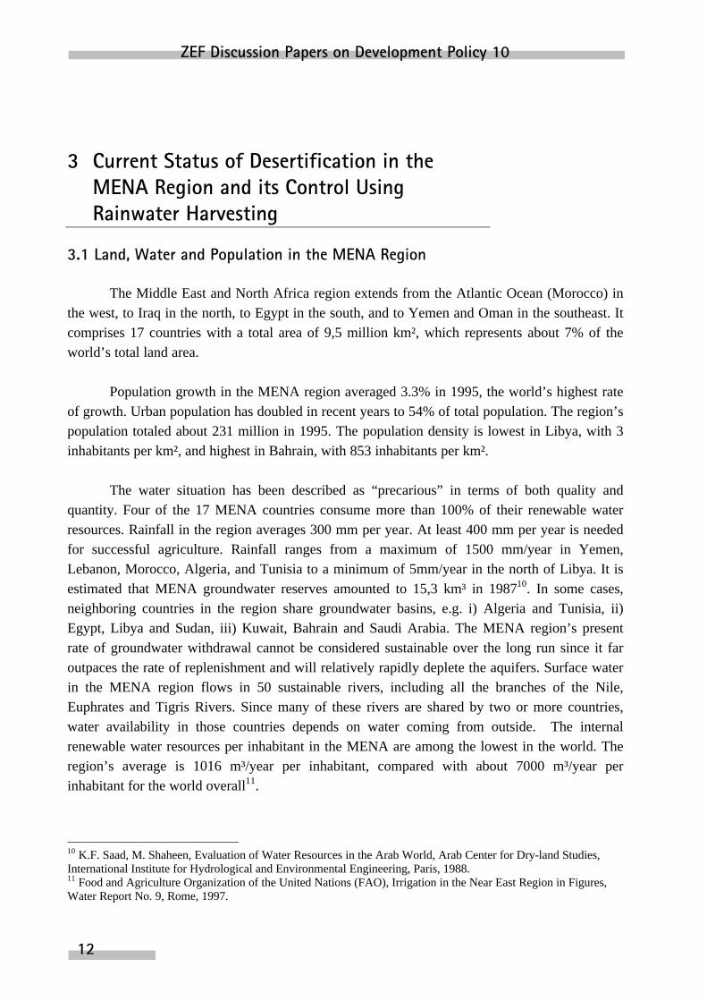
3.1 Land, Water and Population in the MENA Region
The Middle East and North Africa region extends from the Atlantic Ocean (Morocco) inthe west, to Iraq in the north, to Egypt in the south, and to Yemen and Oman in the southeast. Itcomprises 17 countries with a total area of 9,5 million km², which represents about 7% of theworld’s total land area.
Population growth in the MENA region averaged 3.3% in 1995, the world’s highest rateof growth. Urban population has doubled in recent years to 54% of total population. The region’spopulation totaled about 231 million in 1995. The population density is lowest in Libya, with 3inhabitants per km², and highest in Bahrain, with 853 inhabitants per km².
The water situation has been described as “precarious” in terms of both quality andquantity. Four of the 17 MENA countries consume more than 100% of their renewable waterresources. Rainfall in the region averages 300 mm per year. At least 400 mm per year is neededfor successful agriculture. Rainfall ranges from a maximum of 1500 mm/year in Yemen,Lebanon, Morocco, Algeria, and Tunisia to a minimum of 5mm/year in the north of Libya. It isestimated that MENA groundwater reserves amounted to 15,3 km³ in 198710. In some cases,neighboring countries in the region share groundwater basins, e.g. i) Algeria and Tunisia, ii)Egypt, Libya and Sudan, iii) Kuwait, Bahrain and Saudi Arabia. The MENA region’s presentrate of groundwater withdrawal cannot be considered sustainable over the long run since it faroutpaces the rate of replenishment and will relatively rapidly deplete the aquifers. Surface waterin the MENA region flows in 50 sustainable rivers, including all the branches of the Nile,Euphrates and Tigris Rivers. Since many of these rivers are shared by two or more countries,water availability in those countries depends on water coming from outside. The internalrenewable water resources per inhabitant in the MENA are among the lowest in the world. Theregion’s average is 1016 m³/year per inhabitant, compared with about 7000 m³/year perinhabitant for the world overall11.
10 K.F. Saad, M. Shaheen, Evaluation of Water Resources in the Arab World, Arab Center for Dry-land Studies,International Institute for Hydrological and Environmental Engineering, Paris, 1988.11 Food and Agriculture Organization of the United Nations (FAO), Irrigation in the Near East Region in Figures,Water Report No. 9, Rome, 1997.

Desertification and Water Harvesting in the Middle East and North Africa
13
The structure of water demand among individual water users is 1 m³ of drinking-qualitywater per year, 100 m³ of water per year for domestic purposes and a further 1000 m³ of waterper year for the production of food, making a total of 1101 m³ per person per year. In 10 of the17 MENA countries, the internal renewable water resources per inhabitant are below 1000m³/year, and the countries are consequently considered to be water-scarce countries. Fourcountries, Egypt, Oman, Libya and Morocco, are considered to be water-stressed countries, asthey have 1000- 1667 m³/year per inhabitant. With internal renewable water resources in excessof 1700 m³/year per inhabitant, Iraq, Lebanon and Syria are considered to be water-abundantcountries. In the MENA region, 84% of water withdrawals are directed to agriculture. Iraq hasthe highest level of water withdrawal for agriculture (97%), as a high percentage of thecultivated area (95%) is irrigated. Kuwait has the lowest level of water withdrawal foragriculture (38%), as it has practically no internal renewable water resources.
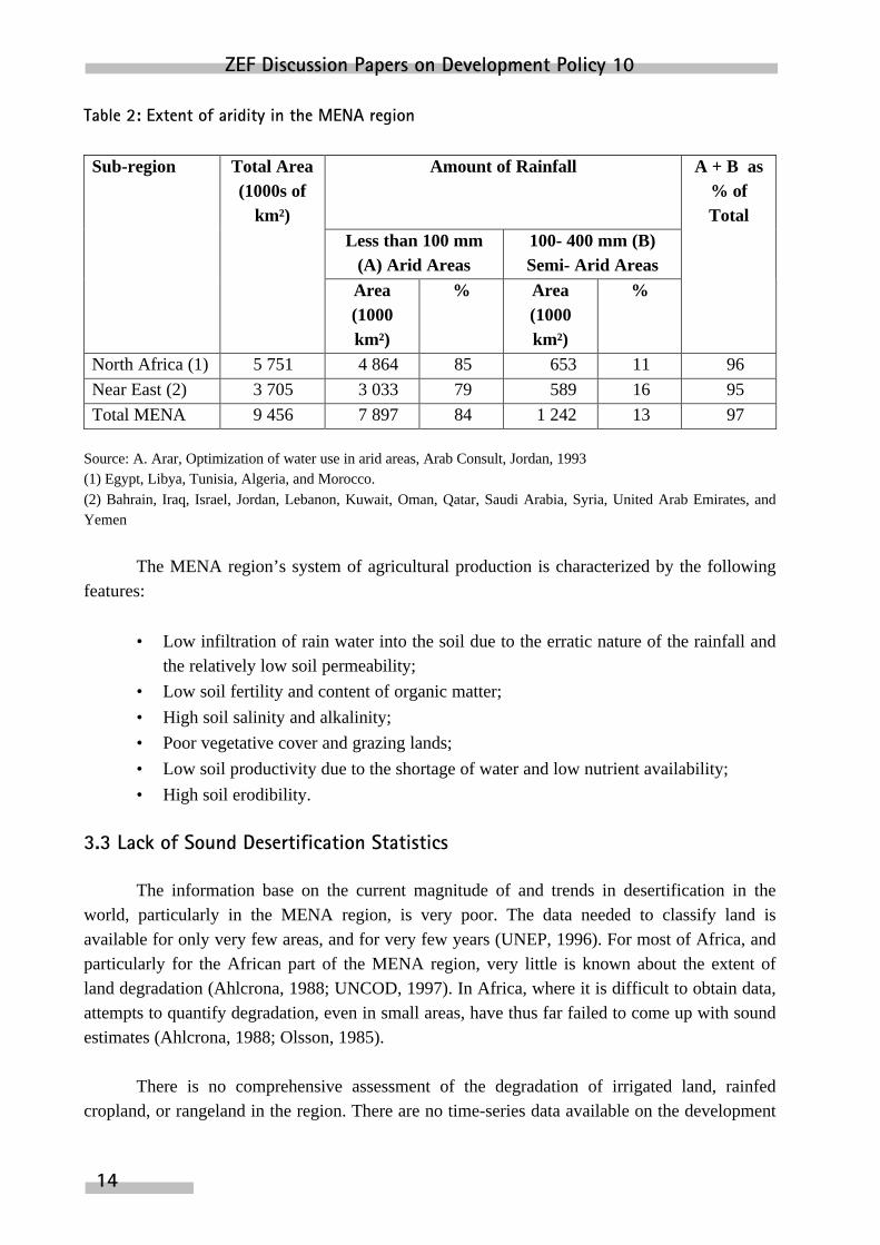
3.2 The Extent of Aridity of the MENA Region
According to UNESCO, arid regions are defined as areas where potential evapo-transpiration is much greater than precipitation. Table 2 shows the extent of aridity in the MENAregion as reflected in rainfall data. It also shows that arid and semi-arid areas amount to about96% of the North African part and 95% of the Asian part of the MENA region.
The most common features of arid and semi-arid lands in the region are12:
• Erratic and unpredictable rainfall with great seasonal and annual fluctuations;
• Average annual evapotranspiration far exceeding precipitation;
• Water-constrained agricultural production;
• Extensive fluctuations in temperature, and rainfall patterns, and in the degree ofaridity.
12 Omar Joudeh, “Integration of Water Harvesting in Agricultural Production”, in the FAO Proceedings of theExpert Consultation about “Water Harvesting for Improved Agricultural Production”, Water Report 3, Rome, 1994.
ZEF Discussion Papers on Development Policy 10
14
Table 2: Extent of aridity in the MENA region
Sub-region Total Area(1000s of
km²)
Amount of Rainfall A + B as% ofTotal
Less than 100 mm(A) Arid Areas
100- 400 mm (B)Semi- Arid Areas
Area(1000km²)
% Area(1000km²)
%
North Africa (1) 5 751 4 864 85 653 11 96
Near East (2) 3 705 3 033 79 589 16 95
Total MENA 9 456 7 897 84 1 242 13 97
Source: A. Arar, Optimization of water use in arid areas, Arab Consult, Jordan, 1993(1) Egypt, Libya, Tunisia, Algeria, and Morocco.(2) Bahrain, Iraq, Israel, Jordan, Lebanon, Kuwait, Oman, Qatar, Saudi Arabia, Syria, United Arab Emirates, andYemen
The MENA region’s system of agricultural production is characterized by the followingfeatures:
• Low infiltration of rain water into the soil due to the erratic nature of the rainfall andthe relatively low soil permeability;
• Low soil fertility and content of organic matter;
• High soil salinity and alkalinity;
• Poor vegetative cover and grazing lands;
• Low soil productivity due to the shortage of water and low nutrient availability;
• High soil erodibility.
3.3 Lack of Sound Desertification Statistics
The information base on the current magnitude of and trends in desertification in theworld, particularly in the MENA region, is very poor. The data needed to classify land isavailable for only very few areas, and for very few years (UNEP, 1996). For most of Africa, andparticularly for the African part of the MENA region, very little is known about the extent ofland degradation (Ahlcrona, 1988; UNCOD, 1997). In Africa, where it is difficult to obtain data,attempts to quantify degradation, even in small areas, have thus far failed to come up with soundestimates (Ahlcrona, 1988; Olsson, 1985).
There is no comprehensive assessment of the degradation of irrigated land, rainfedcropland, or rangeland in the region. There are no time-series data available on the development

Desertification and Water Harvesting in the Middle East and North Africa
15
of desertification in the region. The only information available for the region, is the estimatesprovided by UNDCPAC/ Dregne for 1992. Many of the figures are derived from responses to aquestionnaire sent to 100 countries by UNEP in 1982. The answers to that questionnaireprobably mean very little, says Swift (1984). “In Africa, governments were completing it inmany cases at the height of a drought,”, says Nelson (1989). “Experts even from sophisticatedgovernments say they had great difficulty answering the questions. They had little of the datathat they were asked for. They were no proper guidelines for how to answer critical questionsabout the degree of desertification of land,”, says Forse (1989).
In spite of the deficient data, we used UNDCPAC/Dregne13 estimates for 1992 toquantify the magnitude of desertification in the MENA region, because these estimates are theonly source of information available about the problem in the region. For the purposes ofcomparison, we tried to obtain data from the satellite remote sensing system and selected localresearch reports and studies relating to the region.
Most of the reports on desertification were based on Dregne and Chou (1992) estimates,which were derived from UNDCPAC (1987), reflecting conflicting definitions. One example ofmisleading statistics on desertification is the claim by UNDCPAC that 35 percent of Earth’s landarea is threatened with desertification. This 35 percent, however, is the area that is arid, at leasthalf of which is very arid,: by UNDCPAC’s own acknowledgment, this zone is not in danger, asabout half of it is too arid for any form of agriculture14.
This also applies to the MENA region, most of which is hyperarid (62%, see Table 3),consisting of pure desert, and far too arid for any form of farming. Another example is themisuse of terms such as “desert expansion” in some international debates in spite of theassurance by national authorities that the most serious problems in semi-arid areas do not occurat desert margins (UNCOD Plan of Action, 1977). Few people live in such areas, and the mostdestructive forms of land use, such as overcultivation and overgrazing, do not take place there15.
An additional example is that in Algeria, Saudi Arabia, and Morocco, the problem wasseen as desert expansion. The countermeasure, therefore, was the planting of sand dunes, whichis costly. Warren and Agnew (1988) say that active sand dunes seldom threaten valuable land.Even some areas covered by active dunes has been shown to be stable. The same difficulty wasencountered by the United States Soil Conservation Service, when it plotted damage to farmlandin the drought and recession years of the 1930s. Many areas seen then as irreparably damaged(Held and Clawson, 1965) are producing record crops today.
13 Dregne, H. E., and N.T. Chou, Global Desertification Dimensions and Costs, in Degradation and Restoration ofArid Lands, Lubbock: Texas Tech. University, 1992.14 Warren, A., and C. Agnew, An Assessment of Desertification and Land Degradation in Arid and Semi-arid Areas,International Institute for Environment and Development, Paper No. 2, London: Ecology and Conservation Unit,University College, 1988.15 See Warren, A., and C. Agnew, 1988.
ZEF Discussion Papers on Development Policy 10
16
It stands to reasons that, a selected measure of the desertification process depends uponthe definition used, and that the definition itself is a type of diagnosis of the desertificationprocess. The more precise a diagnosis is, the more effective the selected measure will be. Warrenand Agnew say that if the diagnosis is falling productivity due to over-exploitation, over-grazing,or over-watering, then the measure is better management of land and water. If the problem isseen as climatic change in a certain area, permanent withdrawal is called for. If the problem isseen as near-complete devegetation, in the absence of a climatic change, re-seeding or re-planting is suitable treatment. If the problem is seen as expansion of the desert margin, thensome kind of holding-line might be appropriate treatment. Lastly, if the problem is thought to bedrought for no more than two or three years, food aid may be adequate.
Since desertification is a complex process, involving a mix of conflicting definitions,causes and effects, no single indicator alone can adequately reflect the interaction of its severalcomponents.
3.4 The Magnitude of and Trends in Desertification Problems in the MENA Region
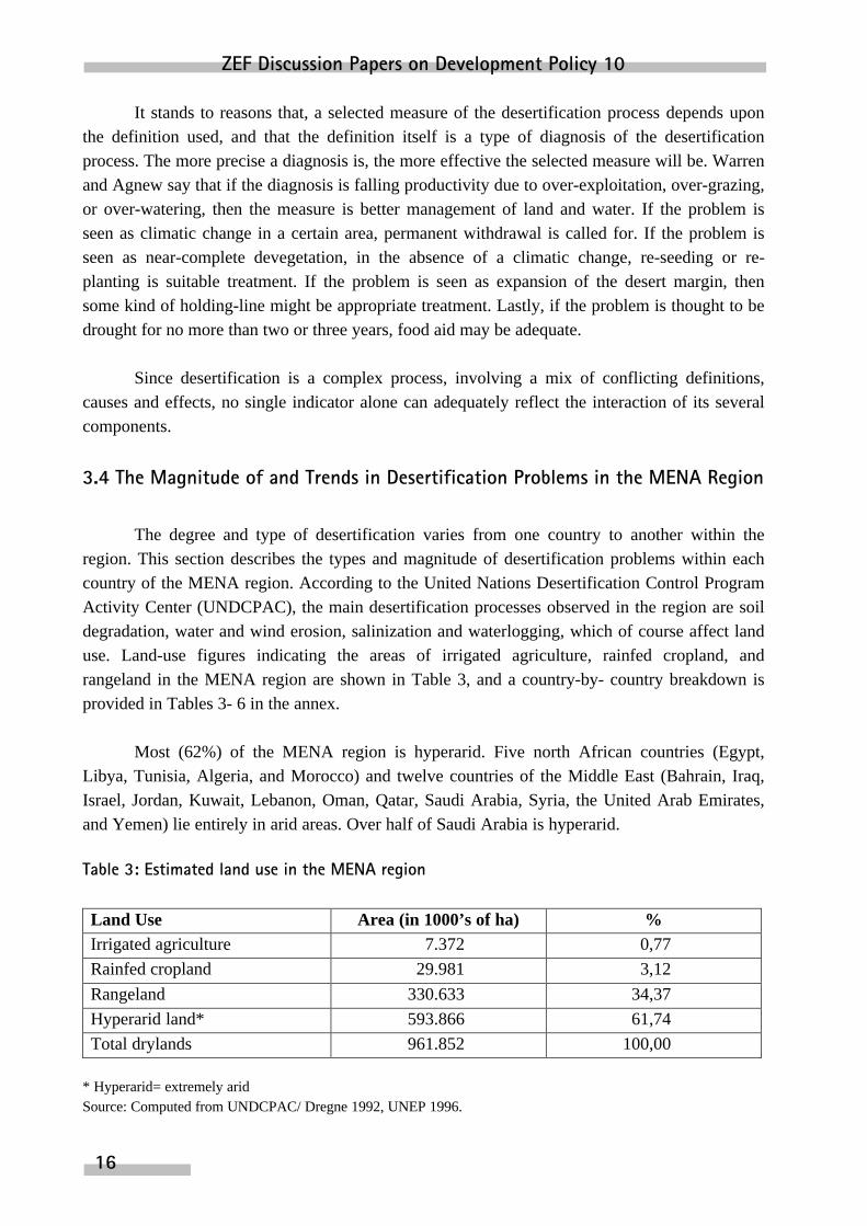
The degree and type of desertification varies from one country to another within theregion. This section describes the types and magnitude of desertification problems within eachcountry of the MENA region. According to the United Nations Desertification Control ProgramActivity Center (UNDCPAC), the main desertification processes observed in the region are soildegradation, water and wind erosion, salinization and waterlogging, which of course affect landuse. Land-use figures indicating the areas of irrigated agriculture, rainfed cropland, andrangeland in the MENA region are shown in Table 3, and a country-by- country breakdown isprovided in Tables 3- 6 in the annex.
Most (62%) of the MENA region is hyperarid. Five north African countries (Egypt,Libya, Tunisia, Algeria, and Morocco) and twelve countries of the Middle East (Bahrain, Iraq,Israel, Jordan, Kuwait, Lebanon, Oman, Qatar, Saudi Arabia, Syria, the United Arab Emirates,and Yemen) lie entirely in arid areas. Over half of Saudi Arabia is hyperarid.
Table 3: Estimated land use in the MENA region
Land Use Area (in 1000’s of ha) %Irrigated agriculture 7.372 0,77
Rainfed cropland 29.981 3,12
Rangeland 330.633 34,37
Hyperarid land* 593.866 61,74
Total drylands 961.852 100,00
* Hyperarid= extremely aridSource: Computed from UNDCPAC/ Dregne 1992, UNEP 1996.

Desertification and Water Harvesting in the Middle East and North Africa
17
UNDCPAC/-Dregne (1992) estimates of the desertification status of the irrigated land,rainfed cropland, and rangeland in the MENA region as a whole are shown in Table 4, and acountry-by-country breakdown is provided in Tables 3- 6 in the annex. Unfortunately, there areno country-specific studies available to compare Dregne’s assessments of desertification in theregion.
Each hectare of desertified land has been categorize into one of four classes according toits degree of desertification (slight, moderate, severe, very severe). Slight, moderate, and severedesertification are usually reversible, but very severely degraded land cannot at present berehabilitated cost-effectively. Land categorized as slightly desertified shows little or nodegradation (less than 10 percent loss in potential yield), moderately desertified land shows 10-25% degradation, severely desertified land 25%- 50% degradation, and very severely desertifiedland more than 50% degradation.
The main indicator of degradation in the region’s irrigated areas is salinity, combinedwith waterlogging. According to the UNDCPAC estimates, most of the affected irrigated areaslie in Iraq (71%), Saudi Arabia (63%), Tunisia (33%), and Egypt (30%) (Table 4 in annex).
These problems are due to bad irrigation management (over-irrigation) in the absence ofadequate drainage systems. Of the total area affected of 2,7 million ha (37%), 231,000 ha (3%)are very severely degraded, while the degree of degradation of the rest (97%) is reversible.Despite the doubts about the reliability of theses estimates (see section 3.2), they show that themagnitude of the problem in the MENA region is very limited.
Moreover, these estimates say nothing about current trends or future developments.Estimated trends in the development of yield, area harvested, and production of grain during the1975- 1997 period show an increase accompanied by reduced application of fertilizers. Thisresult offers some relief from the alarm caused by UNDCPAC estimates and calls for moreprecise studies based on surveys in combination with satellite remote sensing systems.

ZEF Discussion Papers on Development Policy 10
18
Table 4: UNDCPAC (1992) estimates of desertification in irrigated, rainfed cropland, and rangeland areas of the MENA region
Degree/Percentage of DesertificationLandType
TotalArea
(1000’sof ha)
Slight Moderate Severe VerySevere
Total,incl.
Moderate
%
Irrigated 7,372 4,652 2,021 468 231 2,720 37%
Rainfed 29,981 8,226 19,134 2,458 163 21,755 73%
Rangeland 330,633 50,123 104,025 175,301 1,184 280,510 85%
Total 367,986 63,001 125,180 178,227 1,578 304,985 83%
Source: Computed from UNDCPAC/ Dregne, 1992, UNEP 1996.
Rainfed cropland represents only 3 % (almost 30 million ha) of the MENA region’s totaldrylands, of which about 22 million ha (73%) are estimated by UNDCPAC to be degraded. Thescope of degradation of rainfed cropland is greatest in the countries of northern Africa: Algeria(93%), Morocco (69%), Tunisia (69%) and, exceptionally, Egypt (10%). The extent ofdegradation in the countries of the Middle East, i.e. Iraq (72%), Syria (70%), is higher than thatin the Arab Golf Countries,: Oman (50%), Qatar (25%), and Bahrain (20%). According to theUNDCPAC estimates, only 163,000 ha (0.5%) are very severely degraded, and the rest can berehabilitated. Even if these estimates are imprecise, the magnitude of the problem is very limited,particularly given that most of the degradation has occurred in the past 50 years.
According to the UNDCPAC/ Dregne estimates, the degradation of rangeland is moreextensive than that of irrigated or rainfed areas. It is estimated that 85% of the rangelands in theMENA region are degraded. The principal cause of degradation is overgrazing, combined withthe cutting of woody species for use as fuel. Algeria, Iraq, Lebanon, Oman, and Qatar have thehighest percent of desertified rangeland (90%), whereas Bahrain has the lowest (20%).
Modification of UNDCPAC/ Dregne Estimates of Desertification in the MENA Region
Since desertification does not occur apart from drought, we consider irrigated areas to beproductive, cultivated areas suffering from salinity or waterlogging problems due to badmanagement of irrigation and/or drainage. These kinds of problems, which have to do withwater management, and not with drought or directly with the soil, may be considered alarmsignals that improved management of irrigation is overdue. This paper considers the irrigatedareas to be slightly degraded, and not desertified. This is true as long as it can be demonstratedthat there has been no real decline in soil productivity, even though there may have been slightdeclines in certain years.

Desertification and Water Harvesting in the Middle East and North Africa
19
Also, the livestock-carrying capacity of most rangelands in the MENA region is limitedmore by the lack of drinking water than by a lack of feed (see the results of the Egyptian casestudy). The shortage of water compels farmers to monitor the grazability of rangelands, so thateven if overgrazing does in fact occur in some places, Dregne’s estimates that 85% of the MENArangelands are desertified seems to be very high16.
Nor should we ignore the fact that, in order to cope with the scarcity of water, Bedouinsin the MENA region, who have long had to struggle to survive, have devised means and ways offinding alternatives and putting their experience to use, for example by treating the margins oftheir rangelands, cultivating them with some grass species to protect them against erosion andharvesting rainwater to increase their water supply17. Based on the above considerations, weconsider 50% of Dregne’s assessment of rangeland desertification to be more realistic.
In light of the above, Dregne’s assessments of desertification in the MENA countries maybe modified by: (a) excluding the irrigated area as only slightly, or not at all, desertified, and (b)assessing the proportion of rangelands desertified at 50%, instead of at 85% as Dregne did. Theresults are shown in Table 5.
Table 5: Modified UNDCPAC estimates of desertification in irrigated, rainfed cropland, and rangeland areas of the MENA region
Degree/Percentage of DesertificationLandType
TotalArea
(1000’sof ha)
Slight Moderate Severe VerySevere
Total incl.Moderate
%
Irrigated 7,372 7,372 0 0 0 0 0%
Rainfed 29,981 8,226 19,134 2,458 163 21,755 73%
Rangeland 330,633 165,316 61,333 103,323 661 165,317 50%
Total 367,986 180,914 80,467 105,781 824 187,072 51%
Source: Own proposal.
16 The newsletter issued by the “Office of Dry-lands Studies” of Arizona University in 1979, estimated globaldesertification to be only half of Dregne’s estimates.17 Nasr, The Technical, Social and Economic Aspects of Water Harvesting and Water Supply in Rainfed DesertFarming Systems, Project No. I-12, National Agricultural Research Program (NARP), funded by USAID, Ministryof Agriculture and Land Reclamation, Egypt, 1992-1994.

ZEF Discussion Papers on Development Policy 10
20
3.5 Costs of Land Degradation in the MENA Region
Assessments of land-degradation costs capture costs of two kinds. The first is the incomeforegone due to prior land degradation. The second is the cost of preventing further degradationand rehabilitating the land. In preparing this assessment in 1996, UNEP assumed the followingbasic figures for the average yearly income foregone due to desertification, at 1990 prices18: US-$-250 per ha of irrigated land; US-$-38 per ha of rainfed cropland and; US-$-7 per ha ofrangeland. These figures represent a productivity loss of, approximately, 40% as the land is atleast moderately degraded.
Based on the above figures and taking into account the modified assessment of the totalareas affected by degradation in each of the land-use categories shown in Table 5 (0 ha ofirrigated land, 22 million ha of rainfed cropland and 165 million ha of rangeland), we estimatethe annual average income foregone in the MENA region due to desertificationat US-$-1.98billion (Table 7). Since currently available assessments of desertification are imprecise, thisfigures must be considered to be only a very general indication of the income foregone by theregion as result of desertification.
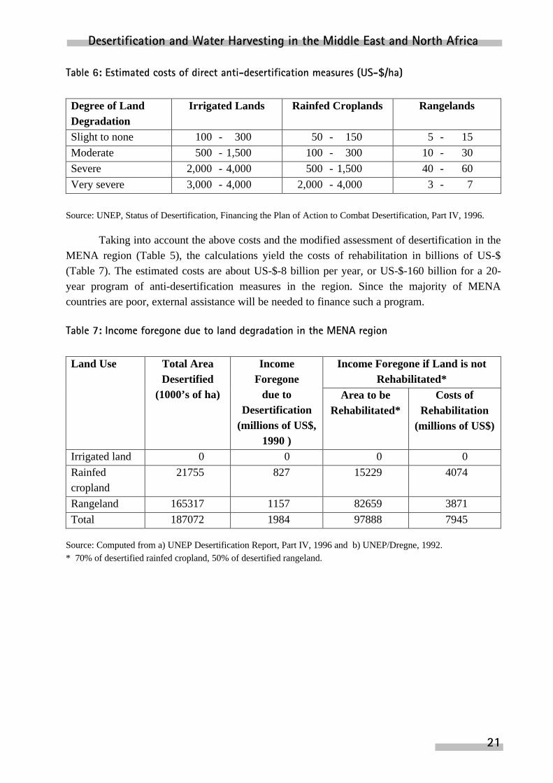
As mentioned above, the costs of rehabilitating land include both the costs incurred tostop further degradation and the costs of restore the land to its original, or at least to an improvedcondition. Drylands slightly affected by desertification require certain corrective measures toprevent further degradation and to sustain their productivity. Severely or very severely degradeddrylands require serious efforts and expense to rehabilitate and return to productive use. Therehabilitation of eroded rainfed cropland requires perhaps five to ten years, and that of rangelandneeds 50 years19. The most recent attempt to obtain figures indicating the costs of direct anti-desertification measures (preventive, restrictive and rehabilitative) was made by UNEP in 1992,based on the 1991 assessment of land degradation. From data provided by a large number ofrelevant projects in various parts of the world, UNEP derived global average figures for suchcosts (Table 6).
18 UNEP, Financing the Plan of Action to Combat Desertification, Desertification Report, Part IV, 1996. This reportused the UNEP/Dregne assessment of desertification published in 1992. Due to the lack of data and information atboth the global and regional levels, Dregne set a single figure on the amount of income foregone, regardless ofwhether the land involved was irrigated land, rainfed cropland, or rangeland.19 UNEP 1996 (see No.1 above).
Desertification and Water Harvesting in the Middle East and North Africa
21
Table 6: Estimated costs of direct anti-desertification measures (US-$/ha)
Degree of LandDegradation
Irrigated Lands Rainfed Croplands Rangelands
Slight to none 100 - 300 50 - 150 5 - 15
Moderate 500 - 1,500 100 - 300 10 - 30
Severe 2,000 - 4,000 500 - 1,500 40 - 60
Very severe 3,000 - 4,000 2,000 - 4,000 3 - 7
Source: UNEP, Status of Desertification, Financing the Plan of Action to Combat Desertification, Part IV, 1996.
Taking into account the above costs and the modified assessment of desertification in theMENA region (Table 5), the calculations yield the costs of rehabilitation in billions of US-$(Table 7). The estimated costs are about US-$-8 billion per year, or US-$-160 billion for a 20-year program of anti-desertification measures in the region. Since the majority of MENAcountries are poor, external assistance will be needed to finance such a program.
Table 7: Income foregone due to land degradation in the MENA region
Income Foregone if Land is notRehabilitated*
Land Use Total AreaDesertified
(1000’s of ha)
IncomeForegone
due toDesertification
(millions of US$,1990 )
Area to beRehabilitated*
Costs ofRehabilitation
(millions of US$)
Irrigated land 0 0 0 0
Rainfedcropland
21755 827 15229 4074
Rangeland 165317 1157 82659 3871
Total 187072 1984 97888 7945
Source: Computed from a) UNEP Desertification Report, Part IV, 1996 and b) UNEP/Dregne, 1992.* 70% of desertified rainfed cropland, 50% of desertified rangeland.

ZEF Discussion Papers on Development Policy 10
22
3.6 Monitoring Indicators of Desertification Processes by means of Satellite Systems
Efforts to monitor desertification have always been subject to the criticism as there is abig discrepancy between the time frame of human monitoring activities and the time frame ofdesertification processes. What we have to study is not the changes that take place in a singleyear, but the changes that occur during a long time-series. Due to the lack of data andinformation on the real magnitude of desertification and its changes over time, it has beenexpedient to carry out these studies with the aid of satellites in view of their multispectralproperties, which enable them to use thermal imaging techniques to represent vegetational cover.
3.6.1 Resolution of Existing Satellites
The first satellite to be launched successfully was the Soviet SPUTNIK, which went intoorbit in 1957. Today, almost 10,000 satellites are being used to serve the earth and/or study theenvironment. The spatial resolution of satellites ranges from high-resolutions capable of imagingobjects only five meters in size to low resolutions covering tens of kilometers20. The temporalresolution ranges between geo-stationary satellites and those that cover a certain strip of areaevery 10-16 days. The spectral resolution ranges between long-wave infrared (IR) and ultrashort-wave (UV).
3.6.2 Advantages of Satellites for Data Collection
In regard to the collection of environmental data, satellite remote sensing systems havethe advantages that they can provide both regional and global data, use their unique sensingcapabilities to monitor changes ranging in duration from half an hour to several weeks, andprocess the data collected for the purposes of comparison.21.
3.6.3 The Most Well-Known Satellites
The most well-known satellites are: (a) the LANDSAT-TM series, which incorporate athematic mapper (TM) and multi-spectral scanner (MS), and work at scales from 1:50,000 to1:1,000,000, (b) the weather satellite METEOSAT, and (c) NOAA satellites, which provide anoverall views of the earth through images made in the red (-R) and near-infrared (NIR) ranges,i.e. in the range of thermal radiation. In 1985, the FAO of the United Nations commissioned theestablishment of a Global Information and Early Warning System (GIEWS) for natural disasterssuch as droughts, floods and earthquakes, and later formed FAO’s Rome-based Remote SensingUnit (FAO RSU).
20 CIESIN, The Importance of Satellite Remote Sensing for Global Change Research, 1996.21 CIESIN, The Use of Satellite Remote Sensing, 1996.
Desertification and Water Harvesting in the Middle East and North Africa
23
3.7 Using NOAA Satellites to Monitor Desertification in the MENA Region
Geographic information systems (GIS) are interesting tools for interdisciplinaryagricultural modeling. Nevertheless, the use of a GIS usually involves a number of difficulties,including 22: (a) the availability of data, (b) the availability of hardware and softwarecompetence, (c) statement accuracy and examination, and (d) the availability of aninterdisciplinary work team. The validity of the results of desertification monitoring in this partof the study is subject to the above-mentioned difficulties.
The key element in controlling soil erosion in the MENA countries is vegetation cover.This study used thermal images generated by satellite remote sensing systems over a certainperiod of time to represent the vegetation cover in the MENA countries. Hielkema23consideredthe application of scales of up to 1:50,000 to be acceptable. Below this scale, e.g. 1:10,000 or atthe farm level, satellite remote sensing would no longer be practicable. This is why the studyused NOAA -systems to monitor vegetation as an indicator of desertification processes in theMENA region. Because the NOAA AVHRR satellite was established in 1982, the study islimited to coverage in the period from 1982 to 1997.
Since each satellite-generated image consists of a very large number of individualdigitized dots, the data were processed by computer and the “Normalized Difference VegetationIndex” (NDVI) was computed. NDVI is a measure of the amount and vigor of the vegetation onthe surface. The magnitude of NDVI is related to the level of photosynthetic activity in theobserved vegetation. In general, higher values of NDVI indicate greater vigor and amounts ofvegetation. The NDVI is derived from data collected by the National Oceanic and AtmosphericAdministration (NOAA) satellites, and processed by the department of Global InventoryMonitoring and Modeling Studies (GIMMS) at the National Aeronautics and SpaceAdministration (NASA). The NOAA-AVHRR sensor collects data at 1.1 km resolution at thesatellite sub-point. The NDVI was calculated for both the entire MENA region and for each ofthe 17 countries of the region for the 16-year period from, 1982 to 1997. This was done in orderto investigate vegetational development by year and by country (see examples of obtainedvegetation maps).
22 Bill, R.U.D. “Fritsch, Grundlagen der Geo-Informationssysteme”, Band 1: Hardware, Software und Daten,Karlsruhe, 1994.23 FAO, Satellite Remote Sensing Specialist, R.S.C., Rome, Italy.

ZEF Discussion Papers on Development Policy 10
24
MENA - NDVI Margins1982
1997

Desertification and Water Harvesting in the Middle East and North Africa
25
Egypt 1986 Egypt 1997
Saudi Arabia 1983 Saudi Arabia 1996
Yemen 1983 Yemen 1996

ZEF Discussion Papers on Development Policy 10
26
This study employed the following sets of satellite data:
• NOAA scene from 15 June 1997 (beginning of the dry season) for the generation ofcountry-specific and overall MENA vegetation maps, that provide information on thedensity and distribution of vegetation; and
• NOAA scene from 26 February 1982 and 15 February 1997 (rainy season) to provideinformation on vegetation dynamics and land-degradation processes
Findings
The study compares the positions of the edges of deserts in the MENA region at twodifferent times. The first time, the edges were plotted on a vegetation map from the year 1982.The second time, the edges were plotted on satellite images of vegetational cover from the year1997. Comparison indicated a regeneration of the vegetational cover. The satellite images of theMENA region show no alarming damage to vegetation. Areas with extensive vegetation werebright or brightened on the satellite image. Although a drought occurred between 1982 and 1997and the amount of rainfall was below average, the edges of the deserts had not shifted in 17years, and some desert areas had even become greener. On the contrary, the study estimates thatthe vegetational boundary has shifted into the deserts in most of the MENA countries (see theNOAA satellite maps of the overall MENA region, and consider Egypt as example in NorthAfrica, Yemen and Saudi Arabia as example of the Asian part of the MENA)24.
Examination of the satellite images revealed no evidence substantiating a trend towardsdesertification in the region. In some places, regeneration of the vegetation could hardly beexpected, given the continual destruction of woody plants that now occurs as a result of highpopulation pressure. It is to be observed, however, that even the destruction of the shrubvegetation may have had a positive aspect for the region, namely that it may have promoted thegrowth of grasses. In fact, the satellite images document the presence of more greenery in thedesert, but do not provide any precise indication of the nature or quality of the vegetation.
Land degradation may have occurred, but there has been no change to more desert-like(less vegetated) conditions. Of course, some small areas have suffered from one or more types ofland degradation, but only for a very short time because the soil’s ability to regenerate itself hasenabled the region to show a net increase in vegetational cover over last 17 years. In arid andsemi-arid areas, the climate does in fact fluctuate wildly from year to year and from decade todecade. As a consequence of this, there is also marked fluctuation in the condition of natural andcultivated vegetation. One common source of confusion is when such fluctuation is attributed to“desertification”.
24 The NOAA has generated 36 satellite maps of the MENA countries that show changes in the distribution ofvegetational cover between 1982 and 1997. These maps and calculations of NDVI s are available in the Center forDevelopment Research (ZEF) at Bonn University.
Desertification and Water Harvesting in the Middle East and North Africa
27
Indeed, there are some indicators of land-degradation processes in the region, but it hasdemonstrated remarkable regenerative ability. Trails in Syria, Jordan, Tunisia, Libya and theSudan have clearly demonstrated that tremendous improvement in the rangelands can be attainedin only a few years following the introduction of proper stocking or deferred rotational grazing25.
The destruction of vegetation has always proceeded from regions under human influencein response to the need for agricultural areas, roads, watering places, firewood, etc. For theregion as a whole, however, it may be said that human influences have been positive and tendedto increase vegetational cover in coastal areas and near rivers, where most of the population isconcentrated. The MENA region’s population growth of 3.3 percent annually has compelledpeople to try to utilize previously unused lands, where water is relatively available, in order tomeet increasing demand for food.
Human efforts involving the use of biotechnology, including genetic engineering and thenitrogen-fixing ability of leguminous plants, offer considerable promise of narrowing thedifferences in yield between farmers and extension stations, without degrading the naturalresource base. Human efforts have led to increasing time trends of grain yield, areas harvestedand production of grain in most of the MENA countries.
Nevertheless, as in all satellite studies, the observed increase in the region’s vegetationalcover in no way denies the occurrence of other types of land degradation and provides nomeasure of land productivity. To gain some indications of the magnitude of other land-degradation problems in the region, other information relating to vegetation was consulted. Thisinformation include the amount of rainfall, crop yields, soil organic matter, use of fertilizers, andthe number of animal grazing in each country over the same period of time.
Unfortunately, there is no information relating specifically to the desert areas of theMENA region that could be compared with information on the non-desert areas in each country.However, the results shown in Table 7 in the annex indicate that grain yields have increased inmost of the MENA countries between 1982 and 1997. Thus, the increase in vegetational coverand increase in cultivated areas and grain yield, considered in conjunction with the reduced useof fertilizers, show that the region has not suffered significantly from the diminution ordestruction of the biological potential of the land during the years 1982 through 1997.
This result agrees with the conclusions reached by FAO studies (see FAO, Food for AllReport, 1997) that the MENA region is to be classified as mainly productive crop, pasture andforest land, and that desertification in the region is mostly moderate.
25 Arrar, A., in German Foundation for International Development (DSE), FAO, GTZ, UNESCWA, ResourceConservation and Desertification Control in the Near East, Report of the International Training Course, Germanyand Kingdom of Jordan, 1989.
ZEF Discussion Papers on Development Policy 10
28
4 Using Water Harvesting Techniques toControl Desertification in the MENA Region
4.1 The History of Water Harvesting
The first water harvesting system in history was build in the MENA region. Researchershave found signs of early water harvesting structures believed to have been constructed over9000 years ago in the Edom mountains in southern Jordan. One of the earliest documentedcomplete water harvesting systems is located in the Negev Desert of Israel. It is believed to havebeen built about 4000 years ago26. Remnants of other installations were also discovered in Iraqand on the Arabian Peninsula, along the routes used at the time by caravans. The waterharvesting installations consisted mainly of means to collect rainwater and divert it into naturaland/or artificial ponds and reservoirs27.
In Yemen, ruins of dams and reservoirs as well as the unique, spectacular mountainterraces, confirm the long history of water harvesting. The great historical Marib dam and itscollapse are mentioned in the Holy Koran. Recent archaeological excavations (German Team,1982 and 1984) discovered ruins of irrigation structures around Marib city dating from themiddle of the third millennium BC (some 4000 years ago)28.
Water harvesting installations dating from 2500 to 1800 BC have been discoveredPalestine. They consisted mainly of cisterns with catchments areas cleared of gravel andsmoothed to increase runoff. In the same region, during the Byzantine era, “the system of runofffarming encompassed practically all of the usable land in the northern Negev highlands.”29
In North Africa, rainwater collection and storage are known to have been practicedduring the 11th and 12th centuries. In Morocco alone, it was estimated in 1990 that there areover 360,000 cisterns throughout the country that still supply domestic water to 10% of thepopulation.
26 Gary, W. Frasier, Water Harvesting/ Runoff Farming Systems for Agricultural Production; in the FAOProceedings of the Expert Consultation about “Water Harvesting for Improved Agricultural Production”, WaterReport 3, Rome, 1994.27 M. Bazza, Operation and Management of Water Harvesting Techniques; in the FAO Proceedings of the ExpertConsultation about “Water Harvesting for Improved Agricultural Production”, Water Report 3, Rome, 1994.28 Abdulrahman, M. Bamatraf, “Water Harvesting and Conservation Systems in Yemen”; in the FAO Proceedings ofthe Expert Consultation about “Water Harvesting for Improved Agricultural Production”, Water Report 3, Rome,1994.29 Hillel, D., Negev, Land, Water, and Life in a Desert Environment, Praeger Publishers Division, 1982.

Desertification and Water Harvesting in the Middle East and North Africa
29
In Egypt, some water harvesting structures built in the Roman era have been, cleanedand/or smoothed and put back into use. At present, all the countries in the MENA region,practice one or more water harvesting techniques intensively in order to collect and storerainwater for use in meeting plant-cultivation, human and animal needs.
Awareness of the role of water harvesting (WH) in improving crop production was raisedthroughout the world in the 1970s and 1980s, when widespread droughts in Africa threatenedagricultural production.
4.2 What is Water Harvesting?
In its broadest sense, water harvesting may be defined as the “collection of runoff for itsproductive use.”30 Runoff may be harvested from roofs and ground surfaces, as well as fromintermittent or ephemeral watercourses. Productive uses include provision of domestic and stockwater, concentration of runoff for crops, fodder and tree production and, less frequently, watersupply for fish and duck ponds.
The techniques utilized for collecting, storing and using rain and flood waters are verydiverse. There are consequently a dozen different definitions and classification of waterharvesting techniques. The terminology of water-harvesting used at the regional andinternational levels has not yet been standardized.
In the next section, water harvesting is considered as a management technique forcollecting, storing, and distributing rainwater for any productive use. In general, water harvestingcan make water available in regions where other sources are too distant or too costly, makingwater harvesting able for supplying water for small villages, households, livestock, andagriculture.
The most practical classification of the various water harvesting techniques and theircharacteristics and uses has been established by the World Bank within the context of the “sub-Saharan Water Harvesting Study” in 1986- 1989 (Figure 1).
30 Klaus Siegert, in the FAO Proceedings of the Expert Consultation about “Water Harvesting for ImprovedAgricultural Production”, Water Report 3, Rome, 1994.

ZEF Discussion Papers on Development Policy 10
30
Figure 1: Classification of water harvesting techniques
Water Harvesting
Category of Rainwater Harvesting Floodwater Harvesting
WH system ( local source ) ( channel flow )
by source
Rooftop Harvesting Runoff Harvesting
(collection from (overland / rill flow)rooftops)
Storage deep ponding deep ponding soil storage deep ponding soil storage
Productive water supply water supply plant production water supply plant productionUse*
Main Plant Runoff Farming ** 3. Floodwater Farming
Production (= water sprading)
Categories
Sub-Divisions 1. Microcatchment Systems 2. External Catchment Systems
(Short Slope Catchment (Long Slope Catchment
Techniques) Techniques
Notes:* Water supply systems ( i. e. ponded water ) used for a variety of purposes, mainly domestic and stock water but also some supplementary irrigation.** The term "farming" ( as in "Runoff Farming" ) is used in its broadest sense - to include trees, agroforestry, rangeland rehabilitation, etc.*** Deep ponding often also referred to as long term storage includes dams, reservoirs and all kind of tanks.
Source: Siegert, K.: Introduction to water harvesting: some basic principles for planning, design and monitoring, in: The FAO Proceedings of the Export Consultation about "Water Harvesting for Improved Agricultural production", Water Report No. 3, Rome, 1994
Desertification and Water Harvesting in the Middle East and North Africa
31
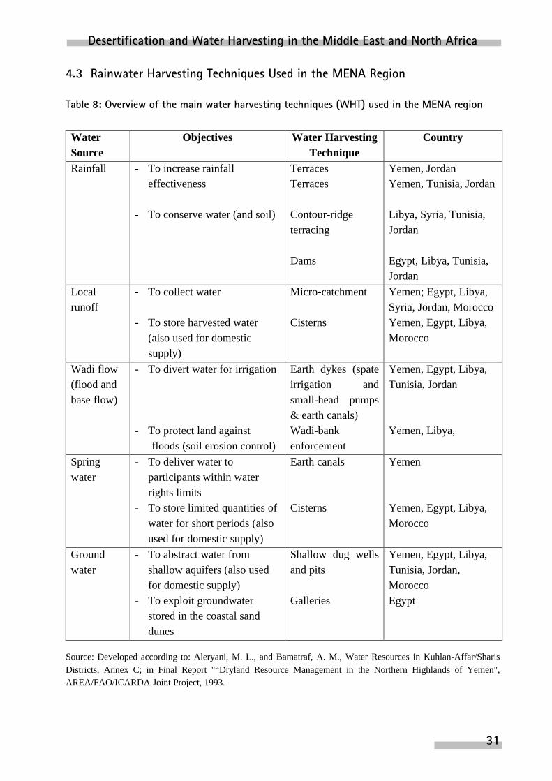
4.3 Rainwater Harvesting Techniques Used in the MENA Region
Table 8: Overview of the main water harvesting techniques (WHT) used in the MENA region
WaterSource
Objectives Water HarvestingTechnique
Country
Rainfall - To increase rainfalleffectiveness
- To conserve water (and soil)
TerracesTerraces
Contour-ridgeterracing
Dams
Yemen, JordanYemen, Tunisia, Jordan
Libya, Syria, Tunisia,Jordan
Egypt, Libya, Tunisia,Jordan
Localrunoff
- To collect water
- To store harvested water(also used for domesticsupply)
Micro-catchment
Cisterns
Yemen; Egypt, Libya,Syria, Jordan, MoroccoYemen, Egypt, Libya,Morocco
Wadi flow(flood andbase flow)
- To divert water for irrigation
- To protect land againstfloods (soil erosion control)
Earth dykes (spateirrigation andsmall-head pumps& earth canals)Wadi-bankenforcement
Yemen, Egypt, Libya,Tunisia, Jordan
Yemen, Libya,
Springwater
- To deliver water toparticipants within waterrights limits
- To store limited quantities ofwater for short periods (alsoused for domestic supply)
Earth canals
Cisterns
Yemen
Yemen, Egypt, Libya,Morocco
Groundwater
- To abstract water fromshallow aquifers (also usedfor domestic supply)
- To exploit groundwaterstored in the coastal sanddunes
Shallow dug wellsand pits
Galleries
Yemen, Egypt, Libya,Tunisia, Jordan,MoroccoEgypt
Source: Developed according to: Aleryani, M. L., and Bamatraf, A. M., Water Resources in Kuhlan-Affar/SharisDistricts, Annex C; in Final Report "“Dryland Resource Management in the Northern Highlands of Yemen",AREA/FAO/ICARDA Joint Project, 1993.

ZEF Discussion Papers on Development Policy 10
32
The productivity of land in the MENA region is determined to a large extent by the totalamount and seasonal incidence of rainfall. Rainfall is generally meager (less than 300 mm peryear), unpredictable and widely fluctuating. Most of the MENA countries are classified aswater-scarce countries. The natural aridity of the MENA region is also a major constraint onproductivity, and very little can be done to change it. However, rainwater can be managed in thatit can be collected, stored, distributed, and more efficiently utilized to meet peopl’s needswithout actually having a greater amount of water available and without undesirable side-effects,such as desertification, occurring. This is called rainwater harvesting and is the key tocontrolling desertification, rehabilitating land and increasing productivity in the region. The mainrainwater harvesting techniques used in the MENA region are summarized in Table 8.
In summary, most of the MENA countries use different local techniques to managerainfall by improving the soil cover and thus catching rain where it falls and aiding infiltration, toincrease soil moisture and increase organic activity in soils. People in the region consider waterharvesting to be a mechanism for survival, with the result that water harvesting is considered tobe an integrated part of agricultural production, of increasing the production of fruit trees,grasses and rangeland, of controlling soil erosion, and of conserving soil moisture when coupledwith appropriate agricultural practices.
4.4 Problems and Constraints Hindering the Use of Water Harvesting for Agricultural Development
Since agriculture in most of the MENA countries is characterized by reduced wateravailability31 and growing demand for food and thus for higher agricultural productivity, MENAcountries have no option but to improve the efficiency of water use in agriculture. This mustinclude efficient management of rainwater through utilization of effective water harvestingtechniques. Instead of allowing runoff to cause erosion, it must be harvested and utilized.
Governmental and non-governmental agencies, supported by local leaders of thebeneficiaries, take the responsibility for the implementation of successful water harvestingsystems. Governmental agencies of the Ministry of Agriculture and/or Land Reclamation, i.e.Soil and Water Conservation Departments, and development and construction divisions, areresponsible for planning, administering and managing soil and water conservation activities inthe MENA countries, including water harvesting techniques.
As mentioned above, traditional techniques of harvesting water are still being used in allthe MENA countries. FAO experts of the soil and water conservation group believe that there isa need to improve the efficiency of traditional techniques. Unfortunately, the introduction of
31 Nasr, Mamdouh, “Agriculture: The Biggest User of Water”, paper presented to: Water-International Conference,Bonn, October 1998.

Desertification and Water Harvesting in the Middle East and North Africa
33
systems which have been tested under various climatic, soil, land-tenure and socio-economicconditions are usually not accepted by the target groups.
The most significant problems and constraints hindering the integration of waterharvesting in the agricultural production of the MENA countries are32:
• Technology inadequate to the requirements of the country/ region/ area;
• Lack of acceptance, motivation and involvement among beneficiaries;
• Lack of adequate hydrological data and information for confident planning, designand implementation of water harvesting projects;
• Insufficient attention to social and economic aspects such as land tenure,unemployment, and return of water harvesting system;
• Lack of effective involvement of the national research centers and extension services;
• Inadequate institutional structures, beneficiary organizations (associations,cooperatives) and government training programs for farmers, pastoralists andextension staff;
• Absence of a long-term government policy.
4.5 Using Rainwater Harvesting to Combat Desertification in Egypt: A Case Study33
4.5.1 Introduction
Since Egypt sets an example for the entire MENA region, the aim of this case-study is toidentify major demographic, technical, social and economic forces driving desertification.
Data for the study was collected according to a multi-method approach, e.g.questionnaires (reconnaissance, pre-test and socioeconomic survey), case studies, and interviewswith private, governmental and donor agencies in the region. A stratified random sample of 280farms was chosen. The stratum selected was one that used a water harvesting technique. Thiswas relevant for the research objectives. Using available maps, the target area was divided intothree types of sub-areas. The first type included areas of farming and water harvesting; thesecond includes towns, villages and rural clusters of more than 10 houses and the third containedsmall HH with animal activities.
32 Most of these problems and constraints are also identified by the FAO Expert Consultation for the Near East,Cairo, 1993.33 A survey was conducted within the research activities of the National Agricultural Research program (NARP)under the supervision of the Ministry of Agriculture and Land Reclamation, Project No. I-12, funded by USAID.The author of the present study was the principal investigator of this project during the 1992-1994 period. Theproject title was: “The Technical, Social and Economic Aspects of Water Harvesting and Water Supply of RainfedDesert Farming Systems.

ZEF Discussion Papers on Development Policy 10
34
The study focussed on the household, its income, employment, water harvestingtechniques, and cropping patterns. This was done to investigate key factors contributing to thedegradation of land and water resources in the region. These factors were grouped into threecategories: technical, socioeconomic and institutional. The technical factors included droughtconditions, unfavorable hydro-geologic conditions, inefficient water control and deliverytechniques, and poor land-use planning.
The socioeconomic factors involved inefficient cropping and cultural practices,inequitable resource allocation due to inflexible water rights and inappropriate land tenure,fragmentation of land holdings, social influences and/or tribal conflicts, and increased populationgrowth with its greater needs and pressures limiting resource sustainability in the region.
4.5.2 Importance of Water Harvesting
The facts that rainfall is very meager in such semi-arid regions and that one millimeter ofharvested rainwater is equivalent to one liter of water per square meter, suggest the importanceof water harvesting apart from the quantity of rainwater collected. The population benefitingfrom the harvesting of rainwater is estimated at 161,000 inhabitants, 59% of which raise sheepand goats and cultivate barley and fruit trees in wadis and depressions where water can beharvested and utilized. Water harvesting also plays a role in people’s social life.
The whole issue of land management by Bedouin tribes has recently been of greatimportance. Degraded land around the tribal sites can be improved only if the communitiesthemselves come to grips with land use management issues. One of the techniques that can be ofassistance in rehabilitating degraded land is water harvesting34.
4.5.3 Technical Description of Water Harvesting Systems
Most water harvesting systems adopted by farmers in the region consist of four maincomponents; catchment area for collecting rainwater, a means of diverting runoff, a waterstorage installation, and appropriate means for using the water.
Water Catchment
The Bedouins are experienced in selecting the most appropriate water catchment areas forcollecting rainwater. As would reasonably be expected, the area they select as a catchment doesnot permit the water to infiltrate into the soil, is cleared of all vegetation, shaped, and smoothed.Farmers decide the size of catchment area and storage tank on the basis of their personalexperience in the past. This involves seasonal observation of the farm water budget, i.e. the
34 Siegert, K, water resources engineer, Water Resources, Development and Management Services, Land and WaterDevelopment Division, FAO, Rome, 1994.
Desertification and Water Harvesting in the Middle East and North Africa
35
amount of water harvested versus the amount of water required. Since the objective is to reducethe chance that there will be periods of insufficient water, the catchment area and water storageinstallation are made at least large enough to ensure that there will be sufficient water duringperiods of little rain.
Water Storage Techniques
Because of the intermittent nature of precipitation runoff, water storage is an integral partof every water harvesting system. There are two main methods of storing rainwater in the region.The first method relies on storing runoff water in wadi channels behind earthen dams in areaswhere slopes are not greater than 2%, or behind stone dams in areas where slopes are 1- 5%. Theaim of establishing such dams is to hold the water until it is needed by building great waterbasins that can be exploited for up to 4 months after the end of rainfall season in March. In thistype of water harvesting, the cultivated soil is the water storage container. This is called a direct-runoff-farming system. There are two basic types of runoff-farming systems: first, the directwater application system, where the runoff water is stored in the soil of the crop growing areaduring the precipitation, and second, the supplemental water system, where the collected water isstored offsite in some reservoirs and later used to irrigate a certain crop area.
The second method of rainfall storage used in the region relies on the building of earthenreservoirs in wadi depressions. The Bedouins in the region use two different kinds of earthenreservoirs. The first are lined reservoirs build according to engineering principals and utilizingmaterials from outside the region, e.g. concrete, or iron. These kinds of reservoirs are extremelyexpensive and are usually built by the local administration of Matrouh governorate.
The second kind of reservoirs are what Bedouins call “Nashou”. These are establishedcisterns under the surface of a plateau. Because of the topographical soil conditions, the selectionof a suitable place for building such a cistern is of great importance. The Bedouins havesufficient experience in this.
Material and labor are of primary concern when selecting a water-harvesting farmingscheme. Not all catchment basin designs require the same labor skills or the same type ofmaintenance. Maintenance on small-scale water harvesting schemes can require 1 to 2 man/daysabout 4 times per year. In order to compact the soil in catchment basins, weed growth should beeliminated and soil erosion prevented.
4.5.4 Socio-economic Indicators of Successful Rainwater Harvesting in Egypt
This part of the study describes the socioeconomic indicators of agricultural developmentrelating to rainwater harvesting techniques in the study area. These indicators include the landtenure system, land management, cropping patterns, farm income and sources of farm revenues,

ZEF Discussion Papers on Development Policy 10
36
the gross margins of selected agricultural products and livestock, animal nutrition management,and the rate of profitability of farm production.
Land Tenure and Management
The lack of title to land is one important factor affecting the improvement of waterharvesting techniques in the area because the lack of tenure means that people are reluctant toinvest in new water harvesting structures or in land which they do not formally own.
Land management has recently been acknowledged to be extremely important,particularly in such a semi-arid area. Because of the shortage of water, land holding ischaracterized by small-scale farm sizes. Of course, the level of education and social status offarm managers play an important role in the use of land and water resources. The better educatedfarmers are, the more efficient is their use of farm resources.
Water Harvesting in the Area
Most of the water harvesting systems used by households in the area were developed andutilized as single-family enterprise. Large communal systems are seldom to be found due to theirhigh installation costs and demanding requirement for group commitment, not only for theconstruction of the system, but also for its maintenance and operation. In combination systems,earthen dikes are usually used in addition to cisterns. Where water infiltration is a problem, dueto soil degradation, earthen and stone dikes are effective particularly if combined with animalmanure. Constructing earthen dikes is one of the methods of guiding runoff. The aim of thiswork is to use the soil for water storage up to the limit of its capacity, thus also supplying thewater needs of plants rooted in the immediate area.
If the water collected represents the means of survival rather than merely an opportunityto generate income, people have a different attitude about it. When farmers harvest water fortheir own survival, they are ready to spend more money and invest more labor in buildingcisterns since, in this case, the water has a different economic significance than water that is usedas a means of increasing income.
The spread of knowledge regarding water harvesting techniques may facilitate successfulimplementation of programs designed to improve water-harvesting infrastructures with a view tocontrolling land degradation in the region. However, farmers’ current knowledge regarding waterharvesting techniques is inadequate and out dated, with the result that much rainwater is lost(78%).

Desertification and Water Harvesting in the Middle East and North Africa
37
Livestock Production
For most Beduins, keeping livestock is not only a source of income, but a way of life.Farmers’ prestige is closely correlated with the size of their herd. Farmers consider livestockalmost like a bank, enlarging their herd when they have surplus money, and converting it to cashwhen they need money.
In spite of the relatively low, but positive gross margins per unit of labor and waterreturned by barley, farmers are encouraged to keep cultivating it in order to cover increaseddemand for grain resulting from increased herd sizes. Cultivating land with barley reduces thethreat of its degradation because plowing opens the soil crust and raises the rate of infiltration. Atthe same time, the increased profitability of orchard enterprises enables farmers to invest more inwater harvesting structures and thus indirectly reduce the threat of land degradation35.
Costs of rehabilitating land
A recent study36 estimated the investments required to upgrade the arable land in thestudy area at $ 1485/ ha, assuming that the work was performed by private contractors.Governmental overheads and supervision costs were not considered. The most importantactivities proposed to upgrade this area were: landscaping (terracing, leveling, etc.), waterprovision (dikes, dams, cisterns, etc.), groundwater wells including pumping facilities, andfeeder roads. The implementation of these improvements might be feasible within a period offive years.
Net farm income
A farm income of US$ 5000, believed to be the minimum income required for anacceptable standard of living for a family of average size (ten members), has not been achieved.This is equivalent to a $ 500 per capita per year, which is less than Egypt’s national average of $650 (1995). The annual income of most farms (75% of the farms surveyed) at 1994 prices,however, ranges between $ 630 and $2380, which is much less than 50% of the income expected(GTZ/QRDP, 1993).
35 This result was confirmed in a recent study in the same area conducted by Qaim Martin, Modernization ofFarming Systems in the Northwest Coastal Zone of Egypt, Qasr Rural Development Project Area, M.Sc. thesis, KielUniversity, 1996.36 “Estimation of Development Costs for the Area of Qasr Rural Development Project (QRDP) at Marsa Matrouh”,Internal Report of GTZ/ QRDP, Marsa Matrouh, Egypt, 1993.
ZEF Discussion Papers on Development Policy 10
38
4.5.5 General Conclusions of the Case Study
Of course, there are some indications of one or more types of land degradation here andthere, i.e. overgrazing and/or soil erosion, but these processes are temporary, and the soil’sability to generate itself is very high, particularly in wet years. The overall development ispositive, since the cultivated area in the region increased by 40% between 1980 and 1996. Thus,the ecological consequences of human activities remained relatively insignificant or wereconcentrated within a limited area, because the population densities of both men and cattle aresufficiently low in areas threatened by desertification.
Traditional “water harvesting” techniques can achieve significant improvements both inagricultural production and environmental rehabilitation. These techniques have contributed tothe rapid restoration of vegetational cover and helped to reverse erosion in degraded areas in thenorth-west coastal areas of Egypt.
Intensified establishment of water and soil conservation facilities has led todesertification control and desert reclamation activities and thus to an increase of 15% in newlycultivated areas at surveyed farms. Effective coordination of governmental, non-governmental,and donors efforts is required to ensure the necessary investments, research, and extension work.
Farmers have increasing awareness of the problems entailed in overgrazing, of the needto strengthen the vegetational cover, and to intensify work against soil erosion. Windbreaks andplantations of fruit trees have increased by 30% among the surveyed farmers.
The trend toward increasing crop yields in conjunction with diminished use of chemicalfertilizers, indicates the success of human efforts to sustain productivity.
However, since there is still a big need for sustainable development in the study area, thegovernmental agencies working in the area, supported by foreign donors, should establish adatabase on land degradation trends, causes, results, and implications, and develop clearlydefined policy alternatives for reducing resource degradation. Soil surveys, and satellites mapsfor classifying land in terms of soil types and erosion, vegetational cover, water availability, andclimatic information represent a comprehensive instrument for establishing this database.
4.5.6 Governmental and Non-Governmental Actions to Combat Desertification
Although the Bedouins have traditionally been a nomadic population, the government’sdetermined policy of encouraging their settlement, has had the effect that only a negligibleproportion of them are now entirely nomadic (with no fixed place of residence to which theyreturn for some portion of every year).

Desertification and Water Harvesting in the Middle East and North Africa
39
A relatively large number of international projects are being implemented in thenorthwest coastal region of Egypt. This reflects the special interest of both national andinternational organizations to develop this region. With assistance from the World FoodProgramme (1979), GTZ/ QRDP (1988), FAO (1965), ILO (1984), USAID (1979) and from theEgyptian government, the majority of the households in this region now have a permanentdwelling. Only a minority of rural households still rely on tents as their sole source of shelter. Nonomads are found close to the coastline, but in the southern extremities of the region there arestill nomads who keep moving with their animal herds in search of seasonal pasture.
The beneficiaries show great interest in both national and international projects and thishas resulted in the continuation of the projects through several phases. At the same time, theinterventions made are replicable and are demonstrated by the significant social and economicbenefits to which these projects contributed37: settlement of the nomadic Bedouins, increases incrop and livestock production, creation of stable society with improved living standards,improved water harvesting structures, and improved conditions for women in productiveactivities.
Table 9 shows the contribution of the WFP in the area of water harvesting compared withthe contribution by the Egyptian government during the 1980-1991. The implemented waterstorage facilities and water harvesting techniques are aimed at maximizing the use of waterresources available in the area. The implementation of WFP’s-activities through the governmentauthorities using traditional techniques on a self-help basis ensures the sustainability of activitiesand helps the local Bedouins to settle and to stabilize their income.
Table 9: Implementation of water harvesting structures, 1980- 1991
Type Volume (m³) WFPNo.
Volume (m³) GovernmentNo.
Clearing of old Roman cisterns 2 534 411 400 3 011 1 394 107
Excavation of new cisterns 4 285 903 177 3 104 696 592
Stone dikes 9 047 750 299 - -
Cemented dikes 321 32 178 899 127 999
Source: Taher, A., Agricultural Development in the Northwest Zones of Egypt, Soils and Water Research Institute,Agricultural Research Center, Ministry of Agriculture and Land Reclamation, Egypt, 1993.
37 Taher, A., Agricultural Development in the Northwest Zones of Egypt, Soils and Water Research Institute,Agricultural Research Center, Ministry of Agriculture and Land Reclamation, Egypt, 1993.

ZEF Discussion Papers on Development Policy 10
40
5 Policy Implications
5.1 Improving the Data Base
“On the basis of experience in implementing the Plan of Action to Combat Desertifica-tion (PACD) during 1978-1991, it could be stated that the PACD is dealing with a problem thatcannot be solved once and for all.”38 It would therefore be unrealistic to fix a date by which thePACD should be fully implemented. “Not surprisingly, the financial provisions proved to be thehardest part of the Convention to negotiate.”39 The Secretariat for the Convention to CombatDesertification concentrates on mobilising adequate financial resources for the PACD.
Most actions dealing with desertification, particularly in the MENA region, aremonitoring actions and are therefore concerned with evaluating the damage and/ loss attributableto desertification. The UNEP estimates that worldwide costs for corrective and rehabilitativemeasures on drylands affected by desertification total US$ 8.6 - 18.2 billion per year40. To date,however, the program’s calls for funding have fallen upon deaf ears. Moreover, it is not knownhow much individual countries are spending or how much multilateral funding for implementingthe PACD is being provided by donor countries and international agencies, either within oroutside the United Nations’ system. Only scattered information from a few donors and agenciesis available, presenting no clear global picture41
5.2 Research into Economic Alternatives and Options
Assessments of exactly how much land turns into desert each year hinge largely ondefinitions. It may be that spending money on better use of the desert in the MENA region ismuch wiser than spending it on measures to combat desertification. This includes that spendingon basic research on better management of desert land and water resources, may be moreefficient, too, namely the cultivation of the desert. Investments in improving water-harvestingfacilities and systems in the region have proved to be economically viable and sociallyacceptable (as evidenced by a case study in Egypt). The funds can be used to intervene in thelife of individual villages to bring soil degradation to a halt.
38 UNEP, Status of Desertification and Implementation of the United Nations Plan of Action to CombatDesertification, Executive Summary, 1996.39 The Secretariat for the Convention to Combat Desertification, Down to Earth, 1998.40 UNEP 1996 (see No. 38 above).41 UNEP 1996 (see No. 38 above).

Desertification and Water Harvesting in the Middle East and North Africa
41
It is to be hoped that current funding of anti-desertification measures will shift over thecourse of time from desertification control and rehabilitation to sustainable desert cultivationwith appropriate use of available water resources. Many investments made to cultivate the desertby increasing the amount of rainwater harvested, can be effective measures for combattingdesertification.
The assessment of the current status of land degradation throughout the world shows thatthere is a lack of hard, precise data that allows conclusions to be drawn regarding the extent andrate of desertification in various parts of the world. This result offers some relief from the alarmcaused by currently existing estimates and calls for more precise studies based on surveys incombination with satellite remote sensing systems and aimed at determining the magnitude ofthe problem throughout the world and the extent to which man is responsible.
There are no reliably accurate estimates of the total economic loss resulting fromdesertification in the various parts of the world, or particularly in the MENA region. Economiclosses directly attributable to desertification can be calculated only at the sites where thedesertification occurs. To assess the losses in productive capacity resulting from landdegradation in various land-use systems, it would be necessary to conduct a series of economicstudies. This could be done based on the given conditions and existing experience of severalMENA countries. Cross-country comparison, however, provides an idea of the differencesbetween various land-use systems, and thus contributes to the investigation of the impact andcauses of desertification processes and the development of possible countermeasures.
At present, there is not even a rough estimate available of the off-site and other indirecteconomic losses resulting from desertification. To shed light on this topic, there is a need formore extensive country-specific research investigating the differences between various socio-economic situations and avoiding generalization in this respect.

ZEF Discussion Papers on Development Policy 10
42
5.3 On Practical Issues of Desert Land Use
On the practical side of programs and projects of desert land and water resourceutilization, a lot of experience has been accumulated over time. Much of that knowledge residesin local communities. Even though improvements in land and water use under desert conditionsare very site-specific, the following- guidelines can frequently be proposed:
i. that target groups be integrated and actively participate in any water-harvestingprojects implemented;
ii. that only simple, small-scale projects be implemented; iii. that the small-scale projects be consolidated into regional and national plans of
action; iv. that the decision-making processes of the national support services be decentralized
to the sites concerned and v. that the role of international organizations be largely an advisory one, and less so an
implementory one in national plans of actions, as this should properly be the task ofdecentralized, national organizations.
Desertification and Water Harvesting in the Middle East and North Africa
43
6 References
Abd El-Samie, A.G., Abd El-Salam, M.A., and Mitkees, A., Report on the Soil Survey andClassification of Ras El-Hekma with Reference to its Water Supply and Land Use,The Desert Institute, Bull No. 10, Mataria, Egypt, 1957.
Abdulrahman, M. Bamatraf, Water Harvesting and Conservation Systems in Yemen, In: theFAO Proceedings of the Expert Consultation about “Water Harvesting for ImprovedAgricultural production”, Water Report No. 3, Rome, 1994.
Acedemy of Science, Groundwater Resources in the Northwest Coast of Egypt, 1975.
Arrar, A., Current Issues and Trends in Irrigation with Special Reference to DevelopingCountries, In: “Resource Conservation and Desertification Control in the Near East,Report of the International Training Course, DSE, FAO, GTZ, UNESCWA, Germanyand Kingdom of Jordan, 1989.
Arther J., et al; Land Degradation in Mediterranean Environments of the World: Nature andExtent, Causes and Solutions, 1998.
Bazza, M., Operation and Management of Water Harvesting Techniques, In: the FAOProceedings of the Expert Consultation about “Water Harvesting for ImprovedAgricultural production”, Water Report No. 3, Rome, 1994.
Bill, R.U.D., Fritsch, Grundlagen der Geo-Informationssysteme, Band 1: Hardware, Softwareund Daten, Karlsruhe, 1994.
Danin, A. Desert Vegetation of Israel and Sinai, Cana Publishing House, Jerusalem, 1983.
David A. Mouat, Desertification in Developed Countries: International Symposium andWorkshop on Desertification in Developed Countries: Why Can’t We Control it?, 1996.
David S. Thomas, et al, Desertification: Exploding the Myth, Paperback, 1994.
Dixon, John A., Paul B. Sherman, and David E. James, The Economics of Dry landManagement, Earthscan Publications Ltd., London, 1989.
Dregne, H. and Tucker, C.J., Desert Encroachment, Desertification Contol Bulletin, 1988.

ZEF Discussion Papers on Development Policy 10
44
Dregne, H. E., and N.T. Chou, Global Desertification Dimensions and Costs, In: the Degradationand Restoration of Arid Lands, Lubbock: Texas Tech. University, 1992.
Dregne, H., Desertification of Arid Lands. Advances in Arid Land Technology andDevelopment, Harwood Academic Publishers, Chur, 1983.
Eden M. J.; et al, Land Degradation in the Tropics: Environmental and Policy Issues (GlobalDevelopment and the Environment), 1996
El-Naggar, S., Perrier, E.R., and Shykhoun, M., Evaluation of Farm Resource Management inthe Northwest Coast of Egypt, ARC-SWRI/ICARDA-FRAMP, Alexandria/Matrouh,Egypt, 1988.
Ergenzinger, P., Water Budget and Water supply for the Regional Agricultural development ofthe El-Qasr Area, Internal Paper of GTZ/ QRDP at Matrouh, Egypt, 1994.
FAO, Statistics of Land and Water Use and Agricultural Production in the MENA Countries,Rome, 1998.
Food and Agriculture Organization of the United Nations (FAO), Irrigation in the Near EastRegion in Figures, Water Report No. 9, Rome, 1997.
Forse, B., The myth of the Marching Desert, CIESIN Organization, 1989.
Gary, W. Frasier, Water Harvesting/ Runoff Farming Systems for Agricultural production, In:the FAO Proceedings of the Expert Consultation about “Water Harvesting for ImprovedAgricultural production”, Water Report No. 3, Rome, 1994.
German Foundation for International Development (DSE), FAO, GTZ, UNESCWA, ResourceConservation and Desertification Control in the Near East, Report of the InternationalTraining Course, Germany and Kingdom of Jordan, 1989.
Glantz, M.H., and Orlovsky, N. S., Desertification: A Review of the Concept, DesertificationControl Bulletin 9, CIESIN Organization, 1983.
Hielkema, J.U., Introduction to Environmental-Satellite Remote-Sensing Techniques andSystems, In “Resource Conservation and Desertification Control in the Near East, Reportof the International Training Course, DSE, FAO, GTZ, UNESCWA, Germany andKingdom of Jordan, 1989.
Hillel, D., Negev, Land, Water, and Life in a Desert Environment, Praeger Publishers Division,1982.
Desertification and Water Harvesting in the Middle East and North Africa
45
Jane C. Brandt; et al; Mediterranean Desertification and Land Use, Paperback, 1996.
Klaus Siegert, Water Harvesting for Improved Agricultural Production, In: the FAO Proceedingsof the Expert Consultation about “Water Harvesting for Improved Agriculturalproduction”, Water Report No. 3, Rome, 1994.
Ministry of Agriculture and Land Reclamation, Results of Agrarian Census of the year 1997.
Ministry of Reconstruction and Land Reclamation, Geographical Information Systems, InternalReport of the GTZ/ Qasr Rural Development Project at Matrouh, Egypt, 1994.
Mokma, D..J., and M.A. Sietz, Effects of Soil Erosion on Corn Yields on Marlette Soils inSouth-central Michigan, Journal of Soil and Water Conservation, 1992.
Nasr, Mamdouh, Agriculture: The Biggest User of Water, Paper Presented to the WaterInternational Conference, Bonn, October 1998.
Nasr, Mamdouh, The Technical, Social and Economic Aspects of Water Harvesting and WaterSupply of Rainfed Desert Farming Systems, Project No. I-12, National AgriculturalResearch Project (NARP), Funded by USAID, Ministry of Agriculture and LandReclamation, Egypt, 1992- 1994.
Olsson, L., An Integrated Study of Desertification: Applications of Remote Sensing, GIS andSpatial Models in semi-arid Sudan, Meddelanden fran Lunds Universities geografiskaInstitution, Avhadlingar, 1985.
Omar Joudeh, Integration of Water Harvesting in Agricultural Production, In: the FAOProceedings of the Expert Consultation about “Water Harvesting for ImprovedAgricultural production”, Water Report No. 3, Rome, 1994.
Qaim Martin, Modernization of Farming systems in the Northwest Coastal Zone of Egypt, QasrRural Development Project Area, M.Sc. thesis, Kiel University, 1996.
Paola M.; et al, Atlas of Mediterranean Desertification, Paperback, 1997.
Robert C. Balling, Interactions of Desertification and Climate, Paperback, 1996.
Rozanov, B. G., Assessing , Monitoring, and Combating Desertification, The 12th InternationalCongress, Soil Science, Symp Paper III, 1982.

ZEF Discussion Papers on Development Policy 10
46
Saad, K.F., Shaheen, Evaluation of Water Resources in the Arab World, Arab Center for DryLand studies, International Institute for Hydrological and environmental Engineering,Paris, 1988.
Siegert K., Water Resources Engineer, Water Resources, Development and ManagementServices, Land and Water Development Division, FAO, Rome, 1994.
Scherr S., Soil Desgradation: A Threat To Developing Countries Food Security in 2020?, DraftReport, IFPRI, 1998.
Swift, J. and Maaliki, A., A cooperative Development Experiment Among Nomadic Herds, In:Niger, Pastoral Development Paper, Overseas Development Institute, London, 1984.
Taher A., Agricultural Development in the Northwest Zones of Egypt, In: the FAO Proceedingsof the Expert Consultation about “Water Harvesting for Improved Agriculturalproduction”, Water Report No. 3, Rome, 1994.
Tucker, C.J. and Justice, C.O., Satellite Remote Sensing of Desert Spatial Extent, DesertificationControl Bulletin, 1966.
UNCOD, Plan of Action and Resolutions, United Nations Conference on Desertification,Nairobi, Kenya, 1997.
United Nations Convention to Combat Desertification, Published by the Secretariat for theConvention to Combat Desertification (CCD), Bonn, Germany, 1999.
United Nations Desertification Control Programme Activity Center, Rolling Back the Desert,United Nations Environment Programme, Nirobi, 1987.
United Nations Desertification Secritariat, Desertification—Its causes and Consequences,Pergamon, Oxford, 1998.
Ven, G. Van De, Simulation of Barely Production in the Northwestern Coastal Zone of Egypt,Wageningen, the Netherlands: Center for Agrobiological Research, 1987.
Warren, A., and C. Agnew, An Assessment of Desertification and Land Degradation in Arid andsemi-arid Areas, International Institute for Environment and Development, Paper No. 2,London: Ecology and Conservation Unit, University College, 1988.
Warren, A., Productivity, Variability and Sustainability as Criteria of Dsertification, In:Desertification in Europe, Proceedings of the International Symposium in the RECProgramme on Climatology, Held in Mytelene, Greece, 1984.

Desertification and Water Harvesting in the Middle East and North Africa
47
Yvan Biot, Rethinking Research on Land Degradation in Developing Countries, World BankDiscussion Paper, 1995

ZEF Discussion Papers on Development Policy 10
48
Annex
Table 1: Estimated Global Land Use of Drylands, by Continent (in 1000 hectares)
Continent Irrigated Rainfed Rangeland Hyperarid TotalDryland
Area Area Area Area AreaAfrica 10424 79822 1342345 705356 2137947
Asia 92021 218174 1571240 187840 2069275
Australia & 1870 42120 657223 0 701213New Zealand
Europe 11898 22106 111570 0 145574
North America 20867 74169 483141 3066 581243
South America 8415 21346 390901 19837 440499
World's total 145495 457737 4556420 916099 6075751
Source: Calculated from UNEP (1996) and Dregne, H. E., and N-T. Chou., Global Desertification Dimensions andCosts. In Degradation and Restoration of Arid Lands. Lubbock: Texas Tech. University , 1992.

Desertification and Water Harvesting in the Middle East and North Africa
49
Table 2: Estimated Global Desertification by Drylands, by Continent (in 1000 hectares)
Continent IrrigatedLand
Rainfed CropLand
RangeLand
Total De-graded
% ofDe-
grad‘n
Total De-graded
% ofDe-
grad‘n
Total De-graded
% ofDe-
grad‘n
Africa 10424 1902 18% 79822 48863 61% 1342345 995080 74%
Asia 92021 31813 35% 218174 122284 56% 1571240 1187610 76%
Australia&
1870 250 13% 42120 14320 34% 657223 361350 55%
NewZealand
Europe 11898 1905 16% 22106 11854 54% 111570 80517 72%
NorthAmerica
20867 5860 28% 74169 11611 16% 483141 411154 85%
SouthAmerica
8415 1417 17% 21346 6635 31% 390901 297754 76%
TotalDryland 145495 43147 30% 457737 215567 47% 4556420 3333465 73%
Source: Calculated from UNEP (1996) and Dregne, H. E., and N-T. Chou., Global Desertification imensions andCosts. In Degradation and Restoration of Arid Lands. Lubbock: Texas Tech. University , 1992.
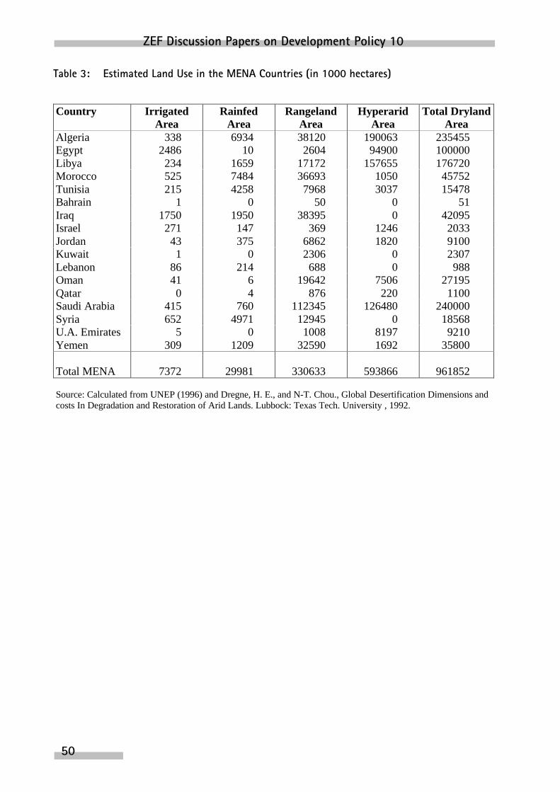
ZEF Discussion Papers on Development Policy 10
50
Table 3: Estimated Land Use in the MENA Countries (in 1000 hectares)
Country IrrigatedArea
RainfedArea
RangelandArea
HyperaridArea
Total DrylandArea
Algeria 338 6934 38120 190063 235455Egypt 2486 10 2604 94900 100000Libya 234 1659 17172 157655 176720Morocco 525 7484 36693 1050 45752Tunisia 215 4258 7968 3037 15478Bahrain 1 0 50 0 51Iraq 1750 1950 38395 0 42095Israel 271 147 369 1246 2033Jordan 43 375 6862 1820 9100Kuwait 1 0 2306 0 2307Lebanon 86 214 688 0 988Oman 41 6 19642 7506 27195Qatar 0 4 876 220 1100Saudi Arabia 415 760 112345 126480 240000Syria 652 4971 12945 0 18568U.A. Emirates 5 0 1008 8197 9210Yemen 309 1209 32590 1692 35800
Total MENA 7372 29981 330633 593866 961852
Source: Calculated from UNEP (1996) and Dregne, H. E., and N-T. Chou., Global Desertification Dimensions andcosts In Degradation and Restoration of Arid Lands. Lubbock: Texas Tech. University , 1992.

Desertification and Water Harvesting in the Middle East and North Africa
51
Table 4: Estimated Desertified Irrigated Land in the MENA Countries (in 1000 hectares)
Degree of DesertificationCountry TotalIrrigated
Area Slight Moderate Severe VerySevere
Total incl.Moderate
% ofDesertified
Area
Algeria 338 288 40 10 0 50 15%Egypt 2486 1735 700 50 1 751 30%Libya 234 179 50 5 0 55 24%Morocco 525 474 51 0 0 51 10%Tunisia 215 145 60 10 0 70 33%Bahrain 1 1 0 0 0 0 0%Iraq 1750 500 750 300 200 1250 71%Israel 271 230 31 10 0 41 15%Jordan 43 30 10 3 0 13 30%Kuwait 1 1 0 0 0 0 0%Lebanon 86 80 6 0 0 6 7%Oman 41 30 11 0 0 11 27%Qatar 0 0 0 0 0 0 0%Saudi Arabia 415 155 200 40 20 260 63%Syria 652 542 70 30 10 110 17%U.A.Emirates
5 3 2 0 0 2 40%
Yemen 309 259 40 10 0 50 16%
Total MENA 7372 4652 2021 468 231 2720 37%
Source: Calculated from UNEP (1996) and Dregne, H. E., and N-T. Chou., Global Desertification Dimensionsand Costs. In Degradation and Restoration of Arid Lands. Lubbock: Texas Tech. University , 1992.
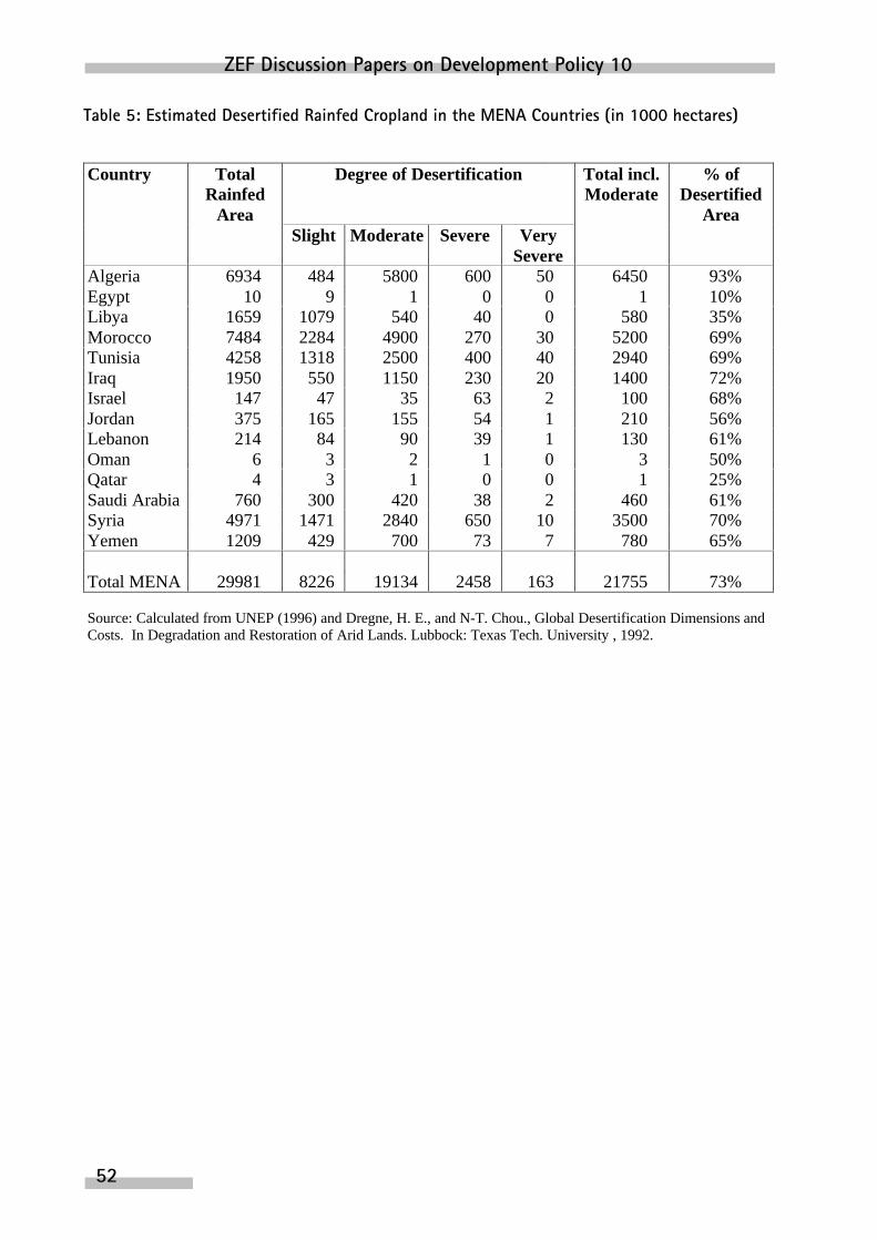
ZEF Discussion Papers on Development Policy 10
52
Table 5: Estimated Desertified Rainfed Cropland in the MENA Countries (in 1000 hectares)
Country TotalRainfed
Area
Degree of Desertification Total incl.Moderate
% ofDesertified
AreaSlight Moderate Severe Very
SevereAlgeria 6934 484 5800 600 50 6450 93%Egypt 10 9 1 0 0 1 10%Libya 1659 1079 540 40 0 580 35%Morocco 7484 2284 4900 270 30 5200 69%Tunisia 4258 1318 2500 400 40 2940 69%Iraq 1950 550 1150 230 20 1400 72%Israel 147 47 35 63 2 100 68%Jordan 375 165 155 54 1 210 56%Lebanon 214 84 90 39 1 130 61%Oman 6 3 2 1 0 3 50%Qatar 4 3 1 0 0 1 25%Saudi Arabia 760 300 420 38 2 460 61%Syria 4971 1471 2840 650 10 3500 70%Yemen 1209 429 700 73 7 780 65%
Total MENA 29981 8226 19134 2458 163 21755 73%
Source: Calculated from UNEP (1996) and Dregne, H. E., and N-T. Chou., Global Desertification Dimensions andCosts. In Degradation and Restoration of Arid Lands. Lubbock: Texas Tech. University , 1992.

Desertification and Water Harvesting in the Middle East and North Africa
53
Table 6: Estimated Desertified Rangeland in the MENA Countries (in 1000 hectares)
Degree of DesertificationCountry TotalRangeland
Area Slight Moderate Severe VerySevere
Total incl.Moderate
% ofDesertified
Area
Algeria 38120 3820 9200 25000 100 34300 90%Egypt 2604 504 300 1800 0 2100 81%Libya 17172 3472 1700 11800 200 13700 80%Morocco 36693 3693 3000 29900 100 33000 90%Tunisia 7968 1168 1270 5500 30 6800 85%Bahrain 50 40 10 0 0 10Iraq 38395 3895 7000 27250 250 34500 90%Israel 369 39 80 230 20 330 89%Jordan 6862 662 1150 5000 50 6200 90%Kuwait 2306 346 1558 400 2 1960Lebanon 688 68 159 436 25 620 90%Oman 19642 1942 5000 12650 50 17700 90%Qatar 876 86 400 385 5 790 90%Saudi Arabia 112345 22345 60000 29800 200 90000 80%Syria 12945 1345 3000 8550 50 11600 90%U.A.Emirates
1008 108 198 700 2 900
Yemen 32590 6590 10000 15900 100 26000 80%
Total MENA 330633 50123 104025 175301 1184 280510 85%
Source: Calculated from UNEP (1996) and Dregne, H. E., and N-T. Chou., Global Desertification Dimensions andCosts. In Degradation and Restoration of Arid Lands. Lubbock: Texas Tech. University , 1992.
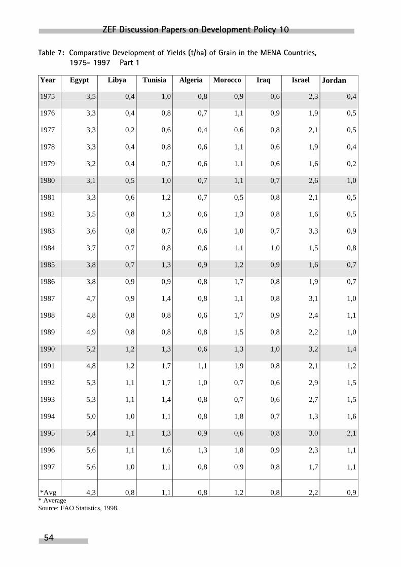
ZEF Discussion Papers on Development Policy 10
54
Table 7: Comparative Development of Yields (t/ha) of Grain in the MENA Countries, 1975- 1997 – Part 1
Year Egypt Libya Tunisia Algeria Morocco Iraq Israel Jordan
1975 3,5 0,4 1,0 0,8 0,9 0,6 2,3 0,4
1976 3,3 0,4 0,8 0,7 1,1 0,9 1,9 0,5
1977 3,3 0,2 0,6 0,4 0,6 0,8 2,1 0,5
1978 3,3 0,4 0,8 0,6 1,1 0,6 1,9 0,4
1979 3,2 0,4 0,7 0,6 1,1 0,6 1,6 0,2
1980 3,1 0,5 1,0 0,7 1,1 0,7 2,6 1,0
1981 3,3 0,6 1,2 0,7 0,5 0,8 2,1 0,5
1982 3,5 0,8 1,3 0,6 1,3 0,8 1,6 0,5
1983 3,6 0,8 0,7 0,6 1,0 0,7 3,3 0,9
1984 3,7 0,7 0,8 0,6 1,1 1,0 1,5 0,8
1985 3,8 0,7 1,3 0,9 1,2 0,9 1,6 0,7
1986 3,8 0,9 0,9 0,8 1,7 0,8 1,9 0,7
1987 4,7 0,9 1,4 0,8 1,1 0,8 3,1 1,0
1988 4,8 0,8 0,8 0,6 1,7 0,9 2,4 1,1
1989 4,9 0,8 0,8 0,8 1,5 0,8 2,2 1,0
1990 5,2 1,2 1,3 0,6 1,3 1,0 3,2 1,4
1991 4,8 1,2 1,7 1,1 1,9 0,8 2,1 1,2
1992 5,3 1,1 1,7 1,0 0,7 0,6 2,9 1,5
1993 5,3 1,1 1,4 0,8 0,7 0,6 2,7 1,5
1994 5,0 1,0 1,1 0,8 1,8 0,7 1,3 1,6
1995 5,4 1,1 1,3 0,9 0,6 0,8 3,0 2,1
1996 5,6 1,1 1,6 1,3 1,8 0,9 2,3 1,1
1997 5,6 1,0 1,1 0,8 0,9 0,8 1,7 1,1
*Avg 4,3 0,8 1,1 0,8 1,2 0,8 2,2 0,9* AverageSource: FAO Statistics, 1998.

Desertification and Water Harvesting in the Middle East and North Africa
55
Table 7: Comparative Development of Yields (t/ha) of Grain in the MENA Countries, 1975- 1997 – Part 2
Year Syria Kuwait Lebanon Oman Qatar Saudi A. Yemen Emirates
1975 0,9 1,3 1,7 0,8 2,1 1,2 1,2
1976 1,1 1,1 1,7 0,9 1,3 1,2 1,5
1977 0,8 1,1 0,8 1,3 1,7 1,1 2,2
1978 1,1 1 0,5 2,2 2,0 0,8 2,4
1979 0,9 0,9 0,5 2,2 2,1 1,1 2,0
1980 1,5 2,3 0,5 2,4 2,1 1 2
1981 1,7 1,3 1,2 2,3 2,5 1,1 1,4
1982 1,3 1,3 3,8 3,2 2,8 1,1 1,6
1983 1,2 1,1 3,8 2,7 3,3 0,7 1,3
1984 1,0 1,2 3,8 2,7 3,5 0,8 1,2
1985 1,4 0,3 1,3 1,1 2,3 3,6 1,0 1,1
1986 1,8 0,3 1,5 1,1 2,4 4,0 1,3 0,8
1987 1,4 0,4 2,0 1,1 2,3 4,4 1,5 1,9
1988 1,9 0,3 2,0 1,5 2,3 4,5 1,7 2,2
1989 0,8 0,3 2,2 1,9 2,3 4,4 1,7 1,6
1990 1,5 0,3 2,0 2,4 2,3 4,6 1,6 2,3
1991 1,7 0,3 2,2 2,3 2,3 4,5 1,2 0,9
1992 2,2 0,3 2,3 2,3 2,3 4,5 1,6 1,9
1993 2,6 0,3 2,3 2,4 2,3 4,5 1,6 1,7
1994 2,4 0,4 2,2 2,4 2,3 4,5 1,7 1,2
1995 2,5 0,5 2,5 2,4 2,3 2,8 1,7 1,4
1996 2,5 0,4 2,5 2,4 2,3 4,4 1,4 1,8
1997 1,7 0,5 2,5 2,3 2,3 5,4 1,2 0,9
*Avg 1,6 0,2 1,7 1,9 2,2 3,5 1,3 1,6* AverageSource: FAO Statistics, 1998.

ZEF Discussion Papers on Development Policy 10
56
Table 8: Livestock Density (head/ha) in the MENA Countries, 1997- 1994 – Part 1
Years Egypt Algeria Tunisia Libya Morocco Bahrain
1975 0,03 0,33 7,36 0,49 1,13 4,05
1976 0,03 0,32 7,03 0,52 1,03 4,1
1977 0,03 0,35 7,14 0,43 1,02 4,14
1978 0,03 0,37 6,15 0,44 1,02 4,18
1979 0,03 0,41 5,00 0,54 0,96 5,27
1980 0,03 0,44 5,89 0,54 1,08 5,27
1981 0,04 0,52 5,52 0,44 1,01 5,27
1982 0,04 0,54 6,02 0,53 0,68 5,5
1983 0,05 0,54 6,19 0,51 0,84 5,5
1984 0,05 0,58 6,63 0,47 0,75 5,5
1985 0,05 0,58 7 0,48 0,84 6
1986 0,05 0,59 6,46 0,44 0,95 6,8
1987 0,06 0,60 6,86 0,41 1,05 7,63
1988 0,06 0,60 6,68 0,41 0,85 8,38
1989 0,06 0,63 6,73 0,45 0,91 8,83
1990 0,06 0,65 7,25 0,47 0,90 9,32
1991 0,06 0,63 7,60 0,47 0,85 9,2
1992 0,06 0,67 7,75 0,45 0,85 9,13
1993 0,07 0,69 8,53 0,43 0,75 8,95
1994 0,07 0,64 7,49 0,40 0,82 8,63
Source: Computed from FAO Statistics for Number of Animals (Sheep and Goats) and Areas of Rangelands, 1998.
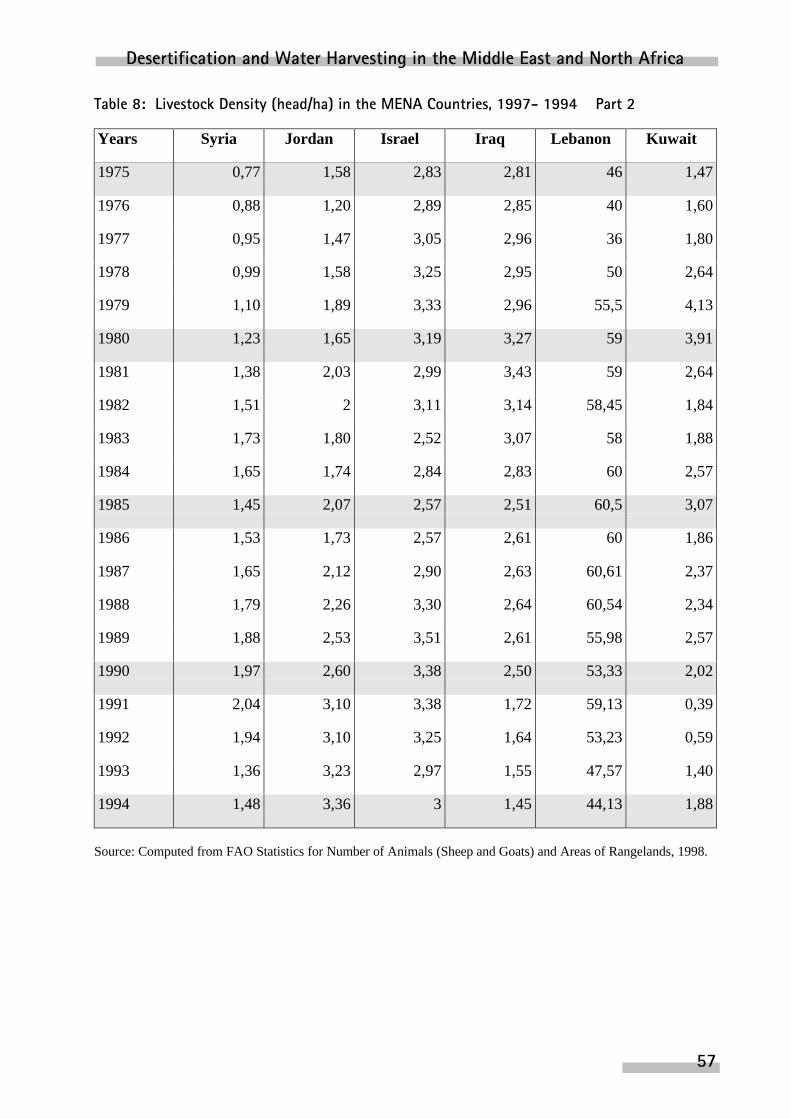
Desertification and Water Harvesting in the Middle East and North Africa
57
Table 8: Livestock Density (head/ha) in the MENA Countries, 1997- 1994 – Part 2
Years Syria Jordan Israel Iraq Lebanon Kuwait
1975 0,77 1,58 2,83 2,81 46 1,47
1976 0,88 1,20 2,89 2,85 40 1,60
1977 0,95 1,47 3,05 2,96 36 1,80
1978 0,99 1,58 3,25 2,95 50 2,64
1979 1,10 1,89 3,33 2,96 55,5 4,13
1980 1,23 1,65 3,19 3,27 59 3,91
1981 1,38 2,03 2,99 3,43 59 2,64
1982 1,51 2 3,11 3,14 58,45 1,84
1983 1,73 1,80 2,52 3,07 58 1,88
1984 1,65 1,74 2,84 2,83 60 2,57
1985 1,45 2,07 2,57 2,51 60,5 3,07
1986 1,53 1,73 2,57 2,61 60 1,86
1987 1,65 2,12 2,90 2,63 60,61 2,37
1988 1,79 2,26 3,30 2,64 60,54 2,34
1989 1,88 2,53 3,51 2,61 55,98 2,57
1990 1,97 2,60 3,38 2,50 53,33 2,02
1991 2,04 3,10 3,38 1,72 59,13 0,39
1992 1,94 3,10 3,25 1,64 53,23 0,59
1993 1,36 3,23 2,97 1,55 47,57 1,40
1994 1,48 3,36 3 1,45 44,13 1,88
Source: Computed from FAO Statistics for Number of Animals (Sheep and Goats) and Areas of Rangelands, 1998.

ZEF Discussion Papers on Development Policy 10
58
Table 8: Livestock Density (head/ha) in the MENA Countries, 1997- 1994 – Part 3
Years Saudi A. Qatar Oman Yemen Emirates
1975 0,05 1,59 0,35 0,35 1,75
1976 0,06 1,58 0,44 0,34 1,37
1977 0,06 1,55 0,54 0,35 1,73
1978 0,07 1,50 0,64 0,35 2,15
1979 0,07 2,11 0,68 0,35 2,23
1980 0,08 2,03 0,74 0,37 2,37
1981 0,07 1,88 0,77 0,38 2,48
1982 0,1 1,08 0,83 0,38 2,60
1983 0,11 1,22 0,84 0,39 2,84
1984 0,11 1,39 0,84 0,40 3,03
1985 0,10 2,80 0,9 0,40 3,25
1986 0,10 3,73 0,92 0,41 3,47
1987 0,1 4,16 0,93 0,41 3,72
1988 0,09 4,2 0,93 0,42 3,98
1989 0,08 4,32 0,94 0,43 4,26
1990 0,08 4,55 0,97 0,44 3,96
1991 0,09 4,48 0,87 0,42 3,90
1992 0,09 5,29 0,88 0,43 3,89
1993 0,09 6,16 0,88 0,44 3,88
1994 0,1 6,79 0,88 0,43 4,12
Source: Computed from FAO Statistics for Number of Animals (Sheep and Goats) and Areas of Rangelands, 1998.

Desertification and Water Harvesting in the Middle East and North Africa
59