derecho hazards in the united states · software (hart 2000). bentley and mote and bentley and...
TRANSCRIPT
Derecho Hazards in the United States
Walker S. Ashley
Climatology Research Laboratory, Department of Geography, The University of Georgia, Athens, Georgia
Corresponding author address: Walker Ashley, Climatology Research Laboratory, Department of Geography, The University of Georgia, GG Building #204, Athens, GA, 30602-2502; [email protected]

ABSTRACT
Convectively generated windstorms occur over broad temporal and spatial scales;
however, the longer-lived, larger-scale, and most intense of these windstorms have been
given the name “derecho.” Utilizing an integrated derecho database including 377 events
from 1986-2003, this investigation reveals the amount of insured property losses,
fatalities, and injuries associated with these windstorms in the United States. Individual
derechos have been responsible for up to 8 fatalities, 204 injuries, forest blowdowns
affecting over 3,000 km2 of timber, and estimated insured losses of nearly a $0.5 billion.
Findings illustrate that derecho fatalities occur more frequently in vehicles or while
boating, while injuries are more likely to happen in vehicles or mobile homes. Both
fatalities and injuries are most common outside the region with the highest derecho
frequency. An underlying synthesis of both physical and social vulnerabilities is
suggested as the cause of the unexpected casualty distribution. In addition, casualty
statistics and damage estimates from hurricanes and tornadoes are contrasted with those
from derechos to emphasize that derechos can be as hazardous as many tornadoes and
hurricanes.
Keywords: Hazards, Weather Disasters, Windstorms, Derechos, Convective Systems, United States

During the summer, hikers and canoeists often flock to Minnesota's Boundary Waters
Canoe Area Wilderness (BWCAW) to observe the beauty and tranquility of this remote
land filled with picturesque lakes and forests. However, on the 4th of July weekend in
1999 the serenity so often identified with the region briefly gave way to a terrifying
display of one of nature’s most violent storms – a derecho.
On this holiday weekend, camp counselors Emily Boyd and Maddy Bennett were
guiding a group of six teenage girls on a weeklong canoe exploration out of Moose Lake
near Ely, Minnesota. Unknown to the group, a large windstorm producing gusts in
excess of 40 m s-1, had already cut a swath of damage across northern Minnesota and was
heading straight for them. The group was canoeing on Knife Lake in the BWCAW
around noon when threatening skies brought the group to shore. The group quickly
beached their canoes and took cover in the form of the “lightning drill.”
As the storm hit, Emily and Maddy quickly pulled the girls together and huddled over
them. Watching trees crash around them, the two leaders hurried the group to an area
that appeared safer near the water’s edge. Although the storm seemed to last an eternity,
blue sky appeared on the western horizon a mere 30 minutes later.
After the storm, the group returned back to the location where they had huddled to
gather their life vests. To their shock, felled trees had crushed the vests. One can only
imagine in horror what would have happened to the girls if Emily and Maddy had not
moved them to the safer location. Emily later recalled that it was a “true miracle that no
one died in the storm that day.” Shocked, yet uninjured, the group spent the next two
days paddling over 20 miles and making 6 portages for home. Regrettably, 25 other
hikers and canoeists in the area were not as lucky and suffered injuries, including broken

backs and necks. During the next several days, rescue crews searched 2,200 campsites in
the BWCAW and Superior National Forest, evacuating about 20 campers by air
(Breining 2000).
Convectively generated windstorms occur over a wide array of temporal and spatial
scales (Fujita 1978, Fujita and Wakimoto 1981, Golden and Snow 1991); however, the
longer-lived, larger-scale, and most intense of these windstorms are termed “derechos”
(Hinrichs 1888, Johns and Hirt 1987). The 4 July 1999 windstorm that swept through the
BWCAW is an unforgettable example of the ferocity so often associated with derechos.
Johns and Hirt (1987), Johns (1993), and Wakimoto (2001) have claimed that
derechos account for much of the structural damage and casualties resulting from
convectively induced non-tornadic winds. Yet, to date, no study has examined the
damage and casualty statistics from derechos.
As indicated by Fujita and Wakimoto (1981), Doswell (1994), Bentley and Mote
(1998), and the 4 July 1999 derecho account above, the societal threat from these large
windstorms appears to be comparable to the devastation induced by a hurricane and can
exceed all but the most intense tornadoes. Changnon et al. (2001) suggest the threat from
weather disasters, including derechos, is likely to grow because of a number societal
factors, including rapid population growth and expansion together with increases in
wealth, development, and urbanization. In order to illustrate the future risk and potential
vulnerability of the U.S. population to these extreme windstorms, the following study
reveals the hazards1 associated with derechos by examining the climatology, casualty
1 Derecho hazard encompasses some aspect of derecho climatology, but also includes the effect these storms have on people and the built environment. In terms of this study, a derecho hazard is defined as any derecho that results in a human casualty or any amount of reported economic damage. This is analogous to the “tornado hazard” description provided by Boruff et al. (2003).
statistics, and damage estimates of events that occurred during the 18-yr period 1986-
2003. It is initially hypothesized that similar statistics from hurricanes and tornadoes,
when contrasted with the derecho numbers, will indicate that derechos can be as
hazardous, due to relatively high frequencies and large spatial extents, as some tornadoes
and hurricanes.
BACKGROUND
In 1888, Iowa physical scientist Gustavus Hinrichs termed any convectively induced
straight-line windstorm, or "straight blow of the prairie," a derecho (a Spanish derivative
meaning "straight-ahead" or "direct") in correspondence with the Spanish derivative
tornado (based on the Spanish word tornar – meaning to “to turn”). Fujita and Wakimoto
(1981) recognized many of the same components of Hinrichs’ definition, labeling these
events as either a downburst cluster (major damage axis between 40 km-400 km) or for
larger events, a family of downburst clusters (major damage axis of 400 km or more).
Johns and Hirt (1987), in a study of 70 derechos in the early 1980s, developed specific
criteria to define derechos utilizing contemporary terms and datasets. Broadly, Johns and
Hirt (1987) defined the derecho to include any family of downburst clusters (Fujita and
Wakimoto 1981) produced by an extratropical convective system. Specifically, using the
National Climatic Data Center’s (NCDC) publication Storm Data, the Storm Prediction
Center’s (SPCs; formerly the National Severe Storms Forecast Center) operational log of
severe weather events, and National Weather Service (NWS) radar summary charts, John
and Hirt (1987) developed formal derecho criteria (cf. their Section 2). Later studies by

Bentley and Mote (1998), Evans and Doswell (2001), Bentley and Sparks (2003), and
Coniglio and Stensrud (2004) have utilized slightly differing criteria to define derechos.
U.S. derechos have been documented in the literature since the early 1980s (e.g.,
Johns and Hirt 1983); only recently have enough events been documented over a
sufficient period to create an adequate climatology of these events. Bentley and Mote
(1998) were the first to provide an initial climatology of these systems by examining 10-
yr of these events for all seasons from 1986-1995. Bentley and Sparks (2003) recently
updated this climatology by appending the years 1996-2000, providing the basis for a 15-
yr climatology. These two studies identified the tendency for derechos to occur in
specific seasonal corridors in the eastern two-thirds of the U.S. A separate study by
Coniglio and Stensrud (2004) attempted to further identify the climatology of derechos
by systematically classifying, based on specific intensity classifications (cf. their Table
1), 244 derechos from 1986-2001.
The climatologies presented by Bentley and Mote (1998), Bentley and Sparks (2003),
and Coniglio and Stensrud (2004) do contain minor differences but, in general,
substantiate each other in regard to the relative spatial and temporal distributions.
Nevertheless, none of the studies could be considered a definitive climatology because of
issues regarding the severe storm wind event database (e.g., see Doswell and Burgess
1988, Weis et al. 2002, and Schaefer et al. 2003) and the varying criteria utilized.
However, these studies have had some success attempting to capture the character and
long-term variation of derechos. In order to generate a more thorough climatology, the
examination of many more years of derecho activity in the U.S. will be needed (Bentley
and Sparks 2003).
Numerous observational studies since the late 1980s (e.g., Johns and Hirt 1987, and
Johns et al. 1990, Johns 1993, Bernardet and Cotton 1998, Bentley and Mote 2000a,
Bentley et al. 2000, Evans and Doswell 2001, Coniglio et al. 2004) have analyzed the
synoptic and mesoscale environments of squall line and bow echo-producing mesoscale
convective systems (MCSs), including those that have produced derechos. Others (e.g.,
Rotunno et al. 1988, Weisman 1992, 1993, Coniglio and Stensrud 2001, Gale et al. 2002)
have utilized numerical simulations to investigate synoptic, mesoscale, and storm-scale
features that produce the convective systems that routinely generate derechos.
Through this brief review, it is evident that a considerable amount of research within
the meteorological community has led to an increased knowledge of derecho
environments, climatology, and an enhanced understanding of the dynamics and features
of their parent convective systems. Yet, no study has examined thoroughly the hazards
associated with derechos. Therefore, this investigation examines the casualty and damage
produced by derechos in order to provide researchers, policy makers, and emergency
managers with valuable information regarding the often-overlooked extreme straight-line
windstorms known as derechos.
RESEARCH METHODOLOGY
Derecho dataset
The contiguous U.S. derecho dataset utilized in this study was compiled through
several sources including two long-term climatological studies – Bentley and Sparks
(2003) and Coniglio and Stensrud (2004). First, a dataset containing 230 derechos
identified by Bentley and Mote (1998) and Bentley and Sparks (2003) for the period

1986-2000 was obtained (M. L. Bentley personal communication). Data utilized in the
Bentley and Mote (1998) and Bentley and Sparks (2003) studies were derived from the
SPC’s on-line database of severe convective wind gusts and the SPC’s SeverePlot
software (Hart 2000). Bentley and Mote and Bentley and Sparks (2003) modified
existing derecho identification methods proposed by Johns and Hirt (1987) in order to
facilitate analysis of the large dataset (cf. their Table 1 or Coniglio and Stensrud’s (2004)
Table 1).
Second, a derecho database produced by Michael Coniglio of the Cooperative
Institute for Mesoscale Meteorological Studies, consisting of 244 events from 1980-2001,
was acquired via the Internet2. This database has been employed in studies by Coniglio
and Stensrud (2004) and Coniglio et al. (2004). Coniglio compiled the database
(hereafter Coniglio and Stensrud (2004) dataset) utilizing the SPC’s severe convective
wind database, SeverePlot software, and available radar data.
In addition to the Bentley and Sparks (2003) and Coniglio and Stensrud (2004)
derecho datasets, the author examined all derecho literature and documented any missing
derechos not revealed by the aforementioned climatological studies. Finally, several
additional events (e.g., 13 March 1993) were added where the Johns and Hirt (1987)
length criteria were not met (e.g., squall line crossing the relatively narrow Florida
peninsula), but were indeed derechos. Finally, the author documented derechos from
2002 and 2003 by examining the SPC’s daily on-line severe storm reports, SPC’s severe
thunderstorm event database, Storm Data, and SeverePlot.
2 This dataset is available via the Internet at <http://www.nssl.noaa.gov/users/mcon/public_html/derlist.htm>
In order to be consistent with the derecho identification methodology outlined by
Coniglio and Stensrud (2004), all derechos that were previously not identified utilizing
radar data (namely, those events identified by Bentley and Mote (1998) and Bentley and
Sparks (2003)) were verified using available radar resources from NCDC, SPC, and
NASA’s Global Hydrology Resource Center. All events in the database were scrutinized
in order to make sure that multiple swaths of damage were a part of the same MCS as
indicated by the radar data. Events that did not verify were removed from the dataset.
Additionally, no attempt was made to include the requirement of a minimum of three
33 m s-1 wind gust reports as originally suggested by Johns and Hirt (1987). There appear
to be a number of unresolved issues that suggest that the inclusion of the 33 m s-1 wind
gust criteria may promote irregularities and biases in the dataset. These unresolved issues
include population biases (Johns and Evans 2000), changes in the verification practices
(Schaefer et al. 2003), significant irregularities in extreme wind gust data when examined
by NWS county warning areas of responsibility (Weiss et al. 2002; Ashley unpublished
research), and the fact that Hinrichs (1888) and Fujita and Wakimoto (1981) make no
reference to wind gust magnitudes in defining a derecho or a series of downburst clusters
(Bentley and Mote 2000b). Consequently, a set of consistent criteria (Table 1) without
this secondary wind requirement was employed to construct the derecho dataset. This set
of criterion is analogous to that proposed and utilized by Bentley and Mote (1998),
Bentley and Sparks (2003), Evans and Doswell (2001), Coniglio and Stensrud (2004),
and Coniglio et al. (2004).
After all events from the aforementioned sources were compiled, the datasets were
compared and crosschecked in order to facilitate the formation of a single, unified dataset
for use in this study. After the derecho track information (i.e., start/end locations and
times) was assembled, an effort was made to attain all severe wind reports associated
with each derecho. The track data were utilized to extract individual severe wind report
data from SeverePlot and Storm Data. This allowed for the compilation of each wind
report location, time, type, and intensity (if applicable) associated with each event for the
entire dataset. In the case of differing start (end) times obtained from coinciding Bentley
and Sparks (2003) and Coniglio and Stensrud (2004) events, the earliest (latest) wind
report obtained from the two primary datasets was utilized for identifying the derecho
start (end) time and location. The extracted wind report data were imported into a
geographic information system (GIS) in order to assure each event had spatial and
temporal continuity. Through the procedures utilized above, a consistent derecho dataset
has been derived for the U.S. utilizing consistent criteria (Table 1). In all, 377 events
were identified for the 18-yr period 1986-2003, an average of nearly 21 events per year
(Table 2).
In order to reveal spatial distributions of derechos in the U.S., wind damage and gust
reports from each derecho were mapped onto 1º latitude x 1º longitude grid. Not unlike
past studies (e.g., Bentley and Mote 1998, Coniglio and Stensrud 2004), the distributions
were determined by counting the cells that contain at least one wind report from each
event and then contouring the sum of each cell over a given temporal period utilizing
inversed-distance interpolation technique (Davis 1986). This interpolation technique
smoothes some maximum values and therefore may underestimate extreme values in the
plots. For this reason, maximum values are indicated on maps where applicable.
Casualty data
Since 1959, Storm Data has been the primary source of severe event data utilized by
meteorologists and climatologists for locating areas of storm damage and determining the
number of casualties produced by significant weather events. The process by which these
data are gathered has been reviewed by Curran et al. (2000; their Section 2) and Bentley
et al. (2002).
Although Storm Data contains the best information on storms affecting the U.S., it is
not all-inclusive owing to the difficulties inherent in the collection of these types of data.
Several studies have illustrated the problems associated with Storm Data, although most
have focused on the underreporting of casualties or damage produced by lightning
(Curran et al. 2000) or hail (Changnon 1999). As with hail and lightning casualty tallies
and damage estimates, derecho-related casualties and damage likely receive less attention
than “large-impact” events such as floods, hurricanes, and tornadoes. Thus, absolute
values obtained from Storm Data should be considered with caution (Curran et al. 2000).
As with any significant weather event, deaths and injuries are more likely to be
accurately reported than damage, which can involve intricate estimating procedures
(Changnon 2003). Therefore, there is more confidence in the casualty data than the
damage estimate data. Finally, there are a number of casualties that are indirectly related
to the storm (e.g., casualties due to “clean-up” operations). These fatalities and injuries
are not included in storm causality tallies.
Despite these inherent problems within Storm Data, it is the only consistent data
source for storm-induced casualties for the period of record. In this study, the casualty
information from Storm Data was utilized without alteration.
For a particular derecho event, Storm Data casualty statistics were coordinated with
the derecho GIS wind report data to ensure that all casualties were a consequence of the
straight-line winds from a corresponding derecho. Finally, fatality data were obtained
and tabulated for both hurricanes (Tropical Prediction Center 2004) and tornadoes
(SeverePlot and Storm Data) in an attempt to compare contiguous U.S. derecho fatalities
with those attributable to hurricanes and tornadoes. Only hurricane fatalities produced by
a landfalling or “near-miss” (i.e., in which the outer bands of the hurricane made it onto
the contiguous U.S. shoreline) hurricane were included in the U.S. hurricane fatality
statistics.
Finally, a similar interpolation procedure was utilized to reveal the spatial distribution
of derechos was performed on the casualty data. In this case, the sum of all injuries on a
1x1º grid was interpolated to illustrate the geographic patterns associated with derecho
injuries.
Damage estimates
Storm Data is the primary U.S. government source of estimated storm-induced
damage data available to researchers. Initially, Storm Data was utilized to estimate
damage totals for derechos in this study. However, estimates extracted from Storm Data
were promptly ruled inadequate because 1) damage estimates produced by NWS offices
and compiled within the publication are arbitrary and subjective; 2) in few instances are
NWS offices provided with legitimate damage estimates from necessary parties,
emergency managers, or insurance companies; 3) reporting inconsistencies and a
difference in reporting policies between NWS offices (R. L. Beasley personal

communication); and 4) lack of estimates for described damages. Therefore, a second,
independent, record of estimated losses to the insurance industry was employed to
provide a potential assessment of the insured losses due to derechos and to illustrate
further the major drawbacks when estimating damage totals using solely the resources of
Storm Data. These data – the Property Claims Service’s (PCS) catastrophe database –
were obtained from the Insurance Services Office, Inc (ISO; G. Kerney personal
communication). The catastrophe database includes estimated industry-wide insurance
payments for property lines of insurance covering fixed property, building contents, time-
element losses, vehicles, and inland marine diverse goods and properties (ISO 2004).
Crop losses due to perils are not included but insured farm buildings and equipment are
included in the catastrophe estimates.
From 1986-1996, the PCS dataset identified an event (or series of related events) as a
catastrophe if that storm episode caused over $5 million in total insured property losses.
In 1997, a shift was made from $5 to $25 million in order to adjust for the effects of
inflation on the selection of catastrophes (Changnon 2001, ISO 2004). These data have
been utilized in the past to estimate property losses resulting from thunderstorm perils
(Changnon 2001) and hurricanes (Tropical Prediction Center 2004). Furthermore, a
recent evaluation of loss data from natural hazards identified the PCS data as the nation’s
best available data (National Research Council 1999, Changnon 2001).
For each qualifying thunderstorm-caused catastrophe, the PCS dataset included the
event’s date(s), the conditions/perils causing the losses, and the amount of insured losses
by state. Unfortunately, the insured losses are estimated for all storm perils, making it
difficult to separate the cost of each peril (e.g., hail from wind). In effect, then, extracting

only derecho wind damage loss from the PCS estimates was not possible except in a
single case (20 November 1989) where the only peril associated with the catastrophe was
wind. In all other cases, losses from flooding, hail, and/or tornadoes were included in the
catastrophe database. In these situations, only insured damage from derechos that lack
considerable tornado, hail, and flood events were tallied utilizing the PCS data. In
making this subjective judgment, the use of detailed verbal descriptions of damage that
often accompany the events in Storm Data, the analysis utilities of NCDC’s Severe Storm
Event database, and the mapping utilities of SeverePlot were employed to assure that the
damage losses were predominantly due to the straight-line winds associated with a
derecho. Events that had substantial damage due to a tornado along the leading edge of a
bow-echo producing system were not excluded. Conversely, events that had any
significant (F2 or greater) tornadoes that were separate of the derecho-producing MCS
and produced considerable damage were removed from the estimating procedure. Only
42 derechos met these criteria and were included in derecho insured loss analysis.
The aforementioned procedure indicates the difficulty in trying to estimate damage
losses strictly from derechos. Estimating damage tallies from any storm peril is a
subjective procedure (Changnon 2003). The estimates provided are utilized for
comparative purposes and to obtain a sense of the damage potential from these extreme
windstorms. The estimates are not intended to be accurate enough to provide precise,
flawless derecho damage tallies.
For comparison purposes, the estimated loss data were adjusted for inflation (to 2003
dollars in this study) utilizing an implicit price deflator for gross national product, as
reported in the Economic Report of the President (Office of the President 2004). Because
this study is not examining trends in normalized damage tallies, it is not as important to
control for wealth or population as conducted in previous research on hurricanes and
tornadoes (Pielke and Landsea 1998, Brooks and Doswell 2001).
RESULTS
Climatology
Studies by Bentley and Mote (1998), Bentley and Sparks (2003), and Coniglio and
Stensrud (2004) have revealed the major geographical distributions and high-frequency
corridors of derechos. However, each of the climatologies presented in the past have
employed differing datasets and mapping techniques to reveal the distribution of
derechos in the U.S. The jointly compiled dataset utilized in this study (i.e., including
events from two recent long-term derecho climatologies – Bentley and Sparks (2003) and
Coniglio and Stensrud (2004)) provides a unique opportunity to extend (i.e., with the
addition of 2002-03 derechos) and briefly reevaluate the preexisting climatology of
derechos. This process highlights the threat any one particular region of the U.S. has to
derechos and subsequently may be employed to develop a risk-assessment of derechos.
When examining derechos for the entire year for the 18-yr period of record (Fig. 1), a
similar derecho spatial pattern to that produced by Bentley and Sparks (2003; their Fig.
14) is evident. Prominent features in the derecho geographical distribution include 1) a
southern Great Plains maximum located over the northeast portion of Oklahoma; 2) an
axis of higher derechos frequencies extending from the Oklahoma maximum
southeastward toward the southern Mississippi Valley region; and 3) a high-frequency
axis that corresponds with Johns’ (1982, 1984) northwest-flow severe weather events
extending from the upper Midwest into the Ohio Valley. The southern Great Plains
maximum likely occurs since this region is affected by both cool and transition-season
serial (Johns and Hirt 1987) events associated with traveling mid-latitude cyclones (Fig.
2.b) and warm-season, progressive (Johns and Hirt 1987) events (Fig. 2.a) while more
poleward locales are affected by primarily warm-season, progressive events. Similar to
the results of Bentley and Mote (1998) and Coniglio and Stensrud (2004), cool-season
derecho maxima are found along the southern Mississippi Valley, while warm-season
event maxima are found in the south-central Great Plains and the Ohio Valley.
Temporally, derechos are primarily warm-season events, with 69% of the events in
the compiled dataset occurring between May and August during the 18-yr period (Fig. 3).
As established in Bentley and Sparks (2003), May has the highest derecho monthly
frequency with, on average, nearly five events occurring annually during this month.
Casualties
Summary studies of thunderstorm-induced, straight-line wind casualties are limited.
In fact, most investigations that examine annual summaries of weather-related fatalities
or injuries typically focus on floods, lightning, hurricanes, and/or tornadoes (e.g.,
Riebsame et al. 1986, Curran et al. 2000). Therefore, it is important to illustrate the
hazards associated with derechos by first examining the number of casualties these events
have produced in the past and compare those statistics with those of other thunderstorm-
related perils.
Fatalities and injuries were tallied for all 377 derechos in the study. There were 153
fatalities during the 18-yr period of record (8.5 yr-1) attributable to damaging straight-line

winds from derechos. The number of fatalities per year is highly variable – from 21 in
1998 to no fatalities in 1988. Examining the derecho fatalities spatially (Fig. 4) indicates
an interesting distribution that does not necessarily correspond with derecho frequencies
across the U.S (Fig. 1). Three northern states, Michigan (17 fatalities), New York (23),
and Ohio (16), contain nearly 37 % of all derecho fatalities. This is somewhat
counterintuitive as one would expect the highest fatality rates in regions with the greatest
likelihood of derecho occurrences (i.e., across the south-central Great Plains). Several
possible explanations could account for this unusual distribution, including: 1) the
tendency for more outdoor-related activities (e.g., camping) in state parks and wilderness
areas of Michigan and New York [increased vulnerability]; 2) boating activities along the
Great Lakes [increased vulnerability]; 3) the increased likelihood of particularly intense,
warm-season derechos across the northern-tier of the U.S. (Coniglio and Stensrud 2004)
[increased vulnerability]; 4) a heightened awareness of severe storms by people in the
southern Great Plains states due to the high frequency of extreme thunderstorm-related
perils in this region [reduced vulnerability]; and 5) the existence of better warning
systems in the southern Great Plains [reduced vulnerability]. Thus, it is possible that
there is some underlying integration of both physical and social vulnerabilities
attributable to the observed derecho fatality distribution (Riebsame et al. 1986).
When examining derecho fatalities by type, boating and vehicular deaths accounted
for nearly 50% of all fatalities (Fig. 5). In the majority of cases, vehicular fatalities
occurred in one of three ways: 1) overturned tractor semi-trailer; 2) felled tree landing on
automobile; or 3) an automobile driven into a felled tree. Marine fatalities principally

occurred as drownings when either sailing vessels or motorized boats were overturned
due to high derecho winds.
The deadliest derechos on record include events occurring on 16 August 1997 (8
fatalities), 31 May 1998 (6), 15 July 1995 (6), 12 July 1995 (5), and 20 July 1987 (5). In
terms of total casualties, there are several derechos that have caused over 100 reported
casualties, including 31 May 1998 (210), 09 April 1991 (135), 04 June 1993 (110), and
10 February 1990 (103).
On average, 145 injuries per year were attributable to derechos; however, annual
values were highly variable with a maximum of 606 injuries occurring in 1998 and a
minimum of 3 injuries occurring in 1988 (Table 2). In terms of spatial distribution (Fig.
6), derecho injuries were clustered around several specific regions including 1) Lake
Michigan; 2) the Interstate 95 corridor in the Northeast; 3) the Ohio River Valley; 4) the
interior of the Southeast; and 4) the south-central Great Plains. Like fatalities, the higher
frequency of injuries tends to occur outside of regions of the highest derecho frequency
maxima. The states of Kentucky (333 injuries), Michigan (200), and Illinois (187) are
highest in terms of derecho injuries.
Unlike fatalities, a considerable number of the injuries reported in Storm Data are not
accompanied by a description of how the injuries occurred other than that they were
caused by thunderstorm-related winds. In fact, nearly 40 % of all derecho injuries
reported in Storm Data have no description of injury type. The remaining 60 % of
injuries were classified according to how or where the injury occurred revealing a
different distribution by type (Fig. 7) than derecho fatalities (Fig. 5). Injuries in mobile
homes (23% of classifiable injuries) and vehicles (21% of classifiable injuries) lead all

other injury types by a considerable margin. Other high-frequency injury types
(accounting for nearly 10% of classifiable injuries each) include camping, flying debris,
permanent structures/homes, and temporary structures (i.e., recreational or special-event
tents).
Comparing derecho casualties to those produced by all thunderstorm winds for the
period 1993-2003 indicates that derechos do not account for the majority of casualties
due to non-hurricane and non-tornadic winds. In terms of fatalities (injuries), derechos
accounted for 38.8 % (39.9 %) of all fatalities (injuries) caused by thunderstorm winds
during this 11-yr period.
Derecho, hurricane, and tornado casualty comparisons
In order to illustrate that derechos can be as hazardous as most hurricanes and
tornadoes, a comparison between derecho-induced fatalities and those produced from
contiguous U.S. hurricanes and tornadoes was constructed for the derecho dataset period
of record (Table 3). Derecho fatalities exceed fatalities from F0 and F1 tornadoes by a
wide margin but account for fewer deaths than those produced by F0, F1, and F2
tornadoes combined. If one considers that F0 and F1 tornadoes account for nearly 88 %
of all U.S. tornadoes from 1986-2003, then derechos exceed the number of fatalities
produced by most tornadoes.
Hurricane fatalities surpass those caused by derechos; though, if the anomalously
high fatality rates from Floyd (56) and Fran (34) are removed, the fatality statistics are
essentially comparable. It is important to consider that hurricane fatality statistics include
deaths related to hurricane-spawned tornadoes, floods, and rip-tides. For this study, those
deaths attributable to tornadoes embedded within or floods attributable to derecho-
producing convective systems were not included. Hence, it is possible that fatalities from
derechos exceed those fatalities induced solely by hurricane winds.
Damage estimates
Straight-line winds associated with derechos have been officially measured at over 60
m s-1 (e.g., 64.4 m s-1 on 22 April 1997, 67.5 m s-1 on 16 July 1980), equivalent to the
sustained winds of a Category 4 hurricane. A number of damage surveys from Storm
Data suggest higher wind gusts have occurred with some events. Although most wind
speeds in derechos never approach these levels of severity, the straight-line winds
meeting even minimal derecho criteria (26 m s-1) can topple trees onto automobiles,
overturn tractor semi-trailers, or damage mobile homes. Undoubtedly, derechos have the
ability to produce substantial damage in regions impacted by these events.
Previous studies that have documented derechos have very limited descriptions
regarding damage summaries or estimates. When estimates are presented for events, they
are typically deduced from Storm Data. There is only one case in the literature that
highlights, in detail, the damaging potential of a derecho. Fujita and Wakimoto (1981)
provided extensive documentation of the 16 July 1980 derecho that produced widespread
damage across large areas of Michigan, Illinois, Wisconsin, and Minnesota. They
indicated that this storm produced approximately $650 million in damage as it traversed
the four-state region. Accounting for inflation (to 2003 dollars), this storm produced an
estimated $1.3 billion in damage from strictly straight-line winds. This estimate exceeds
many damage tallies from U.S. hurricanes and is larger than the inflation-adjusted
damage estimates from all major tornadoes that have affected the U.S. since 1890
(Brooks and Doswell 2001). This single event illustrates that derecho damage can
exceed the damage from most hurricanes and tornado events affecting the contiguous
U.S.
Unfortunately, detailed damage summaries as that provided by Fujita and Wakimoto
(1981) are not available for other derechos. Therefore, the PCS catastrophe dataset was
employed to estimate the impact derechos have had on the insured built environment. In
total, 206 of the 377 derechos in the dataset (54.6%) were associated with 129 separate
PCS catastrophe events. All thunderstorm perils (flooding, hail, tornadoes, and wind)
associated with these 129 catastrophe events were responsible collectively for nearly $33
billion (2003 dollars) in insured losses. In some cases multiple derechos (i.e., derecho
“families” (Bentley and Sparks 2003, Ashley et al. 2003)) were a part of the same PCS
defined catastrophe.
A detailed process was utilized to extract PCS damage estimates for derechos.
Estimated insured losses due to derechos are provided to illustrate the devastating impact
these events can have on the built environment and compare these statistics with
analogous data from U.S. hurricanes. A number of extremely intense derechos or
families (e.g., 08 July 1993, 15 May 1998 family, 4-7 July 2003 family) were excluded
from this analysis because these events were accompanied by considerable damage
produced by flooding, hail, or tornadoes and, therefore, could not be accurately assessed
for damages solely due to derecho winds. Hence, the “high-end” damage potential of the
most intense derechos is likely not illustrated in this analysis.
In all, nine derechos and derecho families producing more than $100 million in
insured losses were identified from the methods utilized in this study (Table 4). The
costliest derecho identified was the 31 May 1998 event that affected the Great Lakes
region. This event was responsible for $432 million in insured property losses across the
states of Minnesota, Wisconsin, and Michigan. Interestingly, this is the only event in
which Storm Data property damage estimates exceeded values obtained from the insured
losses estimated from PCS. In all other derecho cases from 1996-2002, PCS estimates
exceed, in some instances, by an order of magnitude, the estimates provided by Storm
Data. Storm Data accounts for only 39.6 % of the PCS damage losses from the 27 events
in which both Storm Data and PCS data were available. This is especially troubling since
Storm Data estimates account for both insured and non-insured losses while PCS data
report only insured losses. This suggests that estimated damage totals from derechos can
not be deduced from Storm Data.
The PCS catastrophe database includes insured losses from hurricanes and is the
primary dataset employed by NOAA’s Tropical Prediction Center to estimate damage
from Hurricanes. [The Tropical Prediction Center utilizes a 2:1 ratio to estimate total
damage from hurricanes and therefore multiplies the PCS insured loss estimate by two to
obtain a Hurricane total (J. L. Beven personal communication). Since there is no
published reasearch to support this ratio, it was not utilized in this study.] The most
damaging hurricanes affecting the U.S. from 1986-2003 were compared to the estimated
insured damages from derechos obtained from this study (Table 5). Clearly, certain
hurricanes (e.g., Andrew, Hugo, etc.,) are in a category unto themselves and result in
enormous insured damage estimates. However, individual derechos or families of
derechos appear to approach the damage potential of some of the most damaging
hurricanes in the 18-yr period of record. For example, the 31 May 1998 case exceeded
estimates from Hurricane Erin and Bonnie and approached the insured losses produced
by Hurricane Lilly. It is likely that other extreme derechos events have exceeded the 31
May 1998 case (e.g., 16 July 1980) and are comparable to the most damaging hurricanes
in U.S. record.
Forest blowdowns
Not included in either PCS or Storm Data estimates is the impact derechos have on
both private and public forests throughout the U.S. Several derechos have produced
extensive forest blowdowns including the “Independence Day Downbursts” of 04 July
1977 (3440 km2 of forest affected; see Fujita 1985), the two Minnesota derechos of 13
and 14 July 1995 (810 km2 destroyed; Storm Data 1995), the “Adirondack” derecho of
15 July 1995 (3642 km2 affected; 505 km2 sustaining moderate to severe damage; Storm
Data 1995), and the “Boundary Waters” derecho of 04 July 1999 (2691 km2 affected;
1934 km2 destroyed; Parke and Larson 2004, Price and Murphy 2003). The
meteorological community often labels these blowdown events as Pakwashs after the
Pakwash Provincial Forest in Northwest Ontario, Canada, that was impacted severely by
a derecho that occurred on 18 July 1991 (Cummine et al. 1992). Derecho-produced
blowdowns have altered forest landscapes and community dynamics by influencing tree
mortality rates, reducing tree size and structure, decreasing forest diversity, and
modifying species composition by advancing succession status (Peterson 2000).
The financial impact these events have on forests is difficult to approximate. Some
assessments have been provided including a monetary estimate of the impact the 15 July
1995 derecho had on the Adirondack Park in New York. The New York Department of
Environmental Conservation indicated that the timber damage due to the derecho was
estimated at 1 billion board feet with an estimated value of $234 million (2003 dollars;
Storm Data 1995). Unfortunately, damage to forests is not the only hazard realized by
these events. In some cases, campers and hikers visiting these forests during the height
of the tourist season have been killed or seriously injured by derecho-felled trees.
Derechos have even sparked intense political debates at the state and national levels
regarding what to do with the disturbed forests left in the wake of these windstorms.
Both the “Adirondack” and “Boundary Waters” derechos were responsible for extremely
contentious debates on whether salvage logging operations should be permitted in public
forests after large blowdowns. In the case of Adirondack Park, salvage operations had
been in place for nearly 50 years on the grounds of fire prevention and forest
conservation. However, following the assessment of state conservation officers and
consulting ecologists, the State of New York enacted to forgo salvaging operations in the
Adirondack forest after the derecho. The final assessment concluded that the large forest
disturbance produced by the derecho should be treated as a normal ecosystem process
(Robinson and Zappieri 1999).
Finally, the potential for catastrophic fires in forests affected by derechos is often
extremely high due to dramatic increases in the volatility and fuel loading brought about
by the felled timber. For example, the U.S. Forest Service Fuels Risk Assessment report
detailing the 04 July 1999 derecho impacts on the BWCAW suggested that it is not a

matter of if, but when, a large significant wildland fire will threaten the wilderness
(Leuschen et al. 2001).
SUMMARY AND CONCLUSIONS
Assessing the human and economic impacts of derechos has received considerable
less attention in comparison to “large-impact” events such as floods, hurricanes, and
tornadoes. By consolidating and extending the record of U.S. derechos, this investigation
quantitatively and qualitatively revealed the impacts derechos have had on the nation
from 1986-2003. Results indicate that derecho hazards (defined as derechos that result in
injury, death, or economic loss) can be as substantial as hurricanes and tornado hazards.
For the 18-yr period investigated, derechos were responsible for 153 fatalities and
over 2,600 injuries. These casualties were highly variable yet appeared to be coupled
with the corresponding annual frequency in derechos. Derecho fatalities are comparable
to those produced by recent U.S. hurricanes and exceed the fatalities caused by more than
88 % of the tornadoes that have affected U.S from 1986-2003. Individually, derechos
were responsible for up to 8 fatalities and 204 injuries indicating that these storms can
have a substantial human impact. Derecho fatalities have a propensity to occur more
frequently in vehicles or while boating, while injuries are more likely to happen in
vehicles or mobile homes. Both fatalities and injuries are more inclined to occur outside
of the region that possesses the highest derecho frequency. An underlying synthesis of
both physical and social vulnerabilities is suggested as the cause for the casualty
distribution. Contrary to assertions in previous studies (Johns and Hirt 1987, Johns 1993,
Wakimoto 2001), results from this investigation suggest that derechos do not account for
a majority of the casualties owing to convectively induced non-tornadic winds.
Utilizing catastrophe statistics compiled from the insurance industry, this
investigation was able to obtain a sense of the financial impact derechos can incur.
Damage estimates obtained from the PCS insurance catastrophe database were compared
with similar figures from Storm Data to reveal inadequacies in the U.S. government’s
only publication estimating losses from natural disasters. Results suggest that Storm Data
severely undercounts derecho damage totals (in some cases, by an order of magnitude)
and is therefore inadequate for estimating damage totals from derechos. It is likely that
Storm Data is not practicable for estimating damage totals for other thunderstorm-related
perils, as well.
A selective number of derechos were extracted from the dataset with the intention of
providing an estimate of the insured loss due these windstorms. Insured losses from
many derechos and derecho families were found to exceed $100 million dollars with one
event (31 May 1998) nearing $0.5 billion in estimated insured losses. These estimated
losses are comparable to some of the U.S.’s most noteworthy hurricanes in the last 18 yr
and are equivalent to the most damaging tornadoes in the U.S. history (Brooks and
Doswell 2001). According to Fujita and Wakimoto (1981), derechos have exceeded $1
billion dollar threshold in the past; however, in this study no events inducing this amount
of economic impact were identifiable do to constraints imposed by the data and
procedures employed. Derecho damage tallies are likely to be even higher than that
measured in this study as no estimate was provided for noninsured damages or
governmental expenditures, since some states that were impacted by derechos were not

included in the damage estimates, and because several of the most extreme derechos in
the past 18 yr were not included in the damage analysis. Further, the economic impact
due to derecho-induced forest blowdowns is often indeterminate and is therefore typically
excluded from the loss estimates. In one case (15 July 1995), an official estimate
suggested that over $230 million in board timber was lost due to a derecho.
Future study should try to extend the climatological record to increase our
understanding of how these events form and where they most frequent. A considerable
effort should be made to increase the amount of in-depth loss investigations into future
derechos in order to obtain meaningful estimates of actual economic impacts produced by
these windstorms. For example, detailed studies into the 1988 drought (Riebsame et al.
1991), Hurricane Andrew (Pielke 1995), and the Great Flood of 1993 (Changnon 1996)
have assisted in creating a new awareness of data problems and have improved the
estimating procedures associated with each of these perils (Changnon 2003). As
suggested by Changnon (2003), the nation needs a concerted effort, and a continuing
program, to routinely assess and measure the losses from weather extremes, including
derechos, in order to adequately monitor the ever-growing impact of weather disasters,
improve mitigation efforts, and make informed decisions on policies that address hazard
issues.
In summary, the results of this analysis indicate that derechos can be as hazardous
and are comparable in magnitude to most U.S. tornadoes and hurricanes. The study has
attempted to inform scientists, emergency managers, insurers, and the public on the
severity of derechos so that they may take steps to mitigate the potential future hazards of
these tremendous windstorms.

ACKNOWLEDGEMENTS
Thanks to Drs. Thomas Mote and Mace Bentley for providing insightful comments that
improved the initial version of the manuscript, Jamie Dyer for providing an analysis
routine, Dr. Mace Bentley and Michael Coniglio for the availability of their derecho
datasets, and Gary Kerney and Jim Welsh for supplying the PCS data and answering
many questions regarding the collection of the data. Finally, sincere thanks to Emily
Boyd who graciously shared her “Boundary Waters” derecho account and answered
numerous questions about the event as well as provided pictures of the damage. This
research was supported by a cooperative agreement between the USDA Forest Service
and the University of Georgia.

REFERENCES Ashley, W. S., unpublished research: An Examination into Non-meteorological
Influences on the Climatology of Derecho-producing Convective Systems in the United States. [Available online at http://shrmc.ggy.uga.edu/publications/StatisticalPaper.pdf]
Ashley, W. S., M. L. Bentley, T. L. Mote, and J. L. Dyer, 2003: A preliminary
investigation into derecho families. 28th Annual Meeting of the National Weather Association, Jacksonville, FL. [Available online at http://shrmc.ggy.uga.edu/publications/2003NWA_WalkerPoster.pdf]
Bentley, M.L., and T. L. Mote, 1998: A climatology of derecho-producing mesoscale
convective systems in the central and eastern United States, 1986–95. Part I: Temporal and spatial distribution. Bull. Amer. Meteor. Soc., 79, 2527–2540.
Bentley, M.L., and T. L. Mote, 2000a: Synoptic-scale conditions associated with derecho
producing mesoscale convective systems in the cool season. Phys. Geog., 21, 21-37.
Bentley, M.L., and T. L. Mote, 2000b: A Reply to: Comments on “A climatology of
derecho producing mesoscale convective systems 1986 - 1995, Part I: Temporal and spatial distribution.” Bull. Amer. Meteor. Soc., 81, 1054-1057.
Bentley M.L., and J.A. Sparks, 2003: A 15 yr climatology of derecho-producing
mesoscale convective systems over the central and eastern United States. Clim. Research., 24, 129-139.
Bentley, M.L., T. L. Mote, and S. F. Byrd, 2000: A synoptic climatology of derecho
producing mesoscale convective systems in the north-central Plains. Int. J. Climatology., 20, 1329-1349.
Bentley, M.L., T. L. Mote, and P. Thebpanya. 2002: Using Landsat to identify
thunderstorm damage in agricultural regions. Bull. Amer. Meteor. Soc, 83, 363–376.
Bernardet, L.R., and W.R. Cotton, 1998: Multiscale evolution of a derecho-producing
mesoscale convective system. Mon. Wea. Rev., 126, 2991-3015. Boruff, B. J., J. A. Easoz, S. D. Jones, H. R. Landry, J. D. Mitchem, and S. L. Cutter,
2003: Tornado hazards in the United States. Climate Research, 24, 103-117. Breining, G., 2000: Boundary Wathers: The fire next time. Minnesota Conservation
Volunteer, Minnesota Department of Natural Resources, May-June. [Available online at http://www.dnr.state.mn.us/volunteer/mayjun00/blowdown.html]

Brooks, H. E., and C.A. Doswell, III, 2001: Normalized damage from major tornadoes in the United States: 1890–1999. Wea. Forecasting, 16, 168–176.
Changnon, S. A., 1996: Losers and winners: A summary of the flood’s impacts. The
Great Flood of 1993, S. Changnon, Ed. Westview Press, 276-299. Changnon, S. A. 1999: Data and approaches for determining hail risk in the contiguous
United States. J. Appl. Met., 38, 1730–1739. Changnon, S.A. 2001: Damaging Thunderstorm Activity in the United States. Bull. Amer.
Meteor. Soc., 82, 597–608. Changnon, S.A. 2003: Measures of Economic Impacts of Weather Extremes. Bull. Amer.
Meteor. Soc., 84, 1231–1235. Changnon S.A, D. Changnon, and G. Hewings, 2001: Losses caused by weather and
climate extremes: A national index for the U.S. Phys. Geogr., 22, 1-27. Coniglio, M.C., and D.J. Stensrud, 2004: On the climatology of derechos. Accepted for
publication, Wea. Forecasting. Coniglio, M. C., Stensrud, D. J., and M. B. Richman, 2004: An observational study of
derecho-producing convective systems. Wea. Forecasting, 19, 320–337. Curran, E. B., R. L. Holle, and R. E. López, 2000: Lightning casualties and damages in
the United States from 1959 to 1994. J. Climate, 13, 3448–3464. Davis, J. C., 1986: Statistics and Data Analysis in Geology. 2d ed., John Wiley and Sons,
656 pp. Doswell, C.A., III, 1994: Extreme convective windstorms: Current understanding and
research. Rep. of the Proceedings (1994) of the U.S.-Spain Workshop on Natural Hazards (Barcelona, Spain, 8-11 June 1993), J. Corominas and K.P. Georgakakos, Eds., pp. 44-55. [Available from the Iowa Institute of Hydraulic Research, University of Iowa, Iowa City, Iowa 52242].
Doswell, C.A., III, and D.W. Burgess, 1988: On some issues of United States tornado
climatology. Mon. Wea. Rev., 116, 495-501. Evans, J.S., and Doswell, C.A., III, 2001: Examination of derecho environments using
proximity soundings. Wea. Forecasting, 16, 329–342. Fujita, T.T., 1978: Manual of downburst identification for project NIMROD. SMRP Res.
Paper No. 156, Univ. of Chicago, NTIS Accession No. N78-30771/7GI, 104 pp.
Fujita, T. T., 1985: The Downburst - Microburst and Macroburst. Univ. of Chicago Press, 122 pp.
Fujita, T.T., and R.M. Wakimoto, 1981: Five scales of airflow associated with a series of
downbursts on 16 July 1980. Mon. Wea. Rev., 109, 1438-1456. Gale, J.J., Gallus, W.A., Jungbluth, K.A. 2002: Toward improved prediction of
mesoscale convective system dissipation. Wea. Forecasting, 17, 856–872. Golden, J. H. and J. T. Snow, 1991. Mitigation against extreme windstorms. Rev.
Geophy., 29, 477-504. Hart, J. A., 1993: SVRPLOT: A new method of accessing and manipulating the NSSFC
severe weather database. Preprints, 17th Conf. Severe Local Storms, St. Louis, MO, Amer. Meteor. Soc., 40-41. [Software available online at http://www.spc.noaa.gov/software/svrplot2/]
Hinrichs, G., 1888: Tornadoes and derechos. Amer. Meteor. Journal, 5, 341-349. Insurance Services Office, Inc., 2004: Catastrophe loss estimate procedure description.
Property Claim Services, 7pp. [Available from Gary Kerney via email at [email protected]]
Johns, R. H., 1982: A synoptic climatology of northwest flow severe weather outbreaks.
Part I: Nature and significance. Mon. Wea. Rev., 110, 1653-1663. Johns, R. H., 1984: A synoptic climatology of northwest flow severe weather outbreaks.
Part II: Meteorological parameters and synoptic patterns. Mon. Wea. Rev., 112, 449-464.
Johns, R. H., 1993: Meteorological conditions associated with bow echo development in
convective storms. Wea. Forecasting., 8, 294-299. Johns, R. H., and J. S. Evans, 2000: Comments on “A climatology of derecho producing
mesoscale convective systems 1986 - 1995, Part I: Temporal and spatial distribution.” Bull. Amer. Meteor. Soc., 81, 1049-1054.
Johns, R. H., and W. D. Hirt, 1983: The derecho: A severe weather producing convective
system. Preprints, 13th Conf. on Severe Local Storms, Tulsa, OK, Amer. Meteor. Soc., 178-181.
Johns, R. H., and W. D. Hirt, 1987: Derechos: widespread convectively induced
windstorms. Wea. Forecasting, 2, 32-49. Johns, R. H., K. W. Howard, and R. A. Maddox, 1990: Conditions associated with long-
lived derechos - An examination of the large-scale environment. Preprints, 16th
Conf. Severe Local Storms, Kananaskis Park, AB, Can., Amer. Meteor. Soc., 408-412.
Leuschen, T, T. Wordell, M.A. Finney, D. Anderson, T. Aunan and P. Tiné. 2000. Fuels
risk assessment of blowdown in Boundary Waters Canoe Area Wilderness and adjacent lands. Superior National Forest, Duluth, MN, USA. [Available online at http://www.superiornationalforest.org/july4thstorm1999/bwcara/bwcawra.html]
National Research Council, 1999: The costs of natural disasters: A framework for
assessment. National Academy Press, 68 pp. Office of the President, 2004: Economic report of the president. U.S. Government
Printing Office, Washington, DC, 417 pp. [Available online at http://www.gpoaccess.gov/eop/]
Parke, P. S. and N. J. Larson, 1999: The boundary waters windstorm of July 4, 1999.
NWS, Duluth, MN. [Available online at http://www.crh.noaa.gov/dlh/science/] Peterson, C. J., 2000: Catastrophic wind damage to North American forests and the
potential impact of climate change. Science of the Total Environment, 262, 287-311.
Pielke, R. A., Jr., 1995: Hurricane Andrew in South Florida: Mesoscale weather and
societal responses. ESIG, National Center for Atmospheric Research, Boulder, CO, 156 pp.
Pielke, R. A., and C. W. Landsea, 1998: Normalized hurricane damages in the United
States, Wea. Forecasting, 13, 621–631. Price, C. G., and B. P. Murphy, 2002: Lightning activity during the 1999 Superior
derecho. Geophys. Res. Lett., 29, 57-1 Riebsame, W. E., S. A. Changnon, and T. Karl, 1991: Drought and Natural Resources
Mangement in the United States: Impacts and Implications of the 1987-1989 Drought. Westview Press, 174 pp.
Riebsame, W. E., H. F. Diaz, T. Moses, and M. Price, 1986: The social burden of weather
and climate hazards. Bull. Amer. Meteor. Soc., 67, 1378-1388. Rotunno, R., J. B. Klemp, and M. L. Weisman, 1988: A theory for strong, long-lived
squall lines. J. Atmos. Sci., 45, 463-485. Schaefer, J. T., S. J. Weiss, and J. J. Levit, 2003: The frequency of severe thunderstorm
winds over the contiguous United States. 11th International Conf. On Wind Engineering, Lubbock, TX. 8 pp.

NCDC, 1986-2003: Storm Data. 28-45 [Available from National Climatic Data Center, Federal Building, Ashville, NC 28801.]
Robinson, G. R., and J. Zappieri, 1999: Biodiversity policy in time and space: Lessons
from divergent approaches to salvage logging on public lands. Conservation Ecology, 3. [Available online at http://www.ecologyandsociety.org/vol3/iss1/art3/]
Tropical Prediction Center, 2004: NHC/TPC archive of past hurricane seasons: Hurricane
Season Tropical Cyclone Reports. [Available online at http://www.nhc.noaa.gov/pastall.shtml]
Wakimoto, R.M., 2001: Convectively driven high wind events. Meteor. Monogr., 7,
Amer. Meteor. Soc., 255-298. Weiss, S.J., J.A. Hart, and P.R. Janish, 2002: An examination of severe thunderstorm
wind report climatology: 1970-1999. Preprints, 21st Conf. Severe Local Storms, San Antonio, TX, Amer. Meteor. Soc., 446-449.
Weisman, M. L., 1992: The role of convectively generated rear-inflow jets in the
evolution of long-lived mesoscale convective systems. J. Atmos. Sci., 49, 1826-1847.
Weisman, M. L., 1993: The genesis of severe, long-lived bow echoes. J. Atmos. Sci., 50,
645-670.
Table 1. Criteria used to identify derechos for this study.
1 There must be a concentrated area of convectively induced wind gusts greater than 26 m s-1 that has a major axis length of 400 km or more (unless a land constraint necessitates using a shorter distance).
2 The wind reports must have chronological progression, either as a singular swath (progressive) or as a series of swaths (serial), and nonrandom pattern of occurrence by temporally mapping the wind reports of each event.
3 No more than 2.5 hr can elapse between successive wind reports with no more than 2° of latitude and longitude separating successive wind reports.
4 The associated MCS, as indicated by surface pressure and wind fields, must have temporal and spatial continuity.
5 Multiple swaths of damage must be part of the same MCS as indicated by examining available radar data.
Table 2. The number of derechos, fatalities, and injuries for the 18-yr period of record. Included are deaths and injuries from thunderstorm winds during years in which tallies were available in Storm Data. Italicized statistics indicate that the summary figures provided are for an 11-yr period. Asterisks indicate preliminary data.
Derechos Thunderstorm Winds
Year Events Deaths Injuries Deaths Injuries 1986 10 6 134 - - 1987 14 8 113 - - 1988 2 0 3 - - 1989 15 13 126 - - 1990 10 7 196 - - 1991 11 6 157 - - 1992 12 2 136 - - 1993 13 2 154 25 461 1994 21 6 93 15 337 1995 31 18 212 38 473 1996 24 11 142 23 335 1997 25 13 72 37 425 1998 42 21 606 41 860 1999 32 14 146 29 325 2000 31 10 87 25 296 2001 26 9 123 17 341 2002 29 6 42 17 287 2003 29 1 63 19* 226*
Sum: 377 153 2605 286 4366 Mean: 20.9 8.5 144.7 26 396.9 Max: 42 21 606 41 860 Min: 2 0 3 15 226

Table 3. The number of fatalities due to derechos, hurricanes, F0 and F1 tornadoes, and F0, F1, and F2 tornadoes for the 18-yr period utilized in this study. Year Derechos Hurricanes F0 and F1
Tornadoes F0, F1, and F2
Tornadoes 1986 6 8 0 10 1987 8 0 2 11 1988 0 4 3 16 1989 13 37 9 21 1990 7 0 2 9 1991 6 15 8 12 1992 2 23 3 5 1993 2 3 6 19 1994 6 8 2 9 1995 18 23 3 12 1996 11 48 3 9 1997 13 2 7 14 1998 21 5 2 17 1999 14 60 6 14 2000 10 1 1 5 2001 9 0 5 19 2002 6 0 6 22 2003 1 17 3 5 Sum: 153 254 71 229

Table 4. Estimated insured losses due to catastrophic derechos identified in this study. A derecho or series of derechos is indicated for each catastrophe. Asterisks indicate that two separate derechos occurred on the same day and are included in the same catastrophe damage estimate. Parenthetical state identifications designate states that were not included in the PCS or Storm Data estimates but were impacted by the derecho. Estimated (insured and uninsured) property damage totals from all perils for the corresponding PCS catastrophe date were constructed from Storm Data for 1996-2002 events. All estimates account for inflation and are adjusted to 2003 dollars.
Damage Estimate (Millions of $) Derecho Event(s) States Affected
PCS Storm Data 6-Jul-1987 IL, IN, KY, MO 43 -
4-May-1989 OK, TX (LA) 180 -
22-May-1989 AR, KS, MO, OK 20 - 2-Jul-1989 LA, OK, TX (AR) 61 -
20-Nov-1989 CT, DE, MD, NJ, NY, PA 74 - 7-Jul-1991 IN, MI, OH, WI (IA, NY, PA) 77 - 2-Jul-1992 IL, IN (IA, MO) 37 -
1-May-1993 TX (NM) 48 - 4-Jun-1993 IL, IN, KY, MO, VA, WV (NC, TN) 78 - 10-Jul-1993 OH (WV, PA) 42 -
31-May-1994 UT (CO, WY) 42 - 1-Jul-94 KS, NE (OK) 48 - 4-Apr-95 CT, MA, NJ, NY 69 - 15-Jul-95 MA, NY, PA 75 - 24-Jul-95 OK (AR, KS) 63 -
21-May-96 CT, MA, RI (NJ, NY) 39 5 6-Aug-96 MN, WI (IA, MI, NE, SD) 23 3 29-Oct-96 IL, IN, OH (IA, MI, WI) 68 7 19-May-97 PA (OH, NY) 28 1 31-May-98 MI, MN, WI (IA, NY) 432 455
4-Jun/5-Jun/6-Jun-98 AL, AR, GA, MS, TN, TX 191 18 18-Jul/20-Jul/21-Jul-98 IN, MI, OH, WI (MN, PA) 98 58
*7-Sep-98 CT, MD, MI, NH, NJ, NY, PA, VT, WV 252 203 10-Nov-98 IL, IN, MI, MO, OH (AR, MS, TN, TX, OK) 98 12 26-Apr-99 AR, LA, OK, TX 162 2
23-Jul/25-Jul-99 MI, MN, WI (SD) 103 3 30-Jul-99 MI, WI (MN) 92 4 *9-May-00 IL, IN, MI, OH (MO) 106 19 18-May-00 CT, NJ, NY, PA (MA) 79 3 16-Feb-01 AL, GA, LA, MS 176 27 27-May-01 KS, OK (TX) 98 28 *9-Mar-02 IA, IL, KS, MO, NY, OH, PA, WV 137 24
7-Apr/8-Apr-02 LA, MS 20 1

Table 5. The most damaging hurricanes that have directly impacted the contiguous U.S. from 1986-2003 in comparison to the most damaging derechos identified in this study utilizing the procedures outlined in the methodology. Cat. indicates the intensity (using the Saffir-Simpson Hurricane Scale) of each hurricane as it made landfall or approached the coast (for non-landfalling hurricanes). All estimates account for inflation and are adjusted to 2003 dollars. Year Storm Cat. PCS Estimate
(Millions Of $) 1992 Andrew 5 18,985 1989 Hugo 4 3,993 1995 Opal 3 2,411 1999 Floyd 2 2,117 1996 Fran 3 1,803 2003 Isabel 2 1,685 1998 Georges 2 1,264 1991 Bob 4 766 2002 Lili 1 437 1998 31-May - 432 1995 Erin 1 431 1998 Bonnie 3 394 1998 *7-Sep - 252 1998 4-Jun/5-Jun/6-Jun - 191 1989 4-May - 180 2001 16-Feb - 176 1999 26-Apr - 162 1996 Bertha 2 152 2002 *9-Mar - 137 1999 Irene 1 108

Figure 1. The frequency of U.S. derechos 1986-2003. Symbol indicates the maximum value before interpolation.
+
+48 2.67

Figure 2. The seasonal frequency of U.S. derechos 1986-2003. Symbols indicate the maximum value before interpolation.
September-April
May-August
x
+
X/+ 32/30
a)
b)
0.1
5
10
15
20
25

Figure 3. Monthly U.S. derecho frequency 1986-2003.
JAN FEB MAR APR MAY JUN JUL AUG SEP OCT NOV DEC
Month
0
20
40
60
80
Num
ber o
f Eve
nts
Figure 4. U.S. derecho fatalities by state 1986-2003. Circles indicate fatality locations.
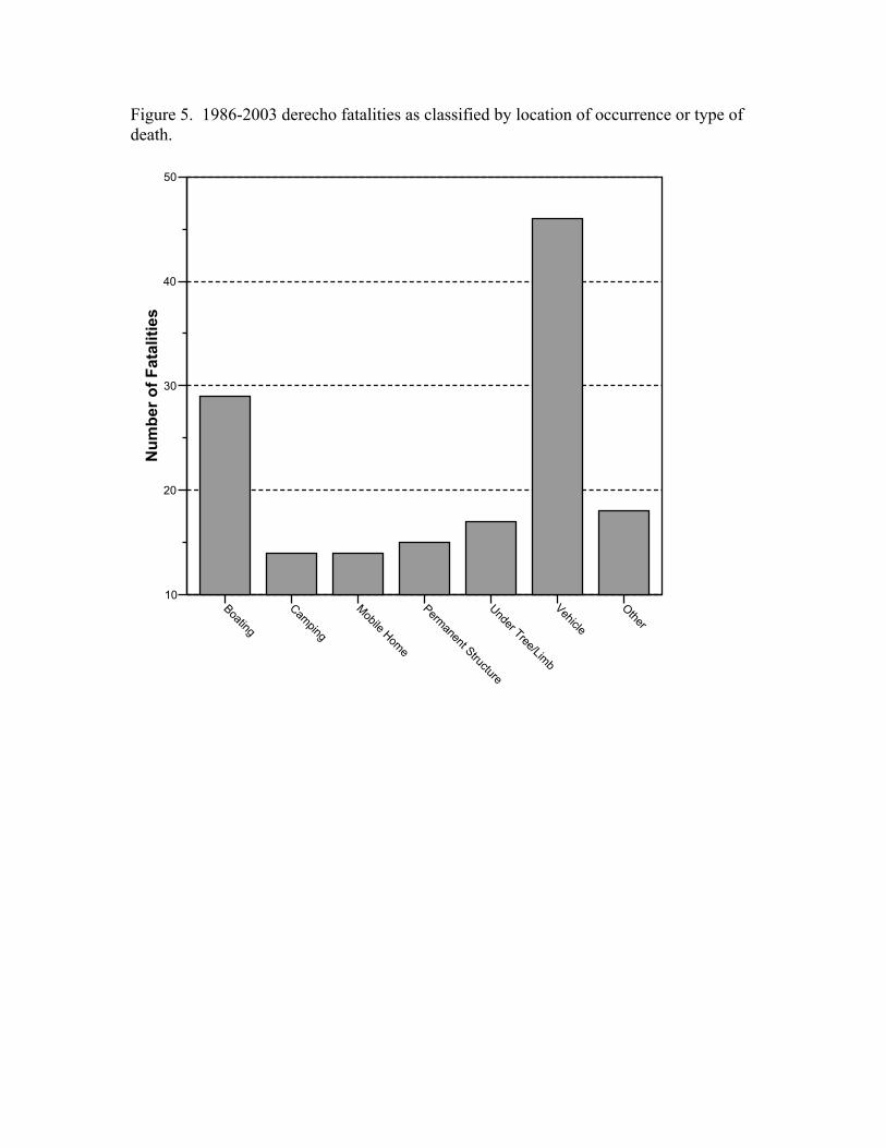
Figure 5. 1986-2003 derecho fatalities as classified by location of occurrence or type of death.
Boating
Camping
Mobile Home
Permanent Structure
Under Tree/Limb
Vehicle
Other
10
20
30
40
50
Num
ber o
f Fat
aliti
es

Figure 6. The distribution of U.S. derecho fatalities. Symbol indicates the gridded maximum value before interpolation.
++ 121
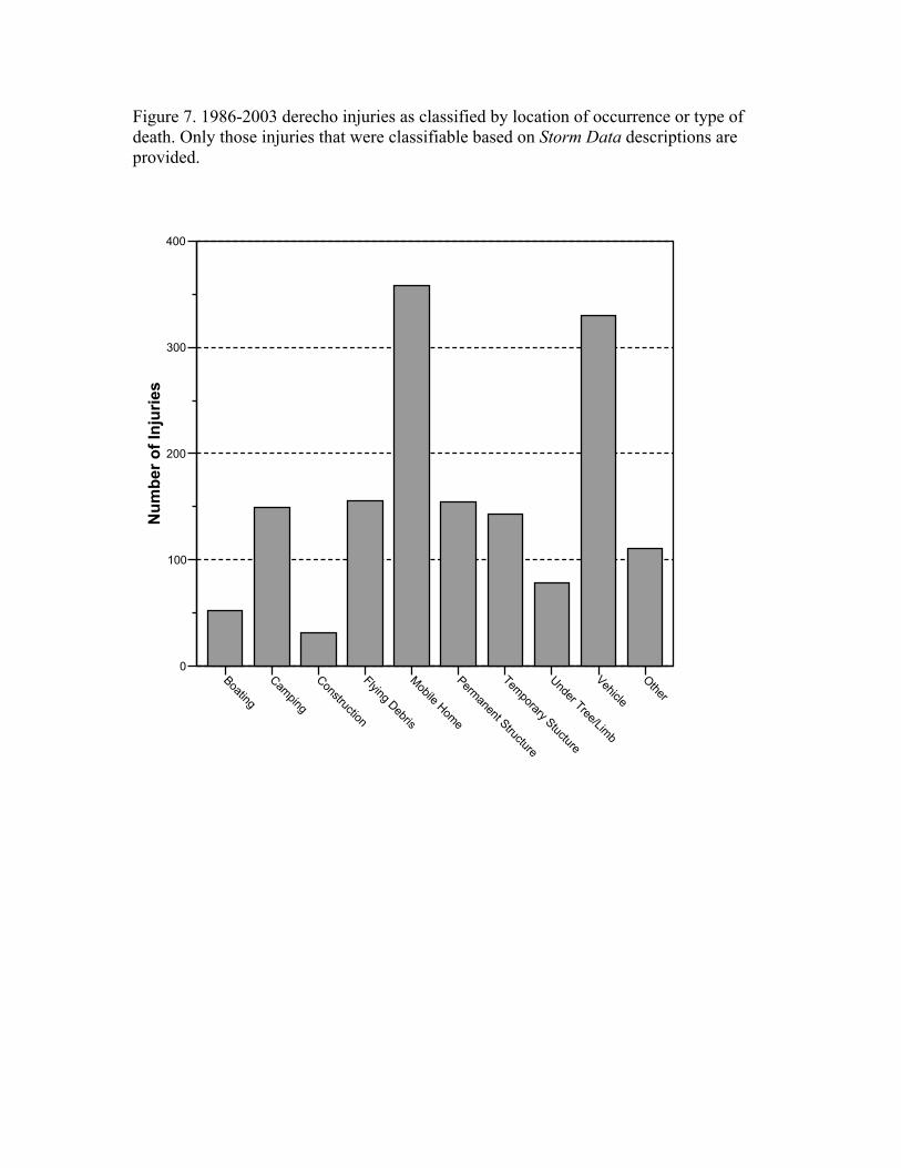
Figure 7. 1986-2003 derecho injuries as classified by location of occurrence or type of death. Only those injuries that were classifiable based on Storm Data descriptions are provided.
Boating
Camping
Construction
Flying Debris
Mobile Home
Permanent Structure
Temporary Stucture
Under Tree/Limb
Vehicle
Other
0
100
200
300
400
Num
ber o
f Inj
urie
s