deployment report for the lake pontchartrain artificial ... report for the lake pontchartrain...
TRANSCRIPT

Deployment Report for the Lake Pontchartrain Artificial Reef Program - Phase II Program
DWF staff inspecting deployment barge 4-21-09
June 2009
By
John Lopez, Ph.D. Lake Pontchartrain Basin Foundation
Submitted to the
Louisiana Department of Wildlife and Fisheries
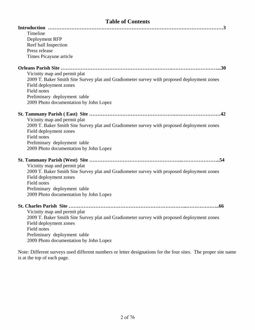
Table of Contents Introduction ……………………………………………………………………………………………3
Timeline Deployment RFP Reef ball Inspection Press release Times Picayune article
Orleans Parish Site ………………………………………………………….………………………...30
Vicinity map and permit plat 2009 T. Baker Smith Site Survey plat and Gradiometer survey with proposed deployment zones Field deployment zones Field notes Preliminary deployment table 2009 Photo documentation by John Lopez
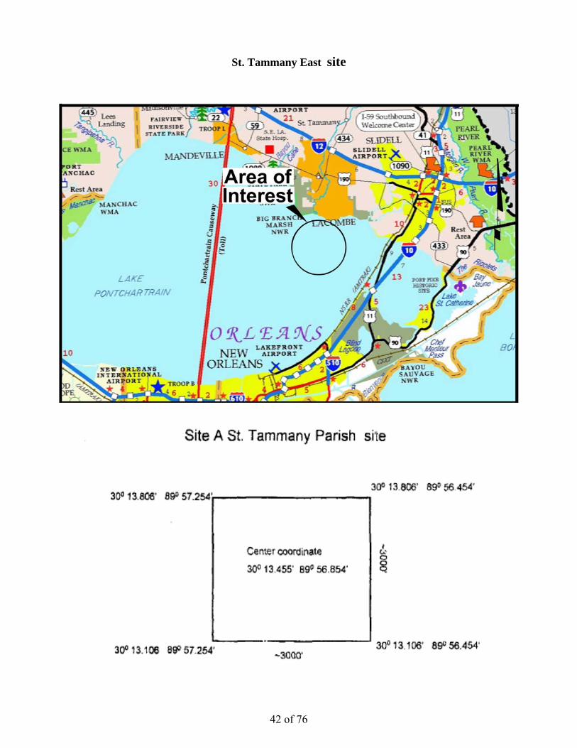
St. Tammany Parish ( East) Site …………………………………………….………………………42
Vicinity map and permit plat 2009 T. Baker Smith Site Survey plat and Gradiometer survey with proposed deployment zones Field deployment zones Field notes Preliminary deployment table 2009 Photo documentation by John Lopez
St. Tammany Parish (West) Site ………………………………………………..…………………..54
Vicinity map and permit plat 2009 T. Baker Smith Site Survey plat and Gradiometer survey with proposed deployment zones Field deployment zones Field notes Preliminary deployment table 2009 Photo documentation by John Lopez
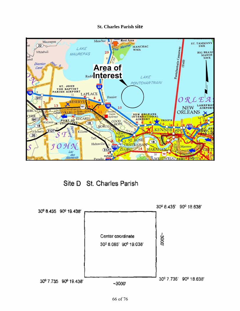
St. Charles Parish Site ……………………………………………………………..………………..66
Vicinity map and permit plat 2009 T. Baker Smith Site Survey plat and Gradiometer survey with proposed deployment zones Field deployment zones Field notes Preliminary deployment table 2009 Photo documentation by John Lopez
Note: Different surveys used different numbers or letter designations for the four sites. The proper site name is at the top of each page.
2 of 76

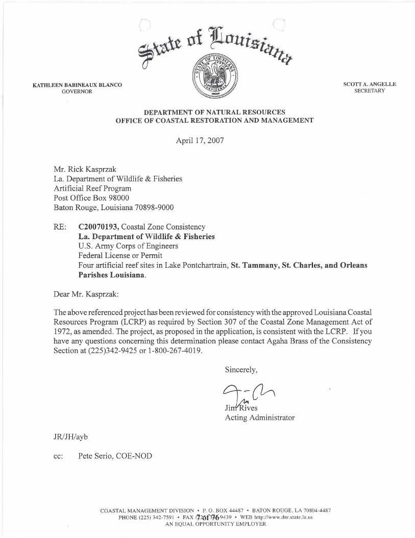
Introduction From 2000 to 2004, a Phase I artificial reef program was developed in Lake Pontchartrain led by LPBF and various partners including the Louisiana Department of Wildlife and Fisheries . A Phase II program was proposed in 2005. Hurricane Katrina delayed the Phase II project and caused additional survey work to be required. The survey conducted by the Mineral Management Service was to identify potential Hurricane storm debris. The project was also delayed by the untimely death of Rick Kasprzak. Rick was the State’s artificial reef coordinator form many years and with his expertise assisted in completion of the Phase I program. Doug Peter is currently the State’s artificial reef program coordinator and has ably assisted in the completion of this program. In June of 2008, LA DWF gave final approval for the Phase II project. In December Coastal Reefbuilders Inc. of Pensacola, Fla. was contracted to deploy the four reef sites in Lake Pontchartrain. This report describes the actual deployment phase of the artificial reef project. Deployment occurred in April and May of 2009 and did not encounter any significant problems of weather or mechanical issues. State and Federal agencies involved with the project were notified of pending deployment and were given access to the sites. DWF staff visited were in the field on three occasions to inspect reef program activities. NOAA and DNR staff also visited the Orleans site deployment . No injuries or safety incidents were reported or are known to have occurred. On May 12, 2009 , a press event was held in New Orleans as the Orleans site was deployed. This resulted in positive coverage for the reef program including both television and print media. In all, the deployment went smoothly and our preliminary assessment is that deployment was successful . This report is provided to the Louisiana Department of Wildlife and Fisheries and will be incorporated into a final report for the Phase II program, which will include deployment description and post-deployment surveys. General Timeline for the Project
July 2005 Informal discussion with DWF personnel to develop Phase II June 13, 2006 Phase II proposed to DWF April 17, 2007 CUP approved by DNR August 6, 2007 USACE Permit approved August 23, 2007 MMS “debris survey” of sites December 11, 2007 DNR Office Mineral Resources approval May 2008 DWF bathymetric survey completed July 14, 2008 DWF approved December 2008 Contract signed for reef ball purchase and deployment April 21, 2009 DWF staff on site April 22, 2009 St. Tammany East site reef deployed April 23, 2009 St. Tammany West reef site deployed May 12, 2009 Press Event May 12, 2009 DWF, NOAA and DNR staff on site May 12, 2009 Orleans reef site deployed May 13, 2009 St. Charles Parish reef site deployed May 13, 2009 DWF staff on site May 20, 2009 Coastal Reefbuilders Inc. delivers field deployment notes to LPBF
Further information Extensive documentation of Phase I and Phase II programs is available at SaveOurlake.org.
3 of 76
Lake Pontchartrain Basin Foundation P.O. Box 6965, Metairie La. 70009-6965
Request for Proposal Proposal Due Date: COB February 29, 2008
Title: Lake Pontchartrain Artificial Reef Construction, southeast Louisiana - Phase II
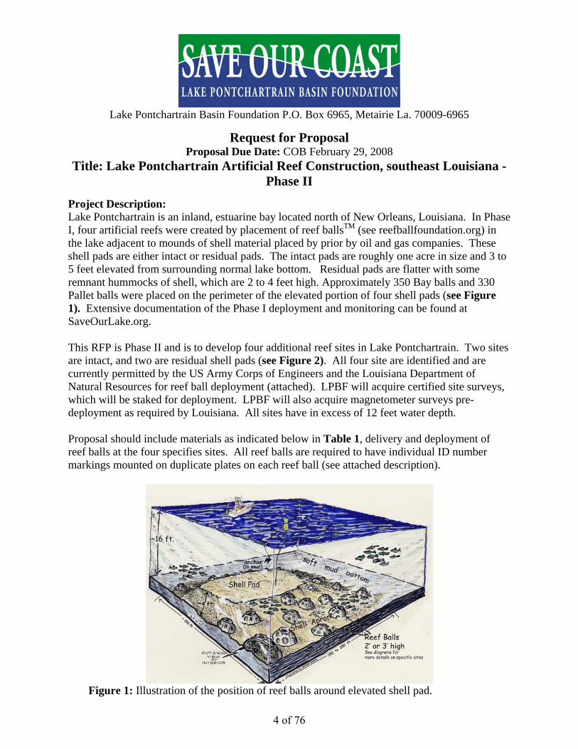
Project Description: Lake Pontchartrain is an inland, estuarine bay located north of New Orleans, Louisiana. In Phase I, four artificial reefs were created by placement of reef ballsTM (see reefballfoundation.org) in the lake adjacent to mounds of shell material placed by prior by oil and gas companies. These shell pads are either intact or residual pads. The intact pads are roughly one acre in size and 3 to 5 feet elevated from surrounding normal lake bottom. Residual pads are flatter with some remnant hummocks of shell, which are 2 to 4 feet high. Approximately 350 Bay balls and 330 Pallet balls were placed on the perimeter of the elevated portion of four shell pads (see Figure 1). Extensive documentation of the Phase I deployment and monitoring can be found at SaveOurLake.org. This RFP is Phase II and is to develop four additional reef sites in Lake Pontchartrain. Two sites are intact, and two are residual shell pads (see Figure 2). All four site are identified and are currently permitted by the US Army Corps of Engineers and the Louisiana Department of Natural Resources for reef ball deployment (attached). LPBF will acquire certified site surveys, which will be staked for deployment. LPBF will also acquire magnetometer surveys pre-deployment as required by Louisiana. All sites have in excess of 12 feet water depth. Proposal should include materials as indicated below in Table 1, delivery and deployment of reef balls at the four specifies sites. All reef balls are required to have individual ID number markings mounted on duplicate plates on each reef ball (see attached description).
Figure 1: Illustration of the position of reef balls around elevated shell pad.
4 of 76
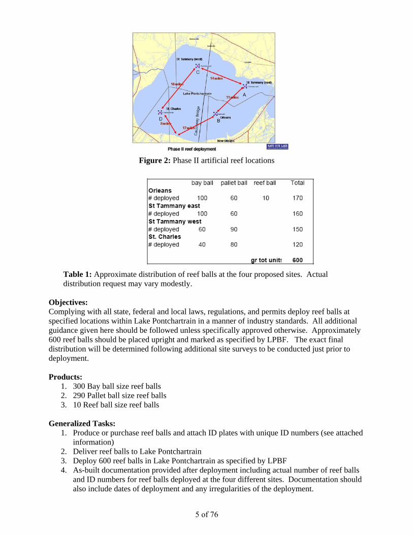
Figure 2: Phase II artificial reef locations
Table 1: Approximate distribution of reef balls at the four proposed sites. Actual distribution request may vary modestly.
Objectives: Complying with all state, federal and local laws, regulations, and permits deploy reef balls at specified locations within Lake Pontchartrain in a manner of industry standards. All additional guidance given here should be followed unless specifically approved otherwise. Approximately 600 reef balls should be placed upright and marked as specified by LPBF. The exact final distribution will be determined following additional site surveys to be conducted just prior to deployment. Products:
1. 300 Bay ball size reef balls 2. 290 Pallet ball size reef balls 3. 10 Reef ball size reef balls
Generalized Tasks:
1. Produce or purchase reef balls and attach ID plates with unique ID numbers (see attached information)
2. Deliver reef balls to Lake Pontchartrain 3. Deploy 600 reef balls in Lake Pontchartrain as specified by LPBF 4. As-built documentation provided after deployment including actual number of reef balls
and ID numbers for reef balls deployed at the four different sites. Documentation should also include dates of deployment and any irregularities of the deployment.
5 of 76

Special Considerations: Lake Pontchartrain is an inland bay, which can have severe weather conditions. Contractor carries all risks of transporting and deployment of reef balls. LPBF must be notified at least 48 hours in advance of deployment and be allowed to inspect deployment operations. The Lake Pontchartrain Basin Foundation is a 501-C3 designated non-profit by the Internal Revenue Service. Cash or in-kind donations to this project may be tax deductable. LPBF is awaiting final approval from the Louisiana Department of Wildlife and Fisheries. The project may be delayed pending final approval. Procedural Guidance: LPBF and contractor will remain in contact by phone or email and keep parties apprised of project development. Any unexpected delays in the project should be communicated immediately. Contract Time: 6 months Estimated Notice to Proceed: March 15, 2008 Proposal Due Date: COB February 29, 2008 Delivery Instructions: Via email – [email protected] Or physical mail Lake Pontchartrain Basin Foundation 3838 North Causeway Boulevard Suite 2070 Metairie, LA 70009-6965 Point of Contact for project or additional RFP information: John Lopez, Ph.D. 225 294-4998 504 421-7348 [email protected] Carlton Dufrechou Executive Director Lake Pontchartrain Basin Foundation 504 836-2215 References: Lopez, J. A., 2005, The Lake Pontchartrain Artificial Reef Program Deployment 2000 to 2004 (see SaveOurLake.org) Attached:
USACE permit Louisiana Department of Natural Resources Permit Guidance for attaching ID plates onto reef balls Coordinates and description of Phase II sites
6 of 76
7 of 76

RECEIVED DEPARTMENT OF THE ARMY NEW ORLEANS DISTRICT, CORPS OF ENGINEERS
JUL 3 0 2007 P.O. BOX 60267 NEW ORLEANS, LOUISIANA 70160-0267
MARINE FISHERIES DIVISION
REPLY TO JUL 2 5 2007 ATIENTIONOF
Operations Division Eastern Evaluation Section
SUBJECT: MVN 2007-2738 EOO
Department of Wildlife and Fisheries Artificial Reef Program Post Office Pox 98000 Baton Rouge, Louisiana 70808
Gentlemen:
The proposal to deploy approximately 600 reef balls at four abandoned shell pad sites within Lake Pontchartrain, in St. Charles Parish, Orleans Parish, and St. Tammany Parish, Louisiana, as shown on the attached drawings, is authorized under Category II of the Programmatic General Permit, provided that all conditions of the permit are met.
Prior to commencing work on your project, you must obtain approvals from state and local agencies as required by law and by terms of this permit. These approvals include, but are not limited to, a permit or waiver from the Coastal Management Division of the Louisiana Department of Natural Resources and a water quality certification from the Louisiana Department of Environmental Quality, Office of Environmental Services.
If the work is initiated within two (2) years of the date of this letter, the authorization remains valid for a total of five (5) years from the date of this letter. If the work is not initiated within two (2) years, this authorization becomes null and void.
Should you have any further questions concerning this matter, please contact Brad LaBorde at (504) 862-2225.
Sincerely,
OtJNVJ)8~ ~: Pete 1. Serio
Chief, Regulatory Branch
Enclosure
8 of 76

9 of 76

Site A St. Tammany Parish site
0 300 13.806' 890 57.254', 30° 13.806' 89 56454'
I
Ic...:.Center coordinate o o Q30° 13.455' 890 56.854'
30° 13.106' 89° 56.454' 30° 13.106 ago 57.254' -3000'
10 of 76
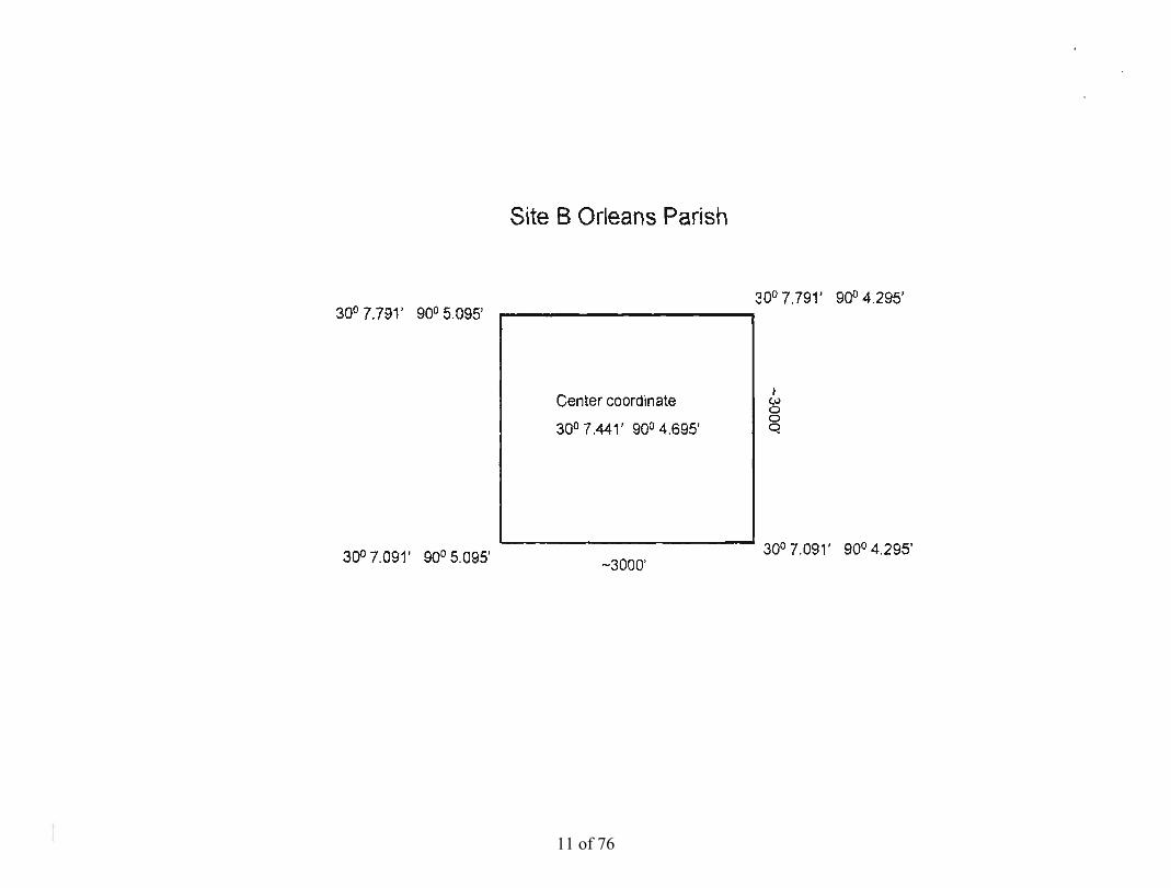
Site B Orleans Parish
30° 7.791' 90° 5.095' j
300 7.791' I
900 4.295'
} wCenter coordinate o o q30° 7.441' 900 4.695'
300 7.091' 900 4.295'300 7.091' 900 5.095' -3000'
11 of 76

Site C S1. Tammany site (west)
30°18.698 900 9.400' i 3~0 18.698' 90° 8.600' I
Center coordinate
300 18.348' 900 9.000'
I W o o Q
300 17.998 900 9.400' -3000' 30° 17.998' 900 8.600'
12 of 76
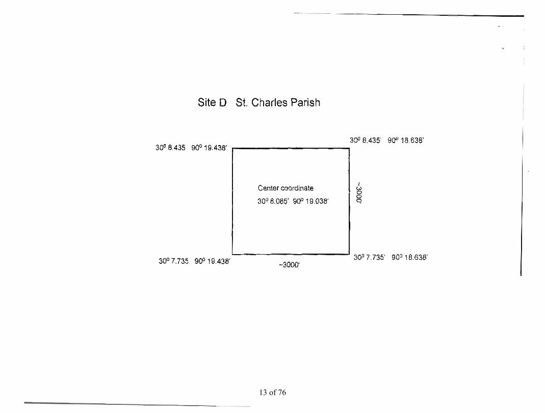
Site 0 St. Charles Parish
300 8.435 900 19.438' i
300 8.435' I
900 18.638'
Center coordinate
300 8.085' 900 19.038'
I <..> o o Q
300 7.735 900 19.438' -3000' 30° 7.735' 900 18.638'
13 of 76
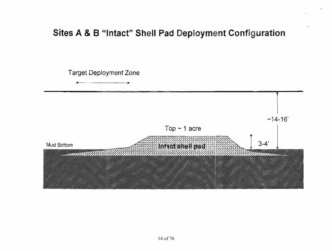
Sites A &B "Intact" Shell Pad Deoloyme1nt Configuration
Target Deployment Zone ~ ~
r -14-16'
Top - 1 acre
MUd Botto
14 of 76
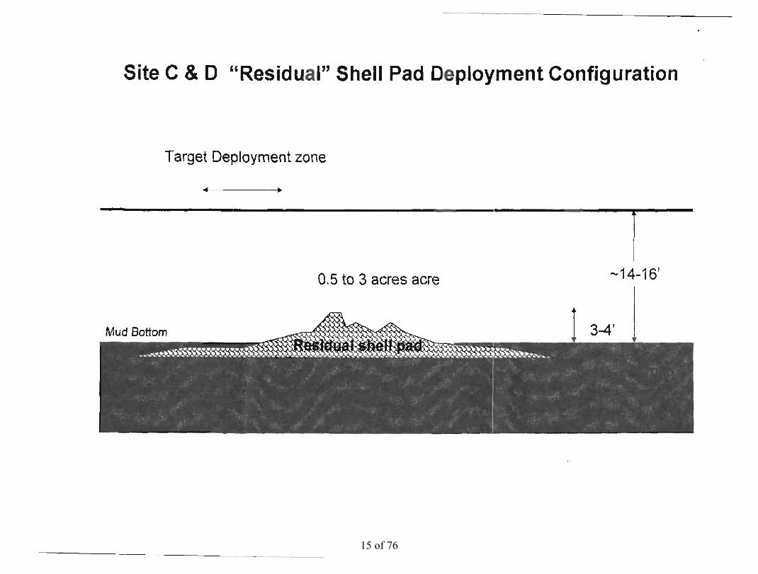
Site C & 0 "Residual" Shell Pad Deployment Configuration
Target Deployment zone
.. .
r -14-16'0.5 to 3 acres acre
15 of 76

General "Intact" Shell Pad Deployment Configuration
1 -14-16'
._------------------------------~-------~------~-----------~--~~~ _ c -3-4'
16 of 76
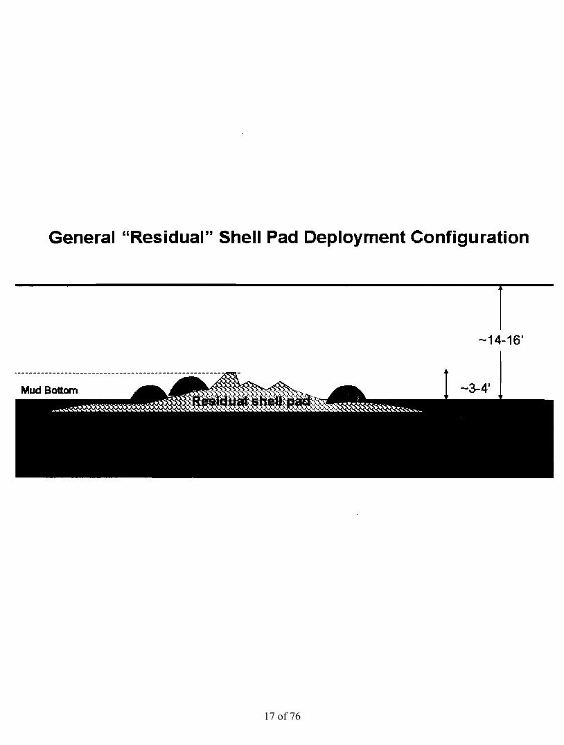
General "Residual" Shell Pad Deployment Configuration
r -14-16'
17 of 76

PGP SPECIAL CONDITIONS Rev 06/2007
I. Activities authorized under this programmatic general permit (PGP) shall not'be used for piecemeal work and shall be applied to single and complete projects. All components of a single and complete project shall be treated together as constituting one action. Multi-phased projects shall be treated as constituting one single and complete project. This general permit shall not be used for any activity that is part of an overall project for which an individual permit is required.
2. No activity is authorized under this general permit which may adversely affect significant cultural resources listed or eligible for listing in the National Register of Historic Places until the requirements for Section 106 of the National Historic Preservation Act are met. Upon discovery of the presence Ofpreviously unknown historic and/or prehistoric cultural resources, all work must cease and the permittee must notify the State Historic Preservation Office and the Army Corps of Engineers, New Orleans District Regulatory'Branch (CEMVN). The authorization is suspended until it is determined whether or not the activity will have an adverse effect on cultural resources. The authorization may be reactivated or modified through specific conditions if necessary, if it'is determined that the activity will have no adverse effect on cultural resources. The CEMVN-PGP authorization will be revoked if it is determined that cultural resources would be adversely affected, and an individual permit may be necessary.
3. The Chitimacha Tribe of Louisiana has stated that the project area is part of the aboriginal Chitimacha homelands. If during the course of work at the site, prehistoric and/or historic aboriginal cultural materials are discovered, the applicant will contact the Chitimacha Tribe of Louisiana at P.O. Box 66 I, Charenton, LA 70523, and CEMVN. CEMVN will initiate the required Federal, State, and Tribal coordination to determine the significance of the cultural materials and the need, if applicable, for additional cultural resource investigations.
4. There shall be no unreasonable interference with navigation by the existence or use of the activity authorized herein. The permittee will, at his or her expense, install and maintain any safety lights, signals, and signs prescribed by the United States Coast Guard, through regulations or otherwise, on authorized facilities or on equipment used in performing work under the authorization.
5. No activity may substantially disrupt the movement of those species of aquatic life indigenous to the waterbody, including those species which normally migrate through the area, unless the activity's primary purpose is to block or impound water.
6. 1f the proposed activity involves the installation of aerial transmission lines, submerged cable, or submerged pipelines across navigable waters of the United States the following is applicable:
The National Ocean Service (NOS) has been notified of this authorization. You must notify NOS and this office in writing, at least two weeks before you begin work and upon completion of the activity authorized by this permit. Your notification of completion must include a drawing which certifies the location and configuration of the completed activity (a certified permit drawing may be used). Notification to NOS will be sent to the following address: National Ocean Service, Office of Coast Survey, N/CS261, 1315 East West Highway, Silver Springs, Maryland 20910-3282.
7. For pipelines under an anchorage or a designated fairway in the Gulf of Mexico the following is applicable:
The National Ocean Service has been notified of this authorization. You must notify NOS and this office in writing, at least two weeks before you begin work and upon completion of the activity authorized by this permit. Within 30 days of completion of the pipeline, 'as built' drawings certified by a professional engineer registered in Louisiana or by a registered surveyor shaH be furnished to this office, the U.S. Coast Guard, Sector New Orleans Command Center, 20 I Hammond Highway, Metairie, Louisiana 70005, and to the Director, National Ocean Service, Office of Coast Survey, N/CS261, 1315 East West Highway, Silver Springs, Maryland 20910-3282. The plans must include the location, configuration and actual burial depth of the completed pipeline project.
18 of 76

-2
8. Ifthe proposed project, or future maintenance work, involves the use of floating construction equipment (barge mounted cranes, barge mounted pile driving equipment, floating dredge equipment, dredge discharge pipelines, etc.,) in the waterway, you are advised to notify the U.S. Coast Guard for their determination as to the need for a Notice to Mariners. Notification, with a copy of your permit approval and drawings, should be mailed to the U.S. Coast Guard, Sector New Orleans Command Center, 20 I Hammond Highway, Metairie, Louisiana 70005, about I month before you plan to start work. Telephone inquiries can be directed to (504) 846-5923.
9. All activities authorized herein shall, if they involve, during their construction or operation, any discharge of pollutants into waters if the United States, be at all times consistent with applicable water quality standards, etlluent limitations and standards of performance, prohibitions, pretreatment standards and management practices established pursuant to the Clean Water Act (PL 92-500: 86 Stat 816), or pursuant to applicable state and local laws.
10. Substantive changes to the Louisiana Coastal Resources Program may require immediate suspension and revocation of this permit in accordance with 33 CFR 325.7.
II. Irrespective of whether a project meets the criteria ofthis permit, the Corps of Engineers retains discretionary authority to require an individual Department of the Army permit when circumstances of the proposal warrant this requirement.
12. Any authorization granted under this permit may be either modified, suspended, or revoked in whole or in part if the Secretary of the Army or his authorized representative determines that there has been a violation of any of the terms or conditions of this permit or that such action would otherwise be in the public interest.
13. The Corps of Engineers may suspend, modify, or revoke this general permit if it is found in the public interest to do so.
14. Activities proposed for authorization under the PGP must comply with all other necessary federal, state, and/or local permits, licenses, or approvals. Failure to do so would result in a violation of the terms and conditions of CEMVN-PGP.
15. The permittee shall allow the District Commander or his authorized representative(s) or designee(s) to make periodic inspections ofthe project site(s) and authorized activities at any time deemed necessary in order to assure that the work being performed under authority of this permit is in accordance with the terms and conditions prescribed herein.
16. This general permit does not convey any property rights, either in real estate or material, or any exclusive privileges; nor does it authorize any injury to property or invasion ofrights or any infringement offederal, state, or local laws or regulations nor does it obviate the responsibility to obtain state or local assent required by law for the activity authorized herein.
17. The federal government will rely upon information and data supplied by the applicant in granting authorization under this permit. If information and data received subsequent to permit issuance prove to be false, incomplete, or inaccurate, the authorization may be modified, suspended, or revoked, in whole or in part.
18. Sewage generated through authorized activities shall be processed through a municipal sewage treatment system or, in areas where tie-in to a municipal system is not practical, the on-site sewerage system must be approved by the local parish sanitarian before construction.
19. Any modification, suspension, or revocation of this general permit, or actions granted under such, will not be the basis for any claim for damages against the United States.
19 of 76

-3
20. Additional conditions deemed necessary to protect the public interest may be added to this general permit by the District Commander at any time. If additional conditions are added, the public will be advised of such by public notice. Authorizations granted under this PGP may include special conditions deemed necessary to ensure minimal impact and compliance with this PGP.
2 I. A review of cumulative losses as authorized via this general permit will be accomplished yearly in or around the month of October. A report of losses will be furnished to the Environmental Protection Agency, the U.S. Fish and Wildlife Service, the National Marine Fisheries Service, and the Louisiana Department of Wildlife and Fisheries. Comments from reviewing agencies will be considered in determination as to whether modifications to the general permit are needed. Should the District Commander make a determination not to incorporate a change proposed by a reviewing agency, after normal negotiations between the respective agencies, the District Commander will explain in writing to the reviewing agency the basis and rationale for his decision.
22. The New Orleans District will periodically review CEMVN-PGP and its terms, conditions, and processing procedures and will decide to either modify, reissue, or revoke the permit. If the PGP is not modified or reissued within 5 years of its effective date, it automatically expires and becomes null and void. Authorizations which have commenced or are under contract to commence prior to permit expiration will remain authorized provided the activity is comp leted within 12 months of the date of CEMVN-PGP expiration, modification, or revocation.
23. The permittee understands and agrees that, if future operations by the United States require the removal, relocation, or other alteration, of the structure or work herein authorized, or if, in the opinion of the Secretary of the Army or his authorized representative, said structure or work shall cause unreasonable obstruction to the free navigation of the navigable waters, the permittee will be required, upon due notice from the Corps of Engineers, to remove, relocate, or alter the structural work or obstructions caused thereby, without expense to the United States. No claim shall be made against the United States on account of any such removal or alteration.
24. You must maintain the activity authorized by this permit in good condition and in conformance with the terms and conditions of this permit. You are not relieved of this requirement if you abandon the permitted activity, although you may make a good faith transfer to a third party. Should you wish to cease to maintain the authorized activity or should you desire to abandon it without a good faith transfer, you must obtain a modification of this permit from this office, which may require restoration of the area.
25. If you discover any previously unknown historic or archeological remains while accomplishing the activity authorized by this permit, you must immediately notify this office of the find. We will initiate the Federal and State coordination required to determine if the discovery warrants a recovery effort or if the site is eligible for listing in the National Register of Historic Places.
26. If you sell the property associated with this permit, you must provide this office with a copy of the permit and a letter noting your agreement to transfer the permit to the new owner and the new owners agreement to accept the permit and abide by all conditions of the permit. This letter must be signed by both parties.
27. If a conditioned water quality certification has been issued for your project, you must comply with the conditions specified in the certification as special conditions to this permit.
28. Many local governing bodies have instituted laws and/or ordinances in order to regulate dredge and/or fill activities in floodplains to assure maintenance of floodwater storage capacity and avoid disruption of drainage patterns that may affect surrounding properties. If your project involves dredging and/or placement of fill, you must contact the local municipal and/or parish governing body regarding potential impacts to floodplains and compliance of your proposed activities with local floodplain ordinances, regulations or permits.
29. If the proposed work includes the installation ofpipeline(s) in waterways, the permittee will maintain the burial depth below the mudline, as shown on the attached drawings. Maintenance operations under this permit include lowering the pipeline(s) to conform to erosive changes of the mudline contour. Burial of the pipeline(s) below the elevation shown on the drawings is authorized for maintenance of the required burial depth or if erosion is expected at the site.
20 of 76

Lake Pontchartrain Artificial Reef Program – Phase II Proposed Tagging
The tagging procedures used for the Lake Pontchartrain Artificial Reef Program – Phase I was only partially successful. Three problems were encountered:
1) During deployment tags were dislodged as reef balls were lifted in pairs and scraped against each other 2) Divers noticed additional tags became loose overtime due to apparent poor adhesion of the silicon to the
anodized aluminum plates 3) Plates located on the side of the reef ball were difficult to locate by divers due to the large surface area and
the awkward position of divers to inspect the sides Some positives were that the anodized aluminum tags did not appear to degrade and that the silicone did adhere to the concrete sides of the reef balls.
Proposed tagging for Phase II deployed reef balls (Figure below)
• Dual tagging of all reef balls with unique ID #, LPBF and Phone number
• One tag will be anchored with heavy aluminum nails placed in un‐set concrete
• Second tag will be set with marine glue as in Phase I but with pre‐drilled holes through the plate so that the unset glue extrudes through the opening. The plate will be held by the plug of glue through the hole rather than the adhesive property of the glue.
John A. Lopez, Ph.D. Director-Coastal Sustainability Program Lake Pontchartrain Basin Foundation SaveOurLake.org 225-294-4998 - land line 504-421-7348 – cell [email protected]
21 of 76

H1, H3 & H4
N1
L1 (ls)
Intact Shell Pads
Residual Shell Pads
Proposed Phase II Artificial Reef Development in Lake Pontchartrain 7/06 ~ locations of proposed sites shown as pink circles
Yellow squares are existing LaDWF sites
For More information see SaveOurLake.org
1) Orleans Parish, 6 miles offshore, intact shell pad 30 7.441 90 4.6952) St. Tammany well site, 3 miles south of Point Platte, intact shell pad 30 13.455 89 56.854 3) St. Charles Parish, 6 miles offshore , residual shell pad 30 8.085 90 19.0384) St. Tammany Parish, 6 miles south of the Tchefuncte River & 8 miles east of Manchac, residual shell pad
30 18.348 90 9.00
13
2
4
22 of 76

Coastal Reefbuilders Inc barge and crane used to deploy the four reef sites. Pictures taken in Bayou Liberty April 21, 2009
23 of 76

Coastal Reefbuilders Inc Barge with reef balls being inspected by DWF staff. Pictures taken in Bayou Liberty May 13, 2009
24 of 76

Coastal Reefbuilders Inc Barge with reef balls with detail of reef ball identification plates . All reef balls had dual plates mounted on side and top. Plates were set with stainless steel screws while concrete was still wet during fabrication. Phase II identification numbers are from 1000 to 1599. Pictures taken in Bayou Liberty April 21, 2009
25 of 76

PRESS CONFERENCE ANNOUNCEMENT Contact: John A. Lopez, Ph.D. Carlton Dufrechou Director Coastal Sustainability Program Executive Director Lake Pontchartrain Lake Pontchartrain Basin Foundation Basin Foundation (504) 421-7348 – cell (504) 400-5132 - cell [email protected] (504) 836-2215 - office [email protected]
Four New Artificial Reefs Developed in Lake Pontchartrain
Fishermen Take Notice!!
New Orleans, LA: Four new artificial reef sites are being developed in Lake Pontchartrain by the Lake Pontchartrain Artificial Reef Working Group led by the Lake Pontchartrain Basin Foundation, LSU AgCenter/ La. Sea Grant and the Coalition to Restore Coastal Louisiana. The new reefs will be completed by May 12, 2009 and will be located in Orleans, St. Tammany, and St. Charles Parishes. A press conference on the reef program will be held Tuesday, May 12 at 1:00 PM at the New Canal Lighthouse, 8001 Lakeshore Drive, along the New Orleans Lakefront. Coordinates of the new reefs will be announced during the press conference. Dr. John Lopez of the Lake Pontchartrain Basin Foundation states that “the purpose of the reefs is to create structural habitat which has been shown to increase fish populations and fish biodiversity in Lake Pontchartrain.” The four reefs are the final phase of the program which follows an initial development of five reefs in Lake Pontchartrain from 2000 to 2004. The new reef construction includes deployment of 600 reef balls of various sizes. Permits to construct the four reefs were obtained by the Louisiana Department of Wildlife and Fisheries. After final inspections, the reef balls will be donated to the State of Louisiana.
26 of 76

Carlton Dufrechou, Executive Director of the Lake Pontchartrain Basin Foundation says “Twenty years ago when the Lake Pontchartrain Basin Foundation was formed, folks thought it would never be possible to fish in the lake again. Now, the lake is back and fishermen know first-hand that the lake is once again one of the premier fishing spots in the Gulf Coast region.” The total project cost of the Phase II artificial reef program, including monitoring is $160,000. Technical and financial support was provided by the La. Department of Wildlife and Fisheries, NOAA Restoration Center, Coalition to Restore Coastal Louisiana, Shell Exploration and Production, Inc., Jefferson Parish Marine Fisheries Advisory Board, Louisiana Office of Coastal Protection and Restoration, Minerals Management Service, T. Baker Smith, and the University of New Orleans. Mark Schexnayder of the LSU AgCenter/ La. Sea Grant says “The earlier studies clearly showed more fish aggregating near the artificial reefs than on control sites, probably drawn by the increase in bait species observed. More fish means a better chance of catching them, and that is a good thing.” “This is a great time for fishing in the lake,” adds Dufrechou. “We have the new reefs going in and the Lake Pontchartrain Basin Foundation is hosting its 13th annual fishing rodeo May 16th and 17th. So I encourage everyone to go out and catch some fish.” For more information on the Lake Pontchartrain Artificial Reef Program and the 13th Annual Save Our Lake and Coast Fishing Rodeo call (504) 836-2215 or visit www.saveourlake.org
*******
27 of 76

Underwater construction helping repopulate Lake Pontchartrain -- with fish by Chris Kirkham, The Times-Picayune Tuesday May 12, 2009, 7:45 PM
ELIOT KAMENITZ / THE TIMES PICAYUNEThe Lake Ponchartrain Basin Foundation along with the LSU Sea Grant and other organizations Tuesday deployed four new artificial reefs in Lake Pontchartrain designed to increase fishing opportunities for anglers. Five miles out from the New Orleans lakefront, 12 feet below the surface, a new terrain for Lake Pontchartrain took shape Tuesday. On an acre-and-a-half of shells, cranes strategically dropped 180 hollow concrete balls, some weighing as much as 3,500 pounds, with the hope of creating an ecological hot spot for game fish and anglers who chase them. • Diagram: How the artificial reef project works After nearly a decade of development, academics and local environmental groups are wrapping up construction on the last of nine artificial reefs in the lake -- most covering one to two acres -- at sites from Slidell to St. Charles Parish. Officials with the Lake Pontchartrain Basin Foundation, one of the sponsoring agencies, see the new reefs as the latest comeback for a habitat that was scoured by shell dredging and pollution until the 1990s. "Very few people took fishing in Lake Pontchartrain seriously, " said John Lopez, director of the foundation's coastal sustainability program. "But now people look at it as a premier spot." Although the lake is the most visible, most accessible waterway for much of the New Orleans area, the wide-open estuary has often been a bust for anglers hoping to bag large speckled trout and redfish.
Even with the marked improvements to water quality in the lake since the 1980s, the landscape is mostly a flat mud bottom that provides little shelter for the crabs and other aquatic life needed to attract pockets of larger fish. Fish like structures, but aside from the bridges and the shorelines, there's little variety in the lake. "The bottom of the lake -- it's not lifeless, but it's featureless, " said Woody Crews, a board member for the foundation and the Coalition to Restore Coastal Louisiana who was on a boat tour surveying the reef-building Tuesday. "Outside of those reef balls, the only feature on this lake is that Causeway." Since 2000 the basin foundation, the Coalition to Restore Coastal Louisiana and LSU's Sea Grant College Program have raised money to build the nine artificial reefs. Eight of them have been built with concrete "reef balls, " which have holes bored in them to allow crabs, shrimp and smaller bait fish to grow inside. That in turn attracts larger game fish, which in turn attract humans who catch them. The reefs are sturdy: none of them was disturbed by Hurricanes Katrina, Rita, Gustav or Ike. And anglers have reported increased catches in the area within weeks of the reefs being built.
28 of 76
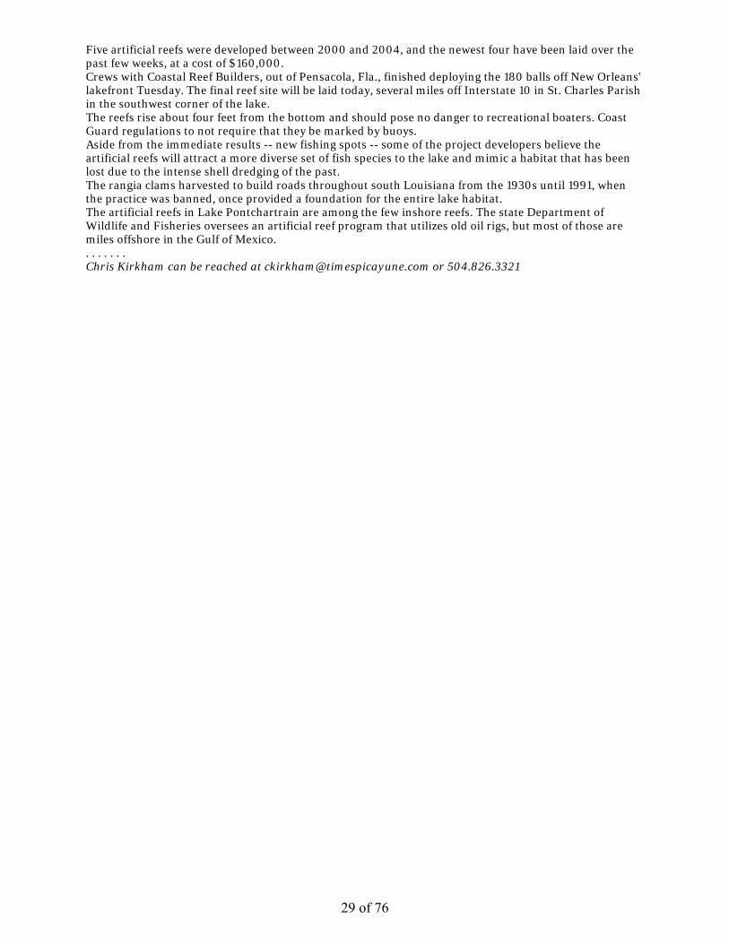
Five artificial reefs were developed between 2000 and 2004, and the newest four have been laid over the past few weeks, at a cost of $160,000. Crews with Coastal Reef Builders, out of Pensacola, Fla., finished deploying the 180 balls off New Orleans' lakefront Tuesday. The final reef site will be laid today, several miles off Interstate 10 in St. Charles Parish in the southwest corner of the lake. The reefs rise about four feet from the bottom and should pose no danger to recreational boaters. Coast Guard regulations to not require that they be marked by buoys. Aside from the immediate results -- new fishing spots -- some of the project developers believe the artificial reefs will attract a more diverse set of fish species to the lake and mimic a habitat that has been lost due to the intense shell dredging of the past. The rangia clams harvested to build roads throughout south Louisiana from the 1930s until 1991, when the practice was banned, once provided a foundation for the entire lake habitat. The artificial reefs in Lake Pontchartrain are among the few inshore reefs. The state Department of Wildlife and Fisheries oversees an artificial reef program that utilizes old oil rigs, but most of those are miles offshore in the Gulf of Mexico. . . . . . . . Chris Kirkham can be reached at [email protected] or 504.826.3321
29 of 76

Orleans Parish site
30 of 76
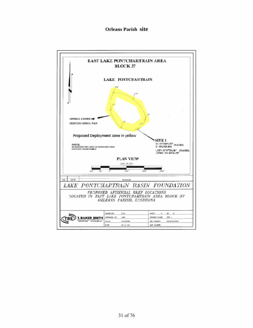
Orleans Parish site
31 of 76

Proposed Deeployment zon
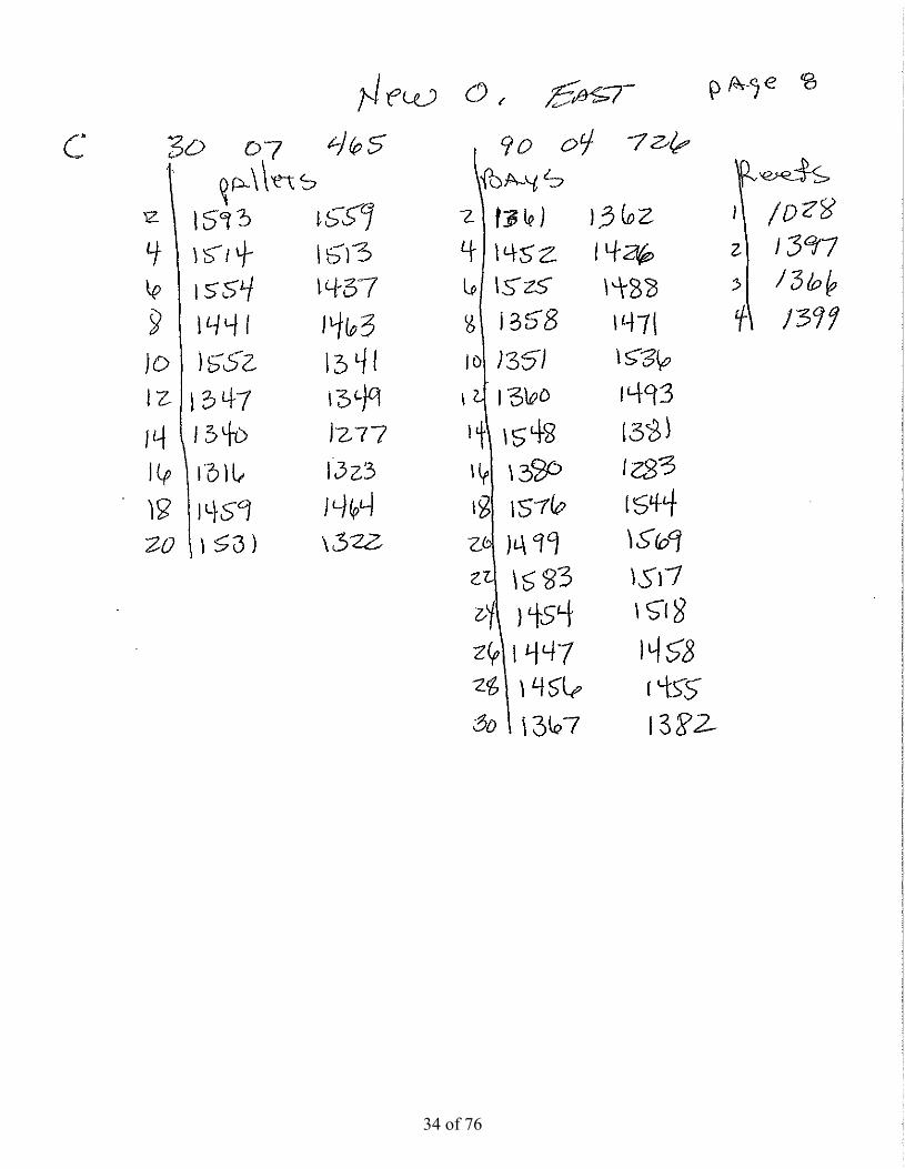
C
ne in yellow
AD
C
B
Rz
A
Reference dones (gree
deploymenten)
t
32 of 76

33 of 76
34 of 76

35 of 76

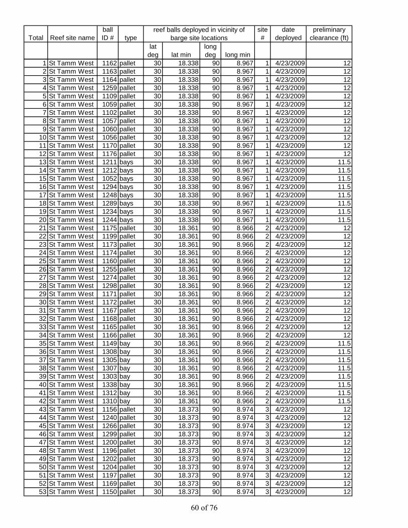
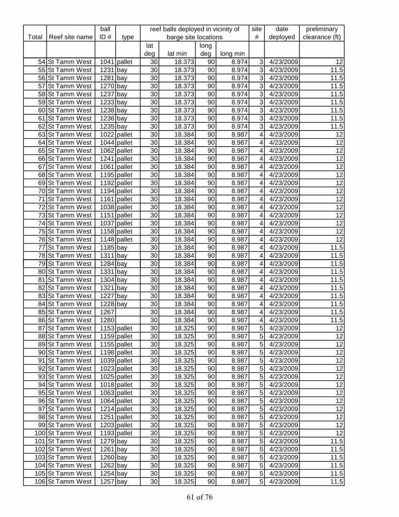
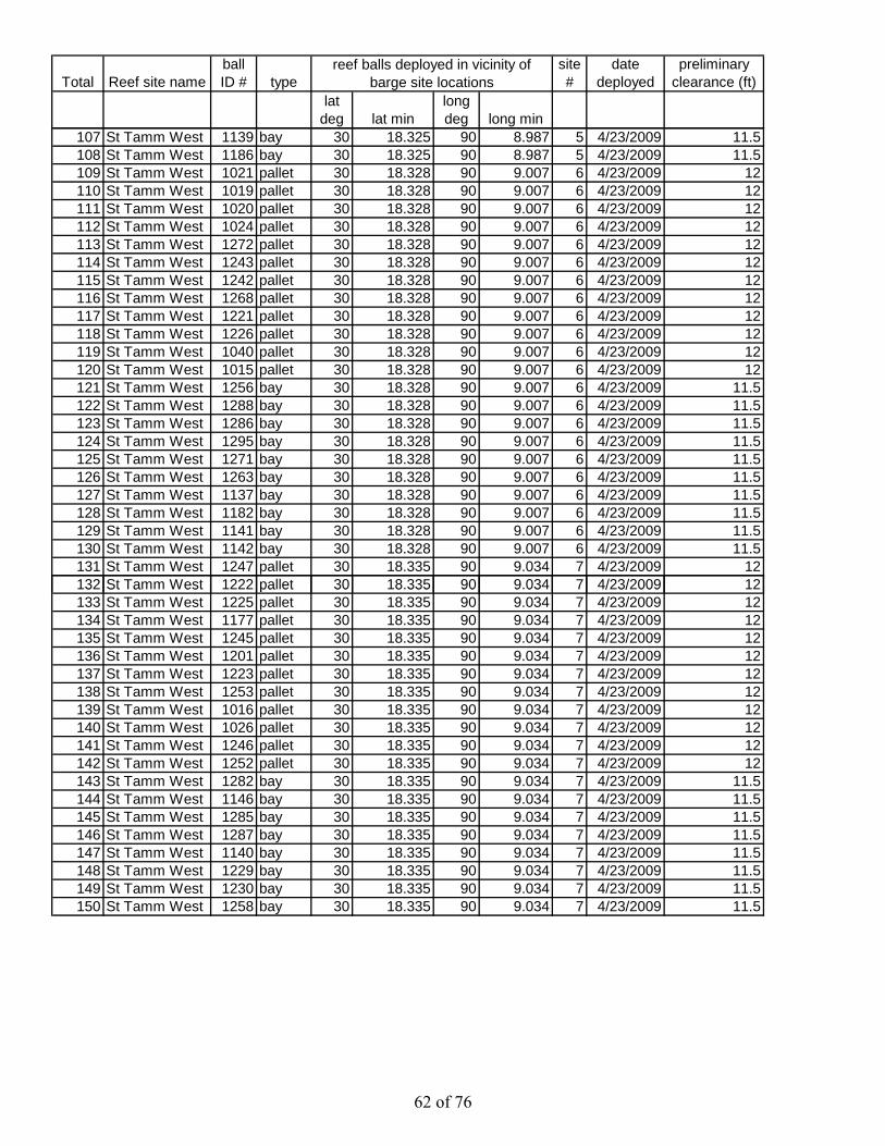
Total Reef site nameball ID # type
site #
date deployed
preliminary clearance (ft)
lat deg lat min
long deg long min
reef balls deployed in vicinity of barge site locations
1 New Orleans 1491 bay 30 7.451 90 4.679 A 5/12/2009 122 New Orleans 1523 bay 30 7.451 90 4.679 A 5/12/2009 123 New Orleans 1575 bay 30 7.451 90 4.679 A 5/12/2009 124 New Orleans 1586 bay 30 7.451 90 4.679 A 5/12/2009 125 New Orleans 1494 bay 30 7.451 90 4.679 A 5/12/2009 126 New Orleans 1591 bay 30 7.451 90 4.679 A 5/12/2009 127 New Orleans 1498 bay 30 7.451 90 4.679 A 5/12/2009 128 New Orleans 1524 bay 30 7.451 90 4.679 A 5/12/2009 129 New Orleans 1567 bay 30 7.451 90 4.679 A 5/12/2009 12
10 New Orleans 1568 bay 30 7.451 90 4.679 A 5/12/2009 1211 New Orleans 1315 pallet 30 7.474 90 4.693 B 5/12/2009 1312 New Orleans 1335 pallet 30 7.474 90 4.693 B 5/12/2009 11.513 New Orleans 1502 pallet 30 7.474 90 4.693 B 5/12/2009 11.514 New Orleans 1534 pallet 30 7.474 90 4.693 B 5/12/2009 11.515 New Orleans 1440 pallet 30 7.474 90 4.693 B 5/12/2009 11.516 New Orleans 1439 pallet 30 7.474 90 4.693 B 5/12/2009 11.517 New Orleans 1460 pallet 30 7.474 90 4.693 B 5/12/2009 11.518 New Orleans 1443 pallet 30 7.474 90 4.693 B 5/12/2009 11.519 New Orleans 1538 pallet 30 7.474 90 4.693 B 5/12/2009 11.520 New Orleans 1511 pallet 30 7.474 90 4.693 B 5/12/2009 11.521 New Orleans 1328 pallet 30 7.474 90 4.693 B 5/12/2009 11.522 New Orleans 1435 pallet 30 7.474 90 4.693 B 5/12/2009 11.523 New Orleans 1466 pallet 30 7.474 90 4.693 B 5/12/2009 11.524 New Orleans 1436 pallet 30 7.474 90 4.693 B 5/12/2009 11.525 New Orleans 1313 pallet 30 7.474 90 4.693 B 5/12/2009 11.526 New Orleans 1345 pallet 30 7.474 90 4.693 B 5/12/2009 11.56 e O ea s 3 5 pa et 30 90 693 5/ / 009 527 New Orleans 1557 pallet 30 7.474 90 4.693 B 5/12/2009 11.528 New Orleans 1555 pallet 30 7.474 90 4.693 B 5/12/2009 11.529 New Orleans 1346 pallet 30 7.474 90 4.693 B 5/12/2009 11.530 New Orleans 1348 pallet 30 7.474 90 4.693 B 5/12/2009 11.531 New Orleans 1527 bay 30 7.474 90 4.693 B 5/12/2009 1232 New Orleans 1542 bay 30 7.474 90 4.693 B 5/12/2009 1233 New Orleans 1526 bay 30 7.474 90 4.693 B 5/12/2009 1234 New Orleans 1550 bay 30 7.474 90 4.693 B 5/12/2009 1235 New Orleans 1432 bay 30 7.474 90 4.693 B 5/12/2009 1236 New Orleans 1561 bay 30 7.474 90 4.693 B 5/12/2009 1237 New Orleans 1533 bay 30 7.474 90 4.693 B 5/12/2009 1238 New Orleans 1546 bay 30 7.474 90 4.693 B 5/12/2009 1239 New Orleans 1547 bay 30 7.474 90 4.693 B 5/12/2009 1240 New Orleans 1541 bay 30 7.474 90 4.693 B 5/12/2009 1241 New Orleans 1528 bay 30 7.474 90 4.693 B 5/12/2009 1242 New Orleans 1521 bay 30 7.474 90 4.693 B 5/12/2009 1243 New Orleans 1495 bay 30 7.474 90 4.693 B 5/12/2009 1244 New Orleans 1529 bay 30 7.474 90 4.693 B 5/12/2009 1245 New Orleans 1496 bay 30 7.474 90 4.693 B 5/12/2009 1246 New Orleans 1545 bay 30 7.474 90 4.693 B 5/12/2009 1247 New Orleans 1522 bay 30 7.474 90 4.693 B 5/12/2009 1248 New Orleans 1577 bay 30 7.474 90 4.693 B 5/12/2009 1249 New Orleans 1444 bay 30 7.474 90 4.693 B 5/12/2009 1250 New Orleans 1445 bay 30 7.474 90 4.693 B 5/12/2009 1251 New Orleans 1376 bay 30 7.474 90 4.693 B 5/12/2009 1252 New Orleans 1389 bay 30 7.474 90 4.693 B 5/12/2009 1253 New Orleans 1450 bay 30 7.474 90 4.693 B 5/12/2009 12
36 of 76

Total Reef site nameball ID # type
site #
date deployed
preliminary clearance (ft)
lat deg lat min
long deg long min
reef balls deployed in vicinity of barge site locations
54 New Orleans 1482 bay 30 7.474 90 4.693 B 5/12/2009 1255 New Orleans 1218 bay 30 7.474 90 4.693 B 5/12/2009 1256 New Orleans 1419 bay 30 7.474 90 4.693 B 5/12/2009 1257 New Orleans 1484 bay 30 7.474 90 4.693 B 5/12/2009 1258 New Orleans 1453 bay 30 7.474 90 4.693 B 5/12/2009 1259 New Orleans 1377 bay 30 7.474 90 4.693 B 5/12/2009 1260 New Orleans 1390 bay 30 7.474 90 4.693 B 5/12/2009 1261 New Orleans 1487 reefs 30 7.474 90 4.693 B 5/12/2009 1262 New Orleans 1582 reefs 30 7.474 90 4.693 B 5/12/2009 1263 New Orleans 1540 reefs 30 7.474 90 4.693 B 5/12/2009 1264 New Orleans 1593 pallet 30 7.465 90 4.726 C 5/12/2009 1265 New Orleans 1559 pallet 30 7.465 90 4.726 C 5/12/2009 1266 New Orleans 1514 pallet 30 7.465 90 4.726 C 5/12/2009 1267 New Orleans 1513 pallet 30 7.465 90 4.726 C 5/12/2009 1268 New Orleans 1554 pallet 30 7.465 90 4.726 C 5/12/2009 1269 New Orleans 1437 pallet 30 7.465 90 4.726 C 5/12/2009 1270 New Orleans 1441 pallet 30 7.465 90 4.726 C 5/12/2009 1271 New Orleans 1463 pallet 30 7.465 90 4.726 C 5/12/2009 1272 New Orleans 1552 pallet 30 7.465 90 4.726 C 5/12/2009 1273 New Orleans 1341 pallet 30 7.465 90 4.726 C 5/12/2009 1274 New Orleans 1347 pallet 30 7.465 90 4.726 C 5/12/2009 1275 New Orleans 1349 pallet 30 7.465 90 4.726 C 5/12/2009 1276 New Orleans 1340 pallet 30 7.465 90 4.726 C 5/12/2009 1277 New Orleans 1277 pallet 30 7.465 90 4.726 C 5/12/2009 1278 New Orleans 1316 pallet 30 7.465 90 4.726 C 5/12/2009 1279 New Orleans 1323 pallet 30 7.465 90 4.726 C 5/12/2009 129 e O ea s 3 3 pa et 30 65 90 6 C 5/ / 00980 New Orleans 1459 pallet 30 7.465 90 4.726 C 5/12/2009 1281 New Orleans 1464 pallet 30 7.465 90 4.726 C 5/12/2009 1282 New Orleans 1531 pallet 30 7.465 90 4.726 C 5/12/2009 1283 New Orleans 1322 pallet 30 7.465 90 4.726 C 5/12/2009 1284 New Orleans 1361 bay 30 7.465 90 4.726 C 5/12/2009 1385 New Orleans 1362 bay 30 7.465 90 4.726 C 5/12/2009 1386 New Orleans 1452 bay 30 7.465 90 4.726 C 5/12/2009 1387 New Orleans 1426 bay 30 7.465 90 4.726 C 5/12/2009 1388 New Orleans 1525 bay 30 7.465 90 4.726 C 5/12/2009 1389 New Orleans 1488 bay 30 7.465 90 4.726 C 5/12/2009 1390 New Orleans 1358 bay 30 7.465 90 4.726 C 5/12/2009 1391 New Orleans 1471 bay 30 7.465 90 4.726 C 5/12/2009 1392 New Orleans 1351 bay 30 7.465 90 4.726 C 5/12/2009 1393 New Orleans 1536 bay 30 7.465 90 4.726 C 5/12/2009 1394 New Orleans 1360 bay 30 7.465 90 4.726 C 5/12/2009 1395 New Orleans 1493 bay 30 7.465 90 4.726 C 5/12/2009 1396 New Orleans 1548 bay 30 7.465 90 4.726 C 5/12/2009 1397 New Orleans 1381 bay 30 7.465 90 4.726 C 5/12/2009 1398 New Orleans 1380 bay 30 7.465 90 4.726 C 5/12/2009 1399 New Orleans 1283 bay 30 7.465 90 4.726 C 5/12/2009 13
100 New Orleans 1576 bay 30 7.465 90 4.726 C 5/12/2009 13101 New Orleans 1544 bay 30 7.465 90 4.726 C 5/12/2009 13102 New Orleans 1499 bay 30 7.465 90 4.726 C 5/12/2009 13103 New Orleans 1569 bay 30 7.465 90 4.726 C 5/12/2009 13104 New Orleans 1583 bay 30 7.465 90 4.726 C 5/12/2009 13105 New Orleans 1517 bay 30 7.465 90 4.726 C 5/12/2009 13106 New Orleans 1454 bay 30 7.465 90 4.726 C 5/12/2009 13
37 of 76

Total Reef site nameball ID # type
site #
date deployed
preliminary clearance (ft)
lat deg lat min
long deg long min
reef balls deployed in vicinity of barge site locations
107 New Orleans 1518 bay 30 7.465 90 4.726 C 5/12/2009 13108 New Orleans 1447 bay 30 7.465 90 4.726 C 5/12/2009 13109 New Orleans 1458 bay 30 7.465 90 4.726 C 5/12/2009 13110 New Orleans 1456 bay 30 7.465 90 4.726 C 5/12/2009 13111 New Orleans 1455 bay 30 7.465 90 4.726 C 5/12/2009 13112 New Orleans 1367 bay 30 7.465 90 4.726 C 5/12/2009 13113 New Orleans 1382 bay 30 7.465 90 4.726 C 5/12/2009 13114 New Orleans 1028 reefs 30 7.465 90 4.726 C 5/12/2009 12115 New Orleans 1397 reefs 30 7.465 90 4.726 C 5/12/2009 12116 New Orleans 1366 reefs 30 7.465 90 4.726 C 5/12/2009 12117 New Orleans 1399 reefs 30 7.465 90 4.726 C 5/12/2009 12118 New Orleans 1589 pallet 30 7.434 90 4.696 D1 5/12/2009 11.5119 New Orleans 1573 pallet 30 7.434 90 4.696 D1 5/12/2009 11.5120 New Orleans 1570 pallet 30 7.434 90 4.696 D1 5/12/2009 11.5121 New Orleans 1597 pallet 30 7.434 90 4.696 D1 5/12/2009 11.5122 New Orleans 1598 pallet 30 7.434 90 4.696 D1 5/12/2009 11.5123 New Orleans 1574 pallet 30 7.434 90 4.696 D1 5/12/2009 11.5124 New Orleans 1599 pallet 30 7.434 90 4.696 D1 5/12/2009 11.5125 New Orleans 1596 pallet 30 7.434 90 4.696 D1 5/12/2009 11.5126 New Orleans 1465 pallet 30 7.434 90 4.696 D1 5/12/2009 11.5127 New Orleans 1520 pallet 30 7.434 90 4.696 D1 5/12/2009 11.5128 New Orleans 1566 bay 30 7.434 90 4.696 D1 5/12/2009 12129 New Orleans 1565 bay 30 7.434 90 4.696 D1 5/12/2009 12130 New Orleans 1578 bay 30 7.434 90 4.696 D1 5/12/2009 12131 New Orleans 1592 bay 30 7.434 90 4.696 D1 5/12/2009 12132 New Orleans 1543 bay 30 7.434 90 4.696 D1 5/12/2009 123 e O ea s 5 3 bay 30 3 90 696 5/ / 009133 New Orleans 1579 bay 30 7.434 90 4.696 D1 5/12/2009 12134 New Orleans 1500 bay 30 7.434 90 4.696 D1 5/12/2009 12135 New Orleans 1564 bay 30 7.434 90 4.696 D1 5/12/2009 12136 New Orleans 1562 bay 30 7.434 90 4.696 D1 5/12/2009 12137 New Orleans 1461 bay 30 7.434 90 4.696 D1 5/12/2009 12138 New Orleans 1497 bay 30 7.434 90 4.696 D1 5/12/2009 12139 New Orleans 1587 bay 30 7.434 90 4.696 D1 5/12/2009 12140 New Orleans 1510 bay 30 7.434 90 4.696 D1 5/12/2009 12141 New Orleans 1489 bay 30 7.434 90 4.696 D1 5/12/2009 12142 New Orleans 1563 pallet 30 7.447 90 4.711 D2 5/12/2009 11.5143 New Orleans 1585 pallet 30 7.447 90 4.711 D2 5/12/2009 11.5144 New Orleans 1558 pallet 30 7.447 90 4.711 D2 5/12/2009 11.5145 New Orleans 1594 pallet 30 7.447 90 4.711 D2 5/12/2009 11.5146 New Orleans 1581 pallet 30 7.447 90 4.711 D2 5/12/2009 11.5147 New Orleans 1326 pallet 30 7.447 90 4.711 D2 5/12/2009 11.5148 New Orleans 1595 pallet 30 7.447 90 4.711 D2 5/12/2009 11.5149 New Orleans 1580 pallet 30 7.447 90 4.711 D2 5/12/2009 11.5150 New Orleans 1553 pallet 30 7.447 90 4.711 D2 5/12/2009 11.5151 New Orleans 1584 pallet 30 7.447 90 4.711 D2 5/12/2009 11.5152 New Orleans 1423 bay 30 7.447 90 4.711 D2 5/12/2009 12153 New Orleans 1427 bay 30 7.447 90 4.711 D2 5/12/2009 12154 New Orleans 1483 bay 30 7.447 90 4.711 D2 5/12/2009 12155 New Orleans 1549 bay 30 7.447 90 4.711 D2 5/12/2009 12156 New Orleans 1446 bay 30 7.447 90 4.711 D2 5/12/2009 12157 New Orleans 1420 bay 30 7.447 90 4.711 D2 5/12/2009 12158 New Orleans 1428 bay 30 7.447 90 4.711 D2 5/12/2009 12159 New Orleans 1429 bay 30 7.447 90 4.711 D2 5/12/2009 12
38 of 76

Total Reef site nameball ID # type
site #
date deployed
preliminary clearance (ft)
lat deg lat min
long deg long min
reef balls deployed in vicinity of barge site locations
160 New Orleans 1519 bay 30 7.447 90 4.711 D2 5/12/2009 12161 New Orleans 1431 bay 30 7.447 90 4.711 D2 5/12/2009 12162 New Orleans 1430 bay 30 7.447 90 4.711 D2 5/12/2009 12163 New Orleans 1433 bay 30 7.447 90 4.711 D2 5/12/2009 12164 New Orleans 1501 bay 30 7.447 90 4.711 D2 5/12/2009 12165 New Orleans 1588 bay 30 7.447 90 4.711 D2 5/12/2009 12166 New Orleans 1434 bay 30 7.447 90 4.711 D2 5/12/2009 12167 New Orleans 1424 bay 30 7.447 90 4.711 D2 5/12/2009 12168 New Orleans 1421 reefs 30 7.447 90 4.711 D2 5/12/2009 12169 New Orleans 1449 reefs 30 7.447 90 4.711 D2 5/12/2009 12170 New Orleans 1210 reefs 30 7.447 90 4.711 D2 5/12/2009 12
39 of 76

CRB barge with John Lopez’s boat during Orleans Parish site deployment May 12, 2009
CRB barge deploying a reef ball sized reef ball during Orleans Parish site deployment May 12, 2009
40 of 76

CRB barge spudded on site at the Orleans Parish site deployment May 12, 2009
CRB barge with certified site marker in foreground during Orleans Parish site deployment May 12, 2009
41 of 76
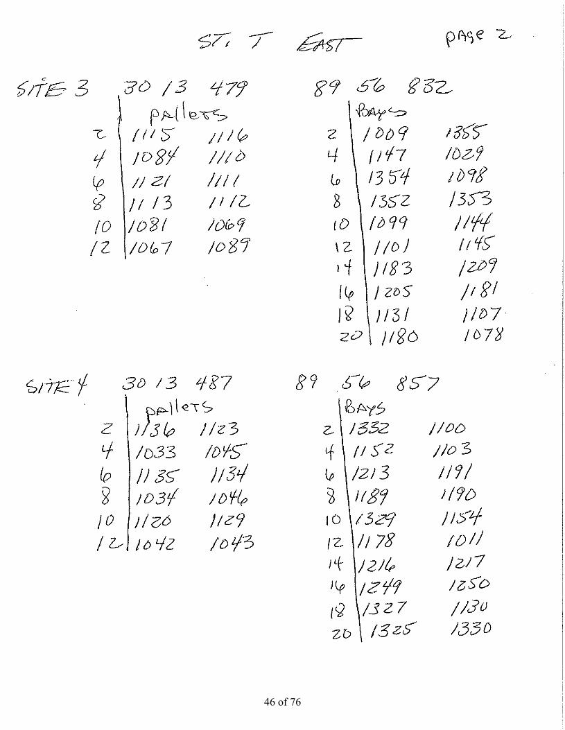
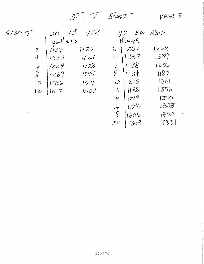
St. Tammany East site
42 of 76

St. Tammany East site
43 of 76

Proposed Deeployment zonne in yellow1
45
2
3
4
Referenzones (
nce deploym(green)
ment
44 of 76

45 of 76
46 of 76
47 of 76

Total Reef site nameball ID # type
site #
date deployed
preliminary clearance (ft)
lat deg lat min
long deg long min
1 St Tamm East 1066 pallet 30 14.439 89 56.836 1 4/22/2009 11.52 St Tamm East 1095 pallet 30 14.439 89 56.836 1 4/22/2009 11.53 St Tamm East 1132 pallet 30 14.439 89 56.836 1 4/22/2009 11.54 St Tamm East 1090 pallet 30 14.439 89 56.836 1 4/22/2009 11.55 St Tamm East 1085 pallet 30 14.439 89 56.836 1 4/22/2009 11.56 St Tamm East 1092 pallet 30 14.439 89 56.836 1 4/22/2009 11.57 St Tamm East 1157 pallet 30 14.439 89 56.836 1 4/22/2009 11.58 St Tamm East 1119 pallet 30 14.439 89 56.836 1 4/22/2009 11.59 St Tamm East 1088 pallet 30 14.439 89 56.836 1 4/22/2009 11.5
10 St Tamm East 1083 pallet 30 14.439 89 56.836 1 4/22/2009 11.511 St Tamm East 1124 pallet 30 14.439 89 56.836 1 4/22/2009 11.512 St Tamm East 1114 pallet 30 14.439 89 56.836 1 4/22/2009 11.513 St Tamm East 1143 bay 30 14.439 89 56.836 1 4/22/2009 11.514 St Tamm East 1010 bay 30 14.439 89 56.836 1 4/22/2009 11.515 St Tamm East 1051 bay 30 14.439 89 56.836 1 4/22/2009 11.516 St Tamm East 1053 bay 30 14.439 89 56.836 1 4/22/2009 11.517 St Tamm East 1008 bay 30 14.439 89 56.836 1 4/22/2009 11.518 St Tamm East 1031 bay 30 14.439 89 56.836 1 4/22/2009 11.519 St Tamm East 1032 bay 30 14.439 89 56.836 1 4/22/2009 11.520 St Tamm East 1047 bay 30 14.439 89 56.836 1 4/22/2009 11.521 St Tamm East 1050 bay 30 14.439 89 56.836 1 4/22/2009 11.522 St Tamm East 1074 bay 30 14.439 89 56.836 1 4/22/2009 11.523 St Tamm East 1012 bay 30 14.439 89 56.836 1 4/22/2009 11.524 St Tamm East 1000 bay 30 14.439 89 56.836 1 4/22/2009 11.525 St Tamm East 1004 bay 30 14.439 89 56.836 1 4/22/2009 11.526 St Tamm East 1002 bay 30 14.439 89 56.836 1 4/22/2009 11.5
reef balls deployed in vicinity of barge site locations
6 St a ast 00 bay 30 39 89 56 836 / / 009 527 St Tamm East 1007 bay 30 14.439 89 56.836 1 4/22/2009 11.528 St Tamm East 1006 bay 30 14.439 89 56.836 1 4/22/2009 11.529 St Tamm East 1077 bay 30 14.439 89 56.836 1 4/22/2009 11.530 St Tamm East 1005 bay 30 14.439 89 56.836 1 4/22/2009 11.531 St Tamm East 1013 bay 30 14.439 89 56.836 1 4/22/2009 11.532 St Tamm East 1049 bay 30 14.439 89 56.836 1 4/22/2009 11.533 St Tamm East 1094 pallet 30 13.457 89 56.828 2 4/22/2009 11.534 St Tamm East 1065 pallet 30 13.457 89 56.828 2 4/22/2009 11.535 St Tamm East 1086 pallet 30 13.457 89 56.828 2 4/22/2009 11.536 St Tamm East 1091 pallet 30 13.457 89 56.828 2 4/22/2009 11.537 St Tamm East 1080 pallet 30 13.457 89 56.828 2 4/22/2009 11.538 St Tamm East 1273 pallet 30 13.457 89 56.828 2 4/22/2009 11.539 St Tamm East 1133 pallet 30 13.457 89 56.828 2 4/22/2009 11.540 St Tamm East 1087 pallet 30 13.457 89 56.828 2 4/22/2009 11.541 St Tamm East 1118 pallet 30 13.457 89 56.828 2 4/22/2009 11.542 St Tamm East 1122 pallet 30 13.457 89 56.828 2 4/22/2009 11.543 St Tamm East 1075 pallet 30 13.457 89 56.828 2 4/22/2009 11.544 St Tamm East 1117 pallet 30 13.457 89 56.828 2 4/22/2009 11.545 St Tamm East 1048 Bay 30 13.457 89 56.828 2 4/22/2009 11.546 St Tamm East 1003 Bay 30 13.457 89 56.828 2 4/22/2009 11.547 St Tamm East 1079 Bay 30 13.457 89 56.828 2 4/22/2009 11.548 St Tamm East 1001 Bay 30 13.457 89 56.828 2 4/22/2009 11.5
48 of 76
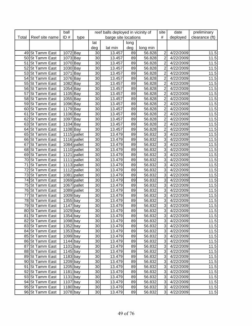
Total Reef site nameball ID # type
site #
date deployed
preliminary clearance (ft)
lat deg lat min
long deg long min
reef balls deployed in vicinity of barge site locations
49 St Tamm East 1072 Bay 30 13.457 89 56.828 2 4/22/2009 11.550 St Tamm East 1073 Bay 30 13.457 89 56.828 2 4/22/2009 11.551 St Tamm East 1070 Bay 30 13.457 89 56.828 2 4/22/2009 11.552 St Tamm East 1030 Bay 30 13.457 89 56.828 2 4/22/2009 11.553 St Tamm East 1071 Bay 30 13.457 89 56.828 2 4/22/2009 11.554 St Tamm East 1076 Bay 30 13.457 89 56.828 2 4/22/2009 11.555 St Tamm East 1082 Bay 30 13.457 89 56.828 2 4/22/2009 11.556 St Tamm East 1054 Bay 30 13.457 89 56.828 2 4/22/2009 11.557 St Tamm East 1105 Bay 30 13.457 89 56.828 2 4/22/2009 11.558 St Tamm East 1055 Bay 30 13.457 89 56.828 2 4/22/2009 11.559 St Tamm East 1096 Bay 30 13.457 89 56.828 2 4/22/2009 11.560 St Tamm East 1179 Bay 30 13.457 89 56.828 2 4/22/2009 11.561 St Tamm East 1106 Bay 30 13.457 89 56.828 2 4/22/2009 11.562 St Tamm East 1097 Bay 30 13.457 89 56.828 2 4/22/2009 11.563 St Tamm East 1104 Bay 30 13.457 89 56.828 2 4/22/2009 11.564 St Tamm East 1108 Bay 30 13.457 89 56.828 2 4/22/2009 11.565 St Tamm East 1115 pallet 30 13.479 89 56.832 3 4/22/2009 11.566 St Tamm East 1116 pallet 30 13.479 89 56.832 3 4/22/2009 11.567 St Tamm East 1084 pallet 30 13.479 89 56.832 3 4/22/2009 11.568 St Tamm East 1110 pallet 30 13.479 89 56.832 3 4/22/2009 11.569 St Tamm East 1121 pallet 30 13.479 89 56.832 3 4/22/2009 11.570 St Tamm East 1111 pallet 30 13.479 89 56.832 3 4/22/2009 11.571 St Tamm East 1113 pallet 30 13.479 89 56.832 3 4/22/2009 11.572 St Tamm East 1112 pallet 30 13.479 89 56.832 3 4/22/2009 11.573 St Tamm East 1081 pallet 30 13.479 89 56.832 3 4/22/2009 11.574 St Tamm East 1069 pallet 30 13.479 89 56.832 3 4/22/2009 11.5St a ast 069 pa et 30 3 9 89 56 83 3 / / 009 575 St Tamm East 1067 pallet 30 13.479 89 56.832 3 4/22/2009 11.576 St Tamm East 1089 pallet 30 13.479 89 56.832 3 4/22/2009 11.577 St Tamm East 1009 bay 30 13.479 89 56.832 3 4/22/2009 11.578 St Tamm East 1355 bay 30 13.479 89 56.832 3 4/22/2009 11.579 St Tamm East 1147 bay 30 13.479 89 56.832 3 4/22/2009 11.580 St Tamm East 1029 bay 30 13.479 89 56.832 3 4/22/2009 11.581 St Tamm East 1354 bay 30 13.479 89 56.832 3 4/22/2009 11.582 St Tamm East 1098 bay 30 13.479 89 56.832 3 4/22/2009 11.583 St Tamm East 1352 bay 30 13.479 89 56.832 3 4/22/2009 11.584 St Tamm East 1353 bay 30 13.479 89 56.832 3 4/22/2009 11.585 St Tamm East 1099 bay 30 13.479 89 56.832 3 4/22/2009 11.586 St Tamm East 1144 bay 30 13.479 89 56.832 3 4/22/2009 11.587 St Tamm East 1101 bay 30 13.479 89 56.832 3 4/22/2009 11.588 St Tamm East 1145 bay 30 13.479 89 56.832 3 4/22/2009 11.589 St Tamm East 1183 bay 30 13.479 89 56.832 3 4/22/2009 11.590 St Tamm East 1209 bay 30 13.479 89 56.832 3 4/22/2009 11.591 St Tamm East 1205 bay 30 13.479 89 56.832 3 4/22/2009 11.592 St Tamm East 1181 bay 30 13.479 89 56.832 3 4/22/2009 11.593 St Tamm East 1131 bay 30 13.479 89 56.832 3 4/22/2009 11.594 St Tamm East 1107 bay 30 13.479 89 56.832 3 4/22/2009 11.595 St Tamm East 1180 bay 30 13.479 89 56.832 3 4/22/2009 11.596 St Tamm East 1078 bay 30 13.479 89 56.832 3 4/22/2009 11.5
49 of 76
Total Reef site nameball ID # type
site #
date deployed
preliminary clearance (ft)
lat deg lat min
long deg long min
reef balls deployed in vicinity of barge site locations
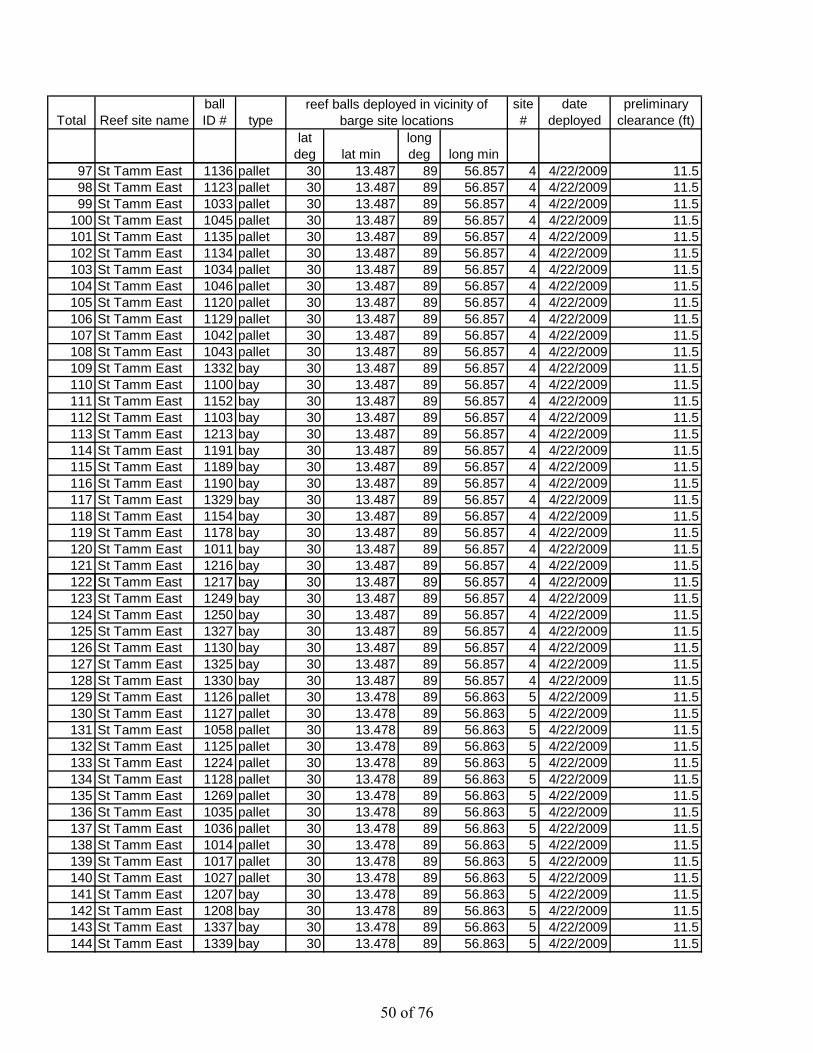
97 St Tamm East 1136 pallet 30 13.487 89 56.857 4 4/22/2009 11.598 St Tamm East 1123 pallet 30 13.487 89 56.857 4 4/22/2009 11.599 St Tamm East 1033 pallet 30 13.487 89 56.857 4 4/22/2009 11.5
100 St Tamm East 1045 pallet 30 13.487 89 56.857 4 4/22/2009 11.5101 St Tamm East 1135 pallet 30 13.487 89 56.857 4 4/22/2009 11.5102 St Tamm East 1134 pallet 30 13.487 89 56.857 4 4/22/2009 11.5103 St Tamm East 1034 pallet 30 13.487 89 56.857 4 4/22/2009 11.5104 St Tamm East 1046 pallet 30 13.487 89 56.857 4 4/22/2009 11.5105 St Tamm East 1120 pallet 30 13.487 89 56.857 4 4/22/2009 11.5106 St Tamm East 1129 pallet 30 13.487 89 56.857 4 4/22/2009 11.5107 St Tamm East 1042 pallet 30 13.487 89 56.857 4 4/22/2009 11.5108 St Tamm East 1043 pallet 30 13.487 89 56.857 4 4/22/2009 11.5109 St Tamm East 1332 bay 30 13.487 89 56.857 4 4/22/2009 11.5110 St Tamm East 1100 bay 30 13.487 89 56.857 4 4/22/2009 11.5111 St Tamm East 1152 bay 30 13.487 89 56.857 4 4/22/2009 11.5112 St Tamm East 1103 bay 30 13.487 89 56.857 4 4/22/2009 11.5113 St Tamm East 1213 bay 30 13.487 89 56.857 4 4/22/2009 11.5114 St Tamm East 1191 bay 30 13.487 89 56.857 4 4/22/2009 11.5115 St Tamm East 1189 bay 30 13.487 89 56.857 4 4/22/2009 11.5116 St Tamm East 1190 bay 30 13.487 89 56.857 4 4/22/2009 11.5117 St Tamm East 1329 bay 30 13.487 89 56.857 4 4/22/2009 11.5118 St Tamm East 1154 bay 30 13.487 89 56.857 4 4/22/2009 11.5119 St Tamm East 1178 bay 30 13.487 89 56.857 4 4/22/2009 11.5120 St Tamm East 1011 bay 30 13.487 89 56.857 4 4/22/2009 11.5121 St Tamm East 1216 bay 30 13.487 89 56.857 4 4/22/2009 11.5122 St Tamm East 1217 bay 30 13.487 89 56.857 4 4/22/2009 11.5St a ast bay 30 3 8 89 56 85 / / 009 5123 St Tamm East 1249 bay 30 13.487 89 56.857 4 4/22/2009 11.5124 St Tamm East 1250 bay 30 13.487 89 56.857 4 4/22/2009 11.5125 St Tamm East 1327 bay 30 13.487 89 56.857 4 4/22/2009 11.5126 St Tamm East 1130 bay 30 13.487 89 56.857 4 4/22/2009 11.5127 St Tamm East 1325 bay 30 13.487 89 56.857 4 4/22/2009 11.5128 St Tamm East 1330 bay 30 13.487 89 56.857 4 4/22/2009 11.5129 St Tamm East 1126 pallet 30 13.478 89 56.863 5 4/22/2009 11.5130 St Tamm East 1127 pallet 30 13.478 89 56.863 5 4/22/2009 11.5131 St Tamm East 1058 pallet 30 13.478 89 56.863 5 4/22/2009 11.5132 St Tamm East 1125 pallet 30 13.478 89 56.863 5 4/22/2009 11.5133 St Tamm East 1224 pallet 30 13.478 89 56.863 5 4/22/2009 11.5134 St Tamm East 1128 pallet 30 13.478 89 56.863 5 4/22/2009 11.5135 St Tamm East 1269 pallet 30 13.478 89 56.863 5 4/22/2009 11.5136 St Tamm East 1035 pallet 30 13.478 89 56.863 5 4/22/2009 11.5137 St Tamm East 1036 pallet 30 13.478 89 56.863 5 4/22/2009 11.5138 St Tamm East 1014 pallet 30 13.478 89 56.863 5 4/22/2009 11.5139 St Tamm East 1017 pallet 30 13.478 89 56.863 5 4/22/2009 11.5140 St Tamm East 1027 pallet 30 13.478 89 56.863 5 4/22/2009 11.5141 St Tamm East 1207 bay 30 13.478 89 56.863 5 4/22/2009 11.5142 St Tamm East 1208 bay 30 13.478 89 56.863 5 4/22/2009 11.5143 St Tamm East 1337 bay 30 13.478 89 56.863 5 4/22/2009 11.5144 St Tamm East 1339 bay 30 13.478 89 56.863 5 4/22/2009 11.5
50 of 76

Total Reef site nameball ID # type
site #
date deployed
preliminary clearance (ft)
lat deg lat min
long deg long min
reef balls deployed in vicinity of barge site locations
145 St Tamm East 1138 bay 30 13.478 89 56.863 5 4/22/2009 11.5146 St Tamm East 1206 bay 30 13.478 89 56.863 5 4/22/2009 11.5147 St Tamm East 1184 bay 30 13.478 89 56.863 5 4/22/2009 11.5148 St Tamm East 1187 bay 30 13.478 89 56.863 5 4/22/2009 11.5149 St Tamm East 1215 bay 30 13.478 89 56.863 5 4/22/2009 11.5150 St Tamm East 1301 bay 30 13.478 89 56.863 5 4/22/2009 11.5151 St Tamm East 1188 bay 30 13.478 89 56.863 5 4/22/2009 11.5152 St Tamm East 1336 bay 30 13.478 89 56.863 5 4/22/2009 11.5153 St Tamm East 1219 bay 30 13.478 89 56.863 5 4/22/2009 11.5154 St Tamm East 1220 bay 30 13.478 89 56.863 5 4/22/2009 11.5155 St Tamm East 1296 bay 30 13.478 89 56.863 5 4/22/2009 11.5156 St Tamm East 1333 bay 30 13.478 89 56.863 5 4/22/2009 11.5157 St Tamm East 1306 bay 30 13.478 89 56.863 5 4/22/2009 11.5158 St Tamm East 1302 bay 30 13.478 89 56.863 5 4/22/2009 11.5159 St Tamm East 1309 bay 30 13.478 89 56.863 5 4/22/2009 11.5160 St Tamm East 1334 bay 30 13.478 89 56.863 5 4/22/2009 11.5
51 of 76
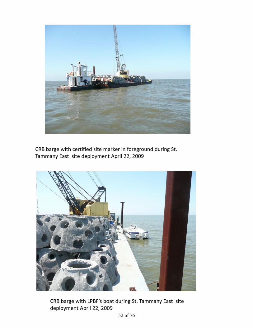
CRB barge with certified site marker in foreground during St. Tammany East site deployment April 22, 2009
CRB barge with LPBF’s boat during St. Tammany East site deployment April 22, 2009
52 of 76

CRB barge deploying a Bay ball sized reef ball during St. Tammany East site deployment April 22, 2009
CRB barge deploying a Bay ball sized reef ball during St. Tammany East site deployment April 22, 2009
53 of 76

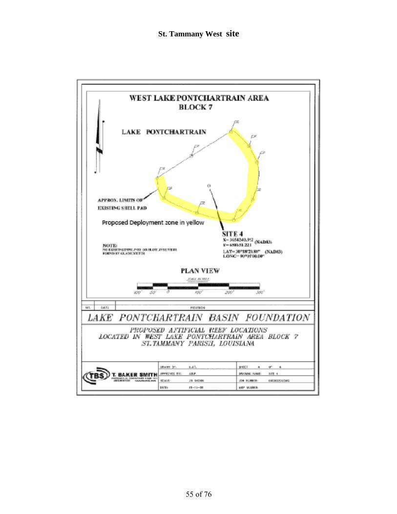
St. Tammany West site
54 of 76
St. Tammany West site
55 of 76

Proposed Deeployment zon
7
ne in yellow
65
15
4
3
2
3
Referendeploymzones (green)
nce ment
56 of 76
57 of 76

58 of 76

59 of 76
Total Reef site nameball ID # type
site #
date deployed
preliminary clearance (ft)
lat deg lat min
long deg long min
reef balls deployed in vicinity of barge site locations
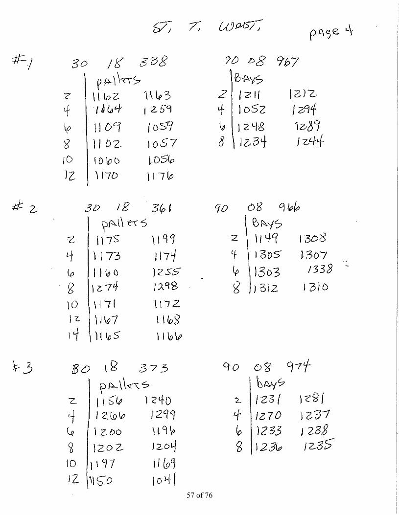
1 St Tamm West 1162 pallet 30 18.338 90 8.967 1 4/23/2009 122 St Tamm West 1163 pallet 30 18.338 90 8.967 1 4/23/2009 123 St Tamm West 1164 pallet 30 18.338 90 8.967 1 4/23/2009 124 St Tamm West 1259 pallet 30 18.338 90 8.967 1 4/23/2009 125 St Tamm West 1109 pallet 30 18.338 90 8.967 1 4/23/2009 126 St Tamm West 1059 pallet 30 18.338 90 8.967 1 4/23/2009 127 St Tamm West 1102 pallet 30 18.338 90 8.967 1 4/23/2009 128 St Tamm West 1057 pallet 30 18.338 90 8.967 1 4/23/2009 129 St Tamm West 1060 pallet 30 18.338 90 8.967 1 4/23/2009 12
10 St Tamm West 1056 pallet 30 18.338 90 8.967 1 4/23/2009 1211 St Tamm West 1170 pallet 30 18.338 90 8.967 1 4/23/2009 1212 St Tamm West 1176 pallet 30 18.338 90 8.967 1 4/23/2009 1213 St Tamm West 1211 bays 30 18.338 90 8.967 1 4/23/2009 11.514 St Tamm West 1212 bays 30 18.338 90 8.967 1 4/23/2009 11.515 St Tamm West 1052 bays 30 18.338 90 8.967 1 4/23/2009 11.516 St Tamm West 1294 bays 30 18.338 90 8.967 1 4/23/2009 11.517 St Tamm West 1248 bays 30 18.338 90 8.967 1 4/23/2009 11.518 St Tamm West 1289 bays 30 18.338 90 8.967 1 4/23/2009 11.519 St Tamm West 1234 bays 30 18.338 90 8.967 1 4/23/2009 11.520 St Tamm West 1244 bays 30 18.338 90 8.967 1 4/23/2009 11.521 St Tamm West 1175 pallet 30 18.361 90 8.966 2 4/23/2009 1222 St Tamm West 1199 pallet 30 18.361 90 8.966 2 4/23/2009 1223 St Tamm West 1173 pallet 30 18.361 90 8.966 2 4/23/2009 1224 St Tamm West 1174 pallet 30 18.361 90 8.966 2 4/23/2009 1225 St Tamm West 1160 pallet 30 18.361 90 8.966 2 4/23/2009 1226 St Tamm West 1255 pallet 30 18.361 90 8.966 2 4/23/2009 126 St a est 55 pa et 30 8 36 90 8 966 / 3/ 00927 St Tamm West 1274 pallet 30 18.361 90 8.966 2 4/23/2009 1228 St Tamm West 1298 pallet 30 18.361 90 8.966 2 4/23/2009 1229 St Tamm West 1171 pallet 30 18.361 90 8.966 2 4/23/2009 1230 St Tamm West 1172 pallet 30 18.361 90 8.966 2 4/23/2009 1231 St Tamm West 1167 pallet 30 18.361 90 8.966 2 4/23/2009 1232 St Tamm West 1168 pallet 30 18.361 90 8.966 2 4/23/2009 1233 St Tamm West 1165 pallet 30 18.361 90 8.966 2 4/23/2009 1234 St Tamm West 1166 pallet 30 18.361 90 8.966 2 4/23/2009 1235 St Tamm West 1149 bay 30 18.361 90 8.966 2 4/23/2009 11.536 St Tamm West 1308 bay 30 18.361 90 8.966 2 4/23/2009 11.537 St Tamm West 1305 bay 30 18.361 90 8.966 2 4/23/2009 11.538 St Tamm West 1307 bay 30 18.361 90 8.966 2 4/23/2009 11.539 St Tamm West 1303 bay 30 18.361 90 8.966 2 4/23/2009 11.540 St Tamm West 1338 bay 30 18.361 90 8.966 2 4/23/2009 11.541 St Tamm West 1312 bay 30 18.361 90 8.966 2 4/23/2009 11.542 St Tamm West 1310 bay 30 18.361 90 8.966 2 4/23/2009 11.543 St Tamm West 1156 pallet 30 18.373 90 8.974 3 4/23/2009 1244 St Tamm West 1240 pallet 30 18.373 90 8.974 3 4/23/2009 1245 St Tamm West 1266 pallet 30 18.373 90 8.974 3 4/23/2009 1246 St Tamm West 1299 pallet 30 18.373 90 8.974 3 4/23/2009 1247 St Tamm West 1200 pallet 30 18.373 90 8.974 3 4/23/2009 1248 St Tamm West 1196 pallet 30 18.373 90 8.974 3 4/23/2009 1249 St Tamm West 1202 pallet 30 18.373 90 8.974 3 4/23/2009 1250 St Tamm West 1204 pallet 30 18.373 90 8.974 3 4/23/2009 1251 St Tamm West 1197 pallet 30 18.373 90 8.974 3 4/23/2009 1252 St Tamm West 1169 pallet 30 18.373 90 8.974 3 4/23/2009 1253 St Tamm West 1150 pallet 30 18.373 90 8.974 3 4/23/2009 12
60 of 76
Total Reef site nameball ID # type
site #
date deployed
preliminary clearance (ft)
lat deg lat min
long deg long min
reef balls deployed in vicinity of barge site locations
54 St Tamm West 1041 pallet 30 18.373 90 8.974 3 4/23/2009 1255 St Tamm West 1231 bay 30 18.373 90 8.974 3 4/23/2009 11.556 St Tamm West 1281 bay 30 18.373 90 8.974 3 4/23/2009 11.557 St Tamm West 1270 bay 30 18.373 90 8.974 3 4/23/2009 11.558 St Tamm West 1237 bay 30 18.373 90 8.974 3 4/23/2009 11.559 St Tamm West 1233 bay 30 18.373 90 8.974 3 4/23/2009 11.560 St Tamm West 1238 bay 30 18.373 90 8.974 3 4/23/2009 11.561 St Tamm West 1236 bay 30 18.373 90 8.974 3 4/23/2009 11.562 St Tamm West 1235 bay 30 18.373 90 8.974 3 4/23/2009 11.563 St Tamm West 1022 pallet 30 18.384 90 8.987 4 4/23/2009 1264 St Tamm West 1044 pallet 30 18.384 90 8.987 4 4/23/2009 1265 St Tamm West 1062 pallet 30 18.384 90 8.987 4 4/23/2009 1266 St Tamm West 1241 pallet 30 18.384 90 8.987 4 4/23/2009 1267 St Tamm West 1061 pallet 30 18.384 90 8.987 4 4/23/2009 1268 St Tamm West 1195 pallet 30 18.384 90 8.987 4 4/23/2009 1269 St Tamm West 1192 pallet 30 18.384 90 8.987 4 4/23/2009 1270 St Tamm West 1194 pallet 30 18.384 90 8.987 4 4/23/2009 1271 St Tamm West 1161 pallet 30 18.384 90 8.987 4 4/23/2009 1272 St Tamm West 1038 pallet 30 18.384 90 8.987 4 4/23/2009 1273 St Tamm West 1151 pallet 30 18.384 90 8.987 4 4/23/2009 1274 St Tamm West 1037 pallet 30 18.384 90 8.987 4 4/23/2009 1275 St Tamm West 1158 pallet 30 18.384 90 8.987 4 4/23/2009 1276 St Tamm West 1148 pallet 30 18.384 90 8.987 4 4/23/2009 1277 St Tamm West 1185 bay 30 18.384 90 8.987 4 4/23/2009 11.578 St Tamm West 1311 bay 30 18.384 90 8.987 4 4/23/2009 11.579 St Tamm West 1284 bay 30 18.384 90 8.987 4 4/23/2009 11.59 St a est 8 bay 30 8 38 90 8 98 / 3/ 009 580 St Tamm West 1331 bay 30 18.384 90 8.987 4 4/23/2009 11.581 St Tamm West 1304 bay 30 18.384 90 8.987 4 4/23/2009 11.582 St Tamm West 1321 bay 30 18.384 90 8.987 4 4/23/2009 11.583 St Tamm West 1227 bay 30 18.384 90 8.987 4 4/23/2009 11.584 St Tamm West 1228 bay 30 18.384 90 8.987 4 4/23/2009 11.585 St Tamm West 1267 30 18.384 90 8.987 4 4/23/2009 11.586 St Tamm West 1280 30 18.384 90 8.987 4 4/23/2009 11.587 St Tamm West 1153 pallet 30 18.325 90 8.987 5 4/23/2009 1288 St Tamm West 1159 pallet 30 18.325 90 8.987 5 4/23/2009 1289 St Tamm West 1155 pallet 30 18.325 90 8.987 5 4/23/2009 1290 St Tamm West 1198 pallet 30 18.325 90 8.987 5 4/23/2009 1291 St Tamm West 1039 pallet 30 18.325 90 8.987 5 4/23/2009 1292 St Tamm West 1023 pallet 30 18.325 90 8.987 5 4/23/2009 1293 St Tamm West 1025 pallet 30 18.325 90 8.987 5 4/23/2009 1294 St Tamm West 1018 pallet 30 18.325 90 8.987 5 4/23/2009 1295 St Tamm West 1063 pallet 30 18.325 90 8.987 5 4/23/2009 1296 St Tamm West 1064 pallet 30 18.325 90 8.987 5 4/23/2009 1297 St Tamm West 1214 pallet 30 18.325 90 8.987 5 4/23/2009 1298 St Tamm West 1251 pallet 30 18.325 90 8.987 5 4/23/2009 1299 St Tamm West 1203 pallet 30 18.325 90 8.987 5 4/23/2009 12
100 St Tamm West 1193 pallet 30 18.325 90 8.987 5 4/23/2009 12101 St Tamm West 1279 bay 30 18.325 90 8.987 5 4/23/2009 11.5102 St Tamm West 1261 bay 30 18.325 90 8.987 5 4/23/2009 11.5103 St Tamm West 1260 bay 30 18.325 90 8.987 5 4/23/2009 11.5104 St Tamm West 1262 bay 30 18.325 90 8.987 5 4/23/2009 11.5105 St Tamm West 1254 bay 30 18.325 90 8.987 5 4/23/2009 11.5106 St Tamm West 1257 bay 30 18.325 90 8.987 5 4/23/2009 11.5
61 of 76
Total Reef site nameball ID # type
site #
date deployed
preliminary clearance (ft)
lat deg lat min
long deg long min
reef balls deployed in vicinity of barge site locations
107 St Tamm West 1139 bay 30 18.325 90 8.987 5 4/23/2009 11.5108 St Tamm West 1186 bay 30 18.325 90 8.987 5 4/23/2009 11.5109 St Tamm West 1021 pallet 30 18.328 90 9.007 6 4/23/2009 12110 St Tamm West 1019 pallet 30 18.328 90 9.007 6 4/23/2009 12111 St Tamm West 1020 pallet 30 18.328 90 9.007 6 4/23/2009 12112 St Tamm West 1024 pallet 30 18.328 90 9.007 6 4/23/2009 12113 St Tamm West 1272 pallet 30 18.328 90 9.007 6 4/23/2009 12114 St Tamm West 1243 pallet 30 18.328 90 9.007 6 4/23/2009 12115 St Tamm West 1242 pallet 30 18.328 90 9.007 6 4/23/2009 12116 St Tamm West 1268 pallet 30 18.328 90 9.007 6 4/23/2009 12117 St Tamm West 1221 pallet 30 18.328 90 9.007 6 4/23/2009 12118 St Tamm West 1226 pallet 30 18.328 90 9.007 6 4/23/2009 12119 St Tamm West 1040 pallet 30 18.328 90 9.007 6 4/23/2009 12120 St Tamm West 1015 pallet 30 18.328 90 9.007 6 4/23/2009 12121 St Tamm West 1256 bay 30 18.328 90 9.007 6 4/23/2009 11.5122 St Tamm West 1288 bay 30 18.328 90 9.007 6 4/23/2009 11.5123 St Tamm West 1286 bay 30 18.328 90 9.007 6 4/23/2009 11.5124 St Tamm West 1295 bay 30 18.328 90 9.007 6 4/23/2009 11.5125 St Tamm West 1271 bay 30 18.328 90 9.007 6 4/23/2009 11.5126 St Tamm West 1263 bay 30 18.328 90 9.007 6 4/23/2009 11.5127 St Tamm West 1137 bay 30 18.328 90 9.007 6 4/23/2009 11.5128 St Tamm West 1182 bay 30 18.328 90 9.007 6 4/23/2009 11.5129 St Tamm West 1141 bay 30 18.328 90 9.007 6 4/23/2009 11.5130 St Tamm West 1142 bay 30 18.328 90 9.007 6 4/23/2009 11.5131 St Tamm West 1247 pallet 30 18.335 90 9.034 7 4/23/2009 12132 St Tamm West 1222 pallet 30 18.335 90 9.034 7 4/23/2009 123 St a est pa et 30 8 335 90 9 03 / 3/ 009133 St Tamm West 1225 pallet 30 18.335 90 9.034 7 4/23/2009 12134 St Tamm West 1177 pallet 30 18.335 90 9.034 7 4/23/2009 12135 St Tamm West 1245 pallet 30 18.335 90 9.034 7 4/23/2009 12136 St Tamm West 1201 pallet 30 18.335 90 9.034 7 4/23/2009 12137 St Tamm West 1223 pallet 30 18.335 90 9.034 7 4/23/2009 12138 St Tamm West 1253 pallet 30 18.335 90 9.034 7 4/23/2009 12139 St Tamm West 1016 pallet 30 18.335 90 9.034 7 4/23/2009 12140 St Tamm West 1026 pallet 30 18.335 90 9.034 7 4/23/2009 12141 St Tamm West 1246 pallet 30 18.335 90 9.034 7 4/23/2009 12142 St Tamm West 1252 pallet 30 18.335 90 9.034 7 4/23/2009 12143 St Tamm West 1282 bay 30 18.335 90 9.034 7 4/23/2009 11.5144 St Tamm West 1146 bay 30 18.335 90 9.034 7 4/23/2009 11.5145 St Tamm West 1285 bay 30 18.335 90 9.034 7 4/23/2009 11.5146 St Tamm West 1287 bay 30 18.335 90 9.034 7 4/23/2009 11.5147 St Tamm West 1140 bay 30 18.335 90 9.034 7 4/23/2009 11.5148 St Tamm West 1229 bay 30 18.335 90 9.034 7 4/23/2009 11.5149 St Tamm West 1230 bay 30 18.335 90 9.034 7 4/23/2009 11.5150 St Tamm West 1258 bay 30 18.335 90 9.034 7 4/23/2009 11.5
62 of 76

Dr. John Lopez en route to the St. Tammany west site deployment April 23, 2009 Picture by Paula Ouder (LSU Sea Grant)
CRB barge with certified site marker in foreground during St. Tammany West site deployment April 23, 2009 Picture by Paula Ouder (LSU Sea Grant)
63 of 76

CRB barge deploying a Bay ball sized reef ball during St. Tammany g p y g y g yWest site deployment April 23, 2009 Picture by Paula Ouder (LSU Sea Grant)
CRB barge deploying a Pallet ball sized reef ball during St. Tammany West site deployment April 23, 2009 Picture by Paula Ouder (LSU Sea Grant)
64 of 76

Dr. John Lopez with CRB crew at the St. Tammany West site April 23, 2009 Picture by Paula Ouder (LSU Sea Grant)
Deployment at ST. Tammany West site April 23, 2009 Picture by Paula Ouder (LSU Sea Grant)
65 of 76
St. Charles Parish site
66 of 76
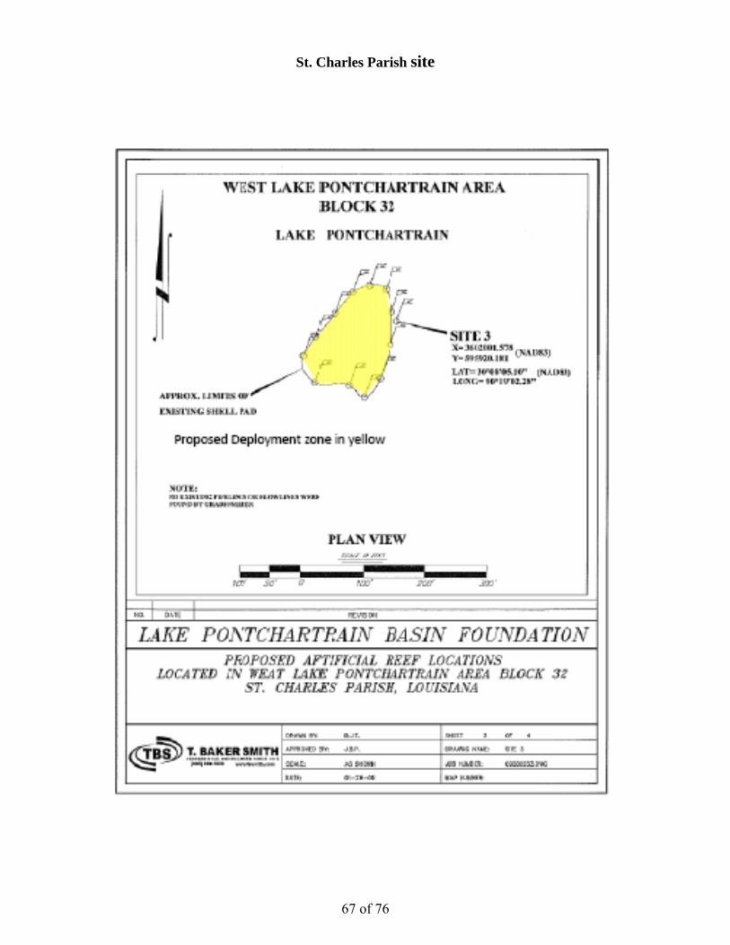
St. Charles Parish site
67 of 76

Proposed Deeployment zon
C
ne in yellow
A
B
D
C
E
RzReference dones (gree
deploymenten)
t
68 of 76
69 of 76

70 of 76
71 of 76

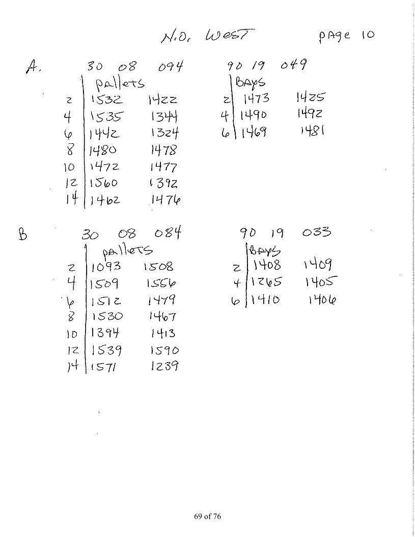
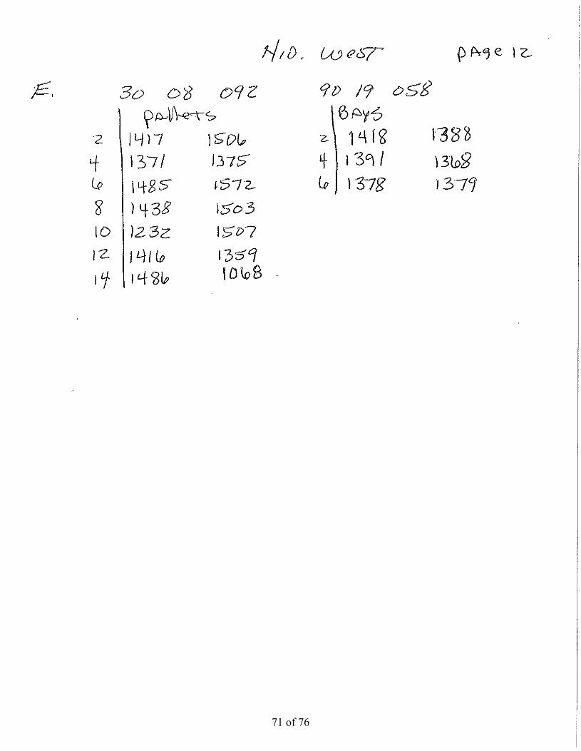
Total Reef site nameball ID # type
site #
date deployed
preliminary clearance (ft)
lat deg lat min
long deg long min
reef balls deployed in vicinity of barge site locations
1 St. Charles 1532 pallet 30 8.094 90 19.049 A 5/13/2009 112 St. Charles 1422 pallet 30 8.094 90 19.049 A 5/13/2009 113 St. Charles 1535 pallet 30 8.094 90 19.049 A 5/13/2009 114 St. Charles 1344 pallet 30 8.094 90 19.049 A 5/13/2009 115 St. Charles 1442 pallet 30 8.094 90 19.049 A 5/13/2009 116 St. Charles 1324 pallet 30 8.094 90 19.049 A 5/13/2009 117 St. Charles 1480 pallet 30 8.094 90 19.049 A 5/13/2009 118 St. Charles 1478 pallet 30 8.094 90 19.049 A 5/13/2009 119 St. Charles 1472 pallet 30 8.094 90 19.049 A 5/13/2009 11
10 St. Charles 1477 pallet 30 8.094 90 19.049 A 5/13/2009 1111 St. Charles 1560 pallet 30 8.094 90 19.049 A 5/13/2009 1112 St. Charles 1392 pallet 30 8.094 90 19.049 A 5/13/2009 1113 St. Charles 1462 pallet 30 8.094 90 19.049 A 5/13/2009 1114 St. Charles 1476 pallet 30 8.094 90 19.049 A 5/13/2009 1115 St. Charles 1473 bay 30 8.094 90 19.049 A 5/13/2009 1216 St. Charles 1425 bay 30 8.094 90 19.049 A 5/13/2009 1217 St. Charles 1490 bay 30 8.094 90 19.049 A 5/13/2009 1218 St. Charles 1492 bay 30 8.094 90 19.049 A 5/13/2009 1219 St. Charles 1469 bay 30 8.094 90 19.049 A 5/13/2009 1220 St. Charles 1481 bay 30 8.094 90 19.049 A 5/13/2009 1221 St. Charles 1093 pallet 30 8.084 90 19.033 B 5/13/2009 1122 St. Charles 1508 pallet 30 8.084 90 19.033 B 5/13/2009 1123 St. Charles 1509 pallet 30 8.084 90 19.033 B 5/13/2009 1124 St. Charles 1556 pallet 30 8.084 90 19.033 B 5/13/2009 1125 St. Charles 1512 pallet 30 8.084 90 19.033 B 5/13/2009 1126 St. Charles 1479 pallet 30 8.084 90 19.033 B 5/13/2009 116 St C a es 9 pa et 30 8 08 90 9 033 5/ 3/ 00927 St. Charles 1530 pallet 30 8.084 90 19.033 B 5/13/2009 1128 St. Charles 1467 pallet 30 8.084 90 19.033 B 5/13/2009 1129 St. Charles 1394 pallet 30 8.084 90 19.033 B 5/13/2009 1130 St. Charles 1413 pallet 30 8.084 90 19.033 B 5/13/2009 1131 St. Charles 1539 pallet 30 8.084 90 19.033 B 5/13/2009 1132 St. Charles 1590 pallet 30 8.084 90 19.033 B 5/13/2009 1133 St. Charles 1571 pallet 30 8.084 90 19.033 B 5/13/2009 1134 St. Charles 1239 pallet 30 8.084 90 19.033 B 5/13/2009 1135 St. Charles 1408 bay 30 8.084 90 19.033 B 5/13/2009 1236 St. Charles 1409 bay 30 8.084 90 19.033 B 5/13/2009 1237 St. Charles 1265 bay 30 8.084 90 19.033 B 5/13/2009 1238 St. Charles 1405 bay 30 8.084 90 19.033 B 5/13/2009 1239 St. Charles 1410 bay 30 8.084 90 19.033 B 5/13/2009 1240 St. Charles 1406 bay 30 8.084 90 19.033 B 5/13/2009 1241 St. Charles 1278 pallet 30 8.072 90 19.034 C 5/13/2009 1142 St. Charles 1275 pallet 30 8.072 90 19.034 C 5/13/2009 1143 St. Charles 1318 pallet 30 8.072 90 19.034 C 5/13/2009 1144 St. Charles 1374 pallet 30 8.072 90 19.034 C 5/13/2009 1145 St. Charles 1343 pallet 30 8.072 90 19.034 C 5/13/2009 1146 St. Charles 1319 pallet 30 8.072 90 19.034 C 5/13/2009 1147 St. Charles 1320 pallet 30 8.072 90 19.034 C 5/13/2009 1148 St. Charles 1291 pallet 30 8.072 90 19.034 C 5/13/2009 1149 St. Charles 1365 pallet 30 8.072 90 19.034 C 5/13/2009 1150 St. Charles 1369 pallet 30 8.072 90 19.034 C 5/13/2009 1151 St. Charles 1290 pallet 30 8.072 90 19.034 C 5/13/2009 1152 St. Charles 1317 pallet 30 8.072 90 19.034 C 5/13/2009 1153 St. Charles 1373 pallet 30 8.072 90 19.034 C 5/13/2009 11
72 of 76

Total Reef site nameball ID # type
site #
date deployed
preliminary clearance (ft)
lat deg lat min
long deg long min
reef balls deployed in vicinity of barge site locations
54 St. Charles 1364 pallet 30 8.072 90 19.034 C 5/13/2009 1155 St. Charles 1537 bay 30 8.072 90 19.034 C 5/13/2009 1256 St. Charles 1451 bay 30 8.072 90 19.034 C 5/13/2009 1257 St. Charles 1414 bay 30 8.072 90 19.034 C 5/13/2009 1258 St. Charles 1407 bay 30 8.072 90 19.034 C 5/13/2009 1259 St. Charles 1515 bay 30 8.072 90 19.034 C 5/13/2009 1260 St. Charles 1468 bay 30 8.072 90 19.034 C 5/13/2009 1261 St. Charles 1395 pallet 30 8.067 90 19.054 D 5/13/2009 1162 St. Charles 1505 pallet 30 8.067 90 19.054 D 5/13/2009 1163 St. Charles 1393 pallet 30 8.067 90 19.054 D 5/13/2009 1164 St. Charles 1551 pallet 30 8.067 90 19.054 D 5/13/2009 1165 St. Charles 1342 pallet 30 8.067 90 19.054 D 5/13/2009 1166 St. Charles 1314 pallet 30 8.067 90 19.054 D 5/13/2009 1167 St. Charles 1363 pallet 30 8.067 90 19.054 D 5/13/2009 1168 St. Charles 1297 pallet 30 8.067 90 19.054 D 5/13/2009 1169 St. Charles 1396 pallet 30 8.067 90 19.054 D 5/13/2009 1170 St. Charles 1386 pallet 30 8.067 90 19.054 D 5/13/2009 1171 St. Charles 1370 pallet 30 8.067 90 19.054 D 5/13/2009 1172 St. Charles 1411 pallet 30 8.067 90 19.054 D 5/13/2009 1173 St. Charles 1372 pallet 30 8.067 90 19.054 D 5/13/2009 1174 St. Charles 1504 pallet 30 8.067 90 19.054 D 5/13/2009 1175 St. Charles 1387 pallet 30 8.067 90 19.054 D 5/13/2009 1176 St. Charles 1398 pallet 30 8.067 90 19.054 D 5/13/2009 1177 St. Charles 1292 pallet 30 8.067 90 19.054 D 5/13/2009 1178 St. Charles 1357 pallet 30 8.067 90 19.054 D 5/13/2009 1179 St. Charles 1350 pallet 30 8.067 90 19.054 D 5/13/2009 119 St C a es 350 pa et 30 8 06 90 9 05 5/ 3/ 00980 St. Charles 1300 pallet 30 8.067 90 19.054 D 5/13/2009 1181 St. Charles 1276 pallet 30 8.067 90 19.054 D 5/13/2009 1182 St. Charles 1293 pallet 30 8.067 90 19.054 D 5/13/2009 1183 St. Charles 1415 pallet 30 8.067 90 19.054 D 5/13/2009 1184 St. Charles 1412 pallet 30 8.067 90 19.054 D 5/13/2009 1185 St. Charles 1264 bay 30 8.067 90 19.054 D 5/13/2009 1286 St. Charles 1403 bay 30 8.067 90 19.054 D 5/13/2009 1287 St. Charles 1474 bay 30 8.067 90 19.054 D 5/13/2009 1288 St. Charles 1457 bay 30 8.067 90 19.054 D 5/13/2009 1289 St. Charles 1401 bay 30 8.067 90 19.054 D 5/13/2009 1290 St. Charles 1404 bay 30 8.067 90 19.054 D 5/13/2009 1291 St. Charles 1400 bay 30 8.067 90 19.054 D 5/13/2009 1292 St. Charles 1402 bay 30 8.067 90 19.054 D 5/13/2009 1293 St. Charles 1448 bay 30 8.067 90 19.054 D 5/13/2009 1294 St. Charles 1475 bay 30 8.067 90 19.054 D 5/13/2009 1295 St. Charles 1470 bay 30 8.067 90 19.054 D 5/13/2009 1296 St. Charles 1516 bay 30 8.067 90 19.054 D 5/13/2009 1297 St. Charles 1384 bay 30 8.067 90 19.054 D 5/13/2009 1298 St. Charles 1385 bay 30 8.067 90 19.054 D 5/13/2009 1299 St. Charles 1356 bay 30 8.067 90 19.054 D 5/13/2009 12
100 St. Charles 1383 bay 30 8.067 90 19.054 D 5/13/2009 12101 St. Charles 1417 pallet 30 8.092 90 19.058 E 5/13/2009 11102 St. Charles 1506 pallet 30 8.092 90 19.058 E 5/13/2009 11103 St. Charles 1371 pallet 30 8.092 90 19.058 E 5/13/2009 11104 St. Charles 1375 pallet 30 8.092 90 19.058 E 5/13/2009 11105 St. Charles 1485 pallet 30 8.092 90 19.058 E 5/13/2009 11106 St. Charles 1572 pallet 30 8.092 90 19.058 E 5/13/2009 11
73 of 76

Total Reef site nameball ID # type
site #
date deployed
preliminary clearance (ft)
lat deg lat min
long deg long min
reef balls deployed in vicinity of barge site locations
107 St. Charles 1438 pallet 30 8.092 90 19.058 E 5/13/2009 11108 St. Charles 1503 pallet 30 8.092 90 19.058 E 5/13/2009 11109 St. Charles 1232 pallet 30 8.092 90 19.058 E 5/13/2009 11110 St. Charles 1507 pallet 30 8.092 90 19.058 E 5/13/2009 11111 St. Charles 1416 pallet 30 8.092 90 19.058 E 5/13/2009 11112 St. Charles 1359 pallet 30 8.092 90 19.058 E 5/13/2009 11113 St. Charles 1486 pallet 30 8.092 90 19.058 E 5/13/2009 11114 St. Charles 1068 pallet 30 8.092 90 19.058 E 5/13/2009 11115 St. Charles 1418 pallet 30 8.092 90 19.058 E 5/13/2009 11116 St. Charles 1388 pallet 30 8.092 90 19.058 E 5/13/2009 11117 St. Charles 1391 pallet 30 8.092 90 19.058 E 5/13/2009 11118 St. Charles 1368 pallet 30 8.092 90 19.058 E 5/13/2009 11119 St. Charles 1378 pallet 30 8.092 90 19.058 E 5/13/2009 11120 St. Charles 1379 pallet 30 8.092 90 19.058 E 5/13/2009 11
74 of 76

Doug Peter (DWF) with Dr. John Lopez at St. Charles Parish site on site May 13, 2009
CRB barge with certified site marker in background during St. Charles site deployment May 13, 2009
75 of 76

Doug Peter and other DWF staff inspecting CRB barge at St. Charles site May 13, 2009
Deploying bay ball size reef balls at St,. Charles site May 13, 2009
76 of 76