department of the army etl 1100-2-4 u.s. army corps of
TRANSCRIPT
ETL 1100-2-4 • 30 September 2020 1
DEPARTMENT OF THE ARMY ETL 1100-2-4 U.S. Army Corps of Engineers
441 G Street, NW
Washington, DC 20314-1000 Technical Letter No. 1100-2-4 30 September 2020
EXPIRES 30 SEPTEMBER 2025 Engineering and Design
DEVELOPING PALEOFLOOD INFORMATION FOR FLOOD FREQUENCY ANALYSIS
1. Purpose. This Engineer Technical Letter (ETL) provides guidance and procedures for the appropriate use of paleoflood analyses and information in support of U.S. Army Corps of Engineers (USACE) flood frequency analysis.
2. Applicability. This ETL applies to USACE commands having Civil Works (CW) planning, engineering design, operations, and maintenance responsibilities.
3. Distribution Statement. Approved for public release; distribution is unlimited.
FOR THE COMMANDER: 3 Appendixes A: References B: Technical Basics of Paleoflood Analysis C: Summary of Paleoflood Analytical Procedures
CHRISTINE T. ALTENDORF, Ph.D., P.E. Chief, Engineering and Construction Division Directorate of Civil Works
2 ETL 1100-2-4 • 30 September 2020
1. Purpose. This ETL provides guidance and procedures for the appropriate use of paleoflood analyses and information in support of USACE flood frequency analysis.
2. Applicability. This ETL applies to USACE commands having CW planning, engineering design, operations, and maintenance responsibilities.
3. Distribution Statement. Approved for public release; distribution is unlimited.
4. References. References are in Appendix A.
5. Records Management (Record Keeping) Requirements. Records management requirements for all record numbers, associated forms, and reports required by this regulation are included in the Army's Records Retention Schedule - Army. Detailed information for all record numbers, forms, and reports associated with this regulation are located in the Records Retention Schedule - Army at https://www.arims.army.mil.
6. Background.
a. Paleoflood analysis is the application of the science of paleohydrology for assessing flood hazards on rivers to critical infrastructure such as dams, levees, and other flood protection works. Paleoflood analyses focus on characterizing the magnitude and timing of rare or extreme large floods that occurred prior to systematic streamflow gage records. Paleoflood information can improve confidence in extrapolation of a flood frequency curve beyond the systematic record and can improve assessment of uncertainties in flood frequency estimates. Paleoflood analyses can confirm, support, or augment existing information on historical flood stages and/or discharges and provide physical evidence for (or against) the occurrence of large floods prior to the historical record.
b. Developing a record of floods longer than the systematic record is warranted because existing records may or may not adequately capture large, infrequent, and potentially damaging hydrologic events within the current hydrologic regime. The primary contributions of paleoflood analyses are to develop defensible scientific data on the timing and magnitude of large, infrequent floods, and incorporate these data into long-term flow frequency statistics for use in risk assessments of critical infrastructure facilities.
c. The use of paleoflood information is consistent with, and supports or augments, existing USACE guidance for characterizing hydrologic loading and associated infrastructure risk, such as Engineer Regulation (ER) 1105-2-101, ER 1110-2-1156, ER 1110-2-1450, ER 1110-2-1464, EM 1110-2-1415, Engineer Manual (EM) 1110-2-1416, and EM 1110-2-1417. As per England 2018 reference, the recent comprehensive protocol document by the U.S. Geological Survey (USGS), published in collaboration with USACE, also provides guidance for hydrologic analysis of critical structures. Analytical procedures provided by this publication, referred to as “Bulletin 17C”, applies to facilities owned, maintained, and/or operated by USACE. The guidance provided in this ETL is consistent with these existing documents.

ETL 1100-2-4 • 30 September 2020 3
d. Paleoflood information is derived through identification and characterization of indicators of past floods (i.e., “Paleostage Indicators” (PSI)) and/or of past landscape stability and an absence of flooding (i.e., “Non-Exceedance Bounds” (NEB)). The magnitudes and timing of peak discharges derived from PSI and NEB features are incorporated into hydrologic analyses using standard hydrologic statistical techniques, in the same manner as peak discharges that have occurred during systematic and historical time periods. The information gained from paleoflood analyses can be used, as appropriate, according to USACE policy and guidance for risk assessment and risk-informed decision making. This ETL provides technical guidance on using paleoflood analytical techniques within the context of USACE hydrologic analyses.
7. Guidance for Developing Paleoflood Information for Flood Frequency Analysis. This ETL provides guidance regarding the appropriate use of paleoflood information in support of flood frequency analysis, as summarized below. Additional information on paleoflood standard procedures and practices is provided in Appendix B and Appendix C.
a. Overall Technical Framework.
(1) Paleoflood analyses are conducted in support of USACE hydrologic analysis, where warranted by consideration of risk drivers and level of uncertainty in risk-informed decision-making or design processes. The heart of paleoflood analyses lies at the intersection of the interrelated fields of geology and hydrology, as applied to infrastructure engineering. Physical evidence of pre-historic and historic floods provides basic data on the timing and magnitude of rare or extreme floods; also, physical evidence of non-inundation provides data on the timing and duration of landscape stability without flooding. These geologic and geomorphic data sets are the foundation for understanding long-term flood chronologies along a river or within a watershed, and for appropriately characterizing hydrologic hazards within a risk-informed framework.
(2) Hydraulic modeling uses the characteristics of past large floods to develop estimates of peak instantaneous discharges responsible for the geologic or geomorphic features, in conjunction with sediment-transport and erodibility principles that have controlled the formation and preservation of flood or non-flood features. Using paleoflood data on the locations, timing, and magnitudes of peak paleodischarges (or lack thereof), standard hydrologic analyses provide context with respect to the existing systematic (gaged) and historic streamflow records and use these data to develop a more robust flood frequency analysis. The efficacy of hydrologic analysis using paleoflood information can be measured by the Effective Record Length (ERL), a statistical metric that helps understand the effect of merging pre-historic and historic flood information.
(3) The additional data provided by collecting paleoflood evidence usually increases the length of the streamflow record (i.e., the ERL is larger/longer), which allows for greater confidence in the updated flood frequency relationship. The application of an updated flood frequency relationship that incorporates paleoflood information should consider uncertainties in the basic paleoflood evidence (e.g., stage, discharge, and timing) as well as the possibility of

4 ETL 1100-2-4 • 30 September 2020
either temporal or geometric non-stationarities in the river system and watershed. These concepts are summarized in this document and accompanying appendices.
b. Analytical Benefits. It is appropriate and recommended to consider acquiring paleoflood information in hydrologic analyses (and decisions dependent on hydrologic analyses) for cases in which rare or extreme floods are poorly known or not represented by the systematic or historical empirical records. Using well-constrained paleoflood information is appropriate and especially useful for estimating annual exceedance probabilities (AEP) rarer than about 1/100 (i.e., for floods greater than the “100-year” return period flood). Using paleoflood information is also recommended for cases in which additional hydrologic information on the timing and magnitude of rare or extreme flood events could be used to:
(1) Increase the ERL of the combined systematic (gaged) and historical streamflow record;
(2) Include data on extreme floods larger than those in the systematic or historical record and/or potential limits to flood magnitudes over time;
(3) Improve quantitative or qualitative treatment of uncertainties in hydrologic loading;
(4) Improve confidence in flood-frequency expected values, and/or;
(5) Address the long-term persistence of rare or extreme discharges over time periods longer than the systematic and historical record.
c. Scalable Approach.
(1) The collection and interpretation of paleoflood information can be scaled to accommodate different project scopes, budgets, schedules, and allowable uncertainties. Because the degree of uncertainty in paleoflood analyses and level of confidence in analytical results usually are dependent upon level of effort, it is appropriate to tailor paleoflood contributions to hydrologic analyses according to specific project needs. Although more detailed efforts often demand greater resources, additional costs and longer timelines may be warranted because of an improved confidence in extreme flood analytical results and a better understanding of uncertainties.
(2) The level of effort can be phased so that progressively more detailed analyses are considered at project-specific milestones, such that potential benefits of the additional effort can be considered. To capture this concept of progressive, adaptive analysis, it is recommended that paleoflood contributions to hydrologic analyses follow three levels of investigation (e.g., viability reconnaissance, evaluation, characterization). Additional information on the goals, approaches, products, and timelines related to each of these levels of investigation are provided in Appendix C.
ETL 1100-2-4 • 30 September 2020 5
d. Selection of River Analytical Reaches.
(1) The initial step within a paleoflood analysis for a specific facility considers the viability of one or more specific river reaches for providing useful and defensible information on the timing and magnitude of past peak flood discharges. The likelihoods that river reaches in the area of interest may or may not provide well-constrained paleoflood data should be considered when initiating a paleoflood analysis at a given site. The probable ranges in uncertainties in paleodischarge values and ages should also be considered (O'Connor, 2014). Best practices used for recent USACE paleoflood viability assessments are Appendix C.
(2) One of the primary sources of uncertainty in developing paleoflood information is the geometric stationarity of the river channel and/or valley over the time period of interest. Preferred and viable paleoflood analysis reaches include those for which hydraulic conditions at the time of past large floods were similar to present-day conditions. Localities should be avoided or not considered if geometric stationarity cannot be reasonably assumed to be negligible or minor. Prior to and during a paleoflood investigation, analysts should be cognizant of all primary sources of uncertainties and probable outcomes, and should be willing and able to suspend the investigation should the benefits of continued analysis become unfavorable.
e. Primary Analytical Tools.
(1) Appendix C provides an outline of key components of a paleoflood investigation at a specific site or river reach, including geomorphic and geologic analyses, age-estimation of flood-related features, historical flood data compilation, hydraulic assessment of rare flood stages, and flood frequency statistical analyses. A paleoflood analysis should include defensible identification and characterization of physical evidence of a high-stage discharge event (PSI), or physical evidence of a past period of no high-stage discharge events (NEB) (England, 2018).
(2) Identifying and characterizing PSI and NEB relies heavily on standard geologic and geomorphologic tools, including (i) delineation of flood-related deposits and landforms, (ii) defining hillslope, alluvial-fan, eolian, or other landforms unrelated to large floods, and (iii) developing age estimates for the formation of relevant fluvial and non-fluvial features. A paleoflood analysis requires an understanding of surficial processes, including fluvial and non-fluvial mechanisms, and the ability to estimate the location, timing, and duration of these processes over geologic and human timescales. Additional information about geologic and geomorphologic tools that should or can be applied to paleoflood analyses is provided in Appendix C.

6 ETL 1100-2-4 • 30 September 2020
(3) Uncertainties in flood stage elevations should be minimized as much as possible within project constraints1, through use of high-resolution topographic information and acceptable methods of location geo-referencing. Geologic, geomorphic, sedimentologic, stratigraphic, and pedogenic information should be collected as necessary to interpret the number and elevations of flood-related features (PSI), or of features demonstrating an absence of inundation (NEB).
(4) It is preferable to characterize features at multiple sites along a reach, in order to address natural variability in down-valley flood water surface elevations (WSE) and maximize the likelihood of identifying all large floods within the paleoflood chronologic record. Multiple reaches within a watershed should be considered for data collection to ensure appropriate spatial representation of extreme floods. The discharges associated with specific geomorphic flood-related features are estimated using riverine hydraulic models and/or physical first principles, and the discharges and ages of the interpreted floods are incorporated into flood frequency analyses per standard USACE procedures (England, 2018; Hydrologic Engineering Center [HEC], 2019). Appropriate methods are summarized in Appendix C.
f. Uncertainties.
(1) Paleoflood analyses should include defensible efforts that define the center, body, and range of discharges associated with flood-related PSI features, or of limiting (non-inundation) discharge values associated with NEB features. Uncertainties in geologic and geomorphic data may be present because of different possible origins of deposits or features, which may affect the identification (or mis-identification) of a feature as a PSI or NEB. Measurement uncertainties also may occur in quantifying the elevation of PSI or NEB, and estimating the depth or velocity of floodwater required to deposit the flood sediment or inundate a NEB, both of which may affect evaluation of peak discharge magnitude. Uncertainties in age ranges of geologic and geomorphic features also contribute to assessments of the timing of specific floods or non-inundation intervals (and therefore to the interpreted paleoflood chronology).
(2) The range of estimated paleodischarges and age related to these uncertainties should be captured and documented in the paleoflood analysis. Standard hydraulic methodologies, such as one-dimensional (1D) or two-dimensional (2D) modeling methods, should be applied considering project constraints and data uncertainties. The hydraulic models used should be calibrated and validated according to current standards and techniques (HEC, 2018, version 5.0.7). Given currently available terrain data and modern computational capabilities, 2D modeling of paleodischarges (for PSI) or of non-inundation discharge values (for NEB) may provide large benefits for little additional effort, because of an improved ability to capture uncertainties.
1 Project constraints often entail cost, schedule, and/or available topographic data or other site information.
ETL 1100-2-4 • 30 September 2020 7
(3) The estimation of paleodischarges and/or non-inundation discharges should consider all major sources of uncertainty, including model parameterization, depths of flow above the geomorphic features, and natural variability in down-valley profiles of PSI, NEB, and past flood WSE (see details in Appendix C).
(4) Uncertainties regarding both geometric and temporal non-stationarity in the river system or watershed should be addressed in order for the paleoflood analysis to be adequately defensible. Geometric non-stationarity represents the occurrence of a paleoflood within a channel or valley with a conveyance geometry that differs significantly from the presently discernible geometry. Present-day channel and valley geometries are usually defined by high-resolution topographic data, which almost always are derived from modern data-collection techniques (e.g., LiDAR) and therefore do not always represent the same channel or valley geometries that existed during a given paleoflood.
(5) Geomorphic interpretation of the evolution of historic and pre-historic landforms may be required to confirm a similarity (or difference) between the modern and flood-contemporaneous topographic conditions, or to develop a defensible model of previous (flood-contemporaneous) channel or valley geometries that can be used for estimating paleodischarges of pre-historic or early historic floods. Appendix C provides additional information on how paleoflood analyses can be structured to ensure that geometric non-stationarity is negligible or minimized.
(6) Temporal non-stationarity of meteorologic and hydrologic systems is a topic of current research and debate and is beyond the guidance addressed in this document. Well-documented evidence of temporal non-stationarity over geologic and historic timescales exist throughout the U.S. and world (Enzel & Wells, 1997) (Mudelsee, Borngen, Tetzlaff, & Grunewald, 2003) (Blöschl & Montanari, 2010) (Hirsch, 2011) (Munoz, et al., 2018).
(7) A basic assumption in all hydrologic flood-frequency analyses is that available systematic and historic streamflow records adequately reflect likely conditions in the future time period of engineering concern. In cases where this assumption might not hold, differing future conditions related to temporal non-stationarity (e.g., hydro-meteorologic changes in longer-term climate, land-use changes) are often modeled using the existing hydrologic information as a starting point. This guidance document does not address the concept of Long-Term Persistence (LTP) of variations in annualized discharge parameters over a wide range of temporal scales; refer to existing guidance in ETL 1110-2-3 for more information.
(8) All paleoflood analyses and resulting information should be considered in context of possible temporal non-stationarity of both meteorologic and land-use changes in the watershed. Specific paleoflood analyses should consider temporal non-stationarity in the watershed of interest. Overall, the use of paleoflood information usually improves the ERL of available hydrologic information, therefore improving the ability to identify LTP of large events for consideration of future conditions.

8 ETL 1100-2-4 • 30 September 2020
g. Historical Information.
(1) Paleoflood analyses may also include the collection and analysis of historical observations that address pre-systematic peak flood heights, extents, timing, and discharges. For cases in which large historical floods (e.g., the flood of record) are reasonably well documented, obtaining physical flood evidence at particular locations allows for calibration of hydraulic models at stages that are not commonly observed and at key sites that also contain evidence of pre-historic flooding. The documentation of historical information at these sites is critical for improving confidence in hydraulic models for extrapolation to discharges not previously observed.
(2) The level of available historical information may vary among watersheds depending on the local contemporaneous population and the ability to record significant flood locations, stages, velocities, or discharges. Local historical information on peak flood parameters (e.g., heights, extents, peak discharge) can be obtained from numerous sources, such as USACE ‘308 reports’ and USGS reports (England, 2018) (Branard, 2019). During field investigations, data may not be available about whether specific flood features are a result of modern, historic, or pre-historic discharges, and the differentiation among features formed during these distinct intervals may be useful elsewhere in the analysis reach (Appendix C). For example, observations of flood damage on a specific bridge or building of known age can help determine an historic flood stage, which can then be used elsewhere in the reach to interpret evidence of other historic or pre-historic stages.
(3) In other areas, the historical record may not include adequate quantitative information on the number, magnitude, and dates of large floods, such that physical flood-related features may significantly improve the historical record and thus the long-term flood frequency analysis. Historical information can be qualitative and requires comparison with other corroborative information in order to improve flow-frequency analyses.
h. Systematic Gage Information.
(1) Paleoflood analyses should include quality-control efforts focused on significant floods within the systematic record, if one exists for the site reach or area. The analysis should include review of evidence for peak flood stage, and factors that might affect the level of uncertainty in the stage-discharge rating curve at nearby sites. For example, rating curves for river reaches affected by ice-related stage increases (related to “ice jams”), or substantial channel geometry changes within the gaged period, should be critically evaluated. Anomalous, non-representative flood stages (and associated discharge estimates) should not be included in the flood chronology without adequate adjustment.
(2) The methods employed in identifying and characterizing paleoflood PSI and NEB (Appendix C) can be used for confirming previous estimates of large, significant peak discharges, or as a basis for reconsidering anomalous, non-representative discharge estimates in the systematic record.

ETL 1100-2-4 • 30 September 2020 9
i. Flood Frequency Analyses.
(1) Paleoflood analyses should include hydraulic and hydrologic analyses according to all applicable USACE guidance. Standard techniques for developing flood frequency information are provided in USGS Bulletin 17C (England, 2018). Current best practices involve combining data from the systematic (gaged), historic, and paleoflood records (USACE, 2018) using appropriate perception thresholds and flow interval data, and develop flood frequency statistics using the Expected Moments Algorithm (EMA) and a Log-Pearson Type III distribution (Cohn, Lane, & Baier, 1997). Current versions of the HEC-Statistical Software Package (SSP) software (HEC, 2019) incorporate the methodology recommended by Bulletin 17C (England, 2018).
(2) Uncertainties in developing flood-frequency curves should also be consistent with the current standard of practice (England, 2018). Uncertainties in the age and magnitude of paleoflood information should be estimated and included in the flood frequency analysis. For example, uncertainty in paleoflood discharge estimates can be captured using flow intervals (England, 2018). The range in uncertainty in flow-frequency relationships using paleoflood information can be captured and portrayed by a series of sensitivity analyses that consider the range in ages for PSI and NEB, and the ranges in peak flood discharges for PSI or limit non-inundation discharge values for NEB.
j. Personnel Qualifications.
(1) Personnel involved in USACE paleoflood analysis should have appropriate expertise and background to collect and analyze technical data at state-of-practice or state-of-research levels. Efficient analyses will include qualified personnel that require little or no technical training, although sufficient expertise on the analytical team may allow transfer of knowledge or capability without substantial project delay or harm.
(2) It is recommended that the analytical team includes personnel with national- or global-level expertise in the technical fields noted in Table 1, supported by personnel with appropriate background in respective technical disciplines. Notably, personnel qualifications for specific paleoflood analyses may be strongly affected by local, reach-specific geologic, geomorphologic, hydrologic, and hydraulic conditions; the experience of personnel conducting the paleoflood analysis should match with the technical conditions and complexities of the local analytical reach. For example, analytical reaches in arid climates and containing fluvial terraces that may serve as PSI require that the project team include personnel with specific experience in assessing arid-climate soil chronosequences developed in alluvial materials.
(3) Analytical reaches characterized by local backwater effects and the possibility of non-steady flow will require personnel with experience in modeling stage and discharge conditions with complex flow geometries. Similarly, for hydrologists, analytical reaches in watersheds characterized by summer-season cyclonic storms and high runoff production should include personnel with experience documenting rapid-runoff discharge characteristics and highly peaked flood hydrographs.

10 ETL 1100-2-4 • 30 September 2020
Table 1 General Personnel Qualifications Required for Paleoflood Analysis
Technical Discipline
Primary Technical Sub-disciplines
Secondary Technical Sub-disciplines
Minimum Educational
Level
Geology and Geomorphology
Geomorphic Mapping
Fluvial and Landform Processes
Sedimentology
Soils Pedogenesis
Age-dating Chronology
Technical Reporting
Geographic Information Systems (GIS)
Bedrock Characterization
Botanical Flood Effects
Archaeological Resources
Technical Communication
Post-graduate (M.S., Ph.D.);
Geology or Geomorphology
Hydraulic Engineering
One-Dimensional Modeling
Two-Dimensional Modeling
Technical Reporting
Sediment Transport
Velocity and Shear Stress Analysis
Non-steady and Non-uniform Flow Characterization
Technical Communication
Post-graduate (M.S., Ph.D.);
Hydraulic Engineering
Hydrology and Hydrologic Engineering
Discharge Measurement Analysis
Streamflow Records Analysis
Historical Archive Research
Flood Frequency Analysis (e, g,, HEC-SSP, PeakFQ)
Technical Reporting
Watershed Hydrology
Storm Typing and Transposition
Rainfall-Runoff Modeling
Technical Communication
Post-graduate (M.S., Ph.D.);
Hydrology
ETL 1100-2-4 • 30 September 2020 11
Appendix A References 1. Required References.
a. USACE Publications.
ER 1105-2-101, Risk Analysis for Flood Damage Reduction Studies. https://www.publications.usace.army.mil/Portals/76/Users/182/86/2486/ER%201105-2-101_Clean.pdf?ver=2019-10-17-144237-503 ER 1110-2-1450, Hydrologic Frequency Estimates. https://www.publications.usace.army.mil/Portals/76/Publications/EngineerRegulations/ER_1110-2-1450.pdf ER 1110-2-1464, Hydrologic Analysis of Watershed Runoff. ER 1110-2- 1464. https://www.publications.usace.army.mil/Portals/76/Publications/EngineerRegulations/ER_1110-2-1464.pdf?ver=2013-09-08-233425-840 ER 1110-2-1156, Safety of Dams – Policy and Procedures. https://www.publications.usace.army.mil/Portals/76/Publications/EngineerRegulations/ER_1110-2-1156.pdf EM 1110-2-1413, Hydrologic Analysis of Interior Areas. https://www.publications.usace.army.mil/Portals/76/Users/227/19/2019/EM_1110-2-1413.pdf?ver=2018-09-13-125346-687 EM 1110-2-1415, Hydrologic Frequency Analysis. http://www.publications.usace.army.mil/Portals/76/Publications/EngineerManuals/EM_1110-2-1415.pdf?ver=2013-09-04-072915-230 EM 1110-2-1416, River Hydraulics. https://www.publications.usace.army.mil/Portals/76/Publications/EngineerManuals/EM_1110-2-1416.pdf?ver=2013-09-04-070758-670 EM 1110-2-1417, Flood-Runoff Analysis. https://www.publications.usace.army.mil/Portals/76/Publications/EngineerManuals/EM_1110-2-1417.pdf?ver=2013-09-04-070759-920 EM 1110-2-1419, Hydrologic Engineering Requirements for Flood Damage Reduction Studies. https://www.publications.usace.army.mil/Portals/76/Publications/EngineerManuals/em_1110-2-1419.pdf
12 ETL 1100-2-4 • 30 September 2020
ER 1110-2-1150, Engineering and Design for Civil Works Projects. https://www.publications.usace.army.mil/Portals/76/Publications/EngineerRegulations/ER_1110-2-1150.pdf ECB 2019-11, Transition Guidance for Levee System Evaluations for the National Flood Insurance Program. https://www.wbdg.org/FFC/ARMYCOE/COEECB/ecb_2019_11.pdf ECB 2019-15, Interim Approach for Risk-Informed Designs for Dam and Levee Projects. https://www.wbdg.org/FFC/ARMYCOE/COEECB/ecb_2019_15.pdf ETL 1100-2-3, Guidance for the detection of nonstationarities in annual maximum discharges. https://www.publications.usace.army.mil/Portals/76/Publications/EngineerTechnicalLetters/ETL_1100-2-3.pdf USACE 1939, Kern River High Water Investigation, Appendix XII - B, Survey Report, Flood Control Sacramento and San Joaquin River Valleys, California, Kern River Group Proposed Flood Control Improvement, 22 p. Branard 2019, Branard, A. and Stowasser, E. (2019) Data Sources for Estimating Hydrologic Hazards for Semi-Quantitative Risk Assessments, Report RMC-TR-2019-07, USACE Risk Management Center, Lakewood, CO, 33 p. https://www.iwrlibrary.us/#/document/1d66bd71-3a95-4248-f96c-93ad4e3ca81a USACE 2019, HEC-SSP Statistical Software Package, User’s Manual version 2.2. Computer Program Documentation CPD-86, Hydrologic Engineering Center, Davis, CA. https://www.hec.usace.army.mil/software/hec-ssp/download.aspx HEC 2020, HEC-RAS River Analysis System, 2D Modeling User’s Manual version 5.0.7. Computer Program Documentation CPD-68A, Hydrologic Engineering Center, Davis, CA. https://www.hec.usace.army.mil/software/hec-ras/download.aspx Kelson et al. 2017a, Kelson, K., Hall, B., Harden, T., Mahan, S., & Duren, A. (2017, October). Late Holocene Paleofloods on the Middle Fork Willamette River: Improving Hydrologic Loading Input for USACE Dam Safety Evaluations. In GSA Annual Meeting in Seattle, Washington, USA-2017. GSA. https://www.researchgate.net/publication/321405714_LATE_HOLOCENE_PALEOFLOODS_ON_THE_MIDDLE_FORK_WILLAMETTE_RIVER_IMPROVING_HYDROLOGIC_LOADING_INPUT_FOR_USACE_DAM_SAFETY_EVALUATIONS Kelson et al. 2017b, Kelson, K.I., B.M. Hall, R. Sasaki, C.M. Leonard, and S. Potts (2017) Paleoflood Analysis for Ball Mountain Dam, Report RMC-TR-2017-08, USACE Risk Management Center, Lakewood, CO, 74 p. https://www.iwrlibrary.us/#/document/fa2c4046-8ff2-4213-97a7-8594874fee54
ETL 1100-2-4 • 30 September 2020 13
Kelson et al. 2018a, Kelson, K.I., B.M. Hall, G.S. Walters, A.M. Duren, and C.M. Leonard (2018) Paleoflood Analysis for Lookout Point Dam, Report RMC-TR-2018-02, USACE Risk Management Center, Lakewood, CO, 80 p. https://www.iwrlibrary.us/#/document/8039ac5a-82b7-4916-9fc0-836c95368435 Kelson et al. 2018b, Kelson, K.I., J.T. Pearce, and D.S. Kinder (2018) Paleoflood Analysis for Proctor Dam, Report RMC-TR-2018-09, USACE Risk Management Center, Lakewood, CO, 36 p. https://www.iwrlibrary.us/#/document/149ab2b5-a595-47ab-c7d5-67c2b09ff707 Kelson et al. 2020, Kelson, K.I., B.M. Hall, and R. Sasaki (2020) Paleoflood Analysis for Carbon Canyon Dam, Report RMC-TR-2020-02, USACE Risk Management Center, Lakewood, CO, 87 p. Pearce 2017, Pearce, J.T. (2017) Limited Geomorphic Investigation of Paleoflooding for Cherry Creek Dam (CO01280), Report RMC-TR-2017-10, USACE Risk Management Center, Lakewood, CO, 26 p. https://www.iwrlibrary.us/#/document/3d44d9ca-5352-4919-e8d2-003ca42414cf Pearce et al. 2018, Pearce, J.T., B.M. Hall, A. Parola, B.C. Comport, and C.M. Leonard (2018) Paleoflood Analysis for Stillhouse Hollow Dam, Report RMC-TR-2018-xx, USACE Risk Management Center, Lakewood, CO, 45 p. Smith et al. 2018, Smith, H., Bartles, M., and Fleming, M. (2018) Hydrologic Hazard Methodology for Semi-Quantitative Risk Assessments: An Inflow Volume-Based Approach to Estimating Stage-Frequency Curves for Dams, Report RMC-TR-2018-03, USACE Risk Management Center, Lakewood, CO, 132 p. https://www.iwrlibrary.us/#/document/87363a2a-8dd9-4596-991e-2f9863815c7e 2. Related Publications.
Baker 1987, Baker, V.R. (1987) Paleoflood hydrology and extraordinary flood events. Journal of Hydrology 96 (1987) 79–99. https://doi.org/10.1016/0022-1694(87)90145-4 Baker 2008, Baker, V.R. (2008) Paleoflood hydrology: Origin, progress, prospects. Geomorphology 101: 1– 13. https://doi.org/10.1016/j.geomorph.2008.05.016 Baker 2013, Baker, V. R. (2013). Global Late Quaternary Fluvial Paleohydrology: With Special Emphasis on Paleofloods and Megafloods. In Treatise on Geomorphology (Vol. 9, pp. 511-527). Elsevier Inc.. https://doi.org/10.1016/B978-0-12-374739-6.00252-9 Benito and O’Connor 2013, Benito, G. and O’Connor, J.E. (2013) Quantitative Paleoflood Hydrology, in Treatise on Geomorphology, Vol. 9.24 (J. Shroder and E.E. Wohl, Ed.) Fluvial Geomorphology, p. 459-474. San Diego: Academic Press. https://doi.org/10.1016/B978-0-12-374739-6.00250-5
14 ETL 1100-2-4 • 30 September 2020
Benson and Dalrymple 1967, Benson, M.A., and T. Dalrymple (1967) General field and office procedures for indirect discharge measurements. In Techniques in Water Resources Investigations, Book 3, Chapter A1. Reston, VA: U.S. Geological Survey. https://doi.org/10.3133/twri03A1 Blainey 2002, Blainey, J.B., R.H. Webb, M.E. Moss, and V.R. Baker (2002) Bias and information content of paleoflood data in flood-frequency analysis. In House, P.K., R.H. Webb, V.R. Baker, and D.R. Levish (Eds.) (2002) Ancient Floods, Modern Hazards: Principles and Applications of Paleoflood Hydrology. Water Sciences and Application, vol. 5. Washington, DC: American Geophysical Union, p. 161-174. https://doi.org/10.1029/WS005p0161 Blöschl and Montanari 2010, Blöschl, G., and A. Montanari (2010) Climate change impacts – Throwing the dice? Hydrological Processes, 24: 374–381. http://citeseerx.ist.psu.edu/viewdoc/download?doi=10.1.1.719.5125&rep=rep1&type=pdf Bretz 1923, Bretz, J.H. (1923) The Channeled Scablands of the Columbia Plateau. Journal of Geology, 617-649. http://wpg.forestry.oregonstate.edu/sites/wpg/files/seminars/1923_Bretz.pdf Cohn et al. 1997, Cohn, T.A., W.L. Lane, and W.G. Baier (1997) An algorithm for computing moments based flood quantile estimates when historical flood information is available. Water Resources Research 33(9): 2089–2096. https://doi.org/10.1029/97WR01640 Costa 1978, Holocene stratigraphy in flood frequency analysis. Water Resources Research. 14(4) 626-632. https://doi.org/10.1029/WR014i004p00626 Costa 1987, Costa, J.E. (1987) A history of paleoflood hydrology in the United States, 1800–1970. History of Geophysics 3: 49–53. https://doi.org/10.1029/HG003p0049 Denlinger et al. 2002, Denlinger, R.P., D.R.H. O’Connell, and P.K. House (2002) Robust determination of stage and discharge: An example from an extreme flood on the Verde River, Arizona. In Ancient Floods, Modern Hazards: Principles and Applications of Paleoflood Hydrology (P.K. House, R.H. Webb, V.R. Baker, and D.R. Levish, Ed.) Water Sciences and Application, vol. 5, p. 127-146. Washington, DC: American Geophysical Union. https://doi.org/10.1029/WS005p0127 England et al. 2010, England, J.F., Jr., J.E. Godaire, R.E. Klinger, T.R. Bauer, and P.Y. Julien (2010) Paleohydrologic bounds and extreme flood frequency of the Upper Arkansas River, Colorado, USA. Geomorphology 124. https://doi.org/10.1016/j.geomorph.2010.07.021 Enzel et al. 1993, Enzel, Y., L.L. Ely, P.K. House, V.R. Baker, and R.H. Webb (1993) Paleoflood evidence for a natural upper bound to flood magnitudes in the Colorado River basin. Water Resources Research. 29(7) 2287-2297. https://doi.org/10.1029/93WR00411
ETL 1100-2-4 • 30 September 2020 15
Fanok and Wohl 1997, Fanok, S.F. and Wohl, E.E. (1997) Assessing the accuracy of paleohydrologic indicators, Harpers Ferry, West Virginia. Journal of American Water Resources Association, 1091-1102. https://onlinelibrary.wiley.com/doi/epdf/10.1111/j.1752-1688.1997.tb04127.x Godaire et al. 2012, Godaire, J.E., Bauer, T.R., and Klinger, R.E. (2012) Paleoflood study, San Joaquin River near Friant dam, California: U.S. Department of Interior, Bureau of Reclamation, Denver, Colo., 60 p. https://drive.google.com/file/d/1dSJiIHaP3I_ld0iOadNtPAlZSoLs4LEi/view Harden et al. 2011, Harden, T.M., O’Connor, J.E., Driscoll, D.G., and Stamm, J.F. (2011) Flood-frequency analyses from paleoflood investigations for Spring, Rapid, Boxelder, and Elk Creeks, Black Hills, Western South Dakota: U.S. Geological Survey Scientific Investigations Report 2011–5131, 136 p., https://pubs.usgs.gov/sir/2011/5131/ Harden et al. 2019, Harden, T., O'Connor, J., and Keith, M. (2019) Improving Flood Frequency Analysis with a Multi-Millenial Record of Extreme Floods on the Tennessee River near Chattanooga, TN. 4th Annual Probabilistic Flood Hazard Assessment Workshop. Rockville, Maryland: U.S. Nuclear Regulatory Commission. Retrieved from https://www.nrc.gov/docs/ML1735/ML17355A093.pdf Hirsch 2011, Hirsch, R.M. (2011) A perspective on nonstationarity and water management. Journal of the American Water Resources Association 47(3): 436–446. https://doi.org/10.1111/j.1752-1688.2011.00539.x House et al. 2002, House, P.K., R.H. Webb, V.R. Baker, and D.R. Levish (eds.) (2002) Ancient Floods, Modern Hazards: Principles and Applications of Paleoflood Hydrology. Water Sciences and Application, vol. 5. Washington, DC: American Geophysical Union. https://agupubs.onlinelibrary.wiley.com/doi/book/10.1029/WS005 Jahns 1947, Jahns, R.H. (1947) Geologic features of the Connecticut Valley, Massachusetts as related to recent floods. U.S. Geological Survey Water Supply Paper 996, 158 pp. https://pubs.usgs.gov/wsp/0996/report.pdf Kelson 2018, Kelson, K.I. (2018) Paleoflood analyses for risk-informed decision making: Was that really the 500-year flood? GeoStrata, 2018(05), 59-63. https://www.geoinstitute.org/sites/default/files/2018-05/May-June-2018.pdf Kite et al. 2002, Kite, J.S., T.W. Gebhardt, and G.S. Springer (2002) Deposits as paleostage indicators in canyon reaches of the Appalachians: Reevaluation after the 1996 Cheat River flood. In Ancient Floods, Modern Hazards: Principles and Applications of Paleoflood Hydrology (P.K. House, R.H. Webb, V.R. Baker, and D.R. Levish, Ed.) Water Sciences and Application, vol. 5, p. 257–266. Washington, DC: American Geophysical Union. https://doi.org/10.1029/WS005p0257

16 ETL 1100-2-4 • 30 September 2020
Lord 2013, Lord, D. (2013) FERC's Need for Probabilistic Flood Hazard Analysis, From Deterministic to Probabilistic. Rockville, Maryland: U.S. Nuclear Regulatory Commission. Retrieved from nrc.gov/docs/ML1305/ML13057A713.pdf Munoz et al. 2015, Munoz, S., Gruley, K., Massie, A., Fike, D., Schroeder, S., & Williams, J. (2015) Cahokia's emergence and decline coincided with shifts of flood frequency on the Mississippi River. Proceedings of the National Academy of Sciences (PNAS), 112 (20) p. 6319-6324. https://www.pnas.org/content/pnas/112/20/6319.full.pdf Munoz et al. 2018, Munoz, S., Giosan, L., Therell, M., Remo, J., Shen, Z., Sullivan, R., Donnelly, J. (2018) Climatic control of Mississippi flood hazard amplified by river engineering. Nature. https://par.nsf.gov/servlets/purl/10092441 NRC 1988, National Research Council, Committee on Techniques for Estimating Probabilities of Extreme Floods (1988) Estimating Probabilities of Extreme Floods, Methods and Recommended Research. Washington, DC: National Research Council. http://www.riversimulator.org/Resources/NRC/EstimatingProbabilitiesOfExtremeFloodsNRC.1988.pdf O’Connor et al. 2014, O’Connor, J.E., , B.F. Atwater, , T.A. Cohn, , T.M. Cronin, , M.K. Keith, , C.G. Smith, and R.R. Mason (2014) Assessing inundation hazards to nuclear power plant sites using geologically extended histories of riverine floods, tsunamis, and storm surges: U.S. Geological Survey Scientific Investigations Report 2014-5207, 65 p. https://pubs.usgs.gov/sir/2014/5207/ Ostenaa et al. 1996, Ostenaa, D., Levish, D., & O'Connell, D. (1996) Paleoflood Study for Bradbury Dam, Cachuma Project, California, U.S. Bureau of Reclamation Seismotectonic Report 96-3. Sigafoos 1964, Sigafoos, R. S. (1964) Botanical Evidence of Floods and Floodplain Deposition, U.S. Geological Survey Professional Paper 485-A, pp. 1-35. https://pubs.usgs.gov/pp/0485a/report.pdf Swierczynski et al. 2016, Swierczynski, T., Ionita, M., and Pino, D. (2016) Using Archives of Past Floods to Estimate Future Flood Hazards. EOS, p. 4 p. Retrieved from https://eos.org/meeting-reports/using-archives-of-past-floods-to-estimate-future-flood-hazards Toonen 2020, Toonen, W. M. (2020) High-resolution sedimentary paleoflood records in alluvial river environments: A review of recent methodological advances and applications to flood hazard assessment. Palaeohydrology. http://dx.doi.org/10.1007/978-3-030-23315-0_11 Webb and Jarrett 2002, Webb, R.H., and R.D. Jarrett (2002) One-dimensional estimation techniques for discharges of paleofloods and historical floods. In Ancient Floods, Modern Hazards: Principles and Applications of Paleoflood Hydrology (P.K. House, R.H. Webb, V.R.

ETL 1100-2-4 • 30 September 2020 17
Baker, and D.R. Levish, Ed.) Water Sciences and Application, vol. 5, p. 111–125. Washington, DC: American Geophysical Union. https://doi.org/10.1029/WS005p0111 Yanosky 1983, Yanosky, T. M. (1983) Evidence of Floods on the Potomac River from Anatomical Abnormalities in the Wood of Floodplain Trees, U.S. Geological Survey Professional Paper 1296, pp. 1-42. https://pubs.usgs.gov/pp/1296/report.pdf
18 ETL 1100-2-4 • 30 September 2020
Appendix B Technical Basics of Paleoflood Analysis 1. Introduction.
a. Paleoflood hydrology is the scientific study of the timing, magnitude, and extent of large, ancient floods. The science of paleoflood hydrology is established and uses the inter-related scientific fields of geology, geomorphology, hydrology, hydraulics, and statistics to characterize rare or extreme floods. Paleoflood hydrology provides evidence of extreme floods that have occurred during pre-historic, geologic time, although application of the well-established scientific information is more focused on assessing the size and recurrence of large prehistoric floods within shorter time periods (hundreds to thousands of years) that are applicable to flood hazard assessments of engineered structures.
b. Paleoflood analysis is the application of paleoflood hydrology for assessing flood hazards to, and risks associated with, critical infrastructure. It characterizes the magnitude and timing of large, rare floods applied to society’s needs for improved engineering decisions. The value of paleoflood analysis lies in the ability to apply the science of paleoflood hydrology to flood hazards, in much the same way that paleoseismology helps assess earthquake hazards. Paleoflood analyses characterize hydrologic hazards for critical infrastructure systems that border or cross rivers, including bridges, power plants, dams, and levees, as well as housing tracts, environmental habitats, cultural resource sites, and many other societally important features.
2. Purpose. The primary purpose of paleoflood analyses is to develop usable information that improves characterization of hydrologic loadings for assessments of critical infrastructure. This purpose is achieved by developing defensible datasets and interpretative information that provide a longer, more robust record of large flood discharges within the watershed of interest, and by acknowledging uncertainties and assumptions that accompany a data-driven scientific endeavor. As a result of a paleoflood analysis within a watershed, the characteristics of long-term hydrologic loading are better known and, most importantly, the confidence in subsequent hydrologic information is improved. The information can then be used for making better decisions related to hydrologic loading for critical infrastructure.
3. Primary Contributions.
a. The value of using paleoflood information to better inform hydrologic analyses is well established, and has been documented over nearly a century (Bretz, 1923) (Costa J. E., 1978) (National Research Council, 1988) (Fanok & Wohl, 1997) (Enzel & Wells, 1997) (House, 2002) (Benito & Thorndycroft, 2004) (Harden et al., 2011) (Godaire, Bauer, & Klinger, 2012) (O'Connor, 2014) (Benito & Thorndycroft, 2004) (England, 2018) (Toonen, 2020).
ETL 1100-2-4 • 30 September 2020 19
b. Using the geologic and geomorphic record of past watershed behavior extends a hydrologic record farther back in time and provides additional information upon which engineering decisions can be made. Early engineering designs often considered only existing historical and systematic (gaged) streamflow records, which are short compared to the recurrence of large storms and floods. Most systematic hydrologic records in the United States are less than about 100 years old; streamflow records approaching 200 years are very unusual. While modern statistical analyses can improve confidence in extrapolating the limited historical data to longer time periods, incorporating (pre-historic) paleoflood data can confirm or refine these extrapolations.
c. In addition, the scientific techniques used for paleoflood characterization are directly applicable to improving the characterization of historic peak discharges that occurred prior to systematic peak discharge measurements. In other words, existing data records may or may not adequately capture large, infrequent and potentially damaging hydrologic events, such that developing a longer record of floods is warranted.
d. Recent research has highlighted the inadequacy of using the limited systematic streamflow record to quantify the magnitudes of floods with return periods greater than 100 years, even in regions with systematic records that are several centuries long (Mudelsee, Borngen, Tetzlaff, & Grunewald, 2003) (Eychaner, 2015). With systematic records usually limited to less than 100 years throughout most of the U.S., assessments of flood risk should incorporate observations and documentation of pre-gaged floods through paleoflood analysis; knowledge of truly exceptional floods, whether obtained from direct hydrological measurements or through paleoflood analysis, should remain a priority for research on hydrological extremes (St. George & Mudelsee, 2018).
e. The primary contribution of a paleoflood analysis is to develop defensible scientific data on the timing and magnitude of large, infrequent floods, and incorporate these data into long-term flow frequency statistics for critical infrastructure systems.
4. Integration with USACE Guidance.
a. Paleoflood information provides additional data that is critical for hydrologic loading estimates and utilizes hydrologic and hydraulic analytical techniques that are covered in other USACE guidance documents (Appendix A). The use of paleoflood information is consistent with, and supports or augments, existing USACE guidance for characterizing hydrologic loading and associated infrastructure risk, such as ER 1105-2-101, ER 1110-2-1156, ER 1110-2-1450, ER 1110-2-1464, and EM 1110-2-1415.
20 ETL 1100-2-4 • 30 September 2020
b. Development of paleoflood discharge and flood frequency data should follow current USACE guidance and standards of practice, including EM 1110-2-1416 (River Hydraulics), EM 1110-2-1417 (Flood Runoff Analysis), and the recent comprehensive hydrologic analysis document published by the U.S. Geological Survey, in collaboration with USACE, referred to as Bulletin 17C (England, 2018). Bulletin 17C provides guidance for hydrologic analysis of critical structures, including those owned, maintained and/or operated by USACE. The guidance provided in this ETL is consistent with these existing documents.
c. In addition, paleoflood information supports and augments USACE guidance for detecting non-stationarity in riverine discharges (ETL 1110-2-3). ETL 1110-2-3 notes that Long-Term Persistence (LTP, related to maximum annual discharge “…oscillations over a wide range of temporal scales”) is “… especially difficult to identify… in cases in which we do not have long time series.” The use of paleoflood information can assist in interpreting and documenting the presence or absence of LTP at a given streamflow gage site. As noted in ETL 1110-2-3, “It is important to work with long time series to relate the most recent potential changes to what was experienced in the past (Blöschl & Montanari, 2010) (Hirsch, 2011). For the detection of non-stationarities in annual maximum peak flow records, the dataset being assessed should consist of a minimum of 30 years of record.”
5. Hydrologic Design Parameters.
a. The results obtained from paleoflood analysis are critical and important inputs for flood frequency and hydrologic hazard curves. The geologic information derived from a paleoflood analysis helps improve confidence in flood estimates with very low AEP (less than 1 in 1,000). This information should be considered and used in risk assessments and risk-informed designs (ECB 2019-15). Notably, information developed via paleoflood analysis does not compromise nor run contrary to existing hydrologic design requirements.
b. Additional information garnered by paleoflood analyses may or may not elicit changes in infrastructure design, but almost always improves confidence in the information available for risk-informed design (or operations) personnel. Paleoflood analyses are independent of calculated high-magnitude discharge design parameters (e.g., Probable Maximum Flood [PMF]), which are based on watershed and meteorologic conditions and are calculated deterministic values independent of frequency. Because of a paucity of systematic hydrologic data in the early 20th century, there are examples of early USACE engineers using paleoflood evidence to guide early embankment and spillway designs (i.e., Isabella Dam; (USACE, 1939)).
6. Analytical Techniques.
a. Paleoflood analyses characterize past large floods by utilizing established scientific techniques from the fields of geology, geomorphology, sedimentology, hydraulics, hydrology, geochronology, archaeology, botany, and statistics. The use of these techniques is described in many USACE and other publications that span scientific research over the past approximately 100 years (Appendix A).
ETL 1100-2-4 • 30 September 2020 21
b. In general, a paleoflood analysis includes many technical steps, but the first critical step involves selecting viable reaches and sites cognizant of potential uncertainties. Subsequent steps involve identifying physical evidence of past floods; unusually large floods often create geomorphically significant changes to floodplains and river valleys, and often leave depositional evidence of high-flood stages that persist through geologic time. These pieces of evidence, referred to as PSI, can be identified and dated to give a record of prehistoric floods (Kelson, 2018).
c. Another type of evidence useful in paleoflood analyses are geomorphic or geologic features that have not been inundated, known as NEB (Levish, 2002). Common geomorphic features (e.g., alluvial fans, colluvial wedges, fluvial terraces) can be utilized as NEB if they demonstrate a lack of flood inundation since their formation; elevations of these features provide an upper limit to past river stages. The time period that has elapsed since the formation of a NEB is the interval over which the river has not flooded to that stage. The PSI and/or NEB along a reach form the physical evidence for (or against) flooding and are the basis for interpreting the chronology of rare or extreme floods.
d. Subsequent investigations define the elevations and ages of the indicators and provide a basis for estimating the associated flood discharges. These steps include quantitative assessment of the ranges in age and discharge for the floods or the flood limits. Latter steps involve incorporating the ranges in age and discharge into flow frequency analyses using standard, accepted hydrologic analytical and statistical tools. If historical floods are present in the geomorphic record, adjustments may be needed for upstream regulation, and some derivative hydrologic loading results may require using standard reservoir-frequency analyses; these hydrologic analyses are outside the focus of this ETL, but may be required to apply paleoflood results to hydrologic loading assessments and, perhaps, decisions dependent on these assessments.
7. Regional Concepts.
a. Paleoflood hydrology was developed in the western U.S., where arid conditions promoted geomorphic assessment of landscape origin (Bretz, 1923; Costa, 1987; Baker, 1987; Baker, 2008), although several paleoflood analyses in the eastern U.S. have contributed to regional and local hydrologic assessments (Jahns, 1947; Sigafoos, 1964; Yanosky, 1983; Fanok & Wohl, 1997).
b. The science of paleoflood hydrology has been applied to hydrologic assessments throughout the world; in the United States, the application of paleoflood analyses specifically to dam safety and associated engineering design was spearheaded by the US Bureau of Reclamation (Ostenaa, Levish, & O'Connell, 1996), but has since been used by the Federal Energy Regulatory Commission (Lord, 2013), and the Tennessee Valley Authority (Harden et al., 2019). The concepts of paleoflood analysis are by no means restricted to the western U.S., and early studies have been conducted throughout the country and the world (Benito & Thorndycroft, 2004).

22 ETL 1100-2-4 • 30 September 2020
c. Original paleohydrology concepts have been applied to assist transportation infrastructure (bridge) design in the mid-western U.S. (Harden et al., 2011), for regulatory guidance to nuclear power plants throughout the U.S. (U.S. Nuclear Regulatory Commission, 2013), and hazard assessments on the U.S. Gulf Coastal Plain and other low-lying coast areas (Munoz, et al., 2018; Toonen, 2020).
d. Modern consensus is that the tools commonly used in the science of paleoflood hydrology are applicable anywhere on the globe and in virtually any climate (Swierczynski et al., 2016). However, the analytical tools used in one region may or may not be applicable in other regions, such that every paleoflood analysis should be customized to fit the conditions relevant to site, reach, or watershed-specific conditions.
8. Analytical Assumptions and Uncertainties.
a. The application of paleoflood information to hydrologic loading analyses, as in all other data-centric technical fields, requires acknowledgement of assumptions that must be satisfied in order to provide value to decision-making processes. In addition, uncertainties related to both knowledge uncertainty and natural variability in paleoflood information and hydrologic processes must be acknowledged, captured, and incorporated into the analytical procedures as best as possible.
b. In all cases, the analytical procedures should include initial assessment of assumptions and uncertainties for the specific reach or watershed of interest. In cases where assumptions and/or uncertainties are substantially unfavorable so as to invalidate results or make results too difficult to obtain economically, paleoflood analysis may not be warranted. However, in most cases the analytical procedures can acknowledge and capture uncertainties in the paleoflood analysis, and still yield useful information for improving confidence in hydrologic loading (National Research Council, 1988).

ETL 1100-2-4 • 30 September 2020 23
THIS PAGE INTENTIONALLY LEFT BLANK
24 ETL 1100-2-4 • 30 September 2020
Appendix C Summary of Paleoflood Analytical Procedures 1. Introduction.
a. This appendix provides brief summaries of common primary steps undertaken during typical paleoflood analyses for dam or levee safety risk assessments, and is intended to supplement information summarized in USGS Bulletin 17C (England, 2018), House (2002) and other references listed in Appendix A. This appendix is not intended to be comprehensive or applicable to every river reach or watershed.
b. The approach and analytical procedures summarized below are applicable to other assessments requiring improved hydrologic flood-frequency information, although heterogeneity in site conditions mandates that every analysis be customized according to project needs (i.e., cost, schedule, data needs) and to specific site and watershed conditions. The scope of a paleoflood analysis need not include all of the tasks summarized below, and progressing from initial levels of effort to more detailed analytical steps should be based on technical information available at that time. This appendix also includes some primary sources of uncertainty that should be recognized and addressed during paleoflood analyses.
2. Site Viability Screening.
a. An initial assessment of the likelihood for a specific river reach to yield viable paleoflood information should be completed during initial consideration for a paleoflood analysis. The initial trigger to conduct a site viability screening may depend on programmatic needs; for example, an analysis may initially be considered to assist a dam or levee safety risk assessment if initial efforts suggest that better data on hydrologic hazards could help constrain uncertainties. Other programmatic, project needs, or goals may warrant an initial assessment of paleoflood viability at a site, along a river reach, within a watershed, or covering a region.
b. In addition to programmatic criteria, a site viability screening should also consider hydrologic criteria for identifying reaches where useful paleoflood information would be obtainable. In a risk-informed framework, the hydrologic criteria should include a qualitative or quantitative metric that represents the likelihood that the site could experience adverse hydrologic loading within a reasonable range of AEP. For example, some dam safety assessments in a risk-informed framework have considered the presence of hydrologically driven overtopping of the dam at AEP more likely than about 10-7. Other dam or levee safety assessments may benefit from better confidence in hydrologic loading for other potential failure modes that do not necessarily involve overtopping, but rather just prolonged loading durations.

ETL 1100-2-4 • 30 September 2020 25
c. A third set of criteria that should be used to assess site viability involves geologic or geomorphic conditions of the reach or site of interest (O'Connor, 2014). These qualitative criteria address viability based on (1) the watershed’s ability to produce sandy or silty sediment that will likely resulting in significant deposition during and after high-stage flooding, (2) the reach’s ability to preserve flood-related sediments or other flood-related geomorphic features, (3) the likely presence of datable material in flood-related deposits or associate with flood-related geomorphic features, and (4) the geometric stability of the river channel and valley over long time periods.
d. The first two geologic criteria are qualitative metrics that address the likelihood that there would be a geologic record of a large paleoflood, both immediately after the flood and for a long time afterward. The third criterion incorporates judgment on the likelihood that the ages of geologic or geomorphic features can be estimated within a reasonable range. The fourth criterion is critical because systematic hydrologic data are based on present-day channel and valley geometries, and because estimation of paleoflood discharges often requires use of present-day topography as a proxy for the channel and valley geometries at the time of a paleoflood.
e. Selecting a viable reach for paleoflood analysis is often highly contingent upon satisfying the assumption of long-term channel and valley stationarity. As an example of the use of these geologic criteria, the Missouri River upstream of Pierre, South Dakota, produces sandy and silty deposits, and has done so for thousands of years, as shown by the presence of elevated sandy fluvial terrace deposits; these deposits are readily datable by various relative and numerical techniques. However, only locally is the upper Missouri River and its valley constrained by resistant bedrock, demonstrating channel stationarity over geologic time scales can be challenging.
f. A reach may score relatively high on any or all of these geologic criteria, regardless of whether a large paleoflood has actually occurred. If reach conditions are favorable but no evidence of a paleoflood is present, the reach may yield useful evidence of an absence of large discharges over a significantly long time interval.
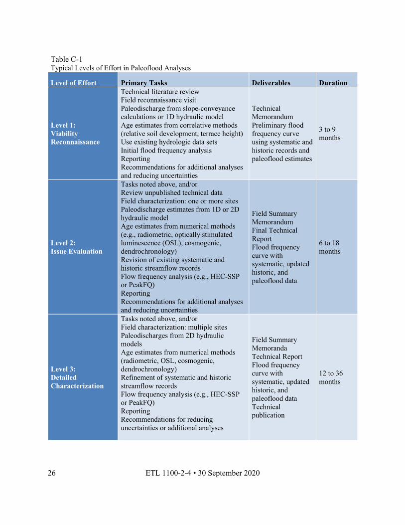
3. Site or Reach Characterization. If information from a site or along a reach suggests a relatively high paleoflood viability based the programmatic, hydrologic, and geologic criteria, completing a paleoflood analysis is likely to improve characterization of hydrologic hazards. The level of effort should be tailored to be consistent with the project objectives, schedule, budget, and levels of uncertainty in existing hydrologic information. Table C-1 provides basic guidelines for various levels of paleoflood site characterization that can be used to customize a paleoflood analysis to specific project needs. The sections below provide basic steps involved with the three levels noted in Table C-1.
26 ETL 1100-2-4 • 30 September 2020
Table C-1 Typical Levels of Effort in Paleoflood Analyses
Level of Effort Primary Tasks Deliverables Duration
Level 1: Viability Reconnaissance
Technical literature review Field reconnaissance visit Paleodischarge from slope-conveyance calculations or 1D hydraulic model Age estimates from correlative methods (relative soil development, terrace height) Use existing hydrologic data sets Initial flood frequency analysis Reporting Recommendations for additional analyses and reducing uncertainties
Technical Memorandum Preliminary flood frequency curve using systematic and historic records and paleoflood estimates
3 to 9 months
Level 2: Issue Evaluation
Tasks noted above, and/or Review unpublished technical data Field characterization: one or more sites Paleodischarge estimates from 1D or 2D hydraulic model Age estimates from numerical methods (e.g., radiometric, optically stimulated luminescence (OSL), cosmogenic, dendrochronology) Revision of existing systematic and historic streamflow records Flow frequency analysis (e.g., HEC-SSP or PeakFQ) Reporting Recommendations for additional analyses and reducing uncertainties
Field Summary Memorandum Final Technical Report Flood frequency curve with systematic, updated historic, and paleoflood data
6 to 18 months
Level 3: Detailed Characterization
Tasks noted above, and/or Field characterization: multiple sites Paleodischarges from 2D hydraulic models Age estimates from numerical methods (radiometric, OSL, cosmogenic, dendrochronology) Refinement of systematic and historic streamflow records Flow frequency analysis (e.g., HEC-SSP or PeakFQ) Reporting Recommendations for reducing uncertainties or additional analyses
Field Summary Memoranda Technical Report Flood frequency curve with systematic, updated historic, and paleoflood data Technical publication
12 to 36 months
ETL 1100-2-4 • 30 September 2020 27
4. Level 1: Viability Reconnaissance.
a. The goal of a reconnaissance-level paleoflood analysis is to assess the viability of a reach or site for providing paleoflood information based on both field- and office-based analyses. These efforts should build upon the screening-level efforts noted above but should not be expected to yield information sufficient for affecting risk-based mitigation or design decisions. Should the reconnaissance-level analysis indicate that additional efforts in the reach or at a site would probably yield defensible, useful paleoflood information, the reconnaissance-level results should help guide additional effort.
b. Preparation for the reconnaissance should include an initial compilation of relevant flood records and hydrologic information, such as the USGS or other reports on significant historical flood stages and discharges; these data would help guide the reconnaissance for identifying evidence of the flood of record or other significant floods.
c. The pre-field effort should include preliminary, office-based identification of flood-related geomorphic features (e.g., fluvial terraces, slackwater deposits, trim lines) (Baker V. R., 2008), or geomorphic features that demonstrate an absence of inundation (e.g., alluvial fans) (Levish D. , 2002). Using an existing hydraulic model or simple 1D calculations, the discharge associated with these features should be estimated. If available, these should be compared with the systematic and historical peak discharges for the reach or site and the calculated discharge for the PMF or other extreme values.
d. The pre-field geomorphic mapping can be compared with the initial hydraulic modeling to assess the likelihood that possible flood-related PSI features represent stages within or prior to the historic record, and that possible NEB features represent reasonable and useful discharge values. This pre-field comparison may also help prioritize sites to visit during the field analysis.
e. The field reconnaissance should focus on developing evidence for or against flooding at stages that are between those from the flood of record and the PMF or other calculated extreme values. This evidence may include stratigraphic or geomorphic features, such as fining-upward fluvial beds or trim lines on valley walls. Field data collection during the reconnaissance should also develop estimated ages for the features related to rare floods and those related to landscape stability and a lack of inundation; the age estimates could be developed through relative age dating (i.e., relative soil development), correlative dating (i.e., comparison with known dated stratigraphy or other features), and / or numerical dating (i.e., analysis through radiometric or isotopic laboratory analysis).
f. Although most reconnaissance-level efforts may not yield well-constrained numerical age estimates, a reasonable range in possible age for each flood-related or non-inundation feature should be developed through the reconnaissance. The paleodischarges associated with the features identified during an initial reconnaissance can be estimated through comparison with known historical or systematic floods, or via simple 1D calculations. These preliminary results can be compared with regional envelope curves showing empirical relationships between peak
28 ETL 1100-2-4 • 30 September 2020
discharge and watershed drainage area, which may provide a reasonable consistency check from historical flood information.
g. The primary results from the field reconnaissance should be a prioritization of sites within the reach of interest that are most likely to yield paleoflood information, and recommendations about the likelihood that future efforts would provide well-constrained paleoflood discharges and ages. The range of uncertainty in the ages and discharges for flood-related and non-inundation features should be provided.
5. Level 2: Issue Evaluation.
a. The goal of an issue evaluation-level paleoflood analysis is to provide defensible and well-constrained information on the magnitude and timing of pre-historic and historic large flood events, in the form of a chronology of large paleoflood discharges (or non-inundation) with a given geologic time period. This level of effort builds upon previous local and regional analyses, including preliminary reconnaissance efforts (as noted above) and other paleoflood analyses in adjacent or nearby comparable watersheds.
b. In some cases, the analysis may initiate with an issue evaluation-level analysis, given project urgency, time constraints, perceived risk, and/or assurance of reach viability, such that no reconnaissance effort is conducted. In these cases, it is appropriate to conduct an overall reconnaissance of selected river reaches and probable field sites, to develop a prioritization scheme for efficient field investigations. This level of analysis includes investigations that are more detailed than in reconnaissance efforts, in scope, number of sites, and level of effort involved for adequately characterizing the paleoflood chronology. At a given PSI site, characterization of the flood history should include, at a minimum:
(1) Demonstration that one or more large peak discharges occurred, using stratigraphic (Costa, 1978; Harden et al., 2011; Kelson et al., 2017a; Toonen, 2020), geomorphic (Levish D. , 2002), botanical (Sigafoos, 1964; Fanok & Wohl, 1997; Wilhelm, et al., 2019), archaeological (Turnbaugh, 1978; Munoz, et al., 2015), or other information;
(2) Estimation of the elevation of the PSI feature with resolution appropriate for maintaining a degree of uncertainty commensurate with the resolution of discharge-estimation techniques, and estimation of the elevation of the peak river stage above the PSI feature; this may involve high-resolution surveying of peak high water marks (Benson & Dalrymple, 1967) and/or estimation of peak water depths and velocities using accepted sediment-transport relationships (Hjulstrom, 1935; Shields, 1936; Fischenich, 2001);
(3) Estimation of the age and age-range for the flood-related deposit or feature, as an approximation of the peak flood timing; this may involve several different lines of chronometry, including relative, correlative, and numerical dating techniques.
ETL 1100-2-4 • 30 September 2020 29
c. At a given site with a NEB, characterization of the non-inundation history should include, at a minimum:
(1) Demonstration that the NEB feature has not been inundated since formation, using geomorphic, soil stratigraphic, and/or sedimentologic evidence; for example, this may involve detailed mapping of alluvial fan morphology, or an eolian sheet that has remained in place since deposition;
(2) Estimation of the elevation of the NEB feature with resolution appropriate for maintaining a degree of uncertainty commensurate with the resolution of discharge-estimation techniques, and estimation of the elevation of the peak river stage above the NEB feature; this may involve high-resolution surveying of the NEB feature and/or estimation of maximum shear stress and sediment-transport velocities (Hjulstrom, 1935) (Shields, 1936) (Fischenich, 2001);
(3) Estimation of the age and age-range for the NEB feature, as an approximation of the peak flood timing; this may involve several different lines of chronometry, including relative, correlative, and numerical dating techniques.
d. In some reaches, perhaps only one or two sites yield sufficient evidence for (or against) flood inundation. If elevation data can be assigned to these locations, 1D or 2D hydraulic modeling can provide estimates of the range in peak discharge associated with the PSI (or the maximum non-inundation discharge associated with the NEB). A limited number of PSI or NEB with reasonable age estimates also allows assignment of the feature(s) to a specific event or time period and helps constrain the paleoflood chronology.
e. For example, a site with a PSI representing a peak discharge of 10,000 cfs and estimated to be about 2,000 years old can be compared with a higher NEB feature that would require no floods greater than 20,000 cfs within a 3,000 year time period. These two simple data points can provide a reasonable paleoflood chronological model that may improve confidence in the flow-frequency curve.
f. It is preferable to include the information noted above at as many sites as possible given project constraints and develop a robust reach-wide paleoflood chronology. Considering multiple sites along a given reach provides improved assurance that the paleoflood chronology is complete; that is, that the paleoflood record includes all of the large floods that have occurred along the reach in the time period of interest, and that the time periods during which no large flood occurred are defined with reasonable information. Along reaches where a record of paleoflood stages can be developed, down-valley profiles of PSI and NEB can be plotted using the high-resolution elevation data and compared with down-valley flood profiles (generated by detailed 2D hydraulic models.
g. Using information from multiple PSI and NEB within a reach can help reduce uncertainty in age ranges for individual floods and for specific non-inundation intervals, as well as constrain the paleoflood down-valley water-surface elevations for improved comparison with 2D hydraulic models of peak flood events. In this way, the identification and characterization of
30 ETL 1100-2-4 • 30 September 2020
multiple PSI and NEB features throughout an analytical reach can provide greatly improved confidence in the paleoflood chronology.
6. Level 3: Detailed Characterization.
a. The goal of a detailed paleoflood characterization is to confirm and/or revise defensible, well-constrained information on the magnitude and timing of pre-historic and historic large flood events, and to provide additional data that decreases uncertainties in the magnitudes and timing of multiple paleoflood events. Key products include a well-constrained chronology of peak flood discharges and/or non-inundation periods, including quantitative depiction of uncertainty ranges in paleoflood ages and discharges. These products should be formatted appropriately for input directly into a flow-frequency analysis (e.g., using Bulletin 17C procedures with HEC-SSP).
b. The more detailed characterizations called for in this level of investigation should be targeted at improving the knowledge of, and thus reducing uncertainty in, a reach-wide paleoflood chronology. This can be achieved by characterizing a greater number of sites (if available), completing additional stratigraphic or age-dating analyses at existing characterization sites, or both. Because of the uniqueness of every reach and site conditions, the number of sites needed to achieve adequate confidence in paleoflood results will vary, and the analysts should constantly consider the trade-offs between the value of more detailed information and the costs of the additional effort. The time needed to complete additional detailed characterizations should be governed both by temporal project constraints and the added value expected from better characterization of the paleoflood chronology.
7. Estimation of Paleodischarge or Non-Inundation Discharge Values. Paleodischarge values can be estimated from PSIs, and non-inundation discharge values can be derived from NEB, using elevations and deposit characteristics gathered during field investigations. These values are derived using three methods: slope-area (Dalrymple & Benson, 1967), 1D flow modeling (Webb & Jarrett, 2002), and 2D flow modeling (HEC, 2018, version 5.0.7).
8. Slope-Area Methods.
a. Two primary empirical relationships provide links between stage and discharge: stage–discharge curves and Manning’s equation. A slope-area estimate, or simplified slope-area estimate, is developed to estimate discharge for the PSI or NEB (Dalrymple & Benson, 1967) (Rantz & others, 1982). For locations near a reliable streamflow gaging station, the slope-area method is often used to extrapolate the stage-discharge rating curve. A slope-area estimate using Manning’s equation can be used to extend the rating curve to larger, previously undocumented flood discharges. Slope-area methods can also be used to estimate paleoflood discharges or non-inundation discharges in areas that lack streamflow gages or rating curves, if roughness coefficients and energy gradient can be estimated or back-calculated from a known historical discharge.
ETL 1100-2-4 • 30 September 2020 31
b. In addition, the slope-area methods should be calibrated using at least one, but preferably more, known flood stages and discharges within the analytical reach, and should include description of the inputs used to allow confidence in the calibrated model. The slope-area method is only suitable for identifying possible target sites and estimating ranges in flood stage and discharge for Level 1 viability reconnaissance studies (Table C-1).
c. Estimating paleoflood discharge and non-inundation discharge values must address uncertainties that are not usually encountered in estimation of historic flood discharges. The analysis must consider the channel geometry that was present at the time of the paleoflood, within reasonable bounds. Reach selection should consider the possibility of geometric non-stationarity of the channel and should favor reaches that have not changed significantly over the time interval of interest. For cases in which the channel cross-sectional area and the hydraulic radius differed significantly during the paleoflood than at the present time, the present-day channel geometry should be modified for paleodischarge estimation. This requires particular attention by the analytical team, especially for reaches that may have undergone significant later migration (e.g., in braided channels inset into unconsolidated valley-fill materials).
d. As noted in Section C-1, selection of the analytical reach should favor the presence of a resistant bedrock channel substratum such that changes in channel geometry are negligible for paleodischarge estimation. Geomorphic observations may serve to identify channels and valleys that have experienced long-term non-stationarity; for example, a correlative set of paired flood terraces on both sides of a bedrock-incised valley may demonstrate the absence of lateral channel migration, and provide justification that the present-day geometry is a reasonable approximation of valley geometry at the time of the paleoflood. This source of uncertainty is also applicable to both the 1D and 2D modeling approaches summarized below.
e. Another possible source of uncertainty in estimating paleodischarge values is the range in possible WSE within the analytical reach. The present-day channel bed profile provides a first approximation of the friction slope or energy gradient values used in the hydraulic model, but differences between the presumed friction slope (i.e., channel bed slope) and the actual energy gradient should be addressed.
f. In many cases, the water surface slope for a paleoflood can be uncertain because of hydrodynamic properties imposed by upstream or downstream boundary conditions, valley-margin conditions, and/or down-valley variations in substratum topography. Reaches that are likely to have experienced substantial differences between friction slope and bed slope, or which contain a significant flow constrictions or expansions that significantly affect the energy grade line, can be identified prior to field data collection and eliminated from the analysis.
g. In most cases of rare, very large flood discharges, uncertainties associated with differences in energy grade line are relatively small compared to other sources of uncertainty and can be included in the overall range of estimated paleodischarge. This source of uncertainty can be reduced by obtaining well-constrained elevation data on as many PSI and NEB locations as possible within the analytical reach. The number of PSI and NEB data points should be sufficient to provide a reasonable range in the WSE, and therefore the friction slope (energy
32 ETL 1100-2-4 • 30 September 2020
gradient), that occurred during the paleoflood. This source of uncertainty is also applicable to both the 1D and 2D modeling approaches summarized below.
h. Uncertainties also are introduced in assuming roughness values for the paleoflood conveyance channel, which help account for several types of energy losses. Accepted USACE methodology in hydraulic modeling currently involves defining roughness coefficients for stream channel as well as overbank areas within the flood conveyance section. Analytical procedures should include a range in reasonable and defensible roughness coefficients for these areas and should consider using more than this two-fold analytical subdivision.
i. Use of archival photographs or other qualitative records on land use and vegetation may be necessary to adequately subdivide the conveyance cross-section, and to select roughness coefficients that apply to the conditions at the time of the paleoflood (i.e., not necessarily the same as present-day conditions). Calibrating the range of reasonable roughness coefficients should involve back-calculations from known historical discharges and stages, using roughness and friction slope values that represent conditions at the time of the paleoflood.
j. Sensitivity analyses should be performed with 1D and 2D modeling efforts (described below) to assess the effects of a range in channel and overbank roughness coefficients on the estimated range in paleodischarge. The sensitivity analyses should guide the analytical team to capture the center, body, and range of reasonable discharge values, and assist interpretation of the best-estimate paleoflood discharge and non-inundation discharge values. This source of uncertainty is also applicable to both the 1D and 2D modeling approaches summarized below.
9. 1D Flow Modeling.
a. 1D flow models with numerous cross sections to represent a river reach are typically used to estimate the ranges in paleodischarge from a PSI and/or non-inundation discharge from a NEB (Webb and Jarrett, 2002). The significant assumptions are 1D flow, stationary channel boundaries, and water surface slope. Stable channel geometry requires that the cross sections of the channel at the time of the paleoflood are the same as when the cross-section measurements were taken.
b. The USGS has published guidance on field procedures for reach selection, and provisions for documenting assumptions, minimizing errors, and maintaining quality control (Webb & Jarrett, 2002). The 1D model should be calibrated using at least one, but preferably more, known flood stages and discharges within the analytical reach, and should include description of the inputs used to allow confidence in the calibrated model. As noted in Section C-1, the selection of viable analytical reaches and sites allows the 1D modeling to avoid characterizing sites subject to channel non-stationarity, thereby eliminating concerns and uncertainties related to non-uniform flow complications, post-flood channel changes, and spatially variable roughness coefficients. The 1D modeling effort should also take into considerations of uncertainty noted in Section C-3a.
ETL 1100-2-4 • 30 September 2020 33
10. 2D Flow Modeling.
a. In many cases, it is possible to account for additional flood complexities through the application of 2D hydraulic modeling, commonly using the HEC-River Analysis System (HEC-RAS) software program (HEC, 2018, version 5.0.7). 2D modeling allows for considerations of secondary currents in flood flows and provides a more realistic representation of large floods. The 2D models provide representative velocities, depths and ability to estimate shear stresses on terraces, alluvial fans, and other geomorphic surfaces in support of paleoflood discharge estimates. As with slope-area and 1D approaches, 2D modeling requires assumptions about the similarity of present-day and paleoflood channel geometries and roughness, and the flow state (i.e., steady vs. unsteady, and uniform vs. non-uniform).
b. As noted in Section C-3a, these assumptions can be addressed adequately for many reaches. Use of HEC-RAS2D (HEC, 2018, version 5.0.7) is recommended for estimating ranges of paleoflood discharge from PSI elevations, and ranges of non-inundation discharge values from NEB elevations.
c. Using appropriate and defensible model inputs, discharge estimates can be obtained for complex flood flows (Denlinger, O'Connell, & House, 2002) (HEC, 2018, version 5.0.7)). The 2D model must be calibrated using appropriate input, including at least one, but preferably more, known flood stages and discharges within the analytical reach, and should include description of the inputs used to allow confidence in the calibrated model.
d. Although data requirements and resources associated with collecting information to conduct 2D analyses can be higher than for a 1D model, readily available software and topographic information has streamlined the 2D modeling efforts to be comparable to 1D efforts. The added benefits of 2D modeling may favor this more complex approach because it allows for a better quantification of uncertainty and is more defensible. If existing detailed topographic data are available, the 2D modeling approach is often more efficient because it allows for systematic analysis of ranges in roughness and energy grade slope, displays results from multiple sensitivity runs, and provides better graphical depictions of expected flow characteristics in both plan view and profile.
e. As shown by recent workers (Harden et al., 2011) (Kelson, 2017a), comparison of 2D water surface profiles with down-valley profiles of flood-related features provides improved analysis of water-surface variability, thereby improving the quantification of uncertainty in estimated paleodischarge along the reach of interest. In summary, the 2D modeling effort should also take into considerations of uncertainty noted in Section C-3a, as well as other sources of uncertainty (if any) that may be identifiable because of the higher analytical capabilities of 2D modeling.
34 ETL 1100-2-4 • 30 September 2020
11. Flood Frequency Analysis.
a. Flood frequency analysis is a statistical method of prediction that consists of studying past flood events that are characteristic of a particular hydrologic process in order to determine the exceedance probabilities of flood events. When considered in a statistically appropriate manner, paleoflood information improves the estimation of exceedance probabilities of large, infrequent floods by adding data on the timing and discharge of extreme floods and limits to flood magnitudes, constraining uncertainties and improving confidence in best estimates in the magnitude and frequency of flood flows.
b. Flood frequency analyses should be performed using the Bulletin 17C procedures (England, 2018). These procedures as embedded in HEC-SSP software (HEC, 2019), which fits the log-Pearson Type III (LPIII) distribution using the EMA. EMA can make use of diverse sources and types of data including censored data, flood intervals, and perception thresholds (Cohn, Lane, & Baier, 1997). Several flood frequency analyses should be performed using the ranges in paleoflood discharges and ages derived from the geologic analysis summarized herein and standard hydrologic analysis of historical and systematic streamflow data (England, 2018).
c. Systematic (gaged) data are operated and can be found through Federal agencies, state agencies, local agencies and private enterprises (England, 2018). Historical data can be found in documents such as water control manuals, USACE studies, contemporaneous newspapers, historical society documents, and eyewitness accounts (Branard, 2019) Flood frequency results should be presented for systematic data, the systematic and historical data, and the combined systematic, historic, and paleoflood data. A sensitivity analysis should be included to quantify uncertainties associated with the ranges in pre-systematic historical discharges and ages, in the length and starting date of the historical record, in estimated paleoflood discharges, and in interpreted age ranges for the PSI and NEB.
12. Reporting and Communication.
a. Reporting of field data, analytical results and conclusions should be consistent with the scope and level of effort of the USACE project. For reconnaissance level analyses, the reporting may include a summary memorandum, augmented with verbal interaction on the project team. For issue evaluation level analysis that provide recommendations on risk-informed decisions or actions, or on facility mitigation or design, a thorough report should be developed to provide methods, results, conclusions, and recommendations, per standard USACE reporting requirements (Kelson et al., 2020). For detailed analyses, the report may include additional supplements, addenda, and/or documents that provide updated data files, conclusions, and recommendations based on the full body of available information.
b. In addition, all levels of paleoflood analysis should include communications with project teams and documents, such that the paleoflood results and associated uncertainties are transmitted in a timely manner and understood by team analysts and risk specialists. Presentation in the open scientific community is encouraged in order to facilitate process improvements and knowledge transfer.