department/ centre/ directorate: geography &...
TRANSCRIPT
1
Department/ Centre/ Directorate: Geography & Regional Development
(1.1.1) Curricula developed /adopted have relevance to the local/ national / regional/global developmental needs with learning objectives including program outcomes, program specific outcomes and course outcomes of all the program offered by the University
The two programmes offered by the university i.e. M.A / M.Sc. Geography and M.A / M.Sc.
Disaster Management have been developed / upgraded with relevance to the local / national/ global
developmental needs. The M.A / M.Sc. Geography curricula has been revised/ updated. Courses on Geo-
spatial technologies, advanced surveying and Digital cartography have been included so that the students
are well equipped and trained in the latest technologies/ instrumentation so that their employment
opportunities in the Government/ private sector are improved.
The M.A / M.Sc. Disaster Management is a professional course which has been conceptualised to
prepare professionally qualified and technically trained human resource for management of disasters in the
disaster prone area like Jammu and Kashmir.
2
Department/ Centre/ Directorate: Geography & Regional Development
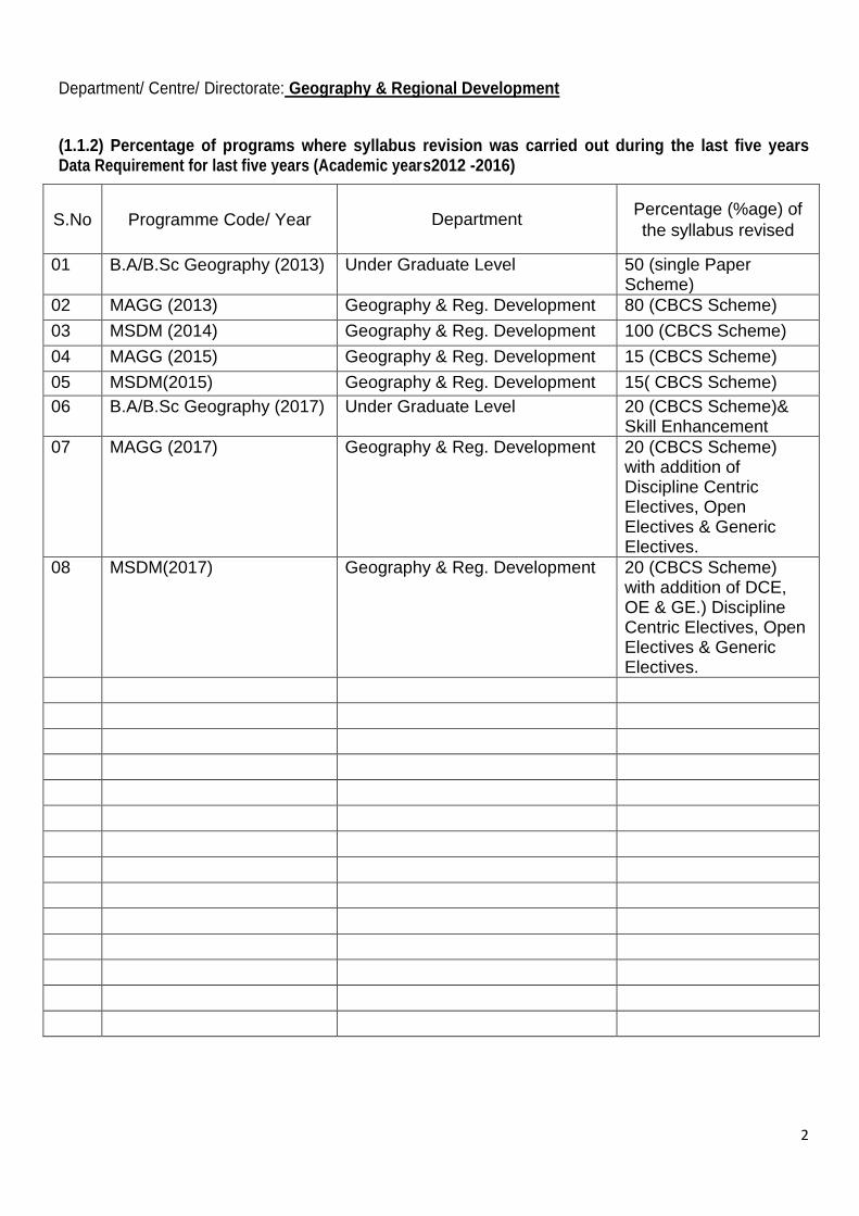
(1.1.2) Percentage of programs where syllabus revision was carried out during the last five years Data Requirement for last five years (Academic years2012 -2016)
S.No Programme Code/ Year Department Percentage (%age) of
the syllabus revised
01 B.A/B.Sc Geography (2013) Under Graduate Level 50 (single Paper Scheme)
02 MAGG (2013) Geography & Reg. Development 80 (CBCS Scheme)
03 MSDM (2014) Geography & Reg. Development 100 (CBCS Scheme)
04 MAGG (2015) Geography & Reg. Development 15 (CBCS Scheme)
05 MSDM(2015) Geography & Reg. Development 15( CBCS Scheme)
06 B.A/B.Sc Geography (2017) Under Graduate Level 20 (CBCS Scheme)& Skill Enhancement
07 MAGG (2017) Geography & Reg. Development 20 (CBCS Scheme) with addition of Discipline Centric Electives, Open Electives & Generic Electives.
08 MSDM(2017) Geography & Reg. Development 20 (CBCS Scheme) with addition of DCE, OE & GE.) Discipline Centric Electives, Open Electives & Generic Electives.
3
Department/ Centre/ Directorate: Geography & Regional Development
(1.1.3) Average percentage of courses having focus on employability/ entrepreneurship/ skill development Data Requirement for last five years (Academic years 2012 -2016)
Name of the Course with code Department
Activities with direct
bearing on Employability/
Entrepreneurship/ skill
development
Name of the
Programme
M.A./M.SC Geography MAGG
Geography Remote Sensing, GIS & GPS Training Total station Digital Cartography Training of SPSS Software (40 %)
M.A./M.Sc. Geography
M.A./M.SC Disaster Management MSDM
-do- Remote Sensing, GIS & GPS Training Internship in Disaster Management at National Institute of Disaster Management (NIDM) , New Delhi Preparation of Disaster Management Plan (70 %)
M.A./M.Sc. Disaster Management
Documents: Upload Program; Curriculum; Syllabus of the courses; Minutes of the Boards of Studies/
Academic Council with course approvals. MoUs with relevant organizations for these courses, if any.

4
Department/ Centre/ Directorate: Geography & Regional Development
(1.2.1) Percentage of new courses introduced of the total number of courses across all programs offered during the last five years Data Requirement for last five years (Academic years 2012 -2016)
Name of the new course introduced Department Name of the
programme
M.A./ M.Sc Disaster Management from the year- 2014
Geography & Regional Development
MSDM
5
Department/ Centre/ Directorate: Geography & Regional Development
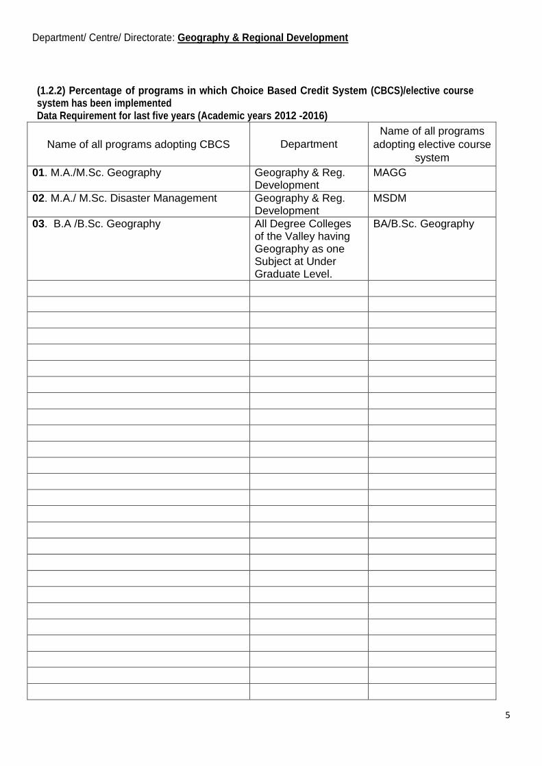
(1.2.2) Percentage of programs in which Choice Based Credit System (CBCS)/elective course system has been implemented Data Requirement for last five years (Academic years 2012 -2016)
Name of all programs adopting CBCS Department
Name of all programs
adopting elective course
system
01. M.A./M.Sc. Geography Geography & Reg. Development
MAGG
02. M.A./ M.Sc. Disaster Management Geography & Reg. Development
MSDM
03. B.A /B.Sc. Geography All Degree Colleges of the Valley having Geography as one Subject at Under Graduate Level.
BA/B.Sc. Geography
6
Department/ Centre/ Directorate: Geography & Regional Development
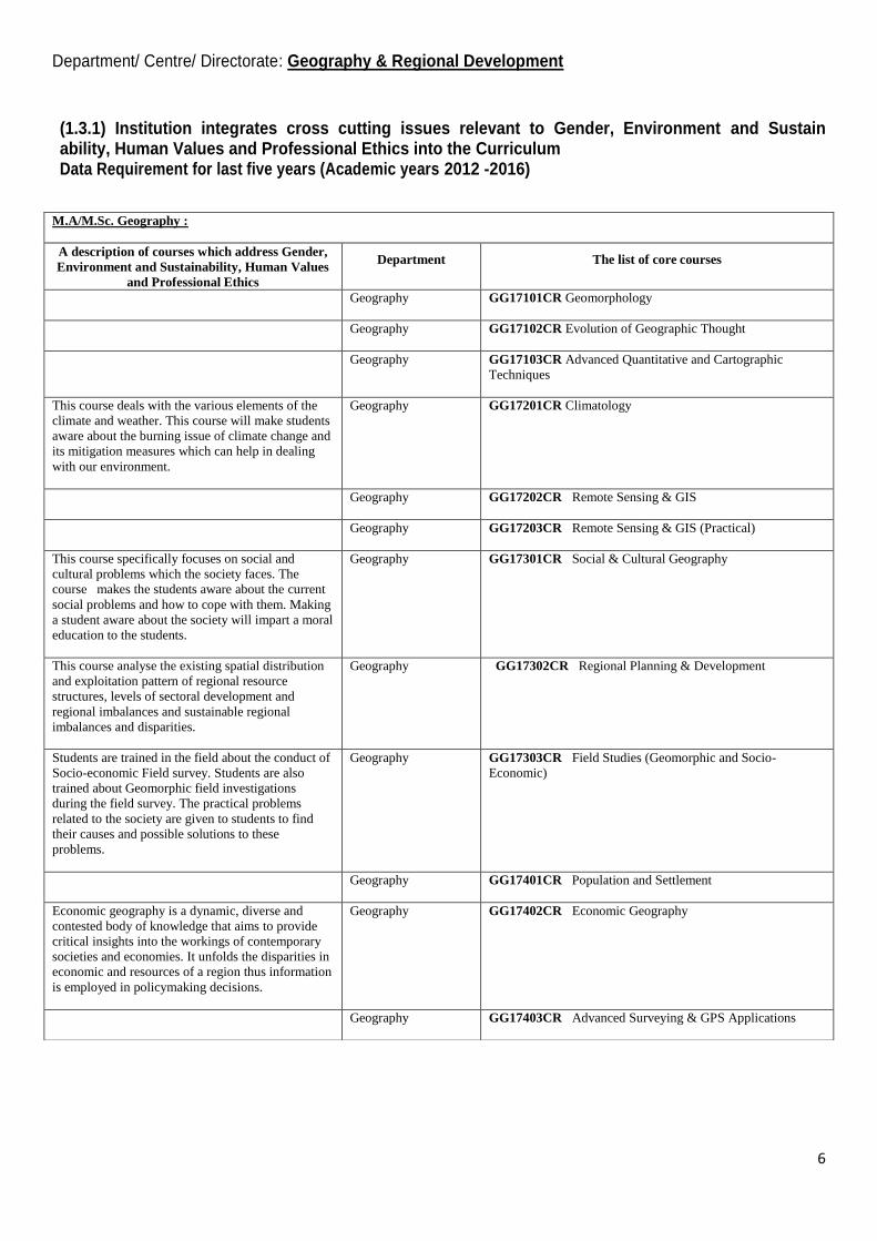
(1.3.1) Institution integrates cross cutting issues relevant to Gender, Environment and Sustain ability, Human Values and Professional Ethics into the Curriculum Data Requirement for last five years (Academic years 2012 -2016)
M.A/M.Sc. Geography :
A description of courses which address Gender,
Environment and Sustainability, Human Values
and Professional Ethics
Department The list of core courses
Geography GG17101CR Geomorphology
Geography GG17102CR Evolution of Geographic Thought
Geography GG17103CR Advanced Quantitative and Cartographic
Techniques
This course deals with the various elements of the
climate and weather. This course will make students
aware about the burning issue of climate change and
its mitigation measures which can help in dealing
with our environment.
Geography GG17201CR Climatology
Geography GG17202CR Remote Sensing & GIS
Geography GG17203CR Remote Sensing & GIS (Practical)
This course specifically focuses on social and
cultural problems which the society faces. The
course makes the students aware about the current
social problems and how to cope with them. Making
a student aware about the society will impart a moral
education to the students.
Geography GG17301CR Social & Cultural Geography
This course analyse the existing spatial distribution
and exploitation pattern of regional resource
structures, levels of sectoral development and
regional imbalances and sustainable regional
imbalances and disparities.
Geography GG17302CR Regional Planning & Development
Students are trained in the field about the conduct of
Socio-economic Field survey. Students are also
trained about Geomorphic field investigations
during the field survey. The practical problems
related to the society are given to students to find
their causes and possible solutions to these
problems.
Geography GG17303CR Field Studies (Geomorphic and Socio-
Economic)
Geography GG17401CR Population and Settlement
Economic geography is a dynamic, diverse and
contested body of knowledge that aims to provide
critical insights into the workings of contemporary
societies and economies. It unfolds the disparities in
economic and resources of a region thus information
is employed in policymaking decisions.
Geography GG17402CR Economic Geography
Geography GG17403CR Advanced Surveying & GPS Applications

7
M.A/M.Sc. Disaster Management :
A description of courses which address Gender, Environment
and Sustainability, Human Values and Professional Ethics
Department The list of core courses
This course aims to deliberate on various physical, social,
economic, and environmental aspects of vulnerability. The learners
are expected to have an understanding of the vulnerability concept
and various criterions of vulnerability assessment.
Geography DM17301CR
Vulnerability Assessment
This course covers all the major hazards having diverse nature.
This course is aimed at making students understand fundamentals
of natural and human-induced hazards. The students are expected
to gain comprehensive knowledge about the types, causes,
mechanism of occurrence, and spatial variability of hazards and
disasters.
Geography DM17101CR
Introduction To Natural And Human
Induced Disasters
This course is aimed to bring in the students, to distinguish the
rehabilitation, reconstruction and recovery phase of disaster
management. The students are expected to gain in–depth
knowledge of physical, social and economic rehabilitation
components and more importantly the learners will be able to
know various rehabilitation processes and the services required in
reconstruction phase. Besides they will be familiar about one of the
important aspects i.e. build back better approach.
Geography DM17202CR
Rehabilitation, Reconstruction And
Recovery
The course on ―Disaster Response‖ takes a holistic view of disaster
response. The said course deals with essential components of
response: stake-holder‘s coordination in disaster response,
managing human behaviour and response measures. By this
course, students should be able to answer how the response to
natural as well as man-made disasters has progressively improved
in terms of effectiveness.
Geography DM17201CR
Disaster Response
Early warning systems and forecasting has been given credit for
preventing and reducing the disaster loss across the globe. In this
course the students will get thorough knowledge about the
important early warning and forecasting systems and prediction
approaches for different natural hazards.
Geography DM17312OE
Forecasting and Early Warning
Systems
8
Department/ Centre/ Directorate: Geography & Regional Development
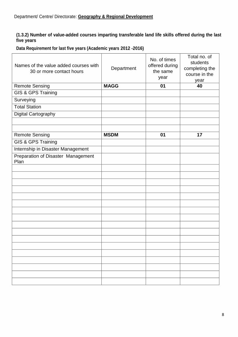
(1.3.2) Number of value-added courses imparting transferable land life skills offered during the last five years
Data Requirement for last five years (Academic years 2012 -2016)
Names of the value added courses with
30 or more contact hours Department
No. of times
offered during
the same
year
Total no. of
students
completing the
course in the
year
Remote Sensing MAGG 01 40
GIS & GPS Training
Surveying
Total Station
Digital Cartography
Remote Sensing MSDM 01 17
GIS & GPS Training
Internship in Disaster Management
Preparation of Disaster Management Plan

9
Department/ Centre/ Directorate: Geography & Regional Development
(1.3.3)Number of value-added courses imparting transferable and life skills offered during the last five years
Percentage of students enrolled in the courses
Data Requirement for last five years (Academic years 2012 -2016)
Names of the value added courses with
30 or more contact hours Department
No. of times
offered
during the
same year
Total no. of
students
completing the
course in the
year
Remote Sensing MAGG 01 40 (100 %)
GIS & GPS Training
Surveying
Total Station
Digital Cartography
Remote Sensing MSDM 01 17 (100 %)
GIS & GPS Training
Internship in Disaster Management
Preparation of Disaster Management Plan

10
Department/ Centre/ Directorate: Geography & Regional Development
(1.3.4) Percentage of students undertaking field projects / internships
Data Requirement for last five years (Academic years 2012 -2016)
Names of the program Department
No. of students
undertaking field
projects / internships
in the last five years
M.A./M.SC Geography
Geography & Reg. Development
(Geomorphic & Socio – Economic Survey) 2012 39
2013 40
2014 39
2015 41
2016 40
M.A./M.SC Disaster Management Geography
(Training Programme for Disaster Management students at National Institute of Disaster Management (NIDM), New Delhi )
2015 15
-do- 2016 17
11
Department/ Centre/ Directorate: Geography & Regional Development
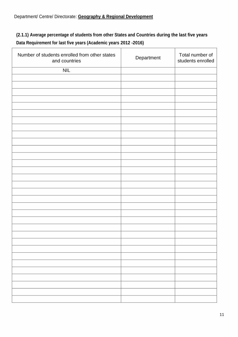
(2.1.1) Average percentage of students from other States and Countries during the last five years
Data Requirement for last five years (Academic years 2012 -2016)
Number of students enrolled from other states
and countries Department
Total number of
students enrolled
NIL
12
Department/ Centre/ Directorate: Geography & Regional Development
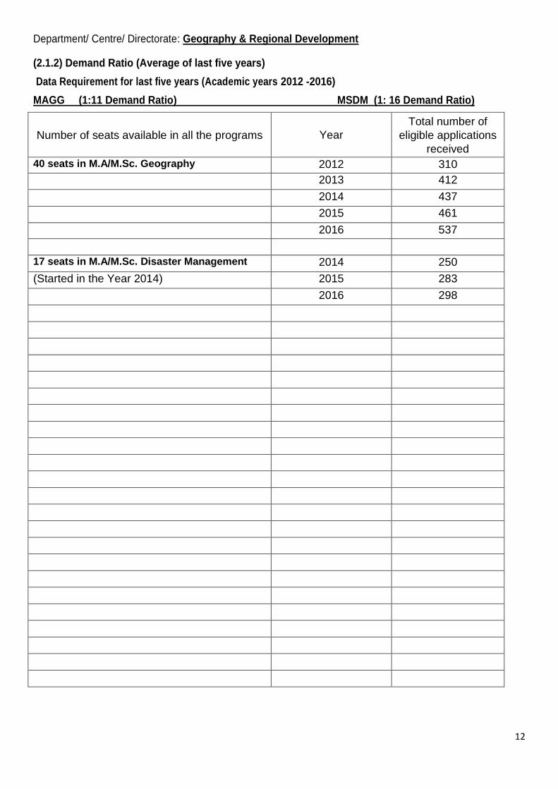
(2.1.2) Demand Ratio (Average of last five years)
Data Requirement for last five years (Academic years 2012 -2016)
MAGG (1:11 Demand Ratio) MSDM (1: 16 Demand Ratio)
Number of seats available in all the programs Year
Total number of
eligible applications
received
40 seats in M.A/M.Sc. Geography 2012 310
2013 412
2014 437
2015 461
2016 537
17 seats in M.A/M.Sc. Disaster Management 2014 250
(Started in the Year 2014) 2015 283
2016 298

13
Department/ Centre/ Directorate: Geography & Regional Development
(2.1.3) Average percentage of seats filled against seats reserved for various categories as per applicable reservation policy during the last five years
Data Requirement for last five years (Academic years 2012 -2016)
Number of students admitted from the
reserved category Year/ Programme
Total number of seats
earmarked for reserved
category as per GOI or
State Government rule
100 % (M.A/M.Sc. Geography) 2012/ MAGG 10
-do- 2013/ MAGG 11
-do- 2014/ MAGG 10
-do- 2015/ MAGG 08
-do- 2016/ MAGG 09
100% (M.A / M.Sc. Disaster Management ) 2014/ MSDM 03
-do- 2015/ MSDM 03
-do- 2016/ MSDM 04
14
Department/ Centre/ Directorate Geography & Regional Development
(2.2.1) The institution assesses the learning levels of the students, after admission and organises special programs for advanced learners and slow learners
Upload a description of the initiative in not more than 500 words
A number of measures have been initiated to address the problems of slow learners of different categories
of students. Firstly, a process of identification is being carried out by the concerned teacher to identify the slow
learners. Usually it has been observed that the courses containing practical training inputs like use of instruments,
involvement of various types of techniques mainly training of softwares poses difficulty in learning process to the
various students. In this direction the additional classes, tutorials, group interactions and individual monitoring
processes of the slow learners is adopted to improve their learning skills.
15
Department/ Centre/ Directorate: Geography& Regional Development
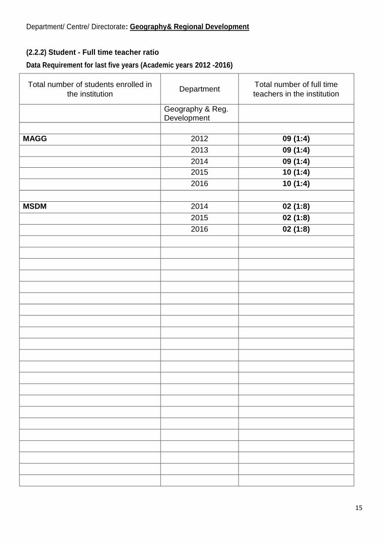
(2.2.2) Student - Full time teacher ratio
Data Requirement for last five years (Academic years 2012 -2016)
Total number of students enrolled in
the institution Department
Total number of full time
teachers in the institution
Geography & Reg. Development
MAGG 2012 09 (1:4)
2013 09 (1:4)
2014 09 (1:4)
2015 10 (1:4)
2016 10 (1:4)
MSDM 2014 02 (1:8)
2015 02 (1:8)
2016 02 (1:8)
16
Department/ Centre/ Directorate: Geography & Regional Development
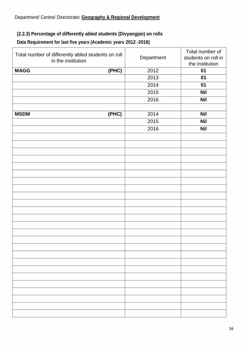
(2.2.3) Percentage of differently abled students (Divyangjan) on rolls
Data Requirement for last five years (Academic years 2012 -2016)
Total number of differently abled students on roll
in the institution Department
Total number of
students on roll in
the institution
MAGG (PHC) 2012 01
2013 01
2014 01
2015 Nil
2016 Nil
MSDM (PHC) 2014 Nil
2015 Nil
2016 Nil

17
Department/ Centre/ Directorate: Geography & Regional Development
(2.3.1) Student centric methods, such as experiential learning , participative learning and problem solving methodologies are used for enhancing learning experiences
Upload description of student centric methods in not more than 500 words.
The Department has adopted various student centric methods for enhancing learning experiences like
Organising Seminars, class presentations, Group discussions and arranging tutorial classes for them.
The students are given a topic for each credit in each course and a seminar is organised on the selected
topic. The students are encouraged to actively participate in these seminars. The students are also given
assignments at the start of the session in each course and they are instructed to complete these assignments and
prepare a presentation on the given topic. The presentations are then to be delivered individually for each
course.
Group discussions are organised at the departmental level and students are divided into groups.
Discussions are organised on socially relevant themes.
Tutorial classes are assigned in the time table for each course and the students are encouraged to
deliberate/ discuss topics of individual courses with their teachers. This provides the students the opportunity
of personalised attention for clearing their doubts about the topics discussed in the classrooms.
18
Department/ Centre/ Directorate: Geography & Regional Development
(2.3.2) Average percentage of teachers using ICT for effective teaching with Learning Management Systems (LMS), E-learning resources etc.
Data Requirement for last five years (Academic years 2012 -2016)
Number of teachers using ICT
(LMS,e-resources) Department
Number of
teachers on
rolls
ICT tools and
resources
available
10 out of 10 (100%) are using ICT MAGG 10 Internet, Smart Board, Overhead Projector
02 out of 03 are using ICT MSDM 02

19
Department/ Centre/ Directorate: Geography & Regional Development
(2.3.3) Ratio of mentor to students for academic and stress related issues
Data Requirement for last five years (Academic years 2012 -2016)
Number of students assigned to each Mentor Department
2012 = 39 (1: 39) Geography & Reg. Dev.
2013 = 40 (1: 40)
2014 = 20 (1: 20)
2015 = 21 (1: 21)
2016 = 20 (1: 20)
2014 = 15 (1: 15)
2015 = 15 (1: 15)
2016 = 08 (1: 08)

20
Department/ Centre/ Directorate: Geography & Regional Development
(2.4.1) Average percentage of full time teachers against sanctioned posts during the last five years
Data Requirement for last five years (Academic years 2012 -2016)
Number of full time teachers Department Number of
sanctioned posts
09 - 2012 Geography & Reg Dev. 10
09 – 2013 10
09 – 2014 10
09 – 2015 10
09 - 2016 10

21
Department/ Centre/ Directorate: Geography & Regional Development
(2.4.3) Average teaching experience of full time teachers in number of years
Data Requirement for last five years (Academic years 2012 -2016)
Name of the teachers Department Number of years with teaching experiences
(upto 2016)
Prof .T.A Kanth Geography & Reg. Dev. 34
Prof. M. Sultan Bhat -do- 22
Prof .Ishtiaq A.Mayer -do- 22
Dr. Shamim Ahmad Shah -do- 19
Dr. Pervez Ahmed -do- 14
Dr. Harmeet Singh -do- 12
Dr. G. M. Rather -do- 11
Dr. Mohd. Shafi Bhat -do- 08
Dr. Javeed Ahmad Rather -do- 08
22
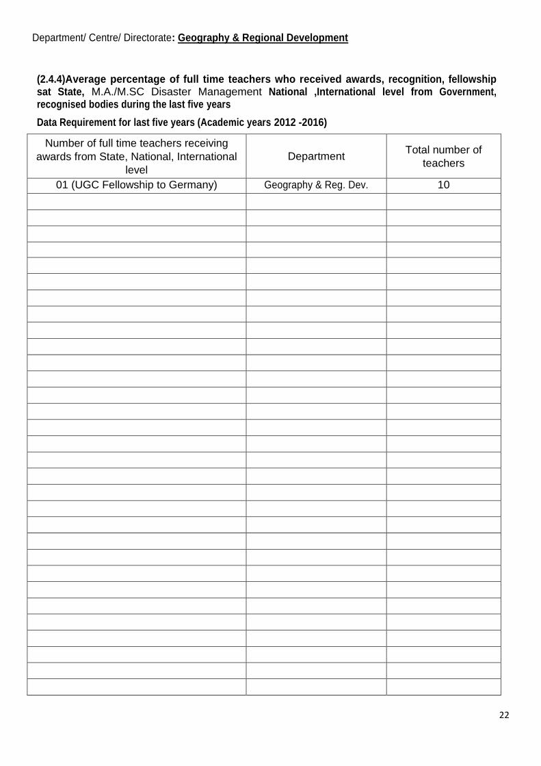
Department/ Centre/ Directorate: Geography & Regional Development
(2.4.4)Average percentage of full time teachers who received awards, recognition, fellowship sat State, M.A./M.SC Disaster Management National ,International level from Government, recognised bodies during the last five years
Data Requirement for last five years (Academic years 2012 -2016)
Number of full time teachers receiving
awards from State, National, International
level
Department Total number of
teachers
01 (UGC Fellowship to Germany) Geography & Reg. Dev. 10

23
Department/ Centre/ Directorate: Geography & Regional Development
(2.4.5) Average percentage of full time teachers from other States against sanctioned posts during the last five years
Data Requirement for last five years (Academic years 2012 -2016)
Number of full time teachers from other states Department Total number of
sanctioned posts
NIL

24
Department/ Centre/ Directorate: Geography & Regional Development
(2.6.1) Program outcomes, program specific outcomes and course outcomes for all programs offered by the institution are
stated and displayed on website and communicated to teachers and students
Data Requirement for last five years (Academic years 2012 -2016)
M.A/M.Sc. Geography:
Program Outcome: The program has been conceptualised with the aim of preparing geographers who are adequately trained to
address the problem and issues being faced in the contemporary times. The curriculum is being continuously updated so that new
concepts, innovations, methodologies and approaches are incorporated to keep the subject in line with the changing trends at the global
level. The students are expected to have a clear understanding of conceptual framework of the subject field of geography. The program
prepares our students to place themselves as regional and urban planners, environmental managers, resource planners and cartographers
etc. The program prepares our students for various competitive examinations so that they can carve a niche for themselves in the civil
services.
The theoretical and practical training in various geospatial technologies adequately trains the students to make their careers as
Remote Sensing and GIS professionals. Modern tools, techniques and introduction of latest instrumentation in surveying has largely
enhanced the employability of our students. The program provides enough opportunities to the students to select their field of
specialization for pursuing research degrees and contribute to the extension of knowledge pertaining especially to our region. The
program develops the competence to facilitate development of inter-disciplinary approach for an easy shift over from curricular work to
research activity which would be able to help the process of socio-economic development of Jammu & Kashmir state. The emphasis of
this programme is to produce applied geographers who are able to work in a multidisciplinary environment and contribute their share in
providing solutions to our day to day problems.
Upload COs for all courses (exemplars
from Glossary-Notes)
Department/
Course No.
Upload a description of Mechanism of Communication
Geomorphology GG17101CR
The course has been designed to provide learners an understanding of
fundamental principles in geomorphology. The course includes looking
at evolution and dynamics of landforms in relation to various exogenic
and endogenic processes.
Evolution of Geographic Thought GG17102CR It helps to understand the evolution and philosophy of the geography,
Its conceptual Developments and paradigm shift.
A student comes to know various carrier opportunities in Geography.
Advanced Quantitative and
Cartographic techniques
GG17103CR The course focuses on the theoretical understanding of statistics and
cartographic techniques and provides opportunities for advanced
research by using GIS and SPSS software. The advanced cartographic
techniques combines science and technical ability that is capable of
communicating information effectively and quickly. The students
would be adequately trained in map making, statistical analysis using
advanced software‘s.
Tourism Geography
GG17104DCE To study the relationship of geography and tourism. To prepare the
learners with knowledge and skills essential to understanding and
manage the needs of destination. Develop strategies for ongoing
personal and professional development as a recreation and leisure
services professional. To facilitate the assessment of the tourism
potential of a destination and prepare tourism development plan as well
as marketing techniques.
Geography of Health and
Health Care
GG17105DCE As a sub-discipline of geography Medical geography studies the
relationship between environment and health, life style and health,
inequalities in distribution of health infrastructure and its associated
issues from a spatiotemporal perspective. Medical geography is ‗the
critical evaluation of environmental and social determinants of disease
and health‘ including the spatial aspect and mapping of health issues.
Oceanography GG17106DCE Oceanography is the branch of Earth Science which deals with the
study of oceans and seas with specific importance to coastline,
estuaries, coastal waters, shelves and the ocean bed. Making career in
Oceanography is challenging as well as rewarding. There are large
employment opportunities for Geographers in both public and private
sectors. The Union Public Service Commission conducts tests for
placements in Central Government Agencies like the Geological
Survey of India and the Central Ground water Board. A professional
in Oceanography can also be absorbed as an Environmental Scientist,

25
Geo-desist, Geographer, Geologist, Geophysicist, Hydrographer,
Oceanographer or mining engineer at various organizations in India
and abroad.
Fluvial Geomorphology
GG17107DCE- The students develop an understanding of various fluvial processes
responsible for the formation of landforms on the surface of the earth..
This course is expected to develop an interest among the students to
pursue this branch of Physical Geography which has considerable
applications in numerous fields
Sustainable Development
GG17108DCE The course introduces the students to the concept of Sustainable
Development. It comprehensively discusses the Man- Environment
relationship that exists under different environmental settings. It is
expected to inculcate the habit of sustainable living among the students
and at the same provide theoretical understanding to them so that they
could pursue their careers as environmental and regional planners.
Geography of Jammu and Kashmir
GG17109GE This course takes a holistic view of Geography of the state. During the
said course students will be provided a general awareness of
physiography, drainage, climate, vegetation, population, agriculture,
horticulture, tourism, and hydroelectric power projects of the State.
Climatology GG17110GE The course focuses on various aspects of climate and its Genesis. It
analyses the impact of climate on human beings. It enables the student
to learn various adaptation and mitigation strategies in this regard. It
also provides practical inputs about various climatological and
meteorological parameters and imparts skill in students regarding their
measurement.
Study of Maps and Globe GG17111OE It helps to understand the basic concept of the world, its location,
different types of maps, determination of coordinates and time zones
etc. A student can start his own consultancy of maps. They can also
work in defence as map reader.
Global Positioning System GG17112OE This course aims to provide learners an understanding of satellite based
navigation system (GPS). It covers deliberations on the structure,
functioning mechanism, and applications of the technology in varied
fields.
Climatology GG17201CR The course focuses on various aspects of climate and its Genesis. It
analyses the impact of climate on human beings and also focuses on
various causes of climatic variability and climate change. It enables the
student to learn various adaptation and mitigation strategies in this
regard
Remote Sensing & GIS GG17202CR Remote sensing is the acquisition of information about an object or
phenomenon without making physical contact with the object and thus
in contrast to on-site observation. Remote sensing is used in numerous
fields, including geography, land surveying and most Earth Science
disciplines. The use of Remote Sensing and Geographic Information
System (GIS) gave scope for immense opportunities in the field of
large-scale mapping, updating of existing geographical maps. But it
has a great scope in India in coming future due to increasing necessity
of geoexplorations, natural resource management, water resource
management, etc.
Remote Sensing and GIS GG17203CR In this course the students would be given practical training on
interpretation and analysis of aerial photographs and satellite data. The
learners are expected to retrieve, edit, analyse spatial information and
design maps using different remote sensing and GIS software‘s.
Urban Geography
GG17204DCE The course comprises of two credits which allows students exposure to
the emerging urban scenario at national and international level. Indian
cities are growing at a rapid pace in terms of their demographic and
spatial size and functional activities. Urban growth has been lopsided
one skewed in favour of large metropolitan cities associated with
serious environmental problems. They need constant attention for their
future expansion and management to improve liveability. This course
helps students to develop professional capacities and skills to address
these complex problems like delimitation of city limits and influence
areas ,land use planning with a focus on locational planning of urban
utilities , preparation of town plans and spatial analysis of
environmental problems to improve quality of urban life.

26
Glacial Geomorphology
GG17205DCE This course is a specialised course of Physical Geography which
introduces students to glacial Geomorphology. The valley of Kashmir
is home to hundreds of glaciers and the landscape of the region has
been largely worked and shaped upon by glaciers. The course is
expected to generate interest among the students to pursue their careers
in the field of glaciology.
Agricultural Geography GG17206DCE Agricultural geography focuses specifically on farming, production of
food, fibre, fuel and livestock resources. The main focus is how to
increase farm house holds income and livelihood concerns. The
students would have an in-depth understanding of the agricultural
Geography.
Hydrology GG17207DCE Hydrology is the study of water's (i) movement, (ii) transport and
storage of mass and energy, and (iii) distribution through, and
exchange between, the biosphere processes and methods while also
providing views and opinions to aid students in
applying hydrological concepts to environmental careers.
Watershed Management GG17208DCE The main aim of the course is to introduce students to concept of
Watershed Management. The course emphasises on identifying
Watershed as an ideal planning unit wherein a student realises the
importance of equitable and judicious management of resources in a
region.
Natural Hazards GG17209GE The course intends to make learners understand various types of
natural hazards. It would cover the deliberations on types, cause, and
effects of these natural processes.
Geography of Himalayas GG17210GE The course focuses on geological, physiological, climatic and socio-
economic Framework of Himalayas. It provides detailed information
about the fragile mountain environment and also focuses on adaptation
and mitigation measures to ensure prosperity and safety of the
inhabitants of the region
Geography of India.
GG17211OE Course content deals with socio-economic-cultural-physical and
environmental conditions of India and is related to investigate spatio-
temporal changes taken place in India.
Disaster Vulnerability in India
GG17212OE The Course is designed to provide comprehensive understanding of
disaster vulnerability of India. The students will develop knowledge
and perception about factors governing Risk and Vulnerability towards
different natural hazards such Earthquake, Floods, Droughts and
Cyclones. The students will also comprehend the geographical controls
on occurrence of these hazards.
Social and Cultural Geography GG17301CR This course specifically focuses on social and cultural problems which
the society faces. The course will make students aware about the
current social problems and how to cope with them. Making a student
aware about the society will impart a moral education to the students.
Regional Planning & Development
GG17302CR The course comprises of four credits. The course explores the current
context and content of regional/spatial planning from perspective of
developing countries and also investigates underlying theoretical
debates. Course is designed to analyse the existing spatial distribution
and exploitation pattern of regional resource structures, , levels of
sectoral development and , regional imbalances and sustainable
regional developmental strategies to address the issues of regional
imbalances and disparities. The focus of the course is to impart
knowledge, understanding and skills necessary to practise
professionally as a regional/spatial planner. Course enables the
students to formulate/prepare short term regional developmental planes
at micro-spatial scale.
Field Studies in Geography
(Practical)
GG17303CR Field studies termed as geographic laboratories leads to learning
experiences outside of the classroom and allow students to gather their
own experience about physical and social elements. Students are
trained in the field about the conduct of Socio-economic Field survey.
Students are also trained about Geomorphic field investigations during
the field survey.
Ecology and Environment GG17304DCE This course focuses on Man environment interaction and helps the
student to understand the concept of sustainable Development. it also
imparts training in EIA and Environmental Management which
enhances the employability of the student

27
Natural Resources Management
GG17305DCE The course aims to introduce students to the concept and philosophy of
Natural Resources Management. Its importance and significance in the
present scenario in light of the tremendous pressure on these precious
resources. The students learn about the various approaches that have
been adopted for effective and judicious utilization of these resources.
Soil Geography GG17306DCE It focuses on formation, distribution and conservation of soil resources
and also provides certain technical inputs which could improve soil
health and boost productivity to ensure food security as most of the
students are from agrarian background.
Environment Impact Assessment
GG17307DCE The EIA is a must and has to be undertaken early in the development
of proposed projects, plans and programmes and must be completed
before a decision to proceed is made. Thus during the course students
will be provided a brief about the concept, approaches and legal
provisions of EIA and the various methodologies applied while doing
EIA.
Geopolitics of Indian Sub-Continent GG17309GE It helps to understand the geopolitical aspects of Indian subcontinent,
foreign policies, strategic location factors etc. of a region. A student
can be adjusted in various departments like defence, foreign policy
consultancy etc.
Glaciology
GG17310GE This course has been conceptualised as a general course for all the
students so that they could learn more about the glaciers, their origin
and classification, Erosional and depositional processes and glacial
hazards etc. After completion of this course, the students are expected
to explore multidisciplinary approaches to various environmental
problems.
World Geography
GG17311OE Deals with the comparison and critical assessment of socio-economic
scenario of developed, developing and under developed societies. It
studies the climatic changes and variations on the wellbeing of
humans.
Disaster Profile of India GG17312OE India‘s unique geo-climatic position makes India particularly
vulnerable to disasters. The Spatio-temporal variability of India with
respect hazards, vulnerability, exposure, and risk would be covered in
this course. The paper will also illustrate the causes and consequences
of historical disasters in India.
Population and Settlement Geography GG17401CR The course is expected to provide learners clear idea of the evolution
and present scope of the discipline. Moreover, the course aims to focus
on past, present and future scenario of population and sex-age structure
of the world. Familiarising students with basic concepts and
approaches that can be applied for studying population phenomena
would also be covered. The course also aims to impart knowledge of
concepts and theoretical framework relating to settlement geography.
Building capacity to use theoretical and empirical advancements to
develop strategies, policies and programmes to meet challenges of
housing problems is also the domain of this course.
Economic Geography GG17402CR Economic geography is a dynamic, diverse and contested body of
knowledge that aims to provide critical insights into the workings of
contemporary societies and economies. It unfolds the disparities in
economic and resources of a region thus information is employed in
policymaking decisions.
Advanced Surveying and GIS
Applications
GG17403CR The course has been planned to provide practical training of various
advanced instruments i.e., Total Station and Global Positioning
System. In addition to setting-up of the instruments, the students are
expected to make some fundamental measurements (distance, angle,
height, area) of land surveying and layout designing in GIS.
Dissertation GG17404DCE This is practical field based course compulsory for all students. This
course demands an in-depth knowledge of the subject with a particular
specialisation. This prepares students for learning field based activities,
applying them to real world problems and giving suitable solutions to
these problems.

28
Political Geography GG17405DCE The course helps to understand the geographical aspects of national
and international politics, foreign policies, strategic location factors
etc. of a region/country.
A student can be adjusted in various departments like defence, foreign
policy consultancy etc.
Applied Geomorphology GG17406DCE The course has been developed to provide learners an understanding of
various application areas of geomorphology. The students are
anticipated to have a thorough understanding of geochronology,
morphometry, and application of geomorphic knowledge in hydrology,
mineral exploration, urbanization, and civil engineering projects.
Bio-Geography GG17407DCE The focus of this paper is to study the intricate relationship between
geography and biology. it also broadens the understanding about
Biodiversity, its conservation and management.
Study of Topographic Maps GG17410OE It helps to understand the basic concept of the topographical maps like
meaning, significance, scope and uses etc. Students are trained how to
study an area with the help of topographical map of the concerned area.
A student can start his own consultancy of maps. They can also work
in defence as map reader.
Geo-Environmental Framework of
J&K
GG17411OE This course will make students aware about the potential geographical
and environmental resources. This will help students in gaining the
knowledge about the resource base of the state and how to conserve
and preserve these resources for sustainable development.
M.A/M.Sc. Disaster Management:
Program Outcome: The incidence of natural and human induced disasters have assumed alarming dimensions both over temporal and
spatial scales resulting in widespread loss of lives and assets globally. Collaborative efforts involving all stakeholders are required at
various levels for making Disaster Risk Reduction (DRR) mechanism effective. In this direction, the introduction of Disaster Management
Programme (M. A/ M. Sc.) by University of Kashmir is an academic initiative expected to be very productive for addressing the various
dimensions of Disaster Risk. The students of this programme are given a comprehensive exposure to the various facets of disaster
management ranging from prevention, mitigation, preparedness to disaster response, forming the core components of the programme. The
programme aims to prepare a pool of skilled human resource personnel who will become qualified and professional disaster managers. The
graduates of the programme are expected to be equipped with a sound knowledge of theory and practical domains of the subject with
professional execution capabilities. In addition the course offers substantial career opportunities to graduates of the programme in various
regional, national, and international organizations.
Upload COs for all courses (exemplars
from Glossary-Notes)
Department/
Course No.
Upload a description of Mechanism of Communication
Introduction To Natural And Human
Induced Disasters
DM17101CR This course covers all the major hazards having diverse nature. This
course is aimed at making students understand fundamentals of
natural and human-induced hazards. The students are expected to
gain comprehensive knowledge about the types, causes, mechanism
of occurrence, and spatial variability of hazards and disasters.
Remote Sensing, GIS and GPS-I
DM17102CR Here course aims to make students understand basic theoretical
concepts of Remote Sensing, Geographic Information System (GIS)
and Global Positioning System (GPS). The students would gain
understanding of electromagnetic spectrum, Image Interpretation,
and image processing. In addition to that this course would include
study of the GIS components, data models, GPS segments and
applications.
Remote Sensing, GIS and GPS-II
DM17103CR This is a practical course aimed at imparting proactive training to
the students. The students will be given basic understanding about
the types and characteristics of spatial data. Learners would be
exposed to various softwares (e.g., Erdas Imagine 9.3; ArcMap
10.2) to handle, edit, integrate, and analyze geographic data for
decision making. The students are also expected to be able to
extract information from satellite data, map designing, and use 3D
data for various applications. Moreover, practical training would be
given to students for collection, transfer, and processing of GPS
data in different application.
Fundamentals of Disaster Management DM17104DCE The course has been designed to deliver on basic concepts,
principles, and significance of disaster management. The course
would also cover best practices, changes, and new aspects of

29
disaster management. The learners would get knowledge of
frameworks adapted for disaster risk reduction over the period of
time that has come up in the backdrop of various world disaster
conferences. Moreover, the course covers disaster management
policies as case studies from under developed, developing and
developed nations.
Understanding Geophysical Environment DM17105DCE This course aims to provide understanding of geomorphology,
hydrosphere, atmosphere and cryosphere. Their dynamics, role and
impact on geophysical environment; and disaster profile of various
regions would also be covered.
Disaster Preparedness And Mitigation
DM17106DCE With emphasis on mitigation and preparedness, the course covers
various aspects of Disaster Management at different levels.
Significance of planning and preparedness involving different
stakeholders at different levels are also part of the course. The
students are anticipated to understand the importance and means of
disaster preparedness and mitigation.
Regional Hazard And Disaster
Management Scenario
DM17107DCE The course is intended to acquaint students about the hazard,
exposure, and vulnerability scenario of Jammu and Kashmir.
Besides, the course would deal with the recent /historical
perspective of disasters in Jammu and Kashmir. The course would
cover the disaster management structure of Jammu and Kashmir
and the role of different organization in disaster management as
well.
Natural Hazards
DM17108GE The aim of this course is to apprise students about various hydro-
meteorological and geological hazards. The learners would get an
understanding of causes, classification, spatial variability and
effects of the natural hazards.
Human-Induced Disasters
DM17109GE The course would particularly emphasize on disasters induced by
humans. Discussion on potential hazards (chemical, biological,
radiological and nuclear) and effects would be focus here. In
addition, the course would cover the deliberations on various case
studies.
Regional Natural Hazards
DM17110OE In this course the learners would get accustomed with knowledge
about hazards with special reference to this region (Kashmir).
Genesis, types, spatio-temporal variability of natural hazards and
effects on society would be primary focus here.
Earthquake Safety And Response
DM17111OE Earthquake being the one hazard that comes with no warning thus
requires different kind of prevention mitigation and preparedness
measures. This course covers various safety and response measures
desired for reducing the earthquake impact. The course would
include various fundamental concepts of seismic hazard; structural
and non-structural measures and safety aspects of the hazard.
Disaster Response
DM17201CR The course on ―Disaster Response‖ takes a holistic view of disaster
response. The said course deals with essential components of
response: stake-holder‘s coordination in disaster response,
managing human behaviour and response measures. At the end of
semester, students should be able to answer how the response to
natural as well as man-made disasters has progressively improved
in terms of effectiveness.
Rehabilitation, Reconstruction And
Recovery
DM17202CR This course is aimed to bring in the students, to distinguish the
rehabilitation, reconstruction and recovery phase of disaster
management. The students are expected to gain in–depth
knowledge of physical, social and economic rehabilitation
components and more importantly the learners will be able to know
various rehabilitation processes and the services required in
reconstruction phase. Besides they will be familiar about one of the
important aspects i.e build back better approach.
Geoinformatics For Disaster
Management
DM17203CR Modern technologies such as Remote Sensing, GIS and Geo-
informatics play a significant role in disaster management. The said
course highlights all the domains with respect to the application of
Geo-informatics in disaster management. In this course students

30
will get hands on experience on how the analysis of satellite data
and GIS could help in a better way to retrieve essential information
for disaster risk reduction. Damage and loss assessment associated
with a particular disaster and mapping pre and post disaster
scenarios would also be covered.
Institutional Structure For Disaster
Management
DM17204DCE In this course the learners would get an understanding of the
evolution, organizational structure, powers, and functions of the
different international, national and local organizations for Disaster
Management.
Statistical Techniques For Disaster
Management
DM17205DCE This course will introduce the students to statistical studies useful
for analysis, understanding behavior and trends using disaster or
hazard related statistics (historical data, statics on frequency,
damage, loss, spatio-temporal patterns, etc.). Statistical analysis of
data collected from the field through observations or from
respondents (designed questionnaires) regarding hazards, disaster,
and about different aspects of the society and scenarios in any phase
of disaster management are also components of this course. This
course will also familiarize the students about how to collect the
data and how to determine factors impacting individuals and
communities.
Disaster Management In India
DM17206DCE The approach towards managing disasters has undergone a radical
change over the last few decades. This course highlights the overall
development of institutions dealing with disaster management in
India. The course acquaints students about the roles, responsibility,
and institutional structure of disaster management in India.
Waste and Debris Management
DM17207DCE This course is aimed to provide the students awareness about the
clean–up, removal, mitigate and disposal of debris and waste
following a major disaster. Further the said course also provides an
insights regarding framing and identifying debris management plan
at site. At the end of course, students should be able to know how to
handle the hazardous and non-hazardous debris and waste.
Geo-Spatial Tools For Disaster
Management
DM17208GE Modern technologies such as Remote Sensing, GIS and Geo-
informatics play a significant role in disaster management. The said
course highlights all the domains with respect to the application of
Geo-informatics in disaster management. In this course students
will get hands on experience on how the analysis of satellite data
and GIS could help in a better way to retrieve essential information
for disaster risk reduction. Damage and loss assessment associated
with a particular disaster and mapping pre and post disaster
scenarios would also be covered.
Disaster Profile Of India
DM17209GE India‘s unique geo-climatic position makes India particularly
vulnerable to disasters. The Spatio-temporal variability of India
with respect hazards, vulnerability, exposure, and risk would be
covered in this course. The paper will also illustrate the causes and
consequences of historical disasters in India.
Global Positioning System (GPS)
DM17210OE GPS providing exact location information has been used in varied
fields. The technology is also useful in all phases of disaster
management. This course will help the students to know the
fundamentals, segments, positioning mechanism, and application of
GPS.
Flood Safety and Response
DM17211OE Floods account for around largest share of all the disasters. About
12 percent of the country is exposed to periodic floods. In this
course learners would be get deliberations on causes, types, effects,
and mitigation and response strategies for the flood hazard.
Vulnerability Assessment
DM17301CR This course aims to deliberate on various physical, social,
economic, and environmental aspects of vulnerability. The learners
are expected to have an understanding of the vulnerability concept
and various criterions of vulnerability assessment.
Disaster Risk Assessment
DM17302CR Risk assessment being an area of immediate importance for disaster
risk reduction. During this course students will get awareness about
the important components (hazard, vulnerability, and exposure) of
disaster risk assessment. Moreover, the important concepts and
approaches in disaster risk assessment and other process involved in
risk assessment will also be included. This course will help the
31
students in knowing about the current status and the gaps in disaster
risk assessment.
Field Training For Disaster Management
DM17303CR During this field based training course, students will be taken to
field and exposed to socio-economic cum geo-physical
environment, so that they are able to evaluate the different
dimensions of vulnerability, exposure, and risk. The students will
also get familiar with the important aspects which shall be kept in
mind while preparing any disaster management plan.
Disaster Risk Reduction and
Development Planning
DM17304DCE This course covers aspects of disaster risk reduction and
development planning. The learners are expected get understanding
of how a planned development can minimise the losses associated
with disasters.
Hydrology and Hydro-Meteorological
Hazards
DM17305DCE In this course the students will be acquainted with the different
dimensions of climatic variability which cause a wide range
of hydro-meteorological hazards such as floods, droughts, frost, and
windstorms.
Climate Change DM17306DCE Climate change being the most challenging natural process of the
present day, the course has been introduced to enable students to get
insights about the changing nature of the earth‘s climate, the
causative and controlling factors. The course also covers the policy
frameworks, mitigation and adaptation strategies for climate
change.
Disaster Sensitive Land Use Planning DM17307DCE Human practices have increased the risk and vulnerability towards
disasters by many folds. Improper land use planning being the
primary indicator of the human influence on the vulnerability. This
course covers the important concepts and aspects of land use
planning and discuss the factors governing the land use change.
Besides in this course students will get familiar with different
techno-legal provisions of India with regard to land use regulations.
Research Methods in Disaster
Management
DM17308DCE Considering the broad scope for research in disaster management
and its importance as a means of disaster mitigation and
preparedness, this course covers different processes and methods
involved disaster management research. This course will enhance
the skills of the students to tackle the research problems.
Geomorphology
DM17309GE The course has been designed to provide learners an understanding
of fundamental principles in geomorphology. The course includes
looking at evolution and dynamics of landforms in relation to
various exogenic and endogenic processes.
Disaster Prevention
DM17310GE In thsi course the students will be familiarized with, how capacity
building is essential for disaster prevention and mitigation. How
technological driven initiatives and community based approach help
in disaster prevention are also part. Besides this course covers the
important aspects of disaster awareness and early warning systems.
Emergency Response
DM17311OE The prompt response to disasters can save lives and reduce the
overall adverse impact of disasters. This course highlights the
essential components of emergency response suitable for on time
action in during different extreme events such as earthquakes,
floods etc.
Forecasting and Early Warning Systems
DM17312OE Early warning systems and forecasting has been given credit for
preventing and reducing the disaster loss across the globe. In this
course the students will get thorough knowledge about the
important early warning and forecasting systems and prediction
approaches for different natural hazards.
Crisis Management and Incident
Response System
DM17401CR The course has been designed to expose learners to the structure
and functioning of crisis management and incident response system.
The students will also be familiarized with the role of international
and national emergency management teams to handle crisis and
incident response system in India.

32
Disaster Management Initiatives & Legal
Provisions
DM17402CR This course is aimed to provide students an in-depth knowledge
about the various humanitarian, institutional and legal initiatives
taken to mitigate disasters at global, national and local level.
Project Work/Dissertation
DM17403CR This course involves components for preparation of dissertation by
concerned students on any of the topics relevant to disaster
management theme, selected in consultation with the concerned
Supervisor/Guide.
Conflicts And Geo-Political Issues in
Disaster Management
DM17404DCE This course is aimed at providing in-depth knowledge about the
conflicts and geo-political issues that are related to disaster
management e.g. the trans-boundary disasters and their
management. Besides the refugee crisis and the role and mandate of
various global and regional organizations in Geo-political conflicts
will also be dealt in the course.
Emergency Medicine
DM17405DCE The course has been developed to make students aware about the
application of medical and health disciplines for prevention,
preparedness, response and recovery of health problems arising out
of disasters. Besides the meaning and significance of disaster
medicine, disaster site management, casualty area management,
community health management, and application of ICT in health
management of disasters will also be covered.
Environmental Impact Assessment and
Environmental Management Programme
DM17406DCE The EIA is very important and has to be undertaken early in the
development of proposed projects, plans and programmes and must
be completed before a decision to proceed is made. Thus during the
course students will be given information about the concept,
approaches and legal provisions of EIA/EMP and the various
methodologies applied while doing EIA.
Drug Abuse and Human Trafficking DM17407DCE The epidemic of substance mistreatment in young generation has
assumed alarming dimensions worldwide. During this course the
students will get to know about the international, national and local
drug and narcotic scenarios and human trafficking in South and
South West Asia.
Climatology DM17408GE The course is designed to provide learners an understanding of
fundamental aspects of weather and climate. Moreover, the course
would cover other atmospheric phenomenon as well such as the
impact of monsoon and western disturbances on the climate of
India.
Disaster Management DM17409GE The main aim of this course is to provide a comprehensive
knowledge to the students on disaster preparedness, mitigation,
rehabilitation, and recovery. It will also enable the students to know
the role and responsibilities of various international, national and
regional agencies in disaster management.
Disaster Management For Critical
Infrastructure
DM17410OE This course enables students to know about critical infrastructure,
disaster vulnerability of basic critical infrastructure and safety
measures for critical infrastructure like hospitals, schools, transport
etc.
Search And Rescue Operations DM17411OE Disasters in densely populated areas around the world have
increased the need for search and rescue capabilities to assist
trapped victims. The said course is thus aimed at enabling students
regarding various search strategies, search plan and search teams
which help the students to know how to search and rescue during
earthquakes, floods, snow avalanches, building fires/collapse.

33
Department/ Centre/ Directorate: Geography & Regional Development
(2.6.2) Attainment of program outcomes, program specific outcomes and course outcomes are evaluated by the institution
Upload a description of the method of measuring attainment of POs , PSOs and COs in not more than 500 words and the level of attainment of POs , PSOs and COs.

34
Department/ Centre/ Directorate: Geography & Regional Development
(2.6.3) Average pass percentage of students
Data Requirement for last five years (Academic years 2012 -2016)
Pass
out
year
Program
Code Department Name of the program
Number of
students
appeared
Number
of
students
passed
Pass
percentage
2012 MAGG Geography M.A./M.Sc.Geography 37 34 91 %
2013 MAGG Geography M.A./M.Sc.Geography 39 34 87 %
2014 MAGG Geography M.A./M.Sc.Geography 40 38 95
2015 MAGG Geography M.A./M.Sc.Geography 37 37 100 %
2016 MAGG Geography M.A./M.Sc.Geography 38 22 57 %
2015 MSDM Geography M.A./M.Sc Disaster Management
17 17 100 %
2016 MSDM Geography M.A./M.Sc Disaster Management
17 17 100%
35
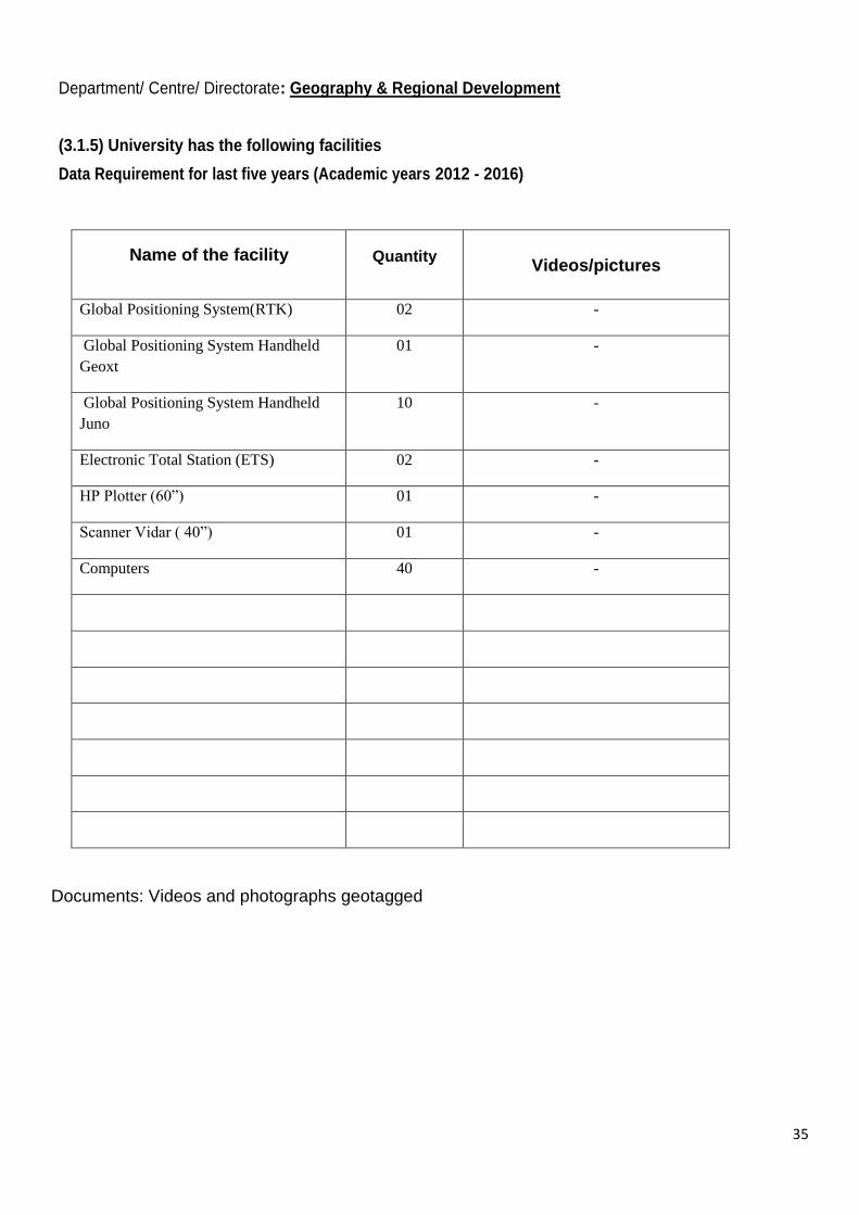
Department/ Centre/ Directorate: Geography & Regional Development
(3.1.5) University has the following facilities
Data Requirement for last five years (Academic years 2012 - 2016)
Name of the facility
Quantity
Videos/pictures
Global Positioning System(RTK) 02 -
Global Positioning System Handheld
Geoxt
01 -
Global Positioning System Handheld
Juno
10 -
Electronic Total Station (ETS) 02 -
HP Plotter (60‖) 01 -
Scanner Vidar ( 40‖) 01 -
Computers 40 -
Documents: Videos and photographs geotagged

36
Department/ Centre/ Directorate: Geography & Regional Development
(3.1.6) Percentage departments with UGC-SAP, CAS, DST-FIST, DBT, ICSSR and other similar recognitions by government agency
Data Requirement for last five years (Academic years 2012 - 2016)
Name of the
Department
Name of the
Scheme
Name of the
funding
agency
Year of
Award
Funds
provided in
Rs.(Lacs)
Duration
of award
Geography & Regional Development
DST -FIST DST 2007 35.00 05 Years
UGC –SAP DRS -I
UGC 2010 to 2015
95.00 05 Years
UGC –SAP DRS -II
UGC 2016 68 .00 05 Years
Upload of departmental recognition award letters on departmental website and send a hard copy and the scanned copies to office of the DIQA

37
Department/ Centre/ Directorate: Geography & Regional Development
(3.3.3) Number of awards for innovation won by institution/teachers/research scholars/students during the last five years
Data Requirement for last five years (Academic years 2012 - 2016)
Name of the Awardee Department
Name of the
Awarding
Agency with
contact details
Year of Award
NIL Nil Nil Nil
Documents: Upload of award letters

38
Department/ Centre/ Directorate: Geography& Regional Development
(3.4.4) Number of Ph.D awarded per teacher during the last five years
Data Requirement for last five years (Academic years 2012 - 2016)
Name of the Ph.D
scholar Department
Name of the
Department
Name of the
guide/s
Year of
registration
of the
scholar
Year of
award
of Ph.D
M.Imran Malik Geography Geography Prof M.Sultan Bhat
2009 2013
Mr.Zahoor Ul Hassan -do- -do- Prof.T.A .Kanth
2009 2013
Mr. Dharamsena -do- Institute of Kashmir Studies
Prof M.SultanBhat
2009 2013
Mr.Rafiq Ahmad Hajam
-do- -do- Prof.T.A .Kanth Dr.G.M.Rather
2012 2015
Ms.NasrinTabassum -do- -do- Prof.T.A .Kanth
2011 2015
Mr.Showkat Ahmad Ganie
-do- -do- Prof M.SultanBhat
2010 2015
Mr.Nissar Ahmad Kuchai
-do- -do- Prof M.SultanBhat
2011 2015
Mr.Arif Hussain Shah -do- -do- Prof M.SultanBhat
2011 2015
Mr.MohdSabar -do- -do- Prof. IShtiaqA.Mayer
2011 2015
MR.Rouf Ahmad Dar -do- -do- Dr.G.M.Rather 2011 2016

39
Department/ Centre/ Directorate: Geography & Regional Development
(3.4.5)Number of research papers per teacher in the Journals notified on UGC website during the last five years
Data Requirement for last five years (Academic years 2012 - 2016)
Title of paper Year Name of the
author/s
Department
of the teacher
Name of journal Year
of
pub.
ISBN/ISSN
number
Analysis and Simulation of Urban
Expansion of Srinagar City
2012 Nissar A. Kuchay &
M. Sultan Bhat
Geography &
Regional
Development
Transactions
(Institute of Indian
Geographers)
2012 0970-9851
Spatial Analysis on the Provision of
Urban Amenities- A Case Study of
Srinagar City, Jammu & Kashmir,
India
2012 J. A. Parray, S. A.
Ganie, Z. A.
Nengroo, and M.
Sultan Bhat
Geography &
Regional
Development
Research on Humanities
& Social Sciences
2012 (P)2224-5766
(O)2225-0484
Reconstructing Past Climate and
Natural Disasters in Kashmir Valley:
Using Historical Evidence as Climate
Proxies
2012 B. Ahmad . K.
Ahmad, Akhtar
Alam, M. Sultan
Bhat.
Geography &
Regional
Development
Journal South Asian
Disaster Studies
2012 0974 – 6463
Delineation of Rural- Urban Fringe-
A Case Study of Srinagar City
2012 Zahoor, A. Nengroo,
Nissar A. Kuchay &
M. Sultan Bhat
Geography &
Regional
Development
International Journal of
Innovative Research &
Development
2012 2278-0211
Yield Damage Functions for Tea
Sectors in Sri Lanka and India- An
Empirical Estimation
2012
P. Dharmasena, &
M. Sultan Bhat
Geography &
Regional
Development
Agriculture Science
Digest
2012 (p) 0253-150X
(O) 0976-0574
Human health and Mining –A Study
of effect of Coal Mining on health of
Workers in Rajouri District of Jammu
and Kashmir
2012 Ishtiaq A. Mayer, M.
Sabar Geography Transactions 2012
ISSN 0970-
9851
Prospects and Problems of Coal
resources in Jammu and Kashmir
with Special reference to Rajouri
District
2012 Ishtiaq A. Mayer, M.
Sabar Geography
Annals of the National
Association of
Geographers
2012 ISSN: 0970-
972X
Waste Generation and its
Management: A case of Srinagar city
2012 Shah S.A Geography &
Regional
Development
National Geographical
Journal of India, National
Geographical Society of
India
2012 ISSN: 0027-
9374/1454.
Tourism and Lake Sustainability: A
case study of Dal Lake
2012 Shah S.A Geography &
Regional
Development
International Journal of
Environmental sciences
2012 ISSN: 2277-
1948
Impact of Commercial Farming on
levels of Development: A study on
Saffron cultivation in Kashmir valley
2012 Shah S.A Geography &
Regional
Development
National Geographical
Journal of India, National
Geographical Society of
India
2012 ISSN: 0027-
9374/1454.
Use of Geographic information
system in land Use Studies: A Micro
Level analysis
2012 Shah S.A Geography &
Regional
Development
European Journal of
Applied Sciences
2012 ISSN:2079-
2077
―Fuzzy Logic Based GIS Modeling
for Identification of Ground Water
Potential Zones in the Jhagrabaria
Watershed of Allahabad, Uttar
Pradesh, India.
2012 Javeed A. Rather
Andrabi Z.A
Geography International Journal of
Advances in Remote
Sensing and GIS
2012 2277-9450
―Evaluation of Concordance between
Environment and Economy: A
Resource Inventory of Dal Lake‖
2012 Javeed A. Rather Geography International Journal of
Physical and Social
Sciences
2012 2249-5894
Tourist Flow and Tourism Potential
Regions of Gulmarg in Kashmir
Himalayas
2013
Nissar A. Kuchay &
M. Sultan Bhat
Geography &
Regional
Development
Global Journal of Human
Social Science -
Geography, Geo-
Sciences, Environmental
Disaster Management
2013 (O) 2249-460x
(p) 0975-87X.

40
Automated drainage characterization
of Dudganga watershed in western
Himalayas,
2013 Nissar A. Kuchay &
M. Sultan Bhat.
Geography &
Regional
Development
European Scientific
Journal
2013 1857- 7431
―Srinagar- The lake city‖ in R.P.
Misra (ed.) in Million Cities of
India.‖
2013 Ishtiaq A. Mayer Geography
Gandhian Research
Centre, New Delhi.
2013 ISSN: 3195-
7643
Sediment Yield Estimation for
Watershed Prioritization in Micro-
Watersheds of Sandran Watershed,
J&K
2013 Aadil Nanda and
Pervez Ahmed
Geography &
Regional Dev.
International Journal of
Recent Scientific
Research,
2013 0976-3031
Prioritization of Micro-Watersheds
for Soil and Water Conservation
Measures in Haheom Watershed, J &
K. (India)
2013 Pervez Ahmed Geography &
Regional Dev.
International Journal of
Science and Advanced
Technology
2013 2221-8386
Quantifying Land use/ Land cover
dynamics in Sandran watershed, part
of Jhelum Basin in Western
Himalayas, Kashmir, India.
2013 Aadil Manzoor
Nanda, Pervez
Ahmed, T. A. Kanth
and Parvaiz A Tali
Geography &
Regional Dev.
National Geographical
Journal of India
2013 0027-9374
Challenges, Issues of Solid Waste
management in Himalayas: A Case
Study of Srinagar city
2013 Shah S A and Wani
A M
Geography &
Regional
Development
African Journal of Basic
& Applied Sciences
2013 ISSN 2079-
2034
Magnitude and Seasonal Variations of
Solid Waste Generation in Tourist
Accommodation of Dal Lake
2013 Shah S A and Wani
A M
Geography &
Regional
Development
International Journal of
Environmental Sciences
2013 ISSN: 2277-
1948
Urban Housing problems, A Micro-
level study on Residential houses of
Tibetan community in Srinagar city
2013 YousufTawseef,
YousufTawheed&S.
A.,Shah
Geography &
Regional
Development
European Academic
Research
2013 ISSN 2286-
4822
―Spatial Distribution of Sex
Composition in Jammu and Kashmir‖
2013 Javeed A. Rather
Andrabi Z.A
Geography Kashmir Journal of
Social Sciences,
University of Kashmir,
Srinagar
2013 0975-6620
Dynamics of Land Use/ Land Cover
in Dal Watershed of Kashmir Valley-
A Remote Sensing and GIS
Approach, International
2014 A. H. Shah, P. A. Teli
& M. Sultan Bhat
Geography &
Regional
Development
Journal of Advanced
Information Science and
Technology (IJAIST)
2014 2319:2682
Spatial variations in the levels of
agricultural & socio-economic
development in Jammu & Kashmir -
A District Level Analysis
2014 S. A. Ganie , M.
Sultan bhat & J. A.
Parray
Geography &
Regional
Development
Agricultural Economics
Research Review
2014 (p)0971-3441
(e)0974-0279
Integrated approach for prioritizing
watersheds for management-A study
of Lidder catchment of Kashmir
Himalayas. Environmental
Management
2014 M. Imran Malik & M.
Sultan Bhat
Geography &
Regional
Development
Environmental
Management. (Springer)
2014 0364-152X
Urban sprawl of Srinagar City and its
Impact on wetlands – A Spatio-
temporal Analysis‖
2014 Nissar A. Kuchay &
M. Sultan Bhat
Geography &
Regional
Development
International Journal of
Environment and
Bioenergy
2014 2165-8951
Delineation of Micro agro Climatic
Zones of Jammu & Kashmir
2014 S. A.Ganie,, M.
Sultan Bhat, N. A.
Kuchay & J. A.
Parray
Geography &
Regional
Development
International Journal of
Agricultural and
Statistical sciences,
2014 0973-1903
Spatial analysis of cropping land use
dynamics in Jammu and Kashmir – A
district level study‖
2014 S. A. Ganie, M.
Sultan Bhat & J. A.
Parray
Geography &
Regional
Development
International Journal of
Recent Scientific
Research,
2014 0976-3031
Anthropogenic Land Use Change
Detection in a Kashmir
Himalayan Watershed
–A Remote Sensing and
GIS Approach
2014 M. Imran Malik & M.
Sultan Bhat
Geography &
Regional
Development
Journal of remote
Sensing & GIS
2014 2330-7990
"Level of Education Vis-A-Vis
Human Health Awareness Among the
people Living in Mountain Regions-
Field Experience of Rajouri District,
J&K State"
2014 Ishtiaq A. Mayer Geography Kashmir Journal of
Social Sciences 2014
ISSN 0975-
6620

41
Evaluation of Landuse/Landcover
Dynamics in Vishav Watershed of
Kashmir Valley (J&K)
2014 Aadil Manzoor
Nanda, Aadil Hamid,
Pervez Ahmed and T
A Kanth
Geography &
Regional Dev.
National Geographical
Journal of India
2014 0027-9374
Morphometric Analysis of Sandran
Drainage Basin (J&K) Using Geo-
Spatial technology
2014 Aadil Manzoor
Nanda, Pervez
Ahmed, T. A. Kanth
and Rafiq A hajam
Geography &
Regional Dev.
Earth Science India 2014 0974-8350.
Sediment Yield Estimation for
Watershed Management in Lolab
Watershed of Jammu & Kashmir state
using Geospatial Tools
2014 Pervez Ahmed and
Abaas A Mir
Geography &
Regional Dev.
International Journal of
Advanced Remote
Sensing and GIS
2014 2320-0243.
Geospatial Based Approach for
Enhancing Environment
Sustainability of Srinagar city - A
Study on Solid Waste Disposal,
2014 Shah S A and Wani
A M
Geography &
Regional
Development
International Journal of
u- and e- Service, Science
and Technology
2014 ISSN: 2005-
4246
Facets Of Housing Geography: A
Micro Level Analysis Of City Core
(Zone Of Discard) Of Srinagar
Metropolis, J&K
2014 Tawseef Yousf,and
Shah,S.A
Geography &
Regional
Development
International Journal of
Recent Scientific
Research
2014 ISSN: 0976-
3031
An Analysis of Urban Primacy in
Himalayan Settlements: The Case of
Srinagar City of Jammu & Kashmir
2014 TawseefYousuf,
TawheedYousuf&
Shah, S.A
Geography &
Regional
Development
International Journal of
Recent Scientific
Research
2014 ISSN: 0976-
3031
Spring Water quality and human
health in foothills settlements of Pir
Panjal range in Anantnag and Kulgam
Districts of J and K , India,
2014 G.M Rather, Rafiq,
A. Hajam, M.S.Bhat
and T.A. Kanth,
Geography Springer science, 2014 101007/978-94-
007-7890-0-6
Nutrition intake and imbalances
among children (0-14 yrs) of Gujjar
communities in great Kashmir
Himalayan range (J and K State)
2014 G.M Rather and
Sameer Fayaz
Geography International Journal of
Recent Scientific
Research
2014 0976-3031
Spatial Variations in Malnutrition
grades using BMI- A comparative
study among Kashmiri and Gujjar
adults of South Kashmir Himalayas J
and K
2014 Rouf, A, Dar and
G.M Rather
Geography International Journal of
Recent Scientific
Research
2014 0976-3031
Livestock carrying capacity of
Kashmir Himalayas: A case study of
Pulwama District‖ Indian Journal of
Landscape System and ecological
studies
2014 Harmeet Singh Geography Indian Journal of
Landscape System and
ecological studies
2014 ISSN 0971-
4170
―Changing Landuse /Land cover
Analysis in Pulwama District of
Jammu and Kashmir
2014 Rafiq Hussain
Andrabi, Harmeet
Singh
Geography International Journal of
Scientific and Research
Publications.
2014 ISSN 2250-
3153
A Comparative analysis of socio-
Economic Viability of Agroforestry
in Pulwama District of Jammu and
Kashmir
2014 Rafiq Hussain
Andrabi, Harmeet
Singh
Geography International Journal of
Engineering, Science and
Mathematics
2014 ISSN 2320-
0294
Economic Viability of Dairy Farming
in Cold Desert of Ladakh: A
Comparative Study of Different
Species of Milch Animals
2014 Harmeet Singh Geography Journal of Rural
Development
2014 ISSN 0970-
3357
Physical Ecology of slums in Srinagar
City
2015 S. Fayaz, G. M.
Rather Z.
Naqshbandi. H.
Farook, M. Sultan
Bhat
Geography &
Regional
Development
International Journal of
Recent Scientific
Research
2015 0976-3031
Field Survey on Historical
Monuments for Assessment of
Earthquake Resistant Structures: Case
Study of Srinagar Capital City of
Jammu & Kashmir, India
2015 S. M. Anees, M.
Sultan Bhat & O. P.
Mishra.
Geography &
Regional
Development
International Journal of
Scientific and Research
Publications
2015 2250-3153
Assessment of the seismic
vulnerability of residential structures
buildings of Srinagar city, Jammu &
Kashmir
2015
S. M. Anees & M.
Sultan Bhat
Geography &
Regional
Development
International Journal of
Advanced Research in
Engineering &
technology (IJARET)
2015 (p)0976 - 6480
(e)0976 - 6499
Sustainability of tourism development
in Kashmir — Is paradise lost,
2015 M. Imran Malik & M.
Sultan Bhat.
Geography &
Regional
Development
Tourism Management
Perspectives
(Sprimger)
2015 2211-9736
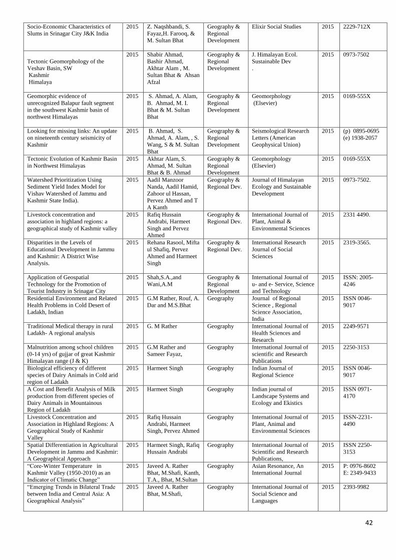
42
Socio-Economic Characteristics of
Slums in Srinagar City J&K India
2015 Z. Naqshbandi, S.
Fayaz,H. Farooq, &
M. Sultan Bhat
Geography &
Regional
Development
Elixir Social Studies 2015 2229-712X
Tectonic Geomorphology of the
Veshav Basin, SW
Kashmir
Himalaya
2015 Shabir Ahmad,
Bashir Ahmad,
Akhtar Alam , M.
Sultan Bhat & Ahsan
Afzal
Geography &
Regional
Development
J. Himalayan Ecol.
Sustainable Dev
.
2015 0973-7502
Geomorphic evidence of
unrecognized Balapur fault segment
in the southwest Kashmir basin of
northwest Himalayas
2015 S. Ahmad, A. Alam,
B. Ahmad, M. I.
Bhat & M. Sultan
Bhat
Geography &
Regional
Development
Geomorphology
(Elsevier)
2015 0169-555X
Looking for missing links: An update
on nineteenth century seismicity of
Kashmir
2015 B. Ahmad, S.
Ahmad, A. Alam, , S.
Wang, S & M. Sultan
Bhat
Geography &
Regional
Development
Seismological Research
Letters (American
Geophysical Union)
2015 (p) 0895-0695
(e) 1938-2057
Tectonic Evolution of Kashmir Basin
in Northwest Himalayas
2015 Akhtar Alam, S.
Ahmad, M. Sultan
Bhat & B. Ahmad
Geography &
Regional
Development
Geomorphology
(Elsevier)
2015 0169-555X
Watershed Prioritization Using
Sediment Yield Index Model for
Vishav Watershed of Jammu and
Kashmir State India).
2015 Aadil Manzoor
Nanda, Aadil Hamid,
Zahoor ul Hassan,
Pervez Ahmed and T
A Kanth
Geography &
Regional Dev.
Journal of Himalayan
Ecology and Sustainable
Development
2015 0973-7502.
Livestock concentration and
association in highland regions: a
geographical study of Kashmir valley
2015 Rafiq Hussain
Andrabi, Harmeet
Singh and Pervez
Ahmed
Geography &
Regional Dev.
International Journal of
Plant, Animal &
Environmental Sciences
2015 2331 4490.
Disparities in the Levels of
Educational Development in Jammu
and Kashmir: A District Wise
Analysis.
2015 Rehana Rasool, Mifta
ul Shafiq, Pervez
Ahmed and Harmeet
Singh
Geography &
Regional Dev.
International Research
Journal of Social
Sciences
2015 2319-3565.
Application of Geospatial
Technology for the Promotion of
Tourist Industry in Srinagar City
2015 Shah,S.A.,and
Wani,A.M
Geography &
Regional
Development
International Journal of
u- and e- Service, Science
and Technology
2015 ISSN: 2005-
4246
Residential Environment and Related
Health Problems in Cold Desert of
Ladakh, Indian
2015 G.M Rather, Rouf, A.
Dar and M.S.Bhat
Geography Journal of Regional
Science , Regional
Science Association,
India
2015 ISSN 0046-
9017
Traditional Medical therapy in rural
Ladakh- A regional analysis
2015 G. M Rather Geography International Journal of
Health Sciences and
Research
2015 2249-9571
Malnutrition among school children
(0-14 yrs) of gujjar of great Kashmir
Himalayan range (J & K)
2015 G.M Rather and
Sameer Fayaz,
Geography International Journal of
scientific and Research
Publications
2015 2250-3153
Biological efficiency of different
species of Dairy Animals in Cold arid
region of Ladakh
2015 Harmeet Singh Geography Indian Journal of
Regional Science
2015 ISSN 0046-
9017
A Cost and Benefit Analysis of Milk
production from different species of
Dairy Animals in Mountainous
Region of Ladakh
2015 Harmeet Singh Geography Indian journal of
Landscape Systems and
Ecology and Ekistics
2015 ISSN 0971-
4170
Livestock Concentration and
Association in Highland Regions: A
Geographical Study of Kashmir
Valley
2015 Rafiq Hussain
Andrabi, Harmeet
Singh, Pervez Ahmed
Geography International Journal of
Plant, Animal and
Environmental Sciences
2015 ISSN-2231-
4490
Spatial Differentiation in Agricultural
Development in Jammu and Kashmir:
A Geographical Approach
2015 Harmeet Singh, Rafiq
Hussain Andrabi
Geography International Journal of
Scientific and Research
Publications,
2015 ISSN 2250-
3153
―Core-Winter Temperature in
Kashmir Valley (1950-2010) as an
Indicator of Climatic Change‖
2015 Javeed A. Rather
Bhat, M.Shafi, Kanth,
T.A., Bhat, M.Sultan
Geography Asian Resonance, An
International Journal
2015 P: 0976-8602
E: 2349-9433
―Emerging Trends in Bilateral Trade
between India and Central Asia: A
Geographical Analysis‖
2015 Javeed A. Rather
Bhat, M.Shafi,
Geography International Journal of
Social Science and
Languages
2015 2393-9982

43
―Emerging trends in bi-lateral trade
between India and Central Asia- A
geographical Analysis‖.
2015 Bhat M. Shafi,
Javeed Ahmad Rather
Geography International journal of
social science and
languages(IJSSL),Vol.
IV: pp. 80-91
2015 ISSN- 2393-
9982
―Core-Winter Temperature in
Kashmir Valley (1950-2010) as an
Indicator of Climatic Change‖.
2015 Bhat M. Shafi,
Javeed Ahmad
Rather, Prof. T. A.
Kanth, Prof. M
Sultan Bhat
Geography Asian Resonance, Vol.
IV: pp. 150-155.
2015 ISSN- 0976-
8602 Print
2349-9433 E
Flood hazard Zonation and
Vulnerability Assessment of greater
Srinagar, J&K India,
2016 H. Farooq, M. Sultan
Bhat, A. Alam & S.
Ahmad
Geography &
Regional
Development
International Journal of
Advanced Research.
2016 2320- 5407
One Dimensional Steady Flow
Analysis Using HECRAS – A case of
River Jhelum, Jammu and Kashmir
2016 H. Farooq, A. Alam,
, M. Sultan Bhat &
S. Ahmad
Geography &
Regional
Development
European Scientific
Journal,
2016 (p)1857– 7881
(e)-1857- 7431
Remote Sensing and GIS Based
Groundwater Potential Mapping for
Sustainable Water Resource
Management of Lidder Catchment in
Kashmir Valley, India
2016
M. Imran Malik , M.
Sultan Bhat & S. A.
Najar
Geography &
Regional
Development
Geological Society of
India
2016 0974-6889
Urban Growth and Its Impact on Land
Transformation in Medium Sized
Urban Centres of Kashmir Valley
2016 Z. Naqshbandi, S.
Fayaz, & M. Sultan
Bhat
Geography &
Regional
Development
Journal Of Humanities
And Social Science
(IOSR-JHSS)
2016 (e) 2279-0837,
(p)-2279-0845
Population growth, urban expansion
and housing scenario in Srinagar City,
J&K, India
2016 Nissar A. Kuchay,
M. Sultan Bhat & N.
Shafi
Geography &
Regional
Development
Journal of Geography and
Regional Planning
2016 2070-1845
A quantitative analysis of spatial
organization of the urban canters in
Kashmir Valley: A geographic
information systems- based study
using primacy index, rank-size rule,
and nearest neighbour index
2016 Z. Naqshbandi, S.
Fayaz, & M. Sultan
Bhat
Geography &
Regional
Development
Journal of Experimental
Science
2016 2218-1768
Seismic Risk Reduction through
Indigenous Architecture in Kashmir
Valley
2016 Bashir Ahmad,
Akhtar Alam, M.
Sultan Bhat, Shabir
Ahmad, Muzamil
Shafi & Rehana
Rasool
Geography &
Regional
Development
International Journal of
Disaster Risk Reduction
(Elsevier)
2016 2212-4209
Variability of Precipitation regime in
Ladakh region of India from
1901-2000
2016 Miftaul Shafiq, M.
Sultan Bhat, Rehana
Rasool, Pervez
Ahmad, Harmeet
Singh & Himayoon
Hassan
Journal of Climatology &
Weather Forecasting
2016 2332-2594
Hypsometric Analysis of Land
Use/Land Cover Change in Anantnag
District of Kashmir Himalayas
2016
Sheraz A. Lone,
Ishtiaq A. Mayer,
Arif Hussain Shah.
Geography
International Journal of
Recent Scientific
Research
2016 ISSN: 0976-
3031
impact of drinking water quality on
the health status of people in Sopore
Tehsil of district Baramulla (J&K")
2016
Manzoor A. Wani,
Ishtiaq A. Mayer and
Bashir A. Lone
Geography International Journal of
Current Research 2016
ISSN: 27819 -
27826
Landuse/ Land cover Analysis in
Hamal Watershed of North western
Himalaya‘s using Remote Sensing &
GIS
2016 Mifta ul Shafiq,
Abaas A Mir, Pervez
Ahmed and Parvaiz
A Bhat
Geography &
Regional Dev.
International Research
Journal of Engineering
and Technology (IRJET)
2016 2395-0056.
Urbanisation Problems and Growth of
Slums in Srinagar urban centre of
Kashmir valley (J &K).
2016 Rehana Rasool, Mifta
ul Shafiq, Pervez
Ahmed
Geography &
Regional Dev.
International Journal of
Recent Scientific
Research
2016 0796-3031
Variability of Precipitation Regime in
Ladakh region from 1901-2000
2016 Mifta ul Shafiq, M
Shafi Bhat, Rehana
Rasool, Pervez
Ahmed, Harmeet
Singh and Himayoon
Hassan
Geography &
Regional Dev.
Journal of Climatology
and Weather Forecasting
2016 2332-2594
An Analysis of Climatic and Human
Induced Determinants of Agricultural
Land Use Changes in Shupiyan Area
of Jammu and Kashmir State, India
2016 Rehana Rasool, Mifta
ul Shafiq, Pervez
Ahmed, Parvaiz
Ahmad
Geography &
Regional Dev.
Geo Journal 2016 0343-2522.
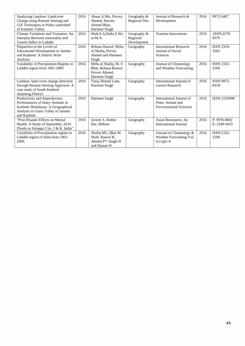
44
Analyzing Landuse/ Landcover
Change using Remote Sensing and
GIS Techniques in Pohru watershed
of Kashmir Valley.
2016 Abaas A Mir, Pervez
Ahmed, Parvaiz
Ahmad Bhat,
Harmeet Singh
Geography &
Regional Dev.
Journal of Research &
Development
2016 0972-5407.
Climate Variations and Visitation: An
Interplay Between seasonality and
Tourist Influx in Ladakh
2016 Shah,S.A,Dada.Z.Wa
ni.M.A.
Geography &
Regional
Development
Tourism Innovations 2016 ,ISSN:2278-
8379
Disparities in the Levels of
Educational Development in Jammu
and Kashmir: A District Wise
Analysis
2016 Rehana Rasool, Mifta
ul Shafiq, Pervez
Ahmed and Harmeet
Singh
Geography International Research
Journal of Social
Sciences
2016 ISSN 2319-
3565
Variability of Precipitation Regime in
Ladakh region from 1901-2000
2016 Mifta ul Shafiq, M. S
Bhat, Rehana Rasool,
Pervez Ahmed,
Harmeet Singh
Geography Journal of Climatology
and Weather Forecasting.
2016 ISSN 2332-
2594
Landuse/ land cover change detection
through Remote Sensing Approach: A
case study of South Kashmir
Anantnag District
2016 Tariq Ahmad Lone,
Harmeet Singh
Geography International Journal of
current Research
2016 ISSN 0975-
833X
Productivity and Reproduction
Performances of Dairy Animals in
Kashmir Himalayas- A Geographical
Analysis in Gurez Valley of Jammu
and Kashmir
2016 Harmeet Singh Geography International Journal of
Plant, Animal and
Environmental Sciences
2016 ISSN-2234490
―Post Disaster Effects on Mental
Health: A Study of September, 2014
Floods in Srinagar City, J & K, India‖
2016 Javeed A. Rather
Dar, Bilkees
Geography Asian Resonance, An
International Journal
2016 P: 0976-8602
E: 2349-9433
Variability of Precipitation regime in
Ladakh region of India from 1901-
2000.
2016 Shafiq MU, Bhat M
Shafi, Rasool R,
Ahmed P*, Singh H
and Hassan H
Geography Journal of Climatology &
Weather Forecasting-Vol.
4:2-pp1-4
2016 ISSN:2332-
2594
45
Department/ Centre/ Directorate: Geography& Regional Development
(3.4.6) Number of books and chapters in edited volumes/ books published, and papers in national/international conference-proceedings per teacher during the last five years
Data Requirement for last five years (Academic years 2012 - 2016)
Name of the teacher:
Title of the paper Department
Title of the
book
published:
Name of the
author/s: Title
of the
proceedings
of the
conference
Name of the
publisher:
National
/International
National /
international
: ISBN/ISSN
number of
the
proceeding
Year of
publication:
Mohd. Shafi Bhat Geography Text Book of
Geography Class-X JKBOSE 2015
46
Department/ Centre/ Directorate: Geography& Regional Development
(3.5.2) Revenue generated from consultancy during the last five years
Data Requirement for last five years (Academic years 2012 - 2016)
Name of the
consultants Department
Name of
consultancy
project
Consulting/spons
oring agency with
contact details
Revenue generated (amount
in rupees)
Total revenue
generated (in
rupees)
Prof. M. Sultan
Bhat Geography EIA & EMP
Wular Development Authority, Govt. of
J & K 1,00,000.00 1,00,000.00
Prof. M. Sultan
Bhat Geography EIA & EMP
Yousmarg Development
Authority, Govt. of J & K
1,00,000.00 1,00,000.00
47
Department/ Centre/ Directorate: Geography& Regional Development
(3.5.3) Revenue generated from corporate training by the institution during the last five years
Data Requirement for last five years (Academic years 2012 - 2016)
Names of
the teacher –
consultants
Department
Title of the
corporate
training
program
Agency
seeking
training with
contact
details
Revenue generated (amount in
rupees
Number of
trainees
Total revenue
generated in rupees
Nil Nil Nil Nil Nil Nil Nil
Documents: Audited statements of account indicating the revenue generated through
consultancy.

48
Department/ Centre/ Directorate: Geography& Regional Development
(3.6.3) Number of extension and outreach programs conducted in collaboration with industry, community and Non-government Organisations through NSS/NCC/Red cross/YRC etc., during the last five years
Data Requirement for last five years (Academic years 2012 - 2016)
Name and number of the
extension and outreach
programs
Department
Name of the collaborating
agency: Non-government,
industry, community with
contact details
Nil Nil Nil
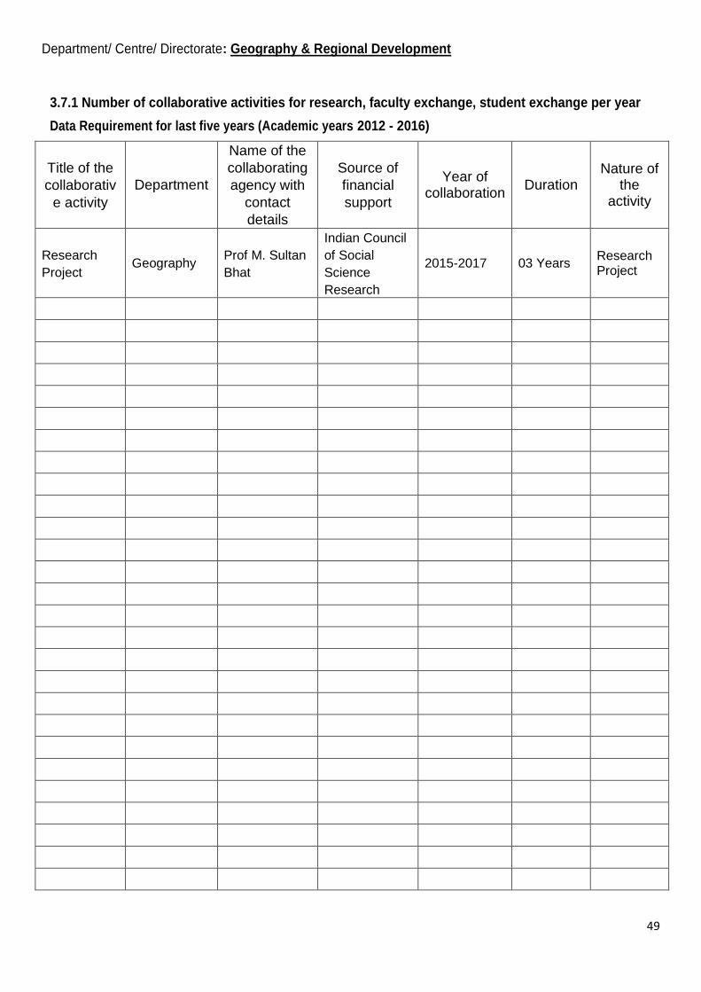
49
Department/ Centre/ Directorate: Geography & Regional Development
3.7.1 Number of collaborative activities for research, faculty exchange, student exchange per year
Data Requirement for last five years (Academic years 2012 - 2016)
Title of the
collaborativ
e activity
Department
Name of the
collaborating
agency with
contact
details
Source of
financial
support
Year of collaboration
Duration Nature of
the activity
Research
Project Geography
Prof M. Sultan
Bhat
Indian Council
of Social
Science
Research
2015-2017 03 Years Research Project

50
Department/ Centre/ Directorate: Geography& Regional Development
(3.7.2) Number of linkages with institutions/industries for internship, on-the-job training, project work, sharing of research facilities etc. during the last five years
Data Requirement for last five years (Academic years 2012 - 2016)
Title of the
linkage Department
Name of the
partnering
institution/
industry/
research lab
with contact
details
Year of
commenc
ement
Duration (From-to
Duration (From-to)
Nature of linkage
Student
Internship Geography
Utrakhand,
Academy of
Administration,
Nanital.
2015
Academic
Student
Internship -do-
National Institute
of Disaster
Management
(NIDM) New Delhi
2016
Academic
Documents: Upload the linkages with institutions/ industries
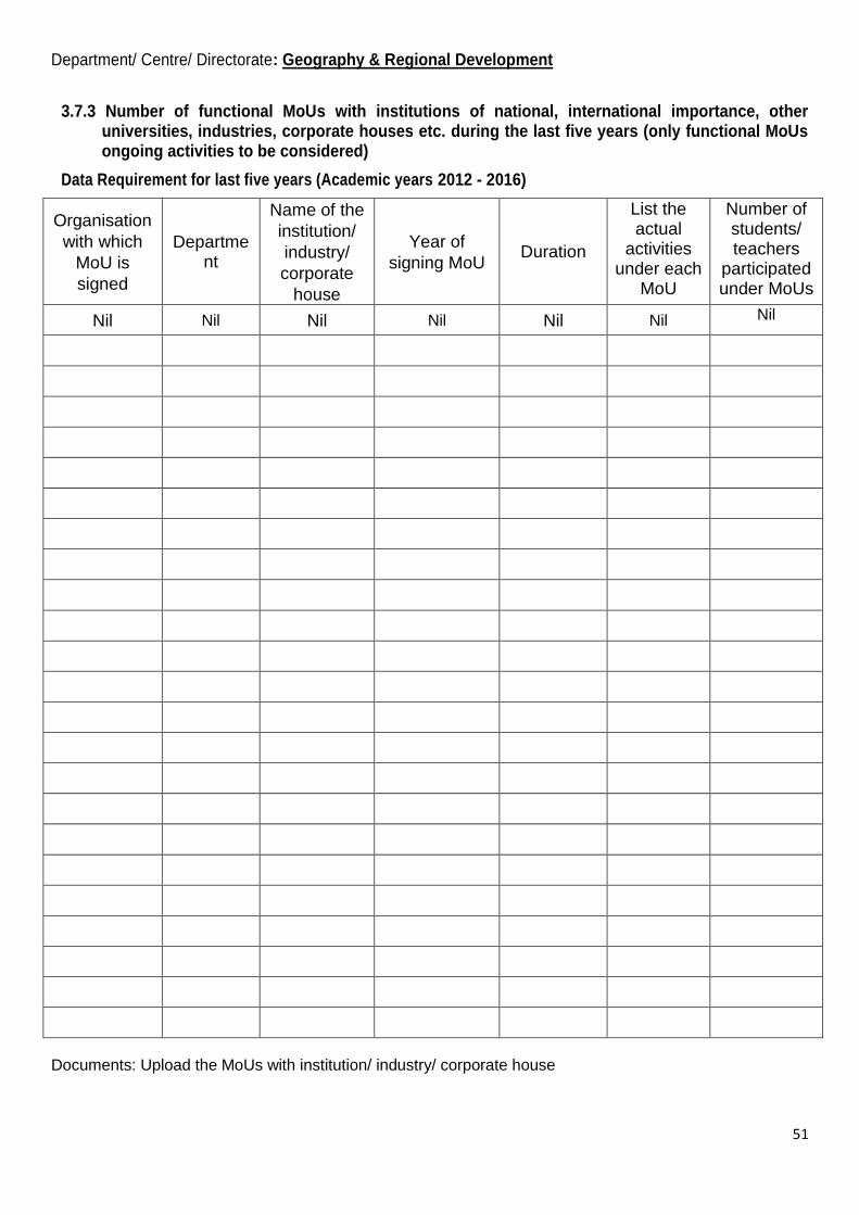
51
Department/ Centre/ Directorate: Geography & Regional Development
3.7.3 Number of functional MoUs with institutions of national, international importance, other universities, industries, corporate houses etc. during the last five years (only functional MoUs ongoing activities to be considered)
Data Requirement for last five years (Academic years 2012 - 2016)
Organisation
with which
MoU is
signed
Department
Name of the
institution/
industry/
corporate
house
Year of
signing MoU Duration
List the actual
activities under each
MoU
Number of students/ teachers
participated under MoUs
Nil Nil Nil Nil Nil Nil Nil
Documents: Upload the MoUs with institution/ industry/ corporate house

52
Department/ Centre/ Directorate: Geography& Regional Development
(4.1.2)The institution has adequate facilities for sports, games (indoor, outdoor, gymnasium, yoga centre etc.,) and cultural activities
Upload a description of adequate facilities for sports, games and cultural activities which include specification about area/size, year of establishment and user rate.
Nil

53
Department/ Centre/ Directorate: Geography& Regional Development
4.1.3 Percentage of classrooms and seminar halls with ICT-enabled facilities such as smart class, LMS, etc.
Data Requirement for last five years (Academic years 2012 - 2016)
Number of classrooms
with LCD facilities Department
Number of classrooms
with wi-fi/ LAN facilities
Number of seminar halls
with ICT facilities
03 classrooms out of 03
are ICT enabled Geography 02 (Labs) 01

54
Department/ Centre/ Directorate: Geography & Regional Development
(5.2.1) Average percentage of placement of outgoing students during the last five years
Data Requirement for last five years (Academic years 2012 - 2016)
Name of the employer with contact
details Department/Year Number of students placed
School of Education Department Geography 2012-2016
10 (General Line Teachers)
Govt. of J & K Geography 2012- 2016
02 (Kashmir Administrative Services)
School of Education Department Geography 2012 - 2016
03 (10+2 Lecturers)
Document: Upload annual report of placement cell

55
Department/ Centre/ Directorate: Geography & Regional Development
(5.2.2) Percentage of student progression to higher education (previous graduating batch)
Data Requirement for last five years (Academic years 2012 - 2016)
UG to PG: Department PG to MPhil: PG to PhD: MPhil to
PhD:
PhD to
Postdoctoral:
5 % Geography 20 % 15 % 80 % Nil
Document: Upload document from Student/alumni database

56
Department/ Centre/ Directorate: Geography& Regional Development
(5.2.3) Average percentage of students qualifying instate/national/ international level examinations during the last five years (eg: NET/SLET/GATE/GMAT/CAT/ GRE/TOEFL/Civil Services/State government examinations)
Data Requirement for last five years (Academic years 2012 - 2016)
Year NET SLET GATE
G
MAT
E
CAT GRE TOEFL Civil
Services
State
government
examinations
2012 22 0 0 0 0 0 0 0 0
2013 30 0 0 0 0 0 0 0 0
2014 16 0 0 0 0 0 0 0 0
2015 11 01 0 0 0 0 0 0 0
2016 09 08 0 0 0 0 0 0 0
Document: Upload document from Student/alumni database
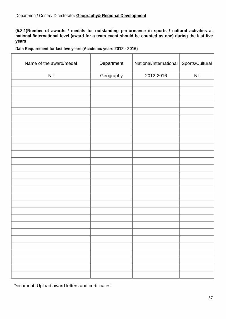
57
Department/ Centre/ Directorate: Geography& Regional Development
(5.3.1)Number of awards / medals for outstanding performance in sports / cultural activities at national /international level (award for a team event should be counted as one) during the last five years
Data Requirement for last five years (Academic years 2012 - 2016)
Name of the award/medal Department National/International Sports/Cultural
Nil Geography 2012-2016 Nil
Document: Upload award letters and certificates
58
Department/ Centre/ Directorate: Geography& Regional Development
(5.3.3)Average number of sports and cultural activities /competitions organised at the institution level per year
Data Requirement for last five years (Academic years 2012 - 2016)
Name of the activity Department
Nil 2012-2016