deltares sustainable development of 8 deltas
TRANSCRIPT

Towards sustainable development of deltas, estuaries and coastal zones
Description of eight selected deltas

Towards sustainable development of deltas, estuaries and coastal zones
Description of eight selected deltas
January 21, 2009


Contents
Preface 5
Yellow River Delta (China) 7
Mekong River Delta (Vietnam) 17
Ganges Brahmaputra Delta (Bangladesh) 29
Ciliwung River Delta (Indonesia) 41
Nile River Delta (Egypt) 49
Rhine River Delta (The Netherlands) 59
Mississippi River Delta (USA) 69
California Bay (USA) 79
79 (Sacramento-San Joaquin)
�

�

This research is part of the preparation of the Aquaterra 2009 conference, the World Forum on Delta and Coastal Development. The Aquaterra 2009 Conference will present and discuss the state and future of deltas world wide, with a special focus on eight selected deltas. All these selected deltas are densely populated and/or economically developed.
• Yellow River delta (China)• Mekong River delta (Vietnam)• Ganges–Brahmaputra delta (Bangladesh)• Ciliwung River delta (Indonesia)• Nile River delta (Egypt)• Rhine River delta (The Netherlands)• Mississippi River delta (USA)• California Bay (USA)
For each of these deltas a short, comprehensive delta description has been compiled. The objective of these descriptions is to give some first impression of the current state of the delta as well as an outline of the major issues at stake. The descriptions have been compiled having in mind persons not familiar with the particular delta. The description of the current state includes: physical characteristics (geography, geomorphology, hydrology), infrastructure, socio-economic situation and the governance structure. The description of the issues at stake include such issues as pressure on space, vulnerability to flooding and loss of environmental quality.
The delta descriptions cover in some 5 pages a wide array of important topics. The descriptions have been based on readily available and easily accessible sources of information; the references used are listed at the end of the descriptions. Sometimes information from different sources was found contradictory.
Although the descriptions have gone through a limited process of review, we cannot fully exclude that the descriptions may contain some errors or misinterpretations. So, in reading the delta descriptions, the focus should be on the overall picture of the physics, economics and culture of the deltas that emerges from the descriptions.
Preface
�

�
Yellow River Delta (China)
1 Current state of the delta
1.1 Physical characteristics
Geography The Yellow River, or in Chinese the Huang He, is the second longest river in China. It flows from the Qinghai-Tibetan (Qingzang) Plateau generally east to the Yellow Sea (5,464 km). In the lower reaches, from Zhengzhou to the sea, a distance of 786 km, the river flows to the northeast across the North China Plain before emptying into the Bohai Sea. Here the river is confined to a levee-lined course as the river bed is on average 4-7 meters higher than the adjacent land. The total basin area is 795,000 km². The total drop in elevation of the lower reaches is 93.6 m.
The Yellow River is called “the cradle of Chinese civilization”, as its basin is the birthplace of the northern Chinese civilizations and is the most prosperous region in early Chinese history. But frequent devastating flooding largely due to the elevated river bed in its lower course, has also earned it the unenviable name “China’s Sorrow”. In the course of time, the outlet of the Yellow River has frequently shifted. From the 13th century till 1855 the Yellow River debouched south of Shandong peninsula through the Yangtze estuary.
The actual Yellow River Delta starts at Lijin. The area of the delta is some 8,000 km2, most of it in the Shandong province. The general terrain of the Yellow River Delta is flat, high in the west and south, and low in the east and north. The highest elevation of southwest is 28 m, the lowest elevation of northeast less than one meter with natural slope 1/8,000 ≈ 1/12,000.
The Yellow River Delta includes urban areas, agriculture, fishing, natural reserve and is of national importance for its oil and gas production.
GeomorphologyThe Yellow River Delta can be described as a fluvial-dominated delta with a minor influence of tidal action. The Yellow River has the highest sediment content of all rivers in the world. It gets its yellow color from the large
�

Yellow River Delta (China)
quantities of fine-grained calcareous silts – 1.6 billion tons annually - which it carries from the Loess Plateau. In the course of millennia, the Yellow River has deposited the sediments of the North China Plain. The plain is one of China’s most important agricultural regions, producing corn, sorghum, winter wheat, vegetables, and cotton.
The Yellow River deposits part of its carried burden of soil in its bed in stretches where it is flowing slowly. These deposits elevate the bottom of the river, which flows between natural levees in its lower reaches. If a flood occurs, the river breaks out of the levees into the surrounding lower flood plain and adopts a new course. Historically this has occurred about once every hundred years. In modern times, considerable effort has been made to confine the river to its bed by strengthening the natural levees.
The present Yellow River Delta originated in 1855, when the Yellow River shifted its mouth to the Bohai Sea. From 1855 – 1872, the coastline has proceeded annually some 150 – 400 m into the sea. Sediments built up new subdeltas in the sea resulting every 8 to 10 years in a shift of the river course. Thus, many sub-deltas have been formed. The most recent major shift occurred in 1976. After 1999 the accretion of land near the river mouth is off-set by erosion elsewhere, especially on the northern coastline.
ClimateThe climate in the Yellow River Delta is semi-arid with continental monsoon. Being adjacent to the Bohai sea, it has also elements of an ocean climate with distinctive seasonal changes. The average multi-annual temperature in the region is about 120C, ranging from -220C to 410C. The annual average precipitation is 537 mm, of which 400 mm is concentrated in the rainy season from June to October. The evaporation ranges between 1,900 and 2,400 mm per year.
HydrologyThe average total discharge of the Yellow River is 58,000 million m3 per year. Since the 1990s the water discharge to the lower Yellow River decreased considerably, due to increased water consumption in the basin. From 1995 to 1998, the lower Yellow river was dry during more than 120 days every year, up to over 200 days in 1997. Since the Xiaolangdi dam came in operation around the year 2000, the discharge is more regulated and zero-flow conditions do not occur anymore. However, the available river water to the delta remains
�

limited, which in dry years will affect the freshwater wetlands and cause a rise in soil salinity.
The groundwater level in the Yellow River Delta is shallow, showing a distinct variation that coincides with rainfall. The low geographical level of the delta, not more than a few meters above sea level, has as consequence that in large parts of the delta the groundwater is in contact with the sea and has the same, or even higher salinity than the sea water. At present, about one third of the delta area has serious salinity problems, one third has moderate salinity problems and only one third can be considered salt free.
1.2 Infrastructure
The Chinese have long sought to control the Yellow River by building dikes and overflow channels. Irrigation and flood-control works have been maintained for centuries. In 1955 the Chinese initiated a 50-year construction plan for control of the river. Dikes have been repaired and reinforced, and a series of
�

Yellow River Delta (China)
silt-retaining dams are being constructed to control the upper river, produce electricity, and provide water for irrigation.
In the delta the river is confined in its natural bed by well maintained levees. From 1997 to 2004 a river-dredging and dike-reinforcement project was conducted for the river course near the mouth. More than 50 km of the river channel was dredged and 25 km of embankment reinforced. Following floods on the Shengli oil field in 1964 and 1975, the lower part of the Yellow River near Dongying harbor was stabilized. Irrigation canals are criss-crossing the delta to provide fresh water to agricultural land.
Shandong province has one of highest quality expressway networks in China. At over 3000 km, the total length of Shandong’s expressways is also the highest among the provinces.
1.� Socio-economics
PopulationThe Yellow River Delta is part of Shandong province, with a population of almost 92 million and a population density of 582 inhabitants/km2. Over 99% of Shandong’s population is Han Chinese. Most of the proper delta area lies in Dong Ying municipality which has 1,8 million inhabitants. Outside the urban area, the main land-use is for agriculture. Here the population density is relatively low: 210 inhabitants/km2.
Economic developmentThe Yellow River Delta has great potential for development. In the National economic development program the area is earmarked for development of a “highly-efficient ecological economy”. In other documents the area is mentioned as an International Demonstrating zone for Green Industry.
Shandong is one of the richest provinces of China. Its economic development focuses on large enterprises with well-known brand names. In the delta, Dong Ying’s oil fields and petroleum industries form an important component of Shandong’s economy. The western part of Shandong is less wealthy than the rest of the province. The revenues from oil and gas exploitation constitute a potential for investments to improve the infrastructure for agriculture.
10

In 2007, the nominal GDP for Shandong was US$ 340 billion, ranking second in China. It’s GDP per capita was US$ 3,646.
AgricultureShandong province ranks first among the Chinese provinces in the production of a variety of products, including cotton and wheat. Other important crops include sorghum and maize. Most of the agriculture in the Yellow River Delta consists of small scale farms. Here the agricultural productivity is relatively low.
Land use maps of the Yellow River Delta show a diversified land use. Water and waste land constitute over 55% of the area. Irrigated agriculture, some 25% of the area, is concentrated in the region south of the Yellow river. Forestry and cattle breeding occupy 9% of the area. Another 9% is urban area and roads.
Fisheries and wildlifeThe 4,800 km2 shallow sea adjacent to the delta, is an excellent breeding place for marine animals including fish, shrimp, crab and seashell. The Yellow River Estuary is famed for “home of fish” and “home of oriental prawn”. In addition, aquaculture is practiced in almost the entire coastal zone along the north and east coast.
IndustryDong Ying city was established in 1983, to develop the Yellow River Delta and China’s second largest oilfield, Shengli Field. The oilfield was discovered in 1964 near a small village called Dong Ying, which gave its name to the city. The proved reserve of oil reaches 4.16 billion ton and natural gas is 23 billion m3, ranking the first in coastal China. Connected to the oil industry, Dongying is one of the world’s leading producers of synthetic rubber tires. It has more tire factories than any other city in the world.
NatureThe Yellow River Delta has the largest new-born wetland in China. The entire area surrounding the lower 65 km of the river is Nature reserve, covering an area of around 1200 km2. A second area of some 300 km2 is found at the northern coast, just west of Dongying harbour. The wetlands of the Yellow River Delta form one of the most complete and extensive young wetland ecological systems in China with abundant resources and a unique ecological status. In
11

Yellow River Delta (China)
recent years, decreased sediment loads to the delta, regulation of the river course to the delta and influences of urbanization and pollution caused by oil development, have led to a trend of rapid decrease of terrestrial wetlands. The freshwater wetland area has decreased with 50% in the recent 20 years, which destroys the integrity of the wetland ecosystems and the habitats that are used by rare birds are facing the danger of disappearance. Currently, the authority which is responsible for the Reserve is actively restoring the freshwater wetlands through the construction of embankments and appropriate water management.
12

2. Main challenges and opportunitiesPressure on available spaceIn the Yellow River Delta, the pressure on the available space is less than elsewhere in China. The population of some 2 million inhabitants is concentrated in Dongying city. The industrial development in the area (in particular related to oil) provides ample jobs as an alternative for agriculture.
AgricultureIn the Yellow River Delta agriculture has to compete with industry for the available water resources. In recent years, a sharp decrease of water availability in the dry season occurred in the lower Yellow River caused by the economic development in the basin area and the rapid increase in water consumption. Although the farms are small scale and the agricultural productivity is low, agriculture uses a substantial part of the available water in periods of low river flow.
Water qualityGrowing pollution levels along with changes in flow regimes are having severe consequences for the ecology of the Yellow River delta and the coastal and marine environments of the Bo Sea as well as their commercial fisheries. For the Yellow River with its limited waters and growing demand, problems of water quality, water quantity, and sediment are interdependent and calling for a basin-wide approach for their solution
Shore protection / Coastal erosion management / river morphology managementThe Yellow River is the river with the highest sediment content of all rivers in the world. For many years, the area of the delta was expanding at a rate which is unique in the world. The construction of the large reservoirs upstream and the water diversions along the river have decreased the water and sediment input to the delta substantially in the recent period. Besides, the northern parts of the delta suffer from coastal erosion since the river flows through its southern branch to sea. These developments have significantly reduced the expansion rate of the delta’
A precondition for the development of the Yellow River Delta is the stabilization of the channels of the Yellow River to prevent future unexpected breaching of dikes. The last part of the river course used to shift its course frequently and
1�
Yellow River Delta (China)
unexpectedly. Investments and developments near the mouth of the Yellow River can not be sustainable without taking into consideration the morpho-dynamics of the river course and of the dynamic of the nature reserve. Monitoring and evaluation are essential elements of an integrated planning. The economic and environmental effectiveness of stabilising measures are the subject of a number of proposed projects.
WetlandsThe sustainable management of the wetlands in the Yellow River Delta will be a major challenge for the agencies involved in water and nature protection. Optimizing the freshwater use from the lower Yellow River requires a balance between the demands from the domestic and economic sectors and the nature reserve while leaving sufficient water discharge at the mouth of the river to minimize sea water intrusion. Because of the highly variable water demands and supplies over the months of the year, this requires sound water management from month to month.
Besides the safeguarding of sufficient water, also solutions need to be sought to mitigate or minimise the negative effects of oil exploitation and its associated disturbance.
1�

References
• Yellow River Delta Environmental Flow Study, Yellow River Conservancy Commission, December 2007
• Vulnerability Assessment oft he Yellow River Delta, China, December 8, 1998, APN project, author unknown
• Yellow River Estuary, Yellow River Conservancy Press, 2007, ISBN 978-7-80734-262-5
• Water Management in the Yellow River Basin: Background, Current Critical Issues and Future Research Needs, Mark Giordano, Zhongping Zhu, Ximing Cai, Shangqi Hong, Xuecheng Zhang and Yunpeng Xue, Comprehensive Assessment Research Report 3, IWMI, 2004
1�

1�

Mekong River Delta (Vietnam)
1 Current state of the delta
1.1 Physical characteristics
Geography The Mekong delta is situated in Cambodia and southern Vietnam, where the Mekong river reaches the South China Sea. The Mekong is one of the longest rivers in the world. It originates at the Tibetan Plateau and flows some 4,000 km in south western direction The Mekong Delta is generally regarded as beginning at Phnom Penh in Cambodia, where the Mekong river meets the Tonle Sap river, and the Bassac River branches. The Mekong subsequently divides into six main channels and the Bassac into three to form the nine “dragons” of the outer delta in Vietnam. The delta comprises a vast triangular plain of approximately 55,000 km2. It extends for about 270 km from its apex at Phnom Penh to the coast. The width of the delta near the coast is some 350 km, the coastline has a length of about 600 km. Approximately 16,000 km2 of the inner delta lie within Cambodia; the remaining 39,000 km2 constitute the southern tip of Vietnam . In Vietnam the Mekong delta is intensively developed for agriculture. The area is one of the most productive and intensively cultivated areas in Asia. The region produces considerable quantities of rice and fish products. Some 22% (17 million) of the Vietnamese population lives in the Mekong Delta. Nearly 85% of the population are rural.
The Cambodian floodplain, on the contrary, is largely undeveloped. A system of so-called colmatage canals has been developed over the centuries to (partially) control the water and sediment flow in and out of the floodplain depressions to support traditional cultivation of rice.
Geomorphology and soilsThe Mekong Delta is the result of many ages of sedimentation and erosion. In Cambodia, the elevation ranges from about 1 to 10 meters above sea level and at some locations the plains are bordered by low hills. In Vietnam the elevation ranges between about 0 and 5 metres above mean sea level with a few very small hills in an otherwise flat landscape. The average elevation of the Vietnamese Mekong Delta is about +0.8 m MSL. The thickness of sediment
1�
layers varies over the delta from at least 500 m near the river mouths to 30 m at some places in the inner delta. At the nine mouths of the Mekong branches, the combined action of river deposition and the sea has produced a coastal belt, slightly higher than the adjacent land. At the coast, sediment deposition continues to extend the Ca Mau Peninsula south and west at a rate of 50 m per year in some places, while coastal erosion occurs at other locations.
During the Holocene sulfur (S) containing sediments were deposited in a tidal brackish water mangrove swamp. Under the conditions in this environment, pyrite (FeS2) was formed in soils underlying some 40 per cent of the delta. Later, fertile alluvial sediments were deposited on top of these sediments. As long as the sulfides in the sediments remain below the water table they are not harmful. When the water table falls, however, as it does during prolonged drought, the pyrite oxidises and produces acid soil water conditions which are toxic to crops and vegetation. Severely affected areas can become “scalded” and barren for decades. If early wet season rainfall washes this sulfuric acid into the drainage systems and canals, it can kill aquatic organisms, cause an increase in fish diseases, change estuary ecosystems and corrode the steel and concrete of engineering structures.
ClimateThe climate in the delta is tropical monsoon and is influenced by both the southwest and northeast monsoons. In general the dry season runs from December to April while the wet season is from May to November. The average annual temperature in the delta is close to 280C. The mean monthly evaporation is around 150 mm. Monthly precipitation ranges between 0 mm in the dry season and around 250 mm in the wet season. There is a considerable spatial variation in annual rainfall across the delta. The average annual rainfall ranges from less than 1,500 mm in the central region and northwest to over 2,350 mm in the south.
Hydrology and floodingFloods play an important role in the life of the people living in the Lower Mekong River Basin. Flash floods of tributaries and extreme mainstream flood events can be destructive and cause enormous damages. On the other hand, the annual moderate floods are a natural phenomenon that is essential to food security (agriculture and fish production) and biodiversity (sustenance of the fresh water ecosystems). The notion that floods bring benefits begins to be widely acknowledged, especially in the delta in Vietnam.
Mekong River Delta (Vietnam)
1�

Studies of the last 45 years of Mekong flow data show no systematic changes in the hydrological regime of the Mekong . The flow of the lower Mekong is regulated by Cambodia’s Great Lake, Ton Le Sap, in the upper delta. The lake acts as a flood storage in the wet season until early October and a supply reservoir in the dry season. The mean annual flow volume of the Mekong river amounts to some 475,000 million m3. In 2005 a flood volume of 500,000 million m3 caused inundation of nearly 50% of the delta. With a storage capacity of some 60,000 million m3, Ton Le Sap is a crucial source of water supply to the delta in the dry season.
In the dry season, flow in the Mekong is insufficient to prevent saline intrusion and extensive salinization of waterways occurs in the lower delta. During a normal dry season, the maximum extent of salt water intrusion covers somewhere between 15,000 km2 and 20,000 km2 . Streams and canals in the
1�

Mekong Delta are influenced by the tides of both the East and West Seas. In the East Sea the tide is semidiurnal with a large tidal amplitude of 3 to 3.5m. The tidal effects from the East Sea propagate over much of the delta. Farmers use these tidal fluctuations to drain and flood their lands. Drainage of floodwaters can be impeded if wet season floods coincide with the spring tide. Tides in the West sea are diurnal with a tidal range of about 0.4 to 1.2 m.
1.2 Infrastructure
The rivers in the Mekong Delta are bordered by natural levees that are formed through silt depositing. The levees are intensively used for housing and roads amongst others as they are the last to flood. The levees separate the rivers from depressions that flood during the flood season. The infrastructure in the Cambodian part of the delta consists of a few roads only, colmatage irrigation systems and a few small scale irrigation schemes.
The Vietnamese part of the delta is characterized by a dense network of canals, levees and roads and well developed irrigation and flood management systems. The French colonization of Indochina 120 years ago initiated major canal construction over much of the Vietnamese Delta, particularly for transport. Canal construction for irrigation and drainage has accelerated in 1910 - 1930 and since the end of the Indochina War in 1975. The delta has now over 10,000 km of major canals that have profoundly changed the hydrological and hydraulic regime in the delta.
To prevent seawater intrusion along the Ca Mau Peninsula and South China Coast a series of 12 massive sluices or tidal floodgates have been installed on the major rivers and canals connected to the East and West China Sea. The gates open automatically on the ebb and close on the spring tide.
Groundwater has been extracted in the Vietnamese part of the Mekong Delta for almost 100 years, however its systematic assessment has only taken place since 1975. Because increasing development, the long dry season in the southwest, and pollution of surface water from salinity, acidity, domestic wastes and suspended sediment, groundwater use is growing.
Mekong River Delta (Vietnam)
20

1 The information used for the
socio-economic description
relates mainly to the
Vietnamese part of the delta.
1.� Socio-economics1
PopulationThe population density in the Vietnamese part of the Mekong River Delta is high compared to other regions of the country. The number of inhabitants of the delta is some 17 million. The population growth rate is 2.5%.
Economic developmentIn the last 20 years, Vietnams economy changed from a plan-economy into a modern free market economy. Under the name “Doi Moi” (literally: change and renewal) Vietnam carried through significant economic and political reforms. From 1996, Vietnam’s economy was among the fastest growing economies of Asia. According to figures from the General Statistics Office in Hanoi, Vietnam’s economy grew 8.5 percent in 2007, the fastest pace since 1996. Industry and construction accounted for 42 percent of Vietnam’s economy in the first quarter of 2008. Agriculture, forestry and fisheries, which accounted for 14 percent of Vietnam’s economy in the first quarter, grew at a 2.9 percent pace, up from 2.6 percent in the same period in 2007. Per capita GDP increased from US$ 200 in 1996 to over US$ 700 in 2006.
In the framework of the Doi Moi, the Vietnamese government identified the Mekong Delta as a priority area for economic development. The target is to increase the production of food, commodities and consumer goods by 8% per year.
AgricultureThe Mekong Delta includes some of the most productive agricultural land in Southeast Asia. The Vietnamese portion of the Mekong Delta occupies 39,000 km2, of which 24,000 km2 are now used for agriculture and aquaculture and 4,000 km2 for forestry. Rice cultivation in the delta is a relatively recent practice with floating rices being used prior to paddy rice during wet season flooding. Primary products from the delta contribute over 30% to the Gross Domestic Product and the delta is Vietnam’s rice bowl, producing 50% of the nation’s rice and contributing to Vietnam’s place as the second largest rice exporter in the world.
One of the reforms of the “Doi Moi” policy, is that private enterprise is allowed in agriculture which enabled farmers to lease land for up to 50 years. In 2007 the Vietnamese government stopped charging irrigation service fees, to further promote agricultural enterprises.
21

A constraining factor for agriculture is the salinity of surface water in large parts of the delta and the problem of acidification of sulphate rich clays.
FisheriesThe lower Mekong River and its delta support one of the largest inland fisheries in the world. Cambodian people in rural areas rely heavily on fisheries for their subsistence. Fish provide from 40% - 60% of animal protein intake for people in rural areas – even those living far from water.
The Vietnamese portion of the delta yields an annual harvest of about 400,000 metric tonnes of fish. Approximately 156,000 tonnes of this are derived from the brackish water and estuarine zone. However, fish production has been declining in recent years as a result of over-exploitation, forest destruction,
Mekong River Delta (Vietnam)
22

drainage of wetlands for agriculture and the effects of toxic chemicals such as Agent Orange.
In a substantial part of the delta, the brackish water conditions make the water unsuitable for rice irrigation during the dry season. Farmers in these areas have adapted to the changing freshwater-salt water environment by evolving a rotating rice-shrimp system to maximize income through both rice and high value, intensive or semi-intensive shrimp production.
IndustryIndustry is fast growing all over Vietnam. In the Mekong delta a substantial part of the industry is related to agriculture and aquaculture. Concerning water resources, the industrial development may be conflicting with agriculture. On one hand agriculture and industry will compete for the scarce groundwater resources, on the other hand, untreated industrial wastewater is polluting the surface water.
NatureThe Mekong waters host over 1,000 species of fish, one of the highest species counts of any river system in the world. The continuing variation in hydrology and the variety of habitats allow the persistence of many species, which all require different conditions. Small islands and riverine sand-bars are common on stretches of the Mekong and its tributaries. The smaller sand bars and islands provide safe breeding sites for many species of waterbirds, some of which are globally rare and endangered. Permanent and seasonal wetlands include reed and sedge beds, swamps, lotus ponds, inundated grasslands and inundated forest. One of the most important wetland habitats is the seasonally-inundated riparian forest found on the gently-sloping plains adjacent to lakes, rivers and tributaries. Over 200 species of plants have been found in these inundated forests and over 200 species of fish use this habitat as a feeding, breeding, and nursery ground and it is vitally important for breeding colonies of large waterbirds.
The mangrove and Melaleuca forests constitute an important forestry resource, potentially capable of meeting the local demand for construction materials, firewood, fodder for domestic animals and other forest products. In addition, the Melaleuca forests provide a valuable harvest of honey from wild bees’ nests, amounting to five or six litres of honey per hectare per year.
2�

The mangrove forests also play a very important role in coastal protection and land reclamation. Mangrove species not only retard erosion due to tidal action (of vital significance in a region prone to typhoons), but also tend to accumulate sediments around their root systems, thereby accelerating accretion of new land.
1.� Governance
At the international level, The Mekong River Commission (MRC) coordinates joint management of the shared water resources of the Mekong Basin and development of the economic potential of the river.
In Cambodia, the main responsibility for water resources planning and development is with the Ministry of Water Resources and Meteorology (MOWRAM). Other Ministries involved are a.o.: Ministry of Rural Development (water supply, sanitation, land drainage in rural areas and small scale irrigation); Ministry of Public Works and Transport (study, survey and construction of river works for navigation and water transport); Ministry of Environment (Protection of natural resources and environmental quality). The National Committee on Disaster Management has a mandate a.o. to coordinate flood management.
At the national level in Vietnam, several ministries are involved in the management of the Mekong Delta: the Ministry of Agriculture and Rural Development in charge of land tenure, land use and infrastructure development; Ministry of Natural Resources and Environment, regulations in development (Convention on Biological Diversity, Ramsar conventions); Ministry of Planning and Investment in charge of preparation of National 5-years socio-economic development plans as well as the overall national planning and coordination.
In the governmental structure of Vietnam, provinces have a considerable autonomy. The delta has 13 provinces. The provinces are further subdivided into districts and communities. At each level (province, district, and commune) Peoples Committees represent the central government and control the activities within the area.
At the local level capacity building is needed for water management as well as for local governance, service organisations and public enterprises. Also the system of laws and regulations as well as its maintenance, requires attention.
Mekong River Delta (Vietnam)
2�

2. Main challenges and opportunities in the Mekong Delta in Vietnam
Pressure on available spaceThe Vietnamese part of the Mekong Delta covers some 12% of the area of Vietnam. With some 20% of the Vietnamese population living in the Mekong Delta, the population density in the delta is relatively high (410 inhabitants/km2 in the delta against 250 inhabitants/km2 in Vietnam). With a population growth rate of 2,5% the pressure on the available space is increasing. An important issue related to the available space is flood protection. Recently the Government of Vietnam adopted a ‘Living with Floods’ Strategy for the Mekong River Delta, meaning more attention to flood benefits and preservation of vulnerable ecosystems.
Agriculture85% of the population in the Mekong Delta is rural. Agriculture and agro-related industry is the main source of living. In the Mekong Delta, land resources are the main constraining factor in the development of agriculture. On one hand a substantial area (potentially 40% of the delta) has become unsuited for agriculture due to acidification of sulfate containing soils; on the other
2�
hand saline surface water affects the quality of the land. A major issue in the Mekong Delta is reclamation of saline and acid affected soils.
Water qualityThe quality of the surface water in the Mekong Delta is threatened by three sources: drainage of acid water from sulphate containing soils (as 40% of the delta area), intrusion of saline water through open river mouths and the pollution of human activities and industry. Industrial activities, such as pulp and paper mills, textile mills and chemical factories, are increasing within the delta. Together with increased waste from shipping, the industries are creating a serious pollution problem. One of the targets of the national socio-economic development plan 2006 – 2010 is that 70% of the industrial zones will be equipped with treatment plants. The polluter pays principle will be leading.
Groundwater is available all over the delta. Due to the deteriorating quality of surface water, groundwater is more and more used for the provision of drinking water. Groundwater is also an attractive resource for industrial water supply as well as for agriculture in periods with saline surface water. Overexploitation of groundwater, leading to salinisation of sources, is a major concern.
Shore protection / Coastal erosion management The sediment balance of the Mekong river is, compared to other major deltas, relatively stable. Although there are significant developments in the Mekong basin, still considerable quantities of sediments are transported to the sea. As a consequence, the Ca Mau Peninsula is still extending, while some coastal erosion occurs at other locations.
WetlandsThe Mekong Delta wetlands belong to the most bio-diverse areas in the world. Along the coast extensive mangrove forests are found which constitute a natural shore protection. In inland wetlands, grasses and Melaleuca forests are found. Melaleuca forests are promoted in the Mekong Delta as the trees grow on acid soils and reduce the acidity of the surrounding water. The wood of Maleleuca trees is used for timber and firewood. Application of Maleleuca wood in the wood industry (ply-wood, card-board) is growing.
Mekong River Delta (Vietnam)
2�

References
• International Hydrological Programme, Water Management in the Mekong Delta, Changes, Conflicts and Opportunities, Ian White, 2002
• Workshop on the Planning and Management of Modified Mega Deltas, first iteration, January 2003, The Hague, the Netherlands; Mekong River Delta, Duong van Ni and Edward Maltby
• Workshop on the Planning and Management of Modified Mega-deltas, The Hague, 24 – 26 september 2001, Background paper by Duong van Ni, Roger Safford and Edward Maltby
• Mekong River Commission 2005, Overview of the Hydrology of the Mekong Basin, Vientiane, November 2005
• ARCBC (Asian Regional Centre for Biodiversity Conservation), Mekong Delta website: http://www.arcbc.org.ph/wetlands/vietnam/vnm_mekdel.htm
• NEDECO, Master Plan for the Mekong Delta in Vietnam (VIE-87/031), Main Report, October 1993;
• MRC, Basin Development Plan (BDP), Phase 1(2001-2005), Status of the Basin, 2006
• MRC, Flood Management and Mitigation Program (FMMP), 2003-20102�
2�

Ganges Brahmaputra Delta (Bangladesh)
1 Current state of the delta
1.1 Physical characteristics
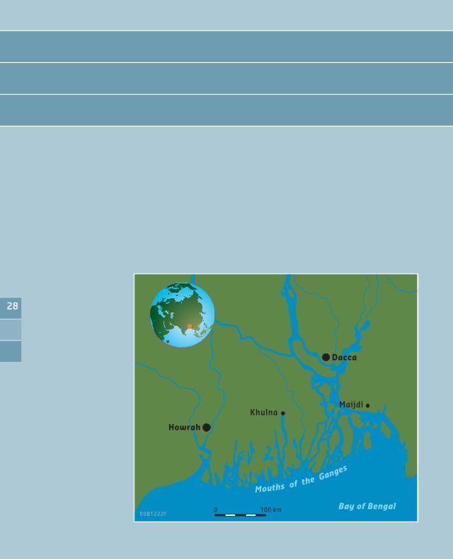
Geography The Ganges Brahmaputra Delta, also named Ganges Delta, Sunderban Delta or Bengal Delta is situated in Asia where the Ganges and Brahmaputra rivers discharge into the Bay of Bengal. It is, with a surface area of some 100.000 km2, the world’s largest delta. Approximately two-thirds of the delta is in Bangladesh, the rest constitutes the state of West Bengal, India. The Ganges Delta is the floodplain of three great rivers: the Ganges, the Brahmaputra and the Megna. Together, these three rivers drain a catchment of about 1.72 million km2, at the southern side of the Himalaya.
The Ganges Delta is among the most fertile regions in the world. Along the coast, the width of the delta is approximately 350 km. The distance from the confluence of the Brahmaputra and the Ganges to the coast is some 250 km. Downstream the confluence, the river is named Padma. About halfway the Padma, the Meghna joins.
GeomorphologyThe Ganges as well as the Brahmaputra have a highly variable discharge. On the steep slopes of the Himalaya the rivers collect huge quantities of sediment. Upstream the confluence, the Ganges is a meandering river, while the Brahmaputra is a braided channel. The channels of both rivers are extremely unstable and river banks can migrate as much as 400 m in a single season. The annual sediment discharge is about 1,500 million tons. During flood the suspended sediment load at the confluence may reach 13 million tons in a single day. Bedload has never been measured, but is obviously extremely high and consists of fine and medium grained sand.
Most of the delta is composed of alluvial soils, with red and red-yellow laterite soils found in the eastern part. The soil contains large quantities of minerals and nutrients, which is good for agriculture. In the course of time, the area of active deltaic sedimentation has changed. Today active sedimentation occurs
2�

mainly in the eastern part of the delta. Here, the annual rate of bank erosion is estimated 10,000 ha whereas the natural accretion is only 2,500 ha. The western part of the delta is characterized by abandoned channels dominating the surface morphology. Here, one of the largest mangrove regions in the world, the Sunderbans, have developed. The abandoned delta is approximately 1.6 times the size of the active delta plain. Many of the former riverine channels are now tidally dominated.
Some of the larger tidal channels form bell-shaped estuaries that may be quite deep, and many of them serve as major transport arteries. Inland, the estuarine channels show highly sinuous channel patterns, but appear to be stable rather than migratory. The tidal range varies considerably along the Bengal coast, mean tidal range is 3.6 m. The coastline is extremely irregular as a result of the large number of tidal channels that dissect the coast. Wave energy is relatively low and muddy tidal flats are common. At low tide, many of these flats are exposed as fluid mud banks. Most of the banks display elongated patterns, aligned in an onshore- offshore direction. The offshore slope fronting the delta is extremely low.
ClimateThe Ganges-Brahmaputra Delta lies mostly in the tropical wet climate zone. The coolest month of the year, is January, with April and May being the warmest months. Average temperatures in January range from 14 to 250C, and average temperatures in April range from 25 to 350C. Average annual rainfall in the basin is some 1,500 mm, with the maximum exceeding 2,200 mm and a minimum of less than 400 mm. Heavy rainfall is characteristic for Bangladesh. With the exception of the relatively dry western region of Rajshahi, most parts of the country receive at least 2,300 mm of rainfall per year. Because of its location just south of the foothills of the Himalayas, where monsoon winds turn west and northwest, the region of Sylhet in northeastern Bangladesh receives the greatest average precipitation. From 1977 to 1986, annual rainfall in that region ranged between 3,280 and 4,780 mm per year. The rainy months are from June through September when monthly rainfall exceeds 100 mm. The dry months still have an average rainfall between 20 and 60 mm.
Ganges Brahmaputra Delta (Bangladesh)
�0

Hydrology The average annual discharge of the three rivers into the Bay of Bengal is approximately 30,000 m3/s. During flood, the maximum discharge may exceed 80,000 m3/s whereas the minimum discharge may drop to some 6,000 m3/s. The major floods occur during the months from June through September.
1.2 Infrastructure
The Ganges Delta is intersected by a dense network of river branches and other watercourses. On one hand this network sustains a cheap means of transport and provides the water and sediment required for intensive agriculture. On the other hand, during high river discharge or storm surges from the sea, the
�1

Ganges Brahmaputra Delta (Bangladesh)
watercourses enlarge the risk of flooding. The abundant presence of open water also hampers the development of road transport.
Infrastructure development in the Ganges Delta primarily aims at flood protection and agricultural water supply in dry periods. Floods are a permanent threat to the population of the delta. About every ten years more than 50% of the area is flooded when river discharges reach extreme values. In addition, heavy local precipitation may exceed the drainage capacity; and typhoons may produce storm surges up to 10 - 15 m. Nevertheless, water resource managers have attempted to develop the land and water resources of the Ganges-Brahmaputra delta through irrigation, drainage, flood control and flood proofing. Early plans calling for large scale irrigation only led to the construction of the Farakka Dam, which controls the Ganges flows just upstream the border between India and Bangladesh.
Since the 1960s Bangladesh has implemented over 600 large, medium and small-scale projects providing flood protection and irrigation facilities to 1,600 km2 of agricultural land. Structural measures such as large and small-scale pumped irrigation, flood control with river embankments, polders, sluices, and cyclone shelters, and drainage improvements with new drains have been applied all over the delta. Non-structural measures have also been introduced, with policies to encourage small-scale irrigation using treadle pumps and small diesel or electric pumps, flood warning and cyclone warning systems.
River navigation is an important means of transport in the delta. Due to decreasing dry season flows and siltation of some branches, the potential of river navigation is declining and a shift to road and rail transport is required. The existing road and rail network supports north-south movement in corridors parallel to the major river branches. Ferries are used to cross the many open watercourses. Construction of new roads to areas currently served by navigation requires considerable investment and will cause some loss of agricultural land.
�2

1.� Socio-economics
PopulationSome 150 million people live on the delta, despite risks from floods caused by monsoons, heavy runoff, and tropical cyclones. Most of the Ganges-Brahmaputra Delta has a population density of some 1500 inhabitants per km² making it one of the most densely populated regions on earth. The annual growth rate is 2%.
Economic developmentThe major part of the nation of Bangladesh lies in the Ganges-Brahmaputra Delta, and many of the country’s people depend on the delta for survival. Bangladesh’s predominantly agricultural economy depends heavily on the discharge of the Ganges, Brahmaputra and Meghna, with their periodic flooding and drought. Although one of the world’s poorest and most densely populated countries, Bangladesh has made major strides to meet the food needs of its increasing population, through increased domestic production augmented by imports. Nonetheless, an estimated 10% to 15% of the population faces serious nutritional risk. Although improving, infrastructure to support transportation, communications, and power supply is rather poorly developed. Bangladesh is limited in its reserves of coal and oil, and its industrial base is weak. The country’s main endowments include its vast human resource base, rich agricultural land, relatively abundant water, and substantial reserves of natural gas. Natural gas serves as the main source for the chemical industry. It covers about 74% of the commercial energy used by the country.
Bangladesh historically has run a large trade deficit, financed largely through aid receipts and remittances from workers overseas. Since independence in 1971, Bangladesh has received more than US$30 billion in grant aid and loan commitments from foreign donors. Efforts to achieve Bangladesh’s macroeconomic goals have been problematic. The privatization of public sector industries has proceeded at a slow pace. The IMF and World Bank predict GDP growth over the next 5 years will be about 6.0%. The per capita GDP is about US$ 400.
AgricultureMost inhabitants of the delta earn their living from agriculture. Although rice and jute are the primary crops, the importance of maize and vegetables is augmenting. Due to the expansion of irrigation networks, some wheat
��

Ganges Brahmaputra Delta (Bangladesh)
producers have switched to cultivation of maize which is used mostly as poultry feed. Thanks to fertile soil and normally ample water supply, rice can be grown and harvested three times a year in many areas. Due to a number of factors, the labor-intensive agriculture has achieved steady increases in food grain production despite the often unfavorable weather conditions. These include better flood control and irrigation, a generally more efficient use of fertilizers, and the establishment of better distribution and rural credit networks. Population pressure continues to place a severe burden on productive capacity, creating a food deficit, especially of wheat. Foreign assistance and commercial imports fill the gap. Underemployment remains a serious problem, and a growing concern for the agricultural sector will be its ability to absorb additional manpower. Finding alternative sources of employment will continue to be a challenge for governments, particularly with the increasing numbers of landless peasants who already account for about half the rural labor force.
FisheriesAt all stages in the cycle but particularly during the monsoon, riverine fish is captured by the rural community. Reduction in discharge during the dry season has declined natural fish populations. Coupled with the impacts of flood control schemes and a lack of systematic management, capture fisheries have considerably reduced. In recent years, fish farming is developing in existing ponds in the delta. Shrimp and salmon are the main species. Most of these fish are exported. The shrimp industry has grown into a nationally important resource. The industry relies on the tidal waters of the Sundarbans and surrounding areas for the supply of shrimp larvae which are netted and then transferred to inland brackish water lagoons and ponds.
IndustryThe development of industry in Bangladesh is relatively slow. Nevertheless, Bangladeshi entrepreneurs are successfully competing in the global garments market. This private industry has created some 2 million jobs, mostly for women. The labor-intensive process of ship-breaking for scrap has developed to the point where it now meets most of Bangladesh’s domestic steel needs. Other industries include sugar, tea, leather goods, newsprint, pharmaceutical, and fertilizer production.
��

NatureThe country supports a wealth of biodiversity, including numerous species of mammals, birds, reptiles, amphibians, freshwater and marine fish, mollusks and vascular plants. Many of these species are of international significance, such as the Asian Elephant, Royal Bengal Tiger, Gharial, Gangetic Dolphin and Hoolock Gibbon.
The dense population and consequent demands for goods and services has subjected the country’s natural resources to overexploitation. In particular the Sundarban Mangrove forest, being a Ramsar site merits special attention. There is a real danger for degradation due to human interference.
1.� Governance
Bangladesh has a highly centralised government with a strong administrative culture. Decisions are taken at the centre, even for local matters. For administrative purposes the country is divided into six divisions, sixty four districts and four hundred sixty four sub-districts. Public goods such as embankments, roads, bridges, schools, hospitals and other public facilities are provided and operated by the government. This system of providing services
��

Ganges Brahmaputra Delta (Bangladesh)
free of cost requires strong and accountable local agencies. Currently, efforts are underway to improve core governance systems in areas such as public procurement, financial management and fiscal reporting. Several reforms to improve sectoral governance are also underway.
The government of Bangladesh, with the assistance of international donor organizations, has introduced a National Water Policy, which guides all the activities in the water sector from the perspective of Integrated Water Resources Management. Moreover, the government has prepared a National Water Management Plan (NWMP) considering long term need, management and utilization of water resources cross cutting all sectors. In 2005 government declared a Coastal Zone Policy, providing a general guidance to all concerned for the management and development of the coastal zone in a manner that the coastal people are able to pursue their life and livelihoods within secure and conducive environment.
��

2. Main challenges and opportunities
Pressure on available spaceThe Ganges Brahmaputra Delta belongs to the most densely populated areas of the world. With a population density of more than 1,000 inhabitants/km2 and a growth rate of 2% the pressure on the available space is high. In Bangladesh the delta is still active with very unstable river branches. Riverbank and island erosion is one of the major issues, and is probably the most important natural cause of landlessness and forced resettlement.
Agriculture and flood protectionThe majority of the population of the Ganges Delta depends on agriculture and agro-related industry. Over 60.000 people each year are made landless by bank erosion along the main rivers. The annual rate of erosion is estimated 10,000 ha whereas the natural accretion is only 2,500 ha. Bangladesh cannot afford to lose any land to erosion and erosion control is a top priority.
A second factor constraining agricultural production and safety of the agricultural population, is flooding. Almost every year floods occur in Bangladesh, with varying intensity and magnitude. In a normal year 20% of the country is inundated by river spills and drainage congestions. Floods with a return period of 100 year may inundate 60% of the country. Flood protection and irrigation improvement is another main concern in Bangladesh. Up to now some 1,600 km2 of agricultural land is well protected. Floods may also occur due to cyclonic storm surges. Although the frequency of these floods is low (major storm surge related floods are reported in 1970, 1991 and 2007) the floods may be extremely devastating. For example, the cyclone of april 1991 induced a storm surge of 6 – 7,5 m height and caused nearly 150,000 deaths. The 1970 Bhola cyclone was less powerfull, but is nonetheless the deadliest tropical cyclone on record. The exact death toll will never be known, but it is estimated that between 300,000 and 500,000 people lost their lives.
To reduce loss of lives and property, Bangladesh focuses on the development of flood forecasting and warning systems.
��

Ganges Brahmaputra Delta (Bangladesh)
Water qualityThe main issue related to water quality is the provision of reliable drinking water. Currently the surface water gets polluted by the discharge of untreated domestic and industrial sewage. While Bangladesh has made significant progress in supplying safe water to its people, large differences in coverage exist across the country. Latrine usage is very poor, averaging only 16% in the rural areas. Diarrheal diseases constitute a major health problem in Bangladesh, killing over 100,000 children each year.
In the late 1970s, many groundwater wells were drilled to replace the traditional contaminated surface water sources. However, in 1993, high arsenic concentrations were discovered in shallow aquifers. Current understanding (2001) is that 25% of the population in the delta are exposed to contamination exceeding national standards, with another 25% that do not meet WHO standards.
WetlandsThe ecologically sensitive wetland areas of Bangladesh are under great pressure from encroachment and their utilization as sources of subsistence and production. The Sundarban Mangrove forest, being a Ramsar site requires special attention as significant parts of the forest have been lost due to human interference.
��
References
• Workshop on the Planning and Management of Modified Mega Deltas, first iteration, September 6 2002, The Hague, the Netherlands; Bengal Delta, Anders Malmgren-Hansen; Emadduddin Ahmad
• Workshop on the Planning and Management of Modified Mega-deltas, The Hague, 24 – 26 September 2001, Background paper by Anders Malmgren-Hansen; Emadduddin Ahmad
• Sustainable Development of Deltas, Proceedings oft he international conference, 23-27 November 1998, Amsterdam, The Netherlands; Country position paper Bangladesh, Dr A.T.M. Shamsul Huda.
• Integrated Flood Management in Deltas and Low-land River Regions, Country paper Bangladesh, High Level meeting on Flood Defences, Nijmegen, 2005.
��
�0

1 Current state of the delta
1.1 Physical characteristics
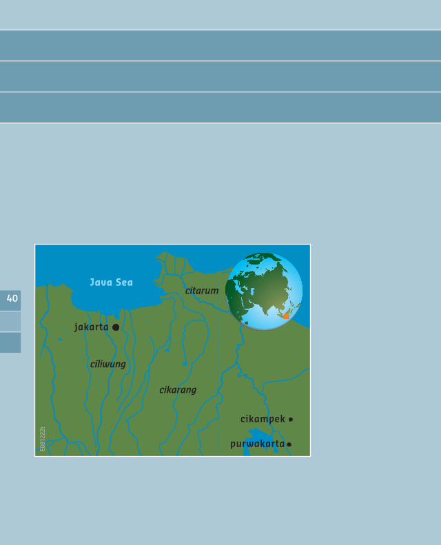
Geography The Ciliwung riverbasin is situated in Western Java. The river has a length of 128 km, of which some 30 km flows through the urban area of Jakarta. The Ciliwung originates on the slopes of Mount Pangrango, (some 3000 m above mean sea level) cutting northward through Bogor and Jakarta towards the Java Sea. In Jakarta, the Ciliwung is divided into smaller canals, built during the Dutch administration.
Together with 13 other rivers and canals the Ciliwung plays a crucial role during flood events in Jakarta. In Jakarta, the Ciliwung river diverts into the West Banjir Canal (WBC), the floodway that was constructed in 1919 to divert abundant water of the rivers on the west side of Jakarta to prevent the downstream areas from being flooded. Downstream the diversion, the old Ciliwung reach is still functioning. The East Banjir Canal (EBC), which is currently under construction, will divert flood waters on the east side of Jakarta.
GeomorphologyThe basin of the rivers that flow through Jakarta can be roughly divided into a steep, mountainous area upstream of Bogor; a moderately steep hilly area between Bogor and Jakarta; a valley plain area along the rivers in the hilly area; and a flat coastal plain area. The city of Jakarta measures over 600 km2. Jakarta’s southern area has an altitude of about 50 metres above mean sea level, but vast tracks of its northern area are lowlands with elevation ranging from -1 to +3 m above mean sea level. The city is therefore prone to perennial inundation due to excessive rainfall and flash floods along the river systems.
ClimateThe Jabodetabek area (the urban area of Jakarta, Bogor, Depok, Tangerang and Bekasi; some 5,500 km2) has a wet season that runs approximately from December till May. Maximum rainfall amounts are generally observed in
Ciliwung River Delta (Indonesia)
�1

January and February, due to heavy monsoon rainfall. Differences in rainfall volumes between the wet season and the dry season occur in the northern part of the Jabodetabek area. In the southern part of the area orographic effects cause relatively high rainfall amounts, even in the “dry season”. The rainfall in the area is characterized by high intensity short duration storms. Even in the wet season, long dry spells can occur between storm events. Rainfall is generally concentrated in the afternoons and evenings. Mean annual precipitation ranges from about 1500 mm at the Java Sea coast to over 4000 mm in the mountainous upstream part of the catchment.
HydrologyThe rivers draining to Jakarta have regularly caused floods. The flood of February 2007 was one of the worst floods ever experienced in Jakarta (return period 50 years). The flood covered 70% of the metropolitan area, whereas 30% was inundated over 100 cm water. The rivers that flow through Jakarta respond very fast to rainfall. The rain falls with high intensities, which means relatively large amounts of rainfall become available for runoff without infiltration. Also a large percentage of the area is urbanised, which causes low infiltration percentages and high (overland) flow velocities. Furthermore the area upstream of Bogor is very steep, leading to high flow velocities.
Ciliwung River Delta (Indonesia)
�2

Analysis of previous flood events (the 1996, 2002 and 2007 floods) shows that extreme flood events mainly occured in January or February, as a result of heavy monsoon rain. The floods are often caused by successive rain storms, with the majority of rain falling in one or two hours. Sea water levels did not contribute much to the flood extent of the 1996, 2002 and 2007 flood events.
However, the impact of sea water levels on the flood extent is expected to increase. Under normal conditions coastal gates are closed to avoid sea water intrusion and to maintain preset water levels in the major drainage system. Under severe flood conditions the coastal gates are opened, based on the tide, to drain excess water to the sea. The Flood Hazard Mapping Study (Deltares 2007) has shown that in future this will no longer be possible. But even today a severe flood threat is present when rain induced floods coincide with high sea water levels.
Already today sea water levels can be more than 2 meters higher than parts of North Jakarta. Severe subsidence over the past 30 years has caused Jakarta to sink to very critical levels. It is expected that North Jakarta will subside at least another meter over the next 20 years. When severe rain induced floods coincide with high sea water levels, flood water cannot be drained to the sea and it is likely that very rapid water level rise will occur in the Northern part of the city. Even a fully rehabilitated drainage system will not be able to cope with these conditions and flood preparedness and flood warning are required to avoid severe damage and casualties. Large-scale additional sea defense measures will be required to prevent permanent inundation (from the sea) of northern Jakarta.
1.2 Infrastructure
The Indonesian economy is rapidly developing and due attention is given to the development of infrastructure in its capital Jakarta. Nevertheless, the rapid urbanisation of Jakarta results in severe shortcomings in the provision of infrastructures. The development of road infrastructure is lagging behind the growth of traffic, resulting in severe traffic jams during almost the entire day. With some 50% of Jakarta situated below mean sea level and only 25% of this area protected by embankments, some 6 million inhabitants are vulnerable to flooding. The vulnerability for flooding is further increased by people living in the flood plains. Whereas the Ciliwung river’s flood-plain was green in 1972;
��

Ciliwung River Delta (Indonesia)
over 10% of the floodplain area is occupied by housing in 2005, mostly as slum dwellings in Jakarta. Inadequate infrastructure for piped water supply influences the flooding problem in Jakarta. Only 47% of Jakarta’s households have access to piped water supply within 200 metres of their dwelling. Such inadequate water infrastructure results in both households and commercial establishments (retailers, offices, industries and others) extracting ground water for their basic water needs. Over half of metropolitan Jakarta’s households draw their water supply from shallow wells (i.e. less than 15 metres deep) whereas businesses rely on deep wells (up to 250 metre deep). Many scientists believe that deep groundwater extractions are primarily responsible for land subsidence, particularly those observed in the coastal, western and northeastern parts of Jakarta. Solid waste disposal in drains reduce the discharge capacity of these drains and as a consequence aggravate the flooding problems.
1.� Socio-economics
PopulationJava has a population of 130 million inhabitants and a population density of more than 1000 inhabitants per km2. It is the most densely populated island in the world. The population of Jakarta has risen sharply from 1.2 million in 1960 to 8.8 million in 2004, counting only its legal residents. The population of greater Jakarta is estimated at 23 million, making it the fourth largest urban area in the world.
In 2005 the population growth rate for Indonesia had decreased to some 1,3% whereas Jakarta’s population growth rate remained at 3,6% per year.
Economic developmentThe Indonesian economy and politics are rapidly developing. In recent years the development was hindered by a series of natural disasters, such as the Tsunami in Aceh and Western Java and the earthquakes in central Java. Nevertheless, in 2007 the annual income per capita was some US $ 2000,- and GDP growth amounted to 6.3%.
��

1.� Governance
The Indonesian Government is currently in a decentralization process. The main challenge in the decentralization process is to prevent decentralized processes from becoming ineffective. Capacity building, for instance for water boards and catchment area commissions in the water sector, and promotion of cooperation (among institutes and between institutes and the central government) are important themes. Indonesia recognizes the increasing importance of sustainable development of water resources in dealing with floods and droughts. Prevention of excessive groundwater use and careful priority setting for increasing water demands are the main issues in this field.
Indonesia’s Ministry of Public Works, the agency in charge of urban planning, recognized that expansion along the lowlands in Jakarta’s northern coast or into the higher elevations in the south were the most ecologically threatening directions of expansion. In 1984 the Ministry therefore devised a “Jakarta Out” strategy that envisages the city expanding to the east and west. However, this sensible plan soon lost out to commercial interests: large scale conversion of green spaces and wetlands into urban-industrial areas. The low-lying coastal plains in north Jakarta, with poor soil bearing capacity for buildings, has become a dense industrial and housing zone.
Whatever preventive and mitigating measures will be taken, it is unlikely that Jakarta will ever be free of flooding. In line with the current national strategy on flood management, it therefore becomes increasingly important to think in terms of managing flood risks rather than only flood prevention. Flood risk management covers a wide range of non-structural measures next to structural measures. Non-structural measures are often cheaper than structural measures, but more complex to implement, as many stakeholders are involved, often with conflicting interests.
��

Ciliwung River Delta (Indonesia)
2. Main challenges and opportunities
Pressure on available spaceThe core problem for the Ciliwung delta is the out-of-control urbanization of Jakarta. The rapid urbanisation of Jakarta results in severe shortcomings in the provision of infrastructure. Occupation of floodplains as well as inadequate infrastructure for piped water supply and solid waste disposal exacerbate the flooding problem in Jakarta.
Vulnerability to floodAlmost half of the area is below sea level and is still subsiding. The city is prone to inundation due to excessive rainfall and flash floods. Changes of land use in the upper Ciliwung catchment and increasing urbanization all over the basin will only aggravate the existing problems. Groundwater withdrawal for water supply will increase the subsidence and the vulnerability of the area. There is a clear lack of storage or diversion options; the construction of the new Eastern Banjir Canal will only partly solve the problems.
Freshwater shortageLand conversion from forest to agriculture and urban area results in water shortages during the dry season. Broad Integrated Water Resources Development studies for West-Java in general and Ciliwung basin in particular were initiated in the eighties already and have continued till today. Masterplanning projects were done and resulted in various strategies to mitigate the water shortage problems. However, only part of the projects and measures were implemented and the pressure on the system has only been increasing since then. A major breakthrough will be necessary to manage the present situation, both with regard to management of the existing water resources, and with regard to demand reduction.
Ageing infrastructureAlthough some of the infrastructure is relatively recent, rehabilitation is needed, especially with respect to drainage systems. This is particularly true for the flood control infrastructure around the city of Jakarta, which largely dates back to the beginning of the 20th century. The same applies to irrigation and drainage works that once were part of the rural agricultural system around Jakarta, but now are part of the city. In the upper catchment some of the
��

hydraulic infrastructure was built more recently, but certainly their capacity is not adapted to the current flows and volumes of water anymore.
Coastal erosionLocally there is coastal erosion due to natural and man-made factors. Islands in the Bay are disappearing as a result of coral reef destruction. Other human interventions along the coast are just aggravating the situation. Integrated Coastal Zone management is very much neede. This will require a further development of the institutional situation with regard to the mandate of national and local authorities to control and manage coastal developments.
Loss of environmental quality and biodiversity:The quality of the surface water in the river and canal system in and around Jakarta forming Ciliwung Delta is quite bad, due to the disposal of untreated wastewater in Jakarta’s urban area as well as discharges from industry and agriculture all over the basin. The quality of the ground water is threatened by salinization (as a consequence of over- abstraction) and contamination by infiltration of polluted surface water. Industrial discharges are not or badly controlled. Consequently the whole physical, biological and ecological system in Ciliwung basin as well as in the coastal wetlands is at stake. Unless remedial action is taken the system is in clear jeopardy.
References
• Hydrology and Sea Water Level, Flood mapping Component, prepared for partners for water, Deltares, December 2007;
• Jakarta Flood Team Indonesia-Netherlands; Executive Summary, Draft – December 2007
• Basin Water Resources Management Planning, Delft Hydraulics, DHV Consultants and Dutch Ministry of Public Works, Transport and Water Management, WorldBank, 2002-2004
• Java Irrigation Improvement and Water Management Project, Delft Hydraulics, DHV consultants, Dutch Ministry of Public Works, Transport and Water Management, 1996-1998
• Jabotabek (Jakarta-Bogor-Tangerang-Bekasi) Water Resources Management Study, Delft Hydraulics and DHV Consultants, 1991-1993
��

��

1 Current state of the delta
1.1 Physical characteristics
Geography The Nile Delta is situated in northern Egypt, where the river Nile reaches the Mediterranean Sea. The Nile is the longest river in the world. It originates near the equator and flows nearly 7,000 km northward. The delta begins approximately 20 km north of Cairo and extends North for about 150 km. At the coast the delta is about 250 km wide, from Alexandria in the west to Port Said in the east. The area of the Nile Delta is about 20,000 km2.
The Nile Valley and the Nile Delta rank among the world’s most fertile farming areas and are surrounded by a highly arid environment. Consequently, the delta is densely populated.
GeomorphologyThe Nile Delta is a flood plain. It was formed by deposition of fine sediments from the floods of the river Nile. The depth of the deposited sediments increases from South to North with a mean thickness of almost 10 m. The soils in the delta are mostly clayey or silty-clayey.
In the past, some seven active branches of the Nile crossed the delta which was constantly growing to the North. Nowadays, these tributaries have been silted up and only two branches remained: Rosetta and Damietta. At the beginning of the 19th century the build up of the delta came to a stand still. The High Aswan Dam comprehensively controls the river flow and the silt, leading to retreat of the shoreline in some areas. In 1981 the Egyptian Shore Protection Agency (EPA) was established, to combat further erosion of the coast. One of the major projects was the promontory of Rosetta, which included a 5 km seawall (breakwater).
A substantial part of the delta lies below 2 m in elevation. The shoreline of the Nile Delta is smooth and arched. There are three brackish lagoons connected to the Mediterranean Sea: Idku, Burullus and Manzala.
Nile River Delta (Egypt)
��

Nile River Delta (Egypt)
ClimateEgypt is totally dependent on Nile water and has been so for thousands of years. The average annual evaporation of Egypt and the Nile Delta are 1,750 mm and 1,500 mm resp. Lower Egypt is also, favoured by some precipitation: the average annual precipitation in the delta is 100 – 200 mm compared with only 25 in Upper Egypt.
HydrologySince the construction of the High Aswan dam, the flow of the Nile is fully regulated. The discharge from Lake Nasser is (by international agreement) 55,500 million m3/year. Downstream of Aswan, the water levels and water distribution are controlled by a number of barrages. North of the delta considerable quantities of Nile water are diverted for irrigation, of which most of the drainage flows back to the Nile, leaving some 35,000 million m3 anually for the delta.
The Nile Delta is underlain by an aquifer composed of a thick layer of sand and gravel with clay intercalations. The sediments are covered by a clay cap of varying thickness, up to 50 m in the northern part of the delta. In terms of abstraction the Nile aquifer is the most important aquifer in Egypt. However, since the aquifer is recharged by infiltration of excess irrigation water originating from Nile water released at Aswan, the Nile aquifer is not a separate resource. In the north groundwater abstractions cause seawater intrusion into the aquifer.
1.2 Infrastructure
With some 50% of the Egyptian population living in the Nile Delta, the delta comprises many cities and towns. Main cities are Alexandria and Port Said along the Mediterranean coast and Ismailia along the Suez Canal.
Main roads in the delta are the Mid Delta Road and the West Desert Highway, connecting Cairo with Alexandria and other main cities in the Middle and West delta. The Eastern Desert Highway connects Cairo with Ismailia, Port Said and other cities near the Suez Canal and Sinai.
�0

The river Nile and its branches have been used for river transport since ancient times. In the Nile delta, the Damietta and Rosetta branches, the Nubaria Canal and Beihera Rayah are growing as proper means for navigation and transport, connecting the Mediterranean with the main river at Cairo and south to Aswan. The Ismailia Canal connects Cairo, on the river Nile, with Ismailia on the Suez Canal.
The water supply to the irrigated agricultural areas of the Nile Delta is both by gravity and pumping. The delta barrages near El Qanater regulate the flows. The canal system is very extensive. Branch canals take off from the main or lateral canals and deliver the water to smaller distributary canals, which in turn deliver water to the field intakes (mesqas). Because the water level in the irrigation system is below field level in most of the area, the water has to be raised. Traditionally this was done by animal driven waterwheels. Nowadays diesel pumping stations are found throughout the delta. The irrigation method is generally flooding. Due to inefficient irrigation practises, large quantities of good irrigation water are spilled to drains and re-use of drainage water is widely practised. To improve irrigation efficiency, Egypt has converted most of its open drainage systems into subsurface pipe drainage systems.
�1
Nile River Delta (Egypt)
1.� Socio-economics
PopulationPopulation growth is certainly among the most pressing challenges that Egypt is facing in its developments. By 2003 the total population in Egypt is estimated at 72,5 million with an annual growth rate of 1,9%. By 2020 the population is estimated between 85 and 90 million. Some 50% of the Egyptian population lives in the Nile Delta.
Economic developmentEgypt’s long-term macro-economic prospects look favourable, with progress set to accelerate on such structural issues as privatisation, trade liberalisation and deregulation. Egypt’s main challenge is matching employment growth to the estimated 800,000 new job seekers coming into the labour market each year.
The agricultural sector, which represented 40% of GDP in 1960, now only produces 17% of GDP. It is almost completely in private hands. The industrial sector, of which 26% is still in public hands, produces 32% of GDP. The services sector, including governments is at 50% the largest sector. In 2002 the annual GDP is some 4,000 US $ per capita. Apart from the formal economy, Egypt has an extensive informal economy comprising street vendors, cleaners, gardeners etc. whose economic activities are not registered by the official statistics.
AgricultureAgriculture is a main economic activity in the Nile Delta. The present agricultural strategy aims at food security (not self-sufficiency). Egypt is increasingly in a position to produce higher value food crops (e.g. fruits and vegetables) and non-food crops (e.g. flax and cotton) and trade them to purchase staples and have additional revenue and employment as well. The most important crops cultivated in the Nile Delta are clover, maize, cotton wheat, rice, fruits and vegetables.
The agricultural sector has already implemented more reforms in terms of privatisation and liberalisation than any other sector in the economy. Yet there is scope for further policy reform that would increase domestic production, export revenues and private sector jobs. Issues to be dealt with are: full property rights on lands, liberalisation and privatisation of agricultural institutions, full liberalisation of pest management services to all crops, development of horticulture and related industry.
�2

Animal husbandryEgypt has considerable scope for increasing its livestock activities. The animal husbandry sector is divided into a small scale, largely subsistence oriented sector catering for the farm family and its direct surroundings; and a modern sector catering to the urban consumer. Beef and milk production in Egypt is still underdeveloped. The country is not self-sufficient in these commodities.
FisheriesThe marine and inland waters of Egypt are reported to produce some 770,000 tons of fisheries products. Some 20% of this quantity is produced in the coastal lakes of the Nile Delta. Virtually, all Egyptian water bodies are fished to the maximum and some are overexploited already. Fish farming has been practiced in Egypt through the ages, currently ranging from traditional village
��

Nile River Delta (Egypt)
type ponds to modern governmental and private fish farms. The future of aquaculture is rather uncertain as fish farms are only allowed to use drainage water, which is a risky source because of pollution.
IndustryIndustry is a growing sector in the national economy of Egypt. Further industrial development is expected to play a major role in the socio-economic development of the country, providing employment for a large part of the growing population. The industrial policy, however, is to create new cities and industrial zones outside of the Nile Valley and Delta.
��

1.� Governance
The governmental structure of Egypt consists of three levels: the central government (26 Ministries); the Governorates and the districts. At the national level the Ministry of Water Resources and Irrigation (MWRI) is the prime responsible ministry for water resources management. At the de-central level Egypt is subdivided into 26 Governorates, of which 12 are (partly) in the Nile Delta. Each Ministry is represented in the governorates by a local authority. The Governor takes the responsibility of the management between all these units and offices to serve the general work-plan of his governorate.
2. Main challenges and opportunities
Population growthOutside the Nile river valley and the delta, Egypt is desert. Consequently most of the Egyptian rural population lives in the Nile Valley and delta. With a population growth rate of nearly 2% the pressure on the available space is the main issue of the Nile Delta.
Intensification of agricultureThe water resources of Egypt are limited to the discharge of the river Nile, which is fully controlled by Lake Nasser. According to international agreements Egypt receives 55,000 million m3 per year. The main concern in water resources management in Egypt is to use the available water to the maximum extent for agriculture. The quantity of fresh water that is finally draining to the Mediterranean should be minimal. A major issue in Egypt is intensification of agriculture. In Egypt this is called horizontal expansion (more irrigated area with the same quantity of water).
Water qualityThe combination of rapid population growth and intensification of agriculture requires permanent attention for the quality of surface water and groundwater. In the Nile Delta most of the domestic (and sometimes even industrial) wastewater is discharged to the drains without any treatment. Re-use pumping stations are mixing drainage water with irrigation water, thus contaminating
��
Nile River Delta (Egypt)
the water in the irrigation canals. The quality of groundwater in the Nile Delta is threatened by over-exploitation of wells as well as leaching of nitrates from the surface, leading to salinisation or contamination of the groundwater resource. Water quality management has been declared a national priority in Egypt. At this moment, however, the legal regulations and institutional capacity to guide this process are limited.
In the Nile Delta fresh water is intensively used for agriculture. Irrigation and drainage systems have been developed long ago and are not always well maintained. The ineffectiveness in irrigation is to a large extent compensated by the re-use of drainage water and the introduction of closed drainage systems. Further improvement of the irrigation and drainage infrastructure is another important issue in water resources development in Egypt.
Shore protection / Coastal erosion managementSince the construction of the Aswan dam, most of the Nile sediments are trapped in Lake Nasser. Consequently, the sediment balance at the coast is disturbed, leading to coastal erosion at various locations. Shore protection and coastal erosion management are another important issue in the Nile Delta.
WetlandsThe Nile Delta comprises several coastal lagoons. As these lagoons are on the migration route of various birds these wetlands have an important ecological function. In the Delta Lake Burullus and Lake Bardawil are RAMSAR sites. As the coastal lagoons are at the end of the system the water quality is threatened by salinization and contamination.
��
References
• National Water Resources Plan Egypt• Workshop on the Planning and Management of Modified Mega Deltas, first
iteration, January 2003, The Hague, the Netherlands; River Nile Delta, prof. Morcos Fanos
• Workshop on the Planning and Management of Modified Mega-deltas, The Hague, 24 – 26 September 2001, Background paper by Alfy Morcos Fanos
• Sustainable development of Deltas, proceedings of the international conference, 23 – 27 November Amsterdam, the Netherlands; Overview of Egypt’s Nile valley and delta Formation, issues, concerns; Mr Abdel-Rahman M Shalaby et al.
• Undermining Standards of Good Governance: Egypt ’s NGO Law and Its Impact on the Transparency and Accountability of CSOs, Mohamed Agati, The International Journal of Not-for-Profit Law, April 2007.
��

��
1 Current state of the delta
1.1 Physical characteristics
Geography The Rhine is one of Europe’s major rivers. From its source in Switzerland it flows through six countries before reaching the North Sea, a distance of 1,320 km. It has a catchment area of ca. 200,000 km2 with more than 58 million inhabitants. The total length of the Dutch coastline is more than 400 kilometres. The coast can be divided into three different parts: the delta area with tidal inlets in the South (now mostly controlled by open or closed barriers), the uninterrupted Holland coast and the Wadden Sea area (featuring a series of barrier islands) in the North. At present, almost one third of the Netherlands is located below average sea level. Another third has to be protected against flooding by rivers in periods of high discharges.
The use of the river Rhine as an inland waterway has largely contributed to the socio economic development of the delta. Rotterdam, in the Netherlands, is one of the worlds largest sea ports; Duisburg, in Germany, is the largest inland port in the world. No other river has as many chemical plants on its banks as the Rhine, while at the same time the Rhine water is a source for drinking water for some 20 million people.
The Delta of the Rhine starts at the German – Netherlands border, where the river splits into its two main branches: the Nederrijn and the Waal. Some 10 km downstream, the IJssel branches off in Northern direction. The Nederrijn, further downstream called Lek, continues in Western direction. The southern branch, the Waal, flows in western direction as well. Near Dordrecht it splits in several branches and feeds a large estuary with four interconnected branches. Two smaller rivers, the Meuse and the Scheldt are debouching in the same estuary. After a storm surge caused a devastating flood in 1953, the Dutch started a huge flood protection programme (Delta plan). Nowadays 4 of the 5 estuary branches, including the Rotterdam Waterway, are protected by dams or storm surge barriers. The area in the estuarine delta that is protected by dikes (the ‘land area’) is mainly used for agricultural and urban/industrial
Rhine River Delta (The Netherlands)
��
Rhine River Delta (The Netherlands)
purposes. It covers approximately 250,000 ha. The total area of water and wetlands in the delta is about half of that of the land: 125,000 ha.
GeomorphologyUntil the 1st century, the main processes that determined the landscape of the Rhine Delta were marine and fluvial sedimentation and erosion as well as the formation of peat. When man started to inhabit the coastal areas, they soon started the reclamation of intertidal areas. Improved drainage conditions in the peat covered areas, stopped peat growth and as a consequence marine influence increased, starting a period of coastal erosion.
The people that had been living on dwelling mounds gradually took the surrounding land into use. Owing to natural and human-induced (such as due to drainage, embankment and reclamation) subsidence, the inhabited areas gradually sank to one to two metres below mean sea level. This increased the risk of flooding and complicated the drainage of surplus surface water. To protect these areas dikes were strengthened continuously. It was not until the 13th century that encircling dikes were introduced. In the period between 1600 and 1800 huge areas of land were thus reclaimed. Also several large water bodies were transformed into productive agricultural land, partly by reclaiming broad meres and lakes, partly by reclaiming silted up land outside the dikes.
In the 17th century, the entrance of the Nederrijn and IJssel was silting up. To enlarge the discharge through these branches, in 1706 the “Pannerdens Kanaal” was dug. Untill today the Pannerdens Kanaal plays an essential role in the discharge distribution and the sediment management of the Rhine.
ClimateThe Netherlands have a moderate climate, influenced by the North Sea. The mean winter temperature is just above 00C ; the mean summer temperature 160C . The average annual precipitation is near 800 mm, varying between less than 400 mm in dry years and over 1,100 mm in wet years. The average annual evaporation amounts to 475 mm. In summer the evaporation may exceed 5 mm/day where in winter it becomes almost zero.
Hydrology Being fed partly by rain and partly by snowmelt from the Swiss Alps, the Rhine has a mixed discharge character with two significant flow peaks: one in the
�0

winter and a much lower one in summer, originating from snowmelt. The mean discharge is 2,200 m3/s, the maximum discharge may reach 16,000 m3/s. The Rhine has its minimum discharge, some 1600 m3/s, in October.
The tide at the North Sea is semi-diurnal, with an amplitude of about 0,5 m in the North to more than 1 m in the Southern part of the coast. Under storm conditions, the sea level may rise 3 to 4 metres above average.
1.2 Infrastructure
The Netherlands is a man-made country. Without dikes, 65% of the area would risk flooding. A substantial part of the land has been reclaimed from the sea. The largest reclamation scheme of the 19th century was that of the Haarlemmermeer in 1852, with a size of well over 18,000 hectares. In the 20th century the reclamation of a substantial part of Lake IJssel added over 150,000 ha to the Dutch land resources.
Initially infrastructure development in the Netherlands was focussed on flood protection. The coast and the many kilometers of riverbanks are protected by solid dikes. Traditionally, the main water management issue was the discharge of excess water. In the low part of the Netherlands polder areas are drained by dense systems of ditches and canals. Pumping stations discharge the water to collector drains and finally to the main water system.
�1

Several extreme dry summers in the seventies, introduced the issue of water supply. The water management since then aimed at water supply in dry periods as well. A complex system of river branches, canals and control structures makes it possible to distribute the water over the country according to the water demands.
In connection with this controlled water distribution the focus shifted in the eighties further to water quality and ecological management. Legislation was made to control the emission of pollutants and all over the country sewage treatmentplants for domestic and industrial water were built.
Climate change may cause sea-level rise and larger discharges of the rivers. In the nineties again a new element was introduced in Dutch water management: building with nature. For the coastal zone the concept of resilience was developed and for the rivers a comprehensive set of projects is being carried out to give more room to the rivers.
1.� Socio-economics
PopulationThe Netherlands have about 16 million inhabitants. The population is almost stable with a minor growth. With nearly 500 inhabitants per km2 the Netherlands are densely populated. About 40% of the population is concentrated in the urban zone between Rotterdam and Amsterdam, where the population density is above 1000 inhabitants per km2.
Economic developmentThe combination of a well developed sea port and a navigable river that connects the delta with a huge hinterland, provided favourable conditions for the development of the Dutch economy. In the past centuries a chain of cities and industrialised areas have evolved. The economic importance of these harbours extend far beyond the delta. The Netherlands are a wealthy country. The per capita GDP is close to US$ 30,000. Most people are employed in services and industry.
Agriculture Only 3,5% of the population is employed in agriculture, though 55% of the area is used for agriculture. Of this area two third is used for dairy farming.
Rhine River Delta (The Netherlands)
�2

Agriculture and the connected agribusiness contributes significant to the Dutch economy. The sector accounts for 23% of the Dutch export. With an export surplus of 7.5 billion Euro agriculture is still an important factor in the Dutch economy.
FisheriesIn the Netherlands fish is caught at sea, along the coast and in inland waters. Fish breeding is, although promising for the future, not yet well developed. Sea fishers bring their fish to the Netherlands from remote fishing grounds. The main part of the caught is exported. Along the coast fisheries are focused on mussels and clams. Professional fishery on inland waters is decreasing.
IndustryTraditional industries in the Netherlands are oil refinery, steel and chemical industry. The importance of agro-related industry and knowledge intensive industry is increasing.
NaturePerhaps the most salient natural features of the delta lie in the estuarine branches of the rivers. The area outside the dikes covers almost 125,000 hectares, of which 85,000 hectares are water, 23,000 hectares are intertidal
��

Rhine River Delta (The Netherlands)
areas, and about 17,000 hectares are more or less permanently dry. Waterfowl visit the delta in large numbers. Almost one million birds are counted each year. Together, 38 species exceed the 1% standard of the Ramsar Convention on Wetlands of International Importance. The specific estuarine values, however, have been severely diminished and – without interference – will decline further.
Also the natural heritage along the river branches and the coast deserves attention. The meandering nature of the river has been transformed, through damming and straightening, so that it now flows through a fixed bed, largely separated from its flood plain. Recently, river- and coastal zone management aim at the restoration of the natural dynamics of rivers and coast.
1.� Governance
Currently, the major water bodies in the delta are managed by the national government. As part of the Ministry of Transport and Water Management, Rijkswaterstaat has the task to develop and implement a long term integrated policy towards the future of the delta waters. Key elements of the policy are the improvement of the natural purification capacity of the delta estuaries and restoration of salt-freshwater gradients and land-water gradients.
Apart from the sectoral management line of responsibility (water management) there is also the administrative line of responsibility: state government – provincial administration – municipal administration. The estuarine delta falls under the jurisdiction of three provinces: the province of Zeeland, Zuid-Holland en Noord-Brabant. Practically the entire province of Zeeland falls within the delta.
The role of the provinces is changing from a predominantly reactive one (for issuing permits and overseeing developments) to a more active one. An important tool for this role is integrated area management.
��

2. Main challenges and opportunities
Pressure on available spaceWith a population density of around 500 inhabitants/km2 the delta is densely populated; in particularly in the western part there is a high pressure on available space. Last major land reclamation was in the 1960’s. Later on, various new plans have been developed including extension of the coast south of The Hague and artificial islands in the North Sea. As yet, none of these plans have been implemented.
��

Rhine River Delta (The Netherlands)
Vulnerability to floodingFlood protection standards are among the highest in the world. Although the probability of flooding is quite small, potential consequences of a flood are high. Sea level rise and new investments will further increase flood risk. Current standards date back to the 1960’s. Because of increases in the number of people and assets to be protected, the new Delta Committee recently proposed to increase the safety level with a factor 10. Maintaining and improving the flood protection systems.
Freshwater shortageAlthough The Netherlands generally has abundance of water from rainfall and external supply through the rivers Rhine and Meuse. Occasionally dry years occur and then serious water shortages are experienced which affect agriculture, energy (cooling water) and shipping (lower navigation depths). Sea levels will increase the problem of salt water seepage and increase he need for flushing. Due to climate change an increase is expected in the frequency and extent of water shortages. To secure future water supplies the new Delta Committee has proposed to raise the target level of Lake IJssel with some 1.5 m. Water of this lake is used for water supply of the western and northern part of the country
Ageing infrastructureSome of the infrastructure is already centuries old, other infrastructure is from a more recent date. Sea level rise may shorten the useful life time of the storm surge barriers in the southwestern delta. Adaptation of infrastructure to new conditions induced by climate change will require major investments in the coming decades, albeit still a very small portion of the GNP. The new Delta Committee has proposed to set-up a so-called Delta Fund to secure the necessary funds.
Coastal erosionCoastal erosion is well controlled with extensive sand nourishments. Sea level rise will increase the maintenance nourishments needs. Most recently the new Delta Committee proposed to extend the coast line with some 1,000 m through additional coastal nourishment. Such extension, to be effectuated in a couple of decades, should offer coastal cities and villages with new development opportunities.
��

Loss of environmental quality and biodiversityDue to the Delta Works most of the delta estuaries were turned into stagnant salt or freshwater lakes. In the closed estuaries, shoreline erosion forms a threat for the remaining terrestrial and transitional zones between the dike and water. In the remaining open estuaries, the Eastern and Western Scheldt, the vulnerability of salt marshes to erosion also increased. Besides these morphologically induced problems most waters also suffer from an impoverished water quality. The worst situation exists in the freshwater Lake Krammer-Volkerak, where eutrophication processes caused by agricultural run-off lead to a very bad water quality with extensive scums of blue green algae. Some years ago, the provincial managing authorities have drafted a vision for the future, in which the restoration of estuarine dynamics has a prominent place. Central to this vision is to partially restore the tidal dynamics and/or to restore the link with the rivers, while maintaining the same level of safety. Plans are being developed and partly underway to improve the situation.
References
• Workshop on the Planning and Management of Modified Mega Deltas, first iteration, September 6 2002, The Hague, the Netherlands; Marcel Marchand, WL|Delft Hydraulics
• Workshop on the Planning and Management of Modified Mega-deltas, The Hague, 24 – 26 September 2001, Background paper Marcel Marchand and Mark van Koningsveld
• Twice a River, Rhine and Meuse in the Netherlands, H. Middelkoop e.a., Arnhem – Lelystad, 1999.
• Leefbaar Laagland, geschiedenis van de waterbeheersing en landaanwinning in Nederland, ICID, December 2003.
• Verdeel en beheers, 300 jaar Pannerdensch Kanaal, G. Van de Ven, 2007.
��

��
1 Current state of the delta
1.1 Physical characteristics
Geography The Mississippi River drains a basin of some 3 million km2, which encompasses more than 40% of the continental United States of America. The basin extends from the Rocky Mountains in the West, to Canada in the North and the Appalachian Mountains in the East. The discharge of the Mississippi accounts for 90% of the freshwater inflow into the Gulf of Mexico.
The Mississippi Delta region comprises much of coastal Louisiana and adjacent Mississippi, and includes the metropolitan area of New Orleans. The delta complex contains major river channels and levees, numerous bayous, swamps and marshes, lakes, tidal flats and channels, barrier islands, and shallow sea environments. Old abandoned distributary ridges of the river are the only land that is one meter or more above sea level. The land between these ridges are low, flat expanses of wetlands that are highly productive of fish and wildlife. The area of the delta is about 25,000 km2, including 5,000 km2 of wetlands and 5,000 km2 of shallow inshore water bodies. Water chemistry in the delta grades from fresh to brackish to marine.
The delta is populated by more than a million people, of which some 500,000 are living in the city of New Orleans. The Mississippi Delta is among the poorest regions of the USA.
GeomorphologyThe Mississippi Delta formed over the past 7,000 years through sediments deposited by the Mississippi River. The input of materials to the Mississippi Delta has been variable, both in space and in time. The variability ranges from daily tides to switching of river channels, regular storms, strong storms and great river floods. The delta has formed as a series of overlapping delta lobes. There was an increase in wetland area in active deltaic lobes and wetland loss in abandoned lobes. The input of water, sediments and nutrients from the Mississippi River directly enhances vertical accretion through the deposition
Mississippi River Delta (USA)
��

Mississippi River Delta (USA)
of mineral sediments and indirectly through the stimulation of plant growth and organic soil formation. Consequently, the past several thousand years there was an overall net increase in the area of wetlands despite a rate of relative sea level rise of more than 10 mm/yr. The rates of marsh production in the Mississippi Delta are among the highest in North America. The river is high in suspended sediment (~350mg/l), and the total amount of sediments discharged in the Gulf of Mexico currently amounts to some 120 million tonnes annually.
In the past century, sedimentation in the Mississippi Delta has gradually reduced. Compaction of relatively young sediments as well as oil and gas extraction from under the delta has caused land subsidence. In addition, large scale dredging of canals for the oil and gas industry have lead to more wave attacks on wetlands and increased erosion of banks and levees. As a result of these influences, the net growth of the delta has reversed into loss of wetlands. Erosion has become an urgent problem for the delta. From the 1930s until the present a total area of 3,900 km2 of coastal wetlands have been lost. This corresponds to a wetland loss of close to 1 hectare per hour. Loss of coastal wetlands has reduced the capacity to absorb storm surges. Flooding has become more frequent and deeper in some delta areas, and open water areas increases.
Hydrology The climate in the delta is subtropical; freezing conditions occur rarely, almost never near the coast. The major climatic events are hurricanes that strike the region frequently, and floods derived from upstream runoff. During winter, the mean monthly temperature in the delta is 130C ; the mean monthly temperature in summer is 280C. The annual precipitation in the delta amounts to some 1,500 mm.
The name Mississippi literally means big water (misi, “big”; sipi, “water”). Although the Mississippi can be ranked as the fourth longest river in the world, in terms of discharge, the Mississippi’s rate of 17,000 m3/s is the eighth largest in the world.
In its headwaters the Mississippi is a clear, fresh stream. Downstream of the confluence with the Missouri River near St. Louis the river becomes a turbulent, cloudy-to-muddy river. Beyond the confluence with the Ohio the lower Mississippi attains its full magnitude. The Ohio being the larger branch,
�0

below the Ohio confluence the Mississippi swells to more than twice the size it is above. Often a mile and a half from bank to bank, the lower Mississippi quietly descends towards the Gulf of Mexico.
Hurricanes are a way of life in the Mississippi delta. The hurricane season of 2005 was the most devastating in recent times, when Hurricane Katrina struck New Orleans and Hurricane Rita made landfall in western Louisiana / Texas. Some 260 km² of marshes were converted into open water, as a consequence of erosion during these storm surges. In addition, large parts of New Orleans were flooded. These events triggered intensive improvements to the flood protection system of the delta.
1.2 Infrastructure
Road infrastructure in the Mississippi Delta is concentrated near the city of New Orleans. Downstream New Orleans, the Road Network is not very well developed as it mainly serves local transport. �1

Mississippi River Delta (USA)
The US has long utilized the Mississippi river system as a major transportation corridor for shipping goods to international markets, as well as supplying goods to the interior of the country. Early infrastructure development thus primarily aimed at navigation and flood control.
From 1870, when the US Army corps of Engineers in support of navigation and improved flood control began leveeing and jettying the river to increase flow velocity and prevent flooding, the geomorphology of the delta is influenced by human interference. The large river Mississippi River flood of 1927 triggered the construction of the Mississippi River levee system. Flood protection, mostly aimed at dealing with river floods but also aimed at providing protection against hurricane surges, nowadays determines the hydrodynamics of the delta. Almost a third of the delta has now been protected through the construction of various types of impoundments. These are areas which are completely or partly surrounded by levees, with water levels controlled to some extent. In these protected areas flooding and the flood related deposition of sediments has reduced. In a substantial part of the city of New Orleans, pumps completely remove water and the area is converted to dry land.
In 1965, the 120 km long man-made Mississippi River Gulf Outlet (MRGO) navigation canal was completed, connecting the Gulf of Mexico to the Port of New Orleans’ Inner Harbor Navigation Canal (IHNC) in eastern New Orleans. The MRGO provides deep-draft, ocean-going vessels with access to the Port of New Orleans’ IHNC wharves, but the use of this canal is not intensive and maintenance efforts are substantial. Because of its limited use, considerable maintenance effort, but also the increased transport of salt water to the New Orleans area, MRGO will most likely be abandoned in the near future.
1.� Socio-economics
PopulationThe Mississippi Delta Region is populated by approximately 8.3 million people, including a large number of persons of low income. The (nonmetro) population of the Lower Mississippi Delta is some three million.
Economic developmentApart from traditional fishing and farming enterprises, economic activities in the delta include navigation, activities related to the oil and gas industry, and
�2

petrochemical processing. Recreation and tourism are quite significant for the local economy.
Agriculture For over two centuries, agriculture has been the mainstay of the delta economy. Sugar cane and rice were introduced to the region by European settlers from the Caribbean in the 18th century. Early agriculture also included limited tobacco production and indigo. Agriculture expanded into labor-intensive plantation systems when thousands of captured Africans were transported as slaves from West Africa. Many entered the Mississippi Delta through the slave market at New Orleans. Thus, in the early 19th century, cotton became the Delta’s premier crop.
Mechanization starting in the 1930s altered agricultural economics. During the late 20th century, lower delta agriculture was predominantly run by families and non-resident corporate entities that held large landholdings. Their operations are heavily mechanized with low labor costs. Such farm entities are capital-intensive, where hundreds and thousands of acres are used to produce market-driven crops such as cotton, sugar, rice, and soybeans.
Fisheries The Mississippi River supports one of the most diverse fisheries in the world. At least 183 species of freshwater fish live in the delta. Marine and estuarine fisheries in the delta, including a substantial share of shellfish (oysters, mussels, clams, etc.) are in excess of one million tonnes per year. However; native fish stocks have been declining in number. Approximately 6% of the
��

Mississippi River Delta (USA)
native fish species in the delta are found on the endangered, threatened, or special concern lists of the U.S. Fish and Wildlife Service.
Aquaculture (fish farming) is growing in importance with the main species of farmed fish being catfish.
IndustryThe hardwood timber industry used to be an important segment of the lower delta economy until the mid-20th century.
The petroleum industry developed in the South as early as 1902. In 1946 the first offshore drilling rig was brought to the delta. Offshore oil drilling proved so successful that it began supplanting the more traditional economic pursuits of fishing and farming. Onshore oil and gas exploration today has come to a virtually complete stop in the delta.
��
The petrochemical industry came to the delta region during the 1930s, as refineries sprang up along the Mississippi River. The petrochemical industry has significantly changed the Lower Mississippi Delta region. In addition to bringing many external corporations to the region, the petrochemical industry spurred the growth of local infrastructure to support its production, research, and development activities.
In recent years, due to the growth of the automobile industry in the South, many parts suppliers have opened facilities in the delta. Moreover, the 1990s legalization of casino gambling in Mississippi has boosted the delta’s economy, particularly in the areas of Tunica and Vicksburg.
NatureWith some 5,000 km2 of wetland the Mississippi Delta constitutes an important natural resource. The potential rates of marsh production in the Mississippi Delta are the highest in North America. Freshwater input maintains a salinity gradient from fresh to saline that creates estuarine conditions and supports a high diversity of wetland and aquatic habitats which are optimal for estuarine species.
In the 1990s hunting developed as a new economic activity in the lower Mississippi Delta. Hunting in the delta is primarily for game such as whitetail deer, wild turkey, and waterfowl, along with many small game species. For many years the hunting and fishing have also attracted visitors in the regional tourism economy.
1.� Governance
The governance of activities in the Mississippi Delta is carried out by a combination of Federal, State and local agencies. The US Army corps of Engineers is the federal agency charged with the primary responsibility for managing the Mississippi River for the national interest associated with navigation and flood control. The Corps also has permit authority over all activities which have an impact on coastal waters and wetlands, which it exercises in conjunction with the state of Louisiana.
A relatively new addition to the federal governance arrangement is the coastal Wetlands Planning, Protection and Restoration Act of 1990 which created
��

Mississippi River Delta (USA)
a task force of 5 federal agencies and the state of Louisiana to develop a “comprehensive approach to restore and prevent the loss of coastal wetlands in Louisiana”.
A complicating problem of wetland management in the Mississippi Delta is land ownership. A mosaic of private and public properties that rarely coincide with natural drainage basins characterises land ownership patterns. Thus management plans are most often formulated for management units instead of natural landscape units such as drainage basins.
Present federal policy focuses on the River’s function for navigation. This focus on navigation has contributed to the accelerating degradation of the delta’s environments.
2. Main challenges and opportunities
Pressure on available spaceThe accessible area of the Mississippi Delta is some 15.000 km2. With about a million inhabitants, the population is not very dense, less than 100 inhabitants/km2. About 50% of the population lives in New Orleans.
The Mississippi Delta is situated in a hurricane sensitive area. In 2005, hurricane Katrina caused flooding and devastation of an extensive area, including New Orleans. In 2008, hundreds of thousands of people have still not returned. Restoration of damaged infrastructure and housing is still an important issue in the Mississippi Delta. The main issue connected to resettlement is the improvement of the reliability of flood protection.
AgricultureAgriculture in the Mississippi Delta is concentrated in large scale, heavily mechanized enterprises. The farms are capital-intensive, producing market-driven crops such as cotton, sugar, rice, and soybeans. Most of the agricultural area is well protected against floods and pumps are used to drain the excess water. Agriculture relates to two issues in the Mississippi Delta: water quality
��

deterioration due to the drainage of nutrients and the conversion of wetlands into dry land.
Water qualityThe main issue related to water quality in the Mississippi Delta is eutrophication. The sources of nutrients, causing eutrophication of the water bodies and waterways in the delta, are: inadequately treated sewage and agricultural and urban runoff. Reduction of the wetland area has aggrevated the problem.
Another water quality problem which has received widespread attention is the seasonally severe and persistent oxygen depletion of the bottom waters of the Northern Gulf of Mexico south of Louisiana. The oxygen depletion (hypoxia) is linked to the nutrient flux discharged by the Mississippi.
Wetlands, Shore protection / Coastal erosion managementThe main issue in the Mississippi Delta is the conservation of wetlands, which comprise 65% of the Gulf of Mexico’s coastal wetlands. About one third of the delta is protected against inundation and part of this area has been converted to dry land. From the 1930s some 4,000 km2 of coastal wetland has been converted to open water. A number of factors have been linked to land loss, including construction of flood control levees along the Mississippi River, reduction of the suspended sediment load of the Mississippi River, oil and ga extraction under the delta, altered wetland hydrology due to canal construction, salt water intrusion, wave erosion along exposed shoreline, sea level rise, and compaction of the relatively young subsoil of the delta.
References
• Workshop on the Planning and Management of Modified Mega Deltas, first iteration, September 6 2002, The Hague, the Netherlands; Mississippi Delta, Paul H. Templet and John Day
• Workshop on the Planning and Management of Modified Mega-deltas, The Hague, 24 – 26 September 2001, Background paper by Scott Mc Creary and Rebecca Atkinson
��

��

1. Current state of the delta
1.1 Physical characteristics
Geography At the heart of California is the 600 km long Central Valley. It is a large, relatively flat, fertile area between the coastal mountain ranges and the Sierra Nevada. Its northern half is drained by the Sacramento River and is referred to as the Sacramento Valley, whereas its southern half is drained by the San Joaquin River and is the San Joaquin Valley. The two valleys and their rivers meet between Sacramento and Stockton and form the Sacramento-San Joaquin Delta. A geometrically complex network of interconnected channels, streambeds, sloughs, marshes, and peat islands, which drain into the Suisun and San Francisco Bays and from there to the Pacific Ocean.
The Sacramento-San Joaquin River delta (SSJRD) is an inland delta. The total area of the basin draining to the delta amounts to nearly 180,000 km2. The delta, which covers only 2% of the basin, once was a great tidal freshwater marsh covered by peat and peaty alluvium. Beginning in the late 1800s, levees were built along the stream channels, and the land, thus protected from flooding was drained, cleared and planted. Currently the delta has an area of some 4,000 km2, of which about 2,500 km2 are farmed. Although the area itself is an exceptionally rich agricultural area, its unique value is as a source of fresh water for the rest of the State. It is the heart of the massive north-to-south water delivery system.
GeomorphologyThe delta has been formed by sediments from the south flowing Sacramento River and the north-flowing San Joaquin River that were captured behind a series of hills along San Francisco Bay. More than 460 million m3 of inorganic sediment enters the estuary annually. In the late 1800’s gold miners used high pressure jets to separate the gold from the silt. This so-called hydraulic mining washed huge quantities of sediment to the delta causing a rise of the bottom of the estuary.
California Bay (USA)
��

The historic delta consisted of a complex network of islands differentiated by hundreds of kilometres of braided river channels. Most of the wetlands have now been converted into agricultural land. All that now remains of the formerly extensive back swamps are a few in-channel islands and berms.
Today the delta includes about 57 islands or tracts that are imperfectly protected from flooding by over 1,500 km of levees. Reclamation and agriculture have led to significant subsidence of the land surface (up to 8 meters in places) on the agricultural islands in the central and western delta. The dominant cause of land subsidence in the delta is decomposition of organic carbon in the peat soils, as a side effect of improved drainage conditions.
ClimateCalifornia’s Bay-Delta is unique among inland deltas because of its wet winter and dry summer precipitation regime. The Mediterranean climate in California is important because it drives a crucial mismatch between the timing of California’s water demands and water supplies. The delta’s climate is also unusual in its extreme variability, which routinely yields extended periods of drought or periods of widespread flooding.
HydrologyThe variability of the delta climate reflects in the variable discharges and salinities in the bay and delta’s ecosystems and other resources. Freshwater discharge through the delta, which captures 42% of California’s runoff feeds San Francisco Bay and partially flushes ocean salt from the estuary’s waters.
The average annual inflow to the delta in the period 1980 – 1991 amounts to 1,080 m3/s, with the Sacramento and San Joaquin Rivers contributing over 75 percent. Historically, the runoff volume of the San Joaquin River was about one-third of the volume of the Sacramento River, so most of the fresh water inflow to the delta originates from the north.
In addition to precipitation-derived runoff, the bay-delta is influenced by the Pacific Ocean in the form of twice-daily tides that deliver a large amount of coastal ocean water and tidal energy to the delta’s hydraulic network. The magnitudes of the tidal flows diminish at locations further into the delta, but nonetheless, for most of the bay-delta, twice-daily tides and varying inputs from rivers and streams result in highly dynamic conditions within a single day.
California Bay (USA)
�0

1.2 Infrastructure
The water resources of the delta not only serve the State and federal projects but also many agricultural and municipal water diverters surrounding and within the delta itself. The bay-delta system provides drinking water for two-thirds of the State’s population, irrigation supplies for some 45% of California’s agricultural production, and is a primary water source for California’s trillion dollar economy. About 190 m3/s of freshwater is pumped from the south side of the delta by the federal Central Valley Project and the State Water Plan to supply municipal and agricultural water demands in southern and central California.
The development of delta infrastructure started in the period from 1850 to 1920, with the emphasis on flood protection. Farmers enclosed and drained wetlands to establish farms. Until the turn of the century, most local landowners, officials and engineers had little experience with levee construction and failures occurred frequently. In the period after 1920 the emphasis shifted to water development first and to restoring the environment later. During this period, state and federal agencies built the great dams on the Sacramento, the San Joaquin and their tributaries to capture and store spring flood waters for release during the dry season. It was also during this period that the Central Valley became the core of California’s extensive water redistribution system. As part of the infrastructure for the Central Valley Project, the Delta Cross Channel was constructed in 1951 to move Sacramento River water efficiently
�1

California Bay (USA)
into the southern delta from which it is exported further south. The 1992 Central Valley Project Improvement Act was aimed at protecting the natural resources of the Central Valley. The act allocated for instance a water reserve of 32 m3/s specifically to sustain fish and wildlife.
Apart from the water distribution infrastructure, also a transport infrastructure developed. Three highways, three railroad lines, five high-voltage power Lines and hundreds of gas lines crisscross the delta region. Ships transport millions of tons of cargo via the deepwater channels to Sacramento and Stockton. Thousands of recreational boats use its other waterways.
1.� Socio-economics
PopulationWith a population of somewhat more than 500,000, the delta’s community is largely rural. In July 2000, the delta counties plus the nine San Francisco Bay Area counties had a combined population of nearly 9 million inhabitants. The combined population of the drainage basin and the area outside the basin that receives delta water exports was over 33 million. For the future, the number of people dependent on water supply from the delta will grow considerably.
Economic developmentThe state of California ranks among the most developed areas in the world. It has the estimated seventh-largest economy in the world The per capita income of about US$ 40,000 per year is above the average for the US. The delta produces large quantities of fruit and vegetables and is home to several large cities. In addition, surrounding cities depend heavily on the water resources for drinking water use. For example, the Los Angeles Aquaduct (about 400 km) supplies drinking water all the way to the city of Los Angeles.
AgricultureCalifornia is the world’s fifth-largest supplier of food and agricultural commodities. Of the 8.5 million acres of irrigated farmland in California, about 3 million acres are irrigated from delta-associated water supplies, resulting in at least US$ 27 billion in agricultural income, which equals 45 percent of California’s agricultural production.
�2

Fisheries and wildlifeThe delta provides valuable habitat for a variety of fish and wildlife. Fisheries in the delta is mainly for recreation.
IndustryA substantial part of the industry in the delta is related to agriculture. In addition, a mixture of high growth industries is found in California, including: advanced manufacturing, aerospace, automotive, biotechnology, construction, information technology, retail, and transportation. Although these industries contribute largely to California’s economy, their importance for water resources management is limited. The industries do not require a substantial part of the available resources, nor are industrial pollutants mentioned as a problem for the water quality.
NatureThe California Bay Delta is home to a diverse array of ecosystems and more than 700 plant and animal species. 91 species of fish and 225 species of birds can be found in the delta. It is a critical resting and feeding area on the Pacific ��

California Bay (USA)
Flyway for migratory birds as well as an important breeding ground for many waterfowl species. 31 species occurring in the delta are listed as threatened or endangered under state and federal endangered species statutes. Some of the smaller unimproved islands in the delta provide suitable habitat for birds and other wildlife. In recent years, large tracts of land in the delta have been set aside for wildlife management and protection.
1.� Governance
There is a dense governance framework for the delta, its drainage basin and San Francisco Bay. It includes intricate and dynamic interplay between local governments, who have primary authority in land-use decision making, and
��
state and federal agencies that have both direct and indirect influence on decision on land use and natural resources. Decisions on local land use issues are often subject to environmental review by a variety of natural resource management agencies within the state and federal government.
Water is managed and allocated according to its chemical, physical and biological properties and the beneficial uses that it provides. Surface water in California is highly regulated, whereas groundwater is not. California lacks a strong linkage between its planning for water resources and its planning for land uses.
In 1994, state and federal resource agencies signed an agreement that led to the formation of CALFED: a cooperative organization, working with other governmental and water and environmental agencies, to find long-term solutions to the delta dilemma. To accomplish this, CALFED and its staff have focused on reliable quality water supply, ecosystem restoration, levee rehabilitation, increased water storage, and improved water conveyance. In 2000, the CALFED Bay-Delta Program was established to address the problems of water reliability, ecosystem restoration, levee integrity, and water quality in the delta and its tributaries.
Recently, the so-called Delta Initiative was launched. It is a multi-year research and planning effort at the University of California - Berkeley dealing with the Sacramento-San Joaquin Delta region of California. The delta is believed to be at risk of disaster. Much of the land in the region has subsided below sea level, and is protected only by an aging system of levees. River floods, earthquakes, and climate change all pose threats to the levees, the land, and the state’s freshwater supply.
In October 2008 the State of California launched a Delta Vision Strategic Plan, to achieve a healthy delta and a more reliable water system for Californians. The plan identifies seven goals as well as 22 strategies and 73 actions needed to achieve these goals. The vision states the that the current governance structure for water and the delta has failed. A key strategy in achieving the goals is creation of a new governance structure with needed legal authority and competencies.
��

California Bay (USA)
2. Main challenges and opportunities
Pressure on available spaceIn the California Bay Delta, pressure on the available space is not a major issue. The delta constitutes only a relatively small area within the Central Valley, and it has no significant advantages for settlement compared to other areas in the Central Valley.
Housing developmentSeveral large scale housing developments have been realized in floodprone areas in the delta in recent years as a result of the growth of the San Francisco area. An issue is that the levee systems around the delta islands have been developed to protect agricultural lands, not urban areas. The existing relatively low levels of flood protection of especially these housing developments are a concern.
AgricultureSince European settlement, California‘s streams have been tapped to meet the ever-increasing human demand for water. In the twentieth century, federal and state water projects increased storage and conveyance capacities, resulting in spectacular prosperity for the state. First the agricultural water demand was dominant, now agriculture has to compete with urban and domestic use.
Water managementCalifornia has grown to a population of 36 million, with an economy that is the seventh-largest in the world, largely on the strength of its large-scale integrated approach to water management. However, opportunities for increasing supply to satisfy growing demand are becoming limited, and environmental problems are creating a growing need to reallocate water to the ecosystem. As California’s population grows, increasing urban water needs will have to be met mainly by improving water management instead of by developing new supplies within the Sacramento-San Joaquin system.
Severe droughts in the last thirty years emphasized the fact that water is precious, while also showing the possibilities for water conservation. The old way of thinking about water as flowing ‘wasted’ to the sea is replaced with the recognition that every drop of water flowing in a river to the sea contributes
��

to valuable ecosystem functionality. Today, individual water consumption is less than it was thirty years ago, and water planners are often more concerned with water reliability and quality than with increasing supply.
ReferencesThe water quality in the delta and San Francisco Bay is affected by a broad range of toxic chemicals contributed by agriculture, industry, sewage treatment plants, shipping, highway traffic and urban stormwater runoff. The ocean also contributes salts and bromide that affect water quality. Sources and fates of contaminants entering the delta are not yet well understood. Concerns for drinking water quality are primarily salinity, turbidity, organic carbon and bromide. The most important concern for agricultural water use is salinity. Concerns for environmental water quality include nutrients, dissolved oxygen, pesticides, mercury and selenium.
Wetlands, Shore protection / Coastal erosion managementThe damage caused by hurricane Katherina in the Mississippi Delta raised the concern that a similar event could be devastating to California Bay. Protection of the area against floods caused by extreme events like hurricanes, has become a major concern in California Bay.
References
• Workshop on the Planning and Management of Modified Mega Deltas, first iteration, September 6 2002, The Hague, the Netherlands; Sacramento-San Joaquin River Delta, Scott Mc Creary and Margaret Schneider
• Workshop on the Planning and Management of Modified Mega-deltas, The Hague, 24 26 September 2001, Background paper by Scott Mc Creary and Rebecca Atkinson
• California Department of Water Resources, 1993, Sacramento San Joaquin Delta Atlas.
• USGS, Delta Subsidence in California, Factsheet 005-00, April 2000• Healey, M.C., M.D. Dettinger, and R.B. Norgaard, eds. 2008. The State of Bay-
Delta Science, 2008. Sacramento, CA: CALFED Science Program. 174 pp.• State of California Resources Agency, Blue ribbon Taskforce, Delta Vision
Strategic Plan, October 2008
��
