deliverable 2.1 new water level data
TRANSCRIPT

Deliverable 2.1 New water level data

Document Code Task 2.2
Title of Document C2 deliverable – New water level data Reference Action C2 Dissemination Level CO Date of Preparation 21/12/2016 Author(s) Stefania Pasetti - MEEO, Lucio Botarelli - Arpae Editor(s) Franco Cima - Lepida SpA Document Location https://drive.google.com Project Coordinator Franco Cima
Version History Version 0.01 First Version – Stefania Pasetti Version 0.02 Second version – Lucio Botarelli Arpae
Document Summary The aim of this document is to describe the existing and the new monitoring sensors infrastructure that has been implemented for the RainBO project, in particular it reports the type of the new sensors, the measured variables, how the data are collected and the transmission protocols.

Summary
Introduction 4
1. State of the art 4
2. New water level infrastructure description 6
2.1 General features of the weather stations 6
2.2 Station installation features 11
2.3 Data transmission 12
2.4 Data and metadata 12
2.5 Sensors features 13
2.5.1 Soil moisture sensors 13
2.5.2 Combined sensor: temperature - humidity - pressure 15
2.5.3 Total rain weighing sensor 16
2.5.4 Radar sensor for water level measurement 17

Introduction
The Ravone catchment, together with the Aposa catchment, are the largest river basins at south of the town. They flow from the hills directly across the central part of city of Bologna.
The upper part of the catchment is characterized by hills and steep slopes, with a prevalent vegetation cover (grass, shrubs, and forest) and partial urbanization in the stream valley. In contrast, the lower portion is flat and densely urbanized, the drainage network is mainly artificial, and the main water course is connected with the main urban drainage system in a critical spillway crosspoint, flowing in a culvert underneath the city’s urban area before joining the Reno River. The natural reach length is approximately 4 km, the culvert reach length is 6 km, and the catchment area extends for about 7 km2.
Many information are available on Ravone floods in the historical documents and in the abundant underground sediments. The Ravone basin is a demonstrative pilot case of RainBO project and in the following paragraphs the existing monitoring network on the area, the new stations installed and that will be installed on the area for the RainBO project will be described.
1. State of the art
The existing monitoring infrastructure includes a meteorological station located near (i.e. approximately 500 m from) the catchment urban area equipped with a rain gauge: the weather station of S. Luca, as shown in the map below, where data have been collected since the early ‘30. To integrate the available dataset, in 2013 a second rain gauge was installed at the catchment upstream end in mount Paderno.
Moreover in 2013, an hydrometer was installed at the culvert entry of the Ravone creek. The table shows the location of the existing weather stations.
Station name Latitude Longitude Height
Bologna S. Luca 44.48
11.30 286
Paderno 44.46
11.31 194
Ravone 44.48
11.31
76

Existing monitoring infrastructure on the Ravone basin

2. New water level infrastructure description
An improvement of the monitoring instrumentation in the Ravone basin has been planned to further refine the model calibration and flow discharge scenarios for the RainBo platform.
The basin has been recently equipped with three soil moisture probes at the weather station of Mount Paderno for collecting real-time data of soil water content at the top of the river valley.
Also a webcam has been placed at the culvert, according to the project needs, with the hydrometer at the creek culvert, for collecting real-time data of water discharge at the most critical river bed section.
A new real-time hydrometer has to be installed next to a bridge in the upper part of the river basin, a new weighing rain gauge has to be located in a public property in the right side of the valley (see the map below). Due to the delay in securing the riversides by the local reclamation consortium (Consorzio della Bonifica Renana) that has been recently appointed by the Region for the hilly basins maintaining, both stations has only be bought and tested, but not yet installed. They are expected to be placed in the first semester of the 2017.
2.1 General features of the weather stations Two new monitoring stations mentioned before will be installed in the Ravone area in order to measure environmental variables to be collected in the RainBo platform and to monitor the Ravone creek with a high degree of accuracy because of its short corrivation time.
Moreover, soil moisture content sensors have been installed in the station of Paderno where a rain gauge was already installed and a webcam on the Ravone culvert has been installed in correspondence of the existing hydrometer (see the picture below). In the map below the new sensors network overview is shown.

New monitoring stations and sensors on the Ravone basin. The red dots are the existing monitoring stations, the blue dots are the RainBo stations and sensors (the bold labels are the sensors already installed in the framework of the
RainBo project)
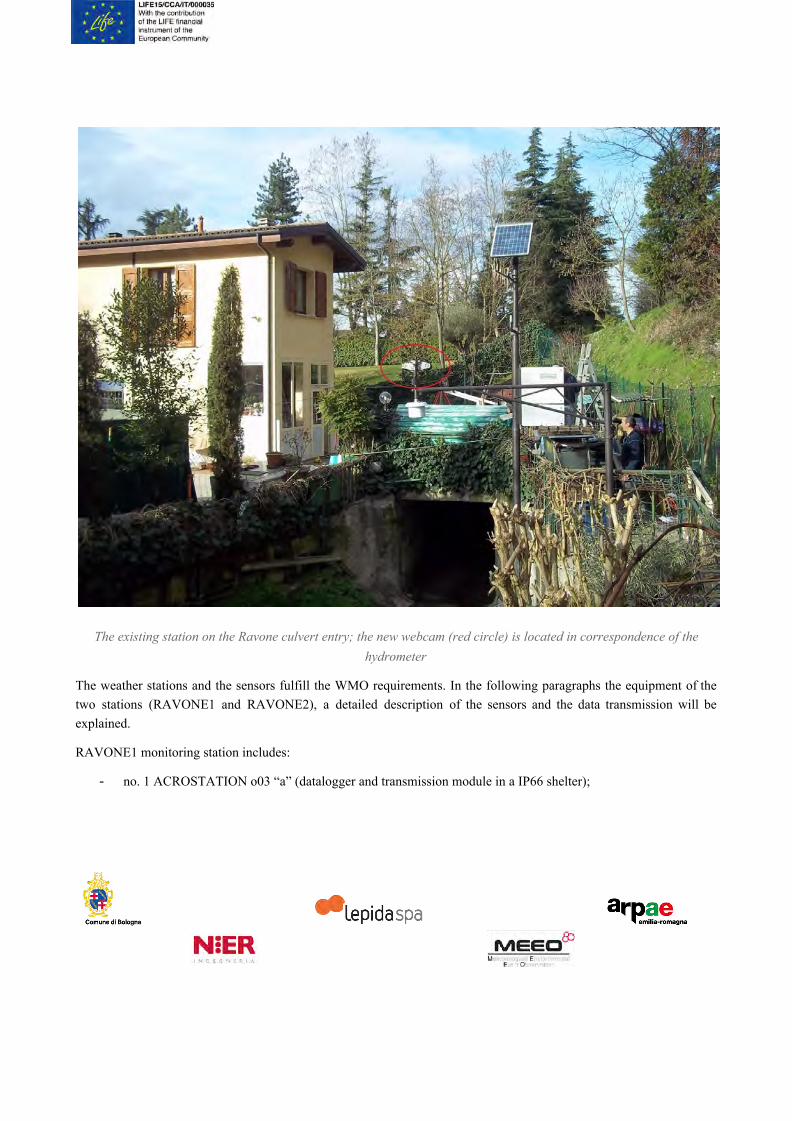
The existing station on the Ravone culvert entry; the new webcam (red circle) is located in correspondence of the hydrometer
The weather stations and the sensors fulfill the WMO requirements. In the following paragraphs the equipment of the two stations (RAVONE1 and RAVONE2), a detailed description of the sensors and the data transmission will be explained.
RAVONE1 monitoring station includes:
- no. 1 ACROSTATION o03 “a” (datalogger and transmission module in a IP66 shelter);

- no. 1 radar sensor VEGA for continuous level measurement of water level VEGAPULS WL61 with mounting support;
- no. 2 solar panels UFLEX 20W equipped with: UV resistant wiring and mounting support for vertical pole;
- no. 1 YUASA Lead Acid, Battery 12V 12Ah.
The RAVONE1 monitoring station benefit also of the module “Energy”, containing a high capacity backup battery (Zn-Aria) for the energy supply of the measuring system in case of prolonged lack of solar radiation. No connection to power grid is planned.
RAVONE1 monitoring station in factory nursery

RAVONE1 monitoring station in factory nursery
RAVONE2 monitoring station includes:
- no. 1 ACROSTATION o03 “b” (datalogger and transmission module in a IP66 shelter)
- no. 1 Microstep-MIS Total rain weighing sensor WRG205
- no. 1 integrated sensor (T-P-RH) 8095-N, WMO compliant with solar shield “008141.6” by Lambrecht GmbH
- no. 1 solar panel UFLEX 20W equipped with: UV resistant wiring and mounting support for vertical pole
- no. 1 YUASA Lead Acid, Battery 12V 12Ah; no connection to power grid is planned.

RAVONE2 monitoring station
Both the stations will send data in RMAP (MQTT protocol) format to the server.
2.2 Station installation features
The stations have a dust and waterproof IP66 box; box and sensors will be hold on a steel pole (circular section 3 mm thick).
The orifice of the rain gauge will be located at an height between 2,00 a 2,40 m, whereas the combined sensor for temperature - humidity - pressure will be positioned at an height between 1,80 e 2,00 m.
The stations will be provided. with a grounding system.

2.3 Data transmission
The RAVONE1 and RAVONE2 stations are open source hardware e software with open source licence approved by Open Source Initiative. The stations are compliant with the technical specifications of the RMAP project.
For the definition of open source hardware, we refer to:
http://www.oshwa.org/definition/italian
The software licence are approved by Open Source Initiative:
https://opensource.org/licenses
Specifications of format, protocol and metadata of the “Rete di Monitoraggio Ambientale Partecipativo” (Network of environmental monitoring participatory) are published on: http://www.raspibo.org/wiki/index.php/Gruppo_Meteo/RFC-rmap
2.4 Data and metadata
Each data is a value linked to 6 unique metadata.
• Time (date and hour of the observation)
• Longitude, latitude ed ID ( in case of mobile stations)
• Type of report or network: it defines stations with homogeneous features (instruments class)
• Time range: observation of time of the forecast and possible statistical elaboration
• Level: vertical coordinates (layer, if present)
• Variables: physics parameter
The protocol of transmission is MQTT, according to the following specifications:
Each topic corresponds to unique metadata, wherear the payload is composed by its value, attributes -if present- and time reference. Json is the payload format.
Topic form:
rmap/IDENT/COORDS/NETWORK/TRANGE/LEVEL/VAR

where
IDENT: station ID for mobile stations, “-” for fixed stations or label not used for credit stations; user ID for RMAP network.
COORDS: lon,lat format, expressed as int(value*10^5) with negative sign, if present
NETWORK: network identification label (max. 16 characters)
TRANGE: with the form indicator, p1, p2; Indicator e p2 integer (absolute value), p1 integer with negative sign. “-” for non significant value
LEVEL: with the format type1,l1,type2,l2; Type1, type2 integer with with negative sign, l1e l2 integer with negative sign. “-” for non significant value
VAR: BXXYYY format (as from code BUFR WMO)
The payload is in JSON format { “v”: VALUE, “t”: TIME, “a”: { “BXXYYY”: VALUE, … } }
VALUE: value in CREX format (as from code BUFR WMO)
TIME: YYYY-mm-ddTHH:MM:SS.MSC (seconds and milliseconds optional) GMT format
2.5 Sensors features
2.5.1 Soil moisture sensors As above mentioned, the soil moisture sensors have been installed in correspondence of the Mount Paderno rain gauge. These sensors are based on C/FDR technology (capacitance/frequency domain technology); in more details, the model used in the station of Mount Paderno is the Decagon Devices EC5. The EC5 has good accuracy and precision, it is a low cost technology and high compatibility with any data acquisition system able to supply electric power between 2500 and 3600 mv and to read an output voltage of 12 bit or higher (see the picture of the sensor below). The EC5 work on a frequency of 70 MHz, this allows to minimize the salinity and soil texture effects on the soil humidity values recorded.

The EC5 probe
In the station the sensors are located in the weather station area, characterized by a grass cover (see the picture below). The probes were placed at 3 different depths: -15 cm, -30 cm and -60 cm. The data of soil moisture for the different depths are then conveyed in the general data flux of the main weather stations (produced by CAE) of the site.
The soil moisture probes placement in correspondence the Mount Paderno CAE weather station

2.5.2 Combined sensor: temperature - humidity - pressure The sensor 8095-N is a combined digital measuring instrument for measuring relative humidity, air temperature and air pressure. The sensor is characterised by a power-saving electronic. The sensor is compliant with the WMO requirements in terms of solar shield. The membrane filter reliably protects the capacitive measuring element from air pollutants. The measurement elements are located within a special shelter with free ventilation.
The functional technical features are:
Temperature
Measuring range -40 °C a +70 °C
Resolution ≤0.1 °C
Accuracy ±0.3 °C at (v > 2 m/s) • ± 0.4 °C (10 … 40 °C) • ± 0.8 °C (-10 … 70 °C)
Time constant < 60 s
Relative humidity
Measuring range 0 … 100% r.h.
Resolution 0.1% r. h.
Accuracy ±3% (10...90%) r. h. • ± 4% (0...100%) r. h.
Time constant < 60 s
Barometric pressure
Measuring range 500...1100 hPa
Resolution 0.1 hPa
Accuracy ± 2 hPa (-30...+70 °C) • ± 1 hPa (-10...+60 °C)

2.5.3 Total rain weighing sensor The rain and snow precipitation gauge is a TRwS 205. It measures solid and liquid precipitation, 1 minute intensity, the total sum of precipitation and the rain duration; the measurement is not influenced by wind vibration, particles, unreal step change of weight, evaporation and temperature fluctuation. It has a wind shield and the orifice is heated.
The sensor has the following technical features:
Measuring range 1500 mm
Resolution 0.001mm
Accuracy ±0.1%
Maximum rain intensity
≥120mm/min
Orifice area ≥200 cm2
Measuring element strain-gauge bridge
Power supply 8÷24VDC / max 15mA
Heating supply 12V/1A (option 24V/1A)
Output contact (1/0.1/0.01mm) Umax=30V, Imax=300mA
Operating temperature range
– 40 ÷ 70°C

2.5.4 Radar sensor for water level measurement This sensor s a VEGAPULS WL61, it uses extremely short microwave impulses emitted by the antenna system in the direction of the measured product, reflected by the product surface and received back again by the antenna system. The time from emission to reception of the signals is proportional to the level.
Measuring range ≤15 m
Accuracy ±2 mm
Process pressure -1 … +2 bar/-100 … +200 kPa
(-14.5 … +29.0 psig)
Operating temperature range
-40 … +80 °C (-40 … +176 °F)
Operating voltage 9.6 … 36 V DC
VegaPulse VL61 sensor