delineation of key biodiversity areas new caledonia · 5 kba delineation the delineation of key...
TRANSCRIPT

1
Delineation of
Key Biodiversity Areas
New Caledonia
Source Relief: DTSI 2011
April 2011

2
New Caledonia ecosystem profile initiative main holders
New Caledonia ecosystem profile members and data providers
Identification des sites cles de biodiversite en Nouvelle-Calédonie
Avec le soutien de :

3
Table of Contents
KBA DELINEATION ........................................................................................................................................... 5
METHODS ...................................................................................................................................................... 10
CRITERION VULNERABILITY ...................................................................................................................................... 10
CRITERION IRREPLACEABILITY ................................................................................................................................... 10
DELINEATION PROCESS ........................................................................................................................................... 12
LAND TENURE ................................................................................................................................................ 14
CORRIDORS.................................................................................................................................................... 14
PLANNING UNIT DESIGN ................................................................................................................................ 15
SPECIES .......................................................................................................................................................... 17
BIRDS ................................................................................................................................................................. 17
MAMMALS .......................................................................................................................................................... 19
BULIMES/SNAILS ................................................................................................................................................... 21
REPTILES.............................................................................................................................................................. 23
FRESHWATER FISH AND CRUSTACEANS ...................................................................................................................... 25
PLANTS ............................................................................................................................................................... 27
LANDSCAPES .................................................................................................................................................. 33
DRY FOREST ......................................................................................................................................................... 33
MANGROVES ........................................................................................................................................................ 33
FORET HUMIDE ..................................................................................................................................................... 34
PROTECTION DES EAUX ........................................................................................................................................... 34
PREDICTED PLANT HABITAT ..................................................................................................................................... 34
MARINE COMPONENT ................................................................................................................................... 35
PRIORITISATION OF CONFIRMED KBAS .......................................................................................................... 38
TIME SERIES ANALYSIS OF FIRE OCCURRENCES IN NEW CALEDONIA .................................................................................. 38
MINING .............................................................................................................................................................. 38
FIRE AND MINING ................................................................................................................................................. 39
INVASIVE SPECIES .................................................................................................................................................. 39
RESULTS ......................................................................................................................................................... 42
THREATENED SPECIES ............................................................................................................................................. 42
CR AND EN SPECIES ............................................................................................................................................... 42
VU, RR AND SPECIES OF NATIONAL PRIORITY/ CONSERVATION SIGNIFICANCE .................................................................... 42
OVERALL KBA AREA STATISTICS ............................................................................................................................... 52
LAND COVER WITHIN KBAS ..................................................................................................................................... 52
LAND TENURE AND KBAS ........................................................................................................................................ 54
MINING .............................................................................................................................................................. 55
OVERALL STATISTICS OF KBAS REGARDING OTHER LANDCOVER ....................................................................................... 56
OVERALL STATISTICS OF LANDCOVER REGARDING KBA COVER ........................................................................................ 56

4
DESCRIPTION AND STATISTICS OF CONFIRMED KBAS IN NEW CALEDONIA .................................................... 58
AOUPINIÉ ARAGO .................................................................................................................................................. 59
BOULINDA ........................................................................................................................................................... 62
KOPETO ............................................................................................................................................................... 66
FORÊT PLATE ........................................................................................................................................................ 70
GORO TANE ......................................................................................................................................................... 73
MASSIF DES LÈVRES ............................................................................................................................................... 76
KONIAMBO .......................................................................................................................................................... 79
TAOM ................................................................................................................................................................. 83
MT PANIÉ ............................................................................................................................................................ 86
MOUNT KAALA ..................................................................................................................................................... 89
THIEBAGHI ........................................................................................................................................................... 92
POUM ................................................................................................................................................................. 96
ILE YANDÉ ............................................................................................................................................................ 99
MT MAOYA ....................................................................................................................................................... 101
DO NYI ............................................................................................................................................................. 104
BWA BWI .......................................................................................................................................................... 108
KOUAKOUE ........................................................................................................................................................ 112
RIVIERE BLEUE .................................................................................................................................................... 116
GRAND SUD ....................................................................................................................................................... 120
ILE DES PINS ....................................................................................................................................................... 124
LIFOU................................................................................................................................................................ 127
OUVÉA .............................................................................................................................................................. 129
ANNEX ......................................................................................................................................................... 131
ANNEX I – LIST OF SPECIES (CR/EN) - CONFIRMED KBAS ........................................................................................... 132
ANNEX II - LIST OF VU SPECIES IN CONFIRMED KBAS ................................................................................................. 137
ANNEX III - ENDANGERED SPECIES IN CANDIDATE KBAS ............................................................................................. 139
ANNEX IV - LIST OF CREN SPECIES WITHIN THE CANDIDATE KBAS THAT ARE NOT IN CONFIRMED KBAS .............................. 142
ANNEX V- LIST OF VURRNP SPECIES NOT IN CONFIRMED KBAS .................................................................................. 143
ANNEX VI - LIST VURRNP SPECIES NOT COVERED BY CREN SITES ................................................................................ 143
ANNEX VII - UTILISED DATA ................................................................................................................................ 144
REFERENCES ................................................................................................................................................. 146

5
KBA Delineation
The delineation of Key Biodiversity Areas was initially discussed in October/November 2008 with
local CI staff in Noumea, New Caledonia. After final project approval the grant agreement was
signed in March 2009. Due to longer preparation time and other delays, a first work plan meeting
was held in Cairns, November 2009 with CI. A first extensive visit had been undertaken to New
Caledonia in March/April 2010 (4 weeks), then July 2010 (two weeks) and a third time for over three
weeks in September/October 2010. After meeting associated partners, institutions and researchers
project outlines were defined, and a longer period of identifying, tracing and sourcing required data
followed. Then data formatting and processing took up a long period of work. This led to building a
textual relational database being linked to the prepared and thematically organised spatial data.
Queries and analysis could then be conducted in text and spatial form. Some analysis was conducted
using spatial databases where text and spatial data could be stored and linked and spatially queried
(e.g. postgres/postgis). Fire modelling was performed using statistical application (R, r-project.org).
KBA draft ideas were presented twice to stakeholders and partners and the concerns and views
incorporated into this analysis as much as possible.
Field trips to Province Nord were conducted as well as visits to various institutions and
organisations. The Government of Province Nord, the Direction du Développement Economique et
de l'Environnement, the Direction des Systemes d’Information Service Informations et Methodes,
and the Service de Forêt were very helpful in data retrieval and assistance in methodological
approaches . Other Gouvernment Institutions visited were Institut Agronomique néo-Calédonien
(investigation on mammals), University of New Caledonia (botanical information), WWF, IRD, and
independent environmental consultancies (such as Bureau d’Etudes et de Recherches biologiques, C.
Poellabauer). Province Sud was also very cooperative in providing advice and establishing contacts
to relevant information sources.
Through various intensive brain-storming sessions with CI a first version of the KBA delineation has
been compiled looking at all species and environmental data available, incorporating expert advice
and stakeholders’ views on species protection and conservation measures. The delineation of Key
Biodiversity Areas concentrated on recorded observations of threatened species, both IUCN-
declared threatened, and locally described as threatened. Furthermore, the delineation also
considered the very special New Caledonian environmental characteristics hosting rare, distinct
species and often described as a main source for high endemism. The marine environment has been
looked at as well, however observation data was not sufficient enough to derive KBAs/site-scale
based biodiversity conservation areas. Existing delineated marine data such as registered World
Heritage data, areas suggested through ecoregional assessemtns and suggested dugong protection
zones are presented forming the base for further discussion in the marine KBA delineation process.
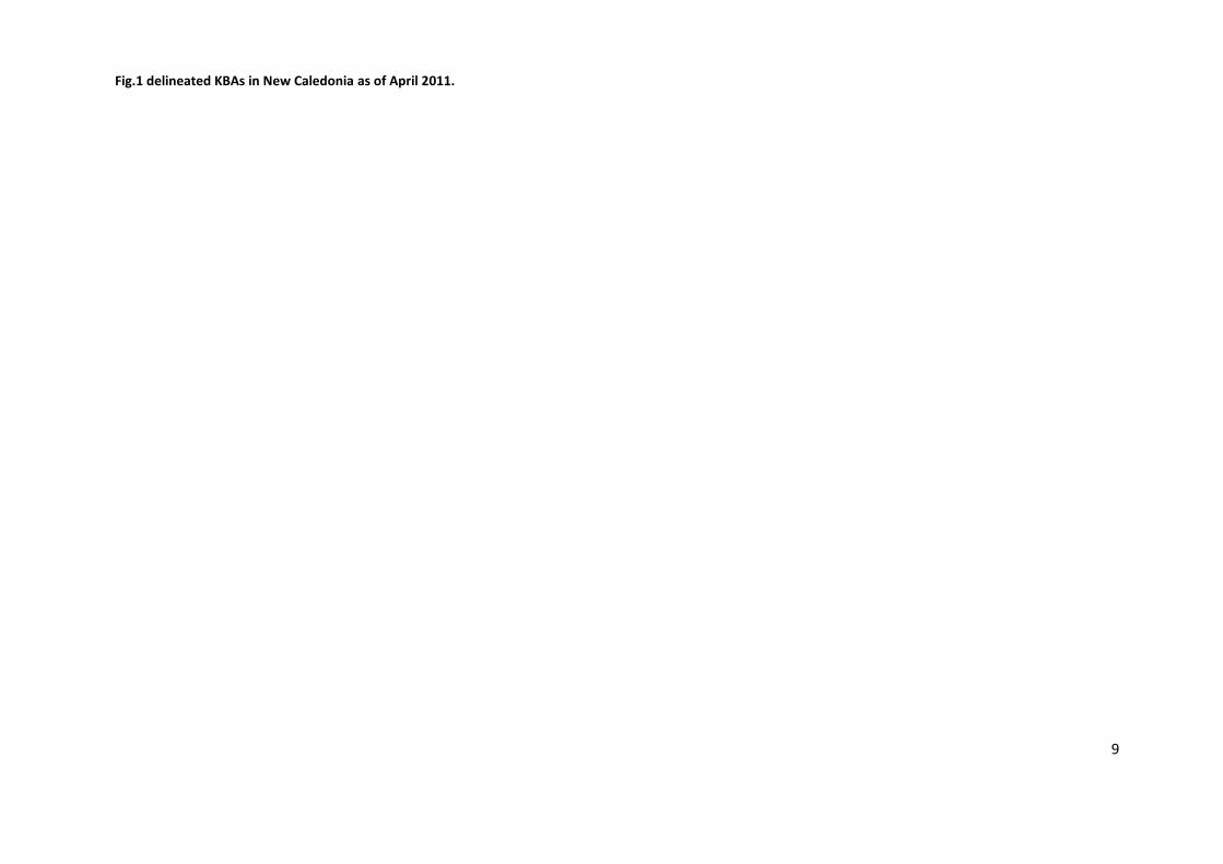
22 confirmed Key Biodiversity Areas have been delineated within New Caledonia, covering an area
of 769,316.65 ha, and 42% of the New Caledonian territory. Small scattered and isolated KBA

6
patches were identified and declared as candidate KBAs, covering 36,990.02 ha and a small
percentage of 2% of the territory.
The first draft of this delineation was presented to main stakeholders, and was generally accepted. It
represents a so far maximum approach of key biodiversity area definition. Following the iterative
process of biodiversity delineation, further participative consultations are likely to take place and
might bear the potential of outlining more refined individual key biodiversity areas, this also in
regard to establishing a conservation network throughout the landscape of New Caledonia.

7
Confirmed and candiate Key Biodiversity Areas are shown in Figure 1.

8
9
Fig.1 delineated KBAs in New Caledonia as of April 2011.

10
Methods
The methodology of delineation of Key biodiversity areas (KBAs) followed the concept outlined in
Langhammer et al. (2007)1, describing an approach for establishing a global standard for the
identification of sites of global biodiversity significance based on vulnerability and irreplaceability.
KBAs are site/habitat scale outcomes based on specific criteria, being threatened species, restricted
range species, significant congregations with standardised thresholds defined by IUCN. KBAs
ultimately set targets for Protected Area networks, and their progress is monitored through
Protected Area gazettal and the development and implementation of management plans.
Confirmed KBAs are a first step to be focused on producing in this analysis, based on known
observation/collection points of threatened and restricted range species. The criteria for developing
confirmed KBAs are the following:
Criterion Vulnerability
Vulnerability is based on presence of species populations with high probability of extinction in short-
to medium-term future. The sites are characterised by regular occurrence of one or more CR
(critically endangered), EN (endangered), or VU (vulnerable) species (Langhammer et al., 2007). The
confirmed KBAs are triggered by each individual species, classed as “CR” or “EN”, observed at a
geographically confirmed and identifiable location.
Globally Threatened Species
i. Site with confirmed presence of CR or EN species
ii. >10 pairs or 30 individuals of VU species
These species occurrences trigger confirmed KBA areas.
Criterion Irreplaceability
Irreplaceability refers to the extent to which areas can be replaced by or substituted for others (C.
Marguels and S. Sakar, 2007)2.
Restricted Range Species
Restricted Range refers to geographic processes that create or drive endemism. The habitat
specificity is also an important element of restricted range. Restricted Range areas are a
representation of geographically concentrated species that depend on network of irreplaceable
1 Langhammer, P.F., Bakarr,M.I., Bennun, L.A., Brooks, T.M., Clay, R.P., Darwall,W., De Silva, N., Edgar, G.J.,
Eken, G., Fishpool, L.D.C.,3 Fonseca, G.A.B. da, Foster, M.N., Knox, D.H., Matiku, P., Radford, E.A., Rodrigues, A.S.L., Salaman, P., Sechrest, W., and Tordoff, A.W. (2007). Identification and Gap Analysis of Key Biodiversity Areas: Targets for Comprehensive Protected Area Systems. Gland, Switzerland: IUCN. 2 Marguels, C. and Sakar, S. (2007). Systematic Conservation Planning, Cambridge University Press, Cambridge
11
sites within at least part of range or life cycle. These are sites that are regularly holding one or
more restricted-range species (Langhammer et al., 2007). Range restriction tends to be based
on geographic patterns rather than habitat types. The restricted range criterion offers the
possibility to address species conservation in a timelier rapid manner. This is of particular
advantage regarding the time lags of vulnerable species being assessed on the International Red
List.
i. Site containing all or most RR species (global range<50,000sqkm) of the area in question (in this case, of New Caledonia)
ii. Site containing 5% global population of RR species underrepresented in other KBA's
Bioregional Restricted Assemblages
Sites holding a significant proportion of the group of species whose distributions are restricted
to a biome or subdivision of it. Bioregional Restricted Assemblages trigger KBAs if they are areas
of high uniqueness in their species assemblages (plant/animal communities). This can clearly
cover many remaining dry forest patches in New Caledonia.
i. Site containing a significant component (no numerical threshold) of the biota of the region in question (ie. high alpha diversity)
ii. Site containing unusual species assemblages underrepresented by KBA's generated by previous criteria (eg. Mangroves/Dry Forest)
Globally significant Congregations
Sites holding large proportions of the global population of a species at a given time (e.g.
breeding colonies, foraging and roosting sites). Spawn zones (e.g. Province Nord, New
Caledonia) can fulfil this criterion.
i. Site that holds on a regular basis >1% of biogeographic population of a congregatory waterbird (list as per Delaney & Scott 2002)
ii. Site that holds on a regular basis >1% of biogeographic population of any congregatory species
iii. Site known or thought to hold on a regular basis >20,000 individuals of single or mixed species
iv. Sites known or thought to exceed thresholds at bottleneck sites for migratory species (ie staging sites)
Candidate KBAs are for sites beyond the confirmed KBA set. Their delineation is determined by
known restricted range species (1% population threshold) and threatened species localities, they are
also site scale outcomes (i.e. they set targets for Protected Area network establishment). Such
candidate KBA sites can be defined by predicted habitat (from modelling or expert guesswork) of
12
threatened and restricted range species, but are basically sites that are suspected to be important in
the context of KBA criteria, and for which no data currently exists.
In New Caledonia land cover such as dry forest or mangroves (protected in Province Sud) range as
Candidate KBAs.
Confirmed KBAs and candidate KBAs are not to be confused with corridors which are at a larger scale
and are for landscape/seascape scale conservation, defined by multiple-use, land-use planning,
ecosystem service protection, and habitat requirements of wide-ranging "landscape species".
Landscapes definitions are following the approaches:
1. Major habitat types (e.g. coastal reef and forest corridor, dry forest corridor, humid forest
corridor, ultrabasic maquis corridor)
2. Just take the whole of Grande Terre as a giant global conservation priority, and have the corridor
plan define the key ecosystem components within this.
Delineation Process
The KBA delineation followed the approach of identification of Key Biodiversity Areas the suggested
by by Langhammer et al, 2007. CR/EN species immedialtely trigger KBA areas. In addition species of
national priority, vulnerability status (VU) or restricted range were considered for selection being
integrated into confirmed KBA area patches if adjacent or in close proximity. This especially accounts
for VU species not being included in the coverage of first CR/EN selected areas, derived as a result
from complementarity analysis. IBAs with threatened DR/EN bird species or protected areas
containing CR/EN species observations triggered underlaying planning units designed for this
conservation planning exercise. Individual Bird point data was also inspected and a few observation
points of CR/EN bird being recorded outside of IBAs were included in KBAs during the delineation
process.
Further, add-on areas were selected as being part of confirmed KBAs. Added on areal units to
confirmed KBAs where selected based on locally important environmental parameters, such as
geology (e.g. Péridotites/ Serpentinites), humid and dry forest cover (high endemic biodiverisity
value), endangered reptile habitat ranges (not a per-se trigger), water protection sites (officially
declared) and distribution of customary land tenure. Humid forest data was included all humid
forest features with equal to or larger than 50ha.
Selected environmental areas highlighted in research work of the local research (e.g. IRD)
highlighting endangered species habitat such as specific geology (ultramorfic substrate), altitude and
rainfall characteristics were considered as relevant for conservation purposes, and therefore
included into confirmed KBAs. Also a four criteria model calculating estimated habitat locations for
endangered plant species (based on their observed location in the landscape). This was useful when
considering KBA area refinement. The process of selecting add-on areas also contributed to

13
maximising the compactness of confirmed KBA shapes, and was approved through various
stakeholder meetings.
All spatially scattered and fragmented CR/EN species occurrence triggered areas that where classed
as candidate KBAs.

14
Land tenure
Land ownership data was obtained from the New Caledonian government (DITTT). Areas of
ownership could be mapped, such as state owned land, provincial owned land, private and
traditionally owned areas. Land ownership data for Province des Iles Loyauté was not available.
However it is known that Loyalty Island is mainly traditionally owned areas, so we can consider that
there is no public owned land there.
Corridors
When thinking of Corridor definitions several points will have to be taken into account:
1. Viable habitat extent of wide-ranging or low-density population species needing a landscape beyond KBA scale to sustain their population
2. Intact ecological gradients across ecotones, altitudes, latitudes (terrestrial and marine), i.e. good beta diversity
3. Key water catchments for freshwater security for major human population areas and freshwater ecosystems
4. Reef to ridge linkages
5. Extensive areas of forest for carbon security
6. Priority areas for reafforestation (carbon security again)
7. Important ecotourism areas dependent upon natural assets
The design of corridors will have to follow after the delineation of KBAs.

15
Planning Unit design
The idea of using planning units is a proven concept often used in conservation planning. The
planning units subdivide the landscape, and are used assessing the importance of biodiversity
measures and for achieving conservation targets (Cowling et al, 2002)3. The units mainly represent
sub-catchment areas (sous-basins), and thus follow relief forms and major contours in the
landscape. For New Caledonia it was also advantageous to choose such delineations since many
political boundaries (Province Sud/Nord) basically follow mountain ridges and on occasion, river
stretches. These river sections were used to subdivide corresponding units. Also, Important Bird
Areas (IBAs) are delineated according to catchment/river lines, and therefore supported the idea of
using planning units as sub-catchment level areas following major landforms in the landscape.
The creation of planning units was based on hydrologic modelling and terrain analysis using a digital
elevation model (DEM, or MNT). The DEM employed for the analysis was 50m raster data obtained
from DTSI, Noumea. The publicly available 30m Aster DEM was also considered, however due to
processing resources and other concerns in terms of accuracy, the 50m DEM was chosen.
Two preliminary steps were conducted for the planning unit design:
DEM preconditioning: A fill command produced levelling out so called ‘sinks’ in the DEM. Sinks are often irregular over or undershoots, mainly resulting from sporadic errors of measurement. This generated a 30m DEM that does not contain any discontinuities.
The ‘filled’ DEM was then employed for further water catchment and basin calculation.
Slope: A slope layer was produced deriving a slope raster with inclination information
(a projected DEM therefore was needed deriving metric units). The slope dataset helped
identifying areas with less than 0.1 degree inclination, resulting in ‘flat’ area layer.
The catchment model process allows generating sub-catchment units on user defined size. After
calculating flow direction and flow accumulation (based on cell-by -cell level using elevation values)
a stream network is computed. Thereby a threshold value is set indicating that cells are part of the
stream network if at least a specified amount of cells are flowing (draining) into them. This ensures
the creation of catchment areas on a refined scale. The accumulation number chosen was 500 in this
model, i.e. indicating that at least 500 cells are required as accumulated flow for the target cell to be
defined as a ‘stream’ cell. This resulted in around 10,700 sub-catchment units for New Caledonia
(average size of 155 ha), but also revealed that coastal areas were not considered in this calculation
as accumulated flow was below 500 cells. Therefore an additional layer was generated, calculating
water basins complementing the catchment layer. Basins are also considered as catchments draining
to a common outlet, however not considering accumulated flow. The planning layer design focused
on a relatively compact shape of singular units. Since these basin areas can become very small,
especially around coastal zones, all basin units smaller than 3.5 ha were dissolved (merged when
spatially adjacent) and all areas less than 0.2 hectare eliminated, being merged to neighbouring
3 Cowling, R.M., Pressey, R.L., Rouget, M., Lombard, A.T. (2003). A conservation plan for a global biodiversity
hotspot – the Cape Floristic Region, South Africa. Biological Conservation 112 (2003), p. 191-216

16
largest polygon. This reduced the amount of basin units significantly. Covering the entire landmass
of New Caledonia Areas with planning units, the sub-catchment layer was then complemented with
the derived basin unit layer.
Since areas with low slope inclination (flat areas) confuse the calculated flow of direction and
accumulation, the calculation of catchment units often phases out into sliver-like elongated, linear
shapes, resulting in rather undesired delineations (Fig. 2, left). Therefore an overlay of the computed
‘flat areas’ on the catchment model output was undertaken in order to remove these linear shapes
of polygons. The largest flat area was identified representing Lac de Yaté (2365 ha), in the south of
Grand Terre (Province Sud). This area was then incorporated into the Planning Unit layer (Fig. 2).
Fig.2 Missing flow direction information result in undesired slivers (left); dissolving these flat areas provide a
better representation of flow characteristics (right).
The planning units so far then resulted in a total of around 20,189 units (average size of 90 ha).

17
Species
Observation data of 481 species was employed for the delineation of KBAs. This included 83 bird
species being recorded in 28 IBAs, 6 bulimes/snails, observations for 111 reptile species (a few of
them not clearly identified and as such left out), field data for 11 fish and 7 crustacean species, 4
Megachiroptera (flying foxes) and 3 Microchiroptera (bats) species as well as observation points for
256 plant species.
Threatened Species covered by confirmed and candidate KBAs are listed in Annex I.
Birds
The Societe Caledonienne d’Ornithologie (SCO), affiliated with Birdlife International, provided all
ornithological relevant information4. Spatial data such as Important Bird Area (IBA) delineations, and
corresponding Bird species information in tabulated form had made available. Overall 30 IBAs were
registered for New Caledonia, covering a total area of 662,380 ha (Minimum 13,000 ha and
maximum 170,680 ha). 3 out of these 11 IBAs are offshore, within marine environment (îlots de
Poindimié, îlots du Nord Ouest, îlots du Lagon Sud). The terrestrial IBAs mainly follow mountain
ridges, and therefore water catchment boundaries, as well as river stretches. The accuracy of the IBA
demarcations could be improved through replacing boundaries with catchment and river line data in
consultation with ornithologist expert knowledge. Table 1 shows all IBAs and associated number of
bird species recorded by SCO as well as the three endangered species Cagou/Kagu (Rhynochetos
jubatus, EN), Méliphage toulou/ Crow Honeyeater (Gymnomyza aubryana, CR) and Perruche
d'Ouvéa/ Ouvea Parakeet (Eunymphicus uvaeensis, EN). The latter triggered the Ile d’Ouvea as a
whole KBA.
Table 1. Bird Species within IBAs
Bird Species Count Bird Species Observed, Status Name of IBA
43 Rhynochetos jubatus, EN Aoupinié
39 Rhynochetos jubatus, EN Arago
21 Rhynochetos jubatus, EN Boulinda
1 Rhynochetos jubatus, EN Cidoa-Bwa Bwi
22 Rhynochetos jubatus, EN Dent de St Vincent
44 Rhynochetos jubatus, EN Entre Mont Do et Mont Nakada
38 Rhynochetos jubatus, EN Entre Mont Rembaï et Mont Canala
38 Rhynochetos jubatus, EN Entre Plateau Dogny et Mont Canala
32 Fonds vallée Amoa et Goro Je
41 Rhynochetos jubatus, EN Forêt Plate
4 Jerôme Spaggiari, Vivien Chartendrault, Nicols Barré, 03/2007. Zones importantes pour la conservation des
oiseaux de Nouvelle-Calédonie, Société calédonienne d’ornithologie, Bird Life International.

18
Bird Species Count Bird Species Observed, Status Name of IBA
34 Rhynochetos jubatus, EN Goro Até et fonds de la Tchamba
44 Rhynochetos jubatus, EN Houaïlou-Néoua
23 Humboldt-Kouakoué
8 îlots de Poindimié
13 îlots du lagon Sud
15 îlots du Nord Ouest
22 Rhynochetos jubatus, EN Koum
24 Lifou
38 Rhynochetos jubatus, EN Massif des Lèvres
35 Rhynochetos jubatus, EN Nassirah
37 Rhynochetos jubatus, EN Nord Me Maoya
44 Rhynochetos jubatus, EN Nord Mont Nakada
15 Eunymphicus uvaeensis, EN Ouvéa
41 Gymnomyza aubryana, CR Panié
28 Rhynochetos jubatus, EN Pic Ningua
42 Pindaï
29 Rhynochetos jubatus, EN Prokoméo
37 Rhynochetos jubatus, EN Sud Me Maoya
41 Rhynochetos jubatus, EN Table Unio
18 Yandé
Other endangered Species listed internationally as endangered in New Caledonia are Egothèle
calédonien / New Caledonian Owlet-Nightjar (Aegotheles savesi, CR) , Lori à diadème/ New
Caledonian Lorikeet (Charmosyna diadema, CR), Râle de Lafresnaye/ New Caledonian Rail (Gallirallus
lafresnayanus, CR). However, these species have not been observed or recorded by SCO.
New Caledonia IBAs are at a scale that ranges broadly between site and landscape, and while
officially the IBAs should be interchangeable with KBA's, it has to be observed in the longer term
whether governments are willing to set national protected area network targets at that scale, or
whether such scale will be politically impossible and better marketed and managed under a corridor
approach.

19
Mammals
The class ‘trrestrial mammals’ in this biodiversity analysis of New Caledonia was focusing on the
order Chiroptera, the two main sub-orders: Megachiroptera - Flying Foxes and Microchiroptera -
'Microbats'. There are indeed no other endemic mammal fauna locally.
Most of the Chiroptera covered in this analysis are Restricted Range species, and all Microchiroptera
recorded are internationally considered as CR, or EN. Almost all Megachiroptera are internationally
classed as VU (IUCN, 2010). In this context, the Restricted Range criterion is based on extent of
occurrence (range) rather than area of occupancy (habitat). The Chiroptera, especially
Megachiroptera, are also considered as landscape species. There is a considerable spatial variability
of colonial roosting species having 'camps' (mostly trees where they roost in great numbers), mainly
due to the fact that these camp sites can change over years as seasons or habitats change. This
means camp locations are not permanently fixed, and as these species feed across the whole
landscape, they cannot be protected at the site level alone. However, they can be assisted through
landscape management via corridor-scale outcome, and species-specific actions such as
enforcement of hunting laws (Langhammer et al., 2007).
Megachiroptera
The flying foxes observed are Pteropus ornatus, Pteropus tonganus, Notopteris Neocaledonica, and
Pteropus Vetulus5. The data was made available by Province Nord, DEEE, and covers nesting and
camp site localities of Flying Foxes within Province Nord area conducted by several observers.
The species Ornate Flying Fox (Pteropus ornatus, VU) and Insular Flying-fox or Pacific Flying Fox
(Pteropus tonganus) have been recorded under one category and observations were represented in
the obtained dataset with same point features. It appears these two species do occur in the general
areas of each other’s camps, and are sympatric as they have been observed sharing same trees6,
with the Pteropus tonganus generally being sighted on the highest branches. Pteropus ornatus is
classified VU because of population decline in the 1960's and endemism5. Pteropus tonganus is
widespread from Solomon Islands to Cook Islands and while locally endangered in parts of its range,
it is generally common7. Pteropus tonganus is therefore not a suitable species for KBA triggering as it
is not categorised as a national conservation priority of New Caledonia. Also Pteropus ornatus
nesting/camp site observations were not considered in the KBA analysis as it was unclear how to
distinguish between the two mentioned species being both recorded with same point locations. The
5 premier travail d'inventaire chiroptere FSEPM-UICN (Kirsch 2002)
6 Sanborn and Nicholson (1950). "Bats from New Caledonia, the Solomons Islands, and New Hebrides."
Fieldiana Zoology 31(36): 313-338.
7 Pierson E. D. and Rainey W. E. (1992). The biology of flying foxes of the genus Pteropus: a review. Biological
0report. 90 (23). 17 pp

20
species New Caledonia Flying Fox (Pteropus Vetulus, VU) and the New Caledonia blossom bat
(Notopteris Neocaledonica, VU) were both part of the observation dataset and nesting/camp sites
mapped out inidividually. It was decided that corresponding observation sites of both species
generate confirmed KBAs, as they are both classed as endemic and of National Priority (Code de
l’Environment, 2009)8. In addition, Notopteris Neocaledonica is together with Notopteris macdonaldi
of Fiji phylogenetically important, representing a Genus with only two species. The three
observation points of Notopteris Neocaledonica were located in mangrove areas, dry forest and in
humid forest/IBA (Entre Mont Do et Mont Nakada). Areas within mangroves and dry forest resulted
in confirmed KBA locations, same as of course within the IBA. 13 out of the 15 locations of Pteropus
Vetulus are situated within humid forest areas, and one of them in a dry forest patch. None of these
15 point observations were within IBAs.
Microchiroptera
Fabrice M. Brescia, Institut Agronomique néo-Calédonien (IAC), Programme Elevage et Faune
Sauvage) contributed observation data on Microchiroptera, but also in addition to Roger James (CI,
Atherton, AU) provided helpful information on Megachiroptera (7/2010).
The species New Caledonian Long-eared Bat (Nyctophilus nebulosus, CR), Loyalty Bent-Winged Bat
(Miniopterus robustior, EN) are the observed Microchiroptera in New Caledonia. Miniopterus
robustior was exclusively recorded in Loyalty Islands, and Nyctophilus nebulosus in Southern
Province, south of Noumea, close to the Protected Area ‘Foret de la Thy’. Observation data for
Chalinolobus neocaledonicus (EN) could not be sourced.
8 DDEE Province Nord, 2009, Code de l’Environment, Editopn 2009, Gourvernement Nouvelle Caledonie ;
DENV Province Sud, 2009, Code de l’Environment, Editopn 2009, Gourvernement Nouvelle Caledonie
21
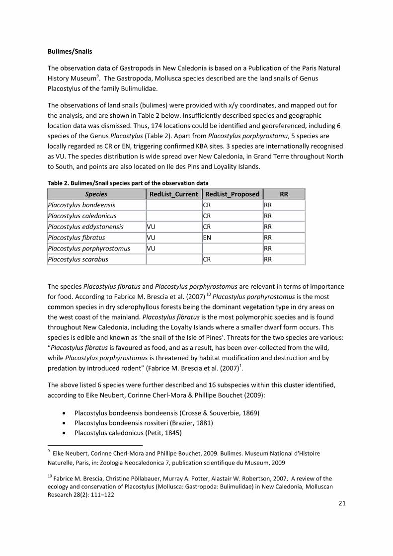
Bulimes/Snails
The observation data of Gastropods in New Caledonia is based on a Publication of the Paris Natural
History Museum9. The Gastropoda, Mollusca species described are the land snails of Genus
Placostylus of the family Bulimulidae.
The observations of land snails (bulimes) were provided with x/y coordinates, and mapped out for
the analysis, and are shown in Table 2 below. Insufficiently described species and geographic
location data was dismissed. Thus, 174 locations could be identified and georeferenced, including 6
species of the Genus Placostylus (Table 2). Apart from Placostylus porphyrostomu, 5 species are
locally regarded as CR or EN, triggering confirmed KBA sites. 3 species are internationally recognised
as VU. The species distribution is wide spread over New Caledonia, in Grand Terre throughout North
to South, and points are also located on Ile des Pins and Loyality Islands.
Table 2. Bulimes/Snail species part of the observation data
Species RedList_Current RedList_Proposed RR
Placostylus bondeensis CR RR
Placostylus caledonicus CR RR
Placostylus eddystonensis VU CR RR
Placostylus fibratus VU EN RR
Placostylus porphyrostomus VU RR
Placostylus scarabus CR RR
The species Placostylus fibratus and Placostylus porphyrostomus are relevant in terms of importance
for food. According to Fabrice M. Brescia et al. (2007) 10 Placostylus porphyrostomus is the most
common species in dry sclerophyllous forests being the dominant vegetation type in dry areas on
the west coast of the mainland. Placostylus fibratus is the most polymorphic species and is found
throughout New Caledonia, including the Loyalty Islands where a smaller dwarf form occurs. This
species is edible and known as ‘the snail of the Isle of Pines’. Threats for the two species are various:
“Placostylus fibratus is favoured as food, and as a result, has been over-collected from the wild,
while Placostylus porphyrostomus is threatened by habitat modification and destruction and by
predation by introduced rodent” (Fabrice M. Brescia et al. (2007)1.
The above listed 6 species were further described and 16 subspecies within this cluster identified,
according to Eike Neubert, Corinne Cherl-Mora & Phillipe Bouchet (2009):
Placostylus bondeensis bondeensis (Crosse & Souverbie, 1869)
Placostylus bondeensis rossiteri (Brazier, 1881)
Placostylus caledonicus (Petit, 1845)
9 Eike Neubert, Corinne Cherl-Mora and Phillipe Bouchet, 2009. Bulimes. Museum National d'Histoire
Naturelle, Paris, in: Zoologia Neocaledonica 7, publication scientifique du Museum, 2009
10 Fabrice M. Brescia, Christine Pöllabauer, Murray A. Potter, Alastair W. Robertson, 2007, A review of the
ecology and conservation of Placostylus (Mollusca: Gastropoda: Bulimulidae) in New Caledonia, Molluscan Research 28(2): 111–122

22
Placostylus eddystonensis eddystonensis (L. Pfeiffer, 1855)
Placostylus eddystonensis savesi Crosse, 1887
Placostylus fibratus alexander (Crosse, 1855)
Placostylus fibratus fibratus (Martyn, 1784)
Placostylus fibratus goroensis (Souverbie in Souverbie & Montrouzier, 1870)
Placostylus fibratus guestieri (Gassies, 1869)
Placostylus fibratus ouveanus (Dotzauer in Mousson, 1869)
Placostylus fibratus souvillei (Morelet, 1857)
Placostylus porphyrostomus mariei (Crosse & Fischer in Crosse, 1867)
Placostylus porphyrostomus monackensis (Crosse, 1887)
Placostylus porphyrostomus porphyrostomus (L. Pfeiffer, 1851)
Placostylus porphyrostomus smithii Kobelt, 1891
Placostylus scarabus (Albers, 1854)
Other species of Gastropod molluscs internationally listed as CR/EN, potentially occurring in the
region, but without any locational records for New Caledonia are listed in Table 3.
Table 3. CR/EN Gastropod molluscs not part of the observed species set used for the delineation
Species RedList_Current RedList_Proposed RR
Draparnaudia anniae CR RR
Draparnaudia subnecata CR RR
Glyptophysa petiti EN RR
Heterocyclus perroquini EN RR
Heterocyclus petiti EN RR
Leuchocharis pancheri CR RR
Draparnaudia and Leuchocharis are air breathing land snails, Heterocyclus and Glyptophysa are
freshwater snails (Neubert et al., 2009).
The non-threatened snails/bulimes identified to sub-species level (Placostylus porphyrostomus
monackensis (Crosse, 1887), Placostylusporphyrostomus mariei (Crosse & Fischer in Crosse, 1867)
and Placostylus porphyrostomus porphyrostomus (L. Pfeiffer, 1851)) were identified as being
captured within larger sets of confirmed KBAs, and therefore single widely isolated observation
points removed as triggers for KBA areas (Placostylus porphyrostomus monackensis: 1 out of 4
points discarded; Placostylusporphyrostomus mariei: 3 out of 10 points discarded; Placostylus
porphyrostomus porphyrostomus: 5 out of 20 points discarded).

23
Reptiles
Reptile target species comprise 84, which are all considered as Restricted Range species. Endemism
is very high in New Caledonia, and 15 of the reptile species are proposed to be classed as CR,
another 22 are suggested to be ranked as EN, and 14 as VU. Out of 2638 point observations, 1758
locations were used in the analysis matching identifiable species descriptions in IUCN and local
species lists, other observations were indicating so far not commonly known sub-species
descriptions, were still open or are still not properly defined. Observations could confirm 14 species
as CR, 14 as EN, and 10 as VU, based on a total of 372 observation points, all triggering confirmed
KBA locations (VU was combined with Restricted Range). The comprehensive analysis observing and
describing reptiles in New Caledonia was conducted by T. Whitaker and R.A. Sadlier (Australian
Museum) over the past years and a main analysis was conducted during a Global Reptile Assessment
Workshop11 in Noumea held in February 2010. The reptile species observation data was presented
and discussed in collaboration with CI, endangered status of each species discussed and a proposed
status developed. Also range polygons of the reptiles had been mapped on the base of relief and
land cover. Later in March 2011 a final assessment of reptile species status was distributed to CI
(Table 4) and further circulated.
Table 4. Final assessment of local/proposed Reptile Status
Species RedList_Current RedList_Proposed RR
Bavayia exsuccida EN RR
Bavayia goroensis EN RR
Bavayia ornata EN RR
Caledoniscincus auratus EN RR
Caledoniscincus chazeaui EN RR
Caledoniscincus orestes EN RR
Celatiscincus similis EN RR
Dierogekko inexpectatus CR RR
Dierogekko kaalaensis CR RR
Dierogekko koniambo CR RR
Dierogekko nehoueensis CR RR
Dierogekko poumensis CR RR
Dierogekko thomaswhitei CR RR
Dierogekko validiclavis EN RR
Eurydactylodes occidentalis CR RR
Eurydactylodes symmetricus EN RR
Graciliscincus shonae VU RR
11
CI/IUCN Workshop, February 2010, Global Reptile Assessment Workshop for New Caledonia, held from 1st
to
5th
February 2010 in Noumea, NC

24
Species RedList_Current RedList_Proposed RR
Kanakysaurus viviparus EN RR
Kanakysaurus zebratus EN RR
Lacertoides pardalis VU RR
Lioscincus maruia EN RR
Lioscincus steindachneri EN RR
Lioscincus vivae CR RR
Marmorosphax boulinda VU RR
Marmorosphax kaala CR RR
Marmorosphax taom CR RR
Nannoscincus exos CR RR
Nannoscincus gracilis VU RR
Nannoscincus hanchisteus CR RR
Nannoscincus humectus EN RR
Nannoscincus manautei CR RR
Nannoscincus mariei VU RR
Nannoscincus rankini VU RR
Oedodera marmorata CR RR
Rhacodactylus chahoua VU RR
Rhacodactylus ciliatus VU RR
Rhacodactylus sarasinorum VU RR
Tropidoscincus aubrianus VU RR

25
Freshwater Fish and Crustaceans
A WWF/CI joint freshwater eco-regional biodiversity assessment was conducted in 2006. At various
recording station across the country, the data was collected at rivers throughout Grand Terre.
Additional information could be obtained from the New Caledonia Fish and Crustacean atlas(Atlas
Poisson, Museum National d'Histoire Naturelle, 2003, Paris)12.
Eleven fish and seven crustacean Species were considered in the analysis. The three species
Ophieleotris nov.sp, Sicyopterus sarasini, Stenogobius yateiensis are endemic, and therefore
regarded as restricted Range species. All the observed Crustacean species are restricted Range and
are important indicators for fresh water environments Atlas Poisson, Museum National d'Histoire
Naturelle, 2003, Paris, p.25). The species of the 2 genus included in the observation set are listed
below (Table 5).
Table 5. Fresh water fish/Crustcaens part of the analysis
Group Species Status RR
Crustaceans Caridina imitatrix endemique RR
Crustaceans Caridina novaecaledoniae endemique RR
Crustaceans Odiomaris pilosus endemique RR
Crustaceans Paratya bouvieri endemique RR
Crustaceans Paratya caledonica endemique RR
Crustaceans Paratya intermedia endemique RR
Crustaceans Paratya typa endemique RR
Fish Cestraeus oxyrhynchus
Fish Cestraeus plicatilis
Fish Eleotris melanosoma
Fish Kuhlia marginata
Fish Ophieleotris sp RR
Fish Redigobius bikolanus
Fish Sicyopterus lagocephalus Espèce protégée en Province Nord
Fish Sicyopterus sarasini Espèce protégée en Province Nord RR
Fish Stenogobius yateiensis Espèce protégée en Province Nord RR
Fish Stiphodon atratus Espèce protégée en Province Nord
Fish Stiphodon rutilaureus Espèce protégée en Province Nord
Species data was based on point locations at river stations. The point data was attributed with fish/
crustacean scientific name description and often included river names. Significant fish species
distribution and classification information for the fresh water environment in New Caledonia was
obtained from Christine Pöllabauer (Bureau d’Etudes et de Recherches biologiques Noumea, C.
12
Marquet, G., Keith, P., Vignieux, E., 2003. Atlas des poissons et des crustacés d’eau douce de Nouvelle
Calédonie, Patrimoines Naturels, 58.

26
Poellabauer, 2010)13. The spatial river network data (line features) employed were the DTSI primary
and secondary river datasets (Reseau hydrographique principal/secondaire). The delineation of the
latter data is based on aerial photography, with supposedly high accuracy of delineation. River
names were not always clear and throughout available, both in fish/crustacean point data and
primary river datasets. River names were not available for the secondary river data. Therefore, in
addition to name matching, closest river features (to point collection data) were identified using
spatial proximity analysis methods. Once river lines were identified the intersecting sub-catchments
could be extracted as areas for confirmed KBA selection (Figure 3).
Fig. 3: Purple catchments correspond to Primary Rivers (blue) with names, yellow sub catchments are
draining to only secondary rivers (green)
It was decided to select whole river sections in proximity to recorded fish at given point locations,
and overlapping sub-catchments. Since ecological condition, water quality and flow are sensitive to
environmental conditions, landuse activities and other influencing factors of corresponding drainage
contributing areas, the selection of areas for protection of fish species focused on river related sub-
catchments.
13
Pöllabauer, Chrstine, 2010, Bureau d’Etudes et de Recherches biologiques, Information des espèce de
poisson/qualité des rivières, Noumea

27
Plants
A comprehensive ecological information research of endangered plants in New Caledonia was
conducted by Jerome Spaggiari end of 2009/beginning 2010, mainly focusing on mapping CR and EN
and (locally) proposed endangered plant species (see Appendix XX). His results are based on the
IUCN assessments (225 species: 3 EX, 27 CR, 66 EN, 125 VU and 4 LC) and referred to publications of
Jaffré et al. (241 species: 1 EX, 26 CR, 68 EN, VU and 101 45 LC) and written recommendations of
other authors. The data were presented in a working paper and as spatial data in form of point
locations representing plant observations across New Caledonia.
Spaggiari performed a literature search on the name of the species from several search engines,
mainly Google Scholar (http://scholar.google.ca/). The data retrieval from considered publications
was concentrating on relevant information needed to define KBAs, such as location, habitats,
population size, etc.). Information on 204 species had been obtained from this bibliography study.
Also known and available locations of the species have been searched on the websites of various
museums and the main site of Global Biodiversity Information Facility (GBIF). 101 kml files and 150
Excel files for species of known locations were downloaded. Finally, he analysed 23 book volumes of
the Flora of New Caledonia and related information available, extracting the locations of known
museum specimens. All geographic information available was analysed and those considered
relevant were individually mapped (J. Spaggiari, 2010)14. He gathered 637 localities comprising 166
species from 42 families.
Further information on plant data was retrieved from the publication of Jaffré et al. (2010)15. conifer
plants were highlighted and 41 species listed, being restricted to those environments on substrate
environments of derived from ultramorphic soil, most of them below 900m altitude. Locational data
for these plant species were retrieved from the Global Biodiversity Information Facility (GBIF), and
used for the KBA analysis.
Target species and species observations
This analysis looked at 341 plant species, 319 are regarded as target species. 214 are being
considered as threatened by the IUCN Red List (CR, EN, and VU), and 118 considered as threatened
locally in New Caledonia (“Pink List”: CR and EN, six species are VU). Thirteen species listed as
threatened (CRENVU) on both lists.
Out of 214 plant species (IUCN - CR, EN, VU) 147 species were mapped, and included in the analysis.
Observations of total of 100 threatened plants (locally or IUCN: CR, EN, VU) have not yet been
available. Refined to CR or EN status both locally or IUCN, it revealed that 29 plant species were not
14
Jerome Spaggiari, 03/2010. Document de travail: “Informations écologiques recueillies sur les espèces de
plantes néocalédoniennes considérées comme EN ou CR”, in: Notes sur les espèces cartographiées - draft
transmis.pdf
15 Jaffré, T., Munzinger, J., Lowry, P.P., 02/2010. “Threats to the conifer species found on New Caledonia’s
ultramafic massifs and proposals for urgently needed measures to improve their protection”, Biodiversity
Conservation, Vol 19, No 5, p. 1485-1502, Springer Verlag

28
mapped and included in this assessment. One of them is ICUN classed as CR (Cleidion lemurum).
Another seven species are regarded as EN by IUCN Red List (Cupaniopsis rotundifolia, Cupaniopsis
glabra, Cryptocarya bitriplinerva, Eugenia daenikeri, Pittosporum gatopense, Niemeyera blanchonii,
Cerberiopsis neriifolia, Podocarpus longifoliolatus and Psychotria deverdiana).
Mapped Plant Species
Overall 3594 plant observations were recorded, with a total of 256 species. 1612 plant species
observations account as endangered or are proposed endangered (CRENVU), comprising 219
individual species. 164 could be identified as either currently listed with IUCN as threatened (CR or
EN) or are locally proposed as CR or EN (Table 6). 89 are currently classed as CR or EN (IUCN), and 91
species are locally proposed as CR or EN. Three plant species IUCN classed as EN are locally
suggested as CR (Libocedrus chevalieri, Phyllanthus unifoliatus and Retrophyllum minor), and another
four species status are assigned by IUCN as VU, and locally proposed as EN (Jasminum noumeense,
Libocedrus yateensis, Neocallitropsis pancheri and Podocarpus polyspermus), one species
(Podocarpus decumbens) is assigned by IUCN as VU, and locally proposed as CR.
Table 6. CR/EN Threatened Plant species (IUCN/local assessment)
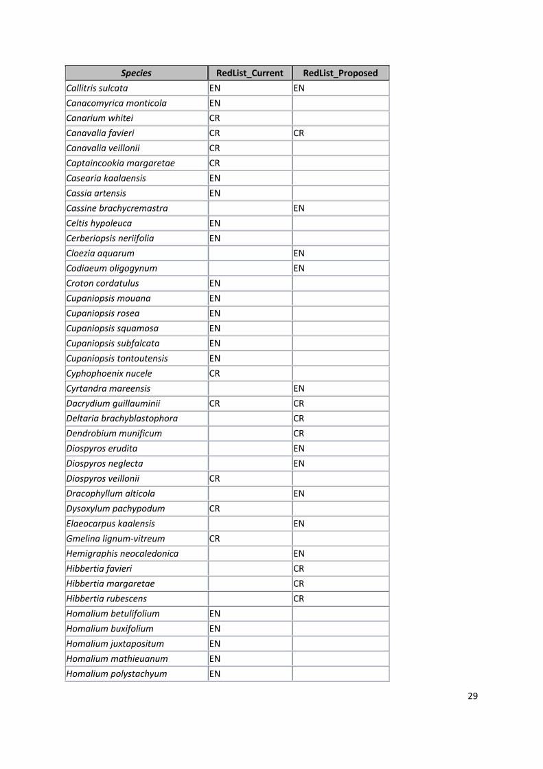
Species RedList_Current RedList_Proposed
Acropogon bosseri EN
Acropogon chalopiniae CR
Acropogon jaffrei EN
Acropogon margaretae CR
Acropogon merytifolius CR
Acropogon veillonii EN
Agathis ovata EN
Alphandia resinosa EN
Ancistrachne numaeensis EN EN
Araucaria humboldtensis EN
Araucaria luxurians EN EN
Araucaria muelleri EN
Araucaria nemorosa CR CR
Araucaria rulei EN EN
Araucaria scopulorum EN EN
Baloghia pininsularis EN
Beauprea congesta EN
Beauprea penariensis EN
Bikkia kaalaensis EN
Bikkia lenormandii EN
Bocquillonia arborea EN
Bocquillonia castaneifolia EN
Bocquillonia longipes EN
29
Species RedList_Current RedList_Proposed
Callitris sulcata EN EN
Canacomyrica monticola EN
Canarium whitei CR
Canavalia favieri CR CR
Canavalia veillonii CR
Captaincookia margaretae CR
Casearia kaalaensis EN
Cassia artensis EN
Cassine brachycremastra EN
Celtis hypoleuca EN
Cerberiopsis neriifolia EN
Cloezia aquarum EN
Codiaeum oligogynum EN
Croton cordatulus EN
Cupaniopsis mouana EN
Cupaniopsis rosea EN
Cupaniopsis squamosa EN
Cupaniopsis subfalcata EN
Cupaniopsis tontoutensis EN
Cyphophoenix nucele CR
Cyrtandra mareensis EN
Dacrydium guillauminii CR CR
Deltaria brachyblastophora CR
Dendrobium munificum CR
Diospyros erudita EN
Diospyros neglecta EN
Diospyros veillonii CR
Dracophyllum alticola EN
Dysoxylum pachypodum CR
Elaeocarpus kaalensis EN
Gmelina lignum-vitreum CR
Hemigraphis neocaledonica EN
Hibbertia favieri CR
Hibbertia margaretae CR
Hibbertia rubescens CR
Homalium betulifolium EN
Homalium buxifolium EN
Homalium juxtapositum EN
Homalium mathieuanum EN
Homalium polystachyum EN

30
Species RedList_Current RedList_Proposed
Homalium rubrocostatum EN
Hunga cordata EN
Iteiluma pinifolium EN
Jasminum noumeense VU EN
Justicia pinensis EN EN
Kentiopsis oliviformis EN
Kentiopsis pyriformis CR
Lasiochlamys hurlimannii EN
Lavoixia macrocarpa CR
Leptostylis gatopensis EN
Leptostylis goroensis CR
Libocedrus chevalieri EN CR
Libocedrus yateensis VU EN
Litsea imbricata EN
Litsea stenophylla EN
Logania imbricata EN
Macadamia angustifolia EN
Medicosma articulata EN
Medicosma Congesta EN
Medicosma exigua EN
Medicosma gracilis EN
Medicosma latifolia EN
Medicosma leratii EN
Medicosma petiolaris EN
Medicosma suberosa EN
Medicosma subsessilis EN
Medicosma tahafeana EN
Megastylis latissima EN
Megastylis paradoxa EN
Melodinus insulaepinorum EN
Metrosideros tetrasticha EN
Myricanthe discolor EN
Neisosperma sevenetii EN
Neisosperma thiollierei CR
Neocallitropsis pancheri VU EN
Ochrosia inventorum CR CR
Oryza neocaledonica EN EN
Oxanthera fragrans EN
Oxanthera neocaledonica EN
Oxanthera undulata CR

31
Species RedList_Current RedList_Proposed
Pandanus lacuum EN
Pandanus verecundus CR
Phyllanthus baraouaensis EN
Phyllanthus conjugatus EN
Phyllanthus fractiflexus EN
Phyllanthus golonensis EN
Phyllanthus jaubertii CR
Phyllanthus mcphersonii EN
Phyllanthus natoensis EN
Phyllanthus paucitepalus EN
Phyllanthus petchikaraensis EN
Phyllanthus pindaiensis CR CR
Phyllanthus pinjenensis EN
Phyllanthus rozennae EN
Phyllanthus stenophyllus EN
Phyllanthus unifoliatus EN CR
Phyllanthus veillonii EN
Pittosporum aliferum EN
Pittosporum brevispinum EN
Pittosporum muricatum EN
Pittosporum ornatum EN
Pittosporum tanianum CR
Planchonella contermina EN
Planchonella kaalaensis EN
Planchonella koumaciensis EN
Podocarpus beecherae EN
Podocarpus decumbens VU CR
Podocarpus longefoliolatus EN
Podocarpus polyspermus VU EN
Pouteria brevipedicellata EN
Pouteria danikeri EN
Pouteria pinifolia EN
Pritchardiopsis jeanneneyi CR
Rauvolfia sevenetii CR
Retrophyllum minor EN CR
Sarcomelicope glauca CR
Scaevola macropyrena EN
Schefflera veitchii EN
Semecarpus riparia EN
Serianthes germainii EN

32
Species RedList_Current RedList_Proposed
Solanum hugonis EN EN
Solanum pseuderanthemoides CR
Stenocarpus heterophyllus EN
Stenocarpus villosus CR
Styphelia violaceospicata EN
Tephrosia leratiana EN
Terminalia cherrieri EN
Trigonostemon cherrieri CR
Tristaniopsis polyandra EN
Tristaniopsis yateensis EN
Vitex evoluta EN
Xanthostemon francii EN
Xanthostemon glaucus CR
Xanthostemon lateriflorus EN
Xanthostemon longipes EN
Xylosma capillipes CR
Xylosma grossecrenatum EN
Xylosma inaequinervium EN
Xylosma peltatum CR
Xylosma pininsulare CR
Zygogynum oligostigma EN

33
Landscapes
Dry Forest
Tropical dry forest is threatened in New Caledoina because it has been reduced to less than 2% of its
original extent. This is mainly due to urbanisation, land clearance, overgrazing, road infrastructure
development and bush fires (Bouchet et al. 1995)16. “Tropical dry forest in New Caledonia is one of
the world’s most endangered tropical dry forest based on the current extent of the forest,
endemism, number of protected areas, and threatened species” (Gillespie & Jaffré 2003)17. Most of
the dry forest distribution is along the west coast, in the low lands intermixed with agricultural land
use (cattle grazing). The dry forest is situated in a dry climate with less than 1100 mm annual rainfall
(Dry Forest Programme, 2010)18. The dry forests differ from the moist forests in their plant
composition. The dry forest of New Caledonia contains 456 plant species belonging to 83 different
botanical families. The specific rate of endemism is 57.5% (Dry Forest Programme, 2010).
Around twenty species are very rare, some do exist in a single location with sometimes less than ten
individual plants. 49 species of dry forest are being proposed on the IUCN red list with a status of CR,
EN or VU. The dry forest of New Caledonia contains the highly endangered species such as rare
lianas (Oxera pulchella and Turbina inopinata), shrubs (Diospyros veillonni) or endemic grasses of the
dry forest (Oryza neocaledonica and Ancistrachne numaensis). The dry forest also contains the
endangered plant Captaincookia margaretae which is the only member of its genus (Rubiaceae) (Dry
Forest Programme, 2010).
Mangroves
According to the Mangrove Atlas 200619, there are 35,100 ha are covered with Mangrove
ecosystems in New Caledonia. This includes 25,900 ha of forest, shrub or tree (55% of Rhizophora
spp. dominant formations and 14% of Avicennia marina dominant formations) and 9,200 ha of
marsh land. 88% of mangroves were recorded on the West Coast, composed of 59% in Northern
Province, 40% in Southern Province and 1% in the Island Provinces8.
16
Bouchet P.H., Jaffré T. and Veillon, J. M. 1995. Plant extinction in New Caledonia: protection of sclerophyll
forests urgently needed. Biodiversity and Conservation 4: 415-428.
17 Gillespie, T.W. and Jaffré, T. 2003. Tropical dry forests of New Caledonia. Biodiversity and Conservation 12:
1687-1697.
18Foret Seche Programme, (2010), http://www.foretseche.nc, accessed on 22
nd April 2010.
19 ZoNéCo, Mangrove Atlas, 2006, New Caledonia

34
Mangrove areas are protected areas in Province Sud. A study on mangroves in New Caledonia
identified four regional distributional groupings such as generalists, north restricted, moisture
preferring, and an arid specialist20.
Foret Humide
The humid forest layer was extracted from the Occupation du sol data (DTSI). The primary data was
obtained from the 2008 layer, and clouded areas were substituted with 1996 land cover information.
Most of the IBAs in New Caledonia follow the distribution of the humid forest area. Areas of less
than 50 ha were masked out, when employing this data in the selection process of added areas for
confirmed KBAs.
Protection des Eaux
The information of protected water areas /captage has been obtained from DTSI. The latest
delineation is based on February 2011, including large areas in Province Sud (overlapping Grand Sud,
Rivière Bleue). The total area covered by the 280 protection sites is 226,381.45 ha. The installation of
these water protection areas (Périmètres de protection des eaux, PPE) helps to protect the
catchment activities that could affect the quality or quantity of extracted water. These PPEs are only
installed for the purpose of water consumption of the communities (Conseil économique et social de
la Nouvelle Calédonie, 2008)21.
Predicted Plant Habitat
The environmental layers such as rainfall, altitude classes (derived from digital elevation model),
geology, and land Cover mappings (based on Satellite Imagery classifications 1996 and 2008, DTSI).
The estimations were produced through GIS Python scripting and mapped out as a spatial layer
showing predictions of endangered plant habitats based on their occurrence in the landscape. The
four environmental parameters served as descriptors for modelled estimations of threatened plant
habitat distributions, implemented through in a four criteria model. Only those model derived
habitat classifications were chosen that showed at least 6 plant observations points, ensuring higher
confidence for area selection. This spatial data of estimated habitats greater than 10 hectars was
considered when selecting added on areas for confirmed KBAs.
20
Duke, N.c., A Brief Account of the Mangroves of New Caledonia, Interim report, 2007, University of Queensland, Brisbane, QLD Australia
21 Conseil économique et social de la Nouvelle Calédonie 2008, Synthèse des Assises de l’eau

35
Marine Component
The Marine environment is represented through various data that was received from the NC
gourvenment and other research institutions. This includes UNSECO worl heritage sites and further
protection sites suggested by ecoregional analysis work (ERA/AER), Mangrove and (remotely sensed)
seagrass areas, as well as Dugong observation points with derived proposed protection areas.
World Heritage Sites
New Caledonia’s tropical lagoons and coral reefs of have been inscribed as a World Heritage Site in
July 2008 under three criterions (vii, ix, and x), meaning (vii) superlative natural phenomena or
natural beauty; (ix) ongoing biological and ecological processes and; (x) biological diversity and
threatened species (McKenna, 2011)22. The six marine clusters are Atolls d'Entrecasteaux, Atolls
d'Ouvéa et Beautemps-Beaupré, Grand Lagon Nord, Grand Lagon Sud, Zone Côtière Nord et Est and
Zone Côtière Ouest. Within the frame of the 2008 World Heritage inscription an overall
management framework was developed by the national and provincial government considering
customary rights with the involvement of all local stakeholders (IUCN, 2008)23. Further within each
of the six clusters, management and conservation plans are being developed with full stakeholder
involvement, including co-management arrangements with the Kanak (McKenna, 2011).
Marine data
Marine data from various sources was obtained describing the marine environment of New
Caledonia and associated challenges. DTSI provided World Heritage information, in the form of
suggested marine protected sites. DTSI also provided the suggested delineations of protected areas
within the marine environment derived from the ecoregional analyses (ERA/ AER)24. Mangrove data
was considered in the mapping output as well as seagrass (herbier) layers obtained from DTSI in
March 2011. The marine IBA delineation (ZICO) was obtained from SCO. The association Opération
Cétacés supplied survey data (2009) on Dugong around Grand Terre, together with suggested
Dugong Protection zones along the coast. The survey shows points where groups of Dugongs were
observed, including the number of individuals per group. Dugongs are regarded as seascape species
and would not account for site scale assessment for KBAs.
After data preparation of the above mentioned data, a map showing all conservation relevant
marine zones was produced (Fig. 4). This output represents a base for further discussion with
experts and stakeholders. This discussion can include transitioning from terrestrial KBA scale to
watersheds and ridge-to-reef priorities.
22
McKenna S.A., Draft paper for Rapid Marine Biodiversity Assessment No.62 (for eastern Lagoons, New
Caledonia), Conservation International 23
World Heritage Nomination – IUCN Technical Evaluation, 2008. The Lagoons of New Caledonia: Reef
Diversity and Associated Ecosystems (France) – ID No. 1115, IUCN Evaluation Report May 2008 24
Gabrié, C., Bouvet, G. , Chevillon, C., Cros, A. (et al.), December 2008. Analyse écorégionale marine de la
Nouvelle-Calédonie, 1A1 Stratégie de conservation de la biodiversité marine, CRISP

36

37
Figure 4: Conservation relevant information within the Marine environment
38
Prioritisation of confirmed KBAs
Prioritisation can be based on the prevailing threats and threat levels to threatened (candidate)
species. The threats could be categorised into mining and related research activities, bush fire
occurrence, and a third threat represented invasive speices. An additional threat potential is the
land ownership information, implying risks of disturbance or degrees of human influences. The
latter however was not considered in the analysis as Province Governments indicated of handling
related tenure issues on an individual/case by case basis.
One major threat theme for New Caledonia is bush fires and its analysis was based on detecting fires
remotely via satellite. This involved a comprehensive time series analysis over the years 2000 to
2010.
Time series analysis of fire occurrences in New Caledonia
The MODIS active fire data MOD14A2 and MYD14A2 are part of the thermal anomalies products and
provide a weekly/8day composites of daily fire occurrence observations of at 1-km resolution, and
spectral range of at 3.9 and 11 μm. The data is recorded up to four times daily, on the two MODIS
platforms, so called Aqua and Terra, detecting the emissions of the mid-infrared radiation from
fires25. The MODIS sensor usually detects both flaming and smouldering fires of 1000m2, however is
able under very good, clear or near-nadir positions to identify flaming fires of one tenth of this size.
It is also stated that under perfect conditions fires of 50m2 can be detected3. No upper limits of fire
extent or temperature levels are restricting remote detection3. The 8 day composite is a maximum
value composite of fire confidence levels, and lowest to highest confidence (low-confidence,
nominal-confidence, or high-confidence fire) was taken in account when compiling the data.
Over a period of 11 years 8 day imagery composites (containing daily image data) were obtained,
over a period of February 2000 to May 2010. Image data was aggregated and summary raster layers
produced. A total summary data set contained all layers and pixel values represented summed fire
occurrences throughout New Caledonia.
Mining
Mining data was obtained from New Caledonian Government (DIMENC). The data used for
identification of mining activities was the mining cadastre from January 2010 as well as an updated
version form December 2010. The status of mines, with names and other indicators were attributed
values. The status descriptions of mining activities included current activity and the four major
mining types such as Exploitation, Travaux de recherche et exploitation, Travaux de recherche, Pas
25
Giglio, L., MODIS Collection 5 Active Fire Product User's Guide Version 2., 2010, Science Systems and Applications, Inc. University of Maryland, Department of Geography

39
d'activité minière. Based on this information threats to biodiversity were highlighted for confirmed
and candidate KBAs.
Fire and Mining
Overlaying the information derived from fire frequency mapping and active mining operations
highlighted KBAs locations and suggests establishment of priority levels for conservation action. The
Threat ranking needs to be applied defining priority levels for KBAs. Priority levels were proposed
such as (I) active mining exploitation areas (Exploitation, Travaux de recherche et exploitation) and
areas of at least one fire occurrence, and (II) active mining research/assessment work (Travaux de
recherche et exploitation) and at least one fire occurrence.
Other outputs priority areas within confirmed KBAs were also based on the two threat criteria
mining and fire occurrence, emphasising areas with (I) both active mining exploitation (Exploitation,
Travaux de recherche et exploitation) and fire occurrences at least recorded twice of the 11 year
observation span, and locations (II) where either these conditions were fulfilled.
Invasive Species
Significant concerns represent invasive species in New Caledonia such as deer and wild pigs, insects
(Wasmania ant) and plants. Corresponding data at this stage was available from IRD, in the form of
plant invase species26. A spatial point dataset (with many points recordes on road sides) was
obtained and projected and incorporated in a preliminary threat analysis. Based on this information
the degree of investation of each confirmed KBA could then be assessed according to occurrence of
observed invasive species locations. Other data on insects or wild pigs could not be retrieved.
Province Nord has some point data on deer (cerf) observations. However, it is rather complex to
map animal movements and identify preferred habitats or preferred feeding grounds as it requires
more detailed data for monitoring observations and behaviour over time accurately.
Mapping the three threats themes
Using the threat layers fire, mines and invasive plant a map was generated where each threat within
a confirmed KBA was counted and an index created through normalisation bythe corresponding KBA
area. A threat layer was then produced as the weighted sum of all the three threat criteria (Fig. 5).
26
Les espèces exotiques envahissantes de Nouvelle-Calédonie. V. Hequet, M. Le Corre, F. Rigault, V. Blanfort.
Septembre 2009, IRD, Noumea

40

41
Figure5: Prioritisation for conservation action based on weighted sum of threats; Mining acitvities, fire and invasive plant species represent threats

42
Results
Threatened Species
The entire observation data covered 481 species that were mapped for analysis, this included 267
species with an status of CR, EN or VU according to IUCN or New Caledonian listings. The observed
species are part of the 516 target species declared as threatened or restricted range by IUCN or
proposed threatened by local New Caledonian lists.
Of these, 199 were known or proposed CR or EN status species, for which occurrence alone triggers
KBA generation. Officially, proposed CR or EN status for a species means it can only trigger a
“Candidate KBA”, but the prevalence of endemic species and the restricted range nature of the
proposed species certainly result in defining confirmed KBAs.
CR and EN species
83 CREN species covered by 28 (out of 30) IBAs
Further 14 CREN species (all plants) covered by 12 Protected Areas (PAs) all in Province Sud:
8 Species Reserves (flora) including 6 (out of 7) of the Southern Botanical Reserves,
one Provincial Park in Noumea, and two Special Reserves (fauna).
A total of 101 out of 199 species are contained in both IBAs and PAs. 57 Species were
observed only within IBAs, and 30 species only in PAs. 94 species were either in IBAs or in
PAs. This left a remainder of 105 species, neither in IBAs nor in PAs, in areas outside existing
IBAs and PAs.
VU, RR and species of national priority/ conservation significance
163 VURRNP species are covered by the analysis, 71 of these are VU (IUCN or locally
proposed)
152 VU/RR/NP species are covered under the CR/EN triggered Planning units
11 VURRNP species are not covered within the first cut of the KBAs, and are ‘outside’ the set
of CR/EN areas, represented by 31 locations.
CREN and VURRNP distribution within New Caledonia are illustrated in Figure 6 below.

43

44
Fig. 6: Threatened species distribution and added areas for KBA delineation, April 2011

45
Following Figures 7 (a, b, c) are showing Province-wise details of the delineated KBAs and sites of observed threatened species that are not part of KBA species inventory.
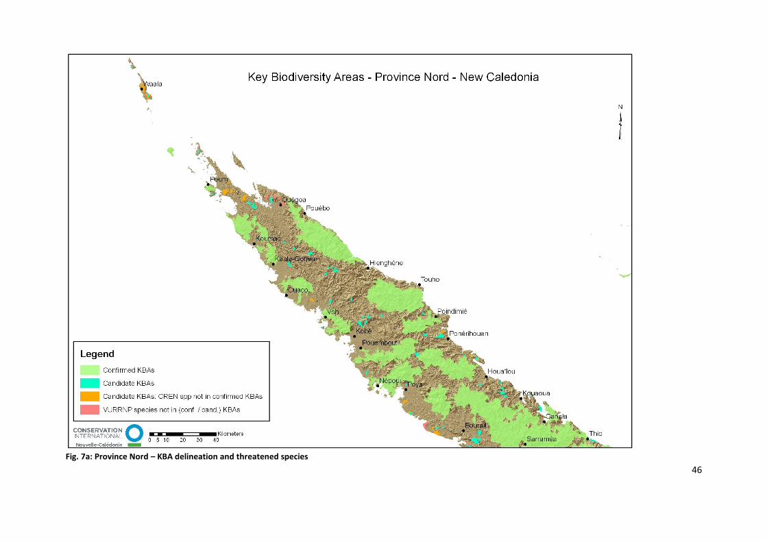
46
Fig. 7a: Province Nord – KBA delineation and threatened species

47

48
49
Fig. 7b: Province Sud – KBA delineation and threatened species

50
51
Fig. 7c: Province Iles Loyauté

Overall KBA Area statistics
The confirmed KBAs cover 41.8 % (769,225.47 ha) and candidate KBAs occupy 2.01% (37,048.37 ha)
of the New Caledonian territory (1,838,615.11 ha). Both KBA sets therefore cover an area of 43.85%
of New Caledonia (806,273.84 ha). Figure 8 below is illustrating this proportion.
Figure 8: Proportion NC Territory area and KBA cover
Land cover within KBAs
The land cover information was derived from the 2008 “Occupation du Sol” data (DTSI). The cloud
covered areas were substituted by the 1996 based land cover data characterised by a few classes
being different from the 2008 land cover data. This should be considered as an estimate for the 2008
cloud cover patches enriching the overall information on ground features. Major overlapping land
cover classes with delineated KBAs are listed in the Figure 9 and 10 below.

Fig. 9: Major Landcover classes in confirmed KBAs.
The land cover in candidate KBAs is shown in Figure 8.
Fig. 10: Major Land cover classes in candidate KBAs.

Land tenure and KBAs
Land tenure/property distribution within KBAs was avaialable from DITTT (Noumea, 2010) as a
spatial layer, and analysed overall for KBAs and each individual KBA. Figure 11 shows confirmed KBAs
and their distribution across land tenureship.
Fig. 11: Land Tenure intersection with confirmed KBAs, in percent
Figure 12 shows candidate KBAs and their respective land tenure proportions.
Fig. 12: Land Tenure intersection with candidate KBAs, in percent
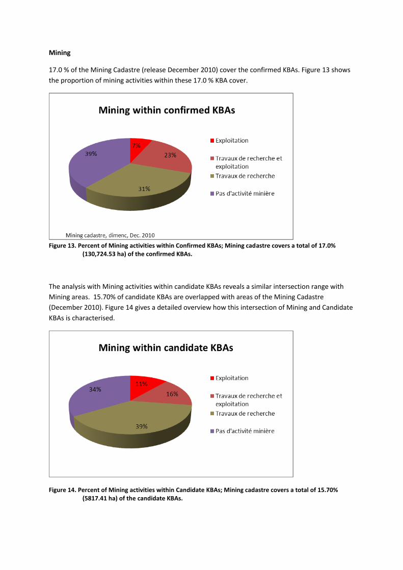
Mining
17.0 % of the Mining Cadastre (release December 2010) cover the confirmed KBAs. Figure 13 shows
the proportion of mining activities within these 17.0 % KBA cover.
Figure 13. Percent of Mining activities within Confirmed KBAs; Mining cadastre covers a total of 17.0%
(130,724.53 ha) of the confirmed KBAs.
The analysis with Mining activities within candidate KBAs reveals a similar intersection range with
Mining areas. 15.70% of candidate KBAs are overlapped with areas of the Mining Cadastre
(December 2010). Figure 14 gives a detailed overview how this intersection of Mining and Candidate
KBAs is characterised.
Figure 14. Percent of Mining activities within Candidate KBAs; Mining cadastre covers a total of 15.70% (5817.41 ha) of the candidate KBAs.

Overall statistics of KBAs regarding other landcover
Composition of confirmed and candidate KBAs
The following table (Table 7) shows the compostion of the entire area of confirmed and candidate
KBAs regarding land cover types, geology and estimated habitat areas. It also reveals the number of
fires detected in the KBA area delineation.
Table 7: Aera% of KBAs covered by landcover types
Type % confirmed KBA % candidate KBA
Captage d'eaux 17.40 11.11
Foret Humide 53.2 23.74
Predicted habitat* 1.04 2.48
Foret seche 0.30 2.05
Protected Areas 9.70 3.55
Ultramorphic geology 29.60 27.67
Fire Events/Occurence
Year span 2000 – 2010 (remotely detected) 460 76
*Predicted habitat for endangered plants based on environmental criteria
Overall statistics of landcover regarding KBA cover
The proportion of Protected Areas, Water Protected Sites as well as humid and dry forest was
calculated being covered by the KBA delineation (Table 8).
Table 8: Area % of landcover types covered by KBAs
Spatial data covered by --- Confirmed KBAs Candidate KBAs
% Foret seche 30.89 10.63
% Foret humide 67.76 1.46
% Protected Areas 97.21 1.71
% Captage d’Eaux 59.98 1.84
The 31% of dry forest cover is composed of the following confirmed KBA area coverages (Table 9):
Table 9: Area % of dry forest covered by individual confirmed KBAs
Confirmed KBA % of Foret seche
KBA Boulinda 19.52
KBA Mt Kaala 0.94
KBA Kopeto 1.08

KBA Thiebaghi 9.35
68% of humid forest is covered by 21 (out of the 22) confirmed KBAs, the overlay percentage of each
KBA is listed below (Table 10).
Table 10: Area % of humid forest covered by individual confirmed KBAs
confirmed KBA % of Foret humide
KBA Aoupinié Arago 3.99
KBA Boulinda 0.90
KBA Bwa Bwi 2.94
KBA Do Nyi 13.72
KBA Forêt Plate 1.40
KBA Goro Tane 1.91
KBA Grand Sud 1.36
KBA Ile des Pins 1.54
KBA Ile Yandé 0.02
KBA Koniambo 0.16
KBA Kopeto 0.17
KBA Kouakoué 4.96
KBA Lifou 17.29
KBA Massif des Lèvres 4.45
KBA Mt Kaala 0.03
KBA Mt Maoya 1.23
KBA Mt Panié 5.38
KBA Ouvéa 1.58
KBA Rivère Bleue 4.40
KBA Taom 0.29
KBA Thiebaghi 0.04

Description and Statistics of Confirmed KBAs in New Caledonia
22 confirmed Key Biodiversity Areas have been delineated within New Caledonia. The total area of
the confirmed 22 KBAs equals to 769,316.65 ha representing 41.8 % of the total land area of New
Caledonian territory (1,838,615.11 ha).
The confirmed KBA areas and area size are listed in Table 1 below.
KBA Area ha
Aoupinié Arago 34,123.03
Boulinda 26,508.19
Bwa Bwi 70,902.70
Do Nyi 152,591.05
Forêt Plate 13,530.95
Goro Tane 15,097.45
Grand Sud 38,676.28
Ile des Pins 15,945.37
Ile Yandé 1,322.56
Koniambo 13,307.16
Kopeto 13,201.99
Kouakoué 41,254.22
Lifou 113,754.90
Massif des Lèvres 46,304.17
Mt Kaala 7,791.80
Mt Maoya 18,343.48
Mt Panie 51,367.94
Ouvéa 13,417.33
Poum 1,502.01
Rivère Bleue 48,732.80
Taom 12,900.67
Thiebaghi 18,740.58
Table 1: Confirmed KBAs, and area size (ha)

Aoupinié Arago
Aoupinié Arago
Aoupinié Arago has an area of 34,123.03 ha, and is located at the southern part of Province Nord,
and east of the town Houaïlou. It consists of CREN areas as well as manually selected “added areas”
(that were not triggered through KBA criteria), but has not sites that are assigned as VURRNP only.
The areal composition is
CREN areas with 32,648.66 ha and
added areas with 1,471.69 ha.
Documentation of Delineation:
The KBA Aoupinié Arago delineation is mainly based on CR/EN triggered sites, and comprises the two
IBAs Aoupinié and Arago with Rhynochetos jubatus (EN). Further triggers are Placostylus fibrates
(VU, proposed EN) and Placostylus eddystonensis (VU, proposed CR). The northern part of the KBA
contains the Protected Area Aoupinié where the three species were sighted as well. Three water
protection areas (perimetre d’eaux de captage) are within the KBA (Tribu de Goapin, Tribus de Ba &
Kaora et Meomo : Creek Mindai, and de Coula a Gonde : Creek Kouiou).
Further areas were added to the KBA as they were covering humid forest and were filling small
geographical gaps. In the mid-south they also complemented communal boundaries (Ponérihouen
Commune), and had larger overlaps with ultramorphic soils. All southern additional areas also have
smaller overlays with IBAs that and were left out by the automated processing (smaller than 5%
were neglected). Added areas in the north-east contained further water protection areas (Tribu De
Neavin : Creek Pouboui).
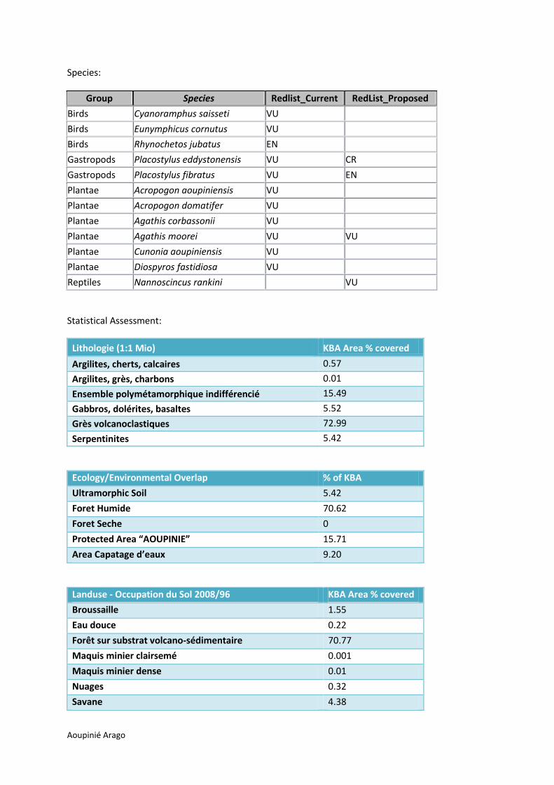
Aoupinié Arago
Species:
Group Species Redlist_Current RedList_Proposed
Birds Cyanoramphus saisseti VU
Birds Eunymphicus cornutus VU
Birds Rhynochetos jubatus EN
Gastropods Placostylus eddystonensis VU CR
Gastropods Placostylus fibratus VU EN
Plantae Acropogon aoupiniensis VU
Plantae Acropogon domatifer VU
Plantae Agathis corbassonii VU
Plantae Agathis moorei VU VU
Plantae Cunonia aoupiniensis VU
Plantae Diospyros fastidiosa VU
Reptiles Nannoscincus rankini VU
Statistical Assessment:
Lithologie (1:1 Mio) KBA Area % covered
Argilites, cherts, calcaires 0.57
Argilites, grès, charbons 0.01
Ensemble polymétamorphique indifférencié 15.49
Gabbros, dolérites, basaltes 5.52
Grès volcanoclastiques 72.99
Serpentinites 5.42
Ecology/Environmental Overlap % of KBA
Ultramorphic Soil 5.42
Foret Humide 70.62
Foret Seche 0
Protected Area “AOUPINIE” 15.71
Area Capatage d’eaux 9.20
Landuse - Occupation du Sol 2008/96 KBA Area % covered
Broussaille 1.55
Eau douce 0.22
Forêt sur substrat volcano-sédimentaire 70.77
Maquis minier clairsemé 0.001
Maquis minier dense 0.01
Nuages 0.32
Savane 4.38
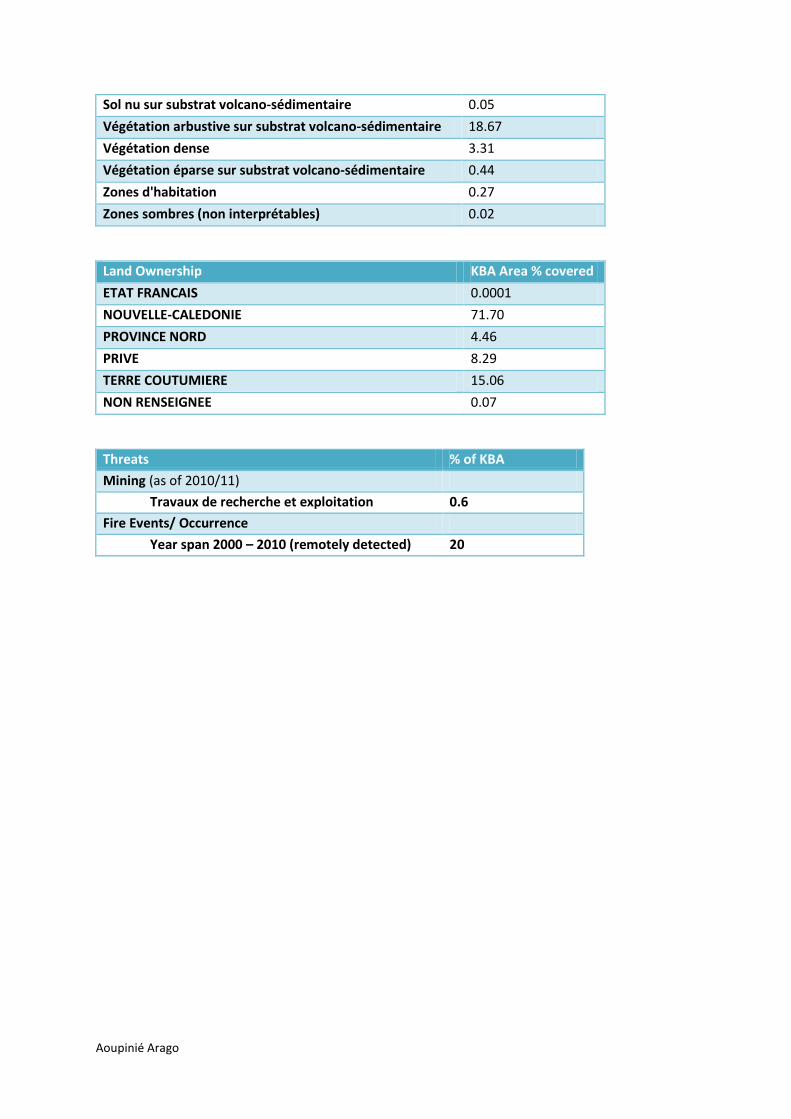
Aoupinié Arago
Sol nu sur substrat volcano-sédimentaire 0.05
Végétation arbustive sur substrat volcano-sédimentaire 18.67
Végétation dense 3.31
Végétation éparse sur substrat volcano-sédimentaire 0.44
Zones d'habitation 0.27
Zones sombres (non interprétables) 0.02
Land Ownership KBA Area % covered
ETAT FRANCAIS 0.0001
NOUVELLE-CALEDONIE 71.70
PROVINCE NORD 4.46
PRIVE 8.29
TERRE COUTUMIERE 15.06
NON RENSEIGNEE 0.07
Threats % of KBA
Mining (as of 2010/11)
Travaux de recherche et exploitation 0.6
Fire Events/ Occurrence
Year span 2000 – 2010 (remotely detected) 20

Boulinda
Boulinda
The KBA Boulinda covers an area of 26,508.19 ha, and is located at the southern part of Province
Nord bordering the west coast between the towns Poya and Népoui.
The total area size for each main KBA cluster is
CREN is 12,201.29 ha,
VU/RR/NP is 5,251.09 ha, and
addon areas 9,055.82 ha
KBA Boulinda with CREN (dark green), VU/RR/NP (light green), added areas (yellow).
Delineation:
The Boulinda KBA in the west covers areas of the IBAs Pindaï and almost all of IBA Boulinda in the
north east that is triggered through the Kagu (Rhynochetos jubatus). Other endangered species in
this KBA include the snail Placostylus fibrates (VU, propsed EN), the reptiles Nannoscincus
hanchisteus (proposed CR), Lioscincus maruia (proposed EN) and the bat Notopteris neoclaedonica
(VU), where nests were observed in the very east of the KBA.
The north-eastern most added areas of the KBA cover areas of Forest Humide. Main added areas in
the centre overlap ultra-morphic soil, and south-western and coastal added areas cover mostly areas
of dry forest. Moreover, central and northern areas also cover reptile ranges of Marmorosphax
boulinda and western areas overlap with reptile ranges of Nannoscincus hanchisteus (CR, but not
triggered CREN as reptile ranges only served as indication). Also, predicted plant habitats for
endangered species occur in small portions in the centre of add-on areas.

Boulinda
Species:
Group Species Redlist_Current RedList_Proposed
Birds Eunymphicus cornutus VU
Birds Rhynochetos jubatus EN
Gastropods Placostylus fibratus VU EN
Gastropods Placostylus porphyrostomus VU
Mammals Notopteris neocaledonica VU
Plantae Acropogon jaffrei EN
Plantae Agathis lanceolata VU
Plantae Agathis moorei VU VU
Plantae Ancistrachne numaeensis EN EN
Plantae Araucaria luxurians EN EN
Plantae Araucaria montana VU
Plantae Araucaria rulei EN EN
Plantae Bocquillonia longipes EN
Plantae Captaincookia margaretae CR
Plantae Croton cordatulus EN
Plantae Homalium rubrocostatum EN
Plantae Kermadecia pronyensis VU
Plantae Medicosma subsessilis EN
Plantae Parasitaxus usta VU
Plantae Phyllanthus pindaiensis CR CR
Plantae Phyllanthus unifoliatus EN CR
Plantae Pittosporum aliferum EN
Plantae Pittosporum collinum VU
Plantae Pittosporum gatopense VU
Plantae Schefflera veitchii EN
Plantae Semecarpus riparia EN
Reptiles Bavayia exsuccida EN
Reptiles Lioscincus maruia EN
Reptiles Marmorosphax boulinda VU
Reptiles Nannoscincus hanchisteus CR
Statistical Assessment:
Lithologie (1:1 Mio) % of KBA
Alluvions 1.66
Argilites, cherts, calcaires 2.12
Basaltes, dolérites 25.35
Conglomérats, calcaires périrécifaux 4.07
Cuirasses 6.11
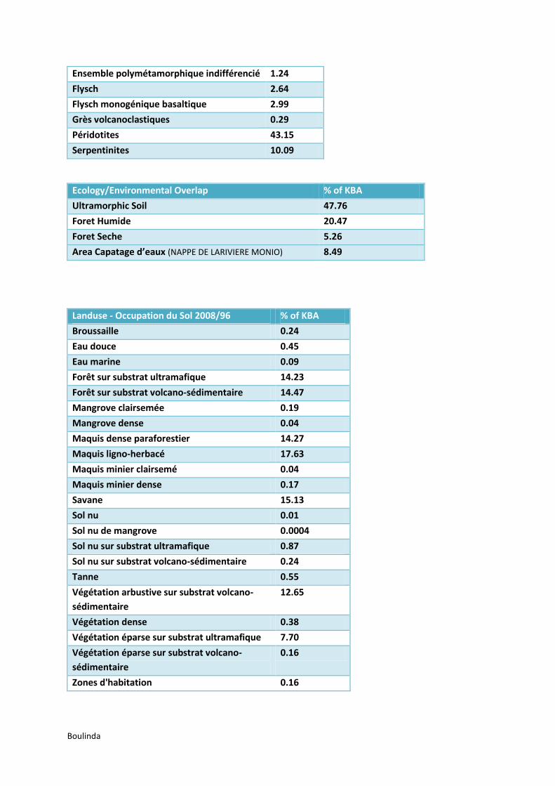
Boulinda
Ensemble polymétamorphique indifférencié 1.24
Flysch 2.64
Flysch monogénique basaltique 2.99
Grès volcanoclastiques 0.29
Péridotites 43.15
Serpentinites 10.09
Ecology/Environmental Overlap % of KBA
Ultramorphic Soil 47.76
Foret Humide 20.47
Foret Seche 5.26
Area Capatage d’eaux (NAPPE DE LARIVIERE MONIO) 8.49
Landuse - Occupation du Sol 2008/96 % of KBA
Broussaille 0.24
Eau douce 0.45
Eau marine 0.09
Forêt sur substrat ultramafique 14.23
Forêt sur substrat volcano-sédimentaire 14.47
Mangrove clairsemée 0.19
Mangrove dense 0.04
Maquis dense paraforestier 14.27
Maquis ligno-herbacé 17.63
Maquis minier clairsemé 0.04
Maquis minier dense 0.17
Savane 15.13
Sol nu 0.01
Sol nu de mangrove 0.0004
Sol nu sur substrat ultramafique 0.87
Sol nu sur substrat volcano-sédimentaire 0.24
Tanne 0.55
Végétation arbustive sur substrat volcano-
sédimentaire
12.65
Végétation dense 0.38
Végétation éparse sur substrat ultramafique 7.70
Végétation éparse sur substrat volcano-
sédimentaire
0.16
Zones d'habitation 0.16

Boulinda
Land Ownership % of KBA
NOUVELLE-CALEDONIE 68.78
PROVINCE NORD 2.24
PRIVE 17.88
COMMUNE 0.47
TERRE COUTUMIERE 8.70
NON RENSEIGNEE 0.74
Threats % of KBA 2010 % of KBA 2011
Mining (as of 2010/11)
Exploitation 3.63 3.63
Travaux de recherche et exploitation 8.00 8.00
Travaux de recherche 0.91 10.88
Pas d'activité minière 8.57 8.57
Fire Events/ Occurrence
Year span 2000 – 2010 (remotely detected) 54

Kopeto
Kopeto
The KBA Kopeto has an area size of 13,202 ha, with
CREN 8,194.46 ha,
VURRNP 633.35 ha and
add-on areas 4,374.18 ha.
It is located south of Pouembout, in Northern Province., and shares an eastern border with KBA
Forest Plate.
Delineation:
Most of the central add-on patch and eastern as well as western-most added areas contain ultra-
morphic geology, the latter overlapping with reptile ranges of Kanakysaurus zebratus, Nannoscincus
manautei, and Lioscincus vivae. The central added areas are mostly on customary land. The small
north western area contains humid forest (“Forêt sur substrat volcano-sédimentaire”), and connects
to the observation site of Placostylus porphyrostomus (VU) further in the north-west. South-western
parts of the KBA (CREN and add-on parts) overlap with a patch of endangered plant predicted
habitats.
Species of KBA Kopeto:
Group Species Redlist_Current RedList_Proposed
Gastropods Placostylus porphyrostomus VU
Plantae Albizia guillainii VU

Kopeto
Group Species Redlist_Current RedList_Proposed
Plantae Araucaria biramulata VU
Plantae Araucaria rulei EN EN
Plantae Captaincookia margaretae CR
Plantae Cleidion lochmios VU
Plantae Diospyros erudita EN
Plantae Diospyros pustulata VU
Plantae Elaeocarpus kaalensis EN
Plantae Homalium rubrocostatum EN
Plantae Kermadecia pronyensis VU
Plantae Medicosma congesta EN
Plantae Medicosma petiolaris EN
Plantae Neocallitropsis pancheri VU EN
Plantae Oryza neocaledonica EN EN
Plantae Pittosporum aliferum EN
Plantae Pittosporum brevispinum EN
Plantae Pittosporum collinum VU
Plantae Pittosporum gatopense VU
Plantae Planchonella contermina EN
Plantae Planchonella kaalaensis EN
Plantae Podocarpus polyspermus VU EN
Plantae Solanum hugonis EN EN
Plantae Xylosma grossecrenatum EN
Plantae Xylosma inaequinervium EN
Reptiles Kanakysaurus zebratus EN
Reptiles Lioscincus maruia EN
Reptiles Lioscincus vivae CR
Reptiles Nannoscincus manautei CR
Statistical Assessment:
Lithologie (1:1 Mio) % of KBA
Alluvions 7.21
Basaltes, dolérites 19.57
Cuirasses 4.49
Grès volcanoclastiques 2.58
Péridotites 58.09
Serpentinites 8.06

Kopeto
Ecology/Environmental Overlap % of KBA
Ultramorphic Soil 61.78
Foret Humide 7.83
Foret Seche 0.59
Area Capatage d’eaux (Pouembout - Plateau Tiea) 0.5
Landuse - Occupation du Sol 2008/96 % of KBA
Broussaille 0.04
Eau douce 0.09
Forêt sur substrat ultramafique 4.24
Forêt sur substrat volcano-sédimentaire 9.48
Maquis dense paraforestier 16.28
Maquis ligno-herbacé 34.50
Maquis minier clairsemé 0.32
Maquis minier dense 1.37
Savane 12.84
Sol nu 0.02
Sol nu sur substrat ultramafique 2.76
Sol nu sur substrat volcano-sédimentaire 0.09
Tanne 0.001
Végétation arbustive sur substrat volcano-sédimentaire 6.69
Végétation dense 0.86
Végétation éparse sur substrat ultramafique 10.40
Végétation éparse sur substrat volcano-sédimentaire 0.02
Zones sombres (non interprétables) 0.001
Land Ownership % of KBA
NOUVELLE-CALEDONIE 62.12
PROVINCE NORD 0.04
PRIVE 18.09
COMMUNE 0.86
TERRE COUTUMIERE 18.62
NON RENSEIGNEE 0.28
Threats % of KBA 2010 % of KBA 2011
Mining (as of 2010/11)
Exploitation 1.91 1.91
Travaux de recherche et exploitation 26.63 26.63
Travaux de recherche 8.77 8.77

Kopeto
Pas d'activité minière 10.55 9.84
Fire Events/ Occurrence
Year span 2000 – 2010 (remotely detected) 15

Forêt Plate
Forêt Plate
The KBA has a size of 13,530.95 ha, that comprises
CREN with 11,961.00 ha,
VURRNP with 173.50 ha and
pu_addon with 1,396.45 ha.
Delineation:
The KBA Forêt Plate in Province Nord continues east from the Kopeto KBA. Most of the KBA Forêt
Plate is covering the IBA Forêt Plate, and the souterhn half occupies the habitat range of the reptile
Nannoscincus humectus. Added areas to this KBA include mostly humid forest. VuRNP areas are
based on three reptile species.
Species:

Forêt Plate
Group Species Redlist_Current RedList_Proposed
Birds Cyanoramphus saisseti VU
Birds Eunymphicus cornutus VU
Birds Rhynochetos jubatus EN
Gastropods Placostylus eddystonensis VU CR
Gastropods Placostylus fibratus VU EN
Plantae Agathis moorei VU VU
Plantae Araucaria montana VU
Plantae Dendrobium munificum CR
Plantae Oryza neocaledonica EN
Plantae Parasitaxus usta VU
Reptiles Lioscincus vivae CR
Reptiles Nannoscincus gracilis VU
Reptiles Nannoscincus humectus EN
Statistical Assessment:
Lithologie (1:1 Mio) % of KBA
Argilites, cherts, calcaires 11.82
Argilites, grès, charbons 23.11
Cuirasses 0.26
Ensemble polymétamorphique indifférencié 5.74
Flysch 0.67
Grès volcanoclastiques 51.19
Péridotites 3.41
Serpentinites 3.79
Ecology/Environmental Overlap % of KBA
Ultramorphic Soil 6.02
Foret Humide 62.58
Landuse - Occupation du Sol 2008/96 % of KBA
Broussaille 1.41
Eau douce 0.22
Forêt sur substrat ultramafique 1.50
Forêt sur substrat volcano-sédimentaire 60.61
Maquis dense paraforestier 0.88
Maquis ligno-herbacé 1.80
Maquis minier clairsemé 0.25

Forêt Plate
Maquis minier dense 0.38
Savane 8.78
Sol nu 0.001
Sol nu sur substrat ultramafique 0.31
Sol nu sur substrat volcano-sédimentaire 0.03
Végétation arbustive sur substrat volcano-sédimentaire 18.54
Végétation dense 3.96
Végétation éparse sur substrat ultramafique 1.29
Végétation éparse sur substrat volcano-sédimentaire 0.04
Zones d'habitation 0.01
Land Ownership % of KBA
NOUVELLE-CALEDONIE 24.86
PROVINCE NORD 61.61
PRIVE 2.6
COMMUNE 1.2
TERRE COUTUMIERE 9.53
NON RENSEIGNEE 0.09
Threats % of KBA 2010 % of KBA 2011
Mining (as of 2010/11)
Travaux de recherche et exploitation 2.81 2.81
Pas d'activité minière 1.43 1.43
Fire Events/ Occurrence
Year span 2000 – 2010 (remotely detected) 2

Goro Tane
Goro Tane
Goro Tane KBA is located on the eastern side in Province Nord, and includes the town Poindimié. Its
area size is 15,097.45 ha. This is the result of
CREN size of 11,826.27 ha,
VURRNP size of 1,431.96 ha and
added areas of 1,837.11ha.
Most of the KBA is covered by the IBA “Goro Até et fonds de la Tchamba” with Rhynochetos jubatus
(EN). North-western parts of the KBA overlap with IBA “Fonds vallée Amoa et Goro Je”. CREN
triggers of Poindimié aera is Medicosma articulate (proposed EN). Add-on areas filling geographic
gaps, were chosen based on high humid forest cover. The north eastern added patch is situated over
a significant amount of ultra morphic geology. The eastern half of the KBA also represents a
potential habitat for the reptile Nannoscincus greeri (proposed EN, but not considered as immediate
trigger).
Species:
Group Species Redlist_Current RedList_Proposed
Birds Eunymphicus cornutus VU
Birds Rhynochetos jubatus EN
Gastropods Placostylus fibratus VU EN
Plantae Acropogon domatifer VU
Plantae Acropogon margaretae CR
Plantae Acropogon merytifolius CR
Plantae Agathis corbassonii VU

Goro Tane
Group Species Redlist_Current RedList_Proposed
Plantae Araucaria montana VU
Plantae Araucaria rulei EN EN
Plantae Archidendropsis paivana VU
Plantae Libocedrus yateensis VU EN
Plantae Medicosma articulata EN
Plantae Podocarpus polyspermus VU EN
Statistical Assessment:
Lithologie (1:1 Mio) % of KBA
Basaltes 5.12
Ensemble polymétamorphique indifférencié 3.82
Gabbros, dolérites, basaltes 0.16
Grès volcanoclastiques 82.72
Péridotites 0.71
Serpentinites 7.47
Ecology/Environmental Overlap % of KBA
Ultramorphic Soil 8.17
Foret Humide 76.23
Foret Seche 0
Area Capatage d’eaux
(Creek Pombouli, Riviere Poihila, Riviere Ndiambi) 6.81
Landuse - Occupation du Sol 2008/96 % of KBA
Broussaille 4.39
Eau douce 0.28
Forêt sur substrat ultramafique 1.13
Forêt sur substrat volcano-sédimentaire 67.09
Maquis dense paraforestier 0.99
Maquis ligno-herbacé 1.26
Maquis minier clairsemé 0.15
Maquis minier dense 0.48
Savane 4.44
Sol nu 0.01
Sol nu sur substrat ultramafique 0.03
Sol nu sur substrat volcano-sédimentaire 0.02
Végétation arbustive sur substrat volcano-sédimentaire 9.29
Végétation dense 9.79
Végétation éparse sur substrat ultramafique 0.24

Goro Tane
Végétation éparse sur substrat volcano-sédimentaire 0.08
Zones d'habitation 0.32
Land Ownership % of KBA
NOUVELLE-CALEDONIE 69.41
PROVINCE NORD 3.81
PRIVE 11.56
COMMUNE 0.27
TERRE COUTUMIERE 13.91
NON RENSEIGNEE 0.41
Threats % of KBA
No Mining records (2010)
Fire Events/ Occurrence
Year span 2000 – 2010 (remotely detected) 12

Massif des Lèvres
Massif des Lèvres
The KBA Massif des Lèvres has an area size of 46,304.17 ha, consisting of
CREN with 40,710.69 ha,
VURRNP with 1,820.22 ha (including area - VU Birdpoint outside IBA - with 169.28 ha),
area with VURRNP species only occurrence with 503.04 ha and
added areas of 3,253.14 ha.
KBA Massif des Lèvres: purple aeas in the south indicate VU species only occuring inside this KBA, northern
pink area represents Bird observation (Eunymphicus cornutus, VU) outside the IBA ‘Massif des Lèvres’.
The KBA is located south west of Touho. The majority of the KBA is covered by the IBA ‘Massif des
Lèvres’. Added areas include a bird point oservation outside the IBA in the north of Eunymphicus
cornutus (VU), and all other areas with humid forest cover and ultra morphic geology. The latter
areas were also chosen on the base of designing a compact KBA, also containing five protected
water reservoirs (see below, list of environmental overlaps). The fragment observation area of the
plant Araucaria montana (VU) that is not covered by any CREN locations throughout New Caledonia
and it was decided to include it in this KBA.
Species:
Group Species Redlist_Current RedList_Proposed
Birds Eunymphicus cornutus VU
Birds Rhynochetos jubatus EN
Plantae Agathis moorei VU VU
Plantae Araucaria montana VU
Plantae Araucaria rulei EN EN
Plantae Euroschinus jaffrei VU

Massif des Lèvres
Group Species Redlist_Current RedList_Proposed
Plantae Homalium polystachyum EN
Plantae Leptostylis petiolata VU
Plantae Libocedrus yateensis VU EN
Plantae Neisosperma sevenetii EN
Plantae Phyllanthus stenophyllus EN
Plantae Podocarpus longifoliolatus EN EN
Plantae Podocarpus polyspermus VU EN
Plantae Sloanea suaveolens VU
Statistical Assessment:
Lithologie (1:1 Mio) % of KBA
Alluvions 1.36
Basaltes 0.38
Ensemble polymétamorphique indifférencié 9.00
Gabbros, dolérites, basaltes 8.94
Grès volcanoclastiques 21.65
Micaschiste, gneiss 42.15
Péridotites 3.57
Serpentinites 12.88
Ecology/Environmental Overlap % of KBA
Ultramorphic Soil 15.22
Foret Humide 58.0
Foret Seche 0
Area Capatage d’eaux
(Creek Oue Hava, Congouma : Creek Taite, Touho Centre et
Koe : Creek Ponandou, Pouiou et Kokingone, Tiwaka)
6.7
Landuse - Occupation du Sol 2008/96 % of KBA
Broussaille 1.58
Eau douce 0.93
Eau marine 0.002
Forêt sur substrat ultramafique 4.63
Forêt sur substrat volcano-sédimentaire 57.47
Mangrove clairsemée 0.003
Mangrove dense 0.01
Maquis dense paraforestier 2.29
Maquis ligno-herbacé 3.42
Maquis minier clairsemé 0.04

Massif des Lèvres
Maquis minier dense 0.07
Savane 12.23
Sol nu 0.03
Sol nu sur substrat ultramafique 0.17
Sol nu sur substrat volcano-sédimentaire 0.08
Végétation arbustive sur substrat volcano-sédimentaire 13.99
Végétation dense 0.98
Végétation éparse sur substrat ultramafique 1.79
Végétation éparse sur substrat volcano-sédimentaire 0.11
Zones d'habitation 0.18
Zones sombres (non interprétables) 0.002
Land Ownership % of KBA
NOUVELLE-CALEDONIE 66.92
PROVINCE NORD 5.40
PRIVE 5.29
TERRE COUTUMIERE 21.29
NON RENSEIGNEE 0.21
Threats % of KBA 2010 % of KBA 2011
Mining (as of 2010/11)
Travaux de recherche 0.08 0.08
Pas d'activité minière 3.13 3.13
Fire Events/ Occurrence
Year span 2000 – 2010 (remotely detected) 16

Koniambo
Koniambo
The total area size of the KBA Koniambo is 13,307.16 ha.
CREN areas cover 6,351.78 ha,
VURRNP area size is 4,273.42 ha and
added area size is 2,677.55 ha.
The KBA is north of Koné (PN), and stretches up to the town Voh which is part of the KBA. 80% of the
KBA is situated on ultra morphic geology. All addon parts are on ultramorphic geology. Western and
northern added patches link CREN and VURRNP areas ensuring compactness and connectivity of the
KBA. The northern half of the large central addon area is selected based on covering high density of
humid forest. Potential reptile habitat ranges of Kanakysaurus zebratus (proposed EN) and
Dierogekko koniambo (proposed CR) are overlapping the entire KBA. Six protected water reservoirs
are part of the KBA (see below). The south eastern added area fully captures the the protected
water reservoir ‘Tribus de Baco et Koniambo’. 0.3% of the KBA represents potential habitats for
endangered plants, based on multi criteria model estimations. The estimated habitats may be
suitable for Neisosperma sevenetii (EN) and Schefflera veitchii (EN).

Koniambo
Species:
Group Species Redlist_Current RedList_Proposed
Plantae Araucaria montana VU
Plantae Cassia artensis EN
Plantae Cassine brachycremastra EN
Plantae Cleidion lochmios VU
Plantae Codiaeum oligogynum EN
Plantae Croton cordatulus EN
Plantae Cupaniopsis subfalcata EN
Plantae Elaeocarpus kaalensis EN
Plantae Homalium juxtapositum EN
Plantae Hunga cordata EN
Plantae Leptostylis petiolata VU
Plantae Medicosma tahafeana EN
Plantae Metrosideros punctata VU
Plantae Phyllanthus fractiflexus EN
Plantae Pittosporum collinum VU
Plantae Pittosporum gatopense EN
Plantae Planchonella contermina EN
Plantae Planchonella kaalaensis EN
Plantae Planchonella koumaciensis EN
Plantae Pouteria danikeri EN
Plantae Pycnandra kaalaensis VU
Plantae Schefflera veitchii EN
Plantae Styphelia violaceospicata EN
Plantae Tephrosia leratiana EN
Reptiles Dierogekko koniambo CR
Reptiles Kanakysaurus zebratus EN
Statistical Assessment:
Lithologie (1:1 Mio) % of KBA
Alluvions 7.30
Argilites, cherts, calcaires 2.66
Argilites, grès, charbons 0.19
Basaltes, dolérites 3.42
Cuirasses 6.25
Péridotites 52.01
Serpentinites 28.16
Alluvions 7.21

Koniambo
Ecology/Environmental Overlap % of KBA
Ultramorphic Soil 80.12
Foret Humide 7.36
Foret Seche 0
Area Capatage d’eaux (Voh, Tieta, Tribu de Tieta, Tribus de
Baco et Koniambo, Tribu d’Oundjo (2x)) 5.07
Landuse - Occupation du Sol 2008/96 % of KBA
Eau douce 0.51
Forêt sur substrat ultramafique 10.76
Forêt sur substrat volcano-sédimentaire 5.80
Mangrove clairsemée 0.00
Maquis dense paraforestier 14.95
Maquis ligno-herbacé 37.13
Maquis minier clairsemé 0.05
Maquis minier dense 0.05
Savane 5.44
Sol nu 0.02
Sol nu sur substrat ultramafique 1.05
Sol nu sur substrat volcano-sédimentaire 0.05
Tanne 0.01
Végétation arbustive sur substrat volcano-sédimentaire 8.22
Végétation dense 0.00
Végétation éparse sur substrat ultramafique 15.00
Végétation éparse sur substrat volcano-sédimentaire 0.01
Zones d'habitation 0.95
Land Ownership % of KBA
ETAT FRANCAIS 0.01
NOUVELLE-CALEDONIE 83.12
PROVINCE NORD 0.05
COMMUNE 0.80
PRIVE 8.83
TERRE COUTUMIERE 6.18
NON RENSEIGNEE 0.76
Threats % of KBA 2010 % of KBA 2011
Mining (as of 2010/11)
Exploitation 2.72 2.72
Travaux de recherche et exploitation 41.17 41.17
Travaux de recherche 9.55 9.55

Koniambo
Pas d'activité minière 10.53 10.53
Fire Events/ Occurrence
Year span 2000 – 2010 (remotely detected) 27

Taom
Taom
The KBA Taom is 12,900.67 ha large, with
CREN of 3,147.77 ha,
VURRNP of 6,081.93 ha and
added areas of 3,665.97 ha.
Taom KBA is located near Ouaco town on the western coast of Province Nord. Eastern addon areas
are over humid forest and ultra morphic substrate. The western patch also covers widely ultra
morphic geology areas and is connecting the western sites of CREN and VURRNP. The KBA contains
3 water protection areas, and in the east potential habitat ranges of reptiles Marmorosphax taom
(proposed CR) and Dierogekko thomaswhitei (proposed CR). 0.23% of the KBA are the potentially
suitable as habitats for the endangered plant species Schefflera veitchii (EN), due to an
environmental parameter model identifying three sites in this KBA.
Species:
Group Species Redlist_Current RedList_Proposed
Gastropods Placostylus bondeensis CR
Plantae Araucaria montana VU
Plantae Cassine brachycremastra EN
Plantae Codiaeum oligogynum EN
Plantae Hibbertia rubescens CR
Plantae Myricanthe discolor EN
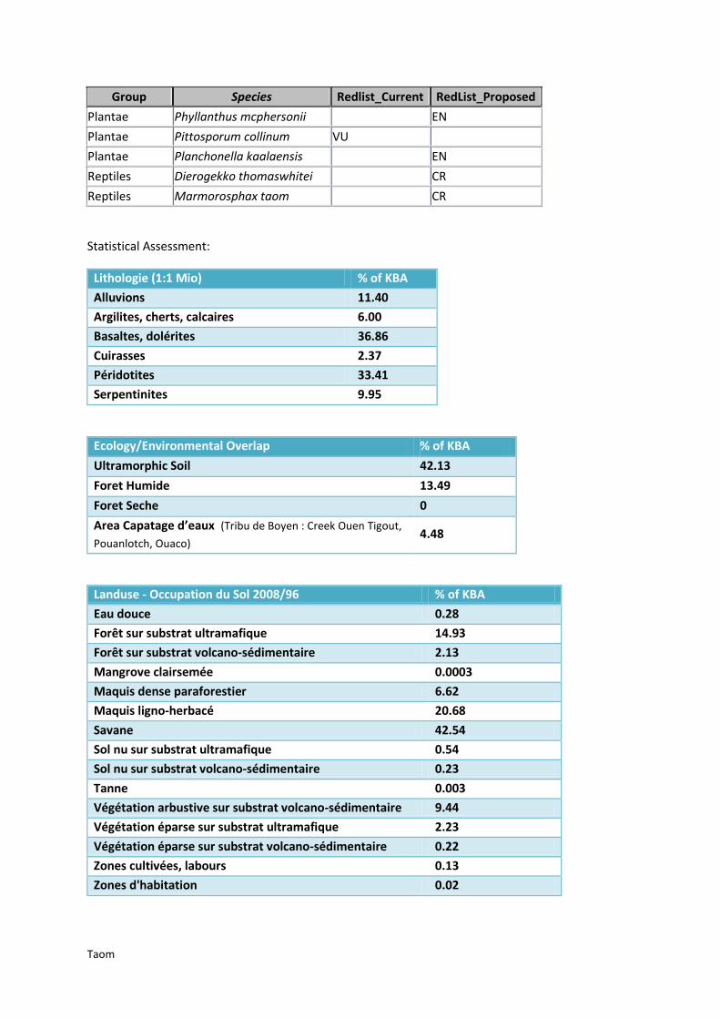
Taom
Group Species Redlist_Current RedList_Proposed
Plantae Phyllanthus mcphersonii EN
Plantae Pittosporum collinum VU
Plantae Planchonella kaalaensis EN
Reptiles Dierogekko thomaswhitei CR
Reptiles Marmorosphax taom CR
Statistical Assessment:
Lithologie (1:1 Mio) % of KBA
Alluvions 11.40
Argilites, cherts, calcaires 6.00
Basaltes, dolérites 36.86
Cuirasses 2.37
Péridotites 33.41
Serpentinites 9.95
Ecology/Environmental Overlap % of KBA
Ultramorphic Soil 42.13
Foret Humide 13.49
Foret Seche 0
Area Capatage d’eaux (Tribu de Boyen : Creek Ouen Tigout,
Pouanlotch, Ouaco) 4.48
Landuse - Occupation du Sol 2008/96 % of KBA
Eau douce 0.28
Forêt sur substrat ultramafique 14.93
Forêt sur substrat volcano-sédimentaire 2.13
Mangrove clairsemée 0.0003
Maquis dense paraforestier 6.62
Maquis ligno-herbacé 20.68
Savane 42.54
Sol nu sur substrat ultramafique 0.54
Sol nu sur substrat volcano-sédimentaire 0.23
Tanne 0.003
Végétation arbustive sur substrat volcano-sédimentaire 9.44
Végétation éparse sur substrat ultramafique 2.23
Végétation éparse sur substrat volcano-sédimentaire 0.22
Zones cultivées, labours 0.13
Zones d'habitation 0.02

Taom
Land Ownership % of KBA
NOUVELLE-CALEDONIE 39.47
PROVINCE NORD 0.35
PRIVE 53.66
TERRE COUTUMIERE 5.91
NON RENSEIGNEE 0.13
Threats % of KBA 2010 % of KBA 2011
Mining (as of 2010/11)
Exploitation 1.31 1.31
Travaux de recherche et exploitation 7.89 7.89
Travaux de recherche 10.70 11.30
Pas d'activité minière 5.40 5.40
Fire Events/ Occurrence
Year span 2000 – 2010 (remotely detected) 7

Mt Panié
Mt Panié
The KBA Mt Panié strechtes from Hienghène up to Pouébo town are. Its entire size is 51,367.94 ha,
consisting of
CREN area size of 38,368.05 ha,
VURRNP of 4412.37 ha, including VURRNP area of 777.30 which is not covered by CREN, and
addon areas of 8,562.95 ha.
The KBA includes the Protected Area ‘Mont Panié’, the IBA ‘Panié’ as well as six protected water
reservoirs (see below). The potential reptile habitat ranges of Bavayia madjo (RR) overlap in the
southern half, and of Caledoniscincus terma (proposed CR) in the north. 63% of the KBA area is
covered with humid forest. This also accounts for the KBA added areas, apart from the most
southern ones. They were chosen for bridging the close geographical gap and coast-line continuity to
the southern most CREN/VURRNP areas.
Species:
Group Species Redlist_Current RedList_Proposed
Birds Cyanoramphus saisseti VU
Birds Eunymphicus cornutus VU
Birds Gymnomyza aubryana CR
Gastropods Placostylus caledonicus CR
Gastropods Placostylus eddystonensis VU CR
Plantae Acropogon merytifolius CR
Plantae Agathis corbassonii VU

Mt Panié
Group Species Redlist_Current RedList_Proposed
Plantae Agathis moorei VU VU
Plantae Alloschmidia glabrata VU
Plantae Araucaria montana VU
Plantae Araucaria schmidii VU
Plantae Basselinia favieri VU
Plantae Basselinia iterata VU
Plantae Cleidion veillonii VU
Plantae Diospyros nebulosa VU
Plantae Diospyros trisulca VU
Plantae Elaeocarpus colnettianus VU
Plantae Elaeocarpus moratii VU
Plantae Lavoixia macrocarpa CR
Plantae Libocedrus chevalieri EN CR
Plantae Libocedrus yateensis VU EN
Plantae Neisosperma brevituba VU
Plantae Parasitaxus usta VU
Plantae Pittosporum paniense VU
Plantae Stenocarpus villosus CR
Reptiles Dierogekko validiclavis EN
Reptiles Lioscincus steindachneri VU
Reptiles Nannoscincus exos CR
Reptiles Rhacodactylus leachianus EN
Statiastical Assessment:
Lithologie (1:1 Mio) % of KBA
Argilites, cherts 3.15
Basaltes 0.17
Mélange ophiolitique 5.76
Micaschiste, gneiss 90.83
Serpentinites 0.03
Ecology/Environmental Overlap % of KBA
Ultramorphic Soil 0.03
Foret Humide 63.27
Foret Seche 0
Protected Area (Mont Panié) 10.5
Area Capatage d’eaux (Balade - Rive droite, Creek Pouirene,
Creek Amene, Tchambouene, Yambe : Creek Garana, Creek Ouayat) 3.32

Mt Panié
Landuse - Occupation du Sol 2008/96 % of KBA
Broussaille 1.09
Eau douce 0.61
Eau marine 0.01
Forêt sur substrat volcano-sédimentaire 61.58
Mangrove clairsemée 0.005
Mangrove dense 0.02
Maquis ligno-herbacé 0.05
Maquis minier clairsemé 0.01
Maquis minier dense 0.04
Savane 14.33
Sol nu 0.004
Sol nu sur substrat ultramafique 0.02
Sol nu sur substrat volcano-sédimentaire 0.14
Végétation arbustive sur substrat volcano-sédimentaire 16.86
Végétation dense 5.04
Végétation éparse sur substrat ultramafique 0.01
Végétation éparse sur substrat volcano-sédimentaire 0.06
Zones d'habitation 0.12
Land Ownership % of KBA
ETAT FRANCAIS 0.001
NOUVELLE-CALEDONIE 72.34
PROVINCE NORD 0.14
COMMUNE 0.19
PRIVE 1.30
TERRE COUTUMIERE 25.44
Threats % of KBA
No Mining records (as of 2010)
Fire Events/ Occurrence
Year span 2000 – 2010 (remotely detected) 46
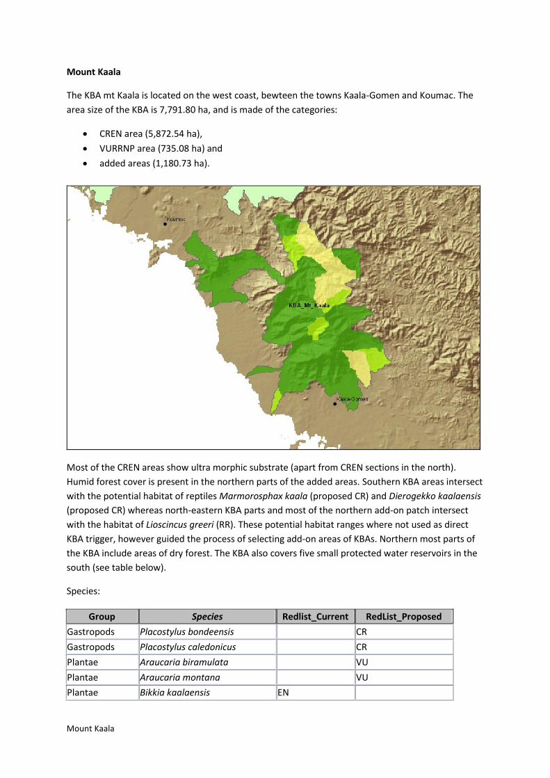
Mount Kaala
Mount Kaala
The KBA mt Kaala is located on the west coast, bewteen the towns Kaala-Gomen and Koumac. The
area size of the KBA is 7,791.80 ha, and is made of the categories:
CREN area (5,872.54 ha),
VURRNP area (735.08 ha) and
added areas (1,180.73 ha).
Most of the CREN areas show ultra morphic substrate (apart from CREN sections in the north).
Humid forest cover is present in the northern parts of the added areas. Southern KBA areas intersect
with the potential habitat of reptiles Marmorosphax kaala (proposed CR) and Dierogekko kaalaensis
(proposed CR) whereas north-eastern KBA parts and most of the northern add-on patch intersect
with the habitat of Lioscincus greeri (RR). These potential habitat ranges where not used as direct
KBA trigger, however guided the process of selecting add-on areas of KBAs. Northern most parts of
the KBA include areas of dry forest. The KBA also covers five small protected water reservoirs in the
south (see table below).
Species:
Group Species Redlist_Current RedList_Proposed
Gastropods Placostylus bondeensis CR
Gastropods Placostylus caledonicus CR
Plantae Araucaria biramulata VU
Plantae Araucaria montana VU
Plantae Bikkia kaalaensis EN

Mount Kaala
Group Species Redlist_Current RedList_Proposed
Plantae Bocquillonia longipes EN
Plantae Casearia kaalaensis EN
Plantae Cassine brachycremastra EN
Plantae Celtis hypoleuca EN
Plantae Deltaria brachyblastophora CR
Plantae Elaeocarpus kaalensis EN
Plantae Homalium mathieuanum EN
Plantae Leptostylis petiolata VU
Plantae Medicosma exigua EN
Plantae Pittosporum collinum VU
Plantae Planchonella contermina EN
Plantae Planchonella kaalaensis EN
Plantae Pycnandra kaalaensis VU
Plantae Vitex evoluta EN
Reptiles Dierogekko kaalaensis CR
Reptiles Marmorosphax kaala CR
Statistical Assessment:
Lithologie (1:1 Mio) % of KBA
Alluvions 2.96
Argilites, cherts, calcaires 17.50
Basaltes, dolérites 16.02
Flysch 12.55
Péridotites 37.60
Serpentinites 13.37
Ecology/Environmental Overlap % of KBA
Ultramorphic Soil 48.74
Foret Humide 2.30
Foret Seche 0.9
Area Capatage d’eaux (Tribu de Baguanda, Tribu de St
Pierre, Paita-Menga, Gomen Centre, Kaala-Gomen) 5.78
Landuse - Occupation du Sol 2008/96 % of KBA
Eau douce 0.003
Forêt sur substrat ultramafique 2.18
Forêt sur substrat volcano-sédimentaire 6.06
Mangrove clairsemée 0.01
Mangrove dense 0.0031

Mount Kaala
Maquis dense paraforestier 13.18
Maquis ligno-herbacé 23.13
Maquis minier clairsemé 0.03
Maquis minier dense 0.02
Savane 36.42
Sol nu 0.11
Sol nu de mangrove 0.03
Sol nu sur substrat ultramafique 1.10
Sol nu sur substrat volcano-sédimentaire 0.44
Végétation arbustive sur substrat volcano-sédimentaire 15.32
Végétation dense 0.01
Végétation éparse sur substrat ultramafique 1.76
Végétation éparse sur substrat volcano-sédimentaire 0.09
Zones d'habitation 0.11
Land Ownership % of KBA
ETAT FRANCAIS 0.50
PROVINCE NORD 0.05
NOUVELLE-CALEDONIE 74.91
COMMUNE 1.81
PRIVE 9.88
TERRE COUTUMIERE 11.99
NON RENSEIGNEE 0.81
Threats % of KBA 2010 % of KBA 2011
Mining (as of 2010/11)
Exploitation 0.21 0.21
Travaux de recherche et exploitation 16.78 16.78
Travaux de recherche 0.42 0.88
Pas d'activité minière 8.41 8.41
Fire Events/ Occurrence
Year span 2000 – 2010 (remotely detected) 9

Thiebaghi
Thiebaghi
TH KBA Thiebaghi (PN) is north Koumac, and borders the west coast, but also stretches further
inland. The area size is 18,740.58 ha, with
CREN covering 7,453.62 ha,
VURRNP area size of 7,236.36 ha and
added areas with 4,050.59 ha
North-eastern areas of the KBA as well as the eastern elongated parts cover long stretched of dry
forest. The latter are also characterised by stretched slivers of ultra morphic substrate (in north-
south direction). Coastal (up to the very south)and central parts of the KBA also have large overlaps
with this type of geology. Apart from the eastern inland extended areas, most of the KBa represents
a potential reptile habitat for Dierogekko nehoueensis (), and south eastern part of the stretched
appendage intersect with the potential habitat area of Lioscincus greeri (RR) (also part of KBA Kaala).
The KBA contains one water reservoir. Coastal add-on areas fully overlap with ultramorphic
substrate, central added areas do also have around half intersection with this substrate. Eastern
most added areas contain a lot of dry forest patches and small fragments of humid forest. The KBA
contains one protected water reservoir (Paagoumene). 3.1% of the KBA areas represent potential
habitats for endangered plants, modelled through a multi-parameter prediction.

Thiebaghi
Species :
Group Species Redlist_Current RedList_Proposed
Gastropods Placostylus bondeensis CR
Gastropods Placostylus caledonicus CR
Plantae Albizia guillainii VU
Plantae Araucaria bernieri VU
Plantae Araucaria montana VU
Plantae Araucaria rulei EN EN
Plantae Araucaria scopulorum EN EN
Plantae Bikkia lenormandii EN
Plantae Bocquillonia castaneifolia EN
Plantae Cassia artensis EN
Plantae Cassine brachycremastra EN
Plantae Codiaeum oligogynum EN
Plantae Cupaniopsis squamosa EN
Plantae Hemigraphis neocaledonica EN
Plantae Homalium mathieuanum EN
Plantae Homalium polystachyum EN
Plantae Iteiluma pinifolium EN
Plantae Macadamia angustifolia EN
Plantae Medicosma gracilis EN
Plantae Myricanthe discolor EN
Plantae Neisosperma sevenetii EN
Plantae Oxanthera neocaledonica EN
Plantae Planchonella contermina EN
Plantae Planchonella koumaciensis EN
Plantae Podocarpus longefoliolatus EN
Plantae Pouteria pinifolia EN
Plantae Pycnandra kaalaensis VU
Plantae Tephrosia leratiana EN
Plantae Vitex evoluta EN
Reptiles Dierogekko nehoueensis CR
Reptiles Kanakysaurus viviparus EN
Reptiles Oedodera marmorata CR
Reptiles Rhacodactylus chahoua VU

Thiebaghi
Statistical Assessment:
Lithologie (1:1 Mio) % of KBA
Alluvions 15.91
Argilites, cherts, calcaires 36.75
Basaltes, dolérites 0.68
Cuirasses 5.75
Flysch 2.63
Flysch monogénique basaltique 0.29
Péridotites 34.04
Serpentinites 3.80
Ecology/Environmental Overlap % of KBA
Ultramorphic Soil 37.85
Foret Humide 1.45
Foret Seche 3.60
Area Capatage d’eaux (Paagoumene) 1.05
Landuse - Occupation du Sol 2008/96 % of KBA
Eau douce 0.27
Forêt sur substrat ultramafique 0.18
Forêt sur substrat volcano-sédimentaire 4.45
Mangrove clairsemée 0.01
Mangrove dense 0.004
Maquis dense paraforestier 5.75
Maquis ligno-herbacé 19.98
Savane 50.26
Sol nu sur substrat ultramafique 1.11
Sol nu sur substrat volcano-sédimentaire 0.63
Végétation arbustive sur substrat volcano-sédimentaire 14.12
Végétation éparse sur substrat ultramafique 2.52
Végétation éparse sur substrat volcano-sédimentaire 0.66
Zones d'habitation 0.05
Land Ownership % of KBA
NOUVELLE-CALEDONIE 72.55
PROVINCE NORD 10.65
COMMUNE 0.20
PRIVE 13.62
TERRE COUTUMIERE 1.57
NON RENSEIGNEE 0.66

Thiebaghi
Threats % of KBA 2010 % of KBA 2011
Mining (as of 2010/11)
Exploitation 1.25 1.25
Travaux de recherche et exploitation 10.74 10.74
Travaux de recherche 13.13 13.13
Pas d'activité minière 17.06 17.05
Fire Events/ Occurrence
Year span 2000 – 2010 (remotely detected) 36

Poum
Poum
The KBA Poum in the very north south of the town Poum, has an area size of 1502.01 ha. This
consists of
CREN area (1,326.21 ha),
VURRNP area (112.47 ha), including VURRNP area of 54.12 ha which is not covered by CREN,
Added areas of 61.03 ha.
The plant Eugenia ericoides (VU), represented by the VURRNP patch is not covered by any CREN area
of the KBAs. The add-on areas in the west at the coast cover predicted habitats of endangered plants
(5.03% of KBA), and their soil substrate is also characterised through ultra morphic geology. The
protected water reservoir (Village de Poum et Tribu de Titch) is located in the centre of the KBA. The
KBA represents the potential habitat range of the reptiles Dierogekko poumensis (proposed CR) and
Dierogekko inexpectatus (proposed CR).
Species:
Group Species Redlist_Current RedList_Proposed
Gastropods Placostylus porphyrostomus VU
Plantae Araucaria bernieri VU
Plantae Araucaria scopulorum EN EN
Plantae Cassine brachycremastra EN
Plantae Eugenia ericoides VU
Plantae Myricanthe discolor EN
Plantae Oxanthera neocaledonica EN

Poum
Group Species Redlist_Current RedList_Proposed
Plantae Pouteria pinifolia EN
Plantae Tephrosia leratiana EN
Reptiles Dierogekko inexpectatus CR
Reptiles Dierogekko poumensis CR
Reptiles Kanakysaurus viviparus EN
Statistical Assessment:
Lithologie (1:1 Mio) % of KBA
Alluvions 3.19
Argilites, cherts, calcaires 15.78
Cuirasses 14.22
Péridotites 66.61
Ecology/Environmental Overlap % of KBA
Ultramorphic Soil 66.61
Area Capatage d’eaux (Village de Poum et Tribu de Titch) 12.05
Landuse - Occupation du Sol 2008/96 % of KBA
Eau douce 0.02
Eau marine 0.01
Forêt sur substrat volcano-sédimentaire 2.71
Mangrove dense 0.005
Maquis dense paraforestier 4.82
Maquis ligno-herbacé 34.45
Savane 30.64
Sol nu sur substrat ultramafique 8.21
Sol nu sur substrat volcano-sédimentaire 0.45
Végétation arbustive sur substrat volcano-sédimentaire 2.90
Végétation éparse sur substrat ultramafique 14.81
Végétation éparse sur substrat volcano-sédimentaire 0.72
Zones d'habitation 0.26
Land Ownership % of KBA
NOUVELLE-CALEDONIE 81.97
PROVINCE NORD 1.18
COMMUNE 1.33
PRIVE 3.66
TERRE COUTUMIERE 11.40
NON RENSEIGNEE 0.21
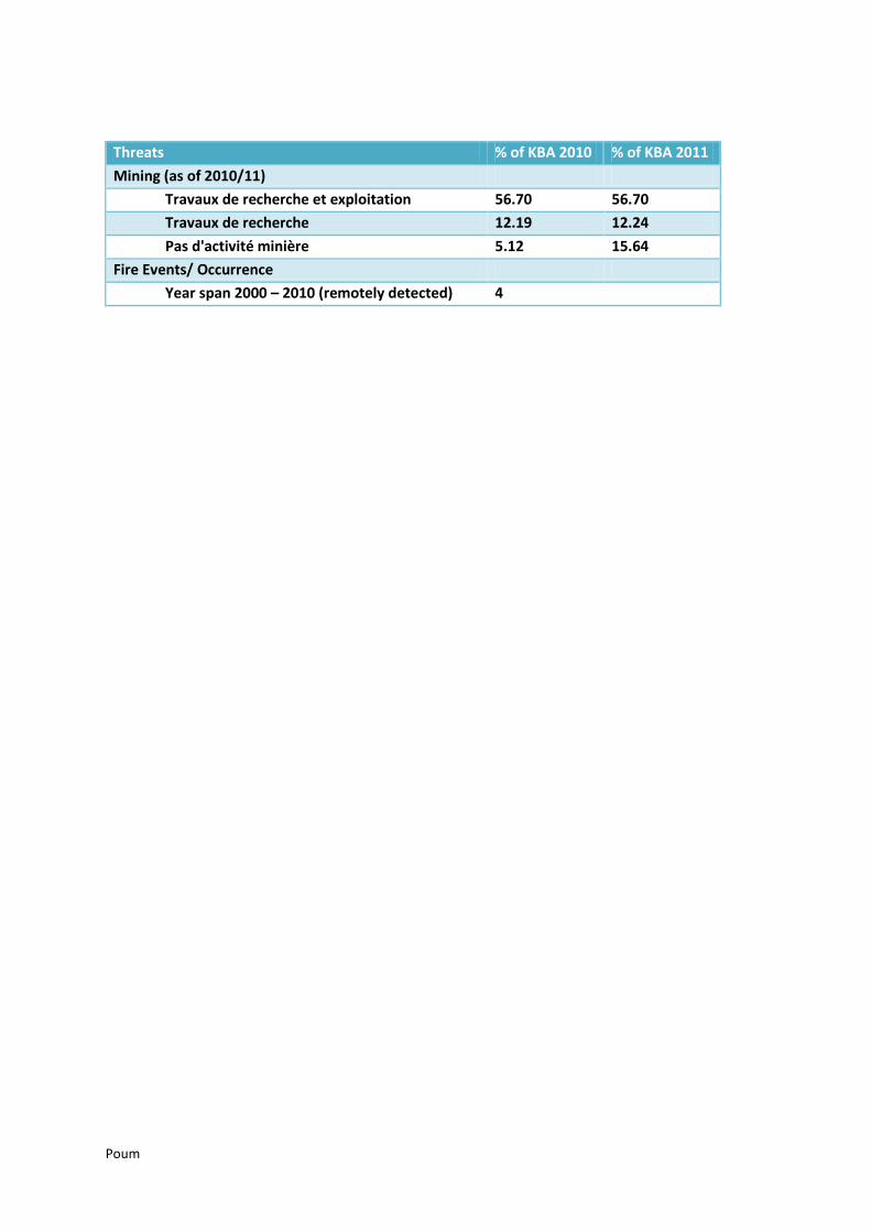
Poum
Threats % of KBA 2010 % of KBA 2011
Mining (as of 2010/11)
Travaux de recherche et exploitation 56.70 56.70
Travaux de recherche 12.19 12.24
Pas d'activité minière 5.12 15.64
Fire Events/ Occurrence
Year span 2000 – 2010 (remotely detected) 4

Ile Yandé
Ile Yandé
The KBA Ile Yandé is the northern most KBA, and is part of Northen Province. The area size is
1322.56 ha, consisting of areas
CREN (63.14 ha),
VURRNP (238.37 ha) and
added areas of 1,015.48 ha.
The KBA follows the delineation of the IBA Yandé. The CREN trigger of KBA is the plant Planchonella
contermina(EN), the VURRNP areas consist of RR classified species. Most of the island has ultra
morphic geology. The western coast is covered by humid forest.
Statistical Assessment:
Lithologie (1:1 Mio) % of KBA
Cuirasses 16.62
Péridotites 80.92
Ecology/Environmental Overlap % of KBA
Ultramorphic Soil 80.92
Foret Humide 11.08
Area Capatage d’eaux (Paagoumene)

Ile Yandé
Landuse - Occupation du Sol 2008/96 % of KBA
Eau douce 0.29
Forêt sur substrat ultramafique 6.51
Forêt sur substrat volcano-sédimentaire 11.92
Mangrove clairsemée 0.20
Mangrove dense 0.33
Maquis dense paraforestier 14.80
Maquis ligno-herbacé 11.83
Savane 7.44
Sol nu sur substrat ultramafique 17.14
Sol nu sur substrat volcano-sédimentaire 0.14
Tanne 0.01
Végétation arbustive sur substrat volcano-sédimentaire 2.58
Végétation éparse sur substrat ultramafique 24.89
Végétation éparse sur substrat volcano-sédimentaire 1.80
Zones d'habitation 0.11
Land Ownership % of KBA
NOUVELLE-CALEDONIE 87.68
PROVINCE NORD 10.22
Missing data to 100% is due to varying delineation of spatial layers
Threats % of KBA 2010 % of KBA 2011
Mining (as of 2010/11)
Pas d'activité minière 9.57 9.57
Fire Events/ Occurrence
Year span 2000 – 2010 (remotely detected) 0
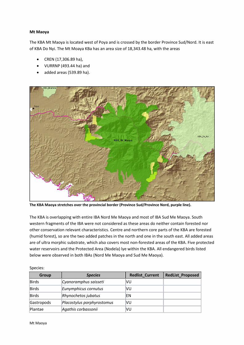
Mt Maoya
Mt Maoya
The KBA Mt Maoya is located west of Poya and is crossed by the border Province Sud/Nord. It is east
of KBA Do Nyi. The Mt Moaya KBa has an area size of 18,343.48 ha, with the areas
CREN (17,306.89 ha),
VURRNP (493.44 ha) and
added areas (539.89 ha).
The KBA Maoya stretches over the provincial border (Province Sud/Province Nord, purple line).
The KBA is overlapping with entire IBA Nord Me Maoya and most of IBA Sud Me Maoya. South
western fragments of the IBA were not considered as these areas do neither contain forested nor
other conservation relevant characteristics. Centre and northern core parts of the KBA are forested
(humid forest), so are the two added patches in the north and one in the south east. All added areas
are of ultra morphic substrate, which also covers most non-forested areas of the KBA. Five protected
water reservoirs and the Protected Area (Nodela) lye within the KBA. All endangered birds listed
below were observed in both IBAs (Nord Me Maoya and Sud Me Maoya).
Species:
Group Species Redlist_Current RedList_Proposed
Birds Cyanoramphus saisseti VU
Birds Eunymphicus cornutus VU
Birds Rhynochetos jubatus EN
Gastropods Placostylus porphyrostomus VU
Plantae Agathis corbassonii VU

Mt Maoya
Group Species Redlist_Current RedList_Proposed
Plantae Agathis moorei VU VU
Plantae Araucaria montana VU
Plantae Araucaria rulei EN EN
Plantae Medicosma suberosa EN
Plantae Phyllanthus baraouaensis EN
Plantae Podocarpus longifoliolatus EN EN
Plantae Podocarpus polyspermus VU EN
Statistical Assessment:
Lithologie (1:1 Mio) % of KBA
Argilites, cherts, calcaires 0.78
Basaltes, dolérites 22.71
Ensemble polymétamorphique indifférencié 5.14
Flysch 1.56
Péridotites 69.60
Serpentinites 0.21
Ecology/Environmental Overlap % of KBA
Ultramorphic Soil 48.36
Foret Humide 40.37
Foret Seche 0
Protected Area (Nodela) 5.0
Area Capatage d’eaux
(Riviere Nekouie, Riviere Karagreu, Riviere Djiaouma, Riviere Baraoua,
Bourail : Creek Daoui)
16.87
Landuse - Occupation du Sol 2008/96) % of KBA
Broussaille 1.11
Eau douce 0.14
Forêt sur substrat ultramafique 34.71
Forêt sur substrat volcano-sédimentaire 5.93
Maquis dense paraforestier 12.10
Maquis ligno-herbacé 16.01
Maquis minier clairsemé 0.01
Maquis minier dense 0.31
Savane 15.75
Savane 0.20
Sol nu sur substrat ultramafique 0.43
Sol nu sur substrat volcano-sédimentaire 0.06

Mt Maoya
Végétation arbustive sur substrat volcano-sédimentaire 4.57
Végétation dense 4.08
Végétation éparse sur substrat ultramafique 4.53
Végétation éparse sur substrat volcano-sédimentaire 0.06
Zones d'habitation 0.01
Land Ownership % of KBA
NOUVELLE-CALEDONIE 71.12
PROVINCE SUD 5.01
COMMUNE 0.26
PRIVE 19.85
TERRE COUTUMIERE 3.36
NON RENSEIGNEE 0.19
Threats % of KBA 2010 % of KBA 2011
Mining (as of 2010/11)
Exploitation 1.80 1.80
Travaux de recherche et exploitation 3.08 3.08
Travaux de recherche 8.23 14.09
Pas d'activité minière 6.34 8.08
Fire Events/ Occurrence
Year span 2000 – 2010 (remotely detected) 11

Do Nyi
Do Nyi
The KBA Do Nyi stretches over the border of Province Nord and Sud, and it covers an area of
152,591.05 ha. The KBA consists of
CREN 109,518.42 ha,
VURRNP areas 18,373.62 ha,
VU Bird observation point (recorded outside IBA) with 102.10 ha and
added areas of 24,720.79 ha.
The KBA Do Nyi is part of both Province Sud and Province Nord (purple line shows the provincial border). Bird observation point (Cyanoramphus saisseti, VU) outside the IBA is mapped in the north (small pink area in the north).
The KBA comprises seven IBAs (Table Unio, Entre Mont Rembaï et Mont Canala, Entre Plateau Dogny
et Mont Canala, Prokoméo, Houaïlou-Néoua, Entre Mont Do et Mont Nakada, Nord Mont Nakada). It
also overlaps with 25 protected water reservoirs, and two Protected areas. The majority of the CREN
areas represent IBAs and dense humid forest. Overlaps of potential reptile habitats of
Caledoniscincus cryptos and Nannoscincus slevini in central eastern section of the KBA, and of
Bavayia pulchella in the north-west of the KBA.
North eastern add-on areas are slected because of their significance of ultramorphic soil
characteristic, and the big patch of the latter links to a bird observation of Cyanoramphus saisseti
(VU) recorded outside the IBA Houaïlou-Néoua. North western add-on patches also include 2 small
water reservoirs (Azareu, Pothe et Ny : Creek Ouego; Gouaro, Pothe et Ny) and contain three bird
observation sites of Cyanoramphus saisseti (VU) recorded outside the IBA Houaïlou-Néoua. Same
observations of this bird were recorded further south west where a larger add-on area was selected,
also overlapping with the water reservoir ‘Ema, Nanon Et Kenerou : Creek Ouen Mehoue’, and

Do Nyi
containing significant amount of dense humid forest. The latter characteristics also accounts for
further eastern smaller add-on areas chosen as well as for southern add-on areas. The southern
most add-on area links a CREN patch further south to main CREN areas of the KBA, and includes the
water reservoir ‘Nassirah : Riviere Oua Ia’.
Huge amount of fire occurance (105) was identified using weekly image time series (MODIS,
observation time span form 2000 to 2010). It has to considered that this KBa covers a relatively large
area, that stretches over 75 km north-soth, and up to 30 km east-west.
Species:
Group Species Redlist_Current RedList_Proposed
Birds Cyanoramphus saisseti VU
Birds Eunymphicus cornutus VU
Birds Rhynochetos jubatus EN
Gastropods Placostylus eddystonensis VU CR
Gastropods Placostylus fibratus VU EN
Mammals Pteropus vetulus VU
Plantae Agathis corbassonii VU
Plantae Agathis lanceolata VU
Plantae Agathis moorei VU VU
Plantae Agathis ovata EN
Plantae Araucaria bernieri VU
Plantae Araucaria biramulata VU
Plantae Araucaria luxurians EN EN
Plantae Araucaria montana VU
Plantae Araucaria rulei EN EN
Plantae Araucaria scopulorum EN EN
Plantae Austrobuxus cracens VU
Plantae Basselinia tomentosa VU
Plantae Basselinia vestita VU
Plantae Celtis hypoleuca EN
Plantae Cleidion marginatum VU
Plantae Cupaniopsis rosea EN
Plantae Dendrobium munificum CR
Plantae Diospyros margaretae VU
Plantae Diospyros perplexa VU
Plantae Dysoxylum pachypodum CR
Plantae Justicia pinensis EN
Plantae Kentiopsis oliviformis EN
Plantae Oxanthera undulata CR
Plantae Phyllanthus petchikaraensis EN
Plantae Pittosporum ornatum EN

Do Nyi
Group Species Redlist_Current RedList_Proposed
Plantae Podocarpus longifoliolatus EN EN
Plantae Schefflera veitchii EN
Plantae Sloanea lepida VU
Plantae Stenocarpus villosus CR
Plantae Tephrosia leratiana EN
Plantae Zygogynum oligostigma EN
Reptiles Lioscincus maruia EN
Reptiles Lioscincus steindachneri VU
Reptiles Nannoscincus gracilis VU
Statistical assessment:
Lithologie (1:1 Mio) % of KBA
Alluvions 0.57
Argilites, cherts, calcaires 3.64
Argilites, grès, charbons 1.79
Basaltes, dolérites 3.23
Cuirasses 2.15
Ensemble polymétamorphique indifférencié 33.74
Flysch 1.42
Gabbros, dolérites, basaltes 3.88
Grès volcanoclastiques 25.39
Péridotites 13.72
Serpentinites 10.40
Ecology/Environmental Overlap % of KBA
Ultramorphic Soil 23.58
Foret Humide 54.29
Foret Seche
Protected Area (Mont Do, Col d'Amieu) ∑ 7.4 -- 0.2; 7.2
Area Capatage d’eaux (TRIBUS DE COULA ET BOREARE, GOUARO POTHE ET NY, GOUARO
Poethe Ny, AZAREU POTHE ET NY : CREEK OUEGO, TRIBUS DE KONOYES, SAHOUE, OUEROU, PIMET ET MECHIN : CREEK NIRE, TRIBU DE NEOUA : AFFLUENT DE LA RIVIERE NOZE, AMON KASSIORI ET OUENA, TENE, BOAKAINE, NAKETY : RIVIERE OUEN NOH, TRIBU DE KOH : RIVIERE DE KOH, TRIBU DE KATRIKOIN - TABLE UNIO, EMA NANON ET KENEROU : CREEK OUEN MEHOUE, TRIBUS DE MIA ET KUINE : RIVIERE NIMBOUE, RIVIERE OUEN AHVIA, MOINDOU, FARINO, TRIBU DE PETIT COULI : CREEK ATE, FONWHARY, TRIBU DE KOINDE, TRIBU DE GRAND COULI : RIVIERE FONWHARY, LA FOA : CREEK OUEN KANDU – DOGNY, SARRAMEA : CREEK FO OUIA, TENDEA, OUIPOIN : CREEK OUEN OMBA, NASSIRAH : RIVIERE OUA IA, KOUERGOA 2, OUAMENIE F1 et F2, TABLE UNIO 2, TRIBU DE NEOUA : AFFLUENT DE LA RIVIERE NOZE)
18.71
Landuse - Occupation du Sol 2008/96) % of KBA
Broussaille 0.26
Eau douce 0.27
Eau marine 0.001

Do Nyi
Forêt sur substrat ultramafique 11.11
Forêt sur substrat volcano-sédimentaire 45.97
Mangrove clairsemée 0.005
Mangrove dense 0.03
Maquis dense paraforestier 7.40
Maquis ligno-herbacé 4.62
Maquis minier clairsemé 0.002
Maquis minier dense 0.03
Nuages 0.01
Savane 9.54
Sol nu 0.0001
Sol nu sur substrat ultramafique 0.84
Sol nu sur substrat volcano-sédimentaire 0.02
Tanne 0.001
Végétation arbustive sur substrat volcano-sédimentaire 13.52
Végétation dense 1.20
Végétation éparse sur substrat ultramafique 4.71
Végétation éparse sur substrat volcano-sédimentaire 0.12
Zones d'habitation 0.29
Zones sombres (non interprétables) 0.06
Land Ownership % of KBA
ETAT FRANCAIS 0.004
NOUVELLE-CALEDONIE 54.74
PROVINCE NORD 3.64
PROVINCE SUD 7.39
COMMUNE 0.34
PRIVE 12.95
TERRE COUTUMIERE 20.03
NON RENSEIGNEE 0.58
Threats % of KBA 2010 % of KBA 2011
Mining (as of 2010/11)
Exploitation 1.01 1.01
Travaux de recherche et exploitation 4.53 4.54
Travaux de recherche 4.89 5.14
Pas d'activité minière 4.23 4.23
Fire Events/ Occurrence
Year span 2000 – 2010 (remotely detected) 105

Bwa Bwi
Bwa Bwi
The KBA Bwa Bwi has an area size of 70,902.70 ha. It contains
CREN areas with 44,638.06 ha
VURRNP areas with 17,617.81 ha and
added areas of 8,636.27 ha size.
The KBA Bwa Bwi comprises five IBAs (Pic Ningua, Nassirah, Cidoa-Bwa Bwi, Koum, Dent de St
Vincent), and overlaps with two Protected Areas (Pic Ningua, Foret de Saille). Almost ¾ of the KBA
(western side) are on ultramorphic geoplogy. This and high density of humid forest was a criteria for
choosing north-eastern add-on patches as well as establishing links between the two IBAs Cidoa-Bwa
Bwi and Koum, and sub-catchments of rivers Xwê Bwi (south of addon area, fish Sicyopterus sarasini,
and Crustacés Paratya bouvieri), Tô De and Neuméni (north, fish Sicyopterus lagocephalus, Crustacés
Paratya bouvieri). Southern added areas were inside the large protected water reservoir ‘Forage de
la Tontouta’, and linkage to most southern CREN and VU areas of this KBA with around 90
endangered plant and 55 reptile observation sites. The added sire in south-west represents a link on
ultramorphic soil substrate to observation sites of the plant Xanthostemon francii (proposed EN)
and the snail Placostylus fibratus (proposed EN). The western part of the KBA shows an add-on area
to the north that is on ultramorphic ground and linking to the triangulated plant site (VURRNP) of
Acmopyle pancheri (RR). The norther central (N-S elongated) added area fill the gap of CREN areas,
avoiding isolation of the plant observaqtion site of Podocarpus longifoliolatus (EN) and overlaps
with the IBA Cidoa-Bwa Bwi and the ‘Forage de la Tontouta’ water reservoir. Eastern most added

Bwa Bwi
area at the coast links to the coastal CREN site of plant Celtis hypoleuca (EN), and overlaps with the
potential habitat modelled/estimated for plant Araucaria scopulorum (EN). In general, 0.24 % of this
large KBA covers predicted habitat for endangered plants.
A large amount of fires could be identified based on remote assessment of MODIS satellite imagery
during a 11 year time span (2000 – 2010).
Species:
Group Species Redlist_Current RedList_Proposed
Birds Cyanoramphus saisseti VU
Birds Eunymphicus cornutus VU
Birds Rhynochetos jubatus EN
Gastropods Placostylus fibratus VU EN
Plantae Acropogon bosseri EN
Plantae Agathis ovata EN
Plantae Alloschmidia glabrata VU
Plantae Araucaria bernieri VU
Plantae Araucaria biramulata VU
Plantae Araucaria luxurians EN EN
Plantae Araucaria montana VU
Plantae Araucaria rulei EN EN
Plantae Beauprea penariensis EN
Plantae Callitris sulcata EN EN
Plantae Canacomyrica monticola EN
Plantae Celtis hypoleuca EN
Plantae Cerberiopsis neriifolia EN
Plantae Cocconerion minus VU
Plantae Cupaniopsis tontoutensis EN
Plantae Diospyros margaretae VU
Plantae Elaeocarpus kaalensis EN
Plantae Hibbertia margaretae CR
Plantae Homalium betulifolium EN
Plantae Leptostylis petiolata VU
Plantae Phyllanthus paucitepalus EN
Plantae Podocarpus longifoliolatus EN EN
Plantae Semecarpus riparia EN
Plantae Xanthostemon francii EN
Plantae Xanthostemon longipes EN
Reptiles Nannoscincus mariei VU

Bwa Bwi
Statistical Assessment:
Lithologie (1:1 Mio) % of KBA
Alluvions 2.04
Argilites, cherts, calcaires 1.60
Basaltes, dolérites 2.14
Flysch 8.95
Gabbros, dolérites, basaltes 0.38
Granite 0.87
Grès volcanoclastiques 2.69
Péridotites 79.70
Serpentinites 1.59
Ecology/Environmental Overlap % of KBA
Ultramorphic Soil 71.02
Foret Humide 25.05
Foret Seche 0
Protected Area (PIC NINGUA, FORET DE SAILLE) ∑ 2.03 -- 0.51; 1.52
Area Capatage d’eaux (THIO, FORAGES DE LA OUENGHI, FORAGE DE LA TONTOUTA,
KOUERGOA 2, OUINANE-TOMO : CREEK OUINANE, TOMO : RIVIERE BAGHA) 48.80
Landuse - Occupation du Sol (2008/96) % of KBA
Broussaille 0.01
Eau 0.0027
Eau douce 1.29
Eau marine 0.00
Forêt sur substrat ultramafique 26.84
Forêt sur substrat volcano-sédimentaire 5.40
Mangrove clairsemée 0.0025
Mangrove dense 0.01
Maquis dense paraforestier 25.30
Maquis ligno-herbacé 21.15
Maquis minier clairsemé 0.02
Maquis minier dense 0.07
Savane 5.81
Sol nu 0.02
Sol nu de mangrove 0.0033
Sol nu sur substrat ultramafique 0.44
Sol nu sur substrat volcano-sédimentaire 0.20
Tanne 0.002
Végétation arbustive sur substrat volcano-sédimentaire 6.70
Végétation dense 0.04

Bwa Bwi
Végétation éparse sur substrat ultramafique 6.63
Végétation éparse sur substrat volcano-sédimentaire 0.02
Zones cultivées, labours 0.01
Zones d'habitation 0.05
Land Ownership % of KBA
NOUVELLE-CALEDONIE 80.72
PROVINCE SUD 0.17
COMMUNE 0.12
PRIVE 10.58
TERRE COUTUMIERE 7.14
NON RENSEIGNEE 0.20
Threats % of KBA 2010 % of KBA 2011
Mining (as of 2010/11)
Exploitation 4.64 4.64
Travaux de recherche et exploitation 6.06 6.06
Travaux de recherche 8.21 10.54
Pas d'activité minière 22.63 25.55
Fire Events/ Occurrence
Year span 2000 – 2010 (remotely detected) 50

Kouakoué
Kouakoué
The KBA Kouakoué in Province Sud represents most of the northern half of the IBA Humboldt-
Kouakoué, with the endangered species Cyanoramphus saisseti (VU). The total area size of the KBA is
41,254.22 ha, with having
CREN with 22,011.18 ha,
VURRNP 2,466.05 ha, (including 608.40 ha that are not covered by CREN areas) ,
added area size of 16,776 ha.
The largest two CREN patches contain each a Protected Area (Humboldt and Kouakoue). Southern
CREN fragments of the KBA contain around 187 plant species observations, with endangered
spaecies such as Canacomyrica monticola (EN), and proposed CR species Dendrobium munificum and
Acropogon chalopiniae as well as proposed EN species Acropogon bosseri, Agathis ovata, Araucaria
humboldtensis and Podocarpus beecherae. In order to ensure a compact KBA structure it was
decided to bond these patches with the main northern CREN zones. This concept was also
supported through the uniform cover of humid forest within the bounds of this KBA Kouakoué. The
large northern added area is covered with around four fifth (4/5) of dense humid forest. In addition,
2/3 of its southern part covers the potential habitat range of reptile Sigaloseps ruficauda (proposed
Kouakoué
VU), and ensures that northern CREN patches are part of this KBA (plants Agathis ovata, (proposed
EN) and Canacomyrica monticola (EN)). Also all other add-on areas further south are equally
chracterised by high humid forest cover.South western added areas represent the potential reptile
habitat of Marmorosphax montana (proposed VU). Generally, all added patches are on ultramorphic
substrate.
Western most VURRNP area (purple) represents the (only)plant site of Pandanus decastigma (VU),
which does not occur in CREN areas of any KBA. Same accounts for the two fish species in the more
central (Cestraeus plicatilis) and western parts of the KBA (Cestraeus oxyrhynchus). The latter site
also covers the two Crustacés species Paratya intermedia (RR) and Paratya bouvieri (RR). No fires
were remotely detected, based on the MODIS satellite time series data (2000 – 2010).
Species:
Group Species Redlist_Current RedList_Proposed
Birds Cyanoramphus saisseti VU
Gastropods Placostylus fibratus VU EN
Plantae Acropogon bosseri EN
Plantae Acropogon chalopiniae CR
Plantae Agathis lanceolata VU
Plantae Agathis ovata EN
Plantae Araucaria bernieri VU
Plantae Araucaria biramulata VU
Plantae Araucaria humboldtensis EN
Plantae Araucaria rulei EN EN
Plantae Beauprea congesta EN
Plantae Canacomyrica monticola EN
Plantae Celtis hypoleuca EN
Plantae Cloezia aquarum EN
Plantae Dendrobium munificum CR
Plantae Dracophyllum alticola EN
Plantae Lasiochlamys hurlimannii EN
Plantae Libocedrus chevalieri EN CR
Plantae Litsea imbricata EN
Plantae Litsea stenophylla EN
Plantae Logania imbricata EN
Plantae Megastylis latissima EN
Plantae Megastylis paradoxa EN
Plantae Metrosideros punctata VU
Plantae Metrosideros tetrasticha EN
Plantae Pandanus decastigma VU
Plantae Parasitaxus usta VU
Plantae Podocarpus beecherae EN
Plantae Podocarpus decumbens VU CR

Kouakoué
Group Species Redlist_Current RedList_Proposed
Plantae Scaevola macropyrena EN
Plantae Semecarpus riparia EN
Plantae Xanthostemon francii EN
Reptiles Graciliscincus shonae VU
Reptiles Nannoscincus mariei VU
Statistical assessment:
Lithologie (1:1 Mio) % of KBA
Alluvions 0.44
Cuirasses 0.67
Dunites 0.26
Péridotites 96.46
Serpentinites 2.17
Ecology/Environmental Overlap % of KBA
Ultramorphic Soil 73.49
Foret Humide 72.64
Foret Seche 0
Protected Area (KOUAKOUE, HUMBOLDT) ∑ 21.99 -- 18.19; 3.8
Area Capatage d’eaux (VALLEE DE DUMBEA, FORAGE DE LA TONTOUTA) 22.63
Landuse - Occupation du Sol (2008/96) % of KBA
Eau douce 1.01
Forêt sur substrat ultramafique 74.34
Forêt sur substrat volcano-sédimentaire 0.20
Maquis dense paraforestier 15.20
Maquis ligno-herbacé 6.96
Maquis minier clairsemé 0.01
Maquis minier dense 0.02
Savane 0.00
Sol nu 0.00
Sol nu de mangrove 0.00
Sol nu sur substrat ultramafique 0.20
Sol nu sur substrat volcano-sédimentaire 0.00
Végétation arbustive sur substrat volcano-sédimentaire 0.21
Végétation dense 0.05
Végétation éparse sur substrat ultramafique 1.79

Kouakoué
Land Ownership % of KBA
NOUVELLE-CALEDONIE 80.54
PROVINCE SUD 19.22
Threats % of KBA 2010 % of KBA 2011
Mining (as of 2010/11)
Exploitation 1.92 1.93
Travaux de recherche et exploitation 0.37 0.37
Travaux de recherche 1.87 1.87
Pas d'activité minière 8.49 12.43
Fire Events/ Occurrence
Year span 2000 – 2010 (remotely detected) 0
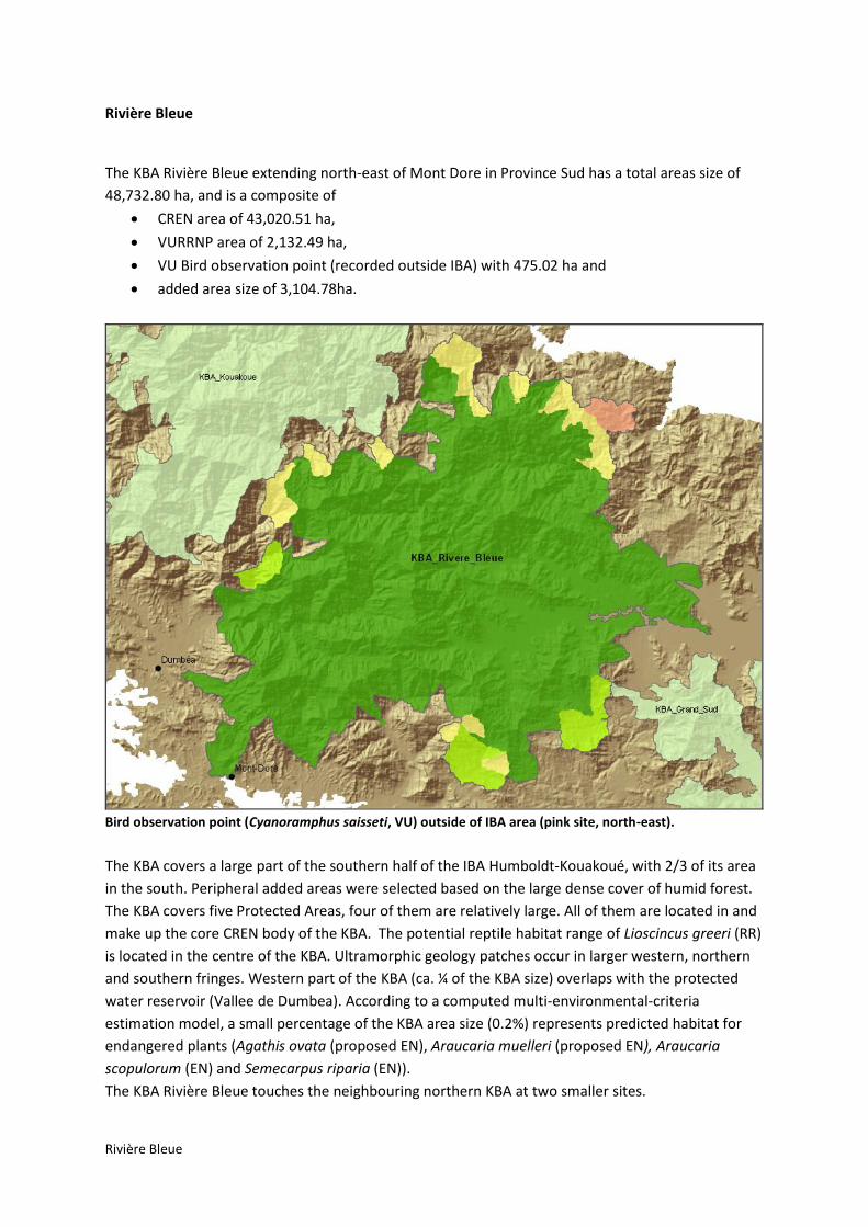
Rivière Bleue
Rivière Bleue
The KBA Rivière Bleue extending north-east of Mont Dore in Province Sud has a total areas size of
48,732.80 ha, and is a composite of
CREN area of 43,020.51 ha,
VURRNP area of 2,132.49 ha,
VU Bird observation point (recorded outside IBA) with 475.02 ha and
added area size of 3,104.78ha.
Bird observation point (Cyanoramphus saisseti, VU) outside of IBA area (pink site, north-east).
The KBA covers a large part of the southern half of the IBA Humboldt-Kouakoué, with 2/3 of its area
in the south. Peripheral added areas were selected based on the large dense cover of humid forest.
The KBA covers five Protected Areas, four of them are relatively large. All of them are located in and
make up the core CREN body of the KBA. The potential reptile habitat range of Lioscincus greeri (RR)
is located in the centre of the KBA. Ultramorphic geology patches occur in larger western, northern
and southern fringes. Western part of the KBA (ca. ¼ of the KBA size) overlaps with the protected
water reservoir (Vallee de Dumbea). According to a computed multi-environmental-criteria
estimation model, a small percentage of the KBA area size (0.2%) represents predicted habitat for
endangered plants (Agathis ovata (proposed EN), Araucaria muelleri (proposed EN), Araucaria
scopulorum (EN) and Semecarpus riparia (EN)).
The KBA Rivière Bleue touches the neighbouring northern KBA at two smaller sites.
Rivière Bleue
Species:
Group Species Redlist_Current RedList_Proposed
Birds Cyanoramphus saisseti VU
Gastropods Placostylus fibratus VU EN
Mammals Nyctophilus nebulosus CR
Plantae Acropogon chalopiniae CR
Plantae Agathis lanceolata VU
Plantae Agathis moorei VU VU
Plantae Agathis ovata EN
Plantae Araucaria bernieri VU
Plantae Araucaria biramulata VU
Plantae Araucaria humboldtensis EN
Plantae Araucaria muelleri EN
Plantae Araucaria rulei EN EN
Plantae Callitris sulcata EN EN
Plantae Canacomyrica monticola EN
Plantae Cloezia aquarum EN
Plantae Dendrobium munificum CR
Plantae Gmelina lignum-vitreum CR
Plantae Libocedrus yateensis VU EN
Plantae Litsea stenophylla EN
Plantae Medicosma leratii EN
Plantae Megastylis latissima EN
Plantae Neisosperma thiollierei CR
Plantae Neocallitropsis pancheri VU EN
Plantae Nothofagus discoidea VU
Plantae Parasitaxus usta VU
Plantae Pittosporum muricatum EN
Plantae Podocarpus beecherae EN
Plantae Podocarpus decumbens VU CR
Plantae Podocarpus longifoliolatus EN EN
Plantae Pouteria pinifolia EN
Plantae Retrophyllum minor EN CR
Plantae Solanum pseuderanthemoides CR
Plantae Stenocarpus heterophyllus EN
Plantae Tristaniopsis polyandra EN
Reptiles Graciliscincus shonae VU
Reptiles Nannoscincus mariei VU

Rivière Bleue
Group Species Redlist_Current RedList_Proposed
Reptiles Rhacodactylus ciliatus VU
Reptiles Rhacodactylus leachianus EN
Reptiles Rhacodactylus sarasinorum EN
Lithologie (1:1 Mio) % of KBA
Argilites, grès, charbons 3.68
Basaltes, dolérites 0.13
Cuirasses 3.16
Dunites 33.47
Fluvio-lacustre 2.72
Gabbros cumulats 3.06
Granite 0.88
Péridotites 50.40
Surface-Water* 2.50
*interpreted, as Geologie layer has empty records identified as surface water
Ecology/Environmental Overlap % of KBA
Ultramorphic Soil 48.34
Foret Humide 54.55
Foret Seche 0
Protected Area
(FORET DE LA THY, HAUTE POURINA, HAUTE YATE, MONTAGNE DES SOURCES,
RIVIERE BLEUE)
∑ 74.64 --
2.26; 9.13; 33.19;
11.64; 18.42
Area Capatage d’eaux (HAUTE COULEE, L' OUMBEA, MONTS KOGHIS : RIVIERE
OUANEOUE - BRANCHE NORD, RIVIERE DES LACS, ROBINSON : RIVIERE YANNA, THI - BRANCHE EST, THI - BRANCHE OUEST, VALLEE DE DUMBEA)
59.73
Landuse - Occupation du Sol (2008/96) % of KBA
Broussaille 0.02
Eau douce 1.33
Forêt sur substrat ultramafique 56.20
Forêt sur substrat volcano-sédimentaire 2.15
Mangrove clairsemée 0.0001
Maquis dense paraforestier 14.90
Maquis ligno-herbacé 16.97
Maquis minier clairsemé 0.0001
Maquis minier dense 0.0035
Savane 0.69
Sol nu sur substrat ultramafique 0.44
Sol nu sur substrat volcano-sédimentaire 0.32

Rivière Bleue
Tanne 0.0001
Végétation arbustive sur substrat volcano-sédimentaire 1.77
Végétation dense 0.05
Végétation éparse sur substrat ultramafique 4.58
Végétation éparse sur substrat volcano-sédimentaire 0.14
Zones d'habitation 0.43
Land Ownership % of KBA
ETAT FRANCAIS 0.17
NOUVELLE-CALEDONIE 52.77
PROVINCE SUD 42.10
COMMUNE 0.84
PRIVE 3.01
TERRE COUTUMIERE 0.60
NON RENSEIGNEE 0.25
Threats % of KBA 2010 % of KBA 2011
Mining (as of 2010/11)
Exploitation 0.94 0.94
Travaux de recherche et exploitation 0.46 0.46
Travaux de recherche 2.12 2.18
Pas d'activité minière 4.11 4.67
Fire Events/ Occurrence
Year span 2000 – 2010 (remotely detected) 10

Grand Sud
Grand Sud
The southernmost KBA of Grand Terre is called “Grand Sud”, and it covers a total area size of
38,676.28 ha. The KBA is composed of
CREN areas of 28,474.09 ha size,
VURRNP areas of 5,624.19 ha size (including 32.82 ha that are not covered by CREN areas)
and
added areas with 4,578.00 ha.
The area covered by VURRNP that are not covered by CREN (northern smaller purple site) represents
the observation of the plant species Tristaniopsis vieillardii (VU).
The KBA Grand Sud cover the potential reptile habitat of Lacertoides pardalis (proposed VU),
Lioscincus greeri (RR) and Bavayia goroensis (proposed EN). All eight Protected Areas are fully
included in the KBA (see listing below), including the very southern fork-shoped one (Cap N'Doua).
Four north-eastern added areas are mostly covering humid forest, and including the south-eastern
added patch share significant portions of ultramorphic substrate. The central curved sliver-like

Grand Sud
added area mainly ensures connectivity within the KBA. According to a multi-criteria modelling
computation, the KBA Grand Sud shows that 16% KBA area represent predicted habitat sites for
endangered plant species of New Caledonia suitable for Agathis ovata(proposed EN), Araucaria
muelleri (proposed EN), Araucaria nemorosa (CR), Araucaria rulei (EN), Hibbertia bouletii (proposed
CR), Hibbertia favieri (proposed CR)and Rauvolfia sevenetii (proposed CR). Apart from Hibbertia
bouletii, these plants were recorded within the KBA Grand Sud (see list below). This highlights a
significant potential for biodiversity, where ca. 6,190 ha are available for achieving conservation
targets.
Species:
Group Species Redlist_Current RedList_Proposed
Gastropods Placostylus fibratus VU EN
Gastropods Placostylus porphyrostomus VU
Plantae Agathis lanceolata VU
Plantae Agathis moorei VU VU
Plantae Agathis ovata EN
Plantae Araucaria bernieri VU
Plantae Araucaria biramulata VU
Plantae Araucaria muelleri EN
Plantae Araucaria nemorosa CR CR
Plantae Araucaria rulei EN EN
Plantae Canarium whitei CR
Plantae Cloezia aquarum EN
Plantae Cocconerion minus VU
Plantae Dacrydium guillauminii CR CR
Plantae Hibbertia favieri CR
Plantae Kentiopsis pyriformis CR
Plantae Kermadecia pronyensis VU
Plantae Leptostylis goroensis CR
Plantae Medicosma leratii EN
Plantae Neocallitropsis pancheri VU EN
Plantae Oxera macrocalyx VU
Plantae Pandanus lacuum EN
Plantae Pandanus verecundus CR
Plantae Pittosporum muricatum EN
Plantae Podocarpus beecherae EN
Plantae Pritchardiopsis jeanneneyi CR
Plantae Rauvolfia sevenetii CR
Plantae Retrophyllum minor EN CR
Plantae Tristaniopsis vieillardii VU
Plantae Tristaniopsis yateensis EN
Plantae Xylosma capillipes CR

Grand Sud
Group Species Redlist_Current RedList_Proposed
Plantae Xylosma peltatum CR
Reptiles Bavayia goroensis EN
Reptiles Graciliscincus shonae VU
Reptiles Lacertoides pardalis VU
Reptiles Rhacodactylus sarasinorum VU
Statistical Analysis:
Lithologie (1:1 Mio) % of KBA
Calcaire corallien 0.67
Cuirasses 31.63
Dunites 8.03
Fluvio-lacustre 11.52
Gabbros cumulats 0.51
Péridotites 46.17
Surface-Water* 1.33
*interpreted, as Geologie layer has empty records identified as surface water
Ecology/Environmental Overlap % of KBA
Ultramorphic Soil 46.17
Foret Humide 21.11
Protected Area
(CAP N'DOUA, CHUTES DE LA MADELEINE, FAUSSE YATE, FORET CACHEE,
FORET NORD, GRAND LAC (OUGONE), PIC DU PIN, YATE)
∑ 12.37
2.03, 1.02, 1.0, 1.59,
0.70, 0.79, 3.83, 1.40
Area Capatage d’eaux (GORO, RIVIERE DES LACS, TRIBU DE GORO : CREEK
OUENDIANA, TRIBU DE TOUAOUROU, WAHO : CREEK NICHOLAS) 37.69
Landuse - Occupation du Sol (2008/96) % of KBA
Eau douce 2.00
Eau marine 0.002
Forêt sur substrat ultramafique 28.58
Forêt sur substrat volcano-sédimentaire 0.50
Mangrove clairsemée 0.01
Mangrove dense 0.01
Maquis dense paraforestier 35.33
Maquis ligno-herbacé 25.25
Maquis minier clairsemé 0.02
Maquis minier dense 0.12
Nuages 0.002

Grand Sud
Savane 0.26
Sol nu 0.02
Sol nu de mangrove 0.001
Sol nu sur substrat ultramafique 1.87
Sol nu sur substrat volcano-sédimentaire 0.40
Tanne 0.004
Végétation arbustive sur substrat volcano-sédimentaire 0.94
Végétation dense 0.27
Végétation éparse sur substrat ultramafique 3.96
Végétation éparse sur substrat volcano-sédimentaire 0.01
Zones d'habitation 0.08
Land Ownership % of KBA
ETAT FRANCAIS 0.002
NOUVELLE-CALEDONIE 89.86
PROVINCE SUD 6.49
COMMUNE 0.02
PRIVE 1.18
TERRE COUTUMIERE 1.32
NON RENSEIGNEE 0.06
Threats % of KBA 2010 % of KBA 2011
Mining (as of 2010/11)
Exploitation 1.16 1.16
Travaux de recherche et exploitation 4.63 4.62
Travaux de recherche 28.69 28.69
Pas d'activité minière 12.16 14.72
Fire Events/ Occurrence
Year span 2000 – 2010 (remotely detected) 20

Ile des Pins
Ile des Pins
The KBA Ile des Pins covers the whole island territory of Ile des Pins (and its town Vao), is part of
Province Sud and has an area size of 15,945.37 ha. The KBA is composed of
CREN 1,550.76 ha,
VURRNP 5,650.87 ha and
added areas 8,743.17 ha.
The KBA is covered up to 60% with humid forest, mainly in the periphrial areas to the coast, and
especiallt to in the west and south (including the southern islands). The KBA also covers the only
protected water water reservoir of Ile des Pins (Kuto et Vao : Creek Galilee et Soucres de la
Wouintureu). At the coast in the south west, the plant Meryta sonchifolia (VU) has been observed,
being the only confirmed site where this plant has been recorded in New Caledonia.
Species:

Ile des Pins
Group Species Redlist_Current RedList_Proposed
Gastropods Placostylus fibratus VU EN
Gastropods Placostylus porphyrostomus VU
Plantae Acropogon bullatus VU
Plantae Baloghia pininsularis EN
Plantae Bocquillonia arborea EN
Plantae Callitris sulcata EN EN
Plantae Cyclophyllum tenuipes VU
Plantae Justicia pinensis EN
Plantae Melodinus insulaepinorum EN
Plantae Meryta sonchifolia VU
Plantae Neocallitropsis pancheri VU EN
Plantae Pouteria brevipedicellata EN
Plantae Sarcomelicope glauca CR
Plantae Serianthes germainii EN
Plantae Xylosma pininsulare CR
Reptiles Rhacodactylus ciliatus VU
Reptiles Rhacodactylus leachianus EN
Statistical Analysis:
Lithologie (1:1 Mio) % of KBA
Calcaire corallien 69.48
Cuirasses 18.15
Dunites 9.81
Gabbros cumulats 0.97
Ecology/Environmental Overlap % of KBA
Foret Humide 58.31
Foret Seche 0
Area Capatage d’eaux (KUTO ET VAO : CREEK GALILEE ET SOUCRES DE LA WOUINTUREU, KUTO PPR, PPE de OUATCHIA DEGOTCHE TOUET)
7.24
Landuse - Occupation du Sol (2008/96) % of KBA
Eau 0.0046
Eau douce 0.37
Forêt sur substrat ultramafique 5.38
Ile des Pins
Forêt sur substrat volcano-sédimentaire 59.24
Mangrove clairsemée 0.01
Mangrove dense 0.48
Maquis dense paraforestier 11.70
Maquis ligno-herbacé 9.71
Savane 5.73
Sol nu 0.0007
Sol nu de mangrove 0.0003
Sol nu sur substrat ultramafique 0.58
Sol nu sur substrat volcano-sédimentaire 0.45
Végétation arbustive sur substrat volcano-sédimentaire 4.31
Végétation éparse sur substrat ultramafique 0.67
Végétation éparse sur substrat volcano-sédimentaire 0.50
Zones d'habitation 0.87
Land Ownership % of KBA
ETAT FRANCAIS 0.04
NOUVELLE-CALEDONIE 0.01
PROVINCE SUD 7.63
COMMUNE 0.003
PRIVE 0.75
TERRE COUTUMIERE 88.78
NON RENSEIGNEE 0.75
Threats % of KBA
No Mining records (as of 2010) –
Fire Events/ Occurrence
Year span 2000 – 2010 (remotely detected) 14

Lifou
Lifou
The KBA Lifou, situated north of the town Wé, is part of the Province des Iles Loyauté and has a total
area size of 113,754.90 ha, consisting of
CREN 4,963.00 ha,
VURRNP 164.29 ha and
added areas 108,627.61 ha.
The KBA Lifou covers the entire area of Ile Lifou.
The IBA Lifou covers the northern half of the island Lifou, and is part of the KBA. Most of the KBA
delineation includes added areas based on the high density of primary humid forest. Most of the
KBA is covered by humid forest (94%). Three sites of Miniopterus robustior (EN) are triggering CREN
areas, and the palm tree species Cyphophoenix nucele (CR) which is endemic to Lifou Island and of
very high conservation relevance.

Lifou
Species:
Group Species Redlist_Current RedList_Proposed
Gastropods Placostylus fibratus VU EN
Mammals Miniopterus robustior EN
Plantae Acropogon veillonii EN
Plantae Cyphophoenix nucele CR
Plantae Tephrosia leratiana EN
Lithologie (1:1 Mio) % of KBA
Calcaire corallien 65.24
Calcaires à rhodolites 34.48
Ecology/Environmental Overlap % of KBA
Foret Humide 91.81
Landuse - Occupation du Sol (2008/96) % of KBA
Forêt sur substrat volcano-sédimentaire 92.12
Savane 0.83
Sol nu sur substrat volcano-sédimentaire 0.13
Végétation arbustive sur substrat volcano-sédimentaire 4.08
Végétation éparse sur substrat volcano-sédimentaire 0.07
Zones d'habitation 1.40
Zones sombres (non interprétables) 0.44
Landownership information was not available.
Threats % of KBA
No Mining records (as of 2010) –
Fire Events/ Occurrence
Year span 2000 – 2010 (remotely detected) 3

Ouvéa
Ouvéa
The KBA Ouvéa, in Province des Iles Loyauté, has an area size of 13,417.33 ha, and follows the
delineation of the IBA Ouvéa. Fragment Islets west of it are not part of the KBA. All KBA area is CREN,
there are no sites assigned as VURRNP only, neither added areas.
The KBA has a large percentage of himud forest cover (71%). Main CREN trigger is the Bird Uvea
Parakeet, Eunymphicus uvaeensis (EN).
Species:
Group Species Redlist_Current RedList_Proposed
Birds Eunymphicus uvaeensis EN
Gastropods Placostylus fibratus VU EN
Statistical Assessment:
Lithologie (1:1 Mio) % of KBA
Calcaire corallien 98.51

Ouvéa
Ecology/Environmental Overlap % of KBA
Foret Humide 71.25
Foret Seche 0
Landuse - Occupation du Sol (2008/96) % of KBA
Eau douce 0.14
Eau marine 0.02
Forêt sur substrat volcano-sédimentaire 75.23
Mangrove clairsemée 0.11
Mangrove dense 0.23
Nuages 0.37
Savane 0.25
Sol nu sur substrat volcano-sédimentaire 0.27
Végétation arbustive sur substrat volcano-sédimentaire 20.67
Zones d'habitation 1.72
Zones sombres (non interprétables) 0.97
Landownership information was not available.
Threats % of KBA
No Mining records (as of 2010) –
Fire Events/ Occurrence
Year span 2000 – 2010 (remotely detected) 1

ANNEX

Annex I – List of Species (CR/EN) - Confirmed KBAs
List of threatened species (CR/EN) within confirmed KBAs is shown below.
Group Species Redlist_Current RedList_Proposed
Birds Eunymphicus uvaeensis EN
Birds Gymnomyza aubryana CR
Birds Rhynochetos jubatus EN
Gastropods Placostylus bondeensis CR
Gastropods Placostylus caledonicus CR
Gastropods Placostylus eddystonensis VU CR
Gastropods Placostylus fibratus VU EN
Mammals Miniopterus robustior EN
Mammals Nyctophilus nebulosus CR
Plantae Acropogon bosseri EN
Plantae Acropogon chalopiniae CR
Plantae Acropogon jaffrei EN
Plantae Acropogon margaretae CR
Plantae Acropogon merytifolius CR
Plantae Acropogon veillonii EN
Plantae Agathis ovata EN
Plantae Ancistrachne numaeensis EN EN
Plantae Araucaria humboldtensis EN
Plantae Araucaria luxurians EN EN
Plantae Araucaria muelleri EN
Plantae Araucaria nemorosa CR CR
Plantae Araucaria rulei EN EN
Plantae Araucaria scopulorum EN EN
Plantae Baloghia pininsularis EN
Plantae Beauprea congesta EN
Plantae Beauprea penariensis EN
Plantae Bikkia kaalaensis EN
Plantae Bikkia lenormandii EN
Plantae Bocquillonia arborea EN
Plantae Bocquillonia castaneifolia EN
Plantae Bocquillonia longipes EN
Plantae Callitris sulcata EN EN
Plantae Canacomyrica monticola EN
Plantae Canarium whitei CR
Plantae Captaincookia margaretae CR
Plantae Casearia kaalaensis EN
Plantae Cassia artensis EN

Group Species Redlist_Current RedList_Proposed
Plantae Cassine brachycremastra EN
Plantae Celtis hypoleuca EN
Plantae Cerberiopsis neriifolia EN
Plantae Cloezia aquarum EN
Plantae Codiaeum oligogynum EN
Plantae Croton cordatulus EN
Plantae Cupaniopsis rosea EN
Plantae Cupaniopsis squamosa EN
Plantae Cupaniopsis subfalcata EN
Plantae Cupaniopsis tontoutensis EN
Plantae Cyphophoenix nucele CR
Plantae Dacrydium guillauminii CR CR
Plantae Deltaria brachyblastophora CR
Plantae Dendrobium munificum CR
Plantae Diospyros erudita EN
Plantae Dracophyllum alticola EN
Plantae Dysoxylum pachypodum CR
Plantae Elaeocarpus kaalensis EN
Plantae Gmelina lignum-vitreum CR
Plantae Hemigraphis neocaledonica EN
Plantae Hibbertia favieri CR
Plantae Hibbertia margaretae CR
Plantae Hibbertia rubescens CR
Plantae Homalium betulifolium EN
Plantae Homalium juxtapositum EN
Plantae Homalium mathieuanum EN
Plantae Homalium polystachyum EN
Plantae Homalium rubrocostatum EN
Plantae Hunga cordata EN
Plantae Iteiluma pinifolium EN
Plantae Justicia pinensis EN EN
Plantae Kentiopsis oliviformis EN
Plantae Kentiopsis pyriformis CR
Plantae Lasiochlamys hurlimannii EN
Plantae Lavoixia macrocarpa CR
Plantae Leptostylis goroensis CR
Plantae Libocedrus chevalieri EN CR
Plantae Libocedrus yateensis VU EN
Plantae Litsea imbricata EN
Plantae Litsea stenophylla EN
Plantae Logania imbricata EN

Group Species Redlist_Current RedList_Proposed
Plantae Macadamia angustifolia EN
Plantae Medicosma articulata EN
Plantae Medicosma congesta EN
Plantae Medicosma exigua EN
Plantae Medicosma gracilis EN
Plantae Medicosma leratii EN
Plantae Medicosma petiolaris EN
Plantae Medicosma suberosa EN
Plantae Medicosma subsessilis EN
Plantae Medicosma tahafeana EN
Plantae Megastylis latissima EN
Plantae Megastylis paradoxa EN
Plantae Melodinus insulaepinorum EN
Plantae Metrosideros tetrasticha EN
Plantae Myricanthe discolor EN
Plantae Neisosperma sevenetii EN
Plantae Neisosperma thiollierei CR
Plantae Neocallitropsis pancheri VU EN
Plantae Oryza neocaledonica EN EN
Plantae Oxanthera neocaledonica EN
Plantae Oxanthera undulata CR
Plantae Pandanus lacuum EN
Plantae Pandanus verecundus CR
Plantae Phyllanthus baraouaensis EN
Plantae Phyllanthus fractiflexus EN
Plantae Phyllanthus jaubertii CR
Plantae Phyllanthus mcphersonii EN
Plantae Phyllanthus paucitepalus EN
Plantae Phyllanthus petchikaraensis EN
Plantae Phyllanthus pindaiensis CR CR
Plantae Phyllanthus stenophyllus EN
Plantae Phyllanthus unifoliatus EN CR
Plantae Pittosporum aliferum EN
Plantae Pittosporum brevispinum EN
Plantae Pittosporum muricatum EN
Plantae Pittosporum ornatum EN
Plantae Planchonella contermina EN
Plantae Planchonella kaalaensis EN
Plantae Planchonella koumaciensis EN
Plantae Podocarpus beecherae EN
Plantae Podocarpus decumbens VU CR

Group Species Redlist_Current RedList_Proposed
Plantae Podocarpus longefoliolatus EN
Plantae Podocarpus polyspermus VU EN
Plantae Pouteria brevipedicellata EN
Plantae Pouteria danikeri EN
Plantae Pouteria pinifolia EN
Plantae Pritchardiopsis jeanneneyi CR
Plantae Rauvolfia sevenetii CR
Plantae Retrophyllum minor EN CR
Plantae Sarcomelicope glauca CR
Plantae Scaevola macropyrena EN
Plantae Schefflera veitchii EN
Plantae Semecarpus riparia EN
Plantae Serianthes germainii EN
Plantae Solanum hugonis EN EN
Plantae Solanum pseuderanthemoides CR
Plantae Stenocarpus heterophyllus EN
Plantae Stenocarpus villosus CR
Plantae Styphelia violaceospicata EN
Plantae Tephrosia leratiana EN
Plantae Tristaniopsis polyandra EN
Plantae Tristaniopsis yateensis EN
Plantae Vitex evoluta EN
Plantae Xanthostemon francii EN
Plantae Xanthostemon longipes EN
Plantae Xylosma capillipes CR
Plantae Xylosma grossecrenatum EN
Plantae Xylosma inaequinervium EN
Plantae Xylosma peltatum CR
Plantae Xylosma pininsulare CR
Plantae Zygogynum oligostigma EN
Reptiles Bavayia exsuccida EN
Reptiles Bavayia goroensis EN
Reptiles Bavayia ornata EN
Reptiles Caledoniscincus chazeaui EN
Reptiles Caledoniscincus orestes EN
Reptiles Celatiscincus similis EN
Reptiles Dierogekko inexpectatus CR
Reptiles Dierogekko kaalaensis CR
Reptiles Dierogekko koniambo CR
Reptiles Dierogekko nehoueensis CR
Reptiles Dierogekko poumensis CR

Group Species Redlist_Current RedList_Proposed
Reptiles Dierogekko thomaswhitei CR
Reptiles Dierogekko validiclavis EN
Reptiles Eurydactylodes symmetricus EN
Reptiles Kanakysaurus viviparus EN
Reptiles Kanakysaurus zebratus EN
Reptiles Lioscincus maruia EN
Reptiles Lioscincus steindachneri EN
Reptiles Lioscincus vivae CR
Reptiles Marmorosphax kaala CR
Reptiles Marmorosphax taom CR
Reptiles Nannoscincus exos CR
Reptiles Nannoscincus hanchisteus CR
Reptiles Nannoscincus humectus EN
Reptiles Nannoscincus manautei CR
Reptiles Oedodera marmorata CR
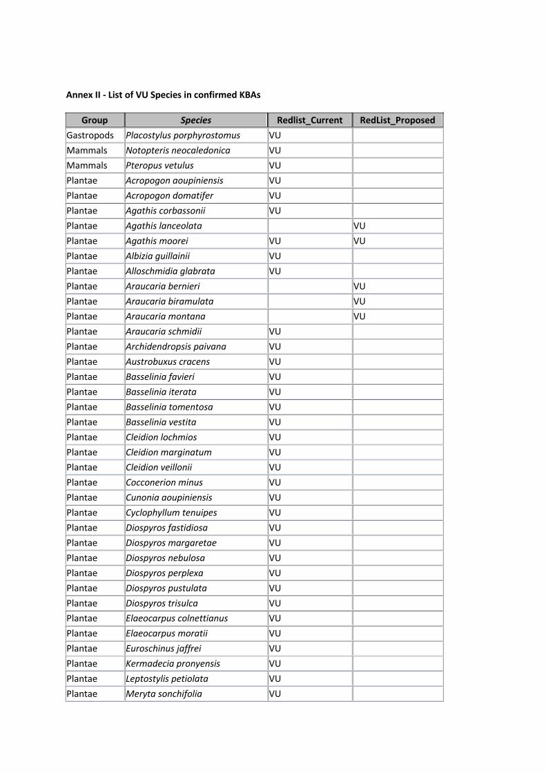
Annex II - List of VU Species in confirmed KBAs
Group Species Redlist_Current RedList_Proposed
Gastropods Placostylus porphyrostomus VU
Mammals Notopteris neocaledonica VU
Mammals Pteropus vetulus VU
Plantae Acropogon aoupiniensis VU
Plantae Acropogon domatifer VU
Plantae Agathis corbassonii VU
Plantae Agathis lanceolata VU
Plantae Agathis moorei VU VU
Plantae Albizia guillainii VU
Plantae Alloschmidia glabrata VU
Plantae Araucaria bernieri VU
Plantae Araucaria biramulata VU
Plantae Araucaria montana VU
Plantae Araucaria schmidii VU
Plantae Archidendropsis paivana VU
Plantae Austrobuxus cracens VU
Plantae Basselinia favieri VU
Plantae Basselinia iterata VU
Plantae Basselinia tomentosa VU
Plantae Basselinia vestita VU
Plantae Cleidion lochmios VU
Plantae Cleidion marginatum VU
Plantae Cleidion veillonii VU
Plantae Cocconerion minus VU
Plantae Cunonia aoupiniensis VU
Plantae Cyclophyllum tenuipes VU
Plantae Diospyros fastidiosa VU
Plantae Diospyros margaretae VU
Plantae Diospyros nebulosa VU
Plantae Diospyros perplexa VU
Plantae Diospyros pustulata VU
Plantae Diospyros trisulca VU
Plantae Elaeocarpus colnettianus VU
Plantae Elaeocarpus moratii VU
Plantae Euroschinus jaffrei VU
Plantae Kermadecia pronyensis VU
Plantae Leptostylis petiolata VU
Plantae Meryta sonchifolia VU

Group Species Redlist_Current RedList_Proposed
Plantae Metrosideros punctata VU
Plantae Neisosperma brevituba VU
Plantae Nothofagus discoidea VU
Plantae Oxera macrocalyx VU
Plantae Pandanus decastigma VU
Plantae Parasitaxus usta VU
Plantae Pittosporum collinum VU
Plantae Pittosporum gatopense VU
Plantae Pittosporum paniense VU
Plantae Pycnandra kaalaensis VU
Plantae Sloanea lepida VU
Plantae Sloanea suaveolens VU
Plantae Tristaniopsis vieillardii VU
Reptiles Graciliscincus shonae VU
Reptiles Lacertoides pardalis VU
Reptiles Marmorosphax boulinda VU
Reptiles Nannoscincus gracilis VU
Reptiles Nannoscincus mariei VU
Reptiles Nannoscincus rankini VU
Reptiles Rhacodactylus chahoua VU
Reptiles Rhacodactylus ciliatus VU
Reptiles Rhacodactylus sarasinorum VU
Reptiles Tropidoscincus aubrianus VU

Annex III - Endangered Species in Candidate KBAs
Candidate KBAs
Group Species RedList_Current RedList_Proposed
Gastropods Placostylus bondeensis CR
Gastropods Placostylus caledonicus CR
Gastropods Placostylus eddystonensis VU CR
Gastropods Placostylus fibratus VU EN
Gastropods Placostylus porphyrostomus VU
Gastropods Placostylus scarabus CR
Mammals Miniopterus robustior EN
Plantae Acropogon jaffrei EN
Plantae Acropogon veillonii EN
Plantae Agathis lanceolata VU
Plantae Agathis moorei VU VU
Plantae Agathis ovata EN
Plantae Albizia guillainii VU
Plantae Alphandia resinosa EN
Plantae Ancistrachne numaeensis EN EN
Plantae Araucaria biramulata VU
Plantae Araucaria humboldtensis EN
Plantae Araucaria luxurians EN EN
Plantae Araucaria muelleri EN
Plantae Araucaria rulei EN EN
Plantae Araucaria scopulorum EN EN
Plantae Bocquillonia castaneifolia EN
Plantae Callitris sulcata EN EN
Plantae Canacomyrica monticola EN
Plantae Canarium whitei CR
Plantae Canavalia favieri CR CR
Plantae Canavalia veillonii CR
Plantae Captaincookia margaretae CR
Plantae Cassine brachycremastra EN
Plantae Cleidion lochmios VU
Plantae Cloezia aquarum EN
Plantae Codiaeum oligogynum EN
Plantae Cupaniopsis mouana EN
Plantae Cyrtandra mareensis EN
Plantae Dendrobium munificum CR

Group Species RedList_Current RedList_Proposed
Plantae Diospyros neglecta EN
Plantae Diospyros pustulata VU
Plantae Diospyros veillonii CR
Plantae Dysoxylum pachypodum CR
Plantae Eugenia noumeensis VU
Plantae Homalium betulifolium EN
Plantae Homalium buxifolium EN
Plantae Homalium mathieuanum EN
Plantae Hunga mackeeana VU
Plantae Jasminum noumeense VU EN
Plantae Justicia pinensis EN EN
Plantae Leptostylis gatopensis EN
Plantae Medicosma latifolia EN
Plantae Medicosma leratii EN
Plantae Megastylis latissima EN
Plantae Melodinus insulaepinorum EN
Plantae Myricanthe discolor EN
Plantae Neocallitropsis pancheri VU EN
Plantae Ochrosia inventorum CR CR
Plantae Oxanthera fragrans EN
Plantae Phyllanthus conjugatus EN
Plantae Phyllanthus golonensis EN
Plantae Phyllanthus natoensis EN
Plantae Phyllanthus pinjenensis EN
Plantae Phyllanthus rozennae EN
Plantae Phyllanthus unifoliatus EN CR
Plantae Phyllanthus veillonii EN
Plantae Pittosporum artense VU
Plantae Pittosporum collinum VU
Plantae Pittosporum muricatum EN
Plantae Pittosporum tanianum CR
Plantae Planchonella contermina EN
Plantae Podocarpus beecherae EN
Plantae Podocarpus longefoliolatus EN
Plantae Schefflera veitchii EN
Plantae Semecarpus riparia EN
Plantae Solanum hugonis EN EN
Plantae Stenocarpus heterophyllus EN
Plantae Tephrosia leratiana EN
Plantae Terminalia cherrieri EN
Plantae Trigonostemon cherrieri CR

Group Species RedList_Current RedList_Proposed
Plantae Tristaniopsis polyandra EN
Plantae Xanthostemon glaucus CR
Plantae Xanthostemon lateriflorus EN
Plantae Xanthostemon longipes EN
Plantae Zygogynum oligostigma EN
Reptiles Caledoniscincus auratus EN
Reptiles Dierogekko koniambo CR
Reptiles Dierogekko poumensis CR
Reptiles Eurydactylodes occidentalis CR
Reptiles Kanakysaurus viviparus EN
Reptiles Rhacodactylus chahoua VU

Annex IV - List of CREN Species within the Candidate KBAs that are not in confirmed KBAs
Group species RedList_Current RedList_Proposed
Gastropods Placostylus scarabus CR
Plantae Alphandia resinosa EN
Plantae Canavalia favieri CR CR
Plantae Canavalia veillonii CR
Plantae Cupaniopsis mouana EN
Plantae Cyrtandra mareensis EN
Plantae Diospyros neglecta EN
Plantae Diospyros veillonii CR
Plantae Homalium buxifolium EN
Plantae Jasminum noumeense VU EN
Plantae Leptostylis gatopensis EN
Plantae Medicosma latifolia EN
Plantae Ochrosia inventorum CR CR
Plantae Oxanthera fragrans EN
Plantae Phyllanthus conjugatus EN
Plantae Phyllanthus golonensis EN
Plantae Phyllanthus natoensis EN
Plantae Phyllanthus pinjenensis EN
Plantae Phyllanthus rozennae EN
Plantae Phyllanthus veillonii EN
Plantae Pittosporum tanianum CR
Plantae Terminalia cherrieri EN
Plantae Trigonostemon cherrieri CR
Plantae Xanthostemon glaucus CR
Plantae Xanthostemon lateriflorus EN
Reptiles Caledoniscincus auratus EN
Reptiles Eurydactylodes occidentalis CR

Annex V- List of VURRNP species not in Confirmed KBAs
Group Species RedList_Current RedList_Proposed RR
Plantae Cyphophoenix elegans VU RR
Plantae Diospyros impolita VU RR
Plantae Dutaillyea amosensis VU RR
Plantae Eugenia noumeensis VU RR
Plantae Hunga mackeeana VU RR
Plantae Ochrosia grandiflora VU RR
Plantae Pittosporum artense VU RR
Annex VI - List VURRNP species not covered by CREN sites
Group Species RedList_Currernt RedList_Proposed RR
Fish Cestraeus oxyrhynchus
Fish Cestraeus plicatilis
Plantae Cyphophoenix elegans VU RR
Plantae Diospyros impolita VU RR
Plantae Diospyros trisulca VU RR
Plantae Dutaillyea amosensis VU RR
Plantae Eugenia ericoides RR
Plantae Meryta sonchifolia VU RR
Plantae Ochrosia grandiflora VU RR
Plantae Pandanus decastigma VU RR
Plantae Tristaniopsis vieillardii VU RR
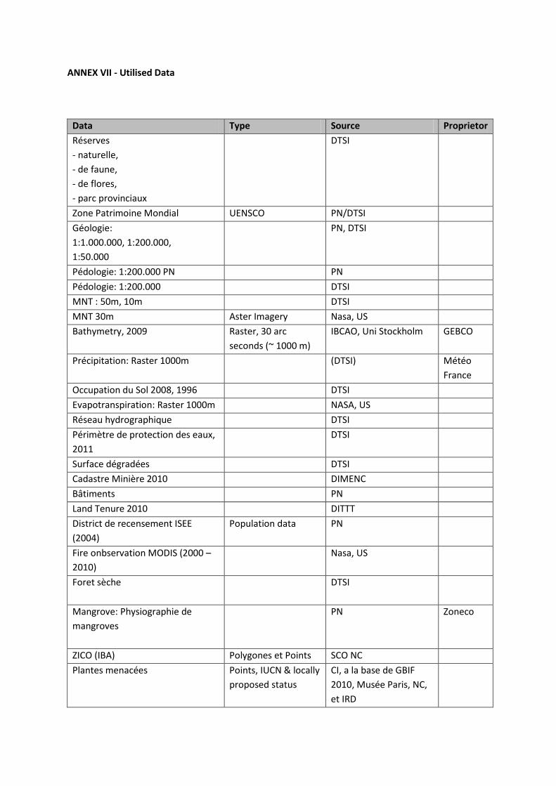
ANNEX VII - Utilised Data
Data Type Source Proprietor
Réserves
- naturelle,
- de faune,
- de flores,
- parc provinciaux
DTSI
Zone Patrimoine Mondial UENSCO PN/DTSI
Géologie:
1:1.000.000, 1:200.000,
1:50.000
PN, DTSI
Pédologie: 1:200.000 PN PN
Pédologie: 1:200.000 DTSI
MNT : 50m, 10m DTSI
MNT 30m Aster Imagery Nasa, US
Bathymetry, 2009 Raster, 30 arc
seconds (~ 1000 m)
IBCAO, Uni Stockholm GEBCO
Précipitation: Raster 1000m (DTSI) Météo
France
Occupation du Sol 2008, 1996 DTSI
Evapotranspiration: Raster 1000m NASA, US
Réseau hydrographique DTSI
Périmètre de protection des eaux,
2011
DTSI
Surface dégradées DTSI
Cadastre Minière 2010 DIMENC
Bâtiments PN
Land Tenure 2010 DITTT
District de recensement ISEE
(2004)
Population data PN
Fire onbservation MODIS (2000 –
2010)
Nasa, US
Foret sèche DTSI
Mangrove: Physiographie de
mangroves
PN Zoneco
ZICO (IBA) Polygones et Points SCO NC
Plantes menacées Points, IUCN & locally
proposed status
CI, a la base de GBIF
2010, Musée Paris, NC,
et IRD
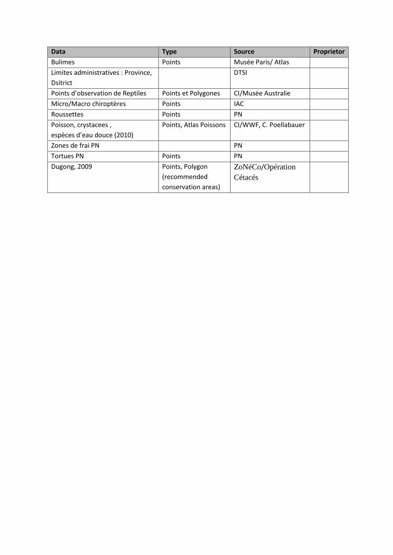
Data Type Source Proprietor
Bulimes Points Musée Paris/ Atlas
Limites administratives : Province,
Dsitrict
DTSI
Points d’observation de Reptiles Points et Polygones CI/Musée Australie
Micro/Macro chiroptères Points IAC
Roussettes Points PN
Poisson, crystacees ,
espèces d’eau douce (2010)
Points, Atlas Poissons CI/WWF, C. Poellabauer
Zones de frai PN PN
Tortues PN Points PN
Dugong, 2009 Points, Polygon
(recommended
conservation areas)
ZoNéCo/Opération
Cétacés

References
Bouchet P.H., Jaffré T. and Veillon, J. M. 1995. Plant extinction in New Caledonia: protection of
sclerophyll forests urgently needed. Biodiversity and Conservation 4: 415-428.
Conseil économique et social de la Nouvelle Calédonie 2008, Synthèse des Assises de l’eau
Conservation Iinternational/IUCN Workshop, February 2010, Global Reptile Assessment Workshop
for New Caledonia, held from 1st to 5th February 2010 in Noumea, NC
DDEE Province Nord, 2009, Code de l’Environment, Editon 2009, Gourvernement Nouvelle Calédonie
DENV Province Sud, 2009, Code de l’Environment, Editon 2009, Gourvernement Nouvelle Calédonie
Cowling, R.M., Pressey, R.L., Rouget, M., Lombard, A.T., 2003. A conservation plan for a global
biodiversity hotspot – the Cape Floristic Region, South Africa. Biological Conservation 112 (2003), p.
191-216
Duke, N.c., A Brief Account of the Mangroves of New Caledonia, Interim report, 2007, University of
Queensland, Brisbane, QLD Australia
Eike Neubert, Corinne Cherl-Mora and Phillipe Bouchet, 2009. Bulimes. Museum National d'Histoire
Naturelle, Paris, in: Zoologia Neocaledonica 7, publication scientifique du Museum, 2009
Fabrice M. Brescia, Christine Pöllabauer, Murray A. Potter, Alastair W. Robertson, 2007, A review of
the ecology and conservation of Placostylus (Mollusca: Gastropoda: Bulimulidae) in New Caledonia,
Molluscan Research 28(2): 111–122
Foret Seche Programme, (2010), http://www.foretseche.nc, accessed on 22nd April 2010.
Gabrié, C., Bouvet, G., Chevillon, C., Cros, A., December 2008. Analyse écorégionale marine de la
Nouvelle-Calédonie, 1A1 Stratégie de conservation de la biodiversité marine, CRISP
Giglio, L., MODIS Collection 5 Active Fire Product User's Guide Version 2., 2010, Science Systems and
Applications, Inc. University of Maryland, Department of Geography
Gillespie, T.W. and Jaffré, T. 2003. Tropical dry forests of New Caledonia. Biodiversity and
Conservation 12: 1687-1697.
Jaffré, T., Munzinger, J., Lowry, P.P., 02/2010. “Threats to the conifer species found on New
Caledonia’s ultramafic massifs and proposals for urgently needed measures to improve their
protection”, Biodiversity Conservation, Vol 19, No 5, p. 1485-1502, Springer Verlag
Jerome Spaggiari, 03/2010. Document de travail: “Informations écologiques recueillies sur les
espèces de plantes néocalédoniennes considérées comme EN ou CR”, in: Notes sur les espèces
cartographiées - draft transmis.pdf

Jerôme Spaggiari, Vivien Chartendrault, Nicols Barré, 03/2007. Zones importantes pour la
conservation des oiseaux de Nouvelle-Calédonie, Société calédonienne d’ornithologie, Bird Life
International.
Langhammer, P.F., Bakarr,M.I., Bennun, L.A., Brooks, T.M., Clay, R.P., Darwall,W., De Silva, N., Edgar,
G.J., Eken, G., Fishpool, L.D.C.,3 Fonseca, G.A.B. da, Foster, M.N., Knox, D.H., Matiku, P., Radford,
E.A., Rodrigues, A.S.L., Salaman, P., Sechrest, W., and Tordoff, A.W. (2007). Identification and Gap
Analysis of Key Biodiversity Areas: Targets for Comprehensive Protected Area Systems. Gland,
Switzerland: IUCN.
Marguels, C. and Sakar, S. (2007). Systematic Conservation Planning, Cambridge University Press,
Cambridge
Marquet, G., Keith, P., Vignieux, E., 2003. Atlas des poissons et des crustacés d’eau douce de
Nouvelle Calédonie, Patrimoines Naturels, 58.
McKenna S.A., Draft paper for Rapid Marine Biodiversity Assessment No.62 (for eastern Lagoons,
New Caledonia), Conservation International
Pöllabauer, Chrstine, 2010, Bureau d’Etudes et de Recherches biologiques, Information des espèce
de poisson/qualité des rivières, Noumea.
Pierson E. D. and Rainey W. E.,1992. The biology of flying foxes of the genus Pteropus: a review.
Biological report 90 (23). 17 pp
Sanborn and Nicholson, 1950. "Bats from New Caledonia, the Solomons Islands, and New Hebrides."
Fieldiana Zoology 31(36): 313-338.
World Heritage Nomination – IUCN Technical Evaluation, 2008. The Lagoons of New Caledonia: Reef
Diversity and Associated Ecosystems (France) – ID No. 1115, IUCN Evaluation Report May 2008
ZoNéCo, 2006. Mangrove Atlas, New Caledonia

NEW CALEDONIA ECOSYSTEM PROFILE WORKING GROUP
The New Caledonia Ecosystem Profile Working group, facilitated by the Government of New
Caledonia, brings together the three provincial communities, NGOs and the scientific community. It
aims to develop tools for decision support to identify priority intervention on remarkable areas and
species of terrestrial, marine and freshwater ecosystems.