del mar mesa - san diego · the del mar mesa specific plan (plan) is the city of san diego's...
TRANSCRIPT
- i -
Del Mar MesaDel Mar MesaSpecific Plan
Prepared byCity of San Diego Planning Department
202 C Street, MS 4ASan Diego, CA 92101
Printed on recycled paper.
This information, or this document (or portions thereof), will be made available in alternative formats upon request.

- ii -
DEL MAR MESA SPECIFIC PLAN
The following amendments have been incorporated into this March 2006 posting of this Plan:
AmendmentDate Approved by
Planning CommissionResolutionNumber
Date Adoptedby City Council
ResolutionNumber
Del Mar MesaSpecific PlanAdopted
April 20, 2000 — June 27, 2000 O-18821
Certified by the California Coastal Commission September 13, 2000

- iii -
MAYORSusan Golding
COUNCILHarry Mathis Byron Wear Christine KehoeGeorge StevensBarbara WardenValerie StallingsJudy McCartyJuan Carlos Vargas
CITY ATTORNEYCasey GwinnRichard A Duvernay, Deputy City Attorney
CITY MANAGERMichael Uberuaga
PLANNING COMMISSIONMark Steele, ChairpersonWilliam Anderson, Vice ChairpersonPatricia ButlerGeralda StrykerAndrea SkorepaFrisco WhiteDavid WatsonBruce Brown
PLANNING and DEVELOPMENT REVIEWKurt Chilcott, Planning and Development Review ManagerErnest Freeman, AICP, Comprehensive Planning DirectorJeff Washington, Neighborhood Development ManagerTom Story, Deputy Director, Multiple Species Conservation Program (MSCP)
Specific PlanRachel Hurst, AICP, Principal PlannerLinda Lowe, Senior Planner/Project ManagerTom Romstad, Associate PlannerContributions by: Gary Hess, Steve Mikelman, Cathy Winterrowd, Miriam Kirshner,Anna McPherson, Latitude 33, Gallegos & Associates, Rick Planning Group
Transportation Study and Circulation ElementSiavash Pazargadi, P. E. Senior Traffic EngineerShahriar T. Ammi, Associate Engineer - TrafficYih Ruey Chang, Assistant Engineer - TrafficMary Allen, Word Processing
- iv -
DEVELOPMENT SERVICESCathy Winterrowd, Senior Planner/EIR Project ManagerSandra Cleisz, Associate Planner/MSCPKeith Greer, Associate Planner, MSCPHolly Smit, Associate Planner, MSCP
SUPPORT SERVICES
Graphic DesignMarilyn Millikan, Graphic Design SupervisorLisa Goehring, Graphic DesignerSam Riordan, Graphic Designer
MappingLeo de Jesus, Principal Engineering AideJanet Atha, Senior Drafting Aide
Word ProcessingLavigne Hill, Clerical Assistant II

- v -
I. INTRODUCTION
A. Purpose of the Plan..........................................................................................................................3B. Plan Organization ............................................................................................................................3
II. PLANNING CONTEXT
A. Plan Area .........................................................................................................................................7B. Planning History and Regulatory Framework..............................................................................13
III. ELEMENTS OF THE SPECIFIC PLAN
A. Land Use........................................................................................................................................19B. Multiple Species Conservation Program (MSCP)/Open Space...................................................25C. Community Facilities .................................................................................................................... 38D. Circulation .....................................................................................................................................45E. Community Design Guidelines.....................................................................................................64F. Coastal Element.............................................................................................................................71
IV. IMPLEMENTATION
A. Relationship with the Framework Plan and General Plan ...........................................................75B. Further California Environmental Quality Act Review...............................................................75C. Zoning............................................................................................................................................76D. Supplemental Development Regulations......................................................................................78E. Environmentally Sensitive Lands Regulations and the Del Mar Mesa Specific
Plan Regulations............................................................................................................................88F. Supplemental Regulations for Resource Management ................................................................91G. Facilities Financing and Fees........................................................................................................97H. Open Space Acquisition Program.................................................................................................99I. Transportation Phasing................................................................................................................100
Table 1. Land Use ....................................................................................................................................20
Table 2. Del Mar Mesa-Land Use Acreages ...........................................................................................21
Table 3. Dwelling Unit Allocation ..........................................................................................................22
Table 4. Open Space Summary................................................................................................................29
Table 5. Publicly-Owned Open Space Summary....................................................................................30
Table 6. Projected Student Generation ....................................................................................................35
Table 7. Land Use Assumptions and Trip Generation............................................................................49
Table 8. AR-1-1 Zone Development Regulations for Del Mar Mesa ....................................................77
Table 9. Distribution of Daily Trips by Development on Carmel Country Road for Phase 1 ............103
Table 10. Phase 1 Development Threshold for Del Mar Mesa Road.....................................................103
Table 11. Transportation Phasing Plan for Del Mar ...............................................................................110

- vi -
Figure 1. Regional Vicinity ..................................................................................................................... 2
Figure 2. Surrounding Communities ....................................................................................................... 6
Figure 3. Aerial Photograph..................................................................................................................... 8
Figure 4. NCFUA Framework Plan....................................................................................................... 12
Figure 5. Land Use................................................................................................................................. 18
Figure 6. Multiple Habitat Boundaries.................................................................................................. 28
Figure 7. Open Space ............................................................................................................................. 28
Figure 8. Elementary School District Boundaries ................................................................................ 36
Figure 9. Backbone Water ..................................................................................................................... 40
Figure 10. Backbone Sewer ..................................................................................................................... 42
Figure 11. Conceptual Drainage .............................................................................................................. 44
Figure 12. Existing Conditions ................................................................................................................ 56
Figure 13. Traffic Forecast and Street Classifications............................................................................ 48
Figure 14. Lane Configurations at Signalized Intersections................................................................... 50
Figure 15. Circulation .............................................................................................................................. 52
Figure 16. Residential Local Street and Del Mar Mesa Road ................................................................ 54
Figure 17. Two-Lane Collector ............................................................................................................... 56
Figure 18. Two-Lane Modified Collector ............................................................................................... 58
Figure 19. Multiuse Trail ........................................................................................................................ 59
Figure 20. Trails ....................................................................................................................................... 62
Figure 21. Bikeway Standards................................................................................................................. 63
Figure 22. Bikeways................................................................................................................................. 64
Figure 23. Shared Driveways................................................................................................................... 68
Figure 24. Existing Zoning ...................................................................................................................... 74
Figure 25. Shaw Texas – Conceptual Site Plan ...................................................................................... 80
Figure 26. Lorenz – Development Area.................................................................................................. 80
Figure 27. Shaw Texas-Lorenz-Conceptual Site Plan ............................................................................ 82
Figure 28. Mesa Verde – Development Area.......................................................................................... 84
Figure 29. Transportation Phasing Alternatives.................................................................................... 102
Figure 30. Ownership Patterns .............................................................................................................. 106

Introduction

DEL MAR MESA SPECIFIC PLAN
- 2 -
Figure 1. Regional Vicinity

DEL MAR MESA SPECIFIC PLAN
- 3 -
I. INTRODUCTION
A. PURPOSE OF THE PLAN
The Del Mar Mesa Specific Plan (Plan) is the City of San Diego's (City) adoptedstatement of policy for growth and regulations for development of the Del Mar Mesaplanning area, one of five subareas designated by the North City Future UrbanizingArea (NCFUA) Framework Plan. The Plan proposes new land use designations,establishes development regulations to permit the allocation of density to moredevelopable portions of the community and establishes open space boundariesconsistent with the City's proposed Multiple Species Conservation Program (MSCP).The Plan also identifies necessary public services and facilities such as schools, parks,libraries, roads, water, sewer and drainage facilities and public safety needs.
B. PLAN ORGANIZATION
The Plan consists of goals, policies and regulations for specific land use elements thatare contained in the Plan. Sections I through III are intended to provide policy for thearea, while Section IV, Implementation, is intended to be regulatory. Land use mapsand figures are also provided throughout the text of the document to further illustratePlan recommendations.
The Plan is organized as follows:
I. Introduction describes the purpose and organization of the Plan.
II. Planning Context is a discussion of the history of the Del Mar Mesa and thephysical, legal and planning framework within which the Plan was prepared.
III. Elements of the Specific Plan serve as the framework for defining land usepolicies for future development and preservation of lands throughout the Del MarMesa, and they include:
a. Land Use - Discussion of development area, total number of units andallocation of density. Also addresses the resort hotel, golf course andaffordable housing program.
b. Multiple Species Conservation Program (MSCP)/Open Space - Discussion ofthe Multi-Habitat Planning Area (MHPA) and Urban Amenity Open Space,criteria for adjustment of open space boundaries and permitted uses anddesign guidelines for areas in and adjacent to the MHPA.
c. Community Facilities - Discussion of schools, parks, libraries, police, fire,solid waste, power, and water, sewer and drainage facilities.

DEL MAR MESA SPECIFIC PLAN
- 4 -
d. Circulation - Discussion of designated road alignments, classifications,standards and alternative transportation modes such as bicycling, hiking andequestrian use.
e. Community Design - The community design guidelines establish goals forfuture development, identify policies to guide development and describe inmore specific detail policy implementation throughout the plan area.
f. Coastal - Describes Coastal Zone areas within Del Mar Mesa, and therelationship of the specific plan to the North City Local Coastal Program.
IV. Implementation outlines the relationship of the Del Mar Mesa Specific Plan tothe Framework Plan and General Plan; process for further CaliforniaEnvironmental Quality Act (CEQA) review; ordinance changes to implement thespecific plan, general and site specific development regulations; applicability ofthe Resource Protection Ordinance; resource management regulations; facilitiesfinancing and fees; open space acquisition program; and transportation phasing.

Planning Context

DEL MAR MESA SPECIFIC PLAN
- 6 -
Figure 2. Surrounding Communities

DEL MAR MESA SPECIFIC PLAN
- 7 -
II. PLANNING CONTEXT
A. PLAN AREA
1. Location, Physical Characteristics and Current Uses
The community of Del Mar Mesa consists of 2,042 acres located approximately20 miles north of downtown San Diego, four miles inland from the PacificOcean and approximately equidistant from Interstates 5 (I-5) and 15 (I-15). DelMar Mesa is located in the North City Future Urbanizing Area (NCFUA) and isidentified as Subarea V in the NCFUA.
A large portion of the eastern end of the community is in a natural state andincludes several trails. Currently, the community is served by one mainunimproved road, formerly known as Shaw Ridge Road. This road has beenrenamed Del Mar Mesa Road and is in the process of being paved and widenedto 50 feet of right-of-way, including 28 feet of pavement, a ten-foot multiusetrail and a six-foot parkway. Del Mar Mesa Road will extend from CarmelCountry Road to the eastern portion of the development area in the community.The western portion of the community includes a completed 18-hole golfcourse, existing residential development and the grading and construction forresidential units to be located around the golf course. No sewer or watereasements exist in Del Mar Mesa, although there are approximately 25residences. Most zoning in the community is AR-1-1, or one dwelling unit forevery ten acres, although about ten percent of the community is zoned AR-1-2,or one dwelling unit for each acre. The northern and the southern portions of thecommunity are located within the state of California’s Coastal Zone.
The western portion of Del Mar Mesa is characterized by a golf course and openspace in Shaw Valley and custom single-family homes located primarily in thenorth, along Del Mar Mesa Road. The eastern portion of the Del Mar Mesa ischaracterized by relatively undisturbed stands of dense chaparral punctuated bysections of coastal sage scrub and scrub oak woodland. Several equestrianfacilities are located along Del Mar Mesa Road in this area, and a 200-foot-wideSan Diego Gas and Electric (SDG&E) transmission line easement traverses thesouthern edge of Del Mar Mesa, turning northward, and crossing Deer Canyon.
The elevations in the community range from approximately 125 feet abovemean sea level (AMSL) at the westernmost boundary to approximately 440 feetAMSL in the southern portion of Del Mar Mesa, overlooking the LosPeñasquitos Canyon Preserve. Regional access to the site is provided by I-5 viathe partially built segment of State Route 56 (SR-56), with entry through thenorthwestern corner of the community on Carmel Country Road.

DEL MAR MESA SPECIFIC PLAN
- 8 -
Figure 3. Aerial Photograph

DEL MAR MESA SPECIFIC PLAN
- 9 -
2. History
Historical sites within Del Mar Mesa represent components of a farmingsettlement in the late 1800s and early 1900s. Visual reminders of the formeragricultural settlement include remnants of eucalyptus groves and scatters ofsurface artifacts. Although farmsteads were widely spaced throughout this area,the early settlers shared community interests based on social and economicendeavors. Carmel Valley provided the main avenue of travel and transportationto Del Mar, which was the nearest community. With completion of a railwaypassing through Del Mar in the early 1880s, the local farmers were provided witha means of transporting goods to a broader market than that offered by seatransport.
The 1884 United States Geological Survey (USGS) map reveals that much of theland adjacent to and within Del Mar Mesa was owned by members of theMcGonigle family. Buildings and features associated with the McGoniglesinclude a house, cabin, fence, field and county road. Evidence of additionalsettlement by 1891 is provided by school records available for the years 1891through 1910. Certain family names that appear consistently in the SoledadDistrict records during the early years are Knecktel, Nieman (aka Neimann andNiemann), Barnhardt, Rimbach, Mecklenseck, Davies and Ginter. With severalexceptions, the location of dwellings associated with these families has not beendetermined.
The Knecktel, Mecklenseck and Neimann families proved to be long-termresidents of the area. All were associated with farming activities in Shaw Valleyand on Del Mar Mesa. Three generations of Knecktels have farmed CarmelValley and Shaw Valley and several members of the family continue to live in thearea. The Mecklensecks farmed land in Shaw Valley and on the mesa. As withother farmers in the area, they practiced dry farming and in later years had an eggbusiness which remained in operation until 1984. The Neimanns built their homeon Del Mar Mesa in 1895. They were among the first in this area to plant orchardson their farmstead. A 1928 aerial photograph depicts the orchards to the north andnorthwest of a complex of buildings. The Neimann home remains intact as acomponent of the Carmel Valley Ranch.
In the 1950s, there appears to have been a brief endeavor to establish communalliving on Del Mar Mesa. Also, during the 1950s, the City of San Diego developeda program, in concert with landowners, to build dams to reduce flooding inCarmel Valley. Many of the dams have since been destroyed. In the 1960s and1970s, the general area attracted a number of horse farms which are now wellestablished.

DEL MAR MESA SPECIFIC PLAN
- 10 -
3. Surrounding Land Use
Existing land uses to the west, northwest, east and southeast of the Del Mar Mesaconsist of existing and planned residential areas in the communities of CarmelValley, Torrey Hills (formerly Sorrento Hills) and Rancho Peñasquitos.Development within these planned communities is primarily suburban in natureand largely comprised of single-family homes on 5,000-square-foot lots,townhomes, condominium complexes and apartments. These communities alsoinclude supportive land uses such as community centers, retail centers,commercial offices, schools and other public facilities.
To the south is the Los Peñasquitos Canyon Preserve which runs in a west-to-eastdirection between Del Mar Mesa and Mira Mesa. To the north of Del Mar Mesa,the land areas identified by the Framework Plan as Subareas III and IV, known asPacific Highlands Ranch and Torrey Highlands, respectively, have both beenshifted to planned urbanizing by a majority vote of the people.
The Torrey Highlands Subarea Plan includes 2,693 residential dwelling units, 35acres of commercial space, a 45-acre mixed-use center, improved and unimprovedtrails, two neighborhood parks and elementary, middle and high schools. ThePacific Highlands Ranch Subarea Plan includes 5,182 residential dwelling units, a34-acre mixed-use core, improved and unimproved trails, a library, elementary,junior and high schools and a transit center.
The western portion of SR-56 is partially built to the northwest. This majorroadway is planned for extension in an east-west direction across the communitiesof Pacific Highlands Ranch and Torrey Highlands. Ultimately, it will connect I-5to I-15, from Carmel Valley to Rancho Peñasquitos and provide an east-westlinkage between these two north-south interstates.
4. Land Ownership
Del Mar Mesa is broken into approximately 130 Assessor's Parcels comprising2,042 acres held by over 60 separate owners (see Figure 30). Of theseownerships, the smallest area held is one acre and the largest is 358 acres. Medianownership is 15 acres. At the time the specific plan was adopted in 1997, a total of551 acres were held by public agencies (the City of San Diego owned 432 acres,the County of San Diego 29 acres and the state of California 89 acres), whichrepresented more than 25 percent of the community (see Table 5). Since the dateof adoption, additional land has been purchased for the purposes of conservationand mitigation. The U.S. Fish and Wildlife Service now owns 52 acres and therights to approximately 20 acres were acquired by private entities for the purposeof mitigation. Included within City ownership is the 251 acres, known as the park-trade parcel, which was conveyed to the City of San Diego in the mid-1990s.Additionally, SDG&E holds an easement on ten acres of land located in the areazoned AR-1-2. San Diego Gas and Electric purchased the easement as off-sitemitigation.

DEL MAR MESA SPECIFIC PLAN
- 11 -
5. Zoning
Approximately 240 acres in the central part of Del Mar Mesa are zoned AR-1-2which permits a maximum density of one dwelling unit/acre (see Figure 24).Approximately 1041 acres are zoned AR-1-1 and may be developed at a densityof one dwelling unit per 2.5 acres. The remainder of the community is zonedAR-1-1, located within the area designated for Resource Based Open Space, andmay be developed at a density of one dwelling unit per ten acres on the leastsensitive portion of the site (see Figure 24).
Part of Del Mar Mesa is also within the Hillside Review Overlay Zone (HR) andareas in the north and south of the community are located within the Coastal Zone(Figure 24). Upon the adoption of the Del Mar Mesa Specific Plan by theCalifornia Coastal Commission on August 13, 1997, the city assumed coastalpermit authority for all areas located in the Coastal Zone within the Del Mar Mesacommunity.
6. Marine Corps Air Station (MCAS) Miramar Noise
The eastern open space/rural residential portion of the Del Mar Mesa communityis located under the Julian departure corridor for the Marine Corps Air Station(MCAS) Miramar. While development in the community is consideredcompatible with flight operations, some residents may experience concern overaircraft noise and over-flight. Occupants will be frequently over-flown bymilitary aircraft and will experience varying degrees of noise and vibration. Theseconcerns can be partially mitigated through noise attenuation to applicablestandards, adherence to the approved and established flight corridors by MCASMiramar and by full disclosure of flight operation impacts.
On occasion, MCAS Miramar may operate 24 hours per day, seven days a week.In deference to local communities, however, operations are normally scheduledfrom 7:00 a.m. to midnight during the week and from 7:00 a.m. to 7:00 p.m. onweekends. The military reserves the right to fly prior to or past normal operatinghours to fulfill mission requirements.

DEL MAR MESA SPECIFIC PLAN
- 12 -
Figure 4. NCFUA Framework Plan

DEL MAR MESA SPECIFIC PLAN
- 13 -
B. PLANNING HISTORY AND REGULATORY FRAMEWORK
1. City’s Growth Management Program
In 1979, the Progress Guide and General Plan (General Plan) established a tieredgrowth management system to encourage the revitalization of the urban corewhile growth and development in outlying areas would be phased and sequencedin accordance with the availability of public facilities and services. This systemclassified the entire City as Urbanized, Planned Urbanizing, or Future Urbanizing.
The Future Urbanizing Area consisted primarily of land that was vacant andzoned A-1 (primarily for agricultural uses), and was intended to be released forurban development only when the Urbanized and Planned Urbanizing areas weresufficiently built out pursuant to the relevant guidelines and policies in theGeneral Plan. As part of the overall growth management program, the thirdtier—the Future Urbanizing Area or FUA—was established as an urban reserve,an area intended for future planning and development. The City's objectives in theurban reserve, therefore, were to avoid premature urbanization, to conserve openspace and natural environmental features and to protect the fiscal resources of theCity by precluding costly sprawl. The General Plan also recommends thepermanent retention of rural, resource based and open space uses whereappropriate.
In 1985, the citizens of San Diego voted to approve the “Managed GrowthInitiative” (Proposition A), which applies to all lands designated as FUA onAugust 1, 1984. Proposition A requires voter approval to "phase shift" land fromthe Future Urbanizing Area designation and voter approval to ease developmentrestrictions in the FUA. Proposition A does allow the City Council to amendregulations affecting land within the FUA, provided that the amendments areneutral or more restrictive in terms of permitting development.
The North City Future Urbanizing Area (NCFUA) is divided into five subareas.Del Mar Mesa is identified as Subarea V. Most of Subareas I, III and IV, BlackMountain Ranch, Pacific Highlands Ranch and Torrey Highlands respectively,have all been shifted to planned urbanizing by a majority vote of the people. Inaddition to Del Mar Mesa, Subarea II and small portions of Subareas I, III and IVhave not been shifted to planned urbanizing and remain in the North City FutureUrbanizing Area.
2. Framework Plan
On October 1, 1992, the City Council adopted the Framework Plan for the NorthCity Future Urbanizing Area as an amendment to the General Plan. TheFramework Plan designates a range of residential densities, mixed uses, publicfacility requirements and substantial open space areas. Because of the residentialdensities and types of land uses designated, approval of a phase shift by the voterswas necessary to implement much of the Framework Plan.

DEL MAR MESA SPECIFIC PLAN
- 14 -
The Framework Plan envisioned low-density residential development for Del MarMesa, with densities ranging from 0.8 dwelling units/gross acre in the northwestquadrant of the subarea to 0.2 dwelling unit/gross acre in the southwest quadrant(see Figure 4). A small local mixed-use center was also shown which includedmultifamily development. The eastern half of the Del Mar Mesa was designatedas open space. A total of 840 dwelling units (550 single-family and 290multifamily) were shown for Subarea V in the Framework Plan. An alternativerecommendation of the FUA Citizen's Advisory Committee was also approved bythe City Council which allocated 1,200 dwelling units to the subarea. The intentof the Council was to reconcile these two numbers in the subsequent subareaplanning process.
The Framework Plan required the preparation of detailed subarea plans for eachof the five subareas before development can occur. A specific plan, consistentwith existing General Plan and Framework Plan policies, was prepared as analternative to preparing a subarea plan and to obtaining a phase shift from futureto planned urbanizing. A majority vote of the people is required in order to phaseshift land from future to planned urbanizing and to allow an increase in theintensity of uses permitted in the community. The specific plan addresses thenecessary requirements to achieve densities greater than one dwelling unit/tenacres as specified in Section 2.5f of the Framework Plan, while not increasing theintensity of uses permitted in the community.
The General Plan, Guidelines for Future Development, recommends thecategorization and designation of environmentally sensitive lands in the FutureUrbanizing Area. In response to this, the Environmental Tier mapping effort wasinitiated for the North City Future Urbanizing Area. This involved gathering dataon numerous environmental and land use factors, transferring the data onto mapsand entering the data into a computerized Geographic Information System. Arating was assigned to each category of data and multiple overlays of assorteddata led to analysis of environmental factors. Although it was not accomplished ata detailed scale, the analysis of these overlays led to the adoption of theEnvironmental Tier, as the Open Space Element for the Framework Plan. TheEnvironmental Tier, as designated by the Framework Plan, identified landscontaining significant sensitive resources, including biologically and culturallysensitive areas, floodplains, unique landscape features and significant topography;and identified corridors for wildlife movement, as well as other open spaceconnections to link major parks, reserves and significant resource areas.
The Framework Plan recommends that the Environmental Tier be protectedthrough purchase, conveyance to a public agency or nonprofit land trust, or viaother restrictions that limit development and use.
The Framework Plan is the overall policy document for Del Mar Mesa while thespecific plan is intended to provide further detail regarding implementation of thisplan. The Del Mar Mesa Specific Plan establishes development standards for thecommunity. In cases where the specific plan is silent, the San Diego MunicipalCode and the Framework Plan shall provide development regulations, standards

DEL MAR MESA SPECIFIC PLAN
- 15 -
and policies for the community. Wherever the policies or development standardsof the specific plan differ from the Framework Plan, the Del Mar Mesa SpecificPlan shall take precedence.
3. Del Mar Mesa Specific Plan
In March 1994, the City Council approved the placement of a phase shift vote forareas in the Future Urbanizing Area, including Del Mar Mesa, on the June 1994general election ballot. This phase shift measure was rejected by the voters. Inresponse, City staff, Del Mar Mesa property owners and citizen groups met in thefall of 1994 to explore alternatives that would allow economically feasibledevelopment and maximize the retention of an interconnected open space systemwithout the need for a phase shift prior to implementation.
As a result of the failure of the ballot measure, and property owner input, Citystaff recognized that comprehensive planning in the NCFUA faced a highlyuncertain future, and proposed, therefore, the specific planning process as analternative to subarea plan preparation required by the Framework Plan.Ultimately, the City Council directed City staff to assume the lead in thepreparation of a specific plan. The Del Mar Mesa Specific Plan was originallyadopted in 1997 and amended in 2000.
Since the failure of the 1994 ballot measure, three subareas have been shifted toplanned urbanizing by a majority vote of the people. These subareas, Subareas 1,3 and 4, will now urbanize in a manner consistent with the Framework Plan andthe adopted subarea plans.
4. Multiple Species Conservation Program (MSCP)
Since the adoption of the Framework Plan (and the Environmental Tier) in 1992,the City’s resource planning efforts largely involved the development of theMultiple Species Conservation Program (MSCP), a joint regional habitatconservation plan between the City, the County of San Diego and ten othermunicipalities in southwestern San Diego County. Implementation of the MSCPwill maintain bio-diversity throughout the San Diego area, minimize or avoidspecies extinction and create a new, streamlined process at the local level as areplacement for certain federal and state permits. The City has completed theplanning effort to identify core biological resource areas and corridors targeted forconservation and, has entered into an implementing agreement with the federaland state wildlife agencies to ensure implementation of the resource conservationplan and habitat preserve. The MSCP/Open Space Element of the Del Mar MesaSpecific Plan was developed in conjunction with the planning effort for the MSCPSubarea Plan, which was adopted in 1997.

Elements of the Specific Plan
DEL MAR MESA SPECIFIC PLAN
- 18 -
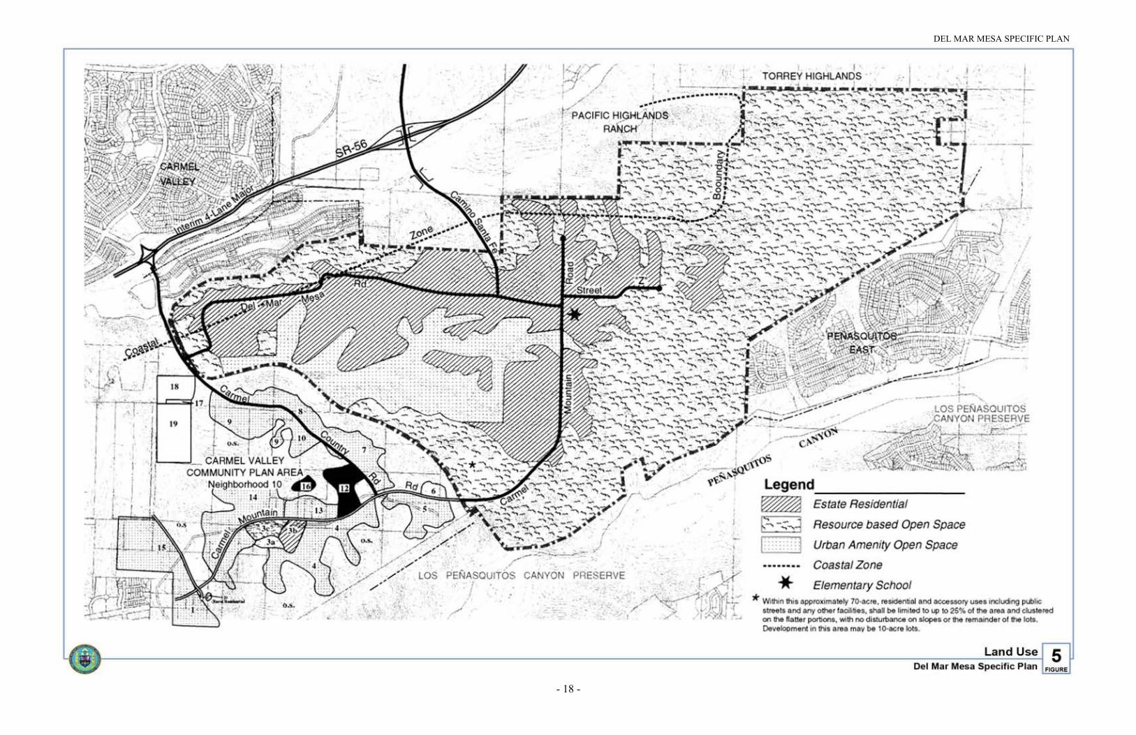
Figure 5. Land Use

DEL MAR MESA SPECIFIC PLAN
- 19 -
III. ELEMENTS OF THE SPECIFIC PLAN
A. LAND USE
The policies of the General Plan and the Framework Plan apply to Del Mar Mesa,with the exception of those that require a phase shift to implement. In addition,Council Policy 600-29 provides guidelines for development within the FUA. TheGeneral Plan goals for the FUA are to “avoid premature urbanization, to conserveopen space and natural environmental features and to protect the fiscal resources ofthe City by precluding costly sprawl and/or leapfrog development.” The overallgoal for Del Mar Mesa is as follows:
GOAL: TO PRESERVE THE RURAL CHARACTER OF DEL MAR MESAWHILE ACCOMMODATING CLUSTERED DEVELOPMENT AND THEPRESERVATION OF OPEN SPACE
Approximately 685 dwelling units are permitted within Del Mar Mesa based on thePlanned Development Permit (PDP) provision which allowed a maximum of onedwelling unit/four acres for the AR-1-1 areas and the AR-1-2 zone, which permits adensity of one dwelling unit per acre. (See Table 2). The existing AR-1-1 zoningwould have allowed a maximum of one dwelling unit per four acres under the ruralcluster option of the Planned Residential Development permit. In order to preservea large, contiguous open space area in the eastern part of the community, thedensity was planned for the western portion of the community at a rate of onedwelling unit per 2.5 acres. The areas zoned AR-1-1 in the eastern portion of thecommunity have a maximum density of one dwelling unit per ten acres and nolonger have the option to develop under the rural cluster alternative of one dwellingunit per four acres. The number of dwelling units that may be permitted in thecommunity may be reduced as properties and their associated rights are purchasedin the Resource Based Open Space area located in the eastern portion of thecommunity. Additional units could be accommodated in the community using theAffordable Housing Density Bonus provision of the Municipal Code. The Del MarMesa Specific Plan proposes to concentrate this development on the western half ofthe Del Mar Mesa where use will be characterized by low-density residentialdevelopment. Virtually the entire eastern half of Del Mar Mesa is intended forpossible open space acquisition and accommodation of limited developmentconsistent with the underlying zoning. Figure 5 shows the overall developmentprogram for the Del Mar Mesa.
1. Development Area
The Del Mar Mesa Specific Plan defines the core development area in thewestern half of Del Mar Mesa. Within this area, substantial structuraldevelopment as well as major and minor roads are expected to occur. Almost allof the development in the Del Mar Mesa will consist of very low-densityresidential development falling into the Estate Residential category. In additionto residential development, the Del Mar Mesa Specific Plan also designates agolf course and a resort hotel within the southwestern portion of the community.

DEL MAR MESA SPECIFIC PLAN
- 20 -
TABLE 1
LAND USE
Land Use Acreage
Estate Residential (includes hotel) 563.0 ac.
Open SpaceResource BasedUrban Amenity
1270.4 ac.208.6 ac.
Total 2042.0 ac.
2. Residential Land Use
While the principal use will be large-lot single-family homes, other kinds ofresidential development (e.g., clustered single-family dwellings or companionunits) will be allowed pursuant to a planned development permit. Due to the ruralnature of the community and the desire to preserve natural and undisturbed openspace rather than artificial, usable open space, the open space per dwelling unitrequired by the planned development permit shall not apply to Del Mar Mesa.A planned development permit may be used to achieve more units on a sitedesignated as Estate Residential provided that the additional density is achievedby including density transferred from a site within Del Mar Mesa and designatedas Resource Based Open Space. The site providing the additional density must bedesignated for Resource Based Open Space, would no longer have densityassociated with it and would be conserved by either easement or dedication to theCity. The Implementation and Community Design Element sections in thisPlan identify both general and site-specific development regulations for parcelswithin the Del Mar Mesa.
Table 3 outlines the dwelling unit allocation for Del Mar Mesa. This issummarized below:
a. Parcels designated for Open Space/Rural Residential development areassigned a maximum of one dwelling unit per ten acres consistent with theunderlying zoning and may be considered for open space acquisition.
b. Areas zoned AR-1-2 designated for development would retain the currentdensity and could develop to a maximum of one dwelling unit/acre.
c. Parcels in City ownership are designated as Resource Based Open Space andare not proposed for any development. Parcels in federal, state and countyownership, and City enterprise fund departments that are zoned AR-1-1, areassigned a maximum of one dwelling unit/ten acres.

DEL MAR MESA SPECIFIC PLAN
- 21 -
d. Approximately 415 dwelling units are assigned to parcels zoned AR-1-1 thatare all or partially designated as Estate Residential. This equates to amaximum of one dwelling unit/2.5 acres for the areas designated for EstateResidential. Approximately 190 units are assigned to parcels zoned AR-1-2and designated for Estate Residential. The maximum density for both zones iscalculated over the gross area of the parcel with development intended to belocated on all or a portion of the site designated for development.
TABLE 2
DEL MAR MESA - LAND USE ACREAGES
Acreage
Land Use Areas AR-1-1 AR-1-2 Total
Private parcels designated forEstate Residential
1041.9 ac. 190.2 ac.
Private parcels designated for RuralResidential and possible OpenSpace acquisition
358.4 ac. 30.1 ac.
Publicly-owned open space 531.4 ac. 20.0 ac.
Subtotal 1931.7 ac. 240.3 ac.
Portions of ownerships that extendoutside Del Mar Mesa
-130.0 ac.
Total 1801.7 ac.3 240.3 ac. 2042 ac.3
Total Dwelling Units Potentially Permitted Without a Phase Shift
1781.7 ac. @ 1DU/4ac. = 445 DUs1
240.3 ac. @ 1DU/ac. = 240 DUs
Total = 685 dwelling units 2, 3
1. One 20-acre parcel was purchased for mitigation prior to August 1, 1984, the effective date ofProposition A. Development rights associated with this parcel are ineligible for reallocation, reducingthe total AR-1-1 zoned acreage on which potential density reallocation is calculated from 1801.7 acresto 1781.7 acres.
2. Additional units could be achieved in Del Mar Mesa under the Affordable Housing Density Bonusprovision of Municipal Code.
3. Since the adoption of the Del Mar Mesa Specific Plan, on July 30, 1996, 95.6 acres have been conservedeither by purchase or easement for the purpose of conservation and mitigation. The units associated withthis acreage will not be eligible for relocation, reducing the total AR-1-1 zoned acreage on whichpotential density allocation is calculated from 1781.7 acres to 1686.1 acres.

DEL MAR MESA SPECIFIC PLAN
- 22 -
TABLE 3
DWELLING UNIT ALLOCATION
AR-1-1 Zone AR-1-2 ZoneLand Use Areas
Acreage DUs Acreage DUsTotal
Private parcels designatedfor Estate Residential
1041.9 ac. 415 DUs(1 DU/2.5 ac.1)
190.2 ac. 190 DUs 605 DUs
Private parcels designatedfor Rural Residential andpossible Open Spaceacquisition
358.4 ac. 35 DUs 30.1 ac. 30 DUs 65 DUs
City-owned 412.8 ac. 4 DUs 2 20.0 ac. 0 DUs 4 DUs
Publicly-owned - otherjurisdictions
118.7 ac. 11 DUs 0 ac. 0 DUs 11 DUs
Total 465 DUs 220 DUs 685 DUs3
1. Development rights equal to nine dwelling units are reallocated from ownership area 50 to area 70, contingent onCouncil approval of Carmel Valley Neighborhood 8A development agreement, or a similar agreement. Transfer ofthese units reduces the total number of dwelling units available for allocation to 406, yielding a density of one duper 2.5 gross acres in areas zoned AR-1-1 with development shown.
2. Density is allocated to City enterprise fund departments according to the existing AR-1-1 zoning. This includesone 17.5-acre parcel owned by the Environmental Services Department (APN 306-050-11) and two parcelstotaling 30 acres owned by the Metropolitan Wastewater Department (APN 306-050-07, 21).
3. Since the adoption of the Plan on July 30, 1996, 95.6 acres have been conserved either by purchase or easementfor the purposes of conservation and mitigation. The units associated with this acreage will not be eligible forrelocation, reducing the number of the total AR-1-1 zoned acreage on which potential density allocation iscalculated from 1781.7 acres to 1686.1 acres.
3. Affordable Housing
The City of San Diego’s “Consolidated Plan” documents the City’s need foraffordable housing. The plan states that nearly 107,000 very-low and low-incomehouseholds in San Diego would require assistance for their housing to beaffordable. The lack of affordable housing is not only a social issue affectingcommunities but also has a negative impact on the local economy. Providinghousing opportunities affordable to those working in low-wage jobs benefits theCity as a whole.
To help address its need for affordable housing, the City encourages the provisionof affordable housing opportunities throughout its many communities, in part,through Council Policy 600-19 concerning balanced communities and through theFuture Urbanizing Area Affordable Housing Requirement contained in the City'sPDP regulations and addressed further in the North City Future Urbanizing AreaFramework Plan.

DEL MAR MESA SPECIFIC PLAN
- 23 -
Although Del Mar Mesa is likely to include many small residential developments withresidents relying on services located outside the area, development plans whichprimarily call for large homes on large lots suggest that household help may be desiredto care for the house and grounds. Furthermore, the resort hotel and golf course bothprovide relatively low-wage employment opportunities. It is clear that affordablehousing provided in Del Mar Mesa will help address the needs created in thecommunity and contiguous areas.
Residential development in Del Mar Mesa must provide for affordable housing asrequired of all such development in the FUA. However, property owners are permittedto meet the affordable housing requirement off-site, if desired, due to the rural characterand the small size of developments proposed for the Del Mar Mesa. The requirementspecifies that residential development projects must provide housing affordable to low-income families as certified by the San Diego Housing Commission. This requirementcan be fulfilled by the following:
a. The provision of units through new construction or acquisition, equivalent to tenpercent of units in the proposed Del Mar Mesa project, for occupancy by, and atrates affordable to households earning no more than 65 percent of median areaincome, adjusted for household size, located on-site or off-site within the Cityboundaries, as certified by the San Diego Housing Commission. The affordableunits must remain affordable for the life of the unit and should be phasedproportionate to development of the market-rate units within the Del Mar Mesaproject; or
b. Dedication of land of equivalent value to a. above, located within the Cityboundaries, as certified by the San Diego Housing Commission; or
c. Developers may, at the discretion of the City, satisfy the requirements of the FUAaffordable housing program by paying an in-lieu fee to the City's NCFUAAffordable Housing Trust Account an amount of money equivalent to the cost ofachieving the level of affordability required by the Del Mar Mesa affordablehousing program as determined by the San Diego Housing Commission. The in-lieufee requirement shall be included as a tentative map condition, where applicableand collected at the time of issuance of building permits; or
d. Developers of projects within Del Mar Mesa of ten or fewer units, or for largerprojects subject to the restrictions specified below, seeking to fulfill the requirementon-site, may do so through the provision of accessory unit(s). Accessory unitswithin Subarea V shall be subject to the CUP requirement and developmentstandards in Municipal Code Section 101.0512 or subsequent amendments.However, the provisions that CUPs only be issued in R-1 zones, Section F.(Suspension of Companion Unit Regulations) and G. (Exclusion of CompanionUnits in the Coastal Zone) shall not be applicable to the Del Mar Mesa SpecificPlan area. Restrictions on occupancy of these units in the above code section maybe deviated from subject to certification by the Housing Commission. It is the intentof this specific plan that occupancy of these units be limited to eligible low-incomehouseholds earning no more than 65 percent of median area income at affordablerental rates. For projects greater than ten units, the number of accessory units shallnot exceed 30 percent of the above affordable housing requirement.

DEL MAR MESA SPECIFIC PLAN
- 24 -
e. Within the Coastal Zone, increased density achieved through provisions of state lawmandating density bonuses shall not result in greater encroachment in designatedResource Based Open Space or augmentation of any circulation element road beyondwhat is adopted in the Plan.
4. Horses and Horse Stables
The Del Mar Mesa community is one of the few areas that is planned to remain rural orsemirural in the City of San Diego. The Plan and the underlying zoning requires that thecommunity develop consistent with agricultural zoning. The primary uses and amenitiesin Del Mar Mesa will consist of single-family residential on larger lots, hiking andequestrian trails, horse stables and a resort hotel and golf course. Currently, thecommunity has scattered single-family residences, horse stables, a series of informalhiking and equestrian trails and large open spaces. Many of the residents of Del MarMesa keep horses on their property and it is anticipated that some of the residents of thenew developments will desire to keep horses on their properties or in the stables that arelocated in the community. The ability to maintain horses on residential property is uniquein the City of San Diego and should be preserved in rural communities such as Del MarMesa.
The City of San Diego Municipal Code contains regulations for the keeping of horses inSection 44.0308. Horses shall be permitted in Del Mar Mesa as long as they comply withthese regulations, which state the following:
No person shall bring or maintain within the City any horse, unless
(a) the number of dwelling units within a one-fourth mile wide belt surrounding thecorral, pasture or stable within which the horse is kept, is less than 300 units; and
(b) 10,000 square feet of such stable, pasture area or corral or combination thereof isprovided for up to two (2) horses with an additional 5,000 square feet for each horsein excess of (2); and
(c) no residence or dwelling unit exists except such as are owned, maintained oroccupied by the owner of such horses within a 75-foot wide belt surrounding thestable, corral or pasture within which such horse is kept.
In order to reduce the conflicts that may be associated with future development, allprojects shall disclose to prospective residents that Del Mar Mesa is a semiruralcommunity which allows residents to maintain horses and/or horse stables on theirproperty.
5. Resort Hotel and Golf Course
On March 26, 1996, a majority of the voters of the City of San Diego approvedProposition C, which amended the City’s General Plan to allow the City Council toconsider a request for a Conditional Use Permit (CUP) for a 300-room resort hotel in thecommunity of Del Mar Mesa. The CUP was approved by the City Council and theresulting project consists of a 300-room resort hotel, an 18-hole golf course and 134residential dwelling units.

DEL MAR MESA SPECIFIC PLAN
- 25 -
B. MULTIPLE SPECIES CONSERVATION PROGRAM (MSCP)/OPEN SPACE
Since the adoption of the Framework Plan (and the Environmental Tier) in 1992, theCity’s adopted resource planning efforts largely involved the development of theMSCP. As a regional habitat conservation plan, the MSCP was designed to addresshabitat needs for multiple species and includes a preserve designed to address thepreservation of natural communities for an 885-square-mile area in the jurisdictionsof 11 cities and a sizeable portion of the unincorporated County of San Diego.
The ecosystem of southwestern San Diego County consists of a diverse assemblage ofvegetation communities/habitat that supports a wide array of plant animal species.These native vegetation communities are considered sensitive by federal, state andlocal jurisdictions because they have been severely reduced in distribution as a resultof urbanization. Some of these vegetation communities occur only within San Diegoas well as the U.S. distribution of component sensitive plant and animal species.Implementation of the MSCP is expected to maintain biodiversity throughout the SanDiego area, minimize or avoid species extinction and create a new, streamlinedprocess for the issuance of federal and state permits.
Del Mar Mesa is included in the Northern Area of the City's MSCP Subarea Plan. It ispart of the Los Peñasquitos Lagoon and Canyon/Del Mar Mesa core biological area.This core biological resource area encompasses one of the few intact natural openspace areas in coastal San Diego County that is still linked to larger expanses ofhabitat to the east, hence, its tremendous significance. Del Mar Mesa contains corehabitat area on the Del Mar Mesa north of the Los Peñasquitos Canyon Preserve inaddition to linkages containing disturbed lands and habitat leading toward CarmelValley and Carmel Creek.
The Plan is consistent with the MSCP Plan and incorporates the MHPA (seeFigure 6). The Del Mar Mesa open space system is shown on Figure 7 and onExhibit A, which was adopted concurrently with the specific plan.
The Plan designates the core biological resource areas and sufficient wildlife linkagesfor preservation within the MHPA of the MSCP (Figure 6). Additionally, the Planidentifies four categories of open space based on conservation potential and planneduse (Figure 7). The open space area categories are described below:

DEL MAR MESA SPECIFIC PLAN
- 26 -
Figure 6. Multiple Habitat Boundaries

DEL MAR MESA SPECIFIC PLAN
- 27 -
1. Publicly-Owned Open Space
At the time that the Plan was adopted in 1997, approximately 551 acres wereowned by the City, county, federal or California Department of Transportation(Caltrans) within Del Mar Mesa. This property is designated as Resource BasedOpen Space in the Plan.
Since the original adoption of the Plan in 1997, additional land or land rights havebeen purchased for the purposes of conservation and mitigation. Approximately95 acres have either been purchased or conserved with easements for conservationand mitigation. This includes approximately 52 acres purchased by the U.S. Fishand Wildlife Service, approximately 18 acres acquired by the City of San Diegoand approximately 20 acres conserved by private entities to mitigate for off-siteimpacts.
The majority of this land is comprised of several large contiguous parcels whichform the entire southeastern border of the subarea. Because this area is adjacent tothe Los Peñasquitos Canyon preserve, it serves visually and biologically as anextension of this preserve and adds substantially to this regionally significantopen space system.
A portion of the open space in Del Mar Mesa also lies within the San DiegoNational Wildlife Refuge and contains highly sensitive vernal pool habitat. Thepurpose of the National Wildlife Refuge is to protect and manage key nativehabitats for several endangered, threatened and rare vernal pool species. A portionof the Refuge is concurrently in public ownership and additional lands may bepurchased from willing sellers.
2. Open Space/Rural Residential Area
A total of 388 acres are designated in the easternmost portion of Del Mar Mesa asOpen Space/Rural Residential (see Figure 7). This area is contiguous to thepreviously acquired open space lands and is proposed for acquisition, therebyfurther extending the major open space block which encompasses the entireeastern half of the Del Mar Mesa. When all lands are acquired, this area willrepresent the largest undisturbed native environment in the entire 12,000-acreNCFUA. These parcels are proposed for acquisition in the Framework Plan and,because of their combined size and undisturbed quality, may be the single mostimportant component within the entire open space system within the NCFUA.More detail regarding the open space acquisition program is contained in theImplementation section of this Plan.

DEL MAR MESA SPECIFIC PLAN
- 28 -
Figure 7. Open Space
DEL MAR MESA SPECIFIC PLAN
- 29 -
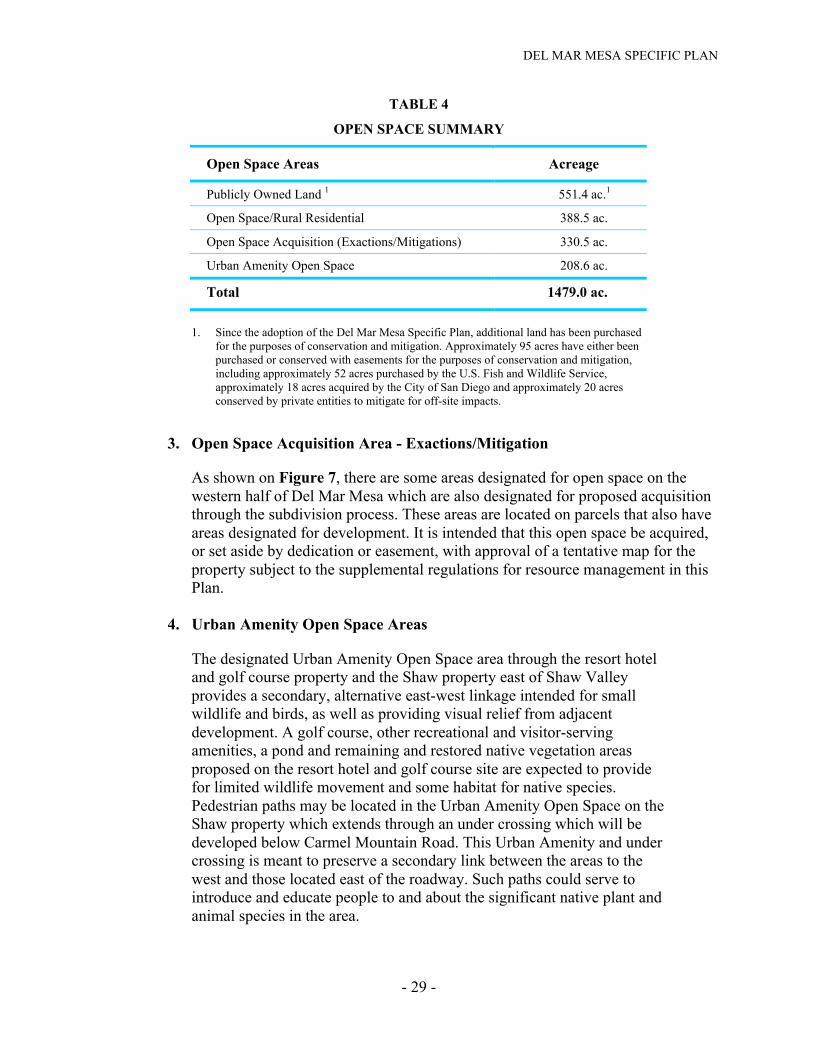
TABLE 4
OPEN SPACE SUMMARY
Open Space Areas Acreage
Publicly Owned Land 1 551.4 ac.1
Open Space/Rural Residential 388.5 ac.
Open Space Acquisition (Exactions/Mitigations) 330.5 ac.
Urban Amenity Open Space 208.6 ac.
Total 1479.0 ac.
1. Since the adoption of the Del Mar Mesa Specific Plan, additional land has been purchasedfor the purposes of conservation and mitigation. Approximately 95 acres have either beenpurchased or conserved with easements for the purposes of conservation and mitigation,including approximately 52 acres purchased by the U.S. Fish and Wildlife Service,approximately 18 acres acquired by the City of San Diego and approximately 20 acresconserved by private entities to mitigate for off-site impacts.
3. Open Space Acquisition Area - Exactions/Mitigation
As shown on Figure 7, there are some areas designated for open space on thewestern half of Del Mar Mesa which are also designated for proposed acquisitionthrough the subdivision process. These areas are located on parcels that also haveareas designated for development. It is intended that this open space be acquired,or set aside by dedication or easement, with approval of a tentative map for theproperty subject to the supplemental regulations for resource management in thisPlan.
4. Urban Amenity Open Space Areas
The designated Urban Amenity Open Space area through the resort hoteland golf course property and the Shaw property east of Shaw Valleyprovides a secondary, alternative east-west linkage intended for smallwildlife and birds, as well as providing visual relief from adjacentdevelopment. A golf course, other recreational and visitor-servingamenities, a pond and remaining and restored native vegetation areasproposed on the resort hotel and golf course site are expected to providefor limited wildlife movement and some habitat for native species.Pedestrian paths may be located in the Urban Amenity Open Space on theShaw property which extends through an under crossing which will bedeveloped below Carmel Mountain Road. This Urban Amenity and undercrossing is meant to preserve a secondary link between the areas to thewest and those located east of the roadway. Such paths could serve tointroduce and educate people to and about the significant native plant andanimal species in the area.

DEL MAR MESA SPECIFIC PLAN
- 30 -
TABLE 5
PUBLICLY-OWNED OPEN SPACE SUMMARY
Acreage
Publicly-Owned Open Space AR-1-1 AR-1-2 Total
Other Public Agencies/JurisdictionsCounty of San Diego
29.2 ac.89.4 ac.
0 ac.0 ac.
29.2 ac.89.4 ac.
Subtotal 118.6 ac. 0 ac. 118.6 ac.1
City of San DiegoAcquired for MitigationAcquired with open space bonds
311.3 ac.101.6 ac.
0 ac.20 ac.
311.3 ac.121.5 ac.
Subtotal 412.9 ac. 20 ac. 432.8 ac.1
Total 531.5 ac. 20 ac. 551.4 ac.
1. Since the adoption of the Del Mar Mesa Specific Plan, additional land has been purchased for the purposesof conservation and mitigation. Approximately 93 acres have either been purchased or conserved witheasements for the purposes of conservation and mitigation, including approximately 52 acres purchased bythe U.S. Fish and Wildlife Service, approximately 18 acres acquired by the City of San Diego andapproximately 20 acres conserved by private entities to mitigate for off-site impacts.
5. Multi-Habitat Planning Area Boundary and Criteria for Adjustment
For more specific definition of the Del Mar Mesa open space boundary andMHPA, refer to the 400-scale map adopted as Exhibit A. The MSCP SubareaPlan allows the City to make minor adjustments to the MHPA in limitedcircumstances with subsequent tentative map approvals or other discretionarypermit approvals. Minor boundary adjustments will not require amendments tothe Plan. Within the Coastal Zone, boundary adjustments which are determined tobe consistent with the MSCP implementing agreement between the City of SanDiego, the California Department of Fish and Game and the U.S. Fish andWildlife Service, do not require an amendment to the Local Coastal Program(LCP). The criteria for making these adjustments, is based on whether theresulting change maintains a preserve area that is of equivalent or higherbiological value to the original configuration. Within the Coastal Zone, boundaryadjustments which require an amendment to the Plan due to modification ofFigure 6 of the Plan will require an amendment to the certified LCP.
Adjustments to the MHPA boundaries may be desirable under somecircumstances. For example:
• New biological information is obtained through site-specific studies;

DEL MAR MESA SPECIFIC PLAN
- 31 -
• Unforeseen engineering design opportunities or constraints may be identifiedduring the siting or design of projects that require modification of the MHPA;and/or
• A landowner may request that a portion or all of his property be includedwithin the MHPA.
As provided for in the City’s MSCP Subarea Plan, adjustments to the MHPA canbe made without the need to amend the MSCP Subarea Plan and the Del MarMesa Specific Plan if the adjustment will result in the same or higher biologicalvalue of the MHPA. The determination of biological value of the proposedchange is made by the City and must have the concurrence of the wildlifeagencies. No amendment of the MSCP Subarea Plan is needed for an approvedequivalent exchange. The comparison of biological value will be based on thefollowing biological factors:
• Effects on significantly and sufficiently conserved habitats (i.e., the exchangemaintains or improves the conservation, configuration, or status ofsignificantly or sufficiently conserved habitats, as defined in the MSCP Plan,Section 4.2.4);
• Effects to covered species (i.e., the exchange maintains or increases theconservation of covered species);
• Effects on habitat linkages and function of preserve areas (i.e., the exchangemaintains or improves a habitat linkage or wildlife corridor);
• Effects on preserve configuration and management (i.e., the exchange resultsin similar or improved management efficiency and/or protection for biologicalresources);
• Effects on preserve configuration and management (i.e., the exchange resultsin similar or improved management efficiency and/or protection for biologicalresources);
• Effects on ecotones or other conditions affecting species diversity (i.e., theexchange maintains topographic and structural diversity and habitat interfacesof the preserve); and/or
• Effects to species of concern not on the covered species list (i.e., the exchangedoes not significantly increase the likelihood that an uncovered species willmeet the criteria for listing under either the federal or state EndangeredSpecies Acts).
6. Guidelines for Development Areas in and Adjacent to the MHPA
The following are specific guidelines for development within the developmentareas in and/or adjacent to the MHPA in Del Mar Mesa:
a. The preserve excludes golf course greens and fairways, although these areasmay provide for some wildlife movement. The precise layout and

DEL MAR MESA SPECIFIC PLAN
- 32 -
configuration of the golf course greens and fairways shall be established whenthe proposed project is approved by the City of San Diego. Minor adjustmentsto the preserve in this location, which result in an equivalent or higherbiological value, may be accommodated without an amendment of the Plan.
b. Within the approximately 70-acre area located within the southwest portion ofthe Shaw property, residential and accessory uses, including public streets andany other facilities, shall be limited to up to 25 percent of the area andclustered on the flatter portions.
c. For the Shaw Texas property (Area No. 61 on Figure 30) and Areas 70, 59and 44 abutting the MHPA to the east, and extending to the border of theAR-1-2 zoned areas to the north, all brush management shall occur within thedefined development area for lots contiguous to the MHPA. This requirementalso applies to Area Nos. 9, 32, 23 and 33, abutting the AR-1-2 zoned areas tothe east and the MHPA to the north. Deviations from brush managementstandards shall be considered if they are consistent with the AlternativeCompliance provision of the Landscape Technical Manual.
d. Fencing or other barriers will be used where it is determined to be the bestmethod to achieve conservation goals and adjacent to land uses incompatiblewith the preserve.
e. Where grading is necessary, daylight grading at the edges of the preserve ispreferred. All grading proposed adjacent to the preserve, including all cut andfill slopes, must occur wholly within the development area, except asspecified in the Plan. Graded areas adjacent to open space shall be re-vegetated with native plant species.
f. A 12 to 14-foot diameter culvert to facilitate wildlife movement shall beprovided where Carmel Mountain Road crosses the Urban Amenity OpenSpace on the Shaw Texas property (Area No. 61 on Figure 30). This culvert isa Development Impact Fee funded improvement in the Public FacilitiesFinancing Plan.
g. The designated Urban Amenity Open Space area through the resort hotel andgolf course property provides an alternative east-west corridor for wildlifemovement. If fencing is proposed within the golf course on the property, itshould not inhibit wildlife movement through this area. In areas where fencingis appropriate, split-rail type not to exceed four feet in height is recommended.
7. Guidelines for Resource Based Open Space Areas and Adjacent Areas
The City of San Diego MSCP Subarea Plan applies to the Resource Based OpenSpace areas within Del Mar Mesa which are included in the adopted MSCP (seeFigure 7). This document should be used in evaluating appropriate uses anddevelopment in these areas.

DEL MAR MESA SPECIFIC PLAN
- 33 -
a. Compatible Land Uses
The following land uses are considered conditionally compatible with thebiological objectives of the MSCP and thus will be allowed within the City'sMHPA/Resource Based Open Space areas:
• Passive recreation
• Utility lines and roads in compliance with the MSCP Subarea Plan
• Limited water facilities and other essential public facilities
• Limited low-density residential uses
• Limited agriculture
Development on private property designated Open Space/Rural Residentialshall not exceed 25 percent of the parcel, consistent with the supplementalregulations for resource management contained in the Plan. Developmentwithin these areas that is consistent with the existing zoning, such as single-family residences on lots zoned AR-1-1, is consistent with the Plan.Expansion of existing uses would need to be in compliance with the Plan andshould provide measures to minimize impacts on the preserve includinglighting, noise or uncontrolled access.
b. Roads and Utilities
• All proposed utility lines (e.g., sewer, water, etc.) should be designed toavoid or minimize intrusion into the MHPA. These facilities should berouted through developed or developing areas rather than the MHPA,where possible. If no other routing is feasible, then the lines should followpreviously existing roads, easements, rights-of-way, and disturbed areas,minimizing habitat fragmentation.
• All new development for utilities and facilities within or crossing preserveareas shall be planned, designed, located and constructed to minimizeenvironmental impacts. All such activities must avoid disturbing thehabitat of MSCP covered species and wetlands. If avoidance is infeasible,mitigation will be required.
• Temporary construction areas and roads, staging areas, or permanentaccess roads must not disturb existing habitat unless determined to beunavoidable. All such activities must occur on existing agricultural landsor in other disturbed areas rather than in habitat. If temporary habitatdisturbance is unavoidable, then restoration of, and/or mitigation for, thedisturbed area after project completion will be required.
• Construction and maintenance activities in wildlife corridors must avoidsignificant disruption of corridor usage. Environmental documents andMitigation Monitoring and Reporting Programs pertaining to such

DEL MAR MESA SPECIFIC PLAN
- 34 -
development must clearly specify how this will be achieved, andconstruction plans must contain all the pertinent information and bereadily available to crews in the field. Training of construction crews andfield workers must be conducted to ensure that all conditions are met. Aresponsible party must be specified.
• Roads in the preserve will be limited to those identified in the Plan, roadsnecessary for maintenance and emergency access and local streets neededto access isolated development areas.
• Development of roads in canyon bottoms should be avoided wheneverfeasible. If an alternative location outside the preserve is not feasible, thenthe road must be designed to cross the shortest length possible of thepreserve in order to minimize impacts and fragmentation of sensitivespecies and habitat. If roads cross the preserve, they should provide forfully functional wildlife movement capability. Bridges are the preferredmethod of providing for movement, although culverts in selected locationsmay be acceptable. Fencing, grading and plant cover should be providedwhere needed to protect and shield animals, and guide them away fromroads to appropriate crossings.
• Where possible, roads within the preserve should be narrowed fromexisting design standards to minimize habitat fragmentation and disruptionof wildlife movement and breeding areas. Roads must be located in lowerquality habitat or disturbed areas to the extent possible.
c. Fencing and Lighting
• Fencing or other barriers will be used where it is determined to be the bestmethod to achieve conservation goals and in areas adjacent to land usesincompatible with the MHPA. For example, chain link or otherappropriate fencing material may be used to direct wildlife to appropriatecorridor crossings, and natural rock/barrier or split-rail fencing to directpublic access to appropriate locations and away from sensitive species orhabitats (e.g., vernal pools). For a description of the appropriate fencingdesigns and materials in Del Mar Mesa, refer to the Community DesignElement of this Plan.
• In order to preserve the rural character and the dark night skiescharacteristic in Del Mar Mesa, standard street lighting will not beprovided in the community. Those lights that are required for safety asdetermined by the City Engineer shall be designed to avoid intrusion intothe MHPA, and to reduce negative effects on wildlife. Lighting in areas ofwildlife crossings should be of low-sodium or similar lighting. Lighting ofall developed areas adjacent to the MHPA should be directed away fromthe preserve. Where necessary, development should provide adequateshielding with non-invasive plant materials (preferably native), berming,and/or other methods to protect the MHPA and sensitive species fromnight lighting.

DEL MAR MESA SPECIFIC PLAN
- 35 -
C. COMMUNITY FACILITIES
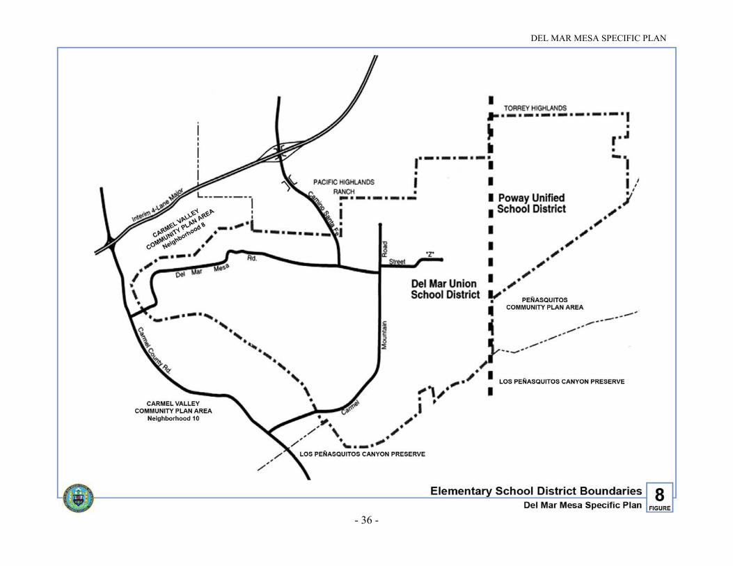
1. Schools
With regard to elementary schools, the western portion of Del Mar Mesa is withinthe Del Mar Union Elementary School District (DMUSD) and the eastern portion ofthe subarea is within the Poway Unified School District (PUSD) (see Figure 8).Junior and Senior High School education is provided by the San Dieguito UnionHigh School District (SDUHSD). Since this Plan anticipates little or no residentialdevelopment in the eastern portion of the subarea, most students will attend schoolsprovided by the Del Mar and San Dieguito school districts.
Based on a projected buildout of 685 single-family dwelling units, Del Mar Mesais expected to generate approximately 320 elementary school students, 77 juniorhigh school students, and 152 high school students.
TABLE 6
PROJECTED STUDENT GENERATION
District Elementary Junior High High School
Del Mar Union 1 312 — —
Poway Unified 2 8 4 6
San Dieguito Union 3 — 73 146
1. Based on an elementary student generation rate of 0.471 students per dwelling unit.
2. Based on elementary, junior and senior high school student generation rates of 0.34, 0.18 and 0.26students per dwelling unit respectively.
3. Based on junior and senior high school student generation rates of 0.11 and 0.22 students perdwelling unit respectively.
a. Elementary Schools
In accordance with DMUSD standards, residential development within theDel Mar Mesa area will result in the need for a new elementary school when300 students are projected to be un-housed in the succeeding school year. Asprojected development in the Del Mar Mesa area is anticipated to generateover 300 elementary students within the service area of the DMUSD, anelementary school site is designated on Figure 5. This site falls within areas44 and 59 on Figure 30. Ownership area number 70 is identified as analternative location for a joint school/park site.
Until sufficient students have been generated from this and adjacent areas, andsufficient mitigation payments, special taxes, or other funds are collected tofund the property acquisition and development, the identified school park
DEL MAR MESA SPECIFIC PLAN
- 36 -
Figure 8. Elementary School District Boundaries

DEL MAR MESA SPECIFIC PLAN
- 37 -
site property shall retain development rights consistent with similarly zonedparcels in the Plan, or one dwelling unit per 2.5 gross acres, except in caseswhere the density is further defined in the Plan. If, prior to acquisition by theDMUSD and/or City of San Diego, the property owner makes application fora subdivision of land or other discretionary action, the City and the DMUSDshall have the opportunity to negotiate purchase of the identified property. Ifthe DMUSD and/or City of San Diego is unsuccessful in securing theschool/park site, a similar process shall apply to the alternative location.Dwelling units assigned to parcels identified as the primary or alternativelocations for a joint school/park site may be transferred by use of a PDP toother parcels in the NCFUA owned by the same entity.
Developed in conjunction with a neighborhood park, a joint school/parkfacility will occupy a minimum of thirteen flat net usable acres, with fiveacres used exclusively for the school, five acres of joint-use playing fields andthree acres operated separately by the City. Until sufficient students have beengenerated from this and adjacent areas, and sufficient mitigation payments,special taxes, or other funds are collected to fund the property acquisition anddevelopment, elementary students within the DMUSD service area will attendexisting schools within DMUSD. The school facilities financing plans includeprovisions for the funding of temporary facilities to accommodate additionalstudents prior to the construction of new permanent facilities.
The threshold for construction of a new elementary school within the PUSD isnot met by anticipated development in the Del Mar Mesa area. Elementarystudents residing within the PUSD service area will attend Deer CanyonElementary School in Rancho Peñasquitos.
Elementary school financing is addressed in Section VI. G. of this Plan.
b. Junior and Senior High Schools
The thresholds for new junior and senior high schools are not met byanticipated development in Del Mar Mesa. However, the cumulative impactsof projected development within the region will necessitate construction of anew junior and/or senior high school at a future date. Until additional facilitiesare constructed, most students residing in the plan area will attend CarmelValley Middle School in Carmel Valley and Torrey Pines High School inCarmel Valley. Students residing within the boundaries of the PUSD willattend Mesa Verde Middle School in Torrey Highlands and Mount CarmelHigh School in Rancho Peñasquitos.
Junior and senior high school financing is addressed in Section IV. G. of thisPlan.

DEL MAR MESA SPECIFIC PLAN
- 38 -
2. Parks
The projected population of Del Mar Mesa will not, according to General Planstandards, require the construction of a complete ten-acre neighborhood park.However, the population will generate demand for recreational facilities.Therefore, a site of sufficient size to accommodate a joint facility combining aneighborhood park and an elementary school site has been identified. The facilitywill occupy a total of 13 acres, with five acres used exclusively for the school,five acres of playing fields used jointly and three acres operated separately by theCity. Should the DMUSD determine that an elementary school site within theplan area is not feasible, a neighborhood park of at least four acres will berequired.
In addition to providing for the neighborhood park, developers within Del MarMesa will be required to pay an impact fee for partial development of acommunity park. The community park for the residents of Del Mar Mesa will belocated in the community of Pacific Highlands Ranch and is depicted in thePacific Highlands Ranch Subarea Plan adjacent to the village, civic and transitcenter uses.
3. Library
The projected population of Del Mar Mesa alone is not sufficient to require a newlibrary. A library is required to serve the developments in the communities ofBlack Mountain Ranch, Pacific Highlands Ranch, Torrey Highlands and Del MarMesa, and is to be located in Pacific Highlands Ranch. Until the PacificHighlands Branch Library is built, residents of Del Mar Mesa would likely use theCarmel Valley branch library in Neighborhood 9. Developers of Del Mar Mesaare required to pay an impact fee for their fair share of construction of a branchlibrary in Pacific Highlands Ranch.
4. Police
Police protection will be provided by the Northern Division of the San DiegoPolice Department. The nearest station is located in University City and a newstation is planned in Carmel Valley. There is also a storefront site reserved atBlack Mountain Ranch should it become needed at a future time.
5. Fire
Fire protection will be provided by the San Diego Fire Department. The nearestfire stations are in Mira Mesa and Carmel Valley Neighborhood 7. Constructionof two fire stations, the one in Black Mountain Ranch and one in PacificHighlands Ranch, is planned for surrounding communities. Developers of DelMar Mesa will be required to pay an impact fee to partially fund construction ofthese fire stations. Until the new stations are built, Del Mar Mesa will be servicedby existing fire stations. In addition, all new development will be reviewed by the

DEL MAR MESA SPECIFIC PLAN
- 39 -
Fire Department for fire safety standards, as the community will containflammable vegetation posing a moderate to high fire risk to future residents.
6. Solid Waste
Solid waste that would be generated by residents of Del Mar Mesa will bedirected to the City's existing sanitary landfills. The City is currently examiningalternative landfill sites to expand capacity.
7. Power
Power lines and service will be provided by San Diego Gas and Electric(SDG&E). Major power lines will run underground along Carmel MountainRoad.
8. Water
Water service within Del Mar Mesa will be provided by the City of San DiegoWater Department. Currently, existing water facilities in the area have inadequatecapacity to serve new development. Existing water transmission facilities in thearea include the Del Mar Heights Pipeline to the north, the Rancho BernardoPipeline to the east and the Green Valley Pipeline to the west (see Figure 9). Theonly new transmission facility proposed at this time is the Carmel Mountain RoadPipeline. The new transmission facilities proposed at this time are the 30-inchCarmel Mountain Road Pipeline and the 16-inch Del Mar Mesa Road DistributionMain, both of which will traverse Del Mar Mesa in their respective rights-of-wayand appropriate easements.
The Miramar 712/North City 610 Water Study will identify needed watertransmission and storage facilities to provide adequate capacity to theundeveloped portions of Carmel Valley: Torrey Hills, Del Mar Mesa, PacificHighlands Ranch, Torrey Highlands, Black Mountain Ranch and Subarea II.
Applicants for tentative maps will be required to provide water studies showingthe proposed water distribution system necessary to serve their developmentsprior to the approval of final maps. Applicants may request the City to process awater reimbursement agreement(s) to recover the cost of facilities including thestudy in excess of their pro rata share. The proposed water system shall bedesigned and constructed to the Water Department’s standards. Public facilities,such as park and school sites, must be served by public water and sewer facilities.

DEL MAR MESA SPECIFIC PLAN
- 40 -
Figure 9. Backbone Water

DEL MAR MESA SPECIFIC PLAN
- 41 -
9. Sewer
Sewer service will be provided by the City of San Diego MetropolitanWastewater department. Existing sewer facilities in the vicinity of Del Mar Mesainclude the Carmel Valley Trunk Sewer to the north and the Peñasquitos TrunkSewer to the south (see Figure 10). All flows generated from Del Mar Mesa willflow into one of these trunk sewers which flow into the Metropolitan SewerageSystem. The existing Carmel Valley Trunk Sewer System does not have thecapacity to serve the proposed development in accordance with the Plan.
The Carmel Valley Trunk Sewer construction is to be funded through a FacilitiesBenefit Assessment. All projects that discharge to this trunk sewer will becharged with that assessment upon pulling building permits. The cost per dwellingunit will be determined with the completion of the Carmel Valley Trunk SewerMaster Plan. The developer will provide a letter of commitment to participate inthe Facilities Benefit Assessment District. Additionally, a participation agreementwill be entered into for all developments that construct the Carmel Valley TrunkSewer facilities which exceed their fair share.
Applicants for tentative maps will be required to provide sewer studies showingthe proposed sewer system necessary to serve their developments and thedrainage basins in which they lay prior to the approval of final maps. Applicantsmay request the City to process sewer reimbursement agreement(s) to recover thecost of facilities including the sewer study in excess of their pro rata share. Allpublic sewer facilities shall be designed and constructed to the Water UtilitiesDepartment’s standards. If proposed facilities do not meet the required standards,then such facilities shall be private and constructed to the requirements of theUniform Building and Plumbing Code. No private mains will be permitted inpublic streets. The cost of operating and maintaining non-regional public sewerpump stations that serve a single development will be borne by the appropriatehomeowners' association or other private entity. Each newly-developed lot will beserved with a sewer lateral, if possible. Exemptions may be approved by thesenior civil engineer of the wastewater section. All septic systems must beapproved and permitted by the County of San Diego Department of HealthServices. Adjacent developments shall minimize the number of penetrations intothe MHPA by coordinating sewer facilities, access roads, other utilities and triallocations. This coordination may require modifications to street alignments andproject grading.
10. Drainage
Existing drainage facilities adjacent to the plan area consist of the Carmel ValleyRestoration and Enhancement Plan (CVREP) within the SR-56 corridor. Theseinclude a detention basin at the east end of Palacio Del Mar and a detention basinon the west side of Carmel Country Road at the Shaw Valley junction. The majordrainage courses for the plan area are divided into three categories: first,

DEL MAR MESA SPECIFIC PLAN
- 42 -
Figure 10. Backbone Sewer

DEL MAR MESA SPECIFIC PLAN
- 43 -
is the area north of Del Mar Mesa Road which drains down the canyon into theexisting Carmel Valley and Deer Canyons; second, is a smaller drainage in thesoutheast corner of the plan area which drains to Peñasquitos Canyon south of DelMar Mesa; and lastly, is the drainage characterized by those properties whichdrain to the west within the Shaw Valley.
The backbone drainage system for Del Mar Mesa will consist largely of overlandflows in the existing natural drainage courses (see Figure 11). This is due to thevery low-density rural and estate lot character of the subdivision proposed withinDel Mar Mesa. It is anticipated that subdivisions would be designed with no netdiversion of drainage from one of the major basins to another. In addition, therewould be potential internal lakes and water features within the golf course whichwould additionally function as detention basins, desilting basins and water qualitybasins.
Portions of the community fall within the Coastal Zone boundaries, and as such,proposed drainage solutions would need to meet the criteria identified by theCoastal Commission to prevent siltation and increased run-off from impacting thePeñasquitos Lagoon.
In compliance with the Clean Water Act, “best management practices” (BMPs)may be required to control pollutants and sediment from entering storm water run-off for the specific plan area. This includes source control BMPs that requirelandscaping of all manufactured slopes and street right-of-way to prevent erosionand by incorporation of a grading/drainage concept which directs water awayfrom easily erodible areas and into a drainage system designed to safely handlethe storm water run-off. Additionally, desilting/water quality basins will beprovided at strategic locations within the plan area as shown on Figure 11.
Other applicable BMPs which may be implemented on a citywide basis inconjunction with the City’s Municipal National Pollutant Discharge EliminationSystem permit and the State Regional Water Quality Control Board shall beincorporated into the tentative maps and final plans. The Planning andDevelopment Review Department shall verify that the mitigation measuresregarding storm water and drainage management and mitigation of urban run-offflows are conditions for the approval of all subsequent tentative maps within theplan area.
Prior to, or concurrent with recordation of the first final subdivision map withinDel Mar Mesa, a Master Drainage Plan shall be prepared and adopted. This planshall address sizing and siting of facilities required to mitigate potential impacts todownstream facilities from increases in run-off and erosion, as a result of thisspecific plan. This Master Drainage Plan shall be comprehensive, covering theentire Del Mar Mesa to the satisfaction of the City Engineer, and shall meet thespecial requirements for Coastal Zone conformance.

DEL MAR MESA SPECIFIC PLAN
- 44 -
Figure 11. Conceptual Drainage

DEL MAR MESA SPECIFIC PLAN
- 45 -
D. CIRCULATION
1. Introduction
This element addresses the circulation system in Del Mar Mesa. It assumes for theplan area 685 dwelling units, a 300-room resort hotel and a golf course. Therecommendations in this Circulation Element are drawn from the Del Mar MesaTransportation Study, performed by the City of San Diego TransportationPlanning Section in November of 1995, and updated in March 1996.
The major issues related to the street system are proposed improvements to DelMar Mesa Road and whether the Camino Santa Fe connection from SR-56 toCarmel Mountain Road should be constructed. Other subjects addressed in theCirculation Element are internal streets, driveways, public access, equestriantrails, hiking and pedestrian trails, bicycle circulation, public transit, park-and-ride, parking, street lights and off-road vehicles. The phasing of the recommendedtransportation improvements is also included in the Implementation Element ofthe Plan.
In order to maintain the rural character of the Del Mar Mesa community, theprovision of standard urban street widths and improvements is discouraged. Theabsence of urban improvements like curbs, gutters, sidewalks and streetlights,help to maintain the rural character of the community. All subdivisions shallincorporate asphaltic berms or rolled curbs, in lieu of concrete curbs and gutters,unless concrete curbs and gutters are required due to drainage considerations.Additionally, graded walkways shall be provided rather than concrete sidewalks.Standard street lighting will not be provided and streetlights shall be providedonly in areas in which it is determined by the City Engineer that they arenecessary for safety.
2. Guiding Principles
The general guiding principles are those of the North City Future Urbanizing AreaFramework Plan. Specific guiding principles are:
• A vehicular and non-vehicular circulation system that meets the needs of DelMar Mesa residents and visitors at an acceptable level of service.
• An efficient and environmentally sensitive transportation system thatmaintains the Del Mar Mesa’s rural character.
• Hiking and equestrian trails, with access to adjacent trails that providewalking and horseback riding opportunities to the general public and Del MarMesa residents.

DEL MAR MESA SPECIFIC PLAN
- 46 -
Figure 12. Existing Conditions

DEL MAR MESA SPECIFIC PLAN
- 47 -
3. Implementing Principles
The general implementing principles are those of the NCFUA Framework Plan.Specific implementing principles are:
• Street improvements shall be compatible with the rural character of thesubarea. Consideration should be given to minimize impacts to the landform,where safety permits and as determined by the City Engineer.
• In order to maintain the rural character of Del Mar Mesa, streets shall bedesigned with pedestrian and equestrian facilities and rolled curbs.
• Transportation facilities shall be regarded as an integral part of the landscapein which they are located.
4. Existing Conditions
Del Mar Mesa is located in the North City Future Urbanizing Area, east ofCarmel Valley Neighborhood 10 and south of SR-56 and Carmel ValleyNeighborhood 8. Since Del Mar Mesa is not yet developed, the area is without apaved street system. As shown on Figure 12, currently the only roadway thatprovides access to the existing residences is Shaw Ridge Road, which is anunpaved local road that connects Carmel Country Road to the eastern part of thestudy area.
In 1998, the name of Shaw Ridge Road was changed to Del Mar Mesa Road tomore closely associate the name of this primary artery with the community.
Direct freeway access to the subarea is possible via SR-56 ramps at CarmelCountry Road. State Route 56 in this area includes a two-mile stretch of a four-lane freeway from a few hundred feet east of Carmel Country Road to CarmelValley Road at El Camino Real. Carmel Valley Road has an existing diamondinterchange which provides full access to I-5. The construction of a southboundlink from SR-56 to I-5 was completed in 1999.
5. Relationships to Other Community Plans
The North City Future Urbanizing Area Framework Plan provides the majorguidelines for development of this and other FUA subareas. Carmel ValleyNeighborhood 8 is located on the north side and Neighborhood 10 is located onthe west side of Del Mar Mesa. Carmel Valley Neighborhood 8A is located westof Neighborhood 10.
The planned street system for Carmel Valley Neighborhoods 8A and 10 directlyimpacts Del Mar Mesa, as these neighborhoods and Del Mar Mesa would utilizeCarmel Country Road for freeway access. The developments on the western sideof Del Mar Mesa will access the freeway system from Carmel Country Road

DEL MAR MESA SPECIFIC PLAN
- 48 -
Figure 13. Traffic Forecast & Street Classifications
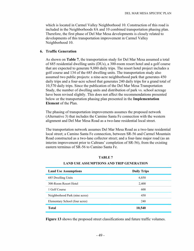
DEL MAR MESA SPECIFIC PLAN
- 49 -
which is located in Carmel Valley Neighborhood 10. Construction of this road isincluded in the Neighborhoods 8A and 10 combined transportation phasing plan.Therefore, the first phase of Del Mar Mesa developments is closely related todevelopments of this transportation improvement in Carmel ValleyNeighborhood 10.
6. Traffic Generation
As shown on Table 7, the transportation study for Del Mar Mesa assumed a totalof 685 residential dwelling units (DUs), a 300-room resort hotel and a golf coursethat are expected to generate 9,880 daily trips. The resort hotel project includes agolf course and 134 of the 685 dwelling units. The transportation study alsoassumed two public projects: a nine-acre neighborhood park that generates 450daily trips and a four-acre school that generates 240 daily trips for a grand total of10,570 daily trips. Since the publication of the Del Mar Mesa TransportationStudy, the number of dwelling units and distribution of park vs. school acreagehave been revised slightly. This does not affect the recommendations presentedbelow or the transportation phasing plan presented in the ImplementationElement of the Plan.
The phasing of transportation improvements assumes the proposed network(Alternative 3) that includes the Camino Santa Fe connection with the westernalignment and Del Mar Mesa Road as a two-lane residential local street.
The transportation network assumes Del Mar Mesa Road as a two-lane residentiallocal street; a Camino Santa Fe connection, between SR-56 and Carmel MountainRoad constructed as a two-lane collector street; and a four-lane major road (as aninterim improvement prior to Caltrans’ completion of SR-56), from the existingeastern terminus of SR-56 to Camino Santa Fe.
TABLE 7
LAND USE ASSUMPTIONS AND TRIP GENERATION
Land Use Assumptions Daily Trips
685 Dwelling Units 6,850
300-Room Resort Hotel 2,400
1 Golf Course 600
Neighborhood Park (nine acres) 450
Elementary School (four acres) 240
Total 10,540
Figure 13 shows the proposed street classifications and future traffic volumes.

DEL MAR MESA SPECIFIC PLAN
- 50 -
14. Lane Configurations at Signalized Intersections

DEL MAR MESA SPECIFIC PLAN
- 51 -
7. Proposed Circulation System
With the proposed network, Carmel Mountain Road's traffic, east of CarmelCountry Road, is projected to be 3,000 daily trips. The projected traffic on CarmelCountry Road, north of Carmel Mountain Road, is 5,000 daily trips. The CaminoSanta Fe connection is projected to have a future traffic volume of 5,000 dailytrips. Based on an ultimate future forecast of 1,200 daily trips, Del Mar MesaRoad will be a two-lane residential local street. Upon construction of the CaminoSanta Fe connection to Del Mar Mesa Road, consideration may be given toclosing Del Mar Mesa Road to through traffic either by placing a gate or twoopposing cul-de-sacs along the roadway. This would maintain the traffic alongDel Mar Mesa Road at the level appropriate for a two-lane residential local street.It should be noted that if the Camino Santa Fe connection is not constructed, theprojected traffic volume on Del Mar Mesa Road would be about 7,000 daily trips.This will result in Del Mar Mesa Road becoming a defacto collector street.Without the Camino Santa Fe connection, Del Mar Mesa Road could not beclosed to through traffic.
A summary of intersection levels of service and lane configuration for keyintersections is shown on Figure 14. As can be seen in this figure, all the rampswould operate at Level of Service “C” and all the signalized intersections wouldoperate at Level of Service “B.”
8. Proposed Future Street Classifications
As noted earlier, the proposed street classifications and traffic forecast for DelMar Mesa are shown on Figure 13 and are described below. The generalalignments of the proposed street network and classifications are shown onFigure 15.
Camino Santa Fe: Two-Lane Collector street from SR-56 toCarmel Mountain Road.
Del Mar Mesa Road: Two-Lane Residential Local street.
Carmel Mountain Road:Segment 1: Two-Lane Modified Collector (one lane in each
direction with a center left-turn lane where needed)from the plan area boundary to the open space.
Segment 2: Two-Lane Collector street through the open space.
Segment 3: Two-Lane Modified Collector street north of theopen space to Camino Santa Fe.
Carmel Country Road: Four-Lane Major street from SR-56 to south ofNeighborhood 10’s northern boundary.

DEL MAR MESA SPECIFIC PLAN
- 52 -
Figure 15. Circulation

DEL MAR MESA SPECIFIC PLAN
- 53 -
a. Del Mar Mesa Road - As discussed earlier, to prevent Del Mar Mesa Roadfrom becoming a defacto two-lane collector street (i.e., one that is constructedas a two-lane residential local street, however, due to excessive traffic demandwould operate as a two-lane collector street), it is recommended that both DelMar Mesa Road and the Camino Santa Fe connection be constructed. With theCamino Santa Fe connection constructed, the ultimate future traffic volume onDel Mar Mesa Road will be about 1,200 daily trips, which can easily beaccommodated by a two-lane residential local street. Due to the proposedalignment of the Camino Santa Fe connection (Figure 15), the length of DelMar Mesa Road will be approximately 1.7 miles. Construction cost for DelMar Mesa Road is estimated at $4.4 million, including an eight to ten-footmultiuse trail. Figure 16 shows the cross section for Del Mar Mesa Road as atwo-lane residential local street.
b. Camino Santa Fe - Construction of a Camino Santa Fe connection, betweenSR-56 and Carmel Mountain Road, was examined as part of alternativeanalysis for the subarea. Figure 17 shows the cross section for Camino SantaFe as a two-lane collector street.
• The western alignment of Camino Santa Fe is the recommendedalignment. This alignment is approximately 1,200 feet west of the easternalignment. It avoids intrusion into the wildlife corridor and allows largeruninterrupted wildlife habitat. This connection allows another access pointto Del Mar Mesa and therefore reduces the subarea’s dependence ontransportation improvements in Carmel Valley Neighborhoods 8A and 10which may allow development in Del Mar Mesa to proceed earlier. Thecost of the Camino Santa Fe connection between SR-56 and Del MarMesa Road is estimated at $2.8 million.
• Additional cost associated with the Camino Santa Fe connection includesthe bridge over SR-56, estimated at $1.5 million (to be paid for by the Cityas part of the SR-56 arterial road construction between Black MountainRoad and Carmel Country Road), and the associated ramps estimated at$2.5 million to be paid for by the FUA/Del Mar Mesa on a fair share basis.
c. Carmel Mountain Road - As shown on Figure 15, the Carmel MountainRoad alignment would begin at the south end of Carmel Country Road and gothrough the community of Del Mar Mesa. It consists of three segmentsestimated at a cost of $5.7 million. All segments will be built with a six-footparkway and a ten-foot graded but unpaved multiuse trail on one side of theroadway. Figures 17 and 18 include cross sections for Carmel MountainRoad:

DEL MAR MESA SPECIFIC PLAN
- 54 -
Figure 16. Residential Local Street and Del Mar Mesa Road

DEL MAR MESA SPECIFIC PLAN
- 55 -
Segment 1: Will proceed east from the plan area boundary to the open space.This segment will be a two-lane modified collector street whichhas one lane in each direction and a center turn lane (50-footcurb-to-curb/72-foot right-of-way), as shown on Figure 18.
Segment 2: Will proceed north-northeast through a primarily open spacedesignated area. The roadway through this area is recommendedto be a two-lane collector street (40-foot curb-to-curb/62-footright-of-way), as shown on Figure 17.
Segment 3: Will proceed northerly from Segment 2 to the Camino Santa Feconnection. This segment is recommended to be a two-lanemodified collector street (50-foot curb-to-curb/72-foot right-of-way) which will include one traffic lane in each direction with acenter turn lane as shown on Figure 18.
9. Internal Streets
The location of internal local roads will be identified by the individual developersof specific projects at the time of tentative map submittal. These internal roadsshould be designed to follow the natural contours of the land and minimize thedisruption of the existing topography and resources. All proposed internalcirculation streets will be subject to the general provisions and guidelines of thePlan, the provisions of the City’s Street Design Manual and approval of the CityEngineer. Where the provisions of the Plan conflict with the City’s Street DesignManual, the Plan standards apply. In order to deviate from the City’s StreetDesign Manual, a deviation request must be made to the City Engineer. Providedthat the request conforms to the Plan and the design is determined to be basedupon sound engineering and provides for the safety and welfare of thecommunity, the deviation shall be granted through a ministerial procedure. Thecross-section for internal local roads is depicted on Figure 16.
10. Pedestrian Circulation
In an effort to preserve the rural qualities of the Del Mar Mesa community,standard sidewalks shall not be provided along the circulation element roadwaysor the internal local roadways within the subdivisions. Pedestrian circulation shallbe accommodated in the community through the provision of multiuse unpavedtrails that are required adjacent to all circulation element roadways and internal local roadways and through a series of hiking and equestrian trails (see Figure 20).Examples of appropriate surface treatments are decomposed granite and/orgrasscrete or similar materials.

DEL MAR MESA SPECIFIC PLAN
- 56 -
Figure 17. Two-Lane Collector

DEL MAR MESA SPECIFIC PLAN
- 57 -
11. Hiking/Equestrian Trails
In order to provide a linkage to the open space system, connect Del Mar Mesa tothe surrounding communities and provide the residents in the area withrecreational opportunities, the Plan includes two trail systems. The multiuse trailshall be located adjacent to all circulation element roadways and shall be designedto accommodate walking, jogging, bicycling and horse riding activities. The trailshall be ten feet in width and separated from the roadway by a six-foot landscapedparkway. In order to direct trail users and provide for safety, the ten-foot trailshall be separated from the six-foot parkway by a three-foot high split rail typefence (see Figure 19). In addition to the multipurpose trail, a hiking/equestriantrail system is proposed. This system is intended to complement the roadsidemultiuse trail system by providing public hiking and riding opportunities awayfrom vehicular traffic (see Figure 20). This system includes a trail on thenorthwestern edge of Del Mar Mesa connecting to Carmel Valley Neighborhood8 and provides a link to existing and planned trails in Carmel ValleyNeighborhood 10. In addition, trails are identified through the Lorenz Parcel(Area No. 70 on Figure 30) and farther to the east extending from Street Z,following the existing SDG&E easement and linking to Peñasquitos Canyon. Thefar eastern trail is designated for multiuse and will accommodate mountain bikes.
In general, existing equestrian/hiking trails designated for inclusion in the non-vehicular circulation system will be left in their present condition. Limitedimprovements may be made to address any existing hazards to safe passage.Roadside multiuse trails and new equestrian/hiking trails shall be improved toachieve City trail standards unless the trail is located in the MHPA or in an areawith steep topography. Where topographic conditions allow, new trails shall beeight feet in width, constructed of decomposed granite to a depth of six inches andshould be no steeper than ten percent grade. Within the MHPA, wildlife corridorsand/or in areas of steep topography, trail widths should not exceed four feet inwidth. The width of the trail shall be ten feet where the multiuse trail andequestrian/hiking trail share the same alignment. Clear signage should beprovided to direct users to designated trail areas.
In order to assure the appropriate connections and trail design, a trail plan thatimplements the goals and objectives of the Plan shall be required prior to theapproval of all future tentative maps. With review and approval of subsequenttentative maps within Del Mar Mesa, the precise alignment of thehiking/equestrian trails identified on Figure 20 shall be determined and securedeither through dedication or easement as a tentative map condition. Provisions forthe maintenance of common trails shall be made either by defining maintenanceas a responsibility of the appropriate homeowner's association in the area orthrough the formation of a Landscape Maintenance District.

DEL MAR MESA SPECIFIC PLAN
- 58 -
Figure 18. Two-Lane Modified Collector

DEL MAR MESA SPECIFIC PLAN
- 59 -
12. Public Transit
The 1994 Regional Transportation Plan (RTP) identifies the SR-56 corridorbetween I-5 and I-15 as a potential transit corridor. The RTP states that ifdevelopment through the North City Future Urbanizing Area is “focused on thepotential station areas at sufficient intensities, guideway transit would be cost-effective in this corridor.” Given funding constraints and the proposed low-density development, the Metropolitan Transit Development Board (MTDB) hasno current plans to provide transit service in this area. However, the FrameworkPlan for the FUA identifies SR-56 as a “Transit/HOV (high-occupancy vehicle)”emphasis facility with right-of-way reserved for HOV and possible future transituse. Residents of Del Mar Mesa could access potential future transit servicesthrough park-and-ride lots planned in Carmel Valley, Pacific Highlands Ranchand Black Mountain Ranch.
13. Bicycle Circulation
A six-foot-wide Class II bikeway is proposed along both sides of CarmelMountain Road and Camino Santa Fe in accordance with the Street DesignManual. Bicycling opportunities would be also available along the remainingroadways of Del Mar Mesa along the ten-foot wide multiuse trail system. Typicalcross sections for the Class II bikeway and the multiuse trail are illustrated onFigures 21 and 19. The bikeway system for the community is depicted onFigure 22.
14. Park-and-Ride
The California Department of Transportation (Caltrans) has a park-and-ridefacility south of Carmel Valley Road and west of the I-5/SR-56 interchange. Thisfacility has 68 spaces for commuter parking which are not fully utilized. Caltranshas identified the need for one or two park-and-ride sites as part of thedevelopment process for the middle segment of SR-56. The Pacific HighlandsRanch Subarea Plan designates a park-and-ride facility to be located within theemployment center to facilitate ride sharing. A second park-and-ride facility isdesignated in Black Mountain Ranch within the north village.
Both Black Mountain Ranch and Pacific Highlands Ranch are planned to containtransit centers which provide shelter, bike storage and vehicle parking near themixed-use centers of the communities.
15. Parking
Required parking facilities will be provided by the developers for their respectivedevelopments in accordance with zoning requirements.

DEL MAR MESA SPECIFIC PLAN
- 60 -
Figure 19. Multiuse Trail
DEL MAR MESA SPECIFIC PLAN
- 61 -
16. Street Lights
One of the defining characteristics of Del Mar Mesa is the dark night sky. This isa unique resource in a city the size of San Diego and should be preserved. In orderto preserve the rural nature of the community and protect the resources in theMHPA, this resource should be maintained in Del Mar Mesa. The MultipleSpecies Conservation Plan Subarea Plan states:
Lighting shall be designed to avoid intrusion into the MHPA and effects onwildlife. Lighting in areas of wildlife crossings should be of low-sodium or similardesign.
In order to preserve this important resource, standard street lighting is notdesirable. The only streetlights that should be provided in the community arethose necessary for safety as determined by the City Engineer, such as but notlimited to, intersections and sharp turns. The streetlights that are required forsafety shall be efficient, avoiding spillover and lighting only necessary areas.Spillover shall be eliminated through the selection of the appropriate lightstandard and lighting device (bulb). The standard lighting, where necessary forsafety shall be full cut-off, low-pressure sodium lights, mounted on poles with amaximum height of 16 feet. In addition to reduced street lighting, the lighting ofprivate recreational facilities, such as tennis courts, shall not be permitted.Swimming pools may be lit for safety purposes, using ground lighting that doesnot project more than six feet from the lighting source. The outdoor lighting ofsingle-family residences is permitted and may be installed for the purposes ofsafety and security. However, this lighting shall minimize the emission of lightrays into the night sky and neighboring open spaces and properties. Carefullydesigned lighting plans are required when submitting for building permits in orderto determine the best balance between safety, security and the preservation of thedark night sky and protection of the resources in the MHPA. This lighting planshall indicate the locations, type and materials of all project lighting and depictthe range of this lighting. Lighting is also to be provided per the following MSCPguidelines:
Artificial lighting is generally not a compatible use in preserve areas as it can bedetrimental to wildlife use, particularly to nocturnal species. Artificial lighting isnot to be provided in preserve areas. Streetlights are to be installed if essentialfor roadway, facility use and safety. Low voltage outdoor or trail lights,spotlights, or bug lights are prohibited in the preserve.
17. Off-Road Vehicles
Off-road vehicle activity is an incompatible use in the open space area, except bypublic agencies for maintenance, management, or emergency purposes. Trail andutility access points should include barriers to preclude off-road use.

DEL MAR MESA SPECIFIC PLAN
- 62 -
20. Trails

DEL MAR MESA SPECIFIC PLAN
- 63 -
Figure 21. Bikeway Standards

DEL MAR MESA SPECIFIC PLAN
- 64 -
Figure 22. Bikeways

DEL MAR MESA SPECIFIC PLAN
- 65 -
E. COMMUNITY DESIGN GUIDELINES
While land use and lot sizes have a considerable impact on the rural characteristicsof a community, the visual aspects of the community and the design details of thebuilt form are also important components in preserving the rural atmosphere. In thedevelopment of the Plan, smaller lot sizes were permitted in order to preserve largetracts of contiguous open space. Although the lot sizes in the plan area are in somecases smaller than traditional estate lot sizes, the preservation of the rural characteris still important and can be achieved through design standards. The development ofmass produced tract homes would be inappropriate and contrary to the historicaltrend of development in the community and to the goal of maintaining andenhancing the rural character of the community. The following design guidelinesare intended to preserve the rural character of Del Mar Mesa and encourage privatedevelopers to design projects that are compatible with the image and scale of a ruralcommunity.
GOAL: DEVELOP THE COMMUNITY OF DEL MAR MESA AS A RURALCOMMUNITY THAT EMPHASIZES OPEN SPACES, DARK NIGHTSKIES, HIKING AND EQUESTRIAN TRAILS AND SENSITIVELYDESIGNED DEVELOPMENTS WHICH COMPLEMENT THE EXISTINGTOPOGRAPHY
The Framework Plan contains implementing principles for very low-density andEstate Residential neighborhoods. The following are several of the implementingprinciples that apply to Del Mar Mesa:
• Lot configuration and site design should emphasize canyons, hillsides andridges as the visual focus points of neighborhoods. The layout of lots in theseneighborhoods should adapt to existing topography and natural features,avoiding standard repetitive lot sizes and shapes.
• Develop clear pedestrian and open space linkages within and betweenneighborhoods.
• Streets, drives, parking and emergency vehicle access should be aligned toconform, as closely as possible, to existing grades and minimize the need for thegrading of slopes. Streets and other built improvements should not greatly alterthe physical and visual character of the hillside.
The following principles are those implementing principles which are specific toDel Mar Mesa and refine the Framework Plan principles listed above. Theseprinciples should be applied to all development projects in order to preserve therural character of the community and develop a community consistent with thisgoal:

DEL MAR MESA SPECIFIC PLAN
- 66 -
• Preserve the rural character of the community by reducing the bulk and scale ofstructures and integrating subdivisions into the existing topography andvegetation through the use of sensitive design and grading techniques.
• Complement the topography of Del Mar Mesa by designing structures whichreflect and complement into the surrounding terrain.
• Utilize landscaping, fencing, street design and sensitive light treatments topreserve the qualities that contribute to the rural character of the community,such as the dark night skies and the open spaces.
• Preserve and enhance the recreational opportunities and promote non-motorizedlinkages within Del Mar Mesa and the surrounding communities by providing asystem of hiking and equestrian trails in the community.
The following design guidelines and regulations which are included in this sectionare designed to implement these principles and to preserve the rural character of thecommunity:
• Minimum Lot Size: 0.50 acres unless a specific lot size is specified in the Plan.
• Minimum Street Frontage: The requirement for minimum street frontage can bedeviated from in order to preserve finger canyons and other topographicfeatures.
• All residential structures shall be sited to take advantage of views and designedto blend in with the topography. The lot layout shall take advantage of the largerlots to provide a variety of orientations for the homes. The orientation of eachlot shall be based upon view potential, topography, climate and exposure andrelation to other homes and streets.
• Lot configuration and site design should emphasize canyons, hillsides andridges as the visual focal points of the neighborhood. The layout of the lots andstreets shall adapt to the existing topography and natural features, avoidingstandard lot sizes and shapes and minimizing cut and fill.
• In order to reduce the bulk and scale of the homes, architecture should bedesigned to complement the surrounding vegetation and topography, takingcues from the natural features of the site rather than overwhelming anddominating these features. This may be achieved by dividing the buildingheights into one and two story components, varying the rooflines and wallplanes, providing openings, projections, recesses and other building details.Additionally, entries, arcades, stairs, overhangs and unique, creative buildingshapes and angles can help to complement the surrounding vegetation andtopography and create and define outdoor space. All accessory buildings andgarages shall be integrated into the main home as subordinate elements whichare designed with the same materials and of the same architectural style.

DEL MAR MESA SPECIFIC PLAN
- 67 -
• The elements described above, such as varying wall planes, projections,recesses and building details, shall be provided on all elevations of each home.
• The location of the garage shall be subordinate to the main home. By reducingthe visual impact of the garage, homes may be able to avoid the standard tractappearance and reduce the bulk and scale of the structures. The large lotsprovide the opportunity to place the garages to the rear of the homes, detachedfrom the homes and oriented away from the street or designed to be side-loaded.Only 50 percent of the square footage for garages oriented away from andplaced to the rear of the homes shall be counted towards the maximum lotcoverages for each lot. All lots with over 0.50 acre of flat, graded pad area shallutilize alternative garage orientations.
• Driveways:
- The number of driveways accessing public streets shall be kept to aminimum. However, U-shaped driveways could be accommodated that havetwo access points to the public street.
- The appropriate use of shared driveways is encouraged. Where lotswill access a public street, shared driveways shall be used where appropriateto minimize the number of access points to adjacent roadways (seeFigure 23).
- The maximum number of units served by a shared driveway shall be four.
- Minimum shared driveway width: 16 feet with two-foot graded and stonedshoulders on both sides.
- Paving shall be required in areas where driveway grade is in excess of sixpercent.
- Maximum length of shared driveway: 1,000 feet.
- All driveways in excess of 500 feet shall provide a turnout approved by theFire Department.
- Improvement of driveways with asphaltic concrete is not required. If theabove improvement is not proposed, four inches of decomposed granite orsuitable alternate material may be approved by the City Engineer in lieu ofmore durable paving on residential driveways. Shared driveways shallconform to all other driveway standards for a single driveway other thanproperty line location.
- PDPs that include shared driveways shall include a condition requiring adriveway maintenance agreement.

DEL MAR MESA SPECIFIC PLAN
- 68 -
Figure 23. Shared Driveways

DEL MAR MESA SPECIFIC PLAN
- 69 -
• Landscaping:
- Street trees should be clustered and set back various distances from theroadways, where possible, to avoid uniform design and permit a minimumsix to eight foot root zone for optimal growth of large trees. The multiusetrail can meander through the public right-of-way and a six to ten footlandscape easement can be used to achieve this goal. Suggested street treespecies include Pepper, Oak and Sycamore.
- Where possible, native vegetation should be maintained. Landscape designshould seek to incorporate the color palette of surrounding native vegetation.Manufactured slopes should be replanted with fire retardant native species,where possible, to control erosion.
• Fencing: The open spaces and spaciousness of the existing communitycontributes significantly to the rural character of Del Mar Mesa. In order topreserve this feeling of spaciousness and to protect views both to and from theopen spaces that surround the development area, solid walls or fences shall notbe permitted in front or street side yards except when these fences are necessaryfor safety reasons. Residential developments may, if fencing is necessary forsafety and privacy, have open fencing in the front and street side yards of theirlots. The recommended fencing design and material is four-foot post and rail. Inaddition to post and rail, the following is a list of other acceptable fencematerials: native stone, masonry, detailed wrought iron, wood, brick. Fenceheights shall not exceed four feet unless specified in the discretionary approvalfor the project. In the case of side yard fencing that is necessary to screen abackyard pool, a six-foot fence may be constructed of either solid, chain link orwrought iron material. All fences in the community, other than the four-foothigh post and rail fence, shall be required to have landscaping that will softenand screen the full height of the fence, either in the form of non-invasive vines,trees or tall shrubs.
• Gated access: Gates shall not be permitted where their placement wouldpreclude access to open space and trails. Gated projects shall be consistent withCouncil Policy 600-42, Council Policy on Gated Communities.
• Brush Management: Brush Management in Del Mar Mesa shall be consistentwith citywide regulations, except in cases where more specific brushmanagement measures are defined in the site specific development regulationslocated in this Plan.
• Signage: For residential developments, signage will be limited to access, littercontrol and educational purposes. A Comprehensive Sign Plan shall be preparedfor all projects proposing signage in excess of access, traffic control, littercontrol and educational purposes.

DEL MAR MESA SPECIFIC PLAN
- 70 -
• Grading Design Policies: The philosophy behind the Plan was to preserve thesteep slopes and designate the flatter portions of the mesa for development.Although the areas designated for development are primarily flat, some canyonswere included in the development area, particularly along the edges of thepreserve area. Special care shall be taken to preserve these canyons.
• Where grading is necessary, daylight grading at the edges of the preserve ispreferred. If grading is proposed adjacent to the preserve, all disturbanceincluding cut and fill slopes, must occur wholly within the development area.Graded areas adjacent to the preserve shall be re-vegetated with native plantspecies.
• Grading in the community shall be minimized. Grading shall be permitted foronly those areas necessary for the construction of streets and homes. Largequantities and areas of grading shall not be permitted as this type of grading isunnecessary for the development of single-family homes and is out of characterin a rural community. Where grading is necessary for the placement of streets,homes and accessory uses, landform grading techniques shall be utilized inorder to create only new slopes that topographically resemble the naturallandforms of the surrounding area. The use of split pads is encouraged in orderto accommodate accessory uses such as pools and tennis courts.
• In order to minimize the grading necessary for development, lot configurationand site design shall adapt to the existing topography and complement thenatural features of the site. The created lots shall emphasize canyons, hillsidesand ridges as visual focal points and avoid standard lot sizes and shapes.Existing topography and landforms, drainage courses, rock outcroppings,vegetation and views shall be incorporated into the design of lots to themaximum extent feasible.
The above grading policies shall apply to all projects proposed in Del Mar Mesaunless alternative grading policies have been established in the site-specificdevelopment regulations described in this Plan.
• Planned Development Permit
The San Diego Municipal Code allows deviations from the standardrequirements with the use of a planned development permit. Although suchdeviations are permitted in the Del Mar Mesa community, certain deviations,such as maintaining the minimum lot size and setbacks, would negativelyimpact the rural character of the community.
• The minimum setbacks in the Del Mar Mesa community shall be:
Front: 25 feetSide: 15 feet (or 30 feet between structures)Rear: 25 feet

DEL MAR MESA SPECIFIC PLAN
- 71 -
• The maximum lot coverage for a two-story home shall be 30 percent. Themaximum lot coverage for a one-story home shall be 40 percent.
• The minimum lot size shall be 0.50 acre.
Deviations from these standards will not be permitted unless deemed appropriatefor the rural character by the Planning and Development Services departments, orunless otherwise specified in the site-specific development regulations of this Plan.Consideration for deviations should be based on compatibility with surroundingtopography and vegetation, surrounding lot sizes and configurations, thearchitecture proposed for the project and whether the requested deviation results ina project that is superior to a project that could be realized without the requesteddeviation.
F. COASTAL ELEMENT
Portions of Del Mar Mesa are located within the Coastal Zone and are governed bythe North City Local Coastal Program (LCP), adopted by the City Council andcertified by the California Coastal Commission. These include areas designatedEstate Residential and Resource Based Open Space in the northwest corner of theDel Mar Mesa and open space areas primarily in public ownership in the southernpart of the subarea (see Figure 5).
The Plan, in addition to the NCFUA Framework Plan, constitutes the land use plansegment for Del Mar Mesa within the City's LCP. This Plan is intended toimplement the Framework Plan and the North City LCP.
The Plan and Plan amendments and ordinances necessary to implement the Planrequire certification by the California Coastal Commission in order to becomeeffective in the Coastal Zone areas. The California Coastal Commission certifiedthe Del Mar Mesa Specific Plan on August 13, 1997. Upon this certification, theCity assumed coastal permit authority for all areas located in the Coastal Zonewithin the Del Mar Mesa community.

Implementation

DEL MAR MESA SPECIFIC PLAN
- 74 -
Figure 24. Existing Zoning

DEL MAR MESA SPECIFIC PLAN
- 75 -
IV. IMPLEMENTATION
A. RELATIONSHIP WITH THE FRAMEWORK PLAN AND GENERALPLAN
The North City Future Urbanizing Area Framework Plan and the General Planprovide the basic policies and underlying standards for the Del Mar Mesa SpecificPlan. The Plan, however, is a refinement of the NCFUA Framework Plan andGeneral Plan, and as such, constitutes an amendment to these plans. Specific textand map amendments to the Framework Plan and General Plan, as summarized inAppendix B, will be adopted concurrently with the Plan, in order to achieveconsistency between the two plans. Wherever the policies or development standardsof the Plan differ from the Framework Plan, the Del Mar Mesa Specific Plan shalltake precedence.
The Framework Plan should also be used in evaluating discretionary developmentprojects, with the exception of recommendations that require a phase shift toimplement. Specifically, Framework Plan Section 4.8, “Implementing Principles:Very Low-Density and Estate Residential Neighborhoods,” applies to residentialdevelopment projects in Del Mar Mesa.
B. FURTHER CALIFORNIA ENVIRONMENTAL QUALITY ACT REVIEW
It has been determined that subsequently submitted project level detail, includingtentative maps and development permits, will be considered new information whichwas not known and could not have been known at the time the Master EIR wascertified as complete. As such, the exemption from the requirement of theCalifornia Environmental Quality Act (CEQA) provided for by Government CodeSection 65457 will not be applicable. However, the City's intention is to streamlinefuture environmental review by analyzing the potential impacts of the Plan at alevel that will be sufficient for future projects, where possible, and by providing aframework for future impact analysis and mitigation consistent with the MasterEIR.
In lieu of the exemption for future projects within the Plan and consistent with theMaster EIR process provided for in CEQA, the City will prepare an Initial Studywhen a future project is submitted. The Initial Study will determine whether theproject may cause any significant impact that was not examined in the Master EIRand whether the project was described as being within the scope of the Plan. If it isdetermined that the subsequent project will have no additional significant impacts,and no new or additional mitigation measures or alternatives are required, thenwritten findings can be made based on the Initial Study and no new environmentaldocument will be required. If the Initial Study findings cannot be made, then eithera Mitigated Negative Declaration or Focused EIR will be required.

DEL MAR MESA SPECIFIC PLAN
- 76 -
Mitigation of significant impacts to sensitive species and important habitats thatwould occur with development of future projects can be achieved through acombination of purchase and dedication of the privately held designated open spaceareas within Del Mar Mesa, if feasible.
C. ZONING
The Plan relies on citywide base zoning to implement the Plan. It also providescriteria for deviations from the minimum standards of the zone, if a discretionaryplanned development permit is obtained. This is consistent with the goal of theLand Development Code—to avoid “tailored zoning” for specific areas.
1. Parcels in City Ownership Designated for Open Space and OtherMitigation Land
City-owned parcels, with the exception of those owned by enterprise funddepartments, are allocated no development in the Plan. Parcels in state or countyownership are allocated one dwelling unit/ten acres consistent with the existingzoning. For the location of these parcels refer to lands designated PubliclyOwned Open Space on Figure 7.
Existing Zoning
AR-1-1 or AR-1-2 zoning.
Proposed Zoning
In the future as part of a larger City rezoning effort, the OC-1-1 zone should beapplied to these parcels and any other parcels that are purchased by the City formitigation purposes and/or are designated for open space.
2. Parcels designated Open Space/Rural Residential
Existing Zoning
For these parcels, as designated Open Space/Rural Residential on Figure 6, theexisting zoning is AR-1-1 and AR-1-2. Parcels within the AR-1-1 zones withinthis designation (as shown on Figure 24) are precluded from applying for theone dwelling/four acre rural cluster option.
Proposed Zoning
No change proposed.
3. Parcels in the AR-1-2 Zoned Areas with Areas Designated for Development
Existing Zoning
AR-1-2, as shown on Figure 24.

DEL MAR MESA SPECIFIC PLAN
- 77 -
Proposed Zoning
No change proposed.
4. Parcels in the AR-1-1 Zoned Areas with Areas Designated for Development
Existing Zoning
The AR-1-1 zone in areas designated for development is amended in the Plan topermit a density of one dwelling unit/2.5 acres. In addition to amending theAR-1-1 zone, the Plan also provides specific development regulations for thecommunity. The properties zoned AR-1-1 with a permitted density of onedwelling unit/2.5 acres are depicted on Figure 24. The development regulationsfor these properties are as follows:
Proposed Zoning
No change proposed.
TABLE 8
AR-1-1 ZONE DEVELOPMENT REGULATIONS FOR DEL MAR MESA
Development Regulations AR-1-1 Zone Regulations for Del Mar Mesa
Permitted Uses Same as citywide AR-1-1
Permitted Density 1 du/2.5 ac.
Minimum Lot Area 1 acre
Minimum Lot Dimensions- Street frontage- Width- Depth
100 feet100 feet150 feet
Setbacks- Front- Side- Rear
25 feet20 feet (40 feet between structures)25 feet
Height Same as citywide AR-1-1
Lot Coverage 30 percent for a two-story, 40 percent for a one-story
Off-Street Parking Same as citywide AR-1-1 zone with exception thatimprovement of driveways with asphaltic concrete is notrequired. If the above improvement is not proposed, fourinches of decomposed granite or suitable alternatematerial may be approved by the City Engineer in lieuof more durable paving on residential driveways.
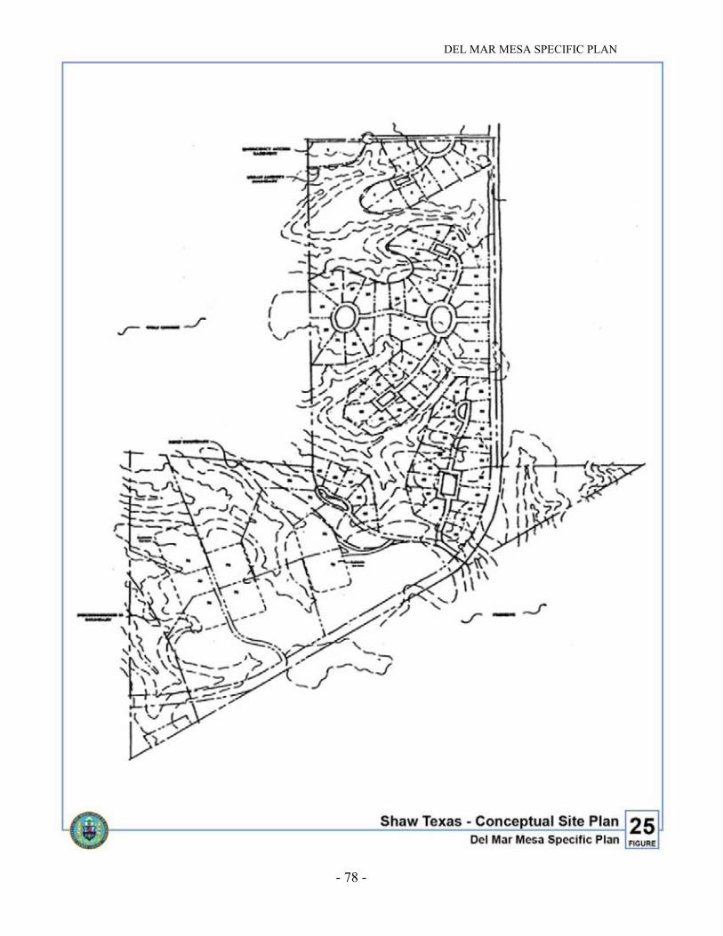
DEL MAR MESA SPECIFIC PLAN
- 78 -
Figure 25. Shaw Texas – Conceptual Site Plan
DEL MAR MESA SPECIFIC PLAN
- 79 -
D. SUPPLEMENTAL DEVELOPMENT REGULATIONS
The following provides development regulations for use in reviewing deviations fromthe minimum standards of the zone permitted with a discretionary planneddevelopment permit. These apply to all areas within Del Mar Mesa unless morespecific development requirements are provided below.
1. Site-specific Development Regulations
The following provides minimum standards for specific parcels within Del MarMesa to be applied when reviewing tentative maps and discretionary developmentpermits. Where these standards conflict with other provisions of the Plan, the Site-specific Development Regulations shall apply. A Planned Development Permit isnecessary to implement these where there are conflicts with base zoning.
a. Shaw Texas (Area No. 61 on Figure 30)
• Minimum Lot Size: 12,000 square feet.
• Within the approximately 70-acre area located within the southwestportion of the Shaw property, residential and accessory uses, includingpublic streets and any other facilities, shall be limited to a maximum of 25percent of the area and clustered on the flatter portions, with nodisturbance on slopes or the 75 percent that remains on the lots as openspace. All brush management shall be accommodated within the defineddevelopment area.
• In the approximately 70-acre area located within the southwest portion ofthe Shaw property no development shall occur within 60 feet of thedesignated MHPA boundary, except brush management activities, publicand private roads and driveways.
• A culvert to facilitate wildlife movement shall be provided where CarmelMountain Road crosses the Urban Amenity Open Space area on thenorthern portion of the parcel. This project is a Del Mar Mesa PFFP andFBA funded improvement.
• Per a private agreement, Area No. 62 on Figure 30 has been conveyedto the resort hotel and golf course property owner. The density associatedwith Area No. 62 corresponding to the allocation for AR-1-1 parcelsdesignated for development is transferred to the Shaw Texas site. Thisequates to seven dwelling units corresponding to the one dwelling unit/2.5acre allocation. This should be memorialized in the discretionary permitfor each project.

DEL MAR MESA SPECIFIC PLAN
- 80 -
Figure 26. Lorenz – Development Area

DEL MAR MESA SPECIFIC PLAN
- 81 -
• A conceptual layout of the Shaw Texas project is shown on Figure 25.This layout, developed in consultation with City staff, identifies steepslopes and biological impacts, provides an Urban Amenity Open Spacecorridor as designated in the specific plan and clusters development tomaintain the viability of a critical wildlife corridor on the southwesternedge of the project. This conceptual site plan may be refined based onfurther City review of the tentative map. An alternative conceptualdevelopment plan is shown on Figure 27.
Should the Shaw/Texas and Lorenz properties be processed as one PDP, thenthe following criteria shall apply:
• There is no increase in the number of dwelling units that may be achievedon the properties. The combined dwelling unit count shall be consistentwith the dwelling unit count already approved for the Shaw/Texas andLorenz properties.
• Homes shall be sited to avoid a standard tract development pattern. Inorder to achieve this goal the following design concepts shall beincorporated into the project:
- Initial home construction shall include a minimum of 25 percent of thehomes as single story.
- The design of each home shall include a similar level of detail, such asvarying wall planes, projections and recesses and similar quality ofdesign and materials on all proposed elevations.
- Houses shall avoid large unbroken wall planes, incorporatingopenings, projections, recesses and changes in plane and buildingdetail.
- Homes shall incorporate the use of overhangs and building shapes in away that results in the creation of usable outdoor spaces.
- The project shall be designed so that adjacent homes shall not havesimilar elevations.
- The rear elevations of homes shall include offset wall planes toachieve a variety of setbacks.
- Lot widths may vary. However, the minimum lot width shall be no lessthan 90 feet (as measured from the mid-point of the building pad). Aminimum of 25 percent of the rim lots shall be 100 feet wide.
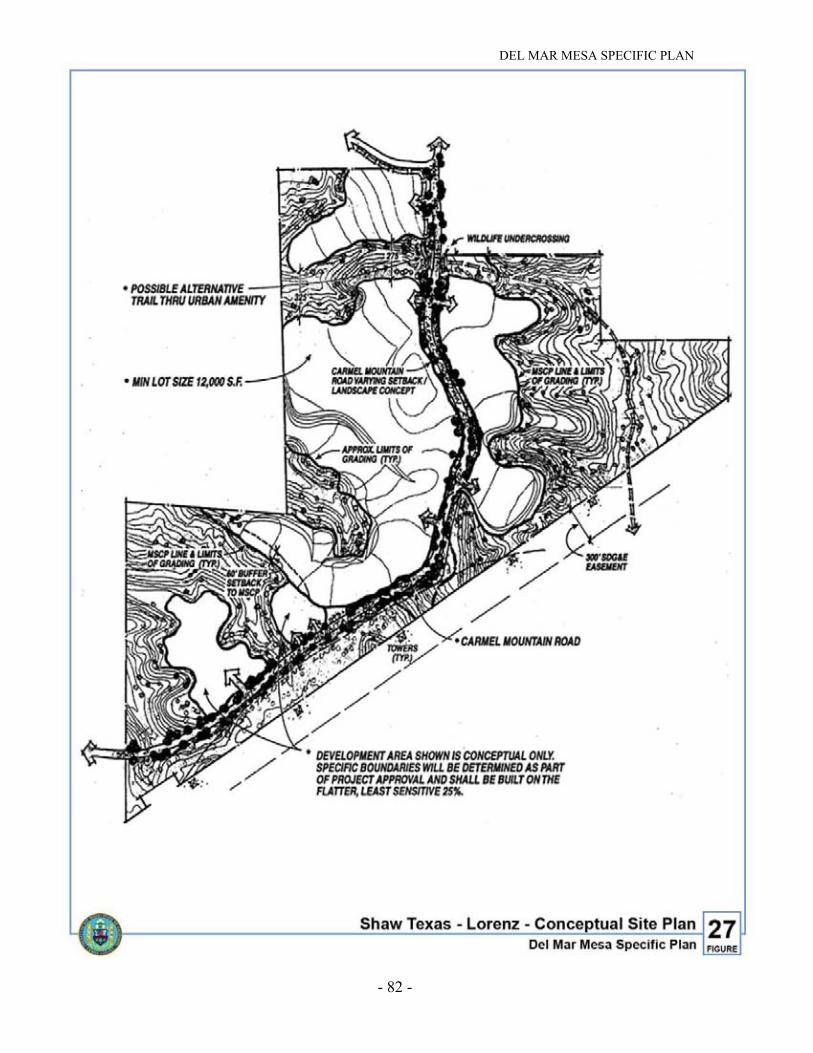
DEL MAR MESA SPECIFIC PLAN
- 82 -
Figure 27. Shaw Texas-Lorenz-Conceptual Site Plan

DEL MAR MESA SPECIFIC PLAN
- 83 -
- Earthen berms shall be provided along Carmel Mountain Road, exceptadjacent to open space and locations where project entrances occur andintersections or where there are physical constraints which wouldprohibit such berming.
- The maximum lot coverages for the project shall be 30 percent fortwo-story homes and 40 percent for single story homes.
- The minimum sideyard setbacks shall be 30 feet between two adjacenttwo-story homes and 25 feet between any two homes in which at leastone is one story. A minimum side yard setback of ten feet shall beprovided between the house and the property line, except along thestreet side yards which shall be a minimum of 15 feet.
- The location of the garage shall be subordinate to the main home. Byreducing the visual impact of the garage, homes may be able to avoidthe standard tract appearance and reduce the bulk and scale of thestructures. The large lots provide the opportunity to place the garagesto the rear of the homes, detached from the homes and oriented awayfrom the street or designed to be side-loaded. Non-front loadedgarages may have a 15-foot front yard setback.
- Measures to accommodate the multiuse trail and the 12- to 14-footmultiuse undercrossing within the Urban Amenity upon theShaw/Texas parcel shall be made if the City and/or community securethe necessary approvals from adjoining properties and supplementalfunding is provided in the FBA to cover incremental increases inconstruction costs.
b. Lorenz Parcel (Area No. 70 on Figure 30)
• Del Mar Mesa, the permitted density for this parcel is one dwellingunit/2.5 acres. The Lorenz parcel could accommodate approximately 32units (78.4 acres at one dwelling unit/2.5 acres). An additional 15 dwellingunits (as per Development Agreement No. 00-18571) may be transferredfrom the Deer Canyon parcel (Area No. 50 on Figure 30) to the Lorenzparcel resulting in a maximum of 47 units. The Deer Canyon parcel willbe transferred to City ownership as per the terms of DevelopmentAgreement No. 00-18571. This is consistent with the Plan. The 15dwelling units associated with the Deer Canyon parcel may also betransferred to other development areas within the Del Mar Mesacommunity or the NCFUA, per a separate agreement with the City.
• All brush management shall occur within the defined development area forlots contiguous to the MHPA. Deviations from brush managementstandards shall be considered if they are consistent with the AlternativeCompliance provision of the Landscape Technical Manual. Fencing willbe located at the limits of the development area.

DEL MAR MESA SPECIFIC PLAN
- 84 -
Figure 28. Mesa Verde – Development Area

DEL MAR MESA SPECIFIC PLAN
- 85 -
• Minimum Lot Size: 0.40 acres. This can be adjusted to accommodate thedwelling unit allocation of 47 dwelling units. Setbacks, coverages and lotsize limitations shall be adjusted to accommodate the unit allocation. If theShaw/Texas and Lorenz properties are developed under one PDP, then thesite-specific regulations described above for the Shaw/Texas propertyshall apply and the project shall be designed to be consistent with theseregulations.
• Conceptual Land Use Areas for the Lorenz parcel are shown onFigure 26. An alternative conceptual land use plan is shown onFigure 27. This is the applicable conceptual land use plan should theShaw/Texas and Lorenz properties be developed as one PDP.
• Should Shaw/Texas and Lorenz be processed as one PDP, then the designcriteria as described in Section 10a (Shaw/Texas parcel) shall apply.
c. Mesa Verde Property (Area Nos. 19, 20, 22, 29 and 43 on Figure 30)
• Minimum Lot Size: 15,000 square feet.
• Minimum Setbacks: 25 feet (front), 15 feet (side), 25 feet (rear).
• Brush Management: Consistent with citywide regulations.
• Defined development area is specified on Figure 28.
d. Resort Hotel and Golf Course Property (Area No. 75 on Figure 30)
• Minimum Lot Size: 10,000 square feet.
• Brush Management: For residential lots adjacent to the golf course, BrushManagement Zone 1 shall be located within the defined development areawith the remainder of brush management, per citywide regulations,located in the designated open space.
• Permitted Uses: Uses adjacent to the open space and the MHPA caninclude recreation, golf courses and driving ranges, streets, parking lots,utility lines, essential public projects, agriculture, resort hotel and dwellingunits.
• Road Standards: Rural road standards should be encouraged for the resorthotel and golf course project. This would discourage curbs, gutters,sidewalks and streetlights. Private roads may be considered with approvalof a PDP for the property.
• A 300-room resort hotel may be considered for the resort hotel and golfcourse project, consistent with Section III.A.5 of the Plan.

DEL MAR MESA SPECIFIC PLAN
- 86 -
• Per a private agreement, Area No. 62 depicted on Figure 30 has beenconveyed to the resort hotel and golf course property owner. The densityassociated with this parcel corresponding to the allocation for AR-1-1parcels designated for development will be transferred to the Shaw Texassite and shall not be included in the residential density calculation for theresort hotel and golf course project. This should be memorialized in thediscretionary permit for each project.
• The designated Urban Amenity Open Space area through the propertyprovides an alternative east-west corridor for wildlife movement. Iffencing is proposed within the proposed golf course on the resort hotel andgolf course property, it should not inhibit wildlife movement through thisarea. In areas where fencing is appropriate, split-rail type not to exceedfour feet in height is recommended. No night lighting of the golf course,driving range or other accessory facilities is permitted, except low-sodiumlights for safety purposes.
• Consistent with the agreements made with the California Department ofFish and Game and U.S. Fish and Wildlife Service, a two-lane access roadfrom Carmel Country Road was constructed to enter the project. Theprecise size and alignment of this road was defined during review of thetentative map and associated discretionary permits.
e. Del Mar Mesa Estates and Lone Tree Estates (Stephens Parcel, Area No.67 and 79 on Figure 30)
• Approximately 18 acres within Area No. 67 are located within the CarmelValley Neighborhood 8 Precise Plan and are within the "PlannedUrbanizing" area. The Neighborhood 8 Precise Plan designates this area asOpen Space and it is zoned AR-1-1. The density associated with thisparcel corresponding to the one dwelling unit/ten-acre density (roundeddown to the lower whole number) may be clustered on the flatter portionof the site located within Del Mar Mesa.
• In addition, a portion of Area No. 79 is located within the PlannedUrbanizing Area within Carmel Valley Neighborhood 8. Consistent withthe above paragraph, the precise acreage designated Planned Urbanizingshall be determined and the density associated with this areacorresponding to the zoning may be clustered on the flatter portions of thesite.
• Del Mar Mesa, the permitted density on the remainder of Area Nos. 67and 79 as depicted in the Del Mar Mesa Specific Plan, is one dwellingunit/2.5 acres. The total density for the project equals this number plusthe dwelling units associated with land within the Planned UrbanizingArea. For Area No. 67, this equates to a maximum of 18 dwelling units.

DEL MAR MESA SPECIFIC PLAN
- 87 -
• The MHPA boundary may be adjusted consistent with Section III.B.5 ofthe Del Mar Mesa Specific Plan. Consideration shall be given toincreasing the development area shown on APN 308-010-021 inexchange for the preservation of APN 308-010-019 as open space.
• Lot configuration and site design should emphasize canyons, hillsides andridges as the visual focal points of the neighborhood. The layout of the lotsand streets with contour grading shall adapt to the existing topography andnatural features, avoiding standard lot sizes and shapes and large amountsof cut and fill.
• The project shall give special attention to the street edges and landscapingto enhance the rural character of homes, open space and views. The streetedge should be designed to retain existing natural features and limit siteimprovements to landscape elements.
• A ten-foot-wide unpaved multiuse trail shall be provided adjacent to DelMar Mesa Road. In addition, Figure 20 shows an equestrian trail to thenorth of Del Mar Mesa Road along the ridge. This trail shall be locatedwithin the defined development area.
• Streets, drives, parking and emergency vehicle access shall be aligned toconform, as closely as possible, to existing grades to minimize the needfor graded slopes. Contour grading should be used to minimize the amountof 2:1 slopes.
• Grading shall be limited to building areas and corridors essential todevelopment of the dwelling units.
• Private streets may be considered for this project with a plannedresidential development permit.
f. Schlacter Parcel (Area No. 58 on Figure 30)
• The area of disturbance for residential development on this parcel andBrush Management Zone 1 shall be limited to 25 acres and be located inthe defined development area as shown on Figure 5 and Exhibit A (theadopted Del Mar Mesa land use map) adopted concurrent with the specificplan.
• With a Planned Development Permit, minimum lot size can be deviatedfrom in order to achieve the dwelling unit allocation for this parcel.
• The project shall incorporate an eight-foot-wide trail connection, as shownon Figure 20, to maintain a linkage to designated trail areas to the east.

DEL MAR MESA SPECIFIC PLAN
- 88 -
• The area utilized for residential development and Brush ManagementZone 1 on this parcel shall be limited to 25 acres. Areas located within theMHPA that are necessary for public trails, required Road Survey 65 right-of-way, other subarea-wide facilities and Brush Management Zones 2 and3 shall not be included within the area limitation.
• Grading and cut/fill slopes are generally prohibited outside the 25-acredevelopment area boundary. “Daylight” cuts and fills are encouragedwhere grading is necessary adjacent to the MHPA. However, due to thepresence of several ravines, avoiding grading outside the defineddevelopment area in accordance with the above policy would result in anirregular or inefficient lot or street pattern. Therefore, under limitedcircumstances, graded slopes may extend outside the 25-acre developmentarea, but only within the limit of the Zone 2-3 brush management area.Where this occurs, the area of grading disturbance shall be re-vegetated in-kind with native plant species as a condition of the implementing tentativemap and/or planned development permit. Variable slope gradients andcontour grading shall be utilized where feasible to simulate adjacentnatural slope conditions.
g. Schmid Parcel (Area No. 59 on Figure 30)
• Minimum Lot Size: 15,000 square feet.
• Road access shall be located along the southwestern edge of the propertyadjacent to the Urban Amenity Open Space.
• The easternmost lot shall accommodate all brush management within thedefined development area subject to the Alternative Compliance provisionof the Landscape Technical Manual.
E. ENVIRONMENTALLY SENSITIVE LANDS REGULATIONS AND THE DELMAR MESA SPECIFIC PLAN REGULATIONS
The Resource Protection Ordinance (RPO) was adopted by the City in 1989. Thepurpose and intent of this ordinance was “to protect, preserve, and, where damaged,to restore the environmentally sensitive lands of San Diego.” The provisions of theordinance are applicable to floodways and 100-year floodway fringe areas, allwetland and wetland buffer areas, all natural hillside areas of 25 percent or greater,biologically sensitive lands and significant prehistoric and historic sites andresources. Permitted uses and development regulations relative to theseenvironmentally sensitive lands were established in the resource protection ordinanceand are described below for the plan area.

DEL MAR MESA SPECIFIC PLAN
- 89 -
The Plan was originally adopted when the RPO was in effect. The adoption of thePlan amended RPO excluding the Del Mar Mesa community from the RPOregulations located in the San Diego Municipal Code and replacing RPO with theregulations contained in the Plan. Although projects within Del Mar Mesa stillrequired a RPO permit, the projects were evaluated for conformance to theregulations contained in the specific plan, rather than the Municipal Code. Theregulations in the Plan were written to be consistent with the EnvironmentallySensitive Lands regulations (ESL) that implement the MSCP program and wouldreplace RPO in the Municipal Code when the Land Development Code was adopted.
With the adoption of the Land Development Code in January 2000, the RPO wasreplaced by the ESL regulations. The adoption of the LDC eliminated the RPOpermit, replacing it with regulations that each project must conform to in order to beapproved. Although a RPO permit will not be required, projects within thecommunity of Del Mar Mesa must conform to the regulations included in this Planand a finding of conformance with these regulations must be made in order toapprove any proposed projects in the community. Where the Plan is silent, the ESLregulations are the applicable regulations.
The RPO acted to protect environmental resources on a parcel-by-parcel basis, asland is developed. Council Policy 600-40, which addressed the preparation of long-range plans, was adopted in 1991 to ensure that comprehensive analyses of largerplanning areas be conducted consistent with RPO. The Council’s objective was toensure that long-range plans, such as this Plan, were prepared consistent with thepurpose and intent of RPO so that conflicts between long-range plans and futuredevelopment permits which were subject to RPO were reduced.
Specifically, the purpose of the policy was to provide guidelines for the preparation oflong-range plans that:
1. Ensured thorough analysis of site constraints and opportunities early in theplanning process;
2. Aided in the review of permits and maps for projects in the planning areas;
3. Ensured the protection of environmental resources by preserving contiguous openspace systems and providing mechanisms to acquire or protect those resources;and
4. Ensured that adopted land use policies and objectives are considered in thecontext of the suitability of the planning area for development.
An analysis, focused on biologically sensitive lands as described in the MSCPSubarea Plan, was conducted by the City’s MSCP staff for the Plan. The open spaceand MHPA boundaries were developed in cooperation with the U.S. Fish andWildlife Service, the California Department of Fish and Game, property owners,

DEL MAR MESA SPECIFIC PLAN
- 90 -
developers and environmental groups in an effort to achieve consolidation of largerhabitat areas and preservation of ecosystem connections within the Plan.
The Plan was developed to be consistent with the ESL Regulations, which wereadopted by ordinance on January 12, 1998, by the City Council, Ordinance number18456. The ESL Regulations replace the RPO and were designed to better implementthe goals of the MSCP.
Development and open space boundaries developed as part of the MSCP planningeffort were also analyzed to quantify impacts to steep slopes and evaluate consistencywith RPO. The plan area contains a total of 712 acres of steep slopes. The worst-casescenario assumes that 130 acres of steep slopes, or 18 percent, could be impactedbased on the development areas shown. When this encroachment into hillsides isadded to the assumed encroachment into biologically sensitive lands, the Plandevelopment program is within the maximum encroachment limitations defined inRPO, when looking at the plan area as a whole.
Because the above analysis was conducted in conformance with City Council Policy600-40, RPO, the MSCP and the ESL Regulations, it is deemed to be an adequateanalysis of the constraints and opportunities of the Plan with respect to biological andhillside resources, as of the effective date of this Plan. Therefore, for projects withinthe Estate Residential area, with respect to hillside and biological impacts, decisionmakers exercising discretion to issue a discretionary permit shall utilize a standard ofreview of substantial conformity with the Plan.
Projects within the plan area which impact biologically sensitive land shall comply withthe supplemental regulations for resource management set forth in Section IV. F.
Projects within the plan area which impact steep slopes shall comply with thesupplemental regulations for resource management set forth in section IV.F. Individualprojects within the Estate Residential area shall not be subject to steep hillsideencroachment limitations contained in RPO or the ESL Regulations because theanalysis conducted in connection with adoption of the Plan has determined thatRPO/ESL has been complied with comprehensively in this regard for the entire planarea.
For other resources regulated by RPO and/or ESL, such as floodplains, wetlands andarcheological resources, there was insufficient information available at the time ofPlan preparation to conduct an adequate analysis pursuant to City Council Policy600-40. Therefore, it is anticipated that subsequent discretionary review will berequired pursuant to applicable Municipal Code provisions regulating these resources.
Concurrent with adoption of the Plan, the RPO was amended to provide an exemptionfor projects where development activity is wholly located in the development area,and where development activity observes a 100-foot setback from wetlands,designated floodplains and identified archeological resources, or when development

DEL MAR MESA SPECIFIC PLAN
- 91 -
would not demolish or substantially alter a designated historical resource. The RPOwas also amended to delete the exemption for single-family residences for parcelswholly or partially within the MHPA. This amendment was necessary to ensure thatany development occurring within the proposed preserve area will be located uponthe least sensitive portion of the site. These amendments are consistent with theadopted ESL Regulations.
Although a project no longer must obtain a RPO permit, projects are still subject tothe supplemental regulations for resource management contained in this specific planin place of the regulations and definitions in RPO. With the adoption of the ESLregulations, the RPO was repealed and the ESL regulations shall be applicable, exceptthat in any instance where the ESL regulations directly conflict with the Plan or thesupplemental regulations for resource management, the Plan and the supplementalregulations for resource management shall control.
All development in Del Mar Mesa is subject to requirements of the CaliforniaEnvironmental Quality Act (CEQA). The Del Mar Mesa Master EnvironmentalImpact Report was approved for the plan area. It is anticipated that environmentalreview of future projects within the Del Mar Mesa community will be facilitated bythis Master EIR.
F. SUPPLEMENTAL REGULATIONS FOR RESOURCE MANAGEMENT
The Plan supersedes where inconsistent with and otherwise supplements the ESLregulations by providing the following supplemental regulations for resourcemanagement. These regulations are intended to be consistent with the Multi-HabitatPlanning Area boundaries and the ESL regulations which replaced the ResourceProtection Ordinance in furtherance of implementing the MSCP. In any instancewhere the ESL regulations directly conflict with the Plan or these supplementalregulations for resource management, the Plan and the supplemental regulations forresource management shall control. Environmental Impact Report No. 95-0353prepared for the Plan analyzed those resource regulations specified in the Plan.
1. Wetlands and Wetland Buffers
Wetlands are defined as land which is transitional between terrestrial and aquaticsystems where the water table is usually at or near the surface or where the land iscovered by shallow water and waters of the United States. Wetlands include allwaters subject to the ebb and flow of the tide, including lagoons, estuaries,marshes, mudflats, rivers, streams (including intermittent streams) and associatedriparian habitat, natural ponds and lakes, vernal pools and manmadeimpoundments and drainages with biological value. Wetlands typically displayhydrophytic vegetation, hydric soils and characteristic hydrology. Due to seasonalfluctuations and past disturbances by humans, all three components may not bepresent. To be considered a wetland within this definition, the area must have oneor more of the following characteristics:

DEL MAR MESA SPECIFIC PLAN
- 92 -
a. At least periodically, the land supports predominantly hydrophytes, as definedin the Unified Federal Method Manual (Federal Manual for Identifying andDelineating Jurisdictional Wetlands, January 19, 1989), on file in the CityClerk's Office as Document No. 00-17602;
b. The substrate meets the criteria for hydric soils, including aquic soils, asdescribed in the Unified Federal Method Manual; or
c. The substrate is saturated with water or covered by shallow water at sometime during the growing season of each year, or if the hydrologic conditionsmeet the criteria in the Unified Federal Method Manual.
Wetland Buffers are defined as lands which provide a buffer area of anappropriate size to protect the environmental and functional habitat values of thewetland.
Permitted uses within wetlands are limited to wetlands-related scientific research,wetland restoration projects where the primary purpose is restoration of thehabitat, and essential public service projects where it has been demonstrated thatthere is no feasible less environmentally damaging location or alternative, andwhere mitigation measures have been provided that assure there is no net loss ofwetland habitat function or value. Permitted uses in wetland buffer areas arelimited to the uses permitted in wetlands, passive recreational uses such as accesspaths, public viewpoints, and informational signs, provided that all necessarymitigation measures are incorporated to protect the adjacent wetlands, andimprovements necessary to protect adjacent wetlands, provided that such uses arecompatible with protecting wetlands.
A wetlands delineation has not been conducted for the specific plan area;however, based on the vegetation mapping provided in the accompanying EIR, itis anticipated that wetlands may occur on site within areas designated fordevelopment. A wetlands delineation shall be required with future discretionaryactions to map the precise locations and analyze the potential impacts to wetlands.Development, other than that described above as permitted uses, shall not beallowed within wetlands and wetland buffers. Additionally, numerous vernalpools (approximately 111 acres of habitat) are present in the eastern portion of thespecific plan area, which is not designated for development.
Amendments to citywide regulations related to wetlands and wetland buffers havebeen made in conjunction with the ESL regulations which replace RPO. Thewetlands and wetland buffer regulations contained in the Plan have beensuperseded in their entirety by the adopted ESL regulations.
DEL MAR MESA SPECIFIC PLAN
- 93 -
2. Floodway
The floodway is all land in a 100-year floodplain not lying within a designatedfloodway. The floodway and 100-year floodplain are identified in the mostcurrently available set of Federal Emergency Management Agency (FEMA) mapscovering the City of San Diego, on file with the City's Floodplain Administrator.Permitted uses in the floodway shall be those uses permitted by the underlyingzone, subject to the following regulations and the regulations and restrictions ofthe underlying zone.
New roadways and roadway expansions, except local access roadways, shall beallowed only where indicated in an adopted community plan, the Plan, oridentified in the Circulation Element of the General Plan. Low-intensityrecreational uses may be permitted.
Within the 100-year floodway, permanent structures and/or fill for permanentstructures, roads and other public improvements will be allowed only if theapplicant can demonstrate that:
a. The development is capable of withstanding periodic flooding and does notrequire the construction of off-site flood protective works including, but notlimited to, artificial flood channels, revetments and levees. Flood protectionworks may be permitted to protect new or existing roads which are identifiedin the Circulation Element of the General Plan and applicable communityplans;
b. Existing biologically sensitive lands and wetlands and wetland buffers will notbe disturbed;
c. Grading and filling are minimized and harm to the environmental values ofthe floodway is minimized;
d. The design of the development incorporates the findings andrecommendations of both a site-specific and watershed hydrologic study inorder that: (1) there will be no increase in the peak runoff rate from the fullydeveloped site as compared to the discharge that would be expected from theexisting undeveloped site as a result of the most intense rainfall expected onceevery ten years during a six-hour period; and (2) the development neithersignificantly increases nor contributes to downstream bank erosion andsedimentation of wetlands or other biologically sensitive lands; and
e. There will be no significant adverse water quality impacts to downstreamwetlands and other biologically sensitive lands.
Floodplains subject to the 100-year flood have been identified by FEMA forportions of the plan area. Specifically, Shaw Valley Creek, a tributary of CarmelValley Creek, is located in the western portion; Deer Canyon Creek is locatedalong the northern boundary and joins with McGonigle Canyon Creek to formCarmel Valley Creek; and unnamed tributaries of Los Peñasquitos Creek are
DEL MAR MESA SPECIFIC PLAN
- 94 -
along the southern boundary of the Plan. Areas within the floodplain of ShawValley Creek are designated for development; however, a hydrologic study hasnot been prepared as part of the Plan. Future development within the floodplainwill be required to meet the above regulations if fill for permanent structures orroadways is proposed.
3. Sensitive Biological Resources (other than Wetlands and Wetland Buffers)
Sensitive biological resources are defined as land which supports sensitivevegetation or the habitats of rare, endangered, or threatened species or subspeciesof animals or plants as defined by the California Endangered Species Act, or theFederal Endangered Species Act, or as otherwise defined in the LandDevelopment Code. Within the plan area, all lands located within the City of SanDiego MHPA are considered sensitive biological resources. Sensitive biologicalresources may also include areas that support sensitive species of plants oranimals.
Permitted uses in areas containing sensitive biological resources shall be thoseuses permitted by the underlying zone subject to the following regulations and theregulations and restrictions of the underlying zone.
Projects within the Estate Residential area which impact biologically sensitiveland will not be required in subsequent ESL review to avoid those resources orcomply with encroachment limitations provided that the project conforms with theEstate Residential area established in the Plan and, appropriate mitigation isprovided for biological impacts of the project in accordance with subsequentimpact analysis conducted in accordance with CEQA and City standards relatedto mitigation for biological impacts in effect at the time of impact and, the takingof habitat or species within the Estate Residential area is not precluded by state orfederal law or the Take Authorizations or Permits issued to the City by the state orfederal governments pursuant to the MSCP.
For properties located wholly within the Resource Based or Urban Amenity OpenSpace areas, a maximum of 25 percent of the site may be developed with thedevelopment area sited upon the least sensitive portion of the site. For propertieslocated partially within the Resource Based or Urban Amenity Open Space areasand partially within the Estate Residential area, any development must occur onthe portion of the site outside the Resource Based or Urban Amenity Open Spaceareas first. If the portion of the site within the Estate Residential area is less than25 percent of the site area, then encroachment into the Resource Based or UrbanAmenity Open Space areas may be permitted to achieve a 25 percent developmentarea.
4. Steep Hillsides
Hillsides occur throughout the specific plan area with the majority of steep slopeslocated in the northeastern and southern portions of the community which areassociated with Deer Canyon, Shaw Valley and Peñasquitos Canyon. The

DEL MAR MESA SPECIFIC PLAN
- 95 -
development area is concentrated in the western portion of the Plan and wouldresult in the loss of approximately 51 acres of hillsides through future grading anddevelopment.
Steep hillsides are defined as all lands having a slope with a natural gradient of 25percent or greater, (25 feet of vertical distance for each 100 feet of horizontaldistance) and a minimum elevation differential of 50 feet.
Permitted uses in the hillside areas shall be those uses permitted by the underlyingzone subject to the following regulations and the regulations and restrictions ofthe underlying zone and the Environmentally Sensitive Lands when applicable tothe hillside portion of a parcel.
All development occurring in steep hillsides must comply with the Steep HillsideGuidelines and the City's Grading Regulations. The proposed development shallminimize the alteration of natural landforms and create only new slopes thattopographically resemble natural landforms of the surrounding area. Structuresproposed on steep hillsides shall be designed to fit the hillside by incorporatingconstruction techniques that minimize alteration of the existing hillsideconditions.
Newly created slopes shall not exceed a gradient of 50 percent. Disturbed portionsof the site in 25 percent or greater slopes shall be re-vegetated or restored inaccordance with the City's Landscape Regulations. All future developmentproposals which encroach into steep hillsides will require a site specific analysisto determine the precise level of impacts to steep slopes and the correspondingmitigation requirements.
5. Significant Prehistoric and Historic Sites and Resources
Significant prehistoric and historic sites and resources are defined as locations ofprehistoric or historic resources that possess unique cultural, scientific, religiousor ethnic value of local, regional, state or federal importance. These resources arelimited to designated historical resources and historical districts (i.e., prehistoricor historic districts, sites, buildings, structures, or objects included in the StateLandmark Register, or the City of San Diego Historical Sites Board List, orincluded in or eligible for inclusion in the National Register of Historic Places),important archaeological sites (i.e., areas of past human occupation whereimportant prehistoric or historic activities or events occurred such as villages orpermanent camps), and traditional cultural properties (i.e., locations of past orcurrent traditional religious or ceremonial observances of importance to anidentifiable ethnic group or which are central to a group's origins as a people suchas burials, pictographs, petroglyphs, solstice observation sites, traditionalgathering areas and sacred shrines).
Permitted uses in lands containing significant prehistoric and historic sites andresources shall be those uses permitted by the underlying zone subject to thefollowing regulations and the regulations and restrictions of the underlying zone.
DEL MAR MESA SPECIFIC PLAN
- 96 -
Substantial alteration, demolition, destruction, removal or relocation of anydesignated historical resource or any historical building or structure locatedwithin a historical district shall not be permitted. Minor alteration of anydesignated historical resource, or any historical building or historical structurelocated within a historical district, or any new construction within a historicaldistrict may be permitted if the minor alteration or new construction would notadversely affect the special character or special historical, architectural,archaeological or cultural value of the resource.
Important archaeological sites shall be preserved in their natural state, exceptthat up to 25 percent encroachment into any important archaeological site maybe permitted if necessary to achieve a reasonable development area. This 25percent encroachment includes all grading and construction. An additionalencroachment of up to 15 percent, for a total encroachment of 40 percent, intoimportant archaeological sites may be permitted for publicly-owned parks andrecreation facilities, public schools and major streets if the development is sited,designed and constructed to minimize adverse impacts to importantarchaeological sites and where it has been demonstrated that there is no feasible,less environmentally damaging location or alternative. Any encroachment intoimportant archaeological sites shall include preservation through avoidance ofthe remaining portion of the important archaeological site and implementationof a research design and excavation program that recovers the scientific value ofthe portion of the important archaeological site that would be lost due toencroachment.
Development shall not be permitted in any traditional cultural property unlessall feasible measures to protect and preserve the resource are required as acondition of development approval.
Alterations and improvements to prehistoric and historic sites and resources thatenhance, restore, maintain or repair the site or resource and which do notadversely affect the special character, or special historical, architectural,archaeological or cultural value of the prehistoric and historic site or resourcemay be permitted.
A survey to identify prehistoric and historic sites and resources has beencompleted for the subarea plan. Only the resources located within the resorthotel and golf course property have been evaluated to determine theirsignificance and no resources within this property have been deemedsignificant. The remaining portions of the specific plan contain numerous (morethan 30) sites or resources that have not been evaluated. Site-specific evaluationshall be completed for any future subdivision or development plan to determinethe allowable development area, the precise level of impacts to significantprehistoric or historic sites or resource and the corresponding mitigationrequirements.

DEL MAR MESA SPECIFIC PLAN
- 97 -
G. FACILITIES FINANCING AND FEES
Public Facilities Financing Plan
In conjunction with development of the Plan, a public facilities financing planreplaced the interim development impact fee and was adopted concurrently with thePlan. The Framework Plan was adopted with the assumption that a phase shift wouldtake place. The Del Mar Mesa Specific Plan was adopted in place of a phase shift.Because any financing element needs to be inclusive, the revised fee analysisaddresses financing of those facilities that are specific to Del Mar Mesa as well as ashare of the facilities in other areas of the NCFUA assumed necessary that will serveDel Mar Mesa.
In addition to the facilities outlined above, the financing element includes ananticipated phasing schedule and estimated cost for the identified facilities. TheFacilities Benefit Assessment (FBA) for Del Mar Mesa is based on the facilitiesneeds specific to Del Mar Mesa and the fair share of the projects needed for the totalFuture Urbanizing Area. For the purpose of developing a FBA, staff has madeassumptions on facilities needs based on the projected population of Del Mar Mesa atbuildout.
The Carmel Valley Trunk Sewer construction is to be funded through a FacilitiesFinance Benefit Assessment. All projects that discharge to this trunk sewer will becharged with that assessment upon pulling building permits. The cost per dwellingunit will be determined with the completion of the Carmel Valley Trunk SewerMaster Plan. Developers will provide a letter of commitment to participate in theFBA District. Additionally, a participation agreement will be entered into for alldevelopments where the flows discharge into the Carmel Valley Trunk Sewer.
Specific Plan Preparation Fee
In accordance with Government Code Section 65456, a Specific Plan Preparation Feeshall be assessed on a per unit basis prior to the issuance of building permits topartially recoup City costs in preparing the Plan.
School Financing
The impact of development within Del Mar Mesa on regional school facilities shallbe borne by property owners within the plan area on a fair share basis. The effectedschool districts have developed financing plans which identify impacts attributable toprojected development and revenue generation mechanisms necessary to mitigatethese impacts.
With respect to the Poway Unified School District (PUSD), impacts are capable ofbeing adequately mitigated by and the financing plan relies upon, the district levyingschool facilities fees (“Statutory School Fees”) pursuant to Government CodeSections 53080 et seq. and 65995 et seq.

DEL MAR MESA SPECIFIC PLAN
- 98 -
With respect to the Del Mar Union School District (DMUSD), Statutory School Feesare not adequate to fully mitigate for school facility impacts. Therefore, prior to Cityapproval of any subdivision, planned development or other discretionary residentialdevelopment application within the DMUSD, the City shall require each applicant toobtain a Certificate of Compliance or a Certificate of Exemption from the DMUSD.A Certificate of Compliance will be issued by the DMUSD only after the applicanthas executed a School Facilities Funding and Mitigation Agreement (in a formsubstantially similar to the agreement set forth in Appendix C) agreeing to pay thespecified Mitigation Payment or acquiescing to be annexed into Community FacilitiesDistrict No. 95-1 of the DMUSD. A Certificate of Exemption shall be issued solely atthe discretion of the DMUSD and only when, after analyzing the project, theDMUSD determines that the applicant should not be required to execute a SchoolFacilities Funding and Mitigation Agreement. The DMUSD has agreed to defend,indemnify and hold the City of San Diego harmless from any claim, action, orproceeding against the City arising from or related to the City's requirement that eachapplicant obtain a Certificate of Compliance or a Certificate of Exemption from theDMUSD prior to project approval to the extent provided in such IndemnificationAgreement. (See Appendix C for Copy of Agreement.)
With respect to the San Dieguito Union School District (SDUSD), Statutory SchoolFees are not adequate to fully mitigate for school facility impacts. Therefore, prior toCity approval of any subdivision, planned development or other residentialdevelopment application within the SDUSD, the City shall require each applicant toobtain a Certificate of Compliance or a Certificate of Exemption from the SDUSD. ACertificate of Compliance will be issued by the SDUSD only after the applicant hasexecuted a School Facilities Funding and Mitigation Agreement acquiescing to beannexed into a Community Facilities District or agreeing to participate in a newlyformed Community Facilities District or agreeing to pay a mitigation fee in anamount to be determined by the SDUSD in accordance with its school facilitiesfinancing plan. A Certificate of Exemption shall be issued solely at the discretion ofthe SDUSD and only when, after analyzing the project, the SDUSD determines thatthe applicant should not be required to execute a mitigation agreement. The SDUSDhas agreed to defend, indemnify and hold the City of San Diego harmless from anyclaim, action, or proceeding against the City arising from or related to the City'srequirement that each applicant obtain a Certificate of Compliance or a Certificate ofExemption from the SDUSD prior to project approval to the extent provided in suchIndemnification Agreement. (See Appendix D for Copy of Agreement.)
Until sufficient students have been generated from this and adjacent areas, andsufficient special taxes are collected to fund the property acquisition anddevelopment, the identified school/park site property shall retain development rightsconsistent with AR-1-1 parcels designated for development in the Plan, except wheredensity is further defined in the Plan. If, prior to acquisition by the DMUSD and/orCity of San Diego, the property owner makes application for a subdivision of land orother discretionary action, the City and the DMUSD shall have the opportunity tonegotiate purchase of the identified property.
DEL MAR MESA SPECIFIC PLAN
- 99 -
Los Peñasquitos Lagoon Enhancement Fund
Applicants for coastal development permits for projects located in the watershed ofthe Los Peñasquitos Lagoon shall, in addition to meeting all other requirements of thelocal coastal program, enter into an agreement with the City of San Diego and theState Coastal Conservancy as a condition of development approval to pay a LosPeñasquitos Lagoon Fund for restoration of the Los Peñasquitos Lagoon and itswatershed.
H. OPEN SPACE ACQUISITION PROGRAM
Based upon the significant biological resources contained in the open space in DelMar Mesa, and the importance of its inclusion in the MSCP as a preserved core area,a main goal of the Plan is, to the greatest extent practicable, the retention as openspace the eastern portion of the Del Mar Mesa designated Open Space/RuralResidential. As stated earlier in the MSCP/Open Space Element, the Del Mar Mesa'sproximity to the Los Peñasquitos Canyon Preserve results in an area that, ifpreserved, provides the single most important component of the open space system inthe NCFUA.
Due to the overall low-density zoning throughout Del Mar Mesa, density from thepreserve area could be clustered onto the area designated for higher densitydevelopment without impacts to the circulation system. To that end, development inthe AR-1-1 areas will partially fund acquisition of the Open Space/Rural Residentialareas through the Facilities Benefit Assessment District (FBA), adopted concurrentlywith the Plan. The potential result is a semirural residential community adjacent to apermanently protected interconnected viable habitat area.
In addition to the FBA, other funds for open space acquisition will include thedirection of mitigation funds associated with the construction of SR-56 and otherdevelopment projects in or outside Del Mar Mesa. Other possible funding sourcesinclude the use of an open space acquisition fund, if established, from the potentialsix million dollars from the resort hotel, revenue bonds guaranteed by this futureincome stream, or possible federal funding.
Once funds become available, an approach to facilitate resource preservation could bethe purchase of options on the open space area to remove properties from the marketto allow for time to raise funds for the balance of the purchase price. It should benoted that property owners in the Open Space/Rural Residential areas can developconsistent with the underlying zoning until such time as a determination is made, andfunds are available, to acquire such properties.

DEL MAR MESA SPECIFIC PLAN
- 100 -
I. TRANSPORTATION PHASING
As shown on Table 7, the Del Mar Mesa Transportation Study assumes a total of 685residential dwelling units (DUs), a 300-room resort hotel, and a golf course, that areexpected to generate 9,880 daily trips. The resort hotel and golf course projectincludes the resort hotel, the golf course and approximately 140 of the 685 dwellingunits. The Transportation Study also assumes two public projects: a nine-acreneighborhood park that generates 450 daily trips and a four-acre school that generates240 daily trips for a grand total of 10,570 daily trips. Since the publication of the DelMar Mesa Transportation Study, the number of dwelling units and distribution ofpark vs. school acreage have been revised slightly. This does not affect therecommendations below.
The phasing of transportation improvements assumes the Alternative 3 network of theTransportation Study that includes the central alignment for SR-56, the Camino SantaFe connection with the western alignment and Del Mar Mesa Road as a two-laneresidential local street.
Special effort has been made to reduce Del Mar Mesa's dependence on roadimprovements outside of the subarea with the exception of Carmel Country Road,between SR-56 and the northern boundary of Carmel Valley Neighborhood 10. Thesegment of Carmel Country Road between SR-56 and Carmel Valley Neighborhood8’s southern boundary (including its interchange with the freeway) is alreadyconstructed and fully operational. The segment of Carmel Country Road south ofNeighborhood 8 to the Neighborhood 10 northern boundary is to be a four-lane majorstreet. This roadway is currently being designed and is scheduled to be fullyconstructed in 1997. The segment south of the Neighborhood 10 northern boundary isalso being designed and is expected to be fully constructed in 1998.
The following pages describe the two phases of the Transportation Phasing Plan.
Phase 1
Carmel Country Road is a vital road that serves Del Mar Mesa and developments inCarmel Valley. According to the City-approved traffic study for Neighborhoods 8Aand 10 Combined Transportation Phasing Plan (8A/10 CTPP), June 26, 1995, CarmelCountry Road is classified as a four-lane major street from SR-56 to south ofNeighborhood 10's northern boundary (see Figure 14).
The four-lane major street segment of Carmel Country Road has a maximumdesirable traffic volume of 30,000 daily trips. Of these 30,000 daily trips, about14,994 are from Carmel Valley Neighborhoods 8A, 10 and Torrey Hills (seeTable 9). The remaining maximum desirable volume is therefore approximately15,000 daily trips, of which 5,000 daily trips would be utilized by the existingdevelopment in Carmel Valley Neighborhood 8 (Palacio Del Mar, located east ofCarmel Country Road and north of Del Mar Mesa Road).

DEL MAR MESA SPECIFIC PLAN
- 101 -
This would result in a 10,006 (30,000 maximum desirable traffic - 19,994 trips fromTorrey Hills, Carmel Valley Neighborhoods 8, 8A and 10) traffic volume reserve onthis segment of Carmel Country Road that could be utilized by Del Mar Mesadevelopments. Given the spatial distribution of Del Mar Mesa’s developable landownership, substantial amount of property is on the east side of the subarea.Therefore, not all of the 10,006 daily trips may be utilized at this stage ofdevelopment. It is expected that the equivalent of 6,600 daily trips will be generatedin the first phase of Del Mar Mesa developments.
In addition to improvement of Carmel Country Road (north of Carmel ValleyNeighborhood 10's northern boundary) as a Four-Lane Major street, Del Mar MesaRoad is also recommended to be improved as a two-lane residential local street (38 ft.c/c width) with a maximum desirable volume of 2,200 Average Daily Traffic (ADT).
At this phase, traffic signals need to be installed at Carmel Country Road at theentrance to the resort hotel and golf course project (to be paid for by the developeronly) if this project is to proceed in this phase, and at the intersection of CarmelCountry Road at the entrance to the Carmel Valley Neighborhood 8 development(Palacio Del Mar). Cost for installation of this signal is to be paid for by CarmelValley FBA and the Del Mar Mesa on a fair share basis.
A list of Phase 1 improvements follows:
1. Carmel Country Road constructed as a four-lane major street, from SR-56 tosouth of Carmel Valley Neighborhood 10's northern boundary. This improvementis in Carmel Valley's Neighborhoods 8A/10 CTPP. Del Mar Mesa is to pay its fairshare of this project through the formation of a reimbursement district.
2. Del Mar Mesa Road constructed as a two-lane residential local street fromCarmel Country Road to Camino Santa Fe. This improvement is to be paid to bythe Del Mar Mesa FBA.
3. Traffic signals to be installed at Carmel Country Road at the entrance to CarmelValley Neighborhood 8's development (Palacio Del Mar). This improvement is tobe paid for by Carmel Valley FBA and the Del Mar Mesa FBA on a fair sharebasis.
4. Traffic signals to be installed at Carmel Country Road/resort hotel and golf courseentrance (if this project is to proceed at this phase). This improvement is to bepaid for by the developer.

DEL MAR MESA SPECIFIC PLAN
- 102 -
29. Transportation Phasing Alternatives

DEL MAR MESA SPECIFIC PLAN
- 103 -
TABLE 9
DISTRIBUTION OF DAILY TRIPS BY DEVELOPMENT
ON CARMEL COUNTRY ROAD FOR PHASE 1
Carmel Country Road Daily Trips
Development
SR-56 To South OfNeighborhood 10's NorthernBoundary (Four-Lane Major)
South Of Neighborhood 10's NorthernBoundary To Carmel Mountain Road
(Four-Lane Modified Collector)
Torrey Hills 1 1,440 1,440
Neighborhood 8 5,000 —
Neighborhood 8A 3,950 3,950
Neighborhood 10 9,604 9,604
Subarea V, with MaximumPotential Development 2
6,600 —
Total 26,594 14,994
1. The source for Torrey Hills and Carmel Valley Neighborhood’s 8A & ten trips is Table 13 of the TransportationAnalysis for Carmel Valley Neighborhood 8A, by Urban Systems Associates, June 26, 1995.
2. Potential development at this phase may be the resort hotel and golf course development with 4,400 daily trips and anadditional 220 dwelling units, or any other combination of development totaling the equivalent of 6,600 ADT.
Phase 1 Development Threshold for Del Mar Mesa Road
Existing and future developments utilizing Del Mar Mesa Road to access CarmelCountry Road, prior to the construction of Camino Santa Fe and its connection to SR-56, are subject to a collective maximum cap of 2,200 Average Daily Traffic (ADT),or 220 equivalent single family dwelling units (EDU), as shown on Table 10 below:
TABLE 10
PHASE 1 DEVELOPMENT THRESHOLD FOR DEL MAR MESA ROAD
Development ADT EDU
Existing Residential Dwellings 250 25
Hotel & Golf Course Maintenance Employees 50 5
Future Single-family Dwellings 1,900 190
Total 2,200* 220
*The distribution of traffic generation shown are estimates. The estimated ADTs can be from anycombination of existing and future development, on a first-come, first-served basis, subject to the2,200 ADT thresholds.
DEL MAR MESA SPECIFIC PLAN
- 104 -
Del Mar Mesa Road shall not be used for commercial deliveries associated with theresort hotel and golf course. The only access from the resort hotel and golf course toDel Mar Mesa Road is for maintenance employees.
There is no residential, employee or service access from Del Mar Mesa Road tohotel/golf course development. Access for maintenance employees and emergencyaccess are the only types of access that exist from Del Mar Mesa Road to thehotel/golf course development.
Monitoring
Monitoring of the Phase 1 developments in Del Mar Mesa will be done by theFacilities Financing Section of the Comprehensive Planning Division throughbuilding permit issuance on a first-come, first-served basis. Permits will not be issuedonce the Phase 1 threshold of 2,200 daily trips is reached.
Phase 2
The remaining dwelling units and/or other developments may be constructed at thesecond phase of development in Subarea V. The required infrastructure to support therest of developments in the subarea are shown on Figure 29 and described below:
1. A four-lane arterial road (as an interim improvement prior to Caltrans' completionof SR-56), from the existing eastern terminus of SR-56 to Camino Santa Fe and agrade separated interchange. Costs for the interchange bridge is to be paid for bythe City. Costs for the interchange ramps at Camino Santa Fe are to be paid for bythe FUA and Subarea V FBA on a fair share basis.
2. Camino Santa Fe connection constructed as a two-lane collector street fromSR-56 to Del Mar Mesa Road. This improvement is to be paid by Del Mar Mesadevelopments.
3. Once the improvements specified in Nos. 5 and 6 above are in place, the centralportion of Del Mar Mesa Road may be considered for closure either by gate orcul-de-sac.
Street improvements in Phase 2 conclude the required transportation phasingimprovements for all of Del Mar Mesa.
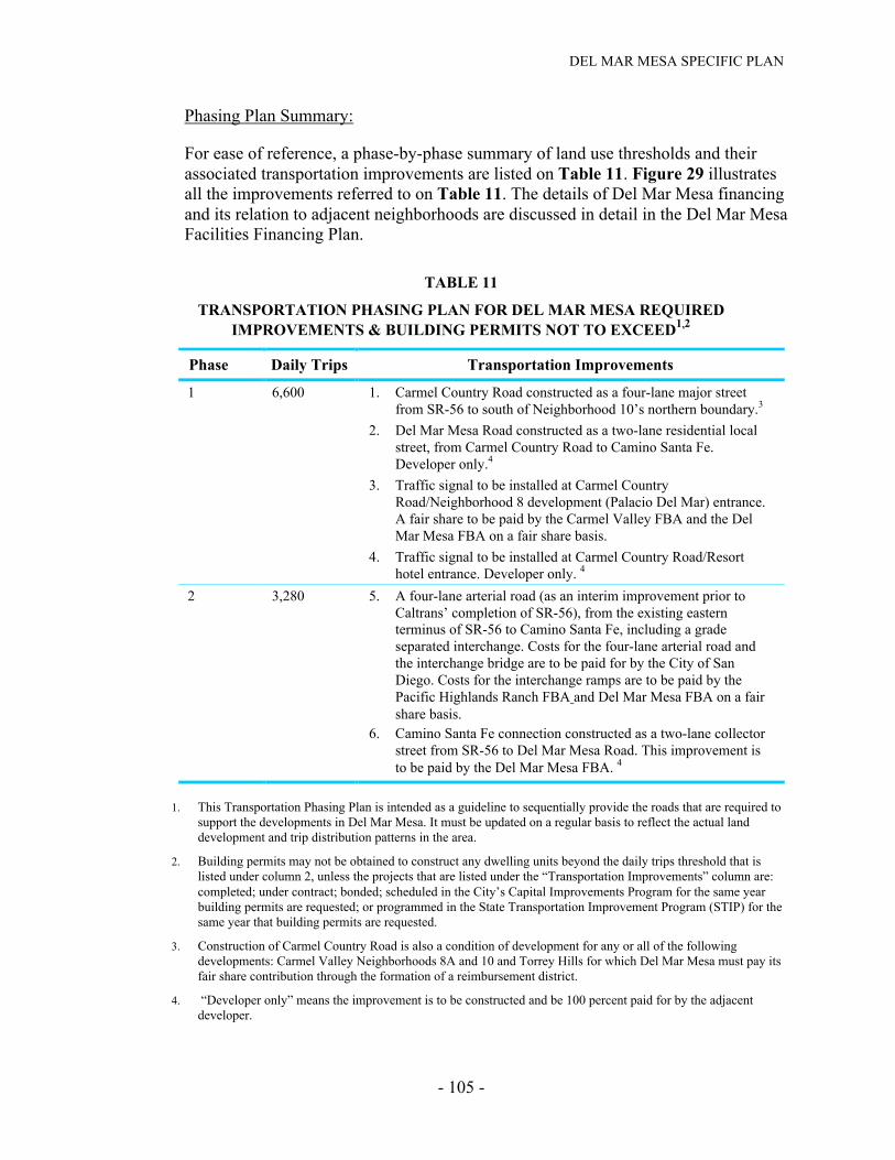
DEL MAR MESA SPECIFIC PLAN
- 105 -
Phasing Plan Summary:
For ease of reference, a phase-by-phase summary of land use thresholds and theirassociated transportation improvements are listed on Table 11. Figure 29 illustratesall the improvements referred to on Table 11. The details of Del Mar Mesa financingand its relation to adjacent neighborhoods are discussed in detail in the Del Mar MesaFacilities Financing Plan.
TABLE 11
TRANSPORTATION PHASING PLAN FOR DEL MAR MESA REQUIREDIMPROVEMENTS & BUILDING PERMITS NOT TO EXCEED1,2
Phase Daily Trips Transportation Improvements
1 6,600 1. Carmel Country Road constructed as a four-lane major streetfrom SR-56 to south of Neighborhood 10’s northern boundary.3
2. Del Mar Mesa Road constructed as a two-lane residential localstreet, from Carmel Country Road to Camino Santa Fe.Developer only.4
3. Traffic signal to be installed at Carmel CountryRoad/Neighborhood 8 development (Palacio Del Mar) entrance.A fair share to be paid by the Carmel Valley FBA and the DelMar Mesa FBA on a fair share basis.
4. Traffic signal to be installed at Carmel Country Road/Resorthotel entrance. Developer only. 4
2 3,280 5. A four-lane arterial road (as an interim improvement prior toCaltrans’ completion of SR-56), from the existing easternterminus of SR-56 to Camino Santa Fe, including a gradeseparated interchange. Costs for the four-lane arterial road andthe interchange bridge are to be paid for by the City of SanDiego. Costs for the interchange ramps are to be paid by thePacific Highlands Ranch FBA and Del Mar Mesa FBA on a fairshare basis.
6. Camino Santa Fe connection constructed as a two-lane collectorstreet from SR-56 to Del Mar Mesa Road. This improvement isto be paid by the Del Mar Mesa FBA. 4
1. This Transportation Phasing Plan is intended as a guideline to sequentially provide the roads that are required tosupport the developments in Del Mar Mesa. It must be updated on a regular basis to reflect the actual landdevelopment and trip distribution patterns in the area.
2. Building permits may not be obtained to construct any dwelling units beyond the daily trips threshold that islisted under column 2, unless the projects that are listed under the “Transportation Improvements” column are:completed; under contract; bonded; scheduled in the City’s Capital Improvements Program for the same yearbuilding permits are requested; or programmed in the State Transportation Improvement Program (STIP) for thesame year that building permits are requested.
3. Construction of Carmel Country Road is also a condition of development for any or all of the followingdevelopments: Carmel Valley Neighborhoods 8A and 10 and Torrey Hills for which Del Mar Mesa must pay itsfair share contribution through the formation of a reimbursement district.
4. “Developer only” means the improvement is to be constructed and be 100 percent paid for by the adjacentdeveloper.
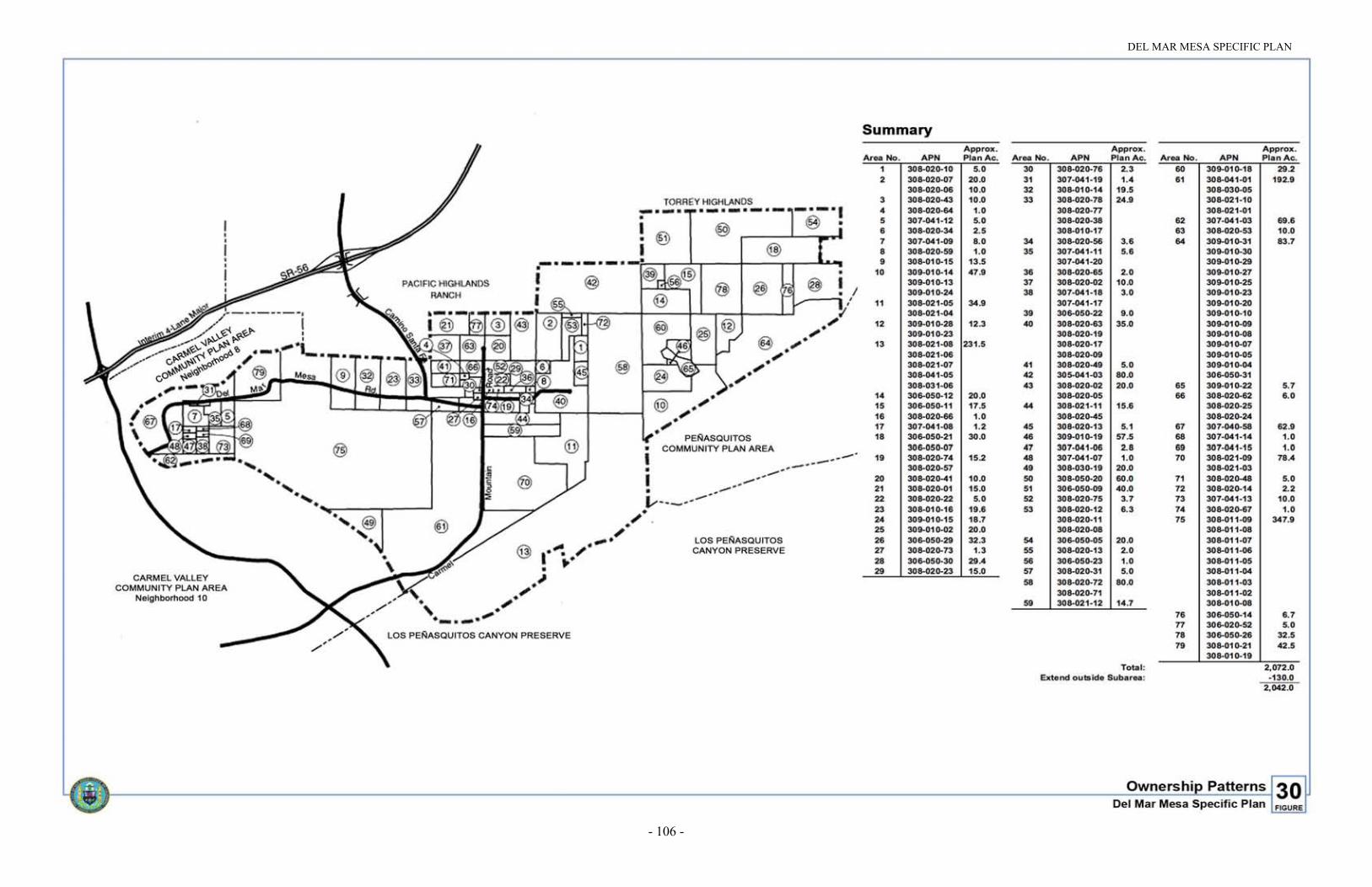
DEL MAR MESA SPECIFIC PLAN
- 106 -
Figure 30. Ownership Patterns