deeside substation innovation centre
TRANSCRIPT

Deeside Substation Innovation Centre
National Grid
Flood Consequences Assessment
B2600008_Deeside_FCA_001_03
September 2017

Deeside Substation Innovation Centre – Flood Consequences Assessment
B2600008-Deeside-FRA-03 i
Deeside Substation Innovation Centre
Project No: B2600008
Document Title: Deeside Substation Innovation Centre - Flood Consequences Assessment
Document No.: B2600008_Deeside_FCA_001_03
Revision: 03
Date: September 2017
Client Name: National Grid
Project Manager: Michael Robinson
Author: Chiko Tembo
File Name: B2600008_Deeside-FCA-001_03 - Innovation Ctr FCA Rpt_FINAL to NG, Sep17
Jacobs U.K. Limited 1 City Walk Leeds, West Yorkshire LS11 9DX United Kingdom T +44 (0)113 242 6771 F +44 (0)113 389 1389 www.jacobs.com
© Copyright 2017 Jacobs U.K. Limited. The concepts and information contained in this document are the property of Jacobs. Use or copying of this document in whole or in part without the written permission of Jacobs constitutes an infringement of copyright.
Limitation: This report has been prepared on behalf of, and for the exclusive use of Jacobs’ Client, and is subject to, and issued in accordance with, the provisions
of the contract between Jacobs and the Client. Jacobs accepts no liability or responsibility whatsoever for, or in respect of, any use of, or reliance upon, this report
by any third party.
Document history and status
Revision Date Description By Review Approved
00 April 2017 Working draft Chiko Tembo Iain Blackwell Michael Robinson
01 May 2017 Final draft document for client
approval Chiko Tembo Iain Blackwell Michael Robinson
02 June 2017 Final issue to client Chiko Tembo Iain Blackwell Michael Robinson
03 Sept 2017 Revised issue to client Ross Armstrong Iain Blackwell Michael Robinson

Deeside Substation Innovation Centre – Flood Consequences Assessment
B2600008-Deeside-FRA-03 ii
Contents
1. Introduction ....................................................................................................................................... 1
1.1 Overview ............................................................................................................................................. 1
1.2 Site Description .................................................................................................................................. 1
1.3 The Local Environment ...................................................................................................................... 3
1.4 Description of Proposed Works .......................................................................................................... 3
1.5 Report Objectives ............................................................................................................................... 5
2. Flood Policy and Planning .............................................................................................................. 6
2.1 Overview ............................................................................................................................................. 6
2.2 Planning Policy Wales ........................................................................................................................ 6
2.3 Technical Advice Note 15: Development and Flood Risk .................................................................. 6
2.3.1 Development Advice Map .................................................................................................................. 7
2.3.2 Nature of development or land use .................................................................................................... 7
2.3.3 Justification of the location of development ....................................................................................... 7
2.3.4 Climate change and lifetime of development ..................................................................................... 7
2.3.5 Local Policies and Plans .................................................................................................................... 8
2.4 Flintshire Unitary Development Plan .................................................................................................. 8
2.4.1 GEN1 General Requirements for Developments ............................................................................... 8
2.4.2 EWP17 Flood Risk ............................................................................................................................. 8
2.5 Local Planning Guidance Notes ......................................................................................................... 9
2.6 Local Policies ...................................................................................................................................... 9
2.6.1 Flintshire Preliminary Flood Risk Assessment ................................................................................... 9
2.6.2 Flintshire Flood Risk Management Strategy ...................................................................................... 9
2.6.3 Tidal Dee Draft Flood Risk Management Strategy ........................................................................... 10
2.6.4 River Dee Catchment Flood Management Plan ............................................................................... 10
3. Assessment of Flood Risk to the Proposed Development ........................................................ 11
3.1 Overview ........................................................................................................................................... 11
3.2 Flood Risk from the Sea ................................................................................................................... 11
3.3 Flood Risk from Rivers ..................................................................................................................... 15
3.4 Flood Risk from Surface Water ........................................................................................................ 15
3.5 Flood Risk from Groundwater .......................................................................................................... 17
3.6 Flood Risk from Water and Wastewater Infrastructure .................................................................... 17
3.7 Flood Risk from Reservoirs .............................................................................................................. 17
3.8 Flood Risk from Canals .................................................................................................................... 17
3.9 Impacts of Climate Change on Flood Risk to the Proposed Development ...................................... 18
3.10 Summary of Flood Risk to the Proposed Development ................................................................... 18
4. Impacts of the Development on Flood Risk Elsewhere .............................................................. 19
4.1 Impact on Flood Risk from the Sea .................................................................................................. 19
4.2 Impact on Flood Risk from Rivers .................................................................................................... 21
4.3 Impact on Flood Risk from Surface Water ....................................................................................... 21
4.4 Impact on Flood Risk from Groundwater ......................................................................................... 21

Deeside Substation Innovation Centre – Flood Consequences Assessment
B2600008-Deeside-FRA-03 iii
4.5 Impact on Flood Risk from Water and Wastewater Infrastructure ................................................... 21
4.6 Impact on Flood Risk from Reservoirs ............................................................................................. 21
4.7 Impact on Flood Risk from Canals ................................................................................................... 22
4.8 Summary of Flood Risk from the Development ............................................................................... 22
5. Flood Mitigation Measures ............................................................................................................ 23
5.1 Introduction ....................................................................................................................................... 23
5.2 Tidal and Fluvial Mitigation ............................................................................................................... 23
5.2.1 Finished floor level ............................................................................................................................ 23
5.2.2 Emergency preparedness, flood warning and evacuation ............................................................... 23
5.2.3 Acceptability criteria.......................................................................................................................... 25
5.3 Surface Water Mitigation .................................................................................................................. 26
6. Residual Risks ................................................................................................................................ 28
6.1 Tidal Defence Overtopping or Breach .............................................................................................. 28
7. Conclusion ...................................................................................................................................... 29
Appendices ................................................................................................................................................. 30
A.1 Appendix A: Topographic Survey
A.2 Appendix B: Natural Resources Wales Information
A.3 Appendix C: Dŵr Cymru Welsh Water Asset Location Plans
A.4 Appendix D: Outline Proposed Development Drainage Plan

Deeside Substation Innovation Centre – Flood Consequences Assessment
B2600008-Deeside-FRA-03 1
1. Introduction
1.1 Overview
Jacobs UK Ltd has been appointed by National Grid (Electricity) Plc (herein referred to as National Grid) to produce a Flood Consequence Assessment (FCA) in support of a planning submission for the construction of a new Innovation Centre (herein referred to as the ‘proposed development’) on land within National Grid’s Deeside Substation in Flintshire, North Wales.
This FCA assesses the level of flood risk posed to the proposed development and to determine whether it poses any additional flood risk to surrounding land and infrastructure.
1.2 Site Description
Deeside Substation is located on the southern bank of the tidal River Dee to the northwest of Connah’s Quay in Flintshire, at Ordnance Survey National Grid Reference SJ 281 708. The blue line on Figure 1-1 denotes National Grid’s site ownership. To the south and east of the substation at height is the Flintshire Bridge (A548), which crosses the River Dee to Deeside Industrial Park on the north bank. Deeside Power Station lies to the west, adjacent to the substation site.
The proposed development, indicated by the dashed orange line in Figure 1-1, is located to the south of the currently live Air Insulated Switchgear (AIS) 400kV substation between the site access road to the south and east, the proposed development entrance road to the west and the substation’s security perimeter fence to the north. To the northeast of the proposed development is the new (in construction) Gas Insulated Switchgear (GIS) 400kV substation.
The proposed development lies within a 1.5 hectare triangular area of flat land comprising grassland and a central area of stone surfacing, which is used as a temporary storage area for plant and material during final construction of the new 400kV substation. Within the proposed development area is the red line planning boundary, which is denoted by the solid red line boundary in Figure 1-1.
Ground levels have been interpreted from a site survey plan provided by National Grid (Appendix A). Site levels in the proposed development vary between approximately 6.5m above ordnance datum (AOD) in the southwest corner to 7m AOD in the north and east. Within the red line planning boundary, the ground level is approximately 6.6m AOD. A desktop study of Light Detection and Ranging (LIDAR) was also carried out and correlates well with the topographic survey. The resolution used to make this dataset was based on a 2m x 2m grid, which is considered to be a high resolution.

Deeside Substation Innovation Centre – Flood Consequences Assessment
B2600008-Deeside-FRA-03 2
Figure 1-1 Location of Proposed Development
Deeside Substation Innovation Centre – Flood Consequences Assessment
B2600008-Deeside-FRA-03 3
1.3 The Local Environment
The River Dee flows from a southeast to northwest direction approximately 220m to the north of the substation site and out into the Dee Estuary. The proposed development is in the tidal reaches of the River Dee. The reinforced earth embankment running the length of the River Dee in the local area is approximately 170m to the north. The River Dee has multiple environmental designations including: the Dee Estuary Ramsar site; the River Dee Site of Special Scientific Interest (SSSI); and the River Dee and Bala Lake Special Area of Conservation (SAC) and Special Protection Area (SPA).
Kelsterton Brook is an ordinary watercourse that flows in open channel a northerly direction to the south of Kelsterton Road (B5129). The brook is culverted at a point approximately 300m to the south of the proposed development, after which its exact direction of flow is unknown. It is assumed that the brook eventually outfalls into the River Dee to the northeast.
There is an unnamed ordinary watercourse that flows in an open channel in a northerly direction to the south of the Kelsterton Road roundabout junction with the A548. The watercourse is culverted beneath the roundabout and A548, after which it flows in a man-made channel parallel (and on the south side) of the Chester-Holyhead mainline railway. Due to access restrictions, the onwards direction of this channel is unknown. Based on the Natural Resources Wales (NRW) Flood Risk from River and Sea Map; it is assumed that the unnamed ordinary watercourse eventually outfalls into the River Dee.
The geology underlying Deeside substation comprises Tidal Flat Deposits (clay, silt and sand), which are superficial deposits atop of the Pennine Lower Coal Measures Formation (mudstone, siltstone and sandstone) bedrock.
Soil information taken from the Soil Map of England and Wales (2017)1 data indicated that the entire proposed development is comprised of Loamy and clayey soils of coastal flats with naturally high groundwater.
1.4 Description of Proposed Works
The proposal for the purpose of the planning submission (bound by the solid red line in Figure 1-1) comprises:
construction of a single storey office and laboratory facilities building known as the ‘Innovation Centre’;
creation of an open car park to the south of the Innovation Centre; and
construction of new internal access track/road and site perimeter fencing to the north of the Innovation Centre.
Proposed ancillary development adjacent to the Innovation Centre comprises development that is classed as Permitted Development within National Grid’s site ownership:
construction of a storage building for plant and equipment; and
creation of a service yard.
All the above development proposals are illustrated in a full proposed development plan shown as Figure 1-2.
1 Soil Map of England and Wales (2017). [Accessed: January 2017]. Available from: http://www.landis.org.uk/soilscapes/

Deeside Substation Innovation Centre – Flood Consequences Assessment
B2600008-Deeside-FRA-03 4
Figure 1-2 Proposed Development Works

Deeside Substation Innovation Centre – Flood Consequences Assessment
B2600008-Deeside-FRA-03 5
1.5 Report Objectives
The objectives of this FCA are to:
identify possible flood mechanisms on and in the vicinity of the proposed development;
identify any aspects of the design that could exacerbate flooding elsewhere;
undertake a formal assessment of the risks posed to the development from all identified flood risk sources and mechanisms;
confirm that the development proposals will not exacerbate flooding elsewhere;
consider the level and acceptability of any residual flood risk; and
produce a FCA compliant with Planning Policy Wales (PPW)2, Technical Advice Note (TAN) 153 and local planning policy and guidance relating to flood risk.
2 The Welsh Government. 2016. Planning Policy Wales (PPW). Edition 9. [Online] [Accessed: January 2017]. Available from: http://gov.wales/docs/desh/publications/161117planning-policy-wales-edition-9-en.pdf. 3 Welsh Government. 2004. Technical Advice Note (TAN) 15: Development and Flood Risk. [Online] [Accessed: January 2017]. Available from: http://wales.gov.uk/docs/desh/publications/040701tan15en.pdf.

Deeside Substation Innovation Centre – Flood Consequences Assessment
B2600008-Deeside-FRA-03 6
2. Flood Policy and Planning
2.1 Overview
The aim of this section of the report is to introduce the main aspects of the local and national planning policies that are relevant to the proposed development in terms of flood risk.
In Wales, Planning Policy Wales (PPW) and Technical Advice Note 15: Development and Flood Risk (TAN 15) provide the national policy framework for the assessment and management of flood risk for new developments. These are supported by local planning policy. Together they establish a presumption against development in areas at the highest risk of flooding, setting a framework for the sequential assessment of the suitability of sites for development. They also set out an assessment methodology (the FCA methodology) for the systematic evaluation of flood risk and the need to integrate mitigation and flood resilience into the design of new development.
2.2 Planning Policy Wales
PPW provides the national policy framework for the assessment and management of flood risk for new developments and references a range of European and national legislation that relates to flood risk. The objective of PPW is to avoid the construction of new development within areas defined as being at flood risk, with planning authorities adopting a precautionary approach when formulating development plan policies, including the principle that it is likely that climate change will increase the risk of river and coastal flooding.
PPW states that new development should not be at risk of flooding itself and should not increase the risk of flooding elsewhere. Additionally, it should be considered that hard-engineered flood defences are likely to be unsustainable in the long-term; new development should be avoided in flood hazard zones.
Only essential transport and utilities infrastructure are considered acceptable within unobstructed floodplains, and then only when such infrastructure is designed to remain operational during times of flooding and with no net loss of floodplain storage or increase in flooding elsewhere.
2.3 Technical Advice Note 15: Development and Flood Risk
TAN 15 provides technical guidance that supplements the policy set out in PPW in relation to development and flooding. TAN 15 advises on development and flood risk relating to sustainability principles and provides a framework within which risks arising from both river and coastal flooding, and from additional runoff from development in any location, can be assessed. This incorporates climate change scenarios. The location of the development needs to be justified in line with TAN 15 and flood risk areas, and the consequence needs to be acceptable given the vulnerability and use of the receptor.
The principal aim of the TAN 15 precautionary framework is to:
Note: The justification method is detailed further in Sections 6 and 7 of the TAN 15 technical guidance.
The operation of the precautionary framework is governed by:
a Development Advice Map4 containing river and coastal/tidal Zones A, B and C with subdivision into C1 and C2, which should be used to trigger the appropriate justification tests; and
4 The Welsh Government. 2004. Technical Advice Note (TAN) 15: Development and Flood Risk: Development Advice Map. [Online] [Accessed: January 2017]. Available from: http://data.wales.gov.uk/apps/floodmapping/.
“Direct new development away from those areas which are at high risk of flooding. Where development has to be considered in high risk areas (Zone C) only those developments which can be justified… are located within such areas.”

Deeside Substation Innovation Centre – Flood Consequences Assessment
B2600008-Deeside-FRA-03 7
definitions of vulnerable development and advice on permissible uses in relation to the location of development and the consequences of flooding.
2.3.1 Development Advice Map
The Development Advice Maps are based on the Environment Agency’s extreme flood outlines (Zone C) and the British Geological Survey alluvial drift data (Zone B). The TAN 15 flood zones are defined as follows:
Zone A: considered to be at little or no risk of fluvial or coastal/tidal flooding;
Zone B: an area known to have been flooded in the past;
Zone C1: an area with an annual probability of flooding from tidal and fluvial sources greater than 0.1%, but which has significant infrastructure, including flood defences; and
Zone C2: an area with an annual probability of flooding from tidal and fluvial sources greater than 0.1% and without significant flood defence infrastructure.
It should be noted that there are two initial reference maps used for assessing the level of tidal and fluvial flood risk associated with land: the TAN 15 Development Advice Map and the NRW flood map5. These are broadly similar, although the NRW flood map provides additional detail in relation to flood probability. The TAN 15 Development Advice Map, which shows the fluvial and tidal flood zones as issued by the Welsh Government, is discussed in this FCA as the classifications from this directly relate to planning policy. However, where relevant, information from the NRW maps is also referred to.
2.3.2 Nature of development or land use
The precautionary framework identifies the vulnerability of different developments to flooding. As per Section 5 of TAN 15, development has been subdivided into three categories: emergency services; highly vulnerable development; and less vulnerable development. The proposed development is considered to be utility infrastructure, which falls within the less vulnerable development category.
2.3.3 Justification of the location of development
In accordance with Section 6 of TAN 15 new development should be directed away from Zone C and towards suitable land in Zone A, otherwise to Zone B, where river or coastal/tidal flood risk will be lower. All new development should only be permitted within Zones C1 and C2 if determined by the planning authority to be justified in that location. Development will only be justified if it can be demonstrated that:
its location in Zone C is necessary to assist, or be part of, a local authority regeneration initiative or a local authority strategy required to sustain an existing settlement; or
its location in Zone C is necessary to contribute to key employment objectives supported by the local authority, and other key partners, to sustain an existing settlement or region;
it concurs with the aims of PPW and meets the definition of previously developed land; and
the potential consequences of a flooding event for the particular type of development have been considered, and in terms of the criteria contained in sections 5 and 7 and Appendix 1 of the TAN 15 found to be acceptable.
2.3.4 Climate change and lifetime of development
Paragraph A1.5 of TAN 15 identifies that a proposed development must provide a safe and secure working environment throughout its life and that an assessment should include a flood event which has a 0.1% probability of occurrence in any year.
5 Natural Resources Wales. 2016. Flood Risk Map. [Online] [Accessed: January 2017]. Available from: https://naturalresources.wales/our-evidence-and-reports/maps/flood-risk-map/?lang=en

Deeside Substation Innovation Centre – Flood Consequences Assessment
B2600008-Deeside-FRA-03 8
NRW advise that for the purposes of FCAs, the lifetime of non-residential developments should be at least 75 years. Therefore, it is necessary to take account of the potential impact of climate change over this timeframe including a flood event which has a 0.1% probability of occurrence6.
The finished floor level of the proposed development is therefore defined so that it is above the 0.1% annual probability flood event level in 2090, i.e. in approximately 75 years.
Whilst noting the requirement to consider a lifetime of at least 75 years, the lifetime of Deeside Substation, immediately to the north of the proposed Innovation Centre and adjacent to the tidal River Dee, and the Innovation Centre itself is 40 years7,8. However, the need to consider a lifetime of 75 years remains, as this FCA establishes the principle to develop the site, and it is possible that in future years (beyond 40 years) an alternative use for the site may be considered.
2.3.5 Local Policies and Plans
TAN 15 is supplemented at a local level by local planning policies set out in Flintshire Unitary Development Plan (UDP), supplementary Local Planning Guidance Notes (LPGN) and technical reports.
2.4 Flintshire Unitary Development Plan
Flintshire UDP is the adopted development plan for the 15 year period from 2000 to 2015. The aim of the Flintshire UDP is to provide a framework for making rational and consistent decisions on planning applications and to guide development to appropriate locations. Although the adopted UDP became time expired at the end of 2015 it remains the adopted development plan for the County. The principal relevant LUDP requirements are set out below.
2.4.1 GEN1 General Requirements for Developments
Development that requires planning permission and is in accordance with the Plan’s other policies, should be located on land, or within suitable buildings, which satisfies the following requirements, including in relation to flood risk:
the development should not result in/be susceptible to problems related to drainage, land stability, contamination, or flooding, either on or off site.
2.4.2 EWP17 Flood Risk
Development which would seek to reduce the impact and frequency of flood risk to areas at risk of flooding will be generally supported provided:
the design and character of the works is appropriate to the locality;
the works do not adversely impact on interests of acknowledged nature conservation and recreation importance; and
the works do not increase flood risk elsewhere.
Other development within areas at risk of flooding will only be permitted where the Council considers that the development is justified and is satisfied that:
the consequences of a flooding event can be effectively managed;
it would not increase the risk of flooding elsewhere;
appropriate alleviation or mitigation measures have been incorporated into the proposal and will be available for the lifetime of the development; and
it would not have any adverse effects on the integrity of tidal and fluvial flood defences.
6 Department for Housing and Regeneration, Welsh Government. 09 January 2014. Letter To all Chief Planning Officers. 7 Atkins. December 2009. Deeside Initial Flood Screening Report 8 Atkins. August 2011. Addendum to Connah’s Quay Gas Insulated Substation, Initial Screening, Flood Consequences Report.

Deeside Substation Innovation Centre – Flood Consequences Assessment
B2600008-Deeside-FRA-03 9
Where practicable, the use of sustainable drainage systems (SuDS) should be considered in all new development proposals, but particularly within and adjacent to areas which have an existing or potential flooding problem. The use of SuDS will also be appropriate in environmentally sensitive locations in terms of bringing about environmental and amenity enhancements.
Within ‘problem areas’, or areas likely to pose a risk to existing built up areas, all developments which involve the installation of impermeable surfaces should be required to incorporate appropriate sustainable designs. Specifically designs could include permeable hard surfaces (e.g. car parking); soakaways; temporary storage areas (e.g. ponds); and/or swales which allow storage, local conveyance and infiltration. Where appropriate, proposals for new buildings should also ensure that their design mitigates the impact of flooding, through flood proofing of building exteriors and interiors.
2.5 Local Planning Guidance Notes
Flintshire UDP is supported by a number of supplementary LPGN that provide detailed guidance on a range of topics to help the interpretation and implementation of the policies and proposals in the UDP. The LPGNs relevant to flood risk include:
LPGN No. 19: Sustainable Drainage Systems (Adopted);
LPGN No. 19: Water Conservation and Sustainable Drainage Systems (Draft); and
LPGN No. 29: Management of Surface Water for New Development
2.6 Local Policies
2.6.1 Flintshire Preliminary Flood Risk Assessment
A Preliminary Flood Risk Assessment (PFRA)9 was produced in 2011 by Flintshire County Council in response to the requirements of the Flood Risk Regulations (2009) for Lead Local Flood Authorities (LLFAs) to identify significant historic events and potential future flood risk.
The PFRA highlights past flooding of local significance (where five or more properties have been subject to flooding at any one time). The closest event to the proposed development occurred in nearby Flint, which is situated 4.8km to the northwest. It has been documented that 13 residential properties and one non-residential property were flooded by Swinchiard Brook watercourse in 2000.
The PFRA indicates that the proposed development is not located in a Flood Risk Area based on the flood risk threshold governing people, businesses or critical services.
2.6.2 Flintshire Flood Risk Management Strategy
The Flood Risk Regulations came into force in December 2009 with a duty on the LLFAs to produce a Flood Risk Management Strategy (FRMS)10 to set out how flood risk in the communities most at risk will be managed over the next six years.
The Flintshire FRMS states that the greatest risk of flooding is the combined risk from river, tidal and coastal flooding. The FRMS highlights widespread surface water related flooding particularly in the sub-catchment areas. At a catchment scale, groundwater and sewer flooding are considered to be low with only some reported incidents of road and property flooding with flooding from these sources deemed more to be localised issues.
9 Flintshire County Council Preliminary Flood Risk Assessment, 2011. [Online] [Accessed: April 2017]. Available from: http://www.flintshire.gov.uk/en/PDFFiles/Land-and-Property/Preliminary-Flood-Risk-Assessment-June-2011-(PDF-1MB-new-window).pdf 10 Flintshire Flood Risk Management Strategy, 2013. [Online] [Accessed: April 2017]. Available from: http://www.flintshire.gov.uk/en/PDFFiles/Flooding-and-Drainage/Flintshire-Local-Flood-Risk-Management-Strategy.pdf

Deeside Substation Innovation Centre – Flood Consequences Assessment
B2600008-Deeside-FRA-03 10
2.6.3 Tidal Dee Draft Flood Risk Management Strategy
Prior to the formation of the NRW, The Environment Agency Wales produced a 100 year flood risk management plan to more effectively manage flood risk issues, which include flooding from ordinary watercourses, surface water and groundwater.
One of the strategic overarching objectives relevant to the proposed development is:
2.6.4 River Dee Catchment Flood Management Plan
The proposed development lies within the Deeside Wirral and North Flintshire sub area. This sub area comprises of the Dee Estuary and the urban areas of Deeside, Sealand, Flint, Holywell, Neston, Heswall and West Kirby. The issues in this sub area include tidal flooding occurring mainly within the River Dee corridor between Chester Weir and the estuary mouth. The channel is defined by earth defences on both sides, however, tidally influenced flooding is more pronounced in low lying areas of Deeside and Sealand.
The CFMP11 states that approximately 1,250 properties are currently at risk of flooding from the 1% AEP river flood event with an anticipated increase to around 1,700 in the future. These properties are mainly located in Deeside. The vision of this area is to increase emphasis on actions to manage the consequences of flooding from all sources as well as to increase community and individual awareness of their flood risks and adoption of actions both can take to help themselves. In summary, flood risk in this sub-area is deemed moderate and is expected to rise significantly in the future.
CFMPs provide an understanding of the scale and extent of flooding now and in the future, and set policies for managing flood risk within the catchment. CFMPs should be used to inform planning and decision making by key stakeholders. The preferred policy option as set out in the CFMP is as follows:
11 River Dee Catchment Flood Management Plan, 2010. [Online] [Accessed: April 2017]. Available from: https://www.gov.uk/government/publications/river-dee-catchment-flood-management-plan
Improve existing protection: This is to be achieved through either renewal of erosion protection, increasing of defence levels, strengthening existing defence or encompassing the above measures. The Environment Agency has sought a medium term solution (20 – 50 years) which will involve raising and improving the existing defences along the Deeside 400kV substation.
Preferred Policy Options:
Deeside Wirral and North Flintshire Policy Option 5: areas of moderate to high flood risk where we can generally take further action to reduce flood risk. This policy will tend to be applied to those areas where the case for further action to reduce flood risk is most compelling, for example where there are many people at high risk, or where changes in the environment have already increased risk. Taking further action to reduce risk will require additional appraisal to assess whether there are socially and environmentally sustainable, technically viable and economically justified options.

Deeside Substation Innovation Centre – Flood Consequences Assessment
B2600008-Deeside-FRA-03 11
3. Assessment of Flood Risk to the Proposed Development
3.1 Overview
This section assesses the flood risk to the proposed development from all local flood risk sources including:
Coastal/tidal;
Fluvial flooding from main rivers and ordinary watercourses;
Surface Water – flooding from runoff and overland flow as a result of rainfall events;
Groundwater – flooding due to the water table emerging at the surface;
Water and wastewater infrastructure – flooding that occurs as a direct result of infrastructure failure or overflow, including sewers, land drainage and flood risk management assets;
Reservoirs – flooding due to the overtopping or breaching of reservoirs; and
Canals – flooding due to the overtopping or breaching of canals.
3.2 Flood Risk from the Sea
Tidal flooding is caused by high tides coinciding with low-pressure storm systems which raise the sea and tidal water levels, overwhelming coastal and river defences. This may be made worse by strong winds blowing the raised body of water up tidal river basins some distance from the coast. Such flooding may become more frequent in future years due to rising sea levels.
According to the TAN 15 Development Advice Maps (see Figure 3-1), the proposed development lies within Zone B and Zone C1. Zone B is defined as an area known to have been flooded in the past, whilst Zone C1 is an area with an annual probability of flooding from tidal and fluvial sources greater than 0.1% AEP, but which has significant infrastructure including flood defences. The flood risk zones are associated with the tidal River Dee.
The NRW flood risk map (see Figure 3-2) shows the proposed development to be at low risk of flooding from the sea. A low flood risk is classed as having a probability between 1 in 1000 (0.1%) and 1 in 100 (1%). This assumes the absence of the flood defence infrastructure, although there are earth embankments reinforced with sections of rock on the southern bank of the River Dee to the north of the site. These defences have a 0.5% standard of protection.

Deeside Substation Innovation Centre – Flood Consequences Assessment
B2600008-Deeside-FRA-03 12
Figure 3-1 TAN 15 Development Advice Map
River Dee
A548
Kelsterton
Road
Indicative Proposed Development Area
Kelsterton Brook

Deeside Substation Innovation Centre – Flood Consequences Assessment
B2600008-Deeside-FRA-03 13
Figure 3-2 NRW Flood Risk from River and Sea Map
Indicative Proposed Development Area
River Dee
Kelsterton Brook
A548
Kelsterton
Road
Unnamed
watercourse

Deeside Substation Innovation Centre – Flood Consequences Assessment
B2600008-Deeside-FRA-03 14
The Tidal Dee defended peak water levels have been provided by NRW. These are extracted from the 1D model produced for the Tidal Dee Flood Mapping Update 201212. The full dataset is contained in Appendix B, with the levels data associated with the closest nodes summarised in Table 3-1. The proposed development is located approximately mid-way between these two model nodes and therefore, to be conservative in establishing design levels, it is assumed that the water levels at node Est_24000 apply to the site. The “present day” levels are 2015. The climate change levels quoted relate to 2090 to take account of the NRW requirement to consider non-residential design life of at least 75 years.
Table 3-1 Tidal Dee defended Peak Water Levels for Selected Nodes Extracted from the 1D Model Produced for the Tidal Dee Flood Mapping Update 2012
Node Flood event annual exceedance probability (%) and water levels in m AOD
0.5% baseline (2015)
0.1% baseline (2015)
0.5% climate change (2090)
0.1% climate change (2090)
00010100000 (upstream of the site)
6.48 6.69 7.19 7.35
Est_24000 (downstream of the site)
6.55 6.76 7.25 7.44
As the site is defended from tidal flooding from the River Dee, the risk of tidal flooding is low, as confirmed by the NRW flood map. Nevertheless, TAN 15 states that Zone B is used as part of a precautionary approach to indicate where site levels should be checked against the extreme (0.1%) flood level. It is considered that if site levels are greater than the flood levels used to define adjacent extreme flood outline there would be no need to consider flood risk in further significant detail, although other specific “acceptability criteria” set out by NRW may need to be considered.
Site levels in the area of the proposed Innovation Centre building are taken to be approximately 6.58m AOD based on the topographic survey. The topographic survey correlates well with the LIDAR survey and is shown to be lower than the present day (2015) extreme flood (0.1%) outline of 6.76m AOD. On this basis the proposed development remains in Zone B and there is a tidal flood risk to the proposed development.
The finished floor level of the Innovation Centre needs to be set such that it meets both National Grid’s flood mitigation policy (to protect up to the 0.1% event where possible), and NRW requirements in the event that these are more onerous. For the Innovation Centre, the proposed finished floor level is 7.56m AOD.
For the sensitivity analysis, this finished floor level needs to be tested against two criteria stipulated by NRW such that the finished floor level is above:
the 0.5% flood event level (at the 95% confidence interval) over 75 years (2090) - this level is 7.43m AOD (see Appendix B); and
the 0.1% flood event level over 75 years (2090) - this level is 7.44m AOD (see Table 3-1 above and Appendix B).
Taking account of these sensitivity criteria, it is seen that the Innovation Centre building, with a proposed finished floor level of 7.56m AOD, is located above both of these “sensitivity test” flood levels by at least 0.12m with respect to the two sensitivity design events with a 75-year lifetime.
12JBA Consulting (December 2012), Tidal Dee Flood Mapping Update, Final Report.

Deeside Substation Innovation Centre – Flood Consequences Assessment
B2600008-Deeside-FRA-03 15
It is therefore concluded that a finished floor level of 7.56m AOD for the Innovation Centre is appropriate, meeting both National Grid’s and NRW’s requirements.
3.3 Flood Risk from Rivers
Fluvial flooding typically occurs when a river’s capacity is exceeded and the excess water overtops the river banks. It can also occur when the watercourse has a high level downstream, perhaps due to structures or blockage, thus limiting the amount of discharge. This creates a back-up of water and again water overtops the banks. Typical flooding issues occur when the natural floodplain has been urbanised and where the river has been constrained.
Given the proposed development’s location in a tidal floodplain, the fluvial flood risk from the River Dee is accounted for within the tidal flood risk as this takes account of both the river flows and tidal influence. As shown on the NRW flood map (see Figure 3-1), flooding from Kelsterton Brook is not shown to affect the proposed development. Floodwaters are contained on the upstream side of Kelsterton Road due to the raised road in relation to the culvert, such that the road effectively impounds water behind it.
The flood map indicates a fluvial flood risk to the proposed development possibly from the unnamed watercourse downstream of the A548, as shown on Figure 3-2. The floodwaters follow a southeast route along the man-made channel, railway line and adjacent access road, resulting in flooding on the proposed development. The risk of flooding is shown to be low. However, as this ordinary watercourse has not been modelled as part of NRW mapping however, if the unnamed watercourse was to be modelled, it is possible that the risk would be moderate in line with the surface water flow path (see Section 3.4 below). On this basis, the fluvial flood risk to the proposed development is considered to be moderate.
3.4 Flood Risk from Surface Water
Surface water runoff is defined as water flowing over the ground that has not yet entered a drainage channel or sewerage system. It usually occurs as a result of an intense period of rainfall that exceeds the infiltration capacity of the ground or where the ground is less permeable due to soil type, geology or due to development. Surface water flood mapping also provides a method for assessing flood risk associated with smaller fluvial features that will not have been included within the national programme of flood mapping as their catchment sizes are less than 3km2.
Typically, runoff occurs on sloping land or where the ground surface is relatively impermeable. The ground can be impermeable either naturally due to the soil type, geology or antecedent rainfall conditions or due to development, which places large areas of impervious material over the ground surface (e.g. paving and roads). The proposed development is potentially at risk of surface water flooding due to runoff from the adjacent hard standing access road.
Presented in Figure 3-3 is the NRW flood map that illustrates surface water flood risk areas. The proposed development is subject to surface water flooding with the presence of one main flow path originating from the unnamed watercourse culverted beneath the A548. The flow path and area of ponding correlate well with the fluvial extent on the downstream side of the A548. The risk of surface water flooding is shown to be low to moderate. A small pocket of the proposed development is shown to be at high risk; however, this size of this area is considered negligible.

Deeside Substation Innovation Centre – Flood Consequences Assessment
B2600008-Deeside-FRA-03 16
Figure 3-3 NRW Surface Water Flood Risk
Surface water flow path Indicative Proposed
Development Area
Kelsterton Brook
Kelsterton
Road
A548
Unnamed
watercourse

Deeside Substation Innovation Centre – Flood Consequences Assessment
B2600008-Deeside-FRA-03 17
3.5 Flood Risk from Groundwater
Groundwater flooding occurs when the natural level of water stored within the ground rises above local ground level. This can result in deep and long-lasting flooding of low lying or below ground areas such as underpasses and basements. Groundwater flooding can cause significant damage and can further risks to the environment and ground stability.
The River Dee was the first river to be designated as a Water Protection Zone under the Water Resources Act 1991. This Protection Zone covers the whole freshwater catchment area until Chester weir. However, the proposed development does not lie within Groundwater Source Protection Zone. The information in the Flintshire Flood Risk Management Strategy suggests that the groundwater flood is low.
3.6 Flood Risk from Water and Wastewater Infrastructure
Flooding from sewers primarily occurs when the flow entering a system exceeds available capacity or if the network capacity has been reduced through blockage or collapse. The same effect can be caused as a result of high water levels in the receiving watercourse. As a result, water can begin to surcharge the sewer network, emerging at ground level through gullies and manholes and potentially causing flooding. If this occurs, flooding can represent significant hazard to human health due to the potential for contaminants in flood water.
Dŵr Cymru Welsh Water provides both the wastewater and water supply in the local area. The latest asset location plans obtained from Welsh Water are contained in Appendix C. The plans show that there are no wastewater assets on the substation site or the proposed development. The nearest wastewater assets are located in Kelsterton Road approximately 100m to the south of the proposed development in Connah’s Quay. The sewers convey wastewater to the east away from the proposed development. Similarly, the plans show a water main and raw water pipeline running parallel in Kelsterton Road. There are no water supply assets on the substation site or the proposed development.
All water companies maintain a register of properties that have suffered from flooding from public surface water, foul or combined sewers due to the system being overloaded. Whilst there is no direct access to this Register, reference is made to incidents recorded in the Flintshire Flood Risk Management Strategy, which highlights that urban drainage and surface water problems have also contributed to the county’s history of flooding. However, the Flintshire Preliminary Flood Risk Assessment does not include any flood incident reports in the Connah’s Quay area. It is therefore assumed that any flood incidents that may have occurred in the vicinity of Deeside Substation would have been minor. Anecdotal evidence from the Site Engineer during the site walkover survey confirmed that the substation site has not experienced flooding from sewers.
Overall, the risk from sewer flooding to the proposed development is considered to be low.
3.7 Flood Risk from Reservoirs
There are no reservoirs close to the proposed development and therefore, there is no flood risk to the proposed development. The flood risk extent from reservoirs upstream is confined to the River Dee.
3.8 Flood Risk from Canals
There are no canals close to the proposed development and therefore there is no flood risk to the proposed development.

Deeside Substation Innovation Centre – Flood Consequences Assessment
B2600008-Deeside-FRA-03 18
3.9 Impacts of Climate Change on Flood Risk to the Proposed Development
It is predicted that sea levels will rise over the operational lifetime of the proposed development, and beyond. The regional net sea level rise allowances for North Wales are contained within The Tidal Dee Flood Mapping Update 2012, and presented in Table 3-2 below.
Table 3-2 Net Mean Sea Level Rise (m) from 2011 2011 2061 2086 2111
0.01 0.37 0.66 1.02
Climate change modelling and guidance indicates that the frequency and severity of storm events will increase in the future and consequently higher rainfall intensities are expect. Flow resulting from increased rainfall over a catchment area may lead to 20% and 30% increases in river flows for the 2020s to the 2050s respectively as recommended by the EA’s peak river flow allowances by river basin district (2017).
With the increased rainfall intensities expected due to climate change, the risk of surface water flooding can also be expected to increase without mitigation.
Climate change could increase the risk of groundwater flooding as a result of increased precipitation filtering into the groundwater body. If winter rainfall becomes more frequent and heavier, groundwater levels may increase. Higher winter recharge may however be balanced by lower recharge during the predicted hotter drier summers. This is less likely to cause a significant change to flood risk than from other sources.
It can be expected that flood risk from any land drainage and sewerage systems would increase as a result of climate change as increased rainfall would place the existing sewer and drainage systems under additional strain.
Climate change impacts therefore need to be taken into account for tidal, fluvial, surface water and drainage infrastructure flood sources.
3.10 Summary of Flood Risk to the Proposed Development
A summary of present day flood risks to the proposed development is provided in Table 3-3.
Table 3-3 Summary of Flood Risk to the Proposed Development
Source of flooding Assessment of Flood Risk to the Proposed Development
Tidal Low
Fluvial Moderate
Surface water Moderate
Groundwater Low
Water and wastewater infrastructure Low
Reservoirs None
Canals None

Deeside Substation Innovation Centre – Flood Consequences Assessment
B2600008-Deeside-FRA-03 19
4. Impacts of the Development on Flood Risk Elsewhere
4.1 Impact on Flood Risk from the Sea
Given that the defences along the tidal River Dee provide a 0.5% standard of protection, the proposed development will not pose any obstruction to direct flood waters to the surrounding area as it is behind these defences.
Taking account of the potential tidal flood risk to the proposed development, it is noted above (Section 3.2) that the finished flood level for the development is 7.56m AOD. As the current ground level at the site of the proposed Innovation Centre is approximately 6.6m AOD, this would require raising of the ground locally so that the development is not adversely affected in an extreme tidal flood event (i.e. in an event that it overtops or breaches the existing tidal defences).
It is therefore necessary to consider the impact of any ground raising, as this would occupy tidal floodplain and therefore reduce floodplain storage, potentially impacting on extreme tidal flood levels.
Taking the tidal 0.5% probability flood level for the more conservative node (Est_24000) provided in Table 3-1 (reproduced below as Table 4-1), the lost volume of tidal floodplain is estimated using the existing site ground level of 6.6m AOD, the proposed increases in development levels across the site (in the area around the building) and the flood levels in Table 4-1.
The finished floor level of the Innovation Centre is 7.56m AOD, which is 0.31m above the 0.5% flood event level in 2090 of 7.25m AOD. The total approximate area around the Innovation Centre building that is between the existing site level of approximately 6.6m AOD and the 0.5% flood event level in 2090 of 7.25m AOD, which comprises the car park and access roads, is 2,000m2. The maximum amount of ground raising up to the 0.5% flood event level is therefore 0.65m (7.25 – 6.60). However, within this area the average level of ground raising is approximately 0.5m. Therefore, the approximate volume of floodplain storage lost is 1,000m3 (2000 x 0.5).
Table 4-1 Tidal Dee defended Peak Water Levels for Selected Nodes Extracted from the 1D Model Produced for the Tidal Dee Flood Mapping Update 2012 and volumes of floodplain lost
Node Flood event annual exceedance probability (%) and water levels in m AOD
0.5% baseline (2015) 0.5% climate change (2090)
Est_24000 (downstream of the site) 6.55 7.25
Volume of floodplain lost (m3) None 1,000
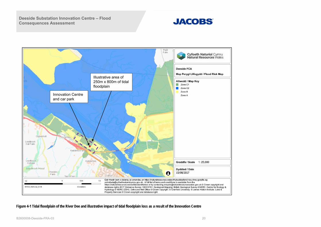
Figure 4-1 shows the Flood Risk Map of the site and the wider Tidal River Dee area. It is seen from this that the proposed Innovation Centre is towards the fringes of the tidal floodplain in Flood Zone C1, with adjacent areas of Flood Zone B. In this location the loss of floodplain would not have any significant effect on floodplain conveyance as the flood waters would rise around the raised ground. Whilst there may be some localised changes, these would be very small taking account of the vast floodplain on the left bank of the River Dee, over which this “lost” flood water would be dissipated.
By way of illustration, for the floodplain storage loss of 1,000m3 in 2090, if this water were to be spread evenly across the Flood Zone B and C1 areas adjacent to the site, over an area of 250m x 800m, this would give a local increase of around 5mm. This is likely to be a conservative assumption due to the flat nature of the surrounding area and the absence of any significant obstructions. To illustrate this broad principle, Figure 4-1 shows the outline of a 250m x 800m area in the vicinity of the proposed development, demonstrating the minor impact that the loss of floodplain would have. It is therefore concluded that the impact of the development on tidal flood risk is low.
Deeside Substation Innovation Centre – Flood Consequences Assessment
B2600008-Deeside-FRA-03 20
Figure 4-1 Tidal floodplain of the River Dee and illustrative impact of tidal floodplain loss as a result of the Innovation Centre
Innovation Centre and car park
Illustrative area of 250m x 800m of tidal floodplain

Deeside Substation Innovation Centre – Flood Consequences Assessment
B2600008-Deeside-FRA-03 21
4.2 Impact on Flood Risk from Rivers
As stated in Section 3.3, the flood risk from the River Dee is considered primarily tidal and the fluvial flood risk from the unnamed watercourse is low.
There is a potential impact of increased surface water flows discharging from the proposed development flowing into local watercourses. However, given the topography of the proposed development and surrounding land, it is highly unlikely that the development would have an impact on the unnamed ordinary watercourse to the south.
Surface water flooding generated from the proposed development is not expected to impact the River Dee provided implementation of an appropriate site drainage strategy. The drainage strategy outlined in Section 5.3 demonstrates that runoff rates and volumes from the development for a range of design storms are restricted to greenfield runoff rates using SuDS. This would avoid additional inflows into local watercourses which would otherwise increase the fluvial flood risk. In addition, the proposed development is not located within a fluvial floodplain, so there would be no loss of floodplain storage.
4.3 Impact on Flood Risk from Surface Water
Any increase in impermeable area would increase the surface water flood risk from the proposed development unless appropriate mitigation is put in place. It is therefore important that an appropriate site drainage plan is implemented to provide sufficient attenuation of surface water on the proposed development. This should be in accordance with policy of the Flintshire UDP (Policy EWP17), which states that development should not increase flood risk elsewhere and appropriate alleviation or mitigation measures have been incorporated into the proposal and will be available for the lifetime of the development. In addition, where practicable, the use of SuDS should be considered in all new development proposals, but particularly within and adjacent to areas which have an existing or potential flooding problem.
There may also be temporary changes in surface water flood risk across the area during construction. For example, heavy vehicles may compact permeable ground, thereby decreasing permeability and increasing surface water runoff and therefore create surface water flow paths leading to and from the construction area. Site traffic may also mobilise sediment, increasing sediment load and sedimentation along the flow paths. The Construction Environment Management Plan (CEMP) or similar, should consider surface water flood risk, and if necessary provide appropriate mitigation.
Providing that the designed drainage strategy is appropriately implemented, and a CEMP or similar is followed, the impact of the development on surface water flooding elsewhere would be low. The mitigation measures provided for surface water flood risk would also address any potential impacts on fluvial flood risk.
4.4 Impact on Flood Risk from Groundwater
The proposed new development may present a small, highly localised barrier to groundwater movement, but it is not anticipated to create a measurable increase in groundwater flood risk to nearby flood receptors. Groundwater flood risk is noted to be low at the proposed development, so the impact of the development on groundwater flood risk elsewhere would be low and no mitigation is required.
4.5 Impact on Flood Risk from Water and Wastewater Infrastructure
As discussed in Section 3.6, there are no water or wastewater assets on the proposed development or immediately adjacent to the proposed development. Therefore, there would be no impact on flood risk elsewhere from these sources, so no mitigation is required.
4.6 Impact on Flood Risk from Reservoirs
As discussed in Section 3.7, there are no reservoirs in close proximity to the proposed development that could be impacted by the proposed development. Therefore, there would be no impact on flood risk and no mitigation is required.

Deeside Substation Innovation Centre – Flood Consequences Assessment
B2600008-Deeside-FRA-03 22
4.7 Impact on Flood Risk from Canals
As discussed in Section 3.8, there are no canals in close proximity to the proposed development that could be impacted by the proposed development. Therefore, there would be no impact on flood risk and no mitigation is required.
4.8 Summary of Flood Risk from the Development
A summary of flood risks from the proposed development are provided in Table 4.2.
Table 4.2 Summary of Flood Risk Elsewhere as a Result of the Development
Source of flooding Impact of the Development on Flood Risk
Tidal Low
Fluvial Low
Surface water Low (taking into account a site-specific drainage strategy, see Section 5)
Groundwater Low
Water and wastewater infrastructure None
Reservoir None
Canals None

Deeside Substation Innovation Centre – Flood Consequences Assessment
B2600008-Deeside-FRA-03 23
5. Flood Mitigation Measures
5.1 Introduction
From the findings in Sections 3 and 4, flood mitigation measures are required at the proposed development for various flood sources, either to mitigate the potential impact on the proposed development, or to mitigate the impact that the proposed development would have on flood risk elsewhere.
The sources of flood risk that require mitigation are tidal, fluvial, surface water and water / wastewater infrastructure. There is an overlap between these sources either in terms of mitigation measures being appropriate for more than one flood source, or that the mitigation is appropriate both for flood risk to the proposed development and from the proposed development.
5.2 Tidal and Fluvial Mitigation
5.2.1 Finished floor level
National Grid’s flood mitigation policy is to protect up to the 1 in 1000 (0.1%) annual probability event where possible (as described in Section 3.2). For this development, taking a development lifetime for this particular asset of 40 years in line with National Grid infrastructure, this level in 2065 would be 7.16m AOD. A proposed freeboard of 400mm would take the recommended finished floor level to 7.56m AOD. As part of a sensitivity test outlined in Section 3.2, this level is shown to be above the 0.1% probability event level in 2090 (7.44m AOD) to take account of the need to consider a development lifetime of 75 years for non-residential property in accordance with NRW policy.
Consideration has also been given to the displacement of tidal floodplain due to the ground level raising requirements associated with delivering a finished floor level of 7.56m AOD. It is demonstrated in Section 4.1 that the impact of the loss of tidal floodplain storage would be negligible due to: (i) the extremely small loss of volume compared to the floodplain area in an extreme event; (ii) the location of the proposed development towards the fringes of the tidal floodplain; and (iii) the absence of any significant local obstructions to impact on flood plain conveyance. It is therefore concluded that no tidal floodplain compensatory storage is necessary.
5.2.2 Emergency preparedness, flood warning and evacuation
It is a requirement of TAN 15 that future users and occupiers of the proposed development are adequately aware of the flood risk, the consequences of flooding, that effective flood warnings are provided, emergency flood plans are available and that safe access and egress is available. There is also a requirement that the proposed development is designed to facilitate movement of goods/possessions away from flooding, to minimise structural damage and to facilitate recovery.
Within the vicinity of the proposed development there are already other National Grid (and other) assets, including National Grid’s Deeside substation. As there is already an existing emergency plan in place for Deeside substation, and the proposed development is adjacent to the substation, the emergency plan would be amended to incorporate the Innovation Centre.
It is recommended that National Grid sign up to NRW’s Floodline Warnings Direct service to provide a degree of warning should tidal/fluvial flooding be considered an imminent risk. Warnings can be provided free of charge via phone call text or email. Based on NRW’s tidal stage hydrographs for the River Dee (Appendix B), the time to peak stage during the 0.5% flood event is approximately 8.5 hours. The nature of extreme tidal flood events (or fluvial events that are influenced by the tide) is such that a good lead time lead time can be given for a flood warning. For tidal events as extreme as the 0.5% probability event, the awareness of a major tidal event is likely to be forecast well over 24 hours in advance, as is currently common practice when significant low pressure weather systems are likely to have an impact on tidal water levels around the coastline and in estuaries.

Deeside Substation Innovation Centre – Flood Consequences Assessment
B2600008-Deeside-FRA-03 24
It is recommended that a detailed site flood evacuation plan is implemented to ensure the safe entry and egress from the proposed development should inundation occur and that safety mechanisms are put in place to protect the proposed development and its occupants.
Depending on the timing of a flood warning, if there is sufficient warning the first action for people scheduled to work at the Innovation Centre would be to avoid travelling to the site. In the event that less warning is available, or that a flood warning is updated (indicating a more significant event) while people are on site, following a flood warning from NRW it is recommended that occupiers of the site evacuate the building via the designated route under the instruction of a designated member(s) of staff.
The immediate surrounding area also falls within a floodplain, and therefore staff (and others on site) would be required to walk through areas also potentially at risk, depending on how the tidal flood developed. However, given the time to the peak of the flood and the flood warning time (likely to be at least several hours), there would be sufficient time to either walk by foot to high ground and a place of refuge, or to exit the site via the normal access roads prior to the onset of inundation.
There is no clearly discernible higher ground in the immediate surrounding land and so it is recommended that staff proceed to Kelsterton Road (10m AOD) along the vehicular site access road. Despite this route falling to a lower level before rising to Kelsterton Road, the alternative and shorter route would lead staff through the opening beneath the A548. During such a time as a flood warning, this route may be hazardous and therefore not recommended. A safe place of refuge on Kelsterton Road would be College Cambria (>10m AOD). The evacuation route and place of refuge are shown on Figure 5-1 below. Occupiers should follow the instructions of emergency services or designated staff before returning to the site.
Floodplain (Zone B)
Floodplain (Zone C1)
Innovation Centre
College Cambria

Deeside Substation Innovation Centre – Flood Consequences Assessment
B2600008-Deeside-FRA-03 25
Figure 5-1 Possible evacuation route and safe place of refuge
In the unlikely event that insufficient flood warning time was available for a safe and orderly evacuation, it is emphasised that the Innovation Centre could be used as a place of refuge during a flood event as it is above the 0.1% probability flood event level even after 75 years (around 2090). Taking account of the potential for inundation of the access road prior to the peak of an extreme flood, the emergency procedure should be clear that if evacuation is not possible by 2 hours before the forecast flood peak, it would be more appropriate to remain on site. Whilst staying on site is less preferable to evacuating the area completely prior to a flood affecting the access road, it provides an important “back-up” safe refuge. The emergency plan should emphasise that no attempt should be made to evacuate the site in the event the access road is flooded, or that flooding is imminent.
5.2.3 Acceptability criteria
Whilst considering the need for “non-structural” tidal flood risk mitigation measures such as flood warning and evacuation from the site (which focus on limiting the impact of an event rather than altering the likelihood of the event occurring) there are further acceptability criteria to be considered which may influence the need for further mitigation.
These acceptability criteria are set out in paragraph A1.15 of TAN 15 and are shown in Table 5-1 as applied to “Industrial”, which for these purposes is the appropriate classification for the Innovation Centre. These criteria are to be considered up to the 0.1% probability event including an allowance for climate change.
Table 5-1 Acceptability criteria of TAN 15 Appendix A1.15
Type of Development
Maximum depth of flooding (mm)
Maximum rate of rise of
floodwaters (m/hr)
Maximum speed of inundation of flood risk area
(hrs)
Maximum velocity of floodwaters (metres/sec)
Property access Property access
Industrial 1000 0.3 2 0.3
0.45
It is noted in TAN 15 (A1.15) that the values in Table 5-1: “…are indicative and reflect conditions in which, given the presence of adequate warnings and preparation, appropriately equipped personnel could undertake emergency activities. However they are not definitive. Each site must therefore be considered individually and a judgement taken in the context of the particular circumstances which could prevail at that site.”
Maximum Depth of Flooding
The 0.1% probability tidal flood level in 75 years (around 2090) is 7.44m AOD. The Innovation Centre is set at 7.56m AOD, well above this extreme flood level, and therefore there is no concern regarding flood depth at the asset itself (or subsequent assets on the site with the same finished floor level). Specifically, the maximum depth criteria has a “property access” focus, and for the proposed development, the property access, i.e. the entrance to the building, would be the same as the finished flood level (7.56mAOD), well above the 0.1% probability flood level in 2090 (7.44mAOD).
From a wider perspective regarding access, the existing access road at the point of the vehicle entrance to the Innovation Centre car park, is at approximately 6.5m AOD, rising up to approximately 6.8m. At its lowest point, the flood depth on the access road would therefore be approximately 0.94m. This is below the maximum 1000mm indicated for “property access”, and so, even taking account of this broader access consideration the criteria is met.

Deeside Substation Innovation Centre – Flood Consequences Assessment
B2600008-Deeside-FRA-03 26
Maximum Rate of Rise of Floodwaters and Maximum Speed of Inundation of Flood Risk Area
As noted above for the peak flood level in the 0.1% probability tidal flood event, the Innovation Centre is set at 7.56m AOD, well above this flood event level of 7.44m AOD in 2090. In the absence of flooding at the building itself, neither the rise of flood waters, nor the maximum speed of inundation, is directly relevant to the building, and therefore both of these criteria are met.
Whilst “property access” is not explicitly listed in section A1.15 of TAN 15 for these two criteria, it is recognised that as this is a new development tying into an existing access road for the substation, these criteria should be given some consideration. With regard to the access to the building along the existing road, and the car park area in front of the building, both the rate of rise of flood waters and the rate of inundation are considered in the event that access is specifically needed at the peak of the 0.1% probability flood event.
Analysis of the tidal hydrograph data for the closest model node indicates that the tidal flood could affect the access road after around 1.5 hours at the peak of the event, rising from approximately 6.6m to 7.44m AOD over a period of about 30 minutes. Whilst this represents a rate of rise greater than the acceptability criteria guidance, this is not considered to be a significant concern due to:
(i) the adequate flood warning time that is likely to be given for a potential major tidal flood event at the site enabling evacuation before the onset of a flood of this nature;
(ii) the building itself is well above the extreme flood level, and therefore the building is a safe refuge, thereby reducing the likelihood of the need for access for a “rescue” during a major flood event;
(iii) the duration over which the flood water is likely to affect the property access (>6.5m AOD) is only around 1.5 hours, thereby restricting access for a relatively short period of time; and
(iv) emergency activities during a flood of this nature are not likely to require access (or egress) along the road over this short period.
Taking these factors into account it is concluded that the rate of rise of floodwaters and the speed of inundation are acceptable. However, it should be made clear in the emergency plan that an evacuation from the site when floodwater is present on the access road should not be attempted.
Maximum velocity of floodwaters
As noted above for the peak flood level in the 0.1% probability tidal flood event, the Innovation Centre is set at 7.56m AOD, well above this flood event level of 7.44m AOD in 2090. In the absence of flooding at the building itself, the maximum velocity of floodwaters is not a concern at the building, including at the property access, and therefore the criteria are met.
5.3 Surface Water Mitigation
The proposed development’s drainage strategy is contained within Appendix D. The site investigation determined that infiltration SuDS techniques for the disposal of surface water are not suitable due to the underlying made ground and relatively impermeable deposits. Given that the proposed development is located in a tidal floodplain, the use of surface SuDS features is not practicable, therefore underground attenuation tanks and a rainwater harvesting tank are proposed.
It is proposed to drain surface water runoff from the Innovation Centre into an attenuation tank beneath the car park. Runoff from the car park will be drained via drainage channels linked to an oil separator into the attenuation tank. Similarly, runoff from the adjacent storage building will be drained into an attenuation tank beneath the service yard. Runoff from the service yard will be drained via drainage channels linked to an oil separator into the attenuation tank. The total attenuation provided is 279 - 396m3 in order to attenuate up to the 1% flood event plus 30% allowance for climate change. Discharge from the two attenuation tanks will be via a single hydrobrake control chamber beneath the service yard to an existing 1500mm diameter surface water culvert. Discharge would be limited to the greenfield runoff; however, in this case, the rate would be restricted to 5.0 l/s, being the

Deeside Substation Innovation Centre – Flood Consequences Assessment
B2600008-Deeside-FRA-03 27
recommended practicable minimum limit of discharge, thereby not increasing flood risk to the proposed development area or substation. The culvert runs from southwest to northeast beneath the service yard and storage building to its outfall into the River Dee. The total attenuation will provide sufficient capacity up to the 1% rainfall event with a 30% allowance for climate change.
Foul drainage from the Innovation Centre would be drained via separate foul drainage into a sewage treatment plant located between the Innovation Centre and the storage building. Following the treatment of the foul drainage, the treated effluent would discharge to the proposed surface water drainage system prior to its connection and finally discharge to the existing culvert.
Further to the drainage strategy, the inclusion of freeboard within the finished floor level of the building Innovation Centre would provide further mitigation to the risk of potential ponding of surface water on the proposed development area.

Deeside Substation Innovation Centre – Flood Consequences Assessment
B2600008-Deeside-FRA-03 28
6. Residual Risks
6.1 Tidal Defence Overtopping or Breach
For flood events over the design event there remains a low residual risk. This is addressed through the allowances for freeboard and climate change, flood warning measures, and evacuation procedures. Additionally, as residual risk effectively increases as climate change impacts become apparent through the operational life of the works, residual risk would be managed through additional adaptive measures as necessary.
In addition, NRW have sought out a medium term (20-50 years) solution of raising and improving the existing defences in order to be best suited with the flood risk area.
This approach to mitigation and the measures proposed manage the residual risk from a combination of tidal and fluvial events from the River Dee.

Deeside Substation Innovation Centre – Flood Consequences Assessment
B2600008-Deeside-FRA-03 29
7. Conclusion
Jacobs was appointed by National Grid to produce a FCA in support of a planning submission for the construction of a new Innovation Centre, car parking and internal access track/road and site perimeter fencing. The proposed development is located to the south of the tidal River Dee and north of Kelsterton Brook and an unnamed watercourse.
A FCA has been carried out to consider flood risk from all sources including tidal, fluvial, surface water, groundwater, artificial drainage systems and infrastructure failure. The FCA has been carried in accordance with TAN 15 and local policies within the Flintshire Unitary Development Plan. The most notable flood risks are tidal/fluvial flooding from the tidal River Dee and surface water, where the flow path and area of ponding correlate well with the fluvial extent, potentially affecting the proposed development.
To mitigate against the risk, it is proposed to set the finished floor level of the Innovation Centre at the 0.1% flood level in 2065, plus an allowance for climate change. This level is governed by the tidal flood risk from the River Dee based on existing hydraulic modelling outputs from NRW models. This aligns with National Grid’s flood mitigation policy which is to protect up to the 0.1% annual probability event where possible. In addition, a 400mm freeboard is proposed, taking the proposed finished floor level to 7.56m AOD. As a sensitivity analysis, two alternative events have been considered which are the 0.1% probability event after 75 years (in 2090) and the 0.5% probability event (at 95% confidence level) in 2090. These levels are 7.44m AOD and 7.43m AOD respectively, both of which are below the finished floor level of the proposed Innovation Centre.
A further set of acceptability criteria for the development as set out in TAN15 have also been considered, covering: maximum flood depth; maximum rate of rise of floodwaters; maximum speed of inundation of the flood risk area; and maximum flood water velocity. Each of these criteria have either been met, or where the values provided for guidance have been exceeded, a justification is given.
Surface water flooding generated from the proposed development would not increase the risk of flooding to areas off-site as mitigation would be provided through the implementation of the proposed drainage strategy. The drainage strategy proposes attenuation tanks and a rainwater harvesting system. These would be sized to have an estimated storage capacity of 279 - 396m3 in order to attenuate up to the 1% flood plus a 30% allowance for climate change. Surface water would be discharged to an existing culvert that passes beneath the proposed development and discharges to the River Dee. The proposed discharge would be limited to the greenfield runoff rate, though restricted to 5.0 l/s, being the recommended practicable minimum limit of discharge, thereby not increasing flood risk to the proposed development area or substation.
This FCA has considered the flood risk from all sources of flooding to and from the proposed development. The impacts of the Innovation Centre on local flood risk would be relatively small and have been fully mitigated. It has also demonstrated that the proposed development is resilient above the NRW standards. It is concluded that flood risk to the proposed development is low, and the proposed development would not increase flood risk elsewhere.

Deeside Substation Innovation Centre – Flood Consequences Assessment
Appendices
Appendix A: Topographic Survey

Deeside Substation Innovation Centre – Flood Consequences Assessment
Appendix B: Natural Resources Wales Information

Deeside Substation Innovation Centre – Flood Consequences Assessment
Appendix C: Dŵr Cymru Welsh Water Asset Location Plans

Deeside Substation Innovation Centre – Flood Consequences Assessment
Appendix D: Outline Proposed Development Drainage Plan