decker island tidal habitat...
TRANSCRIPT

CALIFORNIA NATURAL RESOURCES AGENCY | RESOURCES.CA.GOV/ECORESTORE
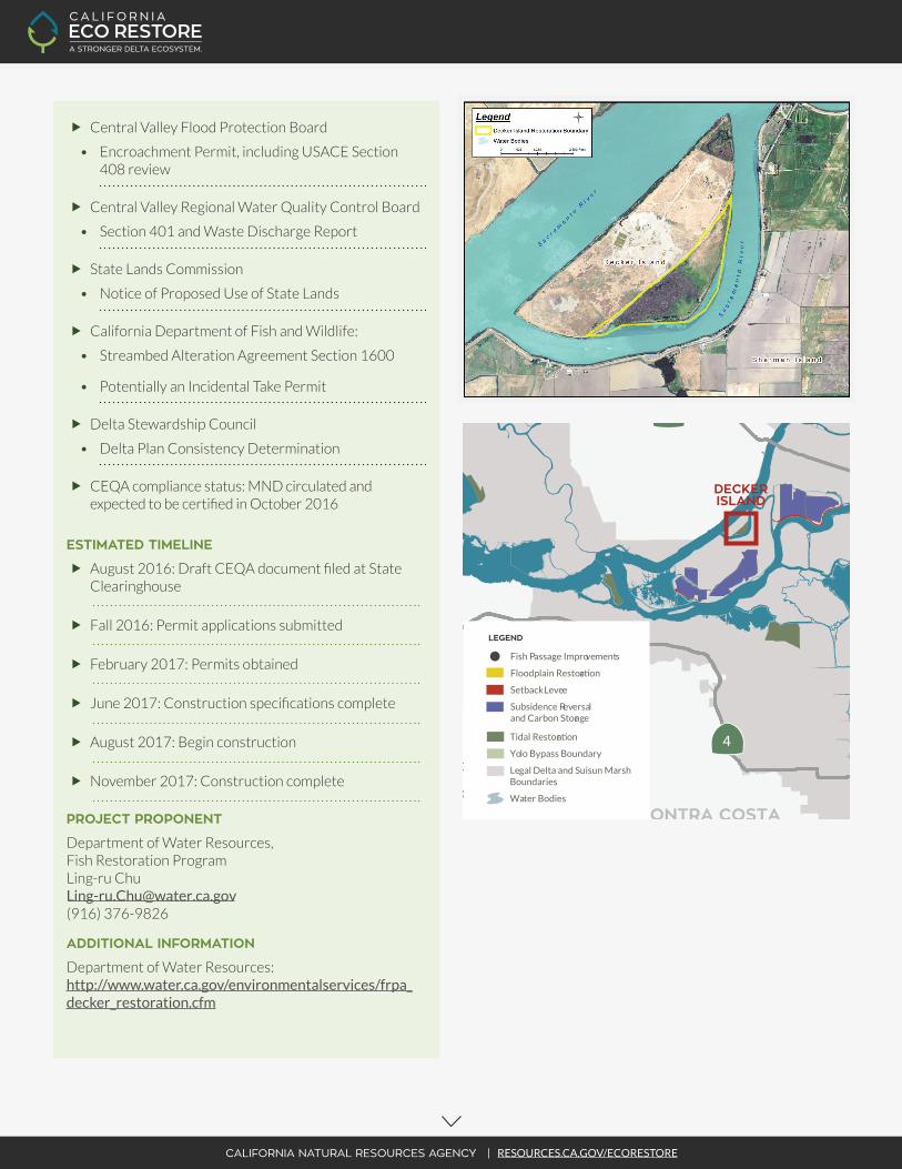
The Department of Water Resources’ (DWR) Fish Restoration Program (FRP) acquired approximately 140 acres on Decker Island in 2015 for tidal wetland restoration. Decker Island was created by the U.S. Army Corps of Engineers (USACE) during the construction of the Sacramento River Deep Water Ship Channel in the early 1900’s. Decker Island is bordered on the west by the Sacramento River and on the east and south by Horseshoe Bend. The Decker Island Tidal Habitat Restoration Project (Project) is intended to partially fulfill DWR’s 8,000-acre tidal habitat restoration obligations pursuant to the 2008 U.S. Fish and Wildlife Service (USFWS) Delta Smelt Biological Opinion (BiOp) for long-term coordinated operations of the State Water Project (SWP) and the federal Central Valley Project (CVP). Additionally, the Project would also be consistent with the 2009 National Marine Fisheries Service (NMFS) Salmonid BiOp for SWP/CVP operations because tidal habitat restoration would provide access for salmonid rearing at Decker Island.
The goal of the Project is to restore unrestricted tidal connectivity to the interior of Decker Island to create a tidal wetland and associated high marsh, and riparian habitats on the site to benefit native fish species. To achieve this goal, the Project will involve breaching the perimeter levee to restore tidal hydrology to the site. The Project consists of restoration planning, modeling, design, permitting, construction, and monitoring. Preliminary planning, conceptual design, baseline data collection (e.g. topography and bathymetry), and hydrodynamic modeling were conducted in 2015. In 2016, FRP continued with restoration planning and environmental compliance documentation preparation. DWR is the CEQA Lead Agency for this project. A draft Mitigated Negative Declaration (MND) was released for public review on August 4, 2016.
DECKER ISLAND TIDAL HABITAT RESTORATION
Solano County
TIDAL WETLAND
RESTORATION GOALS / TARGET
The goals of the effort are to:
� Enhance habitat appropriate for spawning and/or rearing salmonids, Delta Smelt, and other native fish species, enhance available productivity for native fish within and adjacent to the restoration site; and provide connectivity to the marsh plain for migrating salmonids.
LOCATION AND LANDOWNER
The site is in Solano County on the eastern side of Decker Island, along Horseshoe Bend. DWR became the landowner of the 140-acre site in 2015.
FUNDING
Fully funded by the SWP for all phases of the effort
PERMITTING
� Permits and environmental compliance in process or submitted:
• USACE - 404 and 408 Permission
• National Historic Preservation Act - Section 106
• USFWS - Section 7
• NMFS - Section 7
CALIFORNIA NATURAL RESOURCES AGENCY | RESOURCES.CA.GOV/ECORESTORE
� Central Valley Flood Protection Board
• Encroachment Permit, including USACE Section 408 review
� Central Valley Regional Water Quality Control Board
• Section 401 and Waste Discharge Report
� State Lands Commission
• Notice of Proposed Use of State Lands
� California Department of Fish and Wildlife:
• Streambed Alteration Agreement Section 1600
• Potentially an Incidental Take Permit
� Delta Stewardship Council
• Delta Plan Consistency Determination
� CEQA compliance status: MND circulated and expected to be certified in October 2016
ESTIMATED TIMELINE
� August 2016: Draft CEQA document filed at State Clearinghouse
� Fall 2016: Permit applications submitted
� February 2017: Permits obtained
� June 2017: Construction specifications complete
� August 2017: Begin construction
� November 2017: Construction complete
PROJECT PROPONENT
Department of Water Resources, Fish Restoration Program Ling-ru Chu [email protected] (916) 376-9826
ADDITIONAL INFORMATION
Department of Water Resources: http://www.water.ca.gov/environmentalservices/frpa_decker_restoration.cfm
SOLANOCOUNTY
CONTRA COSTACOUNTY
ALAMEDACOUNTY
SAN JOAQUINCOUNTY
YOLOCOUNTY
SUTTERCOUNTY
SACRAMENTOCOUNTY
80
80
505
680
5
5
99
99
12
4
50
CALIFORNIA NATURAL RESOURCES AGENCY | RESOURCES.CA.GOV/ECORESTORE
N
16
0
MILES
5 10 20
CALIFORNIA ECO RESTORE PROJECTS
Knights Landing Outfall Gate
Lindsey Slough
Sherman Island: Mayberry Farms
Sherman Island: Whale’s Mouth
Sherman Island: Mayberry Slough
Twitchell Island: East End
Decker Island
Dutch Slough
Fremont Weir Adult Fish Passage
Hill Slough
McCormack Williamson Tract
Tule Red
Wallace Weir Fish Rescue Facility
Bradmoor Island
Goat Island
Grizzly Slough
Lisbon Weir
Lower Putah Creek Realignment
Lower Yolo Ranch
Prospect Island
Sherman Island: Whale’s Belly
Southport Levee
Twitchell Island: Levee
Twitchell Island: West End
Yolo Bypass Floodplain Restoration
Winter Island
2016 / 2017(Target Construction Start Dates)
2018+(Target Construction Start Dates)
COMPLETED(Construction Completed)
Fish Passage Improvements
Floodplain Restoration
Setback Levee
Subsidence Reversaland Carbon Storage
Tidal Restoration
Yolo Bypass Boundary
Legal Delta and Suisun Marsh Boundaries
Water Bodies
LEGEND
Fish Passage Improvements
Floodplain Restora on
Setback Levee
Subsidence Reversaland Carbon Storage
Tidal Restora n
Yolo Bypass Boundary
Legal Delta and Suisun Marsh Boundaries
Water Bodies
LEGEND
DECKER ISLAND