december 9, 2011. our nation’s transportation infrastructure 1 roads & highways airports &...
TRANSCRIPT

December 9, 2011

OUR NATION’S TRANSPORTATION INFRASTRUCTURE
1
•Roads & Highways
•Airports & Airways
•Rail
•Urban Transit
•Ports & Waterways
•Pipeline

2
• Connects
– cities to suburbs, factories to markets, ports to
warehouses, workers to work places, children to
schools
• Supports other critical infrastructure, e.g., energy
• Is enormous
– 4 million miles of roads
– 604,000 road bridges
– 160,000 miles of rail lines
– 12,000 miles of navigable inland waterways
– 1.7 million miles of oil and gas pipelines
– 10,744 miles of transit rail
The Infrastructure is Vast and Varied

Transportation Infrastructure Moves People and Goods, and Supports Nation’s Economy
3
• Carries 254 million vehicles
• Provides mobility to 15 million Americans who do not own a vehicle
• Moves 16 billion tons of goods
• Pipelines transport 5.4 billion barrels of petroleum
• Supports 10 million airline flights, carrying 800 million passengers and 44 billion tons of freight among commercial service 600 airports.
• The entire transportation system accounts for nearly 9 percent of U.S. gross domestic product.

Infrastructure Spending by Federal, State, and Local Governments In 2006
Total = $108 billion
$38 billion distributed as infrastructure
grants to state and local government
Source: U.S. Department of Transportation, Research and Innovative Technology Administration, Bureau of Transportation Statistics, Government Transportation Financial Statistics 2007
4
Note: Includes capital expenses for equipment such as rolling stock (subway cars and buses for example) or other transportation equipment (such as a state DOT’s operation center’s computers).

Amount of Freight Moved on Highways, Railroads, and Inland Waterways: 2007
5

Measured by Weight, Freight Movements on the U.S. Transportation System Decreased By 13% from 2007 to 2009
Source: Freight Analysis Framework, Federal Highway Administration, U.S. Department of Transportation.
6

Source: U.S. Department of Transportation, Research and Innovative Technology Administration, Bureau of Transportation Statistics, November 2011
7
Ton Mile: a unit of measurement in freight transportation equal to the movement of one ton of goods by one mile

Interstate Highway Miles are 1 Percent of Total Road Miles but Carry 24 Percent of Total Travel
8
Source: U.S. Department of Transportation, Research and Innovative Technology Administration, Bureau of Transportation Statistics, National Transportation Statistics
Total Road Miles = 4,050,717
46,720
4,003,997
The Interstate Highway System is built to the uniform standards, including limited access, at least 50 mile per hour speed limit, a minimum of two travel lanes in each direction, and paved shoulders.

Demand on The System Continues to IncreaseAmount Of Driving On Highway vs. Highway Miles,1990-2010
Source: Federal Highway Administration, U.S. Department of Transportation.
9
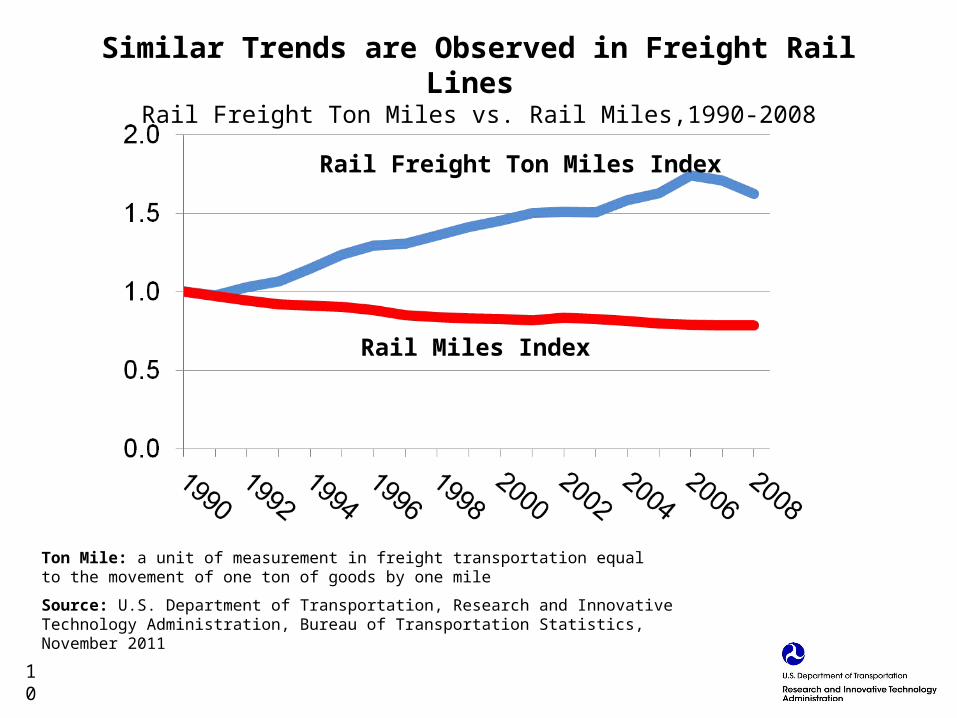
Rail Freight Ton Miles Index
Rail Miles Index
Ton Mile: a unit of measurement in freight transportation equal to the movement of one ton of goods by one mile
Source: U.S. Department of Transportation, Research and Innovative Technology Administration, Bureau of Transportation Statistics, November 2011
Similar Trends are Observed in Freight Rail Lines Rail Freight Ton Miles vs. Rail Miles,1990-2008
10

Higher Demand and Level Roadway Capacity Contribute to Traffic Congestion
In city with > 3M people
In city with 1-3M people
Source: Texas Transportation Institute, Congestion Data for Your City, Excel spreadsheet of the base statistics for the 101 urban areas and population group summary statistics (College Station, TX: 2011), available at http://mobility.tamu.edu as of Jan. 20, 2011.
11

12
Note: Structural deficiencies are characterized by deteriorated conditions of significant bridge elements and reduced load-carrying capacity. A "structurally deficient" designation does not imply that a bridge is unsafe, but such bridges typically require significant maintenance and repair to remain in service, and would eventually require major rehabilitation or replacement to address the underlying deficiency.

Percentage Deficient Bridges by State, 2010
Note: Structural deficiencies are characterized by deteriorated conditions of significant bridge elements and reduced load-carrying capacity. A "structurally deficient" designation does not imply that a bridge is unsafe, but such bridges typically require significant maintenance and repair to remain in service, and would eventually require major rehabilitation or replacement to address the underlying deficiency.
Source: Federal Highway Administration, U.S. Department of Transportation.13

In 2010, One in Every Nine Rural Americans Had No Access to Intercity Transportation Services
Source: Bureau of Transportation Statistics, U.S. Department of Transportation.
14Modes: Air, intercity bus, intercity ferry and intercity rail.

Between 2005 and 2010, 3.5 Million Rural Residents Lost Access to Scheduled Intercity Transportation
Source: Bureau of Transportation Statistics, U.S. Department of Transportation.
15
Transportation systems open to the public, including bus, subway, commuter rail, light rail, passenger ferries, vanpool, and paratransit / demand response services. Excludes charters, school bus, sightseeing, and intercity service.

Transit Ridership Increased by 33% from 1995 to 2009—to 10.4 Billion Trips a Year
Source: 2011 Public Transportation Fact Book, American Public Transportation Association.
16

Transit Infrastructure Condition
• On average, transit rail locomotives, coaches and cars are 18 years old
• Transit buses are 6 years old or older• One in every 4 transit stations is in excellent or good condition• The majority of the transit underground tunnels are in excellent or
good condition
Source: U.S. Department of Transportation, Federal Transit Administration, Status of the Nation's Highways, Bridges and Transit: Conditions and Performance.
17

Source: Bureau of Transportation Statistics, T-100 Market (All Carriers)
Air Passenger Travel Grew 60% and Air Freight Grew 135% from 1990 to 2010
18
Passengers
Freight
Passengers (millions) Freight (millions of tons)

1990 2010
Rank Passengers
(millions) Rank Passengers
(millions)
1 Chicago O'Hare 26.7 1 Atlanta 43.0
2 Dallas/Fort Worth 23.1 2 Chicago O'Hare 32.2
3 Atlanta 23.0 3 Los Angeles 28.9
4 Los Angeles 21.5 4 Dallas/Fort Worth 27.0
5 San Francisco 14.6 5 Denver 25.2
6 New York JFK 13.8 6 New York JFK 22.9
7 Denver 12.0 7 Houston Bush 19.5
8 Miami 11.7 8 San Francisco 19.3
9 New York LaGuardia 11.1 9 Las Vegas 18.9
10 Phoenix 10.7 10 Phoenix 18.9
Source: Bureau of Transportation Statistics, T-100 Market (All Carriers)
In 2010, the Top 10 Airports Accounted for Almost One-Third of All Air Passenger Travel
19

Causes of Flight Delays, Jan-Sept 2011
Source: Bureau of Transportation Statistics, U. S. Department of Transportation
20

The Majority of Tarmac Delays in May 2011 Were Due to Weather Issues
Source: Bureau of Transportation Statistics, U. S. Department of Transportation
21
DOT rule makes 3-hr tarmac times subject to fine
Tarmac times over 3 hours

Percent of On-time Arrivals at Major U.S. Airports Arriving at the Gate Within 15 Minutes of Scheduled Arrival Time
Top Five1990 % 2010 %
1 Washington Dulles 84.3 1 Seattle 85.12 Charlotte 83.5 2 Phoenix 85.13 Las Vegas 82.6 3 Portland, OR 83.74 Salt Lake City 82.5 4 Denver 83.65 Washington Reagan 82.1 5 Charlotte 82.9
Bottom Five1990 % 2010 %
5 New York La Guardia 74.2 5 Boston 76.34 Philadelphia 73.8 4 New York JFK 74.73 New York JFK 73.6 3 New York La Guardia 73.72 Newark 72.3 2 Newark 71.91 Seattle 72.2 1 San Francisco 71.3
Note: Major airports have at least 1 percent of the total of scheduled service domestic passenger enplanements for all airports in the U.S.Source: Bureau of Transportation Statistics, Airline On-Time Data
22

Runway Pavement Conditions Improved Over Time
Source: U.S. Department of Transportation, Federal Aviation Administration, Office of Airport Planning and Programming
23

Source: U.S. Department of Transportation, Maritime Administration, Port Import Export Reporting Service (PIERS); data collected from Vessel as of November 8, 2011.Units: The statistics are shown in TEUs. A TEU is a nominal unit of measure equivalent to a 20’ x 8’ x 8’ shipping container.
86 Percent of Total Import and Export Container Traffic Moves Through the Top 10 Ports
Port Name 2010 TEUs Percentage of Total
1 Los Angeles, CA 5,559,046 20%
2 Long Beach, CA 4,433,994 16%
3 New York, NY 4,043,060 15%
4 Savannah, GA 2,170,339 8%
5 Oakland, CA 1,505,446 5%
6 Norfolk, VA 1,435,098 5%
7 Seattle, WA 1,417,070 5%
8 Houston, TX 1,348,072 5%
9 Charleston, SC 1,076,595 4%
10 Tacoma, WA 835,556 3%
Total for Top 10 Sea Ports 23,824,276 Top 10 Total: 86%
Total for All U.S. Sea Ports 27,877,546
24
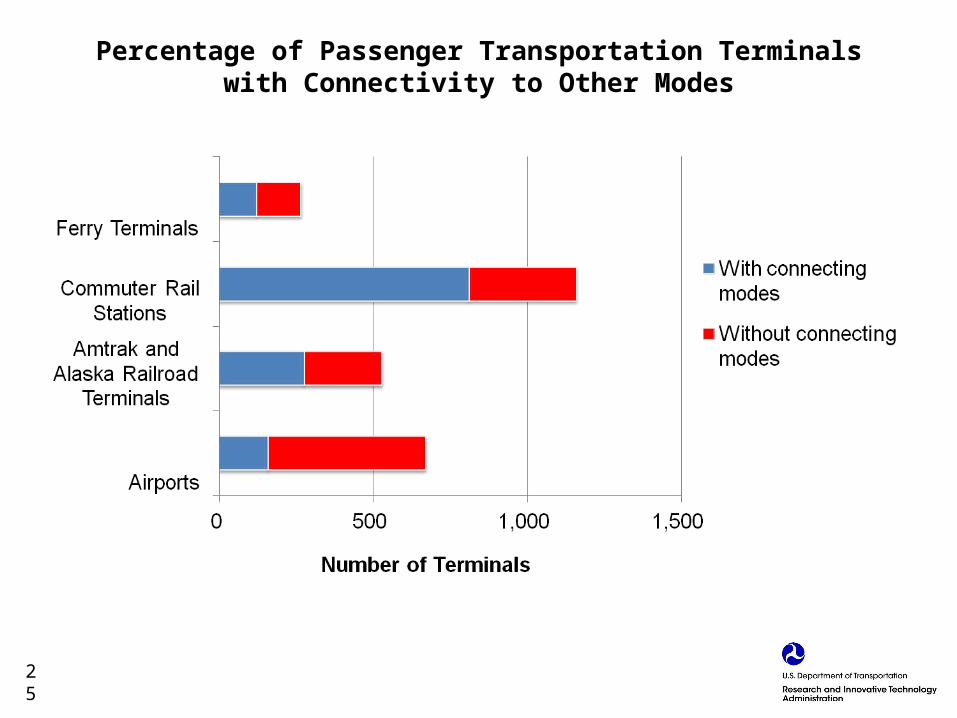
Percentage of Passenger Transportation Terminals with Connectivity to Other Modes
25