date of receipt - climate change adaptation · spearheading ecosystem-based adaptation as climate...
TRANSCRIPT
1
PART I: PROJECT/PROGRAMME INFORMATION
PROJECT/PROGRAMME CATEGORY: REGULAR PROJECT/PROGRAMME COUNTRY/IES: SEYCHELLES SECTOR/S: WATER RESOURCES TITLE OF PROJECT/PROGRAMME: Ecosystem Based Adaptation to Climate Change in
Seychelles
TYPE OF IMPLEMENTING ENTITY: MULTILATERAL IMPLEMENTING ENTITY IMPLEMENTING ENTITY: UNITED NATIONS DEVELOPMENT PROGRAMME EXECUTING ENTITY/IES: MINISTRY OF ENVIRONMENT AND ENERGY AMOUNT OF FINANCING REQUESTED: $ 6,455,750 (In U.S Dollars Equivalent) UNDP PIMS NUMBER: 4775 PROJECT / PROGRAMME BACKGROUND AND CONTEXT: Short Summary The proposed project seeks to reduce the vulnerability of the Seychelles to climate change, focusing on two key issues—water scarcity and flooding. The climate change projections in the Seychelles show that rainfall, while increasing in overall terms, will become even more irregular. Much of the precipitation is falling in sharp bursts, creating heavy flooding in the wet season, while imposing extended period of drought during the dry season. As the country does not have a large water storage capacity, and the topography of the islands constrains such infrastructure, water supplies are heavily dependent on rainfall. Furthermore, the coastal zone is vulnerable to flooding as a consequence of rising sea surface levels, and increased storm surges from cyclonic activity in the Western Indian Ocean. The project will reduce these vulnerabilities by spearheading ecosystem-based adaptation as climate change risk management—restoring ecosystem functionality, and enhancing ecosystem resilience and sustaining watershed and coastal processes in order to secure critical water provisioning and flood attenuation ecosystem services from watersheds and coastal areas. Three project components are proposed:
Component 1 will maintain and enhance upland wetlands in watersheds and strengthen the integrity of the forest landscape with a preference for endemic species, retain and improve water holding capacity (and biodiversity features), and undertake measures to maintain and enhance a balanced hydrological regime as much as possible by soil and water conservation measures, controlling drainage through various bio-engineering measures, improving run-of-river barrages and water control structures, sustainably managing watercourses and promoting local stewardship of watersheds. It will also employ ecosystem-based strategies to remove alien species and re-colonize with native plants along with soil and water conservation and assess the subsequent effects on forest hydrology. The watershed rehabilitation will be implemented in selected watersheds covering 1,800 ha on Mahe Island and about 1,200 hectares on Praslin Island.
Component 2 will maintain and enhance tidal wetlands, beach berms and coral reef functions with EbA measures that include (a) selective shoreline re-vegetation and protection, (b) wetland enhancement and improvement of tidal exchange, (c) coral reef rehabilitation, enhancement and protection to enhance their climate change adaptation role in flood attenuation, and (d) measures that address saltwater intrusion effects on low lying agricultural areas focusing strategically on sites with high vulnerability to climate change (assets at risk). The interventions will focus on two priority sites where coastal
DATE OF RECEIPT: ADAPTATION FUND PROJECT ID: (For Adaptation Fund Board Secretariat Use Only)
PROJECT/PROGRAMME PROPOSAL
2
development, erosion and climate change have diminished the natural coastal defenses and opportunities exist to strengthen the ecosystem attributes and processes. These physical measures will be complemented with policy, legal and institutional capacity development support measures in Component 3. The coastal rehabilitation will be implemented at two sites covering an impact area of about 1,000 ha. Component 3 will develop the policy framework for watershed management which is needed to support EbA measures to address water scarcity and flooding problems and will increase the capacity to respond to climate change through watershed and coastal management. It will also generate appropriate legislation, regulations, standards and guidelines for watershed and coastal protection, and train government, university faculty and NGO staff in applying EbA measures in development decision making in the Seychelles, influencing watershed and coastal management throughout the Mahe and Praslin Islands (covering approximately 20,000 hectares). This component will also increase the awareness, skills and responsibilities of a wide range of stakeholders including district authorities and community organisations in ecosystem-based adaptation for watersheds and coastal areas, and build the lasting basis for further education, training and application in watershed and coastal ecosystem rehabilitation.
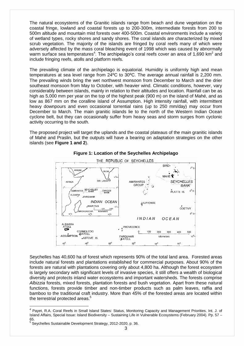
Ecosystem-based adaptation has developed internationally in recognition of the importance of maintaining the ecosystem attributes and functions including hydrological systems and coastal dynamics that underpin the ability to respond to climate change.1 The underlying principle is that healthy ecosystems can play a vital role in maintaining and increasing resilience to climate change and in reducing climate-related risk and vulnerability.2 The project will invest in measures to restore ecosystem functionality, building on techniques that have been piloted in Seychelles, and adapting these by incorporating other good practices. Ecosystem based adaptation will be integrated into the country‘s development planning, policy and land and water management systems, ensuring that environmental impact assessments and management measures protect these ecosystem services. ―Ecosystem-based adaptation‖ in the context of Seychelles climate change issues and this proposal refers to the conservation, rehabilitation and enhancement of watercourses, ecosystems, and habitats in order to increase the capability to adapt to changes in temperature, precipitation, storms and sea level rise that affect watershed management and coastal protection. The watershed and coastal processes that influence the bio-physical landscape are inherently linked to ecosystem attributes and functions. For example, maintaining the hydrological balance in a watershed and utilizing the natural water retention and infiltration properties of the geology, soils and vegetation is central to ecosystem-based adaptation. A drainage basin perspective is necessary for understanding the upstream-downstream connectivity of water supplies, water demands, and emerging water problems.3 Secondly, maintaining landscape connectivity ensures that the ecosystem functions within forests, wetlands, mangroves, dunes and reefs are part of the system of inter-connected defences and mitigating influences to adapt to climate change. Environmental and Socioeconomic Context The Seychelles consists of 115 islands (see Figure 1) of which some 40 are granitic and the rest coral formations. The islands are located within 4⁰ and 9⁰ south of the equator and between
longitude 46⁰ and 57⁰ east. The country has a land mass of 455.3 km2, and an Exclusive
Economic Zone (EEZ) covering 1,374 million km2. The four largest granitic islands: Mahé, Praslin, Silhouette and La Digue, which vary in age from some 650 to 750 million years, together account for 48.6 % of the total landmass. The archipelago has a combined coastline of 491 km.
1 See Andrade Pérez, A., Herrera Fernandez, B. and Cazzolla Gatti, R. (eds.) (2010). Building Resilience to Climate
Change: Ecosystem-based adaptation and lessons from the field. Gland, Switzerland: IUCN. 2 UNFCCC, Subsidiary Body for Scientific and Technological Advice, Ecosystem-based approaches to adaptation:
compilation of information, Durban, 28 November to 3 December 2011 3 Douglas Ellen M., Kate Sebastian, Charles J. Vörösmarty, Stanley Wood, Kenneth M. Chomitz, The Role of Tropical
Forests in Supporting Biodiversity and Hydrological Integrity A Synoptic Overview, World Bank Policy Research Working Paper 3635, June 2005, p.3.
3
The natural ecosystems of the Granitic islands range from beach and dune vegetation on the coastal fringe, lowland and coastal forests up to 200-300m, intermediate forests from 200 to 500m altitude and mountain mist forests over 400-500m. Coastal environments include a variety of wetland types, rocky shores and sandy shores. The coral islands are characterized by mixed scrub vegetation. The majority of the islands are fringed by coral reefs many of which were adversely affected by the mass coral bleaching event of 1998 which was caused by abnormally warm surface sea temperatures4. The archipelago‘s coral reefs cover an area of 1,690 km2 and include fringing reefs, atolls and platform reefs. The prevailing climate of the archipelago is equatorial. Humidity is uniformly high and mean temperatures at sea level range from 24⁰C to 30⁰C. The average annual rainfall is 2,200 mm.
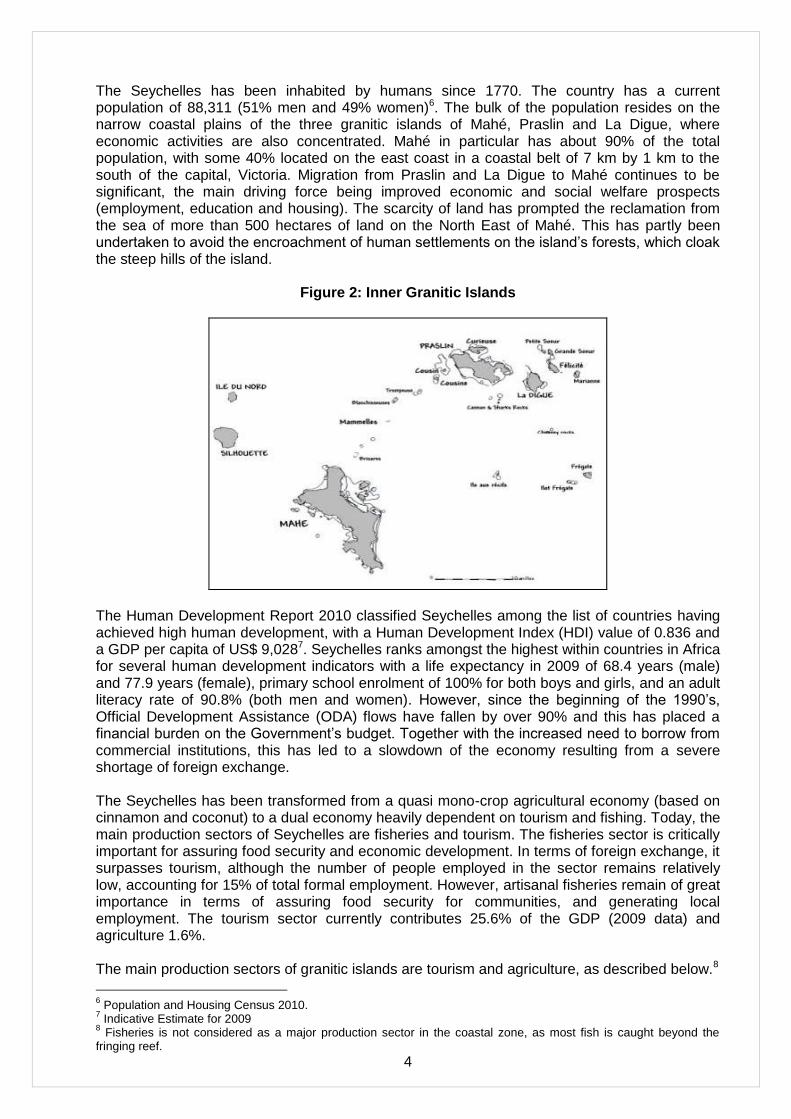
The prevailing winds bring the wet northwest monsoon from December to March and the drier southeast monsoon from May to October, with heavier wind. Climatic conditions, however, vary considerably between islands, mainly in relation to their altitudes and location. Rainfall can be as high as 5,000 mm per year on the top of the highest peak (900 m) on the island of Mahé, and as low as 867 mm on the coralline island of Assumption. High intensity rainfall, with intermittent heavy downpours and even occasional torrential rains (up to 250 mm/day) may occur from December to March. The main granitic islands lie to the north of the Western Indian Ocean cyclone belt, but they can occasionally suffer from heavy seas and storm surges from cyclonic activity occurring to the south. The proposed project will target the uplands and the coastal plateaus of the main granitic islands of Mahé and Praslin, but the outputs will have a bearing on adaptation strategies on the other islands (see Figure 1 and 2).
Figure 1: Location of the Seychelles Archipelago
Seychelles has 40,600 ha of forest which represents 90% of the total land area. Forested areas include natural forests and plantations established for commercial purposes. About 90% of the forests are natural with plantations covering only about 4,800 ha. Although the forest ecosystem is largely secondary with significant levels of invasive species, it still offers a wealth of biological diversity and protects inland water ecosystems and important watersheds. The forests comprise Albizzia forests, mixed forests, plantation forests and bush vegetation. Apart from these natural functions, forests provide timber and non-timber products such as palm leaves, raffia and bamboo to the traditional craft industry. More than 45% of the forested areas are located within the terrestrial protected areas.5
4 Payet, R.A. Coral Reefs in Small Island States: Status, Monitoring Capacity and Management Priorities. Int. J. of
Island Affairs, Special Issue: Island Biodiversity – Sustaining Life in Vulnerable Ecosystems (February 2004). Pp. 57 – 65. 5 Seychelles Sustainable Development Strategy, 2012-2020, p. 36.
4
The Seychelles has been inhabited by humans since 1770. The country has a current population of 88,311 (51% men and 49% women)6. The bulk of the population resides on the narrow coastal plains of the three granitic islands of Mahé, Praslin and La Digue, where economic activities are also concentrated. Mahé in particular has about 90% of the total population, with some 40% located on the east coast in a coastal belt of 7 km by 1 km to the south of the capital, Victoria. Migration from Praslin and La Digue to Mahé continues to be significant, the main driving force being improved economic and social welfare prospects (employment, education and housing). The scarcity of land has prompted the reclamation from the sea of more than 500 hectares of land on the North East of Mahé. This has partly been undertaken to avoid the encroachment of human settlements on the island‘s forests, which cloak the steep hills of the island.
Figure 2: Inner Granitic Islands
The Human Development Report 2010 classified Seychelles among the list of countries having achieved high human development, with a Human Development Index (HDI) value of 0.836 and a GDP per capita of US$ 9,0287. Seychelles ranks amongst the highest within countries in Africa for several human development indicators with a life expectancy in 2009 of 68.4 years (male) and 77.9 years (female), primary school enrolment of 100% for both boys and girls, and an adult literacy rate of 90.8% (both men and women). However, since the beginning of the 1990‘s, Official Development Assistance (ODA) flows have fallen by over 90% and this has placed a financial burden on the Government‘s budget. Together with the increased need to borrow from commercial institutions, this has led to a slowdown of the economy resulting from a severe shortage of foreign exchange. The Seychelles has been transformed from a quasi mono-crop agricultural economy (based on cinnamon and coconut) to a dual economy heavily dependent on tourism and fishing. Today, the main production sectors of Seychelles are fisheries and tourism. The fisheries sector is critically important for assuring food security and economic development. In terms of foreign exchange, it surpasses tourism, although the number of people employed in the sector remains relatively low, accounting for 15% of total formal employment. However, artisanal fisheries remain of great importance in terms of assuring food security for communities, and generating local employment. The tourism sector currently contributes 25.6% of the GDP (2009 data) and agriculture 1.6%. The main production sectors of granitic islands are tourism and agriculture, as described below.8
6 Population and Housing Census 2010.
7 Indicative Estimate for 2009
8 Fisheries is not considered as a major production sector in the coastal zone, as most fish is caught beyond the
fringing reef.
5
Tourism: Prior to completion of the international airport in 1971, the only access to Seychelles was by boat. The tourism industry expanded greatly after the opening of the airport. Tourism arrivals increased steadily for the first 25 years, reaching 47,280 by 1982 and peaking at 130,955 in 1996. Arrivals declined gradually to 124,865 in 1999, before recovering to 130,046 in 2000, and then increasing to 174,529 in 2010. The Seychellois tourism sector contributed 46.1% of the country‘s GDP in 2010 and directly provided for 56.4% of national employment. It generated US$ 382.5 million of foreign exchange, or 33.2% of the country‘s foreign exchange earnings in 2010. The contribution of tourism to the national economy is much more significant, since these statistics do not take into account the economic multiplier effect that is spawned by the industry and the creation of value added in other sectors. Agriculture: Agricultural development in the Seychelles went through major changes from the 1800‘s through to 1960, moving away from food production and into a cash crop economy with copra as the main crop and cinnamon in a lesser position. With the growth of the tourism industry, there was a major exodus of labour from agriculture into construction, tourism and other related sectors. The production of traditional crops declined drastically. Agriculture in Seychelles is now characterized by small farms with an average size of 0.5 hectares and rarely exceeding 2 hectares. Farmers employ various levels of technology and management, some of it fairly sophisticated. Currently, about 500 registered farms are dispersed throughout the major granitic islands of Mahé, Praslin and La Digue, where they are mostly found on the coastal plateau. Current agricultural production meets about 4% of the local demand for beef, 50% for pork, 60 – 70% for vegetables and fruit, 80% for poultry and 100% for eggs. Cinnamon and coconut production have dropped considerably in the last 10 years. Agriculture employs around 3,800 persons and currently accounts for about 3.8% of GDP.
The land area suitable for development is limited. A significant proportion of the main granitic islands of Mahé, Praslin and La Digue is urbanized. The pressure for residential development is strong on the coastal area and the lower parts of the mountains where impacts on water supply watersheds are being felt. The UNCDD Seychelles National Action Plan for Sustainable Land Management (2011) highlights the threats posed by climate change and the need for concerted action on several fronts. Forest fires, unsustainable harvesting of timber and non-timber products, invasion by creepers and biodiversity loss, upland erosion and coastal flooding are among the priorities. Salt water intrusion into groundwater is another growing climate change concern. For example, every year coastal farmers face significant loss of vegetable crops due to high salinity from salt water intrusion, with reported cases at nearly one quarter of the salinity of sea water.9 These are serious climate change issues that affect all Seychellois. Problem Statement: Vulnerability of Island Ecosystems and Communities to Climate Change The Seychelles is economically, culturally and environmentally vulnerable to the effects of climate change and associated extreme weather events10. The effects of climate change are already noticeable in Seychelles and these effects and their associated impacts are projected to escalate in the future. The two biggest climate change vulnerabilities are water scarcity and coastal flooding. 1. Water Scarcity Fresh water is crucial both for human needs which are indispensable for well-being, such as drinking and sanitation, as well as other sectoral uses which are intrinsic to the development process (tourism/agriculture). Although the country receives a relatively high average annual
9 Government of Seychelles, Proposal -Surveying & Monitoring of Coastal Agricultural Area for the Management of
Soil Salinity and Sodicity as a Result of Climate Change, 2012. 10
The Seychelles National Climate Change Committee, 2009. Seychelles National Climate Change Strategy.

6
precipitation quotient of 2,200 mm of rainfall, the Seychelles is water stressed11. The country ranks well in terms of water access comparators - 93% of the population has access to piped water supplies. In 2009, total water demand amounted to 24,489 m3/day. However, the country has limited capacity to store water. The steep terrain of Mahé and Praslin has prevented the development of dams on rivers. Instead water is pumped from rivers (a few small impoundments have been built to capture water in stream, namely Cascade, Le Noil and Rochon Sites (total capacity 119,000m3), directly to treatment plants for supply to customers. Excess water is also pumped to a high holding reservoir (La Gogue Dam - capacity 150,000m3), without its own catchment. This creates a problem during dry spells, when stream base flows can drop dramatically. During such periods, the water supply system is severely stretched to meet demand. Demand for water is growing rapidly at a rate of 8% annually, and is likely to increase as a result of tourism growth. With approximately 18% of the annual water sales in Seychelles attributed to the tourism sector, this growth will have a large impact on water resources especially in terms of planned doubling of available tourism rooms from 6,000 to 12,000 in the next three decades. Similarly, as fishery processing activities increase and diversify, they are expected to draw more water. The agricultural sector, which is heavily dependent on water, will also grow over the next three decades (estimated at 1.2 % per year) which will put additional stress on available water resources. The annual rainfall over the main granitic islands is increasing; annual trends on Mahé for the period 1972 to 2006 showed an increase of 13.7 mm per year. This increase may be attributed to a few episodic heavy rainfall events and is not evenly distributed across the year12. Based on constructed climate scenarios for the islands of Mahé and Aldabra13, it is concluded that in future the rainy season in Seychelles is ‗more likely than not‘ to be wetter, while the dry season is ‗more likely than not‘ to be drier - a situation already emerging in the 1972 - 2006 interval. The scenarios indicate that the impacts of climate change on Seychelles‘ water resources are expected to be severe. The dry southeast monsoon season is expected to become drier and the period between rainfall events during this season is likely to become longer. This will have impacts on stream flow. The water storage capacity in Seychelles will be severely challenged as a consequence. During prolonged climate changed induced dry spells, stream flows are expected to decrease and at times stop. This will have serious consequences for coastal communities. Further, due to the limited water storage capacity, the country will not be able to benefit from increased rainfall during the wet Northwest monsoon. The climate models predict that rainfall during this period will be more intense, falling in short sharp bursts (such sporadic rainfall events accounting for the overall increase in rainfall).much of this is likely to run off into the sea. The rainfall – stream flow relationships are illustrated on Figure 3 graph of mean rainfall and flows (1978-2005) on the Le Noi and Cascade rivers showing a high correlation between rainfall and stream flow in the wetter parts of the island.14 The river systems are very responsive to rainfall patterns because of the generally small catchment areas and the high runoff rates associated with steep slopes, intense rainfall events and limited infiltration controls.
11
An area is considered ‗water stressed‘ if the per capita water availability is below 1000m3 per year, or if there is a
ratio of withdrawals to average annual run-off (water from rain, snowmelt, and irrigation, which is not absorbed by the ground or evaporated of over 0.4. 12
Lajoie, F. R. 2004. Report on the WMO/CLIVAR ETCCDMI African Workshop on Extremes. Seychelles. 13
Chang-Seng, D. 2007. Climate Change Scenario Assessment for the Seychelles, Second National Communication (SNC) under the United Nations Framework Convention on Climate Change (UNFCCC), National Climate Change Committee, Seychelles. Also see Annex 3 for summary of methodology and conclusions. 14
Denis Chang-Seng and Theodore Marguerite, Hydro-Climate Statistical Multivariate Model of Seychelles' Dry Season, Seychelles, Second National Communications, UNFCCC, Seychelles' National Climate Change Committee, Ministry of Environment, Natural Resources and Transport, Nov. 2007.

7
Figure 3: Rainfall (Rf)-Stream Flow (SF) Relationship
0
100
200
300
400
500
600
Jan Feb Mar Apr May Jun Jul Aug Sep Oct Nov Dec
Time (Months)
Ra
infa
ll (
mm
) &
Str
ea
m F
low
(L
/s)
Mean SF Le Niol
Mean SF Cascade
Le Niol Rf
Cascade Rf
Source: Denis Chang-Seng and Theodore Marguerite, 2007.
The warming in the Seychelles region, over the period 1972 – 1997, is estimated to be of the range of 0.25⁰C15. Analysis by Lajoie (2004) indicated that the number of very warm days and
nights is increasing dramatically while the number of very cool days and nights are decreasing. Chang-Seng16 established that the mean air temperature Seychelles is more likely than not to warm by +3.0 ° C by the end of this century. The relative rate of warming will occur mainly during the cooler southeast monsoon. Given this projected increase in surface temperatures, evaporation will also increase putting more demand on the water storage facilities. The demand for water by the human population will also increase during hot periods causing heat stress, as a result of increased irrigation, cooling and sanitation uses. 2. Coastal Flooding As mentioned above, the annual rainfall over the main granitic islands is increasing; annual trends showing an increase. This increase may be attributed to a few episodic heavy rainfall events and is not distributed evenly across the year. The climate models also predict that rainfall during the raining period will be more intense, falling in short sharp busts. These rainfall spells, together with the steep topography of the islands, lead to coastal floods. This is exacerbated by the inherent backward sloping of the coastal plain and a high water table in the coastal plain17. Further, the warming of the atmosphere, which has happened globally and estimated at approximately 0.7⁰C since 190018 has caused the average temperature of the global ocean to
increase to depths of more than 3 km. The thermal expansion occurring as a consequence of the increased ocean temperature, as well as a smaller, yet significant effect of discharge of additional water into the oceans as terrestrial ice and snow melt, has led to a rise in sea level. The Intergovernmental Panel on Climate Change (IPCC) Fourth Assessment Report estimated an average rate of 1.8 mm (with a range of 1.3 to 2.3 mm) per year global sea level rise and predicted that this would continue. The limited data on sea level rise in Seychelles makes any conclusive assessment difficult but it has been estimated that sea level is rising by 1.46 mm per year around Mahé19. The Western Indian Ocean region experiences severe tropical cyclones. Tropical cyclone trajectories do not come close to the main populated islands of the Seychelles, as they are
15
Payet, R. A. & Agricole, W. 2006. Climate Change in the Seychelles – Implications for Water and Coral Reefs. AMBIO, 35 (4): 182 – 189. 16
Chang-Seng, D. 2007. Climate Change Scenario Assessment for the Seychelles, Second National Communication (SNC) under the United Nations Framework Convention on Climate Change (UNFCCC), National Climate Change Committee, Seychelles. Also see annex for summary of methodology and conclusions. 17
Seychelles Agricultural Agency (SAA), 2011. Manual for Best Practices in Soil Conservation and Soil Management for Farmers in the Seychelles. P.7. 18
Stern, N. 2007. The Economics of Climate Change: The Stern Review. Cambridge University Press, Cambridge, pp. 3 – 24. 19
Chang-Seng, D. 2007. Climate Change Scenario Assessment for the Seychelles, Second National Communication (SNC) under the United Nations Framework Convention on Climate Change (UNFCCC), National Climate Change Committee, Seychelles.

8
located close to the equator and in the Indian Ocean, cyclones are more generally prevalent South of the Equator South of 10ºS20. However, it is important to note that extreme rainfall and wave swells resulting from Indian Ocean tropical cyclones do affect the Seychelles and need to be taken into consideration21. Chang-Seng22 concluded that the trend for the number of tropical depressions in the Seychelles is +0.025 and that since 1990, Seychelles has recorded an increase in tropical storms which formed and moved near the granitic islands of Seychelles. This is projected to increase as a result of climate change. With increased peak winds23, the wave action affecting the coastal areas of Seychelles has increased as a result of climate change. Annex 3 provides a summary of the climate change scenario. Sea level rise also exacerbates coastal erosion as the waves reach further inland at high tide. Shore wave heights are limited by water depths, so with the increase in sea level, the height of waves will increase. Nicholls et. al. (2002)24 estimate that without adaptation a 1 meter rise in sea level will produce a 14-fold increase in flooding compared to the situation without sea-level rise. Under a lower sea-level rise scenario of 38cm by the 2080s, the global increase in flooding will be seven-fold compared with the situation without sea-level rise. They also forecast that large relative increases in flooding will be felt in the small island region of the Indian Ocean, which includes the Seychelles. For the same reason flooding in the coastal strips is increased, affecting urban areas in low elevation coastal zones. Barriers to Addressing the Climate Change-Induced Problems The Government of Seychelles has developed a national framework for climate change mitigation and adaptation responses, for example establishing the Seychelles National Climate Change Committee and a Climate and Environmental Services Division in the Ministry of Environment and Energy. However, barriers exist which prevent the Government and communities from addressing the two afore-mentioned climate change-induced vulnerabilities. Ecosystems play an important role in determining the vulnerability of communities to climate change—particularly in Small Island Developing States such as the Seychelles. The forests and wetlands of the granitic islands play an important role in regulating stream flows and water quality. Forested land binds the soil, thereby decreasing soil erosion and increasing the capacity of soils to absorb and retain water. This allows water to penetrate deeper into the soil, allowing for less runoff and slower release. Wetlands and riparian vegetation also assist in the reduction of erosion and slow discharge of water from the watershed over a longer period of time. This will have two benefits in ameliorating the effects of climate change on water supplies - providing more regular stream flow during the lengthier dry season, while buffering against flooding following intense rainfall events. Similarly, mangroves and fringing coral reefs protect coastal land against coastal erosion, while coastal sand dunes and wetlands play an important role in controlling coastal flooding. These flood attenuation services are likely to be critical given projected climate change induced flooding risks. Overcoming the effects of historical land use is a barrier to sustainable water management. Past agricultural practices in Seychelles‘ plantation economy (from 1800 to early 1970s) transformed the landscapes with a focus on coconut, cinnamon, patchouli, vanilla and more recently tea cultivation. This has left an ecological legacy of soil loss, weak soil fertility and the presence of many invasive species. Varley (1971) and Moustache et. al. (2011) have described the role of human intervention on the granitic islands and the subsequent effects on drainage and soil fertility:
Rainfall impact onto the ground was braced by the canopy when the forest had full cover. Once the primary vegetation was removed some 200 years ago on the
20
In the West Indian Ocean cyclones form west of 100ºE and travel eastwards to the East Africa coast in the period
from December to April. Cyclones normally form South of 10ºS—hence South of the Seychelles. 21
The Seychelles National Climate Change Committee, 2009. Seychelles National Climate Change Strategy. 22
Chang-Seng, D. 2007. Climate Variability and Climate Change assessment for the Seychelles, Second National Communication (SNC) under the United Nations Framework Convention on Climate Change (UNFCCC), National Climate Change Committee, Seychelles. 23
Ibid., 2007. 24
Nicholls, R.J. & Hoozemans, F.M.J. 2002. Global Vulnerability Analysis. In Schwartz, M. (Ed). Encyclopedia of Coastal Science, Kluwer Academic Publishers.
9
bulk of the main granitic islands, a series of factors were set in motion to destroy the soil fertility. The removal of the primary forests meant that rain impacted directly onto the ground with the consequence of organic matter containing a large percentage of the circulating plant nutrients were washed away.25
Flooding of the coastal plain is a result of deforestation and poor cultivation practices in the uplands as well as the inherent backward sloping of the coastal plain and a high water table26 and drainage issues in the plateaux, including those created by wetland reclamation. Much of the flooding is reported to be attributable to flat land, wetland reclamation, lack or no road-side drains, blocked drains due to the construction of new side roads, silt accumulation in drains, non-uniform drains, weed and grass overgrowth in drains, no or poor kurb outlets and no proper drains to accommodate storm water runoff.27 The factors affecting flooding include development within floodplains/wetlands and poor construction standards, including loss of old practices of flood preventive or mitigation measures in recent constructions.28 After several major flooding events a 2004 Drainage Task Force Committee undertook a study of the issues. Their report noted:
The three main islands of Seychelles frequently experience flash floods after relatively heavy rainfalls. This has come about generally because of the increase in the amount of storm water runoff due to increase in urbanisation and also the inability of the current drainage systems (most of which were constructed many years ago) to cope with the runoff. Part of the flooding problems is also attributed to:
The rise in global mean temperatures and associated changes in precipitations and wind velocities.
The non-existence or inadequate drainage infrastructure in some areas.
Lack of proper maintenance.
Reclamation of natural wetland areas, which play an important role in the buffering flash flood discharges.
29
The Drainage Task Force Study included amongst its conclusions that development on wetlands aggravated the flooding problems. Houses have been constructed along the path of watercourses/close to river banks and the streams diverted to make way for development. In some areas the wetland has been reclaimed to provide space for farming and other activities. A study under the Second National Communication for UNFCCC proposed efforts towards integrated flood management, including measures for improving information, drainage designs and standards for managing runoff from covered surfaces and catchments, setting flood elevation levels for development, and promoting rainwater harvesting.30 Maintaining effective flood management habitats is therefore important to the drainage problems. Freshwater coastal wetlands sustain the freshwater lens that prevents saline intrusion. Tidal wetlands support mangroves and are nursery areas for some marine species. Coralline sand beaches are a major tourist attraction as are coral reefs. Coral reefs produce coralline sand that maintain coralline sand beaches, and sustain coral reef fisheries. All these
25
Moustache A.M., Ibid., 2010, p. 20. (Varley J.A. reference: Soil analysis and agricultural research in the Seychelles, Report of a visit March-April 1971, Misc Rpt 119 Foreign and Commonwealth Office, Overseas Development Administration, London, 1971) 26
Seychelles Agricultural Agency (SAA), Manual for Best Practices in Soil Conservation and Soil Fertility Management for Farmers in the Seychelles, 2011, p. 7. 27
May Patrick Joseph, Patrick Samson, Jean-Luc Mondon, Geoscience Consultants, Compilation of Information in view of Developing a Geological Risk Map of the islands of Mahe, Praslin and La Dique, SLM Project, Government of Seychelles and UNDP, 2011. 28
Denis Chang Seng & Richard Guillande, Geosciences Consultants, Disaster risk profile of the Republic of Seychelles, UNDP, July 2008 29
Drainage Task Force Committee Report, Oct. 2004, p.5 30
Lemmy Payet and France Sophola, Enabling Activities vis-à-vis National Adaptation to Climate Change in the Context of Drainage and Flood Impact Mitigation and Management in Seychelles, The Seychelles Second National Communication (SSNC) under the UNFCCC, 2007.

10
ecosystems and the ecosystem goods and services that they provide including the protection of coastal infrastructure are at risk from climate change.31 A further coastal issue related to climate change (increased sea level) is the increase salt water intrusion in some of the agricultural lands. Every year in Seychelles especially during the dry season, coastal farmers face great loss of vegetable products as a result of high salinity with reported cases of 8 mS/cm which is nearly one quarter of the salinity of sea water. Seychelles crop production sector include 75-80% vegetable that are highly salt intolerant. Their sensitivity to salinity makes it difficult for them to adapt and therefore leads to high economic loss to the farmers.32 Fire prevention and management is also a key issue that is affected by land use practices and ecosystem management, including the extensive historical use of exotic species for both agriculture and erosion control. The forests of Mahe and Praslin are particularly vulnerable to fire because of the dry conditions and the flammable nature of the generally abundant understory and decaying organic material that is subject to further drying from logging or fires. On Praslin, there is an estimated 271 ha of deforested land and a history of 70 recorded wild fires.33 Some 850 ha are classified as being very high potential fire ignition risk (Senterre, 2009, Table 4). These areas contain the sites of primary interest for watershed rehabilitation. In addition, the areas of high fire hazard risk can be considered in need of fire prevention measures.34 There is growing understanding globally and evidence that such ecosystem services will play a major role in mitigating the adverse effects of climate change and in assisting human societies to adapt to its impacts. However, in Seychelles, inadequate attention has thus far been paid to this aspect. The country has made a major investment in protecting biodiversity, and maintaining the scenic values that underpin the tourism industry. This has manifested itself in the creation of an impressive protected area system, covering 47 % of the country, and in much lauded species recovery efforts. However, outside protected area, unplanned and fragmented development activities occurring over the past 30 years, without due consideration to climate change, have led to degradation of ecosystems, and the associated impairment of ecosystem services. Infrastructure development has led to forest loss and degradation in the hinterland. The opening up of forests resulted in the spread of invasive alien species (IAS) with most of the country‘s forests and wetlands now invaded with high-water use alien species especially along the riparian zones. These species out-compete native species, and do not possess the soil-binding and water regulation functions that the indigenous species have. The modification of coastal habitats such as wetlands and mangroves has been driven by beach front developments for housing, hotels and roads, which has resulted in the removal of coastal vegetation from dune land, thus increasing the vulnerability of beaches to erosion. The modification of coastal ecosystems is understandable, given the country‘s geographical constraints as upland areas are mostly unsuitable for agriculture or other types of development. On the coastal areas, where land is at a premium, reclamation has been practiced extensively ever since the islands were first settled. Much of the development that has led to ecosystem modification involved the construction of infrastructure for tourism, housing and recreation, which has benefited the populace. The loss in ecosystem functionality and the consequent impairment of ecosystem services might not have been calamitous, absent climate change. But given climate change, it is a serious concern as it has the consequence of undermining the country‘s adaptive capacity potential.
31
Dawson Shepherd, A.R., (2012). Final draft technical report V3 on coastal assessments, sites selection and detailed investment plans for proposed investment sites on and around the three main granitic islands of Seychelles.
30th March 2012. 32
Government of Seychelles, Proposal -Surveying & Monitoring of Coastal Agricultural Area for the Management of Soil Salinity and Sodicity as a Result of Climate Change, 2012. 33
Senterre, Bruno, Forest Fire Risk Assessment on Seychelles Main Granitic Island, 2009, p. 16-17. 34
These include: Pointe Chevalier - Zimbabwe - Savoie - Newcome - L'Amitié; Zimbabwe - Salazie - Midlands - Nouvelle Découverte; Hills above Baie Sainte Anne Eastern Praslin National Park; Fond D'Albaretz - Fond Ferdinand – Consolation; Pointe Cabris; Newcome - L'Amitié hills; and Slopes at east of Anse La Blague (Senterre, Forest Fire Risk Assessment on Seychelles Main Granitic Island, 2009, pp. 27-28)

11
There is an urgent unmet need to expand the paradigm the country employs in reducing the vulnerability of the communities and economies to anthropogenic climate change by ensuring that ecosystem based climate risk management objectives are incorporated into the development agenda of Seychelles and taking account of the value of ecosystem services. This requires a paradigm shift in the ecosystem management approaches in Seychelles, from a focus on biodiversity protection and the maintenance of scenic values for tourism, to one that in addition caters for climate change risk management. Further, the approach to the water problem has been generally focused only on water supply infrastructure without sufficient attention on the conditions in the catchment areas or watersheds. The larger scale landscape and watershed perspective is often missing. However, limited experience in ecological rehabilitation work and a lack of knowledge and capacity in ecosystem, watershed and wetland rehabilitation hinders the application of ecosystem based climate change adaptation measures. Although successful plantations to restore ground cover have been completed on some of the islands, there are few examples of comprehensive watershed rehabilitation. Small scale site efforts have occurred to replant a few burned areas, but no substantive recovery of degraded hillsides has to date been implemented and significant capacity and funding constraints are apparent in the existing efforts. The weak institutional capacity of government and communities to protect and rehabilitate watersheds and ecosystems and to ensure their resilience is a critical barrier to advancing ecosystem based approaches to climate change risk management. There is a notable lack of capacity to plan, monitor and enforce climate resilient land, water and coastal (LWC) use management systems at both national and local levels. The current laws and institutional mandates, including the lack of water policy, contain conspicuous gaps that leave uncertainty about responsibilities and capacity to implement watershed protection and rehabilitation and overall water management. Furthermore, ecosystem resilience to climate change is not presently being factored into land, water and coastal use planning, development activities and investment decisions (including Government budgetary allocations) in different economic sectors. Land use decisions are made primarily with a view to optimising yields and incomes from production activities. The informal custom of open access to and use of the hillside watersheds on Mahe and the casual approach to water management is being strained by increased development for housing and growing water demand. Consequently, LWC use planning has heretofore lacked a focus on managing ecosystem services to reduce vulnerability to climate change, irrespective of the adaptation benefits. Potential climate change risk management strategies will involve modifications to how development occurs in the coastal and near shore areas; adaptation measures at the interface between watersheds and coasts are more complex and may be limited in the ability to overcome long terms risks within the available sources of funding. Underlying reasons for the above barriers are knowledge barriers, such as insufficient awareness on climate change impacts and the necessity of supporting ecosystem resilience as an adaptation measure, and institutional and financing gaps in managing watersheds and coastal ecosystems. Seychelles, like other small island states, has difficulty sustaining environmental programmes initiated by international projects due to capacity and resource limitations. The technologies must be appropriate and the approach must engage citizens and the private sector in problems that affect their daily lives. PROJECT / PROGRAMME OBJECTIVES: List the main objectives of the project. The overall goal of the project is to ensure that development in the Seychelles is sustainable, and resilient to anticipated climate change effects. The objective is to incorporate ecosystem based adaptation into the country‘s climate change risk management system to safeguard water supplies, threatened by climate change induced perturbations in rainfall and to buffer expected enhanced erosion and coastal flooding risks arising as a result of higher sea levels and increased storm surge.

12
Project Strategy:
An ecosystem-based adaptation approach will be applied to watershed and coastal rehabilitation on Mahe and Praslin to address water shortages and watershed and coastal flooding that have been accentuated by climate change. The project will develop and implement EbA through a landscape and watershed strategy that builds upon the biodiversity conservation programmes to date in Seychelles in relation to restoring or rehabilitating ecosystem functions that support water supply and flood control services. The proposed strategy aims to maintain and enhance watershed and coastal processes using a combination of primarily ecosystem-related interventions that are adapted to the specific watershed and coastal climate change risks. The EbA concept is to ―apply practical approaches to adaptation that utilize the services of healthy ecosystems,... appropriately integrated into broader adaptation and development strategies‖.35
Ecosystem based adaptation involves the management and rehabilitation of ecosystems through selected measures intended to increase the resilience to climate change, the general categories of which include increased biological measures (forest and wetland rehabilitation) to filter and trap runoff and sediments and reduce forest fire risks within the catchment areas, revegetation and protection of shorelines from storm and human damages, enhanced flood control management of tidal wetlands to improve hydro-ecological processes, soil and water conservation methods on streams and surrounding hillsides to increase rainfall infiltration, renovated and increased water detention structures to reduce runoff rates and enhance water balance, bio-engineering technologies to manage drainage before it enters the stream, improved catchment area management of water supply barrages to make better use of available water, and enhanced awareness, policy and institutional development for both watershed and coastal stewardship of ecosystems.
These are joint EbA measures aimed at strengthening the functional connectivity of ecosystems by (a) maintaining essential hydrological and inter-tidal processes that support ecosystems, (b) maintaining the integrity and contiguity of forest landscapes with plants species that are suited to improving watershed processes, including runoff/infiltration and fire prevention, and (c) enhancing the functional and spatial linkages between the same and different ecosystem types – wetlands, forests, beach berms, reefs and their specific roles in providing for water supply and/or flood attenuation amidst the surrounding development pressures in the landscape. Functional connectivity will be addressed in Component 1 by enhancing the vegetated groundcover and the watercourses that effect both ecosystem functions and hydrological processes, and thereby the landscape connectivity of the targeted watersheds. The outputs from a habitat perspective will include revegetated wetlands and forest stands with altered species mix and forest canopy that increase watershed landscape integrity. In Component 2, this connectivity will be addressed by enhancing the stream channels and flows necessary to maintain effective wetlands, expanding the wetland and shoreline berm vegetation, improving tidal influence on wetlands and rehabilitating the fringing reefs at at Anse Royale and NE Point. The outputs from a habitat perspective will include revegetated riparian streamsides, revegetated or restored wetland areas, intertidal complexes due to greater tidal exchange exchange, revegetated beach berms and an expanded coral reef. In watersheds, the primary objective is to alter the hydrographs in terms of increasing watershed retention of sufficient water to provide for minimum base flows during the dry season and reducing extreme peak flows that generate flooding problems. The EbA strategy is based on increasing upland wetland storage of water, modifying forest stands and canopy at strategic locations, enhancing vegetation ground cover, improving and expanding in-stream and off-channel water control structures that detain or store flow, reducing uncontrolled drainage and sediment inputs at key sites, and better managing the use of the water resources to address climate change risks.
35
UNFCCC, Ecosystem-based approaches to adaptation: compilation of Information, Nov 16, 2011, P. 4.

13
In coastal areas, the primary objective is to restore or enhance the scale and functions of wetlands, beach berms and reefs to the extent possible, so that they are able to withstand increased flooding events. Various biological and physical measures are proposed at selected sites on Mahe through strengthening shoreline stability and vegetation, clearance of feeder and drainage channels and sea outfalls, enhancement of reef conditions, and land shaping/landscaping to enhance and sustain the hydrology. This will also involve measures such as the installation of tidal sluice gates to help manage the essential water flows necessary for healthy wetlands and applying different measures and practices to restore the services of soil to key agriculture areas of Seychelles. PROJECT / PROGRAMME COMPONENTS AND FINANCING: The following table describes indicative outputs and outcomes. Annex 4 summarizes the alignment with Adaptation Fund objectives and indicators. During the project inception phase, detailed site planning will refine the intervention strategies consistent with measurable project outcomes. Three sets of watershed outputs and two sets of coastal outputs form the concrete investment measures that have been proposed by the many stakeholders involved in the project design.
PROJECT
COMPONENTS EXPECTED
OUTCOMES EXPECTED CONCRETE OUTPUTS AMOUNT
(US$)
1. Ecosystem-based adaptation approach to enhancing freshwater security and flood control in Mahé and Praslin under conditions of climate change.
Vulnerable coastal communities benefit from enhanced ecosystem resilience and water harvesting capabilities in water catchment areas covering 3000 hectares.
1.1 Technology application to rehabilitate critical watersheds so as to enhance stream base flows and control erosion to reduce climate change induced water scarcity and watershed flooding
2,009,652
1.2 Management of watersheds to enhance functional connectivity and the resilience of these areas to climate change and reduce water scarcity
184,130
1.3 Small-scale water storage and detention facilities designed and constructed or rehabilitated in critical waterways for communities to benefit from enhanced ecosystem functioning by forests.
831,217
Total Cost Component and Outcome 1 3,025,000
2. Ecosystem-based adaptation approaches along the shorelines of the Granitic Islands reduce the risks of climate change induced coastal flooding.
Enhanced ecosystem integrity and functional connectivity covering a total area of 1000 hectares in the coastal areas of Seychelles.
2.1 Ecosystem based measures for flood protection on an urban shoreline
1,168,195
2.2 Ecosystem based measures for flood protection and mitigating salt water intrusion in an agricultural and tourism development area
826,805
Total Cost Component and Outcome 2 1,995,000
3. Ecosystem based adaptation mainstreamed into development planning and financing.
Coastal communities throughout the granitic islands actively support and benefit from the enhanced ecosystem water provisioning and flood buffering
3.1 Policy and legal frameworks for watershed and coastal climate change adaptation
108,169
3.2 Capacity development for ecosystem based adaptation methods
263,662

14
services provided across 20,000 hectares.
3.3 Lessons learned and knowledge dissemination
108,169
Total Cost Component and Outcome 3 480,000
4. Project/Programme Execution cost (including M&E costs) 450,000
5. Total Project/Programme Cost 5,950,000
6. Project Cycle Management Fee charged by the Implementing Entity 505,750
Amount of Financing Requested 6,455,750
Annex 5 presents the detailed project budget information. PROJECTED CALENDAR: Indicate the dates of the following milestones for the proposed project/programme
MILESTONES EXPECTED DATES
Submission of Concept to AF Board April 2011
Approval of the Concept by the AF Board June 2011
Submission to AF of a Full Project Proposal April 2012
Approval of Full Project Proposal June 2012
Start of Project/Programme Implementation September 2012
Mid-term Review September 2015
Terminal Evaluation July 2018
Project Close September 2018
PART II: PROJECT JUSTIFICATION A. Describe the project / programme components, particularly focusing on the concrete
adaptation activities of the project, and how these activities contribute to climate resilience. The project will implement results-oriented ecosystem based adaptation measures centered on the issues and opportunities identified by local stakeholders. It will focus on the development and application of technological solutions and tools for resolving specific vulnerability issues as a result of climate change in the main granitic islands of Seychelles. In doing so, the project will build on technologies that have been used in similar contexts, or successfully tested at a pilot scale in the Seychelles (e.g., forest rehabilitation). The overall approach is to work from the level of technical solutions at specific watershed/coastal sites to the policy and regulatory level, such that future replication of adaptation measures will be catalysed, supported by new policies, guidelines, and awareness of watershed stewardship. Communities will be increasingly climate resilient and able to protect water supply and livelihoods that are linked to the integrity of the watersheds and coastal ecosystems on the Granitic islands. ―Ecosystem-based adaptation‖ in the context of Seychelles climate change issues and this proposal refers to the conservation, rehabilitation and enhancement of watercourses, ecosystems, and habitats in order to increase the capability to adapt to changes in temperature, precipitation, storms and sea level rise that affect watershed management and coastal protection. The watershed and coastal processes that influence the bio-physical landscape are inherently linked to ecosystem attributes and functions. For example, maintaining the hydrological balance in a watershed and utilizing the natural water retention and infiltration properties of the geology, soils and vegetation is central to ecosystem-based adaptation. A drainage basin perspective is essential for understanding the upstream-downstream connectivity of water supplies, water demands, and emerging water problems.36 Secondly, maintaining
36
Douglas Ellen M., Kate Sebastian, Charles J. Vörösmarty, Stanley Wood, Kenneth M. Chomitz, The Role of Tropical Forests in Supporting Biodiversity and Hydrological Integrity A Synoptic Overview, World Bank Policy Research Working Paper 3635, June 2005, p.3.

15
landscape connectivity ensures that the ecosystem functions of forests, wetlands, mangroves, dunes and reefs are part of the system of inter-connected defences and mitigating influences against climate change. The following table summarizes the ecosystem-based rationale for each of the project components:
Table 2: EbA Rationale for Project Components Project
Components EbA Rationale
1. Ecosystem-based adaptation approach to enhancing freshwater security and flood control in Mahé and Praslin under conditions of climate change
This component proposes to utilize and enhance the natural watershed processes by encouraging rainfall detention and infiltration in upland forests and wetlands, reducing runoff and sedimentation from forest landscapes and nearby roads and developments through vegetative barriers and drainage management, and protecting and enhancing the water holding capacity of wetlands, stream channels and barrages with soil and water conservation and streamflow control measures. It will also apply biological methods in treating agricultural runoff/pollutants, and reduce unregulated water withdrawals in a manner that improves water use efficiency and better management of watershed resources. This component will therefore strengthen wetland and forest ecosystem functions and watershed processes through a combined set of technologies at the landscape level, developing a new watershed management approach to managing stream flows and water availability for domestic and agricultural water supply in the Seychelles.
2. Ecosystem-based adaptation approaches along the shorelines of the Granitic Islands reduce the risks of climate change induced coastal flooding.
This component proposes to strengthen the conservation and enhancement of tidal wetlands, shorelines, reefs and other coastal habitats at selected high vulnerability sites (North East (NE) Point and Anse Royale), increase freshwater inputs and tidal exchange to assist in maintaining wetland ecosystem processes and promote EbA in restoring some wetland functions, improving connectivity of wetland systems and enhancing reef protection and development at selected locations. It will also facilitate increased freshwater (from watershed management) to combat salt water intrusion in farm ponds in the coastal plateau. Cost-effective EbA methods will be applied in combination with various soft engineering technologies to address site specific issues and opportunities that will enhance climate change resilience to coastal flooding, including that related to salt water intrusion in the agricultural area.
3. Ecosystem based adaptation mainstreamed into development planning and financing.
This component proposes to increase national recognition of the importance of watershed and coastal processes and ecosystems in adapting to climate change stress, develop a much-needed policy framework for watershed management and water supply catchment area protection, and provide the necessary legal and institutional mechanisms, capacity development and the standards, guidelines and skills for watershed and coastal management to apply ecosystem-based adaptation. It will also address the need to increase dedicated financing for ongoing water supply watershed management.
The project hypothesis is that multi-faceted ecosystem rehabilitation measures and better management of watersheds and coastal habitats can increase water availability and reduce flooding and salt water intrusion effects associated with climate change in Seychelles. These interventions are proposed within the context of an ecosystem-based approach that emphasizes:
(a) sustaining natural watershed characteristics as much as possible in the face of human interventions to ensure hydrological systems are balanced within a normal range of seasonal and annual flows that can assist to modulate the effects of changes in precipitation and temperature that are being imposed by climate change;
(b) maintaining the natural hydrological, geomorphologic processes and hydro-dynamics that affect the wetland, estuarine, shoreline and near-shore environments including the climate change adaptation functions such as flood attenuation and storm protection that are provided by effectively functioning tidal wetlands, mangroves, beach berms and coral reefs;

16
(c) protecting and enhancing the natural character, complexity, integrity (connectivity) and critical mass of ecosystems which provides a more dynamic basis to accommodate external climate stress to the extent possible alongside the developed landscape and thereby strengthens the resilience to climate change effects; and
(d) establishing the policy and support frameworks for commitment and cooperation of government, civil society and communities working jointly to effectively meet the challenges posed by climate change.
Mahe Island is drained by about 25 main rivers and streams (Figure 4), and another 70-odd very small streams many of which are ephemeral in that they only flow during the wet season. The stream gradients are generally steep and channels are often incised and situated within moderately deep gullies. There are at least 55.7 km2 of catchment areas that serve the domestic water supply systems on Mahe. The Public Utilities Corporation (PUC) has the responsibility for potable water supply. It has identified 32 catchments on Mahe (Table 3). The watersheds, which include all of the lands that drain into the main rivers and streams, encompass a much a larger area. The main rivers are presented on Table 3 although there are many other small streams that drain directly to the sea.
Figure 4: Mahe Island Catchment Areas

17
Table 3: Mahe Island and Praslin Island Catchment Areas and Watersheds
Catchment areas from PUC map (above barrages)
Catchment area km
2
Watershed area km
2
Catchment areas from PUC map (above barrages)
Catchment area km
2
Watershed area km
2
MAHE ISLAND
1 La Gogue 0.656 17 Cascade South 1.01 4.6
Riv Anse Etoile 1.9 Riv Francois (airport) 1.8
2 Machabee 0.41 18 Caiman 2.08 2.8
3 Le Niol 1.616 19 Grand Basin 1.303 2.3
4 Rodos 0.94 20 Du Cap 1.704 2.0
5 Grand St Louis 1.29 4.6 21 Jouanis 2.41
6 Rochon 2.133 3.1 22 Souvenir 1.31
7 Mare aux Couchons 5.416 9.1 23 Anse aux Poules Bleues 1.864 2.1
Riv. Major 1.8 Riv. Anse Louis 3.1
8 Lislette 2.71 24 Mont Plaisir 1.24 2.5?
9 Antas 0.92 25 Royale 0.687 2.6
10 Desert 0.61 26 Anse a la Mouche 0.73
11 Bioliere 1.08 27 Baie Lazare 2.407 3.5
12 Grand Anse 4.396 4.4 28 Bougainville 0.95
13 Seche 2.59 2.3 29 Takamaka 0.95
14 Daubon 2.37 2.9 30 Intendence 1.365 1.7
15 Mamelles 2.89 3.5 31 Anse Forbans 1.32 1.3
16 Cascade 3.204 32 Grande Police 1.14 1.6
TOTAL MAHE 55.7
PRASLIN ISLAND
1 Novelle Decouverte R.m 3.302 n.d. 2 Fond B‘Offay R. 1.832 n.d.
TOTAL PRASLIN 4.864 n.d.
Catchment area km2 – from PUC water supply study map, 1979. This is the area above the PUC barrage
Watershed area km2 – from Universite de Reunion map, 2001. This is the full watershed area to discharge at sea
Proposed project watersheds are shaded in Table 3.
Streams on Mahe are characterised by steep slopes with maximum slopes from 12.5% up to 25%. The lengths of the main rivers do not exceed 4 km on Mahé and 3.5 km on Praslin. The hydrographic basin surfaces are all smaller than 10 km². Flows and runoff of the rivers are quite well correlated to the rainfall intensity. However, infiltration, runoff coefficients are poorly known and studied.37 Praslin Island has 16 major watersheds making up about 16.4 km2. Forest fires are the main cause of erosion and consequently land instability on Praslin. Increased droughts are expected to occur and a lack of early warning and fire control equipment hampers both prevention and response. The following general observations were made during project planning:
The Mahe streamflows mimic the high annual and inter-annual variability in rainfall patterns; the Nov-Mar wet period monthly rainfall exceeds 218 mm and can reach 383 mm; the June-August dry period average monthly rainfall is less than 88 mm with a minimum of 74mm. There are sudden changes in discharge and flash floods that present challenges.
There has not been a systematic reconnaissance inventory of Mahe streams and watersheds; water supply planning has yet to address the status of catchment areas, although this has been recommended in the Seychelles Water Development Plan 2008-2030.
There are distinct wetlands in the upland valleys of Mahe watersheds which serve to capture the head waters of some of the streams (e.g., Mare au Couchons, Baie Lazare, Caiman); these present opportunities to better manage stream flows.
The stream gradients, exposed granite and red earth soil characteristics accentuate water and sedimentation rates and issues, but nevertheless there appear to be many small scale opportunities to further detain runoff in-channel or off-channel through selective installation of barrages in some of the incised channels and small pools.
37
Denis Chang Seng & Richard Guillande, Geosciences Consultants, Disaster risk profile of the Republic of
Seychelles, UNDP, July 2008 p. 68.
18
While the watersheds are heavily affected by alien invasive plants, the riparian zones are substantially intact due to the lack of human activities, although with ground cover that does not sufficiently filter overland flow (a key aspect of proposed rehabilitation) and the continued upward hillside migration of poorly designed roads and development also pose a growing threat to riparian zones at certain locations (e.g., upper Mont Plaisir River).
The government has sponsored small projects to remove alien invasive species and to restore native species with the intention of conserving biodiversity but the relative benefits toward stream flow management have not yet been assessed, and changes to forest canopy and understory vegetation are therefore key design aspects of a rehabilitation programme that could provide important information for long term watershed management programmes. The new forest management plan for Mornes Seychellois National Park may also offer opportunities to adjust upland forest practices in order to facilitate watershed management.
The use of measures to control side hill, tributary and road drainage through minor check dams, interception ditches, vegetative barriers, bio-swales and related methods has not been part of any management programme but this potential could be considered along with the various interventions recommended in previous drainage and stormwater management reports. Ecosystem-based adaptation can play a significant role in reducing flooding risks associated with climate change.
Some of the streams have adjacent land uses that adversely affect stream flow, tributary drainage and water quality due primarily to impermeable surfaces and poor storm drainage design and maintenance on roads and private properties, and also agricultural waste management in certain locations. There is inadequate public awareness of the local watershed and water management sustainability concerns in general, except at times of drought or flooding crises.
Potable water supply from Mahe watersheds is spread across many small water systems, with 32 PUC catchments areas covering 57 km2 and 33 water barrages and distribution systems serving 23,000 households38 in six water districts; this is a wide area and large number of structures and intakes to be managed by a small PUC staff situated within an organisation that has undergone many management changes in recent years, and who have little management authority over watershed land use. Policy and institutional barriers affect sustainable watershed management.
Some of the existing barrages are in need of repair, de-silting and vegetation management, and the extensive unauthorized water abstractions in and around barrages reflects the generally unresolved issue of local access to water and barrages, and the management of water allocation and water withdrawal sites. ‗Water supply protection zones‘ need to be institutionally established and supported by local authorities and residents.
The Praslin watersheds have been extensively altered by fire and much of it occurs on private land. Only a few small sites have commenced rehabilitation projects through NGOs and these have significant limitations that can be overcome through more training and resources. Fire risk is a major concern in Praslin water supply catchment areas.
All of these observations and those highlighted in the Seychelles Water Development Plan 2008-2030 point to serious watershed and water supply problems that are being exacerbated by climate change. The water supply deficit is projected to be 20,444 m3/day on Mahe and 458 m3/day on Praslin (under a low-demand scenario) by 2015.39 Watershed management and ecosystem-based support for ‗watershed services‘ for water supply can help to address this deficit. But there are significant policy and capacity development as well as technical concerns that need to be addressed. For example, options to develop water supply facilities within Mornes Seychellois National Park (est. 4,000 m3/day potential) and a dam proposal for Baie Lazare River (est. 3,500 m3/day potential) present major water policy questions.40 On Praslin, it has been estimated that an additional 300 m3/day could be added to the raw water supply by
38
Republic of Seychelles, Census, Table 9a: Number of households by type of water supply, 2010 39
Public Utilities Corporation, Ministry of Environment, Natural Resources & Transport, The Seychelles Water Development Plan 2008-2030, Final Report, Executive Summary, Table 10.1, June 2011, p. 10-2. 40
Ibid., 2011, Options outline in Table 6.1 and 6.2, p. 6-1/2.

19
improving barrages to enhance dry weather capture and reducing leakage in raw water pipelines.41 Ecosystem-based adaptation measures proposed in the project can provide a foundation for a more comprehensive and integrated approach to sustaining the water supply watersheds on Mahe and Praslin. A central focus of the project will be on reducing the flood peaks and increasing the base flows within the project watersheds – four on Mahe and one extended catchment area on Praslin. There are major fluctuations in seasonal and inter-annual flows. Figure 5 below illustrates flows and rainfall in the Mare aux Couchons River (west coast of Mahe). The general objective will be to reduce the runoff rates and extreme peak flows during the and low flows during the November-March wet season, and increase the low flows during the June-August dry season.
Figure 5: Mare aux Couchons River Discharge, 2011
Land and ecosystem degradation are major factors affecting runoff and stream flows. Land instability issues also occur at various sites, for example in the Mont Plaisir drainage (Anse Royale District)42 and soil erosion can be observed at several sites in all of the proposed project watersheds. The primary methods for land rehabilitation, particularly for post-fire settings, that have been implemented in Seychelles have been listed as:
a) Tree Planting b) Sowing c) Soil ploughing and hoeing (early 20th century) d) Vegetated barriers d) Check dams on gulleys e) Colonization pits and trenches (1951-1956: "bastard pits" or staggered pits", 1956-1957: "contour pits" 1 ft. deep by 1 ft. wide by 5 ft. long); 1958: "colonisation trench") e) Lock and spill drains43
41
Ibid., 2011, ‗Unused rivers‘ also offer the potential to generate an estimated additional 388 m3/day water supply.
42 May Patrick Joseph, Patrick Samson, Jean-Luc Mondon, Geoscience Consultants, Compilation of Information in
view of Developing a Geological Risk Map of the islands of Mahe, Praslin and La Dique, SLM Project, Government of Seychelles and UNDP, 2011. 43
Senterre B., Rehabilitation and Restoration of Post Fire Degraded Lands in the Seychelles, Preliminary results presented at the 1st training – 8-20 June 2009
Manage flood flows
TOTAL MEAN DAILY DISCHARGE FLOW FOR MARE AUX COCHONS RIVER &
DAILY RAINFALL FOR LE NIOL & PORT LAUNAY RAIN FOR 2011
0
200
400
600
800
1000
1200
1400
1600
1-Jan
6-Jan
11-Ja
n
16-Ja
n
21-Ja
n
26-Ja
n
31-Ja
n
5-Feb
10-Fe
b
15-Fe
b
20-Fe
b
25-Fe
b
1-Mar
6-Mar
11-M
ar
16-M
ar
21-M
ar
26-M
ar
31-M
ar
5-Apr
10-Apr
15-Apr
20-Apr
25-Apr
30-Apr
5-May
10-M
ay
15-M
ay
20-M
ay
25-M
ay
30-M
ay4-Ju
n9-Ju
n
14-Ju
n
19-Ju
n
24-Ju
n
29-Ju
n4-Ju
l9-Ju
l
14-Ju
l
19-Ju
l
24-Ju
l
29-Ju
l
3-Aug
8-Aug
13-Aug
18-Aug
23-Aug
28-Aug2-S
ep7-S
ep
12-Se
p
17-Se
p
22-Se
p
27-Se
p2-O
ct
7-Oct
12-Oct
17-Oct
22-Oct
27-Oct
1-Nov
6-Nov
11-Nov
16-Nov
21-Nov
26-Nov
1-Dec
6-Dec
11-Dec
16-Dec
21-Dec
26-Dec
31-Dec
DATES
DIS
CH
AR
GE
IN L
/S &
DA
ILY
RA
INFA
LL I
N M
M
MARE AUX COCHONS RIVER 2011
LE NIOL RAIN 2011
PORT LAUNAY RAIN 2011
Increase base flows

20
Basic measures have been introduced but there are other methods that could also be considered. The degraded ecosystems on Mahe and Praslin are mostly associated with invasive species that have taken hold due to logging, forest and agricultural plantations and fire events. The ground cover rainfall runoff coefficients and the extent and volume of flammable understory are the key variables in efforts to restore or rehabilitate ecosystems in a manner that will improve hydrological functions. The experiences to date in ecosystem rehabilitation can be used to rehabilitate forest watersheds with a focus on removal of invasive species that contribute to high runoff and fire risks, and rapid replacement with ground cover that more effectively contributes to rainfall infiltration and slower runoff. The primary species that have been targeted in the past have been to remove invasive woody plants such as Cinnamomum verum, Chrysobalanus icaco and Syzygium jambos. An early survey revealed 34 invasive species, most prominent being Cinnamomum zeylanicum, Psidium littorale, Adenanthera pavonina and Tabebuia pallida. The greatest intensity of invasion was recorded in Intermediate Forests on moderate or gentle slopes and in stream ravines protected from desiccating winds and insolation. ‗Mountain Mist Forests‘, ‗Palm Forests‘ and ‗Glacis‘ are the least invaded vegetation types. There are significant differences in the prominence of alien and native plant species between leeward and windward sides.44 Prune de France (Chrysobalanus icaco) also called coco plum, bracken fern (Gleichenia dichotoma) the endemic palm Phoenicophorium borsigianum appear to be most dominant on severely degraded land. The replantation efforts by government have so far concentrated on a few species: mahogany, casuarina (Casuarina equisetifolia), Khaya nyasica, Raffia, and less on a few other species (e.g. Eucalyptus camaldulensis, santol (Sandoricum indicum), sangdragon (Pterocarpus indica) and calice du Pape (Tabebuia pallida)). Annex 6 provides a list of plant species that have been considered suitable for ecosystem rehabilitation projects. In the project watersheds, species will need to be considered for their ability to reduce rainfall runoff and fire risks. An updated forest management plan is proposed for Mornes Seychellois National Park. This should include measures to protect streams and to maintain stream integrity and functions in the upland areas. Current and projected timber harvesting areas are very small on Mahe. None were observed in the project watersheds but these will be indentified in conjunction with the current GEF/UNDP Sustainable Land Management Project. The UNDP/GEF has proposed Sustainable Harvesting Guidelines but these have not been funded and should be considered by the proposed AF project. These guidelines are intended to assist forest hydrology by:
Managing harvest openings (cut blocks) and methods to minimize overall effects on rainfall runoff and on fire hazards;
Establishing rainfall runoff controls within defined fire breaks;
Protecting streams and wetlands from disturbance of riparian areas by forestry activities;
Protecting endemic and indigenous plant species that enhance ground cover;
Specifying stream crossing standards and rules for working in and around watercourses;
Specifying fire prevention and suppression measures;
Specifying management of harvest debris to maximize rainfall infiltration; and
Defining the requirements for post-harvest rehabilitation and forest regeneration.
The project will also focus on sites for renovated or planned water control structures. Many of the PUC barrages have been neglected due to lack of authority to manage catchment areas, the lack of resources and capacity to manage the many dispersed facilities and the absence of community awareness and involvement. The sites of PUC water control structures and facility responsibilities should be an integral part of the forest rehabilitation programme for the project watersheds.
44
Fleischmann K., Invasion of alien woody plants on the islands of Mahé and Silhouette, Seychelles, Journal of Vegetation Science, Volume 8, Issue 1, pages 5–12, February 1997.
21
The renovation and construction of water control structures in selected Mahe watersheds will include the following:
Assess the condition of existing PUC barrages and the renovation needs and opportunities;
Determine specifications for upgrading and expanding current barrages
Identify additional sites for run of river instream or off-channel barrages, and for small scale storage reservoirs that are cost-effective for water provisioning within the watershed;
Specify site specific drainage control measures to minimize adverse impacts of catchment area land uses on water supply intakes;
Prepare forest rehabilitation and plantation plans in the immediate vicinity of the PUC water control structures;
Contract and supervise the implementation of approved plans;
Monitor results of water control structures on downstream flows and sedimentation; and
Establish and implement ―water supply protection zones‖ and appropriate regulations and maintenance protocols for these zones.
Watershed-specific forest rehabilitation plans will be designed based upon opportunities identified during the Inception Phase. They will develop an adaptive environmental management framework and process to test the effects of alternative forest regeneration treatments on downstream hydrology. These forest rehabilitation measures will also include soil and water conservation methods alongside consideration of forest canopy/species mix – stream flow relationships. The results from this programme will have important long-term benefits in establishing the optimum methods and planting protocols for forest rehabilitation that serves both biodiversity and hydrological purposes. Detailed coastal plans will also be prepared for Component 2 to specify the wetland, beach berm and reef rehabilitation interventions, drawing upon previous Seychelles experience in each of these sets of activities and linking them to climate change adaptation to establish model practices that can be applied to other sites in the future. The central aim is to expand the scale and functions of these ecosystems to accommodate flooding and storm events. There are important opportunities to protect and conserve streams feeding the wetlands and increase connectivity to tidal influence. This will be addressed at two project areas. The main focus will be on enhancing shorelines, mainly beach berms by sand nourishment, landscaping and planting; improving inshore tidal wetlands that exit behind a beach barrier by improving hydrology and tidal exchange; and enhancing coral fringing reefs by removal of rubble and placement of a submerged breakwater in the surf zone to reduce the wave energy reaching the shoreline and provide a substrate that could be colonized by coral as sea-level rises. Component 1: Ecosystem-based adaptation approach to enhancing freshwater security and flood control in Mahé and Praslin under conditions of climate change. Component 1 of the project is proposed on the basis that more water can be made available and flood flows can be reduced by enhancing upland wetland functions that moderate runoff and stream flows, increasing the ground cover capability of forest vegetation combined with soil and water conservation measures to intercept runoff, taking advantage of small scale water storage and detention opportunities in the watersheds (including desilting and renovating existing barrages), and implementing water use and management measures that improve overall watershed management. The project fundamentally aims to alter the hydrographs of selected project watershed streams in order to enhance the capacity to cope with the freshwater stresses imposed by climate change. A strategic ecosystem-based water resource adaptation assessment will be carried out in the project watersheds. This will establish the water provisioning capabilities of the different watersheds under conditions of climate change, document the threats to ecosystem function and resilience from climate change, map critical ecosystems from a water provisioning
22
perspective and lay out measures to enhance their resilience. Specific ecosystem-based adaptation measures will include restoring the natural processes of wetlands and assisting the natural rehabilitation of degraded areas. The project activities in Component 1 contribute to climate change resilience by developing and demonstrating the EbA technologies for improved watershed management in collaboration with the Seychelles Water Development Plan 2008-2030, seeking to increase water capture and availability, streamflow regulation, erosion control and water use efficiency in selected watersheds on Mahe Island and in an important dry zone on Praslin Island, and strengthening watershed stewardship at the local level to counter the climate-induced extremes. The project proposes to have a significant impact on stream flows in order to enhance water availability during the dry season and to moderate peak flows during the wet season in five watersheds. The five project areas under Component 1 are: Mare aux Couchons River Watershed The Mare aux Couchons River is located in north-west Mahe with its headwaters within Mornes Seychellois National Park. The river has an estimated 5.416 km2 catchment area above the PUC gauging station and a watershed area of more than 9 km2 (Table 3). An important wetland occurs in the watershed. Mare aux Couchons is proposed due to its headwaters in Mornes Seychellois National Park, the issues related to wetland and forest rehabilitation and restoration opportunities around the former plantation site, and the instream potential to expand the regulation of streamflows. The watershed is steep and contains some deep, v-shaped channels and pools. The landscape is heavily forested with mixed species and thick undergrowth. The road into the watershed is in poor condition with significant sheet erosion and some failed or missing culverts. Water is abstracted directly from the Mare aux Cochons River. Mont Plaisir River Watershed Mont Plaisir River is located on the east side of Mahe Island. The water storage facilities include two small barrages with an upstream catchment of 1.24 km2 area above the 10m contour. The area around the lower barrage is overgrown with vegetation and loaded with sediment from urban runoff. The riparian zone is generally well vegetated, although extensive invasive creepers can be seen. This watershed is proposed because it is a priority concern for Seychelles water supply due to the visible effects of urban encroachment on riparian zones and the generally poor state of the barrages, as well as the impingement of alien invasive plants species in the catchment areas of the barrages. Significant land development issues occur in the upper Mont Plaisir, involving subdivision proposals and residential development extending up the hill. This is a moderate density rural residential area with significant development pressures. Uncontrolled runoff from both roads and residential properties can be observed. Baie Lazare River Watershed Baie Lazare watershed (and related streams) is a small, complex watershed that includes Baie Lazare, Dame Les Rois and Val‘Endore rivers and various tributaries. There are many low density residential uses and marginal farms in the upper watershed and intensive agricultural uses in the low plateau lands near the outlet at Grande Anse. A small wetland on an abandoned farm occurs at the upland valley between two hills that form the headwaters. Minor soil erosion was observed at various sites along the road that follows the small incised main channel of Baie Lazare River. This watershed system is proposed because it is representative of a relatively complex set of watershed, water quality and water use issues, the fact that it is a catchment area of concern for PUC and the potential to utilize upland wetland improvements to detain runoff and to influence poorly managed agricultural and other drainage issues through ecosystem-based measures. Two important PUC barrages and a water treatment facility occur in the mid reaches of the watershed and there are two more PUC barrages on Dame Les Rois River, with an upstream catchment of 3.427 km2 area above the barrage on Baie Lazare River. The watershed has a total area of about 3.5 km2 (Table 3).
23
There are significant competing demands for water within this watershed, most notably in the combined use of the Le Roi barrage for PUC potable water and for the many farms that depend upon the river for irrigation. There are many unauthorized abstractions from private landowners and significant water shortages during the dry periods. PUC requirements take precedence during these periods and agricultural withdrawals are suspended which creates hardships for the farmers who depend upon this water. There are two important recorded abstractions for agricultural purposes at the moment: 900m3/d at Baie Lazare and 300m3/d at Dame Le Roi.45 There are also several livestock operations in the watershed that adversely affect water quality and streamflow conditions. It is proposed that basic drainage control and wetland treatment measures be implemented to reduce these runoff and water quality issues that affect water sources in the Baie Lazare River. Stream flow and rainfall data illustrates the intense variability, revealing many rainfall driven high flows throughout much of the year which the project aims to contain and limit. Caiman River Watershed Caiman is an incised, relatively steep watershed located on the west side of Mahe with a narrow boulder-strewn main channel and several small tributaries. At several points the main channel disappears under large granite boulders. The catchment area includes a rural residential, marginal farming area and a largely intact forested watershed with an upland wetland in the headwaters zone. A substantial mangrove wetland occurs at the outlet of the river adjacent to the coastal road. This river is proposed because of its potential capacity to retain streamflows in the upper reaches of the watershed, its remoteness which offers a venue for greater testing of forest rehabilitation alternatives, and for its mixed species forest characteristics. The watershed encompasses about 2.8 km2 (Table 3) with low density residential use in the lower reaches and undeveloped, largely intact vegetation in the upper reaches. There are various potential sites to expand small run of river or storage barrages. The current PUC barrage, which could be upgraded, serves a local community water system as well as some unauthorized water users. This watershed could be managed primarily for potable water supply serving residents in this part of south-west Mahe who currently face water shortages for two months of the year (discussion with resident) and depend upon inconsistent and untreated water sources. This is a river that has high annual variability in discharges and the potential to moderate these extremes. Praslin Fond B’Offay/Nouvelle de Couvert River Watershed The proposed area of rehabilitation on Praslin includes two adjacent micro-watersheds in central Praslin Island, both of which include portions within Praslin National Park. Novelle Decoverte River flows south and contains 1.160 km2 catchment area above the upper PUC barrage (82m elevation) and 1.872 km2 above the upper barrage. The Fond B‘Offay River shares common headwaters within the national park. It contains 0.549 km2 above the upper barrage (113m elevation) and 1.283 km2 above the lower barrage (30m elevation). This is a total catchment area of 4.864 km2, although additional watershed area occurs downstream below the PUC barrages. The entire watershed area encompasses about 12 km2. Output 1.1: Technology application to rehabilitate critical watersheds so as to enhance stream base flows and control erosion to reduce climate change induced water scarcity and watershed flooding The main technologies that will be applied within an EbA approach to watershed rehabilitation under this component include: Wetland Conservation and Rehabilitation - Mahe Island has many small ‗upland valleys‘ between hills which act to capture and detain runoff from the surrounding hills before it moves into the main channel and tributaries. These wetland functions need to be maintained and where feasible, enhanced for their storage capacity (and biodiversity values). Forest Management and Rehabilitation - Watershed protection and hydrological improvements within forests will include: (a) Sustainable Harvesting Guidelines and their
45
Public Utilities Corporation, Ministry of Environment, Natural Resources & Transport, The Seychelles Water Development Plan 2008-2030, Final Report, May 2011, P. 3-2

24
implementation in forestry operations, (b) measures to ensure that fire breaks and other fire control contingencies apply appropriate soil and water conservation measures, (c) reforestation measures alter the forest canopy and ground cover with native plant species that enhance rainfall runoff and sedimentation controls, particularly in areas with slope instability or soil erosion potential and high fire risk (fuel characteristics of understory). Soil and Water Conservation - The GEF/UNDP Sustainable Land Management Project in Seychelles has developed best practices in soil and water conservation and these can form an initial set of technologies for forest rehabilitation and related land rehabilitation on forest, agricultural and other catchment area lands.46 This serves to not only reduce the adverse effects of rainfall runoff and sedimentation but also to provide for vegetation cover rehabilitation or rehabilitation, and related improvements in soil fertility and water quality.
Catchment Area Drainage Controls - Roads and development sites are significant sources of uncontrolled runoff and soil erosion and conspicuous in the drainage issues following severe storms on Mahe. There is an emerging international shift away from stormwater management (collecting and transporting rainfall runoff) toward rainfall capture (promoting infiltration of rain where it falls). Various bio-engineering technologies will be used to increase water catchment. The technologies will be applied in the different watersheds through five sets of outputs:
Outputs Proposed Activities
1.1.1 Mare aux Cochons River Watershed Rehabilitation
This output will focus on restoring and rehabilitating the wetland and utilizing the incised river channel to enhance water supply through small scale water control structures and maintain the biodiversity values of the wetland, forest rehabilitation at selected sites (removal of alien invasive species and replacement with native species) along with soil and water conservation measures to reduce runoff rates, and other vegetative controls at key drainage lines/points. Activities will include hydrological assessment and rehabilitation objectives developed in conjunction with the new Mornes Seychellois National Park Forest Management Plan; mapping of forests and degraded lands, and typical channel profiles; wetland rehabilitation and development options assessed and specifications developed, approved and implemented; forest rehabilitation implemented based on the hydrological and biological assessment; drainage control improvement specifications and appropriate measures to reduce fire risks (fire break design and reforestation prescriptions).
1.1.2 Mt Plaisar River Watershed Rehabilitation
This output will focus on rehabilitating the forests and degraded lands in the upper portions of the watershed to reduce runoff and increase infiltration, and minimizing the adverse effects of adjacent development and roads that has contributed to erosion and sedimentation. It will include hydrological assessment and mapping of forests and wetlands to identify ecosystem-based adaptation opportunities. Selective removal of alien invasive species and replacement with appropriate ground cover will be undertaken. Activities will include developing and implementing the forest rehabilitation specifications based on the hydrological assessment; and drainage control improvements implemented.
1.1.3 Baie Lazare River Watershed Rehabilitation
This output will focus on protecting and enhancing the wetland water storage functions in the upper reaches of the watershed, enhancing the forest retention of runoff, It will involve hydrological assessment and rehabilitation objectives developed and the relevant wetland and forest conservation/rehabilitation plans prepared and implemented in conjunction with a watershed management plan. Other drainage controls, such as biological and physical measures (engineered wetland) to reduce adverse agricultural waste runoff that aggravate the water supply situation will also be
46
Moustache A.M., K. Nancy & M. Bonne, Review of Best Practices in Soil Conservation and Soil Fertility Management for Farmers in the Seychelles, June 2010.

25
implemented.
1.1.4 Caiman River Upland Forest and Wetland Management
This output will provide for upland wetland conservation and management opportunities based on hydrological assessment and rehabilitation objectives to improve the watershed water supply holding capacity associated with the undeveloped forests and wetlands of the watershed. The central focus will be on increasing water storage in an off-channel wetland area, subject to further feasibility studies and consultations with PUC.
1.1.5 Praslin Fond B‘Offay/Nouvelle Decouvert Watershed Rehabilitation
This output will regenerate water supply capacity improvements through a variety of biological and water management interventions in the adjoining micro-watersheds that have their headwaters in the national park. It will include a survey of degraded land and watershed rehabilitation potential, agreements with land owners and government authorities, site rehabilitation plans and tree nursery development. Rehabilitation plots will be established and soil and water conservation methods will be applied, followed by plantation of selected species and incorporation of fire protection measures based on experiences to date. Follow-up maintenance of the plantation will also be required.
Output 1.2: Management of watersheds to enhance functional connectivity and the resilience of these areas to climate change and reduce water scarcity The project will develop awareness of local residents, prepare community-based watershed management plans and address water use conflicts and enforcement of unauthorized abstractions, and related issues linked to watershed use and the impacts of adjacent development on water resources. Special attention will be given to the functional connectivity of forest nodes within the watershed to enhance the long term resilience of watersheds against climate change. Such information will also be captured in the national and district land use plans to ensure the functional connectivity between the different watersheds that are in most cases connected through continual forests cover on the central ridges of Mahe and Praslin. Local residents will also be encouraged to participate in watershed rehabilitation sub-contracts.
Outputs Proposed Activities
1.2.1 Mare aux Cochons River Watershed Management
This output will include establishing a local watershed committee and related community consultation; water use assessment and rationalization of abstractions; development and implementation of a watershed management plan in conjunction with the District Land Use Plan; monitoring and evaluation reports
1.2.2 Mt Plaisar River Watershed Management
This output will include establishing a local watershed committee and related community consultation; development of a water management plan for the Upper Mont Plasir forest reserve in conjunction with the District Land Use Plan; water use assessment and rationalization of abstractions and consultation with water users; and monitoring and evaluation reports.
1.2.3 Baie Lazare River Watershed Management
This output will include establishing a local watershed committee and related community consultation; water use assessment and rationalization of abstractions; development and implementation of a watershed management in conjunction with the District Land Use Plan; and monitoring and evaluation reports.
1.2.4 Praslin Fond B‘Offay/Nouvelle Decouvert Watershed Management
This output will include community consultation; development of a watershed management plan in conjunction with the District Land Use Plan and the management plan for Praslin National Park; establishing protection measures over water supply catchment areas; and monitoring and evaluation reports.

26
Output 1.3: Small-scale water storage and detention facilities designed and constructed or rehabilitated in critical waterways for communities to benefit from enhanced ecosystem functioning by forests The project will also include appropriate water control structures to directly manage the flow regime on these small, steep streams. This could involve a variety of run of river structures and even small storage structures (check dams) in conjunction with catchment area soil and water conservation and forest management. The PUC manages 33 barrages on Mahe and 11 on Praslin which act to detain flows during peak flow periods. Many of these can be renovated and expanded along with appropriate small storage ponds where suitable to hold excess stormwater runoff and release it slowly to avoid flooding in downstream areas and to enhance water sources. There are also options to expand water storage structures which can be considered within an EbA framework and with environmental design parameters and EIA reporting (including any appropriate measures to accommodate migratory aquatic species where they may occur at specific sites).
Outputs Proposed Activities
1.3.1 Mare aux Cochons River control structures
This output will involve ‗environmentally appropriate‘ water control structures that facilitate wetland status and hydrologic and biological functions. Streamflow control structures will be constructed as needed depending upon site investigations in Mornes Seychellois National Park to both serve biodiversity and water supply objectives. Environmental design and EIA to be integrated into the watershed management plan and wetland and forest rehabilitation programme. Downstream barrage renovation and development plans will be implemented and water supply protection zones established and implemented.
1.3.2 Mt Plaisar River control structures
This output will include barrage renovation plans and water source protection zones established and implemented; this will be linked to drainage controls under subcomponent 1.1; targeted rainwater harvesting assistance with local residents may be required to enable a reduction in illegal abstractions.
1.3.3 Baie Lazare River control structures
This output will involve additional barrages constructed to separate domestic and agricultural water uses; barrage renovation plans and water source protection zones established and implemented; water flow and control structures for development of engineered wetland treatment of livestock wastes will also be required to assist in local drainage management around the water supply areas.
1.3.4 Caiman River control structures
This output will, depending upon further site investigation, involve additional barrages or other minor water control structures constructed to enhance water holding capacity of upland wetlands and to manage flows during the wet season.
1.3.5 Praslin Fond B‘Offay/Nouvelle Decouvert River water control structures
This output will involve small check dams and some minor gully control structures as needed depending upon site circumstances. Improved availability of fire suppression water supply may also require some construction of minor water control structures, as determined by the watershed management plan.
Component 2: Ecosystem-based adaptation approaches along the shorelines of the Granitic Islands reduce the risks of climate change induced coastal flooding. Component 2 of the project is proposed on the basis that coastal ecosystems and particularly tidal wetlands, shorelines and reefs have an important role to play in climate change resilience and that, in concert with soft engineering methods and regulatory measures, they can be strengthened in this role. The project component will promote and implement concrete ecosystem-based adaptation measures to deliver flood and saltwater intrusion protection and mitigation in selected sites by managing watershed, wetland and tidal water flows and by
27
improving the ecosystem attributes and functions associated with wetlands, shorelines and reefs. Many of these wetlands have been identified as being vulnerable to climate change and are priority sites for the Government of Seychelles.
The project will develop and implement management plans for adaptation in high priority vulnerable areas (with particular attention to protecting roads, existing land uses and future shoreline development and drawing upon initial results of the Cuba and Japan coastal risk management projects) and apply selected ecosystem-based adaptation measures to supplement engineering structures and solutions such as addressing freshwater inputs, tidal exchange and salt water intrusion adaptation measures. The sub-components are outlined below and are also broken down into specific outputs in the project budget.
Output 2.1: Ecosystem based measures for flood protection on an urban shoreline The objective of this set of outputs is to enhance the hydrological and biological attributes of the selected wetlands and beach berms, improve tidal exchange and provide for accelerated recovery of the coral reef on a section of Mahe shoreline that has flooding and erosion problems. The NE Point site will be the focus of this output. It is a national priority for both wetland conservation and coastal erosion and reef degradation concerns. It is located north of Victoria adjacent to the coast road and a small community. The primary adaptation concern at this site is on increasing the flood buffering capacity of the wetland, the shoreline and the fringing reef. NE Point has a particular combination of characteristics and issues that make it a priority site for coastal ecosystem protection and rehabilitation. The wetland drains to the shore through at least one culvert and the hydrology and tidal exchange can be enhanced to strengthen wetland functions. The site comprises degraded fringing reef in close proximity to the shoreline adjacent to an important road that is one of two routes to the north east side of the Island. The reef is close inshore and whilst the fore reef slope is showing signs of recovery there is still a lot of rubble from the 1998 bleaching that is inhibiting faster recovery. The proposed activities can be delivered practically because of the size of the culvert, the shallow reef flat and the nearby reef. The site is relevant because it includes a priority wetland, a degraded reef and an important coastal road that is liable to flooding. There is also strong interest in this site from stakeholders. The overall size of the site is estimated at 220 ha, with its enhanced ecosystem functionality have a positive effect on ecosystems providing similar services deeper into the ocean and along the fringing reef. The proposed activities include development of an integrated shoreline management plan for the project site, nourishment (addition of sand), landscaping and planting of beach berms to minimise overtopping and erosion. Also proposed is setback demarcation using bollards and walkways so that the vegetation in these areas is not disturbed following planting. The project will enhance hydrography, expand vegetation to benefit from and sustain this hydrography and install tidal sluice gates to help manage the water flows of the tidal wetland.47 The project will also (i) remove rubble from the fore-reef slope (seawards of the fringing reef surf zone) to enhance the possibility of coral recruitment which is inhibited by unstable rubble and; (ii) place a submerged breakwater48 in the surf zone to reduce the wave energy reaching the shoreline and provide a substrate that could be colonised by coral as sea-level rises. The breakwaters would be thin but sufficiently heavy units to remain in place and designed to maximise water exchange, wave energy dissipation and opportunity for coral settlement. The aim is to maximise the wave dampening function of the fringing reef surf zone and potential for sustainable "keep up" by providing a suitable substrate for natural colonisation and growth particularly of calcareous algae (note using live hermatypic coral and coralline algae for EbA is
47
Inshore tidal wetlands are those that exit behind a beach barrier. Tidal wetlands require a physical control on the movement of fresh and saltwater within the wetland and therefore tidal gates and shoreline enhancement are needed to maintain wetland functions. 48
Breakwater module design: Marine quality re-enforced klinker based concrete with grid structure 30cmx3mx3m, square, interlink stacking possible with coral accretions, 45 degree rotation at each level, rough surface texture.
28
high risk in view of global warming and ocean acidification). An EIA would be completed. It is proposed that the coral reef enhancement activities are implemented by NGOs and local communities and supervised by the Seychelles National Parks Authority (SNPA). The activities will be linked to capacity building for community participation and on-going maintenance of the shoreline under Component 3 of the project.
Outputs Proposed Activities
2.1.1 Integrated Shoreline Management Plan
This output will involve the large-scale assessment of erosion and flood risk of the project area and the ecological integrity and functional connectivity within and between the different ecosystems that provide flood buffering environmental services to the coastal communities. It will involve the specification of coastal use and management regimes to ensure that integrity is enhanced in the long-term through providing adequate connectivity.
2.1.2 Wetland rehabilitation
This output will involve an assessment of hydrological balance in the inshore wetland, physical improvements to stream channels and tidal exchange functions and other measures to enhance the hydrological dynamics and productivity of the wetland, and to increase flood buffering capacity of the wetland body. Maintenance and management capacity will be strengthened.
2.1.3 Reef rehabilitation
This output will involve enhancing the fringing coral reef with clearance of rubble and construction of a submerged breakwater in the reef crest surf zone to protect the reef and to provide a substrate for coral colonization. Maintenance and management capacity will also be strengthened.
2.1.4 Beach berm enhancement
This output involves reshaping the beach berm, stabilizing and planting for ecosystem and flood protection, and sand nourishment of the beach. Setback demarcation using bollards and walkways so that the vegetation in these areas is not disturbed following planting. Maintenance and management capacity will also be strengthened. This will be implemented in conjunction with JICA project drainage improvement activities at NE Point.
Output 2.2: Ecosystem based measures for flood protection and mitigating salt water intrusion in an agricultural and tourism development area The objective of this set of outputs is to rehabilitate and restore portions of the tidal wetland, protect and enhance the riparian conditions of wetland channels, improve tidal exchange, strengthen the beach berm and reduce the effects of salt water intrusion to the extent feasible. The Anse Royale area will be the focus of a set of outputs involving wetland rehabilitation, shoreline rehabilitation and ecosystem-based efforts to reduce the effect of salt water intrusion. The site is located on the mid east coast of Mahe Island at the outlet of Mont Plaisir River. It extends along the coast to the south including Anse Forbans and Anse Marie-Louise, where important tourism development sites are found. The primary adaptation focus at this site is on increasing the flood buffering capacity of the wetland and shoreline. The site includes a large discharge channel from the University of Seychelles freshwater wetland and a complex set of small streams and associated wetland components and coastal agricultural and tourism development areas that can be improved through ecosystem rehabilitation measures. There are breaks in the hydrological dynamics that can be addressed toward improving the integrity and connectivity of the wetland habitats. Community participation is essential. The proposed activities can be delivered practically due to accessibility, and will benefit from involvement of the University. Installation of tidal sluice gates (provided feasibility study) and relevant works in the wetlands would increase the buffering capacity of the University wetland and would provide a valuable site for mainstreaming climate change issues. The wetland is fed by Mont Plaisir River where watershed interventions are proposed. Farms exist in the area allowing for wetland rehabilitation from current marginal agricultural land and/or undertaking activities designed to minimise salinization issues in these agricultural lands. The activities will have a beneficial

29
impact both directly in terms of rehabilitaing wetland and raising the profile of ecosystem-based approaches to climate change adaptation. The proposed activities involve include development of an integrated shoreline management plan for the project site, landscaping and planting of channels and beach berms to minimise overtopping and erosion, setback demarcation using bollards and walkways so that the vegetation in these areas is not disturbed following planting, and installing a small tidal sluice gate(s) and associated infrastructure to manage upstream and tidal water flows and water retention. The project also proposes to restore remnant agricultural land back to wetland status where site opportunities accommodate this intention. Capacity building for community participation and on-going maintenance will be provided under Component 3 of the project. Watershed rehabilitation provides an opportunity to also enhance agricultural water supply in the coastal areas that have been badly affected by saltwater intrusion. The farms near Anse Royal area could benefit from the increased water provisioning services through a more intensive watershed and water management approach that links the freshwater resources in the surrounding hills to supplement salt-contaminated agricultural water sources at the coast, and to stimulate related changes in agricultural climate change adaptation practices. These elements – wetland rehabilitation and agricultural water supply will be jointly addressed in the Anse Royale area. The salt water intrusion that is occurring at several locations on Mahe is a serious concern, especially to the agricultural community at those locations. This was key issue in stakeholder consultation. Building upon the approach in Component 1, this Component 2.2 proposes to provide added opportunity to mitigate the effects of increased coastal flooding and to reduce the effects of saltwater contamination of farm ponds. The rehabilitation of the streams and wetlands of Mont Plaisir River and adjacent Lammelles River will require addressing the watershed scale issues, and this can include watershed rehabilitation opportunities to enhance dry season supplementary water supply for agricultural operations in lower Anse Royale. Agricultural water supply enhancement using an EbA approach to watershed rehabilitation and management provides a link between increasing freshwater resources during the dry season and addressing saltwater intrusion impacts that occur during the same critical period. The potential support to private farmers will be contingent on them cost-sharing and undertaking improvements to their farm ponds and also installing rainwater harvesting systems as a pre-condition to implementation of improved agricultural water supply.
Outputs Proposed Activities
2.2.1 Integrated Shoreline Management Plan
This output will involve the large-scale assessment of erosion and flood risk of the project area and the ecological integrity and functional connectivity within and between the different ecosystems that provide flood buffering environmental services to the coastal communities. It will involve the specification of coastal use and management regimes to ensure that integrity is enhanced in the long-term through providing adequate connectivity.
2.2.2 Stream channel and wetland rehabilitation
This output will enhance connectivity between streams and wetlands including rehabilitation of available land to wetland functions. It will include hydrological and topographic studies to determine the water flows to maintain hydrological wetland processes. Rehabilitation of input and output channels and channel and shoreline landscaping to regulate water flows. Design and location of tidal sluice gates and associated infrastructure; Channel clearing and improvements. Maintenance and management capacity strengthened.
2.2.3 Shoreline rehabilitation
This output will involve shoreline and beach berm reshaping and light stabilization measures, planting for ecosystem and flood protection. Maintenance and management capacity strengthened, Beach installation of bollards and walkways to protect vegetation.
2.2.4 Ecosystem This output will supplement agricultural water supply to mitigate the effects of
30
based salinization control measures
increased coastal flooding and saltwater contamination of farm ponds. Hydrological assessment and interventions in coordination with Output 2.2.1 will increase freshwater during the dry season and assist to dilute the effects of flooding and groundwater contamination on the vegetable industry near Anse Royale. Support is contingent on farmer-funded improvements to ponds and rainwater harvesting systems.
Component 3: Ecosystem based adaptation mainstreamed into development planning and financing. Component 3 of the project has been developed on the basis that climate change resilience is hindered by a fundamental lack of awareness of the importance of watershed as sources of drinking water and a lack of experience and authority with the range of ecosystem-based measures that can be used to respond to climate change stress. There is a need for greater awareness, policy, institutions and technical guidance and capacity for watershed and coastal management that incorporates ecosystem-based adaptation. The proposed project activities under this component recognize that in a small country of 90,000 people, government services depend upon an active civil society, communities and private sector to assist in programme delivery related to climate change adaptation. Accordingly, it is proposed to support a community-based approach to increasing awareness and engaging citizens in natural resources management in watersheds and coastal areas. Water management is a priority in the Seychelles and the Seychelles Sustainable Development Strategy 2012-2020 recognizes the various challenges including a need to integrate environmental considerations in cross-sectoral policies and to streamline national and international commitments such as those related to climate change adaptation. But water policy and watershed management remain largely unattended. Various initiatives have been proposed in the past – a water management board, integrated water management, but no action has been taken. For example, Goal 3 of the EMPS – ‗Establish effective integrated water management system‘, has made little progress.49 This may now be changing with the recent water shortages which have raised the profile of the catchment areas and the Water Development Plan 2008-2030 which has described the acuteness of the problem and the added pressures from climate change. The ongoing modernization of the land use planning system and the increased role of district councils also provides an opportunity to develop an initial management framework for watersheds. The proposed Physical Planning Act (2012) provides for ‗forest reserves‘ that can be used to control development set backs and to establish watershed management objectives at the local level. The current reviews of the State Land and Rivers Reserve Act (1991) and the Environmental Protection Act (1994) are also expected to lead to greater flexibility to apply reserve designations for the purposes of stream protection. Ensuring the means of compliance will also be an important element, especially given the limited resources within government. This will complement the recommendations of the Water Development Plan 2008-2030 that include a recommended initiative for integrated river basin management, utilizing the current but dormant Rivers Committee as a focus for policy discussions. Water rights and water allocation processes are also key issues that need a policy framework to address competing demands for access to water and growing conflicts over water use. A recent drought demonstrated the intensity of these conflicts between domestic and agricultural water users. The management of floods on the coastal roads, increased beach erosion from storms, and the challenges faced by growing salt water intrusion present questions about the appropriate technologies and actions that are required to address climate change. The capacity to effectively apply an ecosystem-based approach to the water supply and flooding problems will require an important training and support component. The experience in watershed rehabilitation and management is limited in the Seychelles and significant awareness
49
The 2010 evaluation noted that Activity 6: monitoring and protection of watersheds and river reserves has not been implemented due to lack of funds. Andrew Jean-Louis and Philip Tortell, Report on the Review of the Environment Management Plan for Seychelles (EMPS) 2000-2010, Government of Seychelles, Oct. 2009, p. 134.

31
and capacity building will be needed within government and civil society to carry out the planned physical activities, building upon the ecosystem rehabilitation and forest plantation activities to date.
There is also a clear gap in the institutional responsibilities for watersheds. The MEE has overall responsibility for state lands and environmental conditions including flooding concerns. The Planning Authority has responsibility for land and infrastructure development decisions, alongside the increasing role of District Councils who oversee community input into land uses and local services. The PUC has responsibility to deliver domestic water supply from many watershed sources. The project will therefore need to address some of these institutional issues within government. The pressure to address the urgent water problems in the Seychelles presents some important public policy issues and a need to create a new approach to community-based watershed stewardship, recognizing the limited capacity of government and PUC to manage such a large number of small watersheds that serve the water supply systems. This aspect will require strong links with civil society organisations and district authorities. Component 3 therefore proposes to develop the necessary policy and legal frameworks and the institutional and human capacity to implement ecosystem-based adaptation. Three subcomponents are described below. Output 3.1: Policy and legal frameworks for watershed and coastal climate change adaptation The objective of this set of outputs is to develop the legal and institutional framework for integrated watershed management, the protection of water supply sources, and climate change adaptation within coastal ecosystems. A new water management framework is needed to guide the use and rehabilitation of water supply watersheds, including the roles of government, PUC and local communities in maintaining essential watershed processes and sustainably managing the watershed resources. This subcomponent will firmly establish and activate the Rivers Committee (or similar water management coordination group) and the process for designation and management of river, forest and wetland reserves, as well as the potential financing mechanisms for watershed management and stewardship. PUC have few staff available to manage the raw water sources and no mandate to address the range of issues facing watersheds in Seychelles, most of which have water supply facilities. The institutional development focus should be on establishing distinct water source protection zones and managing the uses within these sites according to some defined maintenance standards and policy directives on the control of unauthorized water uses. Future investment in renovated and new barrages should be in accordance with management plans for these sites. Appropriate capacity development should be provided. MEE can utilize forest reserves/river reserves and regulatory control of setbacks (15m either side of the channel) to protect riparian values once the legal issues are resolved. How these reserves are established and specific management objectives applied and implemented at the watershed and site scale needs to be addressed, in conjunction with local authorities and community organizations. The institutional home for stream protection is not completely clear and some assistance to increase this function will be needed. Options for cost recovery for maintaining ‗watershed services‘ to ensure raw water supply will be pursued through a review of alternative financing mechanisms and selected initiatives to increase funding for watershed rehabilitation and management in Seychelles, drawing upon Payment of Ecosystem Services experiences internationally. The project will pursue a modified payment for watershed services approach that seeks to recover the ongoing costs of watershed management from water supply customers and other potential funding sources.50 The approach is based on the typical watershed services financing model that has been described as ―an
50
Ferguson, Alan. 2012. Watershed Management technical Report for preparation of Adaptation Fund Proposal: Ecosystem Based Adaptation to Climate Change in Seychelles. UNDP Seychelles

32
integrated supply-demand user pay tool to buy conservation and to generate sustainable funding‖.51 The premise for watershed services compensation is that a positive externality exists where upland users/owners are providing a benefit to downstream users/beneficiaries that are also willing to pay for such services. In this case, the PUC, the National Parks Authority and community watershed committees can be viewed as ‗sellers‘ of water supply services to PUC customers. There are many examples of water service fees (based on volumes or flat fees) providing funding for watershed protection and rehabilitation. The current ‗environmental charges‘ on PUC bills are not directly linked to catchment area management programmes or to the actual costs of maintaining quality raw water supply.
Outputs Proposed Activities
3.1.1 Watershed management policy framework
The policy framework to be developed will address gaps in the institutional structures and management systems for water supply watersheds including the application of river reserves, protection of upland wetlands, and the management arrangements for watershed protection, involving district councils, district land use plans and drainage controls in new developments.
3.1.2 Legislative, regulatory and advisory measures
Specific legal and technical guidance measures to reduce development impacts on watersheds, wetlands, beach berms and reefs, such as flood elevation levels for buildings and roads, as appropriate based on Component 1 and 2 results
52 and the implementation of policy framework. This will
include legal measures to secure the project investments in wetland conservation and enhancement. Technical standards and protocols will also be established for watershed and coastal rehabilitation.
3.1.3 Financing mechanisms for watershed protection
Options for cost recovery for maintaining ‗watershed services‘ to ensure raw water supply will be pursued through a review of alternative financing mechanisms and selected initiatives to increase funding for watershed rehabilitation and management in Seychelles, drawing upon Payment for Ecosystem Services experiences internationally.
Output 3.2: Capacity development for ecosystem based adaptation methods The objective of this set of outputs is to strengthen and develop the technical tools and human skills for watershed management and coastal flood protection and sea level rise, including public awareness of adaptation requirements and methods and relevant capacity building for implementation of regulations, standards and guidelines. The NGOs and government agencies that have been involved in ecosystems rehabilitation and degraded land recovery projects in the national park on Mahe, and on Praslin and other islands have experience in many of the biological interventions (e.g., removal of invasive species and replanting with indigenous and endemic species) but have limited expertise to carry out a full watershed rehabilitation programme and the water management aspects particularly would need to be strengthened. A training programme will be needed, potentially in conjunction with University of Seychelles, linked to the proposed plans for rehabilitation in the project watersheds. Gender equity will be a factor in selection of trainees. Many residents have in clear stake in watershed management, as shown by the number of individual water users in rural areas (unauthorized historical water abstractions) and the growing recognition of more frequent water shortages and streams drying up in July-August. It was
51
Wunder Sven, Necessary Conditions for Ecosystem Service Payments, in Economics and Conservation in the
Tropic, Conference Proceedings, 2008, p.7 52 This could include specific measures to promote building on pillars (open structures) to 3.5m above chart datum
where the land surface is less than 3.5m and shoreline retreat is possible and/or flooding from the sea from climate change is a risk; enhanced legal recognition, policy and conservation management commitment of the fringing reef crest, sandy beaches, wetlands and wetland margins (including mangrove) in providing climate change resistance and resilience; and strengthened regulations to restrict access across the beach to marked areas to minimise damage to vegetation. See Dawson Shepherd, A.R., Final draft technical report. 2012.

33
apparent during the project planning mission that addressing the critical water management problems is going to require greater public awareness of the importance of watershed processes and the linkages between land use, landscape and vegetation and water resources.
Outputs Proposed Activities
3.2.1 Training programme development
The programme design will consolidate lessons and advise on forest, wetland and ecosystem rehabilitation and restoration protocols and training modules that are appropriate to Mahe and Praslin watersheds, wetlands and coastal ecosystems, to be developed in collaboration with University of Seychelles.
3.2.2 Training programme delivery
The training programme will provide field-based skills development to a range of stakeholders to improve the implementation of watershed, tidal wetland and beach and reef rehabilitation projects in Seychelles including application of the Sustainable Forest Harvesting Guidelines and the standards developed in Output 3.1.2. The training will to be implemented in conjunction with delivering investment activities under Components 1 and 2.
3.2.3 Institutional support
The Rivers Committee, along with project Watershed Committees and district authorities will undertake community based water management plans that support the watershed and coastal rehabilitation activities, including protection of water supply zones and rationalization of water abstractions.
Output 3.3: Lessons learned and Knowledge Dissemination The main focus is to document the EbA methods and results derived from the project, prepare and disseminate knowledge products on the specific climate change adaptation issues and challenges in Seychelles and facilitate long term capacity building in ecosystem-based adaptation.
Outputs Proposed Activities
3.3.1 Communications strategy
A communication strategy will be developed to raise awareness about EbA measures and the project results
3.3.2 Knowledge products
Various public and professional materials and media products will be prepared and disseminated to promote the key messages and the technical learning derived from the project activities.
3.3.3 Experiences exchange
Workshops for EbA participants to report on and discuss experiences and to refine the lessons learned and technical guidance to assist other projects.
B. Describe how the project / programme provides economic, social and environmental
benefits, with particular reference to the most vulnerable communities, and groups within communities, including gender considerations.
The primary socio-economic benefits of the project relate to the expected increase in water availability and water quality as a result of more intensive protection and management of the watersheds that supply raw water to the PUC water supply system and to the households drawing water directly from streams (est. at 7%). The condition of the 32 water supply catchment areas that have been identified on Mahe has a direct bearing on the lives of most of the 78,539 residents of the island, 93% of which are connected to the PUC systems. Some watersheds provide no dry season water supply for up to two months; others have some water quality concerns, including difficulties for treatment plants to process the gritty ‗red earth‘ soils associate with sedimentation in the upland areas. The project therefore aims to transform the approach to watershed management from one of general neglect to one of careful local

34
stewardship, building upon a set of watershed rehabilitation and management technologies and concrete outputs within an EbA framework. The benefits from coastal interventions will also contribute to reduced flooding risks in the project areas with a total population of around 8,800 residents. Local roads and buildings are under threat during storm events and sea level rise and the project aims to reduce these vulnerabilities. The number of direct project beneficiaries is estimated as follows:
Component 1 Area: Beneficiaries:
Mare aux Couchons R. 1798 (486 PUC water consumers)53
Baie Lazare R (incl Dame Le Roi R.) 2294 (620 PUC water consumers)
Mont Plaisir R. 1091 (295 PUC water consumers)
Caiman River (Anse Bolieau area) 2601(703 PUC water consumers)
Nouvelle Decouverte R. (south) 4876 based on population of Baie St. Anne District, Praslin Island
54 Fond B‘Offay R. (north)
Component 2 NE Point (Anse Etoile District) 4717
Anse Royale District 4168
Total 21,545 persons
The economic benefits will also include reduced flooding damage due to under-regulated and poorly managed watersheds and wetlands. Future flood damages can be reduced through better control of watershed and watercourse drainage with biological and related water management methods. Alongside the substantial water supply and flood management benefits, the project will strengthen the ecosystem functions and biophysical integrity of the watersheds, wetlands and coastal habitats that are the focus of the project. The most vulnerable community groups that will indirectly benefit from the project are: Poorer Groups within the Community (25,000 people – 30% of the population lives under the Basic Needs Poverty Line)55: The poorest in the coastal communities are also the most vulnerable to water shortages. During periods of water restrictions, the most vulnerable members of the communities do not have the means to cart water by vehicle from elsewhere and therefore a large percentage of household income is spent on the purchase of bottled water. The lack of water leads to lack of sanitation. The project will directly tackle the provision of water to the most vulnerable through enhancing the water provision capacity of forests and water during extended dry periods and providing water of high quality throughout the year. Poorer groups will therefore be able to have accessible water for household sanitation as well as for drinking. Vulnerable groups will also benefit from the growth of the economy through receiving benefits through remuneration for work done, especially the continual growth of tourism. This will only be possible with increased water provision and reduction of flooding and erosion of coastal areas. The poorest members of the society normally are also the most vulnerable to coastal flooding as they either stay in vulnerable areas e.g. in reclaimed areas of wetlands or the structures they live in is not robust enough to withstand coastal flooding. With the reduction of coastal flooding through the implementation of this project, these members of the community will be safeguarded.
Farmers (2500 people – 600 farmers, 800 workers and dependents): Most farmers use irrigation for provide water to their crops. With the extended dry periods, and the restrictions on water use during these periods, farmers‘ livelihoods are affected. Further, due to poor soils and steep slopes, most agricultural activities takes place on the coastal plateau of the islands. The increase of flooding and increase of salinity of soils in the coastal zones as a result of flooding, crop failure is becoming more regular. Both through increased water provision throughout the
53
This is the number of PUC water customers in 2012, mostly households, but also commercial establishments. The beneficiary population has been estimated based on average Census household size of 3.7 persons. 54
There are 2549 PUC ‗water consumers‘ and a Census (2010) population of 8603 on Praslin Island. 55
www.nsb.gov.sc
35
year by forests and the reduction of coastal flooding through rehabilitating/managing coastal ecosystems, the vulnerable farmers will benefit and continue sustainable livelihoods.
Urban and rural residents vulnerable to high flooding risks (+/- 40,000 people) that are at risk of losses of life and property from increased flooding, lack of sanitation and decreases in access to safe water. The losses from previous flooding events have been substantial.
Gender equality will be addressed in the project by (a) improving water supply and reducing the household burdens imposed on women during periods of drought, (b) ensuring equal opportunity for women and men to participate on local watershed committees, and (c) promoting gender balance in the proposed training programme.
C. Describe or provide an analysis of the cost-effectiveness of the proposed project / programme.
The cost-effectiveness for the project centers on the value derived from better utilisation of watershed and coastal ecosystems to enhance water availability during the dry season and to reduce both watershed and marine flooding risks. The water supply and flood mitigation opportunities for EbA have yet to be considered in Seychelles. The avoided costs from water rationing, water trucking during drought, desalinisation infrastructure, seasonal closure of vegetable production due to high salinity, flooding events, and shoreline erosion and armouring are some of the key factors affecting the business case for EbA investment. Component 1 of the project is estimated to costs $3.02 M. The adaptation benefits for the approximately 12,000 direct beneficiaries for this component involve more reliable water supply (and reduced water rationing) from a heavily stressed public water system, more public safety and fewer flood damages through better control of watershed drainage, improved quality of water from bio-engineering technologies that intercept certain agricultural waste runoff (Baie Lazare), and targeted forest revegetation measures that reduce wildfire potential and enhance water availability for fire suppression. The Seychelles Water Development Plan 2008-2030 for example, notes that some additional water can be generated through investing in better management of water barrages alone. The long term issues that will be avoided from increased water use competition and conflict, and continual decline and neglect of the watersheds are significant. The potential alternatives to Component 1 investment are to rely on desalination water plants which are 50-100% more costly per unit of water, or to continue to cope with increasing water crises and flooding events. Desalination as an option is very expensive and has high-energy demands56. As all energy in Seychelles is derived from the combustion of imported fossil fuels, the addition of more desalination plants is sub optimal because of the cost, security of supply and because it is felt that projects to mitigate the emission of greenhouse gases and adaptation projects should reinforce each other. Component 2 of the project is estimated to cost $ 1.995 M. The adaptation benefits for the more than 8900 beneficiaries involve increased flood protection from coastal storms and watershed stream flooding, greater protection of the coastal roads and infrastructure at NE Point and Anse Royale, and halting the continual degradation and loss of watercourses and wetland sites that serve to absorb, buffer or manage storm energy and flood flows. The combined effect of high tides and intense rainfall causes significant flooding crisis at certain sites and times. Avoided flood damage is therefore a primary benefit of Component 2. The alternative is to invest in expensive shore armouring, flood drainage canals, elevated roadways and embankments, and associated destruction of much of the natural beach and beach berm in the process. In addressing coastal erosion and flooding, structural engineering options were considered. Engineering options include artificial barriers constructed to diminish wave action out at sea, barriers on the beach and groynes out to sea. However these measures are costly57. Further,
56
Desalination plant – for 17,500 m3/day – the Seychelles PUC estimates total costs USD 69 million CAPEX, USD 3 million OPEX annually. 57
Seawalls – for a 500 m stretch the cost can be anything between USD 40,000 – 80,000, plus annual maintenance costs.

36
tourism is dependent on natural beauty and aesthetic values, which such artificial barriers will affect adversely. Scenic beauty can on the other hand be enhanced through careful ecosystem rehabilitation. Component 3 of the project is estimated to cost $0.48 M. The adaptation benefits relate to development of a policy and institutional framework for sustainable watershed management, and increasing the long term skills and knowledge in EbA including the tested protocols for ecosystem rehabilitation. An alternative is to forgo this component but the sustainability and knowledge development elements associated with Component 1 and 2 would be greatly diminished. Component 3 is necessary to achieve a larger intent from the project: to establish a new approach to the protection and management of water supply watersheds and coastal ecosystems that is necessary for climate resilience in the Seychelles. A cost-effective approach is achieved through better management systems and watershed and wetland stewardship arrangements with local communities which ensure that investments in water supply infrastructure and flood control measures are sustained for the long term, and that the ecosystem based investments made by the project under Components 1 and 2 have a long term impact. D. Describe how the project / programme is consistent with national or sub-national sustainable
development strategies, including, where appropriate, national or sub-national development plans, poverty reduction strategies, national communications, or national adaptation programmes of action, or other relevant instruments, where they exist.
The proposed project is fully consistent with Seychelles‘s National development policies and programmes as reflected in the Seychelles National Climate Change Strategy (SNCCS – Table 4), Seychelles National Action Plan (NAP) for Sustainable Land Management (2011 – Table 5), and the Seychelles Sustainable Development Strategy 2012-2020 (Table 6). More specifically, the project will contribute to the implementation of these national policies and strategies as follows:
Table 4: Support for Seychelles National Climate Change Strategy (2009)
Climate Change Strategy relevant objectives: Proposed support for SNCCS:
Objective 1 – to advance understanding of climate change, its impacts and appropriate response
The project will increase government and public government and public awareness and knowledge on watershed and tidal wetland issues and threats.
Objective 2 – To put in place measures to adapt, build resilience and minimize vulnerability to the impacts of climate change Develop and implement on a pilot scale effective
adaptation measures and tools at community level, including coastal ecosystem rehabilitation approaches;
Demonstration of adaptation technology implementation, with focus on nature-based methods;
The project will develop and implement the strategies and methods for EbA in four project watersheds, at rehabilitation sites on Mahe and Praslin, and at several tidal wetlands on Mahe.
Objective 4 – To mainstream climate change considerations into national policies, strategies and plans. Review of key procedure, guidelines and
specifications to include climate change adaptation considerations into national planning.
Engagement of government (including the executive and legislative) with the scientific community for input of climate risk information into the development of national development strategies, policies and laws.
Identify key stakeholders and develop policy for involvement of key stakeholders in climate change
Drawing upon the field experiences in applying EbA methods, the project will document and disseminate lessons from the project and train stakeholders; it will also develop local awareness and commitment toward watershed and wetland protection.
37
adaptation through a multi-stakeholders coordination committee.
Objective 5 – To build capacity and social empowerment at all levels to adequately respond to climate change. Promote ongoing stakeholder/community
involvement in decision making regarding climate change education, awareness and training at national and district level.
Integrate climate change education into all sectoral policies and strategies, i.e. tourism, fisheries, energy, agriculture, education, development, disaster response, etc.
Develop communication and awareness strategies to engage the community in responding and adapting to climate change.
The project will engage local residents in watershed rehabilitation activities including drainage controls and rainwater harvesting on their own properties. The watershed rehabilitation will be linked with development of an ecosystem rehabilitation course at University of Seychelles.
The UNCCD NAP for Seychelles has noted that degraded lands58 are primarily associated with soil erosion and sedimentation associated with logging and historical conversion of forest land to agricultural uses. The identified sector land degradation (NAP) issues that will be addressed at some level within the proposed project watersheds are as follows59:
Forestry Project watersheds Catastrophic forest fires Praslin hillsides Unsustainable harvesting of timber and non-timber products Mahe watersheds Invasion by creepers and biodiversity loss Mont Plaisir, Baie Lazare,
Mare aux Couchons Agriculture Upland erosion All Mahe watersheds Loss of soil fertility Baie Lazare Coastal area flooding Mont Plaisir, Anse Royale,
Caiman, Anse Boileau Pollution by livestock or over-use of chemicals Val D‘En D‘Or, Baie Lazare Managing new physical developments Housing Mont Plaisir, Anse Royale Tourism and recreation Anse Royale, NE Point Other - Other Wetlands loss and depletion Mont Plaisir, Anse Royale Food security Baie Lazare, Anse Royale,
lower Mont Plaisir Climate change All project watersheds Water cycle and rainfall All project watersheds Waste Baie Lazare Landslides Mont Plaisir, Anse Royale
Table 5: Support for National Action Plan (NAP) for Sustainable Land Management
Relevant sections of the Seychelles NAP:
Proposed support for NAP implementation:
Objective 1.1: Land use planning and management policy and institutional measures support SLM
The project will develop model approaches to watershed management and controlling water capture and runoff
Raise awareness on the new Land Development Act among the general public;
Objective 2.1: Policy and incentives for sustainable The watershed management models
58
Defined by UNCCD as a "reduction or loss, in arid, semi-arid, and dry sub-humid areas, of the biological or economic productivity and complexity of rain-fed cropland, irrigated cropland, or range, pasture, forest, and woodlands resulting from land uses or from a process or combination of processes, including processes arising from human activities and habitation patterns, such as: (i) soil erosion caused by wind and/or water; (ii) deterioration of the physical, chemical, and biological or economic properties of soil; and (iii) long-term loss of natural vegetation." 59
Government of Seychelles, National Action Plan for Sustainable Land Management, UNDP, June 2011, Table 2.
38
forest management will have implications for preparing and implementing the forest management plans
Prepare forest management plans for all forest land on Mahe, Prasline and Curieuse, including private land
Explore and if possible establish payments for ecological service schemes.
Objective 2.2: Fighting forest fires Methods to demonstrate comprehensive rehabilitation of burned land will be implemented by the project including the potential for agroforestry. For protection, water supply could be integrated into the water supply infrastructure improvements
Install system of water storage near critical sites;
Undertake a thorough review of past approaches to rehabilitating burnt land;
Demonstrate rehabilitation through conversion to agro-forestry;
Widespread rehabilitation, based on successful demonstrations
Monitoring of rehabilitated sites
Objective 2.5: Watershed management
Improve understanding of relationship between forest health and water quality and quantity;
A whole watershed approach to EbA will emphasize aspects of forest health and effects on water quality and quantity. The project will establish the policy and mechanisms for watershed management.
Identify main components of water cycle;
Develop recommendations for improved watershed management and adapt other activities to this understanding.
Objective 2.6: Climate change adaptation measures are adequate to protect forested land
The effects of climate change on forest hydrology will be considered and the appropriate forest and wetland rehabilitation measures and costs will be generated for selected watersheds.
Monitor climate change models to determine the most likely impacts of climate change on forested land;
Estimate the costs of measures to adapt forested land management;
Mobilize finances to support adaptation in the forestry sector
Objective 3.4: Sustainable management of agricultural water resources
The proposed site activities at farms that are adversely affected by salt water intrusion will demonstrate water management strategies during the dry season.
Design approach to overcoming water shortages for each site and incorporate into farm development plans
Objective 3.5: Climate change adaptation measures are adequate to protect agricultural land
This objective will be directly implemented at the targeted areas affected by saltwater intrusion Introduce adaptation and mitigation measures to
sustain agricultural production;
Estimate the costs of measures to adapt agricultural land use to climate change;
Objective 4.4: Minimize coastal erosion The improvements to hydrological and ecological processes in the targeted tidal wetlands will contribute to this objective.
For priority areas, develop or sustain coastal protection plans;
Seychelles Sustainable Development Strategy 2012-2020 The proposed project outcomes and outputs related to watershed rehabilitation and management are fully aligned with the Strategic Objective 2 under Goal 3 of the Sustainable Development Strategy, as outline below.
Goal 3: Achieve sustainable forest management using an ecosystem approach which further strengthens ecosystem services
Strategic Objective 2: Develop and implement forest rehabilitation and rehabilitation programme

39
Outcomes:
Degraded forest areas restored and managed sustainably
Protection of watershed
The relevant planned activities under the SSDS Action Plan for this objective are presented below alongside the proposed project support for these activities.
Table 6: Support for Seychelles Sustainable Development Strategy
SSDS Goal 3 Activities
Expected Results Indicators Project Support for SSDS
1. To build capacity to undertake rehabilitations work
Skilled workers Successful rehabilitations work
Number of trained and skilful workers No of people involved in rehabilitation works
The project will train government and NGO staff in watershed rehabilitation under Component 3
2. To restore degraded land
Forests restored and new plantations established
20 hectares of degraded land restored
The project will rehabilitate and restore >20 ha indicated
3. To remove Alien Invasive Species
Habitats dominated by native species
Reduced number of alien invasive species in forest plantation
Removal of alien invasive species will be integrated into the EbA approach to watershed rehabilitation
4. To restore and rehabilitate areas destroyed by forest fires
Plants growing on burnt areas
30 hectares restored Number of species used in rehabilitation Decreased in IAS in selected forest areas
The project will rehabilitate burnt areas on Mahe and Praslin of at least 10 ha, and more depending upon proximity to project areas
5. To develop cost effective techniques for forest rehabilitation.
Techniques developed Application of techniques Rehabilitation of degraded forest
Reports of best practices produced Used of techniques in forest rehabilitation works. Increased forest rehabilitation works
The project will assess in a systematic way, the efficacy of alternative set of rehabilitation (rehabilitation) methods in combination with soil and water conservation
6. To protect and manage watersheds
Removal of Alien Invasive Species along catchment areas Reduction in development in catchment areas Improved water quality
Improved water quality Improved water flow
Increased base flows and enhanced water quality are expected outputs of the project. Efforts to control the effects of development on runoff will be implemented.
7. Update and implement forest fire contingency plan
New plan in place Improved coordination in fighting a forest fire
Water supply for fire protection in the dry season could be improved.
E. Describe how the project / programme meets relevant national technical standards, where applicable
The project will comply with and facilitate the following relevant national legislation and regulations: (a) River Reserves (State Land and Forest Reserves Act) – The Act provides for designation
and conservation of riparian areas (although reserves have yet to be legally gazetted). The project will assist in further declaration and implementation of these reserves and related water supply protection zones in order to maintain riparian areas and their drainage control functions.
(b) Public Utlitities Corporation Act water supply standards – The PUC have responsibility to provide treated domestic water supply to all Seychellois in accordance with international

40
standards for potable water. The project will enhance the ability to meet these standards and through the development of water supply protection zones around PUC barrages will assit the development of Drinking water Safety Plans that are recommended in the Water Development Plan 2008-2030. It will also develop national Water Policy that addresses the gaps in legal and institutional responsbilities for watershed management, including financing mechanisms for maintaining water supply services from watersheds.
(c) Physical Planning Bill, 2012, and regulations for District Land Use Plans – The proposed Physical Planning Act (preparation supported by the UNDP/GEF SLM Project) will supercede the Town and Country Planning Act and guide the District Land Use Plans which will have been completed by the end of 2012. Hillside development and realted conservation of forests and watersheds are key issues on Mahe. The project will provide technical inputs on watershed rehabilitation and management that will assist the implementation of these plans.
(d) Environmental Protection Act 1994, and Impact Assessment Regulations – The legislation requires that an EIA study be carried out and that an environmental authorisation is obtained if any person commences, proceeds with, carries out, executes or conducts construction/ development. The project will develop EbA measures that serve as impact mitigation technologies for environmental management associated with water supply developments that affect stream flows and catchment area runoff. Proposed construction of water control structures will comply with EIA requirements.
(e) Forest Management Plan for Mornes Seychellois National Park – The draft plan is under preparation and the project will complement the plan by strengthening watershed management methods and capacities, including balancing of water development for water supply systems with ecosystem management objectives.
All UNDP supported donor funded projects are required to follow the mandatory requirements outlined in the UNDP Programme and Operational Policies and Procedures (UNDP POPP). This includes the requirement that all UNDP development solutions must always reflect local circumstances and aspirations and draw upon national actors and capabilities.
In addition, all UNDP supported donor funded projects are appraised before approval. During appraisal, appropriate UNDP representatives and stakeholders ensure that the project has been designed with a clear focus on agreed results. The appraisal is conducted through the formal meeting of the Project Appraisal Committee (PAC) established by the UNDP Resident Representative. The PAC representatives are independent in that they should not have participated in the formulation of the project and should have no vested interest in the approval of the project. Appraisal is based on a detailed quality programming checklist which ensures, amongst other issues, that necessary safeguards have been addressed and incorporated into the project design. F. Describe if there is duplication of project / programme with other funding sources, if any. A review of ongoing projects shows that there is no duplication of the proposed project with other ongoing or planned interventions (see Table 7 below). The project will particularly complement the implementation of the recent Seychelles Water Development Plan 2008-2030 and assist in merging watershed and wetland conservation and development objectives.
There are several projects aiming to protect the Seychelles‘ rich biodiversity. The emphasis of biodiversity management in Seychelles has largely been on strengthening management of protected areas and on species conservation. Some impressive bird species reintroductions have been undertaken e.g. Seychelles white-eye and Seychelles magpie robin. Interesting work has also been conducted on eradication of alien invasive species from private islands e.g. rat eradication on Denis and North Islands. These alien invasive species had a negative effect on the biodiversity of islands, and their removal also allowed for reintroduced species to re-establish. The Government of Seychelles is currently undertaking an initiative to mainstream biodiversity in the tourism and fisheries sectors, to reduce the threats proposed by these production activities on Biodiversity. However, the focus of these investments is on reducing

41
threats to intact ecosystems, rather than on restoring areas or on enhancing ecosystem service functionality. These investments do not have a specific focus on climate change risk management—i.e. gearing ecosystem management to reduce the vulnerability to climate change. In support of the Government policies and programmes on climate change adaptation, several external partners are planning inititatives. However, none has the explicit focus on enhancing the resilience of ecosystems as an adaptation measure. A special effort will be made to coordinate with the GEF-funded project ―Implementing Integrated Water Resource and Wastewater Management in Atlantic and Indian Ocean SIDS‖. The project will employ IWRM principles on the island of La Digue, and hence provide an ideal interface for coordination and cooperation. Bilateral projects that will be complemented by the proposed project include the JICA-funded Project for Coastal Erosion and Flood Control in the Republic of Seychelles, and the Assesment of rising mean sea level and extreme events on the islands Mahé, Praslin, La Digue.60 Initial project planning and subsequent design of interventions will be carefully coordinated with the results of these projects. The proposed project will build on the experiences and lessons learned from past and on-going initiatives that are addressing certain elements of the ecosystem-based adaptation and catalyse them into a larger-scale resilience approach. Moreover, it wil take into account the lessons learned in other countries in this sphere, and seek to apply appropriate good management practices locally.
Table 7: Relevant Ongoing and Upcoming Initiatives in Seychelles
Project/Funding
Institution Objective Potential Synergies
Ongoing Projects
GOS/UNDP/GEF Mainstreaming Biodiversity Management into Production Sector Activities
To integrate biodiversity conservation objectives into key production sectors of the economy.
Work done on the project will complement the work of the proposed project as activities focus basically the same production sectors. The one project will integrate biodiversity concerns into development while the other climate change concerns, using ecosystem based adaptation as the entry point, assuring synergies and efficient use of funds.
GOS/UNDP/GEF Mainstreaming Prevention and Control Measures for Invasive Alien Species into Trade, Transport and Travel across the Production Landscape
Increased capacities to prevent and control the introduction and spread of Invasive Alien Species through Trade, Travel and Transport across the Production landscape.
Invasive Alien Species has the ability to modify community structure and/or species composition of natural systems, thereby potentially increasing the impacts and effects of climate change. By controlling the influx of Invasive Alien Species into Seychelles, the ecosystems will be more resilient, thereby assisting in the adaptation of Climate Change.
GOS/UNDP/GEF Capacity Development for Sustainable Land Management in Seychelles
Capacity enhanced in Sustainable Land Management (SLM) and SLM principles applied in national policies, plans, processes and practices.
Climate Change and especially sea-level rise will change soil fertility of the coastal zone and at times these plateau areas will be flooded resulting in a rise in the salinity levels of the soil. The agricultural water management practices in Seychelles through this project will greatly assist in the adaptation of the agriculture sector to climate change, through change in
60
Mendez, H.S., Favier, L., Cutie, F., and Lopez, E.P., (2010). Preliminary assessment report of vulnerability to rising
mean sea level and extreme events on the islands Mahé, Praslin, La Digue. Ministry for Science, Technology and Environment, Environmental Agency, Hazard, Vulnerability and Risk Group.

42
Project/Funding Institution
Objective Potential Synergies
practices as well as crop species and rotation.
GOS/UNDP/GEF Enabling Seychelles to prepare its Second National Communication as a response to its commitments under the UNFCCC
Strengthen technical and institutional capacity to assist Seychelles in mainstreaming climate change concerns into sectoral and national development priorities.
Information on the national circumstances provided in the Initial National Communication (INC) will be updated. Special attention will be paid on new information and data related to the water supply and flood management issues.
GOS/UNDP/GEF Capacity Development for Improved National and International Environmental Management in Seychelles
To integrate local and global environmental management and enhance the capacity to implement global environmental management objectives within national programmes.
Awareness and capacity are developed for mainstreaming global environmental conventions (this includes the UNFCCC) into national programmes. Capacity for local implementation of global environmental conventions will be developed, applied and disseminated.
UNDP/GEF Strengthening Seychelles‘ protected area system through NGO management modalities
Facilitate working partnerships between diverse government and non-government partners in the planning and management of the protected area system in Seychelles.
The synergies will focus on the forest management plan for Mornes Seychellois Forest Management Plan and the implementation of wetland conservation policies alongside climate change adaptation measures.
GOS/EU Climate Change Support Programme
To support sustainable development policies and the implementation of the priority areas of the Seychelles National Climate Change Strategy, in a coordinated effort with other donors.
These two projects will both support to the implementation of the National Climate Change Strategy, with the EU project focusing on technology-based approaches and mitigation strategies and the Adaptation Fund project on ecosystem-based adaptation approaches.
CUBA/GoS, Assesment of rising mean sea level and extreme events on Mahé, Praslin, La Digue
To provide technical support to the government on climate change hazards
Technical information and mapping has provided assistance in project planning
JICA/GoS, Project for Coastal Erosion and Flood Control in the Republic of Seychelles
To address site specific flooding, drainage and shoreline erosion issues on Mahe
Potential collaboration at NE Point where the JICA project will be undertaking measures to secure and improve flood protection on the road
Upcoming projects
GEF/UNDP/UNEP/UNOPS Implementing Integrated Water Resource and Wastewater Management in Atlantic and Indian Ocean SIDS
Protection of a coastal gravel aquifer through integrated land and water management measures demonstrated in the island of La Digue.
Project will employ IWRM principles, and hence an ideal interface for coordination and cooperation. The two projects work in different islands—with this project focusing on ecosystem based adaptation to reduce vulnerabilities to water scarcity in the main population centre of Mahé.
GEF/UNDP Expansion and Strengthening of the Protected Area Subsystem of the Outer Islandsand its Integration into the broader Land and Seascape
To promote the conservation and sustainable use of coastal and marine biodiversity in the Seychelles‘ Outer Islands by integrating a National Subsystem of Coastal and Marine Protected Areas (CMPAs) into the broader land- and seascape while reducing the pressures on natural resources from competing
The project will rehabilitate degraded ecosystems in the Outer Islands through the removal of Invasive Alien Species and introducing indigenous species. An area of 60 ha will be rehabilitated on Desroches and Alphonse Islands. Sustainable Land Management Plans will be developed for these two islands.
43
Project/Funding Institution
Objective Potential Synergies
land uses.
G. If applicable, describe the learning and knowledge management component to capture and
disseminate lessons learned. Learning and knowledge management is recognised as an important component of the project, reflecting one of the key themes of the Adaptation Fund. The project will act as the knowledge window for the government, resource users, and private sector regarding Ecosystem Based Adaptation approaches, bringing in appropriate international experiences to the Seychelles. Awareness raising activities targeting decision makers and local communities will be an integral part of knowledge management and civil society organisations will be involved in their design and roll out. Furthermore, lessons learned by the project will be disseminated with wider stakeholders. The project will promote knowledge sharing and coordination among practitioners through three existing mechanisms, namely: (a) Project Implementation Team: a knowledge sharing and coordination platform for the climate change adaptation initiatives established with the representation of Government, external partners, academia, NGOs and CSOs; (b) the National Climate Change Committee, a broader policy level coordination mechanism; and (c) Local Coordinating Bodies: stakeholder assemblages to ―learn by doing‖ such as ‗River Committee‘ and the ‗Community Watershed Committees‘. The monitoring data from project implementation will be used to consolidate the lessons and to refine the protocols for ecosystem rehabilitation that is aligned with watershed rehabilitation. Inter-community learning and dissemination of knowledge and experience will be fostered through experience sharing exchanges. Workshops will be organised at both district and central levels, in order to disseminate findings and lessons learnt from implementation initiatives that will yield policy briefs to decision makers. A training course will be developed in collaboration with the University of Seychelles. The project will produce information materials in a form of brochures introducing the ecosystem-based adaptation approach. In addition to regular information dissemination and experience sharing through various media (print, radio, TV etc.), project inception and closing workshops will be organised with a strong media presence and a joint project terminal report will be produced and disseminated to stakeholders. A handbook, training modules, and website content capturing best coastal adaptation practices and alternative livelihood options in the Seychelles‘ context will be produced. H. Describe the consultative process, including the list of stakeholders consulted, undertaken
during project preparation, with particular reference to vulnerable groups, including gender considerations.
Two stakeholder consultation workshops were held during project preparation and numerous stakeholders were involved in the project planning. The project design missions also involved many individual meetings and site visits with stakeholders. The strategy for stakeholder involvement recognizes the government‘s commitments to engaging a wide cross section of civil society, private sector and communities in the implementation of climate change adaptation initiatives. The project has also been designed to support decentralization and involvement of District authorities in water and wetland management efforts. Promoting greater community ownership and involvement in river reserves and the protection of rehabilitated or restored ecosystems is a key element of the project design. The goal for stakeholder involvement in the project is to ensure that all stakeholders who are affected by, have a role in, or are interested in project themes have the opportunity to be involved and develop a sense of ―ownership‖ of the project. The objectives of stakeholder involvement are to:
44
1. Promote multi-stakeholder collaboration in the design and implementation of project activities, including effective use of Government, NGO, private sector and community expertise and resources, improved communication channels, and innovative partnerships.
2. Ensure that the laws, policies, plans and strategies for watershed and coastal ecosystem rehabilitation that produced during the project are developed and implemented effectively with the support and collaboration of stakeholders;
3. Develop the mechanisms for community involvement in their local watersheds including participation in good water management practices and gender equity; and
4. Engage stakeholders in experiences-sharing and dissemination of the results of the project activities and expanding the knowledge base and ongoing training on EbA to climate change.
5. Promote good environmental governance mechanisms, including transparency, accountability, cooperation and collaboration among stakeholders.
In order to achieve these objectives, a participatory approach was used to develop the proposal. The scope of this initiative was defined in close consultation with the relevant officials at the MEE through meetings, including the Designated National Authority for the Adaptation Fund and the operational focal points for UNFCCC, UNCBD and GEF, as well as other Government Departments, notably the Ministry of Land Use and Housing, the Planning Authority and the Public Utilities Corporation and other external partners. The initiative is based on analysis and recommendations of a number of official reports and studies such as the Second National Communication report and the Seychelles National Climate Change Strategy that were finalised after thorough stakeholder consultation processes. It also draws heavily on lessons learnt from implementing other projects and Governments priorities related to water supply and flooding issues. The issues that have been identified by stakeholders include the following highlights:
The Morne Seychellois watershed is an important protected area that also contains some water supply development potential which needs to be considered in an environmentally sustainable manner recognizing the biodiversity wetland attributes;
Wildfire is a major concern that relates to vegetation types, fire break measures in the landscape and availability of water especially in the dry season, and this concern for water supply, not only for domestic and agricultural purposes but also fire protection, should be addressed in the project;
There are a large number of issues and responses associated with adaptation to climate change, many of which may not be readily suited to ecosystem based approaches;
The discussions suggested that Component 1 on watershed management was the highest priority public concern that warrants EbA investment and that Component 3 increased public awareness of the issues should be a key part of the solutions being proposed;
It was suggested that the National Wetland Policy be re-assessed under the project to incorporate EbA initiatives and that the present policy is too weak to be effectively implemented in the face on ongoing development applications;
EbA strategies for the watersheds are also affected by urban development pressures and issues related to how far development is allowed to expand up the hillsides of Mahe Island;
There are also development pressures on sand dunes (berms) that are linked to coastal erosion and loss of dune vegetation that is cleared to accommodate developer requirements, all of which need practical measures and enforcement of standards;
Setbacks from streams and shorelines and standards with regard to development impact and elevations and runoff from developments are a major source of the problems for protection of ecosystem functions that support water supply and flood management;
Community involvement, on-the-job training and skills development should be integrated with the implementation of field activities by the project, which also complements community ownership and sustainability.
45
The following stakeholders have been consulted during the project planning.
Table 8: Project stakeholders Stakeholder Anticipated roles
Government entities
Cabinet Final level of approval of decisions
National Assembly A Member of the National Assembly (MNA) is elected in each district by the adult population. The MNA is the democratically elected representative of the district inhabitants. Some other MNAs are representing their party on the proportional basis.
District Administration Under the aegis of the ministry responsible for Local Government a district administration operates in each of the districts in Seychelles. The primary role of the district administration is to serve as an interface between the community in the affairs of the district and promoting access to public service at the local level. It operates in partnership with local representative groups and associations, community-based and non-governmental agencies, the Member of the National Assembly, the District Community Council.
Planning Authority 12 members: 5 Principal Secretaries (PS), chaired by PS MLUH, 5 technical + Seychelles Chamber of Commerce
Deals with planning and building applications, setting urban guidelines and preparing land use plans.
EMPS Steering Committee Multi-stakeholder body with over 40 members, which oversees implementation of 2000- 2010 Environmental Management Plan Seychelles (EMPS) and will oversee the third generation EMPS Plan 2010 – 2020 currently being drafted.
Ministry of Environment and Energy (MEE)
Overall conservation of nature and implementing UNCCD. It is Project implementing partner and its implementing agencies, Policy and Planning Services, Legal Unit, Pollution Control & Environmental Impact Assessment, Nature and Conservation, National Parks and Forestry will be main counterparts.
Auditor General (AG) The AG Office will be actively involved in the legislative and regulatory reform processes in the project.
Seychelles Fishing Authority Authority responsible for management of renewable marine resources.
Department of Tourism and Transport
Deals with the Government-related tourism and transport portfolio. It has a primary focus on tourism policy development, while operational matters are dealt with by Seychelles Tourism Board
Ministry of Land Use and Housing
Main partner in land use planning and management including natural resources such as sand and gravel extraction, quarrying etc.
Ministry of Local Government, Culture and Sport (MLGCS), Department of Local Government
Its mission is to empower local communities to be involved in determining their needs to promote social and economic well-being. District administrators, who live and work in the district, are appointed by the governing party and are officials of MLGCS.
Seychelles Tourism Board Multi-sectoral Board mandated to look at development and marketing local tourism.
Seychelles National Park Authority (SNPA)
Responsible for all National Parks and Marine National Parks. SNPA will actively participate in the legislative and regulatory processes of the project.
Seychelles Agricultural Authority (SAA)
Responsible for providing policy and regulatory framework to, as well as capacity development services to, the agricultural community.
Public Utilities Corporation (PUC) Responsible for the provision of electricity and water to all end users.
Academia
University of Seychelles Departments of Geography, Biology, Meteorology and Hydrology are partners in baseline and feasibility studies and continued monitoring of indicators.
Communities and private sector
Communities Project implementers and direct beneficiaries in the target islands.
Marine Conservation Society NGOs with experience in implementing various environmental

46
Stakeholder Anticipated roles
Seychelles (MCSS), Nature Seychelles (NS), Seychelles Islands Foundation (SIF), Plant Action Conservation (PAC) group, Sustainability for Seychelles (S4S), Island Conservation Society (ICS) Terrestrial Restoration & Action Society of Seychelles (TRASS) Green Island Foundation
projects, some with conservation area management experience and others with land and watershed rehabilitation experience. Potential technical assistance in rehabilitation of degraded coastal zones as they have gained experience in rehabilitation of areas.
Islands Development Company (IDC)
Responsible for the development of the Outer Islands and Silhouettte Island.
Private sector Project implementers and direct beneficiaries in the target islands.
National media Information dissemination
The expertise of stakeholders includes the following: Watershed Rehabilitation:
- Seychelles National Parks Authority – responsible for national park management but also for forestry issues in general e.g. forest fire. Has a lot of experience in forest rehabilitation and have a few small nurseries in operation on the main islands.
- TRASS (Terrestrial Restoration Action Society of Seychelles) – this NGO has experience in Post Fire Rehabilitation Work, Creeper Eradication and general forest rehabilitation.
- Green Island Foundation – NGO involved in the vegetation rehabilitation on North Island and forest rehabilitation on Denis Island.
- Plant Conservation Action Group – very involved in the rehabilitation of natural forests and conservation of wetlands.
- Department of Biological Sciences, Aarhus University, Denmark – research associate doing research on alien species eradication and forest rehabilitation.
Design and Maintenance of Barrages:
- Public Utilities Corporation – parastatal responsible for water provision to citizens, extensive experience in construction and maintenance of water supply systems, some experience in dam construction but might need to bring in international experience.
Wetland/Mangrove Rehabilitation:
- Environmental Engineering & Wetlands Section, Department of Environment – responsible for managing all wetlands and some rehabilitation experience
- Nature Seychelles – NGO that restored an important wetland in the centre of Victoria (Roche Caiman)
- Sustainability for Seychelles (S4S) – experience in mangrove rehabilitation
- Mangroves for the Future (MFF) – projects implemented in Seychelles in coastal ecosystem conservation for sustainable development. Experience in wetland/mangrove rehabilitation since 2004, could use their extensive international expertise on project
- Plant Conservation Action Group – experience in wetland conservation.
Coral Reef Rehabilitation:
- Nature Seychelles – currently implementing a coral reef rehabilitation project around Cousin Island – in process of setting up a coral nursery from where they transplant corals onto degraded areas
- Marine Conservation Society of Seychelles – some coral transplant experience
- University of Seychelles – some experience in reef systems.
Sand Dune Rehabilitation:
47
- Division of Risk and Disaster Management, Department of Environment – has implement some dune rehabilitation projects e.g. planting of native species on disturbed sand dunes
- Green Island Foundation – dune rehabilitation work on Denis Island and some work in Mahe and Praslin, mainly on planning
- Marine Conservation Society of Seychelles- some coastal dune planning experience.
I. Provide justification for funding requested, focusing on the full cost of adaptation reasoning.
Component 1: Ecosystem-based adaptation approach to enhancing freshwater security and flood control in Mahé and Praslin under conditions of climate change Baseline (without AF Resources) Seychelles is not fully equipped with a climate-resilient water supply and management system. This has led to the imposition of numerous water restrictions and emergency measures to provide water to citizens. During the next five years, the Government of Seychelles will address existing water shortages through managing both the demand and supply side of the water equation. Demand for water will be managed through 1) public awareness campaigns implemented by the Public Utilities Corporation (PUC); and 2) drafting and enforcement of legislation and implementation of tariffs bands. The supply of water to Seychellois will be addressed through the replacement/improvement of existing infrastructure e.g. replacing pipelines. Major investments are proposed through the Water Development Plan 2008-2030 to raise the La Gogue reservoir and other infrastructure development allocated by Ministry of Finance to PUC. The current supply system only operates at 56% efficiency with major losses due to old infrastructure (pipelines and meters) and inadequate monitoring. The country is seeking to reduce current water shortages by reducing leakage and installing new pressure and metering systems, and also through the planned demand side management measures. This effort will not be sufficient to address the expected climate change induced dry season water shortages, caused by the reduction and cessation of stream base flows, particularly given the high dependence on a large number of very small watersheds that have proven difficult to manage. Under the business as usual scenario, the Mahé water catchment areas (essentially the entire island except the coastal plateau zone) will be managed in a fragmented and uncoordinated manner and degraded uplands on Praslin will continue the process of decline. Focus will continue to be on the extraction of water from these watersheds rather than on enhancing the water provisioning services of ecosystems under climate change. The importance of watershed management and forest ecosystem functionality as a provider of quality raw water for water supply will go unrecognized, and the dependence on expensive water transfer methods and desalination will grow. Land resource management will not be dealt in a coordinated, integrated manner, with full recognition of the complexity of interaction between different biotic and non-biotic elements of ecosystems. Alien high water-use species will increase and forests will also be lost due to developments, landslides, fires etc, which also directly affects provision of quality water. Residents in the watersheds will remain disengaged in watershed decisions, illegal water abstraction will expand and the conflicts between domestic and agricultural water users will increase. This will reduce the adaptive capacity of Seychelles to climate change. Additionality (with AF Resources) This proposed project will implement an EbA approach to enhance ecosystems‘ resilience in water catchment areas of Mahé and Praslin in order to maximize the supply of water resources, and reduce climate change induced water scarcity. A new approach will be introduced by the project – better utilizing and sustaining the natural ecosystem functions to enhance water quantity and quality, and to re-orient the water supply planning to include the catchment areas above the water intake sites. Watersheds will be evaluated on their water provisioning potential and a range of rehabilitation and other ecosystem enhancing interventions will be implemented at sites that show the highest potential for water provision. This will include rehabilitation of upland wetlands and forests to enhance water-soil infiltration and water storage capacities. It will also address the impacts of wildfires—expected to grow in frequency and intensity under
48
conditions of climate change, in the dry season. This will lead to forest degradation if left unchecked, and will have an adverse effect on hydrological functioning. The EbA approach will promote a landscape, whole watershed strategy that combines ecosystem functions, small-scale water detention and storage facilities (barrages) and changes to the management systems for the many dispersed water supply watersheds, including water source protection zones, enacting river reserves and mobilizing local involvement in forest rehabilitation and watershed and wetland protection.
Component 2: Ecosystem-based adaptation approaches along the shorelines of the Granitic Islands reduce the risks of climate change induced coastal flooding.
Baseline (without AF Resources) The coastal strip of the granitic islands is extremely vulnerable to the projected impacts of climate change especially coastal erosion and flooding. Under the business as usual scenario, coastal erosion will be addressed by continual upgrading of the infrastructure and by continual reclamation of lost land. This will result a largely fragmented ad-hoc approach dealing with problems as they arise. The hard structural technologies that will be employed to protect the shoreline include (1) rock armouring; (2) sea-walls; (3) break-water/piers; and (4) groynes. Tourism developments will mainly finance such structures to protect beaches, while Government will finance structures to safeguard public infrastructure. Private owners will safeguard their own investments. In extreme cases, infrastructure will be moved away from the shoreline e.g. roads. Reclaimed areas on the coast will be exposed to continual erosion. Floods will be dealt as a disaster when it happens. Drainage will be designed to redirect water in some urban areas. At times when flooding as a result of intense rainfall and wave/ocean flooding occur simultaneously, large financial losses will result. The economic costs of these measures will not be factored in, as is often the case with disasters. In selected areas under the status quo, mangroves will be protected for their biodiversity values, but as is the case in the past, not specifically to protect the shoreline from erosion and flooding. In areas outside protected areas the degradation of mangroves will likely continue. Sand dunes and ‗beach berms‘ will continue to be seen as recreational areas, and developed into tourism resorts or private residences. Coral reefs will be conserved in marine protected area, for biodiversity reasons and for the promotion of recreational diving and artisanal fisheries. These sites for protection were not chosen on the basis of the potential ecosystem services they can provide—i.e. buffering services to protect coastal infrastructure. Additionality (with AF Resources) This project will demonstrate an EbA approach to enhance ecosystems‘ resilience in the granitic islands so that they will be able to provide a continuous buffering services against erosion and floods while providing for or enhancing economic activities. A range of rehabilitation and other ecosystem resilience enhancing interventions will be undertaken to strengthen the role of ecosystems in adapting to climate change. This will include efforts to expand the buffering services of wetlands, shoreline beach berms and coral reefs against erosion and floods. The role of wetland ecosystems in facilitating flood attenuation alongside infrastructure and development will be highlighted as a key adaptation opportunity in the coastal plateau that has been overlooked to date. A participatory approach involving local communities in the design, implementation and monitoring of coastal adaptation measures will be made at each site. The project will refine the EbA methods at two priority areas which will provide a platform for raising the awareness about EbA opportunities and encouraging replication in other areas. Component 3. Ecosystem based adaptation mainstreamed into development planning and financing. Baseline (without AF Resources) Since Seychelles ratified the Kyoto Protocol in 1993, the government has taken considerable steps towards the implementation of the UNFCCC, by implementing the required commitments such as the Initial National Communication and Technology Needs Assessment. There has been a growing awareness amongst the decision-makers and government officials that climate

49
change risks to Seychelles are very high and that this is an issue that significantly affects almost all sectors of the national economy. There is a good awareness about the need for comprehensive adaptation measures that will be required to reduce the anticipated negative impacts of climate change. The Seychelles National Climate Change Strategy approved by the Cabinet in 2009 echoes this awareness among the major decision-makers of Seychelles. Two of the five objectives aim “to mainstream climate change considerations into national policies, strategies and plans” and “to build capacity and social empowerment at all levels to adequately respond to climate change”. The Strategy recognizes a lack of capacity and knowledge to address emerging issues as well as limited financial resources for adaptation. Furthermore, existing adaptation efforts have not adequately incorporated EbA approaches. The Government has recognized this shortcoming and that concrete methodologies and actions for the EbA approach are lacking. The Government has identified EbA it as its priority for adaptation fund financing—seeking to put in place the requisite management systems. Given that various government agencies are responsible for different aspects of water and coastal zone management, tackling these issues under the expected conditions of climate change would lack a coordinated approach within government, private sector, NGOs and individual citizens. In the business as usual scenario, the government‘s institutional capacity for planning and implementing adaptation approaches will remain insufficient at the national and local levels with limited access to tools and information for internalizing climate change risks into land, water and coastal resource planning. Land use planning will largely be focused on physical development and urban development, with biodiversity conservation objectives incorporated in high biodiversity areas, and the links between watershed and wetland systems and development plans generally overlooked. There will be little substantive consideration of climate change risks and comprehensive measures for enhancing ecosystem resilience. Climate change will not be internalized in land use management, increasing the likelihood of ecosystems being degraded to a point where they are no longer resilient to climate change. Adaptation actions will remain fragmented and uncoordinated. No systematic knowledge management system with EbA elements will be developed and instituted. Up-scaling of best practices will therefore be unlikely to happen. Additionality (with AF Resources) With financing provided by the Adaptation Fund, watershed and coastal risk management will be mainstreamed in the country‘s legislative framework and sector policies, particularly in developing a policy on watershed management that explicitly addresses climate change risks. The project will establish a new process for community-based management of rehabilitated watersheds and coastal sites that will raise awareness of the role of the ecosystems in addressing climate-related water shortages and coastal flooding. Institutional mechanisms will also be strengthened in support of climate resilience in district land, water and coastal use plans, as well as development plans. In order to support an informed decision making process, environmental assessments will be conducted, which is expected to yield much needed detailed information on threats to ecosystem functions and resilience from climate change as well as various sectors and land uses. Protocols for ecosystem rehabilitation in context with watershed and coastal rehabilitation will be developed and stakeholders will be trained in EbA. The land use planning system and environmental impact assessment and mitigation framework will be applied to ensure that EbA considerations are taken into account and an effective mitigation hierarchy (avoid, reduce, mitigate and offset) is applied for the purposes of securing ecosystem services. Mechanisms will also be provided to involve local authorities and communities in watershed and ecosystem management. E. Describe how the sustainability of the project/programme outcomes has been taken into
account when designing the project.
The strong commitment of the Government of Seychelles to sustainably address climate change and its social, economical, environmental and financial impacts has been evident through several initiatives from the country‘s leadership. This clear intention is reflected in the country‘s National Climate Change Strategy and the establishment of the National Climate Change
50
Committee as well as the Climate and Environmental Services Division in the Ministry of Environment and Energy. AF funds are sought to support the Government of Seychelles in fulfilling these high ambitions and to facilitate the integration of climate-change adaptation into the relevant policies and decision making processes. AF resources will be used to ensure that the relevant institutions are equipped with the capacity to turn the policies into sustainable and positive impacts on the ground. At the same time, the programme‘s water provision and coastal and watershed flooding components and adaptation measures put in place will clearly demonstrate the social, economic, financial and environmental benefits of adapting to the hazards of climate change under a climate-compatible policy and decision-making framework that will support the resiliency of longer-term development efforts beyond the programme cycle. The project has been designed to sustain ecosystem-based adaptation by (a) proposing watershed protection and management policy that explicitly recognises the role of ecosystems in adapting to climate change, (b) activating and strengthening the Rivers Committee and establishing local watershed management committees that promote ongoing community stewardship of the water supply watersheds, (c) establishing specific water supply protection zones around PUC barrages and water intakes that will become a management focus for PUC staff, (d) developing the technical standards, protocols and guidelines for ongoing rehabilitation of forests, wetlands, beach berms and fringing reefs, (e) linking the training programme to an ecosystem rehabilitation course at the university and (f) implementing a financing framework to directly recover the costs of watershed management from the water supply users and other sources of funding. The outputs of this proposed project serve to increase the targeted beneficiaries‘ resilience to climate change and the most pressing climate hazards, that remain insufficiently addressed to date. The activities for the implementation of adaptation measures are conducted on a community level and aim at building an understanding and awareness of the issues at hand while including the communities in the development and maintenance of the adaptation measures. The participation of the targeted communities is, for example, an instrumental part of the watershed management and adaptation measures related to flooding and water provisioning. To a large part, the measures implemented under this project will be designed in a way that they can be maintained and replicated in using locally and nationally built capacity and locally available material. The focus on community-led initiatives and support to community-led replication of the best practice adaptation measures also ensures that the risk of insufficient community support endangering the effective use of the programmes‘ resources and sustainability of the impact is effectively mitigated. Trainings and participatory processes as well as the establishment of local processes and institutions (e.g. watershed committees) aim at creating the local capacity to make informed decisions in regards adapting to climate change-related floodings and water shortages. The implemented measures will protect the well-being, health and assets of individuals, households and towns, which in turn is a basis for further sustainable development of the targeted areas. The project also integrates a specific component on awareness raising and knowledge management as key part of the sustainability and replicability strategy of the initiative. Through systematically documenting and disseminating good practices, it is ensured that lessons learnt from other initiatives are integrated in this project‘s implementation while providing a wide dissemination of project results and lessons learnt. PART III: IMPLEMENTATION ARRANGEMENTS A. Describe the arrangements for project / programme implementation. The project aims to have a substantial impact at a technical, policy and community level. The effects of climate change on water supply and watershed and coastal flooding are a national

51
concern with real consequences that are being felt by Seychellois today. The project implementation structure therefore is important given the profile of the climate change related watershed and coastal management issues in Seychelles. Upon the request of the Government of Seychelles, UNDP will be the Multilateral Implementing Entity (MIE) for this project. The Project will therefore be implemented following UNDP‘s National Implementation Modality (NIM). The designated Implementing Partner of the project will be the Environment Department (ED) of Ministry of Environment and Energy. ED is responsible for implementing UNFCCC and will hold the responsibility of the senior supplier. ED is ultimately responsible for the timely delivery of inputs and outputs and for coordination of all other Responsible parties including other line ministries, relevant agencies, and local government Authorities. The ED will appoint the National Project Director as the focal point for the project. The proposed project builds upon national experience with ecosystem rehabilitation and with water supply source infrastructure but it adds a new dimension by introducing watershed-scale rehabilitation and management of forests, wetlands, stream channels and catchment area drainage systems. This is a substantive shift in policy, water management practices and community involvement in watersheds that requires greater project implementation support than simply the services of a project manager and administrative/finance officer. The project organisation distinguishes between project management functions involving the National Project Director (NPD), the Project Manager (PM) and the Administrative/Finance Officer (AFO) and the project implementation functions involving a Project Implementation Team (PIT) and Activity Contractors. The technical elements of the project and the scope of change proposed in watershed and wetland management warrant a more intensive approach to implementation partnerships, results and environmental management. The PIT will provide a technical coordinator and a community coordinator (senior consultant or NGO staff) to organize and manage the diverse field activities. The policy-related activities and overall management of these teams and the implementation modalities will be the responsibility of the Project Manager. The proposed organisation is presented on Figure 6. The roles of each party are outline below. The National Climate Change Committee - responsible for making management decisions for the project and plays a critical role in project monitoring and evaluation and the quality of processes and products, and using evaluations for performance improvement, accountability and learning. The NCCC represents national interests within government and civil society in responding the climate change risks. The NCCC will serve the functions of a Project Board, as required under UNDP management systems. National Project Director – The NPD will serve as the designated MEE responsible officer and focal point for the project who will provide liaison and reporting to the National Climate Change Committee. Project Assurance - UNDP Mauritius/Seychelles will support project implementation by assisting in monitoring project budgets and expenditures, recruiting and contracting project personnel and consultant services, subcontracting and procuring equipment. The UNDP Mauritius/Seychelles will also monitor the project implementation and achievement of the project outcomes/outputs and ensure the efficient use of donor funds through an assigned Programme Manager. Rivers Committee – This revitalized body, made up of not more that six members, will include key representatives from government, PUC and civil society and have a broad mandate to facilitate policy level responses to critical issues that are being addressed in the project, and to provide technical advice and support to the Project Manager and the Project Implementation Team. (The title of this committee could be changed to Water Management Committee if deemed useful)

52
Project Coordination Unit – (PCU) The PM will be supported by a core government support staff located within the MEE who will provide day-to-day operations of the project, and the overall operational and financial management and reporting requirements. The PCU has the duty to appoint the Project Manager and Project Implementation Team.
Project Manager – (PM) He/she will be a national professional designated for the duration of the project. The PM‘s prime responsibility is to ensure that the project produces the results specified in the project document to the required standard of quality and within the specified constraints of time and cost, and provide guidance and supervision of the Project Implementation Team. The PM will also directly lead the policy initiatives under Component 3 of the project. Project Implementation Team – (PIT) A small operations team is proposed of key government staff facilitated by technical and community advisors employed by a managing contractor. This team will be responsible for developing the technical specifications for and overseeing the implementation of subproject activities that will be largely delivered by Activity Contractors through UNDP procurement processes. The team may involve technical and community subgroups, or similar division that will oversee the project field implementation strategy and performance including environmental design and assessment of the interventions and linking the investment activities under Component 1 and 2 with related capacity and knowledge development under Component 3. Activity Contractors - Packages of work activities (or ‗subprojects‘) will be procured through competitive bidding processes managed by the PCU, with specifications approved by the Rivers Committee and the PIT.
The key project management staff positions include:
Project Manager: A senior MEE representative or appointee responsible for all project operations and progress and reporting to the Project Board, and with the capacity to coordinate the various government and non-government partners in the project. The Project Manager will also be responsible for leading the policy-related elements of the project. PIT Contractor: The Project Implementation Team will be organized and guided by a managing contractor with expertise in watershed, wetland and related water and coastal management fields to be appointed through a competitive bidding process. The contractor will be responsible for field-based management of the activities and technical guidance on the work plan specification and quality of the work implemented. It will have the primary duty, firstly, to ensure that the interventions are well designed and appropriate for the site context and designed on an ‗adaptive environmental management‘ basis where opportunities exist to maximize the lessons that can be drawn from implementation; and secondly, to ensure that the field implementation is operating effectively, on time and budget, and adjusting the work as necessary to address implementation issues as they arise. Administrative Coordinator: The GoS-UNDP Project Coordination Unit officer responsible for management, administrative and reporting functions and facilitating coordination and cooperation within the project organization and between the project and external parties. Responsible for timely procurement of services of the Activity Contractors in accordance with UNDP standards.
The budget for Project Management is shown on Table 9 below and also included in Annex 5.
Table 9: Project Management Costs
Items Mths $/Mth
Project Manager 70 2500 175,000

53
Administrative & Finance officer 70 1000 70,000
Driver 60 800 48,000
Office rent 72 - UNDP/government
Equipment, supplies, miscellaneous 72 250 18,000
Vehicles and travel 70 800 59,000
Monitoring & evaluation 80,000
Total 450,000

54
Figure 6: Project Organisation
National Climate Change Committee (Project Board)
Executive body and NPD responsible for project results, workplan/ budget approval and Monitoring & Evaluation
Rivers Committee MEE (Project Manager) Public Utilities Corporation Planning Authority Technical Coordinator (PIT) Community Coordinator (PIT)
Project Coordination
Unit
Project Implementation Team
Activity Contractors for specific outputs Wetland rehabilitation subprojects Forest rehabilitation subprojects Water control structures
renovations and construction Drainage control subprojects Coral reef rehabilitation subproject Training and awareness-building
subproject
Senior management group responsible for project coordination, progress oversight and water policy initiatives
Operational support group led by a contractor and involving key government and PC staff to supervise implementation of project field activities
Successful bidders to requests for proposals from qualified contractors
UNDP Project assurance
Project Manager Project Manager located in Environment Dept., MEE
National Project Director
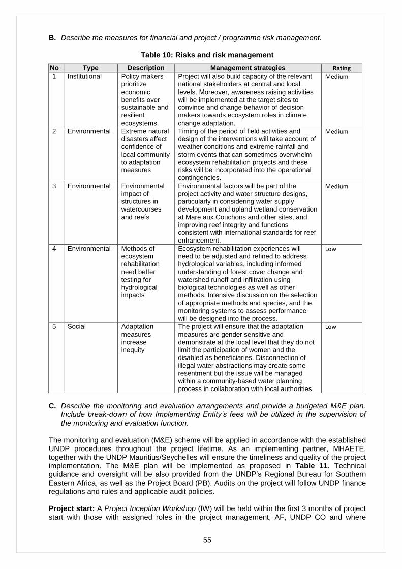
55
B. Describe the measures for financial and project / programme risk management.
Table 10: Risks and risk management
No Type Description Management strategies Rating
1 Institutional Policy makers prioritize economic benefits over sustainable and resilient ecosystems
Project will also build capacity of the relevant national stakeholders at central and local levels. Moreover, awareness raising activities will be implemented at the target sites to convince and change behavior of decision makers towards ecosystem roles in climate change adaptation.
Medium
2 Environmental Extreme natural disasters affect confidence of local community to adaptation measures
Timing of the period of field activities and design of the interventions will take account of weather conditions and extreme rainfall and storm events that can sometimes overwhelm ecosystem rehabilitation projects and these risks will be incorporated into the operational contingencies.
Medium
3 Environmental Environmental impact of structures in watercourses and reefs
Environmental factors will be part of the project activity and water structure designs, particularly in considering water supply development and upland wetland conservation at Mare aux Couchons and other sites, and improving reef integrity and functions consistent with international standards for reef enhancement.
Medium
4 Environmental Methods of ecosystem rehabilitation need better testing for hydrological impacts
Ecosystem rehabilitation experiences will need to be adjusted and refined to address hydrological variables, including informed understanding of forest cover change and watershed runoff and infiltration using biological technologies as well as other methods. Intensive discussion on the selection of appropriate methods and species, and the monitoring systems to assess performance will be designed into the process.
Low
5 Social Adaptation measures increase inequity
The project will ensure that the adaptation measures are gender sensitive and demonstrate at the local level that they do not limit the participation of women and the disabled as beneficiaries. Disconnection of illegal water abstractions may create some resentment but the issue will be managed within a community-based water planning process in collaboration with local authorities.
Low
C. Describe the monitoring and evaluation arrangements and provide a budgeted M&E plan.
Include break-down of how Implementing Entity’s fees will be utilized in the supervision of the monitoring and evaluation function.
The monitoring and evaluation (M&E) scheme will be applied in accordance with the established UNDP procedures throughout the project lifetime. As an implementing partner, MHAETE, together with the UNDP Mauritius/Seychelles will ensure the timeliness and quality of the project implementation. The M&E plan will be implemented as proposed in Table 11. Technical guidance and oversight will be also provided from the UNDP‘s Regional Bureau for Southern Eastern Africa, as well as the Project Board (PB). Audits on the project will follow UNDP finance regulations and rules and applicable audit policies. Project start: A Project Inception Workshop (IW) will be held within the first 3 months of project start with those with assigned roles in the project management, AF, UNDP CO and where
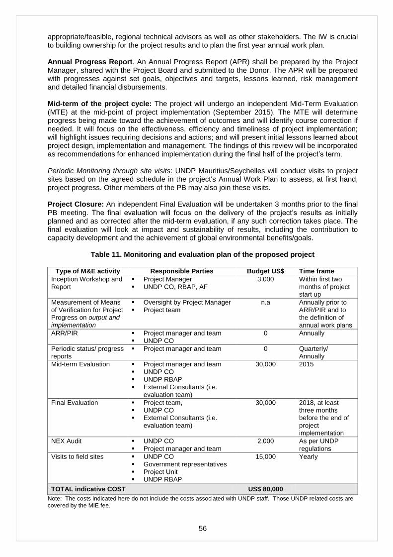
56
appropriate/feasible, regional technical advisors as well as other stakeholders. The IW is crucial to building ownership for the project results and to plan the first year annual work plan. Annual Progress Report. An Annual Progress Report (APR) shall be prepared by the Project Manager, shared with the Project Board and submitted to the Donor. The APR will be prepared with progresses against set goals, objectives and targets, lessons learned, risk management and detailed financial disbursements. Mid-term of the project cycle: The project will undergo an independent Mid-Term Evaluation (MTE) at the mid-point of project implementation (September 2015). The MTE will determine progress being made toward the achievement of outcomes and will identify course correction if needed. It will focus on the effectiveness, efficiency and timeliness of project implementation; will highlight issues requiring decisions and actions; and will present initial lessons learned about project design, implementation and management. The findings of this review will be incorporated as recommendations for enhanced implementation during the final half of the project‘s term. Periodic Monitoring through site visits: UNDP Mauritius/Seychelles will conduct visits to project sites based on the agreed schedule in the project's Annual Work Plan to assess, at first hand, project progress. Other members of the PB may also join these visits. Project Closure: An independent Final Evaluation will be undertaken 3 months prior to the final PB meeting. The final evaluation will focus on the delivery of the project‘s results as initially planned and as corrected after the mid-term evaluation, if any such correction takes place. The final evaluation will look at impact and sustainability of results, including the contribution to capacity development and the achievement of global environmental benefits/goals.
Table 11. Monitoring and evaluation plan of the proposed project
Type of M&E activity Responsible Parties Budget US$ Time frame
Inception Workshop and Report
Project Manager UNDP CO, RBAP, AF
3,000 Within first two months of project start up
Measurement of Means of Verification for Project Progress on output and implementation
Oversight by Project Manager Project team
n.a Annually prior to ARR/PIR and to the definition of annual work plans
ARR/PIR Project manager and team UNDP CO
0 Annually
Periodic status/ progress reports
Project manager and team 0 Quarterly/ Annually
Mid-term Evaluation Project manager and team UNDP CO UNDP RBAP External Consultants (i.e.
evaluation team)
30,000
2015
Final Evaluation Project team, UNDP CO External Consultants (i.e.
evaluation team)
30,000 2018, at least three months before the end of project implementation
NEX Audit UNDP CO Project manager and team
2,000 As per UNDP regulations
Visits to field sites UNDP CO Government representatives Project Unit UNDP RBAP
15,000
Yearly
TOTAL indicative COST US$ 80,000
Note: The costs indicated here do not include the costs associated with UNDP staff. Those UNDP related costs are covered by the MIE fee.

57
The costs of MIU involvement in the M&E process are estimated in Table 12 below.
Table 12: UNDP (Multilateral Implementing Entity) support for and supervision of M&E
Project Monitoring and Evaluation;
a) Inception Phase organisation and operations staff time and related expenses
4 mths @$5,000/mth 20,000
b) Quarterly reporting discussions and submission 18 x $2,000 26,000
c) Annual reporting discussions and submission 6 x $3000 18,000
d) Mid Term Evaluation process organisation and participation
preparation ToRs, appt, briefing and oversight 10,000
e) Terminal Report and Final Evaluation
preparation ToRs, appt, briefing and oversight 10,000
Total $ 84,000
D. Include a results framework for the project proposal, including milestones, targets and
indicators and sex-disaggregate targets and indicators, as appropriate. The project or programme results framework should align with the goal and impact of the Adaptation Fund and should include at least one of the core outcome indicators from the AF’s results framework that are applicable.
The dominant results expected from the project are an increase in dry season stream flows and a decrease in peak flows. It is difficult to predict the scale of effects but the general view of technical staff is that improvement in low flows as well as water supply production could be in the order of 20-30% particularly given the barrage renovation effects (desilting and soil and water conservation), the enhanced upland wetland management and the efforts to increase ground cover vegetative barriers to runoff. The relatively small volumes of water, despite the run-of-river watershed characteristics, are considered within the scope of manageability and influence by watershed rehabilitation. Significantly, the introduction of a policy and institutional framework for watershed management is also expected to have a timely impact on the public recognition of the relationship between watershed land and water use, and water supply availability and quality under climate stress. On the coastal side, the flood attenuation services provided by wetlands at NE Point and Anse Royale have gradually declined due to development pressures and there are recognized opportunities to intervene before the natural stream functions and wetland connectivity attributes reach a point of irretrievability. Rehabilitating the streams and restoring portions of wetlands will require some upstream treatment of the runoff and sediment loading, and in the case of Anse Royale provides an opportunity to enhance water supply for a limited number of farms in the lowland. While potential flood and tidal surge buffering effects are difficult to quantify without further study, the current critical state of many of the watercourses and wetlands to accommodate flooding events is apparent in field visits. The ingredients for an active community-based approach to ecosystem-based adaptation are also present at these sites.

58
Results Framework for Ecosystem Based Adaptation to Climate Change in Seychelles
Objective & Components
Indicators Baseline Targets Source of Verification
Risks and Assumptions
Project Objective: To incorporate ecosystem based adaptation into the country‘s climate change risk management system to safeguard water supplies, threatened by climate change induced perturbations in rainfall and to buffer expected enhanced erosion and coastal flooding risks arising as a result of higher sea levels and increased storm surge.
Ecosystem services and natural assets maintained or improved under climate change and variability-induced stress
Project watersheds and coastal areas are regularly subject to water shortages and flooding events
Reduced water shortages and flooded area involving about 4,000 ha of watershed and coastal ecosystems
Project Monitoring Reports on the Status of Project Watershed and Coastal Ecosystems
Impacts of climate change do not outpace project adaptation responses (this will be alleviated by the project‘s interventions targeted build resilience)
August mean daily discharge on two rivers (Mare aux Couchons & Baie Lazare) with increased base flows
61
Mare aux Couchons August Avg Mean Daily Discharge: 261.1 L/S Baie Lazare August Mean Daily Discharge: 33.4 L/S
Mare aux Couchons and Baie Lazare: Aug. baseline flows +20 – 30%
PUC stream gauge data
Annual variability in rainfall and discharge can mask improvements PUC stream gauges stay functional
January mean daily discharge on two rivers with decreased flood flows
Mare aux Couchons January Avg Mean Daily Discharge: 595.4 L/S Baie Lazare January Mean Daily Discharge: 173.1 L/S
Mare aux Couchons and Baie Lazare: January baseline flows -20%
PUC stream gauge data
Annual variability in rainfall and discharge can mask improvements PUC stream gauges stay functional
Component 1: Ecosystem-based adaptation approaches along the shorelines of the
Number of water users with more reliable water supply
10% of PUC water supply customers in project watersheds without fully reliable surface water supply
100% of PUC customers in target watersheds with more reliable water supply
Water use directives and reports by PUC
Continued high dependence on catchment area water resources
Number of days per Number of days per year 0 days of no water availability PUC stream PUC stream
61
Baseline streamflow data for Mare aux Couchons are averages for 9 years available data within 2000 – 2011 stream flow records; baseline data for Baie Lazare are averages for available 2007 – 2011 stream flow records. Seychelles Publis Utilities Corporation
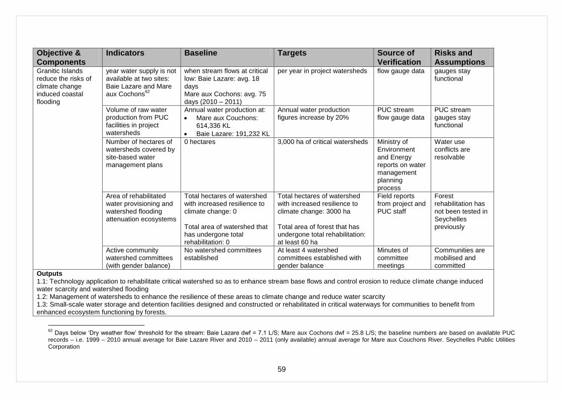
59
Objective & Components
Indicators Baseline Targets Source of Verification
Risks and Assumptions
Granitic Islands reduce the risks of climate change induced coastal flooding
year water supply is not available at two sites: Baie Lazare and Mare aux Cochons
62
when stream flows at critical low: Baie Lazare: avg. 18 days Mare aux Cochons: avg. 75 days (2010 – 2011)
per year in project watersheds flow gauge data gauges stay functional
Volume of raw water production from PUC facilities in project watersheds
Annual water production at:
Mare aux Couchons: 614,336 KL
Baie Lazare: 191,232 KL
Annual water production figures increase by 20%
PUC stream flow gauge data
PUC stream gauges stay functional
Number of hectares of watersheds covered by site-based water management plans
0 hectares
3,000 ha of critical watersheds
Ministry of Environment and Energy reports on water management planning process
Water use conflicts are resolvable
Area of rehabilitated water provisioning and watershed flooding attenuation ecosystems
Total hectares of watershed with increased resilience to climate change: 0 Total area of watershed that has undergone total rehabilitation: 0
Total hectares of watershed with increased resilience to climate change: 3000 ha
Total area of forest that has undergone total rehabilitation: at least 60 ha
Field reports from project and PUC staff
Forest rehabilitation has not been tested in Seychelles previously
Active community watershed committees (with gender balance)
No watershed committees established
At least 4 watershed committees established with gender balance
Minutes of committee meetings
Communities are mobilised and committed
Outputs 1.1: Technology application to rehabilitate critical watershed so as to enhance stream base flows and control erosion to reduce climate change induced water scarcity and watershed flooding 1.2: Management of watersheds to enhance the resilience of these areas to climate change and reduce water scarcity 1.3: Small-scale water storage and detention facilities designed and constructed or rehabilitated in critical waterways for communities to benefit from enhanced ecosystem functioning by forests.
62
Days below ‗Dry weather flow‘ threshold for the stream: Baie Lazare dwf = 7.1 L/S; Mare aux Cochons dwf = 25.8 L/S; the baseline numbers are based on available PUC records – i.e. 1999 – 2010 annual average for Baie Lazare River and 2010 – 2011 (only available) annual average for Mare aux Couchons River. Seychelles Public Utilities Corporation
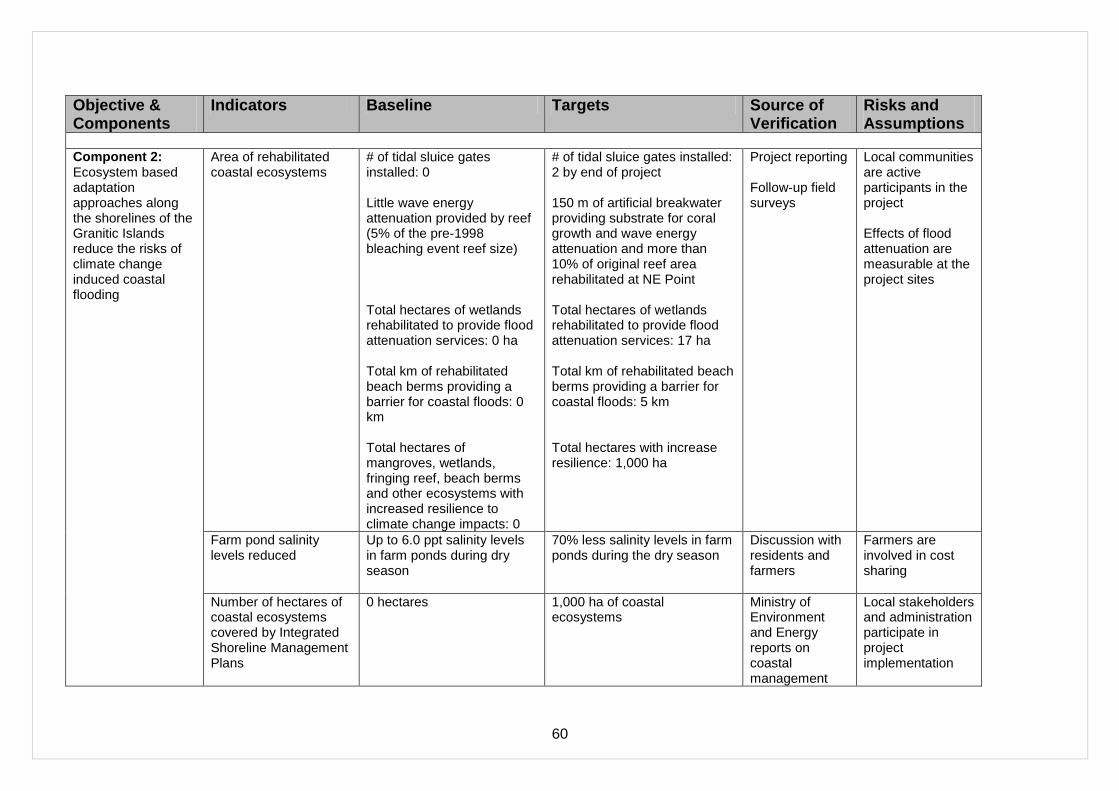
60
Objective & Components
Indicators Baseline Targets Source of Verification
Risks and Assumptions
Component 2: Ecosystem based adaptation approaches along the shorelines of the Granitic Islands reduce the risks of climate change induced coastal flooding
Area of rehabilitated coastal ecosystems
# of tidal sluice gates installed: 0 Little wave energy attenuation provided by reef (5% of the pre-1998 bleaching event reef size) Total hectares of wetlands rehabilitated to provide flood attenuation services: 0 ha Total km of rehabilitated beach berms providing a barrier for coastal floods: 0 km Total hectares of mangroves, wetlands, fringing reef, beach berms and other ecosystems with increased resilience to climate change impacts: 0
# of tidal sluice gates installed: 2 by end of project 150 m of artificial breakwater providing substrate for coral growth and wave energy attenuation and more than 10% of original reef area rehabilitated at NE Point Total hectares of wetlands rehabilitated to provide flood attenuation services: 17 ha Total km of rehabilitated beach berms providing a barrier for coastal floods: 5 km Total hectares with increase resilience: 1,000 ha
Project reporting Follow-up field surveys
Local communities are active participants in the project Effects of flood attenuation are measurable at the project sites
Farm pond salinity levels reduced
Up to 6.0 ppt salinity levels in farm ponds during dry season
70% less salinity levels in farm ponds during the dry season
Discussion with residents and farmers
Farmers are involved in cost sharing
Number of hectares of coastal ecosystems covered by Integrated Shoreline Management Plans
0 hectares
1,000 ha of coastal ecosystems
Ministry of Environment and Energy reports on coastal management
Local stakeholders and administration participate in project implementation

61
Objective & Components
Indicators Baseline Targets Source of Verification
Risks and Assumptions
planning process
Outputs 2.1: Ecosystem based measures for flood protection on an urban shoreline 2.2: Ecosystem based measures for flood protection and mitigating salt water intrusion in an agricultural and tourism development area
Component 3: Ecosystem-Based Adaptation mainstreamed into development planning and financing
Approved water management policy framework being implemented for watershed areas
No policy and financing framework
Approved water management policy for watershed areas Core annual funding for local watershed management provided by tariffs and fees: $ 500,000
63
Policy documents approved by Cabinet Funds collected by PUC for watershed management
Government is committed to policy development Funds allocated or generated for watershed management are targeted at relevant programmes
Capacity developed for EbA methods:
Rivers Committee meet regularly
Technical standards established for watershed, tidal wetland and beach and reef rehabilitation
Number of trainees by gender skilled in EbA methods
No institutional mechanisms Incomplete and ad hoc specifications for ecosystem rehabilitation Few government or NGO staff experienced in watershed or wetland rehabilitation
River Committee meets every quarter to discuss and address issues Technical standards are established and provide the basis for training 50 persons (gender balanced) trained in watershed, tidal wetland and beach and reef rehabilitation
Records of meetings of Rivers Committee Survey of methods to rehabilitate forests and ecosystems Manuals and protocols produced to guide practitioners
Local residents committed to watershed and coastal ecosystem management Technical standards are adequately tested in the project interventions.
63
This figure is based on approximately 23,000 households served by PUC x 26 rps/mth = 598,000/mth income ($43,490) based on fixed monthly water ―environmental charge‖ established by the PUC Schedule on Water & Sewerage Charges.

62
Objective & Components
Indicators Baseline Targets Source of Verification
Risks and Assumptions
Post training surveys
Number of knowledge products on watershed and coastal ecosystem-based adaptation
Limited awareness of EbA methods related to watersheds and coastal ecosystems
10 knowledge products produced to assist awareness building
Project reporting Experience sharing workshops
The knowledge products address user needs and practical methods appropriate for local communities
Outputs 3.1: Policy and legal frameworks for watershed and coastal climate change adaptation 3.2: Capacity development for ecosystem based adaptation methods 3.3: Lessons learned and Knowledge Dissemination

63
E. Include a detailed budget with budget notes, a budget on the Implementing Entity management fee use, and an explanation and a breakdown of the execution costs
Table 13: Project Budget
No. Outputs Cost est. USD
1. ECOSYSTEM-BASED ADAPTATION APPROACH TO ENHANCING FRESHWATER SECURITY AND FLOOD CONTROL IN MAHÉ AND PRASLIN UNDER CONDITIONS OF CLIMATE CHANGE.
Output 1.1 Technology application to rehabilitate critical watersheds so as to enhance stream base flows and control erosion to reduce climate change induced water scarcity and watershed flooding
1.1.1 Mare aux Cochons River Watershed Rehabilitation 525,000
1.1.2 Mt Plaisar River Watershed Rehabilitation 350,000
1.1.3 Baie Lazare River Watershed Rehabilitation 365,000
1.1.4 Caiman River Upland Forest and Wetland Management 145,000
1.1.5 Praslin Fond B‘Offay/Nouvelle Decouvert Watershed Rehabilitation 525,000
Subtotal 1,910,000
Output 1.2 Management of watersheds to enhance functional connectivity and the resilience of these areas to climate change and reduce water scarcity
1.2.1 Mare aux Cochons River Watershed Management 50,000
1.2.2 Mt Plaisar River Watershed Management 50,000
1.2.3 Baie Lazare River Watershed Management 50,000
1.2.4 Praslin Fond B‘Offay/Nouvelle Decouvert Watershed Management 25,000
Subtotal 175,000
Output 1.3 Small-scale water storage and detention facilities designed and constructed or rehabilitated in critical waterways for communities to benefit from enhanced ecosystem functioning by forests.
1.3.1 Mare aux Cochons River Control Structures 240,000
1.3.2 Mt Plaisar River Control Structures 140,000
1.3.3 Baie Lazare River Control Structures 220,000
1.3.4 Caiman River Control Structures 70,000
1.3.5 Praslin Fond B‘Offay/Nouvelle Decouvert Watershed Control Structures
120,000
Subtotal 790,000
1.4 Project Implementation Team 150,000
Component 1 Total 3,025,000
COMPONENT 2: ECOSYSTEM-BASED ADAPTATION APPROACHES ALONG THE SHORELINES OF THE GRANITIC ISLANDS REDUCE THE RISKS OF CLIMATE CHANGE INDUCED COASTAL FLOODING.
Output 2.1 Ecosystem based measures for flood protection on an urban shoreline
2.1.1 Integrated Shoreline Management Plan 30,000
2.1.2 Wetland Rehabilitation 468,000
2.1.3 Reef Rehabilitation 357,000
2.1.4 Beach Berm Enhancement 240,000
Subtotal 1,095,000
Output 2.2 Ecosystem based measures for flood protection and mitigating salt water intrusion in an agricultural and tourism development area
2.2.1 Integrated Shoreline Management Plan 30,000
2.2.2 Stream Channel and Wetland Rehabilitation 475,000
2.2.3 Shoreline Rehabilitation 100,000
2.2.4 Ecosystem Based Salinization Control Measures 170,000
Subtotal 775,000
2.3 Project Implementation Team 125,000
Component 2 Total 1,995,000
COMPONENT 3: ECOSYSTEM BASED ADAPTATION MAINSTREAMED INTO DEVELOPMENT PLANNING AND FINANCING.

64
Output 3.1 Policy and legal frameworks for watershed and coastal climate change adaptation
3.1.1 Watershed Management Policy Framework 25,000
3.1.2 Legislative, Regulatory and Advisory Measures 30,000
3.1.3 Financing Mechanisms for Watershed Protection 25,000
Subtotal 80,000
Output 3.2 Capacity Development for Ecosystem Based Adaptation Methods
3.2.1 Training Programme Development 20,000
3.2.2 Training Programme Delivery 150,000
3.2.3 Institutional Support 25,000
Subtotal 195,000
Output 3.3 Lessons learned and Knowledge Dissemination
3.3.1 Communications Strategy 20,000
3.3.2 Knowledge Products 20,000
3.3.3 Experiences Exchange 40,000
Subtotal 60,000
3.4 Project Implementation Team 125,000
Component 3 Total 480,000
PROJECT MANAGEMENT
Project Manager 175,000
Administrative & Finance Officer 70,000
Driver 48,000
Equipment, Supplies, Workshops, Miscellaneous 19,000
Vehicles and Travel 40,000
Monitoring & Evaluation 80,000
Annual Financial Audit 18,000
Subtotal 450,000
TOTAL PROJECT 5,950,000 Note: Total Project Cost excludes Implementing Agency Fee Note 1: Forest rehabilitation costs in Seychelles are estimated at an average $30,000/ha on Mahe Island and $25,000/ha on Praslin Island Note 2: The Project Implementation Team cost ($400,000) is allocated into Components 1-3.
The execution costs (Project Management) are presented below.
Table 14: Project Execution (Management) Costs
2012 2013 2014 2015 2016 2017 2018 Total
National Consultants 24,000 48,833 48,833 48,833 48,833 48,833 24,835 293,000
Travel 2,000 4,000 4,000 4,000 4,000 4,000 2,000 24,000
Service Contracts (Workshops, M&E) 3,000 1,000 0 30,000 1,000 2,000 30,000 67,000
Service Contracts (Financial audit) 3,000 3,000 3,000 3,000 3,000 3,000 18,000
Materials and Goods 1,000 2,000 2,000 2,000 2,000 2,000 1,000 12,000
Vehicle 15,000 0 0 0 0 0 0 15,000
Miscellaneous 4,000 4,000 4,000 4,000 4,000 1,000 21,000
450,000
A preliminary Project Schedule is provided in Annex 7 and the budget of the Implementing Agency in Annex 1.
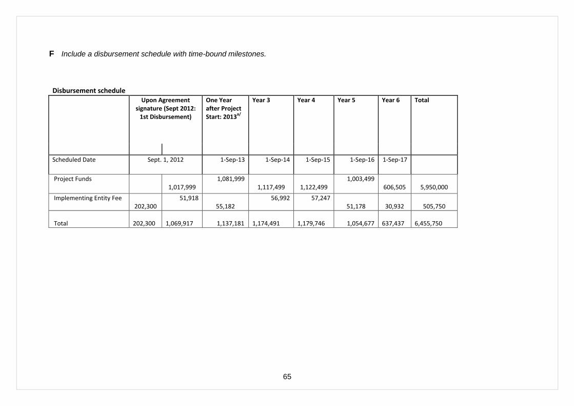
65
F Include a disbursement schedule with time-bound milestones.
Disbursement schedule
Upon Agreement signature (Sept 2012:
1st Disbursement)
One Year after Project Start: 2013
a/
Year 3 Year 4 Year 5 Year 6 Total
Scheduled Date Sept. 1, 2012 1-Sep-13 1-Sep-14 1-Sep-15 1-Sep-16 1-Sep-17
Project Funds 1,017,999
1,081,999 1,117,499
1,122,499
1,003,499 606,505
5,950,000
Implementing Entity Fee 202,300
51,918 55,182
56,992 57,247 51,178
30,932
505,750
Total 202,300
1,069,917 1,137,181
1,174,491
1,179,746 1,054,677
637,437
6,455,750

66
PART IV: ENDORSEMENT BY GOVERNMENT AND CERTIFICATION BY THE IMPLEMENTING ENTITY
A. RECORD OF ENDORSEMENT ON BEHALF OF THE GOVERNMENT
The proposed project is in line with Government of Seychelles‘s policies and priorities. Hence it has been endorsed with the approval of competent authority. A copy of the endorsement letter is attached in Annex 2.
Didier Dogley Special Advisor to Minister Ministry of Environment and Energy Government of Seychelles
Date: April 09, 2012
B. IMPLEMENTING ENTITY CERTIFICATION
I certify that this proposal has been prepared in accordance with guidelines provided by the Adaptation Fund Board, and prevailing National Development and Adaptation Plans and subject to the approval by the Adaptation Fund Board, understands that the Implementing Entity will be fully (legally and financially) responsible for the implementation of this project/programme.
Yannick Glemarec Director Environmental Finance UNDP
Date: April 23, 2012 Tel. and email:+1-212-906-6843 [email protected]
Project Contact Person: Johan Robinson, (LECRDS)
Tel. And Email: + 421 2599337299; [email protected]

67
ANNEX 1 - UNDP Environmental Finance – Specialized Technical Services
The implementing entity fee will be utilized by UNDP to cover its indirect costs in the provision of general management support and specialized technical support services. The table below provides an indicative breakdown of the estimated costs of providing these services. If the national entity carrying out the project requests additional Implementation Support Services (ISS), an additional fee will apply in accordance with UNDP fee policy regarding ISS and would be charged directly to the project budget.
Stage
Specialized Technical Services Provided*
Estimated Costs of Providing Services**
Identification, Sourcing and Screening of Ideas
Provide information on substantive issues and specialized funding opportunities (SOFs)
25,287.50
Verify soundness and potential eligibility of identified idea
Feasibility Assessment / Due Diligence Review
Technical support: provide up-front guidance; sourcing of technical expertise; verification of technical reports and project conceptualization; guidance on SOF expectations and requirements
75,862.50
Provide detailed screening against technical, financial, social and risk criteria and provide statement of likely eligibility against identified SOF
Assist in identifying technical partners; Validate partner technical abilities.
Obtain clearances – SOF
Development & Preparation
Technical support, backstopping and troubleshooting 101,150
Technical support: sourcing of technical expertise; verification of technical reports and project conceptualization; guidance on SOF expectations and requirements
Verify technical soundness, quality of preparation, and match with SOF expectations
Negotiate and obtain clearances by SOF
Respond to information requests, arrange revisions etc.
Verify technical soundness, quality of preparation, and match with SOF expectations
Implementation Technical and SOF Oversight and support 227,587.50
Technical support in preparing TOR and verifying expertise for technical positions. Verification of technical validity / match with SOF expectations of inception report. Participate in Inception Workshop
Technical information and support as needed
Technical support, participation as necessary
Advisory services as required
Allocation of ASLs
Technical support and troubleshooting, Support missions as necessary.
Project visits – at least one technical support visit per year.
Technical support, validation, quality assurance
Return of unspent funds
Evaluation and Reporting
Technical support, progress monitoring, validation, quality assurance
75,862.50

68
Stage
Specialized Technical Services Provided*
Estimated Costs of Providing Services**
Technical support, participation as necessary
Technical support in preparing TOR and verifying expertise for technical positions. Verification of technical validity / match with SOF expectations of inception report. Participate in briefing / debriefing
Technical analysis, compilation of lessons, validation of results
Dissemination of technical findings
Total 505,750 ** This is an indicative list only. Actual services provided may vary and may include additional services not listed here. The level and volume of services provided varies according to need. ** The breakdown of estimated costs is indicative only.
Service standards:
1. initial response to communication within 2 working days 2. full response to communication (with the exception of a response requiring travel) within 10
working days

69
ANNEX 2: Letter of Endorsement- Government of Seychelles
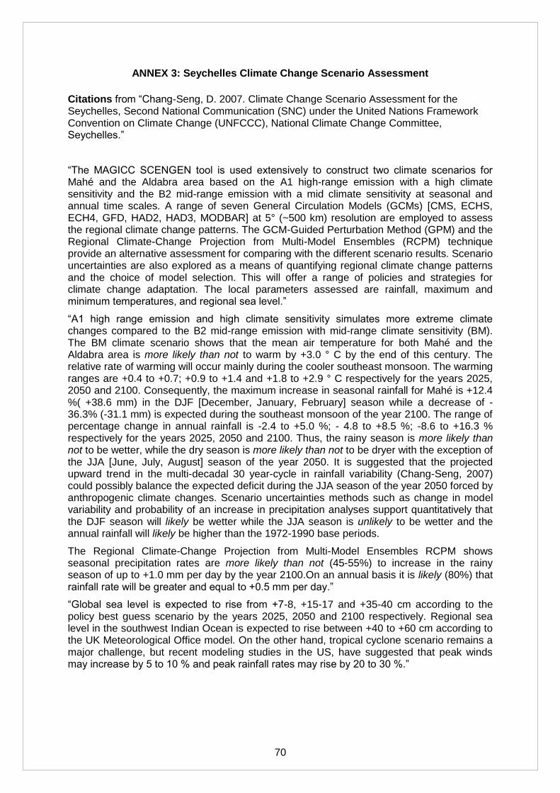
70
ANNEX 3: Seychelles Climate Change Scenario Assessment
Citations from ―Chang-Seng, D. 2007. Climate Change Scenario Assessment for the Seychelles, Second National Communication (SNC) under the United Nations Framework Convention on Climate Change (UNFCCC), National Climate Change Committee, Seychelles.‖
―The MAGICC SCENGEN tool is used extensively to construct two climate scenarios for Mahé and the Aldabra area based on the A1 high-range emission with a high climate sensitivity and the B2 mid-range emission with a mid climate sensitivity at seasonal and annual time scales. A range of seven General Circulation Models (GCMs) [CMS, ECHS, ECH4, GFD, HAD2, HAD3, MODBAR] at 5° (~500 km) resolution are employed to assess the regional climate change patterns. The GCM-Guided Perturbation Method (GPM) and the Regional Climate-Change Projection from Multi-Model Ensembles (RCPM) technique provide an alternative assessment for comparing with the different scenario results. Scenario uncertainties are also explored as a means of quantifying regional climate change patterns and the choice of model selection. This will offer a range of policies and strategies for climate change adaptation. The local parameters assessed are rainfall, maximum and minimum temperatures, and regional sea level.‖
―A1 high range emission and high climate sensitivity simulates more extreme climate changes compared to the B2 mid-range emission with mid-range climate sensitivity (BM). The BM climate scenario shows that the mean air temperature for both Mahé and the Aldabra area is more likely than not to warm by +3.0 ° C by the end of this century. The relative rate of warming will occur mainly during the cooler southeast monsoon. The warming ranges are +0.4 to +0.7; +0.9 to +1.4 and +1.8 to +2.9 ° C respectively for the years 2025, 2050 and 2100. Consequently, the maximum increase in seasonal rainfall for Mahé is +12.4 %( +38.6 mm) in the DJF [December, January, February] season while a decrease of -36.3% (-31.1 mm) is expected during the southeast monsoon of the year 2100. The range of percentage change in annual rainfall is -2.4 to +5.0 %; - 4.8 to +8.5 %; -8.6 to +16.3 % respectively for the years 2025, 2050 and 2100. Thus, the rainy season is more likely than not to be wetter, while the dry season is more likely than not to be dryer with the exception of the JJA [June, July, August] season of the year 2050. It is suggested that the projected upward trend in the multi-decadal 30 year-cycle in rainfall variability (Chang-Seng, 2007) could possibly balance the expected deficit during the JJA season of the year 2050 forced by anthropogenic climate changes. Scenario uncertainties methods such as change in model variability and probability of an increase in precipitation analyses support quantitatively that the DJF season will likely be wetter while the JJA season is unlikely to be wetter and the annual rainfall will likely be higher than the 1972-1990 base periods.
The Regional Climate-Change Projection from Multi-Model Ensembles RCPM shows seasonal precipitation rates are more likely than not (45-55%) to increase in the rainy season of up to +1.0 mm per day by the year 2100.On an annual basis it is likely (80%) that rainfall rate will be greater and equal to +0.5 mm per day.‖
―Global sea level is expected to rise from +7-8, +15-17 and +35-40 cm according to the policy best guess scenario by the years 2025, 2050 and 2100 respectively. Regional sea level in the southwest Indian Ocean is expected to rise between +40 to +60 cm according to the UK Meteorological Office model. On the other hand, tropical cyclone scenario remains a major challenge, but recent modeling studies in the US, have suggested that peak winds may increase by 5 to 10 % and peak rainfall rates may rise by 20 to 30 %.‖
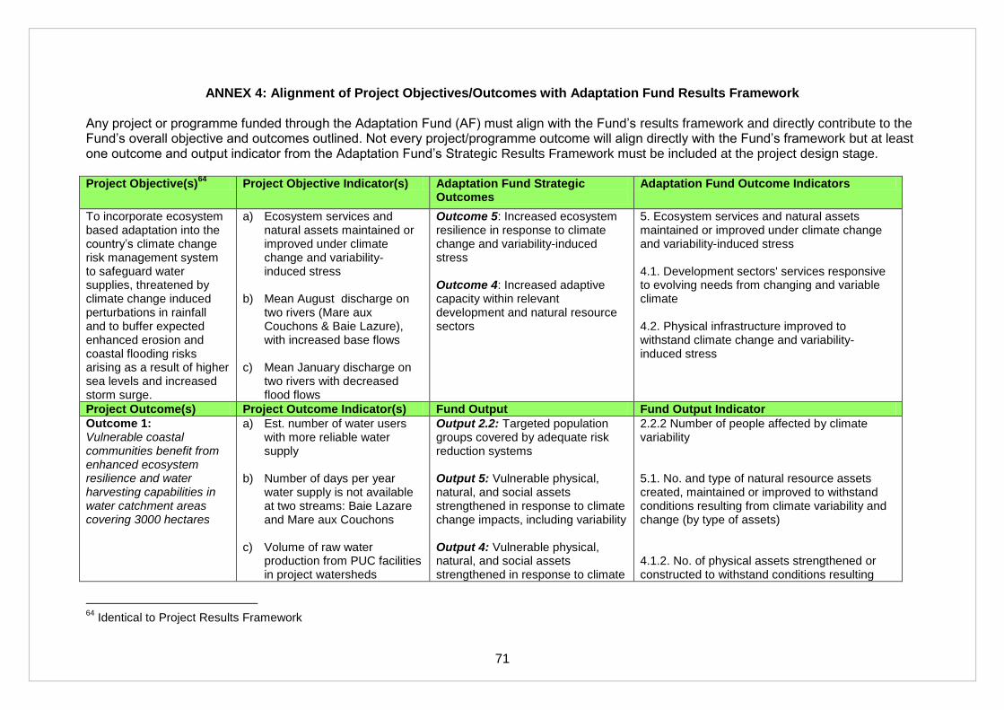
71
ANNEX 4: Alignment of Project Objectives/Outcomes with Adaptation Fund Results Framework Any project or programme funded through the Adaptation Fund (AF) must align with the Fund‘s results framework and directly contribute to the Fund‘s overall objective and outcomes outlined. Not every project/programme outcome will align directly with the Fund‘s framework but at least one outcome and output indicator from the Adaptation Fund‘s Strategic Results Framework must be included at the project design stage. Project Objective(s)
64 Project Objective Indicator(s) Adaptation Fund Strategic
Outcomes Adaptation Fund Outcome Indicators
To incorporate ecosystem based adaptation into the country‘s climate change risk management system to safeguard water supplies, threatened by climate change induced perturbations in rainfall and to buffer expected enhanced erosion and coastal flooding risks arising as a result of higher sea levels and increased storm surge.
a) Ecosystem services and natural assets maintained or improved under climate change and variability-induced stress
b) Mean August discharge on
two rivers (Mare aux Couchons & Baie Lazure), with increased base flows
c) Mean January discharge on
two rivers with decreased flood flows
Outcome 5: Increased ecosystem resilience in response to climate change and variability-induced stress Outcome 4: Increased adaptive capacity within relevant development and natural resource sectors
5. Ecosystem services and natural assets maintained or improved under climate change and variability-induced stress 4.1. Development sectors' services responsive to evolving needs from changing and variable climate 4.2. Physical infrastructure improved to withstand climate change and variability-induced stress
Project Outcome(s) Project Outcome Indicator(s) Fund Output Fund Output Indicator
Outcome 1: Vulnerable coastal communities benefit from enhanced ecosystem resilience and water harvesting capabilities in water catchment areas covering 3000 hectares
a) Est. number of water users with more reliable water supply
b) Number of days per year
water supply is not available at two streams: Baie Lazare and Mare aux Couchons
c) Volume of raw water
production from PUC facilities in project watersheds
Output 2.2: Targeted population groups covered by adequate risk reduction systems Output 5: Vulnerable physical, natural, and social assets strengthened in response to climate change impacts, including variability Output 4: Vulnerable physical, natural, and social assets strengthened in response to climate
2.2.2 Number of people affected by climate variability 5.1. No. and type of natural resource assets created, maintained or improved to withstand conditions resulting from climate variability and change (by type of assets) 4.1.2. No. of physical assets strengthened or constructed to withstand conditions resulting
64
Identical to Project Results Framework
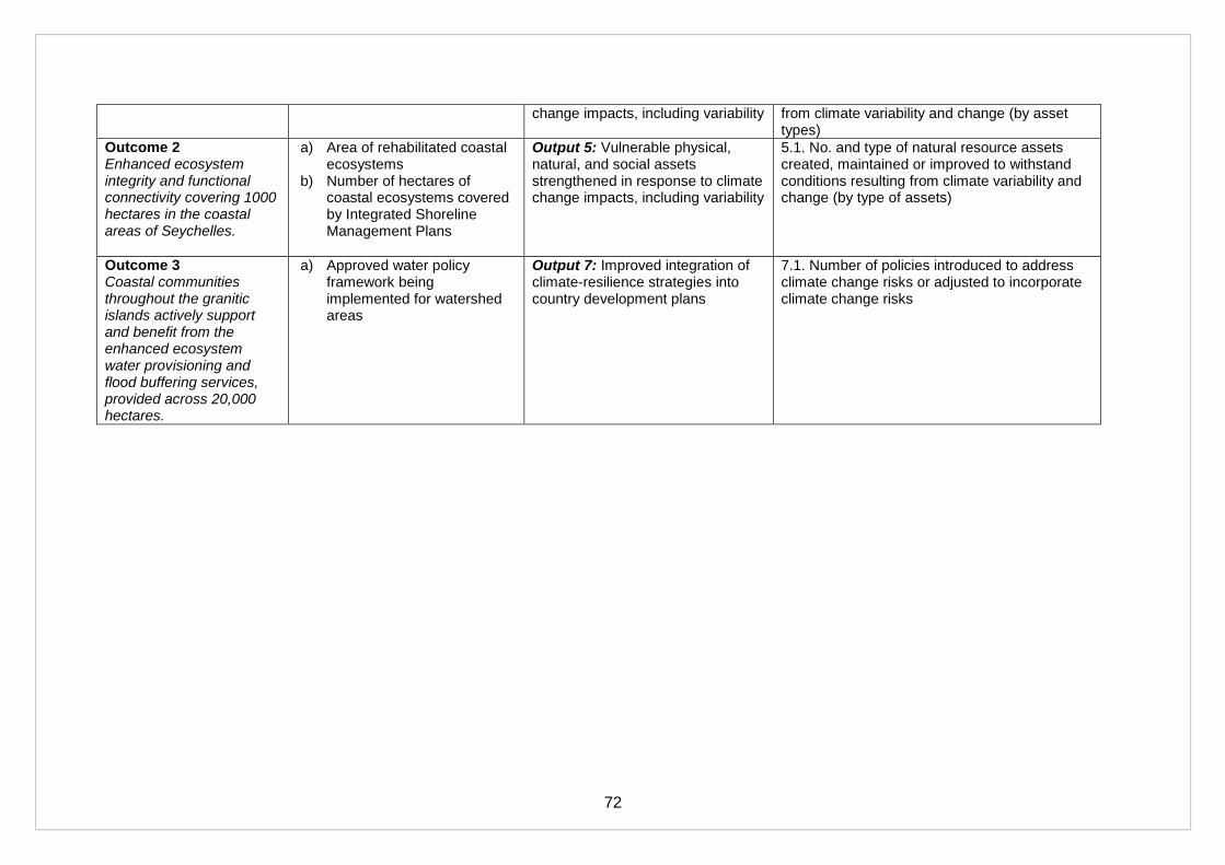
72
change impacts, including variability from climate variability and change (by asset types)
Outcome 2 Enhanced ecosystem integrity and functional connectivity covering 1000 hectares in the coastal areas of Seychelles.
a) Area of rehabilitated coastal ecosystems
b) Number of hectares of coastal ecosystems covered by Integrated Shoreline Management Plans
Output 5: Vulnerable physical, natural, and social assets strengthened in response to climate change impacts, including variability
5.1. No. and type of natural resource assets created, maintained or improved to withstand conditions resulting from climate variability and change (by type of assets)
Outcome 3 Coastal communities throughout the granitic islands actively support and benefit from the enhanced ecosystem water provisioning and flood buffering services, provided across 20,000 hectares.
a) Approved water policy framework being implemented for watershed areas
Output 7: Improved integration of climate-resilience strategies into country development plans
7.1. Number of policies introduced to address climate change risks or adjusted to incorporate climate change risks
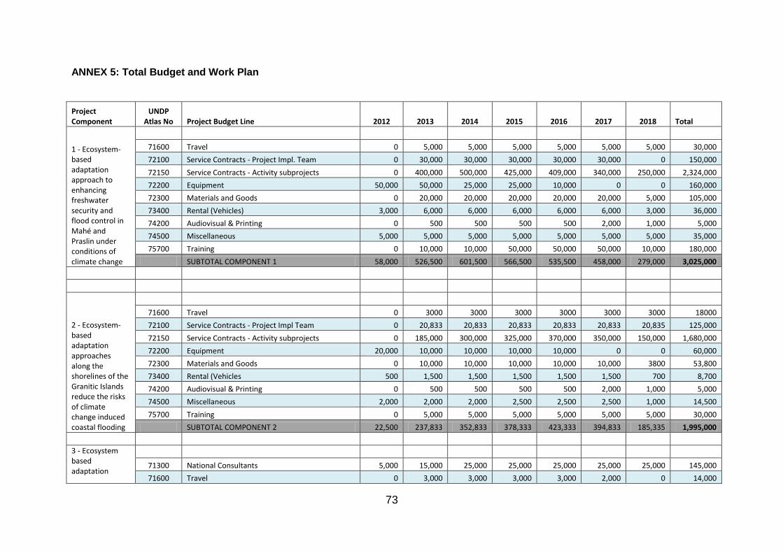
73
ANNEX 5: Total Budget and Work Plan
Project Component
UNDP Atlas No Project Budget Line 2012 2013 2014 2015 2016 2017 2018 Total
1 - Ecosystem-based adaptation approach to enhancing freshwater security and flood control in Mahé and Praslin under conditions of climate change
71600 Travel 0 5,000 5,000 5,000 5,000 5,000 5,000 30,000
72100 Service Contracts - Project Impl. Team 0 30,000 30,000 30,000 30,000 30,000 0 150,000
72150 Service Contracts - Activity subprojects 0 400,000 500,000 425,000 409,000 340,000 250,000 2,324,000
72200 Equipment 50,000 50,000 25,000 25,000 10,000 0 0 160,000
72300 Materials and Goods 0 20,000 20,000 20,000 20,000 20,000 5,000 105,000
73400 Rental (Vehicles) 3,000 6,000 6,000 6,000 6,000 6,000 3,000 36,000
74200 Audiovisual & Printing 0 500 500 500 500 2,000 1,000 5,000
74500 Miscellaneous 5,000 5,000 5,000 5,000 5,000 5,000 5,000 35,000
75700 Training 0 10,000 10,000 50,000 50,000 50,000 10,000 180,000
SUBTOTAL COMPONENT 1 58,000 526,500 601,500 566,500 535,500 458,000 279,000 3,025,000
2 - Ecosystem-based adaptation approaches along the shorelines of the Granitic Islands reduce the risks of climate change induced coastal flooding
71600 Travel 0 3000 3000 3000 3000 3000 3000 18000
72100 Service Contracts - Project Impl Team 0 20,833 20,833 20,833 20,833 20,833 20,835 125,000
72150 Service Contracts - Activity subprojects 0 185,000 300,000 325,000 370,000 350,000 150,000 1,680,000
72200 Equipment 20,000 10,000 10,000 10,000 10,000 0 0 60,000
72300 Materials and Goods 0 10,000 10,000 10,000 10,000 10,000 3800 53,800
73400 Rental (Vehicles 500 1,500 1,500 1,500 1,500 1,500 700 8,700
74200 Audiovisual & Printing 0 500 500 500 500 2,000 1,000 5,000
74500 Miscellaneous 2,000 2,000 2,000 2,500 2,500 2,500 1,000 14,500
75700 Training 0 5,000 5,000 5,000 5,000 5,000 5,000 30,000
SUBTOTAL COMPONENT 2 22,500 237,833 352,833 378,333 423,333 394,833 185,335 1,995,000
3 - Ecosystem based adaptation
71300 National Consultants 5,000 15,000 25,000 25,000 25,000 25,000 25,000 145,000
71600 Travel 0 3,000 3,000 3,000 3,000 2,000 0 14,000

74
mainstreamed into development planning and financing
72100 Service Contracts - Project Impl Team 0 20,833 20,833 20,833 20,833 20,833 20,835 125,000
72150 Service Contracts - Activity Subprojects 0 10,000 15,000 30,000 50,000 35,000 25,000 165,000
72200 Equipment 500 500 500 500 500 0 0 2,500
72300 Materials and Goods 2,000 2,000 2,000 2,000 2,000 2,000 2,000 14,000
73400 Rental (Vehicles) 500 1,000 1,000 1,000 1,000 1,000 500 6,000
74200 Audiovisual & Printing 500 500 500 500 500 3,000 3,000 8,500
SUBTOTAL COMPONENT 3 8,500 52,833 67,833 82,833 102,833 88,833 76,335 480,000
4 - Project Management
71300 National Consultants 24,000 48,833 48,833 48,833 48,833 48,833 24,835 293,000
71600 Travel 4,000 4,000 4,000 4,000 4,000 4,000 4,000 28,000
72100 Service Contracts (Workshops, M&E) 3,000 1,000 0 30,000 1,000 2,000 30,000 67,000
72300 Materials and Goods 5,000 3,000 3,000 3,000 3,000 3,000 3,000 23,000
73400 Vehicle 15,000 0 0 0 0 0 0 15,000
74500 Miscellaneous 4,000 4,000 4,000 4,000 4,000 4,000 24,000
SUBTOTAL PROJECT MANAGEMENT 51,000 60,833 59,833 89,833 60,833 61,833 61,835 450,000
TOTAL 140,000 877,999 1,081,999 1,117,499 1,122,499 1,003,499 606,505 5,950,000
5. UNDP supervision & management fee based on AF Disbursement Matrix 84,291 84,291 84,291 84,291 84,291 84,295 0 505,750
AF Request 224,291 962,290 1,166,290 1,201,790 1,206,790 1,087,794 606,505 6,455,750
Budget Notes:
Component 1 a) The forest and wetland rehabilitation works under Output 1.1. are a combination of reforestation and soil and water conservation
measures to control surface runoff and increase infiltration. This assumes that 10-15 ha of selective 'treatment sites' will have drainage
controls and revegetation undertaken based on the hydrological and biological surveys in each of Mare aux Couchons, Mt Plaisir and Baie
Lazare, and about 25 ha on Praslin Island. The proposed interventions on Caiman River are different from the other watersheds and limited

75
to focusing on management of the upland wetland as a basis for improved regulation of the flows. The costs per ha are currently estimated
at $30,000/ha on upper Mahe and $25,000/ha on Praslin inclusive.
b) The water control structures under Output 1.3 will be selected in conjunction with the Outputs 1.1 and 1,2 and may involve basic instream
and off-channel (overflow) works such as weirs, barrages, or check dams depending upon the initial surveys and discussions. The first
priority is to renovate the existing barrages and the second is to determine sites for additional streamflow control structures. For budgeting
purposes the costs per structure is estimated in the range of $20,000-30,000 per structure based on discussions with PUC.
Component 2 a) The costs are estimated based on the measures costed in Dawson Shepherd, A.R., (2012). "Final draft technical report V3 on coastal
assessments, sites selection and detailed investment plans for proposed investment sites on and around the three main granitic islands of
Seychelles. 30th March 2012." Note that sand nourishment is included in NE Pt site (22.2) but not Anse Royale site (2.2). Also the full costs
of NE Pt shoreline revegetation are expected to be shared with JICA project although yet to be negotiated.
b) The costs of including supplementary irrigation water supply to coastal farms (Output 2.2.4) as part of the stream channel/wetland
rehabilitation (2.2.2) at Anse Royale which will coincidentally require a microwatershed rehabilitation scheme are considered only as part of
the overall catchment area treatment on the hillsides above Lamalle Creek and lower Plaisir R. streams. Total costs, including distribution
systems, will need to be cost-shared with government and beneficiaries.
Component 3 a) The training programme costs are a low estimate based on $3000 x 50 trainees = $150,000
b) Project Implementation Team: This is a project field activity design, delivery and supervision mechanism under the Contract Services
budget line in each of the Components.
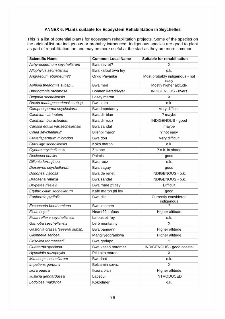
76
ANNEX 6: Plants suitable for Ecosystem Rehabilitation in Seychelles This is a list of potential plants for ecosystem rehabilitation projects. Some of the species on the original list are indigenous or probably introduced. Indigenous species are good to plant as part of rehabilitation too and may be more useful at the start as they are more common
Scientific Name Common Local Name Suitable for rehabilitation
Achyrospermum seychellarum Bwa sevret? X
Allophylus sechellensis Bwa kafoul trwa fey o.k.
Angraecum eburneum?? Orkid Payanke Most probably indigenous - not easy
Aphloia theiformis subsp… Bwa merl Mostly higher altitude
Barringtonia racemosa Bonnen karedrivyer INDIGENOUS - rivers
Begonia sechellensis Lozey maron X
Brexia madagascariensis subsp. Bwa kato o.k.
Campnosperma seychellarum Bwadmontanny Very difficult
Canthium carinatum Bwa dir blan ? maybe
Canthium bibracteatum Bwa dir rouz INDIGENOUS - good
Carissa edulis var.sechellensis Bwa sandal maybe
Colea seychellarum Bilenbi maron ? not easy
Craterispermum microdon Bwa dou Very difficult
Curculigo sechellensis Koko maron o.k.
Gynura seychellensis Zakobe ? o.k. in shade
Deckenia nobilis Palmis good
Dillenia ferruginea Bwa rouz o.k.
Diospyros seychellarum Bwa sagay good
Dodonea viscosa Bwa de renet INDIGENOUS - o.k.
Dracaena reflexa Bwa sandel INDIGENOUS - o.k.
Drypetes riseleyi Bwa mare pti fey Difficult
Erythroxylum sechellarum Kafe maron pti fey good
Euphorbia pyrifolia Bwa dile Currently considered indigenous
Excoecaria benthamiana Bwa zasmen ?
Ficus bojeri Neant?? Lafous Higher altitude
Ficus reflexa seychellensis Lafous pti fey o.k.
Garnotia seychellensis Lerb montanny X
Gastonia crassa (several subsp) Bwa bannann Higher altitude
Glionnetia sericea Mangliyedgranbwa Higher altitude
Grisollea thomassetii Bwa grolapo ?
Guettarda speciosa Bwa kasan bordmer INDIGENOUS - good coastal
Hypoxidia rhizophylla Pti koko maron X
Mimusops sechellarum Bwadnat o.k.
Impatiens gordonii Belzamin sovaz X
Ixora pudica Ikzora blan Higher altitude
Justicia gendardussa Lapsouli INTRODUCED
Lodoicea maldivica Kokodmer o.k.
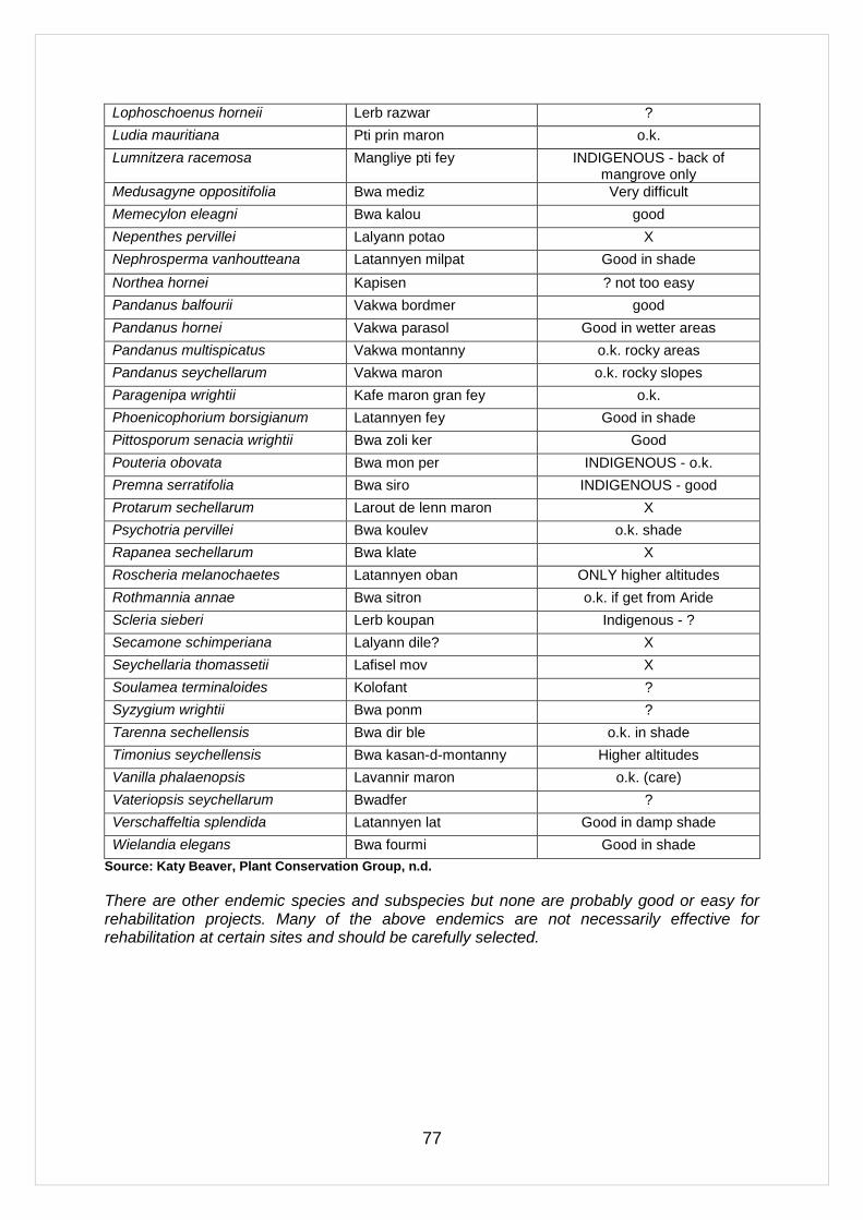
77
Lophoschoenus horneii Lerb razwar ?
Ludia mauritiana Pti prin maron o.k.
Lumnitzera racemosa Mangliye pti fey INDIGENOUS - back of mangrove only
Medusagyne oppositifolia Bwa mediz Very difficult
Memecylon eleagni Bwa kalou good
Nepenthes pervillei Lalyann potao X
Nephrosperma vanhoutteana Latannyen milpat Good in shade
Northea hornei Kapisen ? not too easy
Pandanus balfourii Vakwa bordmer good
Pandanus hornei Vakwa parasol Good in wetter areas
Pandanus multispicatus Vakwa montanny o.k. rocky areas
Pandanus seychellarum Vakwa maron o.k. rocky slopes
Paragenipa wrightii Kafe maron gran fey o.k.
Phoenicophorium borsigianum Latannyen fey Good in shade
Pittosporum senacia wrightii Bwa zoli ker Good
Pouteria obovata Bwa mon per INDIGENOUS - o.k.
Premna serratifolia Bwa siro INDIGENOUS - good
Protarum sechellarum Larout de lenn maron X
Psychotria pervillei Bwa koulev o.k. shade
Rapanea sechellarum Bwa klate X
Roscheria melanochaetes Latannyen oban ONLY higher altitudes
Rothmannia annae Bwa sitron o.k. if get from Aride
Scleria sieberi Lerb koupan Indigenous - ?
Secamone schimperiana Lalyann dile? X
Seychellaria thomassetii Lafisel mov X
Soulamea terminaloides Kolofant ?
Syzygium wrightii Bwa ponm ?
Tarenna sechellensis Bwa dir ble o.k. in shade
Timonius seychellensis Bwa kasan-d-montanny Higher altitudes
Vanilla phalaenopsis Lavannir maron o.k. (care)
Vateriopsis seychellarum Bwadfer ?
Verschaffeltia splendida Latannyen lat Good in damp shade
Wielandia elegans Bwa fourmi Good in shade
Source: Katy Beaver, Plant Conservation Group, n.d.
There are other endemic species and subspecies but none are probably good or easy for rehabilitation projects. Many of the above endemics are not necessarily effective for rehabilitation at certain sites and should be carefully selected.

78
ANNEX 7: Project Implementation Schedule/Gantt Chart
Project Outputs 2012-2013 2013-2014 2014-2015 2015-2016 2016-2017 2017-2018
Q1 Q2 Q3 Q4 Q1 Q2 Q3 Q1 Q2 Q3 Q4 Q1 Q2 Q3 Q4 Q4 Q1 Q2 Q3 Q4 Q1 Q2 Q3 Q4
1. Ecosystem-based adaptation approach to enhancing freshwater security and flood control in Mahé and Praslin under conditions of climate change
Output 1.1 Technology application to rehabilitate critical watersheds so as to enhance stream base flows and control erosion to reduce climate change induced water scarcity and watershed flooding
1.1.1 Mare aux Cochons River Watershed Rehabilitation
1.1.2 Mt Plaisir River Watershed Rehabilitation
1.1.3 Baie Lazare River Watershed Rehabilitation
1.1.4 Caiman River Upland Forest and Wetland Management
1.1.5 Praslin Fond B‘Offay/Nouvelle Decouvert Watershed Rehabilitation
Output 1.2 Management of watersheds to enhance functional connectivity and the resilience of these areas to climate change and reduce water scarcity
1.2.1 Mare aux Cochons River Watershed Management
1.2.2 Mt Plaisar River Watershed Management
1.2.3 Baie Lazare River Watershed Management
1.2.4 Praslin Fond

79
Project Outputs 2012-2013 2013-2014 2014-2015 2015-2016 2016-2017 2017-2018
D‘Offay/Nouvelle Decouvert Watershed Management
Output 1.3 Small-scale water storage and detention facilities designed and constructed or rehabilitated in critical waterways for communities to benefit from enhanced ecosystem functioning by forests.
1.3.1 Mare aux Cochons River Control Structures
1.3.2 Mt Plaisar River Control Structures
1.3.3 Baie Lazare River Control Structures
1.3.4 Caiman River Control Structures
1.3.5 Praslin Fond D‘Offay/Nouvelle Decouvert Watershed Control Structures
2. Ecosystem-based adaptation approaches along the shorelines of the Granitic Islands reduce the risks of climate change induced coastal flooding
Output 2.1 Ecosystem based measures for flood protection on an urban shoreline
2.1.1 Integrated Shoreline Management Plan
2.1.2 Wetland Rehabilitation
2.1.3 Reef Rehabilitation
2.1.4 Beach Berm Enhancement
Output 2.2 Ecosystem based measures for flood protection and mitigating salt water intrusion in an agricultural and tourism development area
2.2.1 Integrated

80
Project Outputs 2012-2013 2013-2014 2014-2015 2015-2016 2016-2017 2017-2018
Shoreline Management Plan
2.2.2 Stream Channel and Wetland Rehabilitation
2.2.3 Shoreline Rehabilitation
2.2.4 Ecosystem Based Salinization Control Measures
3. Ecosystem based adaptation mainstreamed into development planning and financing
Output 3.1 Policy and legal frameworks for watershed and coastal climate change adaptation
3.1.1 Watershed management policy framework
3.1.2 Legislative, regulatory and advisory measures
3.1.3 Financing mechanisms for watershed protection
Output 3.2 Capacity development for ecosystem based adaptation methods
3.2.1 Training programme development
3.2.2 Training programme delivery
3.2.3 Institutional support
Output 3.3 Lessons learned and Knowledge Dissemination
3.3.1 Communications strategy
81
Project Outputs 2012-2013 2013-2014 2014-2015 2015-2016 2016-2017 2017-2018
3.3.2 Knowledge products
3.3.3 Experiences exchange
4. Project Management
Project staff recruited
Equipment procured, office established
PMU operational and managing programme implementation
Project Monitoring and Evaluation
Inception report
Quarterly reports
Annual Progress Report
Steering Committee Meetings
Mid-Term Evaluation
Final Project Evaluation
Project Terminal Report
Audits
82
Annex 8: Comments and Response Matrix for the Project Concept Approved June 2011
Point for
Clarification
Response
CR1: There are no scientific bases to believe that restoring riparian areas in watersheds will result in more regular water yields. While increasing forest cover along water ways reduces soil erosion, there is no rationale to think that seasonal water runoff will change. Furthermore, the proposed changes in forest cover on only ~7% of the islands area (1,090 ha on a ~15,500 ha island) is very unlikely to have a measurable impact on stream-flow, the simplest and less costly method to measure stream flow (no measurement technique provided in the project proposal). The fact that the island of Mahé appears to already be naturally well vegetated, again raises the question if modest forest cover enhancements will have any adaptation benefit. Please demonstrate the effectiveness of the proposed scale and types of interventions. Please provide peer-reviewed scientific justification for the scale and type of intervention.
The Government has reviewed the area targeted for rehabilitation, in response to the comments from the Adaptation Fund Secretariat, and has agreed to increase it to 3,000 ha. As a result of successive human activities, the forests of Seychelles have become highly degraded. Even though forests cover a large percentage of the land area of the Granitic Islands (Kueffer et. al. 200465) natural forest now exists only as relict vegetation (i.e. at the highest altitudes and on glacis). Sixty-three percent of the forests are secondary forests, and most have been invaded by alien exotic species. It is acknowledged that the rehabilitation of watersheds will not lead to an increase in total water yield, and total water yield may actually fall as a result of such rehabilitation as trees draw additional water. A review of studies looking at the relationship between forest cover and water yields undertaken by Bosch et. al. (1982)66 found that forest removal usually leads to increased water yield (other things being equal—i.e. not accounting for the micro climatic effects engendered by such removal, which can reduce precipitation). As the Seychelles currently only captures 3% of the total rainfall for domestic water consumption, there is no need to increase total yield and this is not the purpose of the project. Due to the topography of the island, the country is unable to construct large water storage facilities—to store water captured in the wet season for use in the dry season. Therefore the country needs to ensure steady stream flows in water catchments in the dry season to meet water demand during that period. Climate change models predict that rain will fall in more intense downpours, primarily during the wet season. While precipitation is expected to increase overall, rainfall during the dry season is likely to decrease, and the length of the dry season is also likely to be subject to high perturbation (becoming longer in some years). This situation will place considerable stress on dry season water availability. The project seeks to enhance watershed regulation functions as a climate change adaptation measure to provide 1) high dry season flow, and 2) regulate peak flow—to reduce the risk of flooding. In this regard, there is ample evidence to prove that watershed rehabilitation is a relevant adaptation option. Forests play a critical role in regulating stream flows: i.e. producing a more steady flow even during dry periods by ensuring that precipitation percolates into the ground and is discharged to streams gradually over an extended period. Forest soils have a higher water-storage capacity than non-forest soils and the more complex structure of the forest ground-surface and underlying soil allows more efficient soil water infiltration. By slowing the water runoff rate following heavy rainfall, forests play a role in increasing ground storage capacity and recharge (www.conservationfinance.org)67. By regulating runoffs, forests also play a role in reducing flood volumes and flooding risks. Forests are thus often referred to as a ―green reservoir‖ owing to their osmosis functions and watershed protection capacity.
65 Kueffer, C., Vos, P., Lavergne, C. & Mauremootoo, J. 2004. Case Studies on the Status of Invasive Woody Plant Species in the Western Indian Ocean. 1. Synthesis. Forest Health and Biosecurity Working Papers FBS/4-1E. Forestry Department, Food and Agriculture Organisation of the United Nations, Rome, Italy. 66 Bosch, J.N. & Hewlett, J.D. 1982. A Review of Catchment Experiments to determine the Effect of Vegetation Changes on Water Yield and Evapotranspiration. Journal of Hydrology, 55, p.3 – 23. 67 Payments for Watershed Services. www.conservationfinance.org/guide/images/payments.doc accessed 12/05/2011
83
These specific watershed regulation services are well documented. Bennagen et. al. (www.prem-online.org)68 showed that deforestation and forest degradation in the Pinacanauan Watershed in the Philippines resulted in a reduction in dry season streamflows, attributed to a reduction of the soil water infiltration capacity of the watershed. Johnson et. al. (www.forest-trends.org)69 state: “Although forests (may) reduce total annual water flow… they can increase minimum flows during the dry season (known as base flows)”. Aylward et. al. (1995)70 show that forest conversion and subsequent uses may lead to increased soil compaction and surface run-offs (as opposed to infiltration) following rainfall events. Locatelli et. al. (2009)71 undertook a meta analysis of studies comparing water flows in tropical watersheds under different land uses (natural forest/ planted forests and non-forest lands) to evaluate the linkage between forest cover, total water yield and base flows. This showed that natural forests reduced total flow but resulted in higher base flow during the dry season when compared to non-forested land. Bruijzeel (1990) cites a number of reports documenting the links between deforestation and reduced dry season stream flows. Daniel & Kulasingam 197472; Eckholm 197673; Hardjono 198074; RIN 198575; Nooteboom 198776; Maduma Bandara & Kurupuaracchi 198877; Bartarya 198978). He mentions the work of Hardjono (1980) whose data can be taken as evidence that restoring degraded forest land restores dry season flow. Bruijnzeel (1990)79 also attributes the loss of water soil infiltration potential following forest loss or degradation as the reason for diminishing dry season flows. It is now well recognized that invasive alien species, particular tree species, have increased water usage compared to native species. Increased catchment water yield is a major justification for the cost of clearing alien plants. Studies conducted in South Africa indicate that high rainfall catchment (as all Mahe catchments are) show the greatest potential streamflow enhancement potential from IAS removal ((Calder et. al.2001)80. Various invasive tree species have entered the forests of Seychelles especially in the riparian zones. The woody trees have a higher biomass than the native forest, capturing large amounts of water. Creeper species add an additional layer in the forest, not common in native forest, also drawing water resources, especially during the dry season. This all impacts on the water yield—in this case both the total water yield and the dry season yield. Upper catchment cloud interception can also contribute to increased dry season flows. All
68 Bennagen, M.E., Indab, A., Amponin, A., Cruz, R, Folledo, R., van Beukering, P.J.H., Brander, L., Hess, S., van Soesbergen, A., van der Leeuw, K & de Jong, J. Designing Payments for Watershed Protection Services of Phillipine Upland Dwellers. (www.prem-online.org accessed 12/05/2011). 69 Johnson, N., White, A. & Perrot-Maitre. Developing Markets for Water Services from Forest Issues and Lessons from Innovators. Forest Trends, World Resource Institute (www.forest-trends.org/documents/files/doc_133.pdf accessed 12/05/2011). 70 Aylward, B., Echeveria, J & Barbier, E.B. 1995. Economic Incentives for Watershed Protection: A Report on an ongoing Study of Arenal, Costa Rica. CREED Working Paper Series No. 3. International Institute for Environment and Development, London. Institute for Environmental Studies, Amsterdam. (www.prem-online.org/archive/17/doc/creed03e.pdf accessed 12/05/2011). 71 Locatelli, B & Vignola, R. 2009. Managing Watershed Services of Tropical Forests and Plantations: Can Meta-analysis help? Forest Ecology and Management 258 (2009) 1864 – 1870. 72 Daniel, J.G. & Kulasingam, A. 1974. Problems arising from Large-scale Forest Clearing for Agricultural Use – the Malaysian experience. Malaysian Forester 37: 152 – 160. 73 Eckholm, E. 1976. Losing Ground. W.W. Norton, New York, 223pp. 74 Hardjono, H.W. 1980. Influence of a Permanent Vegetation Cover on Streamflow. Pp. 280 – 297 in Proceedings of the Seminar on Watershed Management, Development and Hydrology, Surakarta, Indonesia, 3 – 5 June 1980 (in Indonesian). 75 RIN 1985. Evaluation of Forest Land. Kali Konto Upper Watershed. II Area, Methods and Organisation. Research Institute for Nature Management (RIN) Leersum, the Netherlands, 30 pp. 76 Nooteboom, H.P. 1987. Further Views on “Environmental Impacts of (de)forestation in the Humid Tropics”. Wallaceana 47: 10 – 11. 77 Madduma Bandara, C.M. & Kurupuarachchi, T.A. 1988. Land Use Change and Hydrological Trends in the Upper Maheweli Basin. Paper presented at the Workshop on Hydrology of Natural and Man-made Forests in the Hill Country of Sri Lanka. Kandy, October 1988, 18 pp. 78 Bartarya, S.K. 1989. Hydrogeology, Geoenvironmental Problems and Watershed Management Strategies in a Central Himalayan River Basin, Kumaun, India. Pp. 308 – 318 in J. Krecek et. al. (eds.). Headwaters Control, Volume 2. IUFRO/WASWC/CSVIS, Plzen, Czechoslovakia. 79 Bruijnzeel, L.A. 1990. Hydrology of Moist Tropical Forests and Effects of Conversion: a State of Knowledge Review. IHP-UNESCO Humid Tropical Programme, Paris, 224 pp. 80 Calder, I & Dye, P. Hydrological Impacts of Invasive Plants. Land Use and Water Resources Research 1 (2001).

84
forested areas above 500 m are considered mountain mist forests and like other cloud forests are important sources of water during dry periods (Bruijnzeel & Proctor, 199581; Hamilton & King, 198382; Zadroga, 198183). The literature shows that to have a major impact on water flows, large scale interventions are necessary. As illustrated in Map 3 in the proposal, critical watersheds cover only part of the island of Mahe. The project will undertake rehabilitation work over an area of 3,000 hectares (covering approximately 50% of Mahé‘s catchment areas).
CR2: While ―restoring‖ mangroves (20 ha), sand dunes (5 ha), wetlands (30 ha) and fringing reefs (0.5 ha) have been done in other places with variable results, it is not clear that the recovery of such small areas will have a desired impact of reducing climate change induced coastal flooding. Please also provide peer-reviewed scientific justification for the scale of these other coastal restorations. In addition, please elaborate on the baseline analysis of the sea level raise, to fully understand the scale and speed of the restoration activities and the long term sustainability of the project.
UNEP-WCMC (2000)84 show that 70 – 90% of the energy of wind-generated waves may be absorbed by mangroves and reefs, but that the buffering capacity depends on ecosystem integrity and physical characteristics. The project is designed to enhance the ability of ecosystems to supply this buffering function. It is acknowledged that the area of the rehabilitation sites is small, given the potential for climate change induced flooding. Nevertheless, the measures have considerable potential to reduce flooding vulnerability at the local level—in flooding hotspots. This is well documented in the scientific literature. Devisscher (2010)85 notes that rehabilitation across a mosaic of ecosystems (larger scale) can further achieve enhancement of services. Restoring mosaics of inter-connected ecosystems can ensure that if some very degraded areas are only slowly recovering, other functioning ecosystems will provide services and structure to build on. Therefore, rehabilitation can be improved by harnessing positive interactions between ecosystems that stabilize community dynamics, ecosystem functions, and the structure of neighboring ecosystems. Halpern et. al. (2007)86 argue that by broadening the scale of intervention through the spatial arrangement of ecosystems these positive interactions can be optimized. Component 2 applies this principle, seeking to combine rehabilitation of different environments (tidal wetlands/ reefs/ dunes) to reduce the flooding risk in coastal flooding hotspots. The intention is to rehabilitate degraded areas within larger environments—thus enhancing overall ecosystem functioning. For mangrove rehabilitation, Lewis (2009)87 and Brockmeyer et. al. (1997)88 describe successful rehabilitation projects, ranging from 2.1 ha to 4.05 to 73 ha to large rehabilitation areas of 50,000 ha, which mitigated the level of flooding in specific areas. Stevenson et. al. (1999)89, Milano (1999)90; Weishar et. al.91, WetlandCare Australia92, Williams et. al. (2001)93 and Erwin
81 Briujnzeel, L.A. & Procter, J. 1995. Hydrology and Biogeochemistry of Tropical Montane Cloud Forests: What do we really know? Ecological Studies. 110: 38 – 78. 82 Hamilton, L.S. & King, P.N. 1983. Tropical Forested Watersheds: Hydrologic and Soil Response to Major Uses or Conversion. Westview Press, Boulder, Colorado, pp.168. 83 Zadroga, F. 1981. The Hydrological Importance of a Montane Cloud Forest Area of Costa Rica. Tropical Agriculture Hydrology. Pp. 59 – 73. 84 UNEP-WCMC (2006). In the Front Line: Shoreline Protection and other Ecosystem Services from Mangroves and Coral Reefs. UNEP-WCMC, Cambridge, UK, 33pp. 85 Devisscher, T. 2010. Ecosystem-based Adaptation in Africa. Rational, Pathways, and Cost Estimates. Sectoral Report for the AdaptCost Study. Stockholm Environment Institute. 86 Halpern, B.S., Silliman, B.R., Olden, J.D., Bruno, J.P. & Bertness, M.D. 2007. Incorporating Positive Interactions in Aquatic Restoration and Conservation. Front. Ecol. Environ. 2007:5(3):153 – 160. 87 Lewis, R.R. 2009. Methods and Criteria for Successful Mangrove Forest Restoration. In Perillo, G.M.E., Wolanski, E., Cahoon, D.R., Brinson, M.M. (Eds). Coastal Wetlands: An Integrated Ecosystem Approach. 88 Brockmeyer, M.E., Rey, J.R., Virnsteain, R.W., Gilmore, R.G., Ernest, L. 1997. Rehabilitation of impounded Estuarine Wetlands by Hydrologic Reconnection to the Indian River Lagoon, Florida (USA). Wetl. Ecol. Manage. 4, 93 – 109. 89 Stevenson, N.J., Lewis, R.R. & Burbridge, P.R. 1999. Disused Shrimp Ponds and Mangrove Rehabilitation. In: Streever, W.J. (Ed). An International Perspective on Wetland Rehabilitation. Kluwer Academic Publishers, Dordrecht, pp. 277 – 297. 90 Milano, G.R. (1999). Restoration of Coastal Wetlands in Southeastern Florida. Wetland Journal 11(2):15 – 24. 91 Weishar, L.L.; Teal, J. & Hinckle, R. Development of Marsch Hydrogeomorphology and Marsh Vegetation within a Salt Hay Farm Wetland Restoration Site. (http://images.library.wise.edu/EcoNatRes/Wetlands?Wetlands27/reference/econatres.wetlands27.lweishar.pdf accessed 14/05/2011) 92 www.wetlandcare.com.au/projects_archived.asp 93 Williams, P.B. & Flair, P.B. (2001). Salt Marsh Restoration Experience in San Francisco Bay. Journal of Coastal Research, Special Issue No. 27, 203 – 311. Royal Palm Beach (Florida).
85
(2009)94 present evidence documenting the success of small wetland rehabilitation projects in mitigating flood damages. Chang et al. 200695, found in a comparison of villages on the Andaman coast of Thailand after the 2004 tsunami, that houses in villages behind intact mangrove forests experienced significantly less flood damage than those in unprotected villages. A survey of households in the Bhitarkanika Conservation Area in India by Badola & Hussain 200596 following the 1999 cyclone found that residents of villages protected by mangroves reported lower levels and duration of flooding, less damage to homes and assets, and higher crop yields than people in villages unprotected by mangroves, or villages with a seaward embankment. The literature also provides evidence of numerous successful coral reef rehabilitation projects (e.g. Hudson et. al. (2007)97, www.globalcoral.org98, Edwards et. al. (2007)99). Successful reef rehabilitation has mostly taken place on a small scale – covering a few hectares. (Edwards et. al (2007)100). The technology for large scale rehabilitation has yet to be proven. The Government of the Seychelles does not intend as a consequence to invest in large scale rehabilitation, but rather in small scale rehabilitation as a complement to other rehabilitation (i.e. dune stabilization). The effect of small-scale sand dune rehabilitation in controlling flooding is documented in the literature (see Roze, F., & Lemauviel, S. (2004)101 and Gomez-Pina et. al. (2002)102. The Government has reviewed the area targeted for rehabilitation, in response to the comments from the Adaptation Fund Secretariat, and has agreed to the following targets Enhanced ecosystem integrity and functional connectivity covering a total area of 1,000 hectares in the coastal areas of Seychelles. It should be noted that the project is designed to ensure that the planned EbA measures are implemented over a wider scale over time, with other sources of funding (i.e. joint management with the private sector; requirements for rehabilitation and offsets as part of development permitting requirements). This approach is already successfully being applied in the Seychelles in the case of species conservation (through the GEF-funded project ―Mainstreaming Biodiversity Conservation into the Production Sectors of Seychelles‖). Component 3 has been specifically designed with this in mind. The focus of component 1 and 2 will be to learn from, adapt and scale up the known and proven technologies from other parts of the world. It will be important to bring in the expertise to assist Seychelles to implement these technologies, and build capacity to apply these measures at larger scale. In order to create a continuity between strategic policy relating to climate change and action ‗on the ground‘, Few et. al. (2004)103 suggest there is a need to invest resources in local adaptive capacity, strengthen local long-term planning mechanisms and establish genuinely cross-scale
94 Erwin, K.L. 2009. Wetlands and Global Climate Change: The Role of Wetland Restoration in a Changing World. Wetlands Ecological Management (2009) 17: 71 – 84. 95 Chang, S.E., Adams, B.J, Alder, J., Berke, P.R., Chuenpagdee, R., Ghosh, S. & Wabnitz, C. 2006. Coastal ecosystems and tsunami
protection. Earthquake Spectra 22(S3): S863-S887. 96 Badola, R. and Hussain, S.A. 2005. Valuing ecosystem functions: an empirical study on the storm protection function of Bhitarkanika
mangrove ecosystem, India. Environmental Conservation 32(1): 85-92. 97 Hudson, J.H.; Franklin, E.C.; Schittone, J.; Stratton, A. 2007. M/V Wellwood Coral Reef Restoration Monitoring Report, Monitoring Events 2004 – 2006. Florida Keys National Marine Sanctuary Monroe Country, Florida. Marine Sanctuaries Conservation Series NHSP-07-02. U.S. Department of Commerce, National Oceanic and Atmospheric Administration, National Marine Sanctuary Program, Silver Springs, MD. 50pp. 98 www.globalcoral.org/pemuteran_coral_reef_restoration.html (accessed 15/05/2011). 99 Edwards, A.J & Gomez, E.D. 2007. Reef Restoration Concepts and Guidelines: Making Sensible Management Choices in the Face of Uncertainty. Coral Reef Targeted Research & Capacity Building for Management Programme: St. Lucia, Australia. iv + 38pp. 100 Edwards, A.J & Gomez, E.D. 2007. Reef Restoration Concepts and Guidelines: Making Sensible Management Choices in the Face of Uncertainty. Coral Reef Targeted Research & Capacity Building for Management Programme: St. Lucia, Australia. iv + 38pp. 101 Roze, F. & Lemauviel, S. 2004. Sand Dune Restoration in North Brittany, France: A 10-year Monitoring Study. Restoration Ecology, Vol. 12, No 1, pp. 29 – 35. 102 Gomez-Pina, G., Munoz-Perez, J.J., Ramirez, J.L. & Ley, C. 2002. Sand Dune Management Problems and Techniques, Spain. Journal of Coastal Research. 103 Few, R., Brown, K., Tompkins, E.L. 2004. Scaling Adaptation: Climate Change Response and Coastal Management in the UK. Tyndall Centre Working Paper No. 60.

86
institutions on coastal management to take and support what may be difficult decisions. This has informed project design. Under the barriers section of the proposal it is described that the limited experience and know-how in Seychelles in ecological rehabilitation work and the sub-optimal availability of knowledge on such rehabilitation that has been accumulated in other countries hinders the application of ecosystem based climate change adaptation measures in areas where ecosystem rehabilitation is required. Some work on coastal rehabilitation has been done and some of the national technicians are aware of the benefits of implementing ecosystem-based approaches but the general public and the most vulnerable communities are unaware of the opportunities provided by such approaches. This includes expanding the networks of practitioners and research capacity, better information and co-generation of knowledge. Of importance here is the educational and awareness raising these implementation sites provide – including for private sector operators. Information can raise general public awareness on the intrinsic and immutable relationship between ecosystems and human well-being, highlighting the critical link between ecosystem health and human health (Silvestri et. al. 2010)104 and the protection against natural disasters. On the sustainability of project in the light of sea-level rise, Ong and Tan (2008)105 asserted that mangroves have survived sea-level changes through geological time. The difference now is that man-made barriers along the coast will prevent mangroves from migrating inland. Zhu et. al (2010)106 writes “In contrast to hard defences, wetlands are capable of undergoing „autonomous‟ adaptation to SLR, through increased accumulation of sediments to allow the elevation of the wetland to keep pace with changes in sea level (Nicholls & Klein, 2005). Provided wetlands are not subjected to coastal squeeze, and the rate of SLR is not too rapid to keep pace, wetlands are capable of adapting to SLR without further investments.” It is therefore not expected that this will have a negative effect on the sustainability of the project as this will be addressed under Component 3 in the integration of ecosystem-based adaptation processes into land use planning and development regulations. The following was added to the section on Coastal Flooding, p.6: Shore wave heights are limited by water depths, so with the increase in sea level, the height of waves will increase. Nicholls et. al. (2002)107 estimate that without adaptation a 1 meter rise in sea level will produce a 14-fold increase in flooding compared to the situation without sea-level rise. Under a lower sea-level rise scenario of 38cm by the 2080s, the global increase in flooding will be seven-fold compared with the situation without sea-level rise. They also forecast that large relative increases in flooding will be felt in the small island region of the Indian Ocean, which includes the Seychelles.
CR3: The outputs associated with ―Ecosystem based climate change adaptation into development planning and financing‖ are opaque. They do not allow seeing what will actually happen on the ground at the community level, and how the interventions will
The outputs of Component 3 have been changed to read as:
3.1 Policy and legal frameworks for watersheds and coastal climate change adaptation.
3.2 Capacity development for ecosystem based adaptation methods.
3.3 Lessons learned and knowledge dissemination.
The description of the ―Expected Outcome‖ has been changed to read: Coastal communities throughout the granitic islands actively support and benefit from the enhanced ecosystem water provisioning and flood buffering services provided across 40,000 hectares
These are estimates of the areas that can realistically be addressed during the period of the project. The three main granitic islands are the only populated islands in Seychelles, with some of the other islands being used for tourism and conservation purposes. The project is not
104 Silvestri, S.; Kershaw, F. (eds). 2010. Framing the Flow: Innovative Approaches to Understand, Protect and Value Ecosystem Services across Linked Habitats. UNEP World Conservation Monitoring Centre, Cambridge, UK. 105 Ong, J.E. & Tan, K.H. 2008. Mangrove and Sea-level Change. In: Chan, H.T. & Ong, J.E. (Eds.) Proceedings of the Meeting and Workshop on Guidelines for the Rehabilitation of Mangroves and other Coastal Forests damaged by Tsunamis and other Natural Hazards in the Asia-Pacific Region, ISME and ITTO Mangrove Ecosystems Proceedings No. 5, pp. 89 – 96. 106 Zhu, X., Linham, M & Nicholls, R.J. 2010. Technologies for Climate Change Adaptation – Coastal Erosion and Flooding. GEF-UNEP. 107 Nicholls, R.J. & Hoozemans, F.M.J. 2002. Global Vulnerability Analysis. In Schwartz, M. (Ed). Encyclopedia of Coastal Science, Kluwer Academic Publishers.

87
translate into actual and measurable environmental deliverables. Also, are the areas listed for the ecosystem the expected targets of the ―mainstreaming‖ activities? Do these areas cover the entirety of the granitic islands or only partial coverage? It is also unclear if mainstreaming will include any of the coralline islands (if they are populated).
envisaged to mainstream activities on these islands although certain activities e.g. legislation and policy will take a national perspective and will definitely impact on the management and development of the outer islands.
CR4: Although it was explained that the proposed measures have either been implemented elsewhere or tested at a smaller scale in Seychelles, please specify if the technical expertise (NGOs, research centres, universities, consultants firms) that will be called upon to implement and build capacities in Seychelles for these technologies, has been already identified. A number of NGOs and other potential stakeholders were mentioned in Table 3.
An mapping exercise has been undertaken to identify institutions in the Seychelles able to implement different project activities:
Watershed Rehabilitation:
- Seychelles National Parks Authority – responsible for national park management but also for forestry issues in general e.g. forest fire. Has a lot of experience in forest rehabilitation and have a few small nurseries in operation on the main islands.
- TRASS (Terrestrial Restoration Action Society of Seychelles) – this NGO has experience in Post Fire Rehabilitation Work, Creeper Eradication and general forest rehabilitation.
- Green Island Foundation – NGO involved in the vegetation rehabilitation on North Island and forest rehabilitation on Denis Island.
- Plant Conservation Action Group – very involved in the rehabilitation of natural forests and conservation of wetlands.
- Department of Biological Sciences, Aarhus University, Denmark – research associate doing research on alien species eradication and forest rehabilitation.
Design and Maintenance of Barrages:
- Public Utilities Corporation – parastatal responsible for water provision to citizens, extensive experience in construction and maintenance of water supply pipes, some experience in dam construction but might need to bring in international experience.
Wetland/Mangrove Rehabilitation:
- Environmental Engineering & Wetlands Section, Department of Environment – responsible for managing all wetlands and some rehabilitation experience
- Nature Seychelles – NGO that rehabilitated an important wetland in the centre of Victoria (Roche Caiman)
- Sustainability for Seychelles (S4S) – experience in mangrove rehabilitation
- Mangroves for the Future (MFF) – projects implemented in Seychelles in coastal ecosystem conservation for sustainable development. Experience in wetland/mangrove rehabilitation since 2004, could use their extensive international expertise on project
- Plant Conservation Action Group – experience in wetland conservation.
Coral Reef Rehabilitation:
- Nature Seychelles – currently implementing a coral reef rehabilitation project around Cousin Island – in process of setting up a coral nursery from where they transplant corals onto degraded areas
- Marine Conservation Society of Seychelles – some coral transplant experience
88
- University of Seychelles – some senior lecturers have extensive experience in reef systems.
Sand Dune Rehabilitation:
- Division of Risk and Disaster Management, Department of Environment – has implement some dune rehabilitation projects e.g. planting of native species on disturbed sand dunes
- Green Island Foundation – dune rehabilitation work on Denis Island and some work in Mahe and Praslin, mainly on planning
- Marine Conservation Society of Seychelles- some coastal dune planning experience.
CR5: Please elaborate on the consultation that have already taken place to develop the PWS scheme and on the feasibility of this scheme to be implemented during the project lifetime.
The Government of Seychelles through funding from the African Development Bank drafted the Seychelles Water Development Plan 2008 – 2030. In this draft plan, the consultants recommended the implementation of a new banded tariff plan. The draft plan has undergone extensive consultation. The tariff plan will be implemented soon but was aimed at an operational expenditure cost recovery for the Public Utility Corporation (PUC). PUC provides water to 95% of the Seychelles population and the implementation of such a scheme will require the recalculation of tariffs based on the agreed payment. The Government of Seychelles believes this is feasible. The implementation of this component is only envisaged at the end of the project after the collection of pre-rehabilitation and post-rehabilitation results with respect to stream flow. Other services e.g. biodiversity will not be incorporated in these Payments. Experience in the implementation and development of Payment for Environmental Services schemes shows the importance of broad participation in the early stages to ensure their long-term legitimacy and sustainability (Russo et. al. 2006)108. An accelerated institutionalization of PES schemes can generate restrictions that are difficult to overcome. This wide consultation and cautious approach will be implemented during the full proposal development and implementation phases. Further, similar systems have been developed in other countries, most notably in Mexico under the Payment of Hydrological Environmental Services Programme. It was designed by the federal government to pay forest owners for the benefits of watershed protection. Funding comes from a fee charged to federal water users, from which a percentage is earmarked for environmental services (Munoz-Pina et. al. 2005)109.
CR6: A separate Component will need to be added to accommodate output 1.3, as installation of barrages does not meet the proposed outcome of Component 1 (i.e. 1090 ha wetlands and rests restored).
Expected Outcome of Component 1 was changed to ―Vulnerable coastal communities benefit from enhanced ecosystem resilience and water harvesting capabilities in water catchment areas covering 3,000 hectares.‖
Wording of output 1.3 was changed to ―Small-scale water storage and detention facilities designed and constructed or rehabilitated in critical waterways for communities to benefit from enhanced ecosystem functioning by forests‖.
CR7: Please provide more information on the benefits to vulnerable communities.
The following was added to Section B: Describe how the project/programme provides economic, social and environmental benefits, with particular reference to the most vulnerable communities:
Particular Focus on the Most Vulnerable Groups among Coastal Communities:
Poorer Groups within the Community (25,000 people – 30% of the population lives under the Basic Needs Poverty Line)110:
The poorest in the coastal communities are also the most vulnerable to water shortages. During periods of water restrictions, the most vulnerable members of the communities do not have the means to cart water by vehicle from elsewhere and therefore a large percentage of household income is spent on the purchase of bottled water. The lack of water leads to lack of sanitation. The project will directly tackle the provision of water to the most vulnerable through enhancing
108 Russo, R.O & Candela, G. 2006. Payment of Environmental Services in Costa Rica: Evaluating Impact and Possibilities. Tierra
Tropical 2(1): 1 – 13. 109 Munoz-Pina, C., Guevara, A., Torres, J.M. & Brana, J. 2005. Paying of Environmental Services in Costa Rica: Evaluating Impact and
Possibilities. Tierra Tropical 2(1): 1 – 13. 110 www.nsb.gov.sc
89
the water provision capacity of forests and water during extended dry periods and providing water of high quality throughout the year. The construction of the barrages to capture the water and the delivery to communities are addressed by the project. Poorer groups will therefore be able to have accessible water for household sanitation as well as for drinking.
Vulnerable groups will also benefit from the growth of the economy through receiving benefits through remuneration for work done, especially the continual growth of tourism. This will only be possible with increased water provision and reduction of flooding and erosion of coastal areas. The poorest members of the society normally are also the most vulnerable to coastal flooding as they either stay in vulnerable areas e.g. in reclaimed areas of wetlands or the structures they live in is not robust enough to withstand coastal flooding. With the reduction of coastal flooding through the implementation of this project, these members of the community will be safeguarded.
Farmers (2500 people – 600 farmers, 800 workers and dependents):
Most farmers use irrigation for provide water to their crops. With the extended dry periods, and the restrictions on water use during these periods, farmers‘ livelihoods are affected. Further, due to poor soils and steep slopes, most agricultural activities takes place on the coastal plateau of the islands. The increase of flooding and increase of salinity of soils in the coastal zones as a result of flooding, crop failure is becoming more regular. Both through increased water provision throughout the year by forests and the reduction of coastal flooding through restoring/managing coastal ecosystems, the vulnerable farmers will benefit and continue sustainable livelihoods.
Small Businesses (+/-200 businesses):
Small business especially tourism enterprises which tend to be near the beach/waterfront investment will be at risk from the flooding resulting from sea level rise and increased storm surges. Small business owners needing water e.g. fish processing plants or construction will also be negatively affected by the water shortages during the dry season. This vulnerable group will directly benefit from the implementation of the project.
Urban dwellers (+/- 40,000 people) that are at risk of losses of life and property from increased flooding, lack of sanitation and decreases in access to safe water.

90
Annex 9: Response Matrix on Observations made by the Adaptation Fund Board on the Project Concept Approved June 2011
AF Comments on Concept Proposal
Responses to comments
The proponent should review the budget for the planned activities, to reflect the estimation of the costs associated with an increase in the size of the target areas;
Two international experts, a Water Resource Management Specialist and a Coastal Rehabilitation Specialist, were recruited during the Project Development Phase to assist in the estimation of realistic costs of the rehabilitation of the ecosystems.
For Component 1, the project strategy has been refined to adopt a multi-dimensional approach to watershed rehabilitation that not only relies on forest cover alterations to influence stream flows and runoff but utilizes a combination of instream and catchment area soil and water conservation and drainage controls. The target areas remain at 3,000 ha after estimation of costs.
For Component 2, the sizes of areas have been reduced to that envisaged in the project concept. In consultation with the Government of Seychelles, it was decided that doing a little everywhere does not necessarily have a beneficial effect unless it exceeds a certain threshold. Two particular vulnerable target areas, with large economic benefit to the Seychelles, were selected based on the presence of tidal wetland, beach berm, the proximity of the road, the presence of a suitable culvert and proximity of the reef111, (therefore rehabilitation resulting in a larger rehabilitated area as a result of functional connectivity) but also on the economic impacts of not adapting these sites to effects of climate change and the number of beneficiaries as a result of the interventions. These sites were determined by the Government of Seychelles as priority sites. Linkages to Component 1 were also considered as a selection criteria in order to further enhance the functional connectivity of the ecosystems.
As accurate estimates of costs as possible have been provided in the proposal based on the expert advice of a number of experts and local stakeholders.
Unless clear evidence of the cost effectiveness of restoration as an adaptation option is demonstrated, the proponent should look into the rehabilitation of the targeted ecosystems, which has been demonstrated to provide tangible results in a more reasonable timescale;
In consideration of this observation, the following definitions of restoration and rehabilitation from Aronson et al. (1993)112 were used:
“The Society of Ecological Restoration (SER) defines restoration as “the intentional alteration of a site to establish defined indigenous, historic ecosystem. The goal of this process is to emulate the structure, functioning, diversity, and dynamics of the specified ecosystem.”
“… the primary goal of … restoration is the conservation of indigenous biodiversity and ecosystem structure and dynamics. They thus differ from a third possible response to ecosystem degradation, which we call rehabilitation.”
“Rehabilitation, in our sense, seeks to repair damaged or blocked ecosystem functions, with the primary goal of raising ecosystem productivity for the benefit of local people. Moreover, it attempts to achieve such changes as rapidly as possible.”
In view of these definitions, the proposal was designed around rehabilitation, rather than restoration. This is because climate change adaptation should primarily involve the enhancement of ecosystem functions, rather than the return of the ecosystems to its original structure and dynamics e.g. biodiversity values.
The proponent should describe more clearly and translate it into
Ecological connectivity refers to interactive pathways that link organisms and ecological processes with land/seascape elements. Land/seascapes contain barriers to movement,
111 Dawson Shepherd, A.R., (2012). Final draft technical report V3 on coastal assessments, sites selection and detailed investment plans
for proposed investment sites on and around the three main granitic islands of Seychelles. 30th March 2012. 112 Aronson, J., Floret, C., Le Floc‘h, E., Ovalle, C. and Pontanier, R. 1993. Restoration and Rehabilitation of Degraded Ecosystems in
Arid and Semi-Arid Lands. I. A View from the South. Society for Ecological Restoration.
91
relevant outputs, the way the functional connectivity of the targeted ecosystems will be ensured;
detrimental habitat, and areas that contain patches with higher and lower quality habitat, which result from a variety of causes including biotic and abiotic interactions, natural disturbances, and patterns of human activities and stressors, and such heterogeneity, will have profound consequences on species distributions and ecological processes. Thresholds of habitat availability appear to occur, with habitat becoming either connected or disconnected at some unknown threshold of habitat abundance. Resource managers should therefore manage the entire land/seascape mosaic, which offers an effective means of preserving connectivity. Functional connectivity defines how the structure of the land/seascape interacts with the properties of organisms, disturbances, or materials to influence how they move113. Therefore ecological integrity can be improved through the improvement of functional connectivity – that is as long as there is opportunity for different ecosystems to interact across the land/seascape, it will be beneficial to the ecosystems. Devisscher (2010)114 notes that rehabilitation across a mosaic of ecosystems (larger scale) can further achieve enhancement of services. Rehabilitating mosaics of inter-connected ecosystems can ensure that if some very degraded areas are only slowly recovering, other functioning ecosystems will provide services and structure to build on. Therefore, rehabilitation can be improved by harnessing positive interactions between ecosystems that stabilize community dynamics, ecosystem functions, and the structure of neighboring ecosystems. Halpern et. al. (2007)115 argue that by broadening the scale of intervention through the spatial arrangement of ecosystems these positive interactions can be optimized. The project applies this principle, seeking to combine rehabilitation of different environments (tidal wetlands/ reefs/ dunes/forests) to reduce the flooding risk in coastal flooding hotspots and increase the water provisioning services. The intention is to rehabilitate degraded areas within larger environments—thus enhancing overall ecosystem functioning through enhancing functional connectivity of the ecosystems. Enhanced ecosystem services from a wetland, for example absorbing nutrients from agricultural land, will have a beneficial effect of coral growth. Defining the scale of functional connectivity is very difficult and depends on specific species. Results indicate that the scale (average distance) of dispersal of coral larvae in the Pacific for example is in the order of 50 – 150 km. 116 More conservative estimates of scale were used in the proposal with direct connectivity e.g within watershed or coastal bay.
Functional connectivity in the proposed project will be ensured through improvements to hydrological systems and tidal exchange, maintaining forest cover integrity and hydrological balance, and expanding the area and density of coral reefs. The watershed connectivity (Component 1) is based on greater forest landscape integrity, more vegetated barriers to rainfall runoff and a more balanced flow regime that enhances ecosystem functions and productivity while reducing runoff and sedimentation rates. The coastal connectivity (Component 2) is based on intervening in the gradual loss of freshwater inputs into the lowland wetlands by enhancing stream flow and habitat conditions (including reduced sedimentation), increased wetland revegetation and rehydration, and rehabilitation or enhancing tidal flushing over the wetlands, as well as increasing the area and density of the fringing coral reef. The following was added to the Project Proposal to describe more clearly the way functional connectivity of targeted ecosystems will be ensured and integrated into the project strategy and the different outputs:
These are joint EbA measures aimed at strengthening the functional connectivity of ecosystems by (a) maintaining essential hydrological and inter-tidal processes that support ecosystems, (b) maintaining the integrity and contiguity of forest landscapes with plants species that are suited to improving watershed processes, including runoff/infiltration and fire prevention, and (c) enhancing the functional and spatial linkages between ecosystem types – wetlands, forests, beach berms, reefs and their specific roles in providing for water supply and/or flood attenuation amidst the surrounding development pressures in the landscape.
113 Grober-Dunsmore, R,; Pittman, S.J.; Caldaw, C.; Kendall, M.S. and Frazer, T.K. 2009. A Landscape Ecology Approach for the Study of Ecological Connectivity Across Tropical Marine Seascapes. In Nagelkerken, I. (ed.) Ecological Connectivity among Tropical Coastal Ecosystems. 114 Devisscher, T. 2010. Ecosystem-based Adaptation in Africa. Rational, Pathways, and Cost Estimates. Sectoral Report for the AdaptCost Study. Stockholm Environment Institute. 115 Halpern, B.S., Silliman, B.R., Olden, J.D., Bruno, J.P. & Bertness, M.D. 2007. Incorporating Positive Interactions in Aquatic Restoration and Conservation. Front. Ecol. Environ. 2007:5(3):153 – 160. 116 Treml, E.A.; Halpin, P.N.; Urban, D.L. and Pratson, L.F. 2008. Modelling population connectivity by ocean currents, a graph-theoretic approach for marine conservation. Landscape Ecology 23: 19 – 36.
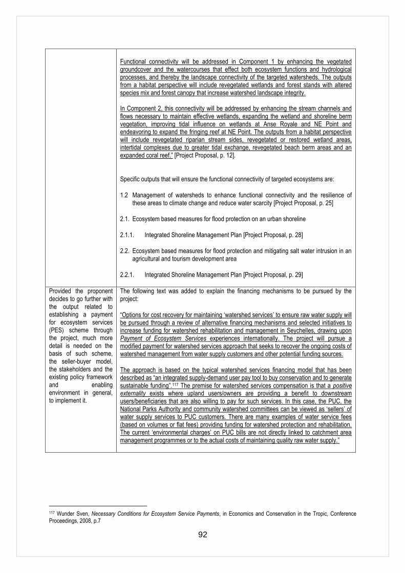
92
Functional connectivity will be addressed in Component 1 by enhancing the vegetated groundcover and the watercourses that effect both ecosystem functions and hydrological processes, and thereby the landscape connectivity of the targeted watersheds. The outputs from a habitat perspective will include revegetated wetlands and forest stands with altered species mix and forest canopy that increase watershed landscape integrity. In Component 2, this connectivity will be addressed by enhancing the stream channels and flows necessary to maintain effective wetlands, expanding the wetland and shoreline berm vegetation, improving tidal influence on wetlands at Anse Royale and NE Point and endeavoring to expand the fringing reef at NE Point. The outputs from a habitat perspective will include revegetated riparian stream sides, revegetated or restored wetland areas, intertidal complexes due to greater tidal exchange, revegetated beach berm areas and an expanded coral reef.‖ [Project Proposal, p. 12].
Specific outputs that will ensure the functional connectivity of targeted ecosystems are:
1.2 Management of watersheds to enhance functional connectivity and the resilience of these areas to climate change and reduce water scarcity [Project Proposal, p. 25]
2.1. Ecosystem based measures for flood protection on an urban shoreline
2.1.1. Integrated Shoreline Management Plan [Project Proposal, p. 28]
2.2. Ecosystem based measures for flood protection and mitigating salt water intrusion in an agricultural and tourism development area
2.2.1. Integrated Shoreline Management Plan [Project Proposal, p. 29]
Provided the proponent decides to go further with the output related to establishing a payment for ecosystem services (PES) scheme through the project, much more detail is needed on the basis of such scheme, the seller-buyer model, the stakeholders and the existing policy framework and enabling environment in general, to implement it.
The following text was added to explain the financing mechanisms to be pursued by the project:
―Options for cost recovery for maintaining ‗watershed services‘ to ensure raw water supply will be pursued through a review of alternative financing mechanisms and selected initiatives to increase funding for watershed rehabilitation and management in Seychelles, drawing upon Payment of Ecosystem Services experiences internationally. The project will pursue a modified payment for watershed services approach that seeks to recover the ongoing costs of watershed management from water supply customers and other potential funding sources.
The approach is based on the typical watershed services financing model that has been described as ―an integrated supply-demand user pay tool to buy conservation and to generate sustainable funding‖.117 The premise for watershed services compensation is that a positive externality exists where upland users/owners are providing a benefit to downstream users/beneficiaries that are also willing to pay for such services. In this case, the PUC, the National Parks Authority and community watershed committees can be viewed as ‗sellers‘ of water supply services to PUC customers. There are many examples of water service fees (based on volumes or flat fees) providing funding for watershed protection and rehabilitation. The current ‗environmental charges‘ on PUC bills are not directly linked to catchment area management programmes or to the actual costs of maintaining quality raw water supply.‖
117 Wunder Sven, Necessary Conditions for Ecosystem Service Payments, in Economics and Conservation in the Tropic, Conference Proceedings, 2008, p.7