data in cap hierarchical structured - · pdf fileno one likes the idea of having html embedded...
TRANSCRIPT

Google Confidential and Proprietary
Hierarchical structured data in CAPSteve HakusaGoogle.org Crisis ResponseApril 24, 2013

Google Confidential and Proprietary
Agenda
● Google Public Alerts● Challenges with structured data
○ Amber alerts○ Tsunami warnings○ Earthquake notifications
● Next steps

Google Confidential and Proprietary
Google Public Alerts

Google Confidential and Proprietary
Google Public Alerts
● Launched in 2011
● 7 alert providers
● 3 countries
● 3 languages
● ~100 different alert types
● >100M views on Google
● Currently working with a
number of other countries
Google Confidential and Proprietary
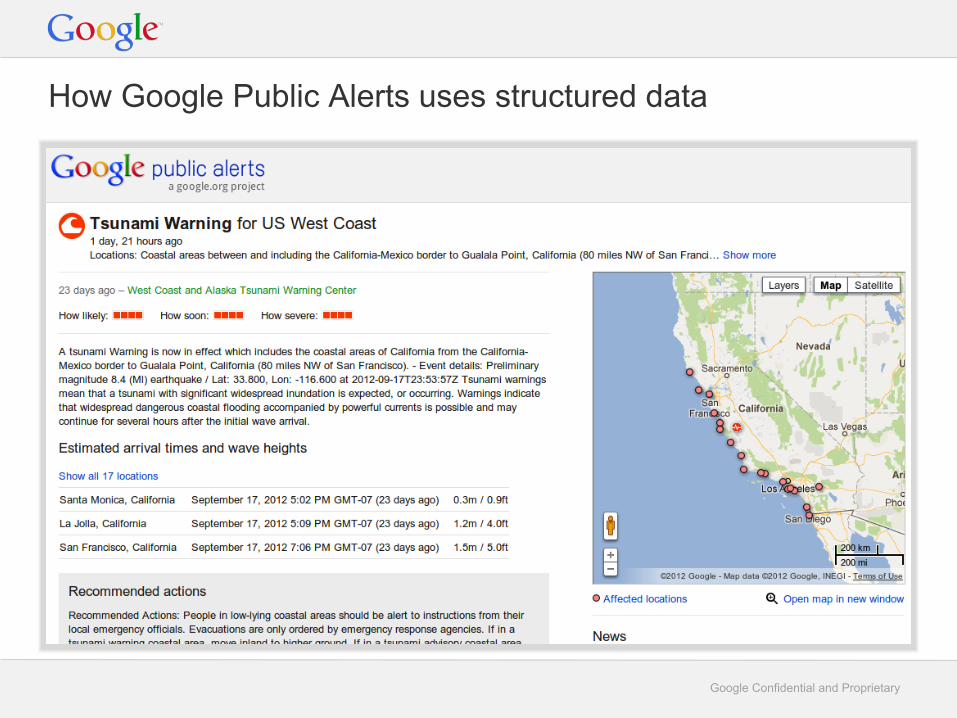
How Google Public Alerts uses structured data

Google Confidential and Proprietary
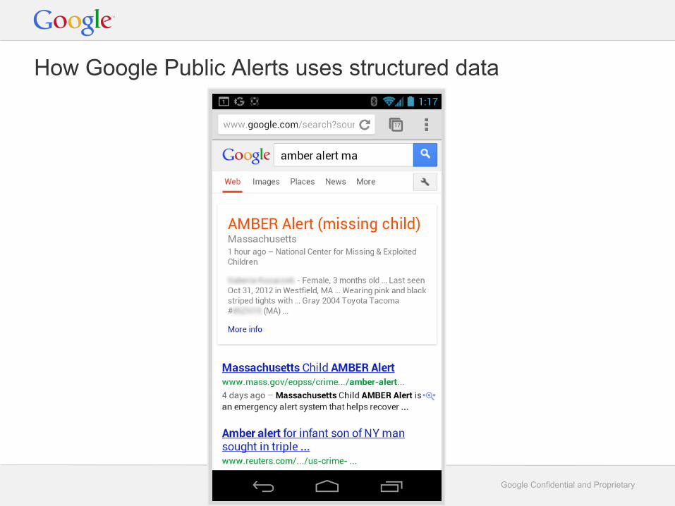
How Google Public Alerts uses structured data
Google Confidential and Proprietary
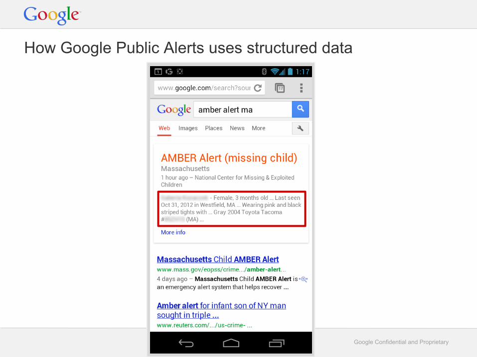
How Google Public Alerts uses structured data
Google Confidential and Proprietary
How Google Public Alerts uses structured data

Google Confidential and Proprietary
How Google Public Alerts could use structured data

Google Confidential and Proprietary
How Google Public Alerts could use structured data

Google Confidential and Proprietary
Extending CAP
● CAP is great for standardizing common fields○ event, effective, expires, description, instructions,
area
● CAP supports limited extensibility○ parameter, a list of (key, value) string pairs
● Simple is good, but we're struggling with extensibility
● Let's look at some examples

Google Confidential and Proprietary
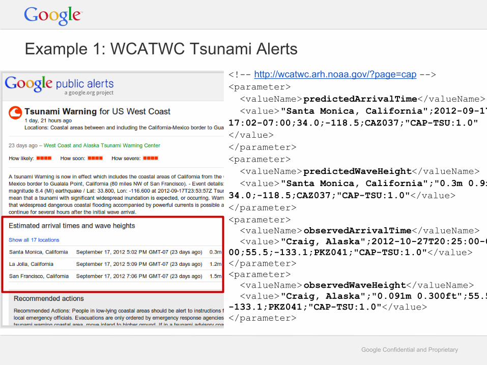
<!-- http://www.tsunami.gov/TEXSchema/TEX.html --><site id=”1”> <location> <name>Santa Monica, California</name> <geo:lat>34.0</geo:lat> <geo:lng>-118.5</geo:lng> </location> <observedArrivalTime> 2012-09-17T17:02:00-07:00</observedArrivalTime> <observedPosAmplitude unit=”m”> 0.3</observedPosAmplitude> <observedPosAmplitude unit=”ft”> 0.9</observedPosAmplitude> <predictedArrivalTime></predictedArrivalTime> <predictedPosAmplitude unit=””></predictedPosAmplitude></site>
Example 1: WCATWC Tsunami Alerts
Google Confidential and Proprietary
<!-- http://wcatwc.arh.noaa.gov/?page=cap --><parameter> <valueName>predictedArrivalTime</valueName> <value>"Santa Monica, California";2012-09-17T22:17:02-07:00;34.0;-118.5;CAZ037;"CAP-TSU:1.0"</value></parameter><parameter> <valueName>predictedWaveHeight</valueName> <value>"Santa Monica, California";"0.3m 0.9ft";34.0;-118.5;CAZ037;"CAP-TSU:1.0"</value></parameter><parameter> <valueName>observedArrivalTime</valueName> <value>"Craig, Alaska";2012-10-27T20:25:00-09:00;55.5;-133.1;PKZ041;"CAP-TSU:1.0"</value></parameter><parameter> <valueName>observedWaveHeight</valueName> <value>"Craig, Alaska";"0.091m 0.300ft";55.5;-133.1;PKZ041;"CAP-TSU:1.0"</value></parameter>
Example 1: WCATWC Tsunami Alerts

Google Confidential and Proprietary
"Santa Monica, California";2012-09-17T22:17:02-07:00;34.0;-118.5;CAZ037;"CAP-TSU:1.0""Santa Monica, California";"0.3m 0.9ft";34.0;-118.5;CAZ037;"CAP-TSU:1.0"
This parameter format is not optimal for CAP consumers
● Field definitions are not clear○ Is 0.3m the "first wave height" or the "max wave height"?
○ Increases the chance that CAP consumers may misinterpret the data.
● Versioning is risky○ Is the wave height in position 2 in version 1.0 but position 3 in version 1.1?
● Requires new parsing code○ Why are semi-colon-separated values required inside an eXtensible Markup Language
document?
○ CAP consumers have to write new (buggy?) parsing code
○ We can't take advantage of common XML parsing libraries
What should we recommend to other countries with tsunami data?

Google Confidential and Proprietary
Example 2: Amber Alerts<!-- https://secure.missingkids.com/en_US/amber/NCMECAmberAlert.xsd --><MissingChild> <PersonGivenName>Jane</PersonGivenName> <PersonSurName>Doe</PersonSurName> <Gender>Female</Gender> <Age>1</Age> <PhysicalDescription> <PersonEyeColorCode>Brown</PersonEyeColorCode> <PersonHairColorCode>Black</PersonHairColorCode> <PersonSkinToneCode>Black</PersonSkinToneCode> <Height>2'</Height> <Weight>23 lbs.</Weight> </PhysicalDescription></MissingChild><Suspect><SuspectVehicle> <VehicleMakeCode>Nissan</VehicleMakeCode> <VehicleModelCode>Maxima</VehicleModelCode> <VehicleColorPrimaryCode>Gray</VehicleColorPrimaryCode> <LicensePlate> <LicensePlateText>CJV 123</LicensePlateText> <LicensePlateState>MO</LicensePlateState> </LicensePlate></SuspectVehicle></Suspect>

Google Confidential and Proprietary
IPAWS Amber Alert CAP<info> ...<event>Child Abduction Emergency</event><responseType>Monitor</responseType><effective>2013-04-13T19:17:06-04:00</effective><expires>2013-04-14T18:17:06-04:00</expires><senderName>Cedar Hill Police Department</senderName><headline>Cedar Hill, TX AMBER Alert: LIC/86p3357 (TX) 2006 Ford Expedition
</headline><description>NO FURTHER DESCRIPTIONS PROVIDED.</description><instruction>NO FURTHER INSTRUCTIONS PROVIDED.</instruction><web>www.missingkids.com</web><parameter><valueName>BLOCKCHANNEL</valueName><value>NWEM</value>
</parameter><parameter><valueName>BLOCKCHANNEL</valueName><value>EAS</value>
</parameter><parameter><valueName>BLOCKCHANNEL</valueName><value>PUBLIC</value>
</parameter><parameter><valueName>CMAMtext</valueName><value>Cedar Hill, TX AMBER Alert: LIC/86p3357 (TX) 2006 Ford Expedition
</value></parameter>
</info>
?

Google Confidential and Proprietary
How to recommend NCMEC extend their CAP?
1. Flatten the hierarchy to parameters?<parameter> <valueName> Suspect0:Vehicle0:LicensePlateState </valueName> <value>MO</value></parameter>
○ Parsing the valueNames gets complicated
2. Stuff NCMEC's XML into a single parameter?○ Duplicates all the common fields between NCMEC XML and CAP
○ Requires two-steps of XML parsing
3. Create a formatted description?○ No one likes the idea of having HTML embedded in the description tag
What should we recommend to other missing children agencies?
Google Confidential and Proprietary
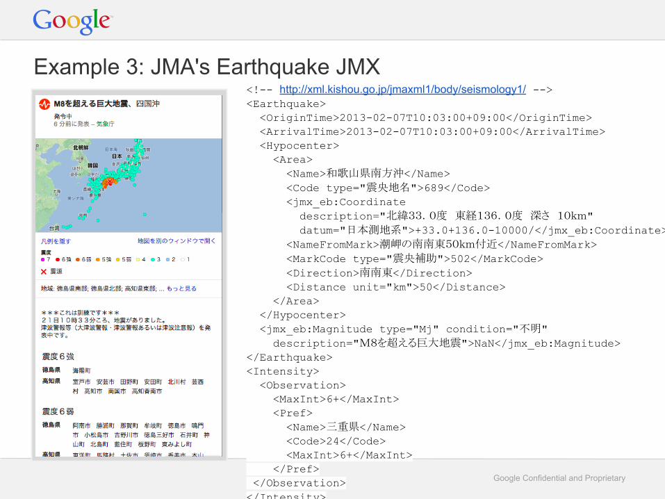
Example 3: JMA's Earthquake JMX<!-- http://xml.kishou.go.jp/jmaxml1/body/seismology1/ --><Earthquake> <OriginTime>2013-02-07T10:03:00+09:00</OriginTime> <ArrivalTime>2013-02-07T10:03:00+09:00</ArrivalTime> <Hypocenter> <Area> <Name>和歌山県南方沖</Name> <Code type="震央地名">689</Code> <jmx_eb:Coordinate description="北緯33.0度 東経136.0度 深さ 10km" datum="日本測地系">+33.0+136.0-10000/</jmx_eb:Coordinate> <NameFromMark>潮岬の南南東50km付近</NameFromMark> <MarkCode type="震央補助">502</MarkCode> <Direction>南南東</Direction> <Distance unit="km">50</Distance> </Area> </Hypocenter> <jmx_eb:Magnitude type="Mj" condition="不明" description="M8を超える巨大地震">NaN</jmx_eb:Magnitude></Earthquake><Intensity> <Observation> <MaxInt>6+</MaxInt> <Pref> <Name>三重県</Name> <Code>24</Code> <MaxInt>6+</MaxInt> </Pref> </Observation></Intensity>
Google Confidential and Proprietary
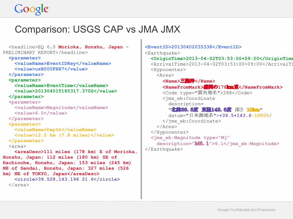
<headline>EQ 6.0 Morioka, Honshu, Japan - PRELIMINARY REPORT</headline> <parameter> <valueName>EventIDKey</valueName> <value>usB000FXH7</value> </parameter> <parameter> <valueName>EventTime</valueName> <value>20130401T185317.370Z</value> </parameter> <parameter> <valueName>Magnitude</valueName> <value>6.0</value> </parameter> <parameter> <valueName>Depth</valueName> <value>12.5 km (7.8 miles)</value> </parameter> <area> <areaDesc>111 miles (178 km) E of Morioka, Honshu, Japan; 112 miles (180 km) SE of Hachinohe, Honshu, Japan; 153 miles (245 km) NE of Sendai, Honshu, Japan; 327 miles (526 km) NE of TOKYO, Japan</areaDesc> <circle>39.528,143.196 21.6</circle> </area>
Comparison: USGS CAP vs JMA JMX<EventID>20130402035338</EventID><Earthquake> <OriginTime>2013-04-02T03:53:00+09:00</OriginTime> <ArrivalTime>2013-04-02T03:53:00+09:00</ArrivalTime> <Hypocenter> <Area> <Name>三陸沖</Name> <NameFromMark>盛岡の178km東</NameFromMark> <Code type="震央地名">288</Code> <jmx_eb:Coordinate description= "北緯39.5度 東経143.6度 深さ 10km" datum="日本測地系">+39.5+143.6-10000/ </jmx_eb:Coordinate> </Area> </Hypocenter> <jmx_eb:Magnitude type="Mj" description="M6.1">6.1</jmx_eb:Magnitude></Earthquake>

Google Confidential and Proprietary
Example 3: JMA's Earthquake JMX<!-- http://xml.kishou.go.jp/jmaxml1/body/seismology1/ --><Earthquake> <OriginTime>2013-02-07T10:03:00+09:00</OriginTime> <ArrivalTime>2013-02-07T10:03:00+09:00</ArrivalTime> <Hypocenter> <Area> <Name>和歌山県南方沖</Name> <Code type="震央地名">689</Code> <jmx_eb:Coordinate description="北緯33.0度 東経136.0度 深さ 10km" datum="日本測地系">+33.0+136.0-10000/</jmx_eb:Coordinate> <NameFromMark>潮岬の南南東50km付近</NameFromMark> <MarkCode type="震央補助">502</MarkCode> <Direction>南南東</Direction> <Distance unit="km">50</Distance> </Area> </Hypocenter> <jmx_eb:Magnitude type="Mj" condition="不明" description="M8を超える巨大地震">NaN</jmx_eb:Magnitude></Earthquake><Intensity> <Observation> <MaxInt>6+</MaxInt> <Pref> <Name>三重県</Name> <Code>24</Code> <MaxInt>6+</MaxInt> </Pref> </Observation></Intensity>

Google Confidential and Proprietary
JMX -> CAP?
● Could follow John Carrick<parameter>
<valueName>localMaxIntensity</valueName> <value>6+;"三重県";JP-PREFECTURE;24;34.7;136.5;CAP-EQ:1.0"</value>
</parameter>
○ But has same problems as CAP-TSU
● Could embed the table as HTML in the CAP description○ No one likes having HTML in the description
● We just process raw JMX for now○ Sad: We want to write code once and have it work for all earthquake alerts
○ Don't know what to recommend to other countries with seismic intensity data

Google Confidential and Proprietary
● We believe that the continued growth of CAP as a standard would
benefit from support for custom hierarchical structured data.
● It is already a stumbling block for this CAP implementor○ Stops us from recommending CAP to groups that want to work with us
○ Writing custom parsers increases implementation costs and risks
● Slows down CAP adoption in the community
Challenge: Lack of hierarchy

Google Confidential and Proprietary
A 2-step proposal for discussion
1. Allow XML extensions in the CAP schema
This could be as simple as a small change to the .xsd:
<any minOccurs="0" maxOccurs="unbounded" namespace="##other" processContents="lax" />
● "Advanced" feature○ parameter still the way to go for simple non-hierarchical content
● Allows earthquake and tsunami data to be represented cleanly● Provides migration path to CAP for complex hierarchies like NCMEC
○ Migrate common fields to CAP, retain community-specific hierarchical data
● Provides clean separation of sets of fields for disparate purposes● Does this cause fragmentation?
○ not much different than parameter (e.g. no standard formats/naming conventions)○ Like parameter , CAP consumers who don't care about extensions can ignore them

Google Confidential and Proprietary
A 2-step proposal for discussion
1. Allow XML extensions in the CAP schema2. Move towards standard extensions
Develop recommendations and best-practices for commonly extensions○ Meteorological events, Earthquakes, Tsunamis, Floods, Missing Children, etc
Eventually, standardize well-adopted recommendations
● Similar to JMX in some respects● Reduces concerns of fragmentation● Lets the community migrate towards the best formats
Google Confidential and Proprietary
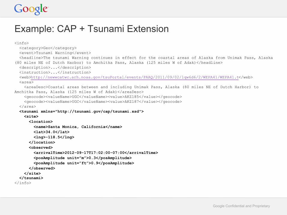
Example: CAP + Tsunami Extension<info> <category>Geo</category> <event>Tsunami Warning</event> <headline>The tsunami Warning continues in effect for the coastal areas of Alaska from Unimak Pass, Alaska (80 miles NE of Dutch Harbor) to Amchitka Pass, Alaska (125 miles W of Adak)</headline> <description>...</description> <instruction>...</instruction> <web>http://newwcatwc.arh.noaa.gov/tsuPortal/events/PAAQ/2011/09/02/lqw6d6/2/WEPA41/WEPA41.txt</web> <area> <areaDesc>Coastal areas between and including Unimak Pass, Alaska (80 miles NE of Dutch Harbor) to Amchitka Pass, Alaska (125 miles W of Adak)</areaDesc> <geocode><valueName>UGC</valueName><value>AKZ185</value></geocode> <geocode><valueName>UGC</valueName><value>AKZ187</value></geocode> </area> <tsunami xmlns="http://tsunami.gov/cap/tsunami.xsd"> <site> <location> <name>Santa Monica, California</name> <lat>34.0</lat> <lng>-118.5</lng> </location> <observed> <arrivalTime>2012-09-17T17:02:00-07:00</arrivalTime> <posAmplitude unit=”m”>0.3</posAmplitude> <posAmplitude unit=”ft”>0.9</posAmplitude> </observed> </site> </tsunami></info>
Google Confidential and Proprietary
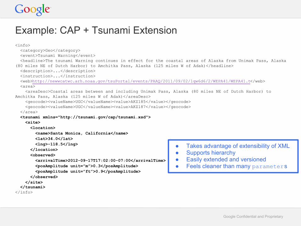
Example: CAP + Tsunami Extension<info> <category>Geo</category> <event>Tsunami Warning</event> <headline>The tsunami Warning continues in effect for the coastal areas of Alaska from Unimak Pass, Alaska (80 miles NE of Dutch Harbor) to Amchitka Pass, Alaska (125 miles W of Adak)</headline> <description>...</description> <instruction>...</instruction> <web>http://newwcatwc.arh.noaa.gov/tsuPortal/events/PAAQ/2011/09/02/lqw6d6/2/WEPA41/WEPA41.txt</web> <area> <areaDesc>Coastal areas between and including Unimak Pass, Alaska (80 miles NE of Dutch Harbor) to Amchitka Pass, Alaska (125 miles W of Adak)</areaDesc> <geocode><valueName>UGC</valueName><value>AKZ185</value></geocode> <geocode><valueName>UGC</valueName><value>AKZ187</value></geocode> </area> <tsunami xmlns="http://tsunami.gov/cap/tsunami.xsd"> <site> <location> <name>Santa Monica, California</name> <lat>34.0</lat> <lng>-118.5</lng> </location> <observed> <arrivalTime>2012-09-17T17:02:00-07:00</arrivalTime> <posAmplitude unit=”m”>0.3</posAmplitude> <posAmplitude unit=”ft”>0.9</posAmplitude> </observed> </site> </tsunami></info>
● Takes advantage of extensibility of XML● Supports hierarchy● Easily extended and versioned● Feels cleaner than many parameters

Google Confidential and Proprietary
Alternative from Eliot Christian
● Allow XML extensions directly at the info level○ The proposal from this presentation
● Add XML extensions as references using derefUri○ Problem: CAP 1.2 spec requires derefUri to be base-64 encoded
○ Requested change: allow non-encoded XML content in derefUri

Google Confidential and Proprietary
Conclusion
● We're excited about the growth in the CAP community
● We want to see adoption accelerate
● We're looking forward to discussing the best ways to do that
Thanks.

Google Confidential and Proprietary
Appendix

Google Confidential and Proprietary
Google Public Alerts

Google Confidential and Proprietary
● CAP-RSMCTK○ Experimental tropical cyclone CAP profile by RSMC Tokyo-Typhoon Center
○ Describes the typhoon forecast cone; intended for distribution outside Japan
○ Defines 21 (!) parameters, flattening JMX
■ TC_CycloneName, TC_CycloneID, TC_MovingDirection, TC_MovingSpeed, TC_PositionConfidence, TC_CenterPressure, TC_MaxSustainedWind, TC_PeakGust, EventEndTime, TC_AnalysisTime, TC_30knotMaxRadius, TC_30knotMinRadius, TC-50knotMaxRadius, TC_50knotMinRadius, TC_30knowMaxRadiusDirection, TC_30knotMinRadiusDirection, TC_50knotMaxRadiusDirection, TC_50knotMinRadiusDirection
Google Confidential and Proprietary
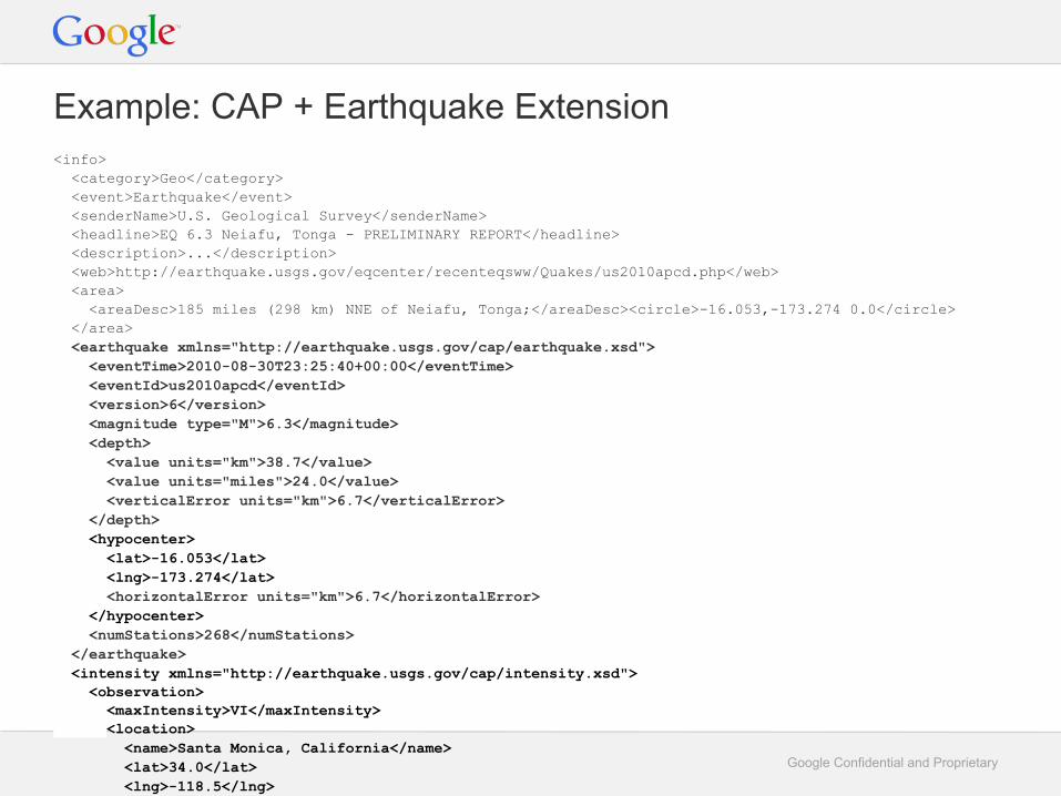
Example: CAP + Earthquake Extension<info> <category>Geo</category> <event>Earthquake</event> <senderName>U.S. Geological Survey</senderName> <headline>EQ 6.3 Neiafu, Tonga - PRELIMINARY REPORT</headline> <description>...</description> <web>http://earthquake.usgs.gov/eqcenter/recenteqsww/Quakes/us2010apcd.php</web> <area> <areaDesc>185 miles (298 km) NNE of Neiafu, Tonga;</areaDesc><circle>-16.053,-173.274 0.0</circle> </area> <earthquake xmlns="http://earthquake.usgs.gov/cap/earthquake.xsd"> <eventTime>2010-08-30T23:25:40+00:00</eventTime> <eventId>us2010apcd</eventId> <version>6</version> <magnitude type="M">6.3</magnitude> <depth> <value units="km">38.7</value> <value units="miles">24.0</value> <verticalError units="km">6.7</verticalError> </depth> <hypocenter> <lat>-16.053</lat> <lng>-173.274</lat> <horizontalError units="km">6.7</horizontalError> </hypocenter> <numStations>268</numStations> </earthquake> <intensity xmlns="http://earthquake.usgs.gov/cap/intensity.xsd"> <observation> <maxIntensity>VI</maxIntensity> <location> <name>Santa Monica, California</name> <lat>34.0</lat> <lng>-118.5</lng> </location> </intensity></info>