data delivery standards and specifications...
TRANSCRIPT

Data Delivery Standards and Specifications Template For improving data deliverables associated with contracts and agreements
This document is intended to provide government project managers with a selection of best practices, standards, and documentation focused on improving the quality of data and documentation delivered through contracts, agreements, and other collaborative activities. Version Publication Date Summary of Changes
1.0 April 2012
Recommended Citation: U.S. Fish and Wildlife Service. 2012. Data Delivery Standards and Specifications Template. USFWS, Pacific Southwest Region. Sacramento, Calif. 92 pp. including appendices.

ii
Who Should Use This Document This document is intended to be used by project managers and specialists in cooperation with contracts and agreement personnel. Project managers cover a wide range of disciplines including: biology, ecology, hydrology, geography, and data management. Below are project categories that might benefit from using this template:
• Contracts • Agreements (university, interagency, or non-governmental) • Government Employees working on projects and who do not have a well-defined data
management framework informing the data and information aspects of their work When to Use this Document Project managers and GIS/Data managers should use this document to evaluate the range of potential data deliverables relevant to their individual project(s), to prepare a Statement Of Work (Appendix A), or help define the requirements for a data management plan. In return, contractors and cooperators will have clearer understanding of project expectations and their responsibilities. This document can be used to develop either pre-contract Requests For Proposals (RFP) or used after contract or agreement award to collaboratively develop data specifications. This document is NOT designed to support the following kinds of projects or project elements:
• web design or development • on-line map services • software applications development • cadastral (boundary) surveying or mapping of land ownership • voucher specimen acquisition, development, and management • DNA sequencing submission standards • sound/video recordings
For any project with a geospatial component, this document is focused on providing best practices and specifications for resource-mapping activities and is not intended to be used for traditional “architectural and engineering” projects such as boundary surveys.(See examples in Section 3.4). Some of the activities described in this document may fall within the scope of licensed professional practice and thus be considered “architectural and engineering” services by federal and state governments. Project type, scope, and complexity will determine if a licensed and qualified professional engineer, surveyor, or photogrammetrist are required. Project managers should comply with federal and state laws. How to Use This Document The checklist on page 2 is provided for a project manager to identify applicable data deliverables to their project as well as to monitor project progress, accomplishments and compliance with specifications. Each data topic in the checklist is hyperlinked to its corresponding section that details a range of options for each data deliverable. Supplemental deliverable requirements for existing or new data deliverables can be described if additional requirements are warranted. This document can be used directly to develop and use as a requirements document, or a project manager could copy/paste selected elements of this template into their own local document requirement standards.

iii
The following steps outline the process used by project managers to evaluate and assign specific data deliverables for each project.
1. Fill out basic project details in the Data Deliverables Checklist (page 2) 2. Mark deliverables applicable to your specific project in the Data Deliverables Checklist 3. Check or mark the appropriate Option(s) for each data deliverable item located in its
corresponding section 4. Provide Supplemental Data Requirements detail in individual sections (if applicable) 5. Check the Date Deliverable Completed column in the Data Deliverables Checklist after the data
deliverable has been submitted to track project compliance on individual requirements.
Project managers should understand that it is impossible to integrate every possible data requirement into this document and may further need to develop their specific projects’ requirements. Depending on the specific requirements of each project, additional requirements or changed requirements may be necessary. As an example, this document includes best practices for database development, but additional or different database specifications might be needed. This document does not replace specific agency requirements because of the variability across agencies; however, it can serve as a standard specification for many agencies, while allowing flexibility for project managers to customize it to their own agency requirements or policy. Note: This document does not endorse specific proprietary software applications or proprietary data formats. Any contract or agreement requirements should not be considered complete until all requirements have been completed and submitted.

iv
Table of Contents Purpose .......................................................................................................................................................... 1
Data Deliverables Checklist .......................................................................................................................... 2
1.0 Records Management .............................................................................................................................. 4
1.1 File Naming ........................................................................................................................................ 4
1.2 File Directory Structure ...................................................................................................................... 9
1.3 Data Backup ...................................................................................................................................... 12
2.0 Data Sharing .......................................................................................................................................... 13
2.1 Data Access and Use Rights ............................................................................................................. 13
2.2 Copyrights ......................................................................................................................................... 15
2.3 Sensitive Data and the Freedom of Information Act ........................................................................ 16
2.4 Data Deliverables .............................................................................................................................. 23
3.0 Field Data .............................................................................................................................................. 26
3.1 Projections, Coordinate Systems and Datums .................................................................................. 26
3.2 Horizontal and Vertical Map Accuracy ............................................................................................ 27
3.3 Resource Mapping with Global Positioning System Data ................................................................ 29
3.4 Resource Management Surveying ................................................................................................... 32
3.5 Control Surveying ............................................................................................................................. 33
3.6 Topographic Surveying ................................................................................................................... 35
3.7 Field Forms ....................................................................................................................................... 38
3.8 Digital Images/Project Photos ........................................................................................................... 38
3.9 Permits .............................................................................................................................................. 40
4.0 Spatial Data and Database..................................................................................................................... 41
4.1 Database Development ..................................................................................................................... 41
4.2 Tables and Spreadsheets ................................................................................................................... 43

v
4.3 Computer-Aided Design (CAD) Data ............................................................................................... 44
4.4 GIS Data ............................................................................................................................................ 46
5.0 Data Documentation ............................................................................................................................. 50
5.1 Geospatial Metadata .......................................................................................................................... 50
5.2 References Metadata ......................................................................................................................... 52
5.3 Controlled Vocabulary ...................................................................................................................... 53
6.0 Aerial Mapping & Image Acquisition .................................................................................................. 55
6.1 Aerial Imagery Acquisition ............................................................................................................... 55
6.2 LIDAR .............................................................................................................................................. 64
7.0 Analyses ................................................................................................................................................ 75
7.1 Process Documentation & Scientific Workflow ............................................................................... 75
8.0 Reporting............................................................................................................................................... 76
8.1 Maps/Cartography ............................................................................................................................. 76
8.2 Project Reporting .............................................................................................................................. 78
8.3 Reports and Publications ................................................................................................................... 78
9.0 Ethics .................................................................................................................................................... 80
10.0 Other Project Requirements ................................................................................................................ 81
10.1 ......................................................................................................................................................... 81
10.2 ......................................................................................................................................................... 81
10.3 ......................................................................................................................................................... 81
10.4 ......................................................................................................................................................... 81
10.5 ......................................................................................................................................................... 81
Contracts & Document Updates ................................................................................................................82
Ackowledgments .......................................................................................................................................82
Appendix A ................................................................................................................................................. 83
Appendix B ................................................................................................................................................. 85


1
Purpose Agreements and contracts are regularly developed between government agencies and third parties such as contractors, cooperators, and partners. This document is intended to provide project managers with a customizable template for defining data deliverables that will be produced by contractors and collaborators. By providing a structured process and template, project managers improve the likelihood that government agencies are obtaining the best value and ensuring long term data integrity. The intent of this document is to synthesize existing policy, guidelines, and standards relating to data (spatial and non-spatial) and information into a comprehensive and customizable specifications document that can be readily used by managers who work with contractors or cooperators. Utilization of this document is intended to provide the following benefits:
• Ensures that established standards and best practices are clearly and consistently articulated in contract or agreement language.
• Provides specification for data deliverables ensuring that the agency receives the required
quantity, type, and format of data and associated metadata.
• Provides benchmarks and guidance for cooperators or contractors when acquiring data, designing databases, monitoring systems, and field procedures that conform to agency expectations, and the subsequent strategies for reporting outcomes to sponsor(s).
• Provides a set of standards and performance measures for evaluating contract deliverables.
• Provides pre-established technical data specifications that managers can easily insert into
contracts or agreements.
• Helps ensure compatibility of deliverables across multiple projects, programs, offices, or agencies.
• Reduces the potential for conflicts or misunderstandings between contractors and government
managers.

2
Data Deliverables Checklist Project Name. ______________________________________________________________ Contract/Agreement Number ______________________________________________________________
Project Description ________________________________________________________________________________________________
Contractor/Cooperator Project Contact Name ________________________________ Organization _____________________________ Project Contact Position ______________________________ Phone ___________________________________ E-mail _____________________________________________ Signature/e-Signature ________________________________ Date ____________________________________
Agency Contact Agency Contact Name ________________________________ Agency _________________________________ Agency Contact Position ______________________________ Phone __________________________________ E-mail _____________________________________________ Signature/e-Signature ________________________________ Date ____________________________________
Contract/Agreement Start Date ______________________________________________________________ Contract/Agreement Completion Date _________________________________________________________
PROJECT DATA REQUIREMENTS Please check any data topic that applies to this project. Data Topic (data topics are hyperlinked to section)
See Section
Is this Deliverable Applicable?
Date Deliverable Completed
Comments
RECORDS MANAGEMENT 1.0 ____________ _____________________________ File Naming 1.1 ____________ _____________________________ File Directory Structure 1.2 ____________ _____________________________ Data Backup 1.3 ____________ _____________________________ DATA SHARING 2.0 ____________ _____________________________ Data Access and Use Rights 2.1 ____________ _____________________________ Copyrights 2.2 ____________ _____________________________ Sensitive Data and FOIA 2.3 ____________ _____________________________ Data Deliverables 2.4 ____________ _____________________________ continued on next page

3
Data Topic (data topics are hyperlinked to section)
See Section
Is this Deliverable Applicable?
Date Deliverable Completed
Comments
FIELD DATA 3.0 ____________ _____________________________ Projections, Coordinate Systems and, Datums
3.1 ____________ _____________________________
Horizontal and Vertical Map Accuracy
3.2 ____________ _____________________________
Resource Mapping -GPS 3.3 ____________ _____________________________ Resource Management Surveying 3.4 ____________ _____________________________ Control Surveying 3.5 ____________ _____________________________ Topographic Surveying 3.6 ____________ _____________________________ Field Forms 3.7 ____________ _____________________________ Digital Images/Photos 3.8 ____________ _____________________________ Permits 3.9 ____________ _____________________________ SPATIAL DATA & DATABASE 4.0 ____________ _____________________________ Database Development 4.1 ____________ _____________________________ Tables and Spreadsheets 4.2 ____________ _____________________________ CAD Data 4.3 ____________ _____________________________ GIS Data (Vector/ Raster) 4.4 ____________ _____________________________ DATA DOCUMENTATION 5.0 ____________ _____________________________ Geospatial Metadata 5.1 ____________ _____________________________ References Metadata 5.2 ____________ _____________________________ Controlled Vocabulary 5.3 ____________ _____________________________ AERIAL MAPPING & IMAGE ACQUISITION
6.0 ____________ _____________________________
Aerial Imagery Acquisition 6.1 ____________ _____________________________ LIDAR 6.2 ____________ _____________________________ ANALYSES 7.0 ____________ _____________________________ Process Documentation & Scientific Workflow
7.1 ____________ _____________________________
REPORTING 8.0 ____________ _____________________________ Maps/Cartography 8.1 ____________ _____________________________ Project Reporting 8.2 ____________ _____________________________ Reports and Publications 8.3 ____________ _____________________________ ETHICS 9.0 ____________ _____________________________ OTHER REQUIREMENTS 10.0 ____________ _____________________________ 10.1 ____________ _____________________________ 10.2 ____________ _____________________________ 10.3 ____________ _____________________________ 10.4 ____________ _____________________________ 10.5 ____________ _____________________________
4
1.0 Records Management
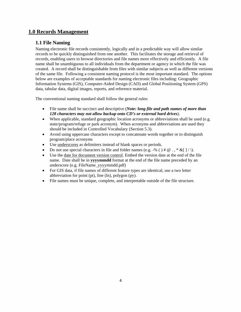
1.1 File Naming Naming electronic file records consistently, logically and in a predictable way will allow similar records to be quickly distinguished from one another. This facilitates the storage and retrieval of records, enabling users to browse directories and file names more effectively and efficiently. A file name shall be unambiguous to all individuals from the department or agency in which the file was created. A record shall be distinguishable from files with similar subjects as well as different versions of the same file. Following a consistent naming protocol is the most important standard. The options below are examples of acceptable standards for naming electronic files including: Geographic Information Systems (GIS), Computer-Aided Design (CAD) and Global Positioning System (GPS) data, tabular data, digital images, reports, and reference material. The conventional naming standard shall follow the general rules:
• File name shall be succinct and descriptive (Note: long file and path names of more than 128 characters may not allow backup onto CD’s or external hard drives).
• When applicable, standard geographic location acronyms or abbreviations shall be used (e.g. state/program/refuge or park acronym). When acronyms and abbreviations are used they should be included in Controlled Vocabulary (Section 5.3).
• Avoid using uppercase characters except to concatenate words together or to distinguish program/place acronyms
• Use underscores as delimiters instead of blank spaces or periods. • Do not use special characters in file and folder names (e.g. -% ( ) # @ . , * &[ ] / \). • Use the date for document version control. Embed the version date at the end of the file
name. Date shall be in yyyymmdd format at the end of the file name preceded by an underscore (e.g. FileName_yyyymmdd.pdf)
• For GIS data, if file names of different feature types are identical, use a two letter abbreviation for point (pt), line (ln), polygon (py).
• File names must be unique, complete, and interpretable outside of the file structure.

5
Option 1. Project or Program Level Files For data at a project or program level, files shall be distinguishable at first glance by data topic or resource, followed by geographic location or unit ID and creation or modification date (yyyymmdd).
Spatial, Database, or Tabular Files When naming spatial, database, or tabular files at the Project and Program level, the standard shall follow: Topic_PlaceOrAreaName_Date
Examples:
SheepFirePerimeter_SEKI_20111002.shp ESRI shapefile depicting the perimeter of the Sheep Fire at Sequoia & Kings Canyon National Parks on October 2, 2011.
VegetationSurvey10k_AHME_2011.gdb ESRI file geodatabase of a 1:10,000 vegetation survey at Ash MeadowsWildlife Refuge during 2011.
BatSurveys_DEVA_20111022.axf ArcPad file of Bat surveys at Death Valley National Park conducted on October 22, 2011.
Spatial Database Engine (SDE) Layers When naming SDE layers for the Project and Program level (as well as Regional and National level), the standard shall follow: CATEGORY_LayerLocationResolutionSource_filetype
Examples: SOIL_ssurgo_MODO100k_py.sde ESRI SDE file of a1:100,000 polyline soil
survey from the Soil Survey Geographic database for Modoc National Wildlife Refuge
CRITICAL_HABITAT_goag_JOTR_pg.sde ESRI SDE file of Critical Habitat polygons for Desert Tortoise (Gopherus agassizii) at Joshua Tree National Park.

6
Reports and References When naming reports and references (that will be included in a bibliography or reference section), the standard shall follow: Author_Agency_Title/Topic_Date
Examples: Smith_USGS_GWMonitoringSAVAv1.2_20111022.pdf PDF file of a groundwater
monitoring report (version 1.2) for the Sacramento Valley by Tom Smith for the US Geological Survey submitted on October 22, 2011.
Moser_FWS_ASBR5YrStatusReview_20070815.docx Microsoft Word Document v2010 of 5 Year status review for Bract milkweed (Asclepias brachystephana) for the USFWS. Author - Bob Turner, submitted on August 15, 2007.
FWS_SDCWO_PermitConditions_20110916.docx Microsoft Word Document v2010 outlining US Fish and Wildlife Service and San Diego County Water Authority Permit Conditions on September 16, 2011.
Digital Images
When naming digital images, the standard shall follow: <Author>_Topic/Subject_Place_Date If multiple photos are taken for one event or location, a sequential number can be placed at the end of each photo image.
Examples: VolunteerPlanting_DEVA_20111022_1.jpg JPEG image format - Volunteer Planting
Event at Death Valley National Park on October 22, 2011 – Photo 1
VolunteerPlanting_DEVA_20111022_2.jpg JPEG image format - Volunteer Planting Event at Death Valley National Park on October 22, 2011 – Photo 2
VolunteerPlanting_DEVA_20111022_3.jpg JPEG image format - Volunteer Planting Event at Death Valley National Park on October 22, 2011 – Photo 3
Smith_AmRe_POR_20111022.jpg JPEG image format - Photo taken by Stuart Smith of a Ambrysus relictus at Points of Rocks Spring on October 22, 2011.
Plot137NE_CADFG_GiMo_MRR3_20111006.tif Tagged Image File - Photo of Study Plot 137NE for Mohave chub (Gila mohavensis) on the Mohave River, Reach 3. Conducted by the California Department of Fish and Game and taken on October 06, 2011.

7
Field Data Sheets or Data Dictionaries When naming Field Data Sheets (FDS) or Data Dictionaries (DD), the acronym shall identify which type of field data collection deliverable is being submitted. When naming field data sheets or data dictionaries, the standard shall follow: DataType_ProjectName_<Contractor>_Date(yyyymmdd)_(Time if applicable for multiple events per day-24 hour clock)
Examples: FDS_MercedTempReach1_UCD_YOSE_20110922_1100.pdf Portable document format file of
field data sheet regarding a field data sheet of a temperature study on Reach 1 of the Merced River in Yosemite National Park conducted on September 22, 2011 at 11:00am.
FDS_MercedTempReach1_UCD_YOSE_20110922_1115.pdf Portable document format file of field data sheet regarding a temperature study on Reach 1 of the Merced River in Yosemite National Park conducted on September 22, 2011 at 11:15am.
DD_MercedTempReach1_UCD_YOSE_20110922.ddf Trimble data dictionary file of data collected for a temperature study on Reach 1 of the Merced River in Yosemite National Park conducted on September 22, 2011.
Metadata When naming metadata not attached to spatial files, the standard shall follow the same name as the data file: Files should be submitted as either .html or .xml documents and should be located at the same file directory level of the data.
Examples: Plot137NE_CADFG_GiMo_MRR3_20111006.xml Metadata file for: Plot137NE_CADFG_GiMo_MRR3_20111006.doc
Extensible markup language metadata file regarding study plot 137NE for Mohave chub (Gila mohavensis) monitoring on the Mohave River, Reach 3. Conducted by the California Department of Fish and Game on October 06, 2011.
DD_MercedTempReach1_UCD_YOSE_20110922.xml Metadata file for: DD_MercedTempReach1_UCD_YOSE_20110922.doc
Extensible markup language metadata file for temperature study on Reach 1 of the Merced River in Yosemite National Park conducted on September 22, 2011 at 11:15am.

8
Option 2. National or Regional Level Files For data on a national or large regional level, files may need to be distinguished first by geographic Place or Unit Name for sorting purposes.
Spatial, Database, or Tabular Files When naming spatial and tabular files for the National or Regional level, the standard shall follow: PlaceName_TopicResolution Examples: Region6_NWRAppBoundaries.shp ESRI shapefile of approved National Wildlife Refuge
boundaries for Region 6. DESE_VegetationSurvey10k.gdb ESRI file geodatabase of 1:10,000 vegetation surveys
for the National Wildlife Refuges in the Desert Complex.
Note: Date will be identified in metadata
Metadata When naming metadata not attached to spatial files, the standard shall follow the same name as the data file: Files should be submitted as either .html or .xml documents and should be located at the same file directory level of the data.
Examples: Region6_NWRBoundariesMap.xml Metadata file for: Region6_NWRBoundariesMap.pdf
Extensible markup language metadata file for map of Region 6 National Wildlife Refuge Boundaries
DESE_VegetationSurveyMethods10k.html Metadata file for: DESE_VegetationSurveyMethods10k.doc
Hypertext markup language metadata file of survey methods used to map vegetation at Wildlife Refuges within the Desert Complex at 1:10,000.
Supplemental Requirement Description
Additional Resources National Park Service. Standard Operating Procedures for Electronic File Naming Guidelines and Standards v. 1.2. 20111011
US Fish and Wildlife Service. Standard Operating Procedures for Document Management. 20090625

9
1.2 File Directory Structure Many contracts or agreements have so few electronic file deliverables that no additional effort is necessary to organize files. This section is focused on organizing electronic files for projects that will have multiple electronic file deliverables. Some agencies have their own file structure standards therefore directories should be developed as specified by the [AGENCY]. For each project the contractor/cooperator is expected to standardize or adopt a directory structure in order to improve project organization. Figure 1-1 represents a logical and moderately complex file directory structure for data deliverables.
Option 1. Specific Agency File Directory Structure
____________________________________________________________________________________________________________________________________________________________
Option 2. Simplified File Directory Structure
At a minimum, there shall be four main directories under a project folder 1) admin, 2) data, 3) references, and 4) reports. Within each of the four main directories a more descriptive directory shall be developed as outlined in the options below.
1. admin – This directory contains memos, meeting notes, budgets and correspondence
associated with the project. 2. data – This directory contains all spatial and non-spatial data including digital photographs or
other graphics files, imagery, GIS and GPS data, tabular information and relational databases.
Under the data directory there are three folders: i. imagery – This folder contains all imagery (processed and unprocessed), graphics or
illustrations related to the project. Metadata is kept in the same folder of the data it is referencing.
ii. spatial – This folder contains all spatial data including created data as well as data derived from GPS units and relational database. Metadata is kept in the same folder of the data it is referencing. Note: map packages (mpk) may be substituted for the spatial data directory and will contain complete map documents and the data referenced by the layers it contains (e.g. .mxd, .shp. dbf, and raster data).
iii. tabular – This folder contains relational and non-relational databases (e.g. Microsoft Access and Excel data). The folder can also contain .csv, .txt files, and .gpx files exported from GPS units. Metadata is kept in the same folder with the data it is referencing.
3. references – Digital copies of all reference material used to support final project report(s)
deliverables will be included in the file structure and labeled according to standard file naming conventions. References may need to be organized according to topic depending on project complexity and the amount of reference information associated with the project.
4. reports – This directory contains all draft and final reports completed for the project. Reports
and publications are organized by version (yyyymmdd); draft and final reports relating to a single project are to be stored in this folder.

10
Option 3. Complex Project File Directory Structure Figure 1-1. Example of project directory based on records management standards.

11
Option 4. Complex Spatial Data Directory Structure The spatial data directory will have at least seven primary folders, each of which contains several types of data that reflect different processing stages. Folders exhibiting UPPERCASE characters refer to folders containing ecological-related SENSITIVE or READ-ONLY data or information. The following folders are recommended to organize spatial data for complex projects:
1. analyses – Data in this folder can contain outputs of spatial data including graphs and tables
and models. 2. derived_data – This folder contains data that have been developed using MASTER or
working data and may include relational databases, tabular data files and GIS layers. 3. historic_data – This folder contains data that are preserved data from an earlier version, but
updated to maintain version history (e.g. an older Microsoft Access database, model or feature class).
4. original_data – This folder contains data from its original source (e.g. data directly downloaded from the GPS, GPS data that have been differentially corrected as well as scanned field data entry forms related to the project).
5. MASTER_DATA – This folder contains final data that are available for read only use by staff. A SENSITIVE subfolder may exist under this directory that flags sensitive information.
6. products – This folder contains Adobe Portable Document Format (PDF) or image maps and figures or graphics directly derived from data relating to the project.
7. working_data – This folder contains files that are under development or are being modified.
Option 5. Complex Imagery Data The imagery directory will have at least three folders, one for each type of digital image described below. Note: image metadata requirements for individual images in Section 3.8
1. ORIGINALS - This folder contains original non-retouched images such as digital photographs downloaded directly from the camera and may or may not be renamed.
2. working - This is a temporary folder used to enhance or document images with watermarks,
cropping, color adjustments, resolution etc. 3. FINAL - This folder contains final images that are processed and available for use.
Supplemental Requirement Description

12
1.3 Data Backup Preserving data in the event of accidental loss is best achieved by backing up regularly and storing data for a certain time period based on data criticality and the frequency that new information is introduced. External hard drives, 3rd party data services, company or university servers are examples of tools used for data backup. Note that data backups should always address any sensitive and/or copyright data requirements that are defined in section 2 of this document. This may require data encryption or managing media in locations that are secure and protected.
Backup Data backup is a mandatory requirement to minimize potential data loss from fire, theft, file corruption, or other disasters. Full project files backup file frequency shall be every ____________. Data will be backed up on the following source media (choose one or more): external hard drive,
network drive, online backup services, other ____________________________________
Option 1. Offsite Backup At least one full back-up copy shall be located at an off-site location, which will be incrementally updated every ___________________. Offsite back-up is defined as storing data in a separate physical location that will not be impacted by the same catastrophe or posted electronically to secure remote backup services.
Supplemental Requirement Description
Additional Resources National Oceanic and Atmospheric Administration, Committee on Archiving and Accessing Environmental and Geospatial Data, National Research Council. Environmental Data Management. Archiving, Stewardship, and Access Committee on Archiving and Accessing Environmental and Geospatial Data at NOAA, National Research Council. 2007
US Department of Commerce. National Institute of Standards and Technology. Contingency Planning Guide for Federal Information Systems. Special Publication 800-34 Rev.1. May 2010.

13
2.0 Data Sharing Most federal and state agencies are committed to acquisition, synthesis, and distribution of information needed by managers and scientists to make informed decisions. Access to data, metadata, and processes should generally be open, transparent, and easily obtained with the exception of data protected by state or federal laws. Data sharing reduces duplication of data collection efforts while providing data access to a wide community of current and future users. Government funded datasets, where possible, should be designed to serve the interests of multiple levels of government and multiple geographical areas and, where applicable, shall be available through publicly available data clearinghouses.
2.1 Data Access and Use Rights Project duration and scope as well as contractor or cooperator affiliation will determine data access and user rights. Except for copyrighted works (Section 2.2), government agencies acquire unlimited rights for all data from contractors and cooperators. The federal government has the right to (1) obtain, reproduce, publish or otherwise use the data first produced under an award and (2) authorize others to receive, reproduce, publish, or otherwise use such data for federal purposes (Federal Acquisition Regulation (FAR) - 45CFR74.36). Once data are transferred from contractors/cooperators to the agency, the agency becomes responsible for providing long-term storage, maintenance, access, and disposition of that data. Final release of these materials at the conclusion of government-funded projects into the public domain should be the de facto policy of most resource agencies, unless higher levels of protection are warranted through law.
Option 1. Project Review Data are to be submitted to the agency at regular milestones described below: Due Date Data& Deliverables to be
Submitted Received – Date(Initials)
______________________ _________________________ ______________________ ______________________ _________________________ ______________________ ______________________ _________________________ ______________________ ______________________ _________________________ ______________________ ______________________ _________________________ ______________________ ______________________ _________________________ ______________________
Unless, noted in the alternative options listed below, all data and deliverables will be delivered before the final contractual payment(s) is completed. Describe data and deliverables (if needed) ______________________________________________
Option 2. Period of Exclusive Use In certain instances, Universities or other collaborators may be granted exclusive rights to data for the period of study____________(months) to allow for analysis and a set amount of time ____________ (months) following the study to allow for publishing. The [AGENCY] always has access to project data which will be provided to the [AGENCY] at previously set milestones

14
(Option1. Project Review). Data will not be shared with outside sources for up to ______ months of exclusive use.
Option 3. Systematic Review and Delivery of Data on Projects Lasting More than 1 Year
For projects producing observation sets greater than 1 year in duration and for long-term (>5 years duration) projects, data are made available to the [AGENCY] as follows: data collected from January 1 to September 30 of a given year will be made available to the [AGENCY] by March 31 of the following year. Data collected from October 1 to December 31 of a given year will be available to the [AGENCY] by June 30 of the following year. All data deliverables should be documented and organized as specified within this document.
Supplemental Requirement Description
Additional Resources US Fish and Wildlife Service, Arctic LCC. Data Sharing Policy. March 15, 2011

15
2.2 Copyrights Copyright gives the author of creative works (i.e. graphics, articles) exclusive rights to the product, typically for a limited amount of time. Data can generally not be copyrighted, however, in some cases data can be protected as trade secret and licensed. The federal agencies represented in this document are guided by the Federal Acquisition Regulations (FAR) of which, there are several provisions that can affect copyright ownership. Data rights clause (FAR 52.227-14) states that the government has unlimited rights in all data first produced in performance of or delivered under a contract, unless the contractor asserts a claim to copyright or the contract provides otherwise. If a contractor is granted copyright in works (excluding computer software), the Government and others acting on its behalf are granted a license to reproduce, prepare derivative works, distribute, perform and display the copyrighted work. Though the [AGENCY] will not offer copyrighted material for sale, neither can the [AGENCY] guarantee it won’t be disclosed if it is the subject of a Congressional request, a judicial request, or a Freedom of Information Act (FOIA) request (Section 2.3). In instances where the material is used in agency decision making and that decision is challenged through one of the above vehicles, disclosure may be required. The agency will make every effort to protect ‘designated’ copyright material by including a statement regarding its copyright protection. In instances, where the material is the subject of a FOIA request, the agency will assume the material should be protected - but cannot guarantee such protection if a significant or compelling public interest has been identified.
Option 1. University Research Copyrights Academic researchers may assert claim to publication rights in scientific and technical articles based on analysis and interpretation of data first produced in the performance of a contract and published in academic, technical or professional journals or symposia proceedings (FAR 27.404g2). The journal or author maintains rights to the printed word, including derivative works. Only universities and colleges involved in basic or applied research may be authorized to assert this type of copyright.
Option 2. Non-Academic Research Copyrights If the contractor will be using or producing copyrighted data products or creative works first produced under the contract, the contractor must make a written request for permission to assert its copyright for such works. In its request, the contractor shall identify the data products involved or furnish copies of the works for which permission is requested, as well as a statement as to the intended publication or dissemination media or other purpose for which the permission is requested. If a licensed report is produced, the contractor is required to affix the applicable copyright notices and acknowledgment of Government sponsorship (including the contract number) to the report. Agencies may place limitations or restrictions on the contractor’s exercise of its rights in creative works including a requirement to assign copyright or licensing rights to the Government or another party. Any of these restrictions shall be expressly included in the contract.
Option 3. Intellectual Property University researchers and researchers from non-governmental organizations will retain principal legal rights to intellectual property developed under [AGENCY] research activities in accordance with their funding agreements.

16
Option 4. Publication Joint publication of results is encouraged; however, no party will publish any results of joint effort without consulting the other. Publication may be joint or independent as agreed upon, always giving due credit to the cooperation of participating government agencies and recognizing within proper limits the rights of individuals doing the work. In the case of failure to agree as to the manner of publication or interpretation of results, either party may publish data after due notice (not to exceed 60 days) and submission of the proposed manuscripts to the other. In such instances, the party publishing the data will give due credit to the cooperation but assume full responsibility of any statements on which there is a difference of opinion. Government agencies reserve the right to issue a disclaimer if such a disclaimer is determined to be appropriate.
Supplemental Requirement Description
Additional Resources United Stated Government. Federal Acquisition Regulation. 41 U.S.C. § 421(c)(1 https://www.acquisition.gov/far/
2.3 Sensitive Data and the Freedom of Information Act Sensitive resource data can either be acquired from a) an agency as part of a project or b) collected by a contractor during field collection activities. In both cases sensitive data and information must be maintained in a secure environment. Information and data that may qualify as sensitive are locations, density, abundance or presence of: rare, federal and state-listed species of plants and animals, archeological resources, historic sites and structures as well as Indian sacred sites. In some cases, certain data and/or information records should be protected under state laws. Location/presence data and information of sensitive resources found in spatial data, maps, narrative descriptions, or databases indicating site specific locations are protected for all federally funded and permitted projects. If any of the following statutes are applicable to the project, additional care must be taken to protect the location and access of any related sensitive data and information.
Indian Sacred Sites - Executive Order No. 13007: Indian Sacred Sites Federal agencies are required to avoid adversely affecting the physical integrity of Indian sacred sites and where appropriate, agencies shall maintain the confidentiality of sacred site locations.
Cultural and Natural Resources - National Parks Omnibus Management Act (16 U.S.C. 5937)
This statute prohibits the release of information regarding the nature and specific location of certain cultural and natural resources in the National Park System. Information prohibited from release includes the location of endangered or threatened species–specifically maps or narrative descriptions indicating site specific locations. The law also identifies conditions under which the Secretary may release this information. Note: This statue is only applicable to National Park resources. However, if a species originates from that park and migrates outside of the Park boundary, this location information may also be protected (e.g. a National Wildlife Refuge location of a pair of bald eagles that have their primary breeding site located within a National Park)
Historic Sites and/or Structures - National Historic Preservation Act (16 U.S.C. 470w-3)

17
This statute prohibits the release of information about the location, character, or ownership of certain historic resources under certain circumstances. This law also identifies conditions under which the Secretary may release this information
Caves - Federal Cave Resources Protection Act (16 U.S.C. 4304)
This statute prohibits making information concerning the specific location of any significant cave available under FOIA except under certain circumstances.
Archeological Sites and Resources - Archaeological Resources Protection Act (16 U.S.C. 470hh)
This statute prohibits the release, under FOIA or any other law, of information concerning the nature and location of certain archeological resources. This law also identifies conditions under which the Secretary may release this information.
Documents and data regarding any of the above federal statutes must be protected by maintaining files on a computer network system that is password protected and READ access is restricted only to the following authorized individuals ________________________________________. New names of individuals can be granted based on written permission granted by the agency project manager. The above statutes require contractors and cooperators to maintain strict security measures while sensitive data is in their care. Upon project completion, data generated from the project and determined to be sensitive, privileged, or subject to restricted access must be identified as being sensitive and appropriately labeled within the SENSITIVE folder in the file directory. Confidentiality of sensitive data shall be documented by the following agreement language:
I agree to keep confidential any protected information that I may develop or otherwise acquire as part of my work with the [AGENCY]. I understand that with regard to protected information, I am an agent of the [AGENCY] and must not release that information. I also understand that by law I may not share protected information with anyone through any means except as specifically authorized by the [AGENCY]. I understand that protected information concerns the nature and specific location of endangered, threatened, rare, commercially valuable, mineral, paleontological, or cultural patrimony resources, such as threatened or endangered species, rare features, archaeological sites, museum collections, caves, fossil sites, gemstones, and sacred ceremonial sites. Lastly, I understand that protected information must not be inadvertently disclosed through any means including websites, maps, scientific articles, presentations, and speeches.
Name __________________________________ Date __________________________ Organization ________________________________________________________________
Option 1. Sensitive Data Acquired from Agency Sensitive site-location data and files should be protected as much as possible, by maintaining files on a computer network system that is password protected and where ‘read only access’ is given to authorized project individuals. The following individual _______________________________will be the administrator for such a system and will provide ‘access reports’ to the [AGENCY]. The system site will contain a warning statement regarding disclosure. Data will be maintained for the duration of the project and then removed from contractor systems and, if necessary, offered to be returned to the [AGENCY].If the cooperator or contractor has a need to maintain possession of this data beyond the terms of this

18
project, written permission must be obtained from the agency. Any public requests for access to the data will be referred to [AGENCY] personnel for processing – who will seek appropriate review and respond in accordingly. Under no circumstances, will the contractor or cooperator release sensitive data without written permission from the agency.
Option 2. Sensitive Data Produced by Contractors Sensitive site-location data should be protected by maintaining files on an individual computer or computer network system that is password protected and where ‘read only access’ is given to authorized project individuals. The following individual_________________________________ will be the administrator for such a system and will provide ‘access reports’ to the [AGENCY]. The system site will contain a warning statement regarding disclosure and a will require that individuals sign a ‘Rules of Behavior’ form (See above confidentiality language) before being granted access. Data will be maintained for the duration of the project, delivered to the agency and then removed from contractor systems provided to. If the cooperator or contractor has a need to maintain possession of this data beyond the terms of this project, written permission must be obtained from the agency. Any public requests for access to the data will be referred to [AGENCY] personnel for processing - who will seek appropriate review and respond accordingly. Under no circumstances, will the contractor or cooperator release sensitive data without written permission from the agency.
Option 3. Sensitive Data and the Freedom of Information Act The Freedom of Information Act (FOIA) is a federal law that allows for the full or partial disclosure of previously unreleased information and documents controlled by the United States Government. FOIA stipulates that the United State Government must provide access to data and information of interest to the public, regardless of whether or not they were created by the federal government. Therefore, data collected by contractors and cooperators on behalf of any agency are subject to the Freedom of Information Act unless the information is protected from disclosure by exemption or by special law enforcement record exclusions. The exemptions protect against the disclosure of information that would harm the following: national security, the privacy of individuals, the proprietary interests of business, the functioning of the government, and other important recognized interests.
The statute requires Federal agencies to provide the fullest possible disclosure of information to the public, therefore, the agency must reasonably segregate records that are releasable from records that the agency requests to deny (withhold). The law also provides administrative and judicial remedies for those denied access to records. State disclosure laws do not trump the FOIA statute. Note: Please be advised that checking off an applicable exemption does not guarantee the material will be withheld because the pro-disclosure provisions of the Act forbid the application of ‘de facto’ withholdings. The FOIA exemptions that may apply are the following.
Exemption 1(classified documents pertaining to national defense and foreign policy). This
exemption permits the withholding of matters specifically authorized under criteria established by an Executive order to be kept secret in the interest of national defense or foreign policy and which are in fact properly classified under such executive order.
Exemption 2 (internal personnel rules and practices). This exemption covers matters that are related to an agency’s personnel rules and practices especially if disclosure would risk circumvention of a legal requirement.

19
Exemption 3 (information exempt under other laws). This exemption incorporates into the
FOIA other laws that restrict the availability of information. To qualify under this exemption, a statute must require that matters be withheld from the public in such a manner as to leave no discretion on the issue. Information may also be exempt if the other law establishes particular criteria for withholding or refers to particular types of matters to be withheld.
Exemption 4 (trade secrets and confidential commercial or financial information). This exemption protects from public disclosure two types of information: Trade secrets and confidential commercial or financial information. A trade secret has been narrowly defined by the courts under the FOIA as a commercially valuable plan, formula, process, or device that is used for making, preparing, compounding or processing trade commodities and that can be said to be the end product of either innovation or substantial effort. The second type of protected data is commercial or financial information obtained from a person that is privileged or confidential. Note: When the agency receives a FOIA request for information which the submitter has designated as confidential commercial information the [AGENCY] must consult with the submitter regarding release and determine after that consultation whether to release it. A submitter may object to disclosure. This would not apply to more routine information which serves no apparent public interest
Exemption 5 (inter-agency, or intra-agency memorandums or letters). This exemption applies to inter-agency or intra-agency material which would not be available by law to a party other than an agency in litigation with the agency. The fifth exemption safeguards the deliberative policy making process of government (the deliberative process privilege). The exemption encourages frank discussion of policy matters between agency official by allowing certain pre-decisional, deliberative documents to be withheld from public disclosure. The exemption also protects against premature disclosure of deliberations before final adoption of an agency policy or position. The exemption also incorporates other privileges such as the attorney client and attorney work product privileges. For example, certain documents prepared by DOI’s lawyers may be withheld in the same way that documents prepared by private lawyers for clients are not available through discovery.
Exemption 6 (personal privacy). This exemption covers personnel, medical and similar files the disclosure of which would constitute a clearly unwarranted invasion of personal privacy. Once it has been determined that a personal privacy interest is threatened by a requested disclosure, the exemption requires agencies to strike a balance between an individual’s privacy interest and the public’s interest in disclosure. In order to obtain information designated as personal privacy information a requester must show a general public interest – not a personal interest - in obtaining the material. The Privacy Act of 1974 also regulates the disclosure of personal information about an individual. The DOI will automatically consider a request by an individual for his or her personal information (first party request) under both the FOIA and the Privacy Act; and will rely upon the statute that provides the greater access.
Exemption 7 (law enforcement). This exemption allows agencies to withhold records or information compiled for law enforcement purposes, but only to the extent that the production of such records would cause one of the six specifically enumerated harms below. The record need not have been initially compiled for law enforcement purposes but may qualify if it risks circumvention of an agency statute and there is a likelihood of law enforcement involvement due to that circumvention.

20
(A) Allows the withholding of a law enforcement record that could reasonably be expected
to interfere with enforcement proceedings. This exemption protects an active law enforcement investigation from interference through premature disclosure.
(B) Allows the withholding of law enforcement information that would deprive a person of a right to a fair trial or an impartial adjudication.
(C) Recognizes that individuals have a privacy interest in information maintained in law enforcement files. If the disclosure of information could reasonably be expected to constitute an unwarranted invasion of personal privacy, the information may be exempt from disclosure.
(D) Protects the identity of confidential sources. Information that could reasonably be expected to reveal the identity of a confidential source is exempt. A confidential source can include a State, local or foreign agency or authority, or a private institution that furnished information on a confidential basis. In addition, the exemption protects information furnished by a confidential source if the data was compiled by a criminal law enforcement authority during a criminal investigation.
(E) Protects from disclosure information that would reveal techniques and procedures for law enforcement investigations or prosecutions; or that would disclose guidelines for investigations or prosecutions; or could reasonably be expected to risk circumvention of law.
(F) Protects law enforcement information that could reasonably be expected to endanger the life or physical safety of an individual.
Exemption 8 (financial institutions). This exemption protects information that is contained in
or related to examination, operating, or condition reports prepared by, on behalf of, or for the use of an agency responsible for the regulation or supervision of financial institutions (such as FDIC, the Federal Reserve, or similar agencies).
Exemption 9 (geological information). This exemption covers geological and geophysical information, data, and maps, concerning wells.
Option 5. California Public Records Act Exemption California’s Freedom of Information law is the California Public Records Act which is designed to give the public access to information in the possession of CA public agencies. Public records include any writing containing information relating to the conduct of the public’s business prepared, owned, used or retained by the State regardless of physical form or characteristics. Similar to FOIA, the California Legislature has established certain categories of records that may be exempt from public disclosure under specified circumstances. These include, certain personnel records, investigative records, drafts, confidential legal advice, records prepared in connection with litigation, real estate appraisals and evaluations made relative to pending acquisition of property, Native American graves, cemeteries and sacred places, archaeological site information, trade secrets, communications with the Governor’s Office, and information that is confidential pursuant to other state or federal statutes. Note: State law does not trump Federal law in all cases of data release. Cooperative agreements between federal and state agencies may allow the withholding of certain types of sensitive information. It may be possible that State employees would have the authority to enter into contractual agreements with federal agencies to withhold protected information. In such cases, agency employees shall contact their FOIA officers and the Office of the Solicitor for assistance.

21
Option 6. Generalization of Sensitive Data Produced by Contractors In cases where sensitive data is requested through the FOIA or is intended for public release; location, distribution, abundance or presence/absence of threatened or endangered plants and animals, rare minerals, archeological features, historic resources, cave resources or wells, data should be processed to withhold the spatial proximity of the protected feature. Any request for public release of sensitive site location data should be referred to the [AGENCY] who will seek appropriate review. The [AGENCY] or contractor/collaborator will generalize specific site location information employing the following techniques: Sensitive spatial data, maps or report deliverables that are to be distributed to the public should employ one of the following generalization techniques.
Generalization of Sensitive Data in Spatial Files
Replace the last 3 whole number digits of UTM coordinates with zeros and remove decimal values
Increase pixel size of location area in raster data Delineate locations or areas as large non-specific polygons (size ______) Delineate locations as one square-mile cells of the township-range-section grid. Code the data located on field data sheets, in the GIS and in database (i.e. assign a value to the sensitive data which is only known to the agency through metadata associated with sensitive data for public release – this metadata is for the agency only).
Display only the records of an established or uniformly arbitrary boundary dataset that contains the data. For example the County, Quad, Watershed, or Hex containing the data.
Generalization of Sensitive Data in Maps
Buffer the area (feature class data) Delineate locations or areas as large non-specific polygons Code data located on maps (i.e. assign the sensitive data a value which is only known to the agency through metadata associated with sensitive data for public release – this metadata is for the agency only).
Display only the records of an established or uniformly arbitrary boundary dataset that contains the data. For example the County, Quad, Watershed, or Hex containing the data.
Generalization of Sensitive Data in Reports
Generalize text descriptions of locations
Other Generalization Technique _____________________________________________________________________________
Supplemental Requirement Description

22
Additional Resources State of California. California Public Records Act. Statutes of 1968, Chapter 1473; California Government Code §§ 6250 through 6276.48 United States Department of Interior, National Park Service. Reference Manual 66B Handling Protected Information. January 2010 United States Department of Interior, National Park Service. Cook, R.R. FOIA and Sensitive Data Guidelines. Sierra Nevada Network, Three Rivers CA. 2006 United States Government. The National Historic Preservation Act. 1966. Public Law 89-665; 16 United States Code 470 et seq. United States Government. Archeological Protection Act. 1979. Public Law 96-95; 16 United States Code. 470aa-mm United States Government. Federal Cave Resources Protection Act. 1988. (16 United States Code. 4304) United States Government. Freedom of Information Act. Public Law 89-554, 80 Stat. 383; Amended 1996, 2002, 2007. http://www.state.gov/m/a/ips/

23
2.4 Data Deliverables Data deliverables may include several data types including textual and numeric information, instrument readouts, equations, statistics, images, diagrams, raw data, processed data, derived data, published data and archived data. Deliverables may also include data generated through experiments, models and simulations, and by observations of natural phenomena at specific times and locations. Data that rely on licensed software for access, evaluation, or use shall be identified in the scope of work and proprietary formats and software shall be documented in the project metadata. Open source format deliverables are encouraged where appropriate.
General Data Submission The contractor will provide a final transmittal to the [AGENCY] that identifies information used during the study period as well as all data and metadata produced including sensitive data. A Microsoft Word document (and/or ASCII text file and/or Open Document Word Processing (ODT) file) describing the data set shall accompany any submission and provide all necessary information for understanding the submittal. The document should include, but is not limited to the following:
• Contents of any CD/DVD, external drive, or other media (or .zip/.tar files) • Description of the project, including all related deliverables and any project codes • Version and date of the data • Information on sensitive data issues (if any exist or as appropriate) • Contact information for those responsible for creating the data and who have the
responsibility for maintaining the master version of the data • A short description of data themes (limited to one to two sentences for each theme)
Below is an example which describes the components of the project submittal form. A blank template is included in Appendix B of this document. In addition to the transmittal, contractors are expected to submit all raw data, derived data products, and other supporting materials created or gathered in the course of work under [AGENCY]-funded projects. Data shall be submitted in one of the following formats: 1) CD-ROM/DVD, 2) External hard disk, or 3) Secure File Transfer Protocol (SFTP). If data are delivered by SFTP, the [AGENCY] will have access to the site, and the site will be maintained for one year from the time final data are available. Contractor or collaborator will be responsible for the quality, completeness, and description of the data, metadata and associated products prior to submitting to the [AGENCY]. Complete metadata (Section 5.1) will be required for all data types.

24
Example of Project Submittal Form – Blank form included in Appendix B
Project: Geomorphic Assessment of Crystal Spring, Ash Meadows NWR Data Date: November 13, 2011 Submitted to: U.S. Fish and Wildlife Service Contract Number: 2011Y20068X4S Data Created by: ABC Consulting Contact: 999.999.9999
Data Type File Name Description Access Restriction Metadata Access (File Path) Tabular Precip_AMAR_2011.xls Precipitation conditions during 2011 in the
Amargosa Valley Not Restricted (Public Domain)
D/AHMEGeomorphAssess/data/tabular
MonitoringWellMeas_AHME_2011.mdb Microsoft Access Database of monitoring well measurements.
Restricted (Not in Public Domain)
D/AHMEGeomorphAssess/data/tabular/SENSITIVE
GPS HECmodelMeas_CRYS_AHME_2011.gpx HECmodelMeas_CRYS_AHME_2011.xml
Raw Garmin file of HEC measurements. Metadata of GPS Collection parameters (e.g. GPS type, differential correction used, averaging method etc).
Not Restricted (Public Domain)
D/AHMEGeomorphAssess/data/spatial/original_data/gps_corrected
GIS GeomorphicAssessment_AHME_20111211.gdb Geodatabase containing all relevant project feature classes
Not Restricted (Public Domain)
D/AHMEGeomorphAssess/data/spatial/products
ArchSites_AHME_2011.shp ArchSites_AHME_2011.xml
Archeological sites discovered during assessment. Metadata.
Available with appropriate permission
D/AHMEGeomorphAssess/data/spatial/original_data
NAIP_NYE_2010.img National Agriculture Inventory Program Imagery for Nye County in 2011.
Not Restricted (Public Domain)
D/AHMEGeomorphAssess/data/spatial/original_data
HECmodelMeas_CRYS_AHME_2011.shp
Shape file of HEC model measurements and locations.
Not Restricted (Public Domain)
D/AHMEGeomorphAssess/data/spatial/working_data
HECmodelMeas_CRYS_AHME_2011.dds HEC model for the Crystal drainage Not Restricted (Public Domain)
D/AHMEGeomorphAssess/data/spatial/original_data/gps_original
Photos 76 Photos in .jpg format. Identified by topic in “original“ Photos Folder
Photos describing site conditions. Vegetation, Channel Configuration, Soils, Hydrology, Historic Condition.
Available with appropriate permission
D/AHMEGeomorphAssess/data/imagery/original
Documents 22 Field Data Sheets(PDF’s)
Site condition field data collection sheets, scanned in as PDF’s
Not Restricted (Public Domain)
D/AHMEGeomorphAssess/data/spatial/original_data/forms_completed
Smith_AHME_Geomorphic_Assessment_20111011.pdf
Geomorphic Assessment Report
Available with appropriate permission (Public Domain)
D/AHMEGeomorphAssess/report
ABC_monitoring_well_measurements_AHME.mdb.docx
Metadata of attributes and data tables for the Microsoft Access database.
Restricted (Not in Public Domain)
D/AHMEGeomorphAssess/reports
Linking Fields
LocationID links MonitoringWellMeasurements_CRYS_AHME_.mdb to HECmodelMeas_CRYS_AHME_2011.shp
Well Locations to HEC Measurement Locations Restricted (Not in Public Domain)
D/AHMEGeomorphAssess/data/spatial

25
Supplemental Requirement Description
Additional Resources Commission on Geosciences, Environment and Resources. Towards a Coordinated Data Infrastructure. 1993. National Academy of Sciences, National Academy of Engineering, and Institute of Medicine. Ensuring the Integrity, Accessibility, and Stewardship of Research Data in the Digital Age. 2009. National Park Service. National GIS and Inventory and Monitoring Programs. Specifications for Geospatial and other Data Deliverables of GIS and Resource Mapping, Inventories and Studies. March 2, 2007

26
3.0 Field Data
3.1 Projections, Coordinate Systems and Datums Project location areal extent will determine the appropriate coordinate system for each data collection or mapping effort. Local project or program data, collected within a smaller geographical area, will have different parameters than national or regional data, collected across a large geographic area. All deliverable spatial data shall be referenced to the NAD83 (current epoch and/or realization) datum. Occasionally, projects may require a coordinate system other than those mentioned below if so; please use Option 3 below to describe those specifications.
Option 1. Local Project and Program Data – Projected UTM NAD 83 For project and program geospatial data, Projected Universal Transverse Mercator (UTM) North American Datum 1983 (current epoch and/or realization) ____________________________ is required. UTM is a worldwide coordinate system based on the Transverse Mercator projection and units of measure are in meters. There are sixty UTM zones each of which covers six degrees of latitude. For GIS projects, you can generally work in only one UTM zone at a time; therefore it is important to know if the project will cross into two zones (e.g. California) before using the UTM coordinate system. If orthometric height data are collected at this scale, the North American Vertical Datum (NAVD88) derived from differential leveling or from the appropriate NGS geoidal model is the required vertical datum.
Option 2. Regional and National Data – Geographic NAD 83 For large scale regional and national geospatial data collection efforts, the Geographic Coordinate System, North American Datum 1983 (current epoch and/or realization) _____________________ is required. Units of measure shall be described in decimal degrees to the appropriate precision. The fifth decimal place of latitude/longitude in CONUS is approximately one meter. In the Northern hemisphere, longitude values shall be indicated as negative and latitude values are positive. In the Southern hemisphere, longitude values shall be indicated as positive and latitude values are negative. If orthometric height data are collected at this scale, the North American Vertical Datum (NAVD88) derived from differential leveling or derived from the appropriate NGS geoidal model is the required vertical datum.
Option 3. Other Coordinate System/Datum ______________________________________________________________________________
Supplemental Requirement Description
Additional References California Department of Fish and Game. Projection and Datum Guidelines. 2005 California Department of Water Resources, GIS Data Subcommittee. Spatial Data Standards for the California Department of Water Resources. June 21, 2010

27
National Park Service. Data Management Guidelines for Inventory and Monitoring Networks. Natural Resource Report NPS/NRPC/NRR – 2008/035. National Park Service, Fort Collins, Colorado. 2008
3.2 Horizontal and Vertical Map Accuracy Field data collection and processing methods will be selected so that the final printed maps shall meet or exceed the National Map Accuracy Standards (NMAS) for the appropriate scale. Published and printed maps should state accuracy according to National Standard for Spatial Data Accuracy (NSSDA). These standards apply to following printed deliverables:
• Topographic/ contour maps and other survey maps • Other ___________________________________
Option 1. Horizontal Map Accuracy A horizontal accuracy specification requires the contractor to ensure that an appropriate technology and horizontal control structure is applied during data collection and processing. The required horizontal accuracy may be uniquely derived for a particular application or extracted from the last column in Table 3.2.1. Table 3.2.1. Comparison of National Map Accuracy Standard (NMAS)/ National Standard for Spatial Data Accuracy (NSSDA) Horizontal Accuracy NMAS Map Scale
NMAS CMAS 90 % confidence level Maximum Error Tolerance
NSSDA RMSE
NSSDA Accuracy
95 %
confidence level
1" = 100' or 1:1,200
3.33 ft 2.20 ft or 67.0 cm 3.80 ft or 1.159 m
1 " = 200' or 1:2,400
6.67 ft 4.39 ft or 1.339 m 7.60 ft or 2.318 m
1" = 400' or 1:4,800
13.33 ft 8.79 ft or 2.678 m 15.21 ft or 4.635 m
1" = 500' or 1:6,000
16.67 ft 10.98 ft or 3.348 m 19.01 ft or 5.794 m
1" = 1.000' or 1:12,000
33.33 ft 21.97 ft or 6.695 m 38.02 ft or 11.588 m
1" = 2,000' or 1:24,000 *
40.00 ft 26.36 ft or 8.035 m 45.62 ft or 13.906 m
* The 1:24,000- and 1:25,000-scales of USGS 7.5-minute quadrangles are smaller than 1:20,000; therefore, the NMAS horizontal accuracy test for well-defined test points is based on 1/50 inch, rather than 1/30 inch for maps with scales larger than 1:20,000.
Specify horizontal map accuracy ______________________________________________________________________________

28
Option 2. Vertical Map Accuracy Vertical accuracy, as applied to contour maps on all publication scales, shall be such that not more than 10 percent of the elevations tested shall be in error by more than one-half the contour interval. The required vertical accuracy may be uniquely derived for a particular application or extracted from the last column in Table 3.2.2. Table 3.2.2. Relationship between the National Map Accuracy Standard (NMAS) and Vertical Map Accuracy Standard (VMAS) for equivalent contour interval and the statistically based National Standard for Spatial Data Accuracy (NSSDA) standards. NMAS Equivalent Contour Interval
NMAS Vertical Map Accuracy Standard 90% Contour Interval
NSSDA RMSE
NSSDA Accuracy 95% Confidence Level
1 ft 0.5 ft 0.30 ft or 9.25 cm 0.60 ft or 18.2 cm 2 ft 1.0 ft 0.61 ft or 18.5 cm 1.19 ft or 36.3 cm 4 ft 2.0 ft 1.22 ft or 37.0 cm 2.38 ft or 72.6 cm 5 ft 2.5 ft 1.52 ft or 46.3 cm 2.98 ft or 90.8 cm 10 ft 5.0 ft 3.04 ft or 92.7 cm 5.96 ft or 181.6 cm 20 ft 10.0 ft 6.08 ft or 185.3 cm 11.92 ft or 363.2 cm
Specify vertical map accuracy ______________________________________________________________________________
Supplemental Requirement Description
Additional Resources Federal Geographic Data Committee, the Subcommittee for Base Cartographic Data; and described in Geospatial Positioning Accuracy Standards, Part 3: National Standard for Spatial Data Accuracy (NSSDA) (FGDC-STD-007.3-1998). National Park Service. Thematic Accuracy Assessment Procedures. Natural resource Report NPS/NRPC/NRR – 2010/204. http://science.nature.nps.gov/im/inventory/veg/docs/NPSVI_Accuracy_Assessment_Guidelines_ver2.pdf United State Army Corps of Engineers. Accuracy Assessment of the Discrete Classification of Remotely-Sensed Digital Data for Landcover Mapping. April 1995. http://www.dtic.mil/cgi-bin/GetTRDoc?AD=ADA296212
Federal Geographic Data Committee. Geospatial Positioning Accuracy Standards. Parts 1-5. http://www.fgdc.gov/standards/projects/FGDC-standards-projects/accuracy/

29
3.3 Resource Mapping with Global Positioning System Data Global Positioning System (GPS) data can be collected as standalone points or as line or polygon geospatial features. When using GPS collection, the GPS unit type, model, averaging method used for static mapping (point), error correction technique (type of differential correction used), and GPS quality filters employed shall be recorded in the metadata and included in the Project Submittal Form (Section 2.4). To achieve a reasonable and reliable level of accuracy using a GPS receiver, follow these best practices for hand-held mapping-grade receivers:
• If applicable, perform differential corrections, either real-time or post processed. • If applicable, keep the distance between the base station and the remote GPS less than 150
miles • Set logging rate to the highest interval possible within data storage limits. • Use mission planning software to maximize accuracy during collection periods and maintain
consistent accuracy for data collected • Create and use a data dictionary or data collection form whenever possible to record collected
attribute data of a feature. • Regularly measure check positions on known control points to validate hardware settings and
measurement techniques.
Select the appropriate GPS accuracy option below for your specific project requirement.
1 -5 meters • Commercial-grade GPS receivers with WAAS enabled (to provide differential correction)
should be used. • Relatively inexpensive GPS receivers or cell phone like devices are not recommended for use
to attain 1-5 meter accuracy. • Position averaging is recommended to meet accuracy requirement. • Metadata should reflect estimated accuracies from field personnel during data collection
activities. • Describe features to GPS _________________________________________________
Sub-meter • GPS units must be of professional-grade quality (able to attain sub-meter accuracy) • National Geodetic Survey Continuously Operating Reference System (NGS – CORS) or
UNAVCO network or Virtual Reference Service (VRS) should be used as reference stations (base/control) for differential corrections, either post-processed or real-time to provide sub-meter positioning to a 95% (2-sigma) confidence
• An external antenna with range pole and level bubble is strongly recommended. • Regularly measure check positions and report on known control points to validate hardware
settings and measurement techniques. http://www.ngs.noaa.gov/ • Describe features to GPS _________________________________________________

30
Sub-30 centimeters (~ 1 ft.) • GPS units must be of professional-grade quality (able to attain 30-centimeter accuracy) to a
95% (2-sigma) confidence. • All field data must be carrier-phase differentially corrected for at least a float-solution either
Real-Time Network (RTN) or Virtual Reference Service (VRS) or post-processed to provide sub-30 centimeter positioning to a 95% (2-sigma) confidence.
• If post-processed techniques are used, the NGS - CORS or UNAVCO network must be used as reference stations (base/control) for differential corrections.
• If real-time techniques are used, proof of a sufficient survey tie to the current NSRS (National Spatial Reference System) to assure required project accuracy is required.
• An external antenna with range pole and level bubble is required. • Regularly measure check positions and report on known control points to validate hardware
settings and measurement techniques. • Describe features to GPS _________________________________________________
Option 1. Use of GPS units with integrated Data Dictionary or Digital Data Collection Forms Data dictionaries in GPS units with data collection forms (e.g. ESRI ArcPAD, Trimble Terrasync, CartoPac) are designed to document GPS mapped features simply, efficiently, and without redundancy. Prior to going into the field, menu and drop-down lists or domains should be created and loaded onto the GPS unit. When collecting data in this fashion, it is mandatory to download data at the end of the day for each field collection effort in order to prevent accidental data loss. A document including the description of collection methods and outline of database schema (including all field names, field sizes, domain lists and table relationships) should be included. Also include the raw version of data dictionary (e.g. ESRI ArcPad .AXF, Trimble Terrasync .DDF) or data collection form as project deliverable.
Option 2. Download/Upload Directly from a Database There are several products that can download / upload directly from a database without the data dictionary as an intermediate by-product (including ESRI ArcPAD/Mobile, ArcGIS Server, CartoPac etc.) A document including the description of collection methods and outline of database schema (including all field names, field sizes, domain lists and table relationships) will be included with the final product deliverables.
Option 3. Manually Transferring Coordinates to Field Data Sheets or into a Database Manual transfer of coordinates to field data sheets provides room for data entry error; therefore it is prudent to back up all data collected from the GPS receiver directly after field data collection efforts. At minimum, record the following in the field data sheet when collecting single GPS points:
• Point Description • Point coordinates (UTM or LL to the appropriate precision) • Date/Time • EHE/EPE or maximum PDOP • Coordinate Datum • Coordinate Projection • Projection Zone (if using UTM’s)
31
To minimize data entry errors when transferring data from analog or paper forms into a database, add constraints to the database fields (e.g. subtypes, domains, ranges).
Supplemental Requirement Description
Additional References National Geodetic Survey website. http://www.ngs.noaa.gov/
National Park Service. Field Data Collection with Global Positioning Systems Standard Operating Procedures. June 5, 2002
National Park Service. Global Positioning Website. http://www.nps.gov/gis/gps/

32
3.4 Resource Management Surveying For any project with a geospatial component, this document is focused on providing best practices and specifications for resource-mapping activities and is not intended to be used for traditional “architectural and engineering” projects such as boundary surveys.(See examples below). Some of the activities described in this document may fall within the scope of licensed professional practice and thus be considered “architectural and engineering” services by federal and state governments. Project type, scope, and complexity will determine if a licensed and qualified professional engineer, surveyor, or photogrammetrist are required. Project managers should comply with federal and state laws. These restrictions DO NOT apply to federal employees who are conducting this field work as federal employees. State and local government employees should always check their own state requirements. Every state has a law that defines the terms “land surveying” and “engineering and licensure requirements” for individuals and firms practicing those professions. In addition to cadastral (boundary) surveying – which is excluded from this document – land surveying may be defined to include topographic surveying, geodetic surveying, and control for aerial mapping. During the project planning phase, it is important for project managers to review and understand the laws governing professional practice of land surveying in the state(s) in which the project is located. The following examples are projects where surveying activities may be required (by state law) to be collected and processed by qualified state licensed professionals.
Topographic Surveying A qualified licensed professional may be required if a survey is intended or suitable for use in planning or design of:
• Most structural improvements that require plans or specifications. • Construction of improvements that impound or divert the flow of water (e.g. a topographic
survey for design of levees and water control structures to create shallow wetland units that are in close proximity to towns/cities/or that may affect downstream users).
• Moving earth in significant quantities (e.g. a survey for the purpose of stream restoration that may affect downstream users).
Geodetic Surveying Examples of geodetic surveying include:
• Establishing certain types of monuments and using static GPS to determine and publish their geodetic position relative to the National Spatial Reference System.
• Establishing Sediment Elevation Tables and determining their elevation relative to the national vertical datum.
Aerial Mapping/ LIDAR Many states include photogrammetry and control for aerial mapping within the practice of land surveying. Examples of aerial mapping and LIDAR activities include:
• LiDAR mapping with a Fundamental Level of Vertical Accuracy equivalent to a 2 foot contour interval.
• Observing checkpoints to determine the level of accuracy obtained by an aerial mapping project.

33
When working with the above types of projects, always consult with qualified professionals (e.g. Land Management, Land Surveyor, Realty or Lands, Engineering, Water Resources/ Hydrology, National Regional and park/program GIS staff) to ensure compliance with legal and policy requirements.
Supplemental Requirement Description
Additional Resources United States Government. Brooks Architect-Engineers Act (40 U.S.C. 1101et seq) United Stated Government. Federal Acquisition Regulation. 41 U.S.C. § 421(c)(1). Part 36.601-604. https://www.acquisition.gov/far/
3.5 Control Surveying Stable, precisely positioned control monuments are required for many purposes, including aerial mapping, topographic surveying, staff gage installation, water management, monitoring of subsidence, sedimentation and sea level rise, and construction and maintenance of habitat enhancements. Presence of control monuments will enable or validate comparisons between the results of surveys over time. The horizontal position of control monuments relative to the required geodetic datum will be established by static GPS observations or, less commonly, optical instruments such as a total station. The orthometric height (elevation) of control monuments may be established by industry standard GPS techniques, differential leveling, or trigonometric leveling using a total station. Control surveys will be carried out by qualified agency employees or by qualified and licensed professional contractors. Project scope and complexity will define field work details.
Option 1. Establishing Benchmarks and Monuments All survey monuments will be set to accepted survey standards for the required stability, use and location. Additional information can be found on the NGS website at: http://www.ngs.noaa.gov/PUBS_LIB/pub_ops.shtml http://www.ngs.noaa.gov/heightmod/Leveling/Manuals/Benchmark_4_1_2011.pdf Types of monuments (in order of decreasing stability):
• Disks drilled into bedrock • Driven-rod monuments isolated from soil movement • Disks drilled into massive concrete structures • Disks in concrete monuments with base set below the frost line • Dig-in pipe monuments • Rebar with drive-on caps
Location of monuments:
• Spacing: As required by survey standards • Accessibility: Convenience of access by vehicle

34
• Lack of obstructions for GPS: Open sky is required for best results • Radio range: On a local high point for maximum coverage (for RTK base stations) • Security: Where instruments may be left unattended or secured, • Longevity: Unlikely to be disturbed by future development. • Stability: Sites suitable for point installation such as bridges or rock outcrops • Intervisibility: To allow orientation of total stations
Monument Installation:
• Obtain permits or landowner permission as required • Call for utility location before digging • Stamp disk with a unique designation and the year of survey, orient to be read from the
south • Take at least three photographs: close-up showing stamping, vertical from eye level,
oblique showing horizon • Measure distance to nearby objects, and develop a to-reach description Monument Publication: • Placing the monument in the NGS database is preferred due to ease of data access and
adjustment to future datums. • For GPS control surveying, use of the NGS “OPUS Projects” system is encouraged.
Alternatively, at least one survey control point within each project will be observed to NGS OPUS DB standards http://www.ngs.noaa.gov/OPUS/about.jsp#publishing and published to OPUS DB.
• For differential leveling projects meeting first or second-order standards, the project data will be submitted to NGS.
• For monuments not meeting NGS standards, Complete a Survey Monument Record for each monument placed, that contains the following data as applicable:
o Monument Designation (identical to the cap stamping) o Site Name (If different form the designation) o Project Description o Latitude Longitude (in dms.s format) with datum, adjustment and epoch (e.g.
NAD 83 (2011) 2010.0) o Horizontal Coordinates in the project plane coordinate system, with units
identified o Orthometric height (elevation) with datum (e.g. NAVD 1988, local tidal datum) o For GPS-derived elevations: ellipsoid height, and geoid model o Description of position derivation o Date o Set by Information (who set the monument) o Description of Monument (Aluminum Cap, Brass Cap, Copperweld) o To-reach description and distance to nearby objects o CAD Information (Sheet Page Number, Drawing Number) o Site sketch
A copy of all project survey monument information (along with pertinent monument metadata) will be delivered to the project manager who will work with appropriate contacts to ensure it meets individual agency’s requirements.

35
Option 2. Static GPS Surveying • Contractors will have demonstrated experience in establishment of GNSS control
networks. Training and authorization to use the NGS OPUS Projects system is preferred. • Survey-quality Global Navigation Satellite System (GNSS) receivers shall be at least
dual-frequency (L1/L2 or L2C), carrier-phase capable. Precise fixed-height tripods will be used.
• Standard occupation logs will be filled out by field crews, and monument data will be collected as detailed in Option 1, above.
• Data will be processed through OPUS Projects, or will be constrained to stations processed through the OPUS DB system. Resulting OPUS data sheets are a required deliverable to the [AGENCY].
• Where GPS-derived orthometric heights are required, the network will include sufficient benchmarks as possible to evaluate the accuracy of the local modeled geoid.
Option 3. Differential leveling Differential leveling using digital barcode equipment can provide vertical precision an order of magnitude greater than that obtainable from GPS techniques. It is most appropriate in situations where modeling the flow of water is very important, and is always used in establishing staff gage reference marks.
• Depending on the requirements of the project, the leveling will be done to either First order, Second-Order or Third order standards.
• First and Second order require invar steel rods. Use of sectioned/ folding rods is permitted for Third Order leveling as long as all other standards are met.
• Specifications and other information is available from NGS http://www.ngs.noaa.gov/heightmod/Leveling/leveling_index.html
Option 4. Conventional (Total Station) Control When vegetation or other obstructions prevent the use of GPS techniques for positioning of control monuments, total stations may be able to provide the level of accuracy required for the project. Alternatively, the total station can be used to establish the position of temporary control points.
• The instrument and targeting system will be chosen to meet the project accuracy requirements, and will be adjusted and calibrated to ensure that they meet the manufacturer’s specifications.
• Pre-planning with least-squares adjustment software can estimate the level of accuracy obtainable from the proposed instrument and targeting system.
Option 5. Real Time Kinematic GPS Control Real Time Kinematic GPS techniques, discussed under Topographic Surveying (Section 3.6), should be used to establish the position of secondary or temporary control points, especially for the control of total station measurements.
3.6 Topographic Surveying Detailed information about terrain, surface features and accurate spatial control are essential for planning and construction for habitat restoration, and numerous resource planning activities. Topographic surveys will be carried out by qualified agency employees or usually by licensed and qualified professional contractors. Project scope and complexity will define field work details,

36
including whether you need a licensed professional engineer or contractor. See Section 3.4 topographic project examples that usually require a licensed surveyor or professional engineer. The following guidelines shall be adhered to in order to provide the highest quality survey product.
• Topographic surveys will be based on control monuments established as described in (Section 3.5).
• All measurements will be recorded digitally or on paper, along with a field note record of the survey, and coordinates will be generated from edited raw data, not directly transferred.
• Within the area specified for valid digital terrain model, survey shots will adequately define the surface, including surface shots at the specified interval (enter interval here)_________), top and bottom of slopes, high points, low points, grade breaks, ground anomalies, pavement cross sections and crowns, direction of pitch on paved surfaces, and to accurately define curvilinear features
• The project deliverables shall include the following. See other document sections for specific requirements:
o Electronic copy of the drawings, in DWG format o Electronic copy of the drawings, in ESRI-compatible format (File geodatabase) o Full Content Standard for Geospatial Metadata (CSDGM)-compliant metadata (for
every DWG and ESRI files) o Original field books, GPS data, monumentation information, notes, printouts,
calculations, photographs and sketches o All OPUS derived data sheets used for survey control.
Option 1. Real Time Kinematic GPS Surveying Real Time Kinematic GPS techniques can be the most productive method of single-point ground surveying.
• RTK surveying will follow best practices defined in the NGS User Guidelines for Single Base Real Time GNSS Positioning http://www.ngs.noaa.gov/PUBS_LIB/NGSRealTimeUserGuidelines.v1.1.pdf
• An established RTN (real-time network) or VRS (Virtual Reference Service) tied to the NSRS (National Spatial Reference System) is acceptable.
• If a VRS is used, the contractor will follow the “Best Methods for RTN Users’ as outlined in the National Geodetic Survey, “Guidelines for Real Time GNSS Networks.”
Option 2. Total Station Surveying The total station has a high level of accuracy within a reduced radius about the control point.
• Instrument and backsight point identification and instrument / target heights will be recorded on paper as well as digitally,
• The backsight will be checked to ensure accurate height measurement, and backsight check shots will be taken at regular intervals, and at the beginning and end of every set up to allow correction of data for which wrong point numbers are entered or station orientation is lost.
• Vertical collimation will be checked and corrected for if necessary.

37
Supplemental Requirement Description
Additional Resources National Geodetic Survey. User Guidelines for Single Base Real Time GNSS Positioning. V1.1. May 2010. http://www.ngs.noaa.gov/PUBS_LIB/NGSRealTimeUserGuidelines.v1.1.pdf National Geodetic Survey. Guidelines for Real Time GNSS Positioning. V2.0 March 2011 http://www.ngs.noaa.gov/PUBS_LIB/NGS.RTN.Public.v2.0.pdf National Oceanic and Atmospheric Administration. Online Positioning User Service (OPUS). www.geodesy.noaa.gov/OPUS

38
3.7 Field Forms Field data collection forms and associated materials shall be managed, protected, and transferred in a way that prevents accidental data loss.
Option 1. Paper Field Forms Field data forms shall be submitted to the [AGENCY] as scanned (300dpi) PDF files and named/organized according to standard file and directory nomenclature (Section 1.1). To prevent accidental data loss, hard copies of field data sheets shall be scanned in as electronic copies directly following field data collection activities. Field data forms shall mimic the data entry form in the database (or vice-versa).
Option 2. Data Dictionary Data dictionaries greatly reduce data-entry error and provide a seamless integration into an ArcGIS database. Custom coded forms will be created with drop-down lists of potential data with the flexibility of adding data manually to the form. Field names, field sizes and domain lists within the data dictionary should be described in the metadata and the blank dictionary file shall be submitted as a deliverable. Examples include Trimble (.ddf) or ArcPad (.axf) files. When using a data dictionary, it is important to download data from the GPS unit after every field data collection effort to prevent accidental data loss.
Supplemental Requirement Description
Additional References National Park Service. Project Management and Data Dictionary Design. Web Page. http://www.nps.gov/gis/gps/gps4gis/pj-manage_attribute.html
3.8 Digital Images/Project Photos Digital images and scanned photographs hold tremendous value and utility. However, the careful, long-term stewardship of these data along with appropriate metadata are required to prevent information loss. Photos taken as part of the data collection protocol for a project constitute data and shall be organized, documented with metadata and preserved in conjunction with all other project data. Even photos taken opportunistically during the course of project activities may be worthy of being managed along with project data photos. Contractors will get approval from agency to define and describe acceptable digital photo software, systems, and protocols. Prior to project initiation, the [AGENCY] will approve the photo management software ____________________________________ used to organize, process, preserve, and deliver digital photos and metadata related to the project. There are a number of photo management software programs available both commercially off-the-shelf (e.g. GPS Photo Link, ThumbsPlus, Photoshop, etc.), or systems that can be easily designed to export these file types. It is becoming more common and practical to embed metadata in the header of the photo files themselves. For example, both .tiff and .jpg files support the International Press

39
Telecommunications Council (IPTC) metadata standard for embedded photo metadata. Advantages to embedded metadata include simplified delivery of photos and metadata in one file.
Metadata Descriptive metadata for every digital image and photo (including scanned photos if applicable) shall be submitted as .xml, .csv, .mdb/mdbx, or embedded EXIF files and will include, the following fields:
• Title – a descriptive title for the photo that answers who/what, where, and when • Photographer – who took the image • Subject(s) – a descriptive term(s), preferably taken from a controlled vocabulary
And/Or
Keyword(s) – a user-defined descriptive term(s). Place – place name where the image was taken Created – when the image was created Geospatial coordinates – latitude and longitude in decimal degrees to 6 places Contact – who to contact for further information Agency Location Code – Park, Refuge, or Unit code Constraints – explanation of restrictions or copyrights for use of the image Exposure, camera and lens data. Note: This information is generally collected in the
Exchangeable Image File (EXIF), however some editing software may discard this information. Use settings within the software to retain this information as part of the image.
Other ____________________________________________________________
Option 1. Digital Project Photos Digital photos associated with a project should be submitted as Tagged Image File Format (.tiff) for high resolution and/or archival quality photos, or Joint Photo Experts Group (.jpg) - lossless files. At a minimum, photos should be submitted at 300 dpi (dots per inch). Photos will be organized in a directory structure that provides logical hierarchal format (Section 1.2).
Option 2. Linked Images in GIS Digital photos and imagery linked to a GIS should be submitted as lossless .jpg’s. There are several tools that can be used to streamline the linking process by mapping photos within a GIS as well as producing metadata reports. One commercial option used by the National Park Service is GPS-Photolink® http://www.geospatialexperts.com/gpsphoto-link-series-p-85.html. If third-party software is not used, map features with linked photographs should contain a GIS attribute field that records the relative directory path and file name of the photo or image. Metadata shall be delivered as XML, .CSV, .MDB/MDBX, or embedded EXIF file.
Option 3. Photo Monitoring Photo monitoring deliverables should be submitted as TIFF files with a minimum resolution of 300 dots per inch (dpi). In addition to the standard metadata, digital photos taken for monitoring purposes should include photo direction (Cardinal Direction, Magnetic Bearing, True Bearing, Other ______________________________________) One commercial option used by the National Park Service is GPS-Photolink® http://www.geospatialexperts.com/gpsphoto-link-series-p-85.html which can be used to automatically populate direction as well as heading adjustments for aerial photography. Metadata shall be delivered as XML, .csv, .mdb/mdbx, or embedded EXIF.

40
Supplemental Requirement Description
Additional Resources Forest Service Pacific Northwest Research Station. Hall, Fredrick C. Photo Point Monitoring Handbook: part A-Field Procedures. General Technical Report PNW-GTR-526. March 2002. National Park Service. NPS Digital Photo Metadata Standards and Review Team. Digital Photo Metadata Standard v 1.0. September 22, 2006 Geospatial Experts. GPS-Photo Link®. Web Page. http://www.geospatialexperts.com/gpsphoto-link-series-p-85.html Standard of the Camera & Imaging Products Association, CIPA DC-008-Translation-2010, Exchangeable image file format for digital still cameras: Exif Version 2.3. http://www.cipa.jp/english/hyoujunka/kikaku/pdf/DC-008-2010_E.pdf.
3.9 Permits Any Permits required as part of the project shall be scanned as PDF files and included as a deliverable. In the file directory structure, permits can be included in the Reference folder under Permits.
Option 1. Permits Associated with Project List all of the permits associated with this project (e.g. Special Use Permits, Scientific Research and Collecting Permits, Wetland Permits etc.). ______________________________________________________________________________ ______________________________________________________________________________ ______________________________________________________________________________ ______________________________________________________________________________
Supplemental Requirement Description

41
4.0 Spatial Data and Database
4.1 Database Development A database is a collection of tables that are logically associated with each other based on shared fields and governed by behavioral rules. All databases have a software mechanism for storing structured data and a language for querying and manipulating the underlying information. Microsoft MS Access is a widely-used database application software, but may have limitations for projects requiring a larger central data repository or with many distributed concurrent users. Occasionally, a client-server or n-tier database architecture may be a better option for securely storing and serving data, and they can more easily handle concurrent use, transactions, triggers, and database permissions and constraints. Government project managers should clearly understand the scope and complexity of their database needs when defining and implanting their requirements. General Database Documentation Requirements:
• All database objects will have complete, clear descriptions embedded in the database file (i.e.,
database properties, table properties, query properties, form properties, and field descriptions).
• Databases will be accompanied by an XML document that provides a complete data dictionary for all database objects and a database diagram to indicate relationships among objects.
• If spatial, the databases shall contain complete FGDC metadata in accordance to Content Standards for Digital Geospatial Metadata or the International Organization for Standardization (Section 5.1). Metadata shall be produced and provided in XML format.
• Any code must have comments embedded in each procedure and function to make it interpretable to others.
Option 1. Use Existing Database Schema Standards ______________________________________________________________________________
Option 2. Other Database Software: Name _________________________Version ____ Specifics may vary based on the database software that is selected. The following guidance was developed for Microsoft Access; however, the basic premises can apply to other database management systems as well. Database Best Practices:
• Create primary keys in all tables. • Normalize the data structure to at least the third normal form. • Enforce referential integrity in relationships wherever feasible. • Establish default values, validation rules and domain constraints for built-in quality
assurance. • Implement pick list domain constraints as database objects. • Split front-end application objects (i.e., the queries, forms, reports, and code associated
with the user interface) from the back-end database (i.e., fields, tables and relationships). These should be maintained as separate database files.

42
• Data types will be appropriate to the kinds of data populating the tables (e.g. a number field showing decimal places needs to be set as “Double” with appropriate decimal places defined).
• Location and associated event data, if applicable, will be stored in separate tables. • For all object types except fields and variables, use a prefix to indicate the object type
with a 3-5 character prefix ending with an underscore character (_). Different subclasses may also be indicated so long as the first letter of the prefix is held constant. For example, subqueries may be indicated with “qsub_”, subforms by “fsub_”, and lookup tables by “tlu_”.
Use these naming conventions for primary database objects:
• tables: tbl_ for tables (or tlu_ for lookup tables and tsys_ for application system tables) • queries: qry_ (or qsub_ for subqueries, qfrm_ for queries that support forms, qrpt_ for
queries supporting reports, etc.) • forms: frm_ (also fsub_ for subforms) • reports: rpt_, rsub_ • macros: mcr_ • modules: mod_ • procedures: proc_ (SQL Server) • views: vw_ or qry_ • functions: fxn_
Use these naming conventions for control objects within forms (these conventions are optional):
• label: lab • text box: txt • combo box: cmb • list box: lst • subform: sub • checkbox: chk • option button: opt • command button: cmd
If necessary, the use of a prefix to indicate the development status of the database is recommended. This is especially helpful in a SQL Server environment, or when multiple copies of a database are in circulation for testing, development and production. Suggested naming prefixes for database status:
• “dev_” for development copies • “test_” for test copies • “wk_” for working copies of project databases (i.e., current season data not yet certified) • “bkp_” for backup copies of the working project database • “mas_” for master copies of project databases (i.e., certified data) • “prod_” production copies of program databases (e.g., contacts lookups, projects, etc.) • “tmp_” for transitional database files that may be deleted later

43
4.2 Tables and Spreadsheets Tables and spreadsheets are suitable for simple data management; however file size and a lack of relational capabilities are limiting factors to using spreadsheet applications for complex data. If multiple linked worksheets are required, or if data or columns need to be repeated in multiple worksheets, it is likely that a database (Section 4.1) is the more suitable tool.
Option 1. Microsoft Excel Version _____ Microsoft Excel is a powerful spreadsheet application and as a general rule is an appropriate tool for tabular data with relatively low structural and relational complexity. If Excel is used for data management, the following guidelines will be followed:
• Spreadsheets will be accompanied by a document that provides a complete data dictionary for all columns, and that describes contents of each worksheet.
• Any code must have comments embedded in each procedure and function to make it interpretable to others.
• Column names must populate the first row. Column names are unique • No spaces are included before or after text or numbers within a cell
Option 2. Other Formats _________________________________ Other table formats that may be considered include dBase (.dbf), Comma Separated Values (.csv) or text (.txt) files. Open standard formats for spreadsheet application may include Open Document Format (ODF), an xml-based file for spreadsheets and charts submitted as Open Document Spreadsheet (ODS) files or Google Docs, a web-based spreadsheet application.
Supplemental Requirement Description
Additional Resources National Park Service. 2007. Natural Resource Database Template Version 3.2 documentation. Natural Resource Program Center, Office of Inventory, Monitoring, and Evaluation, Fort Collins, CO. 30 pg. http://science.nature.nps.gov/im/apps/template/index.cfm

44
4.3 Computer-Aided Design (CAD) Data AutoCAD .dwg/.dxf drawings shall be set up as an individual electronic drawing file, with an additional composite sheet. The drawings shall be drafted in model space and properly located in the project coordinate system and units (Section 3.1). The drawing layout sheets shall be at a scale of [1 inch equals ____ feet]. The drawings shall be titled according to standard nomenclature and include a series number (e.g. drawing no. 1/10).
Option 1 – DWG Format Version_____ Data submitted in DWG format shall include all information stored in the drawing. Non-geographic elements such as drawing borders, title blocks, north arrows, and detail drawings should be placed on specific layers or levels in AutoCAD (Autodesk) and MicroStation respectively, so they can be isolated when the data are brought into the GIS environment.
Option 2 – DXF Format Version_____ Specific elements may be selected for export in the DXF format. Export settings shall define the decimal places of accuracy to 16 to preserve double precision data quality. Either an ASCII or a binary format shall be used for the DXF export.
Option 3 – Archival Base Map Produce a record archival base map with mapping information on individual layers within the electronic drawing files. This information shall be on unfrozen layers. These unfrozen layers shall include the following:
Drawing sheet grid Drawing sheet format Contour lines at ___ foot intervals Index contour lines at___ foot intervals Buildings with finish floor elevation and type of construction Trees and vegetation Structures, fences, walls, and steps Pavements Dirt and gravel trail and road edges Drainage structures, ditches, swales, outfalls, etc. Walks, steps, and rails Curbs and gutters Utilities (one layer for each type) Spot elevations (to include the minimum spot elevations which, in conjunction with the contours, are required to communicate critical elevations. The spot elevations on this layer shall be limited to high points; low points; grade breaks; areas where spot elevations are required to indicate anomalies in the ground surface, and utility structures rim and invert elevations. In areas where contours are more than ten feet apart, spot elevations shall be shown every ten feet.
A narrative explaining the purpose, timing, and method of the survey, project datum and units and derivation of control.
Project control points shown graphically and tabulated with position and description. Contractor’s name, contact information, signature and (if licensed) professional seal
Other ___________________________________________________________________

45
The frozen layers shall contain the remainder of the survey information not required to be viewed on the record archival drawing.
TIN Model ____________________________________________________________________ _____________________________________________________________________
The information shown on all frozen and unfrozen layers shall be free of conflicts when displayed in a composite form. Care shall be taken in placing and labeling points.
Supplemental Requirement Description
Additional Resources Autodesk. AutoCAD 2012 DXF Reference. February 2011. http://images.autodesk.com/adsk/files/autocad_2012_pdf_dxf-reference_enu.pdf Federal Geographic Data Committee. Content Standards for Digital Geospatial Metadata. 1998 Federal Geographic Data Committee. Spatial Data Transfer Standard Part 7 CADD Profile. 2000 National Park Service. Guideline for Preparation of Design and Construction Drawings, NPS-10, Release No. 3. August 1995 National Park Service. Denver Service Center. CADD User’s Guide. May 1999. http://cadd.den.nps.gov/standards.html

46
4.4 GIS Data A Geographic Information System (GIS) is designed to capture, store, manipulate, analyze, manage, and present geographically referenced data, including vector (points, polygons, polylines) and raster data. All spatial data file deliverables must be compatible with the most current version of an ArcGIS file geodatabase or shape file format. If data is to be published online, files will be compliant with Open Geospatial Consortium (OGC) standards http://www.opengeospatial.org/standards/is .
Option 1 – Vector Data Vector data accurately delineates or identifies individual features and their attributes to a geometric location. This type of data can be created using a GPS, digitizing from imagery, converting from other formats, or created from spatial analytical tools.
When digitizing features from imagery:
• Spatial data shall be mapped at a scale appropriate to the source data. • Cluster tolerance (XY tolerance) for feature classes and feature datasets shall be an order
of magnitude smaller than the accuracy of the data. If the accuracy of the data collection is unknown, the standard of 1/10th positional accuracy shall be used.
• Digitizing standards for positional accuracy is defined as the width of the smallest line visible on a map (about 0.05mm) translated into map units. Below is a table of acceptable XY tolerance levels to use when digitizing at specific scales.
Map Scale XY Tolerance Large Scale (cadaster) 0.001 meters 1:10,000 0.05 meters 1:20,000 0.1 meters 1:50,000 0.25 meters 1:100,000 0.5 meters 1:250,000 1.25 meters 1:500,000 2.5 meters 1:1,000,000 5 meters 1:2,000,000 10 meters 1:5,000,000 25 meters 1:10,000,000 50 meters
• Spatial data creation and/or editing shall use vertex snapping at all times. Snapping
tolerances shall not be less than the minimum vertex interval. • Polygons of the same origin shall not overlap and shall not have gaps. • Polylines must not self-intersect or self-overlap. • Polylines must not have pseudonodes (remove needless nodes and merge lines together).
Shape files and feature classes shall be compatible with the current version of ArcInfo or ESRI geodatabase workspace. The sources, scale, date, and methods (i.e. process steps) shall be recorded in CSDGM-compliant metadata (Section 5.1).

47
Vector data shall be delivered to the agency in the following selected format(s):
ESRI Shapefile (.shp) This format may be preferred, unless data is complex enough to require table relationships.
General best practices include:
• Shapefiles shall follow the standard naming convention (Section 1.1). • Shapefiles shall conform to the appropriate projection (Section 3.1). • Field indexing will be completed for attributes that are queried often and for
large datasets. • Other _________________________________________________________
ESRI Feature Class located within a File Geodatabase (.gdb) Version_____ General best practices include:
• Feature classes and datasets shall follow the standard naming convention (Section 1.1). Note: A 32 character limit exists for data published into an SDE environment.
• Feature datasets and classes shall conform to the appropriate projection (Section 3.1).
• Data integrity must be ensured and checkable: o Where applicable each feature class must have a topology element applied. o The ‘Check Geometry’ and ‘Repair Geometry’ tool must be run on all
completed feature classes. o The XY tolerance of a feature dataset will be applied to all the feature
classes stored within it. • Field Names are case sensitive; they must be in UPPER CASE for consistency
and for compatibility with Oracle Databases. • Field indexing will be completed for attributes that are queried often and for
large datasets. • Once editing operations are complete the File geodatabase should be compacted.
Other
Option 2 – Raster Data Raster data represent predominant features or phenomena characterized by pixels organized into a grid where each pixel contains a value representing information representing categorical (e.g. land use categories) or continuous data (e.g. elevation). Raster data will include CSGDM – compliant metadata (Section 5.1). Pyramids and Statistics will be completed for each raster file.
Raster data shall be presented either, (check all that apply) as individual files, in a Raster Catalog, or as a Raster Mosaic and also in one of the following formats:
ArcInfo GRID File This is an ESRI format that supports 32-bit integer and 32-bit floating-point raster grids. Generally, grid themes shall be delivered as an Arc Interchange file (.e00). It is recommended that large grid themes be submitted as separate compressed workspaces

48
because .e00 files may be extremely large. All data submitted in grid format shall include well-defined projection files. This format is appropriate for non-imagery raster data (e.g. land use, soils, and temperature).
ERDAS .img file ERDAS IMAGINE (.img) files use Hierarchical File Format to store many types of data within a single file, including satellite sensor data. This format is appropriate for georeferenced digital aerial photography and satellite imagery
GeoTIFF This is a raster format with geo-referencing stored in the header of the file. All data submitted in GeoTiff format will be supplied as an 8-bit grayscale GeoTiff and/or a 24-bit RGB GeoTiff (.tfw files included). This format is appropriate for georeferenced digital aerial photography, scanned maps and digital photos.
JPEG Compressed GeoTIFF This is a GeoTIFF raster that has been compressed by a lossless JPEG algorithm. This compression type would be suitable for where original data values must be preserved such as, DEM’s, orthophotos, satellite imagery or other high value-related raster data.
MrSid Multiresolution Seamless Image Database is a compressed raster format that can be quickly viewed without having to decompress the entire file. This format is suitable for aerial photos and satellite imagery.
JPEG2000 This data format allows for a high-compression ratio and fast access to large amounts of data at any scale. This format is suitable for georeferenced digital aerial photography, scanned maps, and digital photos.
Other There are other types of raster data formats acceptable for submission. For an entire list see http://help.arcgis.com/en/arcgisdesktop/10.0/help/index.html#//009t0000000q000000.
__________________________________________________________________________

49
Option 3 – Open Geospatial Consortium File For on-line publishing, open-source files should comply with the Open Geospatial Consortium standards http://www.opengeospatial.org/standards/is . File Type: _____________________
Option 4 – Layer Files Include layer files associated with individual geospatial ESRI data that were created and used for any project maps or cartographic products.
Supplemental Requirement Description
Additional Resources Geospatial Data Abstraction Library. Raster Formats. http://www.gdal.org/formats_list.html National Park Service. National GIS and Inventory and Monitoring Programs. Specifications for Geospatial and other Data Deliverables of GIS and Resource Mapping, Inventories and Studies. March 2, 2007 Federal Geographic Data Committee. Geospatial Positioning Accuracy Standards. Parts 1-5. http://www.fgdc.gov/standards/projects/FGDC-standards-projects/accuracy/
Open Geospatial Consortium. Implementation Standards. http://www.opengeospatial.org/standards/is

50
5.0 Data Documentation
5.1 Geospatial Metadata A metadata record is a file of information, generally presented as an XML document, which captures the basic characteristics of a data or information resource. It represents the who, what, when, where, why and how of the data. Geospatial metadata commonly document geographic digital data such as Geographic Information System (GIS) files, geospatial databases, and earth imagery but can also be used to document geospatial resources including data catalogs, mapping applications, data models and related websites. Metadata records include core library catalog elements such as title, abstract, and publication data; geographic elements such as geographic extent and projection/coordinate information; and database elements such as attribute label definitions and attribute domain values. Metadata shall be included as an XML file for all data types including spatial and tabular data, models, and imagery. Metadata will include detailed descriptions of creation methods, analysis steps, spatial and attribute description and accuracies, complete data dictionaries, as well as use constraints and any other relevant information that could affect interpretation of applicability of these data for any potential purpose. The Federal Geographic Data Committee (FGDC) http://www.fgdc.gov is tasked to develop procedures and assist in the implementation of a distributed discovery mechanism for national digital geospatial data. Geospatial metadata are critical to data discovery and serves as the fuel for data.gov portal ,NSDI Clearinghouse, and agency specific data clearinghouses. Note: The FGDC is working on the transition from CSDGM to the ISO suite of standards, so agencies will be moving towards broader use of the ISO standards. ISO should be considered as a future metadata standard. The FGDC has a series of endorsed standards http://www.fgdc.gov/standards/fgdc-endorsed-external-standards/index_html and for metadata specifically they include:
Option 1 – Content Standard for Digital Geospatial Metadata (CSGDM)
Federal Geographic Data Committee (FGDC) Content Standard for Digital Geospatial Metadata (CSDGM), Vers. 2 (FGDC-STD-001-1998) FGDC Endorsed Extensions to the CSDGM Version 2 (FGDC-STD-001-1998):
Content Standard for Digital Geospatial Metadata: Extensions for Remote Sensing Metadata - Extended elements to support the documentation of geospatial data directly obtained from remote sensing. This extension includes elements that describe the remote sensing platform and sensors. This extension is intended for the documentation of data collected directly from the sensor. It is not intended for the documentation of data derived from remotely sensed data such as classified imagery. The core CSDGM standard should be used to document derived data. http://www.fgdc.gov/standards/projects/FGDC-standards-projects/csdgm_rs_ex/remote-sensing-metadata

51
FGDC Endorsed Profiles of the CSDGM Version 2 (FGDC-STD-001-1998)
Biological Data Profile of the Content Standard for Digital Geospatial Metadata - The profile broadens the application of the CSDGM so that it is more easily applied to data that are not explicitly geographic (laboratory results, field notes, specimen collections, research reports) but can be associated with a geographic location. The profile changes the conditionality and the domains of CSDGM elements, requires the use of a specified taxonomical vocabulary, and adds elements. http://www.fgdc.gov/standards/projects/FGDC-standards-projects/metadata/biometadata
Metadata Profile for Shoreline Data - The profile addresses variability in the definition and mapping of shorelines by providing a standardized set of terms and data elements required to support metadata for shoreline and coastal data sets. The profile also includes a glossary and bibliography. http://www.fgdc.gov/standards/projects/FGDC-standards-projects/metadata/shoreline-metadata
Option 2 - International Organization for Standardization
North American Profile (NAP) of ISO 19115
ISO 19110: Geographic information - Methodology for Feature Cataloguing Defines a methodology for cataloging feature types and provides the Entity/Attribute descriptions that are currently not included in ISO 19115 or the NAP
ISO 19115 – 2: Geographic information - Metadata - Part 2: Extensions for imagery and gridded data. Added content for ISO 19115 that supports the documentation of imagery, gridded data and other remotely sensed data such as monitoring stations.
ISO 19119: Geographic information - Services - Amendment 1: Extensions of the service metadata model. Added content for ISO 19115 that supports the documentation of information services associated (coupled) with geospatial data including geospatial data portals, web mapping applications, data models and online data processing services.
ISO 19139: Geographic information - Metadata - XML schema implementation. An XML document that specifies the format and general content of an ISO 19115 the metadata record.
Option 3. Dublin Core Metadata Standard This metadata standard should be used for all non-spatial data (reports and photos) and where applicable, should contain the 15 elements of the Simple Dublin Core Metadata Element Set http://dublincore.org/documents/dces/. Metadata should be delivered as an XML file.
Supplemental Requirement Description

52
Additional Resources Dublin Core Metadata Element set, Version 1.1. http://dublincore.org/documents/dces/ 20101011 Federal Geographic Data Committee. FGDC-STD-001-1998. Content Standard for Digital Geospatial Metadata (revised June 1998). Federal Geographic Data Committee. Washington, D.C. http://www.fgdc.gov/metadata/geospatial-metadata-standards#csdgm
Federal Geographic Data Committee. International Organization for Standardisation. ISO 19110: Geographic Information - Methodology for Feature Cataloguing; ISO 19115 – 2: Geographic Information - Metadata - Part 2; ISO 19119: Geographic Information - Services - Amendment 1; and ISO 19139: Geographic Information -- Metadata -- XML Schema Implementation. http://www.fgdc.gov/metadata/geospatial-metadata-standards
National Park Service. National GIS and Inventory and Monitoring Programs. Specifications for Geospatial and other Data Deliverables of GIS and Resource Mapping, Inventories and Studies. March 2, 2007 National Park Service. 2010. NPS Database Metadata Extractor MS Access Add-in Version 1.2 documentation. Natural Resource Program Center, Natural Resource GIS Program, Fort Collins, CO. 14 pg. http://science.nature.nps.gov/NRGIS/applications/dbaseapps/dme.aspx National Park Service. NPS Digital Photo Metadata Standards and Review Team. Digital Photo Metadata Standard v 1.0. September 22, 2006 Standard of the Camera & Imaging Products Association, CIPA DC-008-Translation-2010, Exchangeable image file format for digital still cameras: Exif Version 2.3. http://www.cipa.jp/english/hyoujunka/kikaku/pdf/DC-008-2010_E.pdf.
Metavist Tool to Create FGDC compliant metadata for Biological Data, http://ncrs.fs.fed.us/pubs/viewpub.asp?key=2737, US Forest Service North Central Research Station, 2004.
5.2 References Metadata All reports and references used to inform decision during the study period shall be scanned, named according to standard nomenclature and included in a bibliography.
Option 1 – Bibliography A typed bibliography of all references relevant to the report will be submitted in the latest versions of both Microsoft Word (DOCX) and PDF, and/or other formats described here: _____________________________________________________________. Electronic copies of the reference will be organized in folders according to topic and included in the folder structure under Reports as described in Section 1.2.
Option 2 – Reference Management Software (e.g. EndNote, Zotero, Mendeley) The following reference management software _______________________________ shall be used to organize, cite and display relevant reports associated with the project. The export format to be used to publish the reference list will be agreed upon by the government agency

53
representative. At a minimum the following Dublin Core Metadata Elements shall be included (if available) for each reference:
• Creator – The entity primarily responsible for making the resource • Subject – The topic of the resource • Title – A name given to the resource • Description - Description may include but is not limited to: an abstract, a table of
contents, a graphical representation, or a free-text account of the resource. • Publisher – An entity responsible for making the resource available • Contributor - An entity responsible for making contributions to the resource • Date – A point or period of time associated with an event in the lifecycle of the resource • Type – The nature or genre of the resource • Format – Indication of file or document type/format (PDF, DOCX, etc.) • Identifier - An unambiguous reference to the resource within a given context • Source - A related resource from which the described resource is derived • Language – The language of the resource • Relation – Any related resources • Coverage – The spatial or temporal topic of the resource, the spatial applicability of the
resource, or the jurisdiction under which the resource is relevant • Rights - Information about rights held in and over the resource
Supplemental Requirement Description
Additional Resources Dublin Core Metadata Element Set, Version 1.1. http://dublincore.org/documents/dces/
5.3 Controlled Vocabulary Consistent use of standard terminology for categorical data values and metadata descriptors facilitates the understanding, integration and use of project-related data products. If controlled vocabulary terms, categorical data and scientific taxonomies are used in the project, when applicable, they shall reflect appropriate and accepted vocabularies previously established in the scientific community (e.g. USDA plant symbols, NRCS Soils Classification, Integrated Taxonomic Information System (IT IS), NPS look-up tables, etc). If the project requires an unconventional or unique vocabulary, it shall be identified in the metadata and fully defined in the data documentation.
Option 1 – Use of Existing Controlled Vocabulary The [AGENCY] and contractor shall use the following controlled vocabulary sources for project deliverables. ______________________________________________________________________________
Option 2 – Use of Unique Controlled Vocabulary The contractor shall identify any new and/or unique terms and categorical data (attribute name, values, and definitions) in the metadata (Section 5.1).

54
Supplemental Requirement Description
Additional Resources Integrated Taxonomic Information System. http://www.itis.gov/ International Standards Organization. Project ISO 25964-1 Thesauri and interoperability with other vocabularies. http://www.niso.org/schemas/iso25964/ The National Park Service. Park Service Terms and Thesaurus. Note: For Park Service Employees Only. Web Page. http://npsfocus.nps.gov/docs/index.htm United States Department of Agriculture. Natural Resource Conservation Service. Plant Symbols. http://plants.usda.gov/java/ United States Department of Agriculture. Natural Resource Conservation Service. Soil Classification. http://soils.usda.gov/technical/classification/scfile/index.html

55
6.0 Aerial Mapping & Image Acquisition All aerial and image acquisition projects shall contain complete FGDC metadata in accordance to Content Standards for Digital Geospatial Metadata or the International Organization for Standardization (Section 5.1). Metadata shall be produced for each and provided in XML file format(s).
6.1 Aerial Imagery Acquisition High resolution orthoimagery can be used for numerous applications including critical infrastructure management, vector data updates, land use analysis, natural resource inventory, and extraction of data by means of photogrammetric measurements. The complex nature of large-area orthoimagery datasets, combined with the broad interest in orthoimagery which is of consistent quality and spatial accuracy, requires high-resolution orthoimagery to meet or exceed format and content outlined in this specification. It must be stressed that the following specifications define the minimum parameters to be used for orthoimagery acquisition. This document follows the National Geospatial Program of the United Stated Geological Survey (USGS) standard for higher resolution 0.3 m (30-centimeter) or 1.0 foot data orthoimagery acquisition. Contract deliverables will be evaluated based on independent check points measured by agency employees or by third party licensed and qualified professional contractors. • Where required by state law, ground control and validation measurements of aerial imagery will be performed by qualified licensed professional contractors (Section 3.4). • Ground control will be based on control surveys performed as described in Section 3.5.
General At a minimum, the following general specifications shall be followed for all orthoimagery deliverables:
• Geographic Extent
Each high-resolution project shall cover the assigned area with a minimum 300 (±30) meter buffer (adjust this size if necessary) on all exterior project edges. Extents shall be computed by projecting the geographic corners and side midpoints to the appropriate projection, then adding the buffer on each side of the resulting minimum bounding rectangle (or polygon, if the project has an irregular shape). If a project contains multiple, non-contiguous polygons, the 300 meter buffer shall apply to each polygon in the project. Orthoimagery shall be divided into 1500m by 1500m foot chips (adjust this size if necessary). Each Image chip will be stored in its own image file. The extent and grid of the image files shall be approved per project area. In order to avoid confusion regarding the use of the term ‘tile’ in this context and also in the context of file format, this document will use the terms image ‘chips’, rather than ‘tiles’ when describing the geographic extent of each image file. The term image ‘file’ will be used to describe the computer files which each cover the geographic extent of one image ‘chip’.
• Non-image Data
Orthoimagery chips shall not contain any non-image data. Non-image data includes photographic frame borders, fiducial marks, artifacts, and titling.

56
• Datums and Coordinates All high-resolution orthoimagery shall be projected in the North American Datum of 1983 (NAD83), using the corresponding native Universal Transverse Mercator (UTM) zone representing the predominance of the project area. Coordinates shall be in meters or other ________________________, any adjustments to the datum are to be specified on a project by project basis. The vertical datum for the supporting elevation data used to create high-resolution digital orthoimagery shall be North American Vertical Datum of 1988 (NAVD88). The project will be controlled using the latest available National Geodetic Survey (NGS) control adjustment of the project area, unless another adjustment is specifically requested (enter alternative adjustment here__________________________). Contractor will verify latest available NGS control adjustment(s) pertinent to the project area’s geographic extent by contacting NGS directly, and will supply the [AGENCY] with information resulting from the contact with NGS.
• Image Mosaicking Orthoimagery may be created using multiple digital images to produce the final product. Specular reflections and other artifacts shall be minimized, especially in developed areas, by patching the area using chips from other imagery.
o Radiometry Balance - When a mosaic of two or more images is made, the brightness and color values of the other images shall be adjusted to match that of the principal image. The seamlines between the overlapping images shall be chosen to minimize tonal variations. Localized adjustment of the brightness and color values shall be made to reduce radiometric differences between join areas. Changes in color balance across the project, if they exist, shall be gradual. Abrupt tonal variations between image files are not acceptable.
o Edge-Matching - Excessive horizontal displacement along seamlines or at image file boundaries is not allowed. The maximum allowable mis-join between transportation features or other well defined linear features is ±3 pixels.
Option 1. Acquisition Requirements The following specifications are for the acquisition and delivery of high-resolution natural-color aerial imagery (color-IR and 4-band are optional, and may have different specifications). All [AGENCY] acquisitions will be digital images.
• Film
If imagery is captured on aerial film for any reason, Kodak 2444 Aerocolor III film (or equivalent), or AGFA X100 film (or equivalent) shall be used. Contractors may choose a film that processes to either a negative or positive image.
• Acceptable Window The acceptable window for the acquisition portion of this task shall be specific to the project area ____________________________________________________________

57
• Time of Day and Year Imagery shall be acquired during minimal shadow conditions. Image acquisition shall occur when the sun angle is greater than 30- degrees. In urban areas containing many high-rise structures, the sun angle should be sufficiently high to minimize shadows. _________________________________________________________________
• Acquisition Conditions
Imagery shall be acquired under conditions free from clouds and cloud shadows, smoke, haze, light streaks, snow, foliage, flooding, and excessive soil moisture. Leaf-off imagery is encouraged but leaf-on projects can be considered based on the scope of the project.
• Image Coverage
The extent of image coverage over the project area shall be sufficient to ensure void areas do not exist in resulting 1500 meter x 1500 meter orthophoto chips. Full image chips that meet or exceed the 300 meter buffer are required. Partial chips are not considered acceptable.
• Calibration
Aerial Sensors/Camera(s) used to acquire project imagery shall have current [AGENCY] certification, or in the case of digital sensors a current [AGENCY] digital aerial sensor type certification.
• Other _________________________________________________________________
Option 2. Camera Station Control • Airborne Global Positioning System (GPS)
Camera position (latitude, longitude, and elevation) shall be recorded at the instant of exposure with airborne GPS. Airborne GPS data shall be differentially corrected and organized as individual data sets grouped by corresponding film roll (if applicable) or flight line. Differentially corrected Airborne GPS positional data shall be stored on portable media, in a nonproprietary format ______________________________ The horizontal root-mean-square error (RMSE) of the airborne GPS control data shall not exceed 0.2m. The vertical RMSE of the Airborne GPS control shall not exceed 0.3m.
• Inertial Measurement Unit (IMU) Exterior Orientation Data (Optional)
If IMU is included as a component of the camera station control; the contractor shall record the camera altitude at the instant of exposure. The IMU data shall be adjusted and organized as individual data sets grouped by corresponding film roll. The RMSE of the adjusted IMU data shall not exceed 0.3 m or 1 ft., and must be used to ensure accuracy.
• Supplemental Ground Control
Differentially corrected GPS ground control, or conventionally surveyed first-order ground control, used to supplement the Airborne GPS positional adjustment shall be stored on portable media, in a non-proprietary format agreed upon by the [AGENCY]. The contractor shall publish and submit a Supplemental Ground Control report that contains narrative, computations and field notes/photos for all points used in the

58
supplemental ground control solution. All ground control will be established by qualified agency employees or qualified licensed professional contractors (Section 3.5).
• Photography Supplemental Report
The report shall show the flight line numbers and exposure station or strip numbers.
• Titling If film is used, each exposure shall be clearly titled along the north edge (if flown north-south) or west edge (if flown east-west) of the photography. Each exposure shall be marked clearly with:
o numerical abbreviation of the month, o day and year of exposure, o the number of the roll (four letter designator, for rolls of film shall be
numbered consecutively beginning with number 1 (e.g. DEVA07 – Death Valley NP Roll 7),
o the number of the exposure on the roll (exposures on each roll shall be numbered consecutively, beginning with the number 1)
o the photo scale expressed as a ratio
Coarse Airborne GPS position shall be included in the title and encoded in the camera data chamber. For cameras that do not have camera station positional encoders, the Contractor shall manually add the coarse camera position on the opposite edge of the film from the roll exposure designator.
• Resolution and Accuracy
The natural color source imagery shall be of sufficient resolution to support production of digital orthorectified images to a ground pixel resolution of 0.3 meters or 1-foot.
• Other _________________________________________________________________
Option 3. Digital Orthophoto Production Digital orthophotography shall be produced consistent with the following requirements:
• Aerotriangulation (AT) data
Aerotriangulation data, if used in the orthorectification process, shall consist of a minimum of _____________ refined image coordinates and adjusted ground coordinates. If Aerotriangulation is performed, the Contractor shall provide a comprehensive AT report.
• Digital Orthorectified Image Datum
Digital Orthorectified images shall be referenced to North American Datum 1983, Universal Transverse Mercator (UTM) meters or the appropriate State Plane zone (feet). If a subset adjustment of NAD83 is desired, it must be specified. _______________________________________________________________________
• Digital Orthorectified Image Color:
Images shall be natural color.

59
Color-IR (Optional) ______________________________________________________ 4-Band (Optional) ________________________________________________________
• Spatial Resolution
The spatial resolution shall be 0.3 meters or 1-foot ground sample distance (GSD). Data units of meters are desirable. Orthoimagery produced under this specification shall not be resampled from the original image, original scan or original capture, with resolution greater or less than the following numbers:
GroundSample Distance (GSD)
Original Image Resolution Maximum Minimum
0.3 meters 0.15 meters 0.32 meters 1 foot 0.5 feet 1.06 feet
• Horizontal Accuracy
Orthoimagery accuracy shall be determined using well defined test points. Computed accuracy must meet or exceed the 95% National Standard for Spatial Data Accuracy (NSSDA) Confidence Interval shown below.
GroundSample Distance (GSD)
Horizontal Accuracy
0.30 meters 1.52 meters 1 foot 5.06 feet
• Product Accuracy Information Reporting
Product accuracy information shall be reported according to National Standard for Spatial Data Accuracy (NSSDA) guidelines. At a minimum, statements concerning source materials and production processes used must be provided at the project level.
• Digital Orthorectified Image Format
Images shall be submitted in uncompressed, untiled, ArcGIS readable, GeoTIFF file format, Version ________ with no internal overviews. Data shall not be compressed during any phase of the production process. Presence of compression artifacts will be cause for rejection. GeoTIFF files shall include (at a minimum) the following GeoTIFF tags and keys:
o ModelTiepointTag o ModelPixelScaleTag
OR o ModelTransformation Tag
AND
o GTModelTypeGeoKey o GTRasterTypeGeoKey o ProjectedCSTypeGeoKey o PCSCitationGeoKey o ProjLinearUnitsGeoKey

60
• Digital Orthorectified Image Chip Size Orthorectified GeoTIFF files shall represent “chips” covering a geographic area 1,500 meters by 1,500 meters or 5,000 feet by 5,000 feet cut at even 1,500 meter or 5,000 foot grid lines with no chip-overage. Corner coordinates will be based on the UTM Grid or other ______________________________. Image files shall be accompanied by an index sheet and shape file suitable for loading into ArcGIS. Index sheet shall include image chip boundaries and filenames. The Index sheet collar shall include Latitude/Longitude reference coordinates.
• Digital Orthorectified Image Characteristics:
Relative join (misalignment) of transportation features between adjacent images shall not exceed 3 pixels. Orthophotos shall be tonally balanced to produce a uniform contrast and tone across image files covering the entire project. Changes in color balance across the project, if they exist, shall be gradual. Abrupt tonal variations between image files are not acceptable. Building tilt shall be corrected to the extent that transportation features are not obscured. In addition, tall buildings in urban areas shall not obscure features in the interior of the city block. Ground features appearing in the orthophoto imagery, such as building roof tops, water towers, and radio towers, shall not be clipped at seamlines or between individual image files. Image artifacts introduced during the scanning process and appearing in the final orthophotos are unacceptable, except for very minimal artifacts falling in noncritical coverage areas, (e.g., a small piece of lint appearing in a vegetated area). Positional adjustment of bridges and overpasses to their true location must be completed as a deliverable.
• Radiometric Resolution
Color Imagery. All color imagery shall be an 8-bit Red, Green, Blue (RGB) Full
Color Images of the TIFF Specification - Revision 6 http://partners.adobe.com/public/developer/en/tiff/TIFF6.pdf.
Color Infrared Imagery (IR). All color infrared imagery shall be an 8-bit Near-IR,
RG image, and RGB Full Color Image of the TIFF Specification – Revision 6. http://partners.adobe.com/public/developer/en/tiff/TIFF6.pdf.
4-Band Imagery. All imagery that contains both natural color and near-IR shall
meet the same requirements as color imagery specified above and shall have the bands saved in the following order: Red, Green, Blue, and Near-Infrared.
Color Depth: Imagery with greater than 8 bits per pixel is allowed providing that
the following TIFF tags are included in the image header: o SampleFormat o MinSampleValue o MaxSampleValue
• File Naming Convention
For projects in UTM/meters, file names for the 1,500 x 1,500 m orthophoto imagery files shall be derived from the southwest corner of each image chip and shall be based on the U.S. National Grid. File names will include Grid Zone Designation (GZD), 100,000 meter block designator and X and Y grid coordinates truncated to 100 meters.

61
Supplemental instructions for naming digital orthorectified image files can be accessed at http://www.fgdc.gov/usng.
• Elevation data Elevation data used during the orthorectification process shall have sufficient resolution and density to produce orthoimagery which meets the horizontal accuracy requirement outlined in this document. The elevation data created for use in the orthorectification process shall be submitted as a deliverable in a common nonproprietary format _____________________________________________________________________
• Other _______________________________________________________________
Option 4. Metadata Project metadata describing the orthophoto production process and each image file shall be submitted as a deliverable. Content Standard for Digital Geospatial Metadata: Extensions for Remote Sensing Metadata shall be provided in an extensible markup language (XML) file format for each orthorectified image file. FGDC compliant metadata for orthoimage files shall be delivered on media agreed upon by agency.
Option 5. Use and Distribution Rights All imagery and data delivered under this task order shall become the property of the United States Government. All deliverable data and documentation shall be free from restrictions regarding use and distribution. Data and documentation delivered under this task order shall be freely distributable by government agencies.
Option 6. Deliverables • Source Imagery
If film is used, the Contractor shall provide the original natural color film acquired for this Task Order. The Contractor shall use the standard [AGENCY] Film Can Label.
• Calibration Reports
Camera Calibration Report(s) for Aerial Camera(s), or in the case of digital sensors, a current Product Characterization Report of the instrument used shall be included as a deliverable.
• Camera Station Control
o Airborne GPS Positional data and statistical summary report shall be submitted on portable media, in a non-proprietary format mutually agreeable to the Government and the Contractor. In addition, the contractor shall produce a statistical report summarizing the results of the airborne GPS adjustment.
o IMU Data If IMU exterior orientation data is part of the Contractors Technical Proposal, the Contractor shall submit this sensor orientation data and a statistical summary report on portable media, in a nonproprietary format mutually agreeable to the Government and the Contractor. The contractor shall also produce a statistical report summarizing the overall accuracy of the adjusted IMU data.

62
• Supplemental Ground Control Differentially corrected GPS ground control, or conventionally surveyed first-order ground control, used to supplement the Airborne GPS positional data shall be delivered on portable media, in a nonproprietary format. _________________________________
• Flight Diagram
A Flight Diagram that illustrates the project area outline, the location of the flight lines and the approximate location of image centers, if relevant, shall be included as a deliverable with fully compliant and complete metadata. This diagram shall be provided in hardcopy and electronically in a geospatial format acceptable to agency (e.g. shapefile, file geodatabase, etc.).
• Photography and Supplemental Report(s):
A Photography Supplemental Report of all the imagery flown shall be produced for the project. The report shall show the flight line numbers and exposure station or strip numbers, and should agree with the values shown in the flight diagram.
• Digital Orthophoto Production
o Aerotriangulation data
Aerotriangulation data, if used in the orthorectification process, consisting of a minimum of refined plate coordinates, adjusted coordinates, and statistical summary report shall be submitted to the Government as a hardcopy and electronically.
o Elevation data
Elevation data created or modified for use in the orthorectification process shall be submitted as a deliverable in a non-proprietary format on portable media.
o Delivery Medium and Format
Digital Orthorectified Images, in GeoTIFF format, shall be submitted on portable media. Image files shall be accompanied by an index sheet and geospatial file format agreed upon by agency (e.g. shapefile, file geodatabase)
Option 7. Quality Control Quality Control will be performed to ensure that all processes and procedures used, and metadata produced by the contractor were adequate to meet all specifications cited as deliverables.
• Visual inspection of the data will be performed looking for the following:
o Completeness of data to cover the specified geographic extent, with no omissions
or corrupt data. o Tonal balancing problems across the block. o Ground Sample Distance to ensure that it meets the specified resolution. o Mis-joins between linear features greater than 3 pixels o Cloud cover, smoke/haze, corrupt data, and void areas. o Extreme tonal or color variation across seamlines.
63
o Excessive horizontal displacement along seamlines in images (more than ±3 pixels along transportation features, unless project specifications specifically state otherwise).
o Excessive tilt in bridges, buildings, and other raised features. o Transportation features that are obstructed by buildings or shadows. o Tall buildings in urban areas that obscure features in the interior of a city block. o Clipping of features (e.g. radio towers, water tanks, buildings) at image file
boundaries. o Building/structure, bridge, or road warp that may indicate bad elevation data. o Smearing. o Evidence of oversaturation or undersaturation as a result of image processing or
histogram manipulation. o Evidence of image compression.
• Perform Horizontal Accuracy Test
Testing is performed if suitable test-point control is furnished as part of the deliverables. Test-point control must be completely independent of control used during aerotriangulation and data production. All ground control will be established by qualified agency employees or qualified licensed professional contractors (Section 3.5).
• Verify Metadata Adequacy
Verify that accompanying metadata is complete and compliant with CSDGM metadata standards.
Supplemental Requirement Description
Additional Resources Adobe Developers Association. TIFF Revision 6.0. June 3 1992. http://partners.adobe.com/public/developer/en/tiff/TIFF6.pdf Federal Geographic data Committee. Geospatial Positioning Accuracy Standards Part 3: National Standard for Spatial Data Accuracy. FGDC-STD-007.3-1998 http://www.fgdc.gov/standards/projects/FGDC-standards-projects/accuracy/part3/index_html US Geological Survey National Geospatial Program. USGS Base Orthoimagery Specifications. V3.1. August 2010 US Geological Survey National Geospatial Program. Standards and Specifications. http://nationalmap.gov/standards/

64
6.2 LIDAR High resolution Light Detection and Ranging (LIDAR) data can be used for many different types of applications including modeling climate change, mapping archeological features, remote topographic surveying and biological and forestry research. It is expected that local conditions in any given project area, specialized applications for the data, or the preferences of the [AGENCY], may mandate more stringent requirements than those listed in this document, therefore it must be stressed that the following specifications define the minimum parameters to be used for LIDAR data collection and processing. This document follows the National Geospatial Program (NGP) of the USGS Standard for LIDAR acquisition. All LIDAR contract surveys will be evaluated for fundamental accuracy by QA/ QC points measured by agency employees or by a third-party professional contractor As a best practice, it is recommended that a control network be put in place that both supports the LIDAR and the follow-on supplemental surveying required to map features and terrain not measured by LIDAR (e.g. inundated areas, bulrush and other thick vegetation, drainage structures).
Option 1. LIDAR Point Collection At a minimum, the following collection parameters shall be followed for LIDAR deliverables:
• Multiple Discrete Return,
Capable of at least 3 returns per pulse. Note: Full waveform collection is both acceptable and welcomed; however, waveform data is regarded as supplemental information. The requirement for deriving and delivering multiple discrete returns remains in force in all cases.
• Intensity Values for Each Return _______________________________________ • Nominal Pulse Spacing (NPS)
NPS of 1- 8 returns/meter (specify NPS here ___________________), dependent on the local terrain and land cover conditions. Assessment to be made against single swath, first return data located within the geometrically usable center portion (typically ~90%) of each swath. Average along-track and cross-track point spacing should be comparable. Collections designed to achieve the NPS through swath overlap or multiple passes are generally discouraged. Such collections may be permitted with prior approval.
• Data Voids
Data Voids [areas => (4*NPS)2, measured using 1st-returns only] within a single swath are not acceptable, except:
• where caused by water bodies • where caused by areas of low near infra-red (NIR) reflectivity such as asphalt or
composition roofing. • where appropriately filled-in by another swath

65
• Spatial Distribution The spatial distribution of geometrically usable points is expected to be uniform and free from clustering. In order to ensure uniform densities throughout the data set:
• A regular grid, with cell size equal to the design NPS*2 shall be laid over the data.
• At least 90% of the cells in the grid shall contain at least 1 LIDAR point. • Assessment to be made against single swath, first return data located within the
geometrically usable center portion (typically ~90%) of each swath. • Acceptable data voids identified previously in this specification are excluded.
Note: This requirement may be relaxed in areas of significant relief where it is impractical to maintain a consistent NPS.
• Scan Angle
Total FOV shall not exceed 40o (+/-20o from nadir) [AGENCY] quality assurance on collections performed using scan angles wider than 34o will be particularly rigorous in the edge-of-swath areas. Horizontal and vertical accuracy shall remain within the requirements as specified below. Note: This requirement is primarily applicable to oscillating mirror LIDAR systems. Other instrument technologies may be exempt from this requirement.
• Vertical Accuracy
Vertical Accuracy of the LIDAR data shall be assessed and reported in accordance with the guidelines developed by the National Digital Elevation Program (NDEP) and subsequently adopted by the American Society for Photogrammetry and Remote Sensing (ASPRS). Vertical accuracy requirements using the NDEP/ASPRS methodology are:
FVA <= 24.5cm ACCz, 95% (12.5cm RMSEz) CVA <= 36.3cm, 95th Percentile SVA <= 36.3cm, 95th Percentile
o Accuracy for the LIDAR point cloud data shall be reported independently from
accuracies of derivative products (i.e., Digital Elevation Models). Point cloud data accuracy shall be tested against a TIN constructed from bare-earth LIDAR points.
o Each landcover type representing 10% or more of the total project area must be tested and reported as an SVA.
o For SVAs, the value is provided as a target. It is understood that in areas of dense vegetation, swamps, or extremely difficult terrain, this value may be exceeded. Overall CVA requirements must be met in spite of "busts" in individual SVAs.
Note: These requirements may be relaxed in cases:
o where there exists a demonstrable and substantial increase in cost to obtain this accuracy.
o where an alternate specification is needed to conform to previously contracted phases of a single larger overall collection effort, i.e., multi-year statewide collections, etc.

66
o where the agency agrees that it is reasonable and in the best interest of all stakeholders to use an alternate specification.
• Relative Accuracy
Relative accuracy <=7cm RMSEZ within individual swaths; <=10cm RMSEz within swath overlap (between adjacent swaths).
• Overlap
Flightline overlap 10% or greater, as required to ensure there are no data gaps between the usable portions of the swaths. Collections in high relief terrain are expected to require greater overlap. Any data with gaps between the geometrically usable portions of the swaths will be rejected.
• Collection Area
Defined Project Area, buffered by a minimum of 100 meters.
• Collection Conditions Atmospheric:
o Cloud and fog-free between the aircraft and ground Ground
o Snow free. Very light, undrifted snow may be acceptable in special cases, with prior approval.
o No unusual flooding or inundation, except in cases where the goal of the collection is to map the inundation.
o Vegetation: Leaf-off is preferred, however: as numerous factors will affect vegetative condition at the time of any collection, the [AGENCY] only requires that penetration to the ground must be adequate to produce an accurate and reliable bare-earth surface suitable for incorporation into the 1/9 (3-meter) National Elevation Data (NED).
• Other Requirement
______________________________________________________________________
Option 2. LIDAR Data Processing and Handling All processing shall be carried out with the understanding that all point deliverables are required to be in full compliance with LAS format, v1.2 or v1.3.
• If full waveform data is collected, delivery of the waveform packets is required. LAS v1.3 deliverables with waveform data are to use external “auxiliary” files with the extension “.wdp” for the storage of waveform packet data. See the LAS v1.3 Specification https://lidarbb.cr.usgs.gov/index.php?showtopic=6385 for additional information.
• GPS times shall be recorded as Adjusted GPS Time, at a precision sufficient to allow
unique timestamps for each pulse. Adjusted GPS Time is defined to be Standard (or satellite) GPS time minus 1*109.
• Horizontal datum shall be referenced to the North American Datum of 1983
(NAD83)/most recent adjustment _______________________________________.

67
Vertical datum shall be referenced to the North American Vertical Datum of 1988 (NAVD 88). The most recent National Geodetic Survey (NGS) approved Geoid model shall be used to perform conversions from ellipsoidal heights to orthometric heights.
• The [AGENCY] preferred Coordinate Reference System for the Conterminous United
States (CONUS) is: UTM, NAD83 meters. Each discrete project is to be processed using the predominant UTM zone for the overall collection area. Other Coordinate System ________________________________________________________________________
• Long swaths (those which result in a .LAS file larger than 2GB) shall be split into
segments no greater than 2GB each. Each segment shall thenceforth be regarded as a unique swath and shall be assigned a unique File Source ID. Other swath segmentation approaches may be acceptable, with prior approval. Renaming schemes for split swaths are at the discretion of the data producer. The Processing Report shall include detailed information on swath segmentation sufficient to allow reconstruction of the original swaths if needed.
• Each swath shall be assigned a unique File Source ID. The Point Source ID field for each
point within each .LAS swath file shall be set equal to the File Source ID prior to any processing of the data. See the .LAS Specification https://lidarbb.cr.usgs.gov/index.php?showtopic=6385 .
• Point Families (multiple return “children” of a single “parent” pulse) shall be maintained intact through all processing prior to tiling. Multiple returns from a given pulse shall be stored in sequential (collected) order.
• All collected swaths are to be delivered as part of the “Raw Data Deliverable”. This
includes calibration swaths and cross-ties. All collected points are to be delivered. No points are to be deleted from the swath .LAS files. This in no way requires or implies that calibration swath data are to be included in product generation. Excepted from this are extraneous data outside of the buffered project area (aircraft turns, transit between the collection area and airport, transit between fill-in areas, etc.). These points may be permanently removed.
• Outliers, blunders, noise points, geometrically unreliable points near the extreme edge of
the swath, and other points deemed unusable are to be identified using the “Withheld” flag, as defined in the .LAS specification.
o This applies primarily to points which are identified during pre-processing or
through automated post-processing routines. o If processing software is not capable of populating the “Withheld” bit, these
points may be identified using Class=11. o “Noise points” subsequently identified during manual Classification and Quality
Assurance/Quality Control (QA/QC) may be assigned the standard .LAS classification value for “Noise” (Class=7), regardless of whether the noise is “low” or “high” relative to the ground surface.
• The ASPRS/LAS “Overlap” classification (Class=12) shall not be used. ALL points not
identified as “Withheld” are to be classified. If overlap points are required to be

68
differentiated by the data producer or cooperating partner, they shall be identified using a method that does not interfere with their classification, such as:
o Overlap points are tagged using Bit:0 of the User Data byte, as defined in the .LAS specification. (SET=Overlap).
o Overlap points are classified using the Standard Class values + 16. o Other techniques as agreed upon
_______________________________________________________________ Note: The technique utilized must be clearly described in the project metadata files.
• Positional Accuracy Validation
The absolute and relative accuracy of the data, both horizontal and vertical, and relative to known control, shall be verified prior to classification and subsequent product development. This validation is obviously limited to the Fundamental Vertical Accuracy, measured in clear, open areas. A detailed report of this validation is a required deliverable.
• Classification Accuracy
It is expected that due diligence in the classification process will produce data that meets the following test: Within any 1km x 1km area, no more than 2% of non-withheld points shall possess a demonstrably erroneous classification value. This includes points in Classes 0 and 1 that should correctly be included in a different Class as required by the contract. Note: This requirement may be relaxed to accommodate collections in areas where the [AGENCY] agrees classification to be particularly difficult.
• Classification Consistency:
Point classification shall be consistent across the entire project. Noticeable variations in the character, texture, or quality of the classification between tiles, swaths, lifts, or other non-natural divisions will be cause for rejection of the entire deliverable.
• Tiles
Note: This section assumes a projected coordinate reference system. o A single non-overlapped tiling scheme shall be established and agreed upon
by the data producer and the [AGENCY] prior to collection. This scheme shall be used for all tiled deliverables.
o Tile size shall be an integer multiple of the cell size of raster deliverables. o Tiles shall be sized using the same units as the coordinate system of the data. o Tiled deliverables shall conform to the tiling scheme, without added overlap. o Tiled deliverables shall edge-match seamlessly and without gaps in both the
horizontal and vertical.
• Other Requirement ______________________________________________________________________
Option 3. Hydro-Flattening Requirements Tiles Hydro-flattening pertains only to the creation of derived Digital Elevation Models (DEMs). No manipulation of or changes to originally computed LIDAR point elevations are to be made. Breaklines may be used to help classify the point data.
69
Inland Ponds and Lakes • ~2-acre or greater surface area (~350’ diameter for a round pond) at the time of
collection. • Flat and level water bodies (single elevation for every bank vertex defining a given
water body). • The entire water surface edge must be at or below the immediately surrounding
terrain. • Long impoundments such as reservoirs, inlets, and fjords, whose water surface
elevations drop when moving downstream, shall be treated as rivers.
Inland Streams and Rivers • 100’ nominal width: Hydro-flattening shall not unnecessarily break a stream or river
into multiple segments. At times it may squeeze slightly below 100’ for short segments. Data producers shall use their best professional judgment.
• Flat and level bank-to-bank (perpendicular to the apparent flow centerline); gradient to follow the immediately surrounding terrain.
• The entire water surface edge must be at or below the immediately surrounding terrain.
• Stream channels should break at road crossings (culvert locations). These road fills shall not be removed from DEM. However, streams and rivers shall not break at elevated bridges. Bridges shall be removed from DEM. When the identification of a feature as a bridge or culvert cannot be made reliably, the feature shall be regarded as a culvert.
Non-Tidal Boundary Waters • Represented only as an edge or edges within the project area; collection does not
include the opposing shore. • The entire water surface edge shall be at or below the immediately surrounding
terrain. • The elevation along the edge or edges should behave consistently throughout the
project. May be a single elevation (i.e., lake) or gradient (i.e., river), as appropriate.
Tidal Waters • Water bodies such as oceans, seas, gulfs, bays, inlets, salt marshes, very large lakes,
etc. including any water body affected by tidal variations. • Tidal variations over the course of a collection or between different collections will
result in discontinuities along shorelines. This is considered normal and these “anomalies” should be retained. The final DEM shall represent as much ground as the collected data permits.
• Variations in water surface elevation resulting in tidal variations during a collection shall NOT be removed or adjusted, as this would require either the removal of valid, measured ground points or the introduction of unmeasured ground into the DEM. The [AGENCY] priority is on the ground surface, and accepts occasional, unavoidable irregularities in water surface due to tidal variation.
• Scientific research projects in coastal areas often have very specific requirements with regard to how tidal land-water boundaries are to be handled. For such projects, the requirements of the research will take precedence.

70
Single-Line Streams Cooperating partners may require collection and integration of single-line streams within their LIDAR projects. While the [AGENCY] does not require these breaklines to be collected or integrated, it does require that if used and incorporated into the DEMs, the following guidelines are met:
• All vertices along single-line stream breaklines are at or below the immediately surrounding terrain.
• Single-line stream breaklines are not to be used to introduce cuts into the DEM at road crossings (culverts), dams, or other such features.
• All breaklines used to modify the surface shall be delivered to the [AGENCY] with the DEMs.
Breakline Collection Extraction Integration
The [AGENCY] does not require any particular process or methodology be used for breakline collection, extraction, or integration. However, the following general guidelines shall be adhered to:
• Bare-earth LIDAR points in close proximity to breaklines shall be excluded from the DEM generation process. This is analogous to the removal of masspoints for the same reason in a traditional photogrammetrically compiled DTM.
• The proximity threshold for reclassification as “Ignored Ground” is at the discretion of the data producer, but in general shall be approximately equal to the NPS.
• These points are to be retained in the delivered LIDAR point dataset and shall be reclassified as “Ignored Ground” (class value = 10) so that they may be subsequently identified.
• Delivered data shall be sufficient for the [AGENCY] to effectively recreate the delivered DEMs using the LIDAR points and breaklines without significant further editing.
Other Requirement
___________________________________________________________________________
Option 4. Deliverables The [AGENCY] shall have unrestricted rights to all delivered data and reports, which will be placed in the public domain. This specification places no restrictions on the data provider's rights to resell data or derivative products at their option.
Metadata Note: “Metadata” refers to all descriptive information about the project. This includes textual reports, graphics, supporting shapefiles, and CSDGM compliant metadata files.
• Collection Report detailing mission planning and flight logs. • Survey Report detailing the collection of control and reference points used for calibration
and QA/QC. • Processing Report detailing calibration, classification, and product generation procedures
including methodology used for breakline collection and hydro-flattening. • QA/QC Reports (detailing the analysis, accuracy assessment and validation of:
o The point data (absolute, within swath, and between swath) o The bare-earth surface (absolute)

71
o Other optional deliverables _______________________________________ • Control and Calibration points: All control and reference points used to calibrate, control,
process, and validate the LIDAR point data or any derivative products are to be delivered. • Geo-referenced, digital spatial representation of the precise extents of each delivered
dataset. This should reflect the extents of the actual LIDAR source or derived product data, exclusive of Triangular Irregular Network (TIN) artifacts or raster NODATA areas. A union of tile boundaries or minimum bounding rectangle is not acceptable. ESRI Polygon shapefile or geodatabase is preferred.
• Product metadata (CSDGM compliant, XML format metadata). One file for each: o Project o Lift
• Tiled deliverable product group (classified point data, bare-earth DEMs, breaklines, etc.). Metadata files for individual tiles are not required.
Raw Point Cloud • All returns, all collected points, fully calibrated and adjusted to ground, by swath
shall be provided. • Fully compliant LAS v1.2 or v1.3, Point Record Format 1, 3, 4, or 5 • LAS v1.3 deliverables with waveform data are to use external “auxiliary” files with
the extension .WDP for the storage of waveform packet data. • Georeference information included in all .LAS file headers • GPS times are to be recorded as Adjusted GPS Time, at a precision sufficient to
allow unique timestamps for each pulse. • Intensity values (native radiometric resolution) • 1 file per swath, 1 swath per file, file size not to exceed 2GB.
Classified Point Cloud • Fully compliant .LAS v1.2 or v1.3, Point Record Format 1, 3, 4, or 5 • .LAS v1.3 deliverables with waveform data are to use external “auxiliary” files with
the extension “.wdp” for the storage of waveform packet data. • Georeference information included in LAS header • GPS times shall be recorded as Adjusted GPS Time, at a precision sufficient to allow
unique timestamps for each pulse. • Intensity values (native radiometric resolution) • Tiled delivery, without overlap
Table 6.1. Minimum Requirements for a Classification Scheme Code Description 1 Processed, but unclassified 2 Bare-earth ground 7 Noise (low or high, manually identified, if needed) 9 Water 10 Ignored Ground (Breakline Proximity) 11 Withheld (if the “Withheld” bit is not implemented in
processing software)

72
Note: Class 7, Noise is included as an adjunct to the “Withheld” bit. All “noise points” are to be identified using one of these two methods. Note: Class 10, Ignored Ground, is for points previously classified as bare-earth but whose proximity to a subsequently added breakline requires that it be excluded during Digital Elevation Model (DEM) generation.
Bare Earth Surface (Raster DEM) • Cell Size no greater than 3 meters or 10 feet, and no less than the design Nominal
Pulse Spacing (NPS). • Delivery in an industry-standard, GIS-compatible, 32-bit floating point raster format
(ERDAS .IMG preferred) • Georeference information shall be included in each raster file • Tiled delivery, without overlap • No edge artifacts or mismatch shall be shown in DEM tiles. A quilted appearance in
the overall project DEM surface, whether caused by differences in processing quality or character between tiles, swaths, lifts, or other non-natural divisions, will be cause for rejection of the entire DEM deliverable.
• Void areas (i.e., areas outside the project boundary but within the tiling scheme) shall be coded using a unique “NODATA” value. This value shall be identified in the appropriate location within the file header.
• Vertical Accuracy of the bare earth surface will be assessed and reported in accordance with the guidelines developed by the NDEP and subsequently adopted by the ASPRS. Vertical accuracy requirements using the NDEP/ASPRS methodology are: FVA <= 24.5cm ACCz, 95% (12.5cm RMSEz) CVA <= 36.3cm, 95th Percentile SVA <= 36.3cm, 95th Percentile
• All QA/QC analysis materials and results shall be delivered to the [AGENCY]. • Depressions (sinks), natural or man-made, are not to be filled (as in hydro-
conditioning and hydro-enforcement). • Water Bodies (ponds and lakes), wide streams and rivers (“double-line”), and other
non-tidal water bodies are to be hydro-flattened within the DEM. Hydro-flattening shall be applied to all water impoundments, natural or man-made, that are larger than ~2 acre in area (equivalent to a round pond ~350’ in diameter), to all streams that are nominally wider than 100’, and to all non-tidal boundary waters bordering the project area regardless of size. The methodology used for hydro-flattening is at the discretion of the data producer.
Breaklines
Note: Delivery of the breaklines used in hydro-flattening is a standard requirement for [AGENCY] LIDAR projects. Specific scientific research projects may be exempted from this requirement. If hydro-flattening is achieved through other means, this section may not apply.
• All breaklines developed for use in hydro-flattening shall be delivered as an ESRI
feature class (PolylineZ or PolygonZ format, as appropriate to the type of feature represented and the methodology used by the data producer). Shapefile or geodatabase is preferred.

73
• Each feature class or shapefile shall include properly formatted and accurate georeferenced information in the standard location. All geospatial deliverables must include projection and coordinate information.
• Breaklines shall use the same coordinate reference system (horizontal and vertical) and units as the LIDAR point delivery.
• Breakline delivery may be as a continuous layer or in tiles, at the discretion of the data producer. Tiled deliveries must edge-match seamlessly in both the horizontal and vertical.
Other Requirement
___________________________________________________________________________
Option 5. Data Upgrades
Independent 3rd-Party QA/QC by another AE Contractor (encouraged) ___________________________________________________________________________
Higher Nominal Pulse Spacing (point density) ___________________________________________________________________________
Increased Vertical Accuracy ___________________________________________________________________________
Full Waveform collection and delivery ___________________________________________________________________________
Increase Swath Overlap ___________________________________________________________________________
Additional Environmental Constraints • Tidal coordination, flood stages, crop/plant growth cycles, etc. • Shorelines corrected for tidal variations within a collection • Other
_________________________________________________________________
Top-of Canopy (First-Return) Raster Surface (tiled). Raster representing the highest return within each cell is preferred.
___________________________________________________________________________
Intensity Images (8-bit gray scale, tiled) ___________________________________________________________________________
Detailed Classification (additional classes):
Code Description
3 Low vegetation 4 Medium vegetation (use for single vegetation class) 5 High vegetation

74
6 Buildings, bridges, other man-made structures n Additional Class(es) as agreed upon in advance
Hydro-Enforced and/or Hydro-Conditioned DEMs
___________________________________________________________________________
Breaklines (PolylineZ and PolygonZ) for single-line hydrographic features (narrow streams not collected as double-line, culverts, etc.), including appropriate integration into delivered DEMs
___________________________________________________________________________
Breaklines (PolylineZ and PolygonZ) for other features (TBD), including appropriate integration into delivered DEMs. ________________________________________________________________________
Extracted Buildings (PolygonZ): Footprints with maximum elevation and/or height above ground as an attribute. ________________________________________________________________________
Other products as defined by requirements and agreed upon prior to funding commitment. ________________________________________________________________________
Supplemental Requirement Description
Additional Resources Federal Emergency Management Agency. Guidelines and Specifications for Flood Hazard Mapping Partners, Appendix A: Guidance for Aerial Mapping and Surveying. April 2003. http://www.fema.gov/plan/prevent/fhm/dl_cgs.shtm National Digital Elevation Program. Guidelines for Digital Elevation Data. May 10, 2004 http://www.ndep.gov/NDEP_Elevation_Guidelines_Ver1_10May2004.pdf US Geological Survey National Geospatial Program. LIDAR Guidelines and Base Specification. Version 13 – ILMF 2010. http://lidar.cr.usgs.gov/USGS-NGP%20Lidar%20Guidelines%20and%20Base%20Specification%20v13(ILMF).pdf

75
7.0 Analyses
7.1 Process Documentation & Scientific Workflow Documentation of project process thoroughly and accurately enables other researchers to verify the quality of a given data product, and ideally, to reproduce it. Scientific Workflow is a record of processing steps (i.e. workflow activities, datasets, services and databases accessed) during a project and can be used to ensure the integrity of a particular model or set of analytical processes. Document the entire workflow noting the data products created at each step. Depending on the nature of the project, workflow may be a computer script (e.g. “R” or python) or it may be notes in an XML or TXT file documenting the process used (i.e. process metadata), or it could be a model output from the ESRI ModelBuilder application. All process documentation and analyses shall contain complete FGDC metadata in accordance to Content Standards for Digital Geospatial Metadata or the International Organization for Standardization (Section 5.1). Metadata shall be produced in an XML file format.
Option 1. ESRI ModelBuilder ModelBuilder is a work flow tool that enables the creation and execution of consistent, repeatable models that are comprised of one or more processing steps. Workflows can be created and executed on both the desktop and over the web. Within ModelBuilder, a model consists of processes and the connections between them. Parameters can be defined that will be filled into a pop-up form at runtime. Most of the geoprocessing tools available within ArcGIS can be used as processes within ModelBuilder as part of a workflow. Model workflows can also be rerun with different data or inputs for evaluating scenarios. The agency may also request that the models be exported as scripts into the Python language.
Option 2. Kepler Kepler is a free, java-based application that can operate on data stored in a variety of formats, locally and over the internet, and is an effective environment for integrating disparate software components, such as merging "R" scripts with compiled "C" code, or facilitating remote, distributed execution of models.
Option. 3 Accuracy Assessment Analyses often require robust accuracy assessments to determine confidence levels and uncertainty of data and analytical outputs. Include a description and report of the accuracy assessment results.
Option 4. Other ______________________________________________________________________________
Supplemental Requirement Description
Additional Resources The Kepler Project. https://kepler-project.org/
McPhillips, Timothy., Shawn Bowers, Daniel Zinn, Bertram Ludäscher . Scientific Workflow Design for Mere Mortals. Future Generation Computer Systems 25(5). May 2009
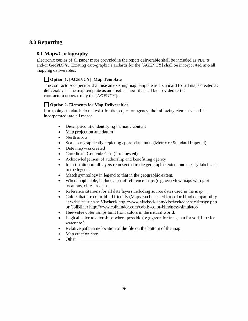
76
8.0 Reporting
8.1 Maps/Cartography Electronic copies of all paper maps provided in the report deliverable shall be included as PDF’s and/or GeoPDF’s. Existing cartographic standards for the [AGENCY] shall be incorporated into all mapping deliverables.
Option 1. [AGENCY] Map Template The contractor/cooperator shall use an existing map template as a standard for all maps created as deliverables. The map template as an .mxd or .mxt file shall be provided to the contractor/cooperator by the [AGENCY].
Option 2. Elements for Map Deliverables If mapping standards do not exist for the project or agency, the following elements shall be incorporated into all maps:
• Descriptive title identifying thematic content • Map projection and datum • North arrow • Scale bar graphically depicting appropriate units (Metric or Standard Imperial) • Date map was created • Coordinate Graticule Grid (if requested) • Acknowledgement of authorship and benefitting agency • Identification of all layers represented in the geographic extent and clearly label each
in the legend. • Match symbology in legend to that in the geographic extent. • Where applicable, include a set of reference maps (e.g. overview maps with plot
locations, cities, roads). • Reference citations for all data layers including source dates used in the map. • Colors that are color-blind friendly (Maps can be tested for color-blind compatibility
at websites such as Vischeck http://www.vischeck.com/vischeck/vischeckImage.php or ColBliner http://www.colblindor.com/coblis-color-blindness-simulator/.
• Hue-value color ramps built from colors in the natural world. • Logical color relationships where possible (.e.g green for trees, tan for soil, blue for
water etc.). • Relative path name location of the file on the bottom of the map. • Map creation date. • Other _____________________________________________________________

77
Option 3. Standard Disclaimer Maps created by a contractor to be distributed to the agency may include a disclaimer.
This map is a product of [CONTRACTOR ] and was provided to the agency in response
to [SPECIFIC REQUEST] for [SPECIFIC PURPOSE].
Maps created for by a contractor on behalf of the agency to distribute to the public shall include a disclaimer.
This map is a product of [AGENCY ] and is distributed to the public for reference purposes only. The map is not designed to provide site-specific information or to be used to establish legal ownership and may not apply to all situations or uses. Information depicted was derived from various sources with varying levels of accuracy. Reasonable efforts have been made to ensure the accuracy of this map, but it is not guaranteed to be without error and the authors and distributors provide no warranty about the content or its accuracy. [ AGENCY ] expressly disclaims responsibility for damages , losses , or liability that may arise from use of this map and further disclaims responsibility for changes that may be made to this map by subsequent users, either electronically or on paper.
Other Disclaimer ____________________________________________________________________________________________________________________________________________________________
Supplemental Requirement Description
Additional Resources Federal Geographic Data Committee. Digital Cartographic Standard for Geologic Map Symbolization http://www.fgdc.gov/standards/projects/FGDC-standards-projects/geo-symbol Colblindor. Color Blindness Viewer Simulator. Web Page. http://www.colblindor.com/coblis-color-blindness-simulator/ VisCheck. Color Blindness Viewer Simulator Web Page. http://www.vischeck.com/vischeck/vischeckImage.php

78
8.2 Project Reporting Project deliverables including progress reports, draft reports and interim data shall be submitted to the [AGENCY] for review at project milestones. A timeline of deliverables and dates shall be developed by the Contractor and reviewed by the Project Manager prior to the start of the project. Interim deliverable data and report products should use Appendix B, Project Submittal Form.
Option 1. Progress Reports Progress Report Due Date __________________________________________ _______________________________ __________________________________________ _______________________________ __________________________________________ _______________________________ __________________________________________ _______________________________ __________________________________________ _______________________________
Option 2. Deliverable Review Data/Report Review Date
__________________________________________ ______________________________ __________________________________________ ______________________________ __________________________________________ ______________________________ __________________________________________ ______________________________ __________________________________________ ______________________________ __________________________________________ ______________________________
Supplemental Requirement Description ______________________________________________________________________________
8.3 Reports and Publications Reports submitted to the [AGENCY] must meet specified criteria outlined by the options below. The responsibility for using the correct format and style as well as printing and distribution costs are assumed by the contractor submitting the report.
Option 1 – Final Unpublished Reports Preparation of reports where large readership is not expected will use readily available fonts (e.g. Arial or Times New Roman), can use limited formatting (e.g.1 column) and will be created in Microsoft Word and/or Open Document Word Processing (ODT) file (the agency will specify what is acceptable). Table of contents will be hyperlinked to each section of the report. Acknowledgments of funding sources must be included in the report. Draft and final draft reports are expected to be submitted for review by the project manager at a specified interval (Section 8.2). Reports shall be submitted in the latest version of Microsoft Word (DOCX), Adobe Acrobat (PDF), and/or an Open Document Word Processing (ODT) file. An electronic copy and at least ____________________ hard copies shall be delivered at the conclusion of the project.

79
Option 2 – Published Reports This option is recommended for reports that will be printed in color and more than 50 hard copies will be distributed, or for which a large readership is expected. The report shall be prepared in Adobe InDesign (or similar software) and use a 2.5-column layout with the following specified font style ______________________________. Logos and acknowledgments of funding sources must be included in the report. If the report is to be distributed on the internet, a font that provides adequate cross-browser compatibility (e.g. Arial or Times New Roman) shall be used. An electronic copy and at least________ hard copies shall be delivered at the conclusion of the project.
Option 3 – Other Report Design Requirements
______________________________________________________________________________ Option 4 – Peer Review
______________________________________________________________________________
Supplemental Requirement Description
Additional Resources National Park Service. Natural Resource Publications Management. http://www.nature.nps.gov/publications/NRPM/ National Park Service. Natural Resource Report, Natural Resource Technical Report, and Natural Resource Data Series. Version 3.2.

80
9.0 Ethics Contractors and agency collaborators have an ethical obligation to government agencies and ultimately the public which fund research and development of data products. It is a moral obligation to be: truthful about data representation, provide confidentiality of sensitive data and to document data process thoroughly.
Code of Conduct (1) I will place quality and objectivity of scientific and scholarly activities and reporting of results ahead of personal gain or allegiance to individuals or organizations. (2) I will maintain scientific and scholarly integrity and will not engage in fabrication, falsification, or plagiarism in proposing, performing, reviewing, or reporting scientific and scholarly activities and their products. (3) I will fully disclose methodologies used, all relevant data, and the procedures for identifying and excluding faulty data. (4) I will adhere to appropriate professional standards for authoring and responsibly publishing the results of scientific and scholarly activities and will respect the intellectual property rights of others. (5) I will welcome constructive criticism of my scientific and scholarly activities and will be responsive to their peer review. (6) I will provide constructive, objective, and professionally valid peer review of the work of others, free of any personal or professional jealousy, competition, non-scientific disagreement, or conflict of interest. I will substantiate comments that I make with the same care with which I report my own work. Signature:________________________________________________________________________
Supplemental Requirement Description
Additional Resources Blakemore, Michael, Longhorn, Roger. 2004. Ethics and GIS: The Practitioners Dilemma. http://www.spatial.maine.edu/~onsrud/GSDIArchive/gis_ethics.pdf. GIS Certification Institute. Code of Ethics. http://www.gisci.org/code_of_ethics.aspx

81
10.0 Other Project Requirements
10.1 _____________________________________________________________________________
10.2 _____________________________________________________________________________
10.3 _____________________________________________________________________________
10.4 _____________________________________________________________________________
10.5 _____________________________________________________________________________

82
Contacts and Document Updates This document will be periodically updated based on new information and resources availability. Submit proposed document updates or modifications to Pat Lineback, Pacific Southwest Region GIS Coordinator, US Fish and Wildlife Service ([email protected]) This project was completed under contract GS10F0325X, Argenta Ecological Consultants, ArgentaEcological.com, Kathie Taylor ([email protected]) Acknowledgements This project was funded by the Pacific Southwest Region of the US Fish and Wildlife Service (USFWS). The project manager was Pat Lineback, Regional GIS Coordinator for Pacific Southwest Region, U.S. Fish and Wildlife Service. Kathie Taylor, Argenta Ecological Consultants, coordinated this project and served as primary writer/editor and synthesized information from many sources for this document. We greatly appreciate and recognize members of the interagency team who provided input, guidance, and oversight for this project including the following organizations and individuals: USFWS (BJ Richardson), California Department of Fish and Game (Tom Lupo), National Park Service (Margaret Beer, Elena Robisch, and Tim Smith), United States Geological Survey (Jennifer Carlino and Emily Fort), and University of California, Davis (Jim Quinn). In addition we would like to express our gratitude for the focused review and assistance provided by USGS (Carol Ostergren, John Faundeen, Elizabeth Sellers), USFWS (Joshua Bradley, Johnny Hunt, Michael Hayden, David Hills, Les Vilcheck, Sean Killen, Hilmar Maier and Lee Sutta), NPS (Craig Dalby, Chris Dietrich and Jay Flaming), California Department of Water Resources (Greg Smith) and to the many others who provided feedback to create a practical and useful document. Finally, special thanks to Richard Kearney, Assistant Regional Director for Science Applications, Pacific Southwest Region, US Fish and Wildlife Service who championed this project in response to a growing need to standardize and improve the quality of contractor provided data to federal and state agencies.

83
Appendix A
Statement of Work Template

84
STATEMENT OF WORK
(Project Title)
(Revision & Date)
1. GENERAL: (background statement outlining the situation leading to the requirement and a clear statement describing the objective of the task and the work to be achieved.)
2. DEFINITIONS: (if applicable, definitions of terms used in the SOW that may be open to various interpretations or are specific to the requirement or station).
3. SCOPE: (an accurate description of the scope of work, including its range, extent and bounds. Be specific, yet simple, with the idea that the person processing this procurement may not be familiar with your need and may not have a clear understanding of the technical requirements).
4. PLACE/DELIVERY AND PERIOD OF PERFORMANCE: (a time schedule for the completion of each stage of the work and for the entire work, and a detailed description of deliverables under the contract.)
5. INSPECTION AND ACCEPTANCE: (clear statement on inspection factors for acceptance of deliverables).
6. GOVERNMENT FURNISHED EQUIPMENT OR MATERIALS/INFORMATION: (if applicable, a clear description of all government furnished equipment or information).
7. AVAILABILITY: (specific statement regarding any availability issues of the work site, or location, i.e. hours, security requirements, weather issues, resource issues such as habitat restrictions, etc.)
8. TECHNICAL COORDINATOR: (contact at the requestor’s location that can be contacted regarding technical questions.)

85
Appendix B
Project Submittal Form

86
Example of Project Submittal Form
Project: _________________________________________ Date: _______________________ Submitted to: _________________________________________ Contract Number: __________________________ Data Created by: ______________ Contact: ______________________________________________
Data Type File Name Description Access Restriction Metadata Access (File Path)

87