d.5 cultural and paleontological resources · meaning 'master' (bean, 1978). the...
TRANSCRIPT

El Casco System Project D.5 CULTURAL RESOURCES
December 2007 D.5-1 Draft EIR
D.5 CULTURAL AND PALEONTOLOGICAL RESOURCES
This section discusses the potential for the Proposed Project and alternatives to impact both previously identified and unanticipated cultural resources in the project area during construction and operation. Background information for the project area is provided (Section D.5.1) along with a list of applicable regulations (Section D.5.2). Potential impacts and mitigation measures for the Proposed Project and alternatives are outlined by project component in Sections D.5.3 through D.5.6.
A cultural resource is defined as any object or specific location of past human activity, occupation, or use, identifiable through historical documentation, inventory, or oral evidence. Cultural resources can be separated into three categories: archaeological, building and structural, and traditional resources.
Archaeological resources include both historic and prehistoric remains of human activity. Historic resources can consist of structures (such as cement foundations), historic objects (such as bottles and cans), and sites (such as trash deposits or scatters). Prehistoric resources can include lithic scatters, ceramic scatters, quarries, habitation sites, temporary camps/rock rings, ceremonial sites, and trails.
Building and structural sites can vary from historic buildings to canals, historic roads and trails, bridges, ditches, and cemeteries.
A traditional cultural resource or traditional cultural property (TCP) can include Native American sacred sites (such as rock art sites) and traditional resources or ethnic communities important for maintaining the cultural traditions of any group.
Paleontology is the study of life in past geologic time based on fossil plants and animals and including phylogeny, their relationships to existing plants, animals, and environments, and the chronology of the Earth's history. A paleontological resource is a locality containing vertebrate, invertebrate, or plant fossils (i.e., fossil location, fossil bearing formation or a formation with the potential to bear fossils). The paleontological resources are considered a fragile and nonrenewable scientific record of the history of life on earth, and so represent an important and critical component of America's natural heritage.
Information for the Proposed Project and Alternatives was gathered from the PEA (SCE, 2007a) prepared by SCE for the CPUC, along with archaeological survey reports prepared on SCE’s behalf by LSA Associates, Inc. (LSA). These data were reviewed and verified by the CPUC consultants who developed this EIR.
The data collection methodology for both studies included the following:
• Records search conducted at the Eastern Information Center (EIC) at the University of California, Riverside and at the San Bernardino Archeological Information Center (SBAIC) at the San Bernardino County Museum in Redlands, CA consisted of a review of relevant historic maps and excavation and survey reports. Site forms for recorded sites within a 0.5-mile radius of the project route and substations were copied. The Native American Heritage Commission (NAHC) was asked to provide a search of its Sacred Lands File.
• A paleontology literature and records review was conducted at the San Bernardino County Museum to determine whether sensitive paleontological resources are within or adjacent to the project study area (Reynolds, 2005).
• Field surveys were conducted in order to verify the location of any previously identified cultural resources and to inspect previously unsurveyed lands within the project study area. Field surveys are useful for identifying aboveground or surface cultural resources and for identifying high-probability areas. However,

El Casco System Project D.5 CULTURAL RESOURCES
Draft EIR D.5-2 December 2007
negative pedestrian survey results do not preclude the possibility that buried archaeological deposits could be discovered. LSA’s intensive pedestrian field surveys were conducted by Phil Fulton, Chris Roberts, Andy Jackson, Brent Jones, and Shannon Carmack (McLean et al., 2006a).
LSA’s archival research indicated that a total of 223 surveys had been conducted within a half-mile of the Proposed Project route. Of these, 97 reports include various portions of the current study area. Information gathered from archival research and field surveys were also used to assess the potential for encountering previously unrecorded cultural and paleontological resources in the project area.
SCE contacted the Native American Heritage Commission (NAHC) on April 20, 2006, and the NAHC responded with a list of Native American individuals/organizations that may have knowledge of cultural resources in the project area. Native American Consultation Letters were sent out by SCE on April 13, 2007 to NAHC-listed Riverside and San Bernardino County contacts requesting information on any sacred lands or sites within the proposed and alternative routes. As of August 1, 2007, SCE received a follow-up letter response from the Agua Caliente Band of Cahuilla Indians and a request for additional information from the Morongo Band of Mission Indians. SCE provided Morongo with a copy of the Cultural Resources Technical Study on June 13, 2007. NAHC correspondence letters and a table of contacts and comments (which includes Native American comments) are presented in Appendix 6.
D.5.1 Environmental Setting for the Proposed Project
Natural Setting and Paleontological Background
The natural setting of the Proposed Project has been summarized by McLean et al. (2006a). The Proposed Project is located in the San Timoteo Canyon and San Gorgonio Pass. The San Bernardino Mountains are in the Transverse Ranges geomorphic province (Norris and Webb, 1990:330). The Transverse Ranges are an east-west trending mountain range at the northeast end of the Los Angeles Basin. This range has some of the highest peaks south of the Sierra Nevada range (Norris and Webb, 1990:330). The San Bernardino Mountains are about 65 miles (105 km) long and 30 miles (48 km) wide at their widest point. The basement rocks of the San Bernardino Mountains are made up of gneisses and schists. Most of the range is made up of quartz monzonite that dates from the late Cretaceous. The mountains contain a few Cenozoic deposits including Pliocene basalt flows and Quaternary fluvial and lacustrine deposits (Norris and Webb, 1990:332).
The San Gorgonio Pass forms a natural break between the San Bernardino Mountains to the north and the San Jacinto Mountains to the south. It is an east-west trending lowland between the two mountain ranges. The surface of the lowland is composed of alluvial fan deposits, mainly from the San Bernardino Mountains. The northern foothills are underlain by upper Cenozoic nonmarine and marine sedimentary deposits (Morton, 1999).
The pass drains to the east into the Coachella Valley and to the west into the Los Angeles Basin. One of the major drainages to the west of the pass is San Timoteo Canyon, which trends generally in an east-west direction. The canyon bisects terraced badlands that are composed of Quaternary and Tertiary nonmarine sediments that date from the Pliocene to the Pleistocene. The pass and canyon areas are composed of late Holocene wash deposits that cut into younger alluvial deposits that date from the late Pleistocene to Holocene. There are exposures of older alluvial and channel deposits from the middle to late Pleistocene that derive from the surrounding mountains (Morton, 1999).

El Casco System Project D.5 CULTURAL RESOURCES
December 2007 D.5-3 Draft EIR
The sedimentary record within the Proposed Project area represents several depositional events, perhaps in response to tectonic activities. These rock units, as described by Robert Reynolds (2005), are discussed below, in their order of deposition.
• Mt. Eden Formation. These lacustrine sediments were deposited on the granite of Potrero Canyon in late Miocene time, 6 million years ago (Ma). This formation is considered to have high potential to contain significant nonrenewable paleontological resources.
• San Timoteo Formation. This Plio-Pleistocene formation consists of siltstones, sandstones, and gravel fanglomerates and was deposited between 2.5 to 0.5 Ma (Albright, 1999; Morton, 1999 v.2; Reynolds, 1986). This formation is considered to have high potential to contain significant nonrenewable paleontological resources.
• Late Pleistocene Alluvium and Terrace Deposits. This formation consists of flat-lying sediments, soil horizons, fine grained fluviatile sediments, and older alluvim of Late Pleistocene age. These deposits were laid down approximately 50,000 years ago and may contain significant paleontologic resources.
The Proposed Project traverses through the South Coast Bioregion, which includes, but is not limited to, the following biotic communities: Riversidean Sage Scrub, Riparian Woodland, Southern Oak Woodland, Chaparral, Cismontane Rural, and Creosote Bush-Low Desert Scrub (Holland, 1986; Jaeger and Smith, 1966). Within these six varied biotic communities, hundreds of different plants, mammals, birds, reptiles, amphibians, and insects coexist. See Section D.4 (Biological Resources) for a detailed description of the biotic communities in the project area.
Ethnographic Background
The Proposed Project crosses through the ethnographic territories of the Cahuilla and Serrano people. The following paragraphs from Supplemental Cultural Resource Assessment Oak Valley Substation Project, San Bernardino and Riverside Counties (McLean et al., 2006b:8-10) provide a brief description of each group.
The Proposed Project is located near the intersection of the traditional tribal boundaries of the Serrano, Cahuilla, and Gabrielino. The study area in San Timoteo Canyon and the San Gorgonio Pass is traditionally in Cahuilla territory. The term 'Cahuilla' is a Spanish version of the Native word káwiya, meaning 'master' (Bean, 1978). The territory of the ethnohistoric Serrano included the San Bernardino Mountains east of the Cajon Pass, extending eastward to the Twentynine Palms region and north toward Victorville (Bean and Smith, 1978a). The Mill Creek study area is on the border between the territories of the Serrano and Cahuilla. “Serrano” is a Spanish word meaning mountain dweller. The Serrano village called Yukaipa 't was located near the present city of Yucaipa after which it was named. Gabrielino territory included the watersheds of the San Gabriel and Santa Ana Rivers, the Los Angeles Basin, and the coast from Aliso Creek at the south to Topanga Creek at the north, as well as the southern Channel Islands. Bean and Smith, (1978a:538) show Gabrielino territory extending to the City of San Bernardino, but not into the project area.
Cahuilla. The Cahuilla occupied areas in the San Gorgonio Pass area, including San Timoteo Canyon, the San Jacinto Mountains, and the western Coachella Valley. The Cahuilla have been divided into three broad groups based on their geographic distribution: Desert Cahuilla, Mountain Cahuilla, and Western (or Pass) Cahuilla. These divisions are loose geographic groupings of small independent villages that differed from each other in speech and custom (James, 1960:37).
The Cahuilla practiced a hunter-gatherer lifestyle and lived in permanent communities located near water such as springs, wells, or streams. The most important factors for choosing a community site
El Casco System Project D.5 CULTURAL RESOURCES
Draft EIR D.5-4 December 2007
were the presence of a stable food supply, water, and some measure of protection from wind, cold in winter, and heat in summer (James, 1960). Among the chief foods of the Cahuilla were acorns and mesquite seeds. Other foods included western juniper, pine nuts, yucca, cactus, rabbit, and deer (Barrows, 1971, James, 1960).
Politically, the Cahuilla were divided into two moieties, the Istam (Wild Cat) and the Tuktum (Coyote). The moieties were then subdivided into clans, membership of which was patrilineal. Each clan was led by a chief, or net. The net acted as judge and chief administrator for the clan. If matters concerned more than one clan, then consultations were held among the various nets, which came to a consensus decision. The net lived in a ceremonial house, or kishumnawat, which was circular in shape, built of timber with thatch on the walls and roof. The houses, or kish, in which the Cahuillas lived were similar to the ceremonial house in shape and construction (James, 1960). The Cahuilla also used a sweathouse, or tomekish, as did other southern California groups.
The Cahuilla lived in permanent villages as well as occupied temporary, seasonal camps where they came to hunt or gather acorns. The Western Cahuilla had villages at Banning, Stubbe Canyon, White Water Canyon, Snow Creek Canyon, Tahquitz Canyon, and Palm Springs. The Mountain Cahuilla lived in Coyote Canyon, Terwilliger Flats, Santa Rosa Peak, and Rock House Canyon. A branch of the Mountain Cahuilla led by Juan Antonio set up a village at the invitation of the Lugo family outside of the present city of Riverside. Juan Antonio then moved into San Timoteo Canyon and established the village of Sahat 'pa (Saahatpa, Sahatapa, Sahat) near El Casco Lake. The Desert Cahuilla placed their villages near springs. There were villages at Fish Springs, Coachella, Agua Dulce, La Mesa, and Torres (James, 1960). The Cahuilla were exploiting the water sources within the pass area as well as San Timoteo Canyon. Besides the historic village of Sahat 'pa, the Cahuilla had an ethnographic habitation site (CA-RIV-57) south of the present city of Banning, southeast of the study area. Recorded in 1984 by Sutton and Arkush, CA-RIV-57 included slicks, bedrock mortars, a midden, pictographs, and a small rock shelter (Sutton and Arkush, 1984).
The Cahuilla had well-established trade and marriage relationships with their neighbors (the Gabrielino, Luiseño, Kumeyaay, Serrano, Chemehuevi, Mojave, and Yuma) (Bean et al., 1981). After Euro-American contact, the Cahuilla incorporated aspects of European culture into their own and appeared to actively pursue such contact. This is evidenced by the actions of such leaders as Juan Antonio, Cabazon, and Antonio Garra (a Cupeño), who strengthened themselves politically by such contact (James, 1960; Phillips, 1975; Bean et al., 1981). This political control continued into the American Period (Bean et al., 1981).
In the 1860s, the Cahuilla outnumbered Euro-Americans; however, the smallpox epidemic of 1862-1863 decimated the Native populations. They were rapidly replaced by the Euro-Americans, and their plight attracted national attention (Bean et al., 1981). In 1877, reservations were created for the Cahuilla, including Morongo, Torres-Martinez, Los Coyotes, Santa Rosa, and Agua Caliente. Indian schools were created at the same time. However, the Cahuilla were able to maintain their political systems and religion. Besides the Cahuilla, other groups living on the Morongo Reservation include the Serrano and Cupeño (Tiller, 1995:274).
Serrano. The Serrano were hunter-gatherers. The men hunted and fished and the women gathered acorns and piñon nuts, which were supplemented with roots, bulbs, shoots, and seeds. They hunted deer, mountain sheep, antelope, rabbits, and quail. Meat was prepared in earth ovens or boiled. Surplus meats and vegetable foods were sun-dried for later use. The Serrano used metates, mortars, flint knives, scrapers, bowls and trays made of pottery, baskets, and horn and bone spoons as utensils for

El Casco System Project D.5 CULTURAL RESOURCES
December 2007 D.5-5 Draft EIR
preparing food (Bean and Smith, 1978b:571). The Serrano were very much like their neighbors, especially the Cahuilla. They used a variety of shells, bone, wood, stone, and plant fibers to make tools and other implements.
The Serrano were organized into two exogamous moieties, the Wildcat and the Coyote. The clans were affiliated with one of the two moieties. The clan leader (kika) had both political and religious duties. The leadership was passed from father to son. The kika lived in the ceremonial house and was assisted in his duties by the paxa, whose office was also passed from father to son. The paxa was in charge of the "sacred bundle containing all ceremonial paraphernalia". The position and functions of the kika and paxa were similar to the other Takic speakers in southern California, but the Serrano were unique in that the kika and paxa were of different moieties (Bean and Smith, 1978b:572).
Villages were placed near permanent water. Serrano dwellings were circular, domed structures built of willow and thatched. The house served primarily for sleeping and storage, other activities were carried out outside or under a ramada. The villages had a large ceremonial house where the leader lived. The ceremonial house was the religious center for the Serrano. Other village structures included a granary and sweat house (Bean and Smith, 1978b:571).
Prehistoric Background
The prehistoric cultural sequence within the Proposed Project route has been summarized by McLean et al. (2006a:8-10) as follows.
The development of a regional chronology marking the major stages of cultural evolution in the southern California area has been an important topic of archaeological research. In general, cultural developments in southern California have occurred gradually and have shown long-term stability; thus, developing chronologies and applying them to specific locales have often been problematic. Southern California researchers have used changing artifact assemblages and evolving ecological adaptations to divide regional prehistory into four stages. Wallace (1955; 1978) and Warren (1968) have developed the two chronologies most commonly cited. Wallace (1955) uses major cultural developments to divide area prehistory into four time periods, or "cultural horizons": the Early Period, the Milling Stone Period, the Intermediate Period, and the Late Period. The following overview is based primarily on Wallace's chronology, which has been revised slightly by Koerper (1981) and Koerper and Drover (1983).
Neither of the chronologies cited begin prior to the Terminal Pleistocene ca. 12,000 years before present (BP). While more sites in North and South America are beginning to be accepted as dating to earlier times, none has been documented within the project region.
The Early Period (Prior to 6000 B.C.). The Early Period (also known as the Hunting Period) covers the interval from the first presence of humans in southern California until post-glacial times (5,500 to 6,000 B.C.). Artifacts and cultural activities from this period represent a predominantly hunting culture; diagnostic artifacts include extremely large, often fluted bifaces associated with the use of the spear and atlatl. In Southern California, important Early Period sites have been found near prehistoric Lake Mohave and along the San Dieguito River (Wallace, 1955, 1978:27; Moratto, 1984:81, 93-99).
The Milling Stone Period (6,000 B.C. - 3,000 B.C.). The transition from the Early Period to the Milling Stone Period is marked by an increased emphasis on the processing of seeds and edible plants and is estimated to have occurred between 6,000 B.C. and 3,000 B.C. According to Wallace (1978:28), wild seeds and edible plants formed the primary food source during this period, with only limited use of

El Casco System Project D.5 CULTURAL RESOURCES
Draft EIR D.5-6 December 2007
shellfish and faunal resources; plant resources were processed using deep-basined mills and handstones, hence the term Milling Stone Period. Milling Stone Period settlements were larger and were occupied for longer periods of time than those of the Early Period, and mortuary practices included both flexed and extended burials as well as reburials. Grave offerings were few, although rock cairns were sometimes placed over the bodies (Wallace, 1955:192, Table 1; 1978:28).
Diagnostic artifacts recovered from Milling Stone Period archaeological sites include metates, manos, and large projectile points indicating the continued use of darts and atlatls. Among the more enigmatic artifacts from this period are discoidals and cogged stones. Discoidals are round to ovoid ground stones with flat or slightly convex faces and edges, while cogged stones are discoidals with serrated edges resembling the teeth on gears. Both types of artifacts appear sometime around 4,000 B.C. and are dated to the Milling Stone Period; their use remains unclear, and they may have had a ceremonial function (Moratto, 1984:149-150).
Wallace (1978:28) offers two possible scenarios to explain the cultural changes that occurred during the Milling Stone Period; quite possibly, both processes occurred simultaneously in different geographical areas. In some regions (such as western San Diego County), Milling Stone cultures may have evolved gradually as the earlier hunting peoples learned to exploit a wider variety of food resources. In other areas, people migrating from interior regions may have introduced the technology for processing seed and plant foods to coastal areas. Evidence for such migrations may be found in climatic data. The onset of the Milling Stone Period corresponds to an interval of warm, dry weather known as the Altithermal; during the Altithermal, many of the inland lakes disappeared and the region became less habitable, perhaps triggering the coastal migrations believed to have occurred at this time (Wallace, 1978:28).
The Intermediate Period (3,000 B.C. - A.D. 500). By approximately 3,000 B.C., the inhabitants of southern California were exploiting a diverse array of food resources, including seeds and edible plants, shellfish, fish, and mammals. Along the coast, a greater reliance was placed on marine food resources as evidenced by the recovery of near-shore and pelagic (deep-water) fish remains from archaeological sites. In the interior regions such as the Mojave Desert, the return of cooler, moister conditions led to increased populations along streams and lakes. Hunting appears to have been the primary food-gathering activity in these interior areas; the best known sites in this region are located at Pinto Basin in northeastern Riverside County (Moratto, 1984:153; Wallace, 1978:30-31).
Intermediate Period sites are characterized by the appearance of the mortar and pestle (although the mano and metate continued in use) and small projectile points. The use of the mortar and pestle may indicate an increased reliance on acorns as a food source, while the small projectile points suggest that the bow and arrow was in limited use (Elsasser, 1978:55; Wallace, 1978:30-31). The circular shell fishhook also made its appearance in coastal sites during this period; the circular fishhook is found most abundantly in areas adjacent to rocky coastline and may have been less subject to fouling than gorges and other types of hooks (Strudwick, 1986:283-284). Intermediate Period burials were generally by interment in a flexed position, face down, although a site at Big Tujunga Wash in the San Fernando Valley contained both reburials under stone cairns and cremations (Elsasser, 1978:55; Wallace, 1955:193-195). Researchers have had difficulty distinguishing Intermediate Period sites, since many of the tool types appear in earlier and later periods; the few known sites have often been identified using radiocarbon or obsidian hydration methods.
The Late Period (A.D. 500 - A.D. 1769). The Late Period (which began in approximately A.D. 500) witnessed a number of important cultural developments in southern California, including the concentration of larger populations in settlements and communities, greater utilization of the available

El Casco System Project D.5 CULTURAL RESOURCES
December 2007 D.5-7 Draft EIR
food resources, and the development of regional subcultures. Cremation was the preferred method of burial during the Late Period, and elaborate mortuary customs with abundant grave goods were common. Other cultural traits diagnostic of the Late Period include increased use of the bow and arrow, steatite containers, circular shell fishhooks, asphaltum (as an adhesive), bone tools, and personal ornaments of bone, shell, and stone (Wallace, 1955:195; Bean and Smith, 1978a: Elsasser, 1978:56; Moratto, 1984:159). Because many of these artifacts are also recovered from earlier periods, other indicators must sometimes be used to distinguish Late Period sites. Among the most useful of these indicators are lithic artifacts manufactured from obsidian. Obsidian from Obsidian Buttes near the Salton Sea was used sporadically in the manufacture of lithic artifacts until sometime after A.D. 1,000, when its use in the Los Angeles Basin became much more common (Hall, 1988).
A number of the cultural elements found in southern California during the Late Period have been linked to the migration of Uto-Aztecan speaking peoples from the Great Basin; these traits include the manufacture of ceramics, the use of small triangular arrow points, and interment by cremation. The date of the Uto-Aztecan migration (which probably occurred in several successive waves over an extended period of time) remains uncertain; it has been dated as early as 2,000 B.C. and as late as A.D. 700. Linguistic evidence suggests a date of A.D. 1 to 500 (Kroeber, 1925:574-580; Koerper, 1979; Moratto, 1984:161).
Historic Background
The historic context within the Proposed Project route has been summarized by McLean et al. (2006a:12-39) as follows.
Mission Period (1771 - 1834). In 1769 a mission was established in what is today the city of San Diego, ushering in the Mission Period of California history. Closest to the study area, Mission San Gabriel Arcangel was established in the San Fernando Valley in 1771. Subsequently, several estancias (ranches) were established throughout the surrounding area to provide the missions with agricultural goods. One such estancia was Guchama, originally built in what is now Loma Linda in 1819, but relocated to the head of the San Timoteo Canyon in 1830. The second location included a 14-room adobe and timber complex.
In 1821, Mexico won its independence from Spain, and Spanish California became Mexican California. In 1823, the San Gorgonio Rancho was established northwest of the modern city of Banning at the highest point of the San Gorgonio Pass. The rancho was used for grazing livestock, but not for other agricultural activities. The location of this rancho placed it on the path traveled to bring salt from the Salton Sink to Mission San Gabriel and the pueblo of Los Angeles.
Rancho Period (1834 - 1848). With the secularization of the missions, the Mission Period came to an end and the Rancho Period began. The Mexican Governor began to grant land throughout California. Only one grant was made in the study area (the San Timoteo Rancho land grant). The holder of the land grant began cattle ranching.
The more notable ranchos and settlements include San Timoteo and San Gorgonio. While these ranchos were owned by, and had parts rented by or given to, Mexican and occasionally American settlers, much of the manual labor was performed by former mission Indians.
In 1842, the Lugo family, who owned Rancho San Bernardino northwest of the study area, enlisted the help of the Cahuilla leader Juan Antonio to help protect their lands from Indian raids. Juan Antonio would remain in the San Timoteo Canyon area until his death in 1862 and maintain control over
El Casco System Project D.5 CULTURAL RESOURCES
Draft EIR D.5-8 December 2007
between 20 to 30 Cahuilla villages. He would prove an important figure in reducing raids by Ute Indians and outlaws, as well as keeping the Cahuilla out of trouble with the Mexican and American authorities.
American Period (1848 - 1900). Following the signing of the Treaty of Guadalupe Hildago in 1848, the United States took possession of California. The treaty bound the United States to honor the legitimate land claims of Mexican citizens residing in captured territories. The Land Act of 1851 established a board of Land Commissioners to review these records and adjudicate claims and charged the Surveyor General with surveying confirmed land grants. In order to investigate and confirm titles in California, American officials acquired the provincial records of the Spanish and Mexican governments, located in Monterey. Those records, most of which were transferred to the U. S. Surveyor General’s Office in San Francisco, included land deeds and sketch maps (Gutierrez et al., 1998).
From 1852 to 1856, a board of Land Commissioners determined the validity of grant claims. Rejected land claims reverted to public domain, and the land then became available for squatters. Ranch titles represented little as collateral. Although the claims of some owners were eventually substantiated, many of the owners lost their lands through bankruptcy or the inability to meet the exorbitant interest on their legal debts (Atkinson, 1933). Many of the original rancho owners eventually lost their land to the United States. Unsurveyed land boundaries created a loophole through which squatters could occupy plots on the fringes of land grants and eventually come to own those plots through squatters’ rights (Gutierrez et al., 1998).
San Timoteo Canyon
Duff Weaver. The residence of Duff Weaver is likely to be within the project area. Weaver has long been considered to be one of the first Anglo settlers of San Timoteo Canyon. Born in 1823, Weaver came to California in the spring of 1849 following in the footsteps of his brother Paulino Weaver who had already established a residence nearby in the area known as Highland Springs. Duff Weaver's lands consisted of 1000 acres, which he used to graze cattle, sheep, and horses. In 1853, Weaver married Amanda Applegate, the daughter of important local, Zina Ayers. The Weavers had eight children (Ingersoll, 1902:669).
Weaver became best known for his friendship with Chief Juan Antonio. During the nineteenth century, there was a general hostility between Indians and whites, who both perceived the other as encroaching on territory. However, Weaver and Juan Antonio became good friends and neighbors. Weaver often acted as a mediator between the Native Americans and the white men (Christian, 2002:166).
During the fall of 1862, a smallpox epidemic struck Los Angeles and southern California. The Indians were especially hard hit. In order to assist his friend, Weaver brought the Indians food and whatever comfort he could provide (Smith et al., 1960; Phillips, 1975), hiring a Mexican who was immune to the disease to care for Juan Antonio and his tribesmen (Smith et al., 1960). Unfortunately, Weaver could not do enough for his friend and Juan Antonio died near the end of February 1863. Juan Antonio was buried at Sahat'pa near the historic San Timoteo Schoolhouse.
Weaver continued to live in San Timoteo Canyon until his death in 1869. The Goldsworth 1872 Plat records the Weaver house between Acosta and Noble in San Timoteo Canyon in the vicinity of the proposed El Casco Substation. There is potential to find buried archaeological deposits and/or structural remains related to Duff Weaver at this location.

El Casco System Project D.5 CULTURAL RESOURCES
December 2007 D.5-9 Draft EIR
San Timoteo Rancho. The Land Commission initially failed to confirm the original land grant made to James Johnson in 1843; however, after Luis Rubidoux, who purchased the land from Johnson in 1845, filed a land claim in 1860, the District Court reversed the decision (Beattie and Beattie 1951:68, Hughes, 1938:6). In July of that same year the census taker noted Rubidoux's son Pascal (aged 21), Pascal's wife Maria (aged 16), and their son Alfredo (2 months) as living on the San Timoteo property, residing in the household adjoining Duff Weaver, who lived about one mile to the north. Also residing with Pascal Rubidoux were three laborers (Manuel Mean, 46, Mexico; Victor Alvares, 30, Sonora; and Bicente, 35, Italy). In 1862, Rubidoux's San Timoteo Ranch was noted as "known as the Mitchell or Lennon property," possibly tenants. By 1870 Pascal Rubidoux was residing on his father's Rancho Jurupa, suggesting that he resided on the San Timoteo Rancho for only a brief period.
The San Timoteo Rancho remained in the possession of the Rubidoux family until the death of Luis Rubidoux in 1867. That year the “valuable rancho” was listed for sale with the notation that it was “well watered with never failing springs; a handsome Dwelling House, and Out-Houses attached, and known as the ‘Robidoux Rancho’” (The Guardian, July 6, 1867).
On February 14 of the following year his widow, Guadalupe Garcia de Rubidoux (signed with an X), sold the entire rancho to James Singleton. The sale noted that she was doing so as the administrator of the estate of Rubidoux, and that it would be deeded when title was confirmed to the heirs of Rubidoux (County of San Bernardino Deed Book: 1-619). The selling price was $3,000 for the 6,000 acres (The Guardian, February 8, 1868).
Dudley Pine/Smith Humphrey. One of the earliest documented settlers in San Timoteo Canyon was Dudley Pine. Pine settled near the northwestern boundary of the Rubidoux land grant, presumably around 1851, when the Mormons were acquiring the San Bernardino Rancho. Pine built a large adobe on the property and established an apple orchard near a creek. In July of 1860, when the census taker visited the property, Pine was noted as a farmer, aged 39, and a native of New York. Residing in the household were his wife Elizabeth, and laborers, James Maldemon and William Stowek.
Sometime between 1860 and 1862, Pine sold the land to Smith Humphrey and returned to San Bernardino to operate several successful hotels. Despite never actually holding legal claim to the land, Humphrey purchased the land from Pine and moved his family into the adobe (Christian, 2002:162; Frink, 1936). By 1860, Humphrey was residing in San Bernardino City and working as a farmer. Two years later Smith Humphrey and his son were assessed for the Pine property in San Timoteo Canyon. The Humphreys remained on the land until the early 1870s, when the San Timoteo Rancho was resurveyed and the property was found to be within the limits of the Singleton Ranch. Singleton promptly evicted all the residents he found to be squatting on his property. Singleton kept the adobe on the property, presumably using it as a storage shed. A newspaper article about the ranch in 1932 reported that the adobe had been covered with wood siding to protect it from the elements (Ewing, 1932).
The exact location of the original Dudley Pine/Smith Humphrey adobe is unknown, but a photograph depicted in a 1932 (Ewing) article noted that it had been covered with wood to preserve it. Based upon the photograph and the building’s location near the barn, the knowledge of the correct location of the Singleton house and other features, and historic photographs, its location may be determined. It appears possible that it is subsumed beneath one of the extant guest houses on the ranch. A portion of the Woodhouse Ranch (Singleton Ranch Complex - CA-RIV-7296) falls within the project area.

El Casco System Project D.5 CULTURAL RESOURCES
Draft EIR D.5-10 December 2007
James Singleton. James Singleton, an engineer and native of England, his wife, Ann, and their two children, William and Ann, moved onto the San Timoteo Rancho shortly after purchasing it for $3,000 in 1868. After the San Timoteo Ranch was surveyed in 1871, James Singleton forced off, or made tenants of, the settlers who believed they had established their homesteads on government land. Most of these ranchers were located on the San Timoteo Canyon side of the property and included the families of Duff Weaver, Smith Humphrey, Manuel Acosta, Diego Lovetta (Lobarta, Livatt), William Kennedy, and others (Goldsworthy 1871, U.S. Federal Census 1870).
Sometime in the 1870s, after the squatters had departed, James Singleton built a large two-story frame house on the west side of the property, approximately 1.2 miles northeast of the Haskell Ranch, where Singleton Road joined San Timoteo Canyon Road (Christian, 2002:180). The house faced west and was located at the junction of Singleton/Woodhouse Road, where it turned south to the present Haskell Ranch. In 1880 James was residing in his new house with wife Ann, then bedridden, and daughter Ann and grandchildren (U.S. Federal Census, 1880). James and Ann’s son, William, and his wife Lydia were still residing on the east side of the ranch (Christian, 2002:181; U.S. Federal Census 1880). Their home, also a two-story frame house (Christian, 2002:181), was located at a bend in the ranch road near the present 1920s sheds. Although two of William Singleton's children married, neither had any children and the branch died with them (Haskell, 2004a).
James Singleton appropriated all of the water in San Timoteo Creek, an act that initiated an 1880s lawsuit by ranch owners below the property and resulted in a ruling that allowed alternating use of the water by Singleton and other ranchers on a five-day cycle. The lawsuit was not settled until 1884, three years after the death of James Singleton (Frink, 1936; Christian, 2002; Strickland, 1998).
In 1886, when they registered to vote, William Singleton (son of James) listed his occupation as farmer, while his nephew, originally William Henry Wilshire, who had by then changed his last name to Singleton, listed his occupation as dairyman. This was apparently the entry of the Singleton and Haskell clan into the dairy business (U.S. Federal Census, 1900). In 1908 the “Singleton Dairy Company of Redlands” was awarded the contract to provide fresh butter to the State Hospital at Patton near San Bernardino (Los Angeles Times, January 13, 1908). Two years later William H. Singleton listed his occupation as operator of a dairy farm, owning it free and clear.
In 1911, the same year that the Singletons and Haskells purchased the Noble/Clough Ranch (the southern portion of the original San Timoteo Rancho), they sold the Singleton Ranch to a group of investors and incorporators. The group also purchased the 114-acre Vanderventer Ranch and the 116-acre Goetting Ranch, a total of 2,966 acres. The intent of the company was to operate the ranches on the "intensive plan," with the Singleton Ranch continuing to be operated as a dairy and the remainder of the land devoted to the growing of grain and breeding all kinds of livestock (Los Angeles Times, June 4, 1911).
Four years later the syndicate decided to place part of the ranch on the market as the Redmont Fruit Farms (Los Angeles Times, February 7, 1915). By 1919 it was noted that the El Casco Land Company (owners of the old Singleton Ranch) and the El Casco Water Company were selling their water rights to the ranchers in the Moreno Valley. The ranchers formed a mutual organization to buy out the entire property and deliver its developed supply of water through the construction of a four-mile tunnel from the Singleton Ranch to the Moreno Valley. The new owners of the El Casco property were to develop the land by sinking several new wells to augment the supply from the four flowing wells, thus supplying the Moreno Valley with enough water to irrigate 2,500 acres.

El Casco System Project D.5 CULTURAL RESOURCES
December 2007 D.5-11 Draft EIR
Woodhouse. The land on which the James Singleton house stood, on the west side of the original ranch near San Timoteo Canyon Road, was sold to Los Angeles residents Rush and Ethel Woodhouse in 1927. Living on the property in 1930 were Rush L. Woodhouse, aged 53, a native of Iowa; his wife Ethel, aged 32, born in Michigan; and her brother, Stanley Hoisington, aged 19. Woodhouse listed his occupation as “cattle farmer.” Residing in the adjoining household was Ed Spences, a 68-year-old native of Connecticut who was working on the farm (U.S. Federal Census, 1930).
Woodhouse built the new log house on the property, razed the old Singleton house, and used the timbers for the log house and lumber, doors, windows, etc., to build the two guest houses on the ranch. Woodhouse farmed about 750 acres, with additional land for pasturage. His "hobby" was raising Hereford cattle, of which he had 120 head.
Vanderventer Ranch. In 1865 the family of Michael Van der Venter (generally spelled Vanderventer) moved to San Timoteo Canyon near El Casco Lake from their earlier home near present Beaumont. Known as "Mich," Vanderventer was a native of New York and of Dutch descent. Vanderventer had come to California by way of New Mexico, where he married his wife Frances Diaz. In 1860, the couple was residing in a household with their children and laborer, John Gate (U.S. Federal Census 1860).
By 1870, Vanderventer was noted as living in San Timoteo Canyon and working as a farmer. Mich Vanderventer began freighting from San Bernardino to the Colorado River, was wounded by an Indian arrow on one of his trips, and died shortly thereafter (Christian, 2002:156). In 1880, son Eugene was listed as the head of the household, and residing with his mother Frances and siblings Byron, James, and Frances (U.S. Federal Census 1880).
In 1882, William Singleton sold a portion of his ranch located southwest of the William Singleton residence to Eugene Maclove (E.M.) Vanderventer. Born in 1857, E.M. Vanderventer was the second son of Michael Vanderventer and Francisca Diaz. In 1881, E.M. Vanderventer married Martha Jane Wilshire, the daughter of Ann Singleton (and granddaughter of James Singleton) and her first husband. Vanderventer established a residence and ranch on the property and grazed cattle (Ewing, 1932). Vanderventer, assisted by local farmers, built the San Timoteo School House in 1883 and was the Secretary of the San Timoteo School District (Shanks, 1994). The San Timoteo Canyon Schoolhouse (P-33-7292) is listed on the National Register and falls within the project area.
In 1911, the E.M. Vanderventer ranch was sold to the same syndicate that purchased the Singleton Ranch, with plans to raise livestock and grain on the property. By 1930 the ranch was owned by Edward A. Pearson, a Pennsylvanian, and his family. Pearson noted his occupation as grain farmer, although he also raised over 100 head of hogs. He produced all of the barley and alfalfa needed for feeding, kept a few chickens, and had a "fine kitchen garden" (U.S. Federal Census, 1930; Ewing, 1932). The historical Vanderventer Ranch (CA-RIV-2262) is located outside of the project area. However, a water conveyance feature (P-33-13428) that may be associated with the Vanderventer Ranch is within the study area of the proposed El Casco Substation.
San Timoteo Canyon Road. San Timoteo Canyon Road was one of three early routes that provided access to southern California before the State was admitted to the Union. In 1819, Mission fathers from San Gabriel established the “rancho” of Guachama near what is now Redlands at the mouth of San Timoteo Canyon hoping for a route that would pass through the settlement and proceed to San Gabriel Mission (Beattie and Beattie, 1951:12). When other routes were found to be difficult, the fathers established a trail through San Timoteo Canyon, San Jacinto, and Aguanga. This route was known as the

El Casco System Project D.5 CULTURAL RESOURCES
Draft EIR D.5-12 December 2007
San Bernardino-Sonora Road (now San Timoteo Canyon Road). During its years of operation, the San Bernardino-Sonora Road was the dominant route into the area, especially for merchandising (Haenszel, 1968: 9; Strickland, 1998:1-2).
Within San Timoteo Canyon, the early road did not follow the now-established paved route into Beaumont. Beginning in present Loma Linda near the original Guachama and later the Asistencia, the route traveled up through present San Timoteo Canyon, then known as San Gorgonio Valley (Goldworthy, 1871), meandering to and through the important ranches, coming out of a side canyon on the west flank of Cherry Valley. Two miles east of Frink’s Ranch (El Casco), the road turned north along what is now called Woodhouse/Singleton Road, passing across present I-10, and continued easterly up the canyon to Paulino Weaver’s adobe in Cherry Valley, then along the south side of the hills to Highland Springs north of Beaumont, Oilman's Ranch in Banning, Whitewater, and the desert beyond (Johnston, 1987:116-117).
Surveys of the San Gorgonio Pass were conducted as early as 1853 to find the best route for a railroad line to the Pacific coast (Robinson, 1957:17). Later in that decade, the Butterfield Overland Mail operation used the San Bernardino-Sonora Road for its route, crossing the project area. When gold was discovered in La Paz, Arizona, in 1862, a new trail, known as the Bradshaw Road, was established for travelers from San Bernardino to the gold fields (Beattie and Beattie, 1951:399-400). This road also followed the Woodhouse/Singleton Road from San Timoteo to Cherry Valley (Johnston, 2004). Rapidly, numerous freight, stage, and mail lines also used the route though San Timoteo Canyon, bringing the first wave of settlers to the area. By 1871, the present road through San Timoteo Canyon had been established.
During the late 1890s, several roads were depicted on a map of the area coursing from San Timoteo Canyon easterly to Yucaipa, Calimesa, Cherry Valley, and Beaumont. One of these went from El Casco to Calimesa, with a branch to Yucaipa, another along present Woodhouse/Singleton Road, and one through the Noble Ranch toward Beaumont (USGS, 1901, surveyed 1897-98). All of these roads are visible on the ground, and although earthen, are drivable today. Another historic road traverses southeast/northwest through the canyon, easterly of the San Timoteo Road and the railroad, connecting historical ranches and settlements. It may have been used during the wet season when San Timoteo Creek flooded. With the advent of the automobile, the need for these roads greatly diminished, as travelers would have used the paved routes, and they simply became ranch roads.
Southern Pacific Railroad. Now operated by Union Pacific, the survey team who laid out this railroad first arrived in the San Gorgonio Pass in 1853 and reported the pass as an ideal route for the railroad in their report to Congress in 1856 (McLean et al., 2006a). The railroad was constructed in this area in 1875. When Chinese laborers died of heat exposure, they were replaced with Indians (The Railroad Gazette, 1875). Segments of the Union Pacific (formerly Southern Pacific) Railroad (CA-RIV-6381H) pass through the project area.
Stewart Ranch. Reznor P. Stewart purchased land south of Banning in 1884 and established a grain and hay farm. Several buildings and features were built to serve the agricultural needs of the ranch. A portion of the Stewart Ranch complex (P-33-13778) and water conveyance features associated with the Stewart Ranch (P-33-13779) fall within the project area.
Gilman Ranch. In 1853, Colonel Isaac Williams established a headquarters for his vaqueros to graze stock on his portion of the rancho. Williams' portion of the rancho was located east of the Smith and Weaver ranches, along the foothills north of the present city of Banning. In 1854, Joe Pope took charge

El Casco System Project D.5 CULTURAL RESOURCES
December 2007 D.5-13 Draft EIR
of Williams’ interests and in 1863 sold it to a French sheep farmer by the name of Chapin. Newton Noble purchased the property from Chapin and established a stagecoach stop on the ranch and opened the first post office in San Gorgonio Pass in 1868 (Gunther, 1984).
In 1869, Noble sold the 160-acre Williams/Chapin Ranch to James Gilman. Gilman took up residence in Pope's adobe. After Gilman married, he built a new home and converted the adobe into a blacksmith shop. In addition to ranching and the businesses surrounding the stagecoach stop, Gilman also established a sawmill and the area's first general store, and also provided pastureland for nearby farmers (Swope, 1987; Hughes, 1938). A portion of the 115 kV subtransmission line corridor crosses the vast Gilman Ranch (P-33-1701). The Ranch is listed on the National Register.
Stage Coach Road. Sometime prior to 1869, a stagecoach road was built to connect Beaumont to the San Jacinto Valley. The stagecoach provided mail service and easier travel to the outside. Prior to the railroad, the stagecoach was the main cultural umbilical cord for many frontier communities in the western United States. A segment of the Stage Coach Road (CA-RIV-4715) crosses the 115 kV subtransmission line corridor of the project area south of the city of Beaumont.
Pre-WWII (1900 - 1941). By 1900, agriculture was firmly entrenched in the study area. In addition to ranching, orchards and row crops had become commonplace. Given the limited water of the area, dry farming was increasingly practiced. Many of the previously independent ranches and farms were bought by a syndicate that planned on intensive agricultural activity, utilizing various ranches to support each other's needs as well as to produce meat and produce for the market.
As railroad traffic increased, diesel-powered locomotives became more common, and the steam-powered models began to be phased out; more sidings were added to allow the faster, more powerful trains to move more efficiently in both directions along the railroad tracks.
The railroad also continued to be a factor in the growth of the communities of the area in the early twentieth century, but, as automobiles became more common, trucks became a principle form of transportation for the farmers and ranchers of the study area. By 1930, dairy farmers were routinely trucking their products to the creamery in Redlands. As telephones became more common, telegraph offices, located locally within the train stations, began to close down. By 1930, the El Casco train station no longer accepted freight (Record of Station Changes, n.d.).
By 1915, the town of Banning had a population of 1,500. Facilities and services available included a goods store, grammar and high schools, multiple churches, hotels, a sanitarium, a theatre, a bank, and a newspaper. The local fruit orchards provided employment indirectly through the canning industry and fruit-packing houses (McLean et al., 2006a). During the Great Depression, the establishment in Banning of a field headquarters for the Metropolitan Water District of Southern California provided a much-needed economic stimulus.
Beaumont continued its slow but steady growth in the early twentieth century. By 1914, Beaumont was home to several businesses, and, like Banning, was a beneficiary of the fruit-growing industry, employment being available through a fruit-packing house (Southern California Panama Pacific Exposition 1915, cited in McLean et al., 2006a).
Post-war (1941 - Present). Though the period under consideration here includes the WWII years, it is referred to as "post-war" because the majority of the development in the study area took place after the war.
El Casco System Project D.5 CULTURAL RESOURCES
Draft EIR D.5-14 December 2007
The post-war population growth of the Los Angeles area spilled over into surrounding regions, including the study area. The cities of Banning and Beaumont saw increases in population and business. The growth of the interstate highway system, improvements to the electrical grid, and other infrastructure changes, additions, and improvements has impacted all of California, including the study area.
More recently, this growth has accelerated as California's population has boomed. In the past two decades, Riverside County’s population has increased by 76 percent, making it the fastest growing county in the state (Riverside County California, 2004-2006).
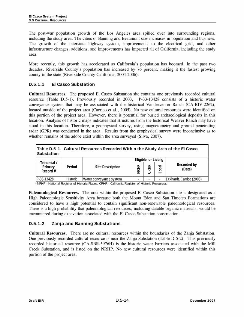
D.5.1.1 El Casco Substation
Cultural Resources. The proposed El Casco Substation site contains one previously recorded cultural resource (Table D.5-1). Previously recorded in 2003, P-33-13428 consists of a historic water conveyance system that may be associated with the historical Vanderventer Ranch (CA-RIV-2262), located outside of the project area (Carrico et al., 2005). No new cultural resources were identified on this portion of the project area. However, there is potential for buried archaeological deposits in this location. Analysis of historic maps indicates that structures from the historical Weaver Ranch may have stood in this location. Therefore, a geophysical survey, using magnetometry and ground penetrating radar (GPR) was conducted in the area. Results from the geophysical survey were inconclusive as to whether remains of the adobe exist within the area surveyed (Silva, 2007).
Table D.5-1. Cultural Resources Recorded Within the Study Area of the El Casco Substation
Eligible for Listing Trinomial /
Primary Record #
Period Site Description
NRHP
CRHR
Loca
l Recorded by (Date)
P-33-13428 Historic Water conveyance system - - - Eckhardt, Carrico (2003) *NRHP - National Register of Historic Places, CRHR - California Register of Historic Resources
Paleontological Resources. The area within the proposed El Casco Substation site is designated as a High Paleontologic Sensitivity Area because both the Mount Eden and San Timoteo Formations are considered to have a high potential to contain significant non-renewable paleontological resources. There is a high probability that paleontological resources, including datable organic materials, would be encountered during excavation associated with the El Casco Substation construction.
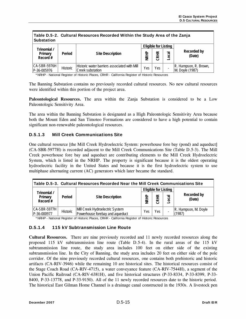
D.5.1.2 Zanja and Banning Substations
Cultural Resources. There are no cultural resources within the boundaries of the Zanja Substation. One previously recorded cultural resource is near the Zanja Substation (Table D.5-2). This previously recorded historical resource (CA-SBR-5976H) is the historic water barriers associated with the Mill Creek Substation, and is listed on the NRHP. No new cultural resources were identified within this portion of the project area.
El Casco System Project D.5 CULTURAL RESOURCES
December 2007 D.5-15 Draft EIR
Table D.5-2. Cultural Resources Recorded Within the Study Area of the Zanja Substation
Eligible for Listing Trinomial /
Primary Record #
Period Site Description
NRHP
CRHR
Loca
l Recorded by (Date)
CA-SBR-5976H P-36-005976 Historic Historic water barriers associated with Mill
Creek substation Yes Yes - R. Hampson, R. Brown, M. Doyle (1987)
*NRHP - National Register of Historic Places, CRHR - California Register of Historic Resources
The Banning Substation contains no previously recorded cultural resources. No new cultural resources were identified within this portion of the project area.
Paleontological Resources. The area within the Zanja Substation is considered to be a Low Paleontologic Sensitivity Area.
The area within the Banning Substation is designated as a High Paleontologic Sensitivity Area because both the Mount Eden and San Timoteo Formations are considered to have a high potential to contain significant non-renewable paleontological resources.
D.5.1.3 Mill Creek Communications Site
One cultural resource [the Mill Creek Hydroelectric System: powerhouse fore bay (pond) and aqueduct] (CA-SBR-5977H) is recorded adjacent to the Mill Creek Communications Site (Table D.5-3). The Mill Creek powerhouse fore bay and aqueduct are contributing elements to the Mill Creek Hydroelectric System, which is listed in the NRHP. The property is significant because it is the oldest operating hydroelectric facility in the United States and because it is the first hydroelectric system to use multiphase alternating current (AC) generators which later became the standard.
Table D.5-3. Cultural Resources Recorded Near the Mill Creek Communications Site Eligible for Listing
Trinomial / Primary Record #
Period Site Description
NRHP
CRHR
Loca
l Recorded by (Date)
CA-SBR-5977H P-36-000977 Historic Mill Creek Hydroelectric System
Powerhouse forebay and aqueduct Yes Yes - R. Hampson, M. Doyle (1987)
*NRHP - National Register of Historic Places, CRHR - California Register of Historic Resources
D.5.1.4 115 kV Subtransmission Line Route
Cultural Resources. There are nine previously recorded and 11 newly recorded resources along the proposed 115 kV subtransmission line route (Table D.5-4). In the rural areas of the 115 kV subtransmission line route, the study area includes 100 feet on either side of the existing subtransmission line. In the City of Banning, the study area includes 20 feet on either side of the pole corridor. Of the nine previously recorded cultural resources, one contains both prehistoric and historic artifacts (CA-RIV-3946) while the remaining 10 are historical sites. The historical resources consist of the Stage Coach Road (CA-RIV-4715), a water conveyance feature (CA-RIV-7544H), a segment of the Union Pacific Railroad (CA-RIV-6381H), and five historical structures (P-33-8334, P-33-8399, P-33-8400, P-33-13778, and P-33-9150). All of the 11 newly recorded resources date to the historic period. The historical East Gilman Home Channel is a drainage canal constructed in the 1930s. A livestock pen

El Casco System Project D.5 CULTURAL RESOURCES
Draft EIR D.5-16 December 2007
was recorded in southern Beaumont, CA. The remaining nine resources are extant homes located in the city of Banning, CA (185, 243, 291, 315, 371 East Wesley Street, 425 East Charles Street, and 390, 410, 421 East Barbour Street) (Table D.5-4). None of the newly recorded resources in this portion of the project area are recommended eligible for listing on the NRHP or are considered to be cultural resources for the purposes of CEQA. However, two structures (P-33-8334 and P-33-9150) are eligible for local listing or designation.
Paleontological Resources. The area along the proposed 115 kV subtransmission line route is designated as a High Paleontologic Sensitivity Area because both the Mount Eden and San Timoteo Formations are considered to have a high potential to contain significant non-renewable paleontological resources. There is a high probability that paleontological resources, including datable organic materials, would be encountered within the project area at surface exposures or during excavation associated with construction of the 115 kV subtransmission line.
Table D.5-4. Cultural Resources Recorded Within the Study Area of the proposed 115 kV Subtransmission Line Route
Eligible for Listing Trinomial /
Primary Record #
Period Site Description NR
HP
CRHR
Loca
l
Relationship to
Centerline Recorded by
(Date)
CA-RIV-3946 Prehistoric / Historic
Scatter of prehistoric and historic artifacts (destroyed) No No - Adjacent M. Avina, J. Doty (1999)
R. McLean (1990) CA-RIV-4715 Historic The Stage Coach Road No No - Crosses
centerline T. Wahoff (1992)
P-33-8334 Historic W. E. Jones House 391 East Barbour Street, Banning No No Yes** Adjacent G. Barker (1983)
J. Marvin, S. Carmack (2005)
P-33-8399 Historic 132 East Wesley Street, Banning No No No Adjacent G. Barker (1983) J. Marvin, S. Carmack (2005)
P-33-8400 Historic J. R. Fountain House 270 East Wesley Street, Banning No No - Adjacent G. Barker (1983)
J. Marvin, S. Carmack (2005) P-33-13778 Historic Stewart Ranch Complex, Banning No No - Crosses
centerline Michael Brandman Associates (2004)
CA-RIV-7544H P-33-13779 Historic
Water conveyance features associated with Stewart Ranch, Banning
No No - Crosses centerline
Michael Brandman Associates (2004)
CA-RIV-6381H P-33-9498 Historic Union Pacific (formerly Southern
Pacific) Railroad - - - Crosses centerline
Ashkar (1999) C. Taniguchi (2005)
P-33-9150 Historic 1222 West Lincoln Street, Banning No No Yes** Adjacent M. Rounds (1983)
- Historic East Gilman Home Channel No No - Crosses centerline J. Marvin, S. Carmack (2005)
- Historic Livestock Pen 14023 Viele Road, Beaumont No No - Adjacent J. Marvin, S. Carmack (2005)
- Historic 185 East Wesley Street, Banning No No - Adjacent J. Marvin, S. Carmack, J. Michalsky (2005)
- Historic 243 East Wesley Street, Banning No No - Adjacent J. Marvin, S. Carmack, J. Michalsky (2005)
- Historic 291 East Wesley Street, Banning No No - Adjacent J. Marvin, S. Carmack, J. Michalsky (2005)
- Historic 315 East Wesley Street, Banning No No - Adjacent J. Marvin, S. Carmack, J. Michalsky (2005)

El Casco System Project D.5 CULTURAL RESOURCES
December 2007 D.5-17 Draft EIR
Table D.5-4. Cultural Resources Recorded Within the Study Area of the proposed 115 kV Subtransmission Line Route
Eligible for Listing Trinomial /
Primary Record #
Period Site Description
NRHP
CRHR
Loca
l
Relationship to
Centerline Recorded by
(Date)
- Historic 371 East Wesley Street, Banning No No - Adjacent J. Marvin, S. Carmack, J. Michalsky (2005)
- Historic 425 East Charles Street, Banning No No - Adjacent J. Marvin, S. Carmack, J. Michalsky (2005)
- Historic 390 East Barbour Street, Banning No No - Adjacent J. Marvin, S. Carmack, J. Michalsky (2005)
- Historic 410 East Barbour Street, Banning No No - Adjacent J. Marvin, S. Carmack (2005) - Historic 421 East Barbour Street, Banning No No - Adjacent J. Marvin, S. Carmack, J.
Michalsky (2005) *NRHP - National Register of Historic Places, CRHR - California Register of Historic Resources **City of Banning does not currently have a local register, but these structures likely would qualify for a local listing in the future
D.5.1.5 220 kV Transmission Line Loop-In
Cultural Resources. The 220 kV transmission line loop-in contains no previously recorded cultural resources. No new cultural resources were identified within this portion of the project area.
Paleontological Resources. The area along the proposed 220 kV transmission line loop-in route is designated as a High Paleontologic Sensitivity Area because both the Mount Eden and San Timoteo Formations are considered to have a high potential to contain significant non-renewable paleontological resources. There is a high probability that paleontological resources, including datable organic materials, would be encountered within the project area at surface exposures or during excavation associated with construction of the 220 kV transmission line loop-in.
D.5.1.6 12 kV Distribution Line Getaways
Cultural Resources. The 12 kV distribution line getaways contain no previously recorded cultural resources. No new cultural resources were identified within this portion of the project area.
Paleontological Resources. The area along the proposed 12 kV distribution line getaways is designated as a High Paleontologic Sensitivity Area because both the Mount Eden and San Timoteo Formations are considered to have a high potential to contain significant non-renewable paleontological resources. There is a high probability that paleontological resources, including datable organic materials, would be encountered within the project area at surface exposures or during excavation associated with the 12 kV distribution line getaways construction.
D.5.1.7 El Casco Substation to San Bernardino Substation Fiber Optic Segment
Of the 42 previously recorded cultural resources located along the El Casco Substation to San Bernardino Substation fiber optic segment, five are prehistoric archaeological sites, five are isolated historical artifacts, and 32 are historical cultural resources (Table D.5-5). Of the five prehistoric archaeological sites, one is a food processing location that was previously destroyed (CA-SBR-911), two are potential Native American campsites (P1064-45, CA-SBR-428), one is a potential Native American food processing site (CA-SBR-915), and one is a ceramic scatter (CA-SBR-12605). The 32 historical resources consist of two historic Native American villages (CA-RIV-179, CA-RIV-794), the

El Casco System Project D.5 CULTURAL RESOURCES
Draft EIR D.5-18 December 2007
San Timoteo Canyon Schoolhouse (P-33-7292, listed on the NRHP), the historical Tenderfoot Bar (P-36-12836), a Pony Express Station (P1064-51H), the El Casco Depot (CA-RIV-3449), segments of the Atchison, Topeka, and Santa Fe Railroad (CA-SBR-6847H) and the Union Pacific Railroad (CA-RIV-6381H), 11 irrigation and/or water conveyance systems (CA-SBR-7765H, CA-SBR-8135H, CA-SBR-11760H, CA-SBR-11770H, CA-SBR-12260H, P1063-50H, PSBR-22H, CA-SBR-8546H, CA-SBR-5976H, CA-SBR-5977H, CA-SBR-8092H [Mill Creek Zanja, listed on the NRHP]), five historical landscapes (CA-SBR-7766H, CA-SBR-7767H, CA-SBR-9991H, CA-SBR-12386H, CA-RIV, 3448H), and eight historical farms and/or ranches (CA-SBR-7139H, CA-SBR-7768H, CA-SBR-8137H, CA-SBR-11504H, CA-SBR-11772H, CA-SBR-11807H, CA-RIV-7294, CA-RIV-7296). Five historical isolated artifacts were previously recorded (P-33-12641, P-33-12642, P-33-12643, P-33-12644, P-33-12690) and consisted of amethyst bottle glass and white ceramic sherds. While two sites, the San Timoteo Canyon Schoolhouse and the Mill Creek Zanja, are listed on the NRHP, three additional sites (Mill Creek Hydroelectric System [CA-SBR-5977H], water barriers associated with Mill Creek [CA-SBR-5976H], and a segment of Atchison, Topeka, and Santa Fe Railroad [CA-SBR-6847H] appear to be eligible for listing. Marigold Farms (CA-SBR-7139H) and a rural historical landscape (CA-SBR-9991H) are eligible for local listing or designation.
Table D.5-5. Cultural Resources Recorded Within the Study Area of the El Casco Substation to San Bernardino Substation Fiber Optic Segment
Eligible for Listing Trinomial /
Primary Record #
Period Site Description
NRHP
CRHR
Loca
l Fiber Optic Overhead or Underground
Recorded by (Date)
CA-SBR-6847H P-36-006847 Historic
Segment of Atchison, Topeka, and Santa Fe Railroad
Yes Yes - Overhead Romani et al. (1990) M. Horne, C. Inoway (1998) M. Robinson (2000)
CA-SBR-7139H P-36-007139 Historic Marigold Farms
Dairy and farming ranch No No Yes Overhead Swope, Slater, Cardoza (1991) R. Hatheway (1991)
CA-SBR-7765H P-36-007765 Historic Orange grove and irrigation
system - - - Underground J. Paulson, P. Singer (1993)
CA-SBR-7766H P-36-007766 Historic
Concrete driveway, slab, orange grove and irrigation system
- - - Underground J. Paulson, P. Singer (1993)
CA-SBR-7767H P-36-007767 Historic
Concrete driveway, walls, and trees associated with Silas Williams house
- - - Underground J. Paulson, P. Singer (1993)
CA-SBR-7768H P-36-007768 Historic Agriculture and residential
site - - - Underground J. Paulson, P. Singer (1993)
CA-SBR-8135H P-36-008135 Historic Series of irrigation flumes - - - Underground L. White (1995)
CA-SBR-8137H P-36-008137 Historic 20th century farm complex - - - Underground L. White (1995)
CA-SBR-9991H P-36-009991 Historic Rural historical landscape No No Yes Overhead B. Tang (2000)
CA-SBR-11504H P-36-011504 Historic Historical farm - - - Overhead R. Goodwin (2003)
CA-SBR-11760H P-36-011760 Historic Irrigation site - - - Overhead J. S. Alexandrowicz
(1999) CA-SBR-11770H P-36-011770 Historic Irrigation site - - - Overhead J. S. Alexandrowicz
(1999)

El Casco System Project D.5 CULTURAL RESOURCES
December 2007 D.5-19 Draft EIR
Table D.5-5. Cultural Resources Recorded Within the Study Area of the El Casco Substation to San Bernardino Substation Fiber Optic Segment
Eligible for Listing Trinomial /
Primary Record #
Period Site Description
NRHP
CRHR
Loca
l Fiber Optic Overhead or Underground
Recorded by (Date)
CA-SBR-11772H P-36-011772 Historic Agricultural and residential
site - - - Overhead J. S. Alexandrowicz (1999)
CA-SBR-11807H P-36-011807 Historic Residential and agricultural
complex No No - Overhead C. Cotterman (2003)
CA-SBR-12260H P-36-012468 Historic Water conveyance system No No - Underground L. Taylor (2006)
CA-SBR-12386H P-36-012852 Historic Agricultural site - - - Overhead J. Sanka (2006)
P1063-50H Historic Berry-Roberts ditch - - - Overhead Never properly recorded PSBR-22H Historic Judson-Brown ditch - - - Overhead Never properly recorded CA-SBR-8546H P-36-008546 Historic Water conveyance system - - - Overhead J. Schmidt (1996)
CA-SBR-5976H P-36-005976 Historic
Historic water barriers associated with Mill Creek substation
Yes Yes - Overhead R. Hampson, M Doyle (1987)
CA-SBR-5977H P-36-000977 Historic Mill Creek Hydroelectric
System Yes Yes - Overhead R. Hampson, R. Brown, M. Doyle (1987)
CA-SBR-8092H NRHP-L-77-329 CHL 43, EL 21
Historic Mill Creek Zanja Water conveyance system Listed Yes - Underground ? R. Hampson, R. Brown,
M. Doyle (1987)
P1064-51H Historic Pony Express Station - - - Overhead Never properly recorded CA-SBR-911 Prehistoric Food processing location
(destroyed) No No No Underground G. Smith (1971)
P1064-45 Prehistoric Potential Native American campsite - - - Underground Never properly recorded
CA-RIV-179 Historic Historic Cahuilla village of Sahat 'pa - - - Overhead Johnston and Johnston
(1960), Lerch (1983) CA-RIV-794 Historic Historic Indian village - - - Overhead Smith (n.d.), Lerch (1983),
Lawson (2004) CA-RIV-3448H Historic Concrete foundation and
associated artifacts - - - Overhead Apple et al. (1988) CA-RIV-3449 Historic El Casco Depot - - - Overhead Apple et al. (1988) CA-RIV-6381H P-33-9498 Historic Union Pacific (formerly
Southern Pacific) Railroad - - - Overhead Ashkar (1999) C. Taniguchi (2005)
P-33-7292 Historic San Timoteo Canyon Schoolhouse Listed Yes - Overhead Bluck (2000)
CA-RIV-7294 Historic Fisherman's Retreat (Silas Cox Ranch) - - - Overhead N. Haskell (1983)
CA-RIV-7296 Historic Woodhouse Ranch (Singleton Ranch Complex) No - - Overhead
N. Haskell (1983) R. Goodwin, N. Lawson, J. Marvin (2004)
CA-SBR-915 Prehistoric Potential Native American food processing site - - - Overhead G. Smith (1976)
CA-SBR-428 Prehistoric Potential Native American camp site - - - Overhead G. Smith (1934)
CA-SBR-12605 Prehistoric Native American ceramic scatter - - - Overhead D. McDougall (2006a)
P-36-12836 Historic Historical Tenderfoot Bar No No - Overhead J. Marvin (2002) *NRHP - National Register of Historic Places, CRHR - California Register of Historic Resources, CHL - California Historical Landmark, EL - Engineering Landmark

El Casco System Project D.5 CULTURAL RESOURCES
Draft EIR D.5-20 December 2007
D.5.1.8 El Casco Substation to Banning Substation Fiber Optic Segment
Of the 14 previously recorded cultural resources along the El Casco Substation to Banning Substation fiber optic segment, one is a prehistoric site and 13 are historical resources (Table D.5-6). The prehistoric site consisted of a bedrock mortar site that was destroyed (CA-RIV-2639). Five of the historical resources are structures (P-33-7295, P-33-13720, P-33-6167, P-33-9150H, P-33-13778), five are refuse scatters (CA-RIV-3447H, CA-RIV-5246, P-33-12639, P-33-12640, P-33-12641), one is a flood control structure (P-33-10792) and two are water conveyance systems (P-33-15002, CA-RIV-7544H). The house at 1222 West Lincoln Street (P-33-9150H) is listed as historically significant by the City of Banning.
Table D.5-6. Cultural Resources Recorded Within the Study Area of the El Casco Substation to Banning Substation Fiber Optic Segment
Eligible for Listing Trinomial /
Primary Record #
Period Site Description
NRHP
CRHR
Loca
l Fiber Optic Overhead or Underground
Recorded by (Date)
CA-RIV-2639 Prehistoric Bedrock mortars (destroyed) No No No Overhead R. E. Reynolds (2000)
CA-RIV-3447H Historic Historical refuse scatter No No No Overhead Dames and Moore (1988) CA-RIV-5246 Historic Historical refuse scatter No No No Overhead ? P-33-7295 Historic Haskell Ranch Complex - - - Overhead J. Marvin (2004) P-33-10792 Historic Flood control structure - - - Overhead R. E. Reynolds (2000) P-33-12639 Historic Historical refuse scatter
associated with railroad - - - Overhead ? P-33-12640 Historic Historical refuse scatter No No No Overhead ? P-33-12641 Historic Historical refuse scatter No No No Overhead Dames and Moore (1988) P-33-13720 Historic ca. 1950s house - - - Overhead ?
P-33-15002 Historic Water conveyance system associated with Singleton Ranch
No No - Overhead LSA (2004)
P-33-6167 Historic ca. 1930 house - - - Overhead ? P-33-9150H Historic 1222 West Lincoln Street,
Banning No No Yes** Overhead M. Rounds (1983)
P-33-13778 Historic 1920s homestead site - - - Overhead Michael Brandman Associates (2004)
CA-RIV-7544H P-33-13779 Historic ~40 water conveyance
features - - - Overhead Michael Brandman Associates (2004)
*NRHP - National Register of Historic Places, CRHR - California Register of Historic Resources **City of Banning does not currently have a local register, but these structures likely would qualify for a local listing in the future
D.5.1.9 El Casco Substation to Tower M29-T2 Fiber Optic Segment
The El Casco Substation to Tower M29-T2 fiber optic segment contains no previously recorded cultural resources. No new cultural resources were identified within this portion of the project area.
D.5.1.10 El Casco Substation to Tower M30-T3 Fiber Optic Segment
Three previously recorded cultural resources are located along the El Casco Substation to Tower M30-T3 fiber optic segment: the historic Cahuilla village of Sahat 'pa (CA-RIV-179); the Woodhouse Ranch (CA-RIV-7296), consisting of three wood-frame houses and one wood-frame barn; and two wood frame houses known as Fisherman's Retreat (CA-RIV-7294) (Table D.5-7).

El Casco System Project D.5 CULTURAL RESOURCES
December 2007 D.5-21 Draft EIR
Table D.5-7. Cultural Resources Recorded Within the Study Area of the El Casco Substation to Tower M30-T3 Fiber Optic Segment
Eligible for Listing Trinomial /
Primary Record #
Period Site Description
NRHP
CRHR
Loca
l Fiber Optic Overhead or Underground
Recorded by (Date)
CA-RIV-179 Historic Historic Cahuilla village of Sahat 'pa - - - Overhead Johnston and Johnston (1960)
Lerch (1983)
CA-RIV-7296 Historic Woodhouse Ranch (Singleton Ranch Complex) No - - Overhead
N. Haskell (1983) R. Goodwin, N. Lawson, J. Marvin (2004)
CA-RIV-7294 Historic Fisherman's Retreat (Silas Cox Ranch) - - - Overhead N. Haskell (1983)
*NRHP - National Register of Historic Places, CRHR - California Register of Historic Resources
D.5.1.11 Banning Substation to Tower M17-T1 Fiber Optic Segment
All four previously recorded resources along the proposed Banning Substation to Tower M17-T1 fiber optic segment are historical (Table D.5-8). One is a segment of the historical Union Pacific (formerly Southern Pacific) Railroad (CA-RIV-6381H) and the other three are historic structures (P-33-8347H, P-33-15193, and P-33-15195). None of the previously recorded structures is recommended eligible for listing on the NRHP or is considered to be a cultural resource for the purposes of CEQA. The Rose House (P-33-8347H) is listed as historically significant by local government.
Table D.5-8. Cultural Resources Recorded Within the Study Area of the Banning Substation to Tower M17-T1 Fiber Optic Segment
Eligible for Listing Trinomial /
Primary Record #
Period Site Description
NRHP
CRHR
Loca
l Fiber Optic Overhead or Underground
Recorded by (Date)
P-33-8347H Historic Rose House ca. 1915 House No No Listed Overhead ?
CA-RIV-6381H P-33-9498 Historic Union Pacific (formerly
Southern Pacific) Railroad - - - Overhead Ashkar (1999) C. Taniguchi (2005)
P-33-15193 Historic Bonilla Residence 402 East Ramsey Street, Banning
No No - Overhead J. Marvin, Shannon Carmack, & J. Michalsky (2005)
P-33-15195 Historic Cortez Residence 403-411 East Williams Street, Banning
No No - Overhead J. Marvin, Shannon Carmack, & J. Michalsky (2005)
*NRHP - National Register of Historic Places, CRHR - California Register of Historic Resources
D.5.2 Applicable Regulations, Plans, and Standards
The Proposed Project is being evaluated under the CEQA by the CPUC as the designated Lead Agency. The following state public resource codes and CEQA regulations apply:
• California Environmental Quality Act (CEQA): Public Resources Code Sections 5020.1, 5024.1, 21083.2, 21084.1, et seq.; requires analysis of potential environmental impacts of proposed projects and application of feasible mitigation measures.

El Casco System Project D.5 CULTURAL RESOURCES
Draft EIR D.5-22 December 2007
• Title 14, Public Resources Code, Section 5020.1 defines several terms, including the following: (f) “DPR Form 523” means the Department of Parks and Recreation Historic Resources Inventory Form; (i) “historical resource” includes, but is not limited to, any object, building, structure, site, area, place, record, or manuscript which is historically or archaeologically significant in the architectural, engineering, scientific, economic, agricultural, educational, social, political, military, or cultural annals of California; (j)”local register of historical resources” means a list of properties officially designated or recognized as historically significant by a local government pursuant to a local ordinance or resolution; (l) “national Register of Historic Places” means the official federal list of districts, sites, buildings, structures, and objects significant in American history, architecture, archaeology, engineering, and culture as authorized by the National Historic Preservation Act of 1966 (Title 16 United States Code Section 470 et seq.); (q) “substantial adverse change” means demolition, destruction, relocation, or alteration such that the significance of an historical resource would be impaired.
• Title 14, Public Resources Code, Section 5024.1 establishes a California Register of Historic Places; sets forth criteria to determine significance; defines eligible properties; lists nomination procedures.
• Title 14, Public Resources Code, Section 5097.5 – any unauthorized removal or destruction of archaeological, paleontological resources on sites located on public lands is a misdemeanor.
• Title 14, Public Resources Code 5097.98 prohibits obtaining or possessing Native American artifacts or human remains taken from a grave or cairn; sets penalties.
• Title 14, Public Resources Code, Section 21083.2 – the lead agency determines whether a project may have a significant effect on unique archaeological resources. If a potential for damage to unique archaeological resources can be demonstrated, such resources must be avoided; if they can not be avoided, mitigation measures shall be required; discusses excavation as mitigation; discusses cost of mitigation for several types of projects; sets time frame for excavation; defines “unique and non-unique archaeological resources;” provides for mitigation of unexpected resources; sets limitation for this section.
• Title 14, Public Resources Code, Section 21084.1 indicates that a project may have a significant effect on the environment if it causes a substantial change in the significance of a historic resource; the section further describes what constitutes a historic resource and a significant historic resource.
• Guidelines for the Implementation of the CEQA. Section 15064.5 specifically addresses effects on historic and prehistoric archaeological resources, in response to problems that have arisen in the application of CEQA to these resources.
• Title 14, Penal Code, Section 622.5 – anyone who damages an item of archaeological or historic interest is guilty of a misdemeanor.
• CEQAGuidelines: California Code of Regulations, Sections 15000, et seq., Appendix G (j), specifically defines a potentially significant environment effect as occurring when the Proposed Project will “. . . disrupt or adversely affect . . . an archeological site, except as part of a scientific study.”
• Public Resources Code, Section 5097.5. Any unauthorized removal of archaeological resources on sites located on public lands is a misdemeanor. As used in this section, “public lands” means lands owned by, or under the jurisdiction of, the state, or any city, county, district, authority or public corporation, or any agency thereof.
D.5.3 Environmental Impacts and Mitigation Measures for the Proposed Project
D.5.3.1 Significance Criteria
Cultural Resources
CEQA Guidelines require that the Proposed Project take into consideration the potential effect of the undertaking on cultural resources. In order to evaluate the potential effect of the project on architectural

El Casco System Project D.5 CULTURAL RESOURCES
December 2007 D.5-23 Draft EIR
and historic resources (over 45 years in age) or prehistoric archaeological resources, a record and literature search of the Proposed Project area was conducted by LSA at the Eastern Information Center (EIC) located at the University of California, Riverside and the San Bernardino Archeological Information Center (SBAIC) located at the San Bernardino County Museum in Redlands to establish the location of previously conducted cultural resource surveys and known resources within a one-half mile radius of all project components. This background record search also provided a basis from which to predict the archaeological potential of the area.
In accordance with CEQA regulations, if the area has not been previously surveyed, or if surveyed and/or documented inadequately, a qualified archaeologist must then conduct a survey of all project components as a means of identifying and assessing the potential impact of the project on known or predicted cultural resources. Site significance criteria are those contained in CEQA Section 15064.5 and 36 CFR 60.4. Literature on the history, prehistory, and ethnography of the area was also consulted as an aid in developing the archaeological potential of the area, and to prepare a setting section for use in evaluating the significance of known or predicted resources.
CEQA contains provisions relative to preservation of historic (and prehistoric) cultural sites. Section 15126.4 of CEQA directs public agencies to “avoid damaging effects” on an archeological resource whenever feasible. If avoidance is not feasible, the importance of the site shall be evaluated to determine impact and develop mitigation measures.
CEQA Section 15064.5 states: Generally, a resource shall be considered by the lead agency to be “historically significant” if the resource meets the criteria for listing on the California Register of Historical Resources (Pub. Res. Code SS5024.1, Title 14 CCR, Section 4852) including the following:
(A) Is associated with events that have made a significant contribution to the broad patterns of Cali-fornia's history and cultural heritage;
(B) Is associated with the lives of persons important in our past;
(C) Embodies the distinctive characteristics of a type, period, region, or method of construction, or represents the work of an important creative individual, or possesses high artistic values; or
(D) Has yielded, or may be likely to yield, information important in prehistory or history.
Archaeological site evaluation assesses the potential of each site to meet one or more of the criteria for “importance” based upon visual surface and subsurface evidence (if available) at each site location, information gathered during the literature and record searches, and the researcher’s knowledge of and familiarity with the historic or prehistoric context associated with each site.
Finally, under California State law, Native American human remains and associated grave goods are granted special significance.
The following significance criteria apply to cultural resources:
• The Proposed Project would cause a substantial adverse change in the characteristics of a significant cultural resource or unique archaeological site as defined by State of California guidelines.
• The Proposed Project would cause a substantial adverse change in the characteristics of a cultural resource included in a local register of historical resources.
• The Proposed Project could uncover, expose, and/or damage Native American human remains.

El Casco System Project D.5 CULTURAL RESOURCES
Draft EIR D.5-24 December 2007
Paleontology
Paleontologic resources are a limited, nonrenewable, very sensitive scientific and educational resource and, in California, are afforded protection under the CEQA (13 Public Resources Code: 21000 et seq.).
The paleontologic importance (high, moderate, low, none, unknown) of a rock unit is the measure most amenable to assessing the importance of the paleontologic resources in an area under investigation because the aerial distribution of a rock unit can be delineated on a map. The paleontologic importance of a rock unit reflects: (1) its potential productivity, and (2) the scientific importance of the fossils it has produced locally.
The potential productivity (high, moderate, low, none, undetermined) of a rock unit in a particular area is based on the densities of fossil specimens and sites in exposures of the unit. The criteria for establishing the potential productivity of a rock unit is as follows:
(1) High Potential. Rock unit contains high density of recorded fossil sites and has produced numerous fossil remains in alignment and/or vicinity, and is very likely to yield additional remains.
(2) Moderate Potential. Rock unit contains moderate density of recorded fossil sites and has produced some fossil remains in alignment and/or vicinity, and is somewhat likely to yield additional remains.
(3) Low Potential. Rock unit contains no or very low density of recorded fossil sites and has produced very few or no fossil remains in alignment vicinity, and is not likely to yield any remains.
(4) Undetermined Potential. Rock unit has limited exposure, is poorly studied, and contains no recorded fossil site. However, in other areas, the same or a similar rock unit contains sufficient sites to suggest rock unit in project area has at least a moderate potential for yielding fossil remains and sites (Note: elsewhere in southern California, exposures of rock units with few or no prior recorded fossil sites have recently proven abundantly fossiliferous during surveying, monitoring, or processing of fossiliferous rock as part of mitigation programs for other construction projects).
(5) No Potential. Unfossiliferous igneous and high-grade metamorphic rock units with no potential for yielding any fossil remains.
Any fossil site containing identifiable fossil remains and the fossiliferous bed are considered highly im-portant paleontologically, regardless of the paleontologic importance of the rock unit in which the site and bed occur.
A fossil specimen is considered scientifically highly important if it is (1) identifiable, (2) complete, (3) well preserved, (4) age diagnostic, (5) useful in environmental reconstruction, (6) a type of topotypic specimen, (7) rare taxon, (8) or part of a diverse assemblage. Identifiable land mammal fossils, for exam-ple, are considered paleontologically highly important because they are comparatively rare in the geo-logic record and allow very accurate age determinations and environmental reconstructions for the rock units in which they occur.
D.5.3.2 Applicant-Proposed Measures
SCE has committed to implementing a number of measures to reduce Proposed Project impacts to cultural resources. These Applicant-Proposed Measures (APMs) shown in Table D.5-9 were outlined in

El Casco System Project D.5 CULTURAL RESOURCES
December 2007 D.5-25 Draft EIR
the PEA (SCE, 2007a) for reducing the potential impacts of construction and operation of the Proposed Project. In the following disclosure and analysis of the project’s potential to impact cultural and paleontological resources, it is assumed that the APMs would be implemented as elements of Proposed Project development, planning, and construction. These APMs are incorporated into additional more specific mitigation measures that would be implemented to ensure that all impacts would be reduced to a less-than-significant level (see Section D.5.3.3).
Table D.5-9. Applicant-Proposed Measures – Cultural and Paleontological Resources APM Description APM CUL-1 New poles would be erected at a sufficient distance from site 33-8334 (sic)* to prevent damage to the
building, its foundations, or supporting structures. APM CUL-2 There is a high potential for buried cultural resources at the proposed El Casco Substation site, including
possible structures and features from the historic Weaver Ranch. Prior to construction, a subsurface exploration program such as ground-penetrating radar, would be conducted to search for buried resources. Should resources be found by this means, they would be evaluated for CRHR-eligibility. Appropriate mitigation measures would be devised for eligible resources. Additionally, ground disturbing activity would be monitored by a qualified archaeologist.
APM CUL-3 In the event that unexpected cultural resources are encountered during the course of project construction, work is to be halted in that location until a qualified archaeologist is able to evaluate the resource.
APM CUL-4 Cultural resource surveys would be conducted in areas that have not been previously surveyed and surveys would be conducted to relocate previously recorded cultural resources once construction and staging areas are called out in final engineering. Any identified resources would be recorded and evaluated. If a cultural resource is identified within a construction/staging area then the construction/staging area would be shifted to avoid cultural resources. If construction/staging areas cannot avoid a significant resource, then appropriate mitigation measures would be developed to reduce any impacts to less than significant and all ground disturbing activities would be monitored by a qualified archaeologist.
APM PALEO-1 Conduct a paleontological field assessment of the finalized right of way for the substation location. APM PALEO-2 Prior to construction a paleontologist would salvage known exposed paleontological resources. This would
consist of collected standard samples of fossiliferous sediments. APM PALEO-3 A paleontological monitor would be present during ground disturbing activities within the Project area. The
monitor would be empowered to temporarily halt or redirect construction activities to ensure avoidance of adverse impacts.
APM PALEO-4 Upon encountering a large deposit of bone, salvage of all bone in the area would be conducted in accordance with modern paleontological techniques.
APM PALEO-5 All fossils collected would be prepared to a reasonable point of identification. Itemized catalogs of all material collected and identified would be provided to the museum repository along with the specimens. A specimen repository would be arranged in writing with a museum prior to initiation of construction excavation.
APM PALEO-6 A report documenting the results of the monitoring and salvage activities and the significance of the fossils would be prepared.
Source: SCE, 2007a. *site number has been corrected. D.5.3.3 Proposed Project Impact Analysis
The majority of identified historic or prehistoric resources in the vicinity of the Proposed Project area would be avoided during the construction. The likelihood for adverse impacts from construction activities hinges on the potential of encountering significant and unanticipated cultural deposits during construction.
Ground-disturbing activities associated with project construction have the highest probability of impacting any known or previously unidentified cultural resources. The Proposed Project involves both overhead and underground components. Construction methods associated with these activities would disturb sediments to varying degrees.
Should any resources be discovered, their significance would have to be determined in relation to the criteria for eligibility to the California Register of Historic Resources (CRHR). Simply because a

El Casco System Project D.5 CULTURAL RESOURCES
Draft EIR D.5-26 December 2007
prehistoric site has been disturbed, or historic structures altered, does not necessarily reduce the significance insofar as CRHR eligibility is concerned. Buried features of many kinds can remain undetected until being discovered during construction; at that time they must be evaluated and a determination made as to their significance.
The preferred mitigation for cultural resources under CEQA is always avoidance of the resource. Should significant resources be discovered during construction, data recovery would be required to gather sufficient information from the site to consider its loss a less-than-significant impact level under CEQA.
Impact CR-1: Project Construction Has the Potential to Affect Known Archaeological Resources (Class II).
Inadvertent impacts may occur to known archaeological resources within and in the vicinity of the project area during construction and during activities associated with transportation, storage, and main-tenance of construction equipment and supplies. Impacts could also result from inadvertent or malicious vandalism or unauthorized collection of cultural resources on the surface of sites. This impact is potentially significant (Class II), but is mitigable to less-than-significant levels with implementation of Mitigation Measures CR-1a (Avoid Environmentally Sensitive Areas), CR-1b (Cultural Resources Treatment Plan [CRTP]), and CR-1c (Construction Monitoring). In APM CUL-4, SCE commits to additional archaeological surveys, avoidance of direct construction impacts to cultural resources, and treatment of resources that cannot be avoided. However, Mitigation Measures CR-1a (Avoid Environmentally Sensitive Areas), CR-1b (Cultural Resources Treatment Plan), and CR-1c (Construction Monitoring) provide more detail on how these activities would be implemented to reduce impacts. These measures would ensure that impacts are mitigated to less-than-significant levels.
The 220 kV transmission line loop-in and 12 kV distribution line getaways contains no previously recorded or newly identified cultural resources. Therefore, the discussion of these impacts does not apply to these project components.
El Casco Substation. The proposed El Casco Substation requires approximately 28 acres to be graded in order to create the relatively flat 14-acre pad for the substation and to address potential landslide issues. Soil stabilization techniques such as deep soil mixing (DSM) and compacted-fill earth buttress would be utilized to prepare the site for construction of the substation pad and to address potential landslide issues. A portion of an existing dirt road would be improved and possibly moved to allow site access. These activities present the greatest likelihood of disturbing both paleontological sediments and archaeological resources associated with known or previously unidentified paleontological and cultural deposits.
The proposed El Casco Substation site contains one previously recorded cultural resource, a historic water conveyance system (P-33-13428). Because P-33-13428 is of an indeterminant age and its association with the Vanderventer Ranch is speculative, this site appears to be ineligible for listing on the NRHP and is not considered to be a cultural resource for the purposes of CEQA. However, there is potential for buried archaeological deposits at this location (Duff-Weaver Adobe). Provisions in APM CUL-2 would ensure that all ground-disturbing activities at the proposed El Casco Substation site would be monitored by a qualified archaeologist. Mitigation Measure CR-1b (Cultural Resources Treatment Plan [CRTP]) ensures that known and recorded cultural resources will be avoided during construction, and operation and maintenance. Mitigation Measure CR-1c (Construction Monitoring) states that archaeological monitoring by a qualified archaeologist shall occur in all areas of ground disturbing
El Casco System Project D.5 CULTURAL RESOURCES
December 2007 D.5-27 Draft EIR
activity that occur within 100 feet of a cultural resource ESA and during removal of all sediments above bedrock. Implementation of the above-mentioned Mitigation Measures, as well as, CR-1a (Avoid Environmentally Sensitive Areas), and APM CUL-3 and APM CUL-4 would ensure that impacts are less than significant (Class II), if buried resources are encountered during construction.
Zanja and Banning Substations. New 115 kV switchracks would be installed at both the Zanja and Banning Substations. New pads would be constructed at both substations to accommodate the structures. Approximately 0.4 acre would be disturbed within the southeast corner of the Zanja Substation and approximately 0.5 acre would be disturbed within the western half of the Banning Substation property. All construction would occur within the existing fenced-in substation properties, where substantial ground disturbance has already occurred.
The Zanja Substation contains no cultural resources within the substation boundaries. Because all work at this site would occur within the existing fenced-in areas, there would be minimal ground-disturbing activities. Therefore, no substantial direct or indirect impacts to cultural resources are anticipated. Implementation of Mitigation Measures CR-1a (Avoid Environmentally Sensitive Areas), CR-1b (Cultural Resources Treatment Plan [CRTP]), and CR-1c (Construction Monitoring), and APM CUL-3 and APM CUL-4, would ensure that impacts are less than significant (Class II), if buried resources are encountered during construction.
Mill Creek Communications Site. A new microwave tower would be installed at the existing Mill Creek Communications Site located on 160 acres of SCE-owned property (i.e., private in-holding owned in fee since 1909) within the San Bernardino National Forest approximately two miles northeast of SCE’s existing Zanja Substation (see Figure B-11). The existing antenna structure, mounted on the rooftop of the existing communications building at Mill Creek Communications Site, is not adequate to support the additional microwave antenna needed for the El Casco System Project, nor is it tall enough to provide adequate line-of-sight to El Casco Substation. Therefore, a new 110-foot tall, three-legged, self-supporting steel lattice antenna tower would be constructed adjacent to the existing communications building. No known cultural resources exist within the Mill Creek Communications site boundaries. Therefore, no substantial direct or indirect impacts to cultural resources are anticipated. Implementation of Mitigation Measures CR-1a (Avoid Environmentally Sensitive Areas), CR-1b (Cultural Resources Treatment Plan [CRTP]), and CR-1c (Construction Monitoring), and APM CUL-3 and APM CUL-4, would ensure that impacts are less than significant (Class II), if buried resources are encountered during construction.
115 kV Subtransmission Line Route. Approximately 225 new steel poles would be installed for the Proposed Project 115 kV subtransmission line. These poles would include a mix of bolted-base tubular steel poles (TSPs) and direct-buried lightweight steel (LWS) poles. For the installation of LWS poles, holes would be bored approximately 24 to 30 inches in diameter and approximately 10 feet deep. Installation of TSPs requires a hole 20 to 25 feet deep and approximately 6 to 8 feet in diameter bored into the ground for construction of a footing. One new spur road would be constructed from the existing access road located south of the El Casco Substation site heading north approximately 600 feet along the subtransmission line route to allow for the 115 kV loop-in to the proposed El Casco Substation. The new spur road would be approximately 12 feet wide with a maximum grade of 15 percent. Staging for subtransmission tower construction and conductor pulling would be at El Casco Substation as well as Maraschino and Banning Substations.
Construction of the proposed subtransmission line would involve grading and improvements to unpaved access roads. The replacement of subtransmission towers would entail soil excavation for new

El Casco System Project D.5 CULTURAL RESOURCES
Draft EIR D.5-28 December 2007
foundation footings. Ground disturbance associated with modifications to existing substations would include excavation for the enlargement of existing footings and/or structures, and placement of new structures. Subtransmission line construction (including the relocation/replacement of existing wood poles and modifications to existing substations) is considered to pose a low risk of disturbance for any known archaeological resources in the area. Ground disturbance would generally be confined to specific areas that had been previously disturbed, or areas considered to have a low likelihood for containing buried cultural materials.
There are 20 previously detected cultural resources along the proposed 115 kV subtransmission line route. None of the resources in this portion of the Proposed Project route are recommended eligible for listing on the NRHP, or are considered to be cultural resources for the purposes of CEQA. However, two structures (P-33-8334 and P-33-9150) are eligible for local listing or designation. Provisions in APM CUL-1 would ensure that one structure (P-33-8334) is not impacted; the other structure (P-33-9150) would not be directly affected by the Proposed Project. Implementation of Mitigation Measures CR-1a (Avoid Environmentally Sensitive Areas), CR-1b (Cultural Resources Treatment Plan [CRTP]), and CR-1c (Construction Monitoring), and APM CUL-3 and APM CUL-4, would ensure that impacts are less than significant (Class II), if buried resources are encountered during construction.
Fiber Optic Line. Following are brief descriptions of activities along each fiber optic segment of the Proposed Project:
• El Casco Substation to San Bernardino Segment. A total of approximately 180,000 feet of fiber optic cable would be installed between the El Casco Substation and the San Bernardino Substation, of which approximately 25,000 feet would be underground. In addition, tower footings would be installed at the proposed El Casco Substation to support an 85-foot tall, three-legged, self-supporting antenna tower adjacent to the larger mechanical and electrical equipment rooms within the substation (see Section B, Project Description, for details concerning El Casco Substation construction).
There are 37 cultural resources recorded along the El Casco Substation to San Bernardino Substation fiber optic segment. Five of these sites are listed on the National Register:
• Segment of AT&SF Railroad (CA-SBR-6847H),
• Water barriers associated with Mill Creek System (CA-SBR-5976H),
• Mill Creek Hydroelectric System (CA-SBR-5977H),
• Mill Creek Zanja (CA-SBR-8092H), and
• San Timoteo Canyon Schoolhouse (P-33-7292).
Two have local significance, Marigold Farms (CA-SBR-7139H) and a rural historical landscape (CA-SBR-9991H). The remaining 30 resources along this segment are not recommended eligible for listing on the NRHP or considered to be a cultural resource for the purposes of CEQA.
• El Casco Substation to Banning Substation Segment. A total of approximately 91,000 feet of fiber optic cable would be installed between the El Casco Substation and the Banning Substation, of which approximately 7,000 ft would be underground. There are 14 cultural resources recorded along the El Casco Substation to Banning Substation fiber optic segment. None of the resources along this segment are recommended eligible for listing on the NRHP or are considered to be cultural resources for the purposes of CEQA. However, one of these sites, 1222 West Lincoln Street (P-33-9150H), is listed as locally significant and located within a portion of the segment where fiber optic cable will be strung overhead on existing poles.
• El Casco Substation to Tower M29-T2 Segment. Approximately 3,000 feet of fiber optic cable would be installed underground between the El Casco Substation and the existing transmission tower numbered M29-T2. The El Casco Substation to Tower M29-T2 fiber optic segment contains no previously recorded or newly identified cultural resources.

El Casco System Project D.5 CULTURAL RESOURCES
December 2007 D.5-29 Draft EIR
• El Casco Substation to Tower M30-T3 Segment. Four new wood poles, each approximately 40 feet tall, would be installed southeast of Fisherman’s Retreat Campground. A total of approximately 8,000 feet of fiber optic cable would be installed between the El Casco Substation and the existing transmission tower numbered M30-T3, of which approximately 3,000 feet would be underground. There are three cultural resources recorded along the El Casco Substation to Tower M30-T3 fiber optic segment. None of the resources along this segment are recommended eligible for listing on the NRHP or are considered to be cultural resources for the purposes of CEQA.
• Banning Substation to Tower M17-T1 Segment. Approximately 12,000 feet of fiber optic cable would be installed between the Banning Substation and the existing transmission tower numbered M17-T1, of which approximately 2,000 feet would be underground. There are four cultural resources recorded along the Banning Substation to Tower M17-T1 fiber optic segment. None of the resources along this segment are recommended eligible for listing on the NRHP or are considered to be cultural resources for the purposes of CEQA. However, one of these sites, the Rose House (P-33-8347H), is listed as locally significant and located within a portion of the segment where fiber optic cable will be strung overhead on existing poles.
Although ground disturbance is minimal along the Proposed Project fiber optic line, and fiber optic cable would be constructed overhead on existing structures and underground through existing conduit, there is potential for inadvertent disturbance of significant cultural resources by heavy equipment leading to a potentially significant impact (Class II). Implementation of Mitigation Measure CR-1a (Avoid Environmentally Sensitive Areas) would ensure that there are no inadvertent impacts to known or newly discovered cultural resources, and that impacts are less than significant.
Mitigation Measures for Impact CR-1
CR-1a Avoid Environmentally Sensitive Areas. SCE shall perform pre-construction surveys for any project areas not yet surveyed (e.g., new or modified staging areas or pull sites). Resources discovered during those surveys would be subject to Mitigation Measures CR-1b (Cultural Resources Treatment Plan [CRTP]) and CR-1c (Construction Monitoring). Newly discovered and previously known prehistoric and historic archaeological sites located within, or just outside, of the project Area of Potential Effect (APE) shall be designated as Environmentally Sensitive Areas (ESAs). Construction personnel shall be instructed how to avoid ESAs.
All construction personnel shall be trained regarding the recognition of possible buried cultural remains, including prehistoric and historic resources during construction, prior to the initiation of construction or ground-disturbing activities. SCE shall complete training for all construction personnel. Training shall inform all construction personnel of the procedures to be followed upon the discovery of archaeological materials, including Native American burials.
Any excavation contract (or contracts for other activities that may have subsurface soil impacts) shall include clauses that require construction personnel to attend training so that they are aware of the potential for inadvertently exposing buried archaeological deposits.
SCE shall provide a background briefing for supervisory construction personnel describing the potential for exposing cultural resources, the location of any potential ESA, and anticipated procedures to treat unexpected discoveries.

El Casco System Project D.5 CULTURAL RESOURCES
Draft EIR D.5-30 December 2007
CR-1b Cultural Resources Treatment Plan (CRTP). SCE shall develop a Cultural Resources Treatment Plan (CRTP) for all known and newly discovered cultural resources within areas of direct impact of project activities, including:
• Procedures for protection and avoidance of ESAs, evaluation and treatment of the unexpected discovery of cultural resources including Native American burials;
• Provisions and procedures for Native American consultation;
• Detailed reporting requirements by the project Archaeologist;
• Curation of any cultural materials collected during the project; and
• Requirements to specify that archaeologists and other discipline specialists meet the Professional Qualifications Standards mandated by the California Office of Historic Preservation (OHP).
Implementation of the CRTP shall ensure that known and recorded cultural resources will be avoided during construction and operation and maintenance. Specific protective measures shall be defined in the CRTP to reduce the potential adverse impacts on any presently undetected cultural resources to less-than-significant levels. The CRTP shall be submitted to the CPUC for review and approval at least 30 days before the start of construction.
The CRTP shall define construction procedures for areas near known/recorded cultural sites. Wherever a tower, access road, equipment, etc., must be placed or accessed within 100 feet of a recorded, reported, or known archaeological site eligible or potentially eligible for the CRHR, the site will be flagged on the ground as an ESA (without disclosure of the exact nature of the environmental sensitivity [i.e., the ESA is not identified as an archaeological site]). Construction equipment shall then be directed away from the ESA, and construction personnel shall be directed not to enter the ESA. Archaeological monitoring of project construction shall be focused in the immediate vicinity of the designated ESAs.
CR-1c Construction Monitoring. Archaeological monitoring shall be conducted by a qualified archaeologist familiar with the types of historic and prehistoric resources that could be encountered along the subtransmission line corridor. Monitoring shall occur in all areas of ground disturbing activity that occur within 100 feet of a cultural resource ESA, and during removal of all sediments above bedrock at the El Casco Substation site. The qualifications of the principal archaeologist shall be approved by the CPUC. Intermittent monitoring may occur in areas of moderate archaeological sensitivity after consultation and approval from the CPUC Lead Environmental Monitor. A Native American monitor is required at all culturally sensitive locations, as specified in the CRTP.
Impact CR-2: Unanticipated Archaeological Discoveries May Be Damaged or Destroyed During Project Construction (Class II).
Unknown and potentially significant cultural resources could exist within areas of ground disturbance during construction of the subtransmission line, access routes, and substations for the Proposed Project. Although the potential for unanticipated cultural resource discoveries tends to be greater in areas of known cultural resource sites, previous development, poor ground visibility, and/or the lack of prior cultural resource investigations can result in areas rich in cultural resource sites going undiscovered.

El Casco System Project D.5 CULTURAL RESOURCES
December 2007 D.5-31 Draft EIR
Destruction of potentially significant cultural resources without mitigation would be a significant impact (Class II). SCE’s APM CUL-2 addresses the potential for discovering historical archaeological material at the proposed El Casco Substation, while APM CUL-3 would ensure that construction is temporarily halted in the event that an unanticipated archaeological resource is discovered. The procedures and provisions in Mitigation Measure CR-2 (Treatment of New Discoveries), below, would further ensure that impacts to unanticipated archaeological discoveries are reduced to a less-than-significant level (Class II).
Mitigation Measures CR 1b (Cultural Resources Treatment Plan [CRTP]) and CR 1c (Construction Monitoring), and APM CUL-4 (defined above), shall also be implemented for Impact CR 2 in order to ensure that impacts would be less than significant.
Mitigation Measure for Impact CR-2
CR-1a Avoid Environmentally Sensitive Areas.
CR-1c Construction Monitoring.
CR-2 Treatment of New Discoveries. Upon discovery of potential buried cultural materials, work in the immediate area of the find shall be halted and SCE’s archaeologist notified. Once the find has been identified, SCE’s archaeologist will make the necessary plans for treatment of the find(s) and for the evaluation and mitigation of impacts if the finds are found to be historically significant according to CEQA (CEQA Guidelines Section 15064.5 [a]).
Impact CR-3: Project Construction Would Affect Significant Paleontological Resources (Class II).
Impacts would occur to paleontological resources within portions of the Proposed Project where construction activities would excavate sensitive sedimentary units. No impacts to significant paleontological resources would occur as a result of the Proposed Project fiber optic line, because these activities would occur either within existing conduits located in road ROWs, or on existing subtransmission towers. Excavation of tower pads and footings, and excavation and grading at the El Casco Substation site would be a potentially significant impact (Class II). SCE commits to fossil collection, salvage, and curation in APMs PALEO-1 through PALEO-6 to reduce the impacts of construction on significant paleontological resources. However, Mitigation Measures CR-3a (Inventory Paleontological Resources in Final APE), CR-3b (Develop Paleontological Monitoring and Treatment Plan), CR-3c (Monitor Construction for Paleontology), CR-3d (Conduct Paleontological Data Recovery), and CR-3e (Train Construction Personnel) provide more detail on how these activities would be implemented to reduce impacts. These measures would ensure that impacts are mitigated to less-than-significant levels.
El Casco Substation. The proposed El Casco Substation requires approximately 28 acres to be graded in order to create the relatively flat 14-acre pad for the substation and to address potential landslide issues. Soil stabilization activities and road improvements for site access present the greatest likelihood of disturbing paleontological sediments associated with known or previously unidentified paleontological deposits. The area within the proposed El Casco Substation site is designated as a High Paleontologic Sensitivity Area because both the Mount Eden and San Timoteo Formations are considered to have a high potential to contain significant non-renewable paleontological resources. Excavation associated with the El Casco Substation construction may cause inadvertent impacts to

El Casco System Project D.5 CULTURAL RESOURCES
Draft EIR D.5-32 December 2007
paleontological resources. This impact is potentially significant (Class II), but mitigable to less-than-significant levels with implementation of Mitigation Measures CR-3a (Inventory Paleontological Resources in Final APE), CR-3b (Develop Paleontological Monitoring and Treatment Plan), CR-3c (Monitor Construction for Paleontology), CR-3d (Conduct Paleontological Data Recovery), and CR-3e (Train Construction Personnel).
Zanja and Banning Substations. All construction would occur within the existing fenced-in properties at both substations, where substantial ground disturbance has already occurred.
The Zanja Substation is considered to be a Low Paleontologic Sensitivity Area and minimal ground disturbance would occur within the substation property. Therefore, no impacts to paleontological resources are anticipated.
The area within the Banning Substation is designated as a High Paleontologic Sensitivity Area because both the Mount Eden and San Timoteo Formations are considered to have a high potential to contain significant non-renewable paleontological resources. Construction within this area may cause inadvertent impacts to paleontological resources. This impact is potentially significant (Class II), but mitigable to less-than-significant levels with implementation of Mitigation Measures CR-3a (Inventory Paleontological Resources in Final APE), CR-3b (Develop Paleontological Monitoring and Treatment Plan), CR-3c (Monitor Construction for Paleontology), CR-3d (Conduct Paleontological Data Recovery), and CR-3e (Train Construction Personnel).
115 kV Subtransmission Line Route. As described previously for Impact CR-1 and in Section B (Project Description), a mix of TSPs and LWSs would be installed for the 115 kV subtransmission lines. Construction of the subtransmission line would involve grading and improvements to unpaved access roads. Replacement of the existing wood poles with TSPs and LWSs would entail soil excavation for new foundation footings. Ground disturbance associated with substation modifications would include excavation for the enlargement of existing footings and/or structures, and placement of new structures. Subtransmission line construction, including the relocation/replacement of existing subtransmission towers and modifications to existing substations, is considered to pose a low risk of disturbance for any known or unanticipated resources in the area. Ground disturbance would generally be confined to specific areas that have been previously disturbed or areas considered to have a low likelihood for containing buried paleontological resources.
The area along the proposed 115 kV subtransmission line route is designated as a High Paleontologic Sensitivity Area because both the Mount Eden and San Timoteo Formations are considered to have a high potential to contain significant non-renewable paleontological resources. However, ground disturbance would be limited to 20-30 inch diameter bore holes, and impacts to paleontological resources are anticipated to be less than significant (Class III).
220 kV Transmission Line Loop-In. Three new double-circuit lattice steel towers (LSTs) would be constructed between the ROW and El Casco Substation, and each LST would require a tower pad approximately 100 feet by 100 feet. The three 220 kV double-circuit LSTs would be built on four drilled pier concrete footings, and each LST would be between 100 and 130 feet tall. An approximately 200-foot long by 12-foot wide dirt spur road would be graded from the substation access road to the three new LSTs. Figure B-3b in Section B (Project Description) shows the route of the 220 kV loop-in to the El Casco Substation.

El Casco System Project D.5 CULTURAL RESOURCES
December 2007 D.5-33 Draft EIR
The area along the proposed 220 kV transmission line loop-in route is designated as a High Paleontologic Sensitivity Area because both the Mount Eden and San Timoteo Formations are considered to have a high potential to contain significant non-renewable paleontological resources. Construction within this area may cause inadvertent impacts to paleontological resources. This impact is potentially significant (Class II), but mitigable to less-than-significant levels with implementation of Mitigation Measures CR-3a (Inventory Paleontological Resources in Final APE), CR-3b (Develop Paleontological Monitoring and Treatment Plan), CR-3c (Monitor Construction for Paleontology), CR-3d (Conduct Paleontological Data Recovery), and CR-3e (Train Construction Personnel).
12 kV Distribution Line Getaways. At the southwest corner of the proposed El Casco Substation, two underground duct banks would be located six feet apart and would be routed towards the northeast corner of the substation. From the northeast corner of the substation, the duct banks would enter separate 26-inch (internal diameter) bore casings, spaced six feet apart, which would be installed underground using horizontal directional drilling (HDD) for a length of approximately 300 feet to allow for crossing beneath the San Timoteo Creek and the adjacent railroad tracks. These bore casings would be installed approximately eight feet below the flow line of the San Timoteo Creek, and would terminate in separate vaults on the south side of San Timoteo Canyon Road.
For each bore casing extending from the El Casco Substation, a three foot wide by three foot tall by three foot long access hole would be excavated near the northeast corner of the substation. Another pair of holes of the same dimensions would be excavated at the termination point of the HDD near San Timoteo Canyon Road. The holes would be filled in with native soil following completion of the HDD work. The area along the proposed 12 kV distribution line getaways is designated as a High Paleontologic Sensitivity Area because both the Mount Eden and San Timoteo Formations are considered to have a high potential to contain significant non-renewable paleontological resources. However, ground disturbance would be limited to 36-inch diameter bore holes, and no significant impacts to paleontological resources are anticipated.
Mitigation Measures for Impact CR-3
CR-3a Inventory Paleontological Resources in Final APE. Prior to construction, SCE shall conduct and submit for approval to the CPUC an inventory of potentially significant paleontological resources, based on field inspection of areas of high or undetermined paleontological sensitivity that would be affected by the project.
CR-3b Develop Paleontological Monitoring and Treatment Plan. SCE shall, upon approval of the paleontological inventory report by the CPUC, prepare and submit for approval a plan to mitigate identified impacts. The Paleontological Monitoring and Treatment Plan shall identify construction impact areas with high potential for encountering significant resources and the depths at which those resources are likely to be discovered. The Plan shall outline a coordination strategy to ensure that all construction disturbance in high sensitivity sediments would be monitored full-time by qualified professionals. The Plan shall also detail methods of recovery; post-excavation preparation and analysis of specimens; final curation of specimens at a recognized, accredited facility; data analysis; and reporting. The Plan shall also specify a program of sample collection prior to construction, including water washing to recover small vertebrate fossils (as defined by the Society of Vertebrate Paleontologists).
CR-3c Monitor Construction for Paleontology. Based on the paleontological sensitivity assessment and Monitoring and Treatment Plan consistent with Mitigation Measure CR-3b (Develop Paleon-

El Casco System Project D.5 CULTURAL RESOURCES
Draft EIR D.5-34 December 2007
tological Monitoring and Treatment Plan), SCE shall conduct full-time construction monitoring in areas where and when sediments of high paleontological sensitivity would be disturbed. Construction activities shall be diverted when data recovery of significant fossils is warranted.
CR-3d Conduct Paleontological Data Recovery. If avoidance of significant paleontological resources is not feasible or appropriate, treatment (including recovery, specimen preparation, data analysis, curation, and reporting) shall be carried out by SCE, in accordance with the approved Treatment Plan per Mitigation Measure CR-3b (Develop Paleontological Monitoring and Treatment Plan).
CR-3e Train Construction Personnel. All construction personnel shall be trained regarding the rec-ognition of possible buried paleontological resources and protection of all paleontological resources during construction, prior to the initiation of construction or ground-disturbing activities. SCE shall complete training for all construction personnel. Training shall inform all construction personnel of the procedures to be followed upon the discovery of paleontological materials.
Upon discovery of potential buried paleontological materials by paleontologists or construc-tion personnel, work in the immediate area of the find shall be diverted and SCE’s paleontologist notified. Once the find has been inspected and a preliminary assessment made, SCE’s paleontologist shall notify the CPUC and proceed with data recovery in accordance with the approved Treatment Plan consistent with Mitigation Measure CR-3b (Develop Paleontological Monitoring and Treatment Plan).
D.5.4 CPUC’s Northerly Route Alternative Option 3
Approximately 135 new steel poles would be installed for the CPUC's Northerly Route Alternative Option 3 (also referred to as Route Alternative Option 3), roughly split between TSPs and LWSs. Route Alternative Option 3 would include rebuilding the entire El Casco-Maraschino 115 kV subtransmission line by upgrading the existing single-circuit line on wood poles to a single-circuit line on steel poles, and the construction of the El Casco-Banning and El Casco-Zanja 115kV subtransmission lines. Route Alternative Option 3 also requires SCE to obtain additional ROWs for approximately two miles. The components of this alternative are described in detail in Section C (Alternatives).
D.5.4.1 CPUC’s Northerly Route Alternative Option 3 – Environmental Setting
Cultural Resources. There are 81 sites located in the segment of Route Alternative Option 3 between the proposed El Casco Substation and the Banning Substation. Most of these sites are concentrated in the residential areas located between the point at which the alternative route exits SCE’s existing Devers-Vista 220 kV ROW and the Banning Substation. Eight of the 81 sites are previously recorded and 73 are newly recorded cultural resources. One site, an ethnohistorical Cahuilla Village, CA-RIV-197, is considered significant and eligible for listing on the NRHP. This site is located near, but outside the Route Alternative Option 3 APE. The seven remaining previously recorded resources are the Union Pacific (formerly Southern Pacific) Railroad (CA-RIV-6381H, P-33-9498), a historic water conveyance system (P-33-13428), a historic refuse scatter (CA-RIV-7462), a 1920 Craftsman home located at 402 East Ramsey Street (P-33-15193) and a 1947 Minimal Traditional home located at 403-411 East Williams (P-33-15195), and two structures dating 45 years or older (381 East Williams and 390 East Ramsey Street). All of the 72 newly recorded resources, located in the city of Banning, CA, appear to be 45 years or older. Resources include one commercial building (940 East Williams Street), one

El Casco System Project D.5 CULTURAL RESOURCES
December 2007 D.5-35 Draft EIR
cemetery (2201 North San Gorgonio Avenue), two churches (1182 East Gilman and 1518 East Williams Street), three apartment buildings (1330-1350-1370 and 1420-1424 East Williams Street and 220 Hargrave Street), and 65 residences (2179 North Alessandro Street, 219 Allen Street, 1213, 1237, 1247, 1263, 1281, 1294, 1307, 1308, 1321, 1331, 1343, 1344, 1384, 1433, 1467, 1475, 1491, 1501, 1521, 1541, 1553, 1569, and 1581 Blanchard Street, 221 and 1188 Cherry Street, 1189 North Evans Street, 1073 East Gilman Street, 231, 275, 331-333, 447, 947, and 981 North Hathaway, 1577 and 1582 East Nicolet Street, 170 and 228 Phillips Avenue, 579, 582, and 852 Repplier Road, 2166, 2228, and 2250 North San Gorgonio Avenue, 578 and 579 East Santa Rita Place, 90, 123, 149, 150, 205, 214, 229, and 275 Summit Drive, 420 South Summit Drive, 985, 1138, 1209, 1367, 1389, 1467, 1477, 1501, 1537, and 1561 East Williams Street; see Table D.5-10). Construction dates for all but eight resources were available on the Riverside County Online Assessors Database. Therefore, the initial CRHR-eligibility assessment is based on architectural evaluation only (Criterion C/1), to establish if the resource embodies distinctive characteristics or represents the work of a master. While none of the resources appears to be individually eligible, six residences located on Summit Drive would be contributing elements to a larger historic district. In addition, while the residence at 981 Hathaway has been modified and therefore is not eligible for the NRHP or CRHR, it is of local interest for its cobblestone construction and also for the stone walls surrounding the property. In-depth background research would be necessary to further evaluate the resources under Criterion A/1 (Is the resource associated with important events) and Criterion B/2 (Is the resource associated with important people). In the absence of this further evaluation and in-depth research, the resources will be considered potentially eligible and treated appropriately. The reader is referred to Section D.5.3.1 for further detail on CEQA significance criteria.
Table D.5-10. Cultural Resources Recorded Within the El Casco to Banning Substation Area of the CPUC's Northerly Route Alternative Option 3
Potentially Eligible for Listing Trinomial /
Primary Record #
Period Resource Address
NRHP
CRHR
Loca
l
Relationship to
Centerline Recorded by
(Date)
CA-RIV-197 Ethnohistorical Cahuilla Village
Significant (d) Yes - Near
CA-RIV-6381H P-33-9498 Historic Union Pacific (formerly
Southern Pacific) Railroad - No - Adjacent Ashkar (1999) C. Taniguchi (2005)
CA-RIV-7462 Historic Historic refuse scatter - - - Adjacent ? P-33-13428 Historic Water conveyance
system - - - Adjacent Eckhardt, Carrico (2003)
P-33-15193 Historic Bonilla Residence 402 East Ramsey Street, Banning
- No - Adjacent J. Marvin, Shannon Carmack, & J. Michalsky (2005)
P-33-15195 Historic Cortez Residence 403-411 East Williams Street, Banning
- No - Adjacent J. Marvin, Shannon Carmack, & J. Michalsky (2005)
- Historic 381 East Williams Street, Banning - No - Adjacent
J. Marvin, Shannon Carmack, & J. Michalsky (2005)
- Historic 390 East Ramsey Street, Banning (Primera Iglesia Bautista Hispana)
- No - Adjacent J. Marvin, Shannon Carmack, & J. Michalsky (2005)
- Historic 2179 North Alessandro Street, Banning - No - Adjacent P. Beedle (2007)

El Casco System Project D.5 CULTURAL RESOURCES
Draft EIR D.5-36 December 2007
Table D.5-10. Cultural Resources Recorded Within the El Casco to Banning Substation Area of the CPUC's Northerly Route Alternative Option 3
Potentially Eligible for Listing Trinomial /
Primary Record #
Period Resource Address
NRHP
CRHR
Loca
l
Relationship to
Centerline Recorded by
(Date)
- Historic 219 Allen Street, Banning - No - Adjacent P. Beedle (2007) - Historic 1213 Blanchard Street,
Banning - No - Adjacent P. Beedle (2007)
- Historic 1237 Blanchard Street, Banning - No - Adjacent P. Beedle (2007)
- Historic 1247 Blanchard Street, Banning - No - Adjacent P. Beedle (2007)
- Historic 1263 Blanchard Street, Banning - No - Adjacent P. Beedle (2007)
- Historic 1281 Blanchard Street, Banning - No - Adjacent P. Beedle (2007)
- Historic 1294 Blanchard Street, Banning - No - Adjacent P. Beedle (2007)
- Historic 1307 Blanchard Street, Banning - No - Adjacent P. Beedle (2007)
- Historic 1308 Blanchard Street, Banning - No - Adjacent P. Beedle (2007)
- Historic 1321 Blanchard Street, Banning - No - Adjacent P. Beedle (2007)
- Historic 1331 Blanchard Street, Banning - No - Adjacent P. Beedle (2007)
- Historic 1343 Blanchard Street, Banning - No - Adjacent P. Beedle (2007)
- Historic ND
1344 Blanchard Street, Banning - No - Adjacent P. Beedle (2007)
- Historic 1384 Blanchard Street, Banning - No - Adjacent P. Beedle (2007)
- Historic 1433 Blanchard Street, Banning - No - Adjacent P. Beedle (2007)
- Historic 1467 Blanchard Street, Banning - No - Adjacent P. Beedle (2007)
- Historic 1475 Blanchard Street, Banning - No - Adjacent P. Beedle (2007)
- Historic 1491 Blanchard Street, Banning - No - Adjacent P. Beedle (2007)
- Historic 1501 Blanchard Street, Banning - No - Adjacent P. Beedle (2007)
- Historic 1521 Blanchard Street, Banning - No - Adjacent P. Beedle (2007)
- Historic 1541 Blanchard Street, Banning - No - Adjacent P. Beedle (2007)
- Historic 1553 Blanchard Street, Banning - No - Adjacent P. Beedle (2007)
- Historic 1569 Blanchard Street, Banning - No - Adjacent P. Beedle (2007)
- Historic 1581 Blanchard Street, Banning - No - Adjacent P. Beedle (2007)
- Historic 221 Cherry Street, Banning - No - Adjacent P. Beedle (2007)

El Casco System Project D.5 CULTURAL RESOURCES
December 2007 D.5-37 Draft EIR
Table D.5-10. Cultural Resources Recorded Within the El Casco to Banning Substation Area of the CPUC's Northerly Route Alternative Option 3
Potentially Eligible for Listing Trinomial /
Primary Record #
Period Resource Address
NRHP
CRHR
Loca
l
Relationship to
Centerline Recorded by
(Date)
- Historic 1188 Cherry Street, Banning - No - Adjacent P. Beedle (2007)
- Historic 1189 North Evans Street, Banning - No - Adjacent P. Beedle (2007)
- Historic 1073 East Gilman Street, Banning - No - Adjacent P. Beedle (2007)
- Historic ND
1182 East Gilman Street, Banning (Church)
- No - Adjacent P. Beedle (2007)
- Historic ND
220 Hargrave Street, Banning (Apartment buildings)
- No - Adjacent P. Beedle (2007)
- Historic 231 North Hathaway Street, Banning - No - Adjacent P. Beedle (2007)
- Historic 275 North Hathaway Street, Banning - No - Adjacent P. Beedle (2007)
- Historic 331-333 North Hathaway Street, Banning - No - Adjacent P. Beedle (2007)
- Historic 447 North Hathaway Street, Banning - No - Adjacent P. Beedle (2007)
- Historic 947 North Hathaway Street, Banning - No - Adjacent P. Beedle (2007)
- Historic 981 North Hathaway Street, Banning - No Yes Adjacent P. Beedle (2007)
- Historic 1577 East Nicolet Street, Banning - No - Adjacent P. Beedle (2007)
- Historic 1582 East Nicolet Street, Banning - No - Adjacent P. Beedle (2007)
- Historic 170 Phillips Avenue, Banning - No - Adjacent P. Beedle (2007)
- Historic 228 Phillips Avenue, Banning - No - Adjacent P. Beedle (2007)
- Historic 579 Repplier Road, Banning - No - Adjacent P. Beedle (2007)
- Historic 582 Repplier Road, Banning - No - Adjacent P. Beedle (2007)
- Historic 852 Repplier Road, Banning - No - Adjacent P. Beedle (2007)
- Historic San Gorgonio Memorial Park (Cemetery) 2201 North San Gorgonio Avenue, Banning
- No - Adjacent P. Beedle (2007)
- Historic 2166 North San Gorgonio Avenue, Banning - No - Adjacent P. Beedle (2007)
- Historic 2228 North San Gorgonio Avenue, Banning - No - Adjacent P. Beedle (2007)
- Historic 2250 North San Gorgonio Avenue, Banning - No - Adjacent P. Beedle (2007)

El Casco System Project D.5 CULTURAL RESOURCES
Draft EIR D.5-38 December 2007
Table D.5-10. Cultural Resources Recorded Within the El Casco to Banning Substation Area of the CPUC's Northerly Route Alternative Option 3
Potentially Eligible for Listing Trinomial /
Primary Record #
Period Resource Address
NRHP
CRHR
Loca
l
Relationship to
Centerline Recorded by
(Date)
- Historic 578 East Santa Rita Place, Banning - No - Adjacent P. Beedle (2007)
- Historic 579 East Santa Rita Place, Banning - No - Adjacent P. Beedle (2007)
- Historic 90 Summit Drive, Banning - Yes - Adjacent P. Beedle (2007) - Historic 123 Summit Drive,
Banning - Yes - Adjacent P. Beedle (2007)
- Historic 149 Summit Drive, Banning - Yes - Adjacent P. Beedle (2007)
- Historic 150 Summit Drive, Banning - Yes - Adjacent P. Beedle (2007)
- Historic 205 Summit Drive, Banning - Yes - Adjacent P. Beedle (2007)
- Historic 214 Summit Drive, Banning - Yes - Adjacent P. Beedle (2007)
- Historic 229 Summit Drive, Banning - No - Adjacent P. Beedle (2007)
- Historic 275 Summit Drive, Banning - No - Adjacent P. Beedle (2007)
- Historic 420 South Summit Drive, Banning - No - Adjacent P. Beedle (2007)
- Historic ND
940 East Williams (Commercial building) - No - Adjacent P. Beedle (2007)
- Historic 985 East Williams Street, Banning - No - Adjacent P. Beedle (2007)
- Historic ND
1138 East Williams Street, Banning - No - Adjacent P. Beedle (2007)
- Historic 1209 East Williams Street, Banning - No - Adjacent P. Beedle (2007)
- Historic ND
1330-1350-1370 East Williams Street, Banning (Apartment buildings)
- No - Adjacent P. Beedle (2007)
- Historic 1367 East Williams Street, Banning - No - Adjacent P. Beedle (2007)
- Historic 1389 East Williams Street, Banning - No - Adjacent P. Beedle (2007)
- Historic ND
1420-1424 East Williams Street, Banning (Apartment buildings)
- No - Adjacent P. Beedle (2007)
- Historic 1467 East Williams Street, Banning - No - Adjacent P. Beedle (2007)
- Historic 1477 East Williams Street, Banning - No - Adjacent P. Beedle (2007)
- Historic 1501 East Williams Street, Banning - No - Adjacent P. Beedle (2007)
- Historic ND
1518 East Williams Street, Banning (Church)
- No - Adjacent P. Beedle (2007)

El Casco System Project D.5 CULTURAL RESOURCES
December 2007 D.5-39 Draft EIR
Table D.5-10. Cultural Resources Recorded Within the El Casco to Banning Substation Area of the CPUC's Northerly Route Alternative Option 3
Potentially Eligible for Listing Trinomial /
Primary Record #
Period Resource Address
NRHP
CRHR
Loca
l
Relationship to
Centerline Recorded by
(Date)
- Historic 1537 East Williams Street, Banning - No - Adjacent P. Beedle (2007)
- Historic 1561 East Williams Street, Banning - No - Adjacent P. Beedle (2007)
Paleontological Resources. The area along Route Alternative Option 3 is designated as a High Paleontologic Sensitivity Area because both the Mount Eden and San Timoteo Formations are considered to have a high potential to contain significant non-renewable paleontological resources. There is a high probability that paleontological resources, including datable organic materials, would be encountered within the project area at surface exposures or during excavation associated with Route Alternative Option 3 construction.
D.5.4.2 CPUC’s Northerly Route Alternative Option 3 – Environmental Impacts and Mitigation Measures
The CPUC’s Northerly Route Alternative Option 3 would traverse the same cultural and paleontological settings as the Proposed Project, although this alternative would not require construction in southern Beaumont and Banning between the Maraschino Substation and Wesley Street. This alternative would also include the northerly El Casco-Banning Route not included in the Proposed Project, thus the analysis in this section will focus on this route.
Impact CR-1: Project Construction Has the Potential to Affect Known Archaeological Resources (Class II).
Except for avoidance of any impacts on the section of the Banning-Maraschino Route that would not be constructed, and the El Casco-Banning Route, the majority of Route Alternate Option 3 follows the same alignment as the Proposed Project. Therefore, many of the impacts for the substations, subtransmission lines, and fiber optic components of the Route Alternative Option 3 are the same as those for the Proposed Project, stated in Section D.5.3.3 above. The majority of the sites are historic resources the portions of the route located between the point at which the alternative route exits SCE’s existing Devers-Vista 220 kV ROW and the Banning Substation (Refer to Figure C-3 in Section C). The section of Route Option Alternative 3 between the Zanja Break-off and the proposed El Casco Substation has been heavily disturbed by the construction of previous transmission systems.
Inadvertent impacts may occur to known archaeological resources within and in the vicinity of Route Alternative Option 3 Project area during construction and during activities associated with transportation, storage, and maintenance of construction equipment and supplies. Impacts could also result from inadvertent or malicious vandalism or unauthorized collection of cultural resources on the surface of sites. This impact is potentially significant, but is mitigable to less-than-significant levels (Class II) with implementation of Mitigation Measures CR-1a (Avoid Environmentally Sensitive Areas), CR-1b (Cultural Resources Treatment Plan), and CR-1c (Construction Monitoring). In APM CUL-4, SCE commits to additional archaeological surveys, avoidance of direct construction impacts to cultural resources, and treatment of resources that cannot be avoided. However, Mitigation Measures CR-1a
El Casco System Project D.5 CULTURAL RESOURCES
Draft EIR D.5-40 December 2007
(Avoid Environmentally Sensitive Areas), CR-1b (Cultural Resources Treatment Plan [CRTP]), and CR-1c (Construction Monitoring) provide more detail on how these activities to reduce impacts would be implemented and would ensure that impacts are mitigated to less-than-significant levels.
Mitigation Measures for Impact CR-1
CR-1a Avoid Environmentally Sensitive Areas.
CR-1b Cultural Resources Treatment Plan (CRTP).
CR-1c Construction Monitoring.
Impact CR-2: Unanticipated Archaeological Discoveries May Be Damaged or Destroyed During Project Construction (Class II).
Unknown and potentially significant cultural resources could exist within areas of ground disturbance during construction of subtransmission lines and substations for Route Alternative Option 3. Although the potential for unanticipated cultural resource discoveries tends to be greater in areas of known cultural resource sites, previous development, poor ground visibility, and/or the lack of prior cultural resource investigations can result in areas rich in cultural resource sites going undiscovered. Destruction of potentially significant cultural resources without mitigation would be a significant impact (Class I). While APM CUL-3 would ensure that construction is temporarily halted in the event that a previously unknown archaeological resource is discovered, the procedures and provisions in Mitigation Measure CR-2 (Treatment of New Discoveries), below, would further ensure that impacts to unanticipated archaeological discoveries are reduced to a less-than-significant level (Class II).
Mitigation Measures CR 1b (Cultural Resources Treatment Plan [CRTP]) and CR 1c (Construction Monitoring), and APM CUL-4 (defined above), shall also be implemented for Impact CR 2 in order to ensure that impacts would be less than significant.
Mitigation Measure for Impact CR-2
CR-1a Avoid Environmentally Sensitive Areas.
CR-1c Construction Monitoring.
CR-2 Treatment of New Discoveries.
Impact CR-3: Project Construction Would Affect Significant Paleontological Resources (Class II).
The area along Route Alternative Option 3 is designated as a High Paleontologic Sensitivity Area because both the Mount Eden and San Timoteo Formations are considered to have a high potential to contain significant non-renewable paleontological resources. Impacts would occur to paleontological resources within portions of Route Alternative Option 3 where construction activities would excavate sensitive sedimentary units, resulting in a potentially significant impact. Construction within this area may cause inadvertent impacts to paleontological resources. This impact is potentially significant (Class II), but mitigable to less-than-significant levels with implementation of SCE’s APMs PALEO-1 through PALEO-6 and Mitigation Measures CR-3a (Inventory Paleontological Resources in Final APE), CR-3b (Develop Paleontological Monitoring and Treatment Plan), CR-3c (Monitor Construction for Paleontology), CR-3d (Conduct Paleontological Data Recovery), and CR-3e (Train Construction Personnel).

El Casco System Project D.5 CULTURAL RESOURCES
December 2007 D.5-41 Draft EIR
Mitigation Measures for Impact CR-3
CR-3a Inventory Paleontological Resources in Final APE.
CR-3b Develop Paleontological Monitoring and Treatment Plan.
CR-3c Monitor Construction for Paleontology.
CR-3d Conduct Paleontological Data Recovery.
CR-3e Train Construction Personnel.
Impact CR-4: Pole Replacement Has the Potential to Indirectly Affect Historical Resources (Class I)
One portion of the Route Alternative Option 3 subtransmission line is located on the south side of Summit Drive in the City of Banning, and therefore passes through a potential historic district. Currently, this ROW contains a City of Banning distribution line on wood poles. The City of Banning street light poles are tapered metal poles capped with ball finials. Each pole has one arm that holds the light. Currently, there are no street light poles along Summit Drive. Rather, the street light arms are located on the existing distribution line poles. Replacement of the current wood poles with taller steel poles would have a visual impact on a neighborhood that is potentially eligible for the CRHR as a historic district due to the removal of the existing street lights. Inadvertent damage could also occur to mature trees along the street if the new poles are placed near them, thereby adversely impacting the historic qualities of the potential district. The siting of new steel poles for the 115 kV subtransmission line associated with this alternative would result in a significant impact (Class I) resulting from the removal of, or damage to, elements (i.e., street lights and existing mature trees) that could contribute to the integrity of a potential historic district. Mitigation Measures CR-1a (Avoid Environmentally Sensitive Areas), CR-1b (Cultural Resources Treatment Plan), CR-1c (Construction Monitoring), and CR-3e (Train Construction Personnel) would help reduce the impacts of this alternative. However, these measures would not reduce the alternative’s significant impacts to less-than significant levels.
Mitigation Measures for Impact CR-4
CR-1a Avoid Environmentally Sensitive Areas.
CR-1b Cultural Resources Treatment Plan (CRTP).
CR-1c Construction Monitoring.
CR-3e Train Construction Personnel.
D.5.5 Partial Underground Alternative
The Partial Underground Alternative is identical to the Proposed Project except under this alternative, a one-mile segment of the 115 kV subtransmission line, from approximately MP 9.0 to MP 10.0, would be installed underground through the Sun Lakes community. Due to the identical environmental setting and similar impacts of the Partial Underground Alternative and the Proposed Project, the analysis of this section will focus only on those components unique to the Partial Underground Alternative.

El Casco System Project D.5 CULTURAL RESOURCES
Draft EIR D.5-42 December 2007
D.5.5.1 Partial Underground Alternative – Environmental Setting
This alternative follows the same route, and impacts the same archaeological sites and culturally sensitive areas as the Proposed Project, therefore the environmental setting for this alternative is identical to that of the Proposed Project and is described above in Section D.5.1.
Cultural Resources. No known cultural resources were identified within the approximately one-mile portion of the Partial Underground Alternative through the Sun Lakes community. However, because there is a potential to encounter undiscovered cultural resources, adverse impacts could occur during project construction.
Paleontological Resources. The approximately one-mile underground section of the Partial Underground Alternative is designated as a High Paleontologic Sensitivity Area because both the Mount Eden and San Timoteo Formations are considered to have a high potential to contain significant non-renewable paleontological resources. There is a high probability that paleontological resources, including datable organic materials, would be encountered at surface exposures or during excavation associated with the Partial Underground Alternative construction.
D.5.5.2 Partial Underground Alternative – Environmental Impacts and Mitigation Measures
The majority of identified historic or prehistoric resources in the vicinity of the project area would be avoided during the construction of the Partial Underground Alternative. The likelihood for adverse impacts from construction activity hinges on the potential of encountering significant and unanticipated cultural deposits during Proposed Project construction.
Ground-disturbing activities associated with project construction have the highest probability of impacting any known or previously unidentified cultural resources. This alternative involves both overhead and underground components. Construction methods associated with these activities would disturb sediments to varying degrees.
Should any resources be discovered, their significance would have to be determined in relation to the criteria for eligibility to the California Register of Historic Resources (CRHR). Simply because a prehistoric site has been disturbed, or historic structures altered, does not necessarily reduce the significance insofar as CRHR eligibility is concerned. Buried features of many kinds can remain undetected until being discovered during construction; at that time they must be evaluated and a determination made as to their significance.
Impact CR-1: Project Construction Has the Potential to Affect Known Archaeological Resources (Class II).
Although no known archaeological resources were identified on the approximately one-mile section of the Partial Underground Alternative, and this change from the overhead alignment in the Proposed Project does not add any new archaeological impacts, Impact CR-1 remains a Class II impact for the remainder of the route and the mitigation measure would not change. Similar to the Proposed Project this impact would be significant, but mitigable (Class II) with implementation of Mitigation Measures CR-1a (Avoid Environmentally Sensitive Areas), CR-1b (Cultural Resources Treatment Plan), and CR-1c (Construction Monitoring),

El Casco System Project D.5 CULTURAL RESOURCES
December 2007 D.5-43 Draft EIR
Mitigation Measures for Impact CR-1
CR-1a Avoid Environmentally Sensitive Areas.
CR-1b Cultural Resources Treatment Plan (CRTP).
CR-1c Construction Monitoring.
Impact CR-2: Unanticipated Archaeological Discoveries May Be Damaged or Destroyed During Project Construction (Class II).
Unknown and potentially significant cultural resources could exist within areas of ground disturbance during trenching and construction of subtransmission lines for the Partial Underground Alternative. Although the potential for unanticipated cultural resource discoveries tends to be greater in areas of known cultural resource sites, previous development, poor ground visibility, and/or the lack of prior cultural resource investigations can result in areas rich in cultural resource sites going undiscovered. Destruction of potentially significant cultural resources without mitigation would be a significant impact. While APM CUL-3 would ensure that construction is temporarily halted in the event that a previously unknown archaeological resource is discovered, the procedures and provisions in Mitigation Measure CR-2 (Treatment of New Discoveries), would further ensure that impacts to unanticipated archaeological discoveries are reduced to a less-than-significant level (Class II).
Mitigation Measure for Impact CR-2
CR-2 Treatment of New Discoveries.
Impact CR-3: Project Construction Would Affect Significant Paleontological Resources (Class II).
Impacts would occur to paleontological resources within portions of the Partial Underground Alternative where construction activities would excavate sensitive sedimentary units, resulting in a potentially significant impact. SCE commits to fossil collection, salvage, and curation in APMs PALEO-1 through PALEO-6 to reduce the impacts of construction on significant paleontological resources. However, Mitigation Measures CR-3a (Inventory Paleontological Resources in Final APE), CR-3b (Develop Paleontological Monitoring and Treatment Plan), CR-3c (Monitor Construction for Paleontology), CR-3d (Conduct Paleontological Data Recovery), and CR-3e (Train Construction Personnel) provide more detail on how these activities would be implemented to reduce impacts. These measures would ensure that impacts are mitigated to less-than-significant levels (Class II).
Mitigation Measure for Impact CR-3
CR-3a Inventory Paleontological Resources in Final APE.
CR-3b Develop Paleontological Monitoring and Treatment Plan.
CR-3c Monitor Construction for Paleontology.
CR-3d Conduct Paleontological Data Recovery.
CR-3e Train Construction Personnel.

El Casco System Project D.5 CULTURAL RESOURCES
Draft EIR D.5-44 December 2007
D.5.6 No Project Alternative
The No Project Alternative is defined in Section C.6, and includes the assumption that either existing subtransmission line systems and substations would continue to operate, or that new subtransmission lines would be built to service the Electric Needs Area.
D.5.6.1 Environmental Impacts of the No Project Alternative
If the No Project Alternative were to be implemented instead of the Proposed Project, the El Casco System Project would not be built and the existing single-circuit 115kV subtransmission line would remain in place and would not be replaced with a double-circuit 115 kV subtransmission line.
The effects of existing facilities on the existing environment would not change. Therefore, no new impacts would occur from continuing operation of the existing subtransmission lines and substations.
Under the No Project Alternative, the implementation of any new electric facilities (i.e., upgrades to existing systems or the development of new systems) may result in impacts to cultural and pale-ontological resources that would result directly from ground-disturbing activities associated with con-struction. New adverse impacts to known CRHR-listed or CRHR–eligible sites and sensitive paleonto-logical deposits resulting from activities such as tower construction, pole replacement, grading and use of new access roads, trenching, reconductoring, and materials laydown may occur. These impacts would be similar to Proposed Project impacts and would likely require similar mitigation measures. However, given the uncertainty of upgrades or development of new electric systems in the project area under the No Project Alternative, the exact locations of these impacts are unknown at this time.
D.5.7 Mitigation Monitoring, Compliance, and Reporting Table
Table D.5-11 on the following page presents the mitigation monitoring recommendations for Cultural Resources. These measures along with APMs CUL-2, CUL-3, and CUL-4 and APMs PALEO 1 through PALEO-6 would be applicable to construction of the proposed route and all alternative route segments.

El Casco System Project D.5 CULTURAL RESOURCES
December 2007 D.5-45 Draft EIR
Table D.5-11. Mitigation Monitoring Program – Cultural and Paleontological Resources
Impact Mitigation Measure Location Monitoring /
Reporting Action Effectiveness
Criteria Responsible
Agency Timing CR-1: Project Construction Has the Potential to Affect Known Archaeological Resource (Class II)
CR-1a: Avoid Environmentally Sensitive Areas. SCE shall perform pre-construction surveys for any project areas not yet surveyed (e.g., new or modified staging areas or pull sites). Resources discovered duringthose surveys would be subject to Mitigation Measures CR-1b (Cultural Resources Treatment Plan [CRTP]) and CR-1c (Construction Monitoring). Newly discovered and previously known prehistoric and historic archaeological sites located within, or just outside, of the project Area of Potential Effect (APE) shall be designated as Environmentally Sensitive Areas (ESAs). Construction personnel shall be instructed how to avoid ESAs. All construction personnel shall be trained regarding the recognition of possible buried cultural remains, including prehistoric and historic resources during construction, prior to the initiation of construction or ground-disturbing activities. SCE shall complete training for all construction personnel. Training shall inform all construction personnel of the procedures to be followed upon the discovery of archaeological materials, including Native American burials. Any excavation contract (or contracts for other activities that may have subsurface soil impacts) shall include clauses that require construction personnel to attend training so that they are aware of the potential for inadvertently exposing buried archaeological deposits. SCE shall provide a background briefing for supervisory construction personnel describing the potential for exposing cultural resources, the location of any potential ESA, and anticipated procedures to treat unexpected discoveries.
All locations where ground-disturbing activities would occur.
• SCE submit final survey report to CPUC.
• CPUC verifies completion of training.
• Known archaeological resources are not adversely affected by construction activity.
• Appropriate Native American consultation is completed.
CPUC Prior to construction.
CR-1b: Cultural Resources Treatment Plan (CRTP). SCE shall develop a Cultural Resources Treatment Plan (CRTP) for all known and newly discovered cultural resources within areas of direct impact of project activities, including: • Procedures for protection and avoidance of ESAs, evaluation and
treatment of the unexpected discovery of cultural resources including Native American burials;
• Provisions and procedures for Native American consultation; • Detailed reporting requirements by the project Archaeologist; • Curation of any cultural materials collected during the project; and • Requirements to specify that archaeologists and other discipline
specialists meet the Professional Qualifications Standards mandated by the California Office of Historic Preservation (OHP).
Implementation of the CRTP shall ensure that known and recorded cultural resources will be avoided during construction and operation and maintenance. Specific protective measures shall be defined in the CRTP to reduce the potential adverse impacts on any presently undetected
All locations where ground-disturbing activities would occur with potentially CRHR-eligible resources.
• CPUC review and approve HPTP.
• SCE conduct required Native American consultation.
• Known archaeological resources are not adversely affected by construction activity.
• Appropriate Native American consultation is completed.
CPUC CPUC approval prior to construction.

El Casco System Project D.5 CULTURAL RESOURCES
Draft EIR D.5-46 December 2007
Table D.5-11. Mitigation Monitoring Program – Cultural and Paleontological Resources
Impact Mitigation Measure Location Monitoring /
Reporting Action Effectiveness
Criteria Responsible
Agency Timing cultural resources to less-than-significant levels. The CRTP shall be submitted to the CPUC for review and approval at least 30 days before the start of construction. The CRTP shall define construction procedures for areas near known/recorded cultural sites. Wherever a tower, access road, equipment, etc., must be placed or accessed within 100 feet of a recorded, reported, or known archaeological site eligible or potentially eligible for the CRHR, the site will be flagged on the ground as an ESA (without disclosure of the exact nature of the environmental sensitivity [i.e., the ESA is not identified as an archaeological site]). Construction equipment shall then be directed away from the ESA, and construction personnel shall be directed not to enter the ESA. Archaeological monitoring of project construction shall be focused in the immediate vicinity of the designated ESAs. CR-1c: Construction Monitoring. Archaeological monitoring shall be conducted by a qualified archaeologist familiar with the types of historic and prehistoric resources that could be encountered along the subtransmission line corridor. Monitoring shall occur in all areas of grounddisturbing activity that occur within 100 feet of a cultural resource ESA, and during removal of all sediments above bedrock at the El Casco Substation site. The qualifications of the principal archaeologist shall be approved by the CPUC. Intermittent monitoring may occur in areas of moderate archaeological sensitivity after consultation and approval from the CPUC Lead Environmental Monitor. A Native American monitor is required at all culturally sensitive locations, as specified in the CRTP.
APM CUL-4: Cultural resource surveys would be conducted in areas that have not been previously surveyed and surveys would be conducted to relocate previously recorded cultural resources once construction and staging areas are called out in final engineering. Any identified resources would be recorded and evaluated. If a cultural resource is identified within a construction/staging area then the construction/staging area would be shifted to avoid cultural resources. If construction/staging areas cannot avoid a significant resource, then appropriate mitigation measures would be developed to reduce any impacts to less than significant and all ground disturbing activities would be monitored by a qualified archaeologist.
All locations identified inthe CRTP.
• CPUC reviews and approves monthly monitoring reports.
• CPUC receives and acts on reports of failure of ESAs to protect cultural resources.
Known archaeological resources are not adversely impacted by construction activities.
CPUC During construction.
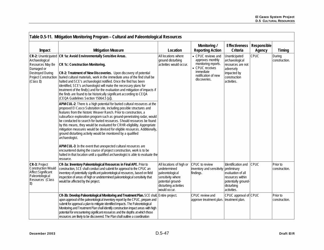
El Casco System Project D.5 CULTURAL RESOURCES
December 2003 D.5-47 Draft EIR
Table D.5-11. Mitigation Monitoring Program – Cultural and Paleontological Resources
Impact Mitigation Measure Location Monitoring /
Reporting Action Effectiveness
Criteria Responsible
Agency Timing CR 1a: Avoid Environmentally Sensitive Areas. CR 1c: Construction Monitoring. CR-2: Treatment of New Discoveries. Upon discovery of potential buried cultural materials, work in the immediate area of the find shall be halted and SCE’s archaeologist notified. Once the find has been identified, SCE’s archaeologist will make the necessary plans for treatment of the find(s) and for the evaluation and mitigation of impacts if the finds are found to be historically significant according to CEQA (CEQA Guidelines Section 15064.5 [a]).
CR-2: Unanticipated Archaeological Resources May Be Damaged or Destroyed During Project Construction (Class II)
APM CUL-2: There is a high potential for buried cultural resources at the proposed El Casco Substation site, including possible structures and features from the historic Weaver Ranch. Prior to construction, a subsurface exploration program such as ground-penetrating radar, would be conducted to search for buried resources. Should resources be found by this means, they would be evaluated for CRHR-eligibility. Appropriate mitigation measures would be devised for eligible resources. Additionally, ground disturbing activity would be monitored by a qualified archaeologist. APM CUL-3: In the event that unexpected cultural resources are encountered during the course of project construction, work is to be halted in that location until a qualified archaeologist is able to evaluate theresource.
All locations where ground disturbing activities would occur.
• CPUC reviews and approves monthly monitoring reports.
• CPUC receives immediate notification of new discoveries.
Unanticipated archaeological resources are not adversely impacted by construction activities.
CPUC During construction.
CR-3: Project Construction Would Affect Significant Paleontological Resources (Class II)
CR-3a: Inventory Paleontological Resources in Final APE. Prior to construction, SCE shall conduct and submit for approval to the CPUC an inventory of potentially significant paleontological resources, based on field inspection of areas of high or undetermined paleontological sensitivity that would be affected by the project.
All locations of high or undetermined paleontological sensitivity where potential ground-disturbing activities would occur.
CPUC to review inventory and sensitivity findings.
Identification and preliminary evaluation of all resources within potentially ground-disturbing activities.
CPUC Prior to construction.
CR-3b: Develop Paleontological Monitoring and Treatment Plan. SCE shall, upon approval of the paleontological inventory report by the CPUC, prepare and submit for approval a plan to mitigate identified impacts. The Paleontological Monitoring and Treatment Plan shall identify construction impact areas with high potential for encountering significant resources and the depths at which those resources are likely to be discovered. The Plan shall outline a coordination
Entire project. CPUC review and approve treatment plan.
CPUC approval of treatment plan.
CPUC Prior to construction.

El Casco System Project D.5 CULTURAL RESOURCES
Draft EIR D.5-48 December 2007
Table D.5-11. Mitigation Monitoring Program – Cultural and Paleontological Resources
Impact Mitigation Measure Location Monitoring /
Reporting Action Effectiveness
Criteria Responsible
Agency Timing strategy to ensure that all construction disturbance in high sensitivity sediments would be monitored full-time by qualified professionals. The Plan shall also detail methods of recovery; post-excavation preparation and analysis of specimens; final curation of specimens at a recognized, accredited facility; data analysis; and reporting. The Plan shall also specify a program of sample collection prior to construction, including water washing to recover small vertebrate fossils (as defined by the Society of Vertebrate Paleontologists).
CR-3c: Monitor Construction for Paleontology. Based on the paleontological sensitivity assessment and Monitoring and Treatment Plan consistent with Mitigation Measure CR 3b (Develop Paleontological Monitoring and Treatment Plan), SCE shall conduct full-time construction monitoring in areas where and when sediments of high paleontological sensitivity would be disturbed. Construction activities shall be diverted when data recovery of significant fossils is warranted.
Locations identified in paleontological treatment plan.
Progress reporting CPUC as identified in treatment plan.
Discovery of significant fossil resources from all localities affected by construction.
CPUC During construction.
CR-3d: Conduct Paleontological Data Recovery. If avoidance of significant paleontological resources is not feasible or appropriate, treatment (including recovery, specimen preparation, data analysis, curation, and reporting) shall be carried out by SCE, in accordance with the approved Treatment Plan per Mitigation Measure CR 3b (Develop Paleontological Monitoring and Treatment Plan).
Locations identified in paleontological treatment plan.
• CPUC review and approve treatment plan.
• CPUC review and approval of final data-recovery report and disposition of fossils.
Recovery of adequate samples of significant fossil resources from all localities affected by construction.
CPUC During construction; report within one year of data-recovery fieldwork.
CR-3e: Train Construction Personnel. All construction personnel shall be trained regarding the recognition of possible buried paleontological resources and protection of all paleontological resources during construction, prior to the initiation of construction or ground-disturbing activities. SCE shall complete training for all construction personnel. Training shall inform all construction personnel of the procedures to be followed upon the discovery of paleontological materials. Upon discovery of potential buried paleontological materials by paleontologists or construction personnel, work in the immediate area of the find shall be diverted and SCE’s paleontologist notified. Once the find has been inspected and a preliminary assessment made, SCE’s paleontologist shall notify the CPUC and proceed with data recovery in accordance with the approved Treatment Plan consistent with Mitigation Measure CR 3b (Develop Paleontological Monitoring and Treatment Plan).
Entire project. • CPUC reviews and approves contract specifications.
• CPUC reviews verification of required training.
• CPUC receives prompt notification of new resource discoveries and violations.
Paleontological resources are not adversely affected by construction activity.
CPUC Prior to and during construction.

El Casco System Project D.5 CULTURAL RESOURCES
December 2003 D.5-49 Draft EIR
Table D.5-11. Mitigation Monitoring Program – Cultural and Paleontological Resources
Impact Mitigation Measure Location Monitoring /
Reporting Action Effectiveness
Criteria Responsible
Agency Timing APM PALEO-1: Conduct a paleontological field assessment of the finalized right of way for the substation location. APM PALEO-2: Prior to construction a paleontologist would salvage known exposed paleontological resources. This would consist of collectedstandard samples of fossiliferous sediments. APM PALEO-3: A paleontological monitor would be present during ground disturbing activities within the Project area. The monitor would be empowered to temporarily halt or redirect construction activities to ensure avoidance of adverse impacts. APM PALEO-4: Upon encountering a large deposit of bone, salvage of allbone in the area would be conducted in accordance with modern paleontological techniques. APM PALEO-5: All fossils collected would be prepared to a reasonable point of identification. Itemized catalogs of all material collected and identified would be provided to the museum repository along with the specimens. A specimen repository would be arranged in writing with a museum prior to initiation of construction excavation. APM PALEO-6: A report documenting the results of the monitoring and salvage activities and the significance of the fossils would be prepared.
Source: SCE, 2007a. *site number has been corrected