cs directive v4.0 final - singapore land authority directives/cs... · cs directive on cadastral...
TRANSCRIPT
1
CCSS DDIIRREECCTTIIVVEE OONN CCAADDAASSTTRRAALL SSUURRVVEEYY PPRRAACCTTIICCEESS
The Directive is available on the Singapore Land Authority website.
URL: http://www.sla.gov.sg/.
SINGAPORE LAND AUTHORITY CHIEF SURVEYOR 55 NEWTON ROAD #12-01 REVENUE HOUSE SINGAPORE 307987 Version 4.0
2
Revision History
Revision
Version 1.0 June 2003
Version 2.0 September 2004
Version 3.0 April 2005
Version 3.1 May 2005
Version 3.2 May 2005
Version 3.3 Sept 2005
Version 3.4 March 2009
Version 4.0 Feb 2015 :
- Section 1.6.1(b), addition of “ Certified Plan
(CP)” and “ Certified Plan, Strata (CPST)”.
- Section 1.8.2, form number amended.
- Section 2.3.1(a) additional item added.
- Section 2.3.1(b) added.
- Section 2.4.4(a) addition of wordings.
- Section 2.4.4(c) , additional items added.
- Section 2.4.5(b), amended.
- Section 2.5 para 5(b) amended.
- Section 2.7 , additional items added.
- Section 2.10.1 and 2.10.2, additional item
added.
- Section 2.13 added.
- Section 2.14 on Need for Coordinates
Verification for Refinement Purposes added.
- Section 3.2(b) “Easting, Northing” co-ordinates
added.
- Section 3.10, additional information added.
- Section 3.12 added.
- Section 4.4.1(j) added.
- Section 4.7(e) “Optional” amended to “ Where
applicable”.
- Section 4.7(f) removed.
- Section 4.8(a) amendments made.
- Section 4.9(b) amended.
- Section 4.10 (a)(i) additional items added.
- Section 5.1(b),(c) additional items added.
- Section 5.5 (x) additional item added.
- Section 5.6 (iv) additional items added.

3
- Section 5.6 (xii),(xiii) and (xiv) added.
- Section 5.7(c) added.
- Section 5.10 additional items added.
- Section 5.12(c)(v)(B) additional item added.
- Section 5.12(f) amended.
- Section 5.15 added.
- Appendix A item 3 amended.
- Appendix B amended.
- Appendix C replaced.
- Appendix D-1 amended.
- Appendix D-2 added.
- Appendix F added wordings and replaced
sample plan.
- Appendix H amended.
- Appendix K, Address removed.
- Appendix M amended.
- Appendix N-1 amended.
- Appendix N-2 amended.
- Appendix Q-1, Q-2 and Q-4 amended.
- Appendix R-1 to R-2, S, T-1 to T-3 added.
- “Survey Services” amended to “Land Survey
Division”.
- “2.515 High Water Mark” amended to “2.515-
metre High Water Mark”
4
TABLE OF CONTENTS
1. GENERAL 9
1.1 Directive to be read with related documents 9
1.2 Registration of registered surveyors and authorised assistant 9
1.2.1 Registration of registered surveyors 9
1.2.2 Licensing of corporations 9
1.2.3 Registration of authorised assistant 10
1.2.4 Entry Card 10
1.2.5 Engagement of registered surveyors 11
1.3 Authorised boundary and control marks 11
1.3.1 Types of marks 11
1.3.2 Abbreviations and symbols for marks 11
1.4 Stability of marks 11, 12
1.5 Numbering of stations 12
1.6 Authorised plan forms 12
1.6.1 Plan requirements 12
1.6.2 Drafting requirements 12
1.7 Notations descriptors used in format 13
1.7.1 Notations used 13
1.7.2 Field separator and record terminator 13
1.8 Survey equipment calibrations 13
1.8.1 Calibration baseline 13
1.8.2 Calibration booking form 13
1.8.3 Calibration requirements 13
1.8.4 Calibration certificates 14
1.8.5 GPS testing and calibration 14
2. ADMINISTRATIVE 15
2.1 Conduct of cadastral survey 15
2.1.1 Commencement of survey 15
2.1.2 Survey in sequence 15
2.2 Supervision of cadastral surveys during surveyor's absence 15
2.2.1 Notification of absence
15
5
2.3 Encroachments 15
2.3.1 Encroachments discovered in cadastral surveys 15
2.3.2 Reporting encroachments 15,16
2.3.3 Power of the Chief Surveyor in dealing with encroachment in survey 16
2.3.4 Certificate in relation to encroachment 16,17
2.4 Allocation of lot numbers, activation of lot numbers and allocation of Strata Title Plan(STP) number
17
2.4.1 Application for lot numbers 17
2.4.2 Application of new lot numbers at launch of sale 17
2.4.3 Application of lot number for HDB recess area 17
2.4.4 Activation of lot numbers 18,19
2.4.5 Authorised usage of lot numbers 19
2.4.6 Lot numbering system 19,20
2.4.7 Display of old and present format lot numbers on Certified Plan(CP) 20
2.4.8 Application of STP number 20
2.5 Amalgamation of lots 20,21
2.6 Blocking-up survey of State land lot 21
2.7 Registrar of Title plan 22
2.8
Resurvey of land lot required for
a) single land lot under sale of State Land; or
b) strata subdivision where there is no land subdivision
22, 23
2.8.1 Verification survey 23
2.9 Survey for surrender and re-issue of title 24
2.10 Survey of balance lot 24
2.10.1 State Land balance lot 24, 25
2.10.2 Private balance lot 25,26
2.11 Alteration of Mukim and Town Subdivision Boundaries 26
2.12 Error in previous survey 26
2.13 Submission of Child Lots – Physical Parent Lots Information 26
2.14 Need for Coordinates Verification for Refinement Purposes 27
3. SURVEY OF LAND LOTS 28
3.1 Plane coordinate system (SVY21 plane coordinate system) 28
3.2 Survey datum 28
3.3 Survey control monuments 29
3.4 Traverse 29-31
6
3.5 Side shots 31-34
3.6 Area 34
3.7 Accuracy specifications 34,35
3.8 Boundary discrepancies 35
3.9 Survey of Resurvey lot 35
3.10 Survey of reclaimed land and foreshore lease 35
3.11 Survey of subterranean and airspace lot 35,36
3.12 New Curve Boundary ( Not applicable to P.O. Boundary) 36,37
4. PLAN & FILE SUBMISSION 38
4.1 Plan scales 38
4.1.1 Built-up areas 38
4.1.2 For other surveys 38
4.2 Drawing specifications 38
4.2.1 Text specifications 38
4.2.2 Line symbols 38
4.2.3 Symbols 38
4.3 Information to be shown on plans 39
4.3.1 Plan headings 39
4.3.2 Plan serial numbers 39
4.3.3 Numerical information on plan 39
4.4 Other information 39
4.4.1 Other information on Certified Plan 39, 40
4.4.2 Plan schedule 40
4.4.3 Names on plans 40
4.4.4 Certification of survey documents 40
4.5 File naming convention 40
4.6 Field survey file 41 - 43
4.7 Results file format 43 - 45
4.8 Sketches 46
4.9 Encroachment 46
4.10 Submission 46,47
4.11 On-line boundary marks shown in survey documents 48
4.12 Incorporating Leveling pages as part of SK 48
7
5. STRATA SURVEY 49
5.1 Field survey procedures 49, 50
5.2 Strata certified plan 51
5.3 Drawing specifications for strata certified plan 51, 52
5.4 Information to be shown on strata certified plans 52, 53
5.5 Information to be shown on site plans 53
5.6 Information to be shown on storey plans 53, 54
5.7 Elevation sketches 54, 55
5.8 Accessory lots 55
5.9 Provisional lots in phased strata developments 55
5.10 Submission 55, 56
5.11 Strata lot numbers without subdivision approval for leases between 7 and 21 years
56
5.11.1 Introduction 56, 57
5.11.2 Application of new strata lot numbers 57
5.11.3 Building with no strata lots 57
5.11.4 Building with strata lots 57
5.12 Strata survey for subdivided building for registration under Land Titles(Strata) Act
57 - 60
5.13 Strata survey of buildings in Cluster Housing 60
5.14 Strata Title Plan(Limited Common Property) – STP(LCP) 60
5.15 Strata Lots with step-down structures constructed below the approved stratum
60, 61
6. AMENDMENT OF APPROVED PLANS AND RELATED
DOCUMENTS
61
7. SURVEY FEES 62
Appendix
A Abbreviations and Symbols for Marks in Sketches / Certified Plans
63
B Sample of RT plan for subterranean lot 64
C Sample of RT plan for airspace lot 65
D-1, D-2 Sample of RT plan for foreshore and reclamation of land 66, 67
E Sample format for the file for RT on diskette 68
F Procedure For Survey On Alteration of Mukim (MK) and Town 69, 70
8
Subdivision (TS) Boundaries
G-1 to G-5 Sample sketches of CP 71 - 75
H Sample Certified Plan 76
J Sample of field survey file (.job) 77 - 79
K Sample of results data file format (.svy) 80 - 82
L SLA’s current policy for retention of encroachments from private properties onto/over/under state lands
83
M Symbol Sheet 84
N-1 to N-2 The sample of subterranean and airspace lot CP 85, 86
P Sample of the level details recording page 87
Q-1 to Q-4 Sample of CPST in STP format 88 - 91
R-1 to R-2 Sample of sketch PPL and letter format for “Child Lots-Physical Parent lots information”
92, 93
S Sample of bar scale 94
T1 to T3 Sample FD, CPST for Elevation Sketch and Storey Plan for strata lots with step down structures
95 - 97

9
1. GENERAL
1.1 Directive to be read with related documents
This Directive serves to provide the details for the procedures and practices relating to the conduct of cadastral surveys in Singapore. It is not intended to be an interpretation of the Boundaries and Survey Maps Act and the Boundaries and Survey Maps (Conduct of Cadastral Surveys) Rules.
It should not be used as a replacement of the Act and Rules which are the authoritative documents. It is also not intended to be an instruction manual for listing every operational process. It does not list details of established practices which registered surveyors are fully aware of and have been practicing them.
CS Circulars and CS Notices are issued by the Chief Surveyor as and when necessary for subject matters on new practices or changes to existing practices. Periodically, these subject matters are reviewed for incorporation in this Directive. At any time, new circulars and notices may still be in use.
Hence, prior to the incorporation, the subject matters in these new circulars and notices are in practice. Registered surveyors should therefore refer to this Directive in conjunction with the Act, Rules, CS Circulars, CS Notices and any other established practices where applicable.
1.2 Registration of registered surveyors and authorised assistant
1.2.1 Registration of registered surveyors
A Surveyor shall only practise if:
(a) his name is in the Register of Surveyors; and
(b) his name is in the Annual Register of Practitioners.
i. Application for registration
A person who meets the requirements for registration as a surveyor can apply to the Land Surveyors Board on a prescribed form accompanied by the requisite documents and a cheque for the prescribed fee made payable to Land Surveyors Board Singapore. For more information, visit the Board website at http://www.minlaw.gov.sg/content/lsb/en.html.
ii. Application for practising certificates
A Registered Surveyor who wishes to practise cadastral survey in Singapore is required to apply to the Board for a Practising Certificate on a prescribed form accompanied by the requisite documents and a cheque for the prescribed fee made payable to Land Surveyors Board Singapore. For more information, visit the Board website at http://www.mlaw.gov.sg/content/lsb/en.html.
1.2.2 Licensing of corporations
A corporation or partnership which intends to provide cadastral survey services is required to have a licence granted by the Land Surveyors Board. Application for a licence should be made on a prescribed form accompanied by the requisite documents and a cheque for the prescribed fee made payable to Land Surveyors Board Singapore. For more information, visit the Board website at http://www.mlaw.gov.sg/content/lsb/en.html.
10
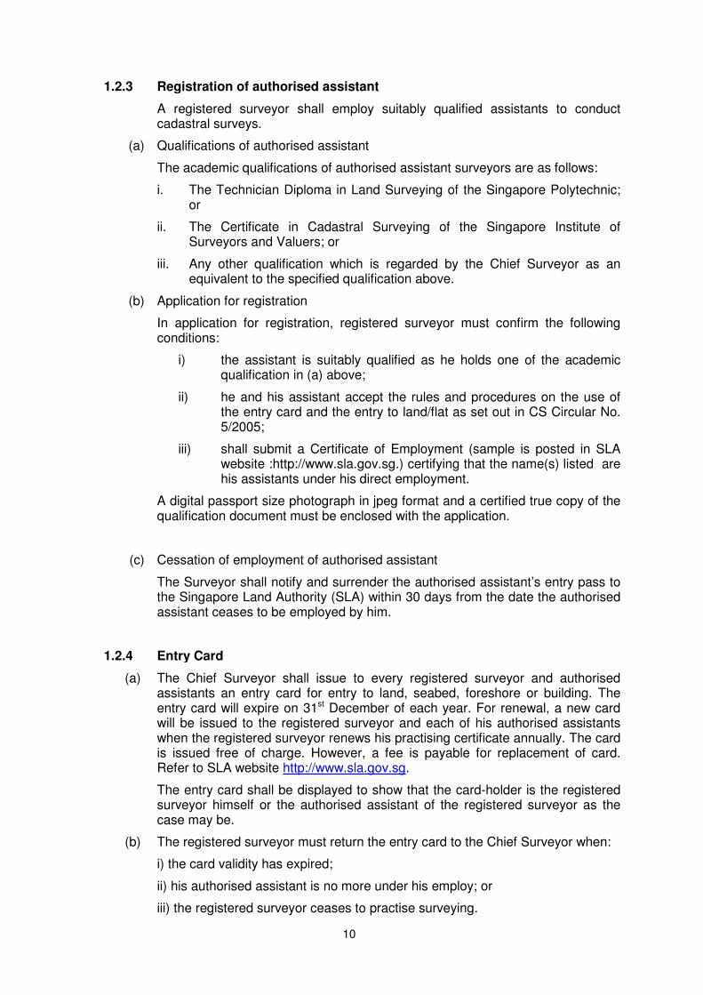
1.2.3 Registration of authorised assistant
A registered surveyor shall employ suitably qualified assistants to conduct cadastral surveys.
(a) Qualifications of authorised assistant
The academic qualifications of authorised assistant surveyors are as follows:
i. The Technician Diploma in Land Surveying of the Singapore Polytechnic; or
ii. The Certificate in Cadastral Surveying of the Singapore Institute of Surveyors and Valuers; or
iii. Any other qualification which is regarded by the Chief Surveyor as an equivalent to the specified qualification above.
(b) Application for registration
In application for registration, registered surveyor must confirm the following conditions:
i) the assistant is suitably qualified as he holds one of the academic qualification in (a) above;
ii) he and his assistant accept the rules and procedures on the use of the entry card and the entry to land/flat as set out in CS Circular No. 5/2005;
iii) shall submit a Certificate of Employment (sample is posted in SLA website :http://www.sla.gov.sg.) certifying that the name(s) listed are his assistants under his direct employment.
A digital passport size photograph in jpeg format and a certified true copy of the qualification document must be enclosed with the application.
(c) Cessation of employment of authorised assistant
The Surveyor shall notify and surrender the authorised assistant’s entry pass to the Singapore Land Authority (SLA) within 30 days from the date the authorised assistant ceases to be employed by him.
1.2.4 Entry Card
(a)
The Chief Surveyor shall issue to every registered surveyor and authorised assistants an entry card for entry to land, seabed, foreshore or building. The entry card will expire on 31st December of each year. For renewal, a new card will be issued to the registered surveyor and each of his authorised assistants when the registered surveyor renews his practising certificate annually. The card is issued free of charge. However, a fee is payable for replacement of card. Refer to SLA website http://www.sla.gov.sg.
The entry card shall be displayed to show that the card-holder is the registered surveyor himself or the authorised assistant of the registered surveyor as the case may be.
(b) The registered surveyor must return the entry card to the Chief Surveyor when:
i) the card validity has expired;
ii) his authorised assistant is no more under his employ; or
iii) the registered surveyor ceases to practise surveying.
11
1.2.5 Engagement of registered surveyors
For every cadastral survey, the registered surveyor shall submit the completed form “Engagement of Registered Surveyor” to the Chief Surveyor. The prescribed form can be retrieved from the SLA website: http://www.sla.gov.sg.
1.3 Authorised boundary and control marks
1.3.1 Types of marks
The following marks are authorised for the type of use specified in relation thereto:
(a) for general use — iron pipes not less than one metre long and not less than 3 and not more than 5 centimetres in diameter, preferably tarred or galvanised;
(b) for general use — reinforced cylindrical concrete marks, approximately 50 centimetres long with a diameter of not less than 5 centimetres and carrying a punched impression for the actual station point;
(c) for general use — existing granite stones with punched centre marks used in previous surveys;
(d) for marking salient traverse points on road surfaces and general use — iron spikes of not less than 15 centimetres long and one centimetre in diameter and set in concrete;
(e) for marking on soft ground — reinforced concrete posts approximately one to two metres long, not less than 5 square centimetres in cross-section and carrying a punched impression for the actual centre point;
(f) for marking on masonry, brickwork and formed pavements — nails or spikes set in concrete;
(g) for marking on large rocks and smooth masonry — cut marks carrying a punched hole with a chiselled broad arrow pointing to it on large rocks and on smooth masonry;
(h) for any other specific use — any other marks approved by the Chief Surveyor; and
(i) any ISN or Precise Level Bench mark which has been established by the Chief Surveyor.
1.3.2 Abbreviations and symbols for marks
The abbreviations and symbols for marks in field books/sketches/.svy file and on plans at Appendix A shall be adopted.
1.4 Stability of marks
(a) A registered surveyor shall take every precaution to ensure that marks are permanent and stable.
(b) Concrete marks shall be planted with not more than 5 centimetres of the mark projecting above ground, and the earth around the mark shall be firmly rammed while planting the mark.
(c) Iron pipes shall be driven into the ground leaving not more than one-tenth of their length projecting.
(d) Spikes, pipes or nails planted in roadways or pavements shall be sunk flush with

12
the surface, their heads set in concrete, and the road or pavement disturbed by the operation shall be made up with concrete to withstand all wear from traffic.
(e) Existing marks found in a survey which are proved to be in position but do not comply with this rule shall be raised or lowered accordingly.
1.5 Numbering of stations
(a) Stations shall be numbered consecutively in the order in which they are observed and no letters or accentuated numbers for stations shall be used for this purpose.
(b) No station number shall be used more than once in each survey.
(c) A station number shall refer to a position and not to any particular mark which may be used to define that position.
(d) A mark which is moved to a different position from where it was first observed shall be allotted a new number.
1.6 Authorised plan forms
1.6.1 Plan requirements
(a) Clarity
i. The scale on which the plan is drawn and the plan size shall be selected such that the coordinates of each station and the area of each lot can be clearly seen.
ii. On plans, if stations or boundaries are illegible or difficult to interpret, a diagram drawn on a scale larger than that of the plan, or drawn not to scale, may be added as an inset.
(b) Plan form
Certified Plan (CP)
i. A1 (594 mm X 841 mm)
ii. A2 (420 mm X 594 mm)
iii. A3 (297 mm X 420 mm)
Certified Plan, Strata (CPST)
iv. B3 (353 mm x 500 mm)
1.6.2 Drafting requirements
(a) Line types
Boundary lines shall be represented by firm black lines, and connection lines and traverse lines in sketches shall be represented by broken black lines.
Mukim and Town Subdivision boundary lines shall be represented as shown in the symbol sheet.
(b) Abbreviations
The abbreviations, symbols and conventional signs adopted by the Chief Surveyor shall be used on plans/sketches/field details.
Symbol sheet is shown in Appendix M.
13
1.7 Notations descriptors used in format
Unless otherwise specified, digital files shall be in readable ASCII format. Each file shall contain more than one section of data. Each section is preceded by a control keyword, followed by the data and is terminated by another record containing another keyword.
1.7.1 Notations used
The following notations shall be used in describing the format of digital files:
i. <field> enclosures for the field item, the brackets "< >" should not be included in the file
ii. \ means a continuation line from the previous line
iii. # when used indicates that the rest of the record is for comments
1.7.2 Field separator and record terminator
Unless otherwise specified, the default field separator is comma (",") and the terminator keyword is usually <END>.
1.8 Survey equipment calibrations
1.8.1 Calibration baseline
All Total Station/Calibration instrument used for cadastral surveys shall be calibrated using the calibration baseline at the Lower Pierce Reservoir.
1.8.2 Calibration booking form
The prescribed calibration booking form QP-LSV-12-F01-03 could be retrieved from the SLA website: http://www.sla.gov.sg. Each registered surveyor shall process the measurements and ensure that the survey equipment used is tested to be in good adjustment. The Registered Surveyor is required to submit the result to Chief Surveyor as and when required.
1.8.3 Calibration requirements
(a) Calibration frequency
Total stations and electronic distance measuring equipment shall be calibrated based on Chief Surveyor’s standards:
i. before being brought into use when new or after repair;
ii. at intervals of not more than one year.
(b) Distance measurement calibration
The distance measurements shall be calibrated for instrument constant and scale and shall be better than (5 mm ± 5 ppm).
(c) Direction Measurement
The repeatability of direction measurements shall be checked by a series of at least 20 measurements to a distant target. The standard deviation of each direction measurement shall be better than ±5 seconds.

14
1.8.4 Calibration certificates
(a) Digital calibration certificate
The digital calibration certificate shall accompany every survey submitted. Refer to field survey file described in Chapter 4.
(b) Additive constant
The additive constant shall be less than 5 mm and shall be applied to all measurements.
1.8.5 GPS testing and calibration
GPS testing and calibration is described in “ Guidelines and Specifications for GPS Surveys of ISN Markers”
15
2 ADMINISTRATIVE
2.1 Conduct of Cadastral Survey
2.1.1 Commencement of survey
(a) Duty to acquire relevant Information
When carrying out a survey, every registered surveyor or his representatives shall obtain all relevant information to locate and re-locate the boundaries of any land to be surveyed.
2.1.2 Survey in sequence
Registered surveyors shall carry out cadastral survey in sequence. There are jobs in which the survey of the child lots was submitted by a registered surveyor for approval prior to the submission of the survey of the parent lot by another registered surveyor. The demarcation of the common boundary shall be made known and accepted by both registered surveyors.
2.2 Supervision of cadastral surveys during registered surveyor's absence
2.2.1 Notification of absence
Any registered surveyor who is away overseas for a continuous period of more than 3 weeks shall inform the Chief Surveyor in writing of:
i. the period of absence from Singapore; and
ii. the name of the registered surveyor supervising the cadastral survey in his absence.
2.3 Encroachments
2.3.1 Encroachments discovered in cadastral surveys
(a) Registered surveyors must detect and record all encroachments in their surveys in the Sketch(SK) or Field detail(FD) pages under any situation of the encroachments. The encroachment may be on the ground, above-ground or below-ground level. The extent of the encroachment details are to be highlighted in yellow in the detail SK.
(b) After checking the survey is in order, any structure located more than 30mm into neighbouring boundary and vice versa must be indicated clearly in the field sketches and reported.
(c) Offsets and radiations are to be taken and recorded to determine the extent of encroachments of the structures in relation to lot boundaries.
2.3.2 Reporting encroachments
(a) Registered surveyors must indicate whether there are any encroachments in the Survey Report form when submitting the job to the Chief Surveyor. For any encroachment reported in the Survey Report form, the registered surveyors are to give a brief description of the encroachment in the Remarks column of the form.
16
(b) Where encroachment is reported in strata survey, it is to be shown and clearly described in the Site Plan and / or Storey Plans of the FD and strata certified plan(CPST). Registered surveyors are to ascertain whether the common properties or strata units or both are affected. If strata units are affected, the amount of encroachment (in sq m) is to be scaled and shown in the FD and CPST. In such a case, the strata lot and its area cannot include the part of the flat unit that encroaches onto adjacent land.
(c) Where the structure of URA Conservation Site is reported to be encroaching onto State Land, the encroachment is allowed to stay. No TOL will be issued but the notice of encroachment will be inserted on the certificate of title(CT) / subsidiary certificate of title(SSCT).
2.3.3 Power of the Chief Surveyor in dealing with encroachment in survey
(a) Pursuant to section 11D(3)(c) of the Boundaries and Survey Maps Act, the Chief Surveyor may refuse to approve any survey plan or assurance plan if an encroachment has been created by the purchaser or owner of a parcel of land being surveyed for any “relevant purpose”, which affects any parcel of land adjoining that parcel of land, and the registered surveyor who signs the plan has not certified that the encroachment has been resolved. The “relevant purpose” has been defined in section 11D(6) to be as follows:
(i) obtaining a new State title for a parcel of land;
(ii) amalgamating the parcel of land; or
(iii) subdividing the parcel of land.
The Chief Surveyor may reject the job if the encroachment is not yet resolved at the time of submission.
(b) Where the encroachment is onto adjoining State Land, the registered surveyor shall liaise with the purchaser or landowner to resolve the encroachment with the Commissioner of Lands. Please refer to Appendix L on SLA’s current policy for retention of encroachments from private properties onto/over/under state lands.
(c) Where the encroachment is onto adjoining private land, the registered surveyor shall liaise with the purchaser or landowner to resolve the encroachment with the landowner of the adjoining land. The landowner of the adjoining land must be the party to confirm that the resolution has been made.
(d) Documentary evidence confirming that the encroachment has been resolved must be produced.
(e)
Where encroachment is from an adjoining land onto the private land under survey, Registered Surveyors are required to submit to Chief Surveyor a copy of their letter notifying their clients/ land owner to resolve the encroachment with their neighbour.
2.3.4 Certificate in relation to encroachment
(a) Rule 15 of the Boundaries and Survey Maps (Conduct of Cadastral Surveys) Rules stipulates that every survey plan submitted to the Chief Surveyor for approval shall be accompanied by a certificate signed by the registered surveyor in the form as prescribed therein. Registered surveyor must complete and submit the prescribed certificate for each job regardless of whether there is any encroachment or not.
(b) Registered surveyors are to note that the certificate shall be completed according to what is intended for under the section 11D(3)(c); i.e. the encroachment is
17
created by the purchaser or landowner of the lot under survey and the encroachment is onto adjacent land. It is not intended for taking resolutions for other situation of encroachments such as the encroachment is caused by and from the adjoining land or it was created by persons other than the purchaser or landowner of the land under survey.
2.4 Allocation of lot numbers, activation of lot numbers and allocation of Strata Title Plan(STP) number
2.4.1 Application for lot numbers
(a) Every registered surveyor or any representatives authorised by him shall obtain from Chief Surveyor all lot numbers to be used in connection with the survey he is to carry out.
(b) Application shall be on prescribed form which can be retrieved from the SLA website Http : // www.sla.gov.sg.
(c) Fee for application of lot numbers.
2.4.2 Application for new lot numbers at launch of sale
(a) Registered surveyor shall apply for new land lot numbers and strata lot numbers before the development is launched for sale. The new lot numbers are issued upfront for purpose to uniquely identify the new land plots/ strata units for launch of sale and for registration of caveat. Unless their lots status have been updated to “live” in the Lot Base System by the Chief Surveyor, such lot numbers are provisional and should not be quoted for any purpose. An application for the land or strata lot numbers to be sold shall be accompanied by:
i For land and/or strata lots, written permission and the approved development plan. If other than for approved development case, the relevant plan referred to in the survey request.
ii
For strata lots, in addition to (i) above, the approved building plan for the development or the certified true copy of the building plan for the development submitted to the Building and Construction Authority for approval.
(b) The land or strata lots shall be identified with house/unit numbers on the approved development plan or the approved building plan.
(c) The total number of land/ strata lot numbers applied shall tally with the total number of plots appearing on the approved development plan.
2.4.3 Application of lot number for HDB recess area
(a) When applying for strata lot numbers for recess areas, registered surveyors shall comply with the following:
i. Provide a copy or portion of the CPST plan to show the relevant unit and indicate clearly the extent of the recess area to be surveyed;
ii. Provide the existing strata lot number and house number of the unit.
18
2.4.4 Activation of lot numbers
(a) Registered Surveyor may apply to update lot status from “provisional” to “live” for purpose of lodging caveats. The application shall be accompanied by:
(i) Inland Revenue Authority of Singapore (IRAS) letter of approved development name or building name and house numbering.
(ii) Fee for activation of lot numbers.
(b) For cases where strata lot numbers are allocated for new developments on en-bloc sale or HDB SER programme sites, the SSCTs or strata leases of the existing strata lots must be terminated or cancelled respectively before the application to make the new strata lots “live” can be submitted. The pre-condition is in CS Circular No.4/2007.
(c) Registered surveyors are required to correlate the property addresses with the new lot numbers allocated at before launch of sale of a development. The data format should be prepared in excel text file format. The respective formats for land lots and strata lots are shown below:
Correlating Accessory Lot to Strata Lot
Excel Filename: Correlating_Accessory_Lot_to_Strata_Lot.xls
Column Name Data
Type Maximum
Characters Allowable
Example (Data)
Accessory_Lot_Number String Accessory -11 Accessory Lot: MK01-A0001M
Strata_Lot_Number String Strata -13 Strata Lot: MK01-U000001P
Activation of Land/Strata/Accessory Lot Numbers (with/without Address)
Excel Filename: Activation_of_Lot_Numbers.xls
Accessory_Lot_Number Strata_Lot_Number
Correlating Accessory Lot to Strata Lot
Lot_Number House_Number Street_Name Level_Number Unit_Number Postal_Code Address_Source Building_Name Building_Source
Activation of Land/Strata/Accessory Lot Numbers (with/without Address)
19
Column Name Data Type
Maximum Characters Allowable
Example (Data)
Lot_Number String Land - 11
Strata – 13
Accessory -11
Land Lot: MK01-00001W
Strata Lot: MK01-U000001P
Accessory Lot: MK01-A0001M
House_Number String 10 123A, 123
Street_Name String 75 YISHUN STREET 72
Level_Number String 3 B1, 10
Unit_Number String 5 1234, 123A
Postal_Code Numeric 6 760764
Address_Source String 4(Auto Display)
IRAS
Building_Name String 50 REVENUE HOUSE
Building_Source String 4(Auto Display)
IRAS
Note : Land includes Subterranean and airspace lots.
2.4.5 Authorised usage of lot numbers
(a) Registered surveyor shall not use any other lot numbers without the express sanction of the Chief Surveyor.
(b) Registered surveyor shall not use or quote the lot number in any instrument or caveat to be lodged in the Land Titles Registry, unless the lot number or the relevant assurance plan, STP or CP has been approved by the Chief Surveyor.
2.4.6 Lot numbering system
The numbering of lot numbers, which is unique for every lot, shall be of the following formats:
(a) Land lot(include airspace and subterranean lots)
MK/TS MK/TS No.
Lot No. Check Digit
⇓ ⇓ ⇓ ⇓ Land Lot No.
: A(2) N(2) N(5) A(1)
Example: MK 18 12828T MK 18 05422T
(Note: “0” in front of the lot number is
required for correlation of
property address text file and .svy file
only)
A(n) denotes n alphanumeric characters N(n) denotes n numeric characters
20
(b) Strata lot
MK/TS MK/TS No.
Strata Lot
Strata Lot No.
Check Digit
⇓ ⇓ ⇓ ⇓ ⇓ Strata Lot
No. A(2) N(2) U N(6) A(1)
Example: MK 17 U 18118L
(c) Accessory lot
MK/TS MK/TS No.
ALot ALot No. Check Digit
⇓ ⇓ ⇓ ⇓ ⇓ Accessory Lot No. A(2) N(2) A N(4) A(1)
Example: TS 25 A 19W
2.4.7 Display of old and present format lot numbers on Certified Plan (CP)
The relationship between the parent lot number in the old and present formats shall be incorporated in the history of subdivision of the CP as illustrated below:
Lot Number
Here Subdivided Into Lots
Old Format New Format
28-7 99899V 4513P & 4514T
29-3 99895L 4429K to 4434T
2.4.8 Application of STP number
When applying to the Chief Surveyor for CPST number for a new strata title development, the registered surveyor shall at the same time apply for a STP number. In the case of further subdivision or amalgamation of strata lots of an existing strata title development, the registered surveyor shall request the Chief Surveyor to release the current STP number of that development.
The STP number shall be shown at the space provided for on the 1st sheet of the STP.
2.5 Amalgamation of lots
(a) Amalgamation of land lots shall only be effected if the lots to be amalgamated satisfy the following conditions:
1. Same land ownership
(i.e. either State ownership, same private ownership, same statutory board, same company, same corporation or same trusteeship, etc).
i. State ownership under different state land sub-ownership status cannot be amalgamated. The lots must be either all pure state land or all state land held in trust by the same statutory board. For such cases the registered surveyor when applying for new lot numbers should provide the proposed subdivision and amalgamation and vice versa. The Chief Surveyor will consider the proposal in consultation with Commissioner of Lands(COL).
21
ii. Same company, same corporation or same trusteeship means a single registered entity; i.e. name of company, corporation, partnership or trusteeship must be the same.
2. Same system of land registration
(i.e. either registered land under Land Titles Act(LTA) or unregistered land under Registration of Deeds Act(ROD)).
i. All registered land lots shall have live CTs.
ii. All state land lots are unregistered lands.
3. Same land tenure
i.e. either freehold(Grant or GFS), Statutory Land Grant(SLG) or Leasehold(L) or State Land(SL).
i. Grant and Grant-In-Fee Simple(GFS) titles are freehold lands and lots can be amalgamated. (Grant is also known as Indenture).
ii. For leasehold land lots, their lease terms (e.g. different restrictive covenants) and expiry dates must be the same.
iii. Registered sub-lease which will create reversionary interest and different sets of expiry dates, cannot be amalgamated.
Note : Registered sub-lease means the original landowner has leased his land be it freehold, SLG or leasehold property to another landowner(called sub-leasee) for a number of years(e.g. 60 years) with reversionary interest. At the end of the sub-lease(e.g. after 60 years), the land goes back to the original landowner. To detect for sub-lease, land lot with registered sub-lease will have 2 or more live CTs. Their CTs will give the details.
4. Contiguous lots
Amalgamation should form one closed polygon lot.
5. The above pre-conditions do not apply to ad-hoc synchronized cases for surrender and re-issue of titles. COL will need to state in the survey request that it is for synchronized issue of titles.
Note : Synchronized issue of titles means the original titles of the parent lots are surrendered to the State simultaneously with the new title issued to the amalgamated child lot. There is no time gap between surrender and re-issue.
(b) Amalgamation of strata lots, or accessory lots, shall only be effected if the lots to be amalgamated satisfy the following conditions:
i. The strata lots must be under the same ownership,
ii. The strata lots are contiguous and residing on the same land lot, in which case the above pre-conditions (a)(2) to (4) for the land lot would have applied to the strata lots.
2.6 Blocking–up survey of State land lot
Blocking-up survey of State land lot shall facilitate further subdivision of the land and simplify lot management. Registered surveyors shall ensure that the proposed blocked-up boundaries are following the edge of the development outline, road network, etc.
22
2.7 Registrar of Title Plan
Registrar of Title (RT) plan may be prepared for the following survey:
a) Subterranean lot;
b) Airspace lot;
c) Reclaimed land;
d) Foreshore structures
In the RT submission, Registered Surveyor is to provide the estimated completion date of construction. Draft description is required for submission of reclaimed land and foreshore structures. Fees payable to the Singapore Land Authority are posted on SLA website http: // www. sla.gov.sg.
The formats of RT plans for the survey above are shown at Appendixes B, C & D at the end of this directive.
Appendix E shows the format for the file for RT to be submitted along with RT plan. The file format is .svy file format.
The correlation of land lot with RT number and area in excel file is required to be submitted. The format is as follows:
Updating Land Lot with RT Number and Area ( Includes Dummy lots)
Excel Filename: RT_Information.xls
Column Name Data Type Maximum Characters Allowable
Example (Data)
Column Name
Lot_Number String Land - 11 Land Lot: MK01-00001W
Lot_Number
Plan_Type String 2 (Auto Display) RT Plan_Type
Plan_Number Numeric 5 12345 Plan_Number
Plan_Area Numeric 8 12345678 Plan_Area
2.8 Resurvey of land lot required for
a) single land lot under sale of State Land; or
b) strata subdivision where there is no land subdivision
(a)
For single land lot under sale of State Land, the cadastral survey is conducted prior to construction and the site may be vacant. When the CP is approved, the registered surveyor concerned will have to draw the attention of the landowner that a resurvey is required when the construction is completed. The reasons for the resurvey are to reinstate the boundary marks which may have been disturbed or removed and to ascertain whether there is any encroachment due to construction.
(b) "Single land lot" under sale of State Land refers to an alienated lot which when developed, will not be further subdivided into child lots. Examples of single lot are bungalow plot, petrol station, religious site, remnant land, etc. A resurvey is not required if the alienated lot will be further subdivided as the subsequent survey of
Lot_Number Plan_Type Plan_Number Plan_Area
Updating Land Lot with RT Number and Area
23
the child lots will address the issues of lost or out-of-position boundary mark and any encroachment.
(c)
Under section 10(1) of the Boundaries and Survey Maps Act (Cap25), the landowner has the responsibility to preserve the boundary marks erected on the boundaries of the land. The preservation of the boundary marks would include that for single land lot surveyed for alienation and the resurvey would reinforce the requirement for the landowner to comply with the section.
(d)
The onus is on the registered surveyor concerned to initiate action for the resurvey as soon as the site permits. The survey fee payable to SLA is in accordance with the prescribed fee under the Boundaries and Survey Maps (Singapore Land Authority Fees) Rules.
(e) Similarly, a resurvey of the land lot is required when a strata survey is conducted to subdivide the building within into strata lots and where there is no subdivision of the land lot consequent to the development. For such a strata development, the registered surveyor, when submitting the Strata Certified Plans to the Chief Surveyor, will include the submission of the CP for the resurvey. However, such resurvey is not required if the strata survey is for:
(i) HDB recess area or HDB Space Added Item(SAI);
(ii) subdivision of existing strata lot or strata provisional lot;
(iii) amalgamation of existing strata lot and or common property;
(iv) excision of strata lots for strata leases;
(v) excision of common property to form strata lot;
(vi) resurvey of strata lot ; or
(vii) registration of strata leases exceeding 7 years but not more than 21 years without sub-divisional approval.
(viii) HDB or private strata leases of part of building or part of estate.
(f)
In the event of any encroachment caused by the developer/ landowner, the registered surveyor shall liaise with the developer / landowner to resolve it before the resurvey is submitted to Chief Surveyor. The details of resolving the encroachment are in the respective content.
2.8.1 Verification Survey
(a) Verification survey is where only part(s) of the lot boundaries are surveyed and no area is required e.g. survey of part of the boundaries lot for encroachment. The CP shall show those boundaries under the verification survey. For fee chargeable refer to SLA website.
(b) If the survey is for all the boundaries of the lot, it is considered as a resurvey. As the whole lot is resurveyed, the area is required to be finalised.
(c) In the case where the whole land lot is required to be resurveyed arising from strata subdivision or where the lot is SVY_QLTY 2, para 2.8.1 (b) will apply.
(d) Where a survey comprises both verification of part of lot boundaries and resurvey of whole lots, then para 2.8.1(a) will apply to the verification survey and 2.8.1(b) to each lot under resurvey.
24
2.9 Survey for surrender and re-issue of title
(a) A cadastral survey for surrender and re-issue of title of a land lot is not required if the lot CP is approved less than 20 years ago and surveyed under the SVY21 datum and does not involve High Water Mark(HWM).
(b) A pair of title plans will be prepared from that CP.
(c) This is also applicable to cases on expiry of leases.
(d) Refer to SLA website for fee payable for the preparation.
2.10 Survey of balance lot
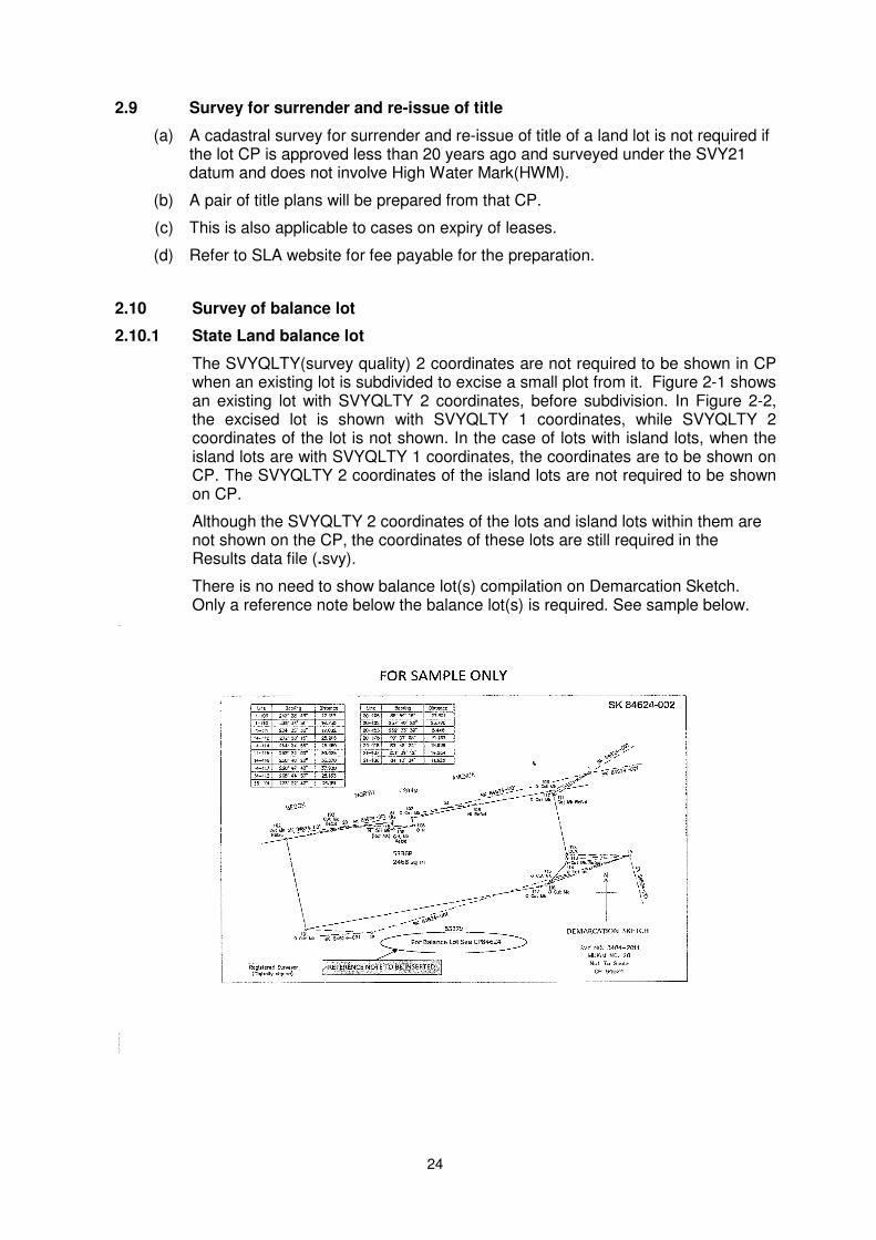
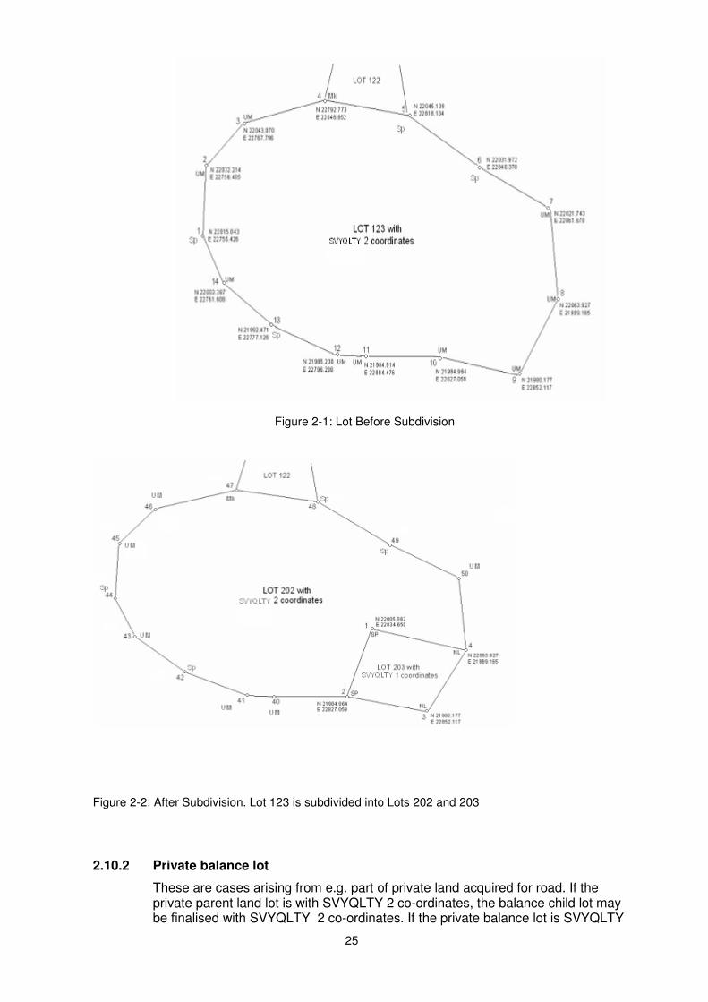
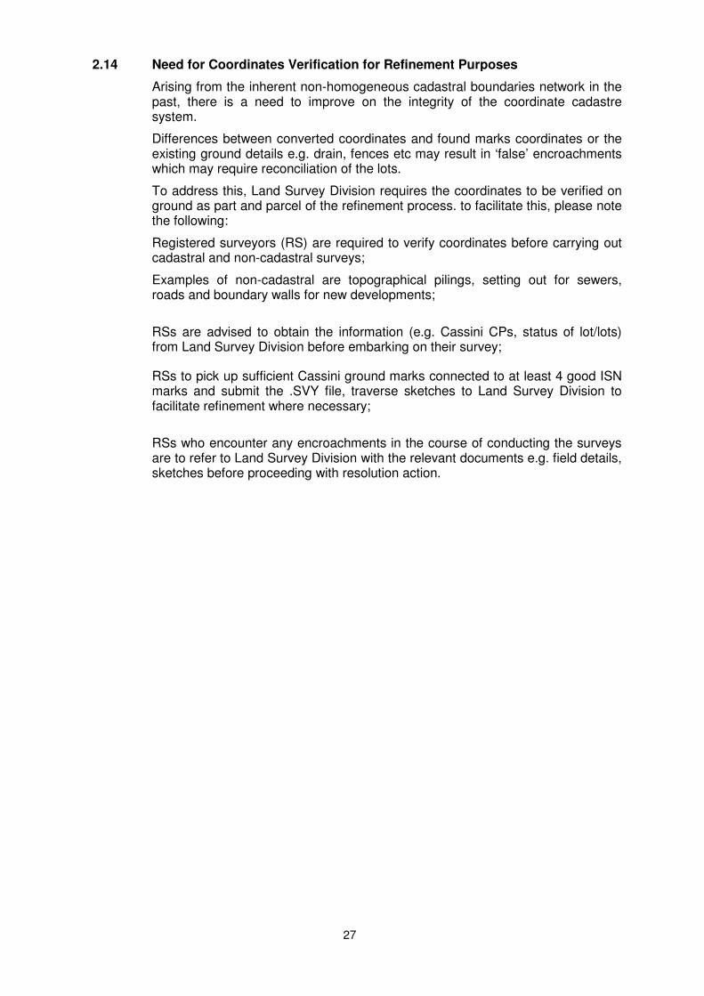
2.10.1
State Land balance lot
The SVYQLTY(survey quality) 2 coordinates are not required to be shown in CP when an existing lot is subdivided to excise a small plot from it. Figure 2-1 shows an existing lot with SVYQLTY 2 coordinates, before subdivision. In Figure 2-2, the excised lot is shown with SVYQLTY 1 coordinates, while SVYQLTY 2 coordinates of the lot is not shown. In the case of lots with island lots, when the island lots are with SVYQLTY 1 coordinates, the coordinates are to be shown on CP. The SVYQLTY 2 coordinates of the island lots are not required to be shown on CP.
Although the SVYQLTY 2 coordinates of the lots and island lots within them are not shown on the CP, the coordinates of these lots are still required in the Results data file (.svy).
There is no need to show balance lot(s) compilation on Demarcation Sketch. Only a reference note below the balance lot(s) is required. See sample below.
25
Figure 2-1: Lot Before Subdivision
Figure 2-2: After Subdivision. Lot 123 is subdivided into Lots 202 and 203
2.10.2 Private balance lot
These are cases arising from e.g. part of private land acquired for road. If the private parent land lot is with SVYQLTY 2 co-ordinates, the balance child lot may be finalised with SVYQLTY 2 co-ordinates. If the private balance lot is SVYQLTY

26
1 co-ordinates shall be finalised with SVYQLTY 1 co-ordinates and shown on CP.
There is no need to show balance lot(s) compilation on Demarcation Sketch. Only a reference note below the balance lot(s) is required. See sample shown in para 2.10.1.
2.11 Alteration of Mukim and Town Subdivision Boundaries
The survey is to be conducted in accordance with the provisions of the Boundaries and Survey Maps Act and its rules. SLA will levy a fee in accordance with the Boundaries and Survey Maps (Singapore Land Authority Fees) Rules and paragraph 7 of this directive.
Appendix F at the end of this Directive sets out the technical procedure for such a survey.
2.12 Errors in previous survey
When a registered surveyor discovers an error in a previous cadastral survey which would materially affects the accuracy of his cadastral survey, he is required:
(a) provide the Chief Surveyor with a full report of the error together with all relevant information relating to the error, and
(b) rectify the error only after Chief Surveyor has given instructions to do so.
2.13 Submission of Child Lots – Physical Parent Lots Information
In some survey jobs, the parent lots (termed as “physical parent lots”) may be amalgamated as a “dummy” lot for simultaneous subdivision into new child lots. The amalgamated “dummy” lot is to simplify, facilitate and comply with the subdivision and survey actions.
For registration of caveats, Certificate of Titles and other instruments against the child lots, the information of the “child lots-physical parent lots” relationship is required. This applies to land, strata and accessory lots. Registered Surveyors are required to indicate whether the child lot is derived from the whole or part of the Physical Parent Lots.
For illustration, please see Sketch PPL and sample letter format at Appendix R-1 and R-2.
Registered Surveyors are required to supply the “child lots-physical parent lots” information when submitting requests for:
(a) Activation of the caveat child lots to live lots (where applicable); or
(b) Approval of RT Plans (where applicable); or
(c) Approval of CP / CPST.
The information is to be supplied at whichever request is submitted first and also send a copy of the letter to your clients (i.e. developers / landowners) for them to forward it to their solicitors.
For more details, see CS Circular No. 1/2011 and CS Circular No. 3/2011.
27
2.14 Need for Coordinates Verification for Refinement Purposes
Arising from the inherent non-homogeneous cadastral boundaries network in the past, there is a need to improve on the integrity of the coordinate cadastre system.
Differences between converted coordinates and found marks coordinates or the existing ground details e.g. drain, fences etc may result in ‘false’ encroachments which may require reconciliation of the lots.
To address this, Land Survey Division requires the coordinates to be verified on ground as part and parcel of the refinement process. to facilitate this, please note the following:
Registered surveyors (RS) are required to verify coordinates before carrying out cadastral and non-cadastral surveys;
Examples of non-cadastral are topographical pilings, setting out for sewers, roads and boundary walls for new developments;
RSs are advised to obtain the information (e.g. Cassini CPs, status of lot/lots) from Land Survey Division before embarking on their survey;
RSs to pick up sufficient Cassini ground marks connected to at least 4 good ISN marks and submit the .SVY file, traverse sketches to Land Survey Division to facilitate refinement where necessary;
RSs who encounter any encroachments in the course of conducting the surveys are to refer to Land Survey Division with the relevant documents e.g. field details, sketches before proceeding with resolution action.
28
3. SURVEY OF LAND LOTS
All cadastral surveys conducted shall conform to these survey procedures, format and standards.
3.1 Plane coordinate system (SVY21 plane coordinate system)
(a) Projection
The plane coordinate system is based on the Transverse Mercator projection from geographical coordinates referenced to the WGS84 ellipsoid.
(b) Origin of projection
The origin of projection is an unmarked point having the following geographical coordinates referenced to the WGS84 ellipsoid.
Longitude 103o 50' 00"
Latitude 1o 22' 00"
False Origin ( Easting ) 28001.642 m
False Origin ( Northing ) 38744.572 m
Scale Factor at Central Meridian 1.00000000
3.2 Survey datum
(a) Reference spheroid
The reference spheroid is the WGS84 ellipsoid with the following definition:
Semi-major axis 6378137.0000 m
Semi-minor axis 6356752.3142 m
Flattening 1/298.257223563
Eccentricity 0.0818191908426
(b) SVY 21 datum
"SVY 21" is a geodetic coordinate datum based on the WGS84 ellipsoid and a reference point known as BASE7 (located at Pillar 7 Pierce Reservoir) with values fixed at:
Longitude 103o 49' 31.975227"
Latitude 1o 22' 02.915414"
Easting Northing
27135.303 m 38834.121 m
Ellipsoidal height 26.824 m
Reduced level (PLD) 17.113 m
Geoidal Undulation 9.711 m
Projection Tranverse Mercator
Projection Origin (Unmarked point)
Longitude Latitude
103o 50' 00"
1o 22' 00"
False Coordinates of Projection Origin
Easting Northing
28001.642mE 38744.572mN
29
3.3 Survey control monuments
(a) Existing survey control network
i. A network of 70 primary control points were surveyed and adjusted in the SVY21 datum. These control points are mainly on rooftops and other less accessible areas. Secondary control markers are emplaced at ground levels along major roads and are maintained by the Land Survey Division, SLA. The secondary control markers form a dense network of ground controls for routine surveys.
ii. Registered surveyor shall check on the availability of control markers in the intended survey area.
(b) Establishment of ISN marker
In the event that there are insufficient ISN markers within the surveyed area, registered surveyors should install and survey the new markers using static DGPS technique as described in “Guidelines and Specifications for GPS Surveys of ISN Markers”.
3.4 Traverse
(a) Conduct of traverse
Every cadastral survey shall comprise a closed loop traverse. The traverse shall commence using an arbitrary azimuth from a control point and terminate at the same point and the same reference azimuth. The length for each traverse line shall be at least 30m.
The on-line marks in traverses are permitted in traverse loop. However, on-line marks may be of less than 30m in length when conditions are not suitable for them to be more than 30m apart.
On-line marks are to be taken in for adjustment. As these on-line marks will no longer be on-line after adjustment, the computed bearing of the long traverse line(>30 m) is to be adopted as back bearing. E.g . For stn 1-3-4-2. Stn 3 and 4 are on-line with stn 1-2. If stn 4-1 is taken as back bearing, then the computed bearing of stn 4-1 shall be adopted. Line 4-2 could then be taken as bearing for angle check even though it is a shorter line. The computed bearing usage is only permitted for on-line mark stations.
(b) Connection to ISN markers
i. The traverse circuit shall be connected to at least 4 good ISN markers.
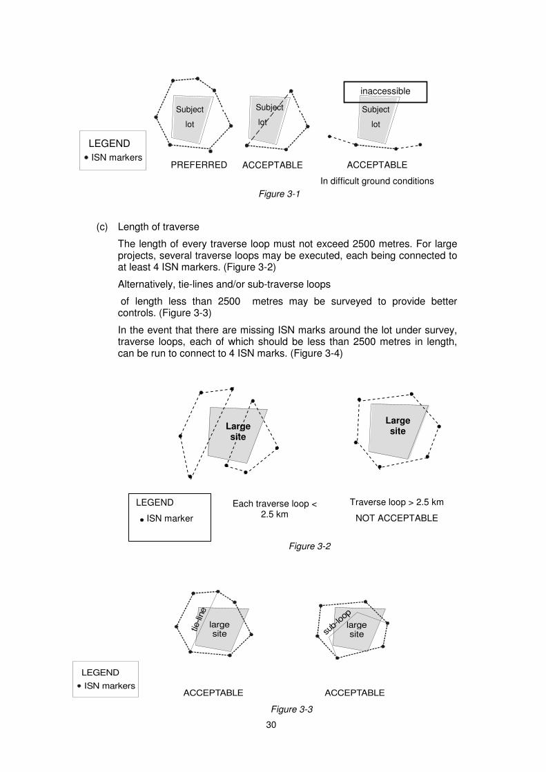
ii. The subject lot under survey shall preferably be wholly enclosed by the ISN markers. In situations where this condition cannot be met, the subject lot shall, as far as practicable, be intersected by at least one line formed by the ISN markers. One-sided connection to ISN markers should be avoided, unless ground conditions do not permit such connections, e.g. foreshore lots. (see Figure 3-1)
iii. Registered surveyor shall be required to establish new ISN markers if he is unable to meet the required 4 ISN markers. He shall process and submit the necessary documents as described in “Guidelines and Specifications for GPS Surveys of ISN Markers” to Land Survey Division for acceptance before submitting the cadastral job to Land Survey Division.
30
Figure 3-1
(c) Length of traverse
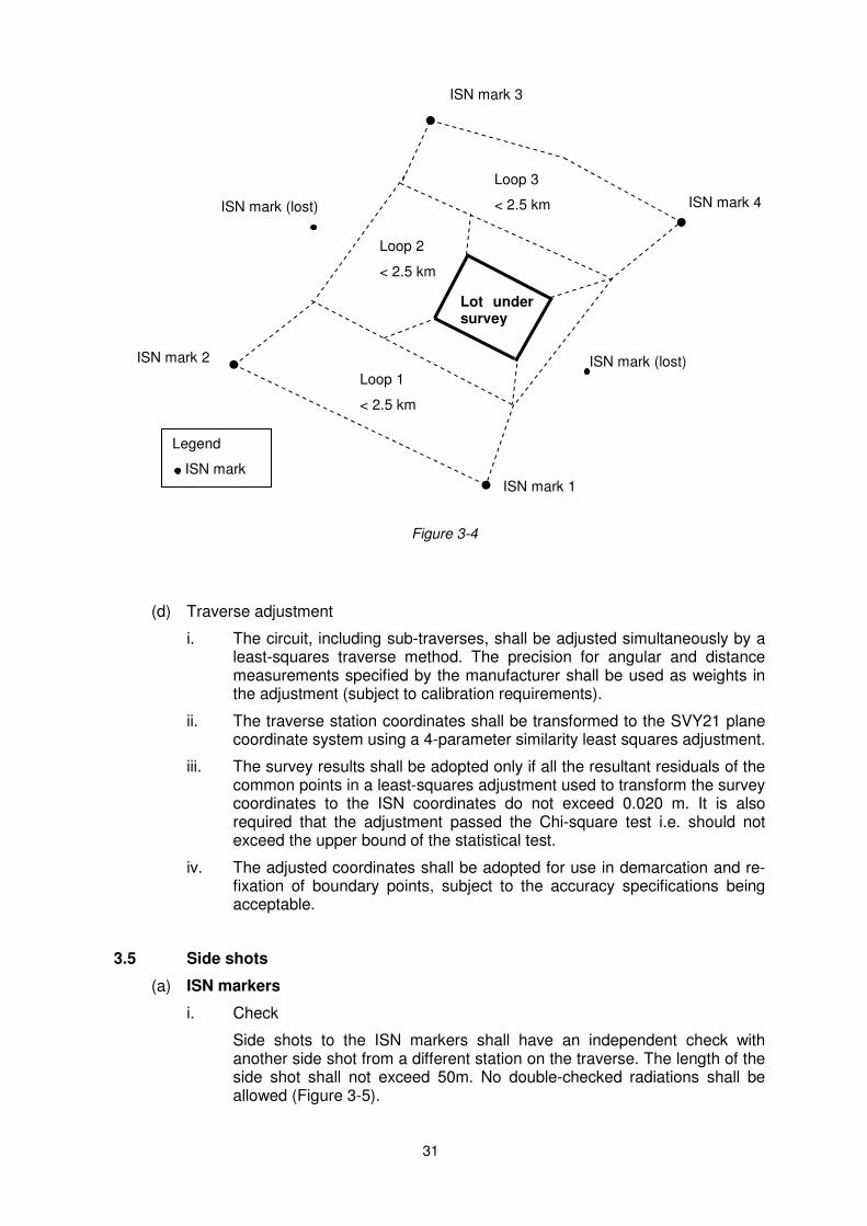
The length of every traverse loop must not exceed 2500 metres. For large projects, several traverse loops may be executed, each being connected to at least 4 ISN markers. (Figure 3-2)
Alternatively, tie-lines and/or sub-traverse loops
of length less than 2500 metres may be surveyed to provide better controls. (Figure 3-3)
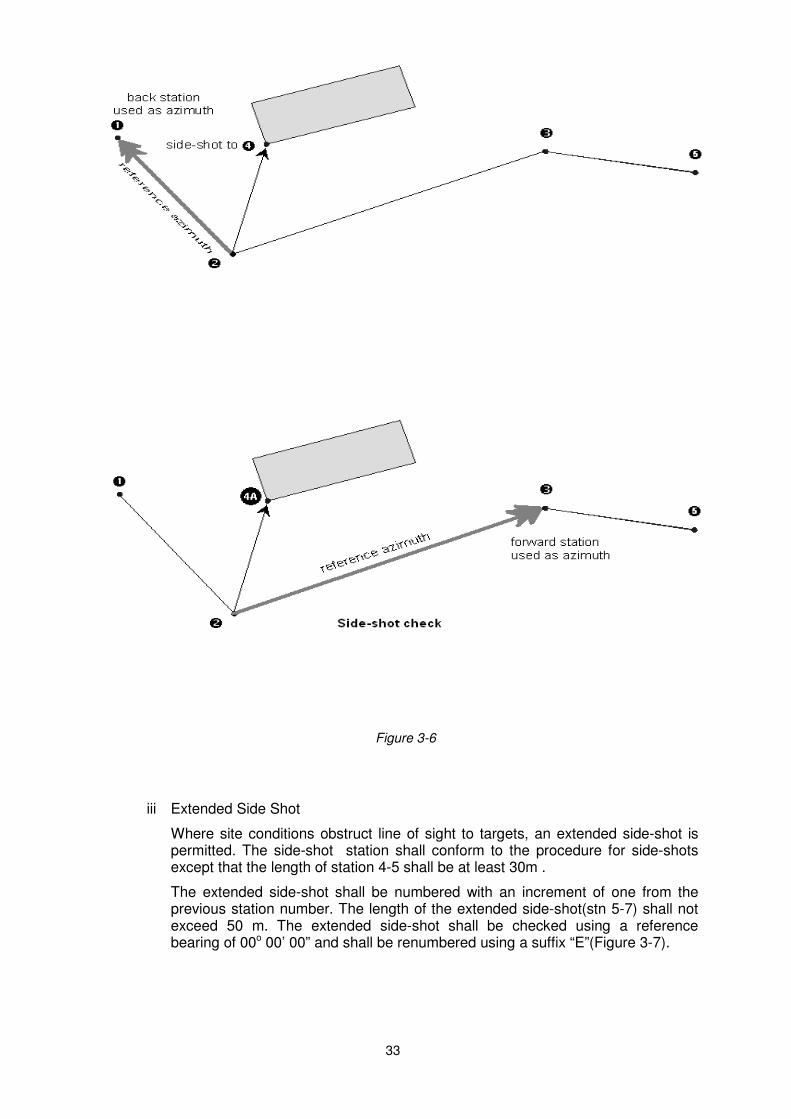
In the event that there are missing ISN marks around the lot under survey, traverse loops, each of which should be less than 2500 metres in length, can be run to connect to 4 ISN marks. (Figure 3-4)
Figure 3-2
largesite
largesite
ACCEPTABLE ACCEPTABLEISN markers
LEGEND
tie-lin
e
sub-
loop
Figure 3-3
PREFERRED ACCEPTABLEISN markers
LEGEND
Subject
lot
Subject
lot
Subject
lot
ACCEPTABLE
In difficult ground conditions
inaccessible
Large site
LEGEND
ISN marker
Each traverse loop < 2.5 km
ACCEPTABLE
Traverse loop > 2.5 km
NOT ACCEPTABLE
Large site
31
Figure 3-4
(d) Traverse adjustment
i. The circuit, including sub-traverses, shall be adjusted simultaneously by a least-squares traverse method. The precision for angular and distance measurements specified by the manufacturer shall be used as weights in the adjustment (subject to calibration requirements).
ii. The traverse station coordinates shall be transformed to the SVY21 plane coordinate system using a 4-parameter similarity least squares adjustment.
iii. The survey results shall be adopted only if all the resultant residuals of the common points in a least-squares adjustment used to transform the survey coordinates to the ISN coordinates do not exceed 0.020 m. It is also required that the adjustment passed the Chi-square test i.e. should not exceed the upper bound of the statistical test.
iv. The adjusted coordinates shall be adopted for use in demarcation and re-fixation of boundary points, subject to the accuracy specifications being acceptable.
3.5 Side shots
(a) ISN markers
i. Check
Side shots to the ISN markers shall have an independent check with another side shot from a different station on the traverse. The length of the side shot shall not exceed 50m. No double-checked radiations shall be allowed (Figure 3-5).
Lot under survey
ISN mark (lost)
ISN mark (lost) ISN mark 2
ISN mark 1
ISN mark 4
Loop 1
< 2.5 km
Loop 2
< 2.5 km
Loop 3
< 2.5 km
Legend
ISN mark
ISN mark 3

32
ii. Numbering
Side shot check stations shall be numbered with consecutive numbers from the previous station.
Figure 3-5
(b) Found Marks
Side shots to found marks do not need an independent check. For observation to found mark of subject or R/S lot, the distance shall not exceed 50 m.
(c) Demarcation of boundaries and exact fixation of wall, occupational details.
i Maximum length of side shot
Every independent vector (side shot) shall not exceed 50 m in length and shall have an independent check.
ii Checks and numbering
The check shall be done with a repeated measurement using a different reference point. Side shot check stations shall be numbered with consecutive numbers from the previous station. The repeated measurement shall have a suffix ‘A’ after the number (Figure 3-6).
33
Figure 3-6
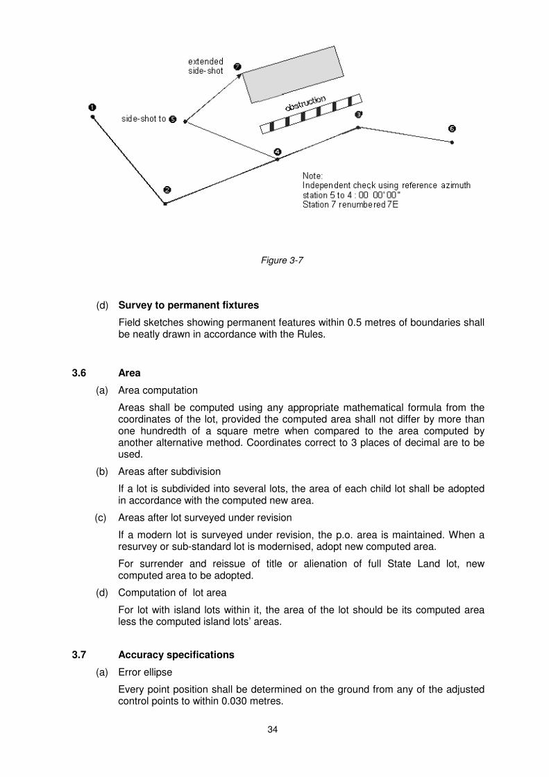
iii Extended Side Shot
Where site conditions obstruct line of sight to targets, an extended side-shot is permitted. The side-shot station shall conform to the procedure for side-shots except that the length of station 4-5 shall be at least 30m .
The extended side-shot shall be numbered with an increment of one from the previous station number. The length of the extended side-shot(stn 5-7) shall not exceed 50 m. The extended side-shot shall be checked using a reference bearing of 00o 00’ 00” and shall be renumbered using a suffix “E”(Figure 3-7).
34
Figure 3-7
(d) Survey to permanent fixtures
Field sketches showing permanent features within 0.5 metres of boundaries shall be neatly drawn in accordance with the Rules.
3.6 Area
(a) Area computation
Areas shall be computed using any appropriate mathematical formula from the coordinates of the lot, provided the computed area shall not differ by more than one hundredth of a square metre when compared to the area computed by another alternative method. Coordinates correct to 3 places of decimal are to be used.
(b) Areas after subdivision
If a lot is subdivided into several lots, the area of each child lot shall be adopted in accordance with the computed new area.
(c)
Areas after lot surveyed under revision
If a modern lot is surveyed under revision, the p.o. area is maintained. When a resurvey or sub-standard lot is modernised, adopt new computed area.
For surrender and reissue of title or alienation of full State Land lot, new computed area to be adopted.
(d) Computation of lot area
For lot with island lots within it, the area of the lot should be its computed area less the computed island lots’ areas.
3.7 Accuracy specifications
(a) Error ellipse
Every point position shall be determined on the ground from any of the adjusted control points to within 0.030 metres.
35
(b) Traverse angular misclose
The angular misclose must not exceed 10√n seconds where n is the number of traverse stations occupied.
(c) Traverse fractional linear misclose
The fractional linear misclose of traverses shall be better than 1:20000 for main loop.
The fractional linear misclose for all sub-loops shall be better than 1:15000.
3.8 Boundary discrepancies
If there are differences between the dimensions of boundaries on the ground and those on the survey documents beyond stipulated tolerances, the registered surveyor shall take appropriate measures to determine whether the differences are due to encroachments, to movements of marks or to defects in the previous survey.
3.9 Survey of Resurvey lot
Resurvey lot is a lot which has not undergone a modern survey.
Registered Surveyor shall survey according to occupational details and the boundary lines and area of the lot are to follow closely to the boundaries and area depicted in the previous survey plan e.g. block sheet.
The proposed boundary lines and area of the lot in relation to the occupational details are to be forwarded to Chief Surveyor for approval before finalising the survey.
3.10 Survey of reclaimed land and foreshore lease
When the reclaimed land project has been completed, Registered Surveyor will carry out the cadastral survey of the reclaimed land. For cases involving 2.515-metre High Water Mark (HWM), the levelling will adopt the nearest PLBM (Precise Level Benchmark) and close to another PLBM or witness marks.
The permissible closing error of the levelling for such purpose shall not exceed + 15√K mm where K is the length of the level line in km.
Salient points of the 2.515-metre HWM shall be surveyed and/or demarcated with authorised marks.
For foreshore lease structure e.g. jetty, the structure shall be surveyed and demarcated at salient points.
3.11 Survey of Subterranean and Airspace lot
The survey shall be carried out after the construction of the structures. All floors/stratums are to be surveyed. The details of the structures are to be surveyed and shown on the sketches.
In the case of subterranean lot, the boundaries of the lot are to include the thickness of walls. In the sketches, the thickness of walls are to be shown and a note stating the building or structural plan that the thickness of wall is adopted from is to be inserted in the sketches.
The determination of the reduced levels for each floor/stratum for both airspace and subterranean shall be based on nearby bench marks established by Chief Surveyor or other bench marks approved for use by the Chief Surveyor. The permissible closing error of the levelling for such purpose shall not exceed + 15√K mm where K is the length of the level line in km.
36
Where reduced levels for the lot could not be determined by levelling, other means can be utilized to determine the reduced levels subject to approval of the Chief Surveyor.
The lot information for each stratum is to be set-up in the Lot Information Section of .svy file if each stratum is difference in shape. The outer most boundary line of the lot is also required to be set-up in the Lot Information Section.
The sample of subterranean and airspace lot CP are shown in Appendix N-1 and N-2.
3.12 New Curve Boundary ( Not applicable to P.O. Boundary)
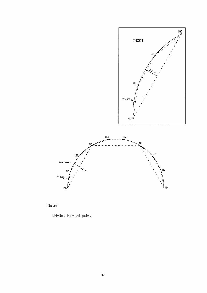
New curve boundaries shall be marked by straight lines on ground such that no point on the curve shall be more than 20 cm from such straight lines. These points are to be demarcated on ground. More boundary points may be created between them to avoid encroachments. These additional points need not be demarcated on ground. They can be treated as unmarked( UM). See example on next page.
37
38
4. PLAN & FILE SUBMISSION
4.1 Plan scales
4.1.1 Built-up areas
Plans shall be drawn at scale of 1:100, 1:200 or 1:500.
4.1.2 For other surveys
Plans shall be drawn at scale of 1:1000, 1:2000, 1:5000 or 1:10000.
4.2 Drawing specifications
The following shall be adhered to when drafting plans:
4.2.1 Text specifications
Description of text Height
Lot number 2.5 mm to 3.0 mm
Area 2.0 to 2.5 mm
Coordinates 2.0 mm
Mark description 1.8 mm
Road name and house number 3.0 mm
Grid value / sheet number 2.5 mm
Text in Schedule / History box (other than MK/TS and CP number, coordinates of origin)
2.5 mm
MK/TS in History box and North point 4.0 mm
CP number in History box 12.0 mm
4.2.2 Line symbols
Description Thickness
Mukim and Town Subdivision boundary 0.30 mm
Boundary 0.25 mm
Schedule / History box 0.25 mm
4.2.3 Symbols
Description Size
Size of symbol mark 1.1 mm diameter
39
4.3 Information to be shown on plan
4.3.1 Plan headings
The heading of each certified plan shall include -
i. the Mukim or Town Subdivision number; and
ii. the scale, in the form of a representative fraction.
4.3.2 Plan serial numbers
Every certified plan shall show a serial number which has been allotted by the Chief Surveyor. This number shall be shown towards the bottom of the plan.
4.3.3 Numerical information on plan
The numerical data essential on certified plans shall be clearly presented and shall include :
i. Station numbers;
ii. Coordinates of boundaries which can be tabulated or be placed alongside the boundaries on plan body;
iii. the area of each lot under survey be shown beneath the lot number or, for clarity, be tabulated with the lot number;
iv. the adjacent lot numbers;
v. the lot numbers of lots under survey shall be significantly shown near the centre of the respective lots to which they refer;
vi. the cadastral map number; and
vii occupational details need not be shown on Certified Plan
4.4 Other information
4.4.1 Other information on Certified Plan
The following information and references shall be shown on certified plans:
(a) the North Point;
(b) the name of the registered surveyor who conducted the survey and, where applicable, the name of every authorised assistant who assisted in the conduct of the survey, the date of the completion;
(c) the Mukim and Town Subdivision boundaries with their numbers;
(d) the coordinate lines with their values, and cadastral map sheet lines with their respective map numbers as may be within the area;
(e) the survey marks by means of conventional signs and abbreviations;
(f) the street names and house numbers;
(g) Approved Plan, authorised plan or Requisition for Survey (R/S) Plan reference number, where applicable;
(h) the file reference number of the Chief Surveyor;
(i) the sketch number and pages.
40
(j) Bar scale for drawing with scale including amalgamation diagram. For sample see Appendix S.
4.4.2 Plan schedule
Every certified plan shall contain a schedule showing the following information:
(a) the original lot number and the number of the previous certified plan and, in the case of a subdivision and amalgamation, the new lot numbers shall also be shown.
4.4.3 Name on plans
Every certified plan shall bear the names of the draftsman and the person who checked the plan and the dates of completion.
4.4.4 Certification of survey documents
Certification on survey documents shall follow the certification as specified in section 38 of Boundaries and Survey Maps (Conduct of Cadastral Surveys) Rules 2005. In E-submission environment, the word “ Digitally signed” is inserted. For more details, refer to the Guidelines on E-Transmission posted on the SLA website : http://www.sla.gov.sg.
4.5 File naming convention
(a) All files shall be in ASCII format and be named according to the CP number followed by an extension that is dependent on the nature of the file.
i.e. <CP number>.<ext>
(b) Only two files are associated with each job: the first is for raw filed data and the other is for completed and processed data. The file extension shown in Table 1 shall be adopted.
Table 1
File Type Extension
Field Survey File job
Results Data File svy
41
4.6 Field survey file
The Field Survey file contains three main sections: a Job Control section, a Calibration section and a Field Data section.
(a) Job control
The Job Control section is preceded by a header control record <JOB> and a
terminator record <END>. The body has the following format:
JOB
<SLA/SVY file number>
<date of commencement>
<date of completion>
<survey company>
<surveyor's name >
<authorised assistant’s name, …… ,authorised assistant’s name>
(comma delimited if more than one assistant)
END
Description Format
SLA/SVY file number NNNNN-YYYY Date of Commencement of survey DD/MM/YYYY Date of Completion of survey DD/MM/YYYY Organisation 50(A) Surveyor's name 50(A) Authorised Assistant’s Name 50(A)
Note: (A) : AlphaNumeric (N) : Numeric
(b) EDM calibration
The EDM calibration section is preceded by a header record <EDM> and a
terminator record <END>. The body has the following format:
EDM
<certificate number*>
<organisation>
<observer>
<date>
<EDM model>, <serial number>, <height above base plate (m)>
<prism model>, <no. of prisms>, <height above base plate (m)>
<residuals 1-2>, <residuals 1-3>, … , <residuals 1-7>
<residuals 2-3>, <residuals 2-4>, … , <residuals 2-7>
<residuals 3-4>, <residuals 3-5>, … , <residuals 3-7>
<residuals 4-5>, <residuals 4-6>, <residuals 4-7>
<residuals 5-6>, <residuals 5-7>
<residuals 6-7>
<additive constant>
<standard deviation of additive constant>
42
<scale (ppm)>
<standard deviation of scale>
<1st order cyclic cosine coefficient (mm)>
<1st order cyclic sine coefficient (mm)>
<2nd order cyclic cosine coefficient (mm)>
<2nd order cyclic sine coefficient (mm)>
<standard deviation of single measured distance(mm)>
END
* To insert a dash if no certificate number.
(c) Instrument precision and instrument & target centring precision
The instrument precision and instrument & target centring precision section describe the instrument’s precision and instrument’s & target’s centring precision. It is preceded by a header record <PRECISION> and a terminator record <END>.
The body has the following format:
PRECISION
<direction (in seconds)> , <a (mm)> , <b (ppm)>
<c (mm)> , <d (mm)>
END
Note:
‘c’ denotes instrument centring precision.
‘d’ denotes target centring precision.
Surveyors shall ensure the accuracy on the instrument set-up, as a default (fixed) value of 2 mm will be taken into account during the Least Squares Adjustment for instrument and target centring precision.
(d) Main traverse
The main traverse section is preceded by a header record <MAIN> and a terminator record <END>. The body has the following format:
MAIN
<1>, <REF>, <DDD.MMSS>
<from_stn>, <to_stn>, <DDD.MMSS>, <ddd.ddd>
< ……… >
<1>, <REF>, <DDD.MMSS>
END
(e) Sub traverse
The sub traverse section is preceded by a header record <SUB> and a terminator record <END>. Tie-lines are considered sub traverses. There may be more than one such sections. The body has the following format:
SUB
<from_stn>, <to_stn>, <DDD.MMSS>
<from_stn>, <to_stn>, <DDD.MMSS>, <ddd.ddd>
< ……… >
<from_stn>, <to_stn>, <DDD.MMSS>, <ddd.ddd>
<from_stn>, <to_stn>, <DDD.MMSS>
END
43
(f) Side-shot
The side-shot section is preceded by a header record <SS> and a terminator record <END>. Side-shots are surveyed during the traverse, i.e. before adjustment to the traverse. The body comprises record pairs, the first is the reference azimuth and the next is the side-shot observation. It has the following format:
SS
<from_stn>, <to_stn>, <DDD.MMSS>
<from_stn>, <to_stn>, <DDD.MMSS>, <ddd.ddd>
< ……… >
<from_stn>, <to_stn>, <DDD.MMSS>
<from_stn>,<to_stn>,<DDD.MMSS>,<ddd.ddd>
END
(g) Observation
The observation section is preceded by a header record <OBS> and a terminator record <END>. These are side-shots executed using datum computed from the adjusted coordinates, typically arising from planting marks. The body comprises record pairs, the first is the reference azimuth and the next is the side-shot observation. Every side-shot in this section must have an independent check observation which has the side-shot marker number having a suffix “A”. The body has the following format:
OBS
<from_stn>, <to_stn>, <DDD.MMSS>
<from_stn>, <to_stn>, <DDD.MMSS>, <ddd.ddd>
< ……… >
<from_stn>, <to_stn>, <DDD.MMSS>
<from_stn>, <to_stn>, <DDD.MMSS>, <ddd.ddd> END
4.7 Results file format
The results file contains several sections:
(a) Traverse adjustment
The traverse adjustment section is preceded by a header record <TRAVERSE> and
a terminator record <END> for the traverse. The line section contains the corrections to the bearings and distances of all the traverse lines, including sub-traverses. The body has the following format:
TRAVERSE
<angular misclose in seconds>, <FLM>
END
LINES
<from station>, <to station>, ~
<corrected distance (m), <corrected bearing (ddd.mmss)>
END
44
(b) Transformation
The transformation section contains the transformation parameters and is preceded by a header record <PARAMETERS> and a terminator record <END>. The
<RESIDUALS> section contains the residuals of the adjusted ISN coordinates. The body has the following format:
PARAMETERS
<a1>, <b1>, <a2>, <b2> …….(to six decimal places)
END
RESIDUALS
<station>, <Northing-residuals (m)>, <Easting-residuals (m)>
< ……… >
<station>, <Northing-residuals (m)>, <Easting-residuals (m)>
END
(c) Coordinates
The coordinates section is preceded by a control record <COORDINATES> and is
terminated by a control record <END>. It contains description of all survey markers and the computed coordinates:
COORDINATES
<station>, <northing>,<easting>, <point type>, ~ <point class>,
<point flag>
< ……… >
<station>, <northing>,<easting>, <point type>, ~ <point class>,
<point flag>
END
Description Format Values Point Type 2(A) CM – concrete marker
SP – spike
NL – nail
SM – ISN marker
MK – cut mark
PP – Pipe
OT – others (OS, Bolt, Resurvey Stone)
UM – not marked
TM – Temp mark, Peg
Point Class 1(N) 1 – approved
2 – provisional
Point flag 1(A) R – rigid
D – digitised
Note: (A) : AlphaNumeric (N) : Numeric
45
Example:
COORDINATES
1, 40144.711 , 40495.243 , NL , 1, R
2, 40156.656 , 40503.707 , NL , 1, R
3, 40165.492 , 40498.912 , NL , 1, R
4, 40159.443 , 40487.463 , CM , 1, R
END
(d) Lot description
The lot description section is preceded by a control record <LOTS> and is
terminated by a control record <END>. It contains description of the survey lots and a list of station numbers that describes the lot:
LOT
<lot Number>, <area>, <area class> ~
<[CP Number1 + CP Number2 + CP Number3 +….]> ~
<station number, ………… , station number>
END
Example:
LOT
MK29-00676N, 173.9, , [CP31788],2,3,4,5,6
MK29-00753L, 133.2, , [CP31788],2,8,11,34
MK29-00754C, 203.0,S, [CP31788+CP31789],34,35,36,40
MK29-00755M,104.7, , [CP31788],11,22,23,24,…...88,89,101\
102,103,104,105,106,118,120
END
Note: (i) Computed Area : (Null)
Scaled Area : S
(ii) The delimiter shown as a back slash ( \ ) can be used at any length
before reaching 80 characters.
(e) Island lot (Where applicable)
The island lot section is preceded by a control record <ISLAND> and is
terminated by a control record <END>. It contains history of subdivision or amalgamation of each lot:
ISLAND
<lot number>, <lot number of lot which contains it>
< … >
<lot number>, <lot number of lot which contains it>
END
46
4.8 Sketches
(a) All field recordings are to be entered in the sketches (SK) pages. All sketches and diagrams shall be drawn on A4 size with 20 mm margin (border edged in 4 point line) on all sides. Traverse sketches and locations of salient features that were surveyed shall be clearly drawn. Sketches should be in TIFF format or DWF format. For TIFF format, sketches shall be rasterised with resolution of 300 dpi and saved in uncompressed TIFF format. The files shall be named <CP number>-nnn.tif or <CP number>-nnn.dwf, where “nnn” are sequential numbers starting from (001). If there is more than one CP for the survey job, the sketch number is to follow the first CP number and registered surveyors are to insert “(See also CP XXXXX)” below the sketch number on each page.
(b) Certification
The first diagram page of the Sketch of every survey shall bear the Registered Surveyor’s certification. No page of a Sketch should be left blank or filled with only the certification. All the pages of the Sketch should also contain the name of the Registered Surveyor, date and the text ‘digitally signed’. All sketches( either single or multi pages) are to be digitally signed.
(c) The text specifications, line and mark symbols shall follow those prescribed for the plan under item 4.2.
4.9 Encroachment
(a) Encroachment
Please refer to section 2.3.
(b) Encroachment report ( when required)
An encroachment report shall consist of graphic sketches showing details and the extent of the encroachment. Sketches may not be to scale but the extent of the encroachment in relation to the boundary line must be clearly depicted and highlighted in yellow. The extent of encroachment area in sq m is to be inserted if required.
4.10 Submission
(a) Materials to be submitted
i. Administrative documents e.g. Survey Report, Certification in relation to encroachment form, documents specific in the Guidelines to E-Transmission and any other relevant documents, survey plans and sketch plans shall be submitted. The following digital files below shall be submitted together with text files in excel format consist of the listing of addresses, plan number, lot numbers and areas. The excel format of the text files are shown on next page.
<CP number>.job
<CP number>.svy
<CP number>-nnn.tiff - (series of files)
47
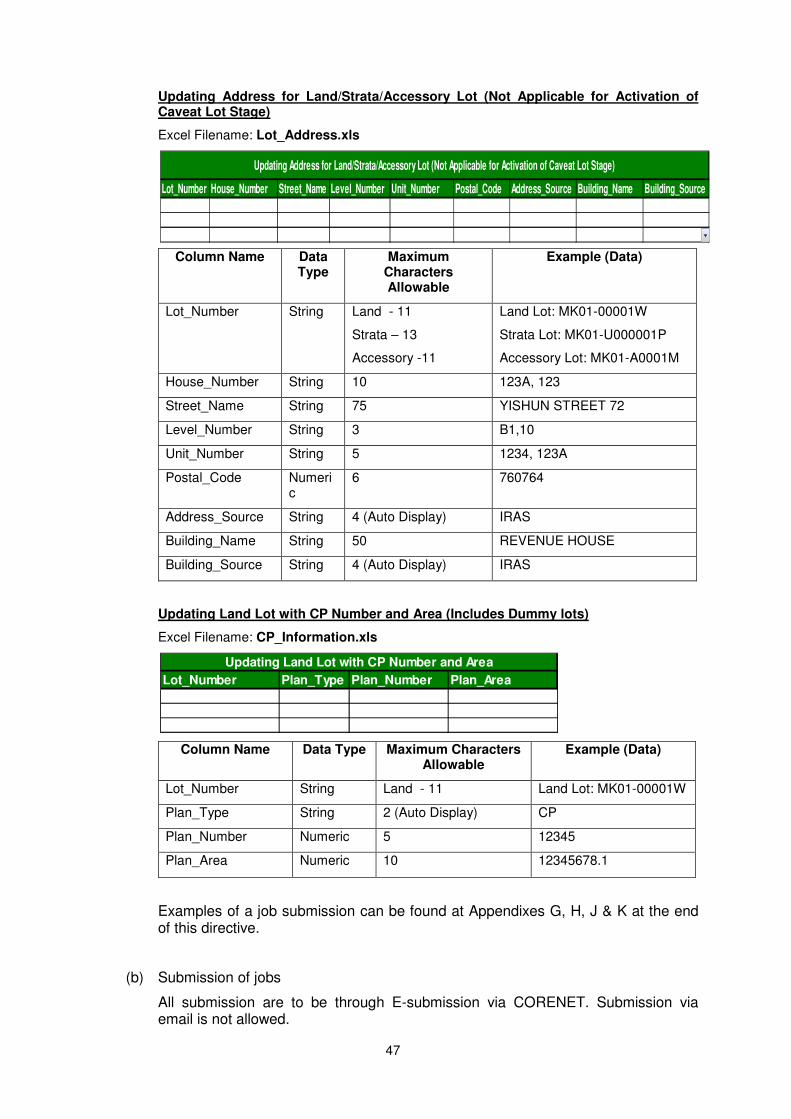
Updating Address for Land/Strata/Accessory Lot (Not Applicable for Activation of Caveat Lot Stage)
Excel Filename: Lot_Address.xls
Column Name Data Type
Maximum Characters Allowable
Example (Data)
Lot_Number String Land - 11
Strata – 13
Accessory -11
Land Lot: MK01-00001W
Strata Lot: MK01-U000001P
Accessory Lot: MK01-A0001M
House_Number String 10 123A, 123
Street_Name String 75 YISHUN STREET 72
Level_Number String 3 B1,10
Unit_Number String 5 1234, 123A
Postal_Code Numeric
6 760764
Address_Source String 4 (Auto Display) IRAS
Building_Name String 50 REVENUE HOUSE
Building_Source String 4 (Auto Display) IRAS
Updating Land Lot with CP Number and Area (Includes Dummy lots)
Excel Filename: CP_Information.xls
Column Name Data Type Maximum Characters Allowable
Example (Data)
Lot_Number String Land - 11 Land Lot: MK01-00001W
Plan_Type String 2 (Auto Display) CP
Plan_Number Numeric 5 12345
Plan_Area Numeric 10 12345678.1
Examples of a job submission can be found at Appendixes G, H, J & K at the end of this directive.
(b) Submission of jobs
All submission are to be through E-submission via CORENET. Submission via email is not allowed.
Lot_Number House_Number Street_Name Level_Number Unit_Number Postal_Code Address_Source Building_Name Building_Source
Updating Address for Land/Strata/Accessory Lot (Not Applicable for Activation of Caveat Lot Stage)
Lot_Number Plan_Type Plan_Number Plan_Area
Updating Land Lot with CP Number and Area
48
4.11 On-line boundary marks shown in survey documents
(a) On-line boundary marks required to be shown on all survey documents (CP, SK or .svy) if they are shared with any adjoining lots. However if it is not (or no longer) shared with any adjoining lot, it is not required to show the on-line boundary mark.
(b) For reference marks which are demarcated along the boundary where the boundary salient point cannot be marked due to obstruction or mark emplaced along straight boundary line at intervals not exceeding 200m, the requirements are as follows:
i) For the .svy file, such points shall continue to be set-up under the “Co-ordinates Section’ but they are not to be set-up under the ‘Lot Section’.
ii) The CP shall continue to show these on-line reference marks. A suffix within bracket, “(REF MK) is to be added to the description of these boundary marks. Example : SP (REF MK). This is the similar to the way they are described in the sketch(SK).
4.12 Incorporating Leveling pages as part of SK
Previously for cadastral survey jobs which involve levelling works e.g. survey of 2.515-metre HWM boundaries, airspace lots and subterranean lots, it is required to submit the Level Book(LB). Instead the levelling pages are to be incorporated as part of the sketch(SK). The level details recording pages shall be numbered consecutively after the cadastral survey recording pages.
E.g: If the cadastral survey recording pages are from SK99999-001 to 034, the level details recording pages shall be numbered from SK99999-035 onwards. If additional field work arising from query etc, the SK pages will continue from the last page number.
A sample of the level details recording page is in Appendix P.

49
5. STRATA SURVEY
5.1 Field survey procedures
(a) Accuracy of linear measurements
i. Every strata lot shall be surveyed and the linear measurements of the survey rounded off to the nearest centimetre.
ii. The total & internal length and width of the strata lot shall to be measured. The physical height shall be measured.
(b) Use of reflector-less total station
The use of reflector-less total station for strata survey is allowed. The field data collected shall be submitted on ASCII format for submission to Chief Surveyor.
The file shall be named according to the CPST number followed by an extension .job.
i.e. <CPST number>.job
(c) All field recordings are to be entered in the Field Details(FD) pages for which a FD No. will be issued by the Chief Surveyor upon request. All FD pages shall be drawn on A4 size with 20 mm margin (border edged in 4 point line) on all sides and in TIFF format or DWF format. For TIFF format the FD pages should be rasterised with resolution of 300 dpi and saved in uncompressed TIFF format. The file shall be named<CPST number>-nnn.tif or <CPST number>-nnn.dwf, where ‘nnn’ are sequential numbers starting from (001). The first CPST No. of each job will be used as the FD No. The text specifications, line and mark symbols shall follow those prescribed for the plan under item 5.3.
To minimise information shown on FD, the following are not required to be shown on FD since these items are already shown on CPSTs :
i. Site Plan showing the land lot ,area, boundaries, peripheral ground details and house number/s with building outline;
ii Plan schedule and legend statement, i.e. house numbers, land lot and approved Certified Plan(CP) on where the building sits and , in the case of a strata subdivision and/or amalgamation, the new strata lot numbers;
iii. Elevation Sketch depicting stratum heights and where applicable, tabulation of strata/accessory lot numbers to their respective flat unit numbers and tabulation of accessory lots made appurtenant to respective strata lots;
For the reference note to Sketches (SK) in relation to the survey of land lot, it is not required to be shown in the FD page for the survey of buildings outline.
Unit numbers to be entered in the FD for all the strata lots in the storey plan (non – typical and typical storey plan).
(d) Survey of buildings
i. The building comprising the strata lots shall be fixed directly in relation to the boundaries of the lot unless ground circumstances do not permit such fixing, and all common properties which encroach onto adjacent land shall be surveyed.
ii Strata survey for subdivision of building will require a resurvey of the land lot in situation as prescribed in para 2.8(e).
50
iii. The amount of encroachment shall be measured, recorded and reported to the Chief Surveyor. An appropriate note stating the nature of encroachment shall be entered on the Site and Storey Plans in the FD diagram and on CPST and STP where applicable. Eg: Part of roof eave encroaching onto private lot 1234A.
Paragraph 2.3 on dealing with and resolving encroachments shall apply as regards how registered surveyors shall handle the encroachments.
(e) Identical strata lots
Where strata lots on the same storey or on different storey of a building are identical, only one such storey shall be depicted in the field book complete with dimensions, and all pages bearing diagrams of identical strata lots shall contain the following statement:
“All strata lots including those shown as ‘similar’ herein have been entered into and all relevant measurements have been fully made.”
(f) Strata lots involving land
Where the strata lots involve land, they shall be demarcated with the approved survey marks on the ground.
(g) Strata boundaries
Unless otherwise stipulated on the strata certified plan, the common boundary of any lot with another lot or with the common property shall be the centre of the floor, wall or ceiling, as the case may be.
Strata boundaries intended not to follow the centre of the floor, wall or ceiling, shall be in accordance with the subdivision plans as approved/authorised by the Chief Planner. The same statement must be stipulated in the field notes and plans.
(h) Certification
The first diagram page of the field notes of every survey shall bear the Registered Surveyor’s certification with entries of his name and date. The certification shall read as follows:
“I, ..................................................................................... , a surveyor registered under the Land Surveyors Act (Cap. 156), certify that these field notes and diagrams on pages ......... to ............... are a correct and complete record of the survey done by me, or under my immediate personal direction and supervision, in strict compliance with the Boundaries and Survey Maps (Conduct of Cadastral Surveys) Rules 2005 (G.N. No. S 155/2005). “
date
Registered Surveyor
(Digitally Signed)
51
5.2 Strata certified plan
(a) Every strata certified plan shall contain:
(i) a site plan;
(ii) a storey plan; and
(iii) an elevation sketch.
(b) Plan format
Strata Certified Plans shall be drawn in the STP format size of 500mm X 353mm.
(c) Plan scales
Except under such circumstances that are, in the opinion of the Chief Surveyor, unusual, all plans shall be plotted according to the following scales:
(i) for site plans — 1:200, 1:500 or 1:1,000; and
(ii) for storey plans — 1:100 or 1:200.
(d) The scale on which a plan is drawn shall be so selected such that the area of each strata lot and all relevant details can be clearly seen.
(e) If on any part of a plan, measurements or details would otherwise be illegible or difficult to interpret, a diagram drawn on a scale larger than that of the plan, or drawn not to scale, may be added as an inset.
5.3 Drawing specifications for strata certified plan
The following shall be adhered to when drafting plans:
(a) Text specifications
Description of text Height
Lot number and description of storey for Elevation sketch
2.5 mm to 3.0 mm
Area 2.0 to 2.5 mm
Corresponding Strata lot and area 2.0 mm
Header for storey and Elevation sketch 4.0 mm
Unit number, description of common property, height
2.0 mm
Text in Schedule / History box (other than MK/TS and CPST number
2.5 mm
MK/TS in History box and North point 4.0 mm
CPST number in History box 12.0 mm
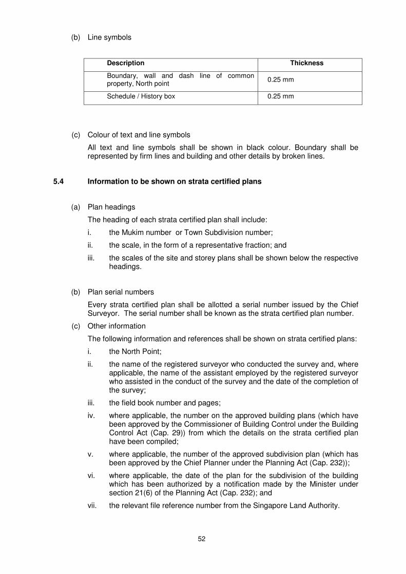
52
(b) Line symbols
Description Thickness
Boundary, wall and dash line of common property, North point
0.25 mm
Schedule / History box 0.25 mm
(c) Colour of text and line symbols
All text and line symbols shall be shown in black colour. Boundary shall be represented by firm lines and building and other details by broken lines.
5.4 Information to be shown on strata certified plans
(a) Plan headings
The heading of each strata certified plan shall include:
i. the Mukim number or Town Subdivision number;
ii. the scale, in the form of a representative fraction; and
iii.
the scales of the site and storey plans shall be shown below the respective headings.
(b) Plan serial numbers
Every strata certified plan shall be allotted a serial number issued by the Chief Surveyor. The serial number shall be known as the strata certified plan number.
(c) Other information
The following information and references shall be shown on strata certified plans:
i. the North Point;
ii. the name of the registered surveyor who conducted the survey and, where applicable, the name of the assistant employed by the registered surveyor who assisted in the conduct of the survey and the date of the completion of the survey;
iii. the field book number and pages;
iv. where applicable, the number on the approved building plans (which have been approved by the Commissioner of Building Control under the Building Control Act (Cap. 29)) from which the details on the strata certified plan have been compiled;
v. where applicable, the number of the approved subdivision plan (which has been approved by the Chief Planner under the Planning Act (Cap. 232));
vi. where applicable, the date of the plan for the subdivision of the building which has been authorized by a notification made by the Minister under section 21(6) of the Planning Act (Cap. 232); and
vii. the relevant file reference number from the Singapore Land Authority.
53
(d) Plan schedule
Every strata certified plan shall contain a schedule showing the following information:
i. the original strata lot number and the number of the previous strata certified plans and, in the case of a subdivision and amalgamation, the new strata lot numbers shall also be shown; and
ii. any other notes relating to the strata lots under survey shall be made against the strata lots on the remarks column.
(e) Names on plans
Every strata certified plan shall bear the names of the draftsman and the person who checked the plan and the dates of completion.
(f) Certification of plans
Every strata certified plan shall bear a certificate containing the registered surveyor’s stamp with entries of his signature and date in the following form:
“I,.................................................... , a surveyor registered under the Land Surveyors Act (Cap. 156), certify that this plan correctly represents the survey done in strict compliance with the Boundaries and Survey Maps (Conduct of Cadastral Surveys) Rules 2005 (G.N. No. S 155/2005).
(date of certification) Registered Surveyor.
(Digitally Signed)”.
5.5
Information to be shown on site plans
Every site plan shall show:
i. the numbers and boundaries of any Mukim and Town Subdivision;
ii. the land lot number and the area of the land lot;
iii. the boundary lines of the land lot on which the building is sited;
iv. the outline of the building;
v. the natural and artificial features that are found within 0.5 metre of the boundaries surveyed;
vi. the encroachment, if any, into adjacent land lots and/or vice versa;
vii. the street names and house numbers;
viii. the cadastral map number;
ix. Field details(FD) references and
x. Scale of the Site Plan and Bar Scale.
5.6 Information to be shown on storey plans
Every storey plan shall show:
i. details of the strata lots on every storey or where strata lots on different storeys are identical, the details of the strata lots on a typical storey plan;
ii. strata lot numbers with their respective scaled areas and boundaries;

54
iii. the area of each strata lot under survey shown beneath the strata lot number or, for clarity, tabulated with the strata lot number, and where a strata lot occupies more than one storey, its total area shall be tabulated:
House No Strata Lot Storey
Strata Area in Parts (sq m)
Total Strata Area (sq m)
100 U67890P
5th 113 164
Attic 51
iv. Where the strata lot contains void space which is of exclusive use of the unit, the extent of the void shall be shown and described. The floor area, void area , total strata void area and the total area of the strata lot (inclusive of the total strata void area) shall be tabulated:
House No Strata Lot Storey
Strata Area in Parts (sq m) Total Strata Void Area
(sq m)
Total Strata Area (sq m) Floor
Area Void Area Sub-Total
100 U123P
5th 118 0 118 1 239
6th 120 1 121
v. the lot numbers of strata lots under survey shall be significantly shown near the centre of the respective strata lots to which they refer;
vi. the adjacent strata lot numbers;
vii. boundary marks planted for strata lots involving land by means of abbreviations, symbols and conventional signs used by the Singapore Land Authority; and
viii. the outline of the common property and the words “common property” at appropriate places; and
xi.
Storey Plans are not required for flat roof and other storeys that contain only common property and without any strata lots.
xii. History box containing information such as Block/House number, road name, site plan number, elevation plan number, SLA/SVY number, Registered Surveyor’s name, Chief Surveyor’s name, plan scale, North point, MK/TS number, plan number and the note “ Areas of Strata Lots are scaled only”.
xiii.
xiv.
Bar Scale to be inserted.
Unit numbers of all strata lots for typical and non-typical storey.
5.7 Elevation sketches
(a) Every strata certified plan shall, in addition to a site plan and a storey plan, show :
(i) an elevation sketch containing the strata lot numbers;
(ii) the corresponding unit numbers of all the storeys; and
(iii) the heights rounded off to the nearest centimetre. The height of the strata lot shall be compiled from the approved building plan. Note: The internal height as
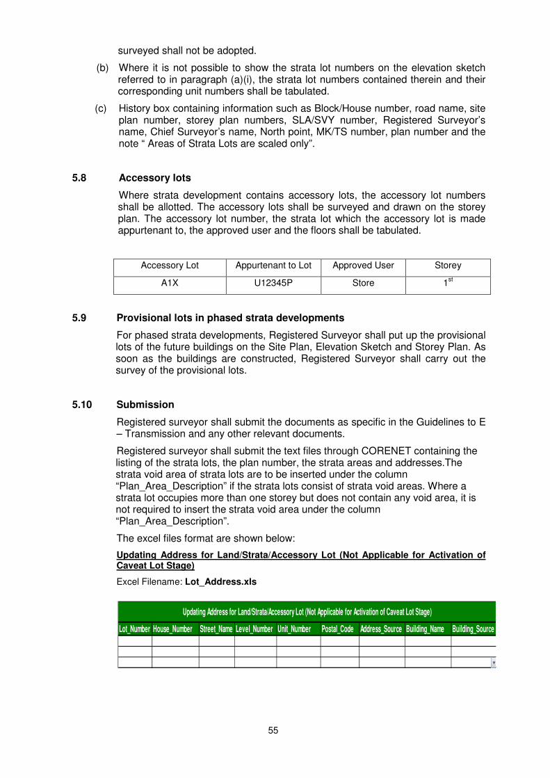
55
surveyed shall not be adopted.
(b) Where it is not possible to show the strata lot numbers on the elevation sketch referred to in paragraph (a)(i), the strata lot numbers contained therein and their corresponding unit numbers shall be tabulated.
(c) History box containing information such as Block/House number, road name, site plan number, storey plan numbers, SLA/SVY number, Registered Surveyor’s name, Chief Surveyor’s name, North point, MK/TS number, plan number and the note “ Areas of Strata Lots are scaled only”.
5.8
Accessory lots
Where strata development contains accessory lots, the accessory lot numbers shall be allotted. The accessory lots shall be surveyed and drawn on the storey plan. The accessory lot number, the strata lot which the accessory lot is made appurtenant to, the approved user and the floors shall be tabulated.
Accessory Lot Appurtenant to Lot Approved User Storey
A1X U12345P Store 1st
5.9 Provisional lots in phased strata developments
For phased strata developments, Registered Surveyor shall put up the provisional lots of the future buildings on the Site Plan, Elevation Sketch and Storey Plan. As soon as the buildings are constructed, Registered Surveyor shall carry out the survey of the provisional lots.
5.10 Submission
Registered surveyor shall submit the documents as specific in the Guidelines to E – Transmission and any other relevant documents.
Registered surveyor shall submit the text files through CORENET containing the listing of the strata lots, the plan number, the strata areas and addresses.The strata void area of strata lots are to be inserted under the column “Plan_Area_Description” if the strata lots consist of strata void areas. Where a strata lot occupies more than one storey but does not contain any void area, it is not required to insert the strata void area under the column “Plan_Area_Description”.
The excel files format are shown below:
Updating Address for Land/Strata/Accessory Lot (Not Applicable for Activation of Caveat Lot Stage)
Excel Filename: Lot_Address.xls
Lot_Number House_Number Street_Name Level_Number Unit_Number Postal_Code Address_Source Building_Name Building_Source
Updating Address for Land/Strata/Accessory Lot (Not Applicable for Activation of Caveat Lot Stage)
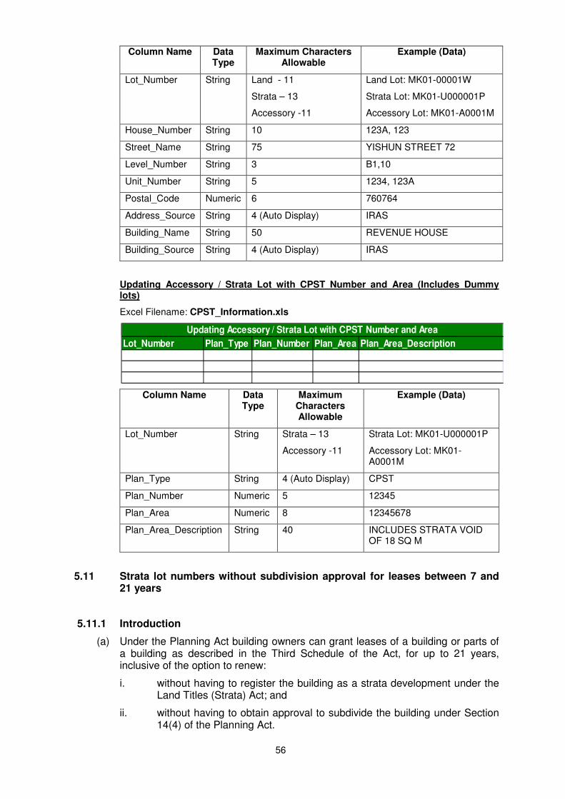
56
Column Name Data Type
Maximum Characters Allowable
Example (Data)
Lot_Number String Land - 11
Strata – 13
Accessory -11
Land Lot: MK01-00001W
Strata Lot: MK01-U000001P
Accessory Lot: MK01-A0001M
House_Number String 10 123A, 123
Street_Name String 75 YISHUN STREET 72
Level_Number String 3 B1,10
Unit_Number String 5 1234, 123A
Postal_Code Numeric 6 760764
Address_Source String 4 (Auto Display) IRAS
Building_Name String 50 REVENUE HOUSE
Building_Source String 4 (Auto Display) IRAS
Updating Accessory / Strata Lot with CPST Number and Area (Includes Dummy lots)
Excel Filename: CPST_Information.xls
Column Name Data Type
Maximum Characters Allowable
Example (Data)
Lot_Number String Strata – 13
Accessory -11
Strata Lot: MK01-U000001P
Accessory Lot: MK01-A0001M
Plan_Type String 4 (Auto Display) CPST
Plan_Number Numeric 5 12345
Plan_Area Numeric 8 12345678
Plan_Area_Description String 40 INCLUDES STRATA VOID OF 18 SQ M
5.11 Strata lot numbers without subdivision approval for leases between 7 and 21 years
5.11.1 Introduction
(a) Under the Planning Act building owners can grant leases of a building or parts of a building as described in the Third Schedule of the Act, for up to 21 years, inclusive of the option to renew:
i. without having to register the building as a strata development under the Land Titles (Strata) Act; and
ii. without having to obtain approval to subdivide the building under Section 14(4) of the Planning Act.
Lot_Number Plan_Type Plan_Number Plan_Area Plan_Area_Description
Updating Accessory / Strata Lot with CPST Number and Area
57
(b) However, the leases, where they are for more than 7 years inclusive of the option to renew, may be registered under the Land Titles Act. For this purpose, strata lot numbers shall be required to identify the relevant parts of the building comprised in the leases to be registered at the Singapore Land Registry.
5.11.2 Application of new strata lot numbers
(a) An application for the strata lot numbers for the part of the building to be leased shall be accompanied by:
i. a certified copy of the proposed lease;
ii. the lease agreement plan; and
iii. the approved building plan.
(b) The lease agreement plan shall be endorsed by the building owner and the tenant.
5.11.3 Building with no strata lots
If the building has not been subdivided before, only the part comprised in the lease shall be identified with a strata lot number.
5.11.4 Building with strata lots
(a) Only one strata lot affected
If an existing strata lot is partially affected by the lease, the portion comprised in the lease and the balance portion shall be identified with strata lots. Survey shall be carried out only for the strata lot comprised in the lease.
(b) More than one strata lot affected
If the part covered by the lease stands on two existing strata lots, then two new strata lot numbers, (one from each strata parent lot), shall be issued to the relevant part covered by the lease.
(c) Strata lots and common property affected
If the part covered by the lease covers part of an existing strata lot and part of the common properties, two new strata lot numbers, (one from the strata parent lot and the other from the common properties), shall be issued to the relevant part covered by the lease.
(d) Cancellation of strata lot
If the lease expires or is terminated, the strata lot number issued shall be made a dead lot forthwith. If a new lease to be registered covers a different extent of an existing strata lot for which the previous lease has expired or terminated, or if a subdivision approval under the Planning Act has been obtained, you will need to apply for a new strata lot number.
5.12 Strata survey for subdivided building for registration under the Land Titles (Strata) Act.
(a) This Part shall apply to the survey of every strata lot comprised in a subdivided building for registration under the Land Titles (Strata) Act. The items under Strata Survey above shall, where applicable, be complied with in all respects to the
58
survey of every strata lot comprised in a subdivided building.
In this Part –
“strata subdivision” has the same meaning as in the Land Titles (Strata) Act (Cap. 158);
“strata title plan” has the same meaning as in the Land Titles (Strata) Act (Cap 158).
“subdivided building” has the same meaning as in the Land Titles (Strata) Act (Cap. 158).
For strata survey to meet the requirements of the Land Titles (Strata) Act, the STP and the CPST shall be prepared in one single set of plan document comprising multiple sheets such that the set represent one STP No. with consecutive sheet Nos. and each sheet of the STP shall carry a unique CPST No. The details of their requirements are elaborated in the paragraphs that follow.
(b) Lodgement of strata certified plan under this Part
Every strata certified plan in relation to a survey of any strata lot comprised in a subdivided building, lodged in the Singapore Land Authority shall comply with the following requirements:
(i) it shall bear a strata certified plan number which shall be endorsed on the bottom right-hand corner as “ST …..”;
(ii) it shall state on the immediate left-hand side of the strata certified plan number endorsed on the strata certified plan, the Mukim or Town Subdivision of the land parcel; and
(iii) it shall measure 500 millimetres in length by 353 millimetres in width and shall have clear margins on the face of each sheet of not less than 40 millimetres on the left-hand side and not less than 15 millimetres on the right-hand, at the top and at the bottom.
(c) Lodgement of strata title plan (STP) under this Part
Registered Surveyors need only to submit one set of the STP. Every STP lodged in the Singapore Land Authority shall comply with the following requirements:
(i) each sheet shall be numbered consecutively and the number shall be endorsed on the top right-hand corner of each sheet as “Sheet No. …..”;
(ii) the first sheet shall contain the STP number, a plan heading, a site plan showing the occupational details along the land lot boundaries and the certifications;
(iii) the second sheet shall contain a plan schedule of subdivision, a legend of the common property, an elevation sketch, and where applicable, a table setting out the provisional lots and a table of accessory lots;
(iv) subsequent sheets shall contain storey plans; and
(v) (where the strata lot occupies more than one storey) subsequent sheets shall contain a table showing –
(A) the floor area, the void area (if any) and the sub-total area of the strata lot on each storey; and
(B) the total void area (if any) and total area of the strata lot.
59
(d) Certification of Registered Surveyor
The first sheet of the STP shall bear a certificate signed by the registered surveyor in the following form:
“I, …………….. of ………………., a surveyor registered under the Land Surveyors Act (Cap 156) certify that:
(a) all buildings and lots shown in this Strata Title Plan prepared by me containing sheets (No. … to ….) in relation to the external surface boundaries of the parcel are in accordance with *the approved Building Plans No. … dated ….. /the approved subdivision plans …. dated ……./the plan dated ………….. for the subdivision of the building which has been authorised by a notification made by the Minister under section 21(6) of the Planning Act (Cap. 232); and
(b) this plan correctly represents the survey done in strict compliance with the Boundaries & Survey Maps (Conduct of Cadastral Surveys) Rules 2005 (G.N. No. S 155/2005).
(date of certification) Registered Surveyor
(Digitally Signed).”.
*delete whichever is inapplicable.
(e) Certification of Chief Surveyor
(1) The first sheet of the STP shall bear a certification of approval by the Chief Surveyor in the following form:
“I, Soh Kheng Peng, the Chief Surveyor, Singapore, certify that the strata certified plans ST …… to …… shown on this Strata Title Plan have been lodged with the Singapore Land Authority and approved by me.
Date: Signature:
(Digitally Signed)”.
(2) In the case of phased development where the provisional lot created in the strata subdivision is only surveyed upon completion of the construction of the building, the following paragraph shall be added to the certification of approval by the Chief Surveyor:
“The boundaries and dimensions of the provisional lot are inconclusive and are subject to survey.”
60
(f) Format of STP
The sample format is in Appendix Q-1 to Q-4.
5.13 Strata survey of buildings in Cluster Housing
Approved cluster housing developments may contain detached (bungalow), semi-detached and terrace houses. For subdivision, each of these houses is allotted a strata lot No and surveyed for registration under the Land Titles (Strata) Act. Unlike conventional strata unit, such cluster housing unit can include open void space within the airspace of “box” format of the house. Also, strata boundaries may not follow the centre of the floor, wall or ceiling. As cluster housing developments can be compact and complex and also will differ from site to site, Registered Surveyors shall, in consultation with their clients, define and survey the exact extent of each strata lot consistent with the extent depicted in the sale and purchase agreement and also with the approved / authorised subdivision plan.
5.14 Strata Title Plan (Limited Common Property) – STP(LCP)
Pursuant to Section 78 of the Building Maintenance and Strata Management Act 2004 (BMSMA), the strata title plan showing common property designated as LCP shall be filed with the Chief Surveyor.
Registered Surveyors, who are engaged by their clients (land owners/ developers) to submit such strata title plans, termed as STP(LCP), to the Chief Surveyor for filing, shall prepare such STP(LCP) to meet the requirements of the BMSMA and any other technical requirements.
Chief Surveyor’s acceptance of the STP(LCP) shall not be taken to warrant or certify as to the correctness of the boundaries of the LCP or validity of the creation of such LCP and Chief Surveyor is not responsible for the contents in the STP(LCP).
For new strata developments involving LCP, please ensure that the STP and STP(LCP) are submitted simultaneously. The background and requirements are depicted in CS Circular Nos. 2/2008 and 3/2008. The CS Circulars are posted on SLA website : Http://www.sla.gov.sg/
5.15 Strata Lots with step-down structures constructed below the approved stratum
There are developments in which strata lots may contain step-down structures (such as swimming pool, lift pit, Jacuzzi, planter box, patio, etc).
For such cases, the structure which is for the exclusive use of the strata lot has its depth extending below the approved stratum. For example: A strata lot on 1st storey may have a private swimming pool with its depth below the ground level and occupying part of the basement floor below. In other cases, there may be no basement floor. The strata lot should be treated as on a single stratum including the depth of the swimming pool.
Using a strata lot with private swimming pool as an illustration, the Field Details and the CPST shall comply with the following requirements:
(a) In Field Details(FD)
i) On Storey Plan - To describe and show the extent of the swimming pool
and measurements of the swimming pool;
61
(b) On CPST (Elevation Sketch)
(i) At Legend - To insert a note. A sample of the note is as follows:-
“ The common property does not include the private swimming pools which are for the exclusive use of the respective strata lots and as indicated and described in the Storey Plan and Elevation Sketch ”;
(ii) At Elevation Sketch – To present the step-down view of the swimming pool clearly and state the depth of the pool (if tapering depths, show maximum and minimum dimensions). To show more than one view if necessary;
(c) On CPST (Storey Plan)
(i)To show the extent of the swimming pool line (dash lines), describe “PRIVATE SWIMMING POOL” and below it, insert within bracket the depth.
The sample FD, CPST for Elevation Sketch and Storey Plan are shown in Appendix T-1 to T-3. The samples are extracted from CS Circular No. 7/2011.
The same requirements shall apply to other types of step-down structures on any approved stratum where applicable.
However, in cases where a separate stratum is shown on the approved Building Plan for the base of the step-down structures, double stratum is to be adopted. The upper stratum of the step-down structure should be considered as void area if it is a void space.
6 AMENDMENT OF APPROVED PLANS AND RELATED DOCUMENTS
(a) When an error is found on approved plan, the Registered Surveyor for the plan shall carry out the necessary amendment on the approved plan and related documents if applicable.
(b) The Registered Surveyor is required :
i) to cut by striking through the error data and insert the correct data in the plan and related documents if applicable;
ii) to insert a note e.g. Lot / Boundary / Area / Co-ordinates amended by me on dd/mm/yy :
Name
Registered Surveyor
(Digitally Signed)
Approved by
Soh Kheng Peng
Chief Surveyor
(Digitally Signed)
iii) To submit through CORENET in another submission number with the payment of amendment fee.

62
7 SURVEY FEES
Gazetted and non-gazetted fees payable to the Singapore Land Authority are posted on SLA website http: // www. sla.gov.sg.
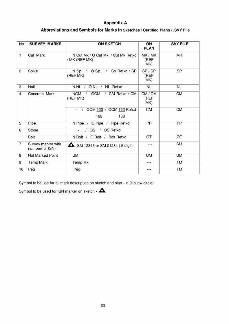
63
Appendix A
Abbreviations and Symbols for Marks in Sketches / Certified Plans / .SVY File
No SURVEY MARKS ON SKETCH ON PLAN
.SVY FILE
1 Cut Mark N Cut Mk / O Cut Mk / Cut Mk Refxd / MK (REF MK)
MK / MK (REF MK)
MK
2 Spike N Sp / O Sp / Sp Refxd / SP (REF MK)
SP / SP (REF MK)
SP
3 Nail N NL / O NL / NL Refxd NL NL
4 Concrete Mark NCM / OCM / CM Refxd / CM (REF MK)
CM / CM (REF MK)
CM
- / OCM 123 / OCM 123 Refxd
188 188
CM CM
5 Pipe N Pipe / O Pipe / Pipe Refxd PP PP
6 Stone - / OS / OS Refxd
OT
OT Bolt N Bolt / O Bolt / Bolt Refxd
7 Survey marker with number(for ISN)
SM 12345 or SM 01234 ( 5 digit) --- SM
8 Not Marked Point UM UM UM
9 Temp Mark Temp Mk --- TM
10 Peg Peg --- TM
Symbol to be use for all mark description on sketch and plan – o (Hollow circle)
Symbol to be used for ISN marker on sketch -
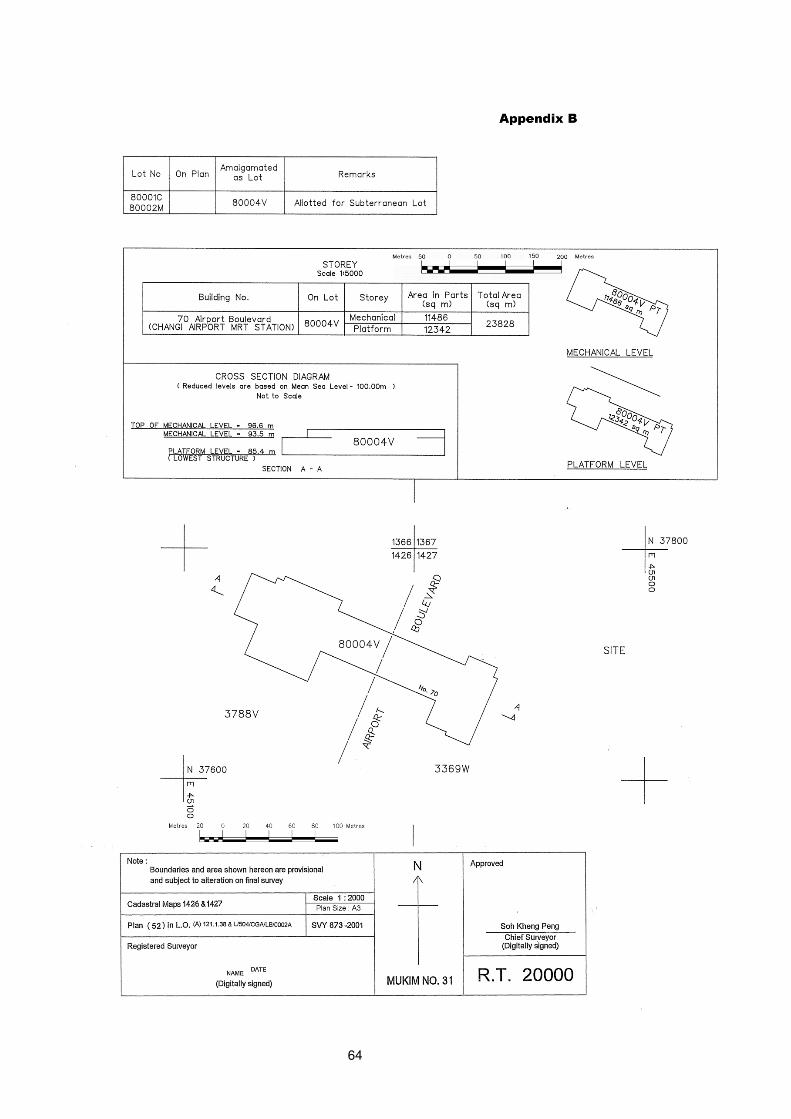
64
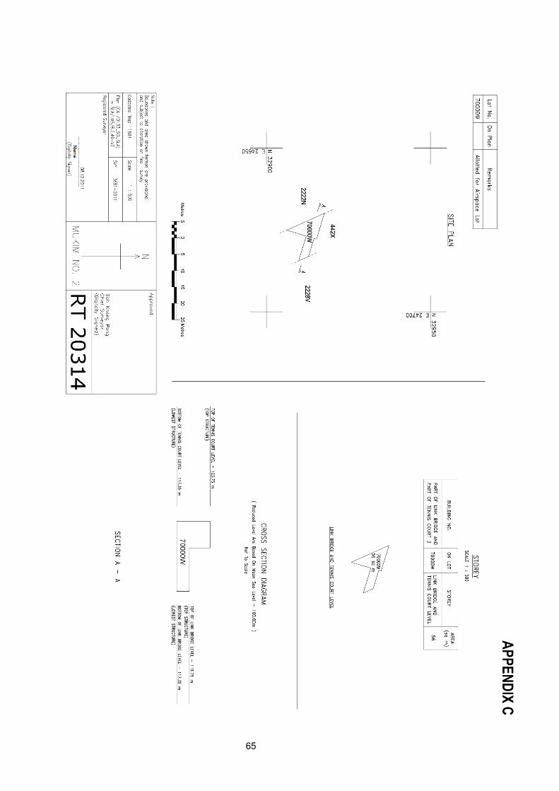
65
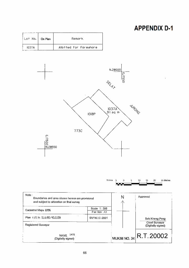
66
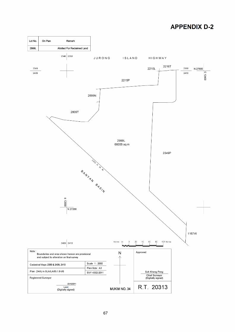
67
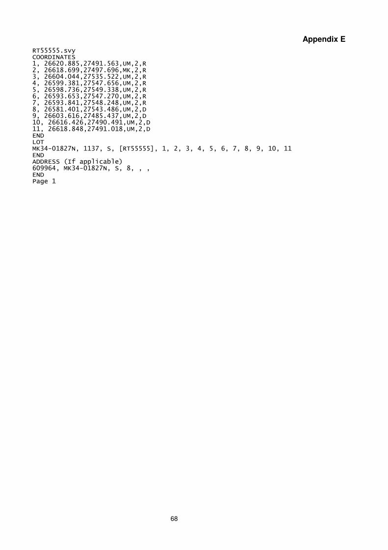
68
Appendix E
RT55555.svy COORDINATES 1, 26620.885,27491.563,UM,2,R 2, 26618.699,27497.696,MK,2,R 3, 26604.044,27535.522,UM,2,R 4, 26599.381,27547.656,UM,2,R 5, 26598.736,27549.338,UM,2,R 6, 26593.653,27547.270,UM,2,R 7, 26593.841,27548.248,UM,2,R 8, 26581.401,27543.486,UM,2,D 9, 26603.616,27485.437,UM,2,D 10, 26616.426,27490.491,UM,2,D 11, 26618.848,27491.018,UM,2,D END LOT MK34-01827N, 1137, S, [RT55555], 1, 2, 3, 4, 5, 6, 7, 8, 9, 10, 11 END ADDRESS (If applicable) 609964, MK34-01827N, S, 8, , , END Page 1

69
Appendix F
Procedure For Survey On Alteration of Mukim (MK) and Town Subdivision (TS)
Boundaries
1 The Registered Surveyor undertaking a survey job which will later on require the alteration of MK/TS boundaries should liaise with the land owner/developer to initiate the proposed alteration as early as possible.
2 The registered surveyor will consider the best route for the alteration of MK/TS boundaries. He will propose the lots to be amalgamated or subdivided and to be transferred from one survey district to another. He will submit the plan showing the proposed alteration of the MK/TS boundaries with an explanatory note to the Chief Surveyor for consideration. In the submission, the following should be included:
a) The Engagement of Registered Surveyor form, where applicable; and
b) The fees as prescribed in The Schedule of the Boundaries and Survey Maps (Singapore Land Authority Fees) Rules.
3 The Chief Surveyor will consider the proposal and will consult the Commissioner of Lands or Land Operation Division and the Land Titles Registry.
4 If the proposal is acceptable, the Chief Surveyor will allocate the new lot numbers.
5 The registered surveyor will carry out the survey action as follows:
a) No field work is required for the alteration if the lot to be transferred is an existing/full lot or a subsequent survey will follow when the site is developed. However, field work to mark out the new boundaries for the alteration is required for cases where the lots have to be subdivided for the alteration and that there will be no subsequent survey action after the transfer of lot is completed.
b) Certified plan, sketches and a Results data file (.svy) are to be put up. The certified plan should show the area and the station numbers.
c) When a lot is subdivided for the purpose of transferring to another survey district, all the
child lots are to be finalised and shown on plan.
d) For lots with SVYQLTY 1 coordinates, the coordinates are to be shown on CP. Lots with SVYQLTY 2 coordinates are not required to have their coordinates shown on CP.
The coordinates of the lots, whether of SVYQLTY 1 or 2, are required to be shown in the
Results Data file (.svy).
e) A sample CP is attached on the next page.
f) The Chief Surveyor will put up the draft notice and order for publication in the gazette under section 12(6) of the Boundaries and Survey Maps Act. The fee payable is posted on SLA website http: // www. sla.gov.sg.
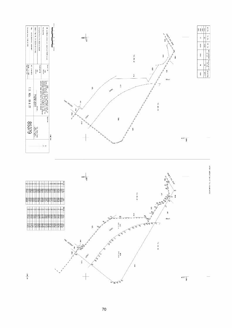
70
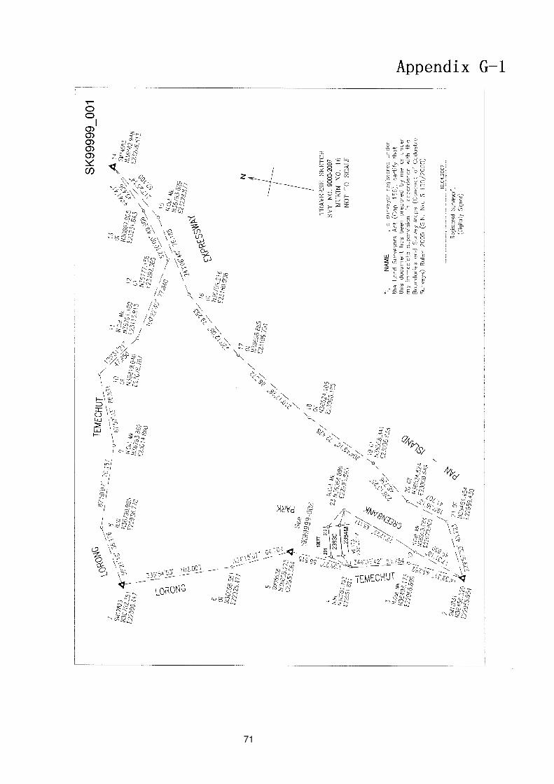
71
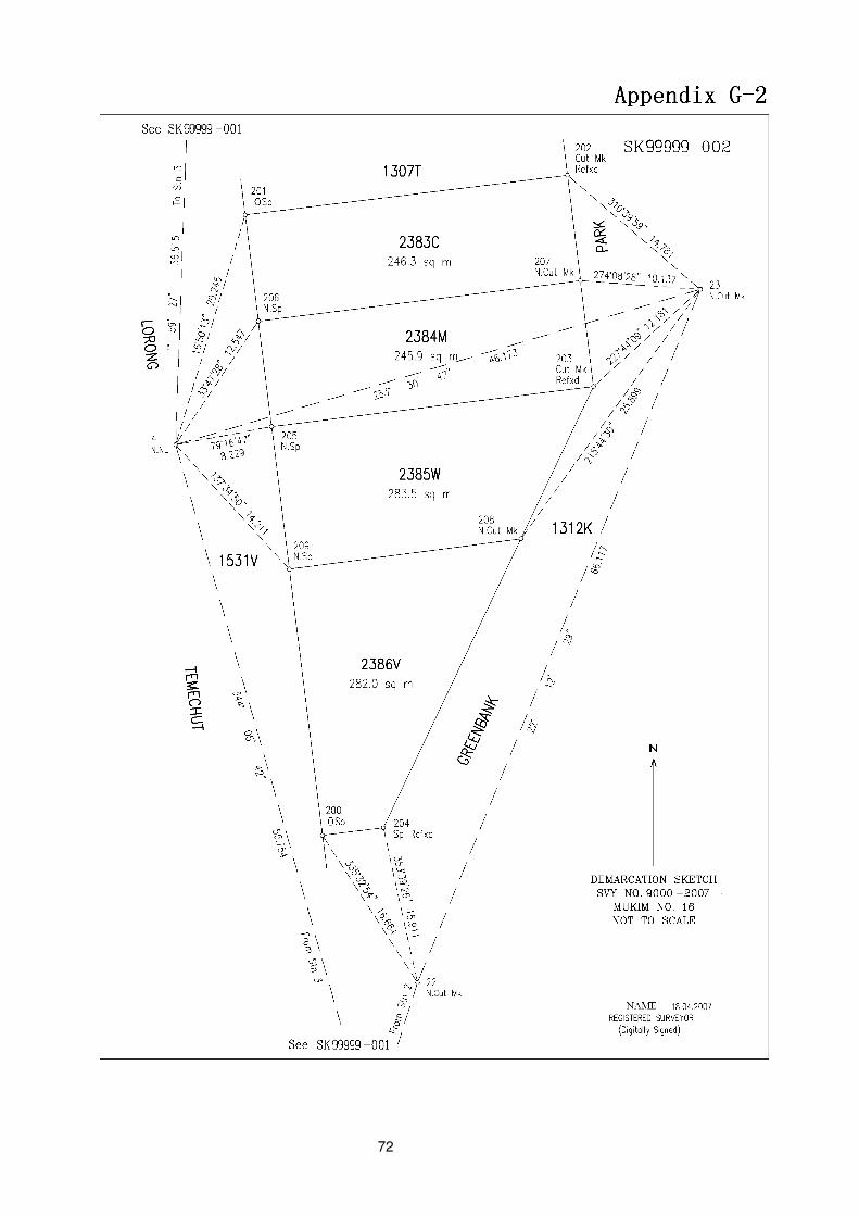
72
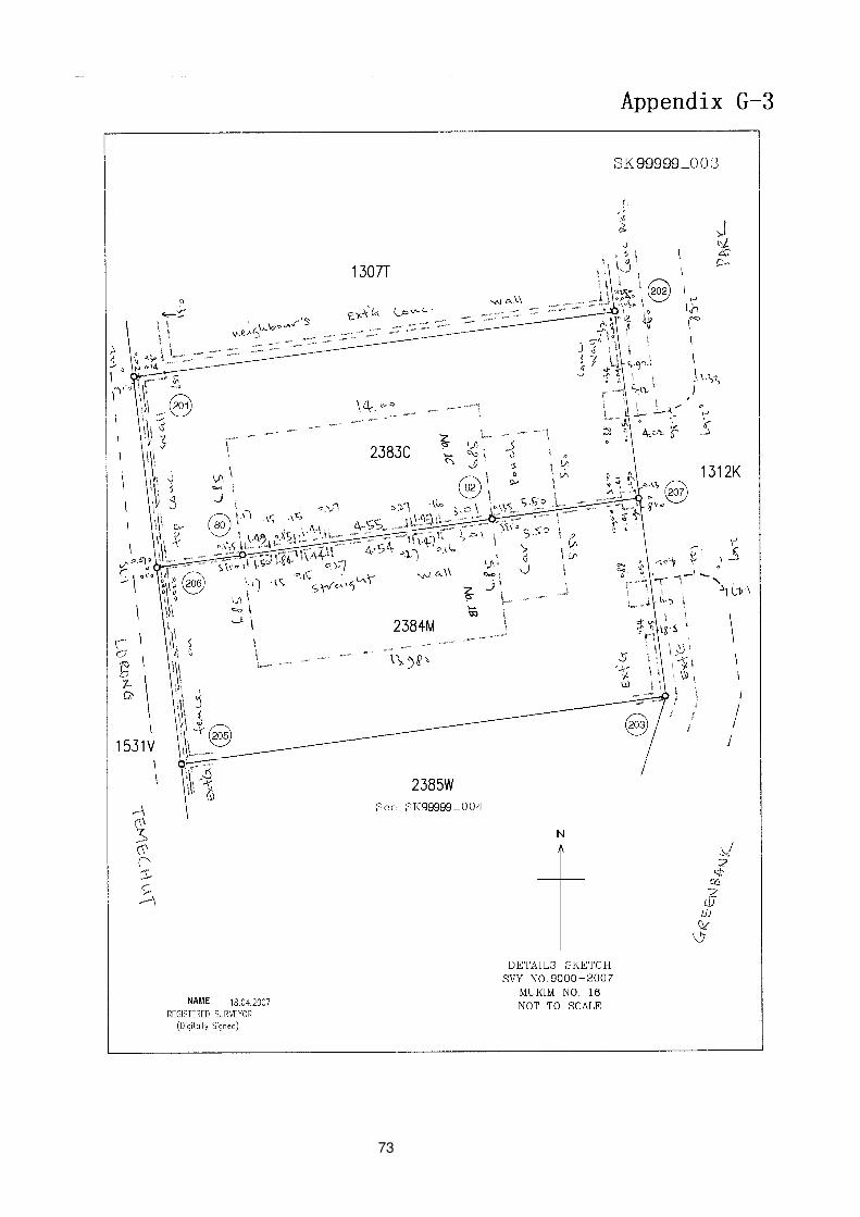
73
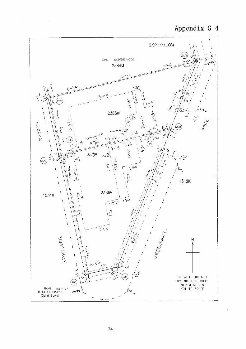
74
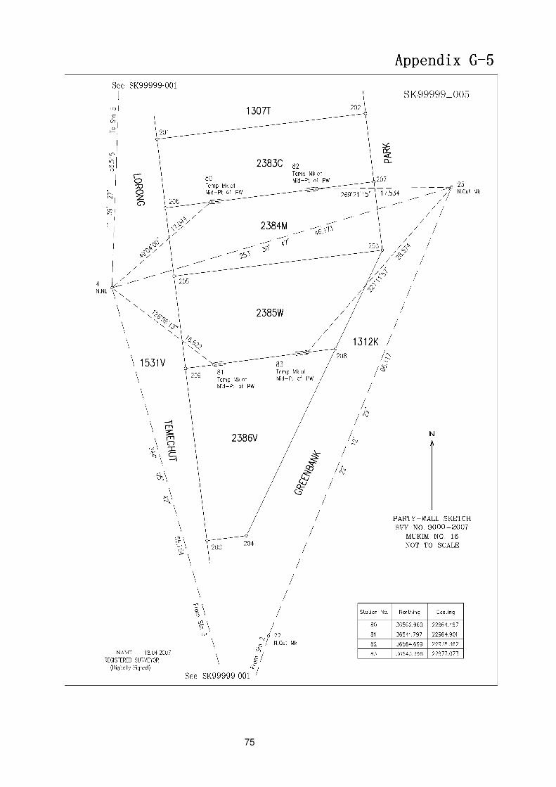
75
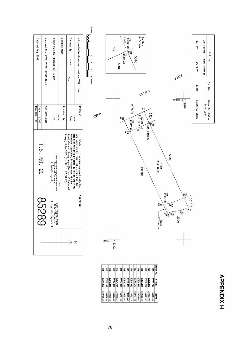
76
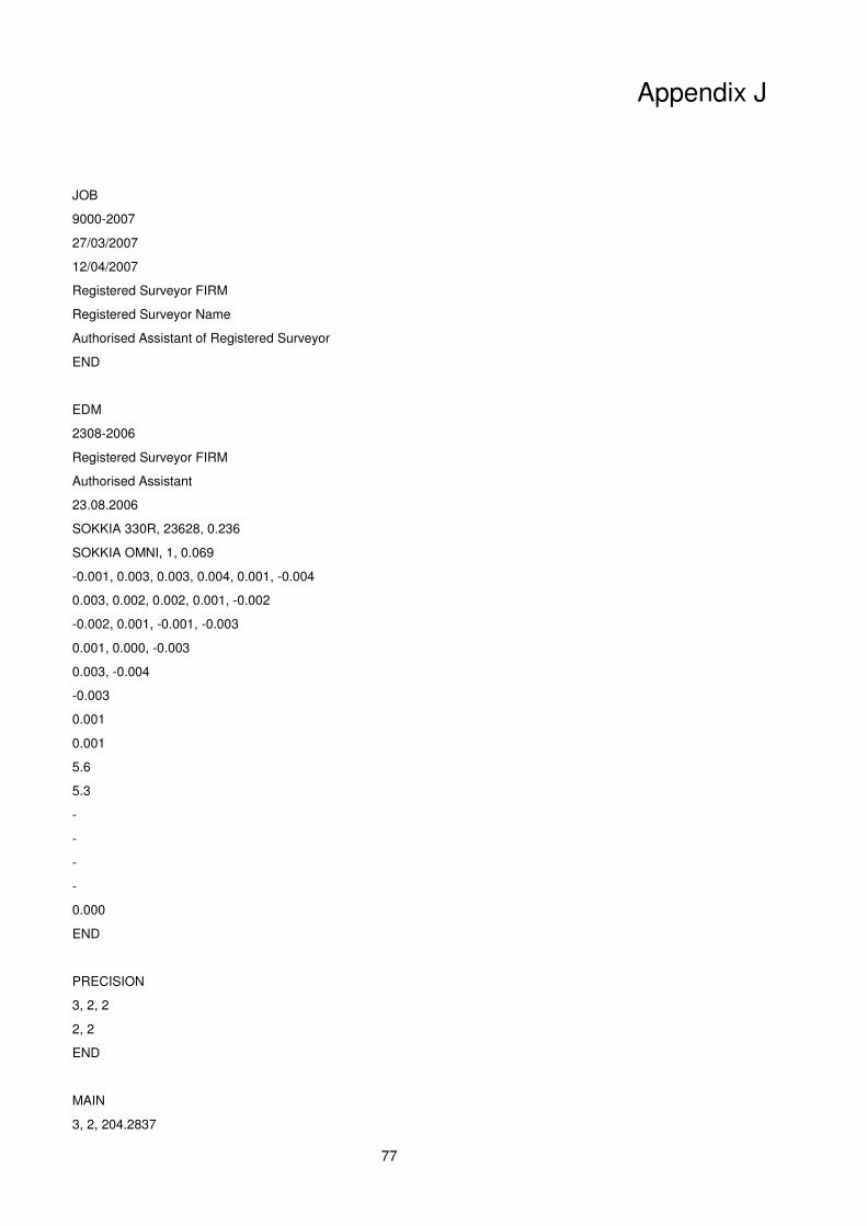
77
Appendix J
JOB
9000-2007
27/03/2007
12/04/2007
Registered Surveyor FIRM
Registered Surveyor Name
Authorised Assistant of Registered Surveyor
END
EDM
2308-2006
Registered Surveyor FIRM
Authorised Assistant
23.08.2006
SOKKIA 330R, 23628, 0.236
SOKKIA OMNI, 1, 0.069
-0.001, 0.003, 0.003, 0.004, 0.001, -0.004
0.003, 0.002, 0.002, 0.001, -0.002
-0.002, 0.001, -0.001, -0.003
0.001, 0.000, -0.003
0.003, -0.004
-0.003
0.001
0.001
5.6
5.3
-
-
-
-
0.000
END
PRECISION
3, 2, 2
2, 2
END
MAIN
3, 2, 204.2837
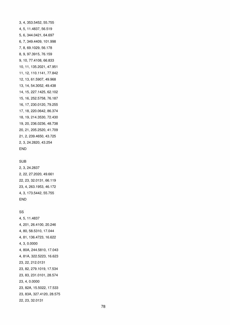
78
3, 4, 353.5452, 55.755
4, 5, 11.4837, 56.519
5, 6, 344.0421, 64.697
6, 7, 349.4409, 101.998
7, 8, 69.1029, 56.178
8, 9, 97.3915, 76.159
9, 10, 77.4108, 66.833
10, 11, 135.2021, 47.951
11, 12, 110.1141, 77.842
12, 13, 61.5907, 49.968
13, 14, 54.3052, 49.438
14, 15, 227.1425, 62.102
15, 16, 252.5758, 76.187
16, 17, 230.0120, 79.255
17, 18, 220.0642, 86.374
18, 19, 214.3530, 72.430
19, 20, 236.0236, 48.738
20, 21, 205.2520, 41.709
21, 2, 239.4650, 43.725
2, 3, 24.2820, 43.254
END
SUB
2, 3, 24.2837
2, 22, 27.2020, 49.661
22, 23, 32.0131, 66.119
23, 4, 263.1953, 46.172
4, 3, 173.5442, 55.755
END
SS
4, 5, 11.4837
4, 201, 26.4100, 20.246
4, 80, 58.5310, 17.044
4, 81, 136.4723, 16.622
4, 3, 0.0000
4, 80A, 244.5810, 17.043
4, 81A, 322.5223, 16.623
23, 22, 212.0131
23, 82, 279.1019, 17.534
23, 83, 231.0101, 28.574
23, 4, 0.0000
23, 82A, 15.5022, 17.533
23, 83A, 327.4120, 28.575
22, 23, 32.0131
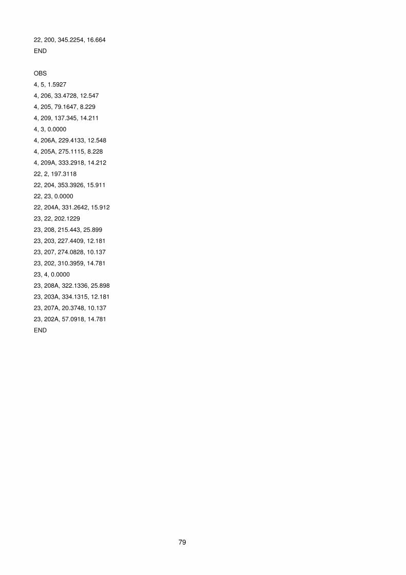
79
22, 200, 345.2254, 16.664
END
OBS
4, 5, 1.5927
4, 206, 33.4728, 12.547
4, 205, 79.1647, 8.229
4, 209, 137.345, 14.211
4, 3, 0.0000
4, 206A, 229.4133, 12.548
4, 205A, 275.1115, 8.228
4, 209A, 333.2918, 14.212
22, 2, 197.3118
22, 204, 353.3926, 15.911
22, 23, 0.0000
22, 204A, 331.2642, 15.912
23, 22, 202.1229
23, 208, 215.443, 25.899
23, 203, 227.4409, 12.181
23, 207, 274.0828, 10.137
23, 202, 310.3959, 14.781
23, 4, 0.0000
23, 208A, 322.1336, 25.898
23, 203A, 334.1315, 12.181
23, 207A, 20.3748, 10.137
23, 202A, 57.0918, 14.781
END
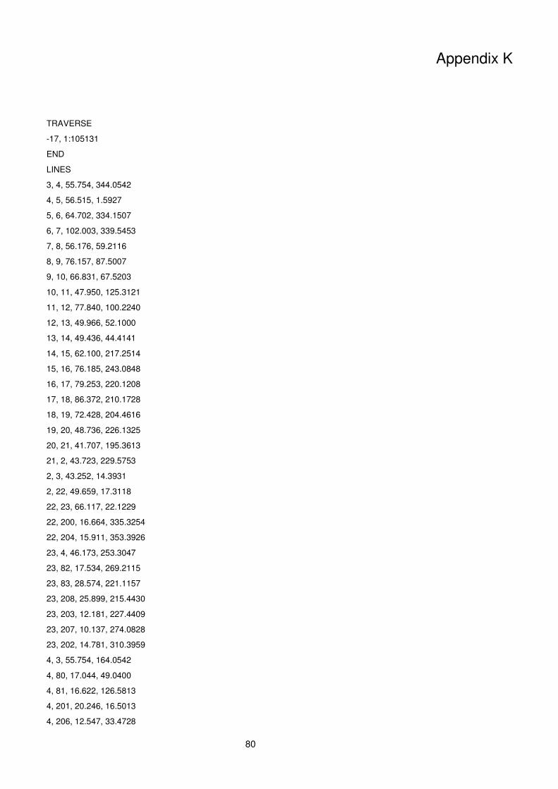
80
Appendix K
TRAVERSE
-17, 1:105131
END
LINES
3, 4, 55.754, 344.0542
4, 5, 56.515, 1.5927
5, 6, 64.702, 334.1507
6, 7, 102.003, 339.5453
7, 8, 56.176, 59.2116
8, 9, 76.157, 87.5007
9, 10, 66.831, 67.5203
10, 11, 47.950, 125.3121
11, 12, 77.840, 100.2240
12, 13, 49.966, 52.1000
13, 14, 49.436, 44.4141
14, 15, 62.100, 217.2514
15, 16, 76.185, 243.0848
16, 17, 79.253, 220.1208
17, 18, 86.372, 210.1728
18, 19, 72.428, 204.4616
19, 20, 48.736, 226.1325
20, 21, 41.707, 195.3613
21, 2, 43.723, 229.5753
2, 3, 43.252, 14.3931
2, 22, 49.659, 17.3118
22, 23, 66.117, 22.1229
22, 200, 16.664, 335.3254
22, 204, 15.911, 353.3926
23, 4, 46.173, 253.3047
23, 82, 17.534, 269.2115
23, 83, 28.574, 221.1157
23, 208, 25.899, 215.4430
23, 203, 12.181, 227.4409
23, 207, 10.137, 274.0828
23, 202, 14.781, 310.3959
4, 3, 55.754, 164.0542
4, 80, 17.044, 49.0400
4, 81, 16.622, 126.5813
4, 201, 20.246, 16.5013
4, 206, 12.547, 33.4728
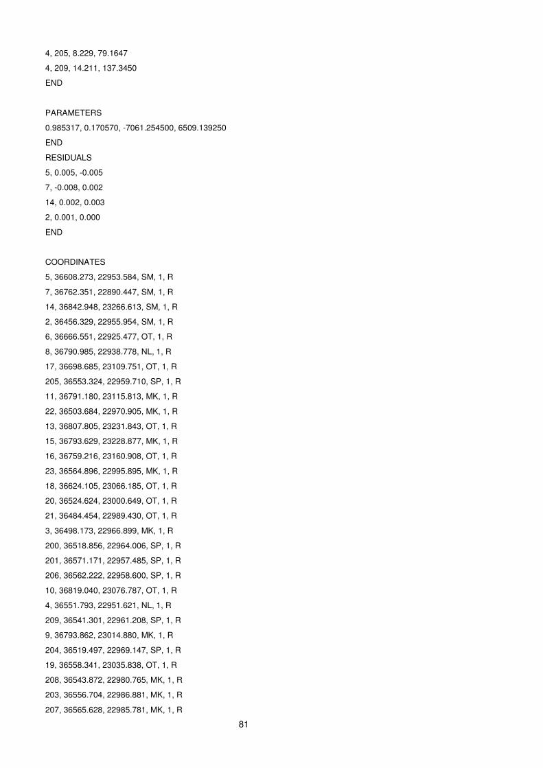
81
4, 205, 8.229, 79.1647
4, 209, 14.211, 137.3450
END
PARAMETERS
0.985317, 0.170570, -7061.254500, 6509.139250
END
RESIDUALS
5, 0.005, -0.005
7, -0.008, 0.002
14, 0.002, 0.003
2, 0.001, 0.000
END
COORDINATES
5, 36608.273, 22953.584, SM, 1, R
7, 36762.351, 22890.447, SM, 1, R
14, 36842.948, 23266.613, SM, 1, R
2, 36456.329, 22955.954, SM, 1, R
6, 36666.551, 22925.477, OT, 1, R
8, 36790.985, 22938.778, NL, 1, R
17, 36698.685, 23109.751, OT, 1, R
205, 36553.324, 22959.710, SP, 1, R
11, 36791.180, 23115.813, MK, 1, R
22, 36503.684, 22970.905, MK, 1, R
13, 36807.805, 23231.843, OT, 1, R
15, 36793.629, 23228.877, MK, 1, R
16, 36759.216, 23160.908, OT, 1, R
23, 36564.896, 22995.895, MK, 1, R
18, 36624.105, 23066.185, OT, 1, R
20, 36524.624, 23000.649, OT, 1, R
21, 36484.454, 22989.430, OT, 1, R
3, 36498.173, 22966.899, MK, 1, R
200, 36518.856, 22964.006, SP, 1, R
201, 36571.171, 22957.485, SP, 1, R
206, 36562.222, 22958.600, SP, 1, R
10, 36819.040, 23076.787, OT, 1, R
4, 36551.793, 22951.621, NL, 1, R
209, 36541.301, 22961.208, SP, 1, R
9, 36793.862, 23014.880, MK, 1, R
204, 36519.497, 22969.147, SP, 1, R
19, 36558.341, 23035.838, OT, 1, R
208, 36543.872, 22980.765, MK, 1, R
203, 36556.704, 22986.881, MK, 1, R
207, 36565.628, 22985.781, MK, 1, R
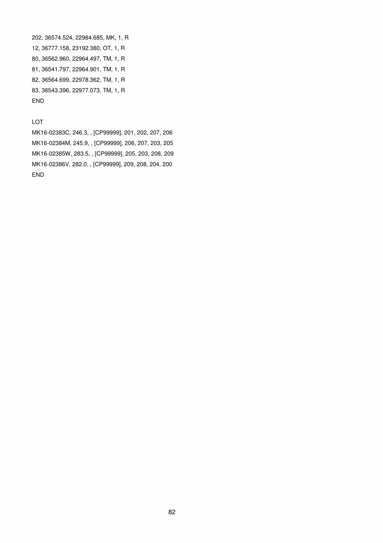
82
202, 36574.524, 22984.685, MK, 1, R
12, 36777.158, 23192.380, OT, 1, R
80, 36562.960, 22964.497, TM, 1, R
81, 36541.797, 22964.901, TM, 1, R
82, 36564.699, 22978.362, TM, 1, R
83, 36543.396, 22977.073, TM, 1, R
END
LOT
MK16-02383C, 246.3, , [CP99999], 201, 202, 207, 206
MK16-02384M, 245.9, , [CP99999], 206, 207, 203, 205
MK16-02385W, 283.5, , [CP99999], 205, 203, 208, 209
MK16-02386V, 282.0, , [CP99999], 209, 208, 204, 200
END
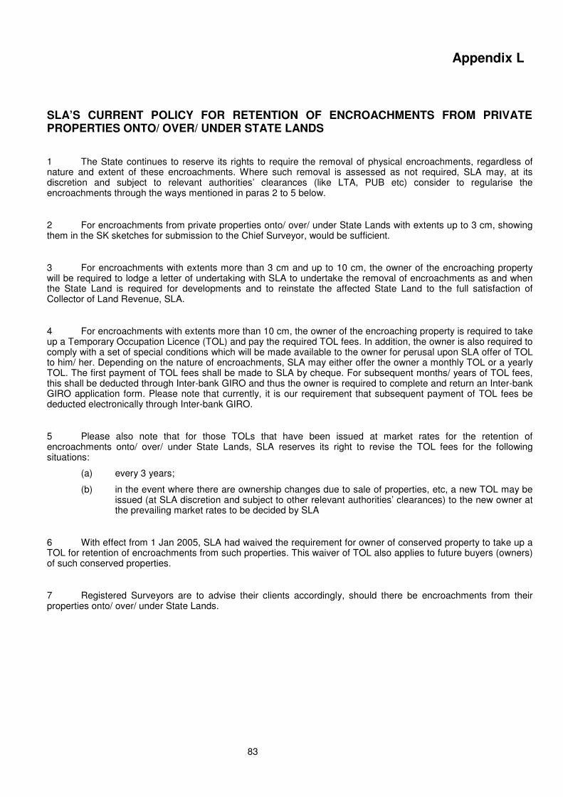
83
Appendix L
SLA’S CURRENT POLICY FOR RETENTION OF ENCROACHMENTS FROM PRIVATE PROPERTIES ONTO/ OVER/ UNDER STATE LANDS
1 The State continues to reserve its rights to require the removal of physical encroachments, regardless of nature and extent of these encroachments. Where such removal is assessed as not required, SLA may, at its discretion and subject to relevant authorities’ clearances (like LTA, PUB etc) consider to regularise the encroachments through the ways mentioned in paras 2 to 5 below.
2 For encroachments from private properties onto/ over/ under State Lands with extents up to 3 cm, showing them in the SK sketches for submission to the Chief Surveyor, would be sufficient.
3 For encroachments with extents more than 3 cm and up to 10 cm, the owner of the encroaching property will be required to lodge a letter of undertaking with SLA to undertake the removal of encroachments as and when the State Land is required for developments and to reinstate the affected State Land to the full satisfaction of Collector of Land Revenue, SLA.
4 For encroachments with extents more than 10 cm, the owner of the encroaching property is required to take up a Temporary Occupation Licence (TOL) and pay the required TOL fees. In addition, the owner is also required to comply with a set of special conditions which will be made available to the owner for perusal upon SLA offer of TOL to him/ her. Depending on the nature of encroachments, SLA may either offer the owner a monthly TOL or a yearly TOL. The first payment of TOL fees shall be made to SLA by cheque. For subsequent months/ years of TOL fees, this shall be deducted through Inter-bank GIRO and thus the owner is required to complete and return an Inter-bank GIRO application form. Please note that currently, it is our requirement that subsequent payment of TOL fees be deducted electronically through Inter-bank GIRO.
5 Please also note that for those TOLs that have been issued at market rates for the retention of encroachments onto/ over/ under State Lands, SLA reserves its right to revise the TOL fees for the following situations:
(a) every 3 years;
(b) in the event where there are ownership changes due to sale of properties, etc, a new TOL may be issued (at SLA discretion and subject to other relevant authorities’ clearances) to the new owner at the prevailing market rates to be decided by SLA
6 With effect from 1 Jan 2005, SLA had waived the requirement for owner of conserved property to take up a TOL for retention of encroachments from such properties. This waiver of TOL also applies to future buyers (owners) of such conserved properties.
7 Registered Surveyors are to advise their clients accordingly, should there be encroachments from their properties onto/ over/ under State Lands.
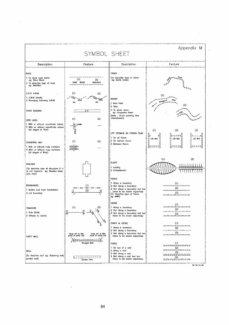
84

85
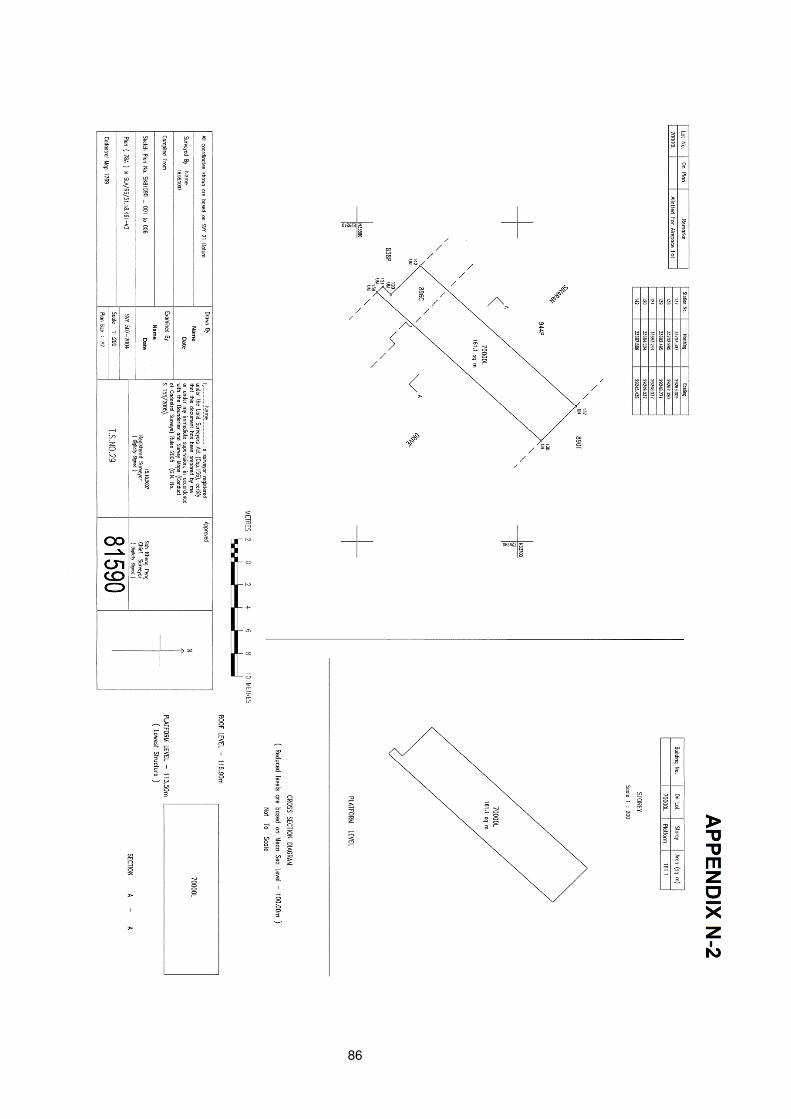
86
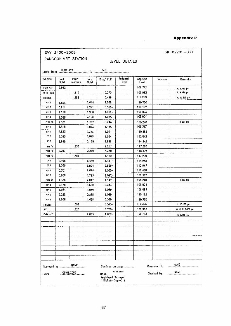
87
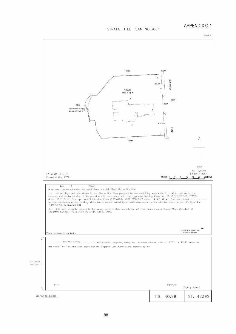
88
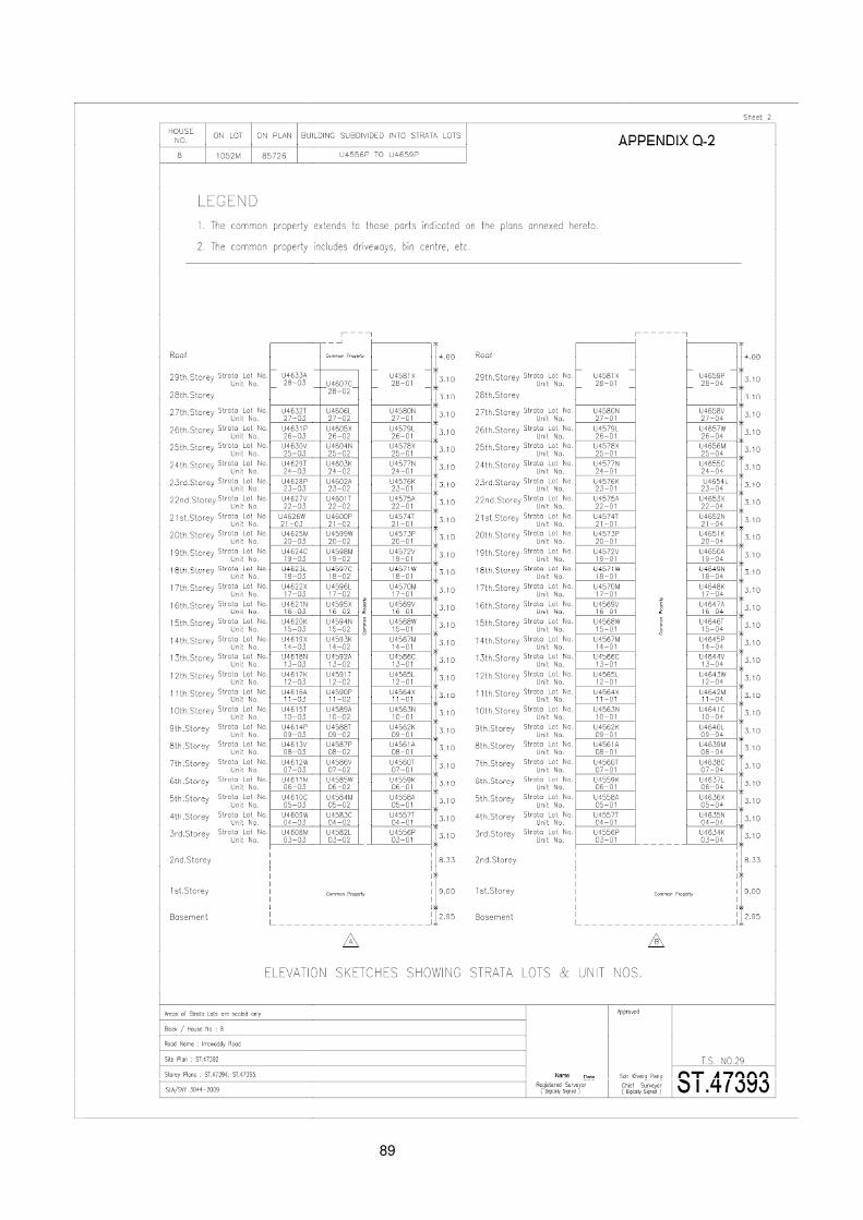
89
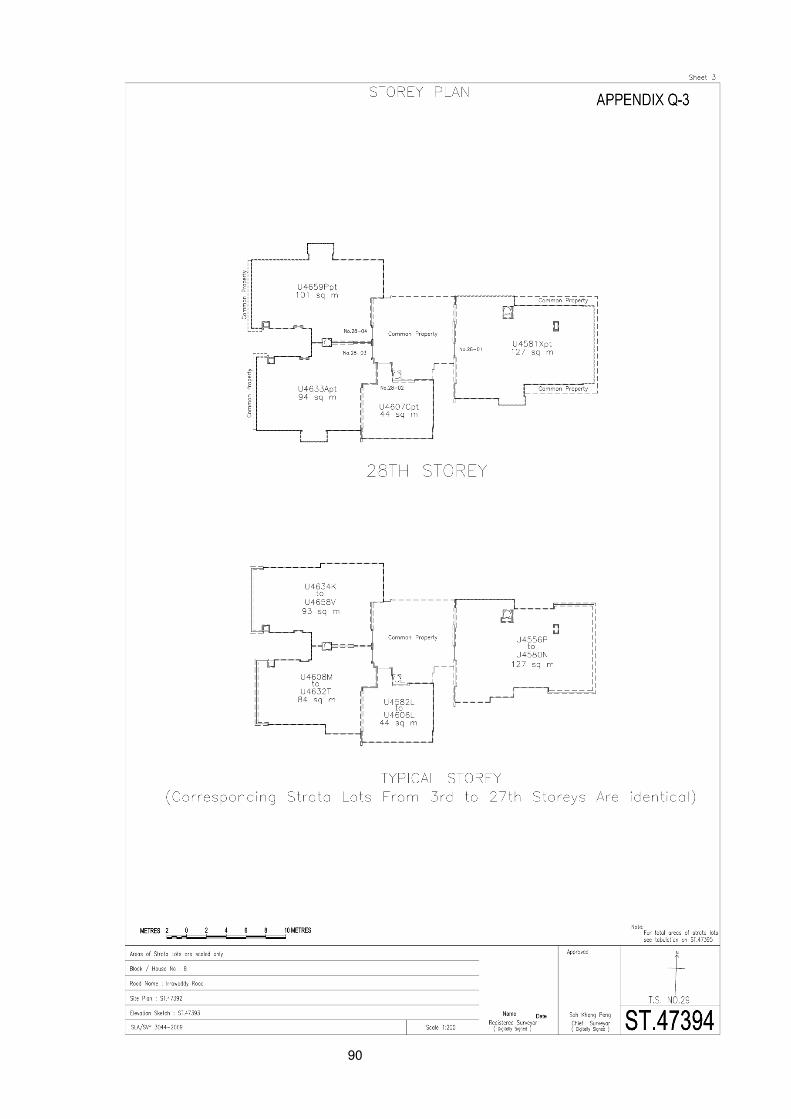
90
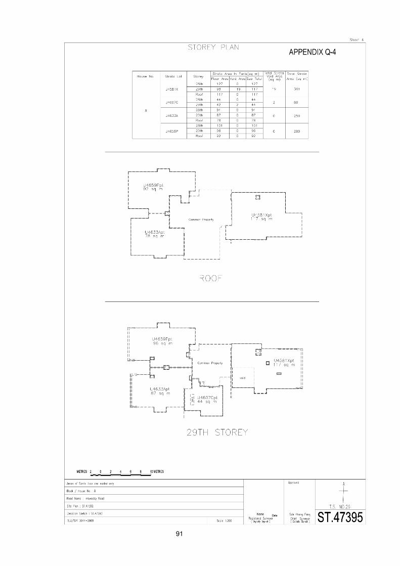
91
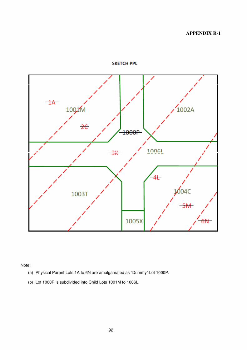
92
APPENDIX R-1
Note:
(a) Physical Parent Lots 1A to 6N are amalgamated as “Dummy” Lot 1000P.
(b) Lot 1000P is subdivided into Child Lots 1001M to 1006L.
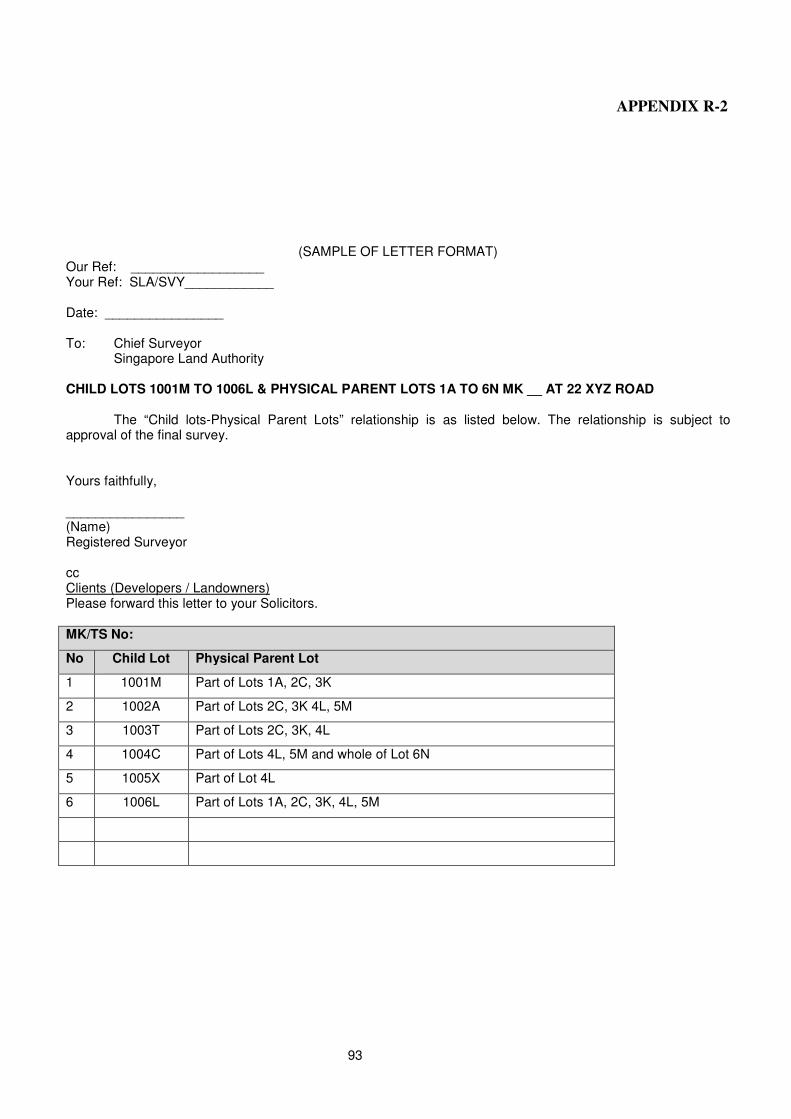
93
APPENDIX R-2
(SAMPLE OF LETTER FORMAT)
Our Ref: __________________ Your Ref: SLA/SVY____________ Date: ________________ To: Chief Surveyor Singapore Land Authority CHILD LOTS 1001M TO 1006L & PHYSICAL PARENT LOTS 1A TO 6N MK __ AT 22 XYZ ROAD
The “Child lots-Physical Parent Lots” relationship is as listed below. The relationship is subject to approval of the final survey. Yours faithfully, ________________ (Name) Registered Surveyor cc Clients (Developers / Landowners) Please forward this letter to your Solicitors. MK/TS No:
No Child Lot Physical Parent Lot
1 1001M Part of Lots 1A, 2C, 3K
2 1002A Part of Lots 2C, 3K 4L, 5M
3 1003T Part of Lots 2C, 3K, 4L
4 1004C Part of Lots 4L, 5M and whole of Lot 6N
5 1005X Part of Lot 4L
6 1006L Part of Lots 1A, 2C, 3K, 4L, 5M
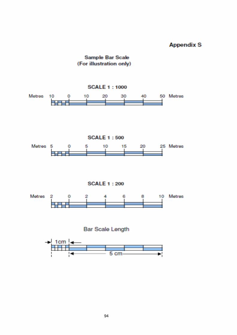
94
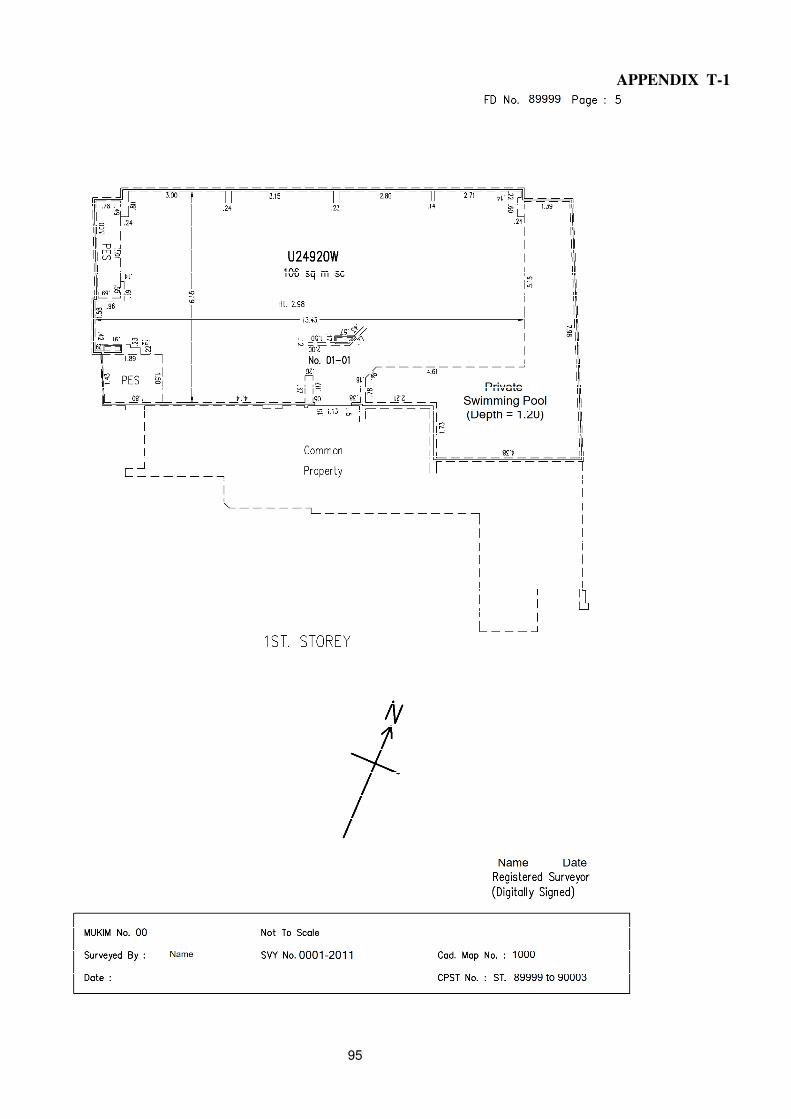
95
APPENDIX T-1
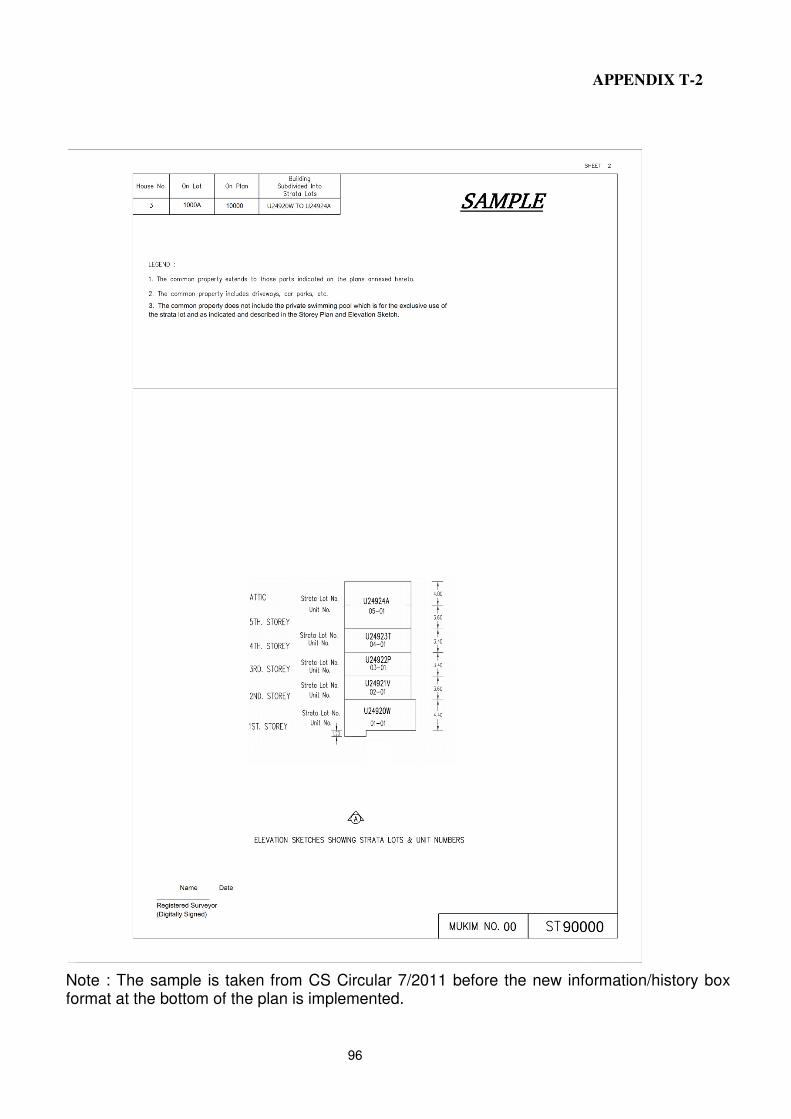
96
APPENDIX T-2
Note : The sample is taken from CS Circular 7/2011 before the new information/history box format at the bottom of the plan is implemented.
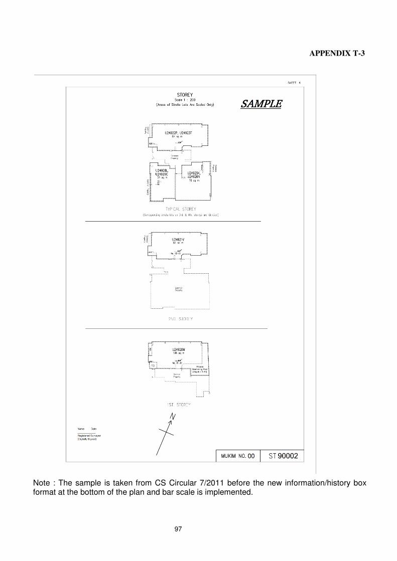
97
APPENDIX T-3
Note : The sample is taken from CS Circular 7/2011 before the new information/history box format at the bottom of the plan and bar scale is implemented.