criteria syntax summary - bentley communities · geopak criteria syntax summary drainage node...
TRANSCRIPT

GEOPAK Criteria Syntax Summary
GEOPAK Criteria Syntax Copyright © 2002 Bentley Systems, Incorporated
9/17/2008 1
INTRODUCTION The sole intent of this document is to provide the users an up to date listing of all supported GEOPAK Criteria Syntax. This document is not intended to train nor provide specific examples. This document should be considered as a command reference only.
This document is being made available for the first time to our Users with the release of GEOPAK Suite 08.08.xx.xx. When a new version of GEOPAK is released (including service packs), this document will be updated to include any additional criteria syntax additions included with the release. All future changes to this document will include a note specifying the released GEOPAK version the additions were added to the product.
Any questions / comments related to GEOPAK Criteria should always be addressed through the conventional Bentley Support and or Training Channels.
GEOPAK Criteria Sytnax Summary.
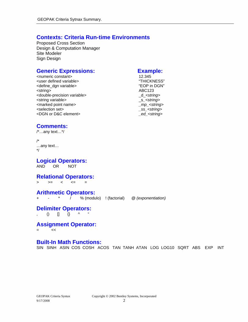
Contexts: Criteria Run-time Environments Proposed Cross Section Design & Computation Manager Site Modeler Sign Design Generic Expressions: Example: <numeric constant> 12.345 <user defined variable> “THICKNESS” <define_dgn variable> “EOP in DGN” <string> ABC123 <double-precision variable> _d_<string> <string variable> _s_<string> <marked point name> _mp_<string> <selection set> _ss_<string> <DGN or D&C element> _ed_<string> Comments: /*…any text…*/ /* …any text… */ Logical Operators: AND OR NOT Relational Operators: > >= < <= = Arithmetic Operators: + - * / % (modulo) ! (factorial) @ (exponentiation) Delimiter Operators: , () [] {} ^ “ Assignment Operator: = << Built-In Math Functions: SIN SINH ASIN COS COSH ACOS TAN TANH ATAN LOG LOG10 SQRT ABS EXP INT
GEOPAK Criteria Syntax Copyright © 2002 Bentley Systems, Incorporated 9/17/2008 2
GEOPAK Criteria Syntax Summary
Intrinsic Variables – Numeric and String
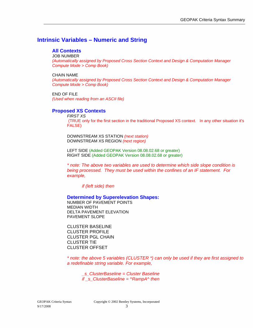
All Contexts JOB NUMBER (Automatically assigned by Proposed Cross Section Context and Design & Computation Manager Compute Mode > Comp Book) CHAIN NAME (Automatically assigned by Proposed Cross Section Context and Design & Computation Manager Compute Mode > Comp Book) END OF FILE (Used when reading from an ASCII file)
Proposed XS Contexts
FIRST XS (TRUE only for the first section in the traditional Proposed XS context. In any other situation it's
FALSE)
DOWNSTREAM XS STATION (next station) DOWNSTREAM XS REGION (next region)
LEFT SIDE (Added GEOPAK Version 08.08.02.68 or greater) RIGHT SIDE (Added GEOPAK Version 08.08.02.68 or greater) * note: The above two variables are used to determine which side slope condition is being processed. They must be used within the confines of an IF statement. For example, if (left side) then Determined by Superelevation Shapes: NUMBER OF PAVEMENT POINTS MEDIAN WIDTH DELTA PAVEMENT ELEVATION PAVEMENT SLOPE CLUSTER BASELINE
CLUSTER PROFILE CLUSTER PGL CHAIN
CLUSTER TIE CLUSTER OFFSET * note: the above 5 variables (CLUSTER *) can only be used if they are first assigned to a redefinable string variable. For example, _s_ClusterBaseline = Cluster Baseline if _s_ClusterBaseline = ^RampA^ then
GEOPAK Criteria Syntax Copyright © 2002 Bentley Systems, Incorporated 9/17/2008 3
GEOPAK Criteria Sytnax Summary.
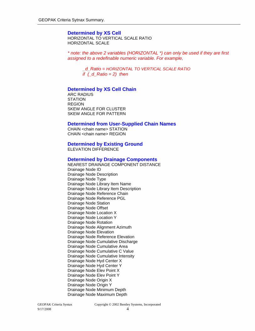
Determined by XS Cell HORIZONTAL TO VERTICAL SCALE RATIO HORIZONTAL SCALE * note: the above 2 variables (HORIZONTAL *) can only be used if they are first assigned to a redefinable numeric variable. For example, _d_Ratio = HORIZONTAL TO VERTICAL SCALE RATIO if (_d_Ratio = 2) then Determined by XS Cell Chain ARC RADIUS STATION REGION SKEW ANGLE FOR CLUSTER SKEW ANGLE FOR PATTERN Determined from User-Supplied Chain Names CHAIN <chain name> STATION CHAIN <chain name> REGION Determined by Existing Ground ELEVATION DIFFERENCE
Determined by Drainage Components NEAREST DRAINAGE COMPONENT DISTANCE Drainage Node ID Drainage Node Description Drainage Node Type Drainage Node Library Item Name Drainage Node Library Item Description Drainage Node Reference Chain Drainage Node Reference PGL Drainage Node Station Drainage Node Offset Drainage Node Location X Drainage Node Location Y Drainage Node Rotation Drainage Node Alignment Azimuth Drainage Node Elevation Drainage Node Reference Elevation Drainage Node Cumulative Discharge Drainage Node Cumulative Area Drainage Node Cumulative C Value Drainage Node Cumulative Intensity Drainage Node Hyd Center X Drainage Node Hyd Center Y Drainage Node Elev Point X Drainage Node Elev Point Y Drainage Node Origin X Drainage Node Origin Y Drainage Node Minimum Depth Drainage Node Maximum Depth
GEOPAK Criteria Syntax Copyright © 2002 Bentley Systems, Incorporated 9/17/2008 4
GEOPAK Criteria Syntax Summary
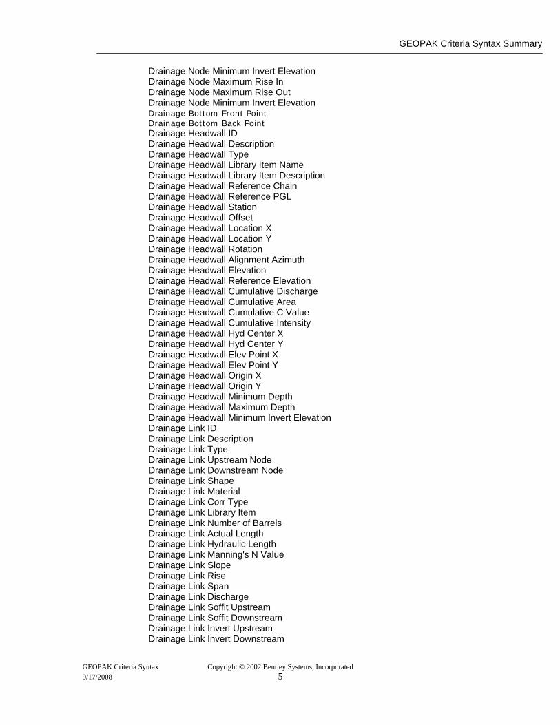
Drainage Node Minimum Invert Elevation Drainage Node Maximum Rise In Drainage Node Maximum Rise Out Drainage Node Minimum Invert Elevation
Drainage Bottom Front Point Drainage Bottom Back Point Drainage Headwall ID Drainage Headwall Description Drainage Headwall Type Drainage Headwall Library Item Name Drainage Headwall Library Item Description Drainage Headwall Reference Chain Drainage Headwall Reference PGL Drainage Headwall Station Drainage Headwall Offset Drainage Headwall Location X Drainage Headwall Location Y Drainage Headwall Rotation Drainage Headwall Alignment Azimuth Drainage Headwall Elevation Drainage Headwall Reference Elevation Drainage Headwall Cumulative Discharge Drainage Headwall Cumulative Area Drainage Headwall Cumulative C Value Drainage Headwall Cumulative Intensity Drainage Headwall Hyd Center X Drainage Headwall Hyd Center Y Drainage Headwall Elev Point X Drainage Headwall Elev Point Y Drainage Headwall Origin X Drainage Headwall Origin Y Drainage Headwall Minimum Depth Drainage Headwall Maximum Depth Drainage Headwall Minimum Invert Elevation Drainage Link ID Drainage Link Description Drainage Link Type Drainage Link Upstream Node Drainage Link Downstream Node Drainage Link Shape Drainage Link Material Drainage Link Corr Type Drainage Link Library Item Drainage Link Number of Barrels Drainage Link Actual Length Drainage Link Hydraulic Length Drainage Link Manning's N Value Drainage Link Slope Drainage Link Rise Drainage Link Span Drainage Link Discharge Drainage Link Soffit Upstream Drainage Link Soffit Downstream Drainage Link Invert Upstream Drainage Link Invert Downstream
GEOPAK Criteria Syntax Copyright © 2002 Bentley Systems, Incorporated 9/17/2008 5
GEOPAK Criteria Sytnax Summary.
Drainage Link Begin Point Drainage Link End Point Drainage Component Front Point Drainage Component Back Point
Intrinsic Variables - D&C Compute Context D&C ITEM NAME D&C ITEM DESCRIPTION Intrinsic Variables – Profile Sub
Profile Sub Chain Profile Sub Horizontal Scale Profile Sub Vertical Scale Profile Sub Reference DP X Profile Sub Reference DP Y Profile Sub Reference DP Station Profile Sub Reference DP Region Profile Sub Reference DP Elevation The above variables take their values from either: a) The parameters explicitly specified in the sub call b) The Profile Cell in the dgn file
Mark Points
Intrinsic Mark Points Pn (where n=1, 2,… 20) P[<arithmetic expression>] XS EG LT PT intrinsic marked point for left end of existing ground example: draw skip to XS EG LT PT XS EG RT PT intrinsic marked point for right end of existing ground example: draw skip to XS EG RT PT XS HI PT intrinsic marked point for upper right edge of cross section cell search boundary example: draw skip to XS HI PT XS LO PT intrinsic marked point for lower left edge of cross section cell search boundary example: draw skip to XS LO PT XS BL PT intrinsic marked point for X and Y axis intersection of cross section cell example: draw skip to XS BL PT Non-Intrinsic Mark Points Xn Yn x[<arithmetic expression>] y[<arithmetic expression>] <mark point name>
GEOPAK Criteria Syntax Copyright © 2002 Bentley Systems, Incorporated 9/17/2008 6
GEOPAK Criteria Syntax Summary
Non-Intrinsic Mark Point Variables: Xn (where n=1, 2,… 1000) Yn (where n=1, 2,… 1000) X[<arithmetic expression>] Y[<arithmetic expression>] XS View: Starting Location: p1 <mark point name>.x Automatically assigned by 3PC <mark point name>.y Automatically assigned by 3PC <mark point name>.elev Automatically assigned by 3PC <mark point name>.distalongchain Automatically assigned by 3PC <mark pointname>.off Automatically assigned by 3PC Plan View: Starting Location: global origin <mark point name>.x Automatically assigned by 3PC <mark point name>.y Automatically assigned by 3PC <mark point name>.elev Undefined (Set to huge number) <mark point name>.distalongchain Undefined (Set to huge number) <mark pointname>.off Undefined (Set to huge number)
Profile View: Starting Location: Reference DP <mark point name>.x Automatically assigned by 3PC <mark point name>.y Automatically assigned by 3PC <mark point name>.elev Set relative to reference elev <mark point name>.distalongchain Set relative to reference distAlongChain <mark pointname>.off Set to 0 NOTE: 3 Port Mark Point Rules:
• Mark Point Name in XS: Point can be used in Plan and Profile Views. • Mark Point Name in Plan: Point can be used in Profile View if < mark point
name>.distAlongChain and < mark point name>.elev assigned. Point cannot be used in XS View.
• Mark Point Name in Profile: Point can be used in Plan View only. Point cannot be used in XS View. • < mark point name>.elev = (Ref DP elev) + (Point’s Prof View Y - Ref DP Prof View Y) *
vert scale / horiz scale • < mark point name>.distAlongChain = (Ref DP distAlongChain) + (Point’s Prof View X –
Ref DP Prof View X) –Gaps, where Gaps = the sum of the lengths of all the gaps between the Point and the Ref DP.
Assignment Statements for Mark Points: < mark point name> = <mark point name> < mark point name>.x = <arithmetic expression> < mark point name>.y = <arithmetic expression> < mark point name>.elev = <arithmetic expression> < mark point name>.distAlongChain = <arithmetic expression> Note: < mark point name> must be marked prior to performing any assignments
GEOPAK Criteria Syntax Copyright © 2002 Bentley Systems, Incorporated 9/17/2008 7
GEOPAK Criteria Sytnax Summary.
Define_DGN Statements:
Note: By Feature Symbology Only
Define_DGN <”string”> \ dgn = <string> \ wt = <string> \ co = <string> \ lc = <string> \ LvName = <string> \ LvName = < string> \ LvName = < string> \ type = line, line_string, arc, curve, shape, cmp_string, cmp_shape, point_string, bspline, ellipse, multiline Note: The DGN filename is optional if drawing to the same file as processing such as in the usage of material above or below or 3PC plan view Criteria. However, omitting the drawing name is only allowed directly in the Criteria and is not supported if defining the define_dgn through Project Manager.
Note: By DDB Feature Define_DGN <”string”> \ dgn = <string> \ ddb = <string> \ feature = <string> Note: Feature = Path in DDB to either the proper category name or individual item name, i.e. feature = Plan Topo & Notation/Roadway Existing/Roadway Features Existing/ExEOP
Note: By Model Surface
Define_DGN <”string”> \ dgn = <string> \ feature type = <string> \ material type = <string> \ surface type = <string>
If-Then expressions:
IF <conditional expression> THEN { } ELSE IF <conditional expression> THEN { } ELSE { }
GEOPAK Criteria Syntax Copyright © 2002 Bentley Systems, Incorporated 9/17/2008 8

GEOPAK Criteria Syntax Summary
Testing for Presence of Marked Points /* Testing for conventional marked points */ if NOT (value of x1 defined) then Note: Resets for each cross section /* Testing for 3PC marked points. Once marked, valid for entire cross section run */ if NOT (_mp_point) then /* Testing for existing ground at a previously marked point */ if (value of elev diff at x1 y1 defined) then Intersecting of Plan Elements: If (intersect dgn = <“string”>) then
/* Looks away from the baseline in the positive X direction */ If (intersect dgn = <“string”> IN) then /* Looks towards the baseline in the negative X direction using the keyword “IN” */
While (intersect dgn = <“string”>) /* Looks away from the baseline in the positive X direction */ While (intersect dgn = <“string”> IN) /* Looks towards the baseline in the negative X direction using the keyword “IN” */ If (intersect dgn = <“string”> within distance = <expression>) then /* Looks away from the baseline in the positive X direction for a specified distance */ If (intersect dgn = <“string”> IN within distance = <expression>) then /* Looks towards the baseline in the negative X direction using the keyword “IN” for a specified distance */
While (intersect dgn = <“string”> within distance = <expression>) /* Looks away from the baseline in the positive X direction for a specified distance */ While (intersect dgn = <“string”> IN within distance = <expression>) /* Looks towards the baseline in the negative X direction using the keyword “IN” for a specified distance */
Logical Intrinsic Variables (Used Only in If-Then Statements):
Proposed XS Context MATERIAL BELOW = < define_dgn variable > MATERIAL ABOVE = < define_dgn variable > MATERIAL BELOW Xn Yn = < define_dgn variable > STATION WITHIN PROFILE = <profile name> CHAIN <_s_string> STATION WITHIN PROFILE = <profile name> INTERSECT DGN = < define_dgn variable >
GEOPAK Criteria Syntax Copyright © 2002 Bentley Systems, Incorporated 9/17/2008 9

GEOPAK Criteria Sytnax Summary.
While expressions: WHILE <conditional expression> { } BREAK (Used only in a WHILE loop, terminates the current loop.) CONTINUE (Used only in a WHILE loop, skips all remaining lines within the current WHILE loop and does a new iteration of the loop.) Arrays: _d_<string>[<arithmetic expression>] = <arithmetic expression>
example: _d_coulmn1[_d_index_number] = _d_current_value
The arithmetic expression used to set the index number should be the number 1 or greater. Never use a zero. _s_<string>[<arithmetic expression>] = ^<string>^
example: _s_coulmn2[_d_index_number] = _s_current_label
The text string field width will be set to 40 characters by default for string arrays. If more than 40 is desired the following syntax may be used: _d_<string> = <arithmetic expression> set string length _d_<string> Go To Label: (Added GEOPAK Version 08.08.02.45 or greater) _d_<string> = <arithmetic expression> GO TO LABEL <arithmetic expression> GO TO LABEL _d_<string> LABEL <arithmetic expression> LABEL _d_<string>
The GO TO LABEL syntax effectively skips all Criteria between the call and the label location. The GO TO and LABEL syntax MUST be in the same level of indentation, i.e., same set of {…}. Draw Statements: DRAW [skip] [GG=<gg name>]<slope component> <distance component>
<gg name>: ^<string>^ _s_<string>
<slope component>: dx = <arithmetic expression> dy = <arithmetic expression> slope = <slope expression> rise:run = <arithmetic expression>:<arithmetic expression> run:rise = <arithmetic expression>:<arithmetic expression>
GEOPAK Criteria Syntax Copyright © 2002 Bentley Systems, Incorporated 9/17/2008 10
GEOPAK Criteria Syntax Summary
angle = <arithmetic expression>
<slope expression>: <arithmetic expression> <arithmetic expression>:<arithmetic expression>
<distance component>:
FOR dx = <arithmetic expression> FOR dy = <arithmetic expression> TO <marked point coordinate> (Ex: TO X1, TO Y33, etc.) TO Existing Ground TO <define_dgn variable> [WITHIN DISTANCE = <arithmetic expression>] TO XS <define_dgn variable> [WITHIN DISTANCE = <arithmetic expression>] TO CHAIN <chain name> TO PROFILE ELEVATION = <prof name>[,<prof name>,…] TO CHAIN <chain name> PROFILE ELEVATION = <prof name>[,<prof name>,…] TO INTERSECTION <marked point> <marked point> FOR DISTANCE = <arithmetic expression>
DRAW [skip] [GG=<gg name>]<all-inclusive slope and distance component>
<all-inclusive slope and distance component>: dx = <arithmetic expression> dy = <arithmetic expression> TO <marked point> TO CHAIN <chain name> PROFILE ELEVATION = <prof name>[,<prof name>,…] TO <drainage point> TO CHAIN <chain name> DISTALONGCHAIN= <arithmetic expression> OFF = <arithmetic expression> TO CHAIN <chain name> DISTALONGCHAIN = <arithmetic expression> ELEV= <arithmetic expression>
<drainage point>:
DRAINAGE COMPONENT FRONT POINT DRAINAGE COMPONENT BACK POINT DRAINAGE LINK BEGIN POINT DRAINAGE LINK END POINT
<marked point>:
Pn P[<arithmetic expression>] Xn Yn X[<arithmetic expression>] Y[<arithmetic expression>] _mp_<string>
DRAW [skip] [GG=<gg name>]TRACE [<define_dgn variable>]
<direction> [OFFSET=<arithmetic expression>] <distance component>
<direction>:
IN OUT
<distance component>:<distance component> TO ENDPOINT (only for draw trace “material” )
GEOPAK Criteria Syntax Copyright © 2002 Bentley Systems, Incorporated 9/17/2008 11
GEOPAK Criteria Sytnax Summary.
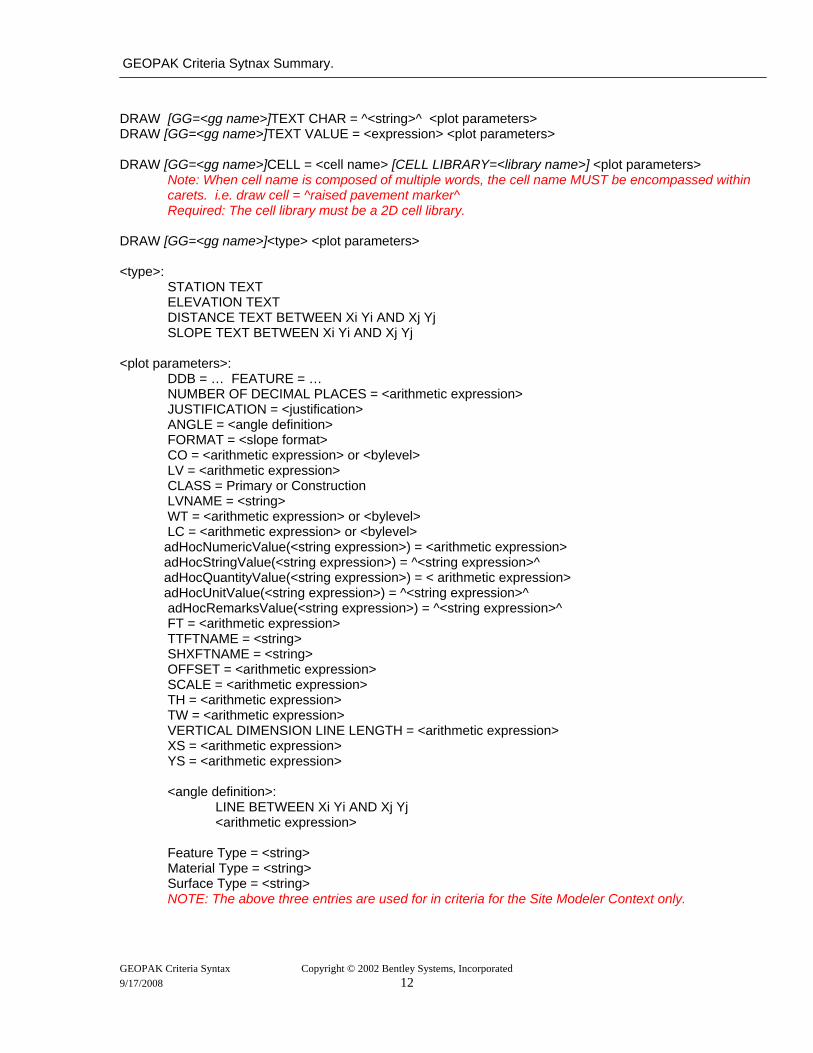
DRAW [GG=<gg name>]TEXT CHAR = ^<string>^ <plot parameters> DRAW [GG=<gg name>]TEXT VALUE = <expression> <plot parameters> DRAW [GG=<gg name>]CELL = <cell name> [CELL LIBRARY=<library name>] <plot parameters>
Note: When cell name is composed of multiple words, the cell name MUST be encompassed within carets. i.e. draw cell = ^raised pavement marker^ Required: The cell library must be a 2D cell library.
DRAW [GG=<gg name>]<type> <plot parameters> <type>:
STATION TEXT ELEVATION TEXT DISTANCE TEXT BETWEEN Xi Yi AND Xj Yj SLOPE TEXT BETWEEN Xi Yi AND Xj Yj
<plot parameters>:
DDB = … FEATURE = … NUMBER OF DECIMAL PLACES = <arithmetic expression> JUSTIFICATION = <justification> ANGLE = <angle definition> FORMAT = <slope format> CO = <arithmetic expression> or <bylevel> LV = <arithmetic expression> CLASS = Primary or Construction LVNAME = <string> WT = <arithmetic expression> or <bylevel> LC = <arithmetic expression> or <bylevel>
adHocNumericValue(<string expression>) = <arithmetic expression> adHocStringValue(<string expression>) = ^<string expression>^ adHocQuantityValue(<string expression>) = < arithmetic expression> adHocUnitValue(<string expression>) = ^<string expression>^ adHocRemarksValue(<string expression>) = ^<string expression>^
FT = <arithmetic expression> TTFTNAME = <string> SHXFTNAME = <string> OFFSET = <arithmetic expression> SCALE = <arithmetic expression> TH = <arithmetic expression> TW = <arithmetic expression> VERTICAL DIMENSION LINE LENGTH = <arithmetic expression> XS = <arithmetic expression> YS = <arithmetic expression>
<angle definition>:
LINE BETWEEN Xi Yi AND Xj Yj <arithmetic expression>
Feature Type = <string> Material Type = <string> Surface Type = <string> NOTE: The above three entries are used for in criteria for the Site Modeler Context only.
GEOPAK Criteria Syntax Copyright © 2002 Bentley Systems, Incorporated 9/17/2008 12

GEOPAK Criteria Syntax Summary
<slope format>:
/ : % RISE:RUN RUN:RISE RUN:1 1:RUN FT/FT M/M
<justification>:
LT, LC, LB, CT, CC, CB, RT, RC, RB
GEOPAK Criteria Syntax Copyright © 2002 Bentley Systems, Incorporated 9/17/2008 13
GEOPAK Criteria Sytnax Summary.
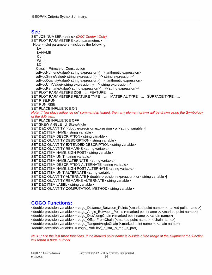
Set: SET JOB NUMBER <string> (D&C Context Only) SET PLOT PARAMETERS <plot parameters> Note: < plot parameters> includes the following: LV = LVNAME = Co = Wt = LC = Class = Primary or Construction adHocNumericValue(<string expression>) = <arithmetic expression> adHocStringValue(<string expression>) = ^<string expression>^ adHocQuantityValue(<string expression>) = < arithmetic expression> adHocUnitValue(<string expression>) = ^<string expression>^ adHocRemarksValue(<string expression>) = ^<string expression>^ SET PLOT PARAMETERS DDB = … FEATURE = … SET PLOT PARAMETERS FEATURE TYPE = … MATERIAL TYPE =… SURFACE TYPE =… SET RISE:RUN SET RUN:RISE SET PLACE INFLUENCE ON Note: If “set place influence on” command is issued, then any element drawn will be drawn using the Symbology of the ddb item. SET PLACE INFLUENCE OFF SET SKEW ANGLE _d_SkewAngle SET D&C QUANTITY [<double-precision expression> or <string variable>] SET D&C ITEM NAME <string variable> SET D&C ITEM DESCRIPTION <string variable> SET D&C QUANTITY DESCRIPTION <string variable> SET D&C QUANTITY EXTENDED DESCRIPTION <string variable> SET D&C QUANTITY REMARKS <string variable> SET D&C ITEM NAME SIGN POST <string variable> SET D&C ITEM UNIT <string variable> SET D&C ITEM NAME ALTERNATE <string variable> SET D&C ITEM DESCRIPTION ALTERNATE <string variable> SET D&C ITEM NAME SIGN POST ALTERNATE <string variable> SET D&C ITEM UNIT ALTERNATE <string variable> SET D&C QUANTITY ALTERNATE [<double-precision expression> or <string variable>] SET D&C QUANTITY REMARKS ALTERNATE <string variable> SET D&C ITEM LABEL <string variable> SET D&C QUANTITY COMPUTATION METHOD <string variable> COGO Functions: <double-precision variable> = cogo_Distance_Between_Points (<marked point name>, <marked point name >) <double-precision variable> = cogo_Angle_Between_Points (<marked point name >, <marked point name >) <double-precision variable> = cogo_DistAlongChain (<marked point name >, <chain name>) <double-precision variable> = cogo_OffsetFromChain (<marked point name >, <chain name>) <double-precision variable> = cogo_TangentAngleChain (<marked point name >, <chain name>) <double-precision variable> = cogo_ProfElev(_s_sta,_s_reg,_s_prof) NOTE: For the last three functions, if the marked point name is outside of the range of the alignment the function will return a huge number. GEOPAK Criteria Syntax Copyright © 2002 Bentley Systems, Incorporated 9/17/2008 14
GEOPAK Criteria Syntax Summary
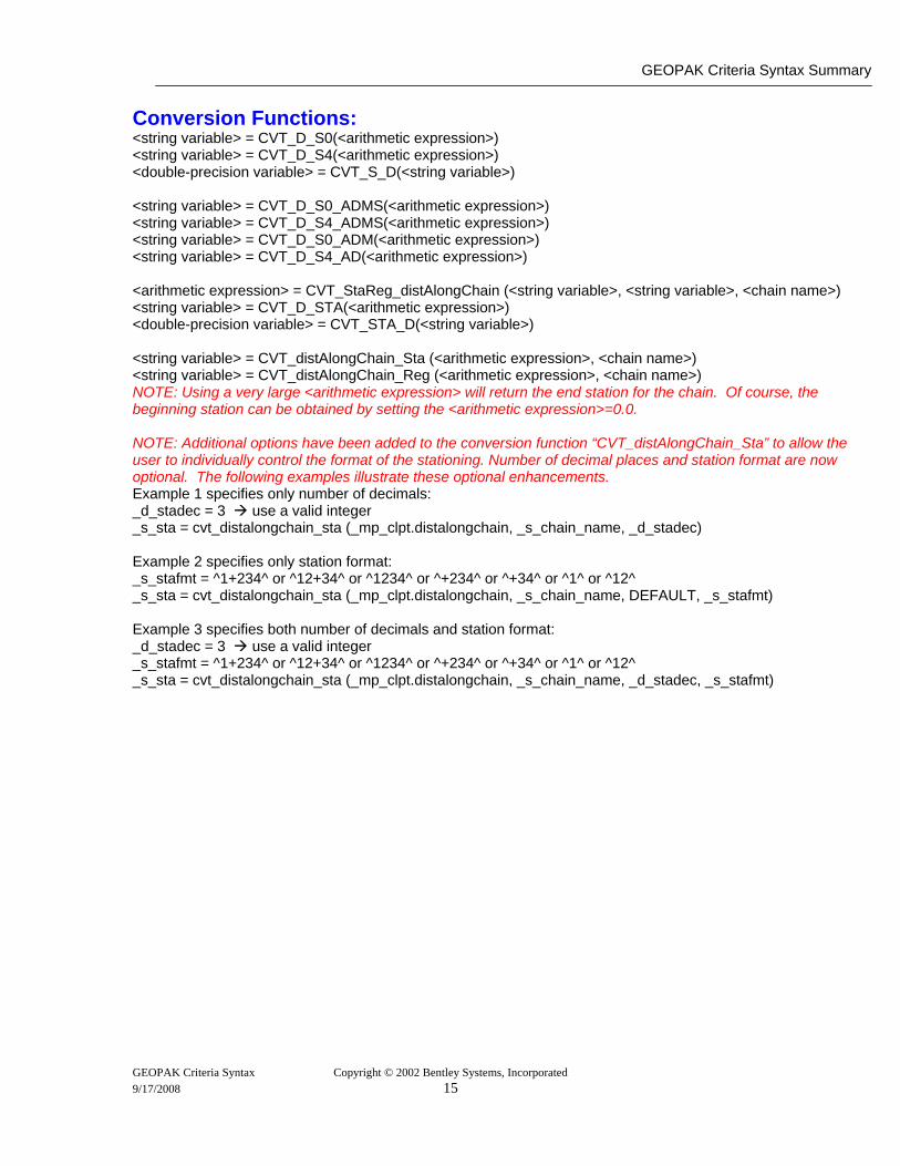
Conversion Functions: <string variable> = CVT_D_S0(<arithmetic expression>) <string variable> = CVT_D_S4(<arithmetic expression>) <double-precision variable> = CVT_S_D(<string variable>) <string variable> = CVT_D_S0_ADMS(<arithmetic expression>) <string variable> = CVT_D_S4_ADMS(<arithmetic expression>) <string variable> = CVT_D_S0_ADM(<arithmetic expression>) <string variable> = CVT_D_S4_AD(<arithmetic expression>) <arithmetic expression> = CVT_StaReg_distAlongChain (<string variable>, <string variable>, <chain name>) <string variable> = CVT_D_STA(<arithmetic expression>) <double-precision variable> = CVT_STA_D(<string variable>) <string variable> = CVT_distAlongChain_Sta (<arithmetic expression>, <chain name>) <string variable> = CVT_distAlongChain_Reg (<arithmetic expression>, <chain name>) NOTE: Using a very large <arithmetic expression> will return the end station for the chain. Of course, the beginning station can be obtained by setting the <arithmetic expression>=0.0. NOTE: Additional options have been added to the conversion function “CVT_distAlongChain_Sta” to allow the user to individually control the format of the stationing. Number of decimal places and station format are now optional. The following examples illustrate these optional enhancements. Example 1 specifies only number of decimals: _d_stadec = 3 use a valid integer _s_sta = cvt_distalongchain_sta (_mp_clpt.distalongchain, _s_chain_name, _d_stadec) Example 2 specifies only station format: _s_stafmt = ^1+234^ or ^12+34^ or ^1234^ or ^+234^ or ^+34^ or ^1^ or ^12^ _s_sta = cvt_distalongchain_sta (_mp_clpt.distalongchain, _s_chain_name, DEFAULT, _s_stafmt) Example 3 specifies both number of decimals and station format: _d_stadec = 3 use a valid integer _s_stafmt = ^1+234^ or ^12+34^ or ^1234^ or ^+234^ or ^+34^ or ^1^ or ^12^ _s_sta = cvt_distalongchain_sta (_mp_clpt.distalongchain, _s_chain_name, _d_stadec, _s_stafmt)
GEOPAK Criteria Syntax Copyright © 2002 Bentley Systems, Incorporated 9/17/2008 15
GEOPAK Criteria Sytnax Summary.
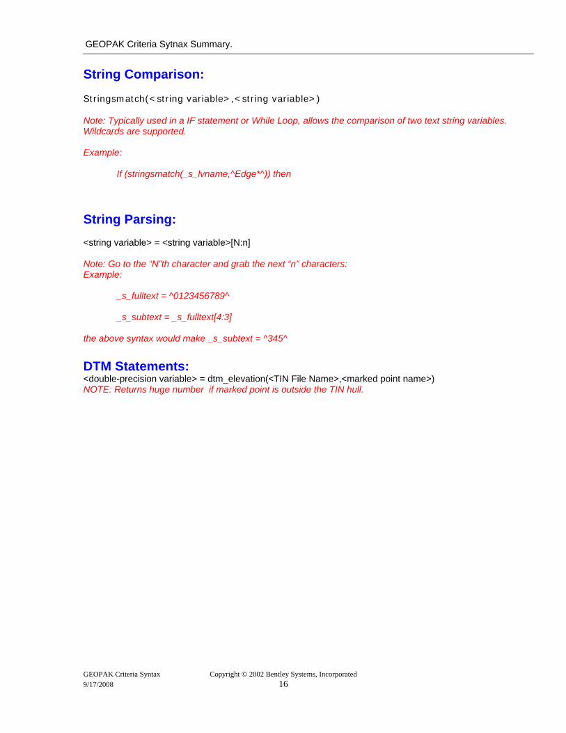
String Comparison: Stringsmatch(<string variable>,<string variable>) Note: Typically used in a IF statement or While Loop, allows the comparison of two text string variables. Wildcards are supported. Example:
If (stringsmatch(_s_lvname,^Edge*^)) then String Parsing: <string variable> = <string variable>[N:n] Note: Go to the “N”th character and grab the next “n” characters: Example:
_s_fulltext = ^0123456789^ _s_subtext = _s_fulltext[4:3]
the above syntax would make _s_subtext = ^345^ DTM Statements: <double-precision variable> = dtm_elevation(<TIN File Name>,<marked point name>) NOTE: Returns huge number if marked point is outside the TIN hull.
GEOPAK Criteria Syntax Copyright © 2002 Bentley Systems, Incorporated 9/17/2008 16
GEOPAK Criteria Syntax Summary
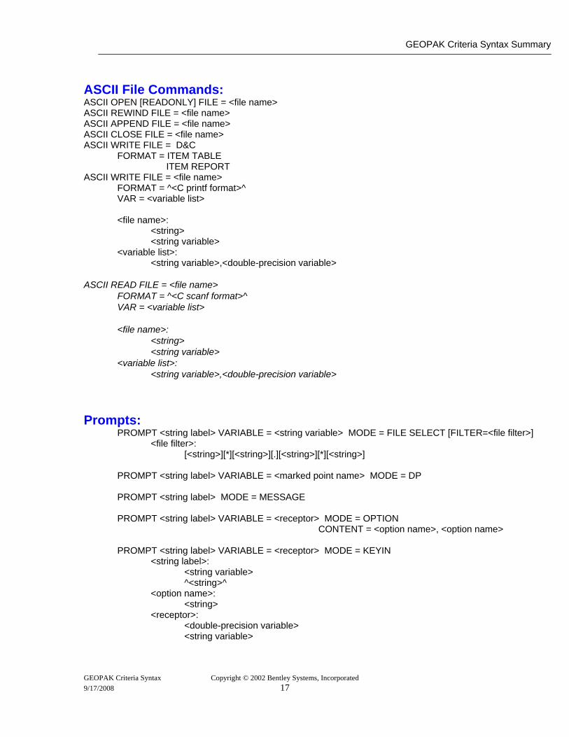
ASCII File Commands: ASCII OPEN [READONLY] FILE = <file name> ASCII REWIND FILE = <file name> ASCII APPEND FILE = <file name> ASCII CLOSE FILE = <file name> ASCII WRITE FILE = D&C
FORMAT = ITEM TABLE ITEM REPORT
ASCII WRITE FILE = <file name> FORMAT = ^<C printf format>^ VAR = <variable list>
<file name>:
<string> <string variable>
<variable list>: <string variable>,<double-precision variable>
ASCII READ FILE = <file name>
FORMAT = ^<C scanf format>^ VAR = <variable list>
<file name>:
<string> <string variable>
<variable list>: <string variable>,<double-precision variable>
Prompts:
PROMPT <string label> VARIABLE = <string variable> MODE = FILE SELECT [FILTER=<file filter>] <file filter>:
[<string>][*][<string>][.][<string>][*][<string>] PROMPT <string label> VARIABLE = <marked point name> MODE = DP PROMPT <string label> MODE = MESSAGE PROMPT <string label> VARIABLE = <receptor> MODE = OPTION
CONTENT = <option name>, <option name> PROMPT <string label> VARIABLE = <receptor> MODE = KEYIN
<string label>: <string variable> ^<string>^
<option name>: <string>
<receptor>: <double-precision variable> <string variable>
GEOPAK Criteria Syntax Copyright © 2002 Bentley Systems, Incorporated 9/17/2008 17

GEOPAK Criteria Sytnax Summary.
Prompts Intrinsic Variables: if (OK) then… if (CANCEL) then… Note that the former condition is true if a prompt command has been processed and the OK push button was pressed. The latter condition is true if a prompt command has been processed and the CANCEL push button was pressed. EXIT Terminates the Criteria Process
Subroutines: SUBROUTINE [XS, PLAN or PROFILE] <sub name> { /* criteria statements */ } END SUBROUTINE CALL <sub name> CALL <sub name> (PLAN VIEW [=<dgn file name>]) CALL <sub name> (PROFILE VIEW [=<dgn file name>] X=<arithmetic expression>
Y=<arithmetic expression> HORIZONTAL SCALE=<arithmetic expression> VERTICAL SCALE=< arithmetic expression>
STA=<string> REG=< arithmetic expression> ELEV=< arithmetic expression>
GAP=<YES or NO>, CHAIN = <chain name>)
Profile Subroutine Call using the Profile Cell: CALL <sub name> (PROFILE VIEW [=<dgn file name>]
CHAIN = <chain name>) <sub name>:
<alphanumeric string> <dgn file name>:
<alphanumeric string> MicroStation Commands: SEND MICROSTATION <string> Cogo Commands: SEND COGO <string>
GEOPAK Criteria Syntax Copyright © 2002 Bentley Systems, Incorporated 9/17/2008 18
GEOPAK Criteria Syntax Summary
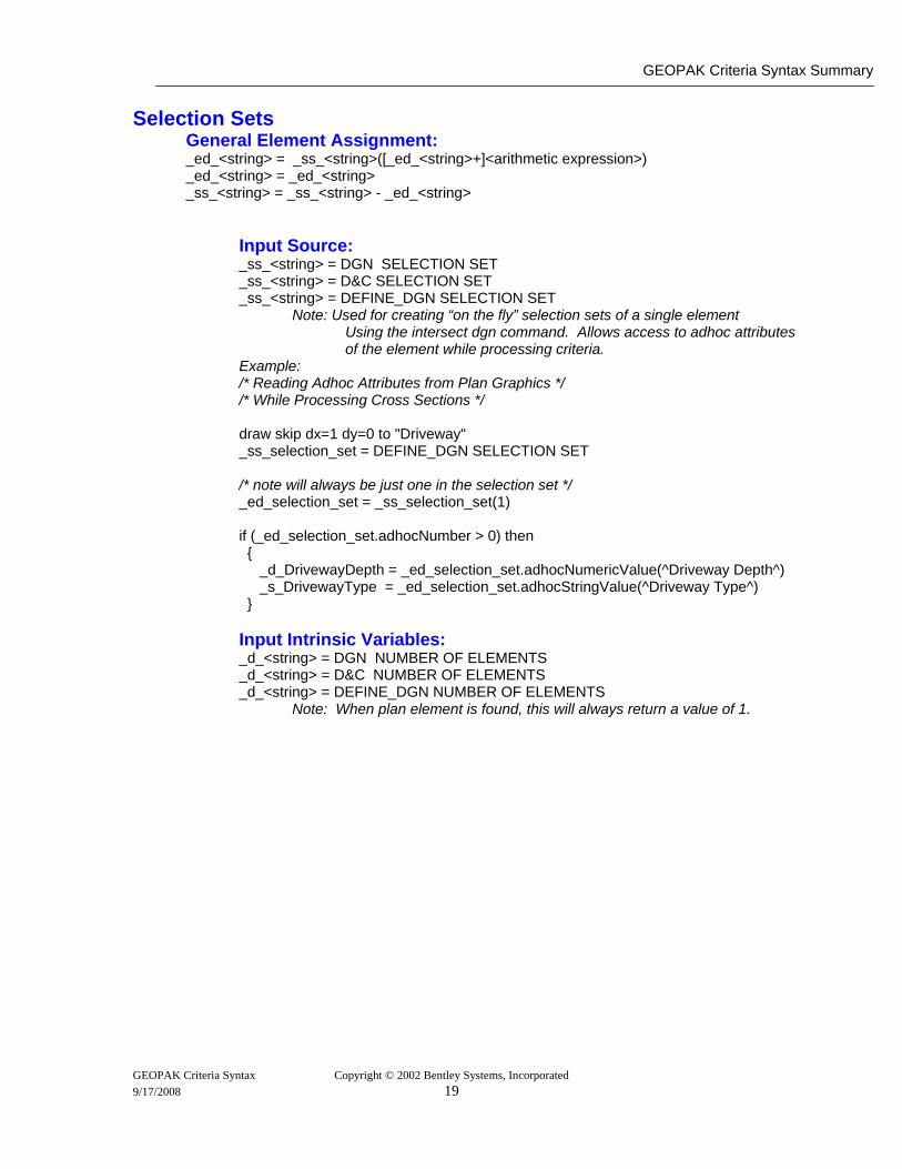
Selection Sets General Element Assignment: _ed_<string> = _ss_<string>([_ed_<string>+]<arithmetic expression>) _ed_<string> = _ed_<string> _ss_<string> = _ss_<string> - _ed_<string>
Input Source: _ss_<string> = DGN SELECTION SET _ss_<string> = D&C SELECTION SET _ss_<string> = DEFINE_DGN SELECTION SET
Note: Used for creating “on the fly” selection sets of a single element Using the intersect dgn command. Allows access to adhoc attributes of the element while processing criteria. Example: /* Reading Adhoc Attributes from Plan Graphics */ /* While Processing Cross Sections */
draw skip dx=1 dy=0 to "Driveway" _ss_selection_set = DEFINE_DGN SELECTION SET
/* note will always be just one in the selection set */ _ed_selection_set = _ss_selection_set(1) if (_ed_selection_set.adhocNumber > 0) then { _d_DrivewayDepth = _ed_selection_set.adhocNumericValue(^Driveway Depth^) _s_DrivewayType = _ed_selection_set.adhocStringValue(^Driveway Type^) } Input Intrinsic Variables: _d_<string> = DGN NUMBER OF ELEMENTS _d_<string> = D&C NUMBER OF ELEMENTS _d_<string> = DEFINE_DGN NUMBER OF ELEMENTS Note: When plan element is found, this will always return a value of 1.
GEOPAK Criteria Syntax Copyright © 2002 Bentley Systems, Incorporated 9/17/2008 19
GEOPAK Criteria Sytnax Summary.
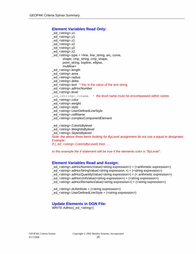
Element Variables Read Only: _ed_<string>.x1 _ed_<string>.y1 _ed_<string>.z1 _ed_<string>.x2 _ed_<string>.y2 _ed_<string>.z2 _ed_<string>.type = <line, line_string, arc, curve, shape, cmp_string, cmp_shape, point_string, bspline, ellipse, multiline> _ed_<string>.length _ed_<string>.area _ed_<string>.radius _ed_<string>.delta _ed_<string>.text * this is the value of the text string _ed_<string>.adHocNumber _ed_<string>.level _ed_<string>.lvname * the level name must be encompassed within carets _ed_<string>.color _ed_<string>.weight _ed_<string>.style _ed_<string>.UserDefinedLineStyle _ed_<string>.cellName _ed_<string>.complexComponentElement _ed_<string>.ColorIsBylevel _ed_<string>.WeightIsBylevel _ed_<string>.StyleIsBylevel Note: the above three items looking for ByLevel assignment do not use a equal to designator. Example: If (_ed_<string>.ColorIsByLevel) then …. In this example the if statement will be true if the elements color is “ByLevel”. Element Variables Read and Assign: _ed_<string>.adHocNumericValue(<string expression>) = (<arithmetic expression>) _ed_<string>.adHocStringValue(<string expression >) = (<string expression>) _ed_<string>.adHocQuantityValue(<string expression>) = (< arithmetic expression>) _ed_<string>.adHocUnitValue(<string expression>) = (<string expression>) _ed_<string>.adHocRemarksValue(<string expression>) = (<string expression>)
_ed_<string>.dcAttribute = (<string expression>) _ed_<string>.UserDefinedLineStyle = (<string expression>) Update Elements in DGN File: WRITE AdHoc(_ed_<string>)
GEOPAK Criteria Syntax Copyright © 2002 Bentley Systems, Incorporated 9/17/2008 20
GEOPAK Criteria Syntax Summary
GEOPAK Criteria Syntax Copyright © 2002 Bentley Systems, Incorporated 9/17/2008 21
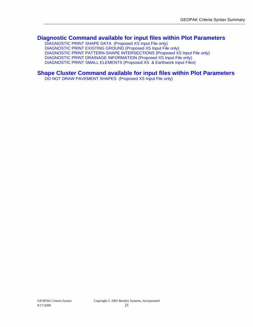
Diagnostic Command available for input files within Plot Parameters
DIAGNOSTIC PRINT SHAPE DATA (Proposed XS Input File only) DIAGNOSTIC PRINT EXISTING GROUND (Proposed XS Input File only) DIAGNOSTIC PRINT PATTERN-SHAPE INTERSECTIONS (Proposed XS Input File only) DIAGNOSTIC PRINT DRAINAGE INFORMATION (Proposed XS Input File only) DIAGNOSTIC PRINT SMALL ELEMENTS (Proposed XS & Earthwork Input Files)
Shape Cluster Command available for input files within Plot Parameters DO NOT DRAW PAVEMENT SHAPES (Proposed XS Input File only)