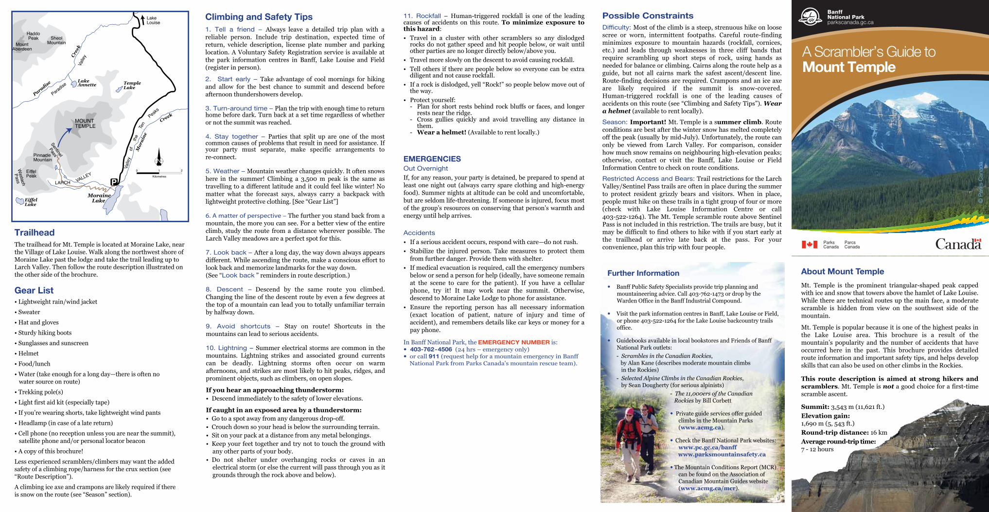
creek a scrambler’s guide to mount temple temple pinnacle mountain mount aberdeen haddo peak sheol...
TRANSCRIPT
Possible Constraints Dif�culty: Most of the climb is a steep, strenuous hike on loose scree or worn, intermittent footpaths. Careful route-finding minimizes exposure to mountain hazards (rockfall, cornices, etc.) and leads through weaknesses in three cliff bands that require scrambling up short steps of rock, using hands as needed for balance or climbing. Cairns along the route help as a guide, but not all cairns mark the safest ascent/descent line. Route-finding decisions are required. Crampons and an ice axe are likely required if the summit is snow-covered. Human-triggered rockfall is one of the leading causes of accidents on this route (see “Climbing and Safety Tips”). Wear a helmet (available to rent locally).
Season: Important! Mt. Temple is a summer climb. Route conditions are best after the winter snow has melted completely off the peak (usually by mid-July). Unfortunately, the route can only be viewed from Larch Valley. For comparison, consider how much snow remains on neighbouring high-elevation peaks; otherwise, contact or visit the Banff, Lake Louise or Field Information Centre to check on route conditions.
Restricted Access and Bears: Trail restrictions for the Larch Valley/Sentinel Pass trails are often in place during the summer to protect resident grizzly bears and visitors. When in place, people must hike on these trails in a tight group of four or more (check with Lake Louise Information Centre or call 403-522-1264). The Mt. Temple scramble route above Sentinel Pass is not included in this restriction. The trails are busy, but it may be difficult to find others to hike with if you start early at the trailhead or arrive late back at the pass. For your convenience, plan this trip with four people.
TrailheadThe trailhead for Mt. Temple is located at Moraine Lake, near the Village of Lake Louise. Walk along the northwest shore of Moraine Lake past the lodge and take the trail leading up to Larch Valley. Then follow the route description illustrated on the other side of the brochure.
11. Rockfall – Human-triggered rockfall is one of the leading causes of accidents on this route. To minimize exposure to this hazard:• Travel in a cluster with other scramblers so any dislodged
rocks do not gather speed and hit people below, or wait until other parties are no longer directly below/above you.
• Travel more slowly on the descent to avoid causing rockfall.• Tell others if there are people below so everyone can be extra
diligent and not cause rockfall.• If a rock is dislodged, yell “Rock!” so people below move out of
the way.• Protect yourself:
- Plan for short rests behind rock bluffs or faces, and longer rests near the ridge.
- Cross gullies quickly and avoid travelling any distance in them.
- Wear a helmet! (Available to rent locally.)
EMERGENCIESOut Overnight If, for any reason, your party is detained, be prepared to spend at least one night out (always carry spare clothing and high-energy food). Summer nights at altitude can be cold and uncomfortable, but are seldom life-threatening. If someone is injured, focus most of the group’s resources on conserving that person’s warmth and energy until help arrives.
Accidents • If a serious accident occurs, respond with care—do not rush.• Stabilize the injured person. Take measures to protect them
from further danger. Provide them with shelter.• If medical evacuation is required, call the emergency numbers
below or send a person for help (ideally, have someone remain at the scene to care for the patient). If you have a cellular phone, try it! It may work near the summit. Otherwise, descend to Moraine Lake Lodge to phone for assistance.
• Ensure the reporting person has all necessary information (exact location of patient, nature of injury and time of accident), and remembers details like car keys or money for a pay phone.
In Banff National Park, the EMERGENCY NUMBER is: • 403-762-4506 (24 hrs – emergency only)• or call 911 (request help for a mountain emergency in Banff National Park from Parks Canada's mountain rescue team).
Gear List• Lightweight rain/wind jacket
• Sweater
• Hat and gloves
• Sturdy hiking boots
• Sunglasses and sunscreen
• Helmet
• Food/lunch
• Water (take enough for a long day—there is often no water source on route)
• Trekking pole(s)
• Light first aid kit (especially tape)
• If you’re wearing shorts, take lightweight wind pants
• Headlamp (in case of a late return)
• Cell phone (no reception unless you are near the summit), satellite phone and/or personal locator beacon
• A copy of this brochure!
Less experienced scramblers/climbers may want the added safety of a climbing rope/harness for the crux section (see “Route Description”).
A climbing ice axe and crampons are likely required if there is snow on the route (see “Season” section).
Climbing and Safety Tips1. Tell a friend – Always leave a detailed trip plan with a reliable person. Include trip destination, expected time of return, vehicle description, license plate number and parking location. A Voluntary Safety Registration service is available at the park information centres in Banff, Lake Louise and Field (register in person).
2. Start early – Take advantage of cool mornings for hiking and allow for the best chance to summit and descend before afternoon thundershowers develop.
3. Turn-around time – Plan the trip with enough time to return home before dark. Turn back at a set time regardless of whether or not the summit was reached.
4. Stay together – Parties that split up are one of the most common causes of problems that result in need for assistance. If your party must separate, make specific arrangements to re-connect.
5. Weather – Mountain weather changes quickly. It often snows here in the summer! Climbing a 3,500 m peak is the same as travelling to a different latitude and it could feel like winter! No matter what the forecast says, always carry a backpack with lightweight protective clothing. [See “Gear List”]
6. A matter of perspective – The further you stand back from a mountain, the more you can see. For a better view of the entire climb, study the route from a distance wherever possible. The Larch Valley meadows are a perfect spot for this.
7. Look back – After a long day, the way down always appears different. While ascending the route, make a conscious effort to look back and memorize landmarks for the way down.(See “Look back ” reminders in route description.)
8. Descent – Descend by the same route you climbed. Changing the line of the descent route by even a few degrees at the top of a mountain can lead you to totally unfamiliar terrain by halfway down.
9. Avoid shortcuts – Stay on route! Shortcuts in the mountains can lead to serious accidents.
10. Lightning – Summer electrical storms are common in the mountains. Lightning strikes and associated ground currents can be deadly. Lightning storms often occur on warm afternoons, and strikes are most likely to hit peaks, ridges, and prominent objects, such as climbers, on open slopes.
If you hear an approaching thunderstorm:• Descend immediately to the safety of lower elevations.
If caught in an exposed area by a thunderstorm:• Go to a spot away from any dangerous drop-off.• Crouch down so your head is below the surrounding terrain.• Sit on your pack at a distance from any metal belongings.• Keep your feet together and try not to touch the ground with
any other parts of your body.• Do not shelter under overhanging rocks or caves in an
electrical storm (or else the current will pass through you as it grounds through the rock above and below).
Temple Lake
LakeAnnette
EiffelLake
MoraineLake
Mor
ain
e
Creek
Creek
Paradise
LakeLouise
MOUNTTEMPLE
PinnacleMountain
MountAberdeen
HaddoPeak Sheol
Mountain
EiffelPeak
Sentinel
Pass
WastachPass LARCH VALLEY
Valle
y
Paradise
Valle
yof
the
Ten
Peaks
0 1 2
Kilometres
Further Information
• Banff Public Safety Specialists provide trip planning and mountaineering advice. Call 403-762-1473 or drop by the Warden Office in the Banff Industrial Compound.
• Visit the park information centres in Banff, Lake Louise or Field, or phone 403-522-1264 for the Lake Louise backcountry trails office.
• Guidebooks available in local bookstores and Friends of Banff National Park outlets:
- Scrambles in the Canadian Rockies, by Alan Kane (describes moderate mountain climbs in the Rockies) - Selected Alpine Climbs in the Canadian Rockies, by Sean Dougherty (for serious alpinists)
- The 11,000ers of the Canadian Rockies by Bill Corbett
• Private guide services offer guided climbs in the Mountain Parks (www.acmg.ca).
• Check the Banff National Park websites: www.pc.gc.ca/banff
www.parksmountainsafety.ca
• The Mountain Conditions Report (MCR) can be found on the Association of Canadian Mountain Guides website (www.acmg.ca/mcr).
About Mount Temple
Mt. Temple is the prominent triangular-shaped peak capped with ice and snow that towers above the hamlet of Lake Louise. While there are technical routes up the main face, a moderate scramble is hidden from view on the southwest side of the mountain.
Mt. Temple is popular because it is one of the highest peaks in the Lake Louise area. This brochure is a result of the mountain’s popularity and the number of accidents that have occurred here in the past. This brochure provides detailed route information and important safety tips, and helps develop skills that can also be used on other climbs in the Rockies.
This route description is aimed at strong hikers and scramblers. Mt. Temple is not a good choice for a first-time scramble ascent.
Summit: 3,543 m (11,621 ft.)Elevation gain: 1,690 m (5, 543 ft.)Round-trip distance: 16 kmAverage round-trip time: 7 - 12 hours
A Scrambler’s Guide to Mount Temple
© P
arks
Can
ada
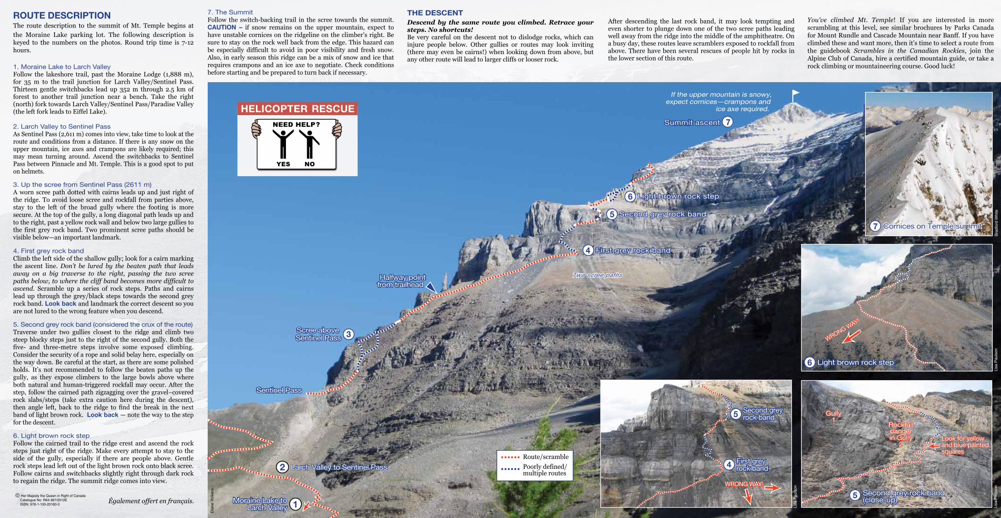
7 Cornices on Temple summitCornices on Temple summit
6 Light brown rock stepLight brown rock step
WRONG WAY!
WRONG WAY!
Lisa
Pau
lson
5 Second grey rock band(close-up)Second grey rock band(close-up)
Gully1
Gully1
Rockfalldangerin Gully
2
Rockfalldangerin Gully
2Look for yellowand blue paintedsquares
Look for yellowand blue paintedsquares
Lisa
Pau
lson
4
5
First grey rock bandFirst grey rock band
Second grey rock bandSecond grey rock band
Brad
ford
Whi
te
Lisa
Pau
lson
WRONG WAY!WRONG WAY!
4
3
2
Scree above Sentinel PassScree above Sentinel Pass
Sentinel PassSentinel Pass
6 Light brown rock stepLight brown rock step
7Summit ascentSummit ascent
Halfway pointfrom trailhead Halfway point
from trailhead
If the upper mountain is snowy,expect cornices—crampons and
ice axe required.
First grey rock band First grey rock band
Two scree pathsTwo scree paths
Larch Valley to Sentinel PassLarch Valley to Sentinel Pass
1Moraine Lake toLarch Valley
Moraine Lake toLarch Valley
ROUTE DESCRIPTIONThe route description to the summit of Mt. Temple begins at the Moraine Lake parking lot. The following description is keyed to the numbers on the photos. Round trip time is 7-12 hours.
1. Moraine Lake to Larch ValleyFollow the lakeshore trail, past the Moraine Lodge (1,888 m), for 35 m to the trail junction for Larch Valley/Sentinel Pass. Thirteen gentle switchbacks lead up 352 m through 2.5 km of forest to another trail junction near a bench. Take the right (north) fork towards Larch Valley/Sentinel Pass/Paradise Valley (the left fork leads to Eiffel Lake).
2. Larch Valley to Sentinel PassAs Sentinel Pass (2,611 m) comes into view, take time to look at the route and conditions from a distance. If there is any snow on the upper mountain, ice axes and crampons are likely required; this may mean turning around. Ascend the switchbacks to Sentinel Pass between Pinnacle and Mt. Temple. This is a good spot to put on helmets.
3. Up the scree from Sentinel Pass (2611 m) A worn scree path dotted with cairns leads up and just right of the ridge. To avoid loose scree and rockfall from parties above, stay to the left of the broad gully where the footing is more secure. At the top of the gully, a long diagonal path leads up and to the right, past a yellow rock wall and below two large gullies to the first grey rock band. Two prominent scree paths should be visible below—an important landmark.
4. First grey rock band Climb the left side of the shallow gully; look for a cairn marking the ascent line. Don’t be lured by the beaten path that leads away on a big traverse to the right, passing the two scree paths below, to where the cliff band becomes more difficult to ascend. Scramble up a series of rock steps. Paths and cairns lead up through the grey/black steps towards the second grey rock band. Look back and landmark the correct descent so you are not lured to the wrong feature when you descend.
5. Second grey rock band (considered the crux of the route)Traverse under two gullies closest to the ridge and climb two steep blocky steps just to the right of the second gully. Both the five- and three-metre steps involve some exposed climbing. Consider the security of a rope and solid belay here, especially on the way down. Be careful at the start, as there are some polished holds. It’s not recommended to follow the beaten paths up the gully, as they expose climbers to the large bowls above where both natural and human-triggered rockfall may occur. After the step, follow the cairned path zigzagging over the gravel–covered rock slabs/steps (take extra caution here during the descent), then angle left, back to the ridge to find the break in the next band of light brown rock. Look back — note the way to the step for the descent.
6. Light brown rock step Follow the cairned trail to the ridge crest and ascend the rock steps just right of the ridge. Make every attempt to stay to the side of the gully, especially if there are people above. Gentle rock steps lead left out of the light brown rock onto black scree. Follow cairns and switchbacks slightly right through dark rock to regain the ridge. The summit ridge comes into view.
7. The Summit Follow the switch-backing trail in the scree towards the summit. CAUTION – if snow remains on the upper mountain, expect to have unstable cornices on the ridgeline on the climber’s right. Be sure to stay on the rock well back from the edge. This hazard can be especially difficult to avoid in poor visibility and fresh snow. Also, in early season this ridge can be a mix of snow and ice that requires crampons and an ice axe to negotiate. Check conditions before starting and be prepared to turn back if necessary.
THE DESCENTDescend by the same route you climbed. Retrace your steps. No shortcuts! Be very careful on the descent not to dislodge rocks, which can injure people below. Other gullies or routes may look inviting (there may even be cairns!) when looking down from above, but any other route will lead to larger cliffs or looser rock.
After descending the last rock band, it may look tempting and even shorter to plunge down one of the two scree paths leading well away from the ridge into the middle of the amphitheatre. On a busy day, these routes leave scramblers exposed to rockfall from above. There have been several rescues of people hit by rocks in the lower section of this route.
You’ve climbed Mt. Temple! If you are interested in more scrambling at this level, see similar brochures by Parks Canada for Mount Rundle and Cascade Mountain near Banff. If you have climbed these and want more, then it’s time to select a route from the guidebook Scrambles in the Canadian Rockies, join the Alpine Club of Canada, hire a certified mountain guide, or take a rock climbing or mountaineering course. Good luck!
Route/scramblePoorly defined/multiple routes
5 Second grey rock bandSecond grey rock bandD
iane
Vol
kers
C Her Majesty the Queen in Right of Canada Catalogue No: R64-367/2012E ISBN: 978-1-100-20160-3
HELICOPTER RESCUE
Également offert en français.