creation of parks: 1882-2014parkweb.vic.gov.au/.../pdf_file/0011/639857/creation-of-parks.pdf ·...
TRANSCRIPT

1
CREATION OF PARKS: 1882-2014

2

i
CREATION OF PARKS
1882–2014
December 2014 Version 1

ii
Authorised and published by Parks Victoria, L10, 535 Bourke Street, Melbourne, VIC, 3000.
Copyright © 2014 Parks Victoria
Every effort has been made to ensure that the information in this plan is accurate. Parks Victoria
does not guarantee that the publication is without flaw of any kind and therefore disclaims all
liability for any error, loss or other consequence that may arise from you relying on any information
in the publication.

iii
CONTENTS
About the creation of parks .................................................................................................................... 1
NATIONAL PARKS - SCHEDULE TWO ................................................................................................... 5
1. Alfred National Park (3050 ha).................................................................................................... 5
2. Alpine National Park (661 777 ha) .............................................................................................. 5
3. Barmah National Park (28 505 ha) .............................................................................................. 7
4. Baw Baw National Park (13 530 ha) ............................................................................................ 7
5. Brisbane Ranges National Park (8885 ha) ................................................................................... 8
6. Burrowa–Pine Mountain National Park (18 400 ha) ................................................................... 9
7. Chiltern–Mt Pilot National Park (21 650 ha) ............................................................................... 9
8. Churchill National Park (271 ha) ............................................................................................... 10
9. Cobboboonee National Park (18 510 ha) .................................................................................. 11
10. Coopracambra National Park (38 800 ha) ................................................................................. 11
11. Croajingolong National Park (88 500 ha) .................................................................................. 12
12. Dandenong Ranges National Park (3540 ha) ............................................................................ 13
13. Errinundra National Park (39 870 ha) ....................................................................................... 14
14. French Island National Park (11 160 ha) ................................................................................... 15
15. Grampians National Park (168 235 ha) ..................................................................................... 16
16. Great Otway National Park (103 875 ha) .................................................................................. 17
17. Greater Bendigo National Park (17 340 ha) .............................................................................. 19
18. Gunbower National Park (9330 ha) .......................................................................................... 20
19. Hattah-Kulkyne National Park (49 975 ha) ............................................................................... 20
20. Heathcote-Graytown National Park (12 700 ha) ...................................................................... 21
21. Kara Kara National Park (13 990 ha) ......................................................................................... 21
22. Kinglake National Park (23 210 ha) ........................................................................................... 22
23. Lake Eildon National Park (27 750 ha) ...................................................................................... 23
24. Lind National Park (1370 ha) ..................................................................................................... 24
25. Little Desert National Park (132 647 ha) ................................................................................... 24
26. Lower Glenelg National Park (26 430 ha) ................................................................................. 25
27. Lower Goulburn National Park (9320 ha) ................................................................................. 26
28. Mitchell River National Park (14 365) ....................................................................................... 26
29. Mornington Peninsula National Park (2680 ha)........................................................................ 27
30. Morwell National Park (565 ha) ................................................................................................ 28
31. Mount Buffalo National Park (31 020 ha) ................................................................................. 29

iv
32. Mount Eccles National Park (8565 ha) ...................................................................................... 30
33. Mount Richmond National Park (1733 ha) ............................................................................... 31
34. Murray–Sunset National Park (664 810 ha) .............................................................................. 31
35. Organ Pipes National Park (153 ha) .......................................................................................... 32
36. Point Nepean National Park (578 ha) ....................................................................................... 32
37. Port Campbell National Park (1 830 ha) .................................................................................... 33
38. Snowy River National Park (114 600 ha) ................................................................................... 34
39. Tarra–Bulga National Park (2015 ha) ........................................................................................ 35
40. Terrick Terrick National Park (6390 ha) .................................................................................... 36
41. The Lakes National Park (2390 ha) ............................................................................................ 37
42. Warby–Ovens National Park (14 750 ha) .................................................................................. 37
43. Wilsons Promontory National Park (49 049 ha) ....................................................................... 38
44. Wyperfeld National Park (359 445ha) ...................................................................................... 39
45. Yarra Ranges National Park (77 185 ha).................................................................................... 40
WILDERNESS PARKS - SCHEDULE TWO A .......................................................................................... 42
1. Avon Wilderness Park (39 650 ha) ............................................................................................ 42
2. Big Desert Wilderness Park (142 300 ha) .................................................................................. 42
3. Wabba Wilderness Park (20 100 ha) ......................................................................................... 43
STATE PARKS - SCHEDULE TWO B ..................................................................................................... 45
4. Arthurs Seat State Park (565 ha) ............................................................................................... 45
5. Black Range State Park (11 700 ha) .......................................................................................... 46
6. Broken-Boosey State Park (1010 ha) ........................................................................................ 46
7. Bunyip State Park (16 655 ha) ................................................................................................... 47
8. Cape Nelson State Park (210 ha) ............................................................................................... 47
9. Cathedral Range State Park (3616 ha) ...................................................................................... 48
10. Dergholm State Park (10 400 ha) .............................................................................................. 48
11. Enfield State Park (4400 ha) ...................................................................................................... 48
12. Holey Plains State Park (10 740 ha) .......................................................................................... 49
13. Kooyoora State Park (11 350 ha) .............................................................................................. 50
14. Lake Tyers State Park (8 680 ha) ............................................................................................... 51
15. Langi Ghiran State Park (3040 ha)* ........................................................................................... 51
16. Leaghur State Park (2050 ha) .................................................................................................... 52
17. Lerderderg State Park (20 185 ha) ............................................................................................ 52
18. Moondarra State Park (6330 ha) .............................................................................................. 53

v
19. Mount Arapiles-Tooan State Park (7470 ha) ............................................................................ 53
20. Mount Buangor State Park (2400 ha) ....................................................................................... 54
21. Mount Granya State Park (6140 ha) ......................................................................................... 54
22. Mount Lawson State Park (13 150 ha) ...................................................................................... 55
23. Mount Napier State Park (2800 ha) .......................................................................................... 55
24. Mount Samaria State Park (7600 ha) ........................................................................................ 55
25. Mount Worth State Park (1040 ha) .......................................................................................... 56
26. Paddys Ranges State Park (2010 ha) ......................................................................................... 56
27. Reef Hills State Park (2020 ha) .................................................................................................. 57
28. Warrandyte State Park (686 ha) ............................................................................................... 58
29. Werribee Gorge State Park (575 ha) ......................................................................................... 59
OTHER PARKS - SCHEDULE THREE..................................................................................................... 61
1. Bay of Islands Coastal Park (950 ha) ......................................................................................... 61
2. Beechworth Historic Park (1090 ha) ......................................................................................... 61
3. Cape Conran Coastal Park (11 700 ha) ...................................................................................... 62
4. Cape Liptrap Coastal Park (4315)* ............................................................................................ 62
5. Discovery Bay Coastal Park (10 460) ......................................................................................... 63
6. Gadsen Bend Park (1620 ha) ..................................................................................................... 63
7. Gippsland Lakes Coastal Park (17 805)* ................................................................................... 64
8. Haining Farm (66 ha) ................................................................................................................. 64
9. Kings Billabong Park (2195 ha) .................................................................................................. 65
10. Lake Albacutya Park (8300 ha) .................................................................................................. 65
11. Langwarrin Flora and Fauna Reserve (214 ha) .......................................................................... 66
12. Lysterfield Park (1397 ha) ......................................................................................................... 67
13. Murray-Kulkyne Park (4555 ha) ................................................................................................ 68
14. Nyah-Vinifera Park (1370 ha) .................................................................................................... 68
15. Steiglitz Historic Park (425 ha)* ................................................................................................ 69
16. Tara Range Park (7620 ha) ........................................................................................................ 70
17. Tyers Park (1810 ha) ................................................................................................................. 70
18. Woodlands Historic Park (820 ha) ............................................................................................ 70
OTHER PARKS AND RESERVES - SCHEDULE FOUR ............................................................................. 73
1. Bunurong Marine Park (1660 ha) .............................................................................................. 73
2. Castlemaine Diggings National Heritage Park (7585 ha) .......................................................... 74
3. Corner Inlet Marine and Coastal Park (18 000 ha).................................................................... 75

vi
4. Deep Lead Nature Conservation Reserve No.1 (1120 ha) ........................................................ 75
5. Nooramunga Marine and Coastal Park (15 000ha) .................................................................. 76
6. Shallow Inlet Marine and Coastal Park (2000 ha) ..................................................................... 76
7. Wilsons Promontory Marine Park (7000 ha) ............................................................................ 77
8. Wilsons Promontory Marine Reserve (3000 ha) ....................................................................... 77
MARINE NATIONAL PARKS – SCHEDULE SEVEN................................................................................ 79
1. Bunurong Marine National Park (2100 ha) ............................................................................... 79
2. Cape Howe Marine National Park (4050 ha) ............................................................................ 79
3. Churchill Island Marine National Park (670 ha) ........................................................................ 80
4. Corner Inlet Marine National Park (1550 ha)............................................................................ 80
5. Discovery Bay Marine National Park (2770 ha) ........................................................................ 81
6. French Island Marine National Park (2800 ha) ......................................................................... 81
7. Ninety Mile Beach Marine National Park (2750 ha) ................................................................. 82
8. Point Addis Marine National Park (4600 ha) ............................................................................ 82
9. Point Hicks Marine National Park (4000 ha) ............................................................................. 83
10. Port Phillip Heads Marine National Park (3580 ha) .................................................................. 83
11. Twelve Apostles Marine National Park (7500 ha) ..................................................................... 84
12. Wilsons Promontory Marine National Park (15 550 ha) ........................................................... 84
13. Yaringa Marine National Park (980 ha) ..................................................................................... 85
MARINE SANCTUARIES - SCHEDULE EIGHT ....................................................................................... 87
1. Barwon Bluff Marine Sanctuary (17 ha) .................................................................................... 87
2. Beware Reef Marine Sanctuary (220 ha) .................................................................................. 87
3. Eagle Rock Marine Sanctuary (17 ha) ....................................................................................... 88
4. Jawbone Marine Sanctuary (30 ha) .......................................................................................... 88
5. Marengo Reefs Marine Sanctuary (12 ha) ................................................................................ 89
6. Merri Marine Sanctuary (25 ha) ................................................................................................ 89
7. Mushroom Reef Marine Sanctuary (80 ha) .............................................................................. 90
8. Point Cook Marine Sanctuary (290 ha) ..................................................................................... 90
9. Point Danger Marine Sanctuary (25 ha).................................................................................... 91
10. Ricketts Point Marine Sanctuary (115 ha) ................................................................................ 91
11. The Arches Marine Sanctuary (45 ha) ....................................................................................... 92
Appendix 1 Guide to current and former names of parks ................................................................ 93

1
About the creation of parks Parks are reserved under Victorian State Government legislation. Many parks have previously been
reserved under legislation, such as the Forests Act 1958 or the Crown Land (Reserves) Act 1978,
before being reserved under the National Parks Act.
The first national parks, such as Mount Buffalo and Wilsons Promontory, were reserved under the
Land Act; initially the Land Act 1890. In 1956 the State Government enacted the National Parks Act
1956 creating a National Parks Authority and thirteen parks to be reserved and managed in
accordance with the Act. This legislation has been remade and amended over time to create new
parks and provide for changes in park management and park management authorities.
Parks are now reserved under the National Parks Act 1975 (Vic). The Act includes a number of
schedules for various classes of parks.
• National Parks
• Wilderness Parks
• State Parks
• Other Parks
• Other Parks and Reserves
• Marine National Parks
• Marine Sanctuaries
As at 30 June 2014 there were 139 areas with a total area of more than 3.45 million ha managed
under various provisions of the National Parks Act.
Number at 30 June 2014 Area (ha) at 30 June 2014
National Parks (Schedule Two) 45 2 904 727
Wilderness Parks (Schedule Two A) 3 202 050
State Parks (Schedule Two B) 26 156 787
Other Parks (Schedule Three) 18 76 712
Other Parks and Reserves (Schedule Four) 8 55 365
Marine National Parks (Schedule Seven) 13 52 900
Marine Sanctuaries (Schedule Eight) 11 876
Other areas (non-scheduled) 15 4 442
Total 139 3 453 859
The number and size of parks in Victoria reserved under the National Parks Act 1975 (Vic.) have
increased significantly over the years: from 26 national parks totalling over 226 000 ha in 1975.
A key factor in the overall increase in the size of the parks estate is the incremental expansion of
individual parks over time including the amalgamation of some parks, for example Bogong National
Park into Alpine National Park. Appendix 1 lists the current and former names of parks.

2
When first created many parks were much smaller than what they are today, particularly some of
the first parks established in Victoria. For example Dandenong Ranges National Park was 176 ha
when first created and has been significantly expanded several times, most notably in the 1960s and
1990s. While only a small part of the park has been reserved for over 120 years, most of the park is
over 50 years old (see diagram opposite).
This history documents the establishment and expansion of the individual parks over time. It details
the size of each park when established and every addition or excision since, including the year and
the name of relevant legislation. The parks are listed alphabetically for each group of parks reserved
under the National Parks Act 1975 (Vic.).
The current legislation under which parks are reserved and managed is the National Parks Act 1975.
This legislation is referred to as the Principal Act and is changed by Amending Legislation to create
new areas of parks, reflect changes in management, such as Native Title, or to remove (repeal)
sections of the Principal Act no longer required. The legislation relevant to each park is noted in the
tables. All legislation can be viewed online at http://www.legislation.vic.gov.au/
A number of parks are the result of recommendations to Government arising from detailed
investigations into public land management. The agencies responsible for these investigations noted
in this report are:
• Land Conservation Council (LCC) 1971 – 1997
• Environment Conservation Council (ECC) 1997 – 2001
• Victorian Environmental Assessment Council (VEAC) 2001 onwards
This history of the reservation of each of Victoria’s parks currently reserved under the National Parks
Act was compiled from three main sources: park management plans, Annual Reports on the National
Parks Act and the Parks and Reserves Information System. Every effort has been made to verify the
information presented using the details of legislation and two publications on the development of
the parks and reserves system in Victoria:
• Jane Calder, 1990 Victoria’s National and State Parks, Victoria National Parks Association,
Melbourne.
• Esther Anderson, 2000, Victoria’s National Parks: A Centenary History, State Library of
Victoria and Parks Victoria, Melbourne.
The information was compiled by Andrea Noriega, who generously volunteered her time for the
project, Wendy Luke, Linda Greenwood and Ian Foletta.
Note that the legislated area for many parks will vary from the total of key changes listed in the
tables due to variations in mapping accuracy.

3

4
NATIONAL PARKS
Schedule Two

5
NATIONAL PARKS - SCHEDULE TWO
1. Alfred National Park (3050 ha)
Year Details Act Addition (ha) Total area
(ha)
1912 established Lands Act 1912 2188 2188
1956 move to National Parks Act 1956 National Parks Act 1956 - 2188
1971 addition National Parks
(Amendment) Act 1971 111 2299
1975 addition and
move to current act National Parks Act 1975 1 2300
1988 addition National Parks
(Amendment) Act 1988 750 3050
Alfred National Park was first reserved as a National Park on 23 December 1925 following
representations from the Field Naturalists Club of Victoria. The Park was named after the Minister
for Lands and Water Supply, Alfred Downard.
Following recommendations in the Land Conservation Council’s East Gippsland Area Review (LCC
1986), Alfred National Park was expanded to 3050 ha in 1988.
2. Alpine National Park (661 777 ha)*
Year Details Act Addition (ha) Total area
(ha)
1978
Tingaringy National Park established National Parks
(Amendment) Act 1978
18 000 18 000
Wabonga Plateau State Park
established 17 600 35 600
1981
Bogong National Park established
National Parks
(Amendment) Act 1981
76 700 112 300
addition to Wabonga Plateau State
Park (southern area) 3600 115 900
Wonnangatta–Moroka National Park
established 107 000 222 900
addition to Bogong National Park
(Kiewa Crown Grant part) 4300 227 200
1984 addition to Bogong National Park (Mt
Higginbotham)
National Parks
(Amendment) Act 1984 200 227 400
1986 Cobberas–Tingaringy National Park
established
National Parks
(Amendment) Act 1986 89 000 316 400
1988
addition to Cobberas–Tingaringy
National Park (east of Snowy River) National Parks
(Amendment) Act 1988
9600 326 000
addition to Cobberas–Tingaringy
National Park (mineral licences) 38 000 364 000
1989
Alpine National Park established
National Parks (Alpine
National Park) Act 1989
262 251 626 151
addition of Brown Creek headwaters
post logging 980 627 231
addition of Wonnangatta Station and 449 627 680

6
Year Details Act Addition (ha) Total area
(ha)
Guys Paddock)
addition of Dartmouth and Conners
Creek areas post logging 8900 363 580
addition of Barry Mountains link post
logging 5500 642 080
addition of Stony/Turnback Creeks
post logging 1900 643 980
Addition of East Kiewa area post
logging 1800 645 780
1995 addition of Roaring Camp, McKillop
Bridge and road reserves
National Parks (Yarra
Ranges and Other
Amendments) Act 1995
120 645 900
1997 addition of the remainder of Kiewa
Crown Grant
Electricity Industry
(Miscellaneous
Amendment) Act 1997
1800 647 700
1997 excision (Mt McKay/Rocky Valley area) Alpine Resorts
(Management) Act 1997 –285 647 415
2000
addition of Wongungarra wilderness) National Parks
(Amendment) Act 2000
12 850 660 265
addition of Mt McKay/Rocky Valley
area 285 660 550
2009 Addition (Mount Typo)
Parks and Crown Land
Legislation amendment
(East Gippsland) Act
2009
825 661 375
2013
addition of an area of snow gum
woodland on northern slopes of Mt
McKay.
Alpine Resorts and
National Parks Acts
Amendment Act 2013
12 661 387
excision of an area on the northern
foreshore of Rocky Valley Dam near
the damwall (9.6 ha) and an area at
Sun Valley comprising part of Falls
Creek’s snow-grooming facilities (0.4
ha)
–10 661 377
* The legislated area varies from the total of key changes due to refinements in mapping.
The significance of the natural environments of the Victorian Alps has long been recognised. The
concept of a Victorian Alpine National Park was first put forward in 1949 when the then Town and
Country Planning Association proposed a park of over 500 000 ha in the State's north eastern
highlands.
Twenty years later, the Association’s successor, the Victorian National Parks Association (VNPA),
made a detailed submission to the State Government for an Alpine National Park. In 1974, the VNPA
published a case for a park extending from Mount Baw Baw to the New South Wales border, in its
book ‘The Alps at the Crossroads’. In 1979, the Land Conservation Council recommended the
creation of a series of national parks and other reserves in the alpine area. Bogong, Wonnangatta–
Moroka and Tingaringy National Parks, and Wabonga Plateau State Park were established as a result.
Following the LCC Alpine Area Special Investigation (LCC 1983), the LCC further recommended that
these parks be extended and linked to form a single, large contiguous Alpine National Park.
Legislation for Alpine National Park was passed in the Victorian Parliament in May 1989 and the park
was proclaimed on 2 December 1989.

7
Since the park was proclaimed, several areas have been added, including the Wongungarra
Wilderness (12 850 ha). An area at Mount Typo (825 ha) was added to the park on 20 August 2010,
bringing the total area of the park to 661 375 ha.
On 1 August 2013 two areas totalling 10 ha were excised from the park and added to Falls Creek
Alpine Resort. This was accompanied by the addition to the park of 12 ha excised from the resort.
The Australian Alps National Parks and Reserves including Alpine National Park were included on the
National Heritage List on 7 November 2008, in recognition for their remarkable landforms, cold
climate flora and fauna, pioneering history and popular recreation areas.
3. Barmah National Park (28 505 ha)
Year Details Act Addition (ha) Total area
(ha)
1987 Barmah State Park established National Parks
(Amendment) Act 1987 7900 7900
2010
Barmah National Park established with
addition of part of Barmah State
Forest
Parks and Crown
Legislation Amendments
(River Red Gums) Act
2009
20 605 28 505
In 1985 the Land Conservation Council recommended in its Murray Valley Area investigation, the
creation of Barmah State Park and in November 1987 the park (7900 ha) was proclaimed. Located on
the Murray River between Echuca and Tocumwal, Barmah State Park was established to protect the
internationally significant Barmah wetlands, including one of the most important waterfowl habitats
in the Murray system, part of Australia’s most extensive River Red Gum forest and two reference
areas.
In 2010 as part of the Government’s response to the Victorian Environmental Assessment Council’s
(VEAC) River Red Gum Forest Investigation, Barmah State Park and a portion of Barmah State Forest
(21 320 ha) were reserved as Barmah National Park (28 505 ha).
4. Baw Baw National Park (13 530 ha)
Year Details Act Addition (ha) Total area
(ha)
1978 Park established National Parks
(Amendment) Act 1978 13 300 13 300
1997 Addition National Parks
(Amendment) Act 1997 230 13 530
Baw Baw National Park (13 300 ha) was established in 1978 under Schedule Two of the National
Parks Act as as a result of the Government’s implementation of the Land Conservation Councils (LCC)
1977 Melbourne Study Area Final Recommendations.
There were some changes to the boundaries of the park on 4 June 1997 bringing the area of the park
to 13 530 ha. The boundary changes accorded with the LCC 1994 Melbourne Study Area District 2

8
Review Final Recommendations accepted by Government and included additions as well as several
small excisions to rationalise the boundary.
The Australian Alps National Parks and Reserves including Baw Baw National Park were included on
the National Heritage List on 7 November 2008, in recognition for their remarkable landforms, cold
climate flora and fauna, pioneering history and popular recreation areas.
5. Brisbane Ranges National Park (8885 ha)*
Year Details Act Addition (ha) Total area
(ha)
1975 established National Parks Act 1975 1132 1132
1978 addition National Parks
(Amendment) Act 1978
50 1182
addition 6288 7470
1981 addition National Parks
(Amendment) Act 1981 15 7485
1984 addition National Parks
(Amendment) Act 1984 32 7517
1995 addition (land from Steiglitz)
National Parks (Yarra
Ranges and Other
Amendment) Act 1995
201 7718
2009 addition (Lower Stony Creek area and
several Government roads)
Parks and Crown Land
Legislation Amendment
(East Gippsland) Act
2009
1200 8918
2013 addition of forest and woodland west
of Balliang
Parks and Crown Land
Legislation Amendment
Act 2013
22 8940
* The legislated area varies from the total of key changes due to refinements in mapping.
The idea of Brisbane Ranges National Park was first proposed at a meeting in September 1918 by the
Field Naturalist Club of Victoria; however, negotiation with the public agencies was needed before
this could occur.
Brisbane Ranges National Park (1132 ha) was first included under Schedule 2 of the National Parks
Act 1975 (Vic.) on 15 August 1975. As a result of the Land Conservation Council recommendations
for the Melbourne Study Area (LCC 1977), the park was increased to 7470 ha on 26 April 1979.
On 20 June 1995 the park was increased to 7718 ha as a result of the LCC recommendations (LCC
1987) to incorporate part of the adjacent Steiglitz Historic Park into the National Park. As a result of
the Parks and Crown Land Legislation Amendment in 2009, Brisbane Ranges National Park was
increased to its current size (8865 ha), including areas formerly managed or owned by Barwon Water
such as the Lower Stony Creek Reservoir and its catchment and adjacent allotments containing
significant natural and heritage values, and several Government roads.
On 18 December 2013 a small area of forest and woodland west of Balliang was added to the park
including endangered Creekline Herbrich Woodland and threatened fauna.
9
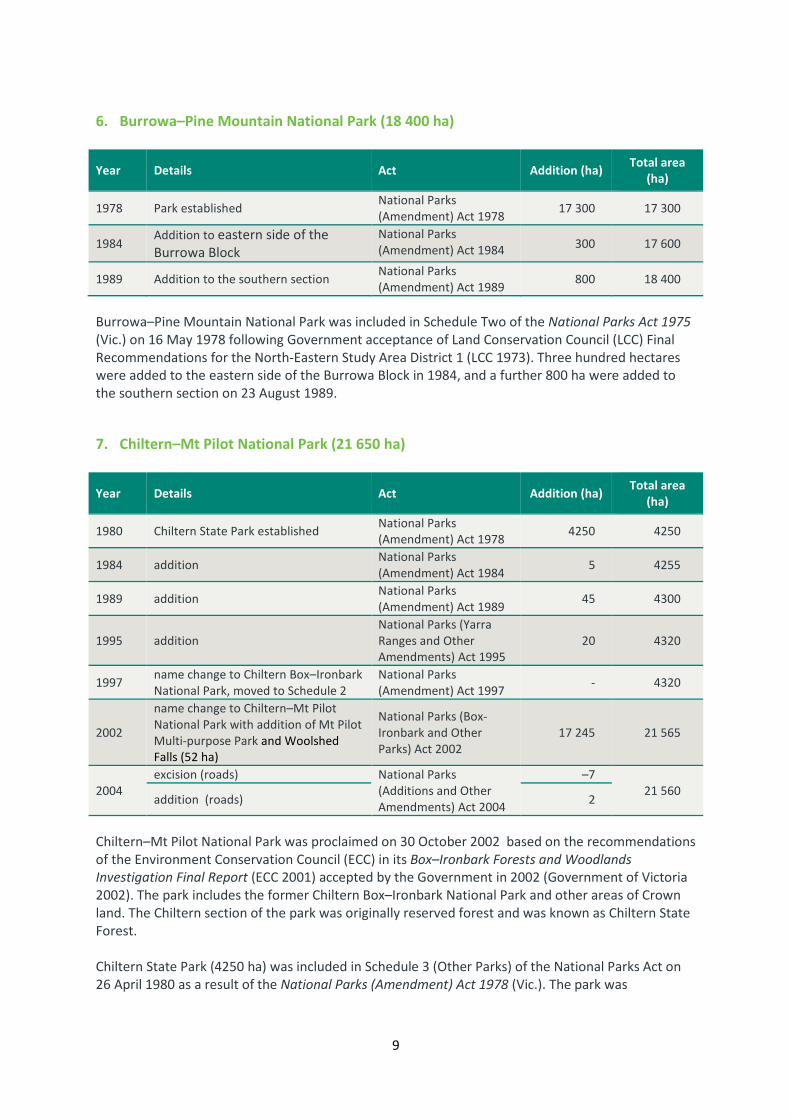
6. Burrowa–Pine Mountain National Park (18 400 ha)
Year Details Act Addition (ha) Total area
(ha)
1978 Park established National Parks
(Amendment) Act 1978 17 300 17 300
1984 Addition to eastern side of the
Burrowa Block
National Parks
(Amendment) Act 1984 300 17 600
1989 Addition to the southern section National Parks
(Amendment) Act 1989 800 18 400
Burrowa–Pine Mountain National Park was included in Schedule Two of the National Parks Act 1975
(Vic.) on 16 May 1978 following Government acceptance of Land Conservation Council (LCC) Final
Recommendations for the North-Eastern Study Area District 1 (LCC 1973). Three hundred hectares
were added to the eastern side of the Burrowa Block in 1984, and a further 800 ha were added to
the southern section on 23 August 1989.
7. Chiltern–Mt Pilot National Park (21 650 ha)
Year Details Act Addition (ha) Total area
(ha)
1980 Chiltern State Park established National Parks
(Amendment) Act 1978 4250 4250
1984 addition National Parks
(Amendment) Act 1984 5 4255
1989 addition National Parks
(Amendment) Act 1989 45 4300
1995 addition
National Parks (Yarra
Ranges and Other
Amendments) Act 1995
20 4320
1997 name change to Chiltern Box–Ironbark
National Park, moved to Schedule 2
National Parks
(Amendment) Act 1997 - 4320
2002
name change to Chiltern–Mt Pilot
National Park with addition of Mt Pilot
Multi-purpose Park and Woolshed
Falls (52 ha)
National Parks (Box-
Ironbark and Other
Parks) Act 2002
17 245 21 565
2004
excision (roads) National Parks
(Additions and Other
Amendments) Act 2004
–7
21 560 addition (roads) 2
Chiltern–Mt Pilot National Park was proclaimed on 30 October 2002 based on the recommendations
of the Environment Conservation Council (ECC) in its Box–Ironbark Forests and Woodlands
Investigation Final Report (ECC 2001) accepted by the Government in 2002 (Government of Victoria
2002). The park includes the former Chiltern Box–Ironbark National Park and other areas of Crown
land. The Chiltern section of the park was originally reserved forest and was known as Chiltern State
Forest.
Chiltern State Park (4250 ha) was included in Schedule 3 (Other Parks) of the National Parks Act on
26 April 1980 as a result of the National Parks (Amendment) Act 1978 (Vic.). The park was

10
established as a result of the Government’s acceptance of recommendations by the Land
Conservation Council.
Several other areas were later added to Chiltern State Park: 5 ha by the National Parks (Amendment)
Act 1984 (Vic.), 45 ha by the National Parks (Amendment) Act 1989 (Vic.) and 20 ha by the National
Parks (Yarra Ranges and Other Amendments) Act 1995 (Vic.). Minor boundary changes in relation to
the Hume Freeway bypass of Chiltern occurred in 1987, bringing the total area of the park to 4320
ha.
In 1997 Chiltern State Park became Chiltern Box–Ironbark National Park (4320 ha), which was
included in Schedule 2 of the National Parks Act on 4 June 1997 as a result of the National Parks
(Amendment) Act 1997 (Vic.).
The Pilot Range section of Chiltern–Mt Pilot National Park was reserved forest under the Forests Act
1958 (Vic.) until the creation of the Mt Pilot Multi-Purpose Park in 1978 under Section 4 of the
Crown Land (Reserves) Act 1978 (Vic.) following the Government’s acceptance of the final
recommendations of the 1977 Land Conservation Council’s study for the North East Study Area
Districts 3, 4 and 5.
Although the Barambogie Area was originally set aside as reserved forest, the LCC recommended
that it become uncommitted land (LCC 1977). This area then became Barambogie State Forest
following the LCC review of the North-eastern area in 1986. The Barambogie Education Area was
also set aside at this time.
Woolshed Falls (52 ha) was added to Chiltern–Mt Pilot National Park in 2002. This area was formerly
part of Beechworth Historic Park, which was first included on Schedule 3 (Other Parks) of the
National Parks Act 1975 (Vic.) on 26 April 1980 following LCC recommendations.
8. Churchill National Park (271 ha)
Year Details Act Addition (ha) Total area
(ha)
1941 Park gazetted as Dandenong National
Park 193 193
1944 Name changed to Churchill National
Park – 193
1956 Established National Parks Act 1956 – 193
1995 Additions to park
National Parks (Yarra
Ranges and Other
Amendments) Act 1995
78 271
Churchill National Park (originally 193 ha and referred to as Dandenong National Park) was created
in 1939 as a result of pressure from conservationist organisations, supported by representatives of
adjoining shires which pressed the Minister of Land to preserve the park as a sanctuary for fauna
and flora. It was gazetted on 12 February 1941. In 1944 Sir Winston Churchill was honoured in the
renaming of the park. Churchill National Park was included on Schedule Two of the National Parks
Act 1975 (Vic.) in 1975.
As a result of the National Parks (Yarra Ranges and Other Amendments) Act 1995 (Vic.) additions
were made to Churchill National Park (Churchill extension 78 ha).

11
This park is a component of a broader strategy to establish a public land corridor linking the
Dandenong Ranges to the metropolitan parks in the Dandenong Creek Valley. The strategy
commenced in 1971 with placement of a proposed public open space reservation on private land
between the two Parks. Linking was achieved progressively by acquisitions in the Parish of Narre
Warren. In 1990 the State Government acquired part of Crown Allotment 70A and part Monbulk
Preemptive Right (ZA Nominees land) abutting the north-east boundary of Lysterfield Park, and part
of Crown Allotments 71, 72 and 73 (Kings land) abutting the eastern boundary of Churchill National
Park. The acquisition of part of Crown Allotments 59, 60 and 71 (Van Beers land) in 1993 completed
the public land link between the Dandenong Valley and Birds Land.
9. Cobboboonee National Park (18 510 ha)
Year Details Act Addition (ha) Total area
(ha)
2008 Park established
National Parks and
Crown Land (Reserves)
Amendment Act 2008
18 510 18 510
Cobboboonee National Park (18 510 ha) was created on 9 November 2008. The park is located in the
Cobboboonee forest north-west of Portland and abuts Lower Glenelg National Park and
Cobboboonee Forest Park.
The national park includes most of the Surry River corridor as well as the headwaters of the Fitzroy
River. It protects significant areas of lowland forest, many wetlands, endangered and vulnerable
vegetation types as well as threatened species, including large forest owls, small marsupials and a
species of skink.
10. Coopracambra National Park (38 800 ha)
Year Details Act Addition (ha) Total area
(ha)
1979 Established as Coopracambra State
Park
National Parks
(Amendments) Act 1978 14 500 14 500
1988 Addition and reserved as a national
park
National Parks
(Amendments) Act 1988 20 600 35 100
1991 Addiition
National Parks
(Miscellaneous
Amendments) Act 1991
3700 38 800
Coopracambra State Park (14 500 ha) was first included on Schedule Three of the National Parks Act
on 26 April 1979, following Land Conservation Council (LCC) 1977 recommendations for the East
Gippsland Study Area LCC (1977). In 1988, following the East Gippsland Area Review (LCC 1986), this
was enlarged to form Coopracambra National Park (35 100 ha) and included in Schedule Two of the
National Parks Act. The Park was expanded to 38 800 ha in 1991 following Government decisions on
East Gippsland National Estate issues.
North of the border in NSW, a similar process of consolidation of park reserves has proceeded. The
original Nalbaugh and Nungatta National Parks were joined to form Genoa National Park, which was
12
subsequently incorporated into South East Forests National Park. Genoa Wilderness Area (NSW) was
gazetted within that reservation in 1993.
The combined Victoria–NSW reservations now extend from north of Cann River to south of Bombala,
a distance of about 50 km.
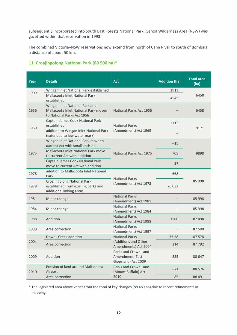
11. Croajingolong National Park (88 500 ha)*
Year Details Act Addition (ha) Total area
(ha)
1909
Wingan Inlet National Park established 1913
6458 Mallacoota Inlet National Park
established 4545
1956
Wingan Inlet National Park and
Mallacoota Inlet National Park moved
to National Parks Act 1956
National Parks Act 1956 – 6458
1969
Captain James Cook National Park
established National Parks
(Amendment) Act 1969
2713
9171 addition to Wingan Inlet National Park
(extended to low water mark) –
1975
Wingan Inlet National Park move to
current Act with small excision
National Parks Act 1975
–15
9898 Mallacoota Inlet National Park move
to current Act with addition 705
Captain James Cook National Park
move to current Act with addition 37
1978 addition to Mallacoota Inlet National
Park National Parks
(Amendment) Act 1978
668
85 998
1979
Croajingolong National Park
established from existing parks and
additional linking areas
76 032
1981 Minor change National Parks
(Amendment) Act 1981 – 85 998
1984 Minor change National Parks
(Amendment) Act 1984 – 85 998
1988 Addition National Parks
(Amendment) Act 1988 1500 87 498
1998 Area correction National Parks
(Amendment) Act 1997 – 87 500
2004
Dowell Creek addition National Parks
(Additions and Other
Amendments) Act 2004
75.58 87 578
Area correction 214 87 792
2009 Addition
Parks and Crown Land
Amendment (East
Gippsland) Act 2009
855 88 647
2010
Excision of land around Mallacoota
Airport
Parks and Crown Land
(Mount Buffalo) Act
2010
–71 88 576
Area correction –85 88 491
* The legislated area above varies from the total of key changes (88 489 ha) due to recent refinements in
mapping

13
Croajingolong National Park was included on Schedule Two of the National Parks Act as a result of
the National Parks (Amendment) Act 1978 (Vic.) and proclaimed on 26 April 1979.
The park was created in 1979 following Government decisions on recommendations from Land
Conservation Council (LCC) studies in the East Gippsland Area in 1977 which recommended a major
coastal national park combining the then Mallacoota Inlet, Wingan Inlet and Captain James Cook
National Parks, and extensive interlinking areas, covering 86 000 ha. The former Wingan Inlet
National Park and Mallacoota Inlet National Park were established 1909. Captain James Gook
National Park was established in 1969
Small amendments were made in 1981 and 1984, and 1500 ha were added to the park in 1988,
following Government decisions on recommendations from Land Conservation Council (LCC) studies
in the East Gippsland Area in 1986, bringing the park to an area of 87 500 ha.
12. Dandenong Ranges National Park (3540 ha)
Year Details Act Addition (ha) Total area
(ha)
1882
Area reserved at One Tree Hill and
Upper Fern Tree Gully as a site for
public recreation
1927 Fern Tree Gully National Park
proclaimed
1956 Fern Tree Gully National Park moved
to National Parks Act 1956 National Parks Act 1956 375
1969 Addition National Parks
(Amendment) Act 1969 2 377
1971 Addition National Parks
(Amendment) Act 1971 24 401
1975 addition and move to current act National Parks Act 1975 49 450
1978 Addition National Parks
(Amendment) Act 1978 9 459
1981 Addition National Parks
(Amendment) Act 1981 7 466
1984 Addition National Parks
(Amendment) Act 1984 3 469
1986 Addition National Parks
(Amendment) Act 1986 21 490
1987 Dandenong Ranges National Park
established
National Parks
(Dandenong Ranges) Act
1987
1430 1920
1997 addition National Parks
(Amendment) Act 1997 1295 3215
2005
area correction National Parks (Otways
and Other Amendments)
Act 2005
3 3218
additions (Melbourne Water land) 132 3350
addition (land purchases) 189 3539
2013 addition area near Mt Evelyn and
correction
Parks and Crown Land
Legislation Amendment
Act 2013
0.12 3540
In the late 1800s, one of Eugene von Guérard’s most celebrated paintings, Ferntree Gully in the
Dandenong Ranges 1857, was displayed in a Collins Street music shop window. According to Ruth
Pullin, the National Gallery of Victoria’s Guest Curator of Eugene von Guérard: Nature Revealed

14
(pers. comm. 2011), the painting encouraged excursions by Melbourne townsfolk to visit the tranquil
and majestic place of the then Dobson’s Gully, soon renamed to the present Ferntree Gully.
Significantly, the location became Victoria’s first officially proclaimed protected area in 1882, when
168 ha at Upper Ferntree Gully and One Tree Hill were reserved as a site for public recreation. In
1927 an area of 227 ha was added to the original 168 ha to create Fern Tree Gully National Park,
proclaimed in 1928.
The State Government purchased additional land in the Dandenong Ranges through an extensive
land acquisition program, including the historic Doongalla Estate, which was purchased in 1950. The
former Forests Commission purchased additional land on behalf of the former National Parks
Service, increasing the size of Fern Tree Gully National Park.
The Land Conservation Council (LCC) in its Final Recommendations for the Melbourne Study Area
(LCC 1977) recommended that Fern Tree Gully National Park, Sherbrooke Forest and Doongalla
Estate, together with various other public lands, be amalgamated to form Dandenong Regional Park.
Following considerable community interest in the area, the State Government decided to establish
Dandenong Ranges National Park. It was created on 13 December 1987 when it was included on
Schedule Two of the National Parks Act 1975 (Vic.) as a result of the National Parks (Dandenong
Ranges) Act 1987 (Vic.). The park incorporated the core areas of, Fern Tree Gully National Park,
Sherbrooke Forest and Doongalla Estate, as well as other public land.
In accordance with LCC 1994 recommendations, various areas of land have been added to the park.
The Mount Evelyn and Montrose Forests, Olinda State Forest, Burnham Beeches Estate, the
‘Mountain Ash Paddock’ and the associated ‘Tan Track’, the northern part (6 ha) of the former ‘40-
acre Nicholas Paddock’ (purchased by the Crown in 1976), and smaller parcels of public land,
including land forming the Sassafras and Upwey corridors, public land water-frontage reserves along
two tributaries of Olinda Creek, the Mechanics and Singleton Reserves and Mount Dandenong
Arboretum, were added to the park as a result of the National Parks (Amendment) Act 1997 (Vic.),
increasing the area of the park from 1920 ha to 3215 ha. Further substantial additions — surplus
Melbourne Water land (‘Silvan No. 2 land’) and ‘Kalorama Park’, and a number of minor boundary
refinements — were made to the park as a result of the National Parks (Otways and Other
Amendments) Act 2005 (Vic.), increasing the area of the park from 3215 ha to 3540 ha. On 18
December 2013 a small area adjoining existing park near Mt Evelyn was added to the park.
13. Errinundra National Park (39 870 ha)*
Year Details Act Addition (ha) Total area
(ha)
1988 Established National Parks
(Amendment) Act 1988 25 100 25 100
1991 addition (area in Goolengook
catchment)
National Parks
(Miscellaneous
Amendments) Act 1991
500 25 600
1998 addition (Ellery Creek catchment) National Parks
(Amendment) Act 1998 1275 26 875
2009 addition (State forest and Goolengook
Flora and Fauna Reserve)
Parks and Crown Land
Legislation Amendment
(East Gippsland) Act
2009
12 340 39 215
* The legislated area above varies from the total of key changes (39 215 ha) due to refinements in mapping

15
Errinundra National Park was included on Schedule Two of the National Parks Act 1975 (Vic.) on 15
July 1988. The park was established following Government decisions on the LCC’s detailed review of
public land use in East Gippsland in 1986. Three other areas were also included: Coast Range South,
the upper Brodribb River (north branch) and the Bonang River (south branch). A further area, in the
Goolengook catchment, was added to the park in 1991. The Ellery Creek Catchment (1275 ha) was
added to the park in 1999 and a large area (12 340 ha) linking the park to Snowy River National Park
was added on 20 August 2010.
14. French Island National Park (11 160 ha)
Year Details Act Addition (ha) Total area
(ha)
1984 French Island State Park established
under National Parks Act 1975
National Parks
(Amendment) Act 1984 8300 8300
1997
French Island National Park
established from French Island State
Park and additional land National Parks
(Amendment) Act 1997
2364 10 664
addition (State Electricity Commission
land at Red Bluff) 261 10 925
1999 addition (Heifer Swamp - part of 60A) 175 11 100
2004
area correction National Parks
(Additions and Other
Amendments) Act 2004
–94 11 006
addition (Tankerton Rd purchase) 2.4 11 009
addition (Forbes Land purchase) 75 11084
addition (Duchers Swamp purchase) 77 11 160
2006
area correction National Parks and
Crown Land (Reserves)
Acts (Amendment) Act
2006
–138 11 012
addition (purchase of Coast Rd) 0.9 11 013
addition (Churcher purchase) 27 11 040
2012 Correction to area
Parks and Crown Land
Legislation Amendment
Act 2012
11 160
Since the first European settlement, about a third of the Island has been alienated from the Crown,
primarily for agricultural and other uses. In 1971, the then Fisheries and Wildlife Division
recommended a French Island Wildlife Reserve in an internal report (Seebeck 1971) which provided
a basis for a submission to the then Land Conservation Council (LCC) in 1974 .
The LCC in its 1977 Final Recommendations for the Melbourne Study Area recommended that an
area of about 8000 ha be reserved as French Island State Park and that it be managed by the then
Fisheries and Wildlife Division. The park was permanently reserved under the Crown Land (Reserves)
Act 1978 (Vic.) in June 1982.
Subsequently, on 28 June 1988, the State Park of 8300 ha was included on Schedule Three (Other
Parks) of the National Parks Act as a result of the National Parks (Amendment) Act 1984 (Vic.), and
transferred to the Schedule Two B (State Parks) in 1989.
Following a review by the former LCC (completed in July 1994) and acceptance of its
recommendations by Government, the National Parks (Amendment) Act 1997 (Vic.) provided for the
reservation of French Island National Park, under Schedule Two (National Parks) of the National
Parks Act. The enlarged French Island National Park (10 664 ha) was proclaimed on 4 June 1997 and

16
the SEC land at Red Bluff (261 ha) included in the park on 15 July 1997. Land in the vicinity of Heifer
Swamp (175 ha) was added to the park in 1999 and ceased to be available for use for duck hunting.
15. Grampians National Park (168 235 ha)*
Year Details Act Addition (ha) Total area
(ha)
1984 established National Parks
(Amendment) Act 1984 167 000 167 000
1986 minor change National Parks
(Amendment) Act 1986 – 167 000
1995 addition
National Parks (Yarra
Ranges and Other
Amendments) Act 1995
200 167 900
1997 minor change National Parks
(Amendment) Act 1997 0 167 900
1998 addition (Pomonal bequest) National Parks
(Amendment) Act 1998 19 167 019
2004
area correction
National Parks
(Additions and other
Amendments) Act 2004
–399 166 620
addition (Mirranatwa purchase) – 166 620
addition (CA 61 P. Boroka, S and D
Penny) 20 166 640
addition (Ledcourt purchase) 32 166 672
addition (Burrah Burrah purchase) 68 166 740
addition (Parrie Yallock purchase) 127 166 767
addition (Mt Christabel purchase) 129 166 796
addition (Swans purchase) 129 166 925
addition 158 167 053
addition (North Mount) 259 167 312
2006
addition (Ledcourt 2) National Parks and
Crown Land (Reserves)
Acts (Amendment) Act
2006
12 167 324
addition (Uebergang) 172 167 496
addition (other crown land and road
closures added 179 167 675
2009 addition
Parks and Crown Land
Legislation Amendment
(East Gippsland) Act
2009
37 167 712
* The legislated area above varies from the total of key changes (168 147 ha) due to refinements in mapping
The park was included in Schedule Two (National Parks) of the National Parks Act 1975 (Vic.) as a
result of the National Parks (Amendment) Act 1984 (Vic.), and proclaimed on 1 July 1984. The park
resulted from the former Land Conservation Council’s South-western Area District 2 Final
Recommendations). Small additions were made in 1986, 1995 and 1998. Three small excisions were
made in 1995 and 1997.
Over 900 ha were added to the park in 2004, 364 ha in 2006 and a further 37 ha added in 2009
resulting in the current size of the park.
Grampians National Park was included on the National Heritage List on 15 December 2006 in
recognition of the significance of one of the richest Aboriginal rock art areas in south-eastern
Australian, as well as the dramatic spring wildflowers.

17
16. Great Otway National Park (103 875 ha)*
Year Details Act Addition (ha) Total area
(ha)
1978 Melba Gully State Park established National Parks
(Amendment) Act 1978
48 48
minor change Melba Gully State Park 0 48
1981 Otway National Park established National Parks
(Amendment) Act 1981 12 750 12 798
1986 addition Melba Gully State Park National Parks
(Amendment) Act 1986 17 12 815
1987 Angahook–Lorne State Park
established
National Parks
(Amendment) Act 1987 21 000 33 815
1988 Carlisle State Park established
National Parks and
Wildlife (Amendment)
Act 1988
5600 39 415
1995
addition Angahook–Lorne State Park
(Eastern View block)
National Parks (Yarra
Ranges and Other
Amendments) Act 1995
124 39 539
addition Otway National Park (near
Point Franklin) 150 39 689
addition Angahook-Lorne State Park
(O'Donohue's land) 216 39 905
addition Melba Gully State Park (Trust
for Nature land) 9 39 914
1997 addition to Angahook-Lorne State Park
(block near Airey's Inlet)
National Parks
(Amendment) Act 1997 19 39 933
2005
Great Otway National Park created
from amalgamation of Otway
National Park, Melba Gully State
Park, most of Angahook–Lorne
State Park and Carlisle State Park
and the additions below
National Parks (Otways
and Other Amendments)
Act 2005
102 690
Hayden's sawmills Historic Area –
Hopetoun Falls Scenic Reserve 2
Sabine Falls Scenic Reserve 8
Knott's No. 3 sawmill Historic Area 13
Glasgow Falls Scenic Reserve 13
Little Aire Creek Scenic Reserve 29
Aire I13 Bushland Reserve 43
Mount Ingoldsby Flora Reserve 48
Wangerrip Streamside Reserve 49
Smythes Creek Flora Reserve 56
Carisbrook Falls Scenic Reserve 60
Johanna Bushland Reserve 63
Princetown Nature Conservation Reserve 69
Henry's Nettle and Carisbrook sawmills Historic Area 72
Cape Otway Lighthouse Reserve 99
Yaugher Flora and Fauna Reserve (356) 121
Marchbank sawmill and tramway Historic Area 132
part of Eumeralla Education Area 151
St George sawmills Historic Area 173
former West Barham Big Trees Flora Reserve 219
Redwater Creek Flora and Fauna Reserve 465

18
Year Details Act Addition (ha) Total area
(ha)
Henry and Sandersons sawmills Historic Area 565
Anglesea Flora Reserve 856
Olangolah Flora and Fauna Reserve 1694
Mount McKenzie/Crinoline Creek Flora and Fauna Reserve 2056
State Forest 53 732
Barwon Water freehold 1410
Wannon Water freehold 560
2006
excision National Parks and
Crown Land (Reserves)
Acts (Amendment) Act
2006
0
103 184
addition (road closures) 4
addition (Sabine Falls) 24
area correction 303
addition (Ironbark Basin) 163
2009
addition (Crown Allotment 2007 and
Crown Allotment 2007 Township of
Wyelangata)
Parks and Crown Land
Legislation Amendment
(East Gippsland) Act
2009
0 103 197
additions 13
2013
addition near Aireys Inlet Parks and Crown Land
Legislation Amendment
Act 2013
12
103 261 addition east of Carlisle River 52
* The legislated area above varies from the total of key changes due to refinements in mapping.
Great Otway National Park was included on Schedule Two to the National Parks Act 1975 (Vic.) on 11
December 2005. It includes the former Otway National Park proclaimed on 1 July 1981 and Melba
Gully State Park proclaimed on 17 July 1986, most of Angahook–Lorne State Park established 24
November 1987 and Carlisle State Park established 21 June 1988, a number of former State forest
areas, many smaller reserves and other areas of public land. There were several significant additions
to the former parks during the years following the proclamation of provisions of the National Parks
(Yarra Ranges and Other Amendments) Act 1995 and also on 4 June 1997 as a result of the National
Parks (Amendment) Act 1997.
The Victorian Environmental Assessment Council (VEAC) commenced an investigation relating to
Angahook–Lorne State Park in 2002. Since the 1980s, the environmental community advocated for
the cessation of logging in the Otways. The purpose of the investigation was later expanded to
include the investigation of a single national park in the Otway Ranges and the addition of State
forest areas to the protected area network.
The VEACs final report was released in November 2004 after extensive research, analysis and
community consultation. The majority of the final recommendations were accepted by the Victorian
Government; including the creation of a large new national park, a forest park and three new
reference areas (Porcupine Creek, Aquila Creek and Painkalac Creek). Land at Ironbark Basin, Sabine
Falls and multiple areas formerly owned and managed by water corporations were added to the
park in 2006.
On 18 December 2014 two areas were added to the park; 12 ha near Aireys Inlet containing high
quality heathy woodland and rare and threatened species, and 52 ha of high quality native
vegetation east of Carlisle River.
19
17. Greater Bendigo National Park (17 340 ha)*
Year Details Act Addition (ha) Total area
(ha)
1986 Whipstick State Park established National Parks
(Amendment) Act 1986
2300 2300
Kamarooka State Park established 6300 8600
1991 addition to Kamarooka State Park
National Parks
(Miscellaneous
Amendments) Act 1991
600 9200
1997 addition to Whipstick State Park National Parks
(Amendment) Act 1997 3 9203
1998
addition to Kamarooka State Park
(Crown Allotment 21 of B, P.
Whirrakee) National Parks
(Amendment) Act 1998
87 9290
addition to Kamarooka State Park
(Crown Allotment 5 of A, P.
Whirrakee)
117 9407
2000
addition to Kamarooka State Park
(Crown Allotment 19 of B, P.
Whirrakee)
National Parks
(Amendment) Act 2000 94 9501
2002 Greater Bendigo National Park
established
National Parks (Box-
Ironbark and Other
Parks) Act 2002
7484 16985
2004
excision National Parks
(Additions and other
Amendments) Act 2004
0 16985
addition (Trust For Nature land and
roads) 35 17020
2009 addition (Crown Allotment 2015 and
Crown Allotment 2016 P. Neilborough)
Parks and Crown Land
Legislation Amendment
(East Gippsland) Act
2009
161 17181
2009 addition (Crown Allotment 's 2008 and
2009 P. Whirrakee)
Parks and Crown Land
Legislation Amendment
(Mount Buffalo) Act
2009
252 17433
* The legislated area above varies from the total of key changes (17 433 ha) due to recent refinements in
mapping
Greater Bendigo National Park was included in Schedule Two of the National Parks Act 1975 (Vic.) as
a result of the National Parks (Box– Ironbark and Other Parks) Act 2002 (Vic.) and was proclaimed on
30 October 2002.
Whipstick and Kamarooka State Parks were established on 17 June 1986. Additions were made to
Kamarooka State Park in 1991, 1998 and 2000 and to Whipstick State Park in 1997.
Greater Bendigo National Park resulted from the Environment Conservation Council (ECC) Box–
Ironbark Forests and Woodlands Investigation Final Report recommendations and included areas
formerly known as: Whipstick State Park (2303 ha, north of Bendigo), Kamarooka State Park (7273
ha, north of Bendigo), One Tree Hill Regional Park (1090 ha, south-east of Bendigo), Mandurang
South and Sandhurst State Forests (1327 ha, south of Bendigo), and former Water Production areas
(1482 ha, south of Bendigo), Eucalyptus Oil Production areas (2267 ha, in north of Bendigo in the
Whipstick area), Flora Reserve (3 ha), Earth Resources areas (156 ha), areas of uncommitted land
linking Kamarooka and Whipstick State Parks (1005 ha), freehold land (94 ha), and land donated by
the Trust for Nature at One Tree Hill (20 ha), which the Trust had acquired with funds donated by

20
the public, the former Strathfieldsaye Shire, Ross Trust, Australian Geographic, two anonymous
donors and the Government of Victoria.
In accordance with ECC final recommendations the recommended Sandhurst Reference Area (G6)
and the areas formerly reserved as state park are reserved to the centre of the Earth and all other
areas, including One Tree Hill, Mandurang and Big Hill, are reserved to a depth of 100 metres below
the surface.
18. Gunbower National Park (9330 ha)
Year Details Act Addition (ha) Total area
(ha)
2009 Park established
National Parks and
Crown Land Legislation
Amendment (River Red
Gums) Bill 2009
9330 9330
The park resulted from the Victorian Environmental Assessment Council (VEAC) River Red Gum
Forest Investigation 2008 Final Report Recommendation, and was included in Schedule Two of the
National Parks Act 1975 (Vic.) as a result of the Parks and Crown Land Legislation Amendment (River
Red Gums) Act 2009. Gunbower National Park was proclaimed on 29 June 2010. The park
incorporated the former Gunbower State Forest and a section on the River Murray Reserve.
19. Hattah-Kulkyne National Park (49 975 ha)
Year Details Act Addition (ha) Total area
(ha)
1960 Hattah Lakes National Park
established
National Parks
(Amendment) Act 1960 17 814 17 814
1975 move to current act National Parks Act 1975 –14 17 800
1978 Hattah–Kulkyne National Park
established with addition of land
National Parks
(Amendment) Act 1978 30 200 48 000
2009 addition
Parks and Crown Land
Legislation Amendment
(River Red Gums) Act
2009
1975 49 975
The history of park reservation in the Mallee dates back to 20 October 1909, when the first part of
Wyperfeld (38.9 km2) was temporarily reserved as a site for a national park, although several
additional areas at Wyperfeld and Hattah Lakes were reserved over the next 70 years. In 1915 an
area including Lake Mournpool and close lakes had been proclaimed a sanctuary for ‘native game’.
Members of the Field Naturalists Club of Victoria pressed for reservation of part of the Mallee lakes
area next to Kulkyne State Forest in the 1930s. In 1941, 17 000 ha of Mallee country was added to
state forest, which became known as the Kulkyne National Forest.
On 7 June 1960, an area of 178 km2, including the Hattah Lakes, was reserved as Hattah Lakes
National Park as a result of the National Parks (Amendment) Act 1960 (Vic.). The adjacent State
forest was added on 26 April 1980 to form Hattah-Kulkyne National Park (480 km2).
The Park was expanded in 1975 ha as a result of the Parks and Crown Land Legislation Amendment
(River Red Gums) Act 1999; including land in Gayfield and Nurnurnemal Parishes.

21
20. Heathcote-Graytown National Park (12 700 ha)
Year Details Act Addition (ha) Total area
(ha)
2002 Park established
National Parks (Box-
Ironbark and Other
Parks) Act 2002
12 700 12 700
2004
excision (part of Rushworth–Graytown
Road)
National Parks
(Additions and other
Amendments) Act 2004
–4 12700
addition 3
The Heathcote–Graytown National Park was included in Schedule Two of the National Parks Act
1975 (Vic.) as a result of the National Parks (Box–Ironbark and Other Parks) Act 2002 (Vic.) on 30
October 2002. Minor amendments were made to the park boundary in 2004.
The park resulted from recommendations from the Environment Conservation Council’s Box–
Ironbark Forests and Woodlands Investigation Final Report, which was accepted by the Victorian
Government in 2002.
The national park includes the former McIvor Range Scenic Reserve (780 ha), adjacent to Heathcote,
bounded by Forest Drive, Heathcote – North Costerfield Road, Heathcote – Nagambie Road and
Hylands Track; Mount Ida Flora Reserve (1265 ha), at the western end of the park; Rushworth State
Forest (9030 ha); Mount Black Flora Reserve (1337 ha); Graytown Historic Reserve (41 ha). The park
includes parts of the historic township of Graytown.
In 2005 a small excision was made to exclude certain areas of the Rushworth-Graytown Road. In the
same year, an addition of an unused section of roads was added to the park.
21. Kara Kara National Park (13 990 ha)
Year Details Act Addition (ha) Total area
(ha)
1984 Kara Kara State Park established National Parks
(Amendment) Act 1984 3840 3840
2002 St Arnaud Range National Park
established
National Parks (Box-
Ironbark and Other
Parks) Act 2002
10 060 13 900
2009 addition (Crown Allotment 2007
P.Carapooee West)
Parks and Crown Land
Legislation Amendment
(East Gippsland) Act
2009
91 13 990
2012 name change to Kara Kara National
Park
Parks and Crown Land
Legislation Amendment
Act 2012
– 13 990
Kara Kara National Park was included in Schedule Two of the National Parks Act 1975 (Vic.) as a
result of the National Parks (Box–Ironbark and Other Parks) Act 2002 (Vic.) and was proclaimed as St
Arnaud Range National Park on 30 October 2002.
22
The park resulted from Recommendation A2 of the Environment Conservation Council’s (ECC) Box–
Ironbark Forests and Woodlands Investigation Final Report (ECC 2001). In accordance with the ECC
recommendations accepted by Government, the park incorporates:
• the former Kara Kara State Park (3948 ha) (originally proclaimed under the National Parks
Act in 1986)
• the Mt Separation Reference Area (188 ha)
• part of the former St Arnaud Range State Forest (8540 ha)
• areas of uncommitted Crown land (1224 ha).
In 2012 the park was renamed Kara Kara National Park in response to community views expressed
during the management planning process for the new national park.
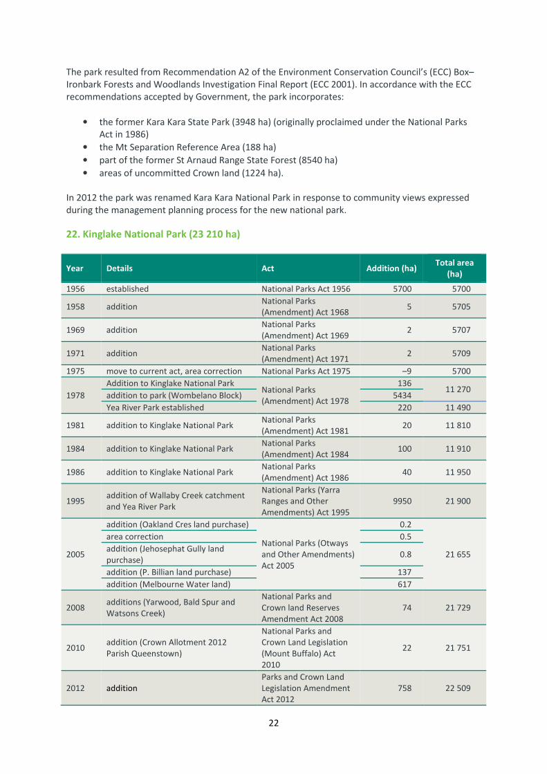
22. Kinglake National Park (23 210 ha)
Year Details Act Addition (ha) Total area
(ha)
1956 established National Parks Act 1956 5700 5700
1958 addition National Parks
(Amendment) Act 1968 5 5705
1969 addition National Parks
(Amendment) Act 1969 2 5707
1971 addition National Parks
(Amendment) Act 1971 2 5709
1975 move to current act, area correction National Parks Act 1975 –9 5700
1978
Addition to Kinglake National Park National Parks
(Amendment) Act 1978
136 11 270
addition to park (Wombelano Block) 5434
Yea River Park established 220 11 490
1981 addition to Kinglake National Park National Parks
(Amendment) Act 1981 20 11 810
1984 addition to Kinglake National Park National Parks
(Amendment) Act 1984 100 11 910
1986 addition to Kinglake National Park National Parks
(Amendment) Act 1986 40 11 950
1995 addition of Wallaby Creek catchment
and Yea River Park
National Parks (Yarra
Ranges and Other
Amendments) Act 1995
9950 21 900
2005
addition (Oakland Cres land purchase)
National Parks (Otways
and Other Amendments)
Act 2005
0.2
21 655
area correction 0.5
addition (Jehosephat Gully land
purchase) 0.8
addition (P. Billian land purchase) 137
addition (Melbourne Water land) 617
2008 additions (Yarwood, Bald Spur and
Watsons Creek)
National Parks and
Crown land Reserves
Amendment Act 2008
74 21 729
2010 addition (Crown Allotment 2012
Parish Queenstown)
National Parks and
Crown Land Legislation
(Mount Buffalo) Act
2010
22 21 751
2012 addition
Parks and Crown Land
Legislation Amendment
Act 2012
758 22 509

23
On 7 March 1928, an area of 5585 ha was permanently reserved as a site for a National Park. Several
small additions occurred between 1928 and 1978. Since 1975, the park has been included on
Schedule Two of the National Parks Act.
In 1980, following the Land Conservation Council (LCC) Melbourne Study Area Final
Recommendations, the size of the park almost doubled (to 11 270 ha) with the inclusion of the
Wombelano Block and two education areas. Subsequent additions in 1981, 1984 and 1986 brought
the area to 11 430 ha.
On 15 December 1995, a net area of 10 170 ha was added to the park. This net increase, arising from
the 1994 LCC Melbourne Area District 2 Review comprised:
• the addition of Yea River Park (220 ha), which since 1980 had been reserved under Schedule
Three of the National Parks Act;
• the addition of a substantial part of the Wallaby Creek catchment area (9965 ha);
• an excision of 15 ha.
Further additions were made as a result of the National Parks and Crown Land (Reserves) Acts
Amendments Bill 2008 on 9 November 2009:
• two blocks of undisturbed bushland contiguous with the existing park (59 ha) – donated
land, land purchased with the assistance of a donation
• frontage of Watsons Creel and nearby road reserve (15 ha) – crown land reserve.
In 2012 an area of 758 ha was added to the park.
23. Lake Eildon National Park (27 750 ha)
Year Details Act Addition (ha) Total area
(ha)
1957 Fraser National Park established Fraser National Park Act
1957 2672 2672
1958 move to National Parks Act National Parks Act 1958 – 2672
1962 addition to Fraser National Park National Parks Act 1962 465 3137
1969 excision from Fraser National Park National Parks
(Amendment) Act 1969 –1 3136
1975 Fraser National Park move to current
act National Parks Act 1975 –36 3100
1978 addition to Fraser National Park National Parks
(Amendment) Act 1978 650 3750
1980 Eildon State Park established 24 000 27 750
1997 Lake Eildon National Park established National Parks
(Amendment) Act 1997 – 27 750
2004 Addition – Enterprise Block, Allans
Peak area, transfer of VPC land
Managed as park; yet to
be formally added 6.2 27 756
2006 Addition –Goulburn Murray Water
land west side of Jerusalem block
Managed as park; yet to
be formally added 116 27 872
The State Rivers and Water Supply Commission purchased a number of grazing properties for the
construction of Lake Eildon. Land that was not flooded by the dam was proposed as a national park
and an area of 6600 acres (2672 ha) proclaimed as Fraser National Park on 18 December 1957.

24
Subsequent additions (and a very small excision) brought the area to 3750 ha by 1978. The park was
included on Schedule Two of the National Parks Act in 1975.
As a result of LCC (1977) recommendations and the National Parks Act 1978 (Vic.), the former Eildon
State Park (24 000 ha) was included on Schedule Three of the National Parks Act on 26 April 1980. It
was transferred to the Schedule Two B (State Parks) on 23 August 1989 as a result of the National
Parks(Amendment) Act 1989 (Vic.).
The State and National Parks were combined to form Lake Eildon National Park, which was
proclaimed on 4 June 1997, as a result of the National Parks (Amendment) Act 1997 (Vic.).
24. Lind National Park (1370 ha)
Year Details Act Addition
(ha)
Total area
(ha)
1956 established National Parks Act 1956 1166 1166
1975 move to current act National Parks Act 1975 0 1166
1988 addition National Parks
(Amendment) Act 1988 199 1365
1995 addition
National Parks (Yarra
Ranges and Other
Amendments) Act 1995
5 1370
Lind National Park (originally 1166 ha) was recommended by a Crown Lands Investigation
Committee to conserve rainforest habitat and was gazetted in 1926.
The Park was included in Schedule Two of the National Parks Act in 1975. Following
recommendations from the East Gippsland Area Review (LCC 1986), Lind National Park was
expanded to 1365 ha in 1988. Five hectares (unused road reserve) were added in 1995.
25. Little Desert National Park (132 647 ha)
Year Details Act Addition (ha) Total area
(ha)
1955 Kiata Lowan Sanctuary established 217 217
1958 Little Desert National Park established
around and including sanctuary
National Parks (Little
Desert and Mt.
Richmond) Act 1968
945 1162
1969 addition National Parks
(Amendment) Act 1969 34 008 35 170
1971 addition National Parks
(Amendment) Act 1971 81 37 251
1975 addition
move to current act National Parks Act 1975 49 37 300
1988 addition (central and western blocks,
and Horseshoe Bend campground)
National Parks and
Wildlife (Amendment)
Act 1988
96 700 134 000
1991 addition (Broughtons Waterhole)
National Parks
(Miscellaneous
Amendments) Act 1991
7 134 007
1997 addition National Parks
(Amendment) Act 1997 640 134 647

25
Little Desert National Park had its beginnings in 1955 when 217 ha were reserved, principally for the
protection of Malleefowl, as the Kiata Lowan Sanctuary (this area is now referred to as the
Sanctuary). The Little Desert was a focus of public attention and controversy in the years following
1968 when plans were announced to develop the area for agriculture. As a result of the public
outcry over this proposal, the area was increased to 1162 ha in 1968 and proclaimed as the Little
Desert National Park – the 21st national park in Victoria.
In 1969 the park was expanded to 35 300 ha with the addition of the majority of the block between
the Wimmera River and the Nhill-Harrow Road. The park became the state’s second largest National
Park in 1988 when an extension of 96 700 ha was proclaimed on 25 May 1988. The extension of the
park from 35 000 ha to 132 000 ha was a result of the National Parks and Wildlife (Amendment) Act
1988, in accordance with the Land Conservation Council (LCC) Final Recommendations for the
Wimmera Study Area. The popular campground known as Horseshoe Bend was also added to the
park at this time.
A significant addition to the park in 1991 was donated by the Williams family (formerly of Kaniva) of
seven hectares of land known as Broughtons Waterhole.
An addition of 640 ha was made in 1997 increasing the park’s area to its current size.
26. Lower Glenelg National Park (26 430 ha)
Year Details Act Addition (ha) Total area
(ha)
1969 established National Parks
(Amendment) Act 1969 9069 9069
1975 addition; move to current act National Parks Act 1975 18 231 27 300
1978 addition (Jones' Lookout) National Parks
(Amendment) Act 1978 – 27 300
1981 minor addition National Parks
(Amendment) Act 1981 – 27 300
1993 minor excision Victorian Plantations
Corporation Act 1993 – 27 300
1995 addition
National Parks (Yarra
Ranges and Other
Amendments) Act 1995
15 27 315
2008
addition (Victorian Plantations
Corporation area)
National Park and Crown
land Reserves
Amendment Act 2008
16 27 331
area correction –901 26 430
During the 1960s it was intended to open up areas of the Kentbruck Heath for closer settlement by
farmers. Pine plantations were also being planned and established along much of the land north and
south of the Glenelg River. Following a long campaign by conservationists aiming to protect many of
the significant areas from development, the Land Utilisation Advisory Council recommended the
creation of a national park. Lower Glenelg National Park was proclaimed in 1969 with an area of
9069 ha. The park included the block of heathland and bush north of Nelson, a section of the
Glenelg River between the Victoria - South Australia border and Keegans Bend, and a separate block
of forest and heathland encompassing most of the significant Moleside Creek catchment.
In 1975, in accordance with recommendations of the Land Conservation Council (LCC), the park was
expanded to include a section of the Glenelg River extending 60 km from the coast, together with

26
large areas of forest and heathland to the north, south and east of the river, making a total area of
27 300 ha.
Princess Margaret Rose Caves Reserve of 90 ha was also included in the park at this time, but special
provisions allowed for its management as Reserved Forest for a further five years. Operationally, it
became part of the park in 1981.
In 1983 the Land Conservation Council recommended two further additions (LCC 1983), which have
been accepted by Government, but are yet to be implemented: 3 ha of public land south of Jones
Lookout, used by the Scout Association; and 3 ha of public land adjoining the park north of the Park
Headquarters access road, which contain the Nelson rubbish tip and which are used partly for
extraction of limestone.
Small additions and excisions were made in 1983, 1993, 1995 and 2008 and 2009. On 9 November
2009 of three small areas of crown land abutting existing park were added to the park (16 ha),
supporting heathy or herb-rich woodlands.
27. Lower Goulburn National Park (9320 ha)
Year Details Act Addition (ha) Total area
(ha)
2009 Park established
Parks and Crown Land
Legislation Amendment
(River Red Gums ) Act
2009
9310 9310
Lower Goulburn National Park was proclaimed on 29 June 2010 and included in Schedule Two of the
National parks Act 1975 (Vic.). The park resulted from the Victorian Environmental Assessment
Council – River Red Gum forest Investigation 2008 Final Report recommendations.
28. Mitchell River National Park (14 365)
Year Details Act Addition (ha) Total area
(ha)
1962 Glenaladale National Park established Glenaladale National
Park Act 1962 163 163
1975 move to current act National Parks Act 1975 – 163
1978 addition to Glenaladale National Park National Parks
(Amendment) Act 1978 20 183
1986 Mitchell River National Park
established
National Parks
(Amendment) Act 1986 11 716 11 900
2002 addition (Southern Rural Water land
and Mitchelldale purchase)
National Parks (Box-
Ironbark and Other
Parks) Act 2002
2350 14 250
Mitchell River National Park is a substantial enlargement of the former Glenaladale National Park of
183 ha. Glenaladale National Park was reserved on 13 November 1963 as a result of the Glenaladale
National Park Act 1962 (Vic.), with 20 ha added in 1978. Glenaladale National Park was renamed and
extended to include the Mitchell River Gorge, foothill forests and rainforest communities to the
north, as a result of the Land Conservation Council’s (LCC) Final Recommendations for the Gippsland
Lakes Hinterland Study Area in 1983.

27
The LCC recommended the area be a State Park, however this was amended to ‘National Park’.
Subsequently, as a result of the National Parks (Amendment) Act 1986 (Vic.) Mitchell River National
Park was proclaimed on 17 June 1986.
Amendments to the National Parks Act on 20 October 2002 also resulted in the addition of 2350 ha
to Mitchell and Wentworth rivers. This includes the formerly proposed dam site at Anguscale and
‘Mitchelldale’, which contains significant grassy woodland vegetation and was purchased with
assistance from the Commonwealth Government.
29. Mornington Peninsula National Park (2680 ha)
Year Details Act Addition (ha) Total area
(ha)
1975 Cape Schanck Coastal Park established National Parks Act 1975 900 900
1978
addition to Cape Schanck Coastal Park
National Parks
(Amendment) Act 1978
94
1844
Nepean State Park established 724
addition to Nepean State Park 45
addition to Cape Schanck Coastal Park
(land in Flinders) 81
1984 addition to Cape Schanck Coastal Park
(Flinders foreshore)
National Parks (Further
Amendment) Act 1984 15 1859
1984 addition to Cape Schanck Coastal Park National Parks
(Amendment) Act 1984 5 1864
1986 addition to Nepean State Park National Parks
(Amendment) Act 1986 8 1872
1988
addition of Point Nepean/Greens Bush
name change to Point Nepean
National Park
National Parks and
Wildlife (Amendment)
Act 1988
270 2142
1989
move to schedule 2B National Parks
(Amendment) Act 1989
–
2392 addition to Point Nepean National
Park (section of Greens Bush) 250
1990 addition to Point Nepean National
Park (final Greens Bush blocks)
National Parks (Further
Amendment) Act 1990 230 2622
1995
addition of South Channel Fort
name change to Mornington Peninsula
National Park
National Parks (Yarra
Ranges and Other
Amendments) Act 1995
6 2628
2005
excision (transfer to Point Nepean
National Park)
National Parks (Point
Nepean) Act 2005
–265
2686
addition (Fingal Rd blocks and part of
Cape Schanck car park) 4
addition (Melbourne Water land at St
Andrews Beach) 19
adjustment to previous area 2686 ha
2006 addition (Lots 101 and 102 Fingal Rd)
National Parks and
Crown Land (Reserves)
Acts (Amendment) Act
2006
0.2 2686
2012 addition (Crown Allotment ‘s 2002,
2005-2007)
Parks and Crown Land
Legislation Amendment
Act 2012
0.3 2686
* The legislated area above varies from the total of key changes (2625 ha) due to refinements in mapping

28
In 1908, the Commonwealth Government of Australia acquired 170 ha of Point Nepean for specific
purposes, which later becomes part of Mornington Peninsula National Park.
The former Cape Schanck Coastal Park, incorporating the then existing coastal reserve (which was
then managed by a committee of management) was proclaimed on 1 December 1975 (900 ha) as a
result of the National Parks Act 1975 (Vic.). Point Nepean National Park was proclaimed in 1988 and
changed its status from state and coastal to national park. The new park comprised the former Cape
Schanck Coastal Park, a portion of the Commonwealth Army Reserve at Point Nepean and the
Highfield and Green’s Bush area of Nepean State Park.
In its 1994 review, the former Land Conservation Council (LCC) endorsed the existing status of
Mornington Peninsula National Park because the park has importance for the representation of land
systems, contains the largest remaining area of remnant native vegetation on the Peninsula with
associated significant flora and fauna and recreation values, and has nationally significant historical
values at Point Nepean and South Channel Fort.
In 2005 there were additions totalling 23 ha to the remaining part of Mornington Peninsula National
Park, 4 hectares at the Cape Schanck car park and on Fingal Road (on 17 August 2005) and 19 ha of
surplus Melbourne Water land at St Andrews Beach (on 6 October 2005). Two additional areas on
Fingal Road were added in 2006 and a small addition in 2011.
30. Morwell National Park (565 ha)
Year Details Act Addition (ha) Total area
(ha)
1956 established Morwell National Park
Act 1966 138 138
1975 addition
move to current act National Parks Act 1975 2 140
1981 addition National Parks
(Amendment) Act 1981 143 283
1989 addition National Parks
(Amendment) Act 1989 113 396
2004 addition (Regional Forest Agreement
and Yinnar additions)
National Parks
(Additions and Other
Amendments) Act 2004
169 565
Morwell National Park was originally proclaimed on 26 November 1966 as a result of the Morwell
National Park Act 1966 (Vic.). Subsequent additions in 1969, 1981, 1989 and 2004 increased the park
size to 565 ha.

29
31. Mount Buffalo National Park (31 020 ha)*
Year Details Act Addition (ha) Total area
(ha)
1898 Eurobin falls reserved as “a site for a
national park” 1165 1165
1956 move to National Parks Act 1956 National Parks Act 1956 11 000 11 000
1975 move to current act National Parks Act 1975 – 11 000
1978 addition (foothill country) National Parks
(Amendment) Act 1978 20 000 31 000
1995 addition
National Parks (Yarra
Ranges and Other
Amendments) Act 1995
2 31 002
2009 addition
Parks and Crown Land
Legislation Amendment
(River Red Gums) Act
2009
22 31 024
2013
excision of an existing access track on
the eastern edge of park near
Buckland River
Parks and Crown Land
Legislation Amendment
Act 2013
–0.7 31 023
* The legislated area above varies from the total of key changes (31 020ha) due to refinements in mapping
The Victorian Government temporarily reserved 1165 ha around the Eurobin Falls as a ‘site for a
national park’ in 1898. In 1908 the area was expanded to over 10 500 ha, with a further 526 ha
added in 1934.
The historic Mount Buffalo Chalet was built in 1910. Following Government acceptance of the
recommendations of the former Land Conservation Council 1977 North Eastern Study Area, Districts
3, 4 and 5, an additional 20 000 ha was added to the park in 1978. A small area of 2 ha was added in
1995, which made no change to official area which was recorded in km2 at that time.
Further areas (two areas on the south-west and north-east boundaries) totalling 22 ha were added
in 2010, bringing the area of the park to 31 020 ha.
excised to provide legal access to a freehold property
The Australian Alps National Parks and Reserves including Mount Buffalo National Park were
included on the National Heritage List on 7 November 2008, in recognition for their remarkable
landforms, cold climate flora and fauna, pioneering history and popular recreation areas.

30
32. Mount Eccles National Park (8565 ha)
Year Details Act Addition (ha) Total area
(ha)
1960 established National Parks
(Amendment) Act 1960 32 32
1962 addition National Parks Act 1962 2 34
1968 addition National Parks
(Amendment) Act 1968 360 394
1975 addition
move to current act National Parks Act 1975 6 400
1986 addition National Parks
(Amendment) Act 1986 5078 5478
2004
area correction National Parks
(Additions and other
amendments) Act 2004
480
additions Regional Forest Agreement,
Bessibelle, The Stones WR, Condah
Leasehold)
2425 8433
2013 addition of an area of lava flow
country.
Parks and Crown Land
Legislation Amendment
Act 2013
193 8626
Mount Eccles, proclaimed a National Park on 7 June 1960 as a result of the National Parks
(Amendment) Act 1960 (Vic.), was first reserved in November 1926 as a site for a public park at the
request of the Minhamite Shire Council. The 32 ha park encompassed the extinct volcano of Mount
Eccles and crater occupied by Lake Surprise and the surrounding area.
Additions to the park have been 2 ha in 1962, 360 ha in 1968 and the adjoining 5078 ha Wildlife
Reserve in 1986, which including a range of volcanic features of national geological significance and
areas for protection of the Tiger Quoll and Yellow-Belled Glider. In 2005, a transfer from the Trust
for Nature of 2425 ha included Bessibelle, The Stones WR and Condah Leasehold, significant
Aboriginal values and forest and woodland communities not found in existing park – areas identified
in the Gippsland and West Victoria Regional Forest Agreement, Land Conservation Council and Land
purchase.
On 18 December 2013 an area of lava flow country, mostly comprising intact stony rise woodland,
was added to the park.
Mount Eccles National Park was included on the National Heritage List on 20 June 2004. The
inclusion of this park recognises that the large, settled Aboriginal community systematically farming
and smoking eels for food and trade, dating back thousands of years.
Mount Eccles National Park is co-managed by Parks Victoria and Budj Bim Council in accordance with
a 2007 Native Title Agreement between the Gunditj Mirring Traditional Owners Aboriginal
Corporation and the Victorian Government.

31
33. Mount Richmond National Park (1733 ha)
Year Details Act Addition (ha) Total area
(ha)
1960 established National Parks
(Amendment) Act 1960 621 621
1968 addition
National Parks (Little
Desert and Mt.
Richmond) Act 1968
203 824
1975 addition
move to current act National Parks Act 1975 876 1700
1978 addition National Parks
(Amendment) Act 1978 7 1707
1987 addition (purchased land) National Parks
(Amendment) Act 1987 26 1733
Mount Richmond National Park was proclaimed a National Park, with an area of 621 ha, on 7 June
1960 as a result of the National Parks (Amendment) Act 1960 (Vic.), following strong representations
from the Portland Field Naturalists Club and other conservation groups. Further additions of 203 ha
in 1968, 876 ha in 1975 and 7 ha in 1978 were made to the park.
In 1987 a small addition of 26 ha of purchased land was made to the park. This land provides an
important link between the park and Discovery Bay Coastal Park and brought its area to the current
1733 ha.
34. Murray–Sunset National Park (664 810 ha)
Year Details Act Addition (ha) Total area
(ha)
1979 Pink Lakes State Park established National Parks
(Amendment) Act 1978 50 700 50 700
1987 excision to Pink Lakes State Park
(Government road)
National Parks
(Amendment) Act 1987 0 50 700
1991 Murray–Sunset National Park
established
National Parks (Further
Amendment) Act 1990 582 300 633 000
2010 Addition
Parks and Crown Land
Legislation Amendment
(River Red Gums) Act
2009
32 135 665 135
* The legislated area above varies from the total of key changes (673 510 ha) due to refinements in mapping.
Murray–Sunset National Park (at first called Yanga-nyawi) was proclaimed on 5 June 1991,
incorporating Pink Lakes State Park (507 km2), which had been proclaimed on 26 April 1979.
In 2010, an addition of 32 135 ha was made, including part of the Murray River floodplain (including
Walpolla Island) and adjoining dryland areas.

32
35. Organ Pipes National Park (153 ha)
Year Details Act Addition (ha) Total area
(ha)
1972 Established from private land
donation
National Parks
(Amendment) Act 1971 65 65
1975 move to current act National Parks Act 1975 0 65
1978 addition National Parks
(Amendment) Act 1978 20 85
1997 addition National Parks
(Amendment) Act 1997 36 121
2000 addition (land from Brimbank) National Parks
(Amendment) Act 2000 13 134
2005
excision (overlap with Calder Freeway) National Parks (Otways
and Other Amendments)
Act 2005
0.1 134
area correction 19 153
Organ Pipes National Park originated as a result of a donation of 65 ha of land to the Crown from the
trustees of the E.A. Green Charitable Foundation. Following transfer of the land to the Crown, and as
a result of the National Parks Act 1971 (Vic.), the area was included in Schedule 2 of the Act, and
proclaimed on 12 March 1972. The area included the interesting basalt columns known as the
Sydenhan Organ Pipes.
An additional 20 ha of land was added to the park as a result of the National Parks (Amendment) Act
1978 (Vic.). A further 36 ha of Crown land, including some land previously compulsorily acquired for
the park, was added to the park on 4 June 1997, as a result of the National Parks (Amendment) Act
1997 (Vic.).
In 2000, an area along Jackson Creek donated by the City of Brimbank was added and five years later
0.1 ha – part of the former Organ Pipes Road and now part of Calder Freeway – was excised from the
park.
36. Point Nepean National Park (578 ha)*
Year Details Act Addition (ha) Total area
(ha)
2005
established (area transferred from
Mornington Peninsula National Park) National Parks (Point
Nepean) Act 2005
265
470 addition (transfer to Crown of
Commonwealth land) 205
2009 addition (former Quarantine Station)
National Parks
Amendment (Point
Nepean) Act 2009
105 575
2013 addition
Parks and Crown Land
Legislation Amendment
Act 2013
1.3 576
* The legislated area varies from the total of key changes due to variations in mapping accuracy over time
In December 1988 an area of approximately 265 ha, comprising two parcels of land at Point Nepean
linked by Defence Road, was transferred from the Commonwealth to the State and opened to the
public as part of the then Point Nepean National Park. At this time Point Nepean National Park

33
extended from Point Nepean to Flinders and inland to Greens Bush, and encompassed the former
Cape Schanck Coastal Park proclaimed in 1975 and parts of the former Nepean State Park
proclaimed in 1978.
In 1995, following the addition of South Channel Fort, Point Nepean National Park was renamed the
Mornington Peninsula National Park, having regard to its geographical extent along the coast and
inland.
On 17 August 2005 amendments to the National Parks Act 1975 (Vic.) created a new Point Nepean
National Park, initially incorporating the Point Nepean and South Channel Fort sections (265 ha) of
Mornington Peninsula National Park. On 20 March 2006, as the result of an agreement between the
Commonwealth and Victorian Governments, 205 ha of Commonwealth land comprising the former
weapons range south of Defence Road was transferred to Victoria and included in the national park,
bringing its area to 470 ha.
The park, sitting at the entrance to Port Phillip Bay, highlights in particular the outstanding heritage
values associated with the history of military use of the area. The park also has significant natural
and Aboriginal cultural values and, with its historic defence installations and panoramic coastal
views, provides a special visitor experience less than two hours’ drive from Melbourne.
On 6 December 2009, 105 ha comprising nearly all of the heritage-listed Quarantine Station and the
adjoining intertidal zone were added to Point Nepean National Park. This addition means that
virtually the whole of Point Nepean is protected in a national park.
On 18 December 2013, a small area at the Quarantine Station excluded from the park in 2009 as a
site for a possible respite centre was added to the park.
Point Nepean National Park was included on the National Heritage List on 16 June 2006. The park
was included in the list for its two 19th
century landmarks – the fortifications and the quarantine
station.
37. Port Campbell National Park (1 830 ha)
Year Details Act Addition (ha) Total area
(ha)
1964 established National Parks
(Amendment) Act 1964 708 708
1975 Excision, move to current act National Parks Act 1975 –8 700
1981 addition National Parks
(Amendment) Act 1981 1050 1750
1997 addition National Parks
(Amendment) Act 1997 0 1750
2005
excision (coastal land in Port Campbell
township) National Parks (Otways
and Other Amendments)
Act 2005
–5
1830 area correction 7
addition 78
The coastal area now forming part of Port Campbell National Park was first reserved late last century
in recognition of the scenic attractions of the coastline. Much later, Port Campbell National Park was
proclaimed on 5 May 1964, as a result of the National Parks Act 1964 (Vic.).

34
Port Campbell National Park was extended in 1981 to include a section of the former Port Campbell
Water Reserve, bushland areas in the Sherbrook River Valley, sand dune systems between Castle
Rock and Princetown, and part of the Sherbrook River Valley as an Education Area. A small house
block in Port Campbell Township was excised in 1997.
On 11 December 2005, 122 ha were added to the park including Loch Ard cemetery and
miscellaneous areas Crown land including unused road reserves. Another 5.4 ha were excised from
the park - land in Port Campbell Township, including part of Port Campbell foreshore, surf lifesaving
club, Caravan Park, a water authority depot and police residence.
38. Snowy River National Park (114 600 ha)*
Year Details Act Addition (ha) Total area
(ha)
1979 established National Parks
(Amendment) Act 1978 26 000 26 000
1981 addition National Parks
(Amendment) Act 1981
200 26 200
1987 addition 15 100 41 300
1988 addition (Rodger - Bowen and
Mooresford areas)
National Parks
(Amendment) Act 1988 54 100 95 400
1991 addition (Swamp and Good Hope
Creek ) excision
National Parks
(Miscellaneous
Amendments) Act 1991
3300 98 700
1995 addition
National Parks (Yarra
Ranges and Other
Amendments) Act 1995
26 98 726
2009 State forest and other Crown land
Parks and Crown Land
Legislation Amendment
(East Gippsland) Act
2009
16 005 114 731
* The legislated area above varies from the total of key changes (114 731 ha) due to refinements in mapping
Snowy River National Park was initially proclaimed on 26 April 1979 (26 000 ha) following the Land
Conservation Council (LCC) studies of East Gippsland in 1977 and the Alpine area in 1979. Further
additions were made in 1981 (200 ha), 1987 (15 100 ha), 1988 (54 100 ha), 1991 (3300 ha) following
further LCC studies in 1995 (26 ha) and 2009 (16 005 ha).
On 15 July 1988 the park was expanded to become an exceptional National Park of 95 400 ha by the
additions of the Mooresford area, contain the tributaries to Raymond Creek with woodlands of
Silver-lead Stringybark; an area west of the Snowy River with high scenic and recreation values; and
the Rodger–Bowen area. The Rodger–Bowen area is of the highest significance, incorporating
Victoria’s largest forest wilderness; the ancient and very beautiful Mountain Ash forest of the
Rodger River; and a rich and varied fauna including substantial populations of arboreal mammals,
large owls, and several significant species such as the endangered Long-footed Potoroo. The
landscapes of the parks are exceptional and provide a magnificent backdrop for a range of
recreation activities.
Additions were made in the Warbisco Creek, Home Creek, Swamp Creek and Good Hope Creek
catchments, the latter two as part of decisions on national estate issues in 1991. A small area of
26 ha was added to the park in 1995. A larger area of 16 005 ha was added to the park in 2010. This
addition links the park with Errinundra National Park and brings the total area to 114 600 ha.

35
The Australian Alps National Parks and Reserves including Snowy River National Park were included
on the National Heritage List on 7 November 2008, in recognition for their remarkable landforms,
cold climate flora and fauna, pioneering history and popular recreation areas.
39. Tarra–Bulga National Park (2015 ha)
Year Details Act Addition (ha) Total area
(ha)
1956 Tarra Valley National Park established National Parks Act 1956 81 81
1962 addition to Tarra Valley National Park National Parks Act 1962 47 128
1971 addition to Tarra Valley National Park National Parks
(Amendment) Act 1971 8 136
1975 addition to Tarra Valley National Park
move to current act National Parks Act 1975 4 140
1978 addition to Tarra Valley National Park National Parks
(Amendment) Act 1978
– 140
Bulga National Park established 80 220
1981 addition to Bulga National Park National Parks
(Amendment) Act 1981 –
1986 Tarra–Bulga National Park established National Parks
(Amendment) Act 1986 1009 1229
1991 addition (link and Cynthea Falls)
National Parks
(Miscellaneous
Amendments) Act 1991
292 1522
2004
excision (cleared paddock in Balook
township)
National Parks
(Additions and other
Amendments) Act 2004
–
addition (Regional Forest Agreement ) 493 2015
Bulga National Park was first reserved in 1904, and Tarra Valley National Park in 1909. Various
additions were subsequently made that expanded these two former parks and linked them through
the Strzelecki Ranges north of Yarram. The park includes significant stands of cool temperate
rainforest of Mountain Ash, Myrtle Beach and Sassafras and other vegetation types representative
of the Strzeleckis.
Tarra–Bulga National Park was proclaimed on 17 June 1986 under Schedule two of the National Park
Act 1975 (Vic.) as a result of the National Parks (Amendment) Act 1986 (Vic.). It was created based
on Land Conservation Council (LCC) recommendations for the South Gippsland Area, District 2.
As a result of a land exchange between Australian Paper Mill Forests (now AMCOR) and the Crown,
the Tarra Valley and Bulga sections of the park were finally linked in 1991. These additions, totalling
292 ha, significantly consolidated Tarra–Bulga National Park and helped protect Cyathea Falls; part
of this land was purchased with funds provided by a generous donor.
In 2004 a further 493 ha was added to the park as a result of the National Parks (additions and other
Amendments) Act 2004.

36
40. Terrick Terrick National Park (6390 ha)*
Year Details Act Addition (ha) Total area
(ha)
1988 Terrick Terrick State Park established
National Parks and
Wildlife (Amendment)
Act 1988
2493 2493
1999 addition (Davies property)and move to
Schedule 2
National Parks
(Amendment) Act 1998 1277 3770
2002 addition (Terrick Terrick Flora Reserve
and Public Land Water Frontage)
National Parks (Box-
Ironbark and Other
Parks) Act 2002
110 3880
2010 addition
Parks and Crown Land
Legislation Amendment
(River Red Gums) Act
2009
2045 5925
2010
addition (Patho West and
Turrumberry Nature Conservation
Reserve)
Parks and Crown Land
Legislation Amendment
(Buffalo Bill) Act 2009
468 6993
* The legislated area above varies from the total of key changes (6393 ha) due to refinements in mapping
Terrick Terrick National Park was included in Schedule Two of the National Parks Act 1975 (Vic.) as a
result of the National Parks (Amendment) Act 1998 (Vic.) and was proclaimed on 15 April 1999. The
park includes the former Terrick Terrick State Park (created in 1988) and 1277 ha of former freehold
land, which, because of its nationally significant grassland values, was purchased with joint State and
Commonwealth funding. The park protects one of the few remaining remnant natural areas of the
northern plains, including Victoria’s largest White Cypress-pine woodland. It is a major landmark and
scenic feature of the flat northern plains between Bendigo and Kerang.
Terrick Terrick Flora Reserve (26 ha), reserved forest (11 ha), water frontage reserve along Bendigo
Creek (adjoining strips of reserved and unreserved Crown land totalling 43 ha) and unused road (4
ha) were added to the park on 30 October 2002 as a result of the National Parks (Box-Ironbark and
Other Parks) Act 2002. This was in line with the final recommendations of the Box-Ironbark Forests
and Woodlands Investigation carried out by the Environment Conservation Council (ECC).
On 30 October 2002, the National Parks (Box-Ironbark and Other Parks) Act 2002 amended the Act
to expand the parks system in the box-ironbark region by nearly 68 000 ha. This resulted from the
Government’s decision on the ECC Box-Ironbark Forests and Woodlands Investigation Final Report
(2001) Terrick Terrick was increased by 110 ha. In 2010 additions of 2045 ha included several nature
conservation reserves containing native grasslands of the northern plains, and other Crown Land.

37
41. The Lakes National Park (2390 ha)
Year Details Act Addition (ha) Total area
(ha)
1956 The Lakes National Park established National Parks Act 1956 1510 1510
1958? addition National Parks
(Amendment) Act 1960 610 2120
1975 move to current act National Parks Act 1975 –20 2100
1978 addition National Parks
(Amendment) Act 1978
280 2380
excision 0
1984 addition National Parks
(Amendment) Act 1984 10 2390
Sperm Whale Head National Park (1451 ha) was first reserved in 1927 and then proclaimed a fauna
sanctuary under the Game Act 1936 (Vic.). It was subsequently reserved under the National Parks
Act in 1956 as The Lakes National Park.
The Park was enlarged by 610 ha in 1958. Rotamah and Little Rotamah Islands were added in 1978
and an addition of 10 ha made in 1984.
42. Warby–Ovens National Park (14 750 ha)
Year Details Act Addition (ha) Total area
(ha)
1978 Warby Range State Park established
and addition
National Parks
(Amendment) Act 1978 2821 2821
1981 addition National parks
(Amendment) Act, 1981 499 3320
1987 addition National Parks
(Amendment) Act 1987 220 3540
1989 addition (Warby Range State Forest) National Parks
(Amendment) Act 1989 3340 6880
1995 addition
National Parks (Yarra
Ranges and Other
Amendments) Act 1995
720 7600
2002 addition
National Parks (Box-
Ironbark and Other
Parks) Act 2002
3860 11 460
2009 addition
Parks and Crown Land
Legislation Amendment
(River Red Gums) Act
2009
3195 14 655
2012 addition
Parks and Crown Land
Legislation Amendment
Act 2012
95 14 750
In 1959 members of the Upper Goulburn Regional Committee and the Upper Murray Regional
Committee made a joint inspection of the Warby Ranges to determine which areas of public land
should be permanently reserved as a National Park. A report prepared by the Committees

38
recommending the creation of a National Park was submitted to the Minister for State Development
in 1968.
In August 1975, 2750 ha of the Warby Range was proclaimed as a Site for Public Purposes (National
Park) and was subsequently renamed Warby Range State Park. This area and an addition were
included in Schedule Three of the National Parks Act under the National Parks (Amendment) Act in
1978. Additions over time significantly increased the size of the park and helped connect the
fragmented sections of the original park, included a substantial donation of land by the Nason family
of Wangaratta (220 ha) in 1984 (added to the park in 1987), and small additions of 46 ha and 499 ha
made in 1979 and 1981 respectively. The Nason family has a long association with the area and was
active in the campaign to establish the park.
Following the Government’s acceptance of the Environment Conservation Council’s (ECC)
recommendations from the Box–Ironbark Forests and Woodlands Investigation Final Report in 2002,
the former Killawarra State Forest (2944 ha), the former Killawarra (Wallaby Hill) Education Area
(279 ha) and former Boweya Flora and Fauna Reserve (261 ha) were added to the park as a result of
the National Parks (Box–Ironbark and Other Parks) Act 2002 (Vic.) on 30 October 2002. Other
purchased freehold land, Buck and Bailey blocks of 163 ha and 175 ha and 26 ha of the Griffiths
Track area were added at the same time increasing the park by 3860 ha.
Booth block, 720 ha of freehold land, was purchased and added to the park in 1995.
In 2010, as a result of the Government’s response to the Victorian Environmental Assessment
Council River Red Gum Forest Investigation, the park was included on Schedule Two of the National
Parks Act and renamed Warby–Ovens National Park. The national park incorporated the former
Warby Range State Park and riverine forests of the lower Ovens River including the former Lower
Ovens State Forest, Lower Ovens Regional Park, Peechelba Flora Reserve, water authority land and
public land water frontage areas and bushland reserve linking the former Killawarra and Ovens
Forests, and part of the Ovens Heritage River. A small addition of 95 ha was made to the park in
2012.
43. Wilsons Promontory National Park (49 049 ha)
Year Details Act Addition (ha) Total area
(ha)
1956 move to Act National Parks Act 1956 41 449 41 449
1969 addition (Yanakie Isthmus and Glennie
group)
National Parks
(Amendment) Act 1969 7448 48 897
1975 Addition; move to current act National Parks Act 1975 103 49 000
1978 addition (2 allotments in former T.
Seaforth)
National Parks
(Amendment) Act 1978 – 49 000
2002 addition (Wilsons Promontory and
Citadel Island lighthouse reserves)
National Parks (Box-
Ironbark and Other
Parks) Act 2002
49 49 049
On 8 July 1898, an area of 36 826 ha at Wilsons Promontory was temporarily reserved under the
Land Act 1890 (Vic.) as a site for a national park. This was followed by the permanent reservation of
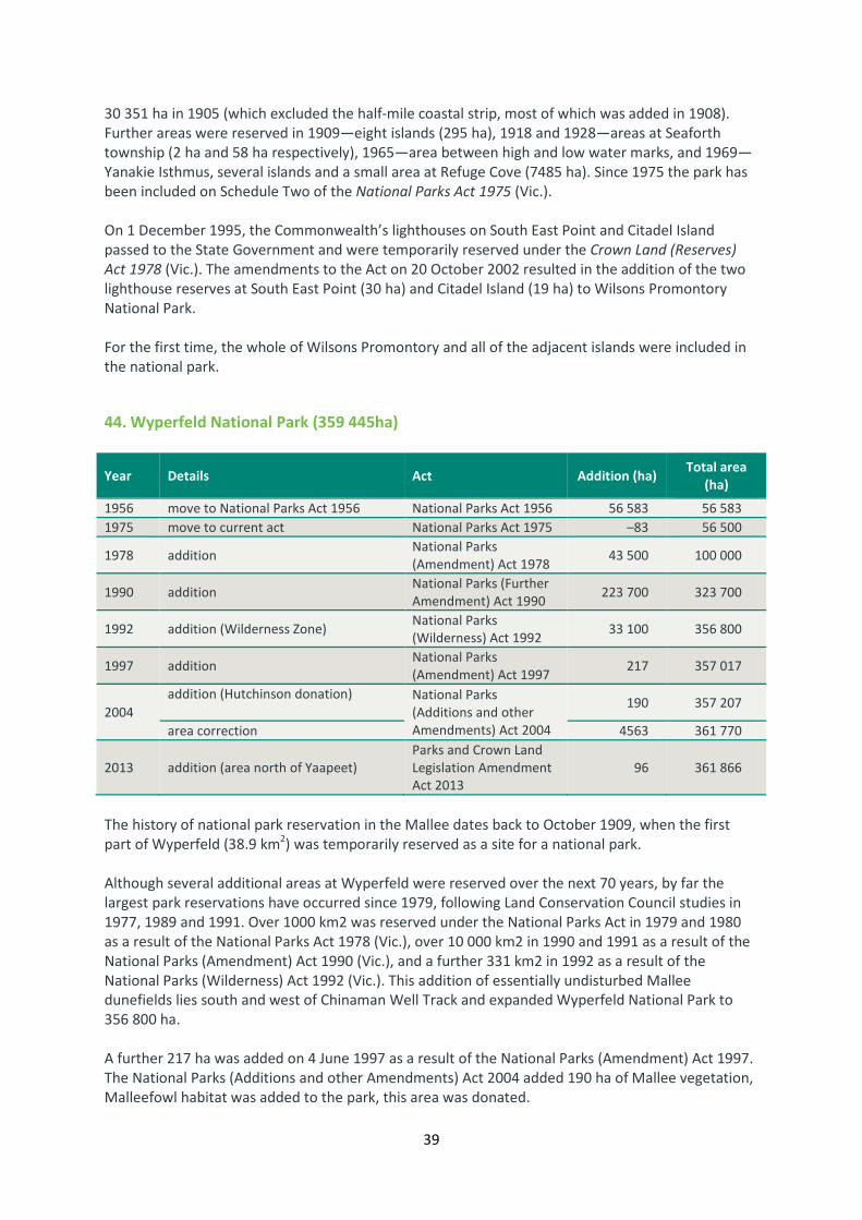
39
30 351 ha in 1905 (which excluded the half-mile coastal strip, most of which was added in 1908).
Further areas were reserved in 1909—eight islands (295 ha), 1918 and 1928—areas at Seaforth
township (2 ha and 58 ha respectively), 1965—area between high and low water marks, and 1969—
Yanakie Isthmus, several islands and a small area at Refuge Cove (7485 ha). Since 1975 the park has
been included on Schedule Two of the National Parks Act 1975 (Vic.).
On 1 December 1995, the Commonwealth’s lighthouses on South East Point and Citadel Island
passed to the State Government and were temporarily reserved under the Crown Land (Reserves)
Act 1978 (Vic.). The amendments to the Act on 20 October 2002 resulted in the addition of the two
lighthouse reserves at South East Point (30 ha) and Citadel Island (19 ha) to Wilsons Promontory
National Park.
For the first time, the whole of Wilsons Promontory and all of the adjacent islands were included in
the national park.
44. Wyperfeld National Park (359 445ha)
Year Details Act Addition (ha) Total area
(ha)
1956 move to National Parks Act 1956 National Parks Act 1956 56 583 56 583
1975 move to current act National Parks Act 1975 –83 56 500
1978 addition National Parks
(Amendment) Act 1978 43 500 100 000
1990 addition National Parks (Further
Amendment) Act 1990 223 700 323 700
1992 addition (Wilderness Zone) National Parks
(Wilderness) Act 1992 33 100 356 800
1997 addition National Parks
(Amendment) Act 1997 217 357 017
2004
addition (Hutchinson donation)
National Parks
(Additions and other
Amendments) Act 2004
190 357 207
area correction 4563 361 770
2013 addition (area north of Yaapeet)
Parks and Crown Land
Legislation Amendment
Act 2013
96 361 866
The history of national park reservation in the Mallee dates back to October 1909, when the first
part of Wyperfeld (38.9 km2) was temporarily reserved as a site for a national park.
Although several additional areas at Wyperfeld were reserved over the next 70 years, by far the
largest park reservations have occurred since 1979, following Land Conservation Council studies in
1977, 1989 and 1991. Over 1000 km2 was reserved under the National Parks Act in 1979 and 1980
as a result of the National Parks Act 1978 (Vic.), over 10 000 km2 in 1990 and 1991 as a result of the
National Parks (Amendment) Act 1990 (Vic.), and a further 331 km2 in 1992 as a result of the
National Parks (Wilderness) Act 1992 (Vic.). This addition of essentially undisturbed Mallee
dunefields lies south and west of Chinaman Well Track and expanded Wyperfeld National Park to
356 800 ha.
A further 217 ha was added on 4 June 1997 as a result of the National Parks (Amendment) Act 1997.
The National Parks (Additions and other Amendments) Act 2004 added 190 ha of Mallee vegetation,
Malleefowl habitat was added to the park, this area was donated.

40
On 18 December 2013, an area of mallee north of Yaapeet providing important malleefowl habitat
was added to the park.
45. Yarra Ranges National Park (77 185 ha)
Year Details Act Addition (ha) Total area
(ha)
1995 established
National Parks (Yarra
Ranges and Other
Amendments) Act 1995
76 000 76 000
2000 addition National Parks
(Amendment) Act 2000 3 76 003
2005
area correction National Parks (Otways
and Other Amendments)
Act 2005
–496 75 507
addition (Melbourne Water surplus
land) 1533 77 404
2008 addition
National Parks and
Crown Land (Reserves)
Acts Amendment Act
2008
150 77 190
2013
addition (area north of Warburton and
part of the O’Shannassy Aqueduct and
walking track) and correction
Parks and Crown Land
Legislation Amendment
Act 2013
0.2 77 190
In 1994 the former Land Conservation Council (LCC), in its Final Recommendations for the
Melbourne Area District 2 Review, recommended establishing an Ash Ranges National Park to
protect the area’s significant mature Wet Forests and Cool Temperate Rainforests. The Government
subsequently accepted this recommendation with several variations, including changing the name to
Yarra Ranges National Park and incorporating the Maroondah, O’Shannassy and Upper Yarra
Reservoirs, and an area at Dom Dom Saddle in the park.
Subsequently, the Yarra Ranges National Park was included on Schedule Two of the National Parks
Act 1975 (Vic.) on 15 December 1995 as a result of the National Parks (Yarra Ranges and Other
Amendments) Act 1995 (Vic.). Four small areas in or on the boundaries of the Armstrong Creek and
Upper Yarra catchments (3 ha) were added to the park on 25 January 2001.
On 11 December 2005, 1533 ha was added to the park; former Crown land and Melbourne Water
land at or near Badger Creek, Cement Creek, Dom Dom Saddle, Fernshaw and Maroondah and in the
Upper Yarra catchment and parts of decommissioned O’Shannassy Aqueduct.
Other areas were added on 23 September 2008 as a result of the National Parks and Crown Land
(Reserve) Acts Amendment Act 2008.
On 18 December 2014 a small area north of Warburton containing wet forest and part of the
O’Shannassy Aqueduct and associated walking track was added to the park.
On 18 December 2014 a small area north of Warburton containing wet forest and part of the
O’Shannassy Aqueduct and associated walking track was added to the park.

41
WILDERNESS PARKS
Schedule Two A

42
WILDERNESS PARKS - SCHEDULE TWO A
1. Avon Wilderness Park (39 650 ha)
Year Details Act Addition
(ha)
Total area
(ha)
1986 established National Parks (Amendment) Act 1986 40 000 40 000
1992 excision National Parks (Wilderness) Act 1992 -350 39 650
The Avon Wilderness Area was recommended by the LCC as part of its Gippsland Lakes Hinterland
Area and Alpine Area Special Investigation in 1983. The area was proclaimed as a Wilderness Park
under the National Parks Act in 1987. The Wilderness Special Investigation (LCC 1991) recommended
the continuing use of the Avon Wilderness Area in accordance with minor boundary amendments,
bringing the total area to 39 650 ha.
The Australian Alps National Parks and Reserves including Avon Wilderness Park were included on
the National Heritage List on 7 November 2008, in recognition for their remarkable landforms, cold
climate flora and fauna, pioneering history and popular recreation areas.
2. Big Desert Wilderness Park (142 300 ha)
Year Details Act Addition
(ha)
Total area
(ha)
established National Parks (Amendment) Act 1978 113 500 113 500
move to Schedule Two A National Parks (Amendment) Act 1989 0 0
additions National Parks (Wilderness) Act 1992 28 800 142 300
Big Desert Wilderness Park was proposed by the LCC in the 1977 Mallee Study Area Final
Recommendations (LCC 1977). Initially included on Schedule 3 (Other Parks) of the National Parks
Act and proclaimed on 26 April 1979, the 113 500 ha Park was managed by the then National Parks
Service. Prior to proclamation, the area was unreserved Crown Land.
The Park was included on the newly created Schedule Two A (Wilderness Parks) of the National
Parks Act as a result of the National Parks (Amendment) Act 1989 (Vic.). Following the LCC
Wilderness Special Investigation Final Recommendations (LCC 1991), two additions totalling 28 800
ha were proclaimed on 30 June 1992 under the National Parks (Wilderness) Act 1992 (Vic.).

43
3. Wabba Wilderness Park (20 100 ha)
Year Details Act Addition
(ha)
Total area
(ha)
1992 established National Parks (Wilderness) Act 1992 20 100 20 100
Wabba Wilderness Park was included on Schedule 2A (Wilderness Parks) of the National Parks Act
1975 (Vic.) as a result of the National Parks (Wilderness) Act 1992 (Vic.) following the Land
Conservation Council’s Wilderness Special Investigation Final Recommendations (1991b). The
Wilderness was proclaimed on 30 June 1992.

44
STATE PARKS
Schedule Two B

45
STATE PARKS - SCHEDULE TWO B
4. Arthurs Seat State Park (565 ha)
Year Details Act Addition
(ha)
Total area
(ha)
1978
Nepean State Park
established National Parks (Amendment) Act 1978
213 213
addition to Nepean State
Park 65 278
1981 addition to Nepean State
Park National Parks (Amendment) Act 1981 43 321
1984 addition to Nepean State
Park (closed roads) National Parks (Amendment) Act 1984 2 323
1988
addition
Arthurs Seat Park
established
National Parks and Wildlife
(Amendment) Act 1988 26 349
1997
addition (Parkdale block and
Arthurs Seat Public Park)
National Parks (Amendment) Act 1997
178 527
addition (McKellar Flora
Reserve) 43 570
addition (blocks along Tower
Hill Road) 1 571
2004
area correction National Parks (Additions and Other
Amendments) Act 2004
-8 563
area correction -6 557
2013 addition (Parkdale Block) Parks and Crown Land Legislation
Amendment Act 2013 7 564
On 16 May 1978, as a result of the National Parks (Amendment) Act 1978 (Vic.), Nepean State Park
(which included the northern section of Greens Bush and most of what is now Arthurs Seat State
Park) was created. Land in the Arthurs Seat area was first reserved for public purposes in 1863. The
Seawinds property was purchased by the Government in 1975.
Between 1978 and 1987 several additions were made to both parks, and in 1988, following
acquisition of additional land at Greens Bush and Commonwealth land at Point Nepean, the areas
became Point Nepean National Park (2200 ha) and Arthurs Seat State Park (350 ha).
The former Land Conservation Council review in 1994 recommended a number of additions to
Arthurs Seat State Park. Most of these areas including Arthurs Seat Public Park and Parkdale block
were proclaimed as part of the park in June 1997.

46
On 18 December 2013 an area of Lowland Forest contiguous with the park (Parkdale Block) north of
Arthurs Seat Road was added to the park.
5. Black Range State Park (11 700 ha)
Year Details Act Addition
(ha)
Total area
(ha)
1987 established National Parks (Amendment) Act 1987 11 700 11 700
Black Range State Park was initially reserved under Schedule Three (Other Parks) of the National
Parks Act on 21 June 1988 as a result of the National Parks (Amendment) Act 1987 (Vic.). It was then
transferred to the Schedule Two B (State Parks) in 1989.
The Park resulted from former Land Conservation Council’s 1982 South-Western Area District 2 Final
Recommendations.
6. Broken-Boosey State Park (1010 ha)
Year Details Act Addition
(ha)
Total area
(ha)
2002 established National Parks (Box-Ironbark and Other
Parks) Act 2002 1030 1030
2006
area correction National Parks and Crown Land
(Reserves) Acts (Amendment) Act 2006
-21 1009
addition (Gordons Road
land) 0.6 1010
Broken-Boosey State Park was included in Schedule Two B of the National Parks Act 1975 (Vic.) as a
result of the National Parks (Box-Ironbark and Other Parks) Act 2002 (Vic.) and was proclaimed on 30
October 2002. This resulted from the Government’s decision on the former Environment
Conservation Council’s Box-Ironbark Forests and Woodlands Investigation Final Report (2001).
The park comprises areas that were formerly Wunghnu Common Bushland Reserve (33 ha),
Wunghnu Town Reserve (7.5 ha), Whitty Bushland Reserve (23 ha), Katamatite Bushland Reserve (17
ha), small parcels of town land, and larger sections of streamside reserve and public land water
frontage. The area of the park was decreased from about 1030 ha to 1010 ha in 2006 as a result of
minor boundary adjustments.

47
7. Bunyip State Park (16 655 ha)
Year Details Act Addition
(ha)
Total area
(ha)
1989
Gembrook Park established
National Parks (Amendment) Act 1989
2650 2650
Bunyip State Park
established 13 900 16550
1997 addition and incorporation
of Gembrook Park National Parks (Amendment) Act 1997 10 16560
2004
area correction National Parks (Additions and Other
Amendments) Act 2004
-20 16540
addition 115 16655
Bunyip State Park was included on Schedule Two B of the National Parks Act and Gembrook Park on
Schedule Three, on 23 September 1992, as a result of the National Parks (Amendment) Act 1989
(Vic.), following former Land Conservation Councils (LCC) 1977 recommendations for the Melbourne
Study Area.
Following the LCC’s 1994 Melbourne Area District 2 Review Final Recommendations, Gembrook Park
was included in Bunyip State Park on 4 June 1997.
In 2004, 115 ha of Heathy Woodland and other areas were added to the park as a result of the
National Parks (Additions and other Amendments) Act 2004.
8. Cape Nelson State Park (210 ha)
Year Details Act Addition
(ha)
Total area
(ha)
1978 established National Parks (Amendment) Act 1978 210 210
1989 move to Schedule 2B National Parks (Amendment) Act 1989 0 210
Cape Nelson State Park was included in Schedule Three (Other Parks) of the National Parks Act on 26
April 1979 as a result of the National Parks Act 1978 (Vic.), following the acquisition of the whole
area (210 ha) containing the significant eucalypt species, Soap Mallee. It was transferred to Schedule
Two B in 1989.

48
9. Cathedral Range State Park (3616 ha)
Year Details Act Addition
(ha)
Total area
(ha)
1978 established National Parks (Amendment) Act 1978 3570 3570
1984 addition National Parks (Amendment) Act 1984 7 3577
1989 move to Schedule 2B National Parks (Amendment) Act 1989 0 3577
1997 addition National Parks (Amendment) Act 1997 39 3616
Cathedral Range State Park (3570 ha) was proclaimed on 26 April 1979 and included on Schedule
Three (Other Parks) of the National Parks Act as a result of the National Parks (Amendment) Act
1978 (Vic.). It was transferred to schedule Two B (State Parks) in 1989. Additions were made to the
park in 1986 (7 ha) and 1997 (39 ha).
The Park was created and extended following Government decisions on the former Land
Conservation Council’s 1977 and 1977 Melbourne Study Area Final Recommendations.
10. Dergholm State Park (10 400 ha)
Year Details Act Addition
(ha)
Total area
(ha)
1989 established National Parks (Amendment) Act 1989 10 400 10 400
Following the former Land Conservation Council 1983 South-Western Area District 1 Review Final
Recommendations , Dergholm State Park was included on Schedule Two B of the National Parks Act
and proclaimed on 23 September 1992 under the National Parks (Amendment) Act 1989 (Vic.).
11. Enfield State Park (4400 ha)
Year Details Act Addition
(ha)
Total area
(ha)
1995 established National Parks (Yarra Ranges and Other
Amendments) Act 1995 4400 4400
1997 addition National Parks (Amendment) Act 1997 0 4400

49
Enfield State Park was proposed by the former Land Conservation Council in the 1982 Final
Recommendations for the Ballarat Study Area. The Park was added to Schedule Two B (State Parks)
of the National Parks Act as a result of the National Parks (Yarra Ranges and Other Amendments Act
1995 (Vic.) and proclaimed on 3 August 1995.
12. Holey Plains State Park (10 740 ha)
Year Details Act Addition
(ha)
Total area
(ha)
1978 established National Parks (Amendment) Act 1978 10 450 10 450
1986
addition
National Parks (Amendment) Act 1986
0 10 450
addition 126 10 576
1995 addition National Parks (Yarra Ranges and Other
Amendments) Act 1995 40 10 616
1997
addition (parts of Crown
Allotments 35 and 35A,
Parish of Holey Plains)
National Parks (Amendment) Act 1997 25 10 641
2008 addition (178 ha Ben Winch
Swamp) and area correction
National Parks and Crown Land
(Reserves) Acts Amendment Act 2008 99 10 740
Holey Plains was first reserved as a site for a State Park under the Land Act 1958 (Vic.) in May 1977,
following earlier recommendations by the former Land Conservation Council in 1972. It was reserved
under the National Parks Act on 16 May 1978, as a result of the National Parks (Amendment) Act
1978 (Vic.). More recent small additions include Clear Water Lake Water Reserve (126 ha) at the
eastern end of the park in 1986, an inlier of forested freehold land, ‘Whites Block’ (40 ha) in 1995,
and parts of Crown Allotments 35 and 35A (25 ha) in 1997.
As a result of the National Parks and Crown Land (Reserves) Acts Amendment Act 2008 (Vic.) an
addition of 178 ha of purchased land, Ben Winch Swamp, a significant wetland containing two
nationally endangered plant species, was made. In addition, the total area took into account a re-
calculation of the park area based on a new map base.

50
13. Kooyoora State Park (11 350 ha)
Year Details Act Addition
(ha)
Total area
(ha)
1984 established National Parks (Further Amendment)
Act 1984 3593 3593
1989 move to Schedule 2B National Parks (Amendment) Act 1989 0 3593
2002
addition (including Wehla
Flora Reserve and Aldridge
Springs)
National Parks (Box-Ironbark and Other
Parks) Act 2002 7757 11 350
On 18 October 1910 a meeting held at Mrs Halbert’s Hotel, Kingower, resolved to ask the Forests
Commission to reserve 6000 acres surrounding the 2000 acres already reserved near Mt Cooyorah
(present day Mt Kooyoora) as a wattle plantation. The land referred to was a picnic and pleasure
resort and provided water all year round to settlers on nearby lower ground.
On 7 April 1915 it was announced that 6360 acres had been reserved in the parishes of Brenanah,
Kangderaar and Kingower and 314 acres in the parish of Wehla.
A Committee of Management was established in 1950 to manage the Melville’s Caves Scenic
Reserve, which had been proclaimed the year before. The committee managed the area until the
creation of the state park in 1985.
During the time of the Committee of Management, the Victorian Concert Orchestra gave 15
performances in the Melville Caves Picnic Area.
Kooyoora State Park was included under Schedule 3 of the National Parks Act 1975 (Vic.) on 17
November 1985. In 1989 the park was moved to Schedule Two B. Following the Government’s
acceptance of the Environment Conservation Council’s 2001 (ECC) Box–Ironbark Forests and
Woodlands Investigation Final Report the park was trebled in size and expanded to 11 350 ha on 30
October 2002.

51
14. Lake Tyers State Park (8 680 ha)
Year Details Act Addition
(ha)
Total area
(ha)
2012 established Parks and Crown Land Legislation
Amendment Act 2012 8645 8645
2013 addition Parks and Crown Land Legislation
Amendment Act 2013 35 8680
Lake Tyers State Park was included in Schedule Two B of the National Parks Act 1975 (Vic.) as a result
of the Parks and Crown Land Legislation Amendment Act 2013 (Vic.), and was proclaimed on 1
September 2012.
The park includes the former Lake Tyers Forest Park, the coastal forests surrounding Lake Tyers as
well as Mt Nowa Nowa and the scenic Boggy Creek gorge immediately north of Nowa Nowa
township. An area of 35 ha was added in 2013.
15. Langi Ghiran State Park (3040 ha)*
Year Details Act Addition
(ha)
Total area
(ha)
1984 established National Parks (Amendment) Act 1984 2695 2695
2004
area correction National Parks (Additions and Other
Amendments) Act 2004
25 2720
addition (Regional Forest
Agreement) 280 3000
2008 addition National Parks and Crown Land
(Reserves) Acts Amendment Act 2008 42 3042*
* The legislated area above varies from the total of key changes (8 918 ha) due to recent refinements in
mapping
Langi Ghiran State Park is included on Schedule Two B of the National Parks Act 1975 (Vic.) and was
proclaimed on 24 June 1987. It was created following acceptance by the Government of Land
Conservation Council (LCC) 1982 recommendations for the Ballarat Study Area.
As a result of the National Parks (Additions and other Amendments) Act 2004 (Vic.), 280 ha of
Woodland (including old growth), and cultural heritage places – an area identified in the Gippsland
and West Victoria Regional Forest Agreement – were added.

52
16. Leaghur State Park (2050 ha)
Year Details Act Addition
(ha)
Total area
(ha)
1990 established National Parks (Further Amendment)
Act 1990 1580 1580
2009 addition Parks Crown and Legislation
Amendment (River Red Gums) Act 2009 470 2050
The park area was originally managed by the Forests Commission of Victoria as Leaghur Forest
Reserve and, from 1970, as Leaghur Forest Park. Subsequently, Leaghur State Park was proposed by
the former Land Conservation Council (LCC) in the 1989 Final Recommendations for the Mallee Area
Review. The Park was proclaimed under Schedule Two B (State Park) of the National Parks Act 1975
(Vic.) on 23 September 1992, as a result of the National Park (Further Amendment) Act 1990 (Vic).
In 2009, as a result of the Parks Crown and Legislation Amendment (River Red Gums) Act (Vic.) 470
ha were added to the park.
17. Lerderderg State Park (20 185 ha)
Year Details Act Addition
(ha)
Total area
(ha)
1988 established National Parks and Wildlife
(Amendment) Act 1988 13 340 13 340
1991 addition National Parks (Miscellaneous
Amendments) Act 1991 760 14 100
1995 addition National Parks (Yarra Ranges and Other
Amendments) Act 1995 150 14 250
2004 addition (Pyrete Range
Regional Forest Agreement)
National Parks and Wildlife (Additions
and Other Amendments) Act 2004 5930 20 180
2009 addition (state forest and
Government roads)
Parks and Crown Land Legislation
Amendment (East Gippsland) Act 2009 5 20 185
Lerderderg State Park was created following Government decisions on the former Land Conservation
Council (LCC) 1977 Melbourne Study Area Final Recommendations and the 1987 LCC Melbourne
Area District 1 Review Final Recommendations.
Lerderderg State Park was initially reserved under Schedule Three of the National Parks Act on 21
June 1988, as a result of the National Parks and Wildlife (Amendment) Act 1988 (Vic.). Further
additions were made in 1991 (760 ha) and 1996 (150 ha). It was transferred to Schedule Two B
(State Parks) in 1989.
In 2004, 5930 ha was added as a result of the National Parks (Additions and other Amendments) Act
2004, including Pyrete Range drier forests, an area identified in the Gippsland and West Victoria
Regional Forest Agreement.

53
In 2006 the Minister leased two small areas of freehold land under section 19E to be managed as
though they were part of Lerderderg State Park – part of the Mackenzies Flat picnic area on the
Lerderderg River and part of Blackwood Ranges Track. A small area was added in 2009.
18. Moondarra State Park (6330 ha)
Year Details Act Addition
(ha)
Total area
(ha)
1984 established National Parks (Amendment) Act 1984 6292 6292
1989
190 ha addition awaiting
proclamation National Parks (Amendment) Act 1989
0 6292
move to schedule 2B 0 6292
1993 excision (State Electricity
Commission easement)
Victorian Plantations Corporation Act
1993 0 6292
2004 addition (previously 6292 ha) National Parks (Additions and Other
Amendments) Act 2004 38 6330
Moondarra State Park was proclaimed in January 1986 following recommendations by the former
Land Conservation Council (LCC) for the Melbourne Study Area in 1977 and for the South Gippsland
Study Area in 1982.
As a result of the National Parks (Additions and other Amendments) Act 2004, 38 ha of Damp and
lowland forest, heathy woodland were added to the park.
19. Mount Arapiles-Tooan State Park (7470 ha)
Year Details Act Addition
(ha)
Total area
(ha)
1987 established National Parks (Amendment) Act 1987 5050 5050
1989 addition
move to schedule 2B National Parks (Amendment) Act 1989 10 5060
1995 addition National Parks (Yarra Ranges and Other
Amendments) Act 1995 1 5061
2004
area correction National Parks (Additions and Other
Amendments) Act 2004
-6 5055
addition (Regional Forest
Agreement) 2415 7470
Following the former Land Conservation Council (LCC) 1982 South-Western Area District 2 Final
Recommendations , the Tooan block, as part of the Mt Arapiles- Tooan State Park, was included on

54
Schedule 3 (Other Parks) and proclaimed on 17 December 1987 under the National Parks
(Amendment) Act 1987 (Vic.) and transferred to the Schedule Two B (State Parks) in 1989.
The Land Conservation Councils 1982 Final Recommendations for the South-Western Area, District
2proposed the creation of a Mount Arapiles-Tooan State Park. This recommendation was adopted
by the Government and the park was proclaimed on 27 May 1987 as a result of the National Parks
(Amendment) Act 1987.
The Park incorporates the area previously reserved as the Mt Arapiles Forest Park and the area
known locally as the Tooan Scrub. The LCC 1986 final recommendations for the Wimmera Study Area
recommended the addition of Mitre Rock to the proposed Park. Mitre Rock was added to the park
on 6 June 1989.
The National Parks (Additions and other Amendments) Act 2004 added 2415 ha of remnant
woodlands to the park. The area was identified in the Gippsland and West Victoria Regional Forest
Agreement.
20. Mount Buangor State Park (2400 ha)
Year Details Act Addition
(ha)
Total area
(ha)
1989 established National Parks (Amendment) Act 1989 2400 2400
The park was proclaimed on 27 October 1989 as a result of the National Parks (Amendment) Act
1989 (Vic). Before its proclamation as a State Park it was proclaimed under Section 50 of the Forests
Act 1958 (Vic.) as the Mount Buangor Forest Park.
21. Mount Granya State Park (6140 ha)
Year Details Act Addition
(ha)
Total area
(ha)
1995 established National Parks (Yarra Ranges and Other
Amendments) Act 1995 6140 6140
Mount Granya State Park was included on Schedule Two B (State Parks) on 3 August 1995 as a result
of the National Parks (Yarra Ranges and Other Amendments) Act 1995 (Vic.).The park was created
following Government decisions on the Land Conservation Council 1973 North Eastern Study Area
District 1 (LCC 1973) and 1986 North-Eastern Area (Benalla-Upper Murray Review).

55
22. Mount Lawson State Park (13 150 ha)
Year Details Act Addition
(ha)
Total area
(ha)
1987 established National Parks (Amendment) Act 1987 13 150 13 150
1989 move to schedule 2B National Parks (Amendment) Act 1989 0 13 150
Mount Lawson State Park was included on Schedule Three of the National Parks Act on 21 June 1988
as a result of the National Parks (Amendment) Act 1987 (Vic.) and was transferred to the Schedule
Two B (State Parks) in 1989.
Mount Lawson State Park was created following Government decisions on the Land Conservation
Council 1973 North Eastern Study Area District 1 (LCC 1973) and 1986 North-Eastern Area (Benalla-
Upper Murray Review).
23. Mount Napier State Park (2800 ha)
Year Details Act Addition
(ha)
Total area
(ha)
1986 established National Parks (Amendment) Act 1986 2800 2800
1989 move to schedule 2B National Parks (Amendment) Act 1989 0 2800
Mount Napier State Park was first reserved for public purposes in 1921. This reserve covered 139 ha
including the summit and part of the Manna Gum woodland. This area together with adjacent public
land was reserved as a State Park under Schedule Three of the National Parks Act on 24 June 1987 as
a result of the National Parks (Amendment) Act 1986 (Vic.). It was included on the Schedule Two B of
the National Parks Act in 1989.
24. Mount Samaria State Park (7600 ha)
Year Details Act Addition
(ha)
Total area
(ha)
1978 established National Parks (Amendment) Act 1978 7600 7600
1989 move to schedule 2B National Parks (Amendment) Act 1989 0 7600

56
Mount Samaria State Park was included on Schedule Three of the National Parks Act as a result of
the National Parks (Amendment) Act 1978 (Vic.) and proclaimed on 26 April 1979. It was transferred
to the Schedule Two B (State Parks) in 1989. The Park was created following Government decisions
on recommendations from the former Land Conservation Council (LCC) 1974 studies in the North-
eastern Study Area.
25. Mount Worth State Park (1040 ha)
Year Details Act Addition
(ha)
Total area
(ha)
1978
established
National Parks (Amendment) Act 1978
221 221
addition 203 424
1981 addition National Parks (Amendment) Act 1981 577 1001
1984 addition National Parks (Amendment) Act 1984 40 1041
The park, included on the Schedule Two B (State Parks) of the National Parks Act 1975 (Vic.), was
proclaimed on 16 May 1978. The Warragul Field Naturalists and Warragul Shire were instrumental in
having the park created to preserve an example of the Wet Forest type originally widespread in the
western Strzelecki Ranges.
The park, originally covering 221 ha, was included on Schedule Three (Other Parks) of the National
Parks Act 1975. It became a State Park as a result of the National Parks (Amendment) Act 1978 (Vic.).
Later additions, bringing the total area of the park to 423.5 ha, 1000 ha, and then 1040 ha, were
proclaimed on 26 April 1979, 19 May 1981, and 15 May 1984 respectively.
26. Paddys Ranges State Park (2010 ha)
Year Details Act Addition
(ha)
Total area
(ha)
1989 established National Parks (Amendment) Act 1989 1670 1670
1995 addition National Parks (Yarra Ranges and Other
Amendments) Act 1995 5 1675
2002 addition (part of Wareek
State Forest)
National Parks (Box-Ironbark and Other
Parks) Act 2002 335 2010
Paddys Ranges State Park (1670 ha) was originally proclaimed under Schedule Two B of the National
Parks Act 1975 (Vic.) on 27 October 1989 under the National Parks (Amendment) Act 1989 (Vic.)

57
following Government acceptance of the former Land Conservation Council (LCC)1981
recommendations for the Northern Central Study Area . The park was originally named ‘Paddy’
Ranges State Park, with the name changed to ‘Paddys’ in 1991.
Five hectares of land were added to the park on 3 August 1995 under the National Parks (Yarra
Ranges and Other Amendments) Act 1995 (Vic.). The park was increased to 2010 ha on 30 October
2002 as a result of the National Parks (Box–Ironbark and Other Parks) Act 2002 (Vic.) to include part
of Wareek State Forest and to consolidate the park boundary.
27. Reef Hills State Park (2020 ha)
Year Details Act Addition
(ha)
Total area
(ha)
1984 Reef Hills Park established National Parks (Further Amendment)
Act 1984 2040 2040
2002
Reef Hills State Park
established
excision
National Parks (Box-Ironbark and Other
Parks) Act 2002 -20 2020
Reef Hills State Park was included in Schedule Two B of the National Parks Act 1975 (Vic.) as a result
of the National Parks (Box–Ironbark and Other Parks) Act 2002 (Vic.), and was proclaimed on the 30
October 2002.
The park includes the former Reef Hills Park (2040 ha) that was included on Schedule 3 of the
National Parks Act as a result of the National Parks (Further Amendment) Act 1984 (Vic.), and
proclaimed on 2 May 1986 in accordance with the 1986Land Conservation Council recommendations
for the North Eastern Area (Benalla – Upper Murray), except for the areas of shooting range and
environs. It also includes 18 ha of former Crown land. The main north–south Reef Hills Road is not
part of the park.

58
28. Warrandyte State Park (686 ha)
Year Details Act Addition
(ha)
Total area
(ha)
1975 established National Parks Act 1975 135 135
1978 addition National Parks (Amendment) Act 1978 83 218
1981 addition National Parks (Amendment) Act 1981 166 384
1984 addition National Parks (Amendment) Act 1984 48 432
1987 addition National Parks (Amendment) Act 1987 154 586
1997
addition (Scotchmans Hill)
National Parks (Amendment) Act 1997
2 588
addition (Mt Lofty) 88 676
2005
addition (land purchases 45,
79, 215)
National Parks (Otways and Other
Amendments) Act 2005
0 676
area correction 1 677
addition (Melbourne Water
land) 2 679
2008 addition (land purchased and
road reserves)
National Parks and Crown Land
(Reserves) Acts Amendment Act 2008 6 685
Much of the current park was formerly managed by a range of authorities, committees and private
owners. Concern for the protection of the area led to a proposal being developed in 1969 to
establish a State Park.
The then Premier, R. J. Hamer, announced the establishment of the original Warrandyte State Park
in 1973 and parts of the current park, Pound Bend, Jumping Creek and Black Flat, totalling 135 ha
were reserved in 1975 under the National Parks Act 1975 (Vic.).
The Northern River Frontage, balance of Jumping Creek Reserve and various small parcels of Crown
land were added to the park in 1978. Additional Crown land, The Common, Timber Reserve and
Fourth Hill were added to the park in 1981. Koornong and the Eastern section of Pound Bend were
added in 1984. The State Government purchased the Stane Brae and Yarra Brae River frontages in
1982 and both parcels of land were incorporated into the park in 1987.
The Mount Lofty block (88 ha) was purchased from Melbourne Water and added to the park on 4
June 1997 as a result of the National Parks (Amendment) Act 1997 (Vic.). This addition accorded with
the Land Conservation Council 1994 Melbourne Area District 2 Review Final Recommendations
accepted by Government.

59
In 2005, an additional 2.8 ha of surplus Melbourne Water land adjacent to Wittons Reserve was
added to the park as a result of the National Parks (Otways and other Amendments Act) 2005 (Vic.).
In 2008, 6 ha were added to the park, three small blocks at Pound Bend (purchased land) and road
reserves no longer required.
29. Werribee Gorge State Park (575 ha)
Year Details Act Addition
(ha)
Total area
(ha)
1978
established
National Parks (Amendment) Act 1978
207 207
addition 168 375
1989 move to schedule 2B National Parks (Amendment) Act 1989 0 375
1995 addition National Parks (Yarra Ranges and Other
Amendments) Act 1995 200 575
Werribee Gorge State Park (207 ha) was initially reserved under Schedule Three of the National
Parks Act on 16 May 1978 as a result of the National Parks (Amendment) Act 1978 (Vic.). Further
additions were made in 1979 (168 ha) and 1995 (200 ha). It was transferred to Schedule Two B
(State Parks) in 1989.
The former Land Conservation Council (LCC) 1977 Melbourne Study Area Final Recommendations
included Werribee Gorge in what was proposed as Brisbane Ranges State Park. This proposal was
not adopted. Werribee Gorge was recognised as a separate State Park in the LCC 1987 Melbourne
Area District 1 Review Final Recommendations.

60
OTHER PARKS
Schedule THREE

61
OTHER PARKS - SCHEDULE THREE
1. Bay of Islands Coastal Park (950 ha)
Year Details Act Addition
(ha)
Total area
(ha)
1997 established National Parks (Amendment) Act 1997 950 950
Most of Bay of Islands Coastal Park was temporarily reserved for public purposes in 1873. In 1978,
the former Land Conservation Council (LCC 1978) recommended that the area be reserved as a
coastal park . It was permanently reserved in 1982 and 1984 under the Crown Land (Reserves) Act
1978 (Vic.) for the protection of the coastline and known as the Bay of Islands Coastal Reserve. As a
result of the National Parks (Amendment) Act 1997 (Vic.), the Bay of Islands Coastal Reserve (above
low water mark), Childers Cove Foreshore Reserve and some adjacent Crown land were proclaimed
as the Bay of Islands Coastal Park on 4 June 1997.
2. Beechworth Historic Park (1090 ha)
Year Details Act Addition
(ha)
Total area
(ha)
1978 established National Parks (Amendment) Act 1978 1130 1130
2002 area excised for Chiltern-Mt
Pilot NP
National Parks (Box-Ironbark and Other
Parks) Act 2002 -50 1080
2004
area correction
National Parks (Additions and Other
Amendments) Act 2004
-15 1065
excision (roads) 12 1077
name change to Beechworth
Historic Park
addition
13 1090
2006 area correction National Parks and Crown Land
(Reserves) Acts (Amendment) Act 2006 0 1090
Beechworth Historic Park was first included on Schedule Three (Other Parks) of the National Parks
Act 1975 (Vic.) on 26 April 1980 following Government acceptance of the former Land Conservation
Council’s recommendations for the North-Eastern Study Area (LCC 1977). Following a subsequent
North-Eastern Area (Benalla–Upper Murray) Review (LCC 1986), a further nine hectares were added
to the park on 23 August 1989. At the same time, a disturbed area along Three Mile Creek was
excised from the park.

62
In accordance with the Government’s acceptance of the former Environment Conservation Council’s
recommendations for the Box-Ironbark Forests and Woodlands Investigation (ECC 2001) , an area
including Woolshed Falls (52 ha) was excised from the park and added to Chiltern–Mt Pilot National
Park in October 2002. Several small additions were made to the park, and two cleared paddocks (7
ha) with no conservation value and several sections of road contributing to the council road network
were excised as a result of the National Parks (and Other Amendments Act) 2004 (Vic.), bringing the
total area to 1090 ha.
The name of the park was formally changed from Beechworth Park to Beechworth Historic Park in
2004 through amendment of the National Parks Act.
3. Cape Conran Coastal Park (11 700 ha)
Year Details Act Addition
(ha)
Total area
(ha)
1997 established National Parks (Amendment) Act 1997 11 700 11 700
Cape Conran Coastal Park was included in Schedule 3 of the National Parks Act 1975 (Vic.), as a
result of the National Parks (Amendment) Act 1997 (Vic.), on 4 July 1997.
The park is based on the recommendation of the former Land Conservation Council (LCC) in its 1986
East Gippsland Area Review Final Recommendations for a Cape Conran–Sydenham Inlet Coastal
Park, with some minor boundary adjustments in the vicinity of Marlo Aerodrome Reserve.
The park also includes the land recommended by the LCC for the Cape Conran Education Area (780
ha). The LCC recommendations for all areas comprising the park were given effect by Executive
Order (Governor-in-Council) on 15 December 1987. The former Cape Conran Foreshore Reserve (500
ha), temporarily reserved and managed by a Committee of Management between 1988 and 1997,
was included in the park.
4. Cape Liptrap Coastal Park (4315)*
Year Details Act Addition
(ha)
Total area
(ha)
1997 established National Parks (Amendment) Act 1997 4175 4175
2005
addition National Parks (Otways and Other
Amendments) Act 2005
24 4199
area correction 26 4225
2013
addition (area near
Walkerville South and
section of redundant road)
Parks and Crown Land Legislation
Amendment Act 2013 0.1 4225*
* The legislated area above varies from the total of key changes (8 918 ha) due to recent refinements in
mapping.

63
Cape Liptrap Coastal Park was included in Schedule 3 of the National Parks Act 1975 (Vic.) as a result
of the National Parks (Amendment) Act 1997 (Vic.) and was proclaimed on 4 July 1997. The park
includes the areas recommended for inclusion in a Venus Bay–Waratah Bay Coastal Park by the
former Land Conservation Council in the South Gippsland Area District 2 Final Recommendations
(LCC 1982), except for part of the Walkerville Foreshore Reserve.
On 11 December 2005, 24 ha were added to the park; Crown land at Rock Hill, three road reserves
accessing Venus Bay beaches.
On 18 December 2013 a small area contiguous with the park near Walkerville South and a section of
redundant government road near Cape Liptrap were added to the park.
5. Discovery Bay Coastal Park (10 460)
Year Details Act Addition
(ha)
Total area
(ha)
1978 established National Parks (Amendment) Act 1978 8450 8450
1981 addition National Parks (Amendment) Act 1981 80 8530
1987 addition National Parks (Amendment) Act 1987 60 8590
1997 addition National Parks (Amendment) Act 1997 1870 10460
Discovery Bay Coastal Park was first included in Schedule Three of the National Parks Act on 26 April
1979 as a result of the National Parks (Amendment) Act 1978 (Vic.). Its area was then 8450 ha.
Additions of purchased land in 1981 and 1987 increased its area to 8590 ha. It was initially
recommended as a Coastal Reserve in 1973 by the former Land Conservation Council (LCC 1973), but
subsequently as a Coastal Park in 1983. The Discovery Bay Coastal Park does not include the
Bridgewater Bay Foreshore Reserve. In 1983 the Land Conservation Council recommended that most
of the public land along the coast west from Sheoaks Road, being land not within the boundary of
the then Township of Portland, be added to the park (LCC 1983). An area totalling 1870 ha was
added to the park on 4 June 1997.
6. Gadsen Bend Park (1620 ha)
Year Details Act Addition
(ha)
Total
area (ha)
2009 established Parks and Crown Land Legislation
Amendment (River Red Gums) Bill 2009 1620 1620
Gadsen Bend Park was included in Schedule Three of the National Parks Act 1975 (Vic.) as a result of
the Parks and Crown Land Legislation Amendment (River Red Gums) Bill 2009 and was proclaimed on
29 June 2010.

64
The park resulted from implementation of the Victorian Environmental Assessment Council– River
Red Gum Forest Investigation 2008 Final Report Recommendations.
7. Gippsland Lakes Coastal Park (17 805)*
Year Details Act Addition
(ha)
Total area
(ha)
1978 established National Parks (Amendment) Act 1978 15500 15500
1981 addition National Parks (Amendment) Act 1981 600 16100
1984 addition National Parks (Amendment) Act 1984 400 16500
1987 addition National Parks (Amendment) Act 1987 700 17200
1997 minor excision and additions
National Parks (Amendment) Act 1997 384 17584
2000 addition National Parks (Amendment) Act 2000 16 17600
2010 addition Parks and Crown Land Legislation
(Mount Buffalo) Act 2010 10 17610*
* The legislated area above varies from the total of key changes (17610 ha) due to recent refinements in
mapping.
The Government proclaimed Gippsland Lakes Coastal Park on 26 April 1979 following acceptance of
Land Conservation Council 1973 recommendations. A number of areas of former freehold land were
added in 1984, 1987 and 1997 and minor additions made in 2000 and 2010.
8. Haining Farm (66 ha)
Year Details Act Addition
(ha)
Total area
(ha)
1978 established National Parks (Amendment) Act 1978 64 64
1981 addition National Parks (Amendment) Act 1981 2 66
Haining Farm, a working dairy farm, was the first land gifted to the Victorian Conservation Trust in
1974. The area was added to Schedule 3 of the National Parks Act 1975 on 16 May 1978 as a result
of the National Parks (Amendment) Act 1978 and a small addition made in 19 May 1981 as a result
of the National Parks (Amendment) Act 1981.

65
9. Kings Billabong Park (2195 ha)
Year Details Act Addition
(ha)
Total area
(ha)
1978
reserved as a wildlife
Reserve
Crown Land (Reserves) Act 1978
2050 2050
addition (Bruce’s Bend) 34 2084
addition 1 2085
2010 transferred to Schedule
Three
Parks and Crown Land Legislation
Amendment (River Red Gums) Act 2009 110 2195
The former Land Conservation Council (LCC), in its 1979 Final Recommendations for the Mallee
Study Area, recommended that 2200 ha of reserved forest and unreserved Crown land known as
Kings Billabong be reserved under Section 14 of the Land Act 1958 (Vic.) as a wildlife reserve.
An area of 34 ha at Bruce’s Bend was subsequently excised from the recommended LCC area and
reserved under Section 4 of the Crown Land (Reserves) Act 1978 (Vic.) as a recreation reserve for use
as a houseboat marina (resurveyed in 1991 to 17 ha). The LCC Mallee Review Final
Recommendations (LCC 1989) proposed a smaller area (2140 ha) as a wildlife reserve.
The reserve (2050 ha) was permanently reserved as a wildlife reserve under Section 4 of the Crown
Land (Reserves) Act 1978 (Vic.) on 10 August 1999, and part of the reserve was further classified as a
Nature Conservation Reserve under the Section 15(2) of the Wildlife Act 1975 (Vic.) on 8 February
2001. An area of 1.1 ha in the southern part of the reserve was added to the reserve on 15 August
2006.
Kings Billabong Park was included on Schedule Three of the National Parks Act in June 2010 as part
of the Government’s response to the Victorian Environmental Assessment Council 2008 River Red
Gum Forest Investigation. The park incorporates the former Kings Billabong Wildlife Reserve,
Karadoc State Forest, Mildura Bushland Reserve and a section of the River Murray Reserve.
10. Lake Albacutya Park (8300 ha)
Year Details Act Addition
(ha)
Total area
(ha)
1978 established National Parks (Amendment) Act 1978 10 700 10 700
1990
excision (Lake Werrebean
transferred to Wyperfeld
National Park) and
addition (Ross Lakes)
National Parks (Further Amendment)
Act 1990 -2400 8300
The history of park reservation in the Mallee dates back to 20 October 1909, when the first part of
Wyperfeld (38.9 km2) was temporarily reserved as a site for a national park.

66
Lake Albacutya Park (107 km2) was proclaimed in 1980. In 1991, Lake Werrebean was transferred to
Wyperfeld National Park, and Ross Lakes was added to Lake Albacutya Park.
11. Langwarrin Flora and Fauna Reserve (214 ha)
Year Details Act Addition
(ha)
Total area
(ha)
1984 established National Parks (Further Amendment)
Act 1984 214 214
1995 minor excision National Parks (Yarra Ranges and Other
Amendments) Act 1995 0 214
The land was resumed by the Victorian Government during the period 1886–1889 for the creation of
the Langwarrin Military Reserve.
At Federation in 1901, the military reserve passed to the Commonwealth Government for military
training purposes. Military use continued until 1979 when the reserve was proclaimed surplus to
Commonwealth needs.
During the period from 1908 onwards, the military reserve was leased for grazing, and in later years,
used for activities such as horse riding and scout camps. Local naturalists and conservation groups,
particularly the Langwarrin Reserve Conservation Committee, pressured the Commonwealth
Government to cease activities damaging the bushland and to protect its natural values. An
ecological evaluation of the reserve in 1975 documented its natural and historical features and
conservation values, and recommended control by a competent management authority (Calder
1975).
In January 1980, the Commonwealth agreed to lease the Langwarrin Military Reserve to the
Victorian Minister for Conservation for the purpose of protecting conservation values. On 28 June
1982, the State Government purchased the reserve from the Commonwealth.
The reserve was proclaimed on 11 December 1985 as a result of the National Parks (Further
Amendment) Act 1984 (Vic.) and included in Schedule 3 of the National Parks Act. Small areas were
excised to allow roundabouts to be constructed on Robinsons Road in 1988 and 1995, and the site of
a pre-existing gun club was excised in 1995.

67
12. Lysterfield Park (1397 ha)
Year Details Act Addition
(ha)
Total area
(ha)
1981 establishment National Parks (Amendment) Act 1981 1150 1150
1984 addition National Parks (Amendment) Act 1984 1 1151
1988 addition National Parks and Wildlife
(Amendment) Act 1988 0 1151
1995 addition National Parks (Yarra Ranges and Other
Amendments) Act 1995 125 1276
1997 addition National Parks (Amendment) Act 1997 121 1397
Lysterfield Park (originally 1151 ha) was included on Schedule 3 of the National Parks Act on 19 May
1981 as a result of the National Parks (Amendment) Act 1981 (Vic.). The Park was created following
the decommissioning of the Lysterfield Reservoir (built in 1936) and placement of its catchment
under the management of the then National Parks Service in 1979. Minor amendments were made
to the park in 1984 (1 ha net addition) and 1988 (road closure). The park was opened to the public in
1986.
As a result of the National Parks (Yarra Ranges and Other Amendments) Act 1995 (Vic.) additions
were made to Lysterfield Park (Lysterfield north-eastern extension 125 ha). A further area of 121 ha
was added to Lysterfield Park as a result of the National Parks (Amendment) Act 1997 (Vic.)
(Lysterfield western extension).
The park is a component of a broader strategy to establish a public land corridor linking the
Dandenong Ranges to the metropolitan parks in the Dandenong Creek Valley. That strategy
commenced in 1971 with placement of a proposed public open space reservation on private land
between the two Parks.
Linking was achieved progressively by acquisitions in the Parish of Narre Warren. In 1990 the State
Government acquired part of Crown Allotment 70A and part Monbulk Preemptive Right (ZA
Nominees land) abutting the north-east boundary of Lysterfield Park, and part of Crown Allotments
71, 72 and 73 (Kings land) abutting the eastern boundary of Churchill National Park. The acquisition
of part of Crown Allotments 59, 60 and 71 (Van Beers land) in 1993 completed the public land link
between the Dandenong Valley and Birds Land.

68
13. Murray-Kulkyne Park (4555 ha)
Year Details Act Addition
(ha)
Total area
(ha)
1978 Murray River Park
established National Parks (Amendment) Act 1978 1550 1550
1984 name change to Murray-
Kulkyne Park National Parks (Amendment) Act 1984 0 1550
1990 addition (Retail Island and
Liparoo block)
National Parks (Further Amendment)
Act 1990 1980 3530
2010 Addition (including Tarpaulin
Bend Reference Area)
Parks and Crown Land Legislation
Amendment (River Red Gums) Act 2009 1025 4555
The history of national park reservation in the Mallee dates back to 20 October 1909, when the first part of
Wyperfeld (38.9 km2) was temporarily reserved as a site for a national park.
Murray-Kulkyne Park was proclaimed on 26 April 1980 as a result of the National Parks (Amendment Act 1978)
(Vic.). In 1990, it was increased with the addition of the Liparoo block.
In 2010 1 025 ha of forests and woodlands along the Murray River (including Tarpaulin Bend Reference Area)
were added to the park.
14. Nyah-Vinifera Park (1370 ha)
Year Details Act Addition
(ha)
Total area
(ha)
2009 established Parks and Crown Land Legislation
Amendment (River Red Gums) Bill 2009 1370 1370
Nyah-Vinifera Park was included in Schedule Three of the National Parks Act 1975 (Vic.) as a result of
the Parks and Crown Land Legislation Amendment (River Red Gums) Bill 2009 and was proclaimed on
30 June 2010.
The park resulted from implementation of the Victorian Environmental Assessment Council River
Red Gum forest Investigation 2008 Final Report recommendations.

69
15. Steiglitz Historic Park (425 ha)*
Year Details Act Addition
(ha)
Total area
(ha)
1978 established as Steiglitz Park National Parks (Amendment) Act 1978 655 655
1981 addition National Parks (Amendment) Act 1981 3 658
1984 addition National Parks (Amendment) Act 1984 12 670
1984 minor change National Parks (Further Amendment)
Act 1984 0 670
1995
extraction (transfer to
Brisbane Ranges National
Park)
National Parks (Yarra Ranges and Other
Amendments) Act 1995 -201 469
2004
area correction National Parks (Additions and Other
Amendments) Act 2004
-59 410
addition and name change to
Steiglitz Historic Park 15 425
2006 excision (roads) National Parks and Crown Land
(Reserves) Acts (Amendment) Act 2006 -2 423*
* The legislated area above varies from the total of key changes (425 ha) due to recent refinements in
mapping.
The Steiglitz Courthouse came under the management of the National Parks Service in 1977. In
1979, 655 ha of Crown land around the township was proclaimed Steiglitz Park under Schedule 3 of
the National Parks Act 1975 (Vic.) as a result of the National Parks Act 1978 (Vic.) in accordance with
the former Land Conservation Council recommendations (LCC 1977).
In accordance with LCC 1987 recommendations parts of the northern and southern sections of the
park (201 ha) were added to Brisbane Ranges National Park in 1995 as a result of National Parks
(Yarra Ranges and Other Amendments) Act 1995.
The National Parks (Additions and other Amendments) Act 2004 changed the name of the Steiglitz
Park in the Act to what it had long been known as; Steiglitz Historic Park.
A total of 15 ha in the old township were added to the park - Land purchases, Land Transferred from
the Trust for Natural, according to the National Parks (Additions and other Amendments) Act 2004.
In 2006 section of South Steiglitz and Meredith-Steiglitz roads were excised from the park (1.9 ha)

70
16. Tara Range Park (7620 ha)
Year Details Act Addition
(ha)
Total area
(ha)
2009 established Parks and Crown Land Legislation
Amendment (East Gippsland) Act 2009 7620 7620
Tara Range Park was proclaimed on 20 August 2010 as a result of the Parks and Crown Land
Legislation Amendment (East Gippsland) Act 2009 (Vic.). Tara Range Park was included on Schedule 4
of the National Parks Act, and is adjacent to Snowy River National Park.
17. Tyers Park (1810 ha)
Year Details Act Addition
(ha)
Total area
(ha)
1984 established National Parks (Amendment) Act 1984 1810 1810
Tyers Park was proclaimed in January 1986 following recommendations by the former Land
Conservation Council for the Melbourne Study Area in 1977 and for the South Gippsland Study Area
in 1982.
18. Woodlands Historic Park (820 ha)
Year Details Act Addition
(ha)
Total area
(ha)
1981 Woodlands established National Parks (Amendment) Act 1981 265 265
1986 addition (Gellibrand Hill block) National Parks (Amendment) Act 1986 393 658
1995
addition (adjacent to
Somerton Road) name change
to Woodlands Historic Park
National Parks (Yarra Ranges and Other
Amendments) Act 1995 46 704
2004
area correction National Parks (Additions and Other
Amendments) Act 2004
1 705
addition (Greenvale Hospital) 115 820
From the 1960s the then Shire of Bulla had a long-standing commitment to bring about the
preservation of Gellibrand Hill and the Woodlands property as parkland. In 1972, the Shire proposed
to the State Government that Woodlands and the Gellibrand Hill summit area be acquired and
developed as metropolitan parkland. In support of this, the former National Parks Service prepared a
preliminary statement on proposed uses and management for the area in October 1973, and
published a Plan of Management for the proposed Park in 1974.

71
The former National Parks Service took possession of the ‘Woodlands’ property in November 1977.
An initial area of 265 ha including Woodlands was proclaimed as under Schedule 3 of the National
Parks Act on 19 May 1981, as a result of the National Parks (Amendment) Act 1981 (Vic.). The Park
was increased in size to 658 ha in 1986, with the addition of the block including Gellibrand Hill itself,
and to 704 ha in 1995 with the addition of Crown land adjacent to Somerton Road. It was renamed
Woodlands Historic Park on 3 August 1995.
The National Parks (Additions and other Amendments) Act 2004 added 115 ha of crown land of
regionally significant woodland and grassland to the park.

72
OTHER PARKS AND RESERVES
Schedule FOUR

73
OTHER PARKS AND RESERVES - SCHEDULE FOUR
1. Bunurong Marine Park (1660 ha)
Year Details Act Addition
(ha)
Total area
(ha)
1984 reserved for protection of
coastline Government Gazette 28/3/1984 962 part part
1991 temporary reservation as a
marine park
Crown Land (Reserves) Act 1978
18/12/1991 3531 part part
2002 established National Parks (Marine National Parks
and Marine Sanctuaries) Act 2002 1660 1660
Part of the marine park was reserved for the protection of coastline on 20 March 1984. On 17
December 1991 the Government temporarily reserved Bunurong Marine Park under the Crown Land
(Reserves) Act 1978 (Vic.).
Bunurong Marine Park was temporarily reserved ‘for the preservation of an area of ecological
significance, conservation of an area of natural interest or beauty or of scientific historic or
archaeological interest and for public recreation’. Concurrently the park was added to Schedule 4 of
the National Parks Act and the Bunurong Sanctuary Zone proclaimed and rules specified under
Section 79A of the Fisheries Act 1968 (Vic.) to prohibit fishing.
The proclamation of Bunurong Marine National Park on 16 November 2002 revoked only the
Sanctuary zone of the Bunurong Marine Park. All other areas of the marine park along the coast
between Coal Point and Undertow Bay, and Eagles Nest Beach and Wreck Creek, remain.

74
2. Castlemaine Diggings National Heritage Park (7585 ha)
Year Details Act Addition
(ha)
Total area
(ha)
2002 established National Parks (Box-Ironbark and Other
Parks) Act 2002 7500 7500
2004
excision (pine plantation)
National Parks (Additions and Other
Amendments) Act 2004
-4 7496
addition (Herons Reef land
purchase) 44 7540
area correction 57 7597
2006
addition (roads closed)
National Parks and Crown Land
(Reserves) Acts (Amendment) Act 2006
0 7597
excision (Dingo Farm
encroachment etc.) -2 7595
area correction 3 7598
addition (Kalimna Park
1and2 land purchases) 4 7602
2008 addition National Parks and Crown Land
(Reserves) Acts (Amendment) Act 2009 10 7612
2009 addition Parks and Crown Land Legislation
(Mount Buffalo) Act 2010 25 7641
Castlemaine Diggings National Heritage Park was originally created with the inclusion of 7500 ha in
Schedule Four of the National Parks Act 1975 (Vic.) as a result of the National Parks (Box-Ironbark
and Other Parks) Act 2002 (Vic.) and was proclaimed on 30 October 2002. This resulted from the
Government’s decision on the Environment Conservation Council’s Box-Ironbark Forests and
Woodlands Investigation Final Report (2001). A new category of park was created. The park is
reserved at or above a depth of 100 metres below the land surface.
The park includes the following former areas of Crown land: Castlemaine–Chewton Historic Area
(3511 ha), 2744 ha of State forest and uncommitted land near Castlemaine, Guilford and Upper
Loddon, Upper Loddon Flora Reserve (820 ha), Vaughan Mineral Springs Reserve (83 ha), Expedition
Pass, Crocodile and Golden Point Reservoirs and Water Production Areas (46 ha total), Faraday
Education Area (42 ha) and 196 ha of various other public land units.
The Herons Reef Gold Diggings (45 ha), was purchased by the State Government in 2003 and added
to the park as a result of the National Parks (Additions and Other Amendments) Act 2004 (Vic.). The
National Parks (Additions and other Amendments) Act 2004 (Vic.), added 45 ha to the park, historic
herons reed gold diggings through land purchase. In 2005 the park boundary was corrected to
exclude certain areas (4 ha).
In 2006 an area for legal access, area associated with dingo farm was extracted from the park (2.1
ha). In 2009, 10 ha of purchased and otherwise acquired land was added to the park, part of the

75
historically significant Welsh Village and several small allotments along Happy Valley Road to
consolidate the park in that location.
Several adjustments have been made to the park including the excision of several small areas, and
the addition of several allotments, bringing the total area of the park to 7585 ha.
Castlemaine Diggings National Heritage Park was included on the National Heritage List on 27
January 2005, in recognition for its rare snapshot into the gold rush-era in Australia.
3. Corner Inlet Marine and Coastal Park (18 000 ha)
Year Details Act Addition
(ha)
Total area
(ha)
1984 established National Parks (Further Amendment)
Act 1984 18 000 18 000
In April 1983, the Victorian Government announced its intention to implement the Final
Recommendations for the Land Conservation Councils 1982 South Gippsland Area District 2
investigation, including recommendations that four reserves be established: the Wilsons Promontory
Marine Reserve (later implemented as a Marine Reserve and a Marine Park) and the Corner Inlet,
Nooramunga and Shallow Inlet Marine and Wildlife Reserves.
In March 1986 the Government, by Order of the Governor-in-Council, reserved Corner Inlet and
Marine and Coastal Park under the Crown Lands (Reserves) Act 1978 (Vic.) and included it on
Schedule 4 of the National Parks Act.
4. Deep Lead Nature Conservation Reserve No.1 (1120 ha)
Year Details Act Addition
(ha)
Total area
(ha)
1978 established Crown Land (Reserves) Act 1978 1120 1120
1988 move to current act 1988 0 1120
2002
name change to Deep Lead
Nature Conservation Reserve
No.1
2002 0 1120
Deep Lead Flora and Fauna Reserve was reserved under the Crown Lands (Reserves) Act in 1978 and
added to Schedule 4 of the National Parks Act in 1988. The name of the reserve was changed to
Deep Lead Nature Conservation Reserve (No. 1) in 2002 as a result of the Environmental
Conservation Council Box-Ironbark Investigation 2001 and the reserve extended to 100 metres
below the land surface.

76
5. Nooramunga Marine and Coastal Park (15 000ha)
Year Details Act Addition
(ha)
Total area
(ha)
1984 established National Parks (Further Amendment)
Act 1984 15 000 15 000
In April 1983, the Victorian Government announced its intention to implement the Final
Recommendations for the Land Conservation Councils 1982 South Gippsland Area District 2
investigation, including recommendations that four reserves be established: the Wilsons Promontory
Marine Reserve (later implemented as a Marine Reserve and a Marine Park) and the Corner Inlet,
Nooramunga and Shallow Inlet Marine and Wildlife Reserves.
In March 1986 the Government, by Order of the Governor-in-Council, reserved Nooramunga Marine
and Coastal Park under the Crown Lands (Reserves) Act 1978 (Vic.) and included it on Schedule 4 of
the National Parks Act.
6. Shallow Inlet Marine and Coastal Park (2000 ha)
Year Details Act Addition
(ha)
Total area
(ha)
1984 established National Parks (Further Amendment)
Act 1984 2000 2000
In April 1983, the Victorian Government announced its intention to implement the Final
Recommendations for the Land Conservation Councils 1982 South Gippsland Area District 2
investigation,, including recommendations that four reserves be established: the Wilsons
Promontory Marine Reserve (later implemented as a Marine Reserve and a Marine Park) and the
Corner Inlet, Nooramunga and Shallow Inlet Marine and Wildlife Reserves.
In March 1986 the Government, by Order of the Governor-in-Council, reserved Shallow Inlet Marine
and Coastal Park under the Crown Lands (Reserves) Act 1978 (Vic.) and included it on Schedule 4 of
the National Parks Act.

77
7. Wilsons Promontory Marine Park (7000 ha)
Year Details Act Addition
(ha)
Total area
(ha)
1984 established National Parks (Further Amendment)
Act 1984 7000 7000
On 26 March 1986 the Government, by Order of the Governor-in-Council, temporarily reserved
Wilsons Promontory Marine Park and Wilsons Promontory Marine Reserve under the Crown Lands
(Reserves) Act 1978 (Vic.).
Wilsons Promontory Marine Park was temporarily reserved ‘for the conservation of areas of natural
interest or beauty or of scientific, historic or archaeological interest and areas for public recreation’.
The park was added to Schedule 4 of the National Parks Act on 23 April 1986.
8. Wilsons Promontory Marine Reserve (3000 ha)
Year Details Act Addition
(ha)
Total area
(ha)
1984 established National Parks (Further Amendment)
Act 1984 3000 3000
On 26 March 1986 the Government, by Order of the Governor-in-Council, temporarily reserved
Wilsons Promontory Marine Park and Wilsons Promontory Marine Reserve under the Crown Lands
(Reserves) Act 1978 (Vic.).
Wilsons Promontory Marine Reserve was temporarily reserved ‘for the conservation of areas of
natural interest or beauty or of scientific, historic or archaeological interest’. The reserve was added
to Schedule 4 of the National Parks Act on 23 April 1986.
The proclamation of Wilsons Promontory Marine National Park revoked all of Wilsons Promontory
Marine Reserve except for the coastline of the Glennie Group of Islands, a small area in the southern
end of Norman Bay, and the eastern coastline from Cape Wellington to the southern part of Refuge
Cove. Technically the marine reserve remains below 200 metres beneath the seabed of the Marine
National Park, although this has negligible practical implications.

78
MARINE NATIONAL PARKS
Schedule SEVEN

79
MARINE NATIONAL PARKS – SCHEDULE SEVEN
1. Bunurong Marine National Park (2100 ha)
Year Details Act Addition
(ha)
Total area
(ha)
2002 established National Parks (Marine National Parks
and Marine Sanctuaries) Act 2002 2100 2100
Bunurong Marine National Park forms part of the system of 13 Marine National Parks and 11 Marine
Sanctuaries in Victorian waters. Selection of these areas was based on more than 10 years of
research, investigation and community consultation by the former Land Conservation Council (LCC)
and Environment Conservation Council (ECC), summarised in the Marine, Coastal and Estuarine
Investigation Final Report (ECC 2000). The recommendations of the ECC accepted by Government
(Government of Victoria 2002) included reservation of the new parks and sanctuaries under the
National Parks Act. Bunurong Marine National Park was included on Schedule 7 of the National Parks
Act 1975 (Vic.) on 16 November 2002.
The new Marine National Park includes areas between the high water mark and 1 km offshore that
were formerly the Sanctuary zone of the Bunurong Marine Park. The proclamation of Bunurong
Marine National Park on 16 November 2002 revoked only the Sanctuary zone of the Bunurong
Marine Park. All other areas of the marine park along the coast between Coal Point and Undertow
Bay, and Eagles Nest Beach and Wreck Creek, remain.
2. Cape Howe Marine National Park (4050 ha)
Year Details Act Addition
(ha)
Total area
(ha)
2002 established National Parks (Marine National Parks
and Marine Sanctuaries) Act 2002 4050 4050
Cape Howe Marine National Park forms part of the system of 13 Marine National Parks and 11
Marine Sanctuaries in Victorian waters. The selection of these areas was based on more than 10
years of research, investigation and community consultation by the former Land Conservation
Council (LCC) and Environment Conservation Council (ECC), summarised in the Marine, Coastal and
Estuarine Investigation Final Report (ECC 2000). The recommendations of the ECC accepted by
Government (Government of Victoria 2002) included reservation of new parks and sanctuaries
under the National Parks Act. Cape Howe Marine National Park was included on Schedule 7 of the
National Parks Act 1975 (Vic.) on 16 November 2002.
Cape Howe Marine National Park includes areas between the high and low water mark that were
formerly part of Croajingolong National Park (Cape Howe Wilderness Zone).

80
3. Churchill Island Marine National Park (670 ha)
Year Details Act Addition
(ha)
Total area
(ha)
2002 established National Parks (Marine National Parks
and Marine Sanctuaries) Act 2002 670 670
Churchill Island Marine National Park forms part of the system of 13 Marine National Parks and 11
Marine Sanctuaries in Victorian waters. The selection of these areas was based on more than 10
years of research, investigation and community consultation by the former Land Conservation
Council (LCC) and Environment Conservation Council (ECC), summarised in the Marine, Coastal and
Estuarine Investigation Final Report (ECC 2000). The recommendations of the ECC accepted by
Government (Government of Victoria 2002) included reservation of the new parks under the
National Parks Act 1975 (Vic.). Churchill Island Marine National Park was included on Schedule 7 of
the National Parks Act on 16 November 2002.
Churchill Island Marine National Park includes areas between the high and low water mark that were
formerly part of Churchill Island Heritage Farm.
4. Corner Inlet Marine National Park (1550 ha)
Year Details Act Addition
(ha)
Total area
(ha)
2002 established National Parks (Marine National Parks
and Marine Sanctuaries) Act 2002 1550 1550
Corner Inlet Marine National Park forms part of the system of 13 Marine National Parks and 11
Marine Sanctuaries in Victorian waters. The selection of these areas was based on more than 10
years of research, investigation and community consultation by the former Land Conservation
Council (LCC) and Environment Conservation Council (ECC), summarised in the Marine, Coastal and
Estuarine Investigation Final Report (ECC 2000). The recommendations of the ECC accepted by
Government (Government of Victoria 2002) included the establishment of the new Marine National
Park under the National Parks Act 1975 (Vic.).
In its response to the ECC recommendations, the Government modified the recommended boundary
of the Corner Inlet Marine National Park to exclude areas on the north-western and north-eastern
sides of the recommended park. Following negotiations between the Government and the
Opposition prior to passage of the legislation in 2002, the boundary of the park was amended again
to reduce the impact of the park on commercial fishers.
Corner Inlet Marine National Park was included on Schedule 7 of the National Parks Act on 16
November 2002. Fishing was allowed to continue in the park until 1 April 2004.
Corner Inlet Marine National Park includes areas between the high and low water marks that were
formerly part of Wilsons Promontory National Park, including parts of Bennison and Granite Islands,
and areas beyond the low water mark that were formerly part of Corner Inlet Marine and Coastal
Park.

81
5. Discovery Bay Marine National Park (2770 ha)
Year Details Act Addition
(ha)
Total area
(ha)
2002 established National Parks (Marine National Parks
and Marine Sanctuaries) Act 2002 2770 2770
Discovery Bay Marine National Park forms part of the system of 13 Marine National Parks and 11
Marine Sanctuaries in Victorian waters. The selection of these areas was based on more than 10
years of research, investigation and community consultation by the former Land Conservation
Council (LCC) and Environment Conservation Council (ECC), summarised in the Marine, Coastal and
Estuarine Investigation Final Report (ECC 2000). The recommendations of the ECC accepted by
Government (Government of Victoria 2002) included reservation of the new park under the National
Parks Act 1975 (Vic.). Discovery Bay Marine National Park was included in Schedule 7 of the National
Parks Act on 16 November 2002.
Discovery Bay Marine National Park includes the areas between high and low water mark that were
formerly part of Discovery Bay Coastal Park.
6. French Island Marine National Park (2800 ha)
Year Details Act Addition
(ha)
Total area
(ha)
2002 established National Parks (Marine National Parks
and Marine Sanctuaries) Act 2002 2800 2800
French Island Marine National Park forms part of the system of 13 Marine National Parks and 11
Marine Sanctuaries in Victorian waters. The selection of these areas was based on more than 10
years of research, investigation and community consultation by the former Land Conservation
Council (LCC) and Environment Conservation Council (ECC), summarised in the Marine, Coastal and
Estuarine Investigation Final Report (ECC 2000). The recommendations of the ECC accepted by
Government (Government of Victoria 2002) included reservation of the new parks under the
National Parks Act 1975 (Vic.). French Island Marine National Park was included on Schedule 7 of the
National Parks Act on 16 November 2002.
French Island Marine National Park includes areas extending between mean high water mark and
150 m offshore that were formerly part of French Island National Park.

82
7. Ninety Mile Beach Marine National Park (2750 ha)
Year Details Act Addition
(ha)
Total area
(ha)
2002 established National Parks (Marine National Parks
and Marine Sanctuaries) Act 2002 2750 2750
Ninety Mile Beach Marine National Park forms part of the system of 13 Marine National Parks and
11 Marine Sanctuaries in Victorian waters. The selection of these areas was based on more than 10
years of research, investigation and community consultation by the former Land Conservation
Council (LCC) and Environment Conservation Council (ECC), summarised in the Marine, Coastal and
Estuarine Investigation Final Report (ECC 2000). The recommendations of the ECC accepted by
Government (Government of Victoria 2002) included reservation of the new Marine National Parks
and Marine Sanctuaries under the National Park Act 1975 (Vic.). Ninety Mile Beach Marine National
Park was included on Schedule 7 of the National Parks Act on 16 November 2002.
Ninety Mile Beach Marine National Park includes areas between the high and low water mark that
were formerly part of McLoughlins Beach – Seaspray Coastal Reserve, reserved under the Crown
Lands (Reserves) Act 1978 (Vic.).
8. Point Addis Marine National Park (4600 ha)
Year Details Act Addition
(ha)
Total area
(ha)
2002 established National Parks (Marine National Parks
and Marine Sanctuaries) Act 2002 4600 4600
Point Addis Marine National Park forms part of the system of 13 Marine National Parks and 11
Marine Sanctuaries in Victorian waters. The selection of these areas was based on more than 10
years of research, investigation and community consultation by the former Land Conservation
Council (LCC) and Environment Conservation Council (ECC), summarised in the Marine, Coastal and
Estuarine Investigation Final Report (ECC 2000). The recommendations of the ECC accepted by
Government (Government of Victoria 2002) included reservation of the new park and sanctuaries
under the National Parks Act 1975 (Vic.). Point Addis Marine National Park was included on Schedule
7 of the National Parks Act on 16 November 2002.
The park includes areas between the high and low water mark that were formerly included in coastal
reserves.
There were minor excisions from the park on 3 December 2003 as a result of the Forests and
National Parks Acts (Amendments) Act 2003 and a boundary coordinate was corrected.

83
9. Point Hicks Marine National Park (4000 ha)
Year Details Act Addition
(ha)
Total area
(ha)
2002 established National Parks (Marine National Parks
and Marine Sanctuaries) Act 2002 4000 4000
Point Hicks Marine National Park forms part of the system of 13 Marine National Parks and 11
Marine Sanctuaries in Victorian waters. The selection of these areas was based on more than 10
years of research, investigation and community consultation by the former Land Conservation
Council (LCC) and Environment Conservation Council (ECC), summarised in the Marine, Coastal and
Estuarine Investigation Final Report (ECC 2000). The recommendations of the ECC accepted by
Government (Government of Victoria 2002) included reservation of new parks and sanctuaries
under the National Parks Act. Point Hicks Marine National Park was included on Schedule 7 of the
National Parks Act 1975 (Vic.) on 16 November 2002.
Point Hicks Marine National Park includes areas between the high and low water mark that were
formerly part of Croajingolong National Park and Point Hicks Lighthouse Reserve.
10. Port Phillip Heads Marine National Park (3580 ha)
Year Details Act Addition
(ha)
Total area
(ha)
2002 established National Parks (Marine National Parks
and Marine Sanctuaries) Act 2002 3580 3580
Port Phillip Heads Marine National Park forms part of the system of 13 Marine National Parks and 11
Marine Sanctuaries in Victorian waters. The selection of these areas was based on more than 10
years of research, investigation and community consultation by the former Land Conservation
Council (LCC) and Environment Conservation Council (ECC), summarised in the Marine, Coastal and
Estuarine Investigation Final Report (ECC 2000). The recommendations of the ECC accepted by
Government (Government of Victoria 2002) included establishment of the new parks and
sanctuaries under the National Parks Act 1975 (Vic.). Port Phillip Heads Marine National Park was
included on Schedule 7 of the National Parks Act on 16 November 2002.
Swan Bay, Popes Eye, Mud Islands, Point Nepean and Point Lonsdale were originally gazetted as part
of the Harold Holt Marine Reserves in 1979 and re-gazetted as the Harold Holt Fisheries Reserves in
1998. Small areas of the former Harold Holt Fisheries Reserves were not included in the Marine
National Park (e.g. in Point Nepean and Swan Bay); these areas were revoked when the park was
established.
Port Phillip Heads Marine National Park includes the area between the high and low water mark at
Point Nepean that was formerly part of Point Nepean National Park (formerly Mornington Peninsula
National Park).
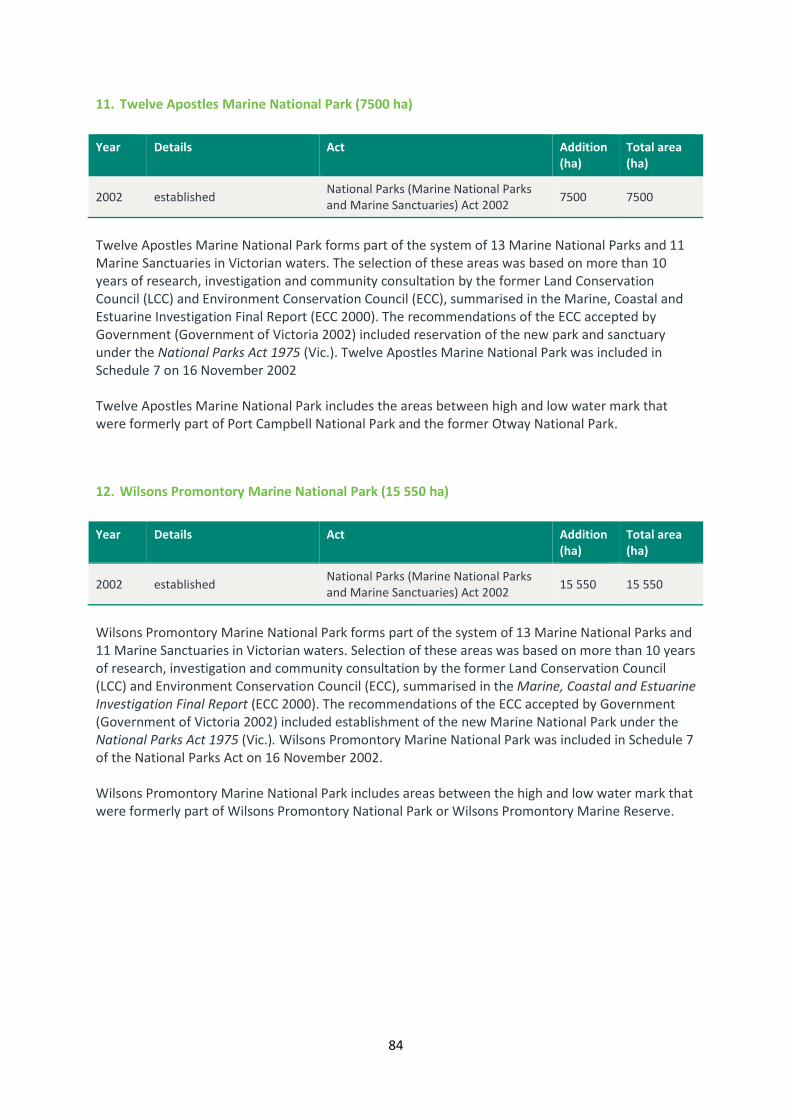
84
11. Twelve Apostles Marine National Park (7500 ha)
Year Details Act Addition
(ha)
Total area
(ha)
2002 established National Parks (Marine National Parks
and Marine Sanctuaries) Act 2002 7500 7500
Twelve Apostles Marine National Park forms part of the system of 13 Marine National Parks and 11
Marine Sanctuaries in Victorian waters. The selection of these areas was based on more than 10
years of research, investigation and community consultation by the former Land Conservation
Council (LCC) and Environment Conservation Council (ECC), summarised in the Marine, Coastal and
Estuarine Investigation Final Report (ECC 2000). The recommendations of the ECC accepted by
Government (Government of Victoria 2002) included reservation of the new park and sanctuary
under the National Parks Act 1975 (Vic.). Twelve Apostles Marine National Park was included in
Schedule 7 on 16 November 2002
Twelve Apostles Marine National Park includes the areas between high and low water mark that
were formerly part of Port Campbell National Park and the former Otway National Park.
12. Wilsons Promontory Marine National Park (15 550 ha)
Year Details Act Addition
(ha)
Total area
(ha)
2002 established National Parks (Marine National Parks
and Marine Sanctuaries) Act 2002 15 550 15 550
Wilsons Promontory Marine National Park forms part of the system of 13 Marine National Parks and
11 Marine Sanctuaries in Victorian waters. Selection of these areas was based on more than 10 years
of research, investigation and community consultation by the former Land Conservation Council
(LCC) and Environment Conservation Council (ECC), summarised in the Marine, Coastal and Estuarine
Investigation Final Report (ECC 2000). The recommendations of the ECC accepted by Government
(Government of Victoria 2002) included establishment of the new Marine National Park under the
National Parks Act 1975 (Vic.). Wilsons Promontory Marine National Park was included in Schedule 7
of the National Parks Act on 16 November 2002.
Wilsons Promontory Marine National Park includes areas between the high and low water mark that
were formerly part of Wilsons Promontory National Park or Wilsons Promontory Marine Reserve.

85
13. Yaringa Marine National Park (980 ha)
Year Details Act Addition
(ha)
Total area
(ha)
2002 established National Parks (Marine National Parks
and Marine Sanctuaries) Act 2002 980 980
Yaringa Marine National Park forms part of the system of 13 Marine National Parks and 11 Marine
Sanctuaries in Victorian waters. The selection of these areas was based on more than 10 years of
research, investigation and community consultation by the former Land Conservation Council (LCC)
and Environment Conservation Council (ECC), summarised in the Marine, Coastal and Estuarine
Investigation Final Report (ECC 2000). The recommendations of the ECC accepted by Government
(Government of Victoria 2002) included reservation of the new parks under the National Parks Act
1975 (Vic.). The Park was included on Schedule 7 of the National Parks Act on 16 November 2002.
Yaringa Marine National Park includes areas between the high and low water mark that were
formerly part of the North Western Port Nature Conservation Reserve.

86
MARINE SANCTUARIES
Schedule EIGHT
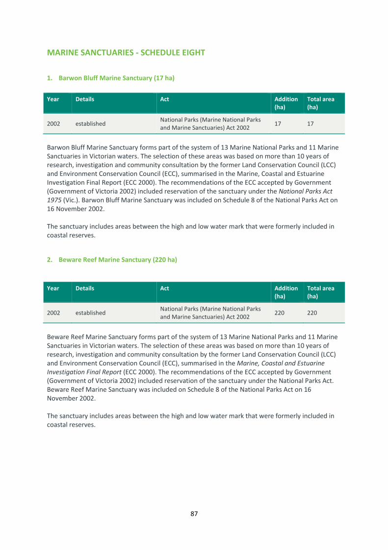
87
MARINE SANCTUARIES - SCHEDULE EIGHT
1. Barwon Bluff Marine Sanctuary (17 ha)
Year Details Act Addition
(ha)
Total area
(ha)
2002 established National Parks (Marine National Parks
and Marine Sanctuaries) Act 2002 17 17
Barwon Bluff Marine Sanctuary forms part of the system of 13 Marine National Parks and 11 Marine
Sanctuaries in Victorian waters. The selection of these areas was based on more than 10 years of
research, investigation and community consultation by the former Land Conservation Council (LCC)
and Environment Conservation Council (ECC), summarised in the Marine, Coastal and Estuarine
Investigation Final Report (ECC 2000). The recommendations of the ECC accepted by Government
(Government of Victoria 2002) included reservation of the sanctuary under the National Parks Act
1975 (Vic.). Barwon Bluff Marine Sanctuary was included on Schedule 8 of the National Parks Act on
16 November 2002.
The sanctuary includes areas between the high and low water mark that were formerly included in
coastal reserves.
2. Beware Reef Marine Sanctuary (220 ha)
Year Details Act Addition
(ha)
Total area
(ha)
2002 established National Parks (Marine National Parks
and Marine Sanctuaries) Act 2002 220 220
Beware Reef Marine Sanctuary forms part of the system of 13 Marine National Parks and 11 Marine
Sanctuaries in Victorian waters. The selection of these areas was based on more than 10 years of
research, investigation and community consultation by the former Land Conservation Council (LCC)
and Environment Conservation Council (ECC), summarised in the Marine, Coastal and Estuarine
Investigation Final Report (ECC 2000). The recommendations of the ECC accepted by Government
(Government of Victoria 2002) included reservation of the sanctuary under the National Parks Act.
Beware Reef Marine Sanctuary was included on Schedule 8 of the National Parks Act on 16
November 2002.
The sanctuary includes areas between the high and low water mark that were formerly included in
coastal reserves.

88
3. Eagle Rock Marine Sanctuary (17 ha)
Year Details Act Addition
(ha)
Total area
(ha)
2002 established National Parks (Marine National Parks
and Marine Sanctuaries) Act 2002 17 17
Eagle Rock Marine Sanctuary forms part of the system of 13 Marine National Parks and 11 Marine
Sanctuaries in Victorian waters. The selection of these areas was based on more than 10 years of
research, investigation and community consultation by the former Land Conservation Council (LCC)
and Environment Conservation Council (ECC), summarised in the Marine, Coastal and Estuarine
Investigation Final Report (ECC 2000). The recommendations of the ECC accepted by Government
(Government of Victoria 2002) included reservation of the sanctuary under the National Parks Act
1975 (Vic.). Eagle Rock Marine Sanctuary was included on Schedule 8 of the National Parks Act on 16
November 2002.
The sanctuary includes areas between the high and low water mark that were formerly included in
coastal reserves.
4. Jawbone Marine Sanctuary (30 ha)
Year Details Act Addition
(ha)
Total area
(ha)
2002 established National Parks (Marine National Parks
and Marine Sanctuaries) Act 2002 30 30
Jawbone Marine Sanctuary forms part of the system of 13 Marine National Parks and 11 Marine
Sanctuaries in Victorian waters. Selection of these areas was based on more than 10 years of
research, investigation and community consultation by the former Land Conservation Council (LCC)
and Environment Conservation Council (ECC), summarised in the Marine, Coastal and Estuarine
Investigation Final Report (ECC 2000). The recommendations of the ECC accepted by Government
(Government of Victoria 2002) included reservation of the new parks and sanctuaries under the
National Parks Act 1975 (Vic.). Jawbone Marine Sanctuary was included on Schedule 8 of the
National Parks Act on 16 November 2002.
The sanctuary includes areas to high water mark that were formerly part of Jawbone Flora and
Fauna Reserve. The Reserve was created in 1990 after the Merrett Rifle Range was decommissioned
in 1986. For the 110 years during the operation of the rifle range, public coastal access was
prohibited for safety reasons, and the marine flora and fauna and coastal vegetation along with
important habitat for migratory and local seabirds and shorebirds were fortuitously protected from
human disturbance.

89
5. Marengo Reefs Marine Sanctuary (12 ha)
Year Details Act Addition
(ha)
Total area
(ha)
2002 established National Parks (Marine National Parks
and Marine Sanctuaries) Act 2002 12 12
Marengo Reefs Marine Sanctuary forms part of a representative system of 13 Marine National Parks
and 11 Marine Sanctuaries in Victorian waters. The selection of these areas was based on more than
10 years of research, investigation and community consultation by the former Land Conservation
Council (LCC) and Environment Conservation Council (ECC), summarised in the Marine, Coastal and
Estuarine Investigation Final Report (ECC 2000). The recommendations of the ECC accepted by
Government (Government of Victoria 2002) included reservation of the new parks and sanctuaries
under the National Parks Act. Marengo Reefs Marine Sanctuary was included on Schedule 8 of the
National Parks Act 1975 (Vic.) on 16 November 2002.
The sanctuary includes areas between the high and low water mark that were formerly included in
coastal reserves.
6. Merri Marine Sanctuary (25 ha)
Year Details Act Addition
(ha)
Total area
(ha)
2002 established National Parks (Marine National Parks
and Marine Sanctuaries) Act 2002 25 25
Merri Marine Sanctuary forms part of the system of 13 Marine National Parks and 11 Marine
Sanctuaries in Victorian waters. The selection of these areas was based on more than 10 years of
research, investigation and community consultation by the former Land Conservation Council (LCC)
and Environment Conservation Council (ECC), summarised in the Marine, Coastal and Estuarine
Investigation Final Report (ECC 2000). The recommendations of the ECC accepted by Government
(Government of Victoria 2002) included reservation of the new parks and sanctuaries under the
National Parks Act 1975 (Vic.). Merri Marine Sanctuary was included on Schedule 8 of the National
Parks Act on 16 November 2002.
Merri Marine Sanctuary includes areas between the high and low water mark that were formerly
part of the Thunder Point Coastal Reserve.

90
7. Mushroom Reef Marine Sanctuary (80 ha)
Year Details Act Addition
(ha)
Total area
(ha)
2002 established National Parks (Marine National Parks
and Marine Sanctuaries) Act 2002 80 80
Mushroom Reef Marine Sanctuary forms part of the system of 13 Marine National Parks and 11
Marine Sanctuaries in Victorian waters. The selection of these areas was based on more than 10
years of research, investigation and community consultation carried out by the former Land
Conservation Council (LCC) and Environment Conservation Council (ECC) and summarised in the
Marine, Coastal and Estuarine Investigation Final Report (ECC 2000). The recommendations of the
ECC accepted by Government (Government of Victoria 2002) included reservation of the new parks
and sanctuaries under the National Parks Act 1975 (Vic.). Mushroom Reef Marine Sanctuary was
included on Schedule 8 of the National Parks Act on 16 November 2002.
The sanctuary includes areas between the high and low water mark that were formerly part of the
Mornington Peninsula National Park.
8. Point Cook Marine Sanctuary (290 ha)
Year Details Act Addition
(ha)
Total area
(ha)
2002 established National Parks (Marine National Parks
and Marine Sanctuaries) Act 2002 290 290
Point Cooke Marine Sanctuary forms part of the system of 13 Marine National parks and 11 Marine
Sanctuaries in Victorian waters. The selection of these areas was based on more than 10 years of
research, investigation and community consultation carried out by the former Land Conservation
Council (LCC) and Environment Conservation Council (ECC) and summarised in the Marine, Coastal
and Estuarine Investigation Final Report (ECC 2000). The recommendations of the ECC accepted by
Government (Government of Victoria 2002) included reservation of the new parks and sanctuaries
under the National Parks Act 1975 (Vic.). Point Cooke Marine Sanctuary was included on Schedule 8
of the National Parks Act on 16 November 2002.
The area of the sanctuary south of Point Cooke was originally gazetted as the Point Cook Marine
Reserve in 1982 and then gazetted as the Point Cook Fisheries Reserve in 1998.

91
9. Point Danger Marine Sanctuary (25 ha)
Year Details Act Addition
(ha)
Total area
(ha)
2002 established National Parks (Marine National Parks
and Marine Sanctuaries) Act 2002 25 25
Point Danger Marine Sanctuary forms part of the system of 13 Marine National Parks and 11 Marine
Sanctuaries in Victorian waters. The selection of these areas was based on more than 10 years of
research, investigation and community consultation by the former Land Conservation Council (LCC)
and Environment Conservation Council (ECC), summarised in the Marine, Coastal and Estuarine
Investigation Final Report (ECC 2000). The recommendations of the ECC accepted by Government
(Government of Victoria 2002) included reservation of the new park and sanctuaries under the
National Parks Act 1975 (Vic.). Danger Marine Sanctuary was included on Schedule 8 on 16
November 2002.
The sanctuary includes areas between the high and low water mark that were formerly included in
coastal reserves.
10. Ricketts Point Marine Sanctuary (115 ha)
Year Details Act Addition
(ha)
Total area
(ha)
2002 established National Parks (Marine National Parks
and Marine Sanctuaries) Act 2002 115 115
Ricketts Point Marine Sanctuary forms part of the system of 13 Marine National parks and 11 Marine
Sanctuaries in Victoria waters. Selection of these areas was based on more than 10 years of
research, investigation and community consultation by the former Land Conservation Council (CLCC)
and Environment Conservation Council (ECC), summaries in the Marine, Coastal and Estuarine
Investigation Final Report (ECC 2000). The recommendations of the ECC accepted by Government
(Government of Victoria 2002) included reservation of the new parks and sanctuaries under the
National Parks Act 1975 (Vic.). Ricketts Point Marine Sanctuary was included on Schedule 8 of the
National Parks Act on 16 November 2002.
The sanctuary varies from the ECC recommended area (ECC 2000) in that the boundary near Table
Tock Point includes near-shore reefs but excluded boat-based recreational fishing spots near Sparks
Street and the jetty outside the Sea Scouts Hall.
The sanctuary includes areas to high water mark that were formerly part of Sandringham Beach
Park.

92
11. The Arches Marine Sanctuary (45 ha)
Year Details Act Addition
(ha)
Total area
(ha)
2002 established National Parks (Marine National Parks
and Marine Sanctuaries) Act 2002 45 45
The Arches Marine Sanctuary forms part of the system of 13 Marine National Parks and 11 Marine
Sanctuaries in Victorian waters. The selection of these areas was based on more than 10 years of
research, investigation and community consultation by the former Land Conservation Council (LCC)
and Environment Conservation Council (ECC), summarised in the Marine, Coastal and Estuarine
Investigation Final Report (ECC 2000). The recommendations of the ECC accepted by Government
(Government of Victoria 2002) included reservation of the new park and sanctuary under the
National Parks Act 1975 (Vic.). The Arches Marine Sanctuary in Schedule 8, of the National Parks Act
on 16 November 2002.
The sanctuary includes areas between the high and low water mark that were formerly included in
coastal reserves.

93
Appendix 1 Guide to former names of parks
Former names for National Park Act parks – by current park name
Current Park
Year
Established Former Park Name
Year
Established
Alpine National Park 1989 Bogong National Park 1981
Alpine National Park 1989 Cobberas-Tingaringy National Park 1986
Alpine National Park 1989 Tingaringy National Park 1978
Alpine National Park 1989 Wabonga Plateau State Park 1981
Alpine National Park 1989 Wonnangatta-Moroka National Park 1981
Arthurs Seat State Park 1988 Nepean State Park 1978
Barmah National Park 2010 Barmah State Park 1987
Beechworth Historic Park 1994 Beechworth Park 1980
Chiltern-Mt Pilot National
Park 2002 Chiltern Box-Ironbark National Park 1997
Chiltern-Mt Pilot National
Park 2002 Chiltern State Park 1980
Churchill National Park 1944 Dandenong National Park 1941
Coopracambra National Park 1988 Coopracambra State Park 1979
Croajingolong National Park 1979 Captain James Cook National Park 1969
Croajingolong National Park 1979 Mallacoota Inlet National Park 1909
Croajingolong National Park 1979 Wingan Inlet National Park 1909
Dandenong Ranges National
Park 1987 Fern Tree Gully National Park 1928
French Island National Park 1997 French Island State Park 1982
Great Otway National Park 2005 Angahook-Lorne State Park 1987
Great Otway National Park 2005 Calisle State Park 1988
Great Otway National Park 2005 Melba Gullt State Park 1978
Great Otway National Park 2005 Otway National Park 1981
Greater Bendigo National
Park 2002 Kamarook State Park 1986
Greater Bendigo National
Park 2002 Whipstick State Park 1986
Hattah-Kulkyne National
Park 1980 Hattah Lakes National Park 1960
Kara Kara National Park 2002 Kara Kara State Park 1986
Kara Kara National Park 2013 St Arnaud Range National Park 2002
Kinglake National Park 1928 Yea River Park 1980
Lake Eildon National Park 1997 Eildon State Park 1980
Lake Eildon National Park 1997 Fraser National Park 1957
Mitchell River National park 1986 Glenalagale National Park 1963
Mornington Peninsula
National Park 1994 Cape Schanck Coastal park 1975
Murray-Sunset National Park 1991 Pink Lakes State Park 1979
Paddys Ranges State Park 1991 Paddy Ranges State Park 1989
Point Nepean National Park 1995 Mornington Peninsula National Park 1995
Point Nepean National Park 1995 Nepean State Park 1978

94
Current Park
Year
Established Former Park Name
Year
Established
Point Nepean National Park 1995 Point Nepean National Park 1988
Reef Hills State Park 2002 reef Hill Park 1986
Tarra-Bulga National park 1986 Bulga National Park 1904
Tarra-Bulga National park 1986 Tarra Valley National Park 1909
Terrick Terrick National Park 1999 Terrick Terrick State Park 1988
The Lakes National Park 1956 Sperm Whale Head National Park 1927
Warby-Ovens National Park 2010 Warby Range State Park 1978
Woodlands historic Park 1995 Woodlands 1981
Former names of National Park Act parks – by former park name
Former Park Name
Year
Established Current Park
Year
Established
Angahook-Lorne State Park 1987 Great Otway National Park 2005
Barmah State Park 1987 Barmah National Park 2010
Beechworth Park 1980 Beechworth Historic Park 1994
Bogong National Park 1981 Alpine National Park 1989
Bulga National Park 1904 Tarra-Bulga National Park 1986
Calisle State Park 1988 Great Otway National Park 2005
Cape Schanck Coastal Park 1975 Mornington Peninsula National Park 1994
Captain James Cook
National Park 1969 Croajingolong National Park 1979
Chiltern Box-Ironbark
National Park 1997 Chiltern-Mt Pilot National Park 2002
Chiltern State Park 1980 Chiltern-Mt Pilot National Park 2002
Cobberas-Tingaringy
National Park 1986 Alpine National Park 1989
Coopracambra State park 1979 Coopracambra National Park 1988
Dandenong National Park 1941 Churchill National Park 1944
Eildon State Park 1980 Lake Eildon National Park 1997
Fern Tree Gully National Park 1928 Dandenong Ranges National Park 1987
Fraser National Park 1957 Lake Eildon National Park 1997
French Island State Park 1982 French Island National Park 1997
Glenalagale National Park 1963 Mitchell River National park 1986
Hattah Lakes National Park 1960 Hattah-Kulkyne National Park 1980
Kamarook State Park 1986 Greater Bendigo National Park 2002
Kara Kara State Park 1986 Kara Kara National Park 2002
Mallacoota Inlet National
Park 1909 Croajingolong National Park 1979
Melba Gully State Park 1978 Great Otway National Park 2005
Mornington Peninsula
National Park 1995 Point Nepean National Park 1995
Nepean State Park 1978 Arthurs Seat State Park 1988
Nepean State Park 1978 Point Nepean National Park 1995

95
Former Park Name
Year
Established Current Park
Year
Established
Otway National Park 1981 Great Otway National Park 2005
Paddy Ranges State Park 1989 Paddys Ranges State Park 1991
Pink Lakes State Park 1979 Murray-Sunset National Park 1991
Point Nepean National Park 1988 Point Nepean National Park 1995
Reef Hill Park 1986 Reef Hills State Park 2002
Sperm Whale Head National
Park 1927 The Lakes National Park 1956
St Arnaud Range National
Park 2002 Kara Kara National Park 2013
Tarra Valley National Park 1909 Tarra-Bulga National Park 1986
Terrick Terrick State Park 1988 Terrick Terrick National Park 1999
Tingaringy National Park 1978 Alpine National Park 1989
Wabonga Plateau State Park 1981 Alpine National Park 1989
Warby Range State Park 1978 Warby-Ovens National Park 2010
Whipstick State Park 1986 Greater Bendigo National Park 2002
Wingan Inlet National Park 1909 Croajingolong National Park 1979
Wonnangatta-Moroka
National Park 1981 Alpine National Park 1989
Woodlands 1981 Woodlands Historic Park 1995
Yea River Park 1980 Kinglake National Park 1928