creating new landscapes and ecosystems
TRANSCRIPT

Creating New Landscapes and Ecosystems
The Alberta Oil Sands
E.A. Johnsona and K. Miyanishib
aBiogeoscience Institute and Department of Biological Sciences, University of Calgary,Calgary, Alberta, Canada
bDepartment of Geography, University of Guelph, Ontario, Canada
Extraction of oil from the Alberta Oil Sands through surface mining involves the removalof the overburden and oil sand to a depth of up to 100 m and over extremely large areas.While the operation of the bitumen processing plants has serious environmental impactson downstream habitats, this article focuses on the reclamation of areas from whichthe oil sands have been removed, processed, and returned. This reclamation followingclosure of the mines will entail the complete re-creation of landforms and ecosystemsat a landscape scale, with the goal of producing suitable habitats for plants, animals,and people. Such projects will require a reasonable understanding of the geophysicaland ecological processes that operate at a wide range of scales. Some information isprovided on the climate, hydrology, vegetation, and land use (past and current) of theOil Sands area, situated within the Boreal Plain ecozone, to provide a framework fordiscussion of issues to be addressed in, and proposed guidelines for, such large-scalereclamation. Although none of the mines has yet closed, numerous consultant reportshave been produced with recommendations for various aspects of such reclamationprojects (e.g., wetland hydrology, vegetation, wildlife habitat). The scientific basis ofsuch reports is found to vary with respect to depth of understanding of the relevantprocesses.
Key words: restoration; surface mining; tailings; ecohydrology; boreal forest; wetlands;peatlands; landscape ecology; oil development; heavy oil; meromictic lakes; naturaldisturbance paradigm
Introduction
Conservation biology and restoration ecol-ogy have for decades tried to alert us to prob-lems and provide solutions based on some sci-ence, expert opinion, experience, and a logicalfeeling for the ecological system. Most conser-vation and restoration efforts have been focusedon single species, particularly mammals, birds,and plants, specific taxonomic assemblages(e.g., neotropical migrants), or certain habitats(e.g., wetlands). Nothing is wrong with this ap-proach, but it presents obvious limitations when
Address for correspondence: E.A. Johnson, Department of BiologicalSciences, University of Calgary, Calgary, AB T2N 1N4, Canada. Voice:+1-403-220-7635; fax: +1-403-289-9311. [email protected]
large-scale impacts are contemplated or car-ried out. Despite landscape ecology’s attemptsat pattern analysis in landscapes and conser-vation biology’s recent interest in large-scaleconservation planning and strategies, the phys-ical environment template at large scales hasbeen mostly explored by ecohydrologists, geo-morphologists, biogeochemists, and meteorolo-gists/climatologists. Conservation and restora-tion at landscape scales have often assumed thatthe degradation is temporary and can be re-paired over relatively short time scales of 50 orso years. What about the creation of completelynew landscapes over time spans of 100 or moreyears?
The Alberta Oil Sands is a large-scale de-velopment that will require reconstruction of
Ann. N.Y. Acad. Sci. 1134: 120–145 (2008). C© 2008 New York Academy of Sciences.doi: 10.1196/annals.1439.007 120

Johnson & Miyanishi: Creating New Landscapes at Alberta Oil Sands 121
Figure 1. Location and distribution of oil sands in northern Alberta. Part of the Athabascadeposit has reserves shallow enough to make surface mining feasible (mineable area inblack). Oil from the deeper deposits (core deposits in gray) is removed using in situ processesinvolving steam injection through wells into the oil sand. Source: Schneider (2002).
ecosystems at the scale of whole landscapes.The heavy oil sands are located in the ColdLake, Peace River, and Athabasca regions ofnorthern Alberta (Fig. 1) and cover approxi-mately 140,000 km2, an area larger than thestate of Florida, or 23% of the Province (OilSands Consultations 2007). Prior to recent oiland forestry developments, the area of the OilSands (except some areas around Peace River)was largely unfragmented and undisturbed byEuropeans. It was still largely inhabited by in-digenous (First Nation) peoples who tried tofollow a lifestyle in which their environmentplayed an important practical and spiritual role.Development for oil extraction was begun in1967 by the Great Canadian Oil Sands Com-pany (now Suncor). There are now five leasesand several under consideration with 43,000
km2 currently under lease. Most of the areaswith underlying oil sands are also under For-est Management Agreement (FMA) leases toforestry companies (Fig. 2). Thus, since 1967and particularly in the last 20 years, oil sandsexploitation and forestry leases have been se-riously fragmenting the landscape (Schneider2002). Climate change will further complicateany changes in the future.
With improved technology, the operatingcost of producing oil sand oil has gone fromabout $35 per barrel in 1980 to $20 per bar-rel in recent years. Both the lowered cost ofproduction and the increasing price of oil (re-cently surpassing $100 per barrel) have resultedin an increased demand for this oil source. TheAlberta Oil Sands supplies one-third of the oilproduction of Canada, and Canada is the main

122 Annals of the New York Academy of Sciences
Figure 2. Boundaries of the Forest ManagementAgreement (FMA) leases in Alberta as of 2006 (grayareas). The lease labeled 2 (shown in dark gray) isheld by Alberta-Pacific, and the one labeled 4 is theCold Lake Air Weapons Range. The area labeledWBNP (north of the Oil Sands) refers to Wood Buf-falo National Park. The striped areas are classified byAlberta as the White Zone where agriculture is per-mitted and most human settlement is concentrated.Source: Alberta Sustainable Resource Development(2007).
supplier of oil to the United States (NationalEnergy Board 2007).
In Canada, the Provinces have greater con-trol over nonrenewable and renewable re-sources in their jurisdiction than does the fed-eral government, but they must share part of therevenue from these resources with the rest of thecountry. Also, as is the case with the Alberta OilSands, most of the mineral rights are owned bythe Province and leased to private companies.As mentioned previously, the Oil Sands areaincludes land traditionally used by First Nationpeoples. All but one of the First Nation bandsin northern Alberta signed a Treaty Land En-titlement Settlement Agreement in 1899 that
gave control of the land to the government andresulted in the establishment of First Nation re-serves while allowing continued use of nonre-serve crown lands for subsistence activities suchas hunting, fishing, and trapping. The reservesare under federal jurisdiction and, at present,only one First Nation group has requested andreceived federal approval for development ofan oil sands mine on its reserve (Denstedt &Jamieson 2007).
The removal of oil sands oil is by twomethods. The near-surface deposits (classifiedas “mineable” in Fig. 1) are recovered byremoving up to 100 m of surface material (over-burden) to access the oil-bearing sedimentarylayers, processing the oil sands, and then even-tually replacing the mine tailings and overbur-den. About 2 tons of oil sands are required toproduce a barrel of oil (Oil Sands Consultations2007). Deeper deposits are removed in situ bysteam assisted gravity drainage (SAGD). Bothprocesses extract bitumen (a heavy carbon-rich, hydrogen-poor hydrocarbon), which is up-graded to synthetic crude by removing carbonand sulfur and adding hydrogen. Production of1 m3 of bitumen (1 m3 = 6.29 barrels) requiresapproximately 125 and 214 m3 of natural gasand 2–4.5 and 0.2 m3 of water by mining andSAGD methods, respectively (National EnergyBoard 2007). The lower water use by SAGDis due to the 90–95% recycling of the steamwater. The chemical processes converting bi-tumen to synthetic crude oil also release SO2,NOx, and volatile organics (Golder AssociatesLtd. 2003; RWDI AIR Inc. 2005a, 2005b;Canadian Centre for Energy Information2007). In this chapter, we focus solely on min-ing of near-surface deposits for two reasons: it iscurrently responsible for most of the Oil Sandsoil production, and it is the method that hasthe most complete and long-term impact onecosystems.
The Alberta government mandates that in-dustry is to create functioning ecosystems fromthis landscape of disrupted ground and sur-face water hydrology, changed biogeochem-istry, and totally removed boreal ecosystems

Johnson & Miyanishi: Creating New Landscapes at Alberta Oil Sands 123
(Alberta Environment 1999). Given the largearea of each mine (ca. 100 km2) eventu-ally to be stripped and mined, this is nota restoration problem but the engineering ofnew ecosystems. The re-creation must achievemaintenance-free, self-sustaining ecosystemswith capabilities equivalent to or better than thepredisturbance conditions (Alberta Environ-ment 1999). Predisturbance land-use capabili-ties include timber harvesting, wildlife habitat,watershed functions, wetlands, sources of tra-ditional foods and medicinal plants, and recre-ation (Oil Sands Vegetation Reclamation Com-mittee 1998). The industry must report eachyear to both Alberta Environment and AlbertaSustainable Resource Development, and plansmust address the final land-use stakeholders’needs and consult with them.
Two points should be made clear at the out-set. First, we will not make an argument here fora return to some presettlement or more pristineenvironment, mostly because we feel that thisis probably impossible considering the issues ofboth the scale of the development and climatechange. Paleoecology has long recognized thatecosystems have never been the same throughtime but have constantly changed in composi-tion as they adjust to their changing environ-ments (Davis 1976; Williams et al. 2007). Thismakes it difficult to set benchmarks, particu-larly those based on some past or present timewith some presumed composition and environ-ment. In the past, ecosystems have been assem-bled and reassembled with relative ease in re-sponse to environmental changes. However, asis implied in the government mandate above,conditions under which natural processes areallowed to recover must be re-created and alsoecosystem services must be maintained. Thetrade-offs are as yet unknown.
Second, the time over which ecosystems havemade adjustments to major changes in the pasthas been long, not the short time over whicheconomies usually adjust to changes in markets.The re-creation of the landscape in the AlbertaOil Sands region will take a longer time thanseems to be planned—probably more than a
Figure 3. Distribution of the Boreal Plain in west-ern Canada (gray) and location of the Alberta OilSands area within the Boreal Plain. Source: Environ-ment Canada (2007).
hundred years. As mentioned, reclamation ofthe Oil Sands mined areas will not be an eco-logical restoration project but will require there-creation of the physical template and theecosystems on it.
In this chapter we will limit ourselves, as thetitle states, to discussion of the ideas and lim-ited results available on re-creating the land-scape and ecosystems on the near-surface minedeposits. Up to this time, no mines have beenclosed so no re-creation has begun althoughsome small-scale pilot studies and reclamationprojects on mine tailings have been started.Most mines will operate for up to 40 years.Further, while we are aware that the bitumenprocessing plants produce important environ-mental impacts downstream in rivers and in theairshed due to pollution as well as energy andwater use, we will not consider these here butfocus instead on the surface mining to extractbitumen.
Boreal Plain Ecosystem
The Oil Sands region is located in the NorthAmerican Boreal Plain (Fig. 3), a dissected, rel-atively flat (400–800 m asl) region that wascovered by the Laurentide ice sheet 10,000 to

124 Annals of the New York Academy of Sciences
12,000 years ago. The surficial glacial depositsare deep (30–200 m), loamy till and gravel–sandglaciofluvial and lacustrine deposits. These de-posits overlie the Mesozoic- and Cenozoic-agesedimentary rocks (largely carbonate) compris-ing most of the bedrock and containing the oildeposits. The landscape has numerous lakes,ponds, and peatlands.
The climate is subhumid and midboreal,with mean temperatures of −2 to +1◦C; sum-mers average 13 to 15◦C and winters −18 to−14◦C. Precipitation is 300 to 600 mm withabout 70% as wet precipitation. Annual poten-tial evapotranspiration is greater than precipi-tation. Potential evapotranspiration is relativelyconstant while precipitation varies from year toyear (Bothe & Abraham 1993). Stream flow islow and varies from year to year due to variablewater storage. The annual water deficit is from40 to 60 mm. Since peak precipitation occursbetween June and August when the vegetationis actively growing and transpiring, there is littlesaturated overland flow (Devito et al. 2005b).
The shape and composition of the land-scape and its climate and hydrology determinethe vegetation composition. The age of theforest is largely determined by natural distur-bances, usually insect outbreaks and wildfire.Landscapes are made up of stream courses,depressions, and ridgelines with hillslopes be-tween them. Hillslopes are generally drier atthe top and wetter at the bases due to differ-ences in the water-contributing area. The sub-strate composition (e.g., till versus glaciofluvialdeposits) determines the ease of movement ofwater through the soil. Consequently, on hill-slopes the factors of contributing area, slopeangle, and substrate transmissivity in general cre-ate moisture gradients along which vegetationis arranged, based on species’ moisture toler-ances. In the subdued landscape of the Bo-real Plain, this pattern generally determinesthe upland vegetation (Bridge and Johnson2000). Thus, on relatively nutrient-rich glacialtill hillslopes, the dry hilltops have a mixtureof aspen (Populus tremuloides Michx.) and whitespruce (Picea glauca (Moench) Voss); the mid-
slopes have white spruce and balsam fir (Abies
balsamea (L.) Mill.), while the wet basal slopeshave black spruce (Picea mariana (Mill.) B.S.P.).On the better-drained and more nutrient-poorglaciofluvial hillslopes, the dry hilltops are dom-inated by jack pine (Pinus banksiana Lamb.) andthe basal slopes by black spruce. Actual slopesare often more heterogeneous than this ideal-ized gradient because of factors, such as prox-imity of seed sources, effects of past distur-bances (see below), and variable substrate andgroundwater flow patterns.
Poorly drained lowlands are usually coveredby peat. Shrub fens are dominated by willows(Salix spp.) and sedges (Carex spp.), and forestfens by tamarack (Larix laricina (Du Roi) K.Koch) and black spruce. Patterned fens are verycommon. Bogs, which occur mostly as islandsin large fens or in small potholes, are dominatedby short black spruce and Sphagnum moss. Peat-lands cover 103,200 km2 of Alberta (16.3% ofthe land base) and are most extensive in thenorthern two-thirds of the Province (Vitt et al.
1996). They cover about 30% of the Oil Sands.Wildfires were the principal determinant of
the forest age mosaic before logging. Mostof the area burned by wildfire in the BorealPlain is caused by lightning fires (Nash & John-son 1996). These wildfires occur mostly dur-ing persistent high pressure systems that lastlonger than 10 to 15 days. The most commonpersistent high pressures are associated withthe Pacific North America pattern (Johnson& Wowchuk 1993) which is characterized byanomalous low pressure in the Gulf of Alaska,high pressure over western Canada, and lowpressure over southeastern Canada and ad-jacent United States. Over decadal scales,episodes of large area burned are associatedwith the positive mode of the Pacific DecadalOscillation (PDO) (Macias Fauria & Johnson2006; Skinner et al. 2006). The persistent posi-tive mode of the PDO since 1977 has led to anincrease in area burned compared to the verylow area burned during the immediately priorperiod 1950–1976, when the negative mode ofthe PDO was more persistent.

Johnson & Miyanishi: Creating New Landscapes at Alberta Oil Sands 125
The average fire frequency has changed atleast three times in the last 350 years due tolarge-scale climate changes related particularlyto the Little Ice Age (Bergeron & Archambault1993; Weir et al. 2000). The fire frequency hasalways been shorter than the life span of thetrees (Johnson et al. 1995; Weir et al. 2000). Theforests adjacent to and up to 50 km away fromagricultural settlements had much shorter firefrequencies in the early 1900s due to the spreadof settlement fires (Weir et al. 2000; Tchir et al.
2004). Most of the area is burned in high inten-sity crown fires that kill most of the trees andremove large amounts of the duff (F and H)layers of the soil by smoldering combustion;such duff consumption is required for goodtree regeneration (Charron & Greene 2002;Miyanishi & Johnson 2002). Both the numberand total area of unburned patches in a burnfollow a power-law relationship to the burnarea; that is, large fires have more unburnedpatches with larger areas than if they were justsmall fires scaled up (Johnson et al. 2003). Old-growth forests make up a small percentage ofthe landscape because of the relatively shortaverage interval between fires (Johnson et al.
1995).The hydrology of the Boreal Plain is com-
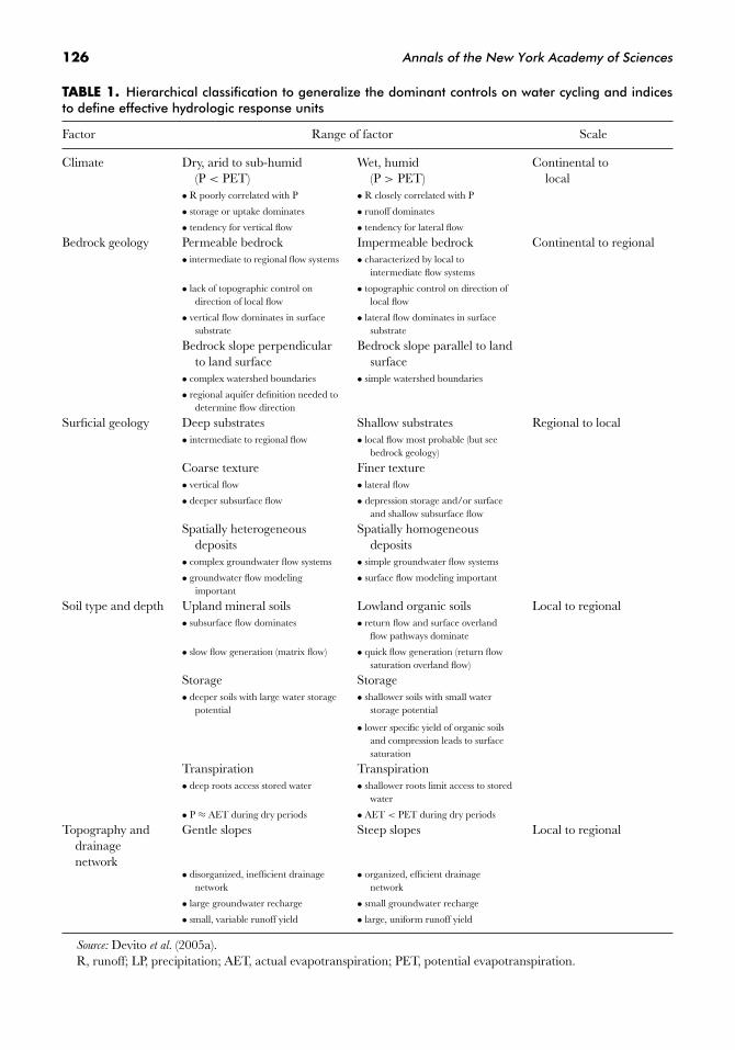
plex and does not conform easily to the usualidea of simple topographic control (Smerdonet al. 2005). The general hierarchy of factorsthat control the hydrology in the Boreal Plainis presented in Table 1 (Devito et al. 2005a). Thelow ratio of runoff to precipitation (<20%) isa result of the unsaturated (vadose) zone stor-age, evapotranspiration (precipitation < po-tential evapotranspiration), and vertical flow.The glacial substrates have important influ-ences on the hydrology. Fine texture (gener-ally glacial till) substrates have low permeabil-ity and low infiltration into the unsaturatedsurface soil; precipitation remains in the root-ing zone and so is easily lost by evapotranspi-ration. Coarse texture (generally glaciofluvial)substrates have high permeability and high in-filtration to the water table that reflects theunderlying impermeable layer which may be
bedrock or impermeable layers in the glacioflu-vial deposits.
The water budget of peatlands is determinedby their vadose zone storage capacity becauseof their more negative heat budget due to thelow thermal capacity of organic matter, the veg-etation cover, and the low lateral and verticalconductivity of the peat (Price 2003; Price et al.
2005). Peatlands account for 25 to 50% of thelandscape in the Boreal Plain (NWWG 1988).Hillslopes contribute little runoff to the peat-lands. During dry weather, water may flow fromthe peat into the mineral soil upland (Devitoet al. 1997).
Although the state of knowledge is still veryincomplete, peatlands are a major store of car-bon in the Boreal Plain (Tarnocai et al. 2005).Peatland surfaces are quite variable over rela-tively short distances, making it difficult to esti-mate the flux of carbon dioxide, methane, anddissolved (in water) carbon (Waddington et al.
1998; Waddington & Roulet 2000). However, itis clear at this time that peat moisture and tem-perature on different kinds of peat surfaces (forexample, lawns, pools, and plateaus) influencewhether carbon is stored or released (Wadding-ton & Roulet 2000). Many peatlands in the Bo-real Plain contain permafrost, which has beendegrading over the last several decades due toglobal warming (Vitt et al. 1994; Halsey et al.
1995; Camill & Clark 1998; Beilman et al. 2001;Camill 2005). As a result of water conditionsand higher net productivity of Sphagnum mosson the areas of permafrost melting, these areasbecome carbon sinks. However methane emis-sions in the decades following permafrost melt-ing offset the carbon sink (Turetsky et al. 2002).Also, wildfires may release large amounts of car-bon from peatlands, further offsetting them asa sink, particularly if peatland burning were toincrease by approximately 17% (Turetsky et al.
2002; Johansson et al. 2006).
Forestry in the Oil Sands Region
Forestry operations occur on muchof the surface of the Oil Sands region;
126 Annals of the New York Academy of Sciences
TABLE 1. Hierarchical classification to generalize the dominant controls on water cycling and indicesto define effective hydrologic response units
Factor Range of factor Scale
Climate Dry, arid to sub-humid Wet, humid Continental to(P < PET) (P > PET) local
• R poorly correlated with P • R closely correlated with P
• storage or uptake dominates • runoff dominates
• tendency for vertical flow • tendency for lateral flow
Bedrock geology Permeable bedrock Impermeable bedrock Continental to regional• intermediate to regional flow systems • characterized by local to
intermediate flow systems
• lack of topographic control ondirection of local flow
• topographic control on direction oflocal flow
• vertical flow dominates in surfacesubstrate
• lateral flow dominates in surfacesubstrate
Bedrock slope perpendicularto land surface
Bedrock slope parallel to landsurface
• complex watershed boundaries • simple watershed boundaries
• regional aquifer definition needed todetermine flow direction
Surficial geology Deep substrates Shallow substrates Regional to local• intermediate to regional flow • local flow most probable (but see
bedrock geology)
Coarse texture Finer texture• vertical flow • lateral flow
• deeper subsurface flow • depression storage and/or surfaceand shallow subsurface flow
Spatially heterogeneousdeposits
Spatially homogeneousdeposits
• complex groundwater flow systems • simple groundwater flow systems
• groundwater flow modelingimportant
• surface flow modeling important
Soil type and depth Upland mineral soils Lowland organic soils Local to regional• subsurface flow dominates • return flow and surface overland
flow pathways dominate
• slow flow generation (matrix flow) • quick flow generation (return flowsaturation overland flow)
Storage Storage• deeper soils with large water storage
potential• shallower soils with small water
storage potential
• lower specific yield of organic soilsand compression leads to surfacesaturation
Transpiration Transpiration• deep roots access stored water • shallower roots limit access to stored
water
• P ≈ AET during dry periods • AET < PET during dry periods
Topography anddrainagenetwork
Gentle slopes Steep slopes Local to regional
• disorganized, inefficient drainagenetwork
• organized, efficient drainagenetwork
• large groundwater recharge • small groundwater recharge
• small, variable runoff yield • large, uniform runoff yield
Source: Devito et al. (2005a).R, runoff; LP, precipitation; AET, actual evapotranspiration; PET, potential evapotranspiration.

Johnson & Miyanishi: Creating New Landscapes at Alberta Oil Sands 127
Figures 1 and 2 show the distribution of theoil sands and the FMA leases in northern Al-berta. These operations create a competingland-use and ecological effect. Forestry beforethe 1950s consisted of selective cutting of largeand straight trees in accessible areas adjacentto streams and rivers. In the mostly even-agedstands of the boreal forest, such harvesting doesnot lead to good regeneration. Also, before1950 there was little regulation and record ofcutting. However, logging was limited in scopeand slow because of the equipment, whichconsisted mostly of handsaws, axes, and horsehauling.
In 1948 the Province of Alberta establishedthe Green Zone, restricting agriculture fromlands that could best be used in forest pro-duction (Schneider 2002). Lands in the GreenZone were retained largely by the Province(i.e., Crown land). The Forest Act was pro-mulgated in 1949 and instituted 20-year leaseswith sustained yield as the objective. By the1950s both natural silviculture and sustained-yield forest management had been introduced.These changes were a result of some un-derstanding of the forest ecology but mostlybased on experience in regeneration, growth,and yield, and silvicultural methods that in-creased forest productivity. Forest research us-ing permanent plots and other experimentaldesigns started at this time. Sustainable forestmanagement in these early years was usuallymodeled on the regulated forest idea. In thewestern Canadian boreal, a regulated forestmanagement area is one in which all parts of theproductive forest (i.e., forests with growth ratesthat produce merchantable trees within the ro-tation age) have a specified period in whichthey will be harvested, either all at once (clear-cut) or in two passes (the faster-growing treespecies, usually pines, are cut in the first passand some years later the slower tree species,usually spruce and fir, that have been releasedand grown to mature size are cut in the secondpass). The strategy varies considerably, depend-ing on the exact combination of saw timberand pulp being managed. Overall in the reg-
ulated forest, the idea was to have the harvestnot exceed the total of the forest growth minusthe loss from natural causes (e.g., fires, insectoutbreaks) (Schneider 2002). Over time, theProvince put in place further limitations withrespect to stream and river courses, wetlands,wildlife (game), and so on.
In the 1980s two factors led to an increasein forestry leases in northern Alberta. The firstwas advancements in pulp technology that al-lowed the use of hardwood species, not justconifers. This opened pulp production to theuse of aspen. The second factor was the grow-ing world demand for pulp products (Pratt &Urquhart 1994). Also, at this time both theforestry companies’ and the provincial govern-ment’s ideas of sustainability became more in-clusive of other parts of the forest ecosystem(Alberta Forest Conservation Strategy 1997).
Alberta-Pacific’s FMA lease (Fig. 2) wasissued in 1990. Most of the Oil Sandsdevelopments are in the Alberta-Pacific leaseof 58,000 km2 (see Figs. 1 and 2). The com-pany harvests about 16,000 ha per year in theforest part of its lease and 11,000 ha per yearin the oil part of its lease. Alberta-Pacific hasimplemented an ecosystem management ap-proach to maintaining biodiversity on its lease.The forest management system is similar to theusual timber supply model used in sustainableforestry up to this time but with more (but notcomplete) spatially explicit control and the in-clusion of disturbances by fire, insects, and hu-mans (e.g., seismic lines, well sites, roads, andtimber harvesting).
Alberta-Pacific, like many other forestrycompanies in the 1990s, has used the “natu-ral disturbance hypothesis” to help it along thepath to ecosystem management (Burton et al.
2003). The natural disturbance model is sim-ply the idea that forest management should bemade to mimic natural disturbances to be moresustainable. This idea is still controversial; how-ever, some parts of it may certainly be usefulonce they are more completely tested and/orgrounded in more experience. Central to thenatural disturbance hypothesis is knowledge of

128 Annals of the New York Academy of Sciences
what the age structure of the forest, its compo-sition, and spatial pattern of different ages andcompositions should be. Once these are known,forestry operations could mimic them or, if thenatural disturbance is not completely stopped(Larsen 1997; Johnson et al. 1998; Campbell &Campbell 2000), some combination of humanand natural disturbances could be incorporatedinto the forest plan. These three characteris-tics of desired age structure, species composi-tion, and spatial patterning are by no means yetclearly articulated. Originally it was suggestedthat some presettlement state be the bench-mark, but clearly the past and future dynamicsof climate, if nothing else, make this an unwiseapproach.
To determine the age-class distribution, theprocesses that create it must be understood.This has usually been approached by under-standing how the disturbances, usually fire,caused the age distribution. If the fire frequencyhad been constant this would have been easy,but we have already learned (e.g., Weir et al.
2000) that this has not been the case. Conse-quently, over time there have been pulses ofage-classes recruited, reflecting usually periodswhen large areas burned. These pulses are aresult of the fact that 95% or more of the areaburned results from a few large fires (Johnsonet al. 1998). These pulses of large fires are associ-ated with periods of large-scale climate patternsconducive to wildfires (Macias Fauria & John-son 2006; Skinner et al. 2006). Mimicking thesepulses of age-classes is difficult under the pre-vailing goals of sustainability for fiber and thebusiness model.
The elimination of old-growth has been oneof the problems of regulated forests. The old-age tail of the forest age distribution would beeliminated in a fully regulated forest. That isto say, all of the productive forest above therotation age of approximately 80 to 100 yearswould be removed (but note that in any leaseonly part of the land-base is productive, e.g.,about 48% in Alberta-Pacific’s lease). Severalideas have been put forward on how to main-tain this old-age tail of the age distribution.
Most have involved maintaining a tail of somesort on the age distribution, even if it is notas old as some natural ones, and creating old-growth characteristics (e.g., Franklin et al. 1981)in a younger forest (Bergeron et al. 1999). Howto maintain the forest composition and biodi-versity within some range of variation that re-flects the distribution of physical site conditionsof the landscape, the climate conditions, andthe disturbance regimes is still largely an openquestion.
Oil Sands Stripping—Extractionand Engineering New Ecosystems
The strategy of engineering new ecosystemsis not to re-create the landscape as it existedbefore but to construct a landscape in whichthe physical environment of geomorphic, hy-drological, and biogeochemical processes willprovide habitat for plants, fungi, and animalsto develop and be sustainable. The first decadeshave been spent in suggesting important pro-cesses to be considered, design ideas, and gen-eral objectives of what could be done based onthe literature, previous practice elsewhere, andpreliminary results from small-scale, short-termstudies. Only a small number of these studiesare currently in the refereed literature.
In recent years this work has been primar-ily but not exclusively through two organi-zations. The Canadian Oil Sands Networkfor Research and Development (CONRAD)is a collection of industry, consultants, aca-demics, and regulatory agencies whose roleis to coordinate reclamation research and todevelop a model that will allow prediction ofecosystem development and sustainability. Inaddition, the Cumulative Environmental Man-agement Association (CEMA) is a nongovern-mental association of more than 40 industry,First Nation, government, community, health,and environmental groups who are interestedin protecting the environment of the Oil Sandsregion. CEMA has established a number ofworking groups and subgroups to look into

Johnson & Miyanishi: Creating New Landscapes at Alberta Oil Sands 129
various aspects of reclamation: NOx SO2 Man-agement Working Group, Sustainable Ecosys-tems Working Group, Reclamation WorkingGroup, Trace Metals and Air ContaminantWorking Group, and Traditional Environmen-tal Knowledge.
The overall strategy of landscape ecosystemre-creation is best understood by examiningthe Landscape Design Working Subgroup pro-posal (CEMA-RWG Landscape Design Sub-group 2005). This document gives a flowchartof landscape design (Fig. 4) as well as a de-sign checklist and goals. This strategy is to beused for landscapes yet to be developed. It doesnot give explicit information on how the land-scape is to be constructed but simply what goalsare to be achieved in the end. As an exampleof use of the checklist, a mine planner pro-poses new landforms consistent with the over-all closure plan for the lease, and the check-list is then used by the landscape design teamto attempt to satisfy each goal and to opti-mize the landscape goals in an iterative pro-cess. The development of this engineered land-scape would take several decades of design,construction, regrading, cover soiling, reveg-etation, reclamation certification, and custo-dial transfers. The checklist gives the designissues to be addressed in the planning (e.g.,technology selection, footprint—size/location,mass balances, design for closure), desired char-acteristics/goals for various ecosystem aspects(e.g., soils, vegetation, wildlife, slope stability,trafficability/bearing capacity, natural appear-ance, seepage and groundwater, surface wa-ter hydrology), and the processes (natural haz-ards and disturbing forces; erosion, transport,and sedimentation; settlement of fills). The OilSands region is at 100-km scale and includes thedisturbed landscape and the cumulative effects.Landscapes are what one can see from a vantagepoint, usually 10 to 100 km. Landscapes willtypically contain 10 to 20 landforms. The land-
form has a scale of 1 to 10 km and includes allparts of the ecosystem, both above and belowground. These definitions given in the Land-scape Design Checklist seem not to be based
on any scaling ideas from geomorphology, hy-drology, or ecosystem science.
In the Oil Sands, after the stripping of soil,peat, and surficial deposits from the underly-ing oil sands and the extraction of bitumen, thelandscape is left as very large pits up to 100m deep, dumps of mine tailings, and piles ofoverburden comprised of recent fluvial depositsand a variety of glacial deposits and bedrockformations. The mine tailings produced dur-ing bitumen extraction are a mixture of wa-ter, clay, sand, and residual bitumen. The sandis used to construct dikes to form impound-ments where the tailings are stored. The ma-ture fine tailings (MFT) left after sand removalare a stable clay/water suspension that wouldtake centuries to settle. To speed the settlingprocess, gypsum is added to bind the clay andproduce consolidated/composite tailings (CT)(Suncor Energy 2005). Thus, the end substratesfor reclamation are overburden, tailings sand,and consolidated/CT; soil and peat from theoriginal stripped sites as well as from neigh-boring undisturbed areas are mixed and usedto cover these substrates prior to revegetation(Oil Sands Vegetation Reclamation Committee1998).
The first problem is how the landscapetemplate should be constructed in order torestore/create hydrological, geomorphic, andecosystem processes that could be consideredequivalent to what was there previously. Reveg-etation is required for erosion control and slopestability as well as provision of wildlife habitat.Since successful revegetation requires sufficientwater for plant establishment, creation of func-tioning hydrological systems is fundamental toany ecosystem reconstruction (Elshorbagy et al.
2005). The results of the mining process deter-mine to some extent this strategy. The large pitscontain highly saline water which initially willserve as a treatment system. This dictates thecontributing areas of the surrounding hillslopesthat will determine the quantity and quality ofthe water. Also, the routing of the water fromthese pits through the downstream landscapesmust be considered.

130 Annals of the New York Academy of Sciences
Figure 4. Flow chart of how the Cumulative Environmental Management Association’s Landscape DesignChecklist may be used. EUB, Alberta Energy and Utilities Board; AENV, Alberta Environment; SRD, AlbertaSustainable Resource Development; EIA, Environmental impact assessment; EPEA, Environmental Protectionand Enhancement Act. Source: CEMA-RWG Landscape Design Subgroup (2005).
End Pit Lakes
An end pit lake is the final mine pit in a minedsubwatershed. The overburden and tailings willbe placed in the pit. The lake will still be pro-cessing consolidated tailings flux water, precip-itation, and surface runoff (Fig. 5). Chemicalflux will come from the reclaimed surroundingwatershed. Some water will come from created
wetlands. The end pit lake should have vegeta-tion around the perimeter and the epilimnionshould maintain levels of oxygen sufficient fornatural biodegradation of organic chemicals re-leased from the mining.
Because the end pit lake is deep (ca. 20 m)and large, it will be density stratified verticallyinto epilimnion and hypolimnion as a resultof salinity and thermal differences. Mixing of

Johnson & Miyanishi: Creating New Landscapes at Alberta Oil Sands 131
Figure 5. Conceptual model of an end pit lake: CT, consolidated tailings; MFT, mature fine tailings; TT,thickened tailings; NST, non-segregated tailings. Source: Golder Associates Ltd. (2005).
these two layers occurs in spring and fall whenwind and temperature gradients supply enoughenergy. This mixing brings oxygen-rich epil-imnion waters to the normally oxygen-poor hy-polimnion and increases biodegradation. How-ever, the hypolimnion has poor water qualitybecause of its anaerobic conditions which willshow up in the surface lake waters and in thelake runoff. The concentration and biodegrad-ing of chemicals from the mines in the lakedepend on the frequency of turnover and strat-ification; if the seepage enters the hypolimnion,it will degrade slowly. If the seepage enters theepilimnion, it will degrade more rapidly. Thepassage of water through wetlands and otherpit lakes could improve the water quality.
Starting in the 1970s there has been mod-eling of the mass balance of the volume andconcentration of chemicals in the input andoutput of end pit lakes to determine the effectsof water recycling, anaerobic and aerobic con-ditions, lake turnover, chemical degradation,oxygen depletion, groundwater seepage, andtailing consolidation. Since there are no endpit lakes at present in the Alberta Oil Sands,
the models cannot be calibrated and validated;however, the models (RMA10, DYRESM) arewidely used mass-balance systems for simula-tions in other stratified lakes (e.g., Balistrieriet al. 2006; Bruce et al. 2006; Beutel et al. 2007;Castendyk & Webster-Brown 2007).
Wetlands
In 1999, several suggestions were madein the “Landscape Design Considerations forWetland Creation” document (Leskiw 1999).Most of these were, as the title of the docu-ment states, considerations and not design re-quirements. The Landscape Design Consider-ations document presented a series of topicsthat needed to be considered. It suggested thatsome understanding was required of the ratio ofupland to wetland area and that the drainagenetwork should consist of a large number ofsmall streams compared to a few big streams.The document points out that most restorationprojects give little consideration to the need tocreate watersheds with functioning water bud-gets for the terrain, climate, and vegetation.

132 Annals of the New York Academy of Sciences
Further, the riparian and wetland areas mustprovide corridors for wildlife. The diversity ofwatersheds must also provide wetlands withvariable water-fluctuation patterns that reflectwhat might occur in this glaciated region nat-urally. The hillslopes surrounding the streamsand wetlands must have the appropriate steep-ness, aspect, substrate, and erosion potential tocreate the desired hydrological and geomorphicprocesses which, in turn, will create the desiredecosystem processes and services. All of thesesuggestions seem to take little guidance fromwhat is known about how drainage networksdevelop in both glaciated and nonglaciatedlandscapes (e.g., Knighton 1984).
Much more inclusive suggestions based onresearch in the area were presented in the doc-ument “Maintenance and Dynamics of NaturalWetlands and Western Boreal Forests: Synthesisof Current Understanding from the UtikumaResearch Study Area” (Devito & Mendoza2006). Most of the recent research on land-scape hydrology in the Boreal Plain with partic-ular reference to wetlands has been done at theUtikuma Research Study Area (URSA) by De-vito and colleagues. The URSA study was insti-tuted to understand the impact of forestry andthe oil industry on Boreal Plain catchments.This research has indicated that the groundwa-ter and surface water interaction is more com-plicated than traditional topographic-based hy-drological models have suggested (Devito et al.
2005a). With the subhumid climate and rolling(low-relief) glaciated topography of the Bo-real Plain, vertical water flow is a more im-portant process than lateral flow on hillslopes(Rodriguez-Iturbe 2000; Winter 2001b); unsat-urated zone capacity and evapotranspirationare key factors driving this dominance of thevertical flow.
The guidelines that were developed from theURSA research offer the Oil Sands mining astrategy for landform construction and wetlandmaintenance (Devito & Mendoza 2006). Theapproach is to use natural analogs or, in otherwords, to try to follow the previous hydrolog-ical patterns and processes in the area. Note
that this natural analog is not intended to re-construct exactly the previous landscapes orwatersheds but to give some idea of the kindof watersheds that can be constructed, whatmay develop naturally from certain constructedlandforms, and what their spatial arrangementscould be in order to facilitate hydrological inter-actions in the landscape. Three preliminary ba-sic conceptual models of hydrological behaviorwere proposed by Devito and Mendoza (2006)as a basis for the design of reconstructed land-scapes at Oil Sands mines based on substratetexture.
1. Fine-grained deposits—overburden andMFT analog (Fig. 6A). Depressions in thislandscape will generally be saturated andform wetlands. However, these depres-sions will tend to be isolated, thereforehaving limited conductivity and only lo-cal flow patterns. The wetlands are oftenperched on topographic highs and maylocally provide areas of recharge downs-lope. Wetlands on flat terrain will requirepeat to retain water on the landscape.
2. Coarse-grained deposits—sand tailingsanalog (Fig. 6B). On upland areas, wet-lands will only persist where fine-grainedconfining layers are present and can ef-fectively seal the depression. These de-pressions are not attached to the regionalgroundwater and form isolated systems.Low areas will tend to be well connectedto regional flow patterns; these will haverelatively constant water levels because oftheir connection to a consistent ground-water supply. These catchment areas canbe quite large, depending on the size ofthe coarse-grained deposit.
3. Coarse-grained veneer on fine-graineddeposits—consolidated/CT analog (Fig.6C). Groundwater flow will be near thesurface and responsive to climate in thissystem. Depressions and wetlands will bebetter connected often by shallow ground-water movement.

Johnson & Miyanishi: Creating New Landscapes at Alberta Oil Sands 133
Figure 6. Conceptual model of dominant storage and water flow within the subhumidclimate of the western Boreal Plain for: A) fine-grained deposits; B) coarse-grained deposits;and C) coarse-grained veneer on fine-grained deposits. P, precipitation; ET, evapotranspira-tion; E, evaporation; OLF, overland flow; SSSF, subsurface storage flow; GrW groundwater.Source: Devito & Mendoza (2006).

134 Annals of the New York Academy of Sciences
Figure 7. Plan of the three constructed slopes (D1, D2, and D3) on a reclaimed overbur-den pile at the Mildred Lake Mine in northern Alberta used to test sustainability of differentreclamation strategies. Source: Elshorbagy et al. (2005).
Upland Hillslopes Hydrology
In 1999 Syncrude Canada Ltd. started aproject to re-create watersheds at their MildredLake Mine (Elshorbagy et al. 2005). The projectconsists of studies of what are thought to be theprincipal integrated hydrological mechanismsresponsible for hillslope moisture and thus veg-etation recovery. Three north-facing hillslopeswere constructed atop level terrain with areasof 1 ha (200 m × 50 m) and slopes of 5:1 (Fig. 7).Slope D1 has a 30 cm till layer over the over-burden of shale and a 20 cm peat layer, D2has 20 cm of till and 15 cm of peat, and D3 has80 cm of till and 20 cm of peat (this treatment isapproximately the Alberta Environment 1995requirement). The slopes were seeded with bar-ley and planted with white spruce and aspenseedlings in June 1999. Soil moisture, soil tem-perature, and soil metric potential were mea-sured at midslope and at several depths oneach hillslope. Also at midslope, relative humid-ity, air temperature, wind speed and direction,dew point, temperature, soil surface tempera-ture, soil temperature gradient, net radiation,and ground heat flux were measured. Over-land flow from each hillslope was determined
at a 60◦ V-notch in the gully at the base ofthe slopes. A sample system also collected wa-ter from the peat and till only (i.e., above theoverburden of shale) at the toe of each slope.
The data from 2000 to 2004 were used in alumped parameter hydrological process model(Fig. 8) that involved feedback loops of water inand between surface, peat, till, and shale layers(Elshorbagy et al. 2005). Major steps of the mod-eling involved understanding the system and itsboundaries, identifying the key variables, repre-senting the physical processes through govern-ing equations, mapping the model structure,and simulating the system to understand its be-havior. In the model, surface water dependson the amount available as precipitation, sur-face overland flow, and infiltration into the peatlayer. Peat (till) moisture depends on inter-flow,evapotranspiration, and infiltration into the till(shale) layer. The model assumes that the shalelayer does not contribute water to the chan-nel at the base of the slope; that is, the waterbudget is determined by flow from the peatand till hillslope only. Interflow is determinedby the hydrologic conductivity, volumetric wa-ter content, hydrologic gradient, and soil type.Infiltration is determined by soil temperature,

Johnson & Miyanishi: Creating New Landscapes at Alberta Oil Sands 135
Figure 8. Illustration of the hydrologic process model involving feedback loops of waterin and between surface, peat, till, and shale layers. The + sign near the arrowheads indicatethat variables at either end change in the same direction, while the − sign indicates theconverse. + or − signs within loops indicate whether the loops are positive or negative.Source: Elshorbagy et al. (2005).
hydrologic conductivity differences betweenand in each layer, and volumetric water con-tent. Evapotranspiration is determined by soilmoisture and atmospheric parameters. Themodel simulates daily hydrologic processes.The model was calibrated using 2001 data andvalidated using 2003 data. Since some of thesystem parameters, such as saturated hydraulicconductivity, are not time invariant, each yearthe model parameters were tuned to that year’ssoil moisture in each layer and the outflow. Thiswas required because the hillslopes are chang-ing over the short term and these changes inparameters were not known a priori.
The results of this modeling exercise wereuseful in understanding the changes occurringin the hillslopes immediately after their cre-ation and the hillslopes’ responses to the dif-ferent treatments. The model best fit the datain hillslopes D3 and D1, the hillslopes with thedeepest peat and till layers. This is reflected
in the mean relative error (MRE) of 3 to 8%and 5 to 9%, respectively. D2, the hillslope withthe thinnest layers, performed the poorest, withMRE of 11 to 21%. The evolution of the pa-rameters may be due to the drought conditionsduring the study period, changes in hillslopeparameters, and, of course, the structure of themodel used. D3 had the largest changes in pa-rameters but also the highest growth of vegeta-tive biomass. The changes in hillslope parame-ters may be related to changes in till infiltrationfrom the peat perhaps due to decompositionand compaction of the peat and changes inshale infiltration due to changes in hydraulicconductivity caused by freeze-thaw cycles. D3had the lowest moisture stress and was followedby D1 and D2 with the highest moisture stressduring the study period.
The model can be used to test the ability ofthe system to hold water and minimize deeppercolation to the shale layer under varying

136 Annals of the New York Academy of Sciences
moisture conditions, estimate water tempo-rally available for primary production, and de-termine conditions leading to system failure(Elshorbagy et al. 2005). This model cannot,and was not intended to, describe long-termdynamics of these hillslopes; it simply gives ashort-term understanding of the processes con-trolling soil moisture under these three treat-ments. Notice that these are not watersheds inthat they do not consist of several hillslopes,streams, and wetlands.
Vegetation Re-creation
The strategy for reclaiming the vegetationwas proposed in the Land Capability Classifi-cation System for Forest Ecosystems (AlbertaEnvironment 1998) and by the Oil Sands Veg-etation Reclamation Committee (1998). Theseevolving strategies are to determine the prin-cipal environmental gradients determining thenatural vegetation composition. The analysis ofthe vegetation gradients is to provide species in-dicators and environmental conditions towardwhich site trajectories should develop. Finally,this understanding of vegetation patterns andtolerances could help in the choice of overstoryand understory plant species to be planted.
The vegetation and environmental gradientswere determined from previous boreal mixed-wood studies (Beckingham & Archibald 1996).Figure 9 gives the summary of both Becking-ham and Archibald’s gradient analysis and theconceptual model of the conditions limiting indifferent parts of the moisture and nutrient gra-dients (Geographic Dynamics Corp. 2002). In-dicator tree and shrub species were found usingDufrene and Legendre (1997). From the or-dination diagrams and species tolerances, po-tential prescriptions have been developed forthe plants best suited for different reclaimedsites. Furthermore, since the understanding ap-pears to be that the vegetation will developalong certain successional pathways (e.g., tothe climax white spruce–balsam fir forest foruplands) (Smith & Ottenbreit 1998), the rec-
ommendation has been to plant species thatare believed to represent different successionalstages to ensure that, as succession proceeds,the later successional species would be availablefor colonization (Oil Sands Vegetation Recla-mation Committee 1998). The underlying gen-eral model of succession presented to the Soiland Vegetation Subgroup of CEMA is givenin Figure 10. The successional pathways can-not be derived from the gradient analysis studybut are generally inferred from chronosequencestudies. However, as explained previously (seeBoreal Plain Ecosystem section), the moisture–nutrient gradients and the upland plant com-munities associated with positions along thesegradients in the Boreal Plain have been shownto be linked to substrate and hillslope positionrather than to time since the last disturbance(Bridge & Johnson 2000).
Some reclamation projects on the tailingssand dikes and overburden dumps have takenplace since 1971 at Suncor and 1976 at Syn-crude (Anderson et al. 1998). Initially, the fo-cus was on erosion control and the areas wereseeded with grasses and legumes. While suc-cessful in achieving this goal, the subsequentshift in objectives from erosion control to de-velopment of self-sustaining ecosystems equiv-alent to predisturbance conditions required achange in reclamation methods since the suc-cessful establishment and growth of grasses in-hibited tree establishment.
In 2000, a system of long-term monitoringplots was established in both natural and re-claimed sites. These monitored sites are to pro-vide a numerical index that can be used toevaluate vegetation and soil/landscape proper-ties. The soil/landscape properties used are soilmoisture and nutrients (pH, soil structure andconsistency, electrical conductivity, and sodiumabsorption ratio) in the soil horizons. Thesesites are divided into capacity classes with re-spect to forest productivity even though this isnot established at this time. This approach isthus seen at present as a site evaluation andreclamation tool only.

Johnson & Miyanishi: Creating New Landscapes at Alberta Oil Sands 137
Figure 9. Distribution of conceptual site types and associated ecosites on the moisture–nutrient regime grid for the Oil Sands area on the Boreal Plain. Source: Geographic DynamicsCorp. (2006).
Wildlife Habitat
Restoration of wildlife in the mined areas isprimarily a matter of creating suitable habitat.These are usually defined as the pattern of up-land and lowland vegetation, connectivity ofthis pattern, the role of disturbances (particu-larly fire) on the age of the forest, and finallythe understory structure and shrub composi-tion. The habitat patterns of particular interest
are those of certain indicator organisms, such ascaribou, moose, fisher, lynx, muskrat, and old-growth birds (Axys Environmental ConsultingLtd. 2003). Again, as we’ve seen above, sugges-tions are made based on what is known aboutthe natural history of the indicator species andwhat kinds of habitat and their patterns couldbe required. However, there are limited stud-ies at the scale at which Oil Sands mining willoccur.

138 Annals of the New York Academy of Sciences
Figure 10. Understanding of succession to climax as given in a report to the Oil Sands Soil andVegetation Working Group. Source: Geographic Dynamics Corp. (2002).
Discussion
The development of the Oil Sands has in-creased rapidly in the last decade as the priceand demand for oil have increased. The speedof development has meant that studies can-not be carried out to see if the proposed re-creation methods will, in fact, work over thelong run. Unfortunately, at present there are nowell-accepted scaling laws in ecosystem restora-tion and re-creation that would allow small-scale model systems to be scaled up in eithertime or space. Past experience in restorationecology has shown that the process generallytakes longer than planned and requires con-siderably more attention and monitoring, of-ten well past the original design and regula-tion period (Zedler & Callaway 1999). Giventhe rate of change in developing boreal ecosys-tems, the Oil Sands re-creation will probablytake 100 or more years for the main bioticcomponents of the system to mature and morethan 500 years for weathering and geomor-phic processes. Even simple questions, such aswhen forestry can expect to be able to har-vest again, are unknown. Forest harvests on re-created ecosystems will probably be longer thanthe present rotation of 80 to 100 years.
The proposed goals of the Alberta govern-ment are to create functioning ecosystems thatare the equivalent of or better than the pre-disturbance ecosystems. However, similar toother policy statements like forest health andecosystem integrity, these are philosophical orpolicy goals, not scientific or engineering con-cepts or theories. Thus, there are no explicitre-creation designs or proven experiences uponwhich to draw. Most of the environmental stud-ies and field treatments to date have been con-cerned with pollution from the bitumen pro-cessing plants, tailing ponds, and piles (Addison& Puckett 1980; Koning & Hrudey 1992; Vittet al. 2003). In this final section we will addresssome of the larger re-creation issues. This is byno means a definitive discussion.
The exact composition and shape the re-created landscapes are to take are still very in-completely known. This landscape re-creationmust be coordinated within a lease but also be-tween leases. At present each lease is largelyindependent and the proposed re-createdecosystems are to be organized largely aroundindividual mines (leases). This strategy seemsto be primarily driven by the sizes and engi-neering considerations of the mining processesand the manner in which the leases are issued.

Johnson & Miyanishi: Creating New Landscapes at Alberta Oil Sands 139
Natural surficial landscapes evolved over timeas a result of geomorphic, tectonic, and glacialprocesses. In the Boreal Plain the basement is asedimentary basin with a thick mantle of glacialmaterial. The drainage network is incomplete,with large areas (ca. 30%) covered by peatlands.This surficial landscape has been weathered forabout 12,000 years and the terrain is still notin equilibrium with erosional and weatheringforces.
Within leases, a return to the postglaciallandscape is not envisioned. However, there arenot yet sufficient studies or models of the geo-morphic and hydrological processes to evaluateand monitor which of these new hillslope andstream-course designs will allow ecosystems todevelop that are acceptable to government re-quirements. As a result of the work of Devitoand his colleagues (Devito 2005a, 2005b;Devito and Mendoza 2006), we have a goodstart toward an understanding of how land-scape hydrology operates in the Boreal Plain.In particular, an understanding of the effectof climate on the precipitation and evapotran-spiration balance and the importance of un-saturated zones, wetlands, and surface-waterstorage to the hydroperiod is central in anylandscape re-creation.
The weathering process with its release ofchemical ions into the developing soil pro-file and into lower-order streams is of centralimportance to the developing ecosystems andhas not been adequately examined. Of par-ticular relevance to the Oil Sands is the cou-pling of weathering and ecosystem primaryproductivity (Walker & Syers 1976; Vitousek& Farrington 1997; Filippelli & Souch 1999;Hotchkiss et al. 2000; Nezat et al. 2004). Interrestrial ecosystems, phosphorus and nitro-gen are two of the more important limitingnutrients that control primary productivity ofecosystems. Phosphorus and the other sedi-mentary nutrients (e.g., calcium, magnesium,potassium) are products of weathering releaseinto the soil solution, although there is some ev-idence that mycorrhizae can extract calcium di-rectly from primary minerals (Blum et al. 2002).
Nitrogen, on the other hand, is available onlyby biological fixation or atmospheric deposi-tion. The latter from human sources has be-come increasingly important in the last sev-eral decades (Vitousek et al. 1997). Weatheringof the substrate limits primary production inecosystems by limiting the nitrogen supply inyoung soils, due in part to a lack of nitrogen-fixing organisms and the low soil carbon. Phos-phorus will be higher early in the weatheringsequences as it is released from the unweath-ered primary minerals. However, with time thesupply of unweathered primary minerals willdecrease and phosphorus will further be re-tained in inorganic and recalcitrant organicforms that decrease its biological availability(e.g., Wood et al. 1984). At some intermediatestage in the weathering sequence the phospho-rus/nitrogen ratio equilibrates, resulting in lowsoil fertility as a result of the low phosphorusavailability. At the hillslope scale, the weather-ing and leaching processes change downslope,with greater weathering and leaching occur-ring in the more acidic soils near ridgelinesand less weathering and leaching occurring inthe more basic soils at the bottom of hillslopes(Bouchard 1983; Bouchard & Jolicoeur 2000).Along with the moisture-contributing area re-lationship on hillslopes, this explains the almostuniversal importance of moisture–nutrient gra-dients in vegetation composition (e.g., Bridge &Johnson 2000). The chemical characteristic offirst-order stream and wetland water is thus anintegration of the source of the water from thehillslopes. An understanding, even rudimen-tary, of the chemical evolution of a landscape,the flux of geologically produced solutes, andthe biochemical cycles in the developing ecosys-tem are essential in any landscape and ecosys-tem re-creation in the Oil Sands.
It appears that peatlands as they exist inthe predisturbance landscape are not to be re-stored. The wetlands that are envisioned willnot have the deep layers of peat presently onthe landscape or the patterned fens. It is notclear what effect the removal of the peatlands,its stockpiling for decades, and then mixing in

140 Annals of the New York Academy of Sciences
with the overburden for surface covering willhave on the atmospheric gain and release of car-bon. For a recent review of carbon stocks andfluxes in Canada, see Bridgham et al. (2006).The peatlands also play a significant role in theecohydrology of the region.
At present the re-creation of the vegetationon the Oil Sands is rather simple. Informa-tion from gradient analysis will be used tochoose indicator organisms to be planted, andthe tolerance curves of these organisms andtheir position on the moisture–nutrient gra-dients will decide their abundance and wherethey will be placed on the landscape. This ap-proach is largely a reconnaissance method, andthe data were collected from undisturbed andweathered soil landscapes. Thus, it is, in somesense, an equilibrium view between natural dis-turbances. The Oil Sands vegetation, however,will grow on new surfaces that have not previ-ously had either physical weathering and ero-sion or plants of any kind. There seems to bea belief that some sort of orderly succession,as shown in Figure 10, will take place, allowingthe ecosystem to eventually establish a “climax”vegetation. This simple sequence of successionis not the current understanding of boreal forestdynamics (Burton et al. 2003).
The boreal forest is subject to a spectrum offrequencies and types of natural disturbancesfrom the slow death of an individual tree overa period of years to the rapid death of mosttrees in a crown fire (White 1979). In gen-eral, the small disturbances are frequent andlarge disturbances are infrequent (Turner &Dale 1998). However, even the large infrequentdisturbances still occur in the life span of thelongest-lived trees. Consequently, most com-munities consist of the composition of plantswhose life histories in some manner allow themto just survive under a particular disturbanceregime, on a particular substrate, and in partic-ular climate conditions. These conditions arerelatively stationary for 1000 years or so andthus certain compositions of vegetation seem torecur frequently (Ritchie 1987). Paleoecology,on the other hand, has taught us that the species
composition we see today is largely unique andhas no analogs in the past. The reason thereare no analogs is that both the physical envi-ronment and the neighborhood of species at aparticular place and time are rarely the samefor longer than 1000 years. This understand-ing of how the boreal forest is organized andresponds to the dynamics of its environment ex-plains how it has been able to move from southof the glacial boundary in the United Statesand to reinvade all of Canada and Alaska in thelast 12,000 years. Using this view of boreal for-est dynamics and given the expected changesdue to climate warming (climate warming ishardly ever considered in any of the Oil Sandsdiscussions), one would expect a very differentcomposition of vegetation on these re-createdsites. Thus one should be trying not to restoresome previous composition of plants and ani-mals but to guarantee that certain physical andecological processes (and services) are operatingwithin some expected bounds. It is these pro-cesses and services which must be determinedand the acceptable bounds defined.
In the Oil Sands studies of ecosystem re-creation there is a major difference betweenthe approaches of the physical process studies(e.g., hydrology and geomorphology) and thevegetation and wildlife studies. The physicalprocess studies have created models of the pro-cesses they are trying to create to see how wellthey can validate their understanding and thusmake predictions of the future. Even these de-manding approaches have difficulties in under-standing how to model the transient behavior ofthese systems and their changing parameters.The strength of this approach is that modelsidentify processes that are functional compo-nents of ecosystems which are desired in thegovernment’s goals. Also, the success or fail-ure of this understanding can be examinedagainst the present physical understanding ofthe processes and the short-term re-creationstudies can be tested against the models’ rela-tively quantitative predictions.
On the other hand, the vegetation andwildlife studies are pattern descriptions of

Johnson & Miyanishi: Creating New Landscapes at Alberta Oil Sands 141
perhaps inappropriate data and do not try tounderstand the processes that give rise to thesepatterns. These studies do not attempt to un-derstand the energy flow and trophic structureof the re-created ecosystems nor do they lookat nutrient cycling, population dynamics, or thenatural disturbance regimes. In both cases andparticularly in the wildlife studies, the conceptof indicator organisms is used. In many of thesecases the use of indicators is based on eithercharismatic species, species that require largeareas of habitat, or ones that are felt to be in-dicative of areas of high species richness. Thebasis for any of these in science is often notsubstantial (Andelman & Fagan 2000).
Conclusions
The Oil Sands development process doesnot yet seem to fully incorporate the difficul-ties of large-scale re-creation of physical land-scapes and ecosystems. The traditional small-scale methods of remediation and restorationare not designed for large-scale re-creationsof landscapes. Furthermore, the focus of suchreclamation methods is generally missing sev-eral key processes, such as biogeochemistry, theloss of or dramatic shallowing of soils, and link-ages among terrestrial, wetland, and aquaticsystems. A knowledge base must be developedof how to re-create physical and ecologicalprocesses so that they operate within certainbounds that provide the biogeosystems andecosystem services desired. Without this kindof understanding, any restoration/reclamationis doomed to fail. In the almost 30 years ofOil Sands development, it has only been in thelast decade that we have begun to see interestin the re-creation of the biogeosystems. Exceptfor some interest in traditional knowledge (e.g.,Smith 2006), almost nothing has been done onecosystem services.
Because of the scale of Oil Sands develop-ment at the lease level and over the wholeOil Sands development, many of the prob-lems discussed in this chapter have to do withthe land-use regulation framework. First, there
seem to be limited mechanisms for creatinghigh-quality fundamental information on thephysical and ecosystem processes that land-use decisions will require. The Canadian OilSands Network for Research and Development(CONRAD) and CEMA have, in their shortlives, tried and made some notable contribu-tions. However, they have not been integratedor expansive enough in their approaches. With-out a high-quality knowledge base, all thepublic consultation and industry/governmentplanning are without a foundation. Develop-ment of this knowledge base will take time.Most geoscience and ecological studies takeyears, if not decades, of continuous, high-quality
research to develop a suitable base upon whichthe changes and variation in the natural pro-cesses can be determined and a more securebase upon which to inform professional prac-tice. This should come as no surprise when oneconsiders how long (and ongoing) the develop-ment of the engineering and industrial methodsof the mining and processing of the oil sands hastaken; the Alberta government in partnershipwith an oil company began experimentation onoil sands extraction in 1944.
Second, the current laws, regulations, andpolicies are unable to set landscape-scale ob-jectives. The current legal and policy arrange-ments are designed for incremental decision-making over one lease and then by differentgovernment agencies. This means that deci-sions at the landscape scale of multiple leasesare not easily possible. The cumulative impactis largely considered within a single lease so thatthe culpability lies with the company or con-sortium that has the lease. Land-use planningand regulatory decisions are made for exampleby Alberta Energy for mineral rights, AlbertaSustainable Resource Development for timber,and Alberta Environment for water and air.The concept of hydrological landscapes as pro-posed in Montgomery et al. (1995) and Winter(2001a) is perhaps the appropriate landscape–ecosystem scale for regional information andplanning. Particularly in the case of the OilSands, another serious limitation is the ability of

142 Annals of the New York Academy of Sciences
environmental planning and decision-makingto maintain both a monitoring and informa-tion flow so as to allow adaptive managementover the time scale of many decades that will berequired, not just over the period in which themine is operating and the period immediatelyafter closure.
Acknowledgments
We gratefully acknowledge D.R. Charlton,G.I. Fryer, and an anonymous reviewer for theirhelpful comments on earlier versions of thismanuscript as well as M. Puddister for prepar-ing the figures.
Conflicts of Interest
The authors declare no conflicts of interest.
References
Addison, P.A. & K.J. Puckett. 1980. Deposition of at-mospheric pollutants as measured by lichen elementcontent in the Athabasca oil sands area. Can. J. Bot.
58: 2323–2334.Alberta Environment. 1998. Land Capability Classification for
Forest Ecosystems in the Oil Sands. ENV-61-P, AlbertaEnvironment, Government of Alberta. Edmonton,AB.
Alberta Environment. 1999. Regional Sustainable Develop-
ment Strategy for the Athabasca Oil Sands Area. 1/754,Alberta Environment, Government of Alberta. Ed-monton, AB.
Alberta Forest Conservation Strategy. 1997. AlbertaForest Conservation Strategy: A New Perspec-tive on Sustaining Alberta’s Forests. Canada-Alberta Partnership Agreement in Forestry, http://www.borealcentre.ca/reports/afcs.html# Principles(date accessed: 11/16/2007).
Alberta Sustainable Resource Development. 2007.Map of Forest Management Agreements (lastreview/updated: February 6, 2006). Sustain-able Resource Development, Government of Al-berta, Edmonton, AB. http://www.srd.gov.ab.ca/forests/managing/fmamap.aspx (date accessed:11/16/2007).
Andelman, S.J. & W.F. Fagan. 2000. Umbrellas and flag-ships: Efficient conservation surrogates or expensivemistakes? Proc. Natl. Acad. Sci. USA 97: 5954–5959.
Anderson, E.R., T. Coolern, S. Tuttle & C. Warner. 1998.A history of terrestrial reclamation in the Oil SandsRegion. In Guidelines for Reclamation to Forest Vegetation in
the Athabasca Oil Sands Region. Alberta EnvironmentalProtection. Edmonton, AB.
Axys Environmental Consulting Ltd. 2003. Literature Re-view of Reclamation Techniques for Wildlife Habi-tats in the Boreal Forest. Biodiversity and WildlifeSubgroup of the Reclamation Working Group, Cu-mulative Effects Management Association, Fort Mc-Murray, AB. http://www.cemaonline.ca/ (date ac-cessed: 1/2/2008).
Balistrieri, L.S., R.N. Tempel, L.L. Stillings & L.A.Shevenell. 2006. Modeling spatial and temporal vari-ations in temperature and salinity during stratifica-tion and overturn in Dexter Pit Lake, Tuscarora,Nevada, USA. Appl. Geochem. 21: 1184–1203.
Beckingham, J.D. & J.H. Archibald. 1996. Field Guide to
Ecosites of Northern Alberta. Northern Forestry Centre.Edmonton, AB.
Beilman, D.W., D.H. Vitt & L.A. Halsey. 2001. Localizedpermafrost peatlands in western Canada: definitions,distributions and degradation. Arct. Antarct. Alp. Res.
33: 70–77.Bergeron, Y. & S. Archambault. 1993. Decrease of forest
fires in Quebec’s southern boreal zone and its rela-tion to global warming since the “Little Ice Age.”Holocene 3: 255–259.
Bergeron, Y., A. Leduc, B.D. Harvey & S. Gauthier. 1999.Forest management guidelines based on natural dis-turbance dynamics: stand- and forest-level consider-ations. Forest. Chron. 75: 49–54.
Beutel, M., M. Hannoun, J. Pasek & K.B. Kavanagh.2007. Evaluation of hypolimnetic oxygen demandin a large eutrophic raw water reservoir. San Vicente
Reservoir, Calif. J. Environ. Eng.-ASCE 133: 130–138.Blum, J.D., A. Klaue, C.A. Nezat, et al. 2002. Mycor-
rhizal weathering of apatite as an important calciumsource in base-poor forest ecosystems. Nature 417:729–731.
Bothe, R.A. & C. Abraham. 1993. Evaporation and Evap-otranspiration in Alberta 1986 to 1992 Addendum.Surface Water Assessment Branch, Technical Ser-vices & Monitoring Division, Water Resources Ser-vices, Alberta Environmental Protection, Edmonton,AB.
Bouchard, M. 1983. Stationary influences on the chem-ical alteration of soils derived from till (Sherbrooke,Quebec, Canada). Catena 10: 363–382.
Bouchard, M. & S. Jolicoeur. 2000. Chemical weatheringstudies in relation to geomorphological research insoutheastern Canada. Geomorphology 32: 213–238.
Bridge, S.R.J. & E.A. Johnson. 2000. Geomorphic princi-ples of terrain organization and vegetation gradients.J. Veg. Sci. 11: 57–70.

Johnson & Miyanishi: Creating New Landscapes at Alberta Oil Sands 143
Bridgham, S.D., J.P. Megonigal, J.K. Keller, et al. 2006.The carbon balance of North American wetlands.Wetlands 26: 889–916.
Bruce, L.C., D. Hamilton, J. Imberger, et al. 2006. Anumerical simulation of the role of zooplankton inC, N and P cycling in Lake Kinneret, Israel. Ecol.
Model. 193: 412–436.Burton, P.J., C. Messier, D.W. Smith & W.L. Adamowicz
(Eds). 2003. Towards Sustainable Management of the Boreal
Forest. NRC Research Press. Ottawa, ON.Camill, P. 2005. Discontinuous permafrost thaw accel-
erates in boreal peatlands during late-20th cen-tury climate warming. Clim. Change 68: 135–152.
Camill, P. & J.S. Clark. 1998. Climate change disequilib-rium of boreal permafrost peatlands caused by localprocesses. Am. Nat. 151: 207–222.
Campbell, I.D. & C.D. Campbell. 2000. Late Holocenevegetation and fire history at the southern boreal for-est margin in Alberta, Canada. Palaeogeogr. Palaeoecol.
164: 263–280.Canadian Centre for Energy Information. 2007. Oil-
sands & Heavy Oil: Oil and Natural Gas Environment.Canadian Centre for Energy Information. Calga-ry, AB. http://www.centreforenergy.com/silos/ong/ongEnvironment/usOilAndGasIndEnv01.asp ?PostID= (date accessed: 10/12/2007).
Castendyk, D.N. & J.G. Webster-Brown. 2007. Sensitivityanalyses in pit lake prediction, Martha Mine, NewZealand 1: Relationship between turnover and inputwater density. Chem. Geol. 244: 42–55.
CEMA-RWG Landscape Design Subgroup. 2005. Land-
scape Design Checklist, Revised RSDS Government Reg-
ulator Version, May 2005. Cumulative Environ-mental Management Association. Fort McMur-ray, AB. http://www.cemaonline.ca/ (date accessed:1/2/2008).
Charron, I. & D.F. Greene. 2002. Post-wildfire seedbedsand tree establishment in the southern mixedwoodboreal forest. Can. J. For. Res. 32: 1607–1615.
Davis, M.B. 1976. Pleistocene biogeography of temperatedeciduous forests. Geosci. Man 13: 13–26.
Denstedt, S. & J.P. Jamieson. 2007. New regulationsallow oil sands development on First Nation Re-serve. Osler, Hoskin & Harcourt LLP, http://www.osler.com/resources.aspx?id=12096 (date ac-cessed: 12/7/2007).
Devito, K., I. Creed, T. Gan, et al. 2005a. A frameworkfor broad-scale classification of hydrologic responseunits on the Boreal Plain: Is topography the last thingto consider? Hydrol. Process. 19: 1705–1714.
Devito, K. & C. Mendoza. 2006. Appendix C:Maintenance and dynamics of natural wetlands inwestern boreal forests: Synthesis of current under-standing from the Utikuma Research Study Area.
In Appendices to the Guideline for Wetland Establishment on
Reclaimed Oil Sands Leases Revised (2007) Edition. Cu-mulative Environmental Management Association.Edmonton, AB. http://www.cemaonline.ca/ (dateaccessed: 1/2/2008).
Devito, K.J., I.F. Creed & C.J.D. Fraser. 2005b. Controlson runoff from a partially harvested aspen-forestedheadwater catchment, Boreal Plain, Canada. Hydrol.
Process. 19: 3–25.Devito, K.J., J.M. Waddington & B.A. Branfireun. 1997.
Flow reversals in peatlands influenced by localgroundwater systems. Hydrol. Process. 11: 103–110.
Dufrene, M. & P. Legendre. 1997. Species assemblagesand indicator species: The need for a flexible asym-metrical approach. Ecol. Monogr. 67: 345–366.
Elshorbagy, A., A. Jutla, L. Barbour & J. Kells. 2005. Sys-tem dynamics approach to assess the sustainabilityof reclamation of disturbed watersheds. Can. J. Civil
Eng. 32: 144–158.Environment Canada. 2007. Ecozones of Canada.
http://www.ec.gc.ca/soer-ree/English/vignettes/default.cfm (date accessed: 11/16/2007).
Filippelli, G.M. & C. Souch. 1999. Effects of climate andlandscape development on the terrestrial phosphoruscycle. Geology 27: 171–174.
Franklin, J.F., K.K. Cromack, W. Denison, et al. 1981.Ecological characteristics of old-growth Douglas-fir forests.
General technical report PNW-118. U.S. Dept. of Agri-culture, Forest Service, Pacific Northwest Forest andRange Experiment Station. Portland, OR.
Geographic Dynamics Corp. 2002. Shrub Species Review
for Boreal Ecosite Re-establishment in the Oil Sands Re-
gion (DOCMan/Public Documents/RWG). CumulativeEnvironmental Management Association. Fort Mc-Murray, AB. http://www.cemaonline.ca/ (date ac-cessed: 11/16/2007).
Geographic Dynamics Corp. 2006. Development of
Site Types: Classification through the Groupings of
Ecosites and Interpretations for Reclamation (DOC-
Man/Public Documents/RWG). Reclamation Work-ing Group of the Cumulative Environmen-tal Management Association. Fort McMurray,AB. http://www.cemaonline.ca/ (date accessed:11/16/2007).
Golder Associates Ltd. 2003. Appendix I: Air emissions for
the evaluation of historic and future acid deposition effects on
soils in the Athabasca Oil Sands Region. Cumulative Envi-ronmental Management Association. Fort McMur-ray, AB. http://www.cemaonline.ca/ (date accessed:11/16/2007).
Golder Associates Ltd. 2005. Phase II 2005/2006
Pit Lake Work Plan. Cumulative Environmen-tal Management Association. Fort McMurray,AB. http://www.cemaonline.ca/ (date accessed:11/16/2007).

144 Annals of the New York Academy of Sciences
Halsey, L.A., D.H. Vitt & S.C. Zoltai. 1995. Disequilib-rium response of permafrost in boreal continentalwestern Canada to climate change. Clim. Change 30:57–73.
Hotchkiss, S., P.M. Vitousek, O.A. Chadwick & J. Price.2000. Climate cycles, geomorphological change, andthe interpretation of soil and ecosystem develop-ment. Ecosystems 3: 522–533.
Johansson, T., N. Malmer, P.M. Crill, et al. 2006. Decadalvegetation changes in a northern peatland, green-house gas fluxes and net radiative forcing. Global
Change Biol. 12: 2352–2369.Johnson, E.A., K. Miyanishi & J.M.H. Weir. 1995. Old-
growth, disturbance, and ecosystem management.Can. J. Bot. 73: 918–926.
Johnson, E.A., K. Miyanishi & J.M.H. Weir. 1998. Wild-fires in the western Canadian boreal forest: Land-scape patterns and ecosystem management. J. Veg.
Sci. 9: 603–610.Johnson, E.A., H. Morin, K. Miyanishi, R. Gagnon & D.F.
Greene. 2003. A process approach to understand-ing disturbance and forest dynamics for sustainableforestry. In Towards Sustainable Management of the Boreal
Forest. NRC Research Press. Ottawa, ON.Johnson, E.A. & D.R. Wowchuk. 1993. Wildfires in the
southern Canadian Rocky Mountains and their re-lationship to mid-tropospheric anomalies. Can. J. For.
Res. 23: 1213–1222.Knighton, D. 1984. Fluvial Forms and Processes. E. Arnold.
London.Koning, C.W. & S.E. Hrudey. 1992. Sensory and chem-
ical characterization of fish tainted by exposureto oil sand wastewaters. Water Sci. Technol. 25:27–34.
Larsen, C.P.S. 1997. Spatial and temporal variations inboreal forest fire frequency in northern Alberta. J.
Biogeogr. 24: 663–673.Leskiw, L. 1999. Appendix C: Landscape design consid-
erations for wetland creation. In Guideline for Wetland
Establishment on Reclaimed Oil Sands Leases. Can-Ag En-
terprises Ltd. for Oil Sands Wetlands Working Group. Cu-mulative Environmental Management Association.Fort McMurray, AB.
Macias Fauria, M. & E.A. Johnson. 2006. Large-scale cli-matic patterns control large lightning fire occurrencein Canada and Alaska forest regions. J. Geophys. Res.
111: G04008.Miyanishi, K. & E.A. Johnson. 2002. Process and patterns
of duff consumption in the mixedwood boreal forest.Can. J. For. Res. 32: 1285–1295.
Montgomery, D.R., G.E. Grant & K. Sullivan. 1995. Wa-tershed analysis as a framework for implementingecosystem management. Water Resour. Bull. 31: 369–386.
Nash, C.H. & E.A. Johnson. 1996. Synoptic climatology
of lightning-caused forest fires in subalpine and bo-real forests. Can. J. For. Res. 26: 1859–1874.
National Energy Board. 2007. Canada’s Oil Sands—Opportunities and Challenges to 2015: AnUpdate Questions and Answers. http://www.neb.gc.ca/clf-nsi/rnrgynfmtn/nrgyrprt/lsnd/pprtntsndchllngs20152006/qapprtntsndchllngs20152006-eng.html (date accessed: 11/16/2007).
National Wetlands Working Group (NWWG). 1998. Wet-
lands of Canada. Ecological land Classification Series,No. 24, Environment Canada, Ottawa, ON andPolyscience
Nezat, C.A., J.D. Blum, A. Klaue, et al. 2004. Influenceof landscape position and vegetation on long-termweathering rates at the Hubbard Brook Experimen-tal Forest, New Hampshire, USA. Geochim. Cosmochim.
Ac. 68: 3065–3078.Oil Sands Consultations. 2007. Alberta’s Oil Sands. Alberta
Department of Energy, Government of Alberta. Ed-monton, AB. www.oilsandsconsultations.gov.ab.ca(date accessed: 11/13/2007).
Oil Sands Vegetation Reclamation Committee. 1998.Guidelines for Reclamation to Forest Vegetation in the
Athabasca Oil Sands Region. Alberta EnvironmentalProtection. Edmonton, AB.
Pratt, L. & I. Urquhart. 1994. The Last Great Forest. NeWestPress. Edmonton, AB.
Price, J.S. 2003. The role and character of sea-sonal peat soil deformation on the hydrology ofundisturbed and cutover peatlands. Water Resour. Res.
39: DOI:10.1029/2002WR001302.Price, J.S., B.A. Branfireun, J.M. Waddington & K.J. De-
vito. 2005. Advances in Canadian wetland hydrol-ogy. Hydrol. Process. 19: 201–214.
Ritchie, J.C. 1987. Postglacial Vegetation of Canada. Cam-bridge University Press. Cambridge, UK.
Rodriguez-Iturbe, I. 2000. Ecohydrology: a hydrologicperspective of climate-soil-vegetation dynamics. Wa-
ter Resour. Res. 36: 3–9.RWDI AIR Inc. 2005a. NOx Dispersion and Chemistry As-
sumptions in the CALPUFF Model. Cumulative Envi-ronmental Management Association. Fort McMur-ray, AB. http://www.cemaonline.ca (date accessed:11/16/2007).
RWDI Air Inc. 2005b. VOC Emissions Speciation Profile Devel-
opment (DOCMan/Public Documents/NSMWG). Cumu-lative Environmental Management Association. FortMcMurray, AB. http://www.cemaonline.ca (dateaccessed: 11/16/2007).
Schneider, R.R. 2002. Alternative Futures: Alberta’s Boreal
Forest at the Crossroads. The Federation of Alberta Nat-uralists and The Alberta Centre for Boreal Research.Edmonton, AB.
Skinner, W.R., A. Shabbar, M.D. Flannigan & K. Logan.2006. Large forest fires in Canada and the

Johnson & Miyanishi: Creating New Landscapes at Alberta Oil Sands 145
relationship to global sea surface temperatures.J. Geophys. Res. Atmos. 111: D14106.
Smerdon, B.D., K.J. Devito & C.A. Mendoza. 2005. Inter-action of groundwater and shallow lakes on outwashsediments in the sub-humid Boreal Plains of Canada.J. Hydrol. 314: 246–262.
Smith, J. 2006. Traditional Environmental Knowledge Research
Guidelines. Cumulative Environmental ManagementAssociation. Edmonton, AB.
Smith, J. & K. Ottenbreit. 1998. Existing ecosites in theOil Sands Region. In Guidelines for Reclamation to For-
est Vegetation in the Athabasca Oil Sands Region. AlbertaEnvironmental Protection. Edmonton, AB.
Suncor Energy. 2005. Suncor Energy Fact Sheet: Over30 Years of Reclaiming the Land. www.suncor.com(date accessed: 12/5/2007).
Tarnocai, C., I.M. Kettles & B. Lacelle. 2005. Peatlands
of Canada. Agriculture and Agri-Food Canada, Re-search Branch. Ottawa, ON.
Tchir, T.L., E.A. Johnson & K. Miyanishi. 2004. A modelof fragmentation in the Canadian boreal forest. Can.
J. For. Res. 34: 2248–2262.Turetsky, M.R., K. Wieder, L. Halsey & D. Vitt. 2002.
Current disturbance and the diminishing peat-land carbon sink. Geophys. Res. Lett. 29: Art. No.10.1029/2001GL014000.
Turner, M.G. & V.H. Dale. 1998. Comparing large, infre-quent disturbances: What have we learned? Ecosys-
tems 1: 493–496.Vitousek, P.M. & H. Farrington. 1997. Nutrient limita-
tion and soil development: Experimental test of abiogeochemical theory. Biogeochemistry 37: 63–75.
Vitousek, P.M., H.A. Mooney, J. Lubchenco & J.M.Melillo. 1997. Human domination of Earth’s ecosys-tems. Science 277: 494–499.
Vitt, D.H., L.A. Halsey, M.N. Thormann & T. Martin.1996. Peatland Inventory of Alberta. Phase 1: Overview of
Peatland Resources in the Natural Regions and Subregions of
Alberta. Alberta Peat Task Force. Edmonton, AB.
Vitt, D.H., L.A. Halsey & S.C. Zoltai. 1994. The boglandforms of continental western Canada in relationto climate and permafrost patterns. Arct. Alp. Res. 26:1–13.
Vitt, D.H., K. Wieder, L.A. Halsey & M.R. Turetsky.2003. Response of Sphagnum fuscum to nitrogen de-position: a case study of ombrogenous peatlands inAlberta, Canada. Bryologist 106: 235–245.
Waddington, J.M., T.J. Griffis & W.R. Rouse. 1998.Northern Canadian wetlands: net ecosystem CO2exchange and climatic change. Clim. Change 40: 267–275.
Waddington, J.M. & N.T. Roulet. 2000. Carbon balanceof a boreal patterned peatland. Global Change Biol. 6:87–98.
Walker, T.W. & J.K. Syers. 1976. Fate of phosphorus dur-ing pedogenesis. Geoderma 15: 1–19.
Weir, J.M.H., E.A. Johnson & K. Miyanishi. 2000. Firefrequency and the spatial age mosaic of the mixed-wood boreal forest in western Canada. Ecol. Appl.
10: 1162–1177.White, P.S. 1979. Pattern, process and natural disturbance
in vegetation. Bot. Rev. 45: 229–299.Williams, J.W., S.T. Jackson & J.E. Kutzbach. 2007. Pro-
jected distributions of novel and disappearing cli-mates by 2100 AD. Proc. Natl. Acad. Sci. USA 104:5738–5742.
Winter, T.C. 2001a. The concept of hydrologic land-scapes. J. Am. Water Resour. As. 37: 335–349.
Winter, T.C. 2001b. Ground water and surface water:the linkage tightens, but challenges remain. Hydrol.
Process. 15: 3605–3606.Wood, T., F.H. Bormann & G.K. Voight. 1984.
Phosphorus cycling in a northern hardwood for-est: Biological and chemical control. Science 223:391–393.
Zedler, J.B. & J.C. Callaway. 1999. Tracking wetlandrestoration: Do mitigation sites follow desired tra-jectories? Restor. Ecol. 7: 69–73.