creating historical transportation shapefiles of …...creating historical transportation shapefiles...
TRANSCRIPT

Creating Historical Transportation Shapefiles of Navigable Rivers, Canals and Railroads for the United States Before World War I
Jeremy Atack
Vanderbilt University and NBER
Draft of
December 26, 2015
Creating Historical Transportation Shapefiles of Navigable Rivers, Canals and Railroads
for the United States Before World War I
Jeremy Atack Vanderbilt University and NBER
At the beginning of the nineteenth century, it cost between 15 and 30 cents to
transport a ton of goods one mile by road (Rothenberg 1981, Taylor 1951). A hundred
years later, contemporary estimates indicate that the cost had not really changed: 25 cents
per ton-mile (U. S. Congress. Senate. 1904). Indeed, some of those campaigning for
better roads at the end of the nineteenth century suggested that the costs might be much
higher.1 This sad state of affairs reflected the very limited adoption of any of the
improvements that had been made in the technology, especially road construction such as
the use of macadam paving or even crushed and compacted gravel that might have cut
costs by half (U. S. Congress. Senate. 1904). Over that same period, however, shipping
costs by other transportation modes had fallen dramatically, often to a small fraction of
what they had been earlier and an even smaller fraction of the rate by road. Moreover, the
quality of their service was typically much improved in terms of speed, certainty of
delivery, etc.. Those reductions in cost and improvements in service constitute what
1For example, one of the pamphlets put out by the Good Roads Movement suggested that cost around 1890 might have been as high as 50 cents per ton-mile and many times that if the weather was bad: “Within a few miles of the “city of brotherly love,” a contractor agreed to haul a boat load of salt hay weighing thirty-five tons for a distance of seven miles, four or five of which were over the earth roads of the city. It was expected that this hauling could have been done in three days at a cost of fifty dollars; but the roads being hub-deep in mud it was found that it required two weeks and cost two hundred dollars, while the horses were nearly “used up” (Potter et al. 1891).

2
George Rogers Taylor called “The Transportation Revolution.” They would have a
profound effect upon the location of people and economic activity in this country. For
example, the price differentials for most products between cities shrank dramatically. For
example, in July 1816 wheat in Philadelphia sold for 2.8 times the price being charged in
Cincinnati (Cole 1938b, a). Midwestern farmers would have loved to sell their produce
(Source: Data from Cole as tabulated by Mario Crucini. See http://www.vanderbilt.edu/econ/cipr/cole-historical-data.html)
in Philadelphia and Philadelphia consumers would have loved to buy in Cincinnati but
500 airlines miles stood between the two – and no airlines. Instead, there was an arduous
and roundabout trip of several weeks by one of several possible routes that risked life and
property. Over the next four plus decades, that price differential narrowed
dramatically—not always consistently, for there were random local supply and demand
fluctuations that occurred—but slowly and steadily. The same was true of wheat prices
between Chicago and New York. This city pair of prices converged at an average annual

3
rate of about 1% per year from 1841 onwards to approximate equality by the end of the
century. Multiple prices are indicative of multiple markets; a single price is consistent
with the existence of a single market. The major factor bringing those markets together
into just one large market was the declining cost of transportation associated with the
innovation and expansion of new, improved and improving modes of transportation.
(Source: Illinois, Boyle (1922); New York, Ronk (1936))
These transportation improvements were especially critical in a country of
continental proportions like the United States, as many politicans recognized. Jefferson’s
Secretary of the Treasury, Albert Gallatin, for example, argued to Congress that “good
roads and canals will shorten distances, facilitate commercial and personal intercourse,
and unite, by a still more intimate community of interests, the most remote quarters of the
United States” and advocated for direct government intervention to prtomote and
4
accelerate their construction (U. S. Congress. Senate 1808). Obviously, he failed with
regard to roads since nothing much happened with that medium until the twentieth
century. His arguments, however, were prescient. Steam navigation on eastern rivers
had barely begun at the time of Gallatin’s report and was unknown on the rivers and lakes
in the interior. The canal building boom had yet to begin and, most significantly, he
anticipated the railroad by two decades, attaching an annex to his report by famed
Philadelphia engineer, Benjamin Latrobe, extolling their virtues.
Canals, steamboat navigation and railroads formed the core of the nineteenth century
transportation revolution and spread across this continent. In 1800, the territory west of
the Mississippi River was not even a part of the United States and Chicago was at least a
5-week trip away from New York. By 1857, the trip could be made in two days; by 1930
trains made the trip in a day (Paullin et al. 1932). Moreover, after 1869, it was possible
to take a train (although not without multiple changes of train and between train stations)
across the entire country from East Coast to West.
In this essay, I describe the various procedures that I have used to create my
historical geographic information systems (GIS) shapefiles (hereafter SHP) of railroads,
rivers and canals for the lower 48 states of the United States covering the period from the
founding of the nation through 1911. These document and detail the spread of the
improved means of transportation within the United States over that period. The files
themselves may be downloaded from https://my.vanderbilt.edu/jeremyatack/data-
downloads/. In creating those files, however, numerous issues arose that shade and shape
their interpretation and use. This essay is designed to encourage use of this new resource
but also alert the user to these issues. It also likely contains some useful hints for others

5
undertaking similar projects.
I am not the first person to try to map such key aspects of American development. In
particular, in the mid-1970s, Christopher Baer and colleagues at the Eleutherian Mills-
Hagley Foundation library began to map the location and document the extent of water
and rail transportation prior to the Civil War in the Middle Atlantic states. This important
study escaped my attention until recently. I have belatedly used it to revise my railroad
SHP files in the four Middle Atlantic cities for which they provide large-scale maps for
1860: Baltimore, Philadelphia, New York city and Washington DC (Baer et al. 1981).
When Baer et al. conducted their study, GIS was still highly specialized and in its
infancy so the results of their historical investigation were published as a series of large
scale maps depicting the state of affairs at fifteen year intervals from 1800 to 1860. Like
me, the authors also grappled with the slippery concept of navigability and mark on their
map for 1800 the “limit—ascending navigation” and “absolute limit” as well as
classifying rivers and streams into those that were “fully boatable” or “marginally
boatable or timber streams.” Thereafter, their mapping of water transportation is limited
to canals and improvements (Baer et al. 1981). (added December 2015)
I created my SHP files without any outside or institutional financial support, doing
the work myself (except where explicitly noted). It has taken several years. I used
ESRI’s GIS software, initially ArcGIS v.9.3-10.3 and, more recently, ArcGIS Pro. The
work was done on an Apple MacBook Pro and a 27” iMac desktop using Parallels under
OS X (rather than Bootcamp) to run Windows 7. In editing large, complex SHP files, the
64-bit architecture of ArcGIS Pro and lots of memory added a welcome speed and
immediacy to the action but ArcGIS Pro only became available late in the process.

6
I use the 1983 North American geographic coordinate system with a contiguous USA
Albers equal area conic projection for my SHP files. All of my GIS SHP files reference
properly against other GIS sources such as U.S.G.S. topographical maps and the various
NHGIS boundary files.
Since GIS itself is relatively new, tracing back to the work of Tomlinson in the late
1960s but only becoming widely used at the end of the twentieth century, most of the
available GIS data is of similarly recent vintage. Some of those data, like a mapping of
physical features such as the coastline or terrain, are relatively permanent, but are still
susceptible to change. For example, strip-mining operations have leveled many mountain
tops and filled valleys.2 Coastal erosion and river delta accretions have changed
coastlines.3 Large manmade lakes how occupy many river valleys such as lakes Mead
and Powell along the Colorado River and Fort Peck Lake on the upper Missouri River
and obscure many natural and man-made features. Towns and cities have been
established and many of these have grown—some enormously. Others, however, have
withered and all but disappeared—sometimes within the span of a few years.4 The more
current the GIS data, the easier it is to understand, interpret and relate GPS information.
Historical data, however, while perhaps of more limited use, can still be of great
2See,forexample,http://appvoices.org/end-mountaintop-removal/mtr101/(visited7/27/2015)whereamapofeasternKentuckyandTennesseeandsouthernWestVirginiafor2009suggeststhattheterrainacross1.2millionacres–anareaapproximatelyequaltothestateofDelaware,hasbeenreshapedbythis(MTR=mountaintopremoval)miningmethod.3See,forexample,http://pubs.usgs.gov/fs/barrier-islands/andhttp://www.nbcnews.com/science/hurricane-sandy-swept-away-half-barrier-islands-sand-8C11018882regardingerosion.Seehttp://www.nytimes.com/2015/08/11/science/elwha-river-dam-removal-project-washington.html?_r=0forarecentcaseofaccretion.4Ghosttownsaretobefoundineverystate.Seehttp://www.ghosttowns.com/
7
value both in understanding historical outcomes (see, for example, Knowles 2002) as
well as contemporary issues (Bleakley and Lin 2015, 2012). Transportation infrastructure
in particular has had an important impact upon the location and development of economic
activity (Donaldson and Hornbeck 2015, Donaldson 2010). Moreover, that infrastructure
has evolved over time through successive waves of invention and innovation. Sometimes,
those new modes displaced the old; sometimes they remained complementary. Where
and when they were substitutes, the older technology faded and was sometimes
reabsorbed. As a result, much of the earlier transportation infrastructure and the timing
of its evolution have all but disappeared (or its presence obscured), even though its
influence on current economic activity might remain (Bleakley and Lin 2012). Indeed, of
course, transportation is at the heart of much of the contemporary use of GPS.
Historically too, transportation was often an important feature on contemporary maps and
a time-ordered sequence of those maps can reveal something about its historical
evolution.
Unfortunately, however, those historical maps are not only spatially inaccurate (and
generally increasingly inaccurate the further back in time one goes) but may also contain
what Mark Ovenden has called “cartografibs” (Ovenden 2011)—inaccuracies. Some of
those inaccuracies were willful to hide activities such as Los Alamos and Oak Ridge
during the Second World War or to provide evidence of unauthorized copying. Some,
however, simply reflect over-optimism regarding anticipated changes. This is especially
likely to be true of man-made works that were in progress or projected while the map
plates were being prepared. Mapmakers, not surprisingly, wanted their maps to contain
most up-to-date information possible and have the longest possible useful life

8
expectancies. Inevitably, they would sometime misguess or simply be misled by overly
optimistic plans.
Elsewhere, I (Atack 2013) have written regarding the creation of my earlier series of
historical GIS shapefiles for canals, navigable rivers and railroads. The new files are
their successors. They build upon my earlier experiences but began from a tabula rasa.
They have been at least three years in the making. The manner by which these have been
constructed is described below along with a necessary discussion of the philosophy that
guided it. Although railroads have attracted the most attention (see, for example, Atack,
Jaremski, and Rousseau 2014, Atack and Margo 2011, Atack and Margo 2012, Chandler
1965, Donaldson and Hornbeck 2015, Fishlow 1965, Fogel 1962), they were the last of
the nineteenth century transportation improvements to be innovated and their spread was
impacted by earlier transportation improvements. For that reason, railroads are discussed
last and I begin with a discussion of water transportation.
Historical maps inform my SHP files but my SHP files are not, themselves, tracings
of transportation modes shown on those maps. The specific geographic locations of
transportation infrastructure, as I describe below, were determined from USGS
topographic maps of various vintages and by satellite imagery. Their locations were then
approximated as closely as possible by creating polylines and snapping ends to edges and
vertices where necessary. Where and when a particular feature also once formed a
political boundary, I used that boundary (or a somewhat simplified version thereof) in the
historical NHGIS boundary files to determine its geographic location.5 My goal was to
5ItisalsoworthemphasizingthatGISmakesuseoftherulesofEuclideangeometryinthatlineshavelengthbutnobreadthandpointsexistbuthaveneitherlengthnor
9
be accurate on the ground to within feet (as opposed to hundreds of yards or miles) of the
true location.
The existence of a particular means of transportation at a specific date, however, was
based upon its being shown on a map from that time. To generate these SHP files,
historical map images showing various transportation improvements at specific dates
were georeferenced (using ArcGIS tools) against NHGIS 2008 TIGER-based historical
state and county boundary files and the U.S. National Atlas database of cities and towns
using the ESRI’s spline function.
In general, I began with points distributed as evenly as possible around the borders of
the historical map images. I added points in the interior of the map images when the
initial georeferencing was felt to be unsatisfactory (i.e. seemed to have large errors as one
moved away from the reference points) but I used no hard-and-fast standard regarding fit
as the historical map images were used only to inform the “existence,” not the specific
location, of the transportation infrastructure.
MygoalincreatingtheseSHPfileswastocapturethedestinationsservedby
differenttransportationmediainthenineteenthcenturyandthegeographicarea
with“access”(howeverthatmightbedefinedbytheuser)toaspecific
transportationmedium,orservedbyit,duringtheperiod.6Underlyingthis
researchismybeliefthatGeorgeRogersTaylor(Taylor1951)wasnotexaggerating
whenhearguedthattherewasa“transportationrevolution”inthenineteenth
breadth,whereasthefeaturesthattheserepresent,especiallymajorrivers,havebreadth.6See,forexample,DonaldsonandHornbeck(2015).Similarly,thenetworkanalysistoolinArcGISallowstheusertodefineageographicareathatmeetsspecificconditionssuchastransportcostslessthanorequaltosomethreshold.
10
century,althoughFogel’s(1964)workontherailroadseemedtogreatlydiminish
therailroad’simportance.TheadventofGIS,however,hasprovidedtheprofession
withanimportantnewtoolwithwhichtore-examinethecontributionofimproved
meansoftransportation.7
Water-borne Transportation
Water provided, from earliest times, the most efficient—and thus cheapest—means
of transportation. It remains so today. It was used in America from earliest times by the
indigenous peoples as well as by European explorers and settlers. Indeed, shipping by
water was so important to commerce that English jurisprudence developed a distinct set
of rules and customs — Admiralty law —governing its conduct.8 Moreover, the lineage
of these laws stretches back to ancient Roman times and includes the more recent
evolution of international agreements regarding the freedom of the seas. The rules
include denying monopoly rights over critical waterways like the Straits of Gibraltar,
Hormuz and Malacca or the English Channel.
These laws and principles in English law were extended to America through English
colonization and carried over into American jurisprudence via Article III, Section 2 of the
U.S. Constitution (United States 1789) which designates Admiralty law as the exclusive
7Suchasitsimpactuponurbanizationandpopulationgrowth(Atack,Haines,andMargo2010),agriculturalexpansion(AtackandMargo2011),theexpansionofbankingbeforetheCivilWar(Atack,Jaremski,andRousseau2014)orbankbalancesheets(Atack,Jaremski,andRousseau2015).8AmongthedifferencesfromthecustomaryAnglo-Americanlaw,forexample,thereisnorighttotrialbyjuryunderAdmiralty.

11
domain of the Federal government.9 Parts also carried over into states’ laws. Central to
Admiralty is the principle of navigation by which those waters deemed to be navigable
became imbued with the character of a public highway and to which the public thereby
has the right of access and passage.
Rivers: As originally conceived in English jurisprudence, navigability applied to
waters subject to “the ebb and flow of the seas” (Story 1833)– that is to the oceans and
the tidal reaches of rivers. This is sometimes referred to as the “salt water test” of
navigability. However, while this criterion worked well in a small island like England, it
proved less suitable in a country of continental proportions like the United States. As
Chief Justice Field would later remark:
“There [in England], no waters are navigable in fact, or at least to any
considerable extent, which are not subject to the tide, and from this
circumstance tidewater and navigable water there signify substantially the
same thing. But in this country, the case is widely different. Some of our
rivers are as navigable for many hundreds of miles above as they are
below the limits of tidewater, and some of them are navigable for great
distances by large vessels which are not even affected by the tide at any
point during their entire length.” (United States 1870)
Indeed, even before the U.S. Constitution was adopted, new rules were applied to the
interior of this country. Specifically, the Northwest Ordinance of 1787 decreed that “the
navigablewatersleadingintotheMississippiandSt.Lawrence,andthecarrying
9Specifically,“Thejudicialpowershallextend…toallcasesofadmiraltyandmaritimejurisdiction…”https://www.law.cornell.edu/constitution/articleiii#section2

12
placesbetweenthesame,shallbecommonhighwaysandforeverfree,aswelltothe
inhabitantsofthestateastothecitizensoftheUnitedStates,withoutanytax
imposedordutiestherefor”(UnitedStates.ContinentalCongress.1787.ArticleIV).
Rightstothesewatersandthestreambedoverwhichthewaterflowedpassedtothe
variousstatesupontheiradmissiontoUnion.
However,thefederalgovernmentretained(andstillretains)aneasementover
thosewatersforthepurposesoftransportationalthoughtheindividualstateswere
freetoreallocatetheunderlyingstreambedasbestsuitedtheirpurposes.Some
states,suchasKentucky,MichiganandOhioconveyedmostoftheirstreambedsto
theriparianowners(exceptforthebedoftheOhioRiverwhichremainsthe
propertyoftheCommonwealthofKentucky,whileMichiganandOhioretainedthe
landsundertheGreatLakeswithintheirborders).InArkansas,Tennessee,
Wisconsinandmanyotherstates,bycontrast,thebedofanavigablewaterwayis
stillheldintrustbythestateforthepeople.10
Thereisnospecificdefinitionofwhatconstitutesorconstitutednavigability
althoughthetermappearsrepeatedlyinfederalandstatelegislation.Consequently,
ithasbeen,andremains,thesubjectoffrequentlitigation.11Inresponse,thecourts
haveacceptedvarioustests.Thesedifferbetweenthevariousstatesandhavealso10See,forexample,Statev.MunciePulpCo.(Tennessee1907).Wisconsin,inparticular,decidedin1911thatstreamsandlakesinthestatewerenavigableiftheyare“navigableinfactforanypurpose,”includingrecreationaluse,aprinciplethatitmaintainstothisdayunderWis.Stat.§30.10(Wisconsin2015),evenifthestreamorlakeisuseableforonlypartoftheyear—seealsohttp://learningstore.uwex.edu/assets/pdfs/g3622.pdf.11Anditisstillbeinglitigated.See,forexample,PPLMontana,LLCv.Montana(UnitedStates2012).AlsoNewYorkTimes“SupremeCourtWadesIntoRagingDisputeOverRiverbedOwnership”(NewYorkTimes.2011).

13
evolvedatthefederallevel.
ThefirsttestiswhetherornotUnitedStatesgovernmentsurveyorspursuantto
theLandActof1785anditssuccessorlegislationhad“meandered”awaterwayand
declaredittobenavigable.12Anothertestarisesfrompastlegaldecisions(i.e.stari
decisis)sinceapriordeclarationthatawaterwaywasnavigableconveyedan
easementforpublicpassagetherebyimpairingprivatepropertyrights.In
particular,intheDanielBallcase(UnitedStates1870)theCourtruledthat
waterwaysthatwere“navigableinfact”were“navigable-in-law”—atleastforthe
purposesoftravelandtransportation.13Indeed,inTheMontello,thecourtwould
12Similarsurveyinstructionsareusedtothisday(includinguseoftheGunterchainasthemeasure=66feet)asintheBureauofLandManagementManual:
“3-120.Facingdownstream,thebankonthelefthandistermedtheleftbankandthatontherighthandtherightbank.Thesetermswillbeuniversallyusedtodistinguishthetwobanksofariverorstream.
Navigableriversandbayous,aswellasallriversnotnavigable,theright-anglewidthofwhichis3chainsandupwards,aremeanderedonbothbanks,attheordinarymeanhigh-watermark,bytakingthegeneralcoursesanddistancesoftheirsinuosities.Riversnotclassedasnavigablearenotmeanderedabovethepointwheretheaverageright-anglewidthislessthan3chains,exceptwhendulyauthorized.
Shallowstreamsandintermittentstreamswithoutwell-definedchannelorbanksarenotmeandered,evenwhenmorethan3chainswide.Tidewaterstreamsaremeanderedatordinarymeanhightideasfarasnavigable,evenwhenlessthan3chainswide.Tidewaterinletsandbayousarerecorded,andaremeanderedifmorethan3chainsinwidth,butwhennon-navigablearenotmeanderedwhenlessthan3chainswide.”
Seehttp://www.blm.gov/cadastral/Manual/73man/id156_m.htm13Theoperatorofthesteamship,TheDanielBall,ontheGrandRiverinMichiganwasconvictedofoperatingwithoutalicense.HeappealedonthegroundsthattheGrandRiverwasnotnavigablebutlost.Therulingdeclared“riversmustberegardedaspublicnavigableriversinlawwhicharenavigableinfact.Andtheyarenavigableinfactwhentheyareused,oraresusceptibleofbeingused,intheirordinarycondition,ashighwaysforcommerce,overwhichtradeandtravelareormaybeconductedinthecustomarymodesoftradeandtravelonwater.”

14
subsequentlyholdthatevidenceofearlyfurtradersusingcanoesontheFoxRiver
wassufficienttomakethatwaterway“navigableinlaw”(UnitedStates1874).The
immediateconsequenceofthisdecisionwasthattheU.S.CorpofEngineerstook
overcompletionofthePortageCanalconnectingtheFoxandWisconsinRivers.
Thesevariousfederalguidelinesregardingnavigabilityweresubsequently
codifiedin33USC“NavigationandNavigableWaters”aftertheRiversandHarbor
AppropriationsActof1899.Inparticular,thelawdecreesthatthe“[N]avigable
watersoftheUnitedStatesarethosewatersthataresubjecttotheebbandflowof
thetideand/orarepresentlyused,orhavebeenusedinthepast,ormaybe
susceptibleforusetotransportinterstateorforeigncommerce”(33USC§329.4)at
thetimeofstatehood.
Underthefederalconstitution,however,individualstatesarefreetoadopttheir
ownrulesprovidedthatthesedonotcontradicttheConstitution.Asaresult,asone
legalscholarwouldremark,therearealmostasmanystatedefinitionsas
“therearecommonlawstates.ThesevaryfromtheruleinTexas
whichprovidesthatastreamsofarasitretainsanaveragewidthof
30feetisnavigable,andtheMississippirulewhichdeclaresthatant
streamorbayou25mileslonganddeepenoughforany30
consecutivedaystofloatasteamboatwithacapacityof200balesof
ThequalificationregardingtravelandtransportationhasprovidedcourtswithwiggleroomandledtothedecisioninDouglastonManorv.Bahrakis(NewYork1997)whichdeniedthepublic’srighttofishthewatersoftheSalmonRiverinOswegoCounty,NY,alongasectionofriverwhereDouglastonManorownedlandonbothbanksoftheriverwhetherfromaboatorbywading(i.e.withoutripariantrespass).
15
cottontobenavigabletotheNorthCarolinarulewhichholdsthata
streamtobenavigablemusthavethecapacityofsupportingsea-going
vessels”(Kanneberg1946).
Somestates,likeMichiganandWisconsin,hadevenlooserstandardsfor
navigability.Inthem,anystreamcapableoffloatingasawlogwasnavigable.
Moreover,determinationsregardingnavigabilityhavecontinuedtoevolve.For
example,theArkansasSupremeCourtinStatev.McIlroy(Arkansas1980)extended
itstraditionalunderstandingofnavigabilitytoincluderecreationaluse.14
Furthermore,somewaterwaysthathadoncebeennavigablecouldhavethat
definitionrescindedbythestateprovidedthefederalgovernmentdidnotobject
sincenavigabilityconveyedapublicrightofaccessandunrestrictedpassage.15
Waterwayshavealwaysbeenbarrierstooverlandtransportation.Wherethey
couldnotbeforded,goodsandpeoplehadtodetour,beferriedacross,orthe
waterwayhadtobebridged.Eachoptionwascostly.However,wherethe
14“Arkansas,asmoststatesintheirinfancy,wasmostlyconcernedwithrivertrafficbysteamboatsorbargeswhencaseslikeLutesville,supra,weredecided.WehavehadnocaseregardingrecreationaluseofwaterssuchastheMulberry.Itmaybethatourdecisionsdidordidnotanticipatesuchuseofstreamswhicharesuitable,astheMulberryis,forrecreationaluse.Suchusewouldincludeflat-bottomedboatsforfishingandcanoesforfloating—orboth.ThereisnodoubtthatthesegmentoftheMulberryRiverthatisinvolvedinthislawsuitcanbeusedforasubstantialportionoftheyearforrecreationalpurposes.Consequently,weholdthatitisnavigableatthatplacewithalltheincidentalrightsofthatdetermination.”(Arkansas1980).15Forexample,theKansaslegislature(Kansas1864)declared“thattheKansas,Republican,SmokyHill,Solomon,andBigBlueriverswithinthelimitsofthestateofKansasareherebydeclarednotnavigableriversorstreams”andallowedrailroadandbridgecompaniescharteredbythestatetobridgeordamthemasifthosewaterwayshadneverbeendeclarednavigablestreams.SeeKawValleyDrainageDistrictofWyandotteCountyvMissouriPacificRailwayCompany(Kansas1916).

16
waterwayhappenedtobeanavigableriver,bridgesposedspecialchallenges.
Navigabilityconveyedtherightofunrestrictedpassagealongthewaterway,yeta
bridgecreatedanartificialbarrierintermsofheadroomabovethesurfaceofthe
water.Moreover,aparticularriver’scharacteristicsmayhaverequiredthe
constructionofsupportstructuresinthestreambedthatposedahazardto
navigationandartificiallyconstrainedtheriver’schannel.Eithercouldbeviewedas
impedingpassage.Bridgesthusledtolitigationand,ultimately,landmarkcourt
decisionsthatultimatelyfavoredtheinterestsofthosewishingtocrossthe
waterwaysoverthoseintentuponusingthemfortransportation.
IntheWheelingBridgeCase,steamboatinterestsinthePittsburgharea(=the
stateofPennsylvaniainthesuit)suedtheVirginia-charteredcompanyresponsible
forconstructionofthebridgeallegingthatthebridgehadbeenbuiltclosertothe
surfaceofthewaterthanspecifiedinthecharterandlowerthanrequiredforsafe
passagebythelatestandlargeststeamboatswhosesmokestackswerebeingbuilt
ever-tallertoimproveboilerperformanceandloweroperatingcosts.16Theirfear
wasthatWheeling,notPittsburgh,mightbecomethenorthernterminusofriver
tradeontheOhioifthosemoreefficientandthuslowercoststeamboatscouldnot
reachPittsburgh.ThesefearswerereinforcedbytheBaltimoreandOhiorailroad’s
decisiontobuilditsrailterminusatWheeling.
Aninitialmajorityfindinginfavoroftheplaintiffs(UnitedStates1851)was
renderedmootbyCongressionalactiononAugust31,1852thatdeclaredthebridge
16OneimplicationofPittsburgh’sargumentisthatthereexistedscaleeconomiesinwesternriversteamboating—asourceofmodernscholarlydebatebetweenAtack(Atack1978)andHaitesandMak(1978,1976).

17
tobealawfulasbuiltandrequiringthatsteamboatsadjusttheiroperationtothese
newcircumstances.Nature,however,wouldintervenewhenthebridgewasblown
downbyaviolentstorminMayof1854.
Uponhearingofplanstorebuildthebridge,thestateofPennsylvaniasoughtan
injunctionagainstthenewconstruction.ThiswasgrantedbyChiefJusticeRobert
Grier(aPennsylvanian)astheCourtwasnottheninsessionbuttheinjunctionwas
ignoredbythecompany.AfterafullhearingbeforetheCourtinDecember1854,a
majorityofthecourtdecidedthatCongresshadactedwithinitsauthorityunderthe
commerceclauseanddissolvedtheinjunction(UnitedStates1855).Therebuilt
bridgereopenedin1859.17
Despitethe“win”fromtheWheelingBridgecaseforthosefavoringbridgingthe
OhioRiver,thefightwassobruisingthatnorailroadbridgecrossedtheriveruntil
1870whenthe14thStreetBridgeinLouisvillewasopened(Kleber2001).
Indeed,railroadscrossedthemightyMississippiRiverbeforetheycrossedthe
Ohiobut,aswiththeroadbridgeatWheeling,thelitigationsurroundingthat
successfulbridgingwasprotractedandexpensive.TheMississippiRiverwasamuch
moreformidabletechnicalchallengethantheOhio.Moreover,itsnorthtosouth
pathfromthenorthernUnitedStatestotheGulfofMexicomeantthatitcouldnot
easilybeoutflankedliketheOhio.AgeneralrailroadlawinIllinoisin1849had
givenblanketauthorizationforrailroadstobridgeanywatercourseinthestate
providedthatnavigationwasunimpaired.But,aswithanystatelaw,itsreach
17ForanextendedhistoryofthecaseseeMonroe(1947).Alsohttp://web.mit.edu/1.011/www/finalppr/areyes-Wheeling_Bridge_Report_final.pdf

18
extendedonlytothestateborderandbetweenIllinoisandIowathislayinthe
middleoftheMississippiRiver.18Therefore,in1853,IllinoischarteredtheRailroad
BridgeCompanyto“build,maintain,andusearailroadbridgeovertheMississippi
River…insuchamannerasshallnotmateriallyobstructorinterferewiththefree
navigationofsaidriver”(i.e.compliantwithfederalstandardsregarding
navigability)atRockIsland.
Constructiononthebridgebeganshortlythereafteranditopenedtotraffic
April22,1856amidstoppositionfromsteamboatinterests,thecityofSt.Louis
whichfearedlossofitspositionasaport,andeventhefederalgovernment(since
RockIslandwasfederalproperty).Again,aswiththeWheelingBridge,fate
intervened.Afterjust15daysofoperation,asteamboat,theEffieAfton,headed
upsteam,lostpowerafterpassingthebridgedraw,driftedbackdownstreamwhere
itcollidedwithabridgespan.Firebrokeoutandtheboatandabridgespanwere
destroyed.ThecaptainofthevesselsubsequentlyfiledsuitinU.S.DistrictCourtin
Chicagoforlossofhisvesselanditscargo(UnitedStates.DistrictCourtforNorthern
Illinois.1857).19AbrahamLincolnappearedasleadcounselforthedefenseand
managedtowinahungjuryinpartbyhisassertionthatpersonswishingtocross
theriverhadasgreatarightasanyonewishingtogoupordowntheriver,although
18Thisisthenormalrulewhereabodyofwatermarksaboundary.TheexceptionistheOhioRiverastheNorthwestOrdinancesdefinedtheterritoryasbeginningonthenorthernshoresoftheriver.ThusKentucky(andVirginia)andnotOhio,IndianaorIllinoiscontrolstheentirewaterwayforpurposessuchasfishing—andbridging.19Seehttp://www.archives.gov/publications/prologue/2004/summer/bridge.htmlandhttp://castle.eiu.edu/~wow/classes/sp07/lawdocument.pdf.
19
hisexactwordshavebeenlost.20
Thedamagedspanwasreplacedandthebridgereopenedfourmonthslater.
However,in1858theHouseCommitteeonCommerceconductedaninvestigation
andconcludedthatthebridgewasaseriousobstructiontonavigationoftheriver
(UnitedStates.Congress.House.CommitteeonCommerce.1858).However,the
Committeerecommendedthatthemattershouldbesettledinthecourtsratherthan
bylegislation.
Shortlythereafter,asuitwasfiledintheU.S.DistrictCourtseekingtohavethe
bridgedeclaredanuisanceandremoved(UnitedStates.DistrictCourtforSouthern
Iowa1859).ThatcourtfoundinfavoroftheplaintiffandorderedtheIowahalfof
thebridgeremoved.Noaction,however,wastakenastherailroadappealedandthe
case,MississippiandMissouriRailroadCompanyvWard,camebeforeSupremeCourt
inDecember1862.BytheendofJanuary1863,thecourthadrendereditsmajority
opinion,overrulingtheDistrictCourtorderandfindingforthedefenseonthe
groundthatiftheoriginaldecisionwereupheldthen,accordingtoJusticeJohn
Catron,“nolawfulbridgecouldbebuiltacrosstheMississippianywhere;norcould
thegreatfacilitiestocommerce,accomplishedbytheinventionofrailroads,be
madeavailablewheregreatrivershadtobecrossed"(UnitedStates.1862).This
opinionwassubsequentlyreaffirmedinTheGalena,Dubuque,Dunleith,and
20TheCourtrecordsfortheU.S.DistrictCourtforNorthernIllinoiswerealldestroyedintheChicagoFireof1871includingthetranscriptofthetrialhasbeenlost.Seehttp://www.archives.gov/publications/prologue/2004/summer/bridge.html.

20
MinnesotaPacketCo.v.TheRockIslandBridge(UnitedStates.1867).21
Giventhisprofusionofdifferentstandardsatthestateandfederallevel
regardingnavigability,Ihaveadoptedauniformpragmaticstandardformyriver
SHPfiles:Icallthosestretchesofariver“navigable”wheresteamboatsregularly
operatedforsometimeduringthenineteenthcentury.Thisdeterminationwas
madebasedworkssuchasHunter’s(1949)historyofwesternriversteamboating
andChittenden(1903)aswellasfromdiscussionsregardingthenavigabilityof
individualriversintheannualreportstoCongressmadebytheCorpofEngineers.
Thesereportsarenowsearchableon-line.
Thankstotheirengine,steamboatscouldgoagainsttherivercurrentalmostas
easilyaswithit,therebymakingbilateraltradearealpossibility.Theirprincipal
competitor,theflatboatorraft,ontheotherhand,couldonlymakeasingleone-way
tripdownstream(Haites,Mak,andWalton1975).Canalsandrailroadsalsoenjoyed
thesameadvantageofbeinglargelyindifferenttothedirectionoftrade.
Theriversthatweseetoday,however,differfromthoseatearliertimesasa
resultoftheactionsofmanandnature.Floodshavesuddenlycreatednew
watercourses.22Silt,gravelandotherwaterbornedebrishavealsograduallyshifted
ariver’sflowandcourse—forexample,alongtheRedRiverinTexasandLouisiana.
21Seealsohttp://www.archives.gov/publications/prologue/2004/summer/bridge.html22Aprocessknowninlegalparlanceasavulsion.ProbablythemostdramaticchangewroughtbynaturetookplaceinApril1881whentheMississippiRiverinfloodbrokethroughanoxbowtothenorthofitsconfluencewiththeKaskaskiaRiverandtookoverthelower10milesoftheKaskaskiariverforitsnewchannel.Asaresult,thecityofKaskaskiafounditselfonthewestsideoftheriverandcutofffromtherestofIllinois,althoughitremainsapartofthestatetothisday.

21
Differentlegalrulesapplytothesesituations.Accretionanderosionthroughthe
normalactionofwaterleavesboundariesunchanged—generallyinthemiddleof
thestreamregardlessofwhereverthatmightbeatanymoment.Ontheotherhand,
suddenchangesresultingfromflooding,landslipsandthelike,leavetheboundary
fixedinitsoriginallocation—inthemiddleoftheoldwatercourseevenifthatno
longercontainswater.Moreover,man,inanefforttoimproveuponnatureand
renderriversmoreuseful,hasstraightenedanddammedthem(Paskoff2007).23
Thesehumanactivitiesandtheeffectsoffloodshavegenerallyshortenedpoint-to-
pointdistancesandreducedtraveltimes.24
Consequently,SHPfilesofcurrentlynavigableriverssuchasthoseoftheU.S.
ArmyCorpofEngineers“NationalWaterwayNetwork”
(http://www.navigationdatacenter.us/data/datanwn.htm)thatareapartofthe
modernnationaltransportationdatabase
(http://www.rita.dot.gov/bts/sites/rita.dot.gov.bts/files/publications/national_tra
nsportation_atlas_database/2014/polyline)areoflimitedusefulnessin
reconstructingaccuratecoursesfornineteenthcenturyrivers.
Inmanycases,ariver’searliercoursecanberecoveredfrompolitical
boundaries,mostofwhichweredeterminedduringthenineteenthcenturyand
23TheMissouriinparticularisdottedwithlargedamsforfloodcontrolandtoimprovenavigationonitsupperreaches.TheSangamonRiver(amongmanyothers)hasalsobeenstraightened.AsaresultitnowenterstheIllinoisRiversometenmilessouthwestofitsoriginalconfluenceandismuchshorterthanitwasinitsnaturalstate.24TheMississippiRivertodayisperhaps10%shorterthanitwasinthe19thcentury.

22
manyofwhichwereinfluencedbythenaturalbarrierscreatedbywaterways.25
Unbridgedwaterwaysmadedeliveringlocally-suppliedservicessuchaspolice
protectionorschoolingacrossthosebarriersinconvenientatbestanddangerousor
impossibleatworst,makingthewaterwaysanaturalbreakbetweenpoliticaland
economicjurisdictions.Moreover,courtdecisionsheldthatchangesinwater
coursesleftpoliticalboundaries,includingthosebetweenstates,unchanged
regardlessofwhatmighthappentotheprivatepropertyrightsfromerosionor
accretiononeone-timeriparianowners.Consequently,reachesofmanysteamboat-
navigatedriversdivergefromtheircoursestheyhaveontoday’smapsandIhave
approximatedtheseearlierpathsusingpoliticalboundariesfromtheNHGIS
boundaryfiles.
Somerivershavealsobeen“improved”toenhancetheircarryingcapacityand
regulatetheirflowbymeansofasystemoflocksanddams.Historically,thesewere
identifiedbythesuffix“Navigation”asintheMuskingum,theMonongahela,andthe
YoughioghenyNavigations.Indeed,nowadays,boththeOhioRiverandthe
MississippiRiveraboveSt.Louiswouldalsoqualifyforthisdesignation.Asa
generalrule,IhavetreatedNavigationsasriversratherthanascanals(i.e.theyare
includedinmyriversSHPfileratherthaninthecanalsSHPfile).Myworking
definitionofanavigationismorerestrictivethanthatgivenby,sayWikipedia,
whichdefinesitasanavigablewaterwaythat“parallelsariverandsharesits25ThevariouscountyboundarychangesaredetailedintheNewberryLibrary’s“AtlasofHistoricalCountyBoundaries”athttp://publications.newberry.org/ahcbp/index.html.AlistingofriverbordersforU.S.statesappearsathttp://en.wikipedia.org/wiki/List_of_river_borders_of_U.S._states.

23
drainagebasin.”Specifically,Iinterpret“parallel”asmeaningcoincidentwiththe
naturalwatercourse(whichmaybesunkenbeneaththesurfaceoftheNavigation).
Thus,theMuskingum,theMonongahela,andtheYoughioghenynavigationsarein
myriverSHPfilebuttheSusquehannaandtheJuanitaDivisionsofthePennsylvania
Mainlinecanal(seebelow)whichparalleltheirrespectiverivers,eachistreatedasa
canalsincebargesoperatingalongthemparalleledthenaturalwatercoursebut
spentverylittletimeintheactualnaturalwatercourseevenwhenswitchingriver
banks.
Somerivers,liketheConnecticutRiver,werenotdammedbutrequiredshort
canalsaroundparticularlytroublesomespotslikeatWindsorLocks(Harte1938).
SotoodidtheOhioRiveratLouisvillewheretheLouisville-PortlandCanaldiverted
trafficaroundtheFallsoftheOhio(Trescott1958).Thesearetreatedasshort
breaksintheriversincethey(generally)forcedtrafficoutofthenatural
watercourseandintoaman-madeone.Theydidnot,however,requireany
transshipmentofcargoorpassengersprovidedthatthevesselcouldfitinthelock
chambers.
Mymappingexcludesthosewaterwaysthatcouldhavebeenmadenavigable
(see,forexample,(UnitedStates.CensusOffice.andGannett1898,plate370)but
werenotbeforetheseconddecadeofthetwentiethcentury.Mymappingof
navigablewaterwaysthusdiffersfromthatusedbyFogel(1964)forhisrailroad
counterfactual.
SomeofthediscrepanciesbetweensourcessuchasFogel(1964)andmy
mapping,however,maysimplyreflectmyinabilitytodocumentthatsteamboats

24
regularlyoperatedonspecificwaters.Forexample,theConecuhRiverisnot
includedinmySHPfileofnavigableriversbecause,althoughthehistoricalevidence
indicatesthatflatboatswereregularlyusedontheriver,onlyonesteamboat,the
“Shaw,”evermadeituptheriverfromPensacola.Itwassunkbyasnagshortly
afterreloadingwithacargoofcottonatBrooklynLandingin1845,bringinga
prematureendtoexperimentswithsteamnavigationonthatriver(Riley1881,
125).Fogel,however,treatstheConecuhRiverasanavigable.
Onriversthatwerenavigable,Ihaveplacedtheheadofnavigationatthepoint
wherethehistoricalrecordindicatessteamboatswouldoftentravelforatleasta
partofmostyearsratherthanatthehighestpointeverreached.Thus,forexample,
LouisHunterinhis(generally)authoritativeSteamboatsontheWesternRivers
(Hunter1949)listsFulton,ArkansasastheheadofnavigationontheRedRiver.
However,IgiveFortTowson,OKastheheadofsteamboatnavigationontheRed
Riverduringthenineteenthcenturybaseduponcontemporarylocalnewspaper
advertisementsandreportssummarizedbyWright(1930,83-5)indicatingregular
packetservicetothatpointbytheearly1840swithmorethanadozensteamboat
landingsabovetheOklahomalineby1854.
Giventhislackofcertaintyaboutanyspecificheadofsteamboatnavigation,I
havegivenabeginningdateandsourcefortheuseofeachriverorstretchofwater
bysteamboatsintheSHPfile.WhenIalsofoundadefinitivedatebywhich
navigationhadceased,thattoohasbeenrecorded.Ifnospecificendingdatewas
citedintheliterature,Ihaveused“2100”whichshouldbeinterpretedasindicating
thatnavigationoftherivercontinues(althoughtheageofsteamboatnavigationper

25
seendeddecadesago).
Whilevarioussourcesdidnotalwaysagree,Iwasusuallyabletodeterminethe
headofnavigationoneachriver.Thedownstreamlimitofnavigation,however,is
lesseasilyspecified.Atsomepoint,riversflowingintotheAtlantic(includingthe
GulfofMexico)andthePacificoceansbecomesubjecttotheebbandflowofthe
tidesandarethusnavigableperseundertheEnglishCommonLawdefinition.
However,thisisnotthesameasthepointwhererivers(andrivernavigation)end
andtheseas(andoceanorcoastalnavigation)begin.AccordingtotheNational
OceanographicandAtmosphericAdministration,thereisnolegaldefinitionofwhat
constitutesthecoastlineorshoreline(see,forexample,http://shoreline.noaa.gov/).
Consequently,IgeneratedcoastlinesfortheWestCoast,theEastCoastandGulfand
theGreatLakesbyconvertingtheNHGISTIGER-basedpolygonstateboundarySHP
filestolinesanddissolvingthevectorsfrontingtheoceanorGreatLakes.This
proceduregeneratescoastlinesthatarecoincidentwiththeNHGISTIGER-based
historicalcountyboundaryusedasreferencepointsinallourwork.26
Mynavigableriverfeatures(butnotthesteamboat-navigatedSHPfilethatI
havemadeavailabletoresearchers)terminateatthecoastline.There,presumably,
cargocouldbetransferredtoandfromseagoingvesselsthatweremoreefficient
meansoftransportation(generallybeinglarger).Oneconsequenceofthisseemingly
rationaldecision,however,isthatneithertheDelawarenorthePotomacrivers
wouldhaveappearedasanavigableriverinmySHPfilesincetheentirelower
26ButthoseSHPfilessometimescontained(seeminglyrandom)extraneouspolylinesinteriortothecoast.ThesehavebeendeletedfromthecoastlineSHPfiles.

26
reachesoftheseriversappearontheoceansideofwhatI(andNHGIS)havecalled
thecoastline.27Similarly,theHudsonRiverbeginningafewmilesbelowthe
northernborderofWestchesterCountyliesontheoceansideofthecoastline.
Todealwiththisproblem,IhavegeneratedasecondriverSHPfile:"Tidal
Reaches."Thisconnectstothenavigableportionsofriversandtothosecanalsthat
terminatedatthecoastlineandtracesouttheriverchannelsofthosenavigable
riversasshownonUSGStopographicalmaps.Ithasbeenmergedwiththe
“NavigableRivers”SHPfiletocreatethe“SteamboatNavigatedRiver”SHPfile.
Thosestretchesofeachnavigableriverthatlaybeyondthecoastlineareidentified
inthisSHPfile’sdatabasebythefield“Tidal”whichhasbeenassignedavalueof1
(zerootherwise)fortidalreaches.TheextentofthesetidalreachesontheUSGS
topographicalmaps,however,appearstobesomewhatarbitrary.Moreover,the
questionofwhetherornotbroadriverestuariesandtidalinletscouldbeusedby
riversteamboatsdependeduponsteamboatdesign.Asageneralrule,those
steamboatsthatwerebuilttooperateontheeasternriversliketheDelaware,the
Potomac,theConnecticutandtheHudsoncouldanddidalsooperateincoastal
waters.However,thoseboatsdesignedfortheMississippiandOhioriverswere
structurallyincapableofbeingusedonopenwaters(Hunter1949)astheywereat
riskofbreakingittwoevenonbroadreachesofthoseriversiftheirshallowhulls
lostthesupportofthewateratanypointbelowthewaterline.
27Forexample,theDelawareRiverestuaryisonlyclosedinthecoastlineshapefileaboveTrenton.ThesameistrueoftheColumbiaRiverinthePacificNorthwestwhichappearsasanestuarybelowCrimaIsland,approximately50milesfromthemouthoftheriverontheOregon-Washingtoncoast.
27
Canals:Canals—man-made waterways—were key components in Treasury
Secretary Albert Gallatin’s bold plan for the early nation’s transportation infrastructure
(U. S. Congress. Senate 1808). The federal government failed to act on most of
Gallatin’s plan but the great commercial success of the Erie Canal sparked a series of
canal booms in America (especially Goodrich 1961, Segal 1961). Some canals were very
short and served to move traffic around specific obstacles such as the Louisville and
Portland Canal (bypassing the Falls of the Ohio near Louisville, Kentucky) and the Soo
Locks (which bypass the rapids on the St. Mary River between Lake Superior and the
lower Great Lakes). Others were much longer and crossed multiple natural watersheds
and drainage basins such as the Erie Canal linking Lake Erie to the Hudson River and the
Wabash and Erie Canal, linking Lake Erie at Toledo through the Wabash River to the
Ohio River at Evansville, Indiana.
Unfortunately, virtually all of the earliest canals in America have now been lost.28
Their prisms (canals’ cross-sections) have silted up and have become overgrown (see, for
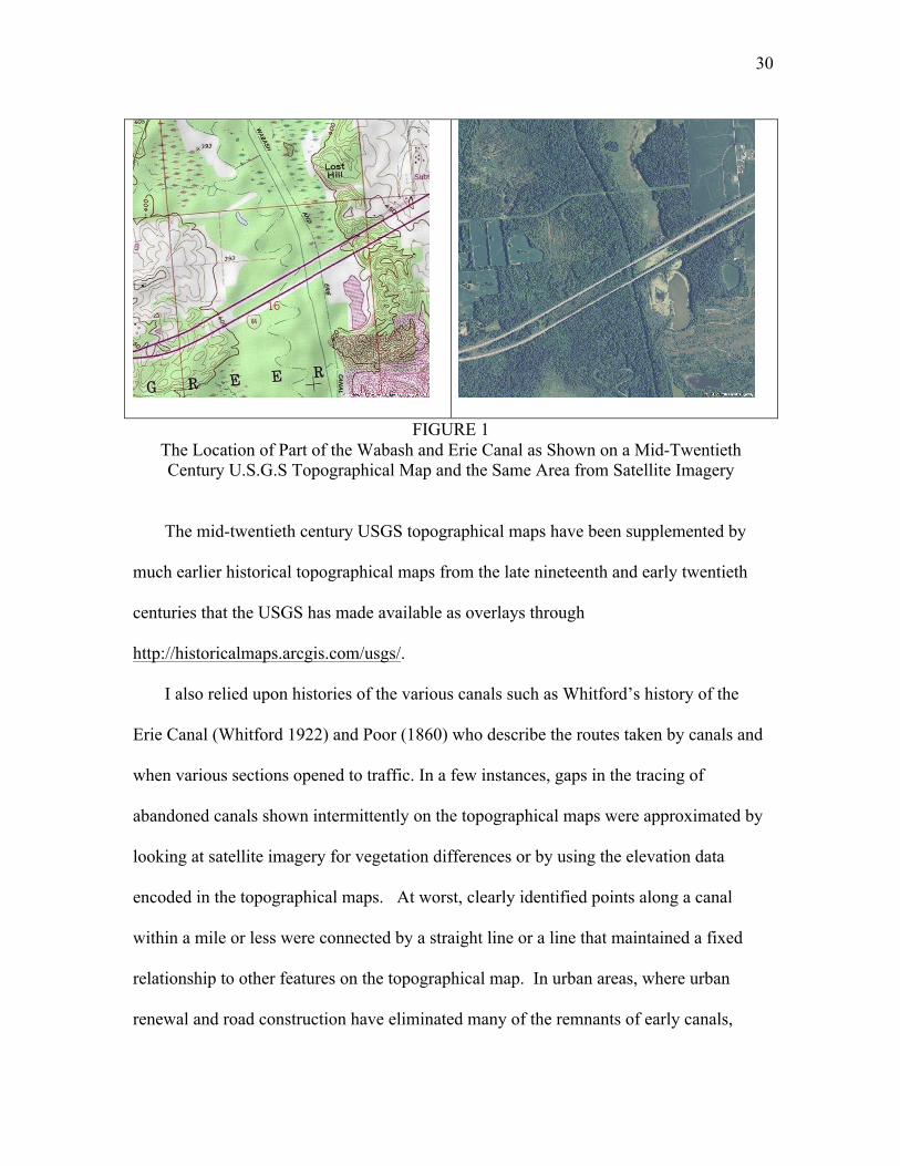
example, the satellite image in the right panel of Figure 1), although some features like
lock chambers and towpaths may remain. Moreover, several canals have been
repurposed in ways that have obliterated much of the archaeological evidence. Railroads 28AtleasttwocanalswerebuiltintheUnitedStatesduringthetwentiethcenturyandarestillinoperation(asareother,oldercanalsthatarestillinservicebutwhichhavebeenupdatedandimprovedliketheSooLocks):TheNewYorkBargeCanal,completedin1918,tookoversectionsoftheoriginalErieCanalandbypassedothersandtheTennessee-Tombigbeewaterwaywhichopenedin1984.Inaddition,thereistheintercoastalwaterwaythatwasbegunintheearlynineteenthcenturybutonwhichmostworkwasdoneinthetwentiethcentury.Neithertheintercoastalwaterway(asasingleentity)northeTenn-TomareincludedinmySHPfile,thoughsomeearlybitsofwhatbecomestheintercoastalwaterway,liketheAlbemarleandChesapeakecanal,are(see,forexample,http://www.carolana.com/NC/Transportation/albemarle_and_chesapeake_canal.html).

28
that came along later were built along the rights-of-way of many canals, including the
Pennsylvania Mainline, the Whitewater and the Framingham canals, beginning in the
middle of the nineteenth century. Many railroad rights of way have subsequently met
similar fates as highways have been built atop them. For example, a part of Interstate 10
in Houston now occupies the old Pacific Railroad right-of-way.29
Twowaterroutesthathavetheterm“Navigation”asapartoftheirnamesare
includedamongthecanalsratherthanbeingtreatedasriversonthegroundsthat
theyhadmuchmoreincommonwithcanalsthanwithrivers.Sixty-twomilesofthe
108mileSchuylkillNavigationbetweenPhiladelphiaandPortCarbonwascovered
byseparatecanalsbuiltalongtheSchuylkillRiverbankratherthanviatherivers
itselfalthoughtoday,onlybriefstretchesofthesecanalsremaininwatersuchas
aroundMontClare,PA(GoogleEarth,belowLock60at40°08′42″N75°30′28″W).I
havealsoincludedtheBaldEagleandSpringCreekNavigationamongthecanals
sinceitrequiredanextensivecanalcuttocompletethelinkbetweenLockHaven
andBellefonte,PA.
Construction of my SHP file for canals began with various, relatively inaccurately
drawn maps of canal routes. Some of these, such as Poor (1860) and maps in the David
Rumsey collection (www.davidrumsey.com, for example, (Tanner 1840)), were more or
29The portion of Southern Pacific railroad right of way between Katy, TX and Tower 13 [in northwest Houston] was abandoned in 1997, after the Union Pacific Railroad merged with the Southern Pacific Railroad (then owner of the Missouri-Kansas-Texas Railroad which built the track in 1893). The Katy Freeway (Interstate 10) has since been widened onto the adjacent right-of-way for most of its length, completely obliterating any traces of it. See http://www.abandonedrails.com/Houston_to_Katy. Even the original Erie Canal could not escape despite its historical significance and status as a cultural icon as a stretch near Port Byron is now a part of the New York Thruway.

29
less contemporaneous. Others, such as Goodrich (1961), are retrospective. These
sources have been used to provide evidence of the existence of a canal and to indicate its
general location.
The actual mapping of the canal’s location (so far as possible), however, was made
by hand-digitizing points using ArcGIS and 7.5 minute U.S.G.S topographical maps
made in the mid- to late-twentieth century. These maps often mark vestiges of features
like the trace of “Wabash and Erie Canal” shown on the Elberfeld (Indiana) Quadrangle
7.5 minute series map from the USGS that was first issued in 1961 (left panel of Figure
1).30 This and similar topographical maps are available as basemaps within ArcGIS via
ArcGIS Online. They are thus relatively easy to use although downloading and rendering
can be slow and tedious depending upon the extent of any zoom. Unfortunately, the far
superior ESRI ArcGIS Pro program has not yet implemented these earlier USGS topo
maps as basemaps. Instead, ArcGIS Pro uses the more recent 2009 7.5 minute maps (see,
for example, http://nationalmap.gov /ustopo/quickstart.pdf). However, while these maps
are based on images of the earlier topo maps, they lack much of the detail—including
showing and identifying features like abandoned canals (see, for example, Appendix A
which shows the same area as Figure 1).
30Availablefromhttp://ims.er.usgs.govasgda_5285424.zip.
30
FIGURE 1 The Location of Part of the Wabash and Erie Canal as Shown on a Mid-Twentieth Century U.S.G.S Topographical Map and the Same Area from Satellite Imagery
The mid-twentieth century USGS topographical maps have been supplemented by
much earlier historical topographical maps from the late nineteenth and early twentieth
centuries that the USGS has made available as overlays through
http://historicalmaps.arcgis.com/usgs/.
I also relied upon histories of the various canals such as Whitford’s history of the
Erie Canal (Whitford 1922) and Poor (1860) who describe the routes taken by canals and
when various sections opened to traffic. In a few instances, gaps in the tracing of
abandoned canals shown intermittently on the topographical maps were approximated by
looking at satellite imagery for vegetation differences or by using the elevation data
encoded in the topographical maps. At worst, clearly identified points along a canal
within a mile or less were connected by a straight line or a line that maintained a fixed
relationship to other features on the topographical map. In urban areas, where urban
renewal and road construction have eliminated many of the remnants of early canals,

31
their prior existence lives on in street names like “Canal” and “Basin” street that were
associated with canals and which are recorded in Street Views and similar urban maps.
Railroads
Railroads present none of the identification issues associated with canals and rivers.
The technology is specific and quite easily defined: A railroad is a technology involving
the use of flanged wheels affixed to an axle and running on a track. The distance
between the flanges on the inside of the wheels sets the track gauge. The earliest tracks
were wood, subsequently reinforced by an iron strap for wear and as a bearing surface.
Eventually these straps evolved into the familiar “T” rail. In time, steel was substituted
for iron providing longer life and offering a significantly higher carrying capacity (Atack
and Brueckner 1982).
This definition of a railroad is sufficiently general to include gravity railways and the
use of inclined planes where power was provided by stationary engines (such as with the
Alleghany Portage railroad between Holidaysburg and Johnstown, Pennsylvania that
served as the link between two sections of the Pennsylvania Mainline Canal or the climb
up from the Ohio River at Madison, Indiana where the Madison to Indianapolis Railroad
began) as well as the more familiar locomotive. These are all included in the railroad
mappings here. Inclined planes and gravity railways were eventually replaced by
locomotive-based railroads as excavating and construction methods improved and
engines became more powerful.
The vast majority of railroad investment went into the right-of-way, especially
grading, cuts and fill, drainage ditches and culverts, bridges, railroad crossings and the
like as well as the roadbed, sleepers and rails (United States. Census Office. 1883). Once

32
built, these features have tended to remain although over time some have been
repurposed into highways or into trails for recreational purposes. Consequently, even
where railroads have been abandoned, enough clues generally remain from which to
retrace their route.
Elsewhere, I have written about creating my earlier generation of historical railroad
shapefiles (Atack 2013). Those began with digitized small scale, state-level maps of the
rail system for 1911 by Matthews Northrup Co. for the “New Century Atlas” (Whitney
and Smith 1911) and worked backwards through time using ever earlier maps at
approximately decadal intervals. My rationale for starting with these 1911 maps was a
combination of their availability and the accuracy with which they appear to have been
drawn despite the limitations of their scale. Where specific railroad lines are still in
operation today or appear on USGS topographical maps (including historical maps from
the late nineteenth or early twentieth centuries), the 1911 maps have proved to be very
accurately and carefully drawn.
My earlier procedure was as follows. I geo-referenced the 1911 maps against NHGIS
state boundary files for that year and traced the rail lines shown on them into a polyline
SHP file. Those tracing thus defined both the location and the extent of railroads in 1911.
Mappings for earlier years were created by working backwards in time, based upon what
were thought to be the “best” mapping of the rail system for a particular year and then
deleting lines from the later SHP file that did not appear on that earlier map but without
modifying their location. Railroads were thus consistently located in the same place that
parts of them would appear on the 1911 maps.
The new SHP files described here now replace those earlier ones. I began with clean

33
slate. This new mapping is far more accurate both with respect to location and to timing
than its predecessors. Like the earlier versions, the current SHP file ends in 1911 and
makes use of the digitized maps from the “New Century Atlas” (Whitney and Smith
1911). However, the current mapping only uses the “New Century Atlas” maps as
evidence of the existence of a railroad in 1911 that connected specific points together.
The 1911 maps are not used to determine the exact spatial location of the railroads shown
upon them. Instead, the precise spatial location of any railroad comes from the union of
modern railroad SHP files derived from satellite imagery and published as a part of the
National Atlas database by the U.S. Department of Transportation
(http://www.rita.dot.gov/bts/sites/rita.dot.gov.bts/files/publications/national_transportatio
n_atlas_database/) and USGS 7.5 minute topographical maps from the late nineteenth
century onwards. This rendering has taken several years to complete. During that time
the entire library of USGS topographical maps (both historical and contemporary) has
been visually examined many times at scales of 1:24000 and 1:10000.
According to the metadata on the National Atlas railroad file, the railroad track data
are taken from the Federal Railroad Administration (FRA) and were created at a scale of
1:100000 or better. Unfortunately no additional is provided in the metadata and the FRA
web site is silent on this point. Among my first actions was to strip as many tracings of
multi-tracking, sidings, turnouts for trains to pass one another, and large switching yards
from these SHP files as possible since we have absolutely no information regarding when
these were built. The modified National Atlas SHP file was then overlaid on freshly
georeferenced state level maps from the New Century Atlas for 1911. All digitized maps
were geo-referenced using ArcGIS 10’s spline algorithm against the National Historical

34
Geographic Information System’s 2008 TIGER-based historical state and county
boundary files (see www.nhgis.org) and the U.S. National Atlas’s database of cities and
towns.
Rather than showing miles of railroad track, the new mappings (like the earlier ones)
show miles of railroad linkage between points. This distinction is an important one, not
least because data on miles of track (whether reported by the railroads themselves or in
sources like Poor’s Manual or reports by the Interstate Commerce Commission)
represents the miles of rail divided by two (since the track consists of two parallel rails
separated by the gauge) and counts track in switching yards, sidings and turnouts in that
total. It would also count a stretch of double track as double the distance. None of these
(except for errors) are included in my shapefiles for the reasons given. Mileages
calculated from my shapefiles using GIS software will thus NOT generally match up to
those reported by the Census (1883), Poor (1860), or other such sources.31 Like my
earlier shapefiles, these new ones measure the distance between origins and destinations
via rail.
Like everything else, however, there are exceptions to this rule. For example, in
1861, we know that the broad gauge (72”) Delaware, Lackawanna and Western railroad
connected to the Central Railroad of New Jersey, a standard gauge road, near Hampton,
New Jersey. Rather than break gauge at that point or build an entirely separate right of
way, however, the Lackawanna Railroad continued on to Jersey City via the New Jersey
Railroad (a “New Jersey” gauge line—58”) by means of a third rail attached to the
31Ofcourse,significantquestionssurroundthosemileagedataanywayasshownbythelatesteditionofHistoricalStatistics(Carteretal.2006)aswellasearlierauthoritiessuchasWicker(1960).
35
railroad ties so that broad gauge trains used the outer pair of rail while standard and New
Jersey gauge trains used the inner rail and the appropriate outer rail (Taylor and Neu
1956, 25). I have represented this arrangement in my SHP files by the creation of parallel
tracks, one of each gauge. I used the same procedure in southeastern Indiana and
southwestern Ohio where the broad gauge Ohio and Mississippi line met up with the
standard gauge Indianapolis and Cincinnati line into Cincinnati. In that case, however,
the historical record so far as I can tell is silent on whether a third rail was added or two
tracks with separate gauges were laid along the right of way.
Railroad lines in the National Atlas SHP file that did not match up by origin, route
and destination with lines shown on the 1911 maps were deleted. When a railroad was
shown on the 1911 maps but for which there was no corresponding railroad in the
modern data by origin, route and destination, the USGS topographical maps for the area
in question were examined carefully. These invariably showed an “old railroad grade”
feature in the expected general location and between the expected origin and destination.
I also examined the registration between the modern active railroad lines and those
shown on the topographical maps, including those from late nineteenth and early
twentieth centuries. If satisfied, I traced the route of the old railroad grade into the edited
SHP file of modern railroad data.
Where there were gaps in “old railroad grade” features, I looked for roads and trails
that might have been built atop the track. I also examined satellite imagery for variations
in vegetation that might reveal the drainage provide by old railroad bed and boundary
lines (including fences and trees) that might indicate an earlier right-of-way. I even
looked for evidence of railroad-related structures like bridge piers remaining in river and
36
streambeds.
As with the previous generation of railroad SHP files, the SHP file that these
procedures generated for 1911 was copied and the copy used as an overlay for the next
earlier digitized railroad map. The closer together in terms of copyright date that those
maps were, the greater the likelihood of conflicting information. Where conflicts were
spotted, efforts were made to resolve them by consulting other maps from a year or two
earlier and later. In some cases, as a result of this procedure, the 1911 mapping was
reviewed and adjustments made to the base SHP file whenever it appeared that the
“wrong” line(s) between particular origins and destinations from among several
possibilities had been chosen.
Whereas my earlier generation of railroad SHP files map the nation’s railroads at
approximately decade intervals, these new mappings are approximately five years apart,
except for the decade of the 1850s where the frequency was increased to every two
years.32 Moreover, a conscious effort was made to locate consecutive maps from similar
sources wherever possible. In particular, the six maps series covering from 1877 through
1903 were produced by Rand McNally (for example, Rand McNally and Company.
1879). These were all versions of their “Business Atlas” intended to inform businesses
how best to ship products nationwide. Similarly, the two mappings for the 1860s make
use of maps produced by Lloyd (1868, 1863) with a similar goal. The specific source(s)
used for each year’s SHP file is shown in Table 1. Additional information appears in the
32Specifically,railroadSHPfileshavebeengeneratedfor1911,1903,1898,1893,1889,1881,1877,1872,1868,1863,1861,1858,1856,1854,1852and1850usingthemap-basedproceduresdescribedabove.

37
metadata (XML) files that are a part of the SHP files.33
Table 1 Map Sources Used to Determine the Existence of Rail Links in Each Specific Year
Year Map source for existence of rail links in that year
1911 WilliamD.WhitneyandBenjaminE.Smith(eds)TheCenturydictionaryandcyclopedia,withanewatlasoftheworld,NewYork:CenturyCo.,1911.Statemaps.
1903 RandMcNally,RandMcNally&Co.,EnlargedBusinessAtlasAndShippers'Guide...ShowingInDetailTheEntireRailroadSystem...AccompaniedByANewAndOriginalCompilationAndReadyReferenceIndex…,Chicago:RandMcNally&Company,1903.
1898 Rand,McNally&Co.'sNewBusinessAtlasMapoftheUnitedStates…,Chicago:RandMcNally&Company,1898.Regionalmaps.
1893 RandMcNallyandCompany,Rand,McNally&Co.'senlargedbusinessatlasandshippersguide;containinglarge-scalemapsofallthestatesandterritoriesintheUnitedStates,oftheDominionofCanada,theRepublicofMexico,CentralAmerica,theWestIndiesandCuba.Chicago:RandMcNally,1893.Statemaps.Louisiana,Maryland/Delaware,Michigan,andMississippifromRandMcNally,UniversalAtlasoftheWorld,Chicago:RandMcNally,1893.Texas:RandMcNally&Co.Indexedcountyandrailroadpocketmapandshippers'guideofTexas:accompaniedbyanewandoriginalcompilationandreadyreferenceindex,showingindetailtheentirerailroadsystem...Chicago:RandMcNally&Co.,1893.
1889 RandMcNally,Rand,McNally&Co.'senlargedbusinessatlasandshippersguide…,Chicago:RandMcNally&Co.,1889.Statemaps.
1881 RandMcNally,NewIndexedBusinessAtlasandShippersGuide,Chicago:RandMcNally&Co.,1881.Statemaps.
1877 RandMcNallyandCompany,RandMcNally&Co’sBusinessAtlas,Chicago:RandMcNally&Co.,1877.Statemaps.
1872 Warner&Beers,AtlasoftheUnitedStates,Chicago:Warner&Beers,1872.Regionalmaps
(Table1,continued)1868 J.T.Lloyd,Lloyd'sNewMapoftheUnitedStatesTheCanadasandNew
BrunswickFromTheLatestSurveysShowingEveryRailroad&StationFinished…1868,NewYork:J.T.Lloyd,1868.Nationalmap.
1863 J.T.Lloyd,Lloyd'sNewMapoftheUnitedStatesTheCanadasAndNewBrunswickFromthelatestSurveysShowingEveryRailroad&StationFinished
33In particular, I wish to acknowledge the generosity of Murray Hudson (Antiquarian Books, Maps, Prints & Globes, 109 S. Church Street, Halls, TN 38040) who scanned and provided me with copies of most of the state maps used for my 1893 railroad SHP file. See http://www.antiquemapsandglobes.com/.

38
toJune1863,NewYork:J.T.Lloyd,1863.Nationalmap. 1861 G.R.TaylorandIreneD.Neu,TheAmericanRailroadNetwork1861-1890,
Cambridge,Mass:HarvardUniversityPress,1956.Regionalmaps. 1858 HugoStammann,J.Sage&Son'snew&reliablerailroadmapcomprisingall
therailroadsoftheUnitedStatesandCanadaswiththeirstationsanddistances,Buffalo,NY:JSage&Sons,1858.Nationalmap.
1856 RichardS.Fisher,Dinsmore'scompletemapoftherailroads&canalsintheUnitedStates&CanadacarefullycompiledfromauthenticsourcesbyRichardS.Fisher,editoroftheAmericanRailRoad&SteamNavigationGuide,NewYork,1856.Nationalmap.
1854 E.D.Sanford,H.V.Poor'srailroadmapshowingparticularlythelocationandconnectionsoftheNorthEast&SouthWestAlabamaRailRoad,byE.D.Sanford,CivilEngineer,n.p.:1854.Nationalmap.
1852 J.H.Colton,Colton'sMapOfTheUnitedStates,TheCanadas&c.ShowingTheRailRoads,Canals&StageRoads:WithDistancesfromPlacetoPlace,NewYork:J.H.Colton,1852.Nationalmap.
1850 CurranDinsmore,Dinsmore&Company'snewandcompletemapoftherailwaysystemoftheUnitedStatesandCanada;compiledfromofficialsources,underthedirectionoftheeditorofthe"AmericanRailwayGuide.",NewYork:1850.Nationalmap.
Notes: See also the SHP file metadata for the specific source(s) of individual maps.
As the sources in Table 1 indicate, the earlier maps tended to be regional or national.
Their resulting (relatively) small scale may have obscured some details and rail links,
especially in more compact and densely settled areas like what is now the Northeast
Corridor. Later on, the maps providing information on the existence of a rail link tended
to be of individual states, many covering both verso and recto pages. These could clearly
show much greater detail with greater accuracy.
This map-based procedure generated sixteen separate SHP files between 1850 and
1911. Prior to the Civil War, however, it is clear that the geographic accuracy of maps
declines sharply (see also Modelski 1987), making their use more difficult and error-
prone. As a result, rather than base my mapping of rail links upon increasingly
questionable maps, I have instead relied upon the work of railroad enthusiasts and

39
historians.
Specifically, I have generated maps for 1826 through 1850 using a database of
railroads by year built that was assembled by Professor Milton C. Hallberg (deceased,
Pennsylvania State University). It is hosted on the web site http://oldrailhistory.com/.
When I produced my previous generation of SHP files, I also consulted this source. At
that time, however, detailed individual maps of each railroad showing when specific
sections of track were built were also a part of the WWW site. Unfortunately, these are
no longer available and I have not been able to locate them in any of the WWW archives.
The Hallberg database has been supplemented by various published railroad
histories, on-line Google search results and the Wikipedia entries for specific railroads
appearing in the database. The combination of these sources made it possible to generate
SHP files for 1845, 1840, 1835, 1830 and 1826—the earliest (gravity coal) railroads in
Hallberg’s database.
Those earlier SHP files were generally consistent with my 1850 SHP file based on
the map published as a part of Dinsmore’s Travel Guide (Dinsmore 1850) and produced
under the direction of the editor of the “American Railway Guide” that my procedure
based upon working backwards from 1911 had produced. Where necessary, a few minor
adjustments were made to the Dinsmore mapping to make it consistent with the evidence
for earlier years (that is say, I treated the database from 1826-1850 as the more
authoritative source, in part because of the questions regarding pre-Civil War maps).
The approach that I describe above where the SHP files for successively earlier years
were based off a copy of the SHP file for the next later year, generated multiple SHP
files, one for each year. These were then merged into a single SHP file covering the

40
entire period by using the “Erase” command to determine what track was added between
each successive pair of years. These were then merged to combine the results back into a
single SHP file.34 The gain from this procedure was that publication (copyright) date for
the later of each pair of maps was used to populate the “InOpBy” field and provides a
rough dating as to when each stretch of line was built.
In addition, the Hallberg database provides an exact dating for when each section of
track was opened to traffic. This has been preserved in the database field “Exact”
although adjustments were made if Hallberg’s dating was contradicted by multiple or by
more authoritative sources (such as the National Park Service’s history of the Alleghany
Portage Railroad).
Prior to the Civil War, the SHP file database also indicates the operator of the track.
During the 1850s, this is the name assigned by Taylor and Neu (1956) for 1861. For
1850 and earlier, the name assigned to the track sections is that given in the Hallberg
database. This scheme is imperfect and these data should only be used with care. For
example, early on, railroads typically changed names at state borders as they were
generally only chartered for operation in one state. They also changed name frequently
as construction plans changed (many names were intended to be broadly descriptive as to
route, as in “Baltimore and Ohio” and “Missouri Pacific”) or bankruptcy or merger
forced corporate reorganization. Thus, for example, the Pendleton and Indianapolis
Railroad, organized in 1848, was quickly renamed the Indianapolis and Bellefontaine
Railroad when it joined up with an Ohio railroad from Bellefontaine in January 1853 at 34Specifically,Iusedthefollowingpairs1826-1830, 1830-1835, 1835-1840, 1840-1845, 1845-1850, 1850-1852, 1852-1854, 1854-1856, 1856-1858, 1858-1861 (the Taylor-Neu map is explicitly dated April 1861), 1861-1863, 1863-1868, 1868-1872, 1872-1877, 1877-1881, 1881-1889, 1889-1893, 1893-1898, 1898-1903, and 1903-1911.
41
Union City, Indiana (Bogle, 218) and became the first railroad in Indiana to connect to
East Coast cities through those Ohio links. In 1855, it was restyled the Bellefontaine and
Indiana Railroad which was shortened to the Bellefontaine Railway in 1864, becoming
the Cleveland, Columbus, Cincinnati and Indianapolis Railway in 1868, and finally the
Cleveland, Cincinnati, Chicago and St. Louis Railway in 1889.
For 1861, Taylor and Neu (1956) also identify railroad track gauges in their maps.
These gauges have been preserved in the database field “Gauge” and are presumed to be
the gauge not only in use in 1861 but also the original gauge when the railroad was built.
Many of the non-standard gauges (i.e. those other than 4’ 8.5”) changed in the decades
that followed as described in the contemporary literature and by Douglas Puffert (2000,
1991). However, I have made no effort to date changes in gauge or incorporate those
changes into my SHP file database and all track added after 1861 is coded as having a
gauge of -1 (i.e. missing/unknown). By 1890, however, most of the railroads in the
nation, outside of mountainous mining areas where narrow gauge still enjoyed a technical
advantage, had converted to standard gauge.
Work by Christian Hung translating my preliminary railroad SHP files into a
network as part of his study of the economic impact of breaks in transportation in the
mid-nineteenth century has helped me identify hundreds of possible connectivity issues
such as dangles (dead-ends) and micro-fractures in routes between origins and
destinations.35 I reviewed all of them and fixed those that I believe represented errors in
35Micro-fracturesanddanglesweremuchmoreprevalentinmyprevious(lessgeographicallyaccurate)generationofSHPfiles(Atack2013)thatformthebasisofDonaldsonandHornbeck’s(2015)reassessmentofFogel’s(1964)socialsavingsfromtherailroad.Thoseerrorswereassiduouslyhand-correctedbyHornbecktogeneratethenetworkthattheyusefortheirmarketaccessanalysisandthe
42
my SHP files. Most of these were very small—a matter of feet or yards on the ground.
Indeed, many were visible only at maximum zoom. These were generally caused by
mistakes in snapping polylines to a vertex, an end, or the edge of an existing feature to
which they were supposed to connect. A few were the result of minute line segments that
were not properly erased when the SHP file from a later year was adjusted to reflect the
preceding year’s mapping. Some likely remain.
Some breaks and dangles, however, properly remain in the SHP file. Early on, for
example, many breaks are located where rivers were not yet bridged. As noted in the
discussion regarding the river SHP files above, there were legal impediments to bridging
navigable waterways. Eventually, the law was interpreted as prohibiting “unreasonable”
restrictions to navigation–that is, they could not permanently block navigation. What this
meant in practice, however, was determined case-by-case and it could be a drawn-out and
expensive process. Moreover, large rivers presented technical engineering challenges in
terms of constructing suitable approaches, providing adequate structural support,
navigation clearances, and coping with periodic extreme flooding, etc.. As a result, many
larger rivers were not crossed for many years after a railroad was built to the river’s
banks. Rather, passengers and cargo were ferried across the rivers. This increased
handling costs and created delays and inconvenience.
In determining when a particular waterway was bridged, I made considerable use of
internet resources, particularly http://www.bridgehunter.com, a “database of historic or
notable bridges in the United States, past and present” although this sometimes proved
incomplete or wrong. I also made use of http://cs.trains.com/trn/f/507/t/42151.aspx resultingnetworkfilesareavailableasapartofDonaldsonandHornbeck’sreplicationfilesfortheirQuarterlyJournalofEconomicsarticle.

43
listing Mississippi River crossings. Where I found a specific date for a particular bridge,
it is recorded in the “InOpBy” field of the SHP file database for that segment of line that
crosses the river. In some cases, however, no information has been found as to when
specific bridge crossings were opened to traffic. For these crossings, the date of bridging
is presumed to be the same as the date when the track leading to and from the river was in
operation.
Other network breaks between lines occurred in larger cities and towns although
most of the maps—especially those national in scale—imply continuous lines. Work
documenting and dating these breaks in cities is in progress by Hung but is, as yet,
incomplete and thus not (generally) reflected in my SHP file. Many of the city breaks
were the result of competing railroad lines failing to agree on a common “Union”
station.36 Forexample,accordingtoa1854map,Bostonhadsevendifferentrail
depotsinsixdistinctlocationsasfaras2.5milesapart(Williams1854).
Indianapoliswastheexception.There,thethreerailroadsservingthecityin1850
(theMadisonandIndianapolisRailroad,theTerreHauteandRichmondRailroad
andtheIndianapolisandBellefontaineRailroad)jointlyagreedtobuilda“Union
Station”servingeveryone.Itopenedin1853andwassubsequentlyconnectedto
otherrailroadsastheyalsoreachedthecity.37However,itwasnotuntiltheearly
twentiethcenturythattheIndianapolissolutionbecamethemodelalmost
36Strictlyspeaking,theUnionStationswerepassengerterminalsbutthesameissuearosewithfreightfacilities.Earlyontherewasneedlessduplicationanddifficultiesininterchangingrollingstockamongcompetinglines.Theseissuestookdecadestoresolve.37Seehttp://www.nps.gov/nr/travel/indianapolis/unionstation.htm

44
everywhere.38
Dangles also occur at docks along the coastline (as at Brooklyn and Bayonne or at
Buffalo) and at major rivers estuaries (like the Delaware, around Philadelphia and
Camden, or the Hudson at Hoboken). Others were to be found in mining areas like the
iron ore mines in Minnesota, the copper mines of Arizona and the Vermont marble
quarries.
Concluding Remarks
In the foregoing, I have made every effort to detail the various issues associated with
the creation of the river, canal and railroad SHP files but many individual decision had to
be made “on the fly.” By doing all of the work myself, I have tried to bring a degree of
consistency to this decision-making. However, it is also clear that my thinking and
resultant decision-making evolved over the years that it has taken to complete this
project. I have also struggled to be as accurate as possible in my tracing of routes (both
with regard to location and timing) though I am sure further improvements could be made
as a close examination of the registration between my SHP files and the USGS
topographical maps or satellite imagery will show. Moreover, dating could almost
certainly be improved if the annual reports of individual railroads, accounts in the press at
the time (including trade journals such as the American Railroad Journal), or railroad
schedules like those published in travel guides such as Appleton, Cobb or Disturnell
(Disturnell 1847, Cobb 1945, Appleton and Company 1847) were used rather than maps.
Hopefully, however, any errors are small especially relative to the utility of these 38See,forexample,UnionStationinWashingtonDC:https://en.wikipedia.org/wiki/Union_Station_%28Washington,_D.C.%29,StLouis:https://en.wikipedia.org/wiki/Union_Station_%28St._Louis%29orUnionStationinChicago:https://en.wikipedia.org/wiki/Chicago_Union_StationandMayer(1945)

45
historical GIS SHP files.
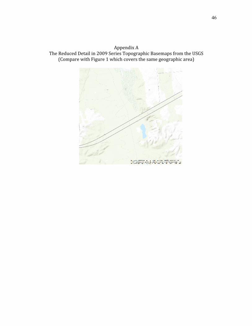
46
AppendixATheReducedDetailin2009SeriesTopographicBasemapsfromtheUSGS
(ComparewithFigure1whichcoversthesamegeographicarea)

47
Bibliography
Appleton and Company. 1847. Appletons' illustrated railway and steam navigation guide. New York, N.Y.: D. Appleton & Co.
Arkansas. 1980. State v. McIlroy, 595 S.W.2d 659. Atack, Jeremy. 1978. "Economies of Scale in Western River Steamboating: A
Comment." The Journal of Economic History 38 (2):457-466. doi: 10.2307/2119835.
Atack, Jeremy. 2013. "On the Use of Geographic Information Systems in Economic History: The American Transportation Revolution Revisited." Journal of Economic History 73 (2):313-38.
Atack, Jeremy, and Jan Brueckner. 1982. "Steel Rails and American Railroads, 1867-1880." Explorations in Economic History 19 (October):339-59.
Atack, Jeremy, Michael Haines, and Robert A Margo. 2010. "Did Railroads Induce or Follow Economic Growth? Urbanization and Population Growth in the American Midwest, 1850-1860?" Social Science History 34 (2):171-97.
Atack, Jeremy, Matthew Jaremski, and Peter L. Rousseau. 2014. "American Banking and the Transportation Revolution Before the Civil War." Journal of Economic History 74 (4):(forthcoming).
Atack, Jeremy, Matthew Jaremski, and Peter L. Rousseau. 2015. "Did Railroads Make Antebellum US Banks More Sound?" In Enterprising America: Business, Banks and Credit Marets in Historical Perspective, edited by William J. Collins and Robert A Margo, 149-78. Chicago: University of Chicago Press for the NBER.
Atack, Jeremy, and Robert A Margo. 2012. "Land Ownership and the Coming of the Railroad in the American Midwest, 1850-1860." In Railroads in Historical Context: Construction, Costs and Consequences, edited by Anne McCants and Eduardo Beira, 151-177. Portugal: Foz Tua/EFP/MIT.
Atack, Jeremy, and Robert A. Margo. 2011. "The Impact of Access to Rail Transportation on Agricultural Improvement: The American Midwest as a Test Case, 1850-1860." Journal of Transport and Land Use 4 (2):5-18.
Baer, Christopher T., Glenn Porter, William H. Mulligan, Marley E. Amstutz, and Anne E. Webster. 1981. Canals and railroads of the Mid-Atlantic states, 1800-1860. Wilmington, Del.: Regional Economic History Research Center, Eleutherian Mills-Hagley Foundation.
Bleakley, Hoyt, and Jeffrey Lin. 2012. "Portage and Path Dependence." The Quarterly Journal of Economics 127 (2):587-644. doi: 10.1093/qje/qjs011.
Bleakley, Hoyt, and Jeffrey Lin. 2015. "History and the Sizes of Cities." American Economic Review. 105 (5):558-63. doi: 10.1257/aer.p20151069.
Bogle, Victor M. "Railroad Building in Indiana, 1850-1855." Indiana Magazine of History:211-232.
Boyle, James Ernest. 1922. Chicago wheat prices for eighty-one years, daily, monthly and yearly fluctuations and their causes. [Ithaca? N.Y.].
Carter, Susan B., Scott Sigmund Gartner, Michael R. Haines, Alan L. Olmstead, Richard Sutch, Gavin Wright, and Louis P. Cain. 2006. Historical Statistics of the United States Millennial Edition Online. New York, NY: Cambridge University Press.

48
Chandler, Alfred D. 1965. The railroads, the Nation's first big business; sources and readings, The Forces in American economic growth series. New York,: Harcourt.
Chittenden, Hiram Martin. 1903. History of early steamboat navigation on the Missouri river; life and adventures of Joseph La Barge. 2 vols, American explorers series, IV. New York,: F. P. Harper.
Cobb, Charles. 1945. American railway guide and pocket companion for the United States : containing correct tables for time of starting from all stations, distances, fares, etc. on all the railway lines in the United States : together with a complete railway map : also many principal steamboat and stage lines running in connection with railroads. Milwaukee, Wis.: Kalmbach Pub. Co.
Cole, Arthur Harrison. 1938a. Wholesale commodity prices in the United States, 1700-1861. Cambridge, Mass.,: Harvard University.
Cole, Arthur Harrison. 1938b. Wholesale commodity prices in the United States, 1700-1861 : statistical supplement: actual wholesale prices of various commodities, History of American economy : Studies and material for study. Cambridge, Mass.,: Harvard University Press.
Dinsmore, Curran. 1850. Dinsmore & Company's new and complete map of the railway system of the United States and Canada; compiled from official sources, under the direction of the editor of the "American Railway Guide.". New York.
Disturnell, John. 1847. Disturnell's guide through the middle, northern, and eastern states containing a description of the principal places, canal, railroad, and steamboat routes, tables of distances, etc. : compiled from authentic sources. New York: J. Disturnell.
Donaldson, Dave. 2010. "Railroads of the Raj: Estimating the Impact of Transportation Infrastructure." National Bureau of Economic Research Working Paper Series No. 16487.
Donaldson, Dave, and Richard Hornbeck. 2015. "Railroads and American Economic Growth: A "Market Access" Approach." Quarterly Journal of Economics accepted for publication July 2015:forthcoming.
Fishlow, Albert. 1965. American railroads and the transformation of the antebellum economy, Harvard economic studies, v. 127. Cambridge, MA: Harvard University Press.
Fogel, Robert William. 1962. "A Quantitative Approach to the Study of Railroads in American Economic Growth: A Report of Some Preliminary Findings." The Journal of Economic History 22 (2):163-197.
Fogel, Robert William. 1964. Railroads and American economic growth: essays in econometric history. Baltimore, MD: Johns Hopkins Press.
Goodrich, Carter. 1961. Canals and American economic development. New York,: Columbia University Press.
Haites, Erik F, James Mak, and Gary M Walton. 1975. Western river transportation: the era of early internal development, 1810-1860, The Johns Hopkins University studies in historical and political science. Baltimore, MD: The Johns Hopkins University Press.
Haites, Erik F., and James Mak. 1976. "Economies of Scale in Western River Steamboating." The Journal of Economic History 36 (3):689-703. doi: 10.2307/2118851.

49
Haites, Erik F., and James Mak. 1978. "Economies of Scale in Western River Steamboating: A Reply." The Journal of Economic History 38 (2):467-470. doi: 10.2307/2119836.
Harte, Charles Rufus. 1938. Connecticut's canals. New Haven,: The author. Hunter, Louis C. 1949. Steamboats on the Western rivers; an economic and
technological history, Studies in economic history. Cambridge, MA: Harvard University Press.
Kanneberg, Adolph. 1946. "Wisconsin Law of Waters." Wisconsin Law Review. Kansas. 1864. Laws, c. 97. Kansas. 1916. Kaw Valley Drainage Dist. of Wyandotte Cnty. v. Missouri Pac. Ry. Co.,
161 P. 937, 944 Kleber, John E. 2001. The encyclopedia of Louisville. Lexington: University Press of
Kentucky. Knowles, Anne Kelly. 2002. Past time, past place : GIS for history. Redlands, Calif.:
ESRI Press. Lloyd, J. T. 1863. Lloyd's New Map of the United States The Canadas And New
Brunswick From the latest Surveys Showing Every Railroad & Station Finished to June 1863. New York: J. T. Lloyd.
Lloyd, J. T. 1868. Lloyd's New Map of the United States The Canadas and New Brunswick From The Latest Surveys Showing Every Railroad & Station Finished … 1868. New York: J. T. Lloyd.
Mayer, Harold M. 1945. "The Railway Terminal Problem of Central Chicago." Economic Geography 21 (1):62-76. doi: 10.2307/141384.
Mills, Randall Vause. 1947. Stern-wheelers up Columbia; a century of steamboating in the Oregon country. Palo Alto, Calif.,: Pacific Books.
Modelski, Andrew M. 1987. Railroad maps of North America : the first hundred years. New York: Bonanza Books.
New York. 1997. "Douglaston Manor v. Bahrakis." In 678 N.E.2d 201, 202 New York Times. 2011. "Supreme Court Wades Into Raging Dispute Over Riverbed
Ownership." The New York Times October 3, 2011. http://www.nytimes.com/gwire/2011/10/03/03greenwire-supreme-court-wades-into-raging-dispute-over-r-74586.html.
Ovenden, Mark. 2011. Railway maps of the world. New York, NY: Viking,. Paskoff, Paul F. 2007. Troubled waters : steamboat disasters, river improvements, and
American public policy, 1821-1860. Baton Rouge: Louisiana State University Press.
Paullin, Charles Oscar, John Kirtland Wright, Carnegie Institution of Washington. Division of Historical Research., and American Geographical Society of New York. 1932. Atlas of the historical geography of the United States, Carnegie institution of Washington. [Washington, D.C., New York]: Pub. jointly by Carnegie institution of Washington and the American geographical society of New York.
Poor, Henry V. 1860. "History of the railroads and canals of the United States of America exhibiting their progress, cost, revenues, expenditures & present condition." In. New York: J.H. Schultz & Co.,. Sabin Americana - Full text online

50
http://www.library.uiuc.edu/proxy/go.php?url=http://galenet.galegroup.com/servlet/Sabin?af=RN&ae=CY108091097&srchtp=a&ste=14&q=uiuc_uc.
Potter, Isaac B., Lewis M. Haupt, Edward P. North, and League of American Wheelmen. 1891. Roads improvement. The common roads of Europe and America. [n.p.],.
Puffert, Douglas J. 1991. "The economics of spatial network externalities and the dynamics of railway gauge standardization." PhD microform, Department of Economics, Stanford University.
Puffert, Douglas J. 2000. "The Standardization of Track Gauge on North American Railways, 1830-1890." The Journal of Economic History 60 (4):933-960. doi: 10.2307/2698082.
Rand McNally and Company. 1879. The Rand-McNally official railway guide and hand book. Subscribers' ed. Chicago: National Railway Publication Co.
Riley, B. F. 1881. History of Conecuh County, Alabama. Embracing a detailed record of events from the earliest period to the present; biographical sketches of those who have been most conspicuous in the annals of the county; a complete list of the officials of Conecuh, besides much valuable information relative to the internal resources of the county. Columbus, Ga.,: T. Gilbert, printer.
Ronk, S. E. 1936. "Prices of Farm Products in New York." Cornell Agricultural Experiment Station Bulletin 643.
Rothenberg, Winifred B. 1981. "The Market and Massachusetts Farmers, 1750-1855." The Journal of Economic History 41 (2):283-314.
Segal, Harvey H. 1961. "Cycles of Canal Construction." In Canals and American Economic Development., edited by Carter Goodrich, 169-215. New York: Columbia University Press.
Story, Joseph. 1833. Commentaries on the Constitution of the United States : with a preliminary review of the constitutional history of the colonies and states, before the adoption of the Constitution. 3 vols. Cambridge [Mass.]: Brown, Shattuck, and co.
Tanner, Henry S. 1840. A Description of the Canals and Railroads of the United States, Comprehending Notices of all the Works of Internal Improvement Throughout the Several States. . New York: T.R. Tanner & J. Disturnell.
Taylor, George Rogers. 1951. The transportation revolution 1815-1860: Holt, Rinehart & Winston.
Taylor, George Rogers, and Irene D. Neu. 1956. The American railroad network, 1861-1890, Studies in economic history. Cambridge, MA: Harvard University Press.
Tennessee. 1907. State v. Muncie Pulp Co, 104 S.W. 437. Trescott, Paul B. 1958. "The Louisville and Portland Canal Company, 1825-1874." The
Mississippi Valley Historical Review 44 (4):686-708. doi: 10.2307/1886603. U. S. Congress. Senate. 1808. Roads and canals. Communicated to the Senate, April 6,
1808. U. S. Congress. Senate. 1904. Improvement of the public roads. United States. 1851. Com of Pennsylvania v Wheeling and Belmont Bridge Company, 54
U.S. 518 How.: United States.,. United States. 1855. Com of Pennsylvania v Wheeling and Belmont Bridge Company, 59
U.S. 18 How.: United States.,. United States. 1870. The Daniel Ball, 77 U.S. 10 Wall.

51
United States. 1874. The Montello, 87 U.S. 20 Wall.: United States Supreme Court. United States. 2012. PPL Montana, LLC v. Montana, 132 S. Ct. . United States, . 1789. Constitution. United States. 1862. Mississippi and Missouri Railroad Company v Ward, 67 U.S. 485. United States. 1867. The Galena, Dubuque, Dunleith, and Minnesota Packet Co. v. The
Rock Island Bridge, 71 U.S. 4 Wall 435. United States. Census Office. 1883. United States census of transportation, 1880.
Washington, D. C.: Govt. Print. Office. microform. United States. Census Office., and Henry Gannett. 1898. Statistical atlas of the United
States : based upon the results of the eleventh census. Washington: G.P.O. United States. Congress. House. Committee on Commerce. 1858. Railroad Bridge acrss
the Mississippi Rive at Rock Island. United States. Continental Congress. 1787. An ordinance for the government of the
territory of the United States, North-west of the river Ohio. New York: s.n. United States. District Court for Northern Illinois. 1857. Hurd v. Rock Island Bridge
Company (Note: The court's papers were all destroyed in the Chicago fire of 1871. See http://www.archives.gov/publications/prologue/2004/summer/bridge.html).
United States. District Court for Southern Iowa, . 1859. Rock Island Bridge Case [James Ward V. Mississippi & Missouri Railroad Company]: R.R. Hilt.
Whitford, Noble E. 1922. History of the Barge Canal of New York State (Supplement to the Annual Report). In New York: Annual Report of the State Engineer and Surveyor Albany.
Whitney, William Dwight, and Benjamin E. Smith. 1911. The Century dictionary and cyclopedia, with a new atlas of the world. Rev. and enl. ed. 12 vols. New York,: The Century co.
Wicker, Elmus. 1960. "Railroad Investment Before the Civil War." In Trends in the American Economy in the Nineteenth Century, edited by William N. Parker, 503-46. Princeton: Princeton University Press for the NBER
Williams, Alexander. 1854. Telegraph and Rail Road map of the New England States. Boston.
Wisconsin. 2015. Statutes: 30.10 Declarations of navigability. Wisconsin: https://docs.legis.wisconsin.gov/statutes/statutes/30/I/10.
Wright, Muriel H. 1930. "Early Navigation and Commerce along the Arkansas and Red Rivers in Oklahoma." Chronicles of Oklahoma 8 (March):65-88.