crater lake u.s. department of the interior
TRANSCRIPT

FAHRENHEIT
CELSIUS
Refections Visitor Guide Summer/Fall 2021
Crater Lake National Park National Park Service U.S. Department of the InteriorCrater Lake
Welcome to Crater Lake! ...Or in many cases, welcome back! Last year at this time many of us were hunkered Craig Ackerman down or isolated Superintendent trying to reduce the spread of the COVID virus and keep our family, friends, and neighbors safe. This year vaccinations and effective protocols are allowing more people to travel and visit our great public lands. We are expecting record visitation to our national parks! While we are more fully staffed than last year, we are still limited in the services and facilities that we can provide, so we ask you to exercise good planning, judgment, and patience while exploring the park and nearby areas.
Please review the rules on page 2 to protect yourself from harm and park resources from damage. Be prepared with proper clothing and footwear, food, water, and sunscreen. And pack plenty of consideration and courtesy. Report problems to a ranger and offer help to people you observe who may need assistance. It will make the park a better place for everyone, and you will be re-warded in knowing that you contributed to the protection and enhancement of one of the most special places on Earth.
Hours & Seasons The park is open year-round, 24 hours a day. Some roads, however, are closed seasonally due to snow. The park’s North Entrance and Rim Drive close for the season on November 1 (or earlier if there is signifcant snowfall). Crews start plow-ing these roads in April, but opening dates vary. The North Entrance and West Rim Drive open sometime between mid-May and late June. The East Rim Drive opens sometime between mid-June and late July. Highway 62 and the road to Rim Village are plowed year-round.
Rotary Plow at Rim Village
Exploring Your Park 10 Great Ways to Enhance Your Stay Whether this is your frst visit to the park or your 50th, seeing Crater Lake from the rim of the caldera is likely to be an awe-inspiring experience. But there is also much to see and do here after the initial view. If you’ve been to the park in pre-COVID times, you’ll notice that some services and experiences are not available this summer in the interests of public health. For example, boat tours and trolley tours are not operating, Crater Lake Lodge is open to overnight Lodge guests only, and the park flm is not being shown. Fortunately, the pandemic has not afected the park’s outstanding scenery, hiking trails, roads, overlooks, and other recreational opportunities—many of which are described in this visitor guide. To get you started, here are 10 ideas for making the most of your stay:
Circle the Lake Find the Phantom Ship Rim Drive is a 33-mile (53-km) paved Anchored near the lake’s south shore is road around Crater Lake. More than 30 an island that seems to be sailing away. To pullouts ofer excellent views of the park’s see it, walk to Sun Notch or drive to the scenery. Allow 2 to 3 hours (see page 5). viewpoint named in its honor (see page 5).
Photograph the Pinnacles Have a Picnic Formed by the same eruption that gave The pullouts and picnic areas on the Rim birth to the lake, these colorful volcanic Drive are perfect for outdoor eating. Stop spires are tucked away in the park’s by the Rim Village Café or Mazama Village southeast corner (see page 5). Store for grab-and-go sandwiches.
Visit the Sinnott Overlook Touch the Water Perched on a clif at Rim Village, this The trail to the lake shore is steep and can historic overlook features a dramatic view be crowded, but the water at the bottom is of the caldera and exhibits that explain some of the world’s purest. Swim, fsh, or its geologic features (see page 3). simply dangle your toes (see page 2).
Climb a Peak Savor the Sunset The summits of Garfeld Peak, Watchman Sunsets in the park can be spectacular— Peak, and Mount Scott each ofer spectac- especially from the top of Watchman Peak ular—and very diferent—views of Crater and from roadside pullouts high on the Lake (see page 4). Rim Drive (see page 2).
Watch for Wildfowers View the Milky Way From late June to early August, fowers line On moonless nights, the park ofers some many of the park’s roads and trails. Take a of the darkest night skies in America. Look short stroll on the Castle Crest Trail to view up to see meteors, satellites, planets, and the park’s premier display (see page 4). the starry arms of our galaxy.
Most days in July, August, and September are warm and sunny. In May,Climate June, and October, clear days alternate with periods of rain and snow. Winters are long. Storms from the Pacifc Ocean dump an average of 42Chart feet (13 meters) of snow at Park Headquarters! The park’s tremendous snowfall is a result of its position at the crest of the Cascade Mountains.
FAHRENHEIT Jan Feb Mar Apr May Jun Jul Aug Sep Oct Nov Dec
Average Daily High (ºF) 34 35 37 42 50 58 69 69 63 52 40 34 Average Daily Low (ºF) 18 18 19 23 29 34 41 41 37 31 24 19
Average Snowfall (inches) 100 81 83 45 19 4 0.2 0.1 3 21 61 93 Avg. Snow Depth (inches) 78 100 115 110 75 23 1 0 0 2 16 47
Avg. Lake Surface Temp. (ºF) 39 38 37 38 40 47 57 60 57 51 44 40
CELSIUS Jan Feb Mar Apr May Jun Jul Aug Sep Oct Nov Dec
Average Daily High (ºC) 1 2 3 6 10 15 21 21 17 11 4 1 Average Daily Low (ºC) -8 -8 -7 -5 -2 1 5 5 3 -1 -5 -7 Average Snowfall (cm) 254 206 211 115 49 9 0.5 0.3 7 53 155 237 Avg. Snow Depth (cm) 199 254 291 280 191 59 3 0 1 6 42 119
Avg. Lake Surface Temp. (ºC) 4 3 3 3 4 8 14 16 14 10 7 5
Air temperature and snowfall averages are from Park Headquarters, 1931-2019. Water temperatures are from 1965-2019.
2... Activities, Rules to Know 3... Food and Other Services 4... Hiking Trails 5... Map, Scenic Viewpoints 6... Article: Whitebark Pines 7... Article: Submarine Voyage 8... Recommended Reading
Look Inside!
Park Profle Crater Lake National Park protects the deepest lake in the United States. Fed by rain and snow (but no rivers or streams), the lake is considered to be the cleanest large body of water in the world. The water is exceptional for its clarity and intense blue color.
The lake rests inside a caldera formed 7,700 years ago when a 12,000-foot-tall (3,600-meter) volcano collapsed following a major eruption. The eruption may have been the largest in North America in the past 640,000 years. Later eruptions formed Wizard Island, a cinder cone near the southwest shore.
Today, old-growth forests blanket the volcano’s slopes, harboring more than 700 native plant species and at least 72 types of mammals. The park is central to the cultural traditions of local American Indian tribes, whose ancestors witnessed the lake’s formation.
• Park established: 1902 • Size: 183,224 acres (74,148 hectares) • Number of visitors last year: 670,500 • Lake depth: 1,943 feet (592 meters) • Lake width: 4.5 to 6 miles (7 to 10 km) • Highest point: Mount Scott, elevation
8,929 feet (2,721 meters)
Artist Paul Rockwood’s conception of Mount Mazama, the volcano that collapsed to form Crater Lake. If you gathered up the ash from the mountain’s big eruption and spread it evenly across the state of Oregon, it would form a layer 8 inches (20 cm) thick.

Bicycling Around the Lake Summer Sunset Touring the East RimJunior Rangers
National Park Service U.S. Dept. of the Interior
Crater Lake Visitor Guide Summer/Fall 2021
This is the offcial trip-planner and newspaper of Crater Lake National Park. It is published twice a year and funded through sales made in the Crater Lake Natural History Association store.
Park Phone: 541-594-3000 Website: www.nps.gov/crla Mail: PO Box 7, Crater Lake, OR 97604 Email: [email protected]
Know the
Rules
National parks belong to everyone. We all share responsibility in protecting them. Please take a moment to become familiar with these important regulations. For a full list of the park’s rules, visit go.nps.gov/regs.
Drones Operating remote-controlled aircraft in the park is prohibited.
Guns Firearms are allowed in the park in accor-dance with Oregon state laws. They are prohibited, however, in all park buildings.
Marijuana Possession of marijuana is prohibited. Oregon state laws allowing the use of marijuana do not apply in the park, an area of federal jurisdiction.
Overnight Parking The park is open 24 hours, but overnight parking is not allowed, except in the park’s campgrounds, for guests at the park’s ho-tels, and for backpackers (permit required).
Feeding Animals Do not feed wildlife, including birds and squirrels. Exposing them to our food alters their behavior, is bad for their health, and can be dangerous for you. Store food properly. Generally, this means in your vehicle or in a campground food locker. Backcountry campers should hang their food or use a bearproof canister.
Golden-Mantled Ground Squirrel
Help keep wildlife wild. Please do not feed!
Hiking and Climbing Stay on trails. This prevents erosion, protects vegetation, and protects other hikers. The Cleetwood Cove Trail is the only legal access to the lake shore. Hiking and climbing inside the caldera is otherwise prohibited. The walls consist of unstable rocks and loose soil.
Park Features Leave rocks, plants, animals, and artifacts undisturbed for others to enjoy. It is prohibited to collect, deface, disturb, or destroy natural or cultural features. Do not approach, touch, feed, or disturb wildlife.
Activities Backpacking
Over 95% of the park is managed as wilder-ness. Although some trails and locations are closed to backcountry camping (for example, there is no camping in the summer with a view of the lake), exploring the park’s old-growth forests and volcanic landscapes can be a rewarding experience. Generally, backpackers must travel at least 1 mile from their vehicle in order to camp.
Before setting out, all backpackers must obtain a permit, in person, from the Ranger Station at Park Headquarters. (The one exception is through-hikers on the Pacifc Crest Trail, who may instead sign a trail register as they enter the park.) Backcountry permits are free of charge and are available between 8 am and 4:30 pm daily. They are not available after hours or over the phone.
Bicycling Bicycles are allowed on paved roads and the unpaved Grayback Drive. They are not allowed on trails, or of-trail. Helmets are required for riders under 16 years of age and are strongly recommended for all cyclists. The park’s paved roads are narrow with heavy automobile trafc. The most popular trip in the park is the 33-mile (53-km) Rim Drive, featuring spectacular views but also long climbs that gain a total of 3,800 feet (1,158 meters) in elevation. For a fatter, more relaxing ride, try the paved, 11-mile (18-km) bike path around Diamond Lake, 5 miles (8 km) north of the park. The closest place to rent bikes is Diamond Lake Resort.
The park’s annual “Ride the Rim” event will be taking place on September 11 and September 18 this year. The East Rim Drive will be closed to automobiles, giving bicyclists and pedestrians a chance to enjoy 24 miles (39 km) of scenic roadway without vehicle noise and trafc. Visit www.ridetherimoregon.com to learn more.
Enjoying the Park with Your Pet
Pets are welcome in the park, but only in certain areas. Pets on leash are allowed on the Godfrey Glen Trail, Lady of the Woods Trail, Grayback Drive, and Pacifc Crest Trail (see page 4). Leashes must not exceed 6 feet, and only one pet per hiker is allowed. Pets are not permitted on other trails or of-trail. Pets on leash (or otherwise physi-cally restrained) are also allowed in picnic areas, campgrounds, parking lots, on paved surfaces, and up to 50 feet (15 meters) away from paved surfaces. Popular places to walk a dog include Rim Village and Mazama Campground. Pets are not allowed inside buildings, including Crater Lake Lodge and The Cabins at Mazama Village. The preced-
Fishing at Cleetwood Cove
ing rules do not apply to service animals here to assist people with disabilities. Solid waste must be picked up immediately and disposed of properly, in a trash can or toilet.
Junior Ranger Program Are you between 6 and 12 years old? Pick up a free Junior Ranger activity book! They are available 24 hours a day at Park Headquarters and at two places in Rim Village (outside the Rim Village Visitor Center and on the front porch of the Community House).
the Rim Village Visitor on the back porch of
To become a Junior Ranger and earn an ofcial badge, complete at least 7 pages as you explore the park. Then show your book to a ranger
Center (9:30 am– 4:30 pm daily through September 6). Or, you can receive a badge through the mail if you put your fnished book in the 24-hour drop box outside the Rim Village Visitor Center, mail it to the address on the book’s front cover, or ask an adult to scan or photograph the pages and email them to [email protected].
Other fun, Crater Lake activities are avail-able online. Visit go.nps.gov/kids.
Wildlife Viewing The park is home to a variety of animals, but they can be difcult to spot. Many are active primarily at night or shy away from humans. The most commonly seen animals are squirrels, chipmunks, marmots, ravens, jays, and deer. Lucky observers might spot a pika, porcupine, fox, coyote, wolf, marten (a type of weasel), bald eagle, owl, or herd of elk. Bobcats and mountain lions are present but are rarely seen. Approximately 50 black bears live in the park, but they also prefer to stay hidden. You might see one crossing a road. The only creatures that tend to pester people are mosquitoes (from mid-June to mid-July) and yellowjacket wasps (in August and September).
Accessibility Except for the Sinnott Overlook, developed areas in the park are generally accessible to individuals with mobility impairments. The most accessible path for people using wheelchairs is the paved promenade at Rim Village. The Godfrey Glen, Sun Notch, Pinnacles, and Plaikni Falls trails are acces-sible to all-terrain wheelchair users with assistance (see page 4). Many pullouts on the Rim Drive have wheelchair-accessible wayside exhibits. We are working hard to improve our level of accessibility for all park visitors. We welcome your comments.
Black Bear Crossing the Pinnacles Road
Sky Gazing With clean air and unobstructed views, the rim of Crater Lake is a great place to observe astronomical events. Discovery Point is a favorite spot to watch the sunrise. For sunsets and moonrises, try Watchman Overlook, Cloudcap Overlook, or hike to the top of Watchman Peak.
Fishing Crater Lake is home to rainbow trout and kokanee salmon. Neither is native to the lake. Fishing is allowed at the bottom of the Cleetwood Cove Trail, where you’ll fnd a short stretch of rocky shoreline. Fishing licenses are not necessary. There are no restrictions on the size, number, or type of fsh taken. Fish may be released or kept. To prevent the introduction of other non-native organisms, no organic bait of any kind may be used. This includes fsh eggs, PowerBait, and live or dead fsh. Fishing is limited to artifcial lures and fies only.
Swimming Swimming is allowed in Crater Lake, but the water is cold! Most people swim for just a few minutes. Swimming is permitted only at the bottom of the Cleetwood Cove Trail. The shoreline is rough and rocky; there are no beaches, and no lifeguards are on duty. Swimmers must stay within 100 yards (91 meters) of shore and not venture out of Cleetwood Cove. Long-distance swimming is prohibited. To prevent the introduction of non-native organisms, the use of equipment other than standard swimsuits is forbidden. Wetsuits, snorkels, fns, goggles, life jackets, and other fotation aids are not allowed, as well as other gear—such as rafts, canoes, kayaks, and paddleboards—that could serve as potential vectors for invasive species.
Hiking to Cleetwood Cove The Cleetwood Cove Trail is the only legal access to the shore of Crater Lake. The hike is steep and strenuous: in 1.1 miles (1.7 km) it drops 700 feet (213 meters) in elevation. Walking back up is equivalent to climbing 65 fights of stairs! The trail is recommended only for those in good physical condition. It should not be attempted by anyone with heart, breathing, or walking problems. It is not accessible for people with mobility impairments. Hikers should wear sturdy shoes and carry water. Vault toilets are located at the top of the trail. Depending on snow conditions, the trail is usually open from mid-June to late October. For public health reasons, boat tours on Crater Lake are not operating this year.
SKETC
H FRO
M RO
AD
GU
IDE TO
CRA
TER LAK
E
Rim Drive
Lake Shore
The strenuous trail to Cleetwood Cove drops 700 feet (213 meters) in elevation.
2

Sinnott Overlook
Services & Facilities This information was accurate at the time of publication but is subject to change. To fnd out the current status of park facilities and hours of operation, check one of the 12 information boards located around the park.
Emergencies Dial 911 to report any emergency, 24 hours a day. First aid is available at the Ranger Sta-tion at Park Headquarters (8 am– 4:30 pm).
Restrooms Restrooms with fush toilets and running water are open 24 hours a day at Rim Village and Mazama Campground. Vault toilets are located near all three park entrances (West, South, and North) and at 8 other places around the park (see map on page 5).
Drinking Water A water bottle flling station is available 24 hours outside the Mazama Village Store. At Rim Village, water from the restroom sinks is safe to drink. Bottled water can be purchased at the Mazama Village Store, Annie Creek Gift Shop, Rim Village Café, and Rim Village Community House (see hours below).
Food & Dining The Rim Village Café serves grab-and-go sandwiches, salads, and snacks.
May 14 –Sept. 26 . . . . 10 am–6 pm Sept. 27–Oct. 31 . . . . 10 am–5 pm
The Annie Creek Restaurant in Mazama Village serves pizza, burgers, and other entrees from May 22–Sept. 26. Lunch . . . . . . . . . . . . . . 11 am–3 pm Dinner . . . . . . . . . . . 5 pm–8:30 pm
The Mazama Village Store sells groceries, snacks, ready-made sandwiches and salads, camping supplies, frewood, and gasoline. May 21–June 10 . . . . 10 am–5 pm June 11–Sept. 6 . . . . . . 8 am–7 pm September 7–26 . . . . 10 am–7 pm
The Crater Lake Lodge Dining Room also serves meals, but only for Lodge guests.
Gifts & Books The nonproft Crater Lake Natural History Association sells books, maps, postcards, and souvenirs. This summer, it’s operating out of the Community House in the middle of Rim Village (9 am–5 pm daily). The park’s concessioner, Crater Lake Hospitality, also ofers a range of merch-andise at the Rim Village Gift Shop (which has the same hours as the Rim Village Café, see above), the Annie Creek Gift Shop in Mazama Village (open 11 am–8:30 pm daily through September 26), and the Mazama Village Store (see hours above).
Post Offce A US Post Ofce window is open daily (except on Sundays and holidays) at Park Headquarters. At some point this summer, it might be moving to Mazama Village. Hours are 9 am–2 pm in June, then 9 am–12 pm & 1 pm–3 pm the rest of the summer.
Lost & Found Visit the Ranger Station at Park Headquar-ters (8 am– 4:30 pm) or call 541-594-3060.
Rim Café & Gift Shop
Visitor Centers With public health in mind, both park visitors centers are currently closed, but rangers are stafng an outdoor information desk on the back porch of the Rim Village Visitor Center. It’s open 9:30 am– 4:30 pm daily through September 6. The park’s 22-minute flm is not being shown this year, but you can view it on the park’s website (www.nps.gov/crla) or purchase the DVD for half price ($7.50) at the nonproft store inside the Community House in the middle of Rim Village. The Community House is also where you can fnd the park’s souvenir passport stamp (9 am–5 pm daily).
Exhibits Many pullouts in the park have roadside exhibits. The Sinnott Overlook, perched on a rock ledge behind the Rim Village Visitor Center, has geology exhibits, a relief model, and a spectacular lake view. It’s open 9:30 am– 4:30 pm daily through September, unless the stairs to the overlook are covered by snow. For overnight guests at Crater Lake Lodge, 24-hour exhibits on the history of the Lodge can be found on the ground foor, west of the lobby.
Lodges The park has two hotels, both operated by Crater Lake Hospitality. Crater Lake Lodge (71 rooms) overlooks the lake at Rim Village. Rooms begin at $200. This year, it will be open May 14 –October 10. The Cabins at Mazama Village (40 rooms) are $165 per night and will be open May 21–September 26. For both facilities, advance reservations are highly recommended; call 866-292-6720 or visit www.travelcraterlake.com.
Campgrounds Mazama Campground has a total of 214 sites for tents ($22 per night) and RVs (starting at $32). It is operated by the park’s concessioner, Crater Lake Hospitality, and will be open this year June 4 –September 26. In June, all sites are available on a frst-come, frst-served basis starting at 12 pm each day at the Mazama Village Store. For July–September, all sites are reservable in advance (www.travelcraterlake.com or 866-292-6720), with any remaining sites available at 12 pm. The campground has drinking water and fush toilets, but, with public health in mind, no showers or laundry this year. The park’s other campground, Lost Creek Campground (16 tent sites), will not be opening in 2021. A list of lodging and camping options outside the park can be found on the park’s website, www.nps.gov/crla.
Gasoline & EV Self-serve, unleaded gasoline is available at the Mazama Village Store during business hours (see above left) from May 21–September 26 and then 10 am–5 pm from September 27–October 11. A charging station for electric vehicles is located in front of the Annie Creek Gift Shop, also at Mazama Village. It has one standard connector and one Tesla connector.
Phone & Internet Cell reception in the park is spotty. You may have luck at overlooks on the Rim Drive. Free public WiFi is available outside the Rim Village Café and the Mazama Village Store. Password-protected WiFi is available for guests at the park’s hotels.
Ask the Ranger How deep is Crater Lake? Crater Lake is 1,943 feet (592 meters) deep. It’s the deepest lake in the USA— 300 feet deeper than Lake Tahoe, which ranks 2nd—and the 9th deepest lake in the world. It’s also the deepest lake in the world formed by volcanic activity.
Where does the water in the lake come from? About 83% of the water comes from rain and snow falling directly on the surface. The rest is runoff from precipitation landing on the slopes above the lake.
Is it clean enough to drink? Since there are no inlets carrying silt, sediment, or pollution into Crater Lake, its water is very clean: cleaner than the water that comes out of your faucet at home! Even so, drinking from the lake at Cleetwood Cove is not recommended due to the presence of swimmers.
How clear is the water? When an 8-inch-wide plate called a Secchi disk is lowered into the lake (see photo on page 7), the average depth at which it disappears is 103 feet (31 meters). Some days, readings surpass 130 feet (40 m)!
Why is the water blue? The lake appears blue because it is very clean and very deep. When sunlight enters the lake, most of the red, orange, yellow, and green light waves are absorbed by the water and converted into heat. Blue light waves are not absorbed; they are scattered by the water molecules, which sends some of them out of the lake and into our eyes. If Crater Lake was dirtier (or shallower), other colors would be returned to our eyes, too. They’d be scattered by particles (or refected off the bottom) before being absorbed.
Does the water level vary? Each year, the level of Crater Lake fuctuates by only 2 to 3 feet. (Winter storms make it rise; dry summers cause it to fall.) Crater Lake is just like your bathtub—halfway up the side, there is an overfow drain! The lake experiences twice as much precipitation as evaporation, but the caldera doesn’t fll up because water seeps out through a porous layer of rock along the north shore. Water leaks out of Crater Lake at a rate of 2 million gallons every hour! The water goes deep underground and does not feed any nearby springs or rivers.
Does the lake freeze? Ice rarely forms on Crater Lake, except during the coldest of winters. The lake contains a tremendous amount of water (5 trillion gallons), but it has a relatively small surface area (21 square miles). The lake has not frozen over since 1949.
How did Crater Lake form? Crater Lake occupies the shell of Mount Mazama, a collapsed volcano. The volcano once stood 12,000 feet (3,600 meters) tall, but its summit imploded after a major eruption 7,700 years ago. The eruption was about 100 times the magnitude of the 1980 eruption at Mount St. Helens.
How do we know the eruption was 7,700 years ago? Mount Mazama’s caldera-forming eruption produced pyroclastic fows of ash and pumice that fattened the forests
growing on the mountain. The age of the eruption has been determined by carbon-dating tree remains buried in the ash deposits.
Is Wizard Island the former summit of Mount Mazama? Wizard Island is not the peak of the old mountain. It’s a newer volcano—a cinder cone—that erupted out of the lake around 7,300 years ago. Three other eruptions have occurred in the lake since its formation, all underwater. The most recent was a lava dome that grew to within 95 feet (29 meters) of the surface 4,800 years ago.
Wizard Island
Could Mount Mazama erupt again? According to geologists, future eruptions are almost guaranteed. This is one of 18 volcanoes in the United States that the US Geological Survey considers to pose a “very high threat” to human life and property. A major eruption, however, is not likely to happen again for thousands of years; the magma reservoir beneath Crater Lake has not had suffcient time to recharge itself.
Has the bottom of the lake been explored? In the summers of 1988 and 1989, a one-person submarine called Deep Rover made 47 trips to the bottom of the lake. There, re-searchers discovered some amazing features: hydrothermal springs, 30-foot-tall chimneys of rock precipitated from the upwelling fuids, blue pools of mineral-rich water, and puffy mats of yellow bacteria surviving in the dark by oxidizing iron for energy. To learn more, read the feature article on page 7.
Does anything live in the lake? Crater Lake is home to a variety of insects, worms, snails, small crustaceans, and amphibians, including a type of salaman-der found nowhere else in the world (the Mazama newt, a proposed subspecies of the rough-skinned newt). Most of the lake’s bio-mass, however, is plant-based: aquatic moss carpets the foor at depths of 80 to 460 feet (see the photo on page 7). Nowhere else in the world does moss grow so far below the surface, a testament to Crater Lake’s clarity and transparency to sunlight.
Rough-Skinned Newt
© W
ILLIAM
FLAX
ING
TON
Are there fsh in the lake? Crater Lake contained no fsh until it was stocked for recreational fshing between 1888 and 1941. Six species were introduced, but only two have survived: rainbow trout and kokanee salmon. In 1915, crayfsh were also added to the lake (as trout food). Recently, their population has exploded: 80% of the shoreline is now crayfsh terri-tory, and they’ve been found living at depths of up to 800 feet (250 meters). Like minia-ture vacuum cleaners, they eat everything in their path, reducing the abundance and diversity of native organisms. Unfortunately, crayfsh are swiftly pushing the lake’s native newts toward extinction.
3
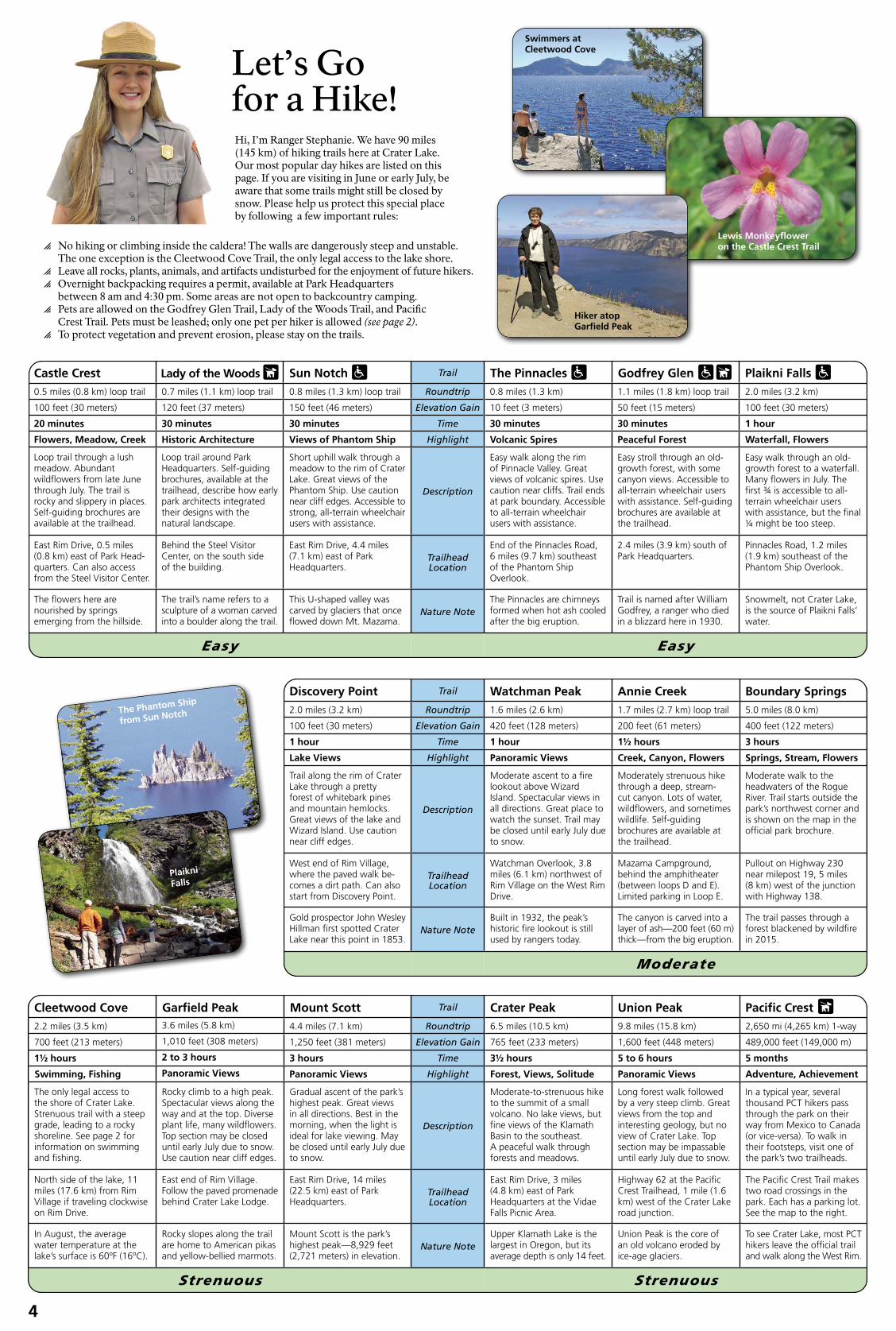
Let’s Go for a Hike! Hi, I’m Ranger Stephanie. We have 90 miles (145 km) of hiking trails here at Crater Lake. Our most popular day hikes are listed on this page. If you are visiting in June or early July, be aware that some trails might still be closed by snow. Please help us protect this special place by following a few important rules:
� No hiking or climbing inside the caldera! The walls are dangerously steep and unstable. The one exception is the Cleetwood Cove Trail, the only legal access to the lake shore.
� Leave all rocks, plants, animals, and artifacts undisturbed for the enjoyment of future hikers. � Overnight backpacking requires a permit, available at Park Headquarters
between 8 am and 4:30 pm. Some areas are not open to backcountry camping. � Pets are allowed on the Godfrey Glen Trail, Lady of the Woods Trail, and Pacifc
Crest Trail. Pets must be leashed; only one pet per hiker is allowed (see page 2). � To protect vegetation and prevent erosion, please stay on the trails.
Lewis Monkeyfower on the Castle Crest Trail
Hiker atop Garfeld Peak
Swimmers at Cleetwood Cove
Castle Crest Lady of the Woods Sun Notch Trail The Pinnacles Godfrey Glen Plaikni Falls 0.5 miles (0.8 km) loop trail 0.7 miles (1.1 km) loop trail 0.8 miles (1.3 km) loop trail Roundtrip 0.8 miles (1.3 km) 1.1 miles (1.8 km) loop trail 2.0 miles (3.2 km)
100 feet (30 meters) 120 feet (37 meters) 150 feet (46 meters) Elevation Gain 10 feet (3 meters) 50 feet (15 meters) 100 feet (30 meters)
20 minutes 30 minutes 30 minutes Time 30 minutes 30 minutes 1 hour
Flowers, Meadow, Creek Historic Architecture Views of Phantom Ship Highlight Volcanic Spires Peaceful Forest Waterfall, Flowers
Loop trail through a lush Loop trail around Park Short uphill walk through a Easy walk along the rim Easy stroll through an old- Easy walk through an old-meadow. Abundant Headquarters. Self-guiding meadow to the rim of Crater of Pinnacle Valley. Great growth forest, with some growth forest to a waterfall. wildfowers from late June brochures, available at the Lake. Great views of the views of volcanic spires. Use canyon views. Accessible to Many fowers in July. The through July. The trail is trailhead, describe how early Phantom Ship. Use caution Description caution near cliffs. Trail ends all-terrain wheelchair users frst 3 is accessible to all-rocky and slippery in places. park architects integrated near cliff edges. Accessible to at park boundary. Accessible with assistance. Self-guiding terrain wheelchair users Self-guiding brochures are their designs with the strong, all-terrain wheelchair to all-terrain wheelchair brochures are available at with assistance, but the fnal available at the trailhead. natural landscape. users with assistance. users with assistance. the trailhead. ¼ might be too steep.
East Rim Drive, 0.5 miles Behind the Steel Visitor East Rim Drive, 4.4 miles End of the Pinnacles Road, 2.4 miles (3.9 km) south of Pinnacles Road, 1.2 miles (0.8 km) east of Park Head- Center, on the south side (7.1 km) east of Park Trailhead 6 miles (9.7 km) southeast Park Headquarters. (1.9 km) southeast of the quarters. Can also access of the building. Headquarters. Location of the Phantom Ship Phantom Ship Overlook. from the Steel Visitor Center. Overlook.
The fowers here are nourished by springs emerging from the hillside.
The trail’s name refers to a sculpture of a woman carved into a boulder along the trail.
This U-shaped valley was carved by glaciers that once fowed down Mt. Mazama.
Nature Note The Pinnacles are chimneys formed when hot ash cooled after the big eruption.
Trail is named after William Godfrey, a ranger who died in a blizzard here in 1930.
Snowmelt, not Crater Lake, is the source of Plaikni Falls’ water.
Easy Easy
The Phantom Ship
from Sun Notch
Plaikni
Falls
Discovery Point Trail Watchman Peak Annie Creek Boundary Springs 2.0 miles (3.2 km) Roundtrip 1.6 miles (2.6 km) 1.7 miles (2.7 km) loop trail 5.0 miles (8.0 km)
100 feet (30 meters) Elevation Gain 420 feet (128 meters) 200 feet (61 meters) 400 feet (122 meters)
1 hour Time 1 hour 1½ hours 3 hours
Lake Views Highlight Panoramic Views Creek, Canyon, Flowers Springs, Stream, Flowers
Trail along the rim of Crater Moderate ascent to a fre Moderately strenuous hike Moderate walk to the Lake through a pretty lookout above Wizard through a deep, stream- headwaters of the Rogue forest of whitebark pines Island. Spectacular views in cut canyon. Lots of water, River. Trail starts outside the and mountain hemlocks. Description all directions. Great place to wildfowers, and sometimes park’s northwest corner and Great views of the lake and watch the sunset. Trail may wildlife. Self-guiding is shown on the map in the Wizard Island. Use caution be closed until early July due brochures are available at offcial park brochure. near cliff edges. to snow. the trailhead.
West end of Rim Village, Watchman Overlook, 3.8 Mazama Campground, Pullout on Highway 230 where the paved walk be- Trailhead miles (6.1 km) northwest of behind the amphitheater near milepost 19, 5 miles comes a dirt path. Can also Location Rim Village on the West Rim (between loops D and E). (8 km) west of the junction start from Discovery Point. Drive. Limited parking in Loop E. with Highway 138.
Gold prospector John Wesley Built in 1932, the peak’s The canyon is carved into a The trail passes through a Hillman frst spotted Crater Nature Note historic fre lookout is still layer of ash—200 feet (60 m) forest blackened by wildfre Lake near this point in 1853. used by rangers today. thick—from the big eruption. in 2015.
Moderate
Cleetwood Cove Garfeld Peak Mount Scott Trail Crater Peak Union Peak Pacifc Crest 2.2 miles (3.5 km) 3.6 miles (5.8 km) 4.4 miles (7.1 km) Roundtrip 6.5 miles (10.5 km) 9.8 miles (15.8 km) 2,650 mi (4,265 km) 1-way
700 feet (213 meters) 1,010 feet (308 meters) 1,250 feet (381 meters) Elevation Gain 765 feet (233 meters) 1,600 feet (448 meters) 489,000 feet (149,000 m)
1½ hours 2 to 3 hours 3 hours Time 3½ hours 5 to 6 hours 5 months
Swimming, Fishing Panoramic Views Panoramic Views Highlight Forest, Views, Solitude Panoramic Views Adventure, Achievement
The only legal access to the shore of Crater Lake. Strenuous trail with a steep grade, leading to a rocky shoreline. See page 2 for information on swimming and fshing.
Rocky climb to a high peak. Spectacular views along the way and at the top. Diverse plant life, many wildfowers. Top section may be closed until early July due to snow. Use caution near cliff edges.
Gradual ascent of the park’s highest peak. Great views in all directions. Best in the morning, when the light is ideal for lake viewing. May be closed until early July due to snow.
Description
Moderate-to-strenuous hike to the summit of a small volcano. No lake views, but fne views of the Klamath Basin to the southeast. A peaceful walk through forests and meadows.
Long forest walk followed by a very steep climb. Great views from the top and interesting geology, but no view of Crater Lake. Top section may be impassable until early July due to snow.
In a typical year, several thousand PCT hikers pass through the park on their way from Mexico to Canada (or vice-versa). To walk in their footsteps, visit one of the park’s two trailheads.
North side of the lake, 11 miles (17.6 km) from Rim Village if traveling clockwise on Rim Drive.
East end of Rim Village. Follow the paved promenade behind Crater Lake Lodge.
East Rim Drive, 14 miles (22.5 km) east of Park Headquarters.
Trailhead Location
East Rim Drive, 3 miles (4.8 km) east of Park Headquarters at the Vidae Falls Picnic Area.
Highway 62 at the Pacifc Crest Trailhead, 1 mile (1.6 km) west of the Crater Lake road junction.
The Pacifc Crest Trail makes two road crossings in the park. Each has a parking lot. See the map to the right.
In August, the average water temperature at the lake’s surface is 60ºF (16ºC).
Rocky slopes along the trail are home to American pikas and yellow-bellied marmots.
Mount Scott is the park’s highest peak—8,929 feet (2,721 meters) in elevation.
Nature Note Upper Klamath Lake is the largest in Oregon, but its average depth is only 14 feet.
Union Peak is the core of an old volcano eroded by ice-age glaciers.
To see Crater Lake, most PCT hikers leave the offcial trail and walk along the West Rim.
Strenuous Strenuous
4

CRATER LAKE NATIONAL PARK
CRATERLAKENATIONALPARK
PUMICE DESERT
od
evo o w kC et ee rCelC
Bea
r
Sl
Skel
l Ch
anne FF
ULB TTOCS
ole r y B ay
m ab
Be ue F
Creek
ANDERSON BLUFFS
Chaski Bay
Sa
Castle ek ndLittle
Creek Castle
DU
TT
ON
RID
GE
Park Boundary
Cr
5
Mun
son
Cre
ek
Lost Cr
Cavern
W
heSun eler C
reek
Creek Cre
Fork
eG THE PINNACLES
kR AYRA BIn ADn G Cie KE
East
Creek
Area of Detail Regional Map to Portland Bend230 138 97to Eugene
NATIONAL 20to Roseburg, Bend,CRATER LAKE Pacifc Crest FORESTSand Eugene National Scenic 58 Trail
NATIONAL PARK 97
NORTH ENTRANCE ROAD (closed in winter)
5 DiamondCRATER LAKE Lake138 ChemultNATIONAL PARK Roseburg 138
230 CRATER LAKEUnion CreekRed Cone NATIONAL
7363ft Grouse Hill Prospect PARK 2245m 7412ft 62
62 Klamath Chiloquin
2260m Fort Grants 234
Cleetwood Cove Trail Pass 62 97Medford199 Klamath
Ashland to Redding Falls
Steel
Llao Rock Bay
Pacifc Crest National Scenic Trail
North Junction 7025ft 2142m
8049ft 2453m
Llao Bay
Merriam Cone EAST RIM DRIVEWEST RIM DRIVE
(closed in winter) Devils Backbone 1788ft deep
545m
486ft deep 148m
Grotto
(closed in winter)
Cove Deepest point 1943ft deep
Watchman Overlook
Watchman Peak 8013ft 2442m
592m
Wizard Crater LakeIsland Elevation at lake level
6940ft 6173ft Cloudcap Overlook2116m 1882m 7865ft 2397m
Lightning LightningSprings SpringsTrail Pumice Castle Overlook 7100ft 2165m
Mount Scott Point Danger (highest point in park) Discovery Rim Village
Rim Café & Gift Shop Bay 8929ftCommunity House (NHA Store) 2721mSinnott Overlook
Phantom ShipRim Visitor Center OverlookCrater Lake LodgeDiscovery Phantom
ShipPoint Trail Plaikni Falls
Pacifc Crest Garfeld PeakNational Scenic Sun
Trail 8054ft NotchCre 2455mPark Headquarters Lady of the
Woods TrailSteel Visitor Center (closed)
Castle6450ft Crest1966m
EAST RIM DRIVE (closed in winter)
eek Trail
62 Vidae Falls to Medford and Whitehorse
Ponds Annie Spring
Lost Creek (closed)
Grayback Drive (gravel road open to hikers,
Annie bicycles, horses, and pets,Spring Godfrey Glen Trail but closed to motor vehicles)
Entrance Station
Pinnacles Trail
Annie Creek TrailAnnie Creek Restaurant & Gift Shop
Crater Peak 7263ftMazama Village Pinnacles2214m
Overlook
6004ft Union Peak 1830m 0 1 2 3 4 5 Kilometers NORTH
Union Peak 7709ft 2350m
Trail
Pacifc Crest National Scenic Trail
62
to Klamath Falls and 97
0 1
Information
Campground
Lodging
2
Gas
Groceries
Food Service
3 4
Picnic Area Restrooms
Trail Open Vault Toilet to Pets (no water)
Wheelchair-Accessible Trail
Highlights of the Rim Drive The Pinnacles
The 33-mile (53-km) road around Crater Lake is one of America’s most scenic byways. The full loop is typically open from early July to late October. It can be driven, without stopping, in about an hour, but plan to spend at least 2 to 3 hours to enjoy the varied sights. The road is narrow, so use caution and be alert for bicyclists, pedestrians, and wildlife. There are more than 30 scenic pullouts, many of which have roadside exhibits. Be sure not to miss these 7 “must-see” stops. For more information, pick up the excellent Road Guide to Crater Lake National Park (48 pages, $7.95) at the Crater Lake Natural History Association store in the Community House at Rim Village.
Discovery Point Imagine seeing Crater Lake by accident. Near this spot, on the back of a mule in 1853, gold prospector John Hillman became the frst European-American to stumble across what he called “Deep Blue Lake.”
Watchman Overlook This pullout ofers an unmatched view of Wizard Island, a cinder cone that erupted out of Crater Lake approximately 7,300 years ago. To fnd it, drive 3.8 miles (6.1 km) west of Rim Village and look for a viewpoint lined with wooden fences.
Cloudcap Overlook This overlook sits at the end of a 1-mile (1.6-km) spur road, the highest paved road in Oregon. Whitebark pines cling for survival here, dwarfed and contorted by the harsh winds.
Pumice Castle Overlook Stop here to see one of the park’s most colorful features: a layer of orange pumice rock that has been eroded into the shape of a medieval castle. Watch carefully for this unmarked viewpoint, located 1.1 miles (1.8 km) west of the Cloudcap Overlook road junction and 2.4 miles (3.9 km) east of the Phantom Ship Overlook.
Phantom Ship Overlook Nestled against the shore, Crater Lake’s “other island” escapes detection by many park visitors. Though it resembles a small sailboat, the island is as tall as a 16-story building. It’s made of erosion-resistant lava, 400,000 years old—the oldest exposed rock within the caldera.
Pinnacles Overlook This overlook is well worth the 6-mile (10-km) detour from Rim Drive. Colorful spires, 100 feet (30 meters) tall, are being eroded from the canyon wall. These “fossil fumaroles” are the result of volcanic gases that rose up through a cooling ash deposit from the eruption that formed Crater Lake.
Vidae Falls This spring-fed, roadside waterfall tumbles over a glacier-carved clif and drops 100 feet (30 meters) over a series of ledges. In summer, wildfowers fourish in the cascade’s spray.
5 Miles
Hiking Trail
Paved Road
Unpaved Road
5

This tree is afficted with white pine blister
RICH
ARD
SNIEZK
O, U
SFS
Ancient whitebark pines grow on the rim of Crater Lake. Shorter than most evergreens, rust. As the fungus grows within the tree, it they are often older than they look—some ruptures the bark, allowing orange-colored live for more than 1,000 years. In bright fruiting bodies to release spores into the
regenerate our whitebark pine forests before the current groves die of.
Scientists frst harvested seeds at Crater Lake in 2003, from 10 trees at Rim Village. The seeds were germinated in a nursery at the Dorena Genetic Resource Center, a US Forest Service facility 20 miles (32 km) south of Eugene that studies how trees defend themselves from disease. At the age of two, the seedlings were exposed to the blister-rust fungus and were checked, over the next 5 years, for signs of resistance. “The parent trees are given letter grades, just like grades in school,” describes Hooke. “Unfortunately, we got one C, fve Ds, and four Fs.” Seeds collected
Clark’s Nutcracker: Planter of Seeds No story on the whitebark pine would be complete without mention of its avian partner: the Clark’s nutcracker (Nucifraga columbiana)—a large, raucous bird related to ravens, jays, and magpies. The fate of the two species is intertwined. Nutcrackers rely on whitebark pines for food; whitebark pines depend on nutcrackers for seed dispersal.
Unlike most pine cones, those of the whitebark pine remain tightly closed, on
since then, from trees elsewhere in the the tree, after the seeds ripen. The seeds park, have shown better resistance. “They are freed and planted with the help of include some As and Bs,” Hooke reports. the Clark’s nutcracker, which uses its
sharp bill to pry out the large, nutritioussunshine, the tree’s gray bark sometimes wind. Eventually, when the fungus encircles the tree’s trunk and cuts off its fow of water Ofspring from these parent trees began to nuts. Some seeds get eaten immediately, appears white, hence the common name. and nutrients, the tree will die. arrive in 2009, when 332 nursery-grown
seedlings from 16 parent trees were planted but most are hidden a few inches deep in the soil, in small caches of 3 to 5. One nutcracker can stash up to 100,000in Rim Village. You can examine these trees
yourself by walking along the paved paths Can We Stop the Decline behind the Rim Village Gift Shop (between
seeds in a single summer! Over the next 9 months, it will use its precise spatial memory to retrieve more than half of its the Gift Shop and the edge of the caldera).
of the Whitebark Pine? Whitebark pines have long stood sentinel December of 2020, the US Fish & Wildlife
caches. Unclaimed seeds will eventuallyMost are between 3 and 6 feet tall. “To germinate and grow into trees. protect them, we planted them next to boul-ders,” says Hooke. “That’s where to look.” So far, pocket gophers have eaten some of the seedlings, and a few have succumbed to
on the rocky rim of Crater Lake. Twisted Service announced that the tree is on blister-rust infection, but 80% are still alive. and gnarled, they are able to withstand cold temperatures, strong winds, and heavy snows. Lately, however, these hardy trees have been dying at an alarming rate. Drive around the lake this summer and you’ll witness the carnage: half of the park’s whitebark pines are dead, half of the rest are dying, and the fate of the entire species is in jeopardy. “At this point,” says park botanist Jen Hooke, “their decline seems irreversible.” What’s behind the destruction of these majestic trees, and can anything be done to save them?
While climate change is playing a big role (causing whitebark pines to sufer from increased insect damage, competition from other tree species, and more intense wildfres), the primary culprit is actually a lethal fungus (Cronartium ribicola)— although human beings are really to blame. We imported the non-native fungus by accident in 1910, when contaminated trees from a nursery in France were shipped to a landowner in British Columbia, Canada. Now a permanent resident of North America, the fungus travels short distances on the wind via microscopic spores, infecting all pines that have 5 needles per bundle, including sugar pines, limber pines, and western white pines. Trees
a path toward extinction and initiated proceedings to list it as a threatened species under the Endangered Species Act of 1973.
If we lose our whitebark pines, we’ll lose more than just some picturesque trees. An entire forest community is at risk. “The whitebark pine is a ‘foundation species’ at Crater Lake,” explains Hooke. “A lot of other species depend on it.” Whitebark pines are the only trees that grow at the park’s highest elevations. They stabilize the soil on steep slopes, helping wildfowers and other plants to gain a foothold. They provide nutritious seeds and sheltered habitat for squirrels, grouse, and other creatures. And by shielding snowbanks from the sun, they retain soil moisture and reduce spring to their task. Whitebark fooding at lower elevations. pines typically don’t produce
many cones until age 50, and Now for the good news: it’s not until age 100 that within most populations, they enter into their prime a few individuals seem to reproductive years. Raising a possess an inborn, genetic forest of genetically resistant resistance to the blister-rust trees will take time. If we fungus. Some trees are able wait too long—until most to shed their infected needles of the current trees have (on which the fungal spores died—the few survivors germinate) before the fungus will be at such low numbers can spread from the needles that Clark’s nutcrackers
Jen Hooke, park botanist
Since 2011, Hooke and her crew of seasonal botanists have continued to harvest seeds from trees that, in the feld, appear to be staving of or coping with blister-rust infection. About 40 fungus-resistant parent trees have been identifed and confrmed (although 7 of them have since died), and a total of 6 “restoration plantings” of their progeny have taken place around the park. Botanists at other national parks—including Yellowstone, Mount Rainier, and Glacier— have been planting nursery-grown seedlings as well. “A whole community of people is working hard to save this tree,” says Hooke. “We are not alone in our eforts.”
There is a sense of urgency
Whitebark pine cones sit horizontally at the tops of trees, providing perfect perches for the Clark’s nutcracker.
Just think: every whitebark pine you see at Crater Lake (except those established since 2009 by the park’s botany crew) was carefully planted by a Clark’s nutcracker! That explains why they tend to grow in clusters, with several trunks emerging from the same spot. Each cluster indicates where an industrious nutcracker, years ago, buried a small cache of seeds.
Removing a cone’s scales reveals a feast of nutritious nuts.
© D
ON
PIGO
TT
infected with the fungus develop a disease to the branches. Other trees (the birds responsible for called “white pine blister rust,” evident by are able to quarantine the propagating the trees in the orange cankers that form on the branches disease in a section of bark and prevent wild) may not even bother to visit them and trunk. The disease has no cure; death it from spreading further. Fewer than 5% and disperse their seeds, opting instead for follows infection in 5 to 15 years. of whitebark pines express these traits, other food sources. That’s why, although
but researchers such as Hooke are trying the idea of planting trees in a national park Whitebark pines (Pinus albicaulis) are to identify and utilize them. By locating may at frst seem counter to the agency’s particularly susceptible to blister rust. resistant trees, collecting their seeds, practice of avoiding manipulation of the Across their range, from California east to and planting their ofspring throughout natural landscape, intervention is critical. Wyoming and north to British Columbia, the park, we might be able to accelerate Whitebark pines are not likely to save their numbers are in rapid decline. In the natural selection process in order to themselves. (continued on page 8)
Beetle Epidemic Complicates Whitebark Pine Restoration The non-native fungus described above is not the only foe facing the whitebark pine. A native insect, the mountain pine beetle (Dendroctonus ponderosae), is hastening the decline of the species. Over the past few decades at Crater Lake, nearly as many whitebark pines have succumbed to beetles as to blister rust. An even bigger concern is that the beetles are killing some of the few trees that have the genetic tools to combat the fungus. Scientists are now in
The size of a grain of rice, pinea race to identify and protect these important individuals
KLAUS BOLTE, CANADIAN FOREST SERVICE
beetles go unnoticed by evenbefore the beetles get to them frst. the most observant of us. (The one here is shown at 8 times its
What’s behind the beetle epidemic? For millennia, actual size.) Except for a fewmountain pine beetles have thrived in the forests days in summer, when adults fy of western North America. In the past, however, from their home tree to a new their intolerance of cold weather generally host, they spend their entire life safeguarded high-elevation trees. Lower-elevation cycle beneath the bark.
species, such as lodgepole pines and ponderosa pines, were the beetles’ main targets. That all changed as of the 21st century. Across the western US and Canada, beetles have turned their attention toward whitebark pines. Our warming climate, it seems, is allowing them to survive winter at higher latitudes and higher elevations.
Beetle attacks are swift and deadly. Female beetles swarm individual trees, laying eggs beneath the bark. When the eggs hatch, the larvae dine on the tree’s innermost layer of bark, tunneling horizontally around the trunk. Within a few weeks, the tree dies, having literally starved to death—its fow of water and nutrients cut off.
Fortunately, we can protect some individual trees from beetle infestation. Shortly after adult beetles overwhelm a tree, they emit a pheromone (a chemical signal) that alerts other beetles in the area to stay away. Much like a “no vacancy” sign, this pheromone, called verbenone, tells other beetles that the tree can’t support a larger population. By attaching pouches containing a synthetic form of verbenone to the trunks of trees we’d like to protect, we can trick the beetles into thinking that those trees have already been attacked. The method isn’t foolproof, and the pouches must be replaced annually to be effective, but it’s our best hope of prolonging the lives of the disease-resistant trees whose seeds hold the key to the long-term survival of our whitebark pine communities.
This summer, Jen Hooke’s crew will be stapling pouches of verbenone to 66 whitebark pines in an effort to ward off beetles. These trees are potentially valuable “parents” whose seedlings might have a degree of natural resistance to the blister-rust fungus.
6

Crater Lake: 20
40Clearly Remarkable First-time visitors to Crater Lake are often surprised to discover such a clean lake in the belly of what once was a dirty, smelly, violent volcano. Early park naturalist Arthur Hasler may have been only slightly exaggerating when he observed, 85 years ago, that “The unusual transparency of the water, in addition to its apparent blue color, sends the sightseer into ecstasies.” Ecstatic or not, most sightseers today react by instinctively reaching for their camera, as though compelled to capture proof that such a remarkable lake exists. What accounts for the lake’s stunning clarity? How do we quantify it? And how does the transparency of the water afect the lake’s ecology and broader scientifc signifcance?
Believe it or not, the water in Crater Lake is cleaner than the water that pours from your faucet at home. That’s because roughly 83% of it comes from rain and snow falling directly on the lake’s surface. (The rest
A scientist inspects a clump of moss retrieved from the depths of Crater Lake. Moss carpets the lake foor as deep as 460 feet (140 meters) below the surface, a testament to the lake’s transparency to sunlight.
60 is runof from precipitation landing on the slopes inside the
80caldera.) No rivers or creeks carry silt, sediment, or pollution into Crater Lake. The other 100 reason the lake is so pure is that its volcanic basin is currently dormant. The last eruption 120 occurred some 4,800 years ago, when an underwater lava dome 140 east of Wizard Island grew to within 95 feet (29 meters) of the surface. Since then, volcanic 2020
Scientists deploy Secchi disks in Crater Lake several times per summer. Each circle below represents a different reading. Visibility is typically best in June and poorest in August, when a warm layer of water traps particles near the surface. The shallowest readings occur after thunderstorms, when rain washes sediment into the lake from the caldera’s inner slopes. In 1995, storms in June and July reduced visibility for the entire summer. Even so, the shallowest reading was still 59 feet (18 meters)!
1980 1990 2000 2010
Dep
th i
n F
eet
Crater Lake Water Clarity, 1978-2020
activity has ceased, at least for the time being. Some dissolved gases and minerals do enter the lake through hydrothermal vents on the lake’s foor, but in very small amounts.
With so few particles suspended in the water, Crater Lake is exceptionally clear— certainly one of the clearest lakes on Earth. When an 8-inch (20-cm) Secchi disk is lowered into the water, the average depth at which it disappears is more than 103 feet (31 meters)! On a good day, Secchi disk readings surpass 130 feet (40 meters). In the early 1980s, however, worries arose that Crater Lake’s clarity was diminishing. Secchi disk depths from 1978-81 were noticeably shallower than the previous measurements that had been taken, a decade earlier, in 1968-69. So concerned was the United States Congress that it passed a law directing the Secretary of the Interior to investigate. Happily, the resulting Limnological (lake research) Monitoring Program, which continues to this day, found that the 1978-81 readings fell squarely within the normal range of variation. Clarity fuctuates quite a bit (see the graph above), but Crater Lake is as clean as ever.
Park scientists also monitor transparency with more sophisticated instruments. At least once a month each summer, they lower a waterproof light meter into the lake to study the degree to which diferent wavelengths of light are able to penetrate. On average, they fnd that 1% of the sun’s visible rays persist to a depth of 330 feet (100 meters). That might not, at frst blush, sound impressive. But even 1% of the sun’s visible rays are more than enough to support the survival of aquatic plants. Moss, for example, hangs from underwater clifs as deep as 460 feet (140 meters) below the surface. Nowhere else in the world has moss been found thriving at such tremendous depths.
The ultraviolet (UV) part of the spectrum also pierces deep into Crater Lake. In fact, scientists in 2003 were amazed to discover that UV rays penetrate deeper into Crater Lake than was believed to be theoretically possible in even the purest of water. A benchmark of physics had to be reset! Crater Lake’s transparency to UV light has a huge impact, it turns out, on its living organisms. Just as ultraviolet rays are
harmful to humans—giving us sunburns and skin cancer—they are also hazardous to aquatic life forms. Moss doesn’t grow within 85 feet (26 meters) of the lake’s surface. Most of the lake’s 163 species of phytoplankton (tiny algae that form the basis of the food chain) hide out even deeper. You’d need to travel 260 feet (80 meters) below the surface to fnd them at their maximum abundance.
In a lake as clear as this one, small changes in water quality are easy to detect, especially compared with other lakes that aren’t as clear. (continued on next page)
Secchi (rhymes with “Becky”) disks are used worldwide to measure water clarity. The usual method is to lower the 8-inch (20-cm) disk un-til it disappears, raise it until it reappears, then take the average of the two readings. Ideally, measurements are taken at midday under calm conditions. The average Secchi disk depth at Crater Lake is 103 feet (31 meters)!
The Journeys of Deep Rover, Remembered Visitors to Crater Lake often fnd themselves wondering if anyone has explored its depths. The answer is yes! In the summers of 1988 and 1989, a one-person submarine made 47 separate dives to the bottom. They were not sightseeing trips—their purpose was to collect data on the lake’s hydrology, biology, and geology and to resolve a controversy over geothermal energy development that was brewing on the borders of the national park. Today, the journeys of Deep Rover stand as a milestone in our understanding of the lake’s ecology and our eforts to protect it. Let’s revisit the discoveries and examine the legacy of this fascinating and important expedition.
Mark Buktenica was the park’s aquatic ecologist from 1985 through 2017. Seen here at the controls of Deep Rover, he remembers the expedition as the experience of a lifetime: “What we found was not only scientifcally interesting, it was spectacular—as spectacular as the scenery above the lake’s surface.”
Beneath Crater Lake National Park lies a reservoir of restless magma. In the mid-1980s, a company from California announced its desire to build a power plant on public lands adjacent to the park. The plan was to use geothermal heat (in the form of steam) to spin turbines to produce electricity for San Francisco. They drilled an exploratory well, half a mile outside the park’s eastern
boundary, and reported temperatures above the boiling point of water just 1,350 feet (410 meters) below ground. The project aroused widespread concern. Might it adversely afect the plumbing of Crater Lake? The United States Congress stepped in, authorizing the Department of the Interior to suspend all drilling while the park investigated two unknowns: Are there any hydrothermal inputs into Crater Lake? And if so, are they signifcant in any way to the lake’s ecology?
The National Park Service, US Geological Survey, and National Geographic Society teamed up to lease a submarine, called Deep Rover, from a company in Vancouver, Canada. Flown by helicopter onto the lake, it was powered by batteries and could stay underwater for six hours at a time. Its hollow, plastic hull had room for only one occupant, who served both as pilot and scientist. Three men—two oceanographers from Oregon State University and Mark Buktenica, the park’s aquatic ecologist— alternated dives. “As I slowly sank into the depths of the lake, I was engulfed in blue that eventually turned to darkness,” recalls Buktenica of his half-hour commutes to the lake foor. “The only sounds in the submarine were the creaking and popping of the hull as it adjusted to the increasing water pressure and the persistent hum of the carbon dioxide scrubbers cleaning the air.”
Fortunately, a radio allowed the men to communicate with the surface, and headlights on the sub allowed them to see. What they found was surprising—and spectacular! Colonies of yellow-gold bacteria grew in vast, pufy mats, often around pools of aqua-blue water (see photo at right). Probes inserted into the bacteria mats registered temperatures as high as 66°F (18.9°C), much warmer than the surrounding 38°F (3.5°C) lake water. The bacteria were surviving in the darkness by oxidizing iron for energy—iron introduced to the lake in warm, hydrothermal fuids from below. Some of the fuids then trickled into the aqua-colored pools, where, laden with minerals, they could not mix freely with the waters above them. The fuids were greatly enriched in elements such as manganese, radon, lithium, and helium-3, indicating that they had once been in contact with hot, subterranean rock. Elsewhere in the lake, the team found 30-foot-tall (9-meter) (continued on next page)
More than 30 years after it explored Crater Lake, the submarine named Deep Rover still captures our imagination. The pilot sat alone inside a clear acrylic sphere and collected samples using two robotic arms.
“It’s bizarre... remarkable.... I’ve never seen anything like it before!” So radioed oceanographer Jack Dymond on August 10, 1989, when he discovered the frst of many “blue pools” on the foor of Crater Lake. This is the only lake in the world in which subsurface pools of high-density water have been detected.
7

Support Your Park— Volunteer Ski Patrollers
Park visitor Kari Bertram spotted this red fox in Mazama Village. Red foxes are not always red—most at Crater Lake are silver to black.
“Classroom at Crater Lake”
Volunteer Your Time Looking for a hands-on way to help the park? Consider sharing your time and talents as a Crater Lake VIP (Volunteer-In-Parks). Full-time volunteers are needed to help staf visitor centers and present interpretive programs. Opportunities are advertised several times each year at www.volun-teer.gov. Volunteers are provided free housing in exchange for 3 months of service. To volunteer periodically, join The Friends of Crater Lake, a nonproft whose members help with special events and operate a winter information desk at Rim Village. Learn more at www.friendsofcraterlake.org. Or join the Crater Lake Ski Patrol, whose members assist winter visitors and maintain the park’s cross-country ski trails. For more information, visit www.craterlakeskipatrol.com.
Report Your Wildlife Sightings Scientists need your help! If you spot any interesting animals during your visit or witness any unusual behavior, please let us know! Your observations will help us learn which animals live in the park and how they use it. Species reported in 2020 included the northern saw-whet owl, police-car moth, pine marten, mountain lion, and gray wolf. To share your sighting, email [email protected]. Let us know the date and precise location of your encounter, a detailed description of what you saw, and your name and contact info, in case we have follow-up questions. And if you captured any photos, send them along (ideally with permission for us to use them in reports and publications). Photographic evidence can be very important in confrming the identity of some species. Just remember that approaching, feeding, or disturbing wildlife is strictly prohibited—so please keep your distance. Thanks for your participation!
Buy Crater Lake License Plates If you live in Oregon, consider choosing Crater Lake license plates for your vehicle. For a one-time charge of $30, you can outft your car with these beautiful plates while supporting park projects. You can purchase them at any time, not just when buying a new vehicle or renewing your registration. Visit any DMV ofce or www.oregon.gov/odot/dmv for details. Proceeds go into an endowment that funds the operation of the park’s Science and Learning Center, which provides living and working space for visiting scientists, teachers, and artists. The Center draws researchers and educators to Crater Lake from around the world, encouraging them to use the park as an outdoor laboratory and classroom. For more information, visit go.nps.gov/slc.
Contribute to the Crater Lake Trust The Crater Lake National Park Trust is a nonproft that raises private funds to support park projects and connect the park with surrounding communities. Each year, for example, it helps fund feld trips here for more than 5,000 students. In a program called “Classroom at Crater Lake,” kids engage in hands-on science and learn about wildlife, old-growth forests, and winter ecology. Learn more at www.craterlaketrust.org. Share your love of the park by making a tax-deductible gift.
Share Your Comments Whether you have a compliment, concern, or suggestion, we’d like to hear from you! This is your park, and we value your input on how best to manage it. To provide feedback, send an email or letter to the park’s Superintendent (see addresses on page 2).
Decline of the Clearly Journeys of Whitebark Pine Remarkable Deep Rover (continued from page 6) (continued from page 7) (continued from page 7)
The decline of the whitebark pine, and (It’s easier to tell when a spoonful of dirt rock spires, chimneys made of silica that of the high-elevation forest community is added to a glass of clear water than to had precipitated out of other upwelling it supports, illustrates the importance of a glass that’s already muddy.) At a time fuids at some point in the past. preventing the introduction of non-native when virtually every large lake in the world species in the frst place. Prevention, is experiencing degradation from local Bacteria were not the only life forms found early detection, containment, and quick human activity, Crater Lake has become to be thriving at great depths in Crater eradication of non-natives are key to important to scientists as a barometer with Lake. A variety of worms, insects, and tiny avoiding costly and difcult mitigation which to measure changes happening on crustaceans were spotted as well. Although eforts. It’s also a reminder, says Hooke, a regional and global scale—including not dependent on the hydrothermal vents, that “Even the most remote places are changes in climate. they were remarkable for their ability to vulnerable to our impacts. The whitebark tolerate the extreme water pressures found pine is basically a wilderness species, but Since 1965, when scientists began in the lake’s deepest basin, 1,943 feet (592 it’s in decline because of humans.” keeping track, the average summer water meters) below the surface. Some were also
temperature at the surface of Crater Lake notable for their life history. Adult fies of Even so, Hooke remains optimistic. has risen by more than 5° Fahrenheit the genus Heterotrissocladius, for example, “We need to maintain hope,” she says. (2.9°C). This increase is almost certainly drop their eggs into the lake. The eggs sink “Collective hope and action are very the result of warming air temperatures. slowly to the bottom, hatch into larvae, powerful. They are representative of Currently, researchers are seeking to feed on lake foor sediments for perhaps the good part of the human spirit. The understand how our warming climate two to three years, swim back up to the efort to save the whitebark pine is range- might be impacting the lake’s circulation, surface (pupating along the way), then wide. Many people and organizations clarity, and ecology. In the short term, emerge as winged adults. Two to three days are involved. I’m still hopeful that, in the it’s possible that Secchi disk readings in later, the adults lay eggs and die, and the future, my grandkids and great-grandkids Crater Lake will actually increase! Warm cycle starts again. will be able to see whitebark pines surface water has trouble mixing with enduring on the rim of Crater Lake.” the cold water beneath it, which limits The discoveries of Deep Rover allowed
the circulation of oxygen and nutrients Crater Lake to join a list 15 other National in the lake, reducing the amount of Park Service units deemed to have phytoplankton living in (and clouding up) “signifcant thermal features” worthy of the water column. However, if deep-water protection under the Geothermal Steam mixing happens less frequently in the Act, a law passed by Congress in 1970. Any future, on occasions when it does occur, future drilling or geothermal development larger-than-ever accumulations of nutrients on nearby public lands won’t be permitted might be stirred up from the bottom, if it’s likely to adversely afect those resulting in algae blooms at the surface and features. Deep Rover also furthered, by a dramatic reduction in water clarity. leaps and bounds, our understanding of
the lake’s evolution and ecology. Even so, At least for now, though, human civilization the sub visited only 2% of the lake foor. has yet to have a signifcant impact on the Many secrets surely remain in the dark,
To examine a grove of whitebark pines up clarity of Crater Lake. Hopefully many watery depths of this collapsed volcano. close (and to witness the damage wrought by
more generations of people will be able to Hopefully, someday, humans will return beetles and the blister-rust fungus), visit the Whitebark Pine Picnic Area. It’s on the East Rim experience the “ecstasies” of gazing down to explore the rest of the bottom of our Drive, just north of the Mount Scott trailhead. upon this remarkable body of water. nation’s deepest lake.
Shop at the NHA Store When you shop at the visitor center bookstore (this year being operated out of the Community House in Rim Village), all proceeds from your purchase are invested back into the park. The store is operated by the Crater Lake Natural History Association, a nonproft established in 1942 to support the park’s educational and scientifc programs. The Crater Lake NHA funds a variety of important projects, including the printing of this visitor guide! Some of the store’s offerings are described below. For a complete list of merchandise and to shop online, visit www.craterlakeoregon.org. You can also order by calling 541-594-1109.
Recommended Reading
Crater Lake: The Story Behind the Scenery Large photos with detailed captions accompany the text of this popular book. 48 pages, $11.95.
Crater Lake: Gem of the Cascades A comprehensive guide to the park’s geology, written by a former ranger. 168 pages, $15.95.
Road Guide to Crater Lake National Park Consult this guide as you circle the lake for a deeper understanding of the park’s features. 48 pages, $7.95.
Trails of Crater Lake & Oregon Caves A detailed guide to 24 hikes. 112 pages, $14.95.
Crater Lake Topo Map Great for backpacking. Waterproof and tearproof. 1:55,000 scale. $14.95.
Plants & Animals of Crater Lake Nat’l Park This folding guide will help you identify the park’s most visible species. 11 pages, $6.95.
Volcanoes Folding, waterproof guide to volcanoes, lava rocks, and plate tectonics. 11 pages, $7.95.
Star & Planet Guide Rotating “planisphere” for locating stars, planets, and constellations in the night sky. $7.99 small, $11.99 large.
101 Wildfowers of Crater Lake Nat’l Park Detailed descriptions and vivid photos of the park’s most common fowers. 74 pages, $14.95.
Trees To Know in Oregon Tree identifcation is easy and enjoyable with this photo-packed, fact-flled guide. 153 pages, $18.00.
Crater Lake: Into the Deep DVD Own the flm shown at the visitor center. Discover the park’s signifcance and explore the lake’s violent past. 22 minutes, $7.50.
Guide to the Nat’l Parks of the United States This best-selling book from National Geographic features 380 stunning photos and 80 color maps. 480 pages, $28.00.
www.craterlakeoregon.org