craster exploration well environmental statement … exploration well nts...environmental statement...
TRANSCRIPT
Craster Exploration Drilling EIA – Non-Technical Summary
Craster Exploration Well Environmental Statement Non-Technical Summary
Craster Exploration Drilling EIA – Non-Technical Summary
1
NON-TECHNICAL SUMMARY
Introduction
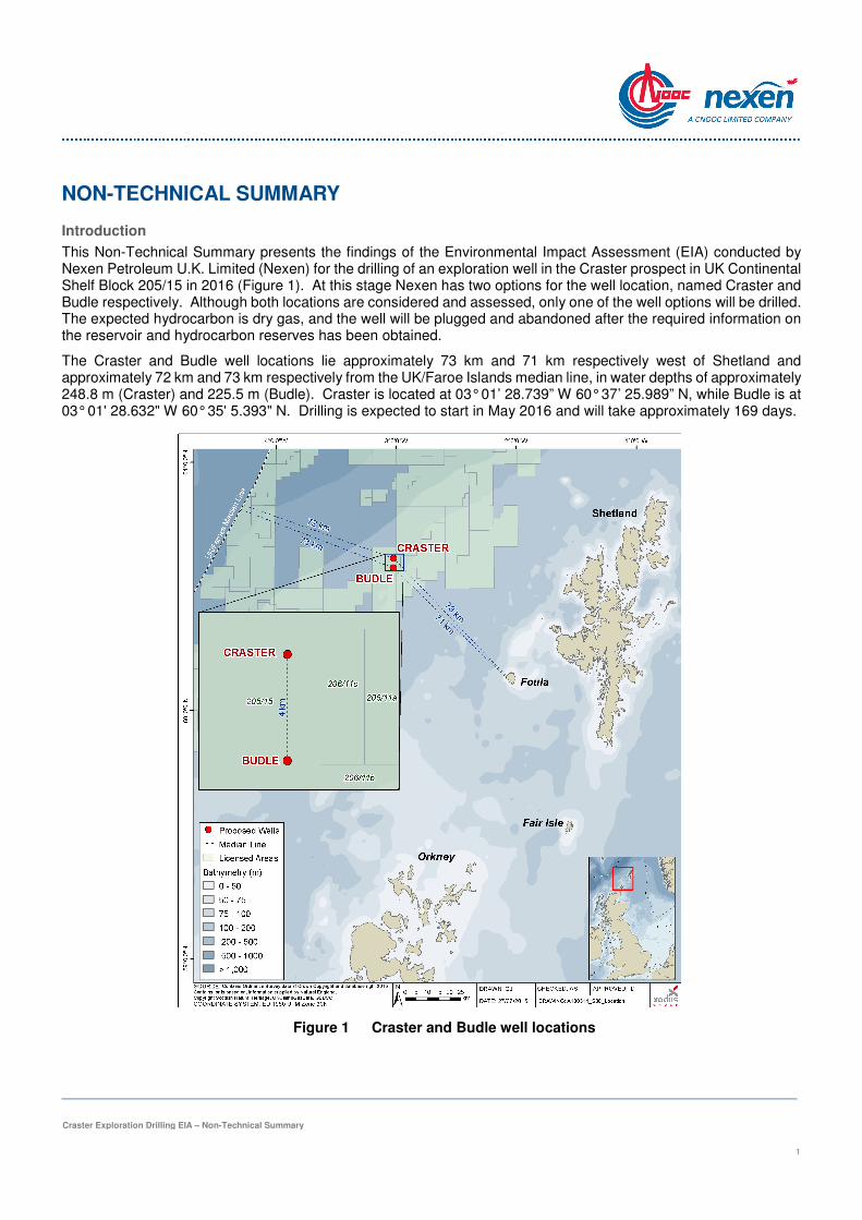
This Non-Technical Summary presents the findings of the Environmental Impact Assessment (EIA) conducted by Nexen Petroleum U.K. Limited (Nexen) for the drilling of an exploration well in the Craster prospect in UK Continental Shelf Block 205/15 in 2016 (Figure 1). At this stage Nexen has two options for the well location, named Craster and Budle respectively. Although both locations are considered and assessed, only one of the well options will be drilled. The expected hydrocarbon is dry gas, and the well will be plugged and abandoned after the required information on the reservoir and hydrocarbon reserves has been obtained.
The Craster and Budle well locations lie approximately 73 km and 71 km respectively west of Shetland and approximately 72 km and 73 km respectively from the UK/Faroe Islands median line, in water depths of approximately 248.8 m (Craster) and 225.5 m (Budle). Craster is located at 03° 01’ 28.739” W 60° 37’ 25.989” N, while Budle is at 03° 01' 28.632" W 60° 35' 5.393" N. Drilling is expected to start in May 2016 and will take approximately 169 days.
Figure 1 Craster and Budle well locations
Craster Exploration Drilling EIA – Non-Technical Summary
2
Consideration of alternatives
The various options for drilling the exploration well have been evaluated in terms of technical feasibility, environmental impact, health and safety, reputation and cost. Nexen is obliged to drill this exploration well, subject to regulatory approval, under the terms of Licence No P.2062. Whilst not drilling the well (the do nothing option) would avoid any potential for environmental impact, it would prevent Nexen from investigating and confirming hydrocarbon reserves in the licence block and would not facilitate optimum utilisation of potential reserves that might be developed to the benefit of Nexen and the nation.
The following options have been considered by Nexen in planning the exploration well:
>>>> Selection of drilling rig;
>>>> Time of year for drilling;
>>>> Selection of mud system and cuttings disposal;
>>>> Selection of well logging and sampling operations including vertical seismic profiling;
>>>> Well testing operations; and
>>>> Suspension or abandonment.
The following options have been selected by Nexen as the preferred options to drill an exploration well in Block 205/15:
>>>> The selected drilling rig will be a semi-submersible drilling rig, using dynamic positioning (DP), anchors or both to maintain position on location;
>>>> Drilling operations are planned to start in May 2016 at the earliest;
>>>> Both water based mud and low toxicity oil based mud will be used with all water based mud-contaminated cuttings/residues discharged to sea. Any low toxicity oil based mud-contaminated cuttings/residues will either be skipped and shipped to shore or will be treated offshore before being discharged to sea (an application to discharge the treated cuttings will be made to the Regulator);
>>>> A vertical seismic profiling survey will be carried out if needed;
>>>> Well testing will take place; and
>>>> The well will be plugged and abandoned after it has been drilled.
Although an ES is not normally mandatory for exploration drilling, DECC’s requirement for an ES in this instance is based on the nature of the well and its location. The well is in relatively deep water, the down-hole conditions will potentially involve high pressures and high temperatures (HPHT)1, the well will be close to the Faroe-Shetland Sponge Belt Nature Conservation Marine Protected Area, and this will be the first time Nexen has drilled west of Shetland.
Drilling operations
Drilling operations are expected to start in May 2016. The total duration of the drilling, well testing and abandonment operations is expected to be around 169 days or six months. At the time of undertaking the EIA, it has not yet been confirmed which drilling rig will be used for the proposed exploration drilling, other than that it will be a semi-submersible (positioned using DP, anchors or both) with a crew experienced in drilling HPHT wells.
1 A well that is hotter or higher pressure than most. In the UK, formally defined as a well having a bottom hole temperature >149˚C or requiring a blow-out preventer (BOP) with a rating of >10,000 psi (68.95 MPa).
Craster Exploration Drilling EIA – Non-Technical Summary
3
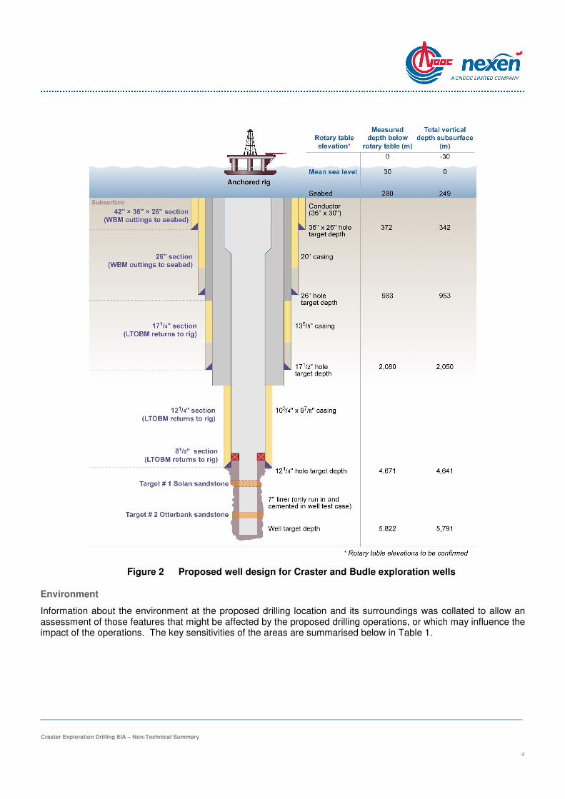
The drilling activity proposed is a single vertical well to 5,791 m (19,000 ft) total vertical depth below mean sea level). The expected hydrocarbon type is dry gas. However, there is some uncertainty regarding the hydrocarbon type and it is possible that some heavy oil may also be found. The well will be drilled in five sections of successively smaller diameters (i.e. 42", 26", 17½", 12¼" and 8½") and steel casings and a liner installed, as shown in Figure 2. Drilling muds fulfil a number of functions such as lubrication and cooling of the drill bit, suspension and transport of rock cuttings from the drill bit at the bottom of the borehole to the surface, and the provision of ‘weight’ (hydrostatic pressure) to counter-balance formation pressure. Water based muds are essentially a slurry made up of seawater and clay particles (e.g. bentonite) and a number of chemical additives which are selected to optimise and control the drilling process. Water based mud will be used to drill the two top hole sections, with low toxicity oil based mud being used to drill the deeper sections. Low toxicity oil based muds are required for the deeper sections because of the sub-surface geology. While it is permitted to discharge rock cuttings with adhering water based muds to sea (with appropriate controls in place), the same is not true for cuttings with adhering oil based muds which have much more stringent requirements for cleaning – typically requiring either specialist cleaning equipment (thermomechanical cuttings cleaning) or total containment and shipping to shore for treatment and disposal. With a riser in place to enable the return of cuttings and mud back up to the drilling rig, the cuttings can be subject to screening to separate out the bulk of the oil based mud for re-use, prior to subjecting the screened cuttings to either thermomechanical cuttings cleaning treatment to the required standard for offshore discharge, or to containment and shipping to shore (so called ‘skip and ship’).
After drilling operations are completed, a well clean-up operation will be carried out. The casings and liner will be cleaned up by displacing the oil based mud in the well bore to seawater; this fluid will be circulated out of the well and discharged overboard to the marine environment once visibly free of oil. A drill stem test is planned for this exploration well, although it may not be required if insufficient hydrocarbons are found. Although there are two independent exploration targets (the Jurassic Solan and the Triassic Otterbank sandstone formations) only one target will undergo testing. It is assumed that a normal well test will be required (rather than an extended well test). This will involve hydrocarbon production from the well for a maximum duration of 96 hours. Since there will be no export facilities available during this exploration operation, the produced hydrocarbons will be burnt in a flare. A maximum of 2,000 tonnes of produced hydrocarbons will be flared.
It is expected that vertical seismic profiling (VSP) may be required for this exploration well. This survey activity generates sound pulses through the water using compressed air from an airgun array (the source), these being directed at the geological strata downhole. This is a very small seismic survey around the well location which, together with the data gained through drilling, will provide a better understanding of the local geology beneath the seabed. The airgun will be deployed from the drilling rig, and sensors will be deployed to receive and measure the reflected sound signals.
Once drilling, well testing and VSP are complete, the exploration well will be plugged and abandoned according to regulatory requirements to prevent any risk of hydrocarbon spills. This means that cement plugs will be installed to prevent any further hydrocarbon flow from the reservoir, and that the steel casings will be cut below the level of the seabed so that no obstructions remain.
Craster Exploration Drilling EIA – Non-Technical Summary
4
Figure 2 Proposed well design for Craster and Budle exploration wells
Environment
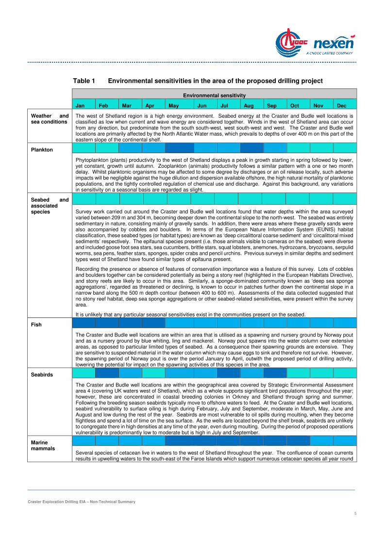
Information about the environment at the proposed drilling location and its surroundings was collated to allow an assessment of those features that might be affected by the proposed drilling operations, or which may influence the impact of the operations. The key sensitivities of the areas are summarised below in Table 1.
Craster Exploration Drilling EIA – Non-Technical Summary
5
Table 1 Environmental sensitivities in the area of the proposed drilling project
Environmental sensitivity
Jan Feb Mar Apr May Jun Jul Aug Sep Oct Nov Dec
Weather and sea conditions
The west of Shetland region is a high energy environment. Seabed energy at the Craster and Budle well locations is classified as low when current and wave energy are considered together. Winds in the west of Shetland area can occur from any direction, but predominate from the south south-west, west south-west and west. The Craster and Budle well locations are primarily affected by the North Atlantic Water mass, which prevails to depths of over 400 m on this part of the eastern slope of the continental shelf.
Plankton
Phytoplankton (plants) productivity to the west of Shetland displays a peak in growth starting in spring followed by lower, yet constant, growth until autumn. Zooplankton (animals) productivity follows a similar pattern with a one or two month delay. Whilst planktonic organisms may be affected to some degree by discharges or an oil release locally, such adverse impacts will be negligible against the huge dilution and dispersion available offshore, the high natural mortality of planktonic populations, and the tightly controlled regulation of chemical use and discharge. Against this background, any variations in sensitivity on a seasonal basis are regarded as slight.
Seabed and associated species
Survey work carried out around the Craster and Budle well locations found that water depths within the area surveyed varied between 209 m and 304 m, becoming deeper down the continental slope to the north-west. The seabed was entirely sedimentary in nature, consisting mainly of gravelly sands. In addition, there were areas where these gravelly sands were also accompanied by cobbles and boulders. In terms of the European Nature Information System (EUNIS) habitat classification, these seabed types (or habitat types) are known as ‘deep circalittoral coarse sediment’ and ‘circalittoral mixed sediments’ respectively. The epifaunal species present (i.e. those animals visible to cameras on the seabed) were diverse and included goose foot sea stars, sea cucumbers, brittle stars, squat lobsters, anemones, hydrozoans, bryozoans, serpulid worms, sea pens, feather stars, sponges, spider crabs and pencil urchins. Previous surveys in similar depths and sediment types west of Shetland have found similar types of epifauna present.
Recording the presence or absence of features of conservation importance was a feature of this survey. Lots of cobbles and boulders together can be considered potentially as being a stony reef (highlighted in the European Habitats Directive), and stony reefs are likely to occur in this area. Similarly, a sponge-dominated community known as ‘deep sea sponge aggregations’, regarded as threatened or declining, is known to occur in patches further down the continental slope in a narrow band along the 500 m depth contour (between 400 to 600 m). Assessments of the data collected suggested that no stony reef habitat, deep sea sponge aggregations or other seabed-related sensitivities, were present within the survey area.
It is unlikely that any particular seasonal sensitivities exist in the communities present on the seabed.
Fish
The Craster and Budle well locations are within an area that is utilised as a spawning and nursery ground by Norway pout and as a nursery ground by blue whiting, ling and mackerel. Norway pout spawns into the water column over extensive areas, as opposed to particular limited types of seabed. As a consequence their spawning grounds are extensive. They are sensitive to suspended material in the water column which may cause eggs to sink and therefore not survive. However, the spawning period of Norway pout is over the period January to April, outwith the proposed period of drilling activity, lowering the potential for impact on the spawning activities of this species in the area.
Seabirds
The Craster and Budle well locations are within the geographical area covered by Strategic Environmental Assessment area 4 (covering UK waters west of Shetland), which as a whole supports significant bird populations throughout the year; however, these are concentrated in coastal breeding colonies in Orkney and Shetland through spring and summer. Following the breeding season seabirds typically move to offshore waters to feed. At the Craster and Budle well locations, seabird vulnerability to surface oiling is high during February, July and September, moderate in March, May, June and August and low during the rest of the year. Seabirds are most vulnerable to oil spills during moulting, when they become flightless and spend a lot of time on the sea surface. As the wells are located beyond the shelf break, seabirds are unlikely to congregate there in high densities at any time of the year, even during moulting. During the period of proposed operations vulnerability is predominantly low to moderate but is high in July and September.
Marine mammals
Several species of cetacean live in waters to the west of Shetland throughout the year. The confluence of ocean currents results in upwelling waters to the south-east of the Faroe Islands which support numerous cetacean species all year round
Craster Exploration Drilling EIA – Non-Technical Summary
6
Environmental sensitivity
Jan Feb Mar Apr May Jun Jul Aug Sep Oct Nov Dec
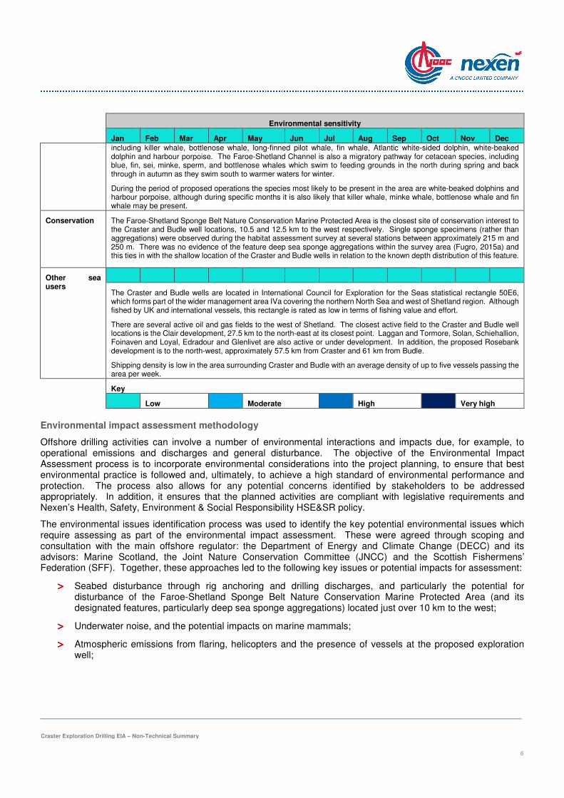
including killer whale, bottlenose whale, long-finned pilot whale, fin whale, Atlantic white-sided dolphin, white-beaked dolphin and harbour porpoise. The Faroe-Shetland Channel is also a migratory pathway for cetacean species, including blue, fin, sei, minke, sperm, and bottlenose whales which swim to feeding grounds in the north during spring and back through in autumn as they swim south to warmer waters for winter.
During the period of proposed operations the species most likely to be present in the area are white-beaked dolphins and harbour porpoise, although during specific months it is also likely that killer whale, minke whale, bottlenose whale and fin whale may be present.
Conservation The Faroe-Shetland Sponge Belt Nature Conservation Marine Protected Area is the closest site of conservation interest to the Craster and Budle well locations, 10.5 and 12.5 km to the west respectively. Single sponge specimens (rather than aggregations) were observed during the habitat assessment survey at several stations between approximately 215 m and 250 m. There was no evidence of the feature deep sea sponge aggregations within the survey area (Fugro, 2015a) and this ties in with the shallow location of the Craster and Budle wells in relation to the known depth distribution of this feature.
Other sea users
The Craster and Budle wells are located in International Council for Exploration for the Seas statistical rectangle 50E6, which forms part of the wider management area IVa covering the northern North Sea and west of Shetland region. Although fished by UK and international vessels, this rectangle is rated as low in terms of fishing value and effort.
There are several active oil and gas fields to the west of Shetland. The closest active field to the Craster and Budle well locations is the Clair development, 27.5 km to the north-east at its closest point. Laggan and Tormore, Solan, Schiehallion, Foinaven and Loyal, Edradour and Glenlivet are also active or under development. In addition, the proposed Rosebank development is to the north-west, approximately 57.5 km from Craster and 61 km from Budle.
Shipping density is low in the area surrounding Craster and Budle with an average density of up to five vessels passing the area per week.
Key
Low Moderate High Very high
Environmental impact assessment methodology
Offshore drilling activities can involve a number of environmental interactions and impacts due, for example, to operational emissions and discharges and general disturbance. The objective of the Environmental Impact Assessment process is to incorporate environmental considerations into the project planning, to ensure that best environmental practice is followed and, ultimately, to achieve a high standard of environmental performance and protection. The process also allows for any potential concerns identified by stakeholders to be addressed appropriately. In addition, it ensures that the planned activities are compliant with legislative requirements and Nexen’s Health, Safety, Environment & Social Responsibility HSE&SR policy.
The environmental issues identification process was used to identify the key potential environmental issues which require assessing as part of the environmental impact assessment. These were agreed through scoping and consultation with the main offshore regulator: the Department of Energy and Climate Change (DECC) and its advisors: Marine Scotland, the Joint Nature Conservation Committee (JNCC) and the Scottish Fishermens’ Federation (SFF). Together, these approaches led to the following key issues or potential impacts for assessment:
>>>> Seabed disturbance through rig anchoring and drilling discharges, and particularly the potential for disturbance of the Faroe-Shetland Sponge Belt Nature Conservation Marine Protected Area (and its designated features, particularly deep sea sponge aggregations) located just over 10 km to the west;
>>>> Underwater noise, and the potential impacts on marine mammals;
>>>> Atmospheric emissions from flaring, helicopters and the presence of vessels at the proposed exploration well;

Craster Exploration Drilling EIA – Non-Technical Summary
7
>>>> Discharges to sea, especially cuttings discharges;
>>>> Interactions with other sea users including shipping and fishing activities in the area; and
>>>> Spill risk.
To help inform these assessments, the following supporting studies were also conducted:
>>>> Site-specific seabed survey to assess the possible presence of habitats and species of conservation importance;
>>>> Drill cuttings dispersion modelling, to assist in assessing the fate and impacts of cuttings discharged to the seabed from the drilling process;
>>>> Oil spill modelling, to facilitate assessment of the impacts from worst case scenarios regarding accidental spills of either crude oil or diesel fuel. Although the expected hydrocarbon is dry gas, it is possible that some accompanying oil might be present also; and
>>>> Underwater noise modelling, to assess the impacts of loud underwater noise on marine mammals resulting from VSP activities during the drilling project.
The significance of each impact is assessed based on its likelihood or frequency and its potential consequence. The consequence rating takes account of the magnitude of the impact and the sensitivity of the receptor. Cumulative and transboundary impacts were also assessed.
Seabed Impacts
The placement of the drilling rig anchors and lines on the seabed will result in a temporary direct impact on the seabed fauna over an area of 0.08 km2 (8 hectares). Animals which live on the seabed, and a proportion of the animals that burrow into the sediment or form tubes within it (such as polychaete worms), may be lost from this direct footprint area.
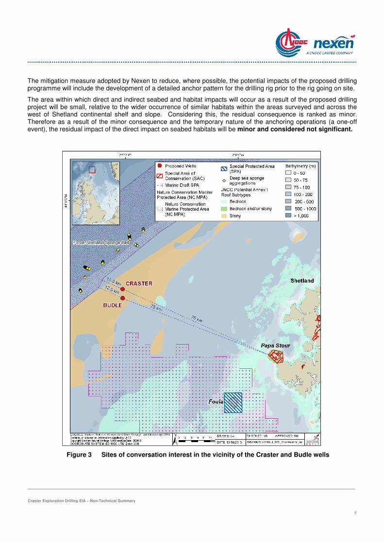
The proposed drilling project is located 10.5 km from the Faroe-Shetland Sponge Belt Nature Conservation Marine Protected Area (Figure 3), which is designated due to the presence of slow growing, deep sea sponge aggregations, aggregations of a clam species known as the ocean quahog, offshore subtidal sands and gravels, the continental slope, continental slope channels, iceberg plough marks, growth of wedges/slide deposits, and sediment wave fields (including sand wave fields). Although well outside the nature conservation marine protected area boundary, use has been made of Marine Scotland’s online Feature Activity Sensitivity Tool to determine whether the exploration activity will exert pressures to which these protected features are sensitive. This tool has helped in determining that any impacts on such features, whether inside or outside the Faroe-Shetland Sponge Belt Nature Conservation Marine Protected Area, are likely to be negligible and not significant.
No deep sea sponge aggregations were observed within the area, and the closest known records of this feature lie more than 10.5 km to the west (Figure 3). No ocean quahogs (a long-lived species of clam that is a protected feature of many offshore protected sites) were observed either in the camera footage during the survey, or in any of the samples (Fugro, 2015a). According to the mapped distribution of continental slope channels, slide deposits, sand wave fields and sediment wave fields in JNCC (2014), there will be no direct interaction between these features and the Craster drilling project. Therefore any impacts on such features, whether inside or outside the Faroe-Shetland Sponge Belt Nature Conservation Marine Protected Area, are likely to be negligible and not significant.
In addition, the proposed drilling project is located in an area of seabed classified by JNCC as potentially comprising Annex I stony reef habitat (Figure 3). Survey work did show the presence of occasional cobbles and boulders in the vicinity of the Craster and Budle locations, the closest of these occurring approximately 2 km to the south of Craster. However, a ‘reefiness’ assessment conducted according to JNCC criteria scored these stony areas as either ‘not a reef’ or as of ‘low’ reef potential. On this basis none of these areas are likely to constitute an Annex I stony reef.
Craster Exploration Drilling EIA – Non-Technical Summary
8
The mitigation measure adopted by Nexen to reduce, where possible, the potential impacts of the proposed drilling programme will include the development of a detailed anchor pattern for the drilling rig prior to the rig going on site.
The area within which direct and indirect seabed and habitat impacts will occur as a result of the proposed drilling project will be small, relative to the wider occurrence of similar habitats within the areas surveyed and across the west of Shetland continental shelf and slope. Considering this, the residual consequence is ranked as minor. Therefore as a result of the minor consequence and the temporary nature of the anchoring operations (a one-off event), the residual impact of the direct impact on seabed habitats will be minor and considered not significant.
Figure 3 Sites of conversation interest in the vicinity of the Craster and Budle wells

Craster Exploration Drilling EIA – Non-Technical Summary
9
Underwater noise impacts
In recent years there has been growing awareness of the potential for man-made underwater noise to impact marine animals, particularly marine mammals. During the drilling operations at one of the well locations, noise will be generated by the drilling rig itself, its support vessels (i.e. standby vessel, anchor handling vessels and supply vessels), and by helicopters. These sources will emit low frequency noise to the air as well as into the water column. More substantial sources of underwater noise may potentially arise also from VSP survey work if this is required (loud seismic pulses but survey of short duration) and/or if a DP rig is selected, from the thrusters used continuously by the rig to maintain position whilst on location.
With regard to noise impacts in air, noise production on platforms is minimised as a matter of course when personnel are likely to be impacted under Health & Safety at work legislation. Due to the mismatch between air and water, much of the sound energy from noise above water (e.g. from helicopters) is reflected from the water surface and little penetrates through to the water column. Noise modelling conducted (Xodus, 2015a) indicates that injury zones for VSP on its own could extend to 57 m from the seismic source. The noise from the associated vessels which will be used during the proposed operations will not pose any risk of injury to the marine mammals. Disturbance impacts from VSP could occur at up to 940 m, whilst noise from vessels (including either rig DP noise or anchor handling vessels) could potentially cause disturbance out to between 14.1 – 16.8 km; however, this is based on very precautionary thresholds.
For the VSP, standard mitigation measures will be adopted. These include the presence of marine mammal observers, use of passive acoustic monitoring which comprises of a short hydrophone array station, a deck cable and data processing system which processes and stores data on the marine mammals in the area, and observations 60 minutes before use of seismic sources to detect the presence of marine mammals.
The supply vessels, standby vessel, anchor handling vessels and VSP survey vessel are likely to be used for limited periods during the proposed drilling project and therefore the frequency can be considered as a one-off event, and the residual consequence is considered minor. As such, the residual impact from drilling and vessel noise will be negligible and is therefore considered not significant.
The use of VSP will occur for a short period of time during the proposed drilling project as a one-off event; therefore, with the mitigation proposed, the residual consequence is minor. Consequently, the residual impact of the noise emitted by the VSP will be negligible and is therefore considered not significant.
Under the Offshore Marine Regulations, an assessment for the requirement for a wildlife disturbance licence was undertaken for the drilling of the exploration well. This assessment concluded that it is extremely unlikely that any operations will adversely affect animals in such a way as to result in detrimental impacts at the population level, and therefore Nexen believes it is unnecessary to apply for a wildlife disturbance licence. These conclusions apply to both possible well locations (Craster and Budle).
Atmospheric emissions
During the proposed drilling operations, atmospheric emissions will result from combustion and process operations of the drilling rig, as well as from its associated vessels and aircraft. These emissions may contribute to a variety of environmental effects and associated impacts (e.g. climate change, acidification, petrochemical smog and small particulates).
The total CO2 emissions from the proposed drilling project are estimated to be 39,813 tonnes which will contribute 0.07% of the total atmospheric emissions associated with UK offshore shipping and maritime activities. An estimate of the total CO2 equivalents generated by all gaseous emissions from the proposed drilling project, based on their global warming potential (CO2-e), has also been calculated and amounts to 43,196 tonnes; equivalent to 0.08% of the offshore annual emissions for the UK.
Nexen will ensure that appropriate management procedures are in place to ensure that the vessel days and proposed operations are as short as possible, and that there is regular monitoring to ensure equipment efficiency.
Craster Exploration Drilling EIA – Non-Technical Summary
10
Given the relatively small scale nature of the emissions associated with the drilling project, and the dispersive nature of the offshore environment, it is considered that the residual consequence is ranked as negligible and when the short duration of the proposed operations is taken into account, the frequency is also negligible. As a result of the negligible consequence and frequency, the residual impact of the atmospheric emissions at a local scale will be negligible and therefore not significant.
Discharges to sea
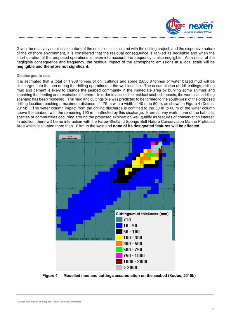
It is estimated that a total of 1,988 tonnes of drill cuttings and some 2,650.8 tonnes of water based mud will be discharged into the sea during the drilling operations at the well location. The accumulation of drill cuttings, drilling mud and cement is likely to change the seabed community in the immediate area by burying some animals and impairing the feeding and respiration of others. In order to assess the residual seabed impacts, the worst case drilling scenario has been modelled. The mud and cuttings pile was predicted to be formed to the south-west of the proposed drilling location reaching a maximum distance of 175 m with a width of 40 m to 50 m, as shown in Figure 4 (Xodus, 2015b). The water column impact from the drilling discharge is confined to the 50 m to 60 m of the water column above the seabed, with the remaining 190 m unaffected by this discharge. From survey work, none of the habitats, species or communities occurring around the proposed exploration well qualify as features of conservation interest. In addition, there will be no interaction with the Faroe-Shetland Sponge Belt Nature Conservation Marine Protected Area which is situated more than 10 km to the west and none of its designated features will be affected.
Figure 4 Modelled mud and cuttings accumulation on the seabed (Xodus, 2015b)

Craster Exploration Drilling EIA – Non-Technical Summary
11
Considering the characteristics of the potential impact, the benthic receptor species and the potential for recovery, the consequence of the potential impact due to discharge of cuttings to the seabed and to the water column is considered to be minor. Since the proposed operations are a one-off event and temporary in duration (<170 days), the overall residual impact is minor and not significant.
A number of mitigation measures will be applied to the proposed drilling project to limit, where practicable, the potential environmental impacts of drilling discharges, including: designing and using drilling fluids in a manner that minimises impacts from discharges, using chemicals with no or low potential for environmental impact (where technical requirements allow), applying for the appropriate permit application, and reducing the amount of unused cement.
The chemicals used to formulate the water based mud will be discharged to sea together with the cuttings. The details of such chemical use and discharge with regard to types and quantities to be used, and associated toxicity and bioaccumulation risks, are assessed and permitted separately (prior to drilling) under the UK Offshore Chemical Regulations 2002. Only chemicals which are approved for use (and discharge) in the UK can be used, in addition to which Nexen will implement its own policy on the use and discharge of hazardous chemicals.
Overall, with the low toxicity of water based mud, and rapid dispersion due to the tidal streams in the area, the environmental impact of drilling discharges on the water column is likely to be negligible and therefore not significant.
Interactions with other sea users
Use of the sea by both the oil and gas and the fishing industries brings with it the potential for interactions. Impacts arising from this interaction can include direct and indirect exclusion of fishing from certain areas, damage to fishing gear from seabed debris, cement build-up and obstacles, and damage to oil and gas industry subsea facilities by fishing gear.
Although there will be an increase in the number of vessels in the area during the proposed drilling project, including the drilling rig itself, these activities will only be of a relatively limited duration. Standard communication and notification procedures will be in place to ensure that all vessels operating in the area are aware of the activities, including the presence of the drilling rig.
A number of mitigation measures will be employed to minimise the risk to other sea users, including: ensuring required consents are in place for the drill rig and the proposed operations, presence of a standby vessel, a vessel traffic survey and appropriate risk assessment, implementation of a 500 m safety exclusion zone around the drilling rig, reduction of vessel use and duration as far as possible, and communication of the location of the anchors and anchor lines (if used) to other sea users.
The proposed drilling project is located in an area of relatively low levels of shipping activity in comparison to other areas of the North Sea. The vessels utilising the waters around the proposed drilling project are primarily cargo, tanker or fishing vessels but port and non-port service, underwater operation and passenger vessels also utilise the area at lower densities. With the limited vessel requirement and the mitigation measures to be deployed, there is little chance of an increase in the risk of vessel collision as a consequence of increased vessel activities. In addition, the proposed drilling project is small and temporary, and there is ample sea room around either of the drilling locations for route adjustments through the project duration.
Vessels will be temporarily excluded from an area of approximately 0.8 km2 (80 hectares) around the drilling rig as a result of the proposed drilling project. The anchors and anchor lines will lie outwith this area; therefore Nexen will ensure the location of these will be communicated to other sea users. Taking into account the localised and temporary nature of the access restrictions for a period of approximately 170 days, the decreasing fishing effort observed in the wider area since 2010 and the low level of vessel traffic, the overall risk of interference with fishing and shipping activity is considered to be low. It is therefore considered that the residual consequence is rated as minor. In frequency ranking terms, the residual impact will be a one-off event overall. As a result of the minor consequence and one-off frequency, the residual impact will be minor and is considered not significant.

Craster Exploration Drilling EIA – Non-Technical Summary
12
Spill risk
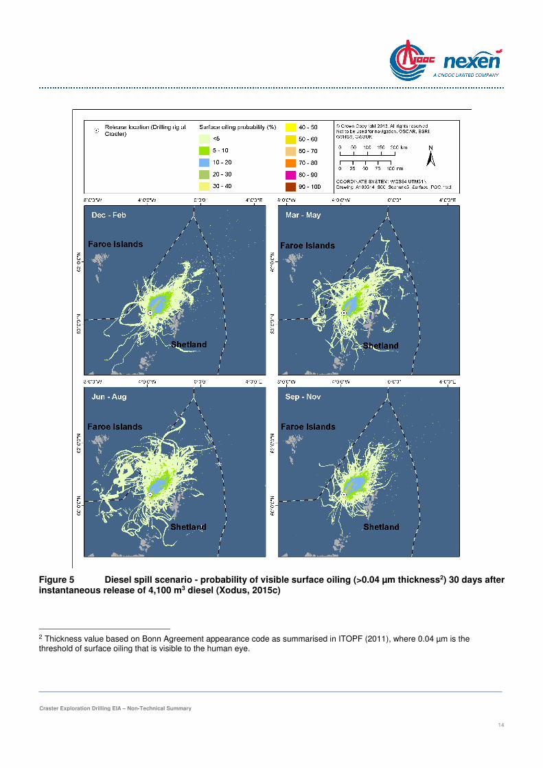
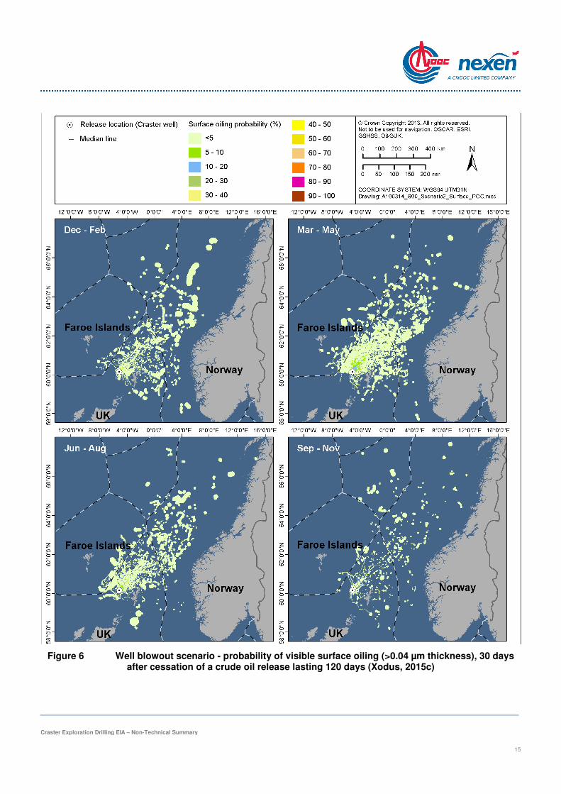
The risk of an accidental hydrocarbon spillage to the sea is often one of the main environmental concerns associated with oil-industry activities. Spilled oil at sea can have a number of environmental and economic impacts, the most conspicuous of which are on seabirds and coastal areas. The actual impacts depend on many factors, including the volume and type of hydrocarbon spilled, the sea and weather conditions at the time of the spill, and the oil spill response. Although the expected hydrocarbon is dry gas, it is possible that some crude oil may also be present; therefore the expected hydrocarbon for this well has been assumed (on a worst case basis) to be crude oil. Oil spill modelling was conducted using the OSCAR model system in order to predict the likely fate of oil spilled under the worst case scenarios appropriate to the proposed exploration drilling project. These scenarios took into account various factors including the possible high pressure and high temperature nature of the well, the possible presence of crude oil in the reservoir, the size and type of drilling rig likely to be required to withstand the harsh west of Shetland environment and, in the event of a blowout, the time taken to procure a second rig to drill a relief well to plug the release. The results of such modelling will be used in planning the response to any oil spills during drilling operations, from the smallest to the largest events. Two worst case scenarios were modelled, as follows:
>>>> An instantaneous loss of diesel fuel from the vessel with the largest fuel inventory - likely to be the drilling rig itself, for which the largest fuel inventory assumed is 4,100 m3 – this release was modelled for 30 days;
>>>> Spillage of crude in the event of an uncontrolled well blowout, using the highest unconstrained well flow rate (16,785 m3/day) for 120 days – the fate of oil was modelled for 30 days following the cessation of this release.
The model computes a series of trajectories for the spilled oil under various wind and current conditions (using location-specific data), in a process known as stochastic modelling.
The results of modelling for the diesel spill scenario (Figure 5) indicate that the probability of surface oiling remains highest close to the spill location with the plume spreading to the north-east. The probability of visible surface oiling of >30% is restricted to the release location. Although the pattern of spread varies slightly with season, the probability of visible surface oiling crossing median lines is relatively low (<5%). In addition, the shortest arrival time of spilled diesel in Norwegian waters would occur in the summer season (after 5 days 9 hours), and the shortest arrival time to Faroese waters was predicted to be in the spring season (1 day 7 hours). For all seasons, the maximum time-averaged thickness over the surface of the sea was less than 5 mm; the majority of the surface oil was <50 µm thick. There is a maximum 2% probability that the diesel will beach on the Shetland shoreline, and less than 1% that the diesel will beach in Orkney (Xodus, 2015c).
The results of modelling for the well blowout scenario (Figure 6) indicate that after 150 days, the probability of visible surface oiling remains highest close to the spill location, but the plume is likely to spread to the north-east to be thinly and more sporadically spread over a larger sea area. Although the pattern and area of spread is similar across seasons, the visible surface oiling is likely to be most continuous through the months of spring and most sporadic or patchy in autumn. As for the diesel spill scenario, the probability of visible surface oiling crossing median lines is relatively low (<5%). In all seasons, the maximum time-averaged thickness of oil over the surface of the sea was less than 200 µm, with the majority predicted to be <5 µm. The shortest arrival time to Norwegian waters was predicted in the winter season (14 days 11 hours), the shortest arrival time to Faroese waters was predicted in the summer season (8 days 8 hours) and the shortest arrival time to the Atlantic Ocean was predicted in the spring season (74 days 10 hours). There is a maximum 5% probability that such a hydrocarbon release will beach anywhere in Shetland.
The most significant spill risk in terms of likelihood is associated with hose failure during transfer of drilling mud, diesel and chemicals during drilling operations. These spills are expected to be small in volume and procedures will be in place to reduce the risk of spillage, in particular written procedures on fluid transfers, and regular inspection of equipment and provision of spill kits. A larger well blowout could result in oil reaching the coastline, but the likelihood of this type of event is considered to be remote, i.e. of very low probability. The consequences of a significant release

Craster Exploration Drilling EIA – Non-Technical Summary
13
of hydrocarbons from the proposed drilling project will vary depending on factors such as wind speed and direction and sea state, as well as the time of year and the length of coastline affected.
Even with comprehensive prevention measures in place, the residual risk of spill remains, and integral to offshore operations is the implementation of detailed and fully tested contingency response plans. Nexen has in place a range of response/mitigation measures to address such risks. All drilling activities at the proposed drilling project will be covered by an appropriate Oil Pollution Emergency Plan. The Oil Pollution Emergency Plan sets out the responses required and the available resources for dealing with all spill sizes.
The planning, design and support of all activities for the proposed drilling project will aim to eliminate or minimise potential environmental risks. As described, these impacts are being mitigated through the equipment design, spill risk reduction measures and provision of appropriate spill response arrangements. Nexen’s management processes will ensure that these mitigation commitments are implemented and monitored.
Craster Exploration Drilling EIA – Non-Technical Summary
14
Figure 5 Diesel spill scenario - probability of visible surface oiling (>0.04 µm thickness2) 30 days after instantaneous release of 4,100 m3 diesel (Xodus, 2015c)
2 Thickness value based on Bonn Agreement appearance code as summarised in ITOPF (2011), where 0.04 µm is the threshold of surface oiling that is visible to the human eye.
Craster Exploration Drilling EIA – Non-Technical Summary
15
Figure 6 Well blowout scenario - probability of visible surface oiling (>0.04 µm thickness), 30 days after cessation of a crude oil release lasting 120 days (Xodus, 2015c)
Craster Exploration Drilling EIA – Non-Technical Summary
16
Given the potential for widespread impact from a worst case release of hydrocarbons, the residual consequence is ranked as major. In significance ranking terms, the likelihood of occurrence is considered remote. As a result of the major consequence and remote occurrence, the residual impact will be minor and is therefore considered not significant. These conclusions apply to both possible well locations (Craster and Budle).
Cumulative and Transboundary impacts
The closest developments to the proposed Craster and Budle well locations are the Clair and Clair Ridge developments located 27.5 km and 32 km from Craster respectively, and 29 km and 33 km from Budle respectively. The 27th and 28th Licensing Rounds saw numerous licences being awarded in Blocks to the west of Shetland. Those closest lie to the south of the Craster and Budle wells, also in Block 205, and were awarded in the 27th Licensing Round to Parkmead. In the 28th Licensing Round Total was awarded licences to the north of the Craster and Budle wells while E.ON has been awarded a block to the north-west. Operators Hurricane, BP, Parkmead, Total and OMV received conditional licences in the west of Shetland in the 28th Licensing Round, in addition to Nexen. It is likely that there will be increased exploration activity, such as seismic surveys and exploration drilling in the region in the future.
Considering the short-lived nature of the drilling project, with the well expected to be dry gas, the fact that the well will be abandoned with no obstructions left at the seabed, along with the mitigation measures that Nexen will employ, no direct overlap with other oil and gas projects and activities in the region is anticipated. The small project footprint, together with its short duration will also mean that the potential for significant additive or in combination effects in relation to those from other projects is also limited. Given the distance of the proposed drilling project to the UK/Faroe Islands median line (72 km from Craster and 73 km from Budle), transboundary impacts to the seabed are unlikely and will be of negligible significance. Overall, therefore, significant cumulative or transboundary impacts are not likely.
Environmental management
Nexen has established an independently verified Environmental Management System which covers all operations including offshore drilling. Nexen is committed to managing all potential environmental impacts associated with its activities on the UKCS by means of its Health, Safety, Environment and Social Responsibility policy and its dedicated Environmental Management System, which is embedded in the overarching UK Management System which controls all aspects of the business. The management system is aligned with ISO 14001:2004 and has been verified under OSPAR Recommendation 2003/5 by ERM CVS Ltd (last verification in May 2015). The Nexen Environmental Management System will continue to be independently verified on a two-yearly basis in addition to internal monitoring and assessment.
Nexen’s overall aim is to minimise environmental impact during all operations. In addition to ensuring risks are identified and controlled, the system assists Nexen in compliance with internal policies and procedures; it facilitates continual improvement through the setting of objectives and targets and provides a systematic approach for identifying and reviewing compliance with current and future regulatory requirements. Overall, the system is designed to firstly promote a positive impact on environmental management and performance. Secondly it ensures that continual improvement is held as being of the utmost importance in our everyday operations.
Conclusions
The Nexen Environmental Management System will ensure that measures described herein to minimise and mitigate against environmental impact will be delivered by the project.
Overall, it is concluded that the proposed exploration well, at either the Craster or Budle locations, will not result in any significant environmental impacts.