cped meeting public services building 4:00 pm …
TRANSCRIPT

CPED MEETING PUBLIC SERVICES BUILDING PRELIMINARY AGENDA October 12, 2015
4:00 PM
Page
1. ROLL CALL Councilmembers Scott Lybbert, Gina Saldana, Tom Harris and Alt. Adam Roduner; City Administrator Tim Snead; Building Official Carl Worley; Maintenance Supervisor Dave Reynolds and City Engineer Ariel Belino.
2. PUBLIC COMMENT/PRESENTATION
3. PREVIOUS MEETING MINUTES
CPED Minutes for September 14, 2015
2 - 3 a.
4. BICYCLE ROUTES 4 - 31 a.
5. CEMETARY IMPROVEMENTS Evan Landin was in to discuss options that the Rotary Club could take out the arborvitae, replace irrigation system, storm water and parking.
6. COMPREHENSIVE PLAN
7. PLAT EXTENSION ORDINANCE
8. PLANNING COMMISSION TONIGHT
6:30 PM
9. COMMITTEE RESPONSIBILITIES
Comp Plan Updates (ongoing) Update Master Sidewalk Plan (2012) a. Business Sidewalk Plan (2012) Public Improvements M Street NE (2012) Impact Fees (2014)

CITY OF QUINCY
CPED MINUTES
September 14, 2015
ROLL CALL
4:08 PM
PRESENT: Councilmembers Scott Lybbert, Gina Saldana, Tom Harris; Staff: City Administrator Tim
Snead; Building Official Carl Worley and Nancy Miller
PUBLIC COMMENT/PRESENTATION
No public present.
PREVIOUS MEETING MINUTES
August 10, 2015 Minutes were discussed and unanimously approved.
COMPREHENSIVE PLAN UPDATE
Request for Statement of Qualifications were called for on MRSC, with no RFQ received. Building
Official Worley explained that while at an AWC conference he ran in to former Quincy Building Official
Willie Hill. Mr. Hill now works for BHC Consultants. Roger Wagoner, also of BHC, provided a
detailed letter regarding our need for a Comprehensive Plan Update due 2018. Building Official Worley
will be meeting in person with Mr. Wagoner on September 21st. The last 20 year comprehensive plan
was done in 1996. There are minor annual updates and every 7 years an update is completed. Alliance
was contracted in 2006 to provide our last 7 yr update. Alliance has been sold and the did not respond to
the MRSC call for RFQ's. There are several aspect to the 20 year Comprehensive Plan Update including
the housing assessment which Grant Count Health District paid for half during the 2006 update.
Details to be discussed during the September 21st meeting are: 1) Whether we will be required to make
a second call for RFQ's; 2) An outline of what services the quote will include and payment terms. This
item will need to be included in the 2016 budget.
SIDEWALK IMPROVEMENTS
Building Official Worley explained the essence of the Sidewalk Reimbursement Program and how it has
been working. He requested the committees input to extend the program to include micro areas on board
with sidewalks, but are unable to qualify as they have no curb and gutter. Would the committee consider
expanding to areas which have catch basins to handle the storm water? The committee was very
supportive and recommended Building Official Worley approach Mayor Hemberry with the possibility
of curb and gutter funding for these micro areas.
WALKING/BICYCLE PATH

During the discussion to approve August 10, 2015 minutes explanation was requested regarding which
specific properties would complete the safe path to school and/or the park. The Jex property is within the
UGA, but still county the other would be a Grant County Port District Property along the north side of the
canal. Building Official Worley offered to email the 2014 map of the safe routes to school path and
bicycle standards for bicycle lanes.
ADJOURNMENT
4:59 PM
COMMITTEE RESPONSIBILITIES
Comp Plan Updates (ongoing)
Update Master Sidewalk Plan (2012)
a. Business Sidewalk Plan (2012)
Public Improvements M Street NE (2012)
Impact Fees (2014)

OCKYAVER DMON AVE
Lu(0
LU
<II-no
Me; Inst/Ftolxl
ssma L((7I+7‘

Bicycle Lanes
19.1 PurposeThe AASHTO Guidefor the Development ofBicycleFacilities de?nes a bike lane as “a portion of aroadway which has been designated by striping,signing, and pavement markings for the preferentialor exclusive use of bicyclists.” As levels of bicyclinghave increased in the United States, there has been agrowing amount of support for bike lanes on urbanand suburban roadways. Bike lanes are a preferredfacility type in European countries, and in NorthAmerica, nearly every major city has made an effort inrecent years to install bicycle lanes, either as “pilotprojects” (to test their success) or, in many cases, onlarger networks of intercon-necting roadways. Severalsmall towns have led the wayin establishing networks ofbicycle lanes,particularlycollege towns where there arehigh levels of student bicyclecommuters (e.g., University ofCalifornia at Davis andUniversity of Texas at Austin).
As a relatively new feature inthe roadway cross-section,bike lane design has been thetopic of much study in recent
years. Bike lane design can bequite challenging in situationswhere the existing urban trafficpatterns are complex and cross-sections are alreadyconstrained by heavy traffic
Volumes‘ Designers throughout the country developnew and better solutions each year. This sectionincludes excerpts from several sources, includingOregon’s 1995 Bicycle and Pedestrian Plan andPhiladelphia’s Bicycle Network Plan.
Note: The Europeans have pioneered innovativebike lane design solutions. Lesson 22 includes adescription of European approaches that have beensuccessful.
As with the other bicycle facility design issuescovered in this manual, bike lane design is covered in
some detail by the AASHTO Guide for the Develop-ment 0fBicycIe Facilities. This text should bereferenced for additional information.
19.2 Bicycle LaneWidthsand Construction StandardsBicycle lanes serve the needs of all types of cyclistsin urban and suburban areas, providing them withtheir own travel lane on the street surface. Theminimum width of a bike lane shouldbe 1.5 meters (5feet) against a curb or adjacent to a parking lane. Onstreets where the bike lane is adjacent to the curband the curb includes a l—footto 2-foot gutter pan,bike lanesshouldbe a minimum of 4 feet wide (widthdoes not include the gutter pan, since bicyclists aretypically unable to use this space).
Wider bike lanes are recommended on streets withhigher motor vehicle speeds and traffic Volumes, orwhere pedestrian traffic in the bike lane is antici-pated. Width measurements are taken from the curbface to the bicycle lane stripe.
Since bicyclists usually tend to ride a distance of 0.8meters to 1.1 meters (2.5 feet to 3.5 feet) from the curbface, it is very important that the pavement surface inthis zone be smooth and free of structures. Draininlets and manholes that extend into this area causebicyclists to swerve, having the effect of reducingthe usable width of the lane. Where these structures
exist and the surface cannot be made smooth, bike
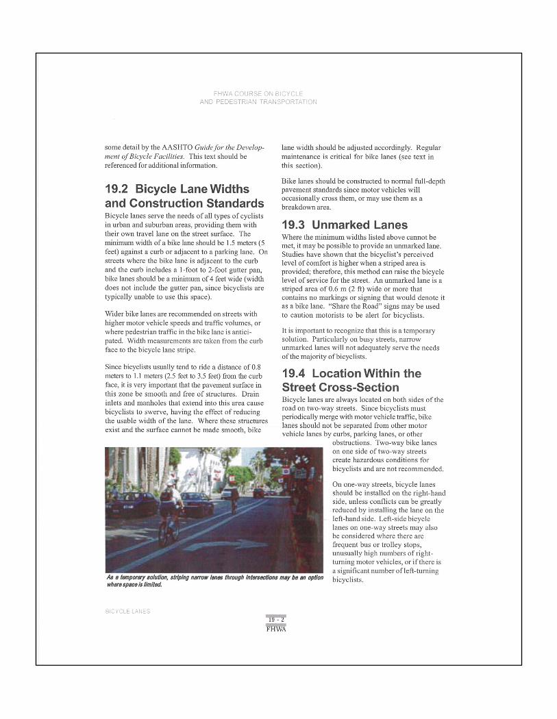
wherespace is limilsd.As a temporarysolu?on, striping narrowlanes through Inlarsac?onsmay be an op?on
lane width should be adjusted accordingly. Regularmaintenance is critical for bike lanes (see text inthis section).
Bike lanes should be constructed to normal full—depthpavement standards since motor vehicles willoccasionally cross them, or may use them as abreakdown area.
19.3 Unmarked LanesWhere the minimum widths listed above cannot bemet, it may be possible to provide an unmarked lane.Studies have shown that the bicyclist’s perceivedlevel of comfort is higher when a striped area isprovided; therefore, this method can raise the bicyclelevel of service for the street. An unmarked lane is astriped area of 0.6 m (2 ft) wide or more thatcontains no markings or signing that would denote itas a bike lane. “Share the Road” signs may be usedto caution motorists to be alert for bicyclists.
It is important to recognize that this is a temporarysolution. Particularly on busy streets, narrowunmarked lanes will not adequately serve the needsof the majority ofbicyclists.
19.4 Location Within theStreet Cross-SectionBicycle lanes are always located on both sides of theroad on two-way streets. Since bicyclists mustperiodically merge with motor vehicle traffic, bikelanes should not be separated from other motorvehicle lanes by curbs, parking lanes, or other
obstructions. Two-way bike laneson one side of two-way streetscreate hazardous conditions forbicyclists and are not recommended.
On one—way streets, bicycle lanesshould be installed on the right-handside, unless con?icts can be greatlyreduced by installing the lane on theleft-hand side. Left-side bicyclelanes on one—way streets may alsobe considered where there arefrequent bus or trolley stops,unusually high numbers of right-tuming motor vehicles, or ifthere isa signi?cant number ofleft-turningbicyclists.
19 . 2
FHWA
(1)Striped parking
Parking stalls or optional 4" solidstripe‘6' solid white stripe“\
D‘E Motorvehicle lanes8' min. 5' min. 5' min. 8‘ min.
parking bike bike parking
lane lane' The op?mal solid wasmaybe advisablevnheresials arc umeoessaryibocause parking is light)intlhesc Is
oomemihd.mulofsis my miseurexruche like ianaln b c a Irzifriclane.
(2) Parking permitted withoutparking stripe or stall
6“ solidwhite stripe
Motorvehicle lanes
I ‘12‘m5n. ' 12' min.
‘ iris recozninervdcdvi-heremerels sub?ari?ul piulong or mrmwerol perked ears '5 high(e‘g., oomnwrdalareas).
(3) Parking prohibited
4' “‘i"- 6‘ solid whitestripe 4' min-
‘_l
_ Motorvehicle lanes
bike b“<9
Iane lane
(4) Cross section on roads with nocurb and gutter (source: NCDOT)
2'min. I.’ min.
‘Bikelane Bike lane in:jMotorvehiclelanes
_ A min. In.
BicycleIaneeprovidedunderdifferentlypes oicandilians.Source: AASHTOGuidefor the DevelopmentofBicycleFacilities,1991.
15)V 3
FHWA
19.5 Practices ToBe AvoidedTwo-Way Bike LaneThis creates a dangerouscondition for bicyclists. Itencourages illegal ridingagainst traf?c, causing severalproblems:
- At intersections anddriveways, wrong—way
riders approach from adirection where they arenot visible to motorists.
- Bicyclists closest to themotor vehicle lane haveopposing motor vehicletraf?c on one side andopposing bicycle traffic onthe other.
- Bicyclists are put intoawkward positions whentransitioning back tostandardbikeways.
If constraints allow widening ononly one side of the road, thecenterline stripe may be shiftedto allow for adequate travellanes and bike lanes:
Continuous Right-'[\irn LanesThis con?guration is difficultfor cyclists: Riding on theright puts them in con?ict withright-tuming cars, but riding onthe left puts them in con?ict
with cars merging into and out
Fl-1:";-‘« -CI.")>J5’\3E ON BPC‘/CLE~»F!»»\N TRANSPORTATION
hbo?i mu IbnvnI wrung-inyblcydlatlanollnModrivrb min ?eldof within.
azn?nuoul?ghl-tumIansraeanllgumdlaatandnniappruclm.
of the right-turn lane. The best solution is toeliminate the continuous right-turn lane, consolidateaccesses, and create well-de?ned intersections.
19.6 Contra-FlowBike LanesContra-?ow bike lanes on a one-way street are not
usually recommended. They may encourage cyclists
*3«.?vCv_Cl.'
to ride against traffic, which iscontrary to the rules of the roadand a leading cause of bicycle/motor vehicle crashes.
There are, however, specialcircumstances when this designmay be advantageous:
- A contra—?ow bike laneprovides a substantialsavings in out-of-direc-tion travel.
- The contra-?ow bikelane provides directaccess to high-use destinations.
- Improved safety because of reduced con-?icts on the longer route.
- There are few intersectingdriveways, alleys, orstreets on the side of thecontra-?ow lane.
- Bicyclists can safely andconveniently re-enter thetraf?c stream at eitherend of the section.
° A substantial number ofcyclists are already using thestreet.
- There is sufficient streetwidth to accommodate a bikelane.
A contra-?ow bike lane may also be appropriate ona one-way residential street recently converted froma two-way street (especially where this change wasmade to calm traffic).
For a contra—?ow bike lane to function well, these
design:
'm?''r'H'v'vT
special features should be incorporated into the

- The contra-?ow bike lane must be placed onthe right side of the street (to motorists’ left)and must be separated from oncoming traf?c bya double yellow line. This indicates that thebicyclists are riding on the street legally, in adedicated travel lane.
- Any intersecting alleys, major driveways, andstreets must have signs indicating to motoriststhat they should expect two—way bicycle traf?c.
- Existing traffic signals shouldbe fitted withspecial signals for bicyclists; this can beachieved with either loop detectors or pushbuttons (these should be easily reached bybicyclists without having to dismount).
Note: Under no circumstances should a contra~?ow
bike lane be installed on a two—way street, evenwhere the travel lanes are separated by a raisedmedian.
19.7 Bike Lane PavementMarkingsThe Manual an UniformTrafficControl Devices(MUTCD) section 9C addresses standard bike lanemarkings. The stripe between the bicycle lane andthe adjacent motor vehicle lane should be a 100-millimeter (4 inch) wide white line (minimum width).Six- to eight-inch-wide lines provide an even clearerdivision of space, and are highly recommended.
Donna-llawblkalmescanprovidedirectmeet! to Iiiyli-usedeudna?ana.
Whereparlcingisallowednext to a bikelane,t.heparkingarea shouldbe de?nedby parking space markings or a solid100 millimeter (4 inch) wide stripe.
Care should be taken to use pavementstriping that is durable,yet skid-resistant. Reflectors and raisedmarkings in bike lanes can de?ect abicycle wheel, causing a bicyclist tolose control. If re?ective pavementmarkers are needed for motorists,theyshouldbe installedon the motorist’sside of the stripe, and have a beveledfront edge.
Whilethe 1988editionof the MUTCDrecommendsthe use of the diamond-
shaped preferential lane symbol in conjunction withbike lane signs, this symbol is often confusing forboth the bicyclist and motorist. For this reason,subsequent editions of the MUTCD will probablyeliminate the use of the diamond in bike lanes. Thenew standard pavement markings for bicycle lanesare the bicycle symbol (or the words BIKE LANE)and a directional arrow.
19.8 Bike Lane SigningThe Manual on UniformTrafficControl Devices(MUTCD) section 9B addresses standard bike lanesigning. According to section 9B-8, the R3-16 signshould be used in advance of the beginning of a
BIKEROUTEI-EmBikeInnasigns Mould be replaced withbike Ims stencils, withuptlond NOPARKINGsign: whereneeded.
3&2
FHWA
designated bicycle lane to callattention to the lane and to thepossible presence of bicy-clists. In locations wherebicycle lanes are ending, thesame IL’:-l6 sign should beused, with the word ENDSsubstituting for the wordAHEAD. The R7-9 or R7-9asigns should be used alongstreets where motorists arelikely to park or frequentlypull into the bike lane.
19.9 DiagonalParkingDiagonal parking causes con?icts with bicycle travel:Drivers backing out have poor visibility of oncomingcyclists and parked vehicles obscure other Vehiclesbacking out. These factors require cyclists to rideclose to the center of a travel lane, which is intimidat-ing to inexperienced riders.
Where possible on one-way streets, diagonal parkingshould be limited to the le? side, even if the street
has no bike lane; on one—way streets with bike lanes,the bike lane should be placed adjacent to parallelparking (preferably on the right).
Bike lanes are not usually placed next to diagonalparking. However, should diagonal parking berequired on a street planned for bike lanes, thefollowing recommendations can help decreasepotential con?icts:
The parking bays must be long enough to
accommodatemost vehicles.
A 200-millimeter- (8-inch—)wide stripe shouldseparate the parking area from the bike lane.
Enforcement may be needed to cite or removevehicles encroaching on the bike lane.
BikeInnanext to diagonalpuking, Hncn stripsshouldseparateMoarms.
19.10 Bike LaneDesign atIntersectionsIntersections With BusStopsIf there is a bus stop at thenear side of the intersection, abroken line should extend thelength of the bus stop (no lessthan 15 meters [50 feet]), andthe solid white line shouldresume on the far side of theintersection, immediatelyafterthe crosswalk. If a bus stop islocated on the far side of theintersection, the solid white
line on the far side of the intersection should bereplaced with a broken line for a distance of at least24 meters (80 feet) from the crosswalk (at thisintersection, a broken line would still be requiredon the near side if there is right—tumingtraf?c).
Intersections With Right-Turn LanesIn general, right-turn lanes should be used onlywhere warranted by a traffic study, as they presentproblems for both bicyclists and pedestrians:
If right-turning cars and through bicyclistsmust cross paths.
If the additional lane width adds to the pedes-trian crossing distance.
If right-tum moves are made easier for motor-ists, which may cause inattentive drivers to notnotice pedestrians on the right.
The through bike lane to the left of a right-tum laneshould be striped with two 100-millimeters- (4—in-)wide stripes and connected to the preceding bikelane with 0.9—rneter(3-foot) dashes and 2.7-meter(9-foot) spaces. This allowsturningmotoriststo crossthe bike lane. A legend must be placed at thebeginning of the through bike lane. Sign R4-4,BEGIN RIGHT TURN LANE, YIELD TO BIKES,may be placed at the beginning of the taper in areaswhere a through bike lane may not be expected.
IflE
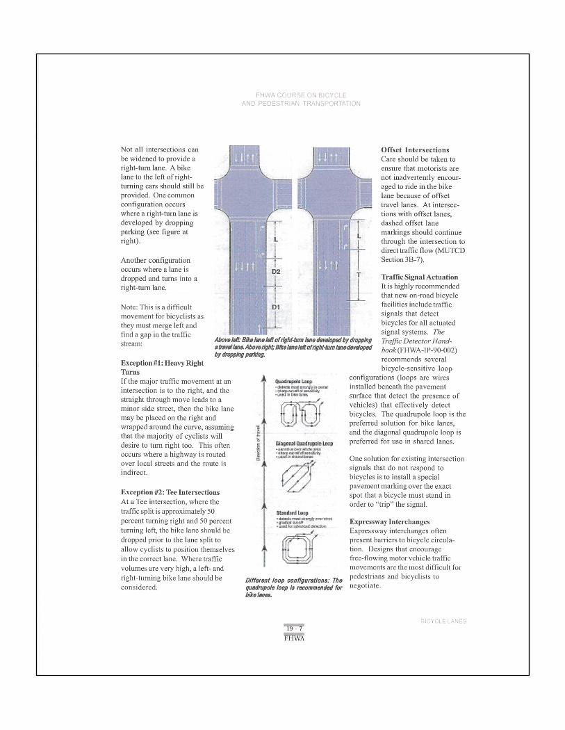
Not all intersections canbe widened to provide aright-tum lane. Abikelane to the left of right-turning cars should still beprovided. One commoncon?guration occurswhere a right-tum lane isdeveloped by droppingparking (see ?gure atright).
Another con?gurationoccurs where a lane isdropped and turns into aright-tum lane,
Note: This is a dif?cultmovement for bicyclists asthey must merge left and
i ‘
?nd a gapin the traf?cMmutskoham?ml?mmakwwwbymwmg
S"°‘““< lblvdIma.Abawn'9hL'D1hImaId!oIr@h!-lumlmadavdapsd5)’¢9PPll7l?Pl?h'W-
Exception #1: Heavy RightTurnsIf the major traffic movement at an IIIIIIIIIUWintersection is to the right, and the in“
straight through move leads to aminor side street, then the bike lanemay be placed on the right andwrapped around the curve, assuming 1
that the majority of cyclists will 5desire to turn right too. This often E ""°"
occurs where a highway is routedB
2' 3:33"over local streets and the route isindirect‘
Exception #2: Tee IntersectionsAt a Tee intersection, where thetraffic split is approximately 50 g.¢;u,.u
* * l???i??ll IVIIIIIIpercent turning right and 50 percent :,'_.;§=:u':’:‘?_turning left, the bike lane should bedropped prior to the lane split to
allow cyclists to position themselvesin the correct lane. Where traf?cvolumes are very high, a le?- andright-turning bike lane should beconsidered.
E:
Different loop canllguratiana: Thequadrupole loop I: recommendedforb?ra Inna.
H1.1:
sl?
Offset IntersectionsCare should be taken to
ensure that motorists arenot inadvertently encour-aged to ride in the bikelane because of offsettravel lanes. At intersec-tions with offset lanes,dashed offset lanemarkingsshould continuethrough the intersection to
directtraffic ?ow (MUTCDSection 3B-7).
Traffic Signal ActuationIt is highly recommendedthat new on-road bicyclefacilities include trafficsignals that detectbicycles for all actuatedsignal systems. TheTrafficDetector Hana’-book(Fl-IWA—IP—90—002)recommends severalbicycle—sensitive loop
con?gurations (loops are wiresinstalled beneath the pavementsurface that detect the presence ofVehicles) that effectively detectbicycles. The quadrupole loop is thepreferred solution for bike lanes,and the diagonal quadrupole loop ispreferred for use in shared lanes.
One solution for existing intersectionsignals that do not respond tobicycles is to install a specialpavement marking over the exact
spot that a bicycle must stand inorder to “trip" the signal.
Expressway lnterchangesExpressway interchanges oftenpresent barriers to bicycle circula-tion. Designs that encouragefree-?owing motor vehicle trafficmovements are the most difficult forpedestrians and bicyclists tonegotiate.
/-‘UWDPi:.J‘:D-..
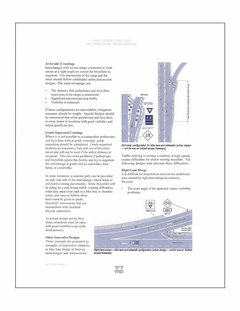
At-Grade CrossingsInterchanges with access ramps connected to localstreets at a right angle are easiest for bicyclists tonegotiate. The intersection of the ramp and thestreet should follow established urban intersectiondesigns. The main advantages are:
- The distance that pedestrians and bicyclists _-_
must cross at the ramps is minimized.- Signalized intersections stop traffic.- Visibility is enhanced.
If these con?gurations are unavoidable, mitigationmeasures should be sought‘ Special designs shouldbe considered that allow pedestrians and bicycliststo cross ramps in locations with good visibility andwhere speeds are low.
:.'.'. .‘.. ‘.2 -'.L;-'.‘. .3 .'.';..w .".'r.;'.‘.
Grade-Separated CrossingsWhere it is not possible to accommodate pedestriansand bicyclists with at-grade crossings, grade
P654”:!.'\'.‘.‘-s.'1'.l.'.i'n"I'l7s'1~.Iu1n’:lE.‘!!£h'$-5'.".<.'.‘diI!‘d!£.‘.v'
‘
.
iiseparation should be considered. Grade-separated 5m,,,,,p ,,,,,;;W,,g,,, 15,51“/,,,,,,d,/dug‘, (,,,g,,, 4.1,,facilities are expensive; they add out-of-direction —na!foruu an IlmltadaocassMann)travel and will not be used if the added distance istoo great. This can create problems if pedestrians Traffic eiiieiiiig 01' exiting 3 i'°3dWaYat high 3Peeii5and bicyclists ignore the facility and try to negotiate creates difficulties for slower moving bicyclists. Thethe interchange at grade with no s;dewa1ks,b;ke following designs help alleviate these dif?culties:l , lk .anes or crosswa s
Right_LaneMergeIt is difficult for bicyclists to traverse the unde?ned
In some instances, a separate path can be providedarea created by righmane merge movements’on only one side of the interchange, which leads to b :
awkward crossing movements. Some bicyclists willecause
be riding 0'1 3 Paiiifacing iTafi"iCseTe3iii1gdiffieiiiiies - The acute angle of the approachcreates visibilitywhen they must cross back to a bike lane or shoulder problems‘(clear and easy-to-follow direc-tions must be given to guidebicyclists’ movements that areinconsistent with standardbicycle operation).
To ensure proper use by bicy-clists, structures must be open,with good visibility (especiallyunderpasses).
Other Innovative DesignsThese concepts are presented asexamples of innovative solutionsi0 bike iaiie design at freeway Hyllt-IanaInayo—bIkeIanemdsldaivdkconfigurnlian(urbanda.1ign—nomrunon IlmIIad—interchanges and intersections. nwmfmlvsya).
*1‘!IE
FhWA COURSE OW BECYCLEAND PEDESTRIAN TF’A.Y‘lSF’O?.TAT1Ch\
° Motor vehicles are o?en accelerating to mergeinto traf?c.
- The speed differential between cyclists andmotorists is high.
The following design guides bicyclists in a mannerthat provides:
- A short distance across the ramp at close to aright angle.
- Improved sight distances in an area where traf?cspeeds are slower than farther downstream.
- A crossing in an area where drivers’ attention isnot entirely focused on merging with traf?c.
Exit RampsExit ramps present dif?culties for bicyclists because:
- Motor vehicles exit at fairly high speeds.' The acute angle creates visibility problems.° Exiting drivers often do not use their right-turn
signal, confusing pedestrians and bicyclistsseeking a gap in the traffic.
The exit ramp design on the A.previous page guides bicy-clists in a manner thatprovides:
- A short distance acrossthe ramp, at close to aright angle.
- Improved sight distancesin an area where traf?cspeeds are slower thanfarther upstream.
° A crossing in an areawhere the driver’sattention is not distractedby other motor vehicles.
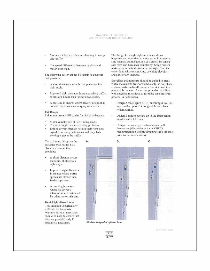
Dual Right-Turn LanesThis situation is particularlydifficult for bicyclists.Warrants for dual turn lanesshould be used to ensure thatthey are provided only ifabsolutely necessary.
The design for single right-tum lanes allowsbicyclists and motorists to cross paths in a predict-able manner, but the addition of a lane from whichcars may also turn adds complexity: Some driversmake a last minute decision to turn right from thecenter lane without signaling, catching bicyclistsand pedestrians unaware.
Bicyclists and motorists should be guided to areaswhere movements are more predictable, so bicyclistsand motorists can handle one con?ict at a time, in apredictable manner. A curb cut provides bicyclistswith access to the sidewalk, for those who prefer toproceed as pedestrians.
- Design A (see Figure 19-13) encourages cycliststo share the optional through~right-tum lanewith motorists.
- Design B guides cyclists up to the intersectionin a dedicated bike lane.
° Design C allows cyclists to choose a paththemselves (this design is the AASHTOrecommendation—simply dropping the bike laneprior to the intersection).
B. C.
BikeIliatllmuglldualn’yIIl-tumlam.
WFHW

A fourth design places an island between the right-tum lane and the optional through—rightturn lane.This creates a more conventional intersection,separating the con?icts. This design is also betterfor pedestrians, as the island provides a refuge.
Engineering judgment should be used to determinewhich design is most appropriate forthe situation.
Right-Turn Lane Without Room for a Bike LaneOn bike laneretro?tprojectswhere there is insu?icientroom to mark a minimum1.2-meter(4-foot) bike laneto the le? of the right-tum lane, a right-tum lanemay be marked and signed as a shared-use lane toencourage through~cyclists to occupy the leftportion of the turn lane. This is most successful onslow-speed streets.
19.11 ExerciseRedesign a local intersection to include bike lanes.Choose an intersection with a moderate level ofcomplexity, and assume that curb lines can be movedat will in order to achieve your design. Prepare areport and graphics that show existing conditionsand recommendedmodi?cations. Signalizationchanges (if necessary) should also be explained, aswell as any advance striping and signing needed onthe intersection approaches.
19.12 ReferencesText and graphics in this lesson were derived fromthe following sources:
Oregon Department of Transportation, OregonBicycle and Pedestrian Plan, 1995.
Philadelphia Department of Streets, PhiladelphiaBicycle Facility Design Guidelines, 1998.
For more information on this topic, refer to:
AASHTO, Guidefor the Development ofBicycleFacilities, latest edition.
ITE Technical Committee6A-55, Review afPlanningand Design Standards forBicycle Facilities, 1997.
USDOT, Manual on UniformTraffcCantrol Devices,Section 9, latest edition.
Join!use of a ht-(umlure Inrtllmugli-lalcrcllat.
CITY OF QUINCY
CPED MINUTES
June 9, 2014
4:09 PM
ROLL CALL
Building Official Worley, Secretary Miller Councilmember Lybbert
Absent were Councilmembers Harris and Roduner who were at the fire contract meeting and Peterson
excused due to work obligations.
PUBLIC COMMENT/PRESENTATION
No public were present.
PREVIOUS MEETING MINUTES DISCUSSION
Minutes from April 14th CPED were distributed.
SIDEWALK IMPROVEMENTS SR 28 & SR 281
Building Official Worley explained the process of measuring and identify problem areas is still being
worked out.
BICYCLE TRAILS AND WALKING PATH ROUTES
Building Official Worley passed out a map with potential bicycle path options. Areas of concern such as
crossing at busy intersections; short routes; the need to develop design standards for the trail/path.
POSTAL BOXES IN BUMP-OUTS
The two locations were considered. The location on Central Ave N, under the Farmer Consumer
Awareness Sign was not a great fit and the property owner really did not like the idea. Across the street
in the Bump Out at Central Ave and D ST SW was the other location being considered. The committee
and the post office found this a favorable location.
CITY OF QUINCY GIS DEVELOPMENT PROJECT
Building Official Worley provided the cost schedule for the budgeted ARC GIS software. Building
Official Worley explained that Glenda’s computer needs to be replaced. The software and computer will
actual cost will be slightly higher than budgeted. The GIS software will support 5 users. Building
Official Worley was authorized to place on council agenda for the cost increase.
PLANNING COMMISSION TONIGHT
6:30 PM
OLD BUSINESS (FUTURE ITEMS TO WORK ON)
Deferred sidewalk agreement pay-off plan
Training
Subdivision Updates
Abatement Process
Sidewalks Improvement Program Status
ADJOURNED 4:55 PM
WSDOT Design Manual M 22.01.08 Page 1520-1 July 2011
Chapter 1520 Roadway Bicycle Facilities
1520.01 General 1520.02 References 1520.03 Definitions 1520.04 Facility Selection 1520.05 Project Requirements 1520.06 Shared-Use Path Design 1520.07 Shared Roadway Bicycle Facility Design 1520.08 Signed Shared Bicycle Roadway Design 1520.09 Bicycle Lane Design 1520.10 Documentation
1520.01 General
The Washington State Department of Transportation (WSDOT) encourages bicycle use on its facilities. Bicycle facilities (bike lanes and shared roadways), or improvements for bicycle transportation, are included in the project development and highway programming processes.
This chapter is a guide for designing bicycle facilities within state highway right of way or between the curb lines on city streets designated as state highways when the design matrices (see Chapter 1100) indicate full design level for bicycle and pedestrian design elements. Bike lanes and shared roadways are presented.
When designing facilities outside of state highway right of way or beyond the curb on city streets designated as state highways, use the latest edition of AASHTO’s Guide for the Development of Bicycle Facilities.
These guidelines apply to normal situations encountered during project development. Unique design problems are resolved on a project-by-project basis using guidance from the region’s Bicycle Coordinator or bicycle and pedestrian expert.
1520.02 References
(1) Federal/State Laws and Codes
Americans with Disabilities Act of 1990 (ADA)
23 Code of Federal Regulations (CFR) Part 652, Pedestrian and Bicycle Accommodations and Projects
Revised Code of Washington (RCW), Chapter 35.75, Streets – Bicycles – Paths http://apps.leg.wa.gov/rcw/default.aspx?cite=35.75
RCW 46.04, Definitions http://apps.leg.wa.gov/rcw/default.aspx?cite=46.04
RCW 46.61, Rules of the road http://apps.leg.wa.gov/rcw/default.aspx?cite=46.61

Roadway Bicycle Facilities Chapter 1520
Page 1520-2 WSDOT Design Manual M 22-01.08 July 2011
RCW 46.61.710, Mopeds, electric-assisted bicycles – General requirements and operation http://apps.leg.wa.gov/rcw/default.aspx?cite=46.61.710
RCW 47.26.300, Bicycle routes – Legislative declaration http://apps.leg.wa.gov/rcw/default.aspx?cite=47.26.300
(2) Design Guidance
Manual on Uniform Traffic Control Devices for Streets and Highways, USDOT, FHWA; as adopted and modified by Chapter 468-95 WAC “Manual on uniform traffic control devices for streets and highways” (MUTCD) www.wsdot.wa.gov/publications/manuals/mutcd.htm
Selecting Roadway Design Treatments to Accommodate Bicycles, USDOT, Federal Highway Administration (FHWA), 1994
Standard Plans for Road, Bridge, and Municipal Construction (Standard Plans), M 21-01, WSDOT www.wsdot.wa.gov/publications/manuals/m21-01.htm
Understanding Flexibility in Transportation Design – Washington, WSDOT, 2005 www.wsdot.wa.gov/research/reports/600/638.1.htm
(3) Supporting Information
A Policy on Geometric Design of Highways and Streets (Green Book), AASHTO, 2004
Guide for the Development of Bicycle Facilities, AASHTO, current edition
1520.03 Definitions
bicycle Any device propelled solely by human power upon which a person or persons may ride, having two tandem wheels, either of which is 16 inches or more in diameter, or three wheels, any one of which is more than 20 inches in diameter.
bicycle route A system of facilities that are used or have a high potential for use by bicyclists or that are designated as such by the jurisdiction having the authority. A series of bicycle facilities may be combined to establish a continuous route and may consist of any or all types of bicycle facilities.
bike lane A portion of a highway or street identified by signs and pavement markings as reserved for bicycle use.
shared roadway A roadway that is open to both bicycle and motor vehicle travel. This may be a new or existing roadway/highway, a street with wide curb lanes, or a road with paved shoulders.
signed shared roadway A shared roadway that has been designated by signing as a route for bicycle use.
shared-use path See Chapter 1515.
wye (Y) connection An intersecting one-way roadway, intersecting at an angle less than 60°, in the general form of a “Y.”

Chapter 1520 Roadway Bicycle Facilities
WSDOT Design Manual M 22.01.07 Page 1520-3 July 2010
1520.04 Facility Selection
(1) Facility Location
Provide bicycle facilities on routes that have been identified as local, state, or regional significant bike routes. Fill gaps in the existing network of bicycle facilities when the opportunity is available. For other roadways, provide full design level shoulders for bicycle needs unless:
• Bicyclists are prohibited by law from using the facility.
• The cost is excessively disproportionate to the need or probable use.
• Other factors indicate there is no need.
Refer to Understanding Flexibility in Transportation Design – Washington for further information.
(2) Selection of the Type of Facility
Selection of the facility type includes consideration of community needs and safe, efficient bicycle travel. Exhibit 1520-1 provides a generalized method of assessing the type of bicycle facility needed.
Roadway Classification, Land Use, Speed, and ADT
Facility Recommendation
Rural and suburban highways and streets (less than four dwelling units per acre), speeds above 25 mph, and ADT above 2,000.
Full design level shoulder (see Chapter 1140) on both sides (4 ft minimum width), or shared-use path (see Chapter 1515).
Major arterial in residential area, school zones, or streets in commercial or industrial areas.
Bike lanes on both sides (see 1520.07), or shared-use path (see Chapter 1515).
Local street in residential area where speed is 25 mph or below, or ADT is 2,000 or less.
Rural highways and streets where passing sight distance is available and speed is 25 mph or below, or ADT is 2,000 or less.
Collector or minor arterial where speed is 25 mph or below, or ADT is 2,000 or less.
Shared roadway.
Bike Facility Selection Exhibit 1520-1
An important consideration is route continuity. Change facility types at logical locations. For additional information, see Understanding Flexibility in Transportation Design – Washington.

Roadway Bicycle Facilities Chapter 1520
Page 1520-4 WSDOT Design Manual M 22-01.07 July 2010
1520.05 Project Requirements For urban bicycle mobility Improvement projects (see Bike/Ped connectivity projects in the matrices, Chapter 1100), apply the guidance in this chapter to the bicycle facility.
For highway design elements affected by the project, apply the appropriate design level from the matrices (see Chapter 1100) and as found in the applicable chapters.
For highway design elements not affected by the project, no action is required.
1520.06 Shared-Use Path Design Shared-use paths are facilities physically separated from motorized vehicular traffic within the highway right of way or on an exclusive right of way with minimal crossflow by motor vehicles. Primarily used by pedestrians and bicyclists, shared-use paths are also used by joggers, skaters, wheelchair users (both nonmotorized and motorized), equestrians, and other nonmotorized users. Chapter 1515 provides design guidance for shared-use paths.
1520.07 Shared Roadway Bicycle Facility Design Generally, lower-speed/lower-volume streets can provide for bicycle travel without additional signing and pavement markings for bicycles (see Exhibit 1520-2).
The region Traffic Engineer is responsible for determining which sections of state highways are inappropriate for bicycle traffic. The State Traffic Engineer, after consultation with the Bicycle Advisory Committee, prohibits bicycling on sections of state highways through the traffic regulation process. Contact the region Traffic Office for further information.
Shared Roadway Exhibit 1520-2
Chapter 1520 Roadway Bicycle Facilities
WSDOT Design Manual M 22.01.07 Page 1520-5 July 2010
Bicyclists traveling between cities or on recreational trips may use many rural highways. Providing and maintaining paved shoulders, with or without an edge stripe, can significantly improve convenience for bicyclists and motorists along such routes.
A shared roadway bike route with improvements for bicycles can offer a greater degree of service to bicyclists than other roadways. Improvements on shared roadways to facilitate better bicycle travel include widening the shoulders to full design level width (a minimum of 4 feet), adding pavement markings, improving roadside maintenance (including periodic sweeping), and removing surface obstacles such as drain grates that are not compatible with bicycle tires.
Where public transport and cycling facilities meet, an integrated design that does not inconvenience either mode is desirable. When buses and bicyclists share the same roadway, consider the following:
• Where bus speeds and volumes are high, separate facilities for buses and bicyclists are desirable.
• Where bus speeds and volumes are low, consider a shared-use bus/bicycle lane.
Consider providing bicycle parking facilities near public transportation stops.
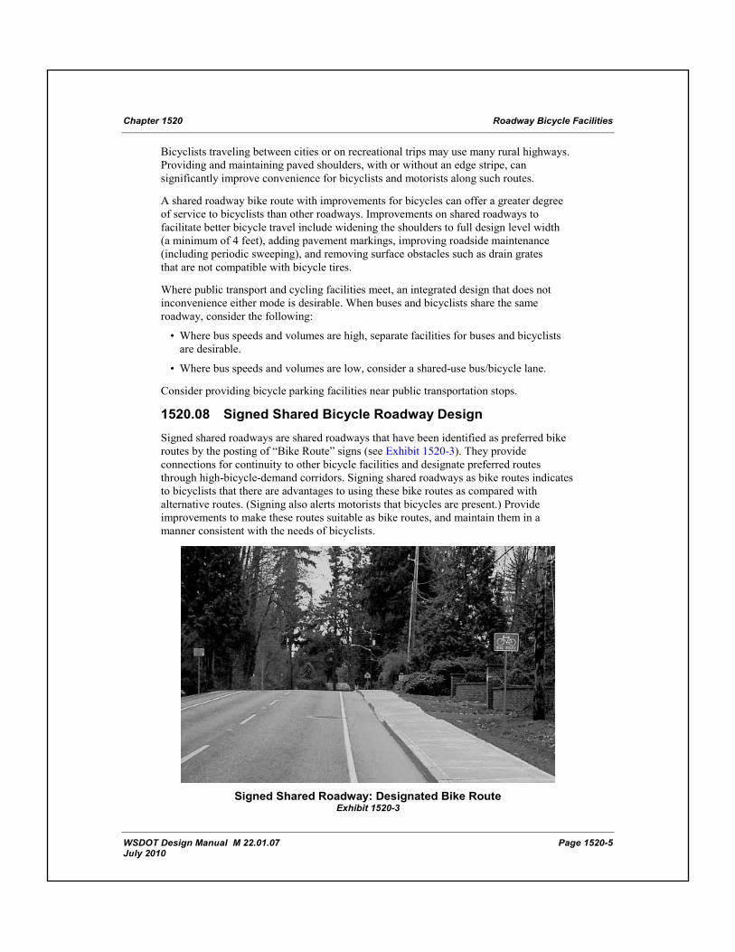
1520.08 Signed Shared Bicycle Roadway Design Signed shared roadways are shared roadways that have been identified as preferred bike routes by the posting of “Bike Route” signs (see Exhibit 1520-3). They provide connections for continuity to other bicycle facilities and designate preferred routes through high-bicycle-demand corridors. Signing shared roadways as bike routes indicates to bicyclists that there are advantages to using these bike routes as compared with alternative routes. (Signing also alerts motorists that bicycles are present.) Provide improvements to make these routes suitable as bike routes, and maintain them in a manner consistent with the needs of bicyclists.
Signed Shared Roadway: Designated Bike Route
Exhibit 1520-3

Roadway Bicycle Facilities Chapter 1520
Page 1520-6 WSDOT Design Manual M 22-01.07 July 2010
Use the following criteria to aid in determining whether to designate and sign a bike route:
• The route offers a higher degree of service than alternative streets. • The route provides for through and direct travel in bicycle corridors. • The route connects bicycle facilities. • Traffic control devices have been adjusted to accommodate bicyclists. • Street parking is prohibited where lane width is critical. • Surface obstacles to bicyclists have been addressed. • Maintenance of the route, such as more frequent street sweeping and repair, is at
a higher level than comparable streets.
Establish a signed shared roadway bike route by placing MUTCD Bicycle Route signs or markers along the roadways. When the signed shared roadway designates an alternate route, consider destination signing.
1520.09 Bicycle Lane Design Bicycle lanes are established along streets in corridors where there is current or anticipated bicycle demand and where it is desirable for bikes to be better separated from motor vehicle lanes. Provide bike lanes where it is desirable to delineate available road space for preferential use by bicyclists (see Exhibit 1520-4). Consider bike lanes in and around schools, parks, libraries, and other locations where young cyclists are present.
Bicycle lanes delineate the rights of way assigned to bicyclists and motorists and provide for movements that are more predictable by each. Bike lanes can be provided on existing roadways by reducing the number or width of lanes or prohibiting parking. Design considerations include the impacts to motor vehicle traffic and the loss of parking for nearby land uses.
Bike Lane
Exhibit 1520-4
Chapter 1520 Roadway Bicycle Facilities
WSDOT Design Manual M 22.01.07 Page 1520-7 July 2010
Where street improvements are not possible, improve the bicyclist’s environment by providing shoulder-sweeping programs and special signal facilities.
(1) Widths
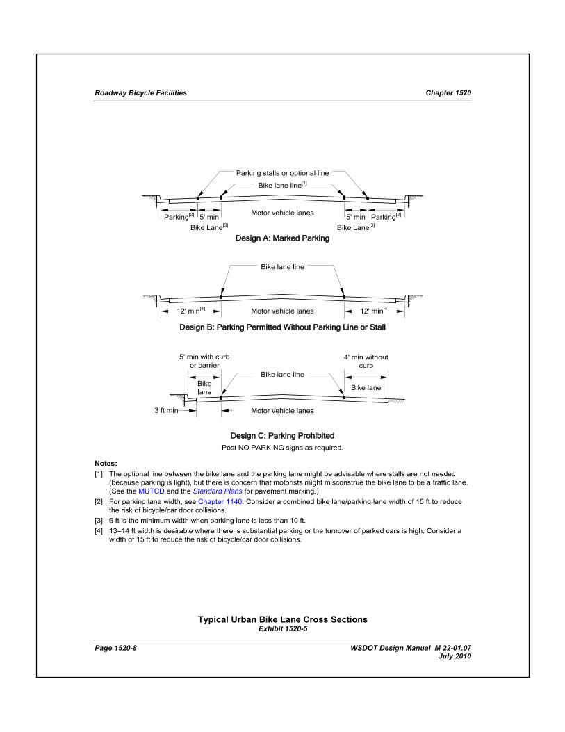
The minimum width for a bike lane is 4 feet. Some typical bike lane configurations are illustrated in Exhibit 1520-5 and described below:
• Design A depicts bike lanes on an urban-type curbed street where parking stalls (or continuous parking stripes) are marked. Locate bike lanes between the parking area and the traffic lanes. Minimum widths are shown. When the combined width of the bike lane and the parking lane is less than 15 feet, an increased probability of bicycle/car door collisions exists. When wider widths are not available, consider eliminating bike lane marking and signing.
Do not place bike lanes between the parking area and the curb. Such facilities increase the potential conflicts for bicyclists, such as the opening of car doors and poor visibility at intersections. Also, they restrict bicyclists leaving the bike lane to turn left and they cannot be effectively maintained.
• Design B depicts bike lanes on an urban-type curbed street where parking is permitted without pavement markings between the bike lane and the parking lane. Establish bike lanes in conjunction with the parking areas. 12 feet (15 feet desirable) is the minimum total width of the bike lane and parking lane. This design is satisfactory where parking is not extensive and where the turnover of parked cars is infrequent. However, an additional width of 1 to 2 feet is desirable if parking is substantial or the turnover of parked cars is high. Delineated parking lanes are desirable.
• Design C depicts bike lanes along the outer portions of a roadway, with and without curb, where parking is prohibited. This configuration eliminates potential conflicts (such as the opening of car doors) with motor vehicle parking. Minimum widths are shown. With curb, guardrail, or barrier, the minimum bike lane width is 5 feet. When a gutter is present, the width may need to be increased to provide a minimum width of 3 feet from the edge of the gutter. Additional width is desirable, particularly where motor vehicle operating speeds exceed 40 mph.
Increase shoulder widths to accommodate bicycle traffic when truck, bus, or recreational vehicle traffic makes up 5% or more of the daily traffic.
Bike lanes are not advisable on long, steep downgrades where bicycle speeds greater than 30 mph can be expected. As grades increase, downhill bicycle speeds increase, which increases the handling difficulty if bicyclists are riding near the edge of the roadway. In such situations, bicycle speeds can approach those of motor vehicles, and experienced bicyclists will generally move into the motor vehicle lanes to increase sight distance and maneuverability. However, less experienced bicyclists may not choose this position. When steep downgrades are unavoidable, provide full design-level shoulder width and signing in accordance with the MUTCD to alert bicyclists of the grade and the need to control their speeds.
Bike lanes are usually placed on the right side of one-way streets. Consider placing the bike lane on the left side when it produces fewer conflicting movements between bicycles and motor vehicles.
Roadway Bicycle Facilities Chapter 1520
Page 1520-8 WSDOT Design Manual M 22-01.07 July 2010
Design A: Marked Parking
5' min 5' minMotor vehicle lanes
Parking stalls or optional line
Bike lane line[1]
Bike Lane[3] Bike Lane[3]
Parking[2]Parking[2]
Design B: Parking Permitted Without Parking Line or Stall
Motor vehicle lanes
Bike lane line
12' min[4] 12' min[4]
Bike laneBike lane
Motor vehicle lanes
Design C: Parking Prohibited
Post NO PARKING signs as required.
3 ft min
5' min with curb or barrier
Bike lane line
4' min without curb
Notes: [1] The optional line between the bike lane and the parking lane might be advisable where stalls are not needed
(because parking is light), but there is concern that motorists might misconstrue the bike lane to be a traffic lane. (See the MUTCD and the Standard Plans for pavement marking.)
[2] For parking lane width, see Chapter 1140. Consider a combined bike lane/parking lane width of 15 ft to reduce the risk of bicycle/car door collisions.
[3] 6 ft is the minimum width when parking lane is less than 10 ft. [4] 13–14 ft width is desirable where there is substantial parking or the turnover of parked cars is high. Consider a
width of 15 ft to reduce the risk of bicycle/car door collisions.
Typical Urban Bike Lane Cross Sections
Exhibit 1520-5
Chapter 1520 Roadway Bicycle Facilities
WSDOT Design Manual M 22.01.07 Page 1520-9 July 2010
(2) Intersection Design
Design bike lanes at intersections in a manner that minimizes confusion for motorists and bicyclists and permits both users to operate in accordance with the Rules of the Road (RCW 46.61).
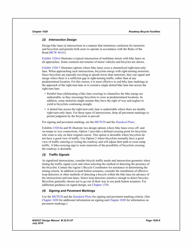
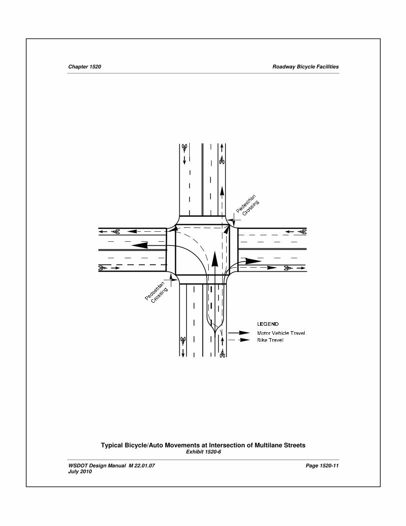
Exhibit 1520-6 illustrates a typical intersection of multilane streets with bike lanes on all approaches. Some common movements of motor vehicles and bicycles are shown.
Exhibit 1520-7 illustrates options where bike lanes cross a channelized right-turn-only lane. When approaching such intersections, bicyclists merge with right-turning motorists. Since bicyclists are typically traveling at speeds lower than motorists, they can signal and merge where there is a sufficient gap in right-turning traffic, rather than at any predetermined location. For this reason, it is most effective to end bike lane markings at the approach of the right-turn lane or to extend a single dotted bike lane line across the right-turn lane.
• Parallel lines (delineating a bike lane crossing) to channelize the bike merge are undesirable, as they encourage bicyclists to cross at predetermined locations. In addition, some motorists might assume they have the right of way and neglect to yield to bicyclists continuing straight.
• A dotted line across the right-turn-only lane is undesirable where there are double right-turn-only lanes. For these types of intersections, drop all pavement markings to permit judgment by the bicyclists to prevail.
For signing and pavement marking, see the MUTCD and the Standard Plans.
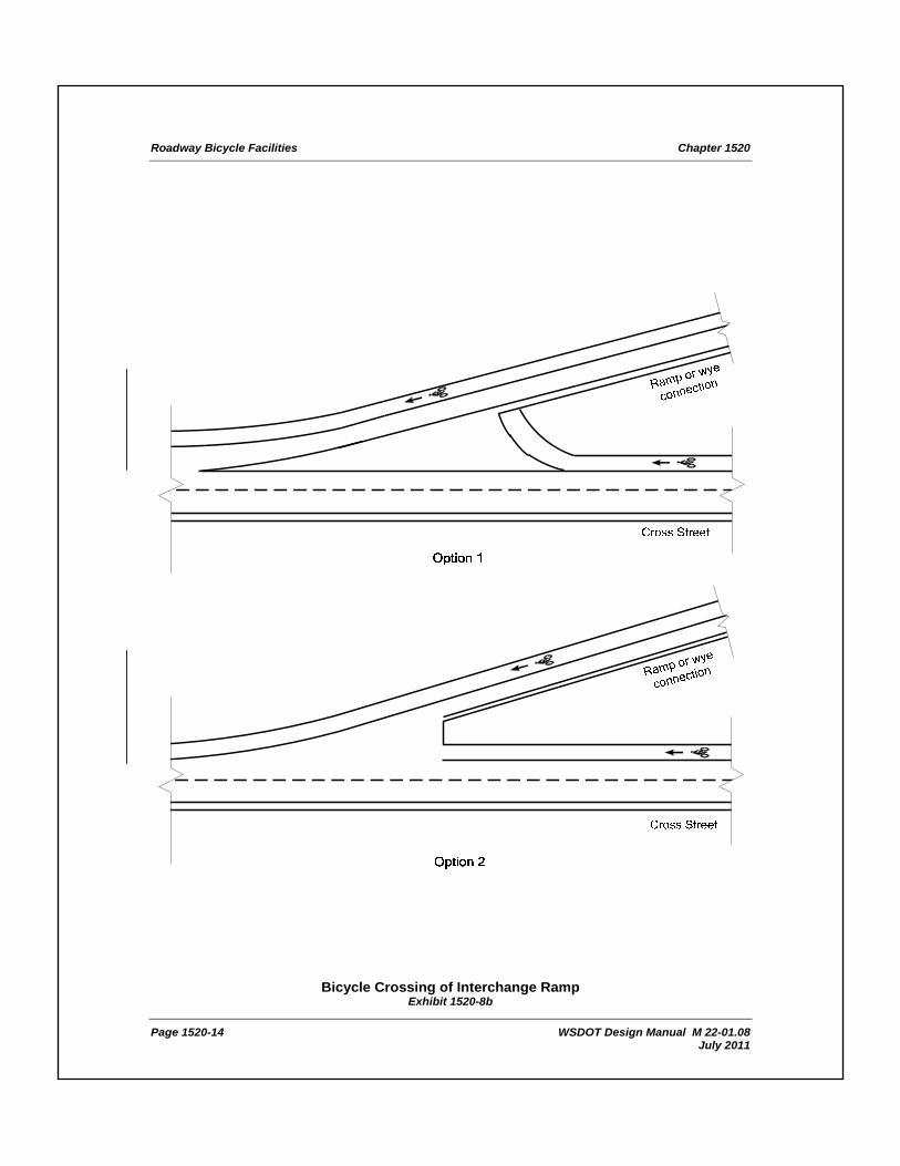
Exhibits 1520-8a and 8b illustrate two design options where bike lanes cross off- and on-ramps or wye connections. Option 1 provides a defined crossing point for bicyclists who want to stay on their original course. This option is desirable where bicyclists do not have a good view of traffic. Use Option 2 where bicyclists normally have a good view of traffic entering or exiting the roadway and will adjust their path to cross-ramp traffic. A bike-crossing sign to warn motorists of the possibility of bicyclists crossing the roadway is desirable.
(3) Traffic Signals
At signalized intersections, consider bicycle traffic needs and intersection geometry when timing the traffic signal cycle and when selecting the method of detecting the presence of the bicyclist. Contact the region’s Bicycle Coordinator for assistance in determining the timing criteria. In addition to push button actuators, consider the installation of effective loop detectors or other methods of detecting a bicycle within the bike lane (in advance of the intersection) and turn lanes. Select loop detectors sensitive enough to detect bicycles. Bicyclists generally choose not to go out of their way to use push button actuators. For additional guidance on signal design, see Chapter 1330.
(4) Signing and Pavement Markings
Use the MUTCD and the Standard Plans for signing and pavement marking criteria. (See Chapter 1020 for additional information on signing and Chapter 1030 for information on pavement markings.)
Roadway Bicycle Facilities Chapter 1520
Page 1520-10 WSDOT Design Manual M 22-01.07 July 2010
(5) Drainage Grates and Manhole Covers
Locate drainage inlet grates and manhole covers to avoid bike lanes. When drainage grates or manhole covers are located in a bike lane, minimize the effect on bicyclists. A minimum of 3 feet of lateral clearance is needed between the edge of a drainage inlet grate and the shoulder stripe. Install and maintain grates and manhole covers level with the surface of the bike lane.
Provide drainage inlet grates on bicycle facilities that have openings narrow enough and short enough that bicycle tires will not drop into the grates. Replace existing grates that are not bicycle-safe with grates designed for bicycles: a WSDOT vaned grate, herringbone grate, or other grate with an opening perpendicular to the direction of travel, 4 inches or less center to center.
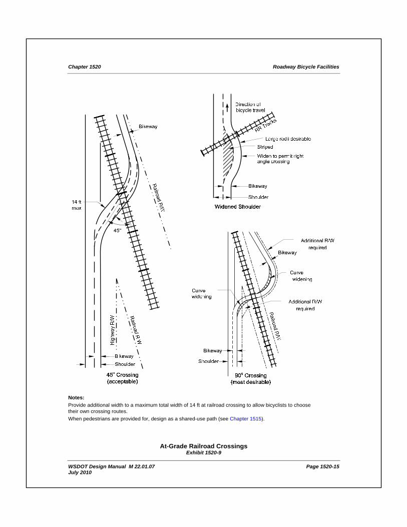
(6) At-Grade Railroad Crossings
Whenever a bike lane crosses railroad tracks, continue the crossing at least as wide as the bike lane. Use special construction and materials to keep the flangeway depth and width to a minimum. Wherever possible, design the crossing at right angles to the rails (see Exhibit 1520-9). Where a skew is unavoidable, widen the shoulder, or bike lane, to permit bicyclists to cross at right angles (see Exhibit 1520-9).
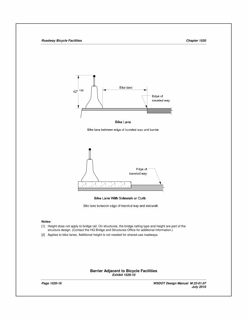
(7) Barrier and Rail
When the edge of the bike lane is within 5 feet of a barrier or railing, provide a barrier height a minimum of 42 inches to reduce the potential for bicyclists to fall over the barrier (see Exhibit 1520-10).
On structures, the bridge railing type and height are part of the structure design. Contact the Headquarters (HQ) Bridge and Structures Office for additional information. (See Chapter 720 for further considerations.)
1520.10 Documentation For the list of documents required to be preserved in the Design Documentation Package and the Project File, see the Design Documentation Checklist: www.wsdot.wa.gov/design/projectdev/
Chapter 1520 Roadway Bicycle Facilities
WSDOT Design Manual M 22.01.07 Page 1520-11 July 2010
Typical Bicycle/Auto Movements at Intersection of Multilane Streets Exhibit 1520-6

Roadway Bicycle Facilities Chapter 1520
Page 1520-12 WSDOT Design Manual M 22-01.07 July 2010
Notes:
[1] If space is available.
[2] Optional dashed line. Undesirable where a long right-turn-only lane or double turn lanes exist.
[3] When optional dashed line is not used, drop all bike lane delineation at this point.
[4] Drop bike lane line where right-turn-only is designated.
Bike Lanes Approaching Motorists’ Right-Turn-Only Lanes
Exhibit 1520-7

Chapter 1520 Roadway Bicycle Facilities
WSDOT Design Manual M 22.01.08 Page 1520-13 July 2011
Bicycle Crossing of Interchange Ramp
Exhibit 1520-8a
Roadway Bicycle Facilities Chapter 1520
Page 1520-14 WSDOT Design Manual M 22-01.08 July 2011
Bicycle Crossing of Interchange Ramp Exhibit 1520-8b
Chapter 1520 Roadway Bicycle Facilities
WSDOT Design Manual M 22.01.07 Page 1520-15 July 2010
Notes:
Provide additional width to a maximum total width of 14 ft at railroad crossing to allow bicyclists to choose their own crossing routes.
When pedestrians are provided for, design as a shared-use path (see Chapter 1515).
At-Grade Railroad Crossings Exhibit 1520-9
Roadway Bicycle Facilities Chapter 1520
Page 1520-16 WSDOT Design Manual M 22-01.07 July 2010
Notes:
[1] Height does not apply to bridge rail. On structures, the bridge railing type and height are part of the
structure design. (Contact the HQ Bridge and Structures Office for additional information.)
[2] Applies to bike lanes. Additional height is not needed for shared-use roadways.
Barrier Adjacent to Bicycle Facilities Exhibit 1520-10