coyote creek watershed historical ecology study · laguna seca. fisher creek ... which took place...
TRANSCRIPT
// e
xe
Cu
tiv
e s
um
ma
ry
This report synthesizes historical evidence into a picture of how Coyote Creek looked and functioned
before intensive modification. This new view shows how the contemporary landscape was shaped and
provides an array of tools for the restoration of watershed functions, natural flood protection, and
integrated water management.
STUDy OVERVIEWIn recent years, a number of environmental research and management efforts in the Santa Clara Valley (“Valley”) have
recognized the need for a better understanding of historical conditions as a basis for developing locally appropriate
habitat goals and guidelines for restoration design. Understanding how habitat patterns and their controlling physical
processes have been altered helps determine the relative potential for recovery, and suggests appropriate measures to
implement. Fortunately, the Santa Clara Valley has a wealth of historical information which represents an untapped
resource for understanding the origins and potential of today’s landscape.
hISTORICAL OVERVIEWCoyote Creek’s naturally wide footprint has led to an unusual amount of publicly owned lands along the stream.
This imposing morphology — including broad, flood-prone stream benches and long, dynamic braided reaches
— tended to restrict streamside development. As a result, there is a relatively high proportion of city and county
parkland that could contribute to stream
health, through coordinated stream
restoration and natural system-based
flood protection activities. Additionally,
while modified in many ways, Coyote
Creek has escaped major straightening.
Unlike most Bay Area streams, the
channel tends to follow its historical
route. These basic aspects of the stream’s
history contribute to significant present-
day restoration potential.
ExECUTIVE SUmmARy CONTENTS • Study and Historical Overviews
• Understanding Landscape Change
• Managing Watershed Functions and Processes
• Identifying Opportunities for Habitat Restoration
• Developing Tools for Natural Flood Protection
ES-1
coyote creek watersHeD HIstorIcal ecology stuDy
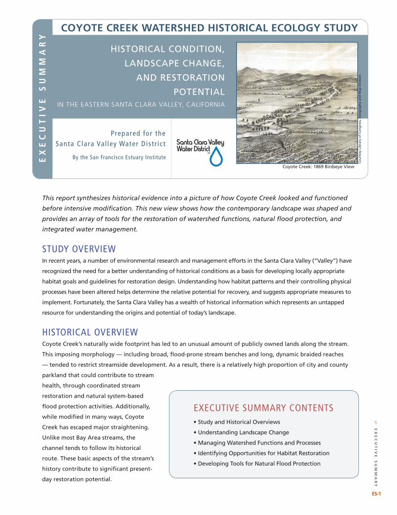
Coyote Creek: 1869 Birdseye View
ex
eC
ut
ive
su
mm
ar
y
Prepared for the Santa C lara Val ley Water D is t r i c t
HISTORICAL CONDITION,
LANDSCAPE CHANGE,
AND RESTORATION
POTENTIALin the eastern santa Clara Valley, California
By the San Francisco Estuary Institute
Co
urt
esy
Lib
rary
of
Co
ng
ress
, Geo
gra
ph
y an
d M
ap D
ivis
ion
.

ES-�
1:200,000 scale
0 1 2 4 6 8Miles
San
Francisco
Bay
Project Area
Coyote Watershed
Calera Creek
Tularcitos Creek
Upper Penitencia Creek
Los Coches Creek
Berryessa Creek
Miguelita Creek
South Babb Creek
Norwood Creek
Evergreen Creek
Thompson Creek
Upper Silver Creek
Coyote Creek
Fisher Creek
Fisher Creek
Lower Penitencia
Creek
Coyote Creek
Coyote Creek
In this study, we mapped historical landscape patterns for the valley floor draining to Coyote Creek – an approximately 100-square-mile area on the eastern side of the Santa Clara Valley. This portion of Santa Clara County includes parts of the cities of San Jose, Milpitas, and Morgan Hill. The aerial photograph below shows the study area in 2002. A sampling of early images illustrates historical habitats mapped on the facing page.
STUDY AREA
Low gradient, perennial reach.
Narrow reach with perennial water and gravel bars.
Broad, gravelly, intermittent Coyote stream bed.
Laguna Seca: tules and ponds.
2002 Imagery Copyright 2005 AirPhotoUSA, LLC, All Rights Reserved
Co
yo
te
Cr
ee
k w
at
er
sh
ed
his
to
riC
al
eC
ol
og
y s
tu
dy
ES-�
Lake Cunningham
// e
xe
Cu
tiv
e s
um
ma
ry
ES-�
Co
urt
esy
The
Ban
cro
ft L
ibra
ry, U
C B
erke
ley.
1:200,000 scale
0 1 2 4 6 8Miles
Calera Creek
Arroyo de los Coches
Lower Penitencia
Creek Upper Penitencia Creek
South Babb Creek
Laguna Socayre
Norwood Creek
Thompson CreekUpper Silver Creek
TulareHill Laguna Seca
Fisher Creek
Coyote Creek
Coyote Creek
Coyote Creek
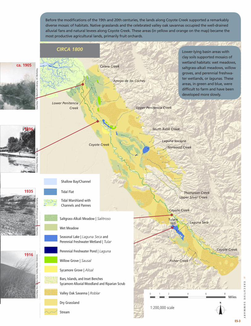
Before the modifications of the 19th and 20th centuries, the lands along Coyote Creek supported a remarkably diverse mosaic of habitats. Native grasslands and the celebrated valley oak savannas occupied the well-drained alluvial fans and natural levees along Coyote Creek. These areas (in yellow and orange on the map) became the most productive agricultural lands, primarily fruit orchards.
Lower-lying basin areas with clay soils supported mosaics of wetland habitats: wet meadows, saltgrass-alkali meadows, willow groves, and perennial freshwa-ter wetlands, or lagunas. These areas, in green and blue, were difficult to farm and have been developed more slowly.
Saltgrass-Alkali Meadow | Salitroso
Wet Meadow
Seasonal Lake | Laguna Seca and Perennial Freshwater Wetland | Tular
Perennial Freshwater Pond | Laguna
Willow Grove | Sausal
Sycamore Grove | Alisal
Bars, Islands, and Inset Benches Sycamore Alluvial Woodland and Riparian Scrub
Valley Oak Savanna | Roblar
Dry Grassland
Stream
Shallow Bay/Channel
Tidal Flat
Tidal marshland with Channels and Pannes
ES-3
ca. 1905
1896
1935
1916
// e
xe
Cu
tiv
e s
um
ma
ry
CIRCA 1800
Co
urt
esy
His
tory
San
Jo
sé.
Co
urt
esy
Co
op
er O
rnit
ho
log
ical
So
ciet
y.
Co
urt
esy
the
San
ta C
lara
Val
ley
Wat
er D
istr
ict.
Co
yo
te
Cr
ee
k w
at
er
sh
ed
his
to
riC
al
eC
ol
og
y s
tu
dy
e x e C u t i v e s u m m a r y
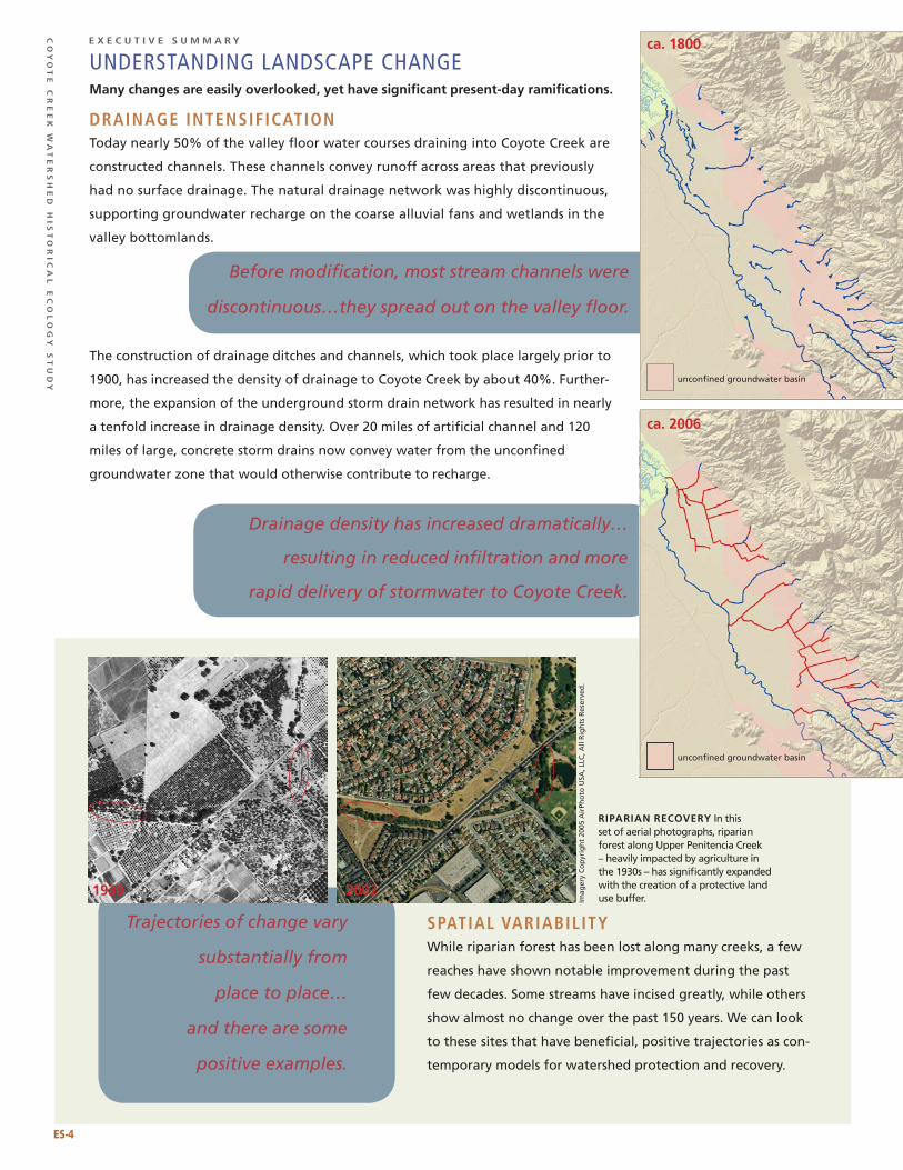
UNDERSTANDING LANDSCAPE ChANGEmany changes are easily overlooked, yet have significant present-day ramifications.
drainage intensifiCationToday nearly 50% of the valley floor water courses draining into Coyote Creek are
constructed channels. These channels convey runoff across areas that previously
had no surface drainage. The natural drainage network was highly discontinuous,
supporting groundwater recharge on the coarse alluvial fans and wetlands in the
valley bottomlands.
The construction of drainage ditches and channels, which took place largely prior to
1900, has increased the density of drainage to Coyote Creek by about 40%. Further-
more, the expansion of the underground storm drain network has resulted in nearly
a tenfold increase in drainage density. Over 20 miles of artificial channel and 120
miles of large, concrete storm drains now convey water from the unconfined
groundwater zone that would otherwise contribute to recharge.
spatial variabilityWhile riparian forest has been lost along many creeks, a few
reaches have shown notable improvement during the past
few decades. Some streams have incised greatly, while others
show almost no change over the past 150 years. We can look
to these sites that have beneficial, positive trajectories as con-
temporary models for watershed protection and recovery.
Before modification, most stream channels were
discontinuous…they spread out on the valley floor.
Drainage density has increased dramatically…
resulting in reduced infiltration and more
rapid delivery of stormwater to Coyote Creek.
rIparIan recoVery In this set of aerial photographs, riparian forest along Upper Penitencia Creek – heavily impacted by agriculture in the 1930s – has significantly expanded with the creation of a protective land use buffer.
Trajectories of change vary
substantially from
place to place…
and there are some
positive examples.
unconfined groundwater basin
unconfined groundwater basin
ca. 1800
ca. 2006
1939 2002
ES-�
Imag
ery
Co
pyr
igh
t 20
05 A
irPh
oto
USA
, LLC
, All
Rig
hts
Res
erve
d.
// e
xe
Cu
tiv
e s
um
ma
ry
mANAGING WATERShED FUNCTIONS AND PROCESSESHistorical information provides a starting point for setting appropriate local goals.
riparian habitat: one siZe doesn’t fit all.While we tend to think of riparian habitat as a dense, closed canopy forest, this was not the dominant riparian type on
Coyote Creek, where open savanna/woodland, riparian scrub, and large, unvegetated gravel bars were all important
riparian components. Given that these habitat types have been disproportionately lost, watershed management efforts
should consider their restoration at appropriate sites.
SyCAmORES AND NIGhThAWkS: INTERmITTENT IS NOT NECESSARILy BAD.
Under natural conditions, most of Coyote Creek was seasonally dry (see center spread).
The combination of intermittent reaches and perennial reaches (which were limited to
the top and bottom of the valley), supported a wide range of native species, including
the Lesser Nighthawk, which once nested in the gravelly creek beds but is no longer a
breeding resident species.
SyCAmORE ALLUVIAL WOODLAND: ThE ChARACTERISTIC hABITAT OF COyOTE CREEk
Historical evidence indicates that Coyote Creek’s dominant riparian habitat was Sycamore alluvial woodland. Now mostly
eliminated along the creek (and throughout the state), this habitat of episodic, gravel-dominated Central Coast streams had
a relatively open tree canopy with widely-spaced sycamores — in contrast to the densely wooded contemporary conditions.
RIPARIAN CONVERSION: COTTONWOOD FOREST REPLACES SyCAmORE WOODLAND
Since the construction of Coyote Dam in 1936, peak
flows from most of the upper watershed have been
reduced, while summer flows have increased. As a result,
trees have invaded the active channel, largely eliminat-
ing unvegetated bars and open riparian habitat, and
converting one riparian habitat type to another. While
clearly possessing riparian value, these new habitats
should probably be assessed for long-term viability and
ecological function.
COyOTE VALLEy REACh: RESTORATION
AND PRESERVATION OPPORTUNITIES.
Some of the best existing examples of Coyote Creek’s
pre-modification riparian habitat can be found in
Coyote Valley between Sycamore Avenue and Highway
101. This reach maintains fish assemblages with a
relatively high proportion of native species and has
been recognized as a significant remnant of Central
Coast Sycamore Alluvial Woodland. Plans for the
long-term viability of this community should consider
the potential negative impacts associated with
summertime flows and the potential benefits of high
flow pulses in the winter. Restoration at Ogier Ponds
could contribute significantly to this important reach.
“ …whose course
is marked with
groups of giant
sycamores, their
trunks gleaming
like silver through
masses of glossy
foliage…”
- Bayard Taylor, describing
Coyote Creek circa 1850
(in Carroll 1903: 185)
rIparIan HabItat conVersIon in the vicinity of Cottonwood Lake.
ES-5
Imag
ery
Co
pyr
igh
t 20
05 A
irPh
oto
USA
, LLC
, All
Rig
hts
Res
erve
d.
1939 2002
Co
yo
te
Cr
ee
k w
at
er
sh
ed
his
to
riC
al
eC
ol
og
y s
tu
dy
e x e C u t i v e s u m m a r y
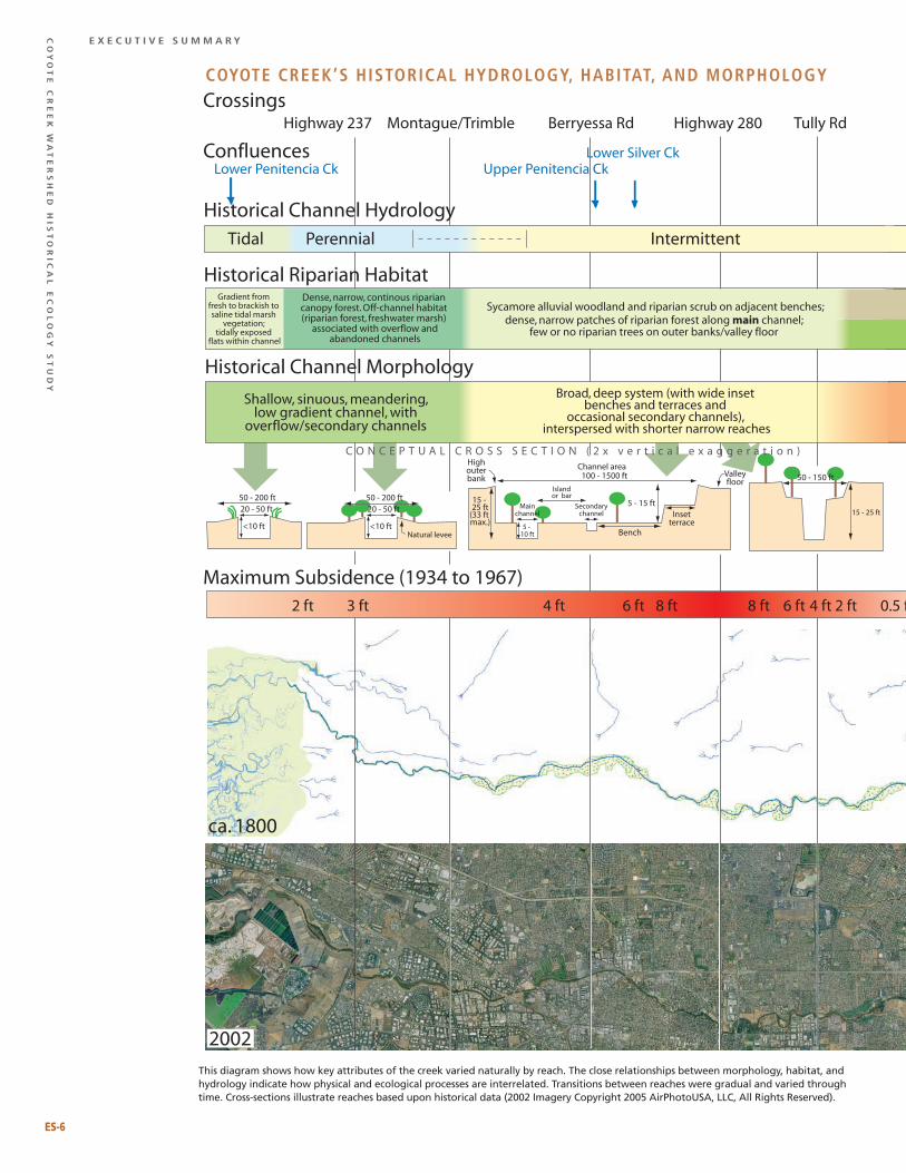
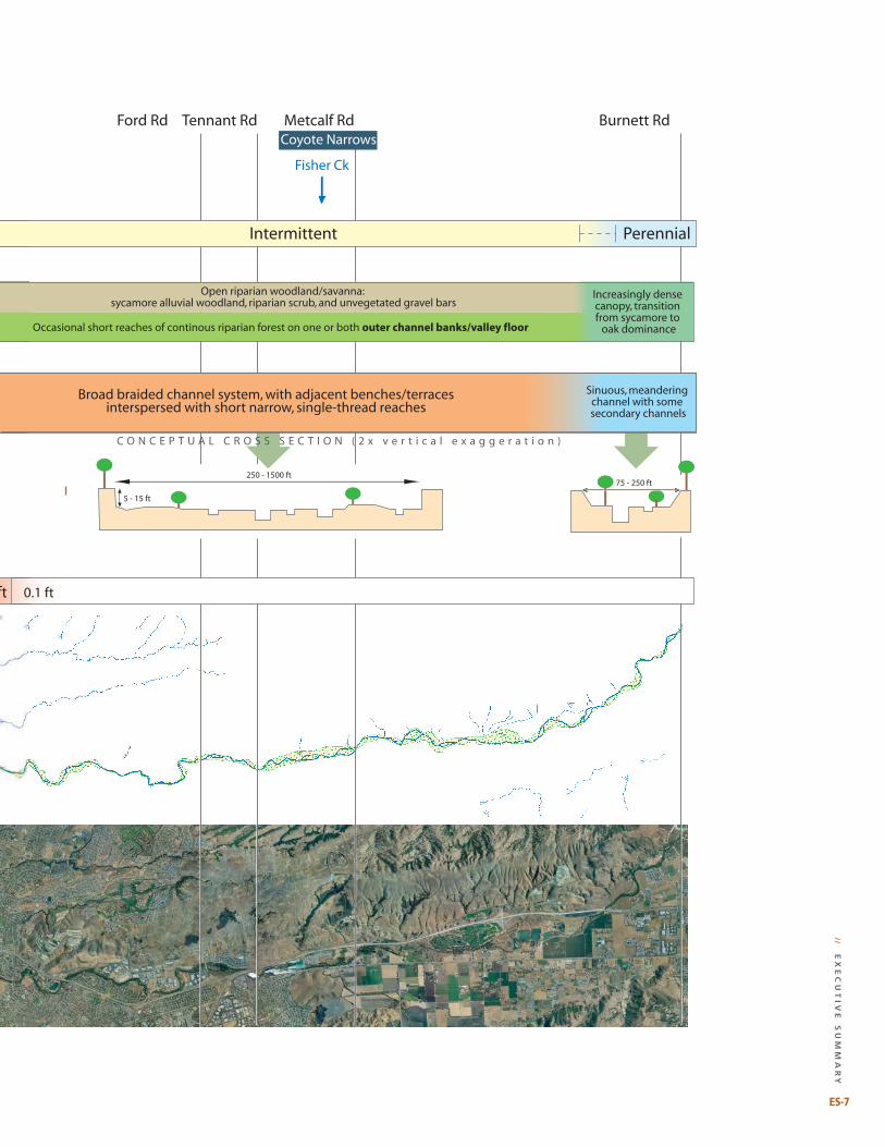
Highway 237 Montague/Trimble Berryessa Rd Highway 280 Tully Rd
Tidal Perennial Intermittent
Gradient from fresh to brackish to saline tidal marsh
vegetation; tidally exposed
flats within channel
Maximum Subsidence (1934 to 1967)
Upper Penitencia CkLower Penitencia CkLower Silver Ck
Historical Channel Hydrology
Historical Riparian HabitatDense, narrow, continous riparian canopy forest. Off-channel habitat (riparian forest, freshwater marsh)
associated with overflow andabandoned channels
Sycamore alluvial woodland and riparian scrub on adjacent benches;
Historical Channel Morphology
dense, narrow patches of riparian forest along main channel;few or no riparian trees on outer banks/valley floor
Crossings
Confluences
ca. 1800
0.5 ft2 ft4 ft6 ft8 ft8 ft6 ft4 ft3 ft2 ft
2002
5 - 15 ft
5 - 10 ft
Mainchannel
Secondarychannel
Islandor bar
Bench
Highouterbank
15 - 25 ft
(33 ft max.)
Insetterrace
Valleyfloor
100 - 1500 ftChannel area
15 - 25 ft
50 - 150 ft
<10 ft
20 - 50 ft50 - 200 ft
<10 ftNatural levee
20 - 50 ft50 - 200 ft
Shallow, sinuous, meandering,low gradient channel, with
overflow/secondary channels
Broad, deep system (with wide inset benches and terraces and
occasional secondary channels), interspersed with shorter narrow reaches
C O N C E P T U A L C R O S S S E C T I O N ( 2 x v e r t i c a l e x a g g e r a t i o n )
Ford Rd Tennant Rd Burnett RdMetcalf Rd
Intermittent Perennial
Fisher Ck
Coyote Narrows
0.1 ft
Increasingly dense canopy, transition from sycamore to
oak dominance
Open riparian woodland/savanna: sycamore alluvial woodland, riparian scrub, and unvegetated gravel bars
Occasional short reaches of continous riparian forest on one or both outer channel banks/valley floor
250 - 1500 ft
5 - 15 ft
75 - 250 ft
C O N C E P T U A L C R O S S S E C T I O N ( 2 x v e r t i c a l e x a g g e r a t i o n )
Broad braided channel system, with adjacent benches/terracesinterspersed with short narrow, single-thread reaches
Sinuous, meandering channel with some secondary channels
This diagram shows how key attributes of the creek varied naturally by reach. The close relationships between morphology, habitat, and hydrology indicate how physical and ecological processes are interrelated. Transitions between reaches were gradual and varied through time. Cross-sections illustrate reaches based upon historical data (2002 Imagery Copyright 2005 AirPhotoUSA, LLC, All Rights Reserved).
ES-6
Coyote Creek’s historiCal hydrology, habitat, and morphology
// e
xe
Cu
tiv
e s
um
ma
ry
Highway 237 Montague/Trimble Berryessa Rd Highway 280 Tully Rd
Tidal Perennial Intermittent
Gradient from fresh to brackish to saline tidal marsh
vegetation; tidally exposed
flats within channel
Maximum Subsidence (1934 to 1967)
Upper Penitencia CkLower Penitencia CkLower Silver Ck
Historical Channel Hydrology
Historical Riparian HabitatDense, narrow, continous riparian canopy forest. Off-channel habitat (riparian forest, freshwater marsh)
associated with overflow andabandoned channels
Sycamore alluvial woodland and riparian scrub on adjacent benches;
Historical Channel Morphology
dense, narrow patches of riparian forest along main channel;few or no riparian trees on outer banks/valley floor
Crossings
Confluences
ca. 1800
0.5 ft2 ft4 ft6 ft8 ft8 ft6 ft4 ft3 ft2 ft
2002
5 - 15 ft
5 - 10 ft
Mainchannel
Secondarychannel
Islandor bar
Bench
Highouterbank
15 - 25 ft
(33 ft max.)
Insetterrace
Valleyfloor
100 - 1500 ftChannel area
15 - 25 ft
50 - 150 ft
<10 ft
20 - 50 ft50 - 200 ft
<10 ftNatural levee
20 - 50 ft50 - 200 ft
Shallow, sinuous, meandering,low gradient channel, with
overflow/secondary channels
Broad, deep system (with wide inset benches and terraces and
occasional secondary channels), interspersed with shorter narrow reaches
C O N C E P T U A L C R O S S S E C T I O N ( 2 x v e r t i c a l e x a g g e r a t i o n )
Ford Rd Tennant Rd Burnett RdMetcalf Rd
Intermittent Perennial
Fisher Ck
Coyote Narrows
0.1 ft
Increasingly dense canopy, transition from sycamore to
oak dominance
Open riparian woodland/savanna: sycamore alluvial woodland, riparian scrub, and unvegetated gravel bars
Occasional short reaches of continous riparian forest on one or both outer channel banks/valley floor
250 - 1500 ft
5 - 15 ft
75 - 250 ft
C O N C E P T U A L C R O S S S E C T I O N ( 2 x v e r t i c a l e x a g g e r a t i o n )
Broad braided channel system, with adjacent benches/terracesinterspersed with short narrow, single-thread reaches
Sinuous, meandering channel with some secondary channels
ES-�
Co
yo
te
Cr
ee
k w
at
er
sh
ed
his
to
riC
al
eC
ol
og
y s
tu
dy
e x e C u t i v e s u m m a r y
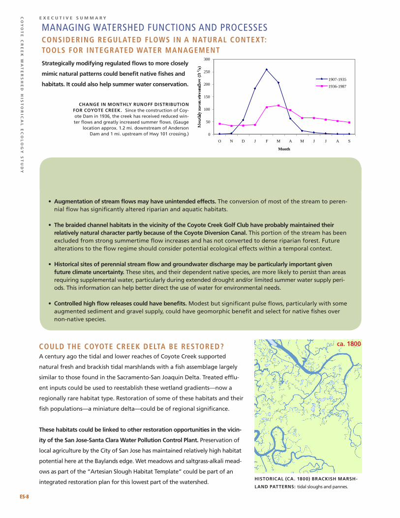
mANAGING WATERShED FUNCTIONS AND PROCESSESConsidering regulated flows in a natural Context: tools for integrated water management
strategically modifying regulated flows to more closely
mimic natural patterns could benefit native fishes and
habitats. It could also help summer water conservation.
Could the Coyote Creek delta be restored?A century ago the tidal and lower reaches of Coyote Creek supported
natural fresh and brackish tidal marshlands with a fish assemblage largely
similar to those found in the Sacramento-San Joaquin Delta. Treated efflu-
ent inputs could be used to reestablish these wetland gradients—now a
regionally rare habitat type. Restoration of some of these habitats and their
fish populations—a miniature delta—could be of regional significance.
these habitats could be linked to other restoration opportunities in the vicin-
ity of the san Jose-santa clara water pollution control plant. Preservation of
local agriculture by the City of San Jose has maintained relatively high habitat
potential here at the Baylands edge. Wet meadows and saltgrass-alkali mead-
ows as part of the “Artesian Slough Habitat Template” could be part of an
integrated restoration plan for this lowest part of the watershed.
0
50
100
150
200
250
300
O N D J F M A M J J A S
Month
1907-1935
1936-1987
cHange In montHly runoff DIstrIbutIon for coyote creek. Since the construction of Coy-ote Dam in 1936, the creek has received reduced win-ter flows and greatly increased summer flows. (Gauge
location approx. 1.2 mi. downstream of Anderson Dam and 1 mi. upstream of Hwy 101 crossing.)
• augmentation of stream flows may have unintended effects. The conversion of most of the stream to peren-nial flow has significantly altered riparian and aquatic habitats.
• the braided channel habitats in the vicinity of the coyote creek golf club have probably maintained their relatively natural character partly because of the coyote Diversion canal. This portion of the stream has been excluded from strong summertime flow increases and has not converted to dense riparian forest. Future alterations to the flow regime should consider potential ecological effects within a temporal context.
• Historical sites of perennial stream flow and groundwater discharge may be particularly important given future climate uncertainty. These sites, and their dependent native species, are more likely to persist than areas requiring supplemental water, particularly during extended drought and/or limited summer water supply peri-ods. This information can help better direct the use of water for environmental needs.
• controlled high flow releases could have benefits. Modest but significant pulse flows, particularly with some augmented sediment and gravel supply, could have geomorphic benefit and select for native fishes over non-native species.
Greater variability could be important to stream health:
HIstorIcal (ca. 1800) brackIsH marsH-
lanD patterns: tidal sloughs and pannes.
ca. 1800
ES-8
// e
xe
Cu
tiv
e s
um
ma
ry
ES-�
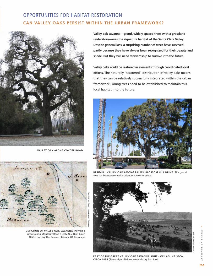
OPPORTUNITIES FOR hABITAT RESTORATIONcan Valley oaks persIst wItHIn tHe urban framework?
Valley oak savanna—grand, widely spaced trees with a grassland
understory—was the signature habitat of the santa clara Valley.
Despite general loss, a surprising number of trees have survived,
partly because they have always been recognized for their beauty and
shade. but they will need stewardship to survive into the future.
Valley oaks could be restored in elements through coordinated local
efforts. The naturally “scattered” distribution of valley oaks means
that they can be relatively successfully integrated within the urban
framework. Young trees need to be established to maintain this
local habitat into the future.
Valley oak along coyote roaD.
part of tHe great Valley oak saVanna soutH of laguna seca, cIrca 1896 (Shortridge 1896, courtesy History San José).
DepIctIon of Valley oak saVanna showing a grove along Monterey Road (Healy, U.S. Dist. Court
1859, courtesy The Bancroft Library, UC Berkeley).
resIDual Valley oak among palms, blossom HIll DrIVe. This grand tree has been preserved as a landscape centerpiece.
Co
urt
esy
The
Ban
cro
ft L
ibra
ry, U
C B
erke
ley.
Co
urt
esy
His
tory
San
Jo
sé.
Co
yo
te
Cr
ee
k w
at
er
sh
ed
his
to
riC
al
eC
ol
og
y s
tu
dy
e x e C u t i v e s u m m a r y
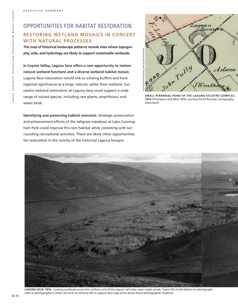
OPPORTUNITIES FOR hABITAT RESTORATIONrestorIng wetlanD mosaIcs In concert wItH natural processesthe map of historical landscape patterns reveals sites where topogra-
phy, soils, and hydrology are likely to support sustainable wetlands.
In coyote Valley, laguna seca offers a rare opportunity to restore
natural wetland functions and a diverse wetland habitat mosaic.
Laguna Seca restoration would link to existing buffers and have
regional significance as a large, natural, valley floor wetland. Suc-
cessful wetland restoration at Laguna Seca could support a wide
range of valued species, including rare plants, amphibians, and
water birds.
Identifying and preserving habitat remnants. Strategic preservation
and enhancement efforts of the saltgrass meadows at Lake Cunning-
ham Park could improve this rare habitat while coexisting with sur-
rounding recreational activities. There are likely other opportunities
for restoration in the vicinity of the historical Laguna Socayre.
small perennIal ponD of tHe laguna socayre complex, 1876 (Thompson and West 1876, courtesy David Rumsey, Cartography Associates).
laguna seca, 1916. Looking southeast across the northern end of the laguna: tall tules, open water ponds, Tulare Hill at left (letters on photographs refer to photographer’s notes; red circle at extreme left in Laguna Seca map series above shows photographer location).
ES-10
Co
urt
esy
Dav
id R
um
sey,
Car
tog
rap
hy
Ass
oci
ates
.
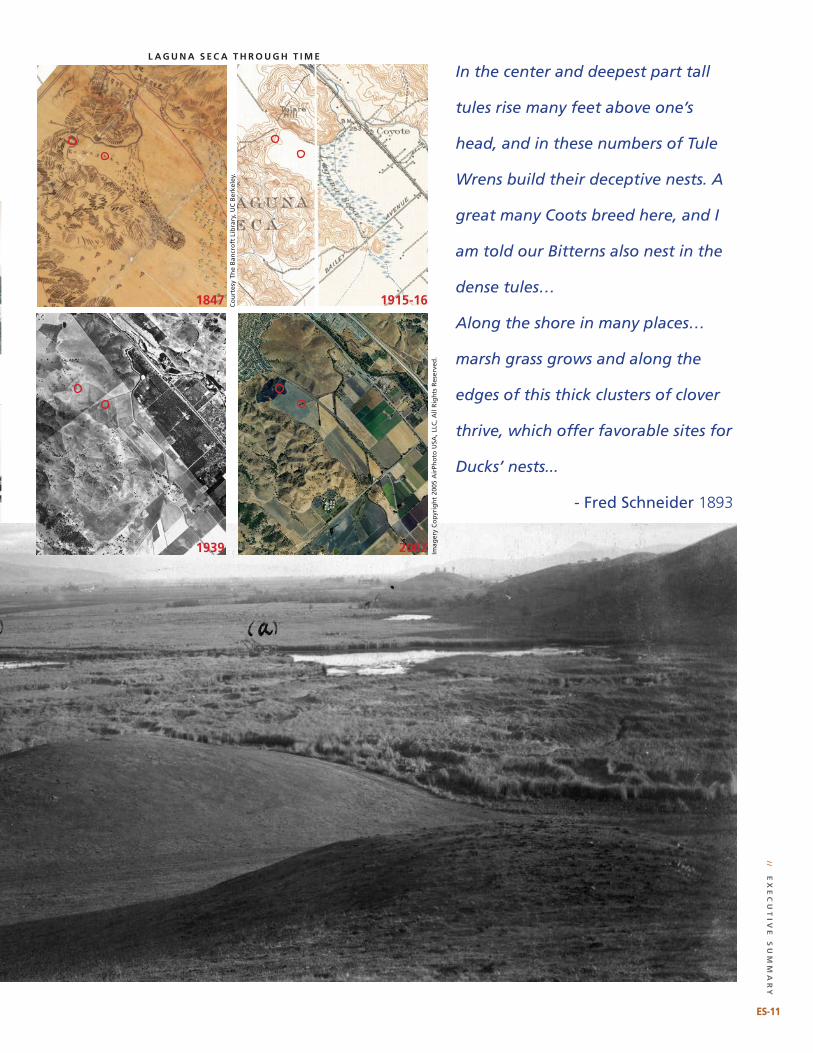
In the center and deepest part tall
tules rise many feet above one’s
head, and in these numbers of Tule
Wrens build their deceptive nests. A
great many Coots breed here, and I
am told our Bitterns also nest in the
dense tules…
Along the shore in many places…
marsh grass grows and along the
edges of this thick clusters of clover
thrive, which offer favorable sites for
Ducks’ nests...
- Fred Schneider 1893
l a g u n a s e c a t H r o u g H t I m e
1847 1915-16
1939 2002
ES-11
// e
xe
Cu
tiv
e s
um
ma
ry
Co
urt
esy
The
Ban
cro
ft L
ibra
ry, U
C B
erke
ley.
Imag
ery
Co
pyr
igh
t 20
05 A
irPh
oto
USA
, LLC
, All
Rig
hts
Res
erve
d.
Co
yo
te
Cr
ee
k w
at
er
sh
ed
his
to
riC
al
eC
ol
og
y s
tu
dy
e x e C u t i v e s u m m a r y
TOOLS FOR NATURAL FLOOD PROTECTIONHistorical data help identify places where natural approaches can be used to reduce
flood risk.
InfIltratIon Versus DraInage—reDesIgnIng tHe way water moVes
tHrougH tHe Valley
The dramatic increase in constructed drainage tends to decrease groundwater
recharge while increasing flood peaks downstream. Reducing drainage connectivity
through off-site storage, swales, and neighborhood-scale infiltration projects will
be important to both flood protection and water supply, especially given predicted
climatic changes and increased impervious surfaces.
Restoration of natural hydrogeomorphology of Laguna Seca and the Fisher Creek drainage network could provide
significant off-site flood peak attenuation as well as wetland habitat for a range of native species.
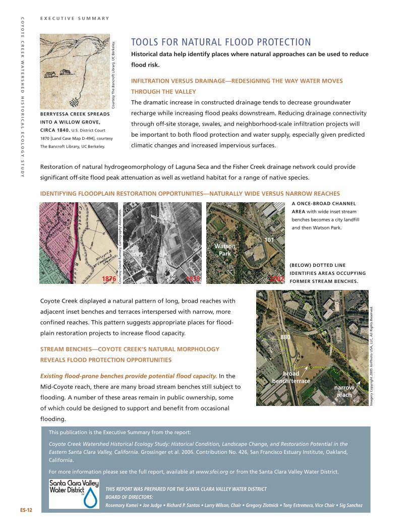
IDentIfyIng flooDplaIn restoratIon opportunItIes—naturally wIDe Versus narrow reacHes
Coyote Creek displayed a natural pattern of long, broad reaches with
adjacent inset benches and terraces interspersed with narrow, more
confined reaches. This pattern suggests appropriate places for flood-
plain restoration projects to increase flood capacity.
stream bencHes—coyote creek’s natural morpHology
reVeals flooD protectIon opportunItIes
Existing flood-prone benches provide potential flood capacity. In the
Mid-Coyote reach, there are many broad stream benches still subject to
flooding. A number of these areas remain in public ownership, some
of which could be designed to support and benefit from occasional
flooding.
berryessa creek spreaDs
Into a wIllow groVe,
cIrca 1840. U.S. District Court
1870 [Land Case Map D-494], courtesy
The Bancroft Library, UC Berkeley.
a once-broaD cHannel
area with wide inset stream
benches becomes a city landfill
and then Watson Park.
(below) DotteD lIne
IDentIfIes areas occupyIng
former stream bencHes.
this report was prepared for the santa Clara valley water distriCt board of direCtors:rosemary kamei • Joe Judge • richard p. santos • larry wilson, Chair • gregory Zlotnick • tony estremera, vice Chair • sig sanchez
This publication is the Executive Summary from the report:
Coyote Creek Watershed Historical Ecology Study: Historical Condition, Landscape Change, and Restoration Potential in the
Eastern Santa Clara Valley, California. Grossinger et al. 2006. Contribution No. 426, San Francisco Estuary Institute, Oakland,
California.
For more information please see the full report, available at www.sfei.org or from the Santa Clara Valley Water District.
1876 1939 2002
101
880
watson park
ES-1�
broad bench/terrace
narrow reach
Imag
ery
Co
pyr
igh
t 20
05 A
irPh
oto
USA
, LLC
, All
Rig
hts
Res
erve
d.
Co
urt
esy
The
Ban
cro
ft L
ibra
ry, U
C B
erke
ley.
Co
urt
esy
Dav
id R
um
sey,
Car
tog
rap
hy
Ass
oci
ates
.