county of sonoma agenda item summary report
TRANSCRIPT

County Of Sonoma Agenda Item Summary Report
Department Sonoma County Permit and Resource Management Department
Name and Phone Number Cynthia Demidovich - (707) 565-1754
Board Date 06192011
AGENDA SHORT TITLE Hearing to consider a Coastal Permit Sonoma County Regional Parks co Mark Cleveland CPH09-0007 REQUESTED BOARD ACTION Adopt a Resolution to approve a Coastal Permit for the Bodega Bay Coastal Prairie Trail Project located along a one mile route from 2255 Highway 1 to 100 Keefe Ave Bodega Bay APNrsquos 100-220-008 100-230-001 100-230-042 100-020-019 101-020-042 101-020-043 101-020-044 and 101-020-045 Fifth District
Action Requested of the Board of Supervisors Hearing to consider a request from the Sonoma County Regional Parks for a Coastal Permit for the Bodega Bay Coastal Prairie Trail Project Application No CPH09-0007 At the conclusion of the hearing your Board may approve the Coastal Permit as approved by staff Location Zoning and Project Description The subject property is located along a one mile route from 2255 Highway 1 to 100 Keefe Ave Bodega Bay APNrsquos 100-220-008 100-230-001 100-230-042 100-020-019 101-020-042 101-020-043 101-020-044 and 101-020-045 Supervisorial District No 5 The base zoning for all parcels is PF (Public Facilities) and combining zones are CC (Coastal Combining) SR (Scenic Resources) and G (Geologic Hazard Area) The proposed project is a request for a Coastal Permit to construct a trail known as the Coastal Prairie Trail The project area is approximately 9245 acres in size and owned by Sonoma County Regional Parks and the California Department of Parks and Recreation The project site is located west of Highway 1 between the highway and Bodega Dunes Campground The trail will be a Class I bicycle path with a multi-use for bicycle pedestrian and equestrian uses The trail will be approximately 10 miles in length and 12-feet wide The trail shoulders will be one-foot wide along one side of the trail and three-feet wide on the other side the three-foot wide shoulder will accommodate equestrian use The remaining sections of the main trail will consist of approximately 918 feet of boardwalk over wetlands within federal regulatory jurisdiction and a 120-foot long bridge over an unnamed tributary The proposed project includes two parking areas and trailheads to serve the new trail The main parking area accessed from Highway 1 will include a portable restroom three family picnic sites a bike rack trail signage and a pull-in area for busses and emergency vehicles The proposed project also
includes improvements to Highway 1 as requested by Caltrans
Attachments Project Memo Draft Board of Supervisors Resolution EXHIBIT A Draft Conditions of Approval EXHIBIT B Proposal Statement EXHIBIT C Vicinity Map EXHIBIT D Site Plan EXHIBIT E Property Map EXHIBIT F Coastal Land Use Map EXHIBIT G Wetland Mitigation Enhancement and Habitat Plan dated February 2012 Separate Attachment to the Board of Supervisors and On File With Clerk Previously Adopted Mitigated Negative Declaration June 21 2011
COUNTY OF SONOMA PERMIT AND RESOURCE MANAGEMENT DEPARTMENT 2550 Ventura Avenue Santa Rosa CA 95403 (707) 565-1900 FAX (707) 565-1103
DATE June 19 2012 at 210 pm TO Board of Supervisors FROM Cynthia Demidovich Project Planner SUBJECT Hearing to consider a Coastal Permit for the Sonoma County Regional Parks
proposed Bodega Bay Coastal Prairie Trail Project CPH09-0007 Sonoma County Regional Parks Supervisorial District No 5
Action Requested of the Board of Supervisors The Board is requested to conduct a public hearing on the proposed Coastal Permit for the Coastal Prairie Trail At the conclusion of the hearing your Board may approve the Coastal Permit as recommended by staff Prior Actions A Mitigated Negative Declaration was previously adopted by the Board of Supervisors on June 21 2011 at a regularly scheduled public hearing The Mitigated Negative Declaration was prepared by the Sonoma County Regional Parks Department Subsequent to adopting the Mitigated Negative Declaration a Wetland Mitigation Enhancement and Habitat Restoration Plan for the Coastal Prairie Trail Project dated February 2012 was prepared by Jane Valerius to clarify the location of the wetland and riparian mitigation enhancement The Coastal Permit application was submitted on July 16 2009 and was deemed complete on December 19 2011 On May 15 2012 the Board of Supervisors took original jurisdiction on the proposed project as requested by the Permit and Resource Management Department (PRMD) On June 9 2012 staff sent out a Notice of Public Hearing ndash Pending Action on a Coastal Permit to surrounding neighbors and posted the Notice on and near the project site Location Zoning and Project Description Location The Coastal Prairie Trail project will be located on eight contiguous properties owned by the County of Sonoma and the State of California The parcels are located between Bay Hill Road and Keefe Avenue in Bodega Bay (a one mile route from 2255 Highway 1 to 100 Keefe Ave Bodega Bay) The base zoning for all parcels is PF (Public Facilities) and combining zones are CC (Coastal Combining) SR (Scenic Resources) and G (Geologic Hazard Area) The project area is bordered by Sonoma Coast State Park and Bodega Dunes Campground to the west and State Highway 1 to the east The Salmon Creek residential community is located on the northern boundary just beyond the proposed parking area off Keefe Avenue The southern boundary is bordered by County of Sonoma properties which is where the Bodega Bay Community Center and the Nicholas Green Memorial Bell Tower are located
June 19 2012 File No CPH09-007 Page 2 The Bodega Bay RV Park is located along the southern boundary of the Bodega Bay Community Center property Approximately 300-feet of shoulder along the east side of State Highway 1 will be widened for the proposed State Highway 1 improvement near the south driveway that serves the trailhead The area of the shoulder widening is generally within property owned by Caltrans and is bordered by private residential property The project area and vicinity includes a vast array of biological resources including upland and wetland plant communities that provide habitat to many wildlife species some of which are sensitive species The project area is a mosaic of habitats including coastal terrace prairie northern coastal scrub and wetlands typical of the Sonoma County coastal environment An unnamed stream traverses one of the State Parks properties and is surrounded by dense riparian vegetation The project area also includes stands of Monterey cypress eucalyptus and Monterey pine A bridge is intended to cross a USGS mapped stream channel located on the project site This stream is unnamed It originates on the east side of Highway 1 between two saddles on the northern slope of Mount Roscoe and flows in an east-west direction parallel to the entrance road to the Bodega Dunes State Park within State Parks property Within the project area the stream empties into a large palustrine emergent wetland and is surrounded by the Arroyo Willow plant community Ultimately the stream drains further into two basins within coastal dune habitat on State Parks property Trail Improvements The proposed project is a request for a Coastal Permit to construct a trail known as the Coastal Prairie Trail The trail is designed as a Class 1 bike path and will provide equitable access for all modes of trail use including bicycle pedestrian and equestrian uses The trail will be approximately 10 miles in length and 12-feet wide The trail width includes an 8-foot wide trail with rock aggregated shoulders along each side of the trail Approximately 4230 feet of the trail will be surfaced with resin-stabilized aggregate The trail shoulders will be one-foot wide along one side of the trail and three-feet wide on the other side the three-foot wide shoulder will accommodate equestrian use The remaining sections of the main trail will consist of approximately 918 feet of boardwalk over wetlands within federal regulatory jurisdiction and a 120-foot long bridge over the unnamed tributary Bridge Improvements A pre-fabricated wooden-deck bridge will be installed over the unnamed tributary that flows through one of the State Parks properties The bridge will be single-span and 120-feet in length and 8-feet in width The bridge will include boardwalk approaches each 32-foot long and 8-foot wide on both ends of the bridge to complete the span over the tributary and 12-foot by 10-foot concrete landing pads on both ends of the boardwalk sections Parking Improvements The trailhead will be located approximately half-way along the trail approximately 010 mile south of State Parkrsquos Bodega Dunes Campground entrance road off State Highway 1 The trailhead will include a parking area accessed from a paved entrance a screened portable restroom picnic tables bicycle rack trash cans and other amenities The trailhead parking area will accommodate approximately 15 passenger vehicles including one van accessible disabled parking space in compliance with ADA requirements The trailhead parking area will include access for school and public transit busses as well as emergency access vehicles Additional parking for seven vehicles including one ADA-compliant parking space will be provided at the northern terminus of the Coastal Prairie Trail at Keefe
June 19 2012 File No CPH09-007 Page 3 Avenue A wildlife-friendly vehicle barrier consisting of logs and bollards will be placed around the parking areas so that vehicles cannot drive onto the trail itself State Highway 1 Improvements A 300-foot section of shoulder along the east side of Highway 1 will be widened to provide an 8-foot paved width across from the access driveway to the trailhead parking area The paved shoulder will include 50-foot long tapered ends on both sides The purpose is to provide an area to pass vehicles making the left turn into the trailhead parking area This improvement will occur on both sides of the Caltrans maintenance facility driveway on an existing Caltrans easement The project will also include installation of two culverts on the south side of the Bodega Dunes Campground entry road interpretive and operational signage along the trail and relocation of one PGampE utility pole along State Highway 1 Purpose and Need for the Project Project Purpose The purpose of the proposed project is to develop a section of Class I bicycle path along State Highway 1 to provide a safe travel way separate from the State highway The Class I bicycle path will be multi-use for bicycle pedestrian and equestrian use Currently the only path for non-motorized use along this section of State Highway 1 is a very narrow section of paved shoulder immediately adjacent to the vehicle travel lane Development of the Coastal Prairie Trail is expected to encourage alternatives to motorized travel between existing residential recreational and commercial areas in Bodega Bay and reduce traffic congestion Project Need The development of a continuous trail through the unincorporated Town of Bodega Bay and the immediate surrounding area has long been a community goal Topographic and land use constraints have presented numerous challenges to the development of such a trail Long stretches of Highway 1 cut through the center of town These stretches have little to no road shoulder because of existing right-of-way vegetation and topography Numerous residential structures have been built alongside Highway 1 creating sight distance problems around curves and leaving little room to walk bicycle ride horses or use any form of alternative transportation The existing condition forces non-motorized travelers onto the narrow shoulders along Highway 1
DISCUSSION OF ISSUES
Issue 1 General Plan Consistency The General Plan land use designation for the subject parcel is PQP (Public and Quasi Public) General Plan Land Use Policy 25 indicates the PQP designation is intended to provide sites that serve the community or public needs and owned or operated by government agencies non-profit entities or public utilities Public parks and new trails intended to be used by the public is an allowed use in this land use designation
June 19 2012 File No CPH09-007 Page 4 General Plan Policy PF-2a of the Public Facilities and Services Element states to plan design and construct park and recreation fire and emergency medical public education and solid waste services and public utilities in accordance with projected growth The Coastal Prairie Trail is located within two existing public parks and the new trail will benefit and be used by the general public General Plan Policy OSRC-17d of the Open Space and Resource Conservation defines the ldquoSonoma Coast Trailrdquo as extending from Black Point to the Estero Americano and finds the trail consistent with the California State Coastal Plan Policy 145 that calls for the establishment of a statewide coastal trail system This General Plan Policy also states that trails on Figure OSRC-3 make up the Countys designated plan for trails The Sonoma Coast Trail is identified as a designated trail under this policy and the Coastal Prairie Trail is a segment of the Sonoma Coast Trail General Plan Policy CT-3v of the Circulation and Transit Element states where a nexus exists require private or public development to plan design and construct bicycle and pedestrian facilities to integrate with the existing and planned bicycle and pedestrian network The Coastal Prairie Trail is integrated with existing bicycle and pedestrian networks located in two public parks will benefit and be used by the general public General Plan Policy CT-3q of the Circulation and Transit Element states to design construct and improve bikeways consistent with the Bikeways Plan ldquoProject Priority Listrdquo The Coastal Prairie Trail is a trail listed on the Bikeways Plan ldquoProject Priority Listrdquo and has been designed as an improved pedestrian bikeway and equestrian trail As conditioned the proposed project is consistent with the goals objectives and policies of the General Plan Issue 2 Local Coastal Plan Consistency The Local Coastal Plan land use designation for the subject site is Institutional and Section VII-59 of the Local Coastal Plan defines Institutional uses as land accommodating institutional or public uses The project site is located on two public parks and the new trail will benefit and be used by the general public The proposed project is consistent with the Coastal Land Use designation of Institutional The Recreation Resources section of the Local Coastal Plan per section V-3 requires the following development criteria for coastal access trails
Among the facilities needed for access ways and shoreline destinations are safe trails restrooms parking areas trash receptacles and signs Necessary facilities at a particular site will depend upon expected use and the availability of facilities nearby
The Coastal Prairie Trail is designed as a Class 1 bike path and will provide equitable access for all modes of trail use including bicycle pedestrian and equestrian uses and provides coastal access to the public Restroom facilities and trash receptacles will be located at the south trailhead Adequate parking areas and trail signs will be located at the south and north trailheads The proposed project is consistent with the Recreation Resources section of the Local Coastal Plan Issue 3 Coastal Zoning Ordinance Consistency The Coastal Zoning designation for the subject parcels is PF (Public Facilities) CC (Coastal Combining District) G (Geologic Hazard) SR (Scenic Resource Combining District) Section 26C-182(a) of the
June 19 2012 File No CPH09-007 Page 5 Public Facilities Zoning district allows any facility owned and operated by a city or the county as an allowed use without a Use Permit The proposed project will not have an effect on a Scenic Resource Combining District as the facilities will be screened by existing vegetation and natural terrain The materials used will blend in with the native surroundings as the aggregate used for the trail surface will be tinted an earth tone color and wood will be used for the boardwalks and bridge The trail will be constructed at grade following natural contours of the land The trailhead parking area accessed from Highway 1 will be well screened by existing vegetation Issue 4 Environmentally Sensitive Habitat Areas Wetlands The following policies from the Environmental Resources section of the Sonoma County Local Coastal Plan apply to the proposed project
Section III-1of the Local Coastal Plan
30233 (a) The diking filling or dredging of open coastal waters wetlands estuaries and lakes shall be permitted in accordance with other applicable provisions of this division where there is no feasible less environmentally damaging alternative and where feasible mitigation measures have been provided to minimize adverse environmental effects and shall be limited to the following
(7) Nature study aquaculture or similar resource-dependent activities
(c) In addition to the other provisions of this section diking filling or dredging in existing estuaries and wetlands shall maintain or enhance the functional capacity of the wetland or estuary Any alteration of coastal wetlands identified by the Department of Fish and Game including but not limited to the 19 coastal wetlands identified in its report entitled Acquisition Priorities for the Coastal Wetlands of California shall be limited to very minor incidental public facilities restorative measures nature study commercial fishing facilities in Bodega Bay and development in already developed parts of south San Diego Bay if otherwise in accordance with this division
This Section of the Coastal Plan allows filling of wetlands when there is no feasible less environmentally damaging alternative and where feasible mitigation measures have been provided to minimize adverse environmental effects provided the use is nature study aquaculture or similar resource-dependent activities In addition this Section limits the fill of a wetland to very minor incidental public facilities The proposed project has been designed to avoid and minimize damage to wetlands Permanent impacts to the wetlands would be from the boardwalk footings and regular trail sections To offset the loss of the wetland Regional Parks is proposing to enhance the on-site existing wetland at a 31 ratio (see discussion listed below Issue 5) The Coastal Prairie Trail is a very minor incidental public facility located in two existing public parks and is a resource-dependent use as the use is a nature trail that provides coastal access In addition the Coastal Prairie Trail is part of the ldquoSonoma Coast Trailrdquo which is part of a statewide coastal trail system
June 19 2012 File No CPH09-007 Page 6
Section III-2 of the Local Coastal Plan
30240 (a) Environmentally sensitive habitat areas shall be protected against any significant disruption of habitat values and only uses dependent on such resources shall be allowed within such areas
(b) Development in areas adjacent to environmentally sensitive habitat areas and parks and recreation areas shall be sited and designed to prevent impacts which would significantly degrade such areas and shall be compatible with the continuance of such habitat areas
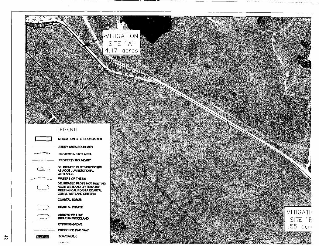
Wetlands are considered environmentally sensitive habitats in the Local Coastal Plan The trail has been designed to minimize impacts to existing wetlands as the impacts will occur to low quality wetlands The applicant is proposing to enhance on-site wetland habitat values at a 31 which is equal to approximately 417 acres of enhancement (see additional discussion listed below Issue 5) In addition a 185 acre of wetland enhancement will also take place on-site Section III-13 of the Local Coastal Plan
(24) Prohibit the removal of vegetation from wetlands unless it is shown to be essential to the habitat viability
(25) Prohibit construction of agricultural commercial industrial and residential structures within 100 feet of wetlands
(26) Between 100 and 300 feet of wetlands prohibit construction of agricultural commercial industrial and residential structures unless an environment assessment finds the wetland would not be affected by such construction
As previously stated the on-site wetland habitat will be enhanced at a 31 ratio and the proposed use is not an agricultural commercial industrial or residential the use is considered a recreational use The trail is a resource-dependent use as the nature trail provides coastal access to the public Riparian Habitat
Section III-12 Local Coastal Plan
(9) Prohibit construction of permanent structures within riparian areas as defined or 100 feet from the lowest line of riparian vegetation whichever is greater except development dependent on there sources in the riparian habitat including public recreation facilities related to the resource Any development shall be allowed only if it can be sited and designed to prevent impacts which would significantly degrade such areas and shall be compatible with the continuance of the riparian habitat The riparian area or 100 foot wide buffer zone should generally be maintained in a natural undisturbed state Trails and access may be permitted if studies determine no long-term adverse impacts would result from their construction maintenance and public use Trails should be made of porous materials
This Section from the Local Coastal Plan allows development to encroach within the 100-foot riparian setback provided the project is sited and designed to prevent impacts which would significantly degrade the riparian habitat Trails and access is permitted if studies determine there is no long-term adverse impacts due to construction maintenance and public use
June 19 2012 File No CPH09-007 Page 7 The proposed project includes a bridge with a wooden-deck to be installed over an unnamed tributary that flows through one of the State Parks properties (north of Bodega Dunes State Park) The 120-foot long bridge will minimize impacts to the surrounding willow riparian community Permanent impacts to the Arroyo WillowRiparian Woodland and Arroyo WillSedge Woodland riparian plant communities are associated with the bridge footings and boardwalk footings only due to the removal of approximately 20 square feet of willowswoodlandriparian plants The Wetland Mitigation Enhancement and Habitat Restoration Plan requires native trees and shrubs be planted at a 31 ratio based on trees removed from the riparian areas This ratio will result in approximately 55 acres of on-site riparian enhancement Issue 5 Impacts on Wetlands The proposed project will create temporary and permanent impacts to wetland habitat Temporary impacts will be the result of construction activities The wetlands under federal jurisdiction and those are state jurisdiction are located on the proposed trail and adjacent east and west side of the trail In the federal wetlands permanent impacts would be from the boardwalk footings In the state wetlands permanent impacts would result from the boardwalk footings and the regular trail sections The boardwalks themselves will not result in permanent impacts to either federal or state wetlands because they will either be avoided or minimized as a result of the placement of boardwalks Federal Wetlands There are two sections of seasonal federal wetlands south of the Bodega Dunes Campground access road which together form a large horseshoe-shaped feature These are scrub-shrub dominated wetlands with the dominant indicator species including slough sedge (Carex obnupta) California blackberry (Rubus ursinus) and common velvet grass (Holcus lanatus) Boardwalks are proposed to cross over the federal wetlands thereby avoiding impacts to these wetland areas Placement of a bridge across the unnamed tributary drainage north of the Bodega Dunes Park entrance will minimize impacts to the willow riparian community Permanent impacts to the Arroyo WillowRiparian Woodland and Arroyo WillowSedge Woodland plant communities are associated with the bridge footings and boardwalk footings only State Wetlands Wetland areas under California Coastal Commission (CCC) jurisdiction cannot be avoided because almost all of properties that compose the Coastal Prairie Trail project meet the Coastal Act wetland definition The trail has been aligned to follow the contours of the site to the extent feasible to minimize cuts and fills and to pass through areas with higher concentrations of non-native plants to minimize impacts to native plants The proposed trail surface within state wetlands includes cement-stabilized aggregate with rock-aggregate shoulders Since it is not possible to create new CCC wetland communities the mitigation plan is designed to compensate for impacts to CCC wetlands by enhancing a 417 acre area that is currently mapped as coastal scrub This area was likely coastal prairie before this area was invaded by coyote bush (Baccharis pilularis) This area also has been invaded by iceplant (Carpobrotus edulis) and is dominated by non-native grasses primarily velvet grass (Holcus lanatus) The focus of the enhancement is to eliminate the invading coyote bush iceplant and non-native grasses and increase the native species cover and re-establish the coastal prairie community type The purpose and goal of
June 19 2012 File No CPH09-007 Page 8 enhancing the existing coastal scrub community by converting it to a native coastal prairie community is to enhance the functions and values of the site and return it to the native grassland condition The proposed project will create the following temporary and permanent impacts to wetlands located on the project site Temporary Impacts Permanent Impacts Federal Wetlands 039 acres temporary impacts +-0003 acres permanent impacts (17080 square feet) (1410 square feet) State Wetlands 329 acres temporary impacts 139 acres permanent impacts (143314 square feet) (60436 square feet) Wetland Mitigation Enhancement and Habitat Restoration Plan The Wetland Mitigation Enhancement and Habitat Restoration Plan for the Coastal Prairie Trail Project (prepared by Jane Valerius dated February 2012) provides a Wetland Mitigation Enhancement Plan for the proposed project to compensate for the permanent loss of wetland habitat The Wetland Mitigation Enhancement Plan describes the proposed mitigation measures designed to compensate for impacts primarily to state wetlands since the federal wetlands will either be avoided or minimized as a result of the placement of boardwalks within United States Army Corps of Engineers (Army Corps) wetland areas The mitigation measures for the Mitigated Negative Declaration and the Wetland Mitigation Enhancement Plan are included in the conditions of approval The Wetland Mitigation Enhancement and Habitat Restoration Plan and the previously adopted Mitigated Negative Declaration require the following mitigation measures will be conducted by Sonoma County Regional Parks to compensate for the permanent and temporary impacts to wetlands and riparian habitat 1 Enhance existing wetlands at a 31 ratio based on the permanent loss of state jurisdictional
wetlands resulting in a minimum of 417 acres of wetland enhancement 2 Wetland enhancement includes removal of coyote brush iceplant and non-native grasses 3 Direct seeding the temporary construction areas with a seed mix based on the native grasses
forbs and flowers disturbed to construct the project 4 Direct seeding from seed and mulching of temporary construction areas along the trail and at
staging areas with a seed mix based on the native grasses forbs and flowers disturbed to construct the project Seed mixes to be gathered from on-site
5 Removal of non-native trees and jubata grass in the willow riparian community and planting
native trees and shrubs 6 Removal of non-native trees such as Monterey pine and removal of coyote brush and direct
seeding of native coastal prairie species south of the Bodega Dunes Park entrance road 7 Monitoring and following performance criteria for wetland enhancement for a minimum of three
years after all seeding planting and weed control activities have been completed
June 19 2012 File No CPH09-007 Page 9
In addition to the 417 acre of wetland enhancement listed above another 185 acre of wetland enhancement will also take place on-site The mitigation sites will be monitored for a minimum of three years An annual report describing the monitoring efforts will be submitted to the CCC the Army Corps and Regional Water Quality Control Board (RWQCB) by January 31st of each year The first year annual report will be submitted after the first growing season after planting The Annual Reports will include a description of the results of the vegetation monitoring including observations of the success of the herbicide treatments and any maintenance activities Photos of the site will also be included An analysis of the performance of the wetland enhancement and grassland restoration sites will also be provided in the report along with any recommendations for remedial measures that may need to be implemented to improve the performance of the mitigation sites Issue 6 Impacts on Riparian Habitat The proposed project will create temporary and permanent impacts to riparian habitat Temporary impacts are associated with construction activities and the areas will be restored to their pre-construction condition after construction activities are complete Permanent impacts to the Arroyo WillowRiparian Woodland and Arroyo WillSedge Woodland riparian plant communities are associated with the bridge footings and boardwalk footings only Placement of a bridge across the unnamed tributary drainage north of the Bodega Dunes Park entrance will minimize impacts to the willow riparian community at this location The proposed project will create the following temporary and permanent impacts to riparian habitat located on the project site Temporary Impacts Permanent Impacts Arroyo Willow temporary impacts 0022 acres permanent impacts 00003 acres Riparian Woodland (962 square feet) (126 square feet) Arroyo Willow temporary impacts 0015 acres permanent impacts 00002 acres Sedge Woodland (660 square feet) (70 square feet) Wetland Mitigation Enhancement and Habitat Restoration Plan The previously mentioned Wetland Mitigation Enhancement and Habitat Restoration Plan for the Coastal Prairie Trail Project also provides a riparian mitigation enhancement plan for the proposed project to compensate for the permanent loss of riparian habitat The plan and the previously adopted Mitigated Negative Declaration require the following mitigation measures that are included in the condition of approval 1 Plant native trees and shrubs at a 31 ratio based on trees removed from the riparian areas that
have a breast-height diameter of 6-inches or greater resulting in a minimum of 55 acres of riparian enhancement In the case of removal of non-native species a suitable native species will be selected for replanting
June 19 2012 File No CPH09-007 Page 10 2 Hydro-seed andor direct seed the temporary construction areas with a seed mix based on the
native grasses forbs and flowers disturbed to construct the project 3 Monitor the re-vegetationplant community restoration for a three year period 4 Replant as needed to achieve a 75 percent total survivability
The mitigation sites will be monitored for a minimum of three years and an annual report describing the monitoring efforts will be submitted to the CCC the Army Corps and Regional Water Quality Control Board (RWQCB) by January 31st of each year The first year annual report will be submitted after the first growing season after planting Mitigation Measures require the annual reports to include a description of the results of the vegetation monitoring including observations of the success of the herbicide treatments and any maintenance activities Photos of the site will also be included Monitoring reports shall include the survival percent cover and height of both tree and shrub species The number by species of plants replaced an overview of the revegetation effort and the method used to assess these parameters shall also be included Photos from designated photo locations shall also be included in the annual reports Issue 7 Environmental Review As indicated previously a Mitigated Negative Declaration was previously adopted and approved by the Sonoma County Board of Supervisors on June 21 2011 and the Board found the proposed project will not have a significant effect on the environment provided that mitigation measures are included No additional environmental review is required under Section 15168(c)(2) of CEQA as no new effects could occur and no new mitigation measures are required as the project is within the scope of the project covered by the previously adopted and approved Mitigated Negative Declaration pursuant to Section 15162 of CEQA List of Attachments Draft Board of Supervisors Resolution EXHIBIT A Draft Conditions of Approval EXHIBIT B Proposal Statement EXHIBIT C Vicinity Maps EXHIBIT D Site Plan EXHIBIT E Assessors Parcels EXHIBIT F General Plan Map EXHIBIT G Zoning Map EXHIBIT H Coastal Land Use Map EXHIBIT I Wetland Mitigation Enhancement and Habitat Plan dated February 2012 EXHIBIT J Southern Biological Study Area Map EXHIBIT K Northern Biological Study Area Map EXHIBIT L Southern Enhancement and Restoration Map EXHIBIT M Northern Enhancement and Restoration Map __________________________________________________________________________________ Separate Attachment for the Board of Supervisors and On File with the Clerk Previously Adopted Mitigated Negative Declaration June 21 2011
Resolution No
Date 6192012 CPH09-0007 Cynthia Demidovich
Resolution Of The Board Of Supervisors Of The County Of Sonoma State of California Approving The Proposed Bodega Bay Coastal Prairie Trail Project Located Along A One Mile Route Extending From 2255 Highway 1 To 100 Keefe Ave Bodega Bay APNs 100-220-008 100-230-001 100-230-042 100-020-019 101-020-042 101-020-043 101-020-044 And 101-020-045 Whereas the Sonoma County Regional Parks applied for a Coastal Permit to construct
the Bodega Bay Coastal Prairie Trail Project located along a one mile route extending from 2255 Highway 1 to 100 Keefe Ave Bodega Bay APNs 100-220-008 100-230-001 100-230-042 100-020-019 101-020-042 101-020-043 101-020-044 and 101-020-045 Zoning PF (Public Facilities) CC (Coastal Combining) SR (Scenic Resources) and G (Geologic Hazard Area) Supervisorial District No 5 (the ldquoProjectrdquo) and
Whereas a Mitigated Negative Declaration was prepared for the Project and noticed and
made available for agency and public review in accordance with the California Environmental Quality Act (ldquoCEQArdquo) and the State and County CEQA Guidelines and
Whereas A Mitigated Negative Declaration was previously adopted and approved by the
Sonoma County Board of Supervisors on June 21 2011 at a regularly scheduled public hearing The Board found the Project will not have a significant effect on the environment and
Whereas On May 15 2012 the Board of Supervisors took original jurisdiction over the
Project and Whereas in accordance with the provisions of law the Board of Supervisors held a
public hearing on June 19 2012 at which time all interested persons were given an opportunity to be heard and
Whereas the Board of Supervisors has had an opportunity to review this Resolution and
finds that it accurately sets forth the intentions of the Board regarding the Mitigated Negative Declaration and the Project
Now Therefore Be It Resolved that said Board of Supervisors makes the following
findings
1 The Project is consistent with the General Plan land use designation of PQP (Public and Quasi Public) as General Plan Land Use Policy 25 indicates the PQP designation is intended to provide sites that serve the community or public needs owned and operated by government agencies non-profit entities or public utilities Public parks and new trails intended to be used by the public is an allowed use in this land use designation
Resolution Date 6192012 Page 2
2 General Plan Policy PF-2a of the Public Facilities and Services Element states to plan design and construct park and recreation fire and emergency medical public education and solid waste services and public utilities in accordance with projected growth The Coastal Prairie Trail is located within two existing public parks Bodega Dunes Regional Park and California State Parks and the new trail will benefit and be used by the general public
3 The Project is consistent with General Plan Policy OSRC-17d of the Open Space and Resource Conservation This policy states that trails on Figure OSRC-3 make up the Countys designated plan for trails The Sonoma Coast Trail is identified as a designated trail under this policy and extends from Black Point southward to the Estero Americano The Coastal Prairie Trail is located within the Sonoma Coast Trail
4 The Project is consistent with General Plan Policy CT-3v of the Circulation and Transit Element This policy states where a nexus exists require private or public development to plan design and construct bicycle and pedestrian facilities to integrate with the existing and planned bicycle and pedestrian network The Coastal Prairie Trail is integrated with existing bicycle and pedestrian networks located in two public parks will benefit and be used by the general public
5 The Project is consistent with General Plan Policy CT-3q of the Circulation and Transit Element This policy states to design construct and improve bikeways consistent with the Bikeways Plan ldquoProject Priority Listrdquo The Coastal Prairie Trail is a trail listed on the Bikeway Plan ldquoProject Priority Listrdquo and has been designed as an improved pedestrian bikeway and equestrian trail
6 The Project is consistent with the Coastal Land Use designation of Institutional Section VII-59 of the Local Coastal Plan defines Institutional uses as land accommodating institutional or public uses The project site is located in two public parks and the new trail will benefit and be used by the general public
7 The Project is consistent with the Coastal Zoning Ordinance designation of PF (Public Facilities) as the project is a public facility owned and operated by a city or in the county and meets all setback and height requirements
8 The Project is consistent with the Local Coastal Plan as the project has been designed to avoid and minimize damage to wetlands The Coastal Prairie Trail is a very minor incidental public facility located in two existing public parks and is a resource-dependent use as the use is a nature trail that provides coastal access The Coastal Prairie Trail is part of the ldquoSonoma Coast Trailrdquo which is part of a statewide coastal trail system To offset the take of the wetland the applicant is proposing to enhance the on-site existing wetland habitat values at a 31 ratio which is equal to approximately 417 acres of wetland enhancement
Trails are permitted to encroach into the 100 foot riparian setback provided the project is sited and designed to prevent impact which would significantly degrade the riparian habitat Placement of a bridge across the unnamed tributary drainage north of the Bodega Dunes Park entrance will minimize impacts to the willow riparian community Native
Resolution Date 6192012 Page 3
trees and shrubs will be planted at a 31 ratio based on trees removed from the riparian areas This ratio will result in approximately 55 acres of on-site riparian enhancement
Be It Further Resolved the Board hereby grants the requested Coastal Permit subject to
Conditions of Approval in Exhibit ldquoArdquo attached hereto approves the Project and direct the Director of Sonoma County Regional Parks to take such action as may be necessary to carry out the Project
Be It Further Resolved that the Board of Supervisors designates the Clerk of the Board as the custodian of the documents and other material which constitute the record of proceedings upon which the decision herein is based These documents may be found at the office of the Clerk of the Board 575 Administration Drive Room 100-A Santa Rosa California 95403
Supervisors Brown Rabbitt McGuire Carrillo Zane Ayes Noes Absent Abstain So Ordered
SONOMA COUNTY BOARD OF SUPERVISORS
Exhibit A
Draft Conditions of Approval Date June 19 2012 File No CPH09-0007 Applicant Sonoma County Regional Parks APN 100-220-008 100-230-001 100-230-
042 100-020-019 101-020-042 101-020-043 101-020-044 and 101-020-045
Location One mile route from 2255 Highway 1 to 100 Keefe Ave Bodega Bay Project Description Request for a Coastal Permit to construct a one mile long trail known as the Coastal Prairie Trail The project area is approximately 9245 acres in size and owned by Sonoma County Regional Parks and the California Department of Parks and Recreation The southerly terminus is located west of Highway 1 between Highway 1 and Bodega Dunes Campground and the northerly terminus is located at California State Parks at Keefe Avenue ________________ Prior to commencing the use evidence must be submitted to the file that all of the following non-operational conditions have been met BUILDING 1 The applicant shall apply for and obtain building related permits from the Permit and Resource
Management Department (PRMD) The necessary applications appear to be but may not be limited to site review building permit and grading permit
2 Prior to initiation of the approved use the project shall comply with the accessibility requirements
set forth in the most recent California Building Code (CBC) as determined by the PRMD Building Division Such accessibility requirements shall apply to all new construction and remodeling and where required by the CBC to retrofitting of the existing structure
HEALTH ldquoThe conditions below have been satisfiedrdquo BY ______________________________ DATE ________ OPERATIONAL REQUIREMENTS Septic 3 The use of portable toilets located at the Bodega Dunes Campground trailhead shall meet the
following minimum requirements a Portable toilets shall be serviced as needed but a minimum of once every seven days b The applicant shall provide an accessible portable restroom on the job site where
required by Federal State or local law including but not limited to requirements imposed under OSHA the Americans with Disabilities Act or Fair Employment and Housing Act
c Reliance upon portable toilets shall not be allowed to create a public nuisance Solid Waste 4 All garbage and refuse in the picnic area shall accumulate or be stored in non-absorbent water-
tight vector resistant durable easily cleanable galvanized metal or heavy plastic containers with
Conditions of Approval ndash CPH09-0007 June 19 2012 Page 2
tight fitting lids Garbage and refuse on this site shall accumulate or be stored for no more than seven calendar days and shall be properly disposed of at a County Transfer Station or County Landfill before the end of the seventh day
TRANSPORTATION AND PUBLIC WORKS The conditions below have been satisfied BY ______________________________ DATE ________ 5 The applicant shall obtain a State of California Encroachment Permit prior to constructing any
improvements including driveway within State highway right-of-way 6 The accessible parking stall located on Keefe Avenue shall be constructed and striped per
Caltrans Standard Plan A90A (2006 edition) The following items and actions are required a Per the California Vehicle Code Section 22503 angled parking in the public right-of-way may
be approved by Ordinance of the local agency in this case the Board of Supervisors The applicant shall prepare and present the parking item to the Board for consideration
b The applicant shall install at each end of the designated parallel parking an R24(CA) (Park
Parallel) sign as directed by the Sonoma County Department of Transportation amp Public Works
c Alternatively the accessible stall can be constructed parallel with Keefe Avenue per Caltrans
Standard Plan A90B (2006 edition) If constructed to this standard Items (a) and (b) above are not required
7 The applicant shall obtain an Encroachment Permit from PRMD prior to constructing any
improvements within County road right-of-way FIRE AND AEMWERGENCY SERVICES ldquoThe conditions below have been satisfiedrdquo BY ______________________________ DATE ________ 8 To facilitate locating an emergency and to avoid delays in response all existing and newly
constructed or approved roadways whether public or private shall provide year-round unobstructed access to conventional drive vehicles including sedans and fire engines as required by Sonoma County Fire Safe Standards
a Roadway (ldquomulti-use trail) should be constructed at least 10 feet in width rather than 8 feet in
width as described
b All roadway structures such as bridges and crossings shall have their allowable weight limit (as determined by an engineer qualified to evaluate roadway structures) posted
GRADING AND STORM WATER ldquoThe conditions below have been satisfiedrdquo BY ______________________________ DATE ________ 9 Grading andor building permits require review and approval by the Grading and Storm Water
Section of PRMD prior to issuance Grading permit applications shall abide by all applicable standards and provisions of the Sonoma County Code and all other relevant laws and regulations
10 A Drainage Report for the proposed project shall be prepared by a civil engineer currently
registered in the State of California be submitted with the grading andor building permit application and be subject to review and approval by the Grading and Storm Water Section
PRMD The Drainage Report shall include at a minimum a project narrative on- and off-site hydrology maps hydrologic calculations hydraulic calculations pre- and post-development analysis for all existing and proposed drainage facilities The Drainage Report shall abide by and contain all applicable items in the Drainage Report Required Contents (DRN-006) handout
11 Drainage improvements shall be designed by a civil engineer currently registered in the State of
California and in accordance with the Sonoma County Water Agency Flood Control Design Criteria Drainage improvements shall be shown on the gradingsite plans and be submitted to the Grading and Storm Water Section of PRMD for review and approval Drainage improvements shall maintain off-site natural drainage patterns limit post-development storm water levels and pollutant discharges in compliance with PRMDrsquos best management practices guide and shall abide by all applicable standards and provisions of the Sonoma County Code and all other relevant laws and regulations Drainage improvements shall not adversely affect adjacent properties or drainage systems
12 The applicant shall provide grading plans prepared by a civil engineer currently registered in the
State of California which clearly indicate the nature and extent of the work proposed and include all existing and proposed land features elevations roads driveways buildings limits of grading adequate grading cross sections and drainage facilities such as swales channels closed conduits or drainage structures The grading plans shall abide by and contain all applicable items from the Grading Permit Required Application Contents (GRD-004) handout
13 As part of the grading plans the applicant shall include an Erosion PreventionSediment Control
Plan which clearly shows Best Management Practices to be implemented limits of disturbed areas vegetated areas to be preserved pertinent details notes and specifications to prevent damages and minimize adverse impacts to the environment Tracking of soil or construction debris into the public right-of-way shall be prohibited Runoff containing concrete waste or by-products shall not be allowed to drain to the storm drain system waterway(s) or adjacent lands The erosion preventionsediment control plan shall abide by and contain all applicable items in the Grading Permit Required Application Contents (GRD-004) handout
14 Before construction may begin near a waterway wetland or environmentally sensitive area a
protective construction fence shall be placed in such a manner to allow the proposed development while preventing land disturbance adjacent to the waterway wetland or environmentally sensitive area The protective construction fence shall be shown and noted on the gradingsite plans
15 Any stream crossing such as a bridge or culvert shall maintain at least one foot of freeboard
between the 100-year water surface elevation the lowest structural component 16 If the cumulative land disturbance of the project is equal to or greater than one (1) acre then the
project is subject to National Pollutant Discharge Elimination System (NPDES) requirements and must obtain coverage under the State Water Resource Control Boardrsquos General Construction Permit (General Permit) Documentation of coverage under the General Permit must be submitted to the Grading and Storm Water Section of PRMD prior to issuance of any grading permit for the proposed project
PLANNING ldquoThe conditions below have been satisfiedrdquo BY ______________________________ DATE ________ 17 This Coastal Permit allows the construction of a one mile long trail known as the Coastal Prairie
Trail The permitted hours of operation are 24 hours a day seven days a week The use shall be operated in accordance with the Proposal Statement and Site Plan located in File CPH09-0007 unless otherwise modified by these conditions
18 Any proposed modification alteration andor expansion of the use as described by the
Conditions of Approval ndash CPH09-0007 June 19 2012 Page 4
application submitted on July 16 2009 and December 19 2011 and as authorized by this Coastal Permit shall require prior review and approval of PRMD or the Board of Zoning Adjustments as appropriate Such changes may require a new or modified Coastal Permit and additional environmental review
19 The applicant shall provide evidence to the project planner that all mitigation measures located in
the Mitigated Negative Declaration dated April 25 2011 have been implemented prior to commencing the use
20 This ldquoAt Costrdquo entitlement is not vested until all permit processing costs are paid in full
Additionally no grading or building permits shall be issued until all permit processing costs are paid in full
21 The applicant shall provide evidence to the project planner that all recommendation located in the
Wetland Mitigation Enhancement and Habitat Restoration Plan for the Coastal Prairie Trail Project dated February 2012 prepared by Jane Valerius have been met prior to commencing the use
22 At the time of submitting a building permit application the applicant shall submit to the Permit and
Resource Management Department a Condition Compliance Review fee deposit (amount to be determined consistent with the Ordinance in effect at the time) In addition the applicant shall be responsible for payment of any additional compliance review fees that exceed the initial deposit (based upon hours of staff time worked) prior to final inspection being granted
23 The Director of PRMD is hereby authorized to modify these conditions for minor adjustments to
respond to unforeseen field constraints provided that the goals of these conditions can be safely achieved in some other manner The applicant must submit a written request to PRMD demonstrating that the condition(s) is infeasible due to specific constraints (eg lack of property rights) and shall include a proposed alternative measure or option to meet the goal or purpose of the condition PRMD shall consult with affected departments and agencies and may require an application for modification of the approved permit Changes to conditions that may be authorized by PRMD are limited to those items that are not adopted standards or were not adopted as mitigation measures or that were not at issue during the public hearing process Any modification of the permit conditions shall be documented with an approval letter from PRMD and shall not affect the original permit approval date or the term for expiration of the permit
The owneroperator and all successors in interest shall comply with all applicable provisions of the Sonoma County Code and all other applicable local state and federal regulations
24 This permit shall be subject to revocation or modification by the Permit and Resource
Management Department if (a) the department finds that there has been non-compliance with any of the conditions or (b) the department finds that the use for which this permit is here by granted constitutes a nuisance Any such revocation shall be preceded by a public hearing noticed and heard pursuant to Section 26-92-120 and 26-92-140 of the Sonoma County Code
In any case where a Coastal Permit has not been used within two (2) years after the date of granting thereof or for such additional period as may be specified in the permit such permit shall become automatically void and of no further effect provided however that upon written request by the applicant prior to the expiration of the two year period the permit approval may be extended for not more than one (1) year by the authority which granted the original permit pursuant to Section 26-92-130 of the Sonoma County Code
PERMIT AND RESOURCE MANAG EM-ENTDEPARTMENT
COUNTY OF SONOMA
ED
DEC 1 9 2011
HE
Item 2 Proposal Statement
Bodega Bay Coastal Prairie Trail Project
PROJECT PROPOSAL STATEMENT
The project area is within 9245 acres of property owned by Sonoma County Regional Parks (Regional Parks) and the California Department of Parks and Recreation (State Parks) located on the northern boundary of the community of Bodega Bay in an unincorporated area of Sonoma County It is in Sonoma County-General Plans Sonoma CoastGualala Basin Planning Area The proposed project is consistent with General Plan policies PF-2a PF-2c for establishing community parks to serve the unincorporated areas The proposed project would also further the General Plan objective OS-7 d (2) by providing a section of the Sonoma Coast Trail California Coastal Trail
Location The project-site is located west of State Highway 1 between the highway and Bodega Dunes Campground (see attached location map)
Land use Existing land use of the majority of the property is un_developed coastal prairie _and scrub parkland There is a two lane driveway into Bodega Dunes State Park in the middle of the site There is also a small community center building (900 SF) in the northern area of the site currently leased by the County to the Bodega Bay Community Association (BBCA) which includes a fenced play lot unpaved parking and the Nicholas Green Memorial Bell Tower
Proximity to waterways includes an unnamed seasonal drainage located north of the State Parks driveway that is bounded by wetlands areas Vegetation is primarily coastal prairie
- coastal scrub with a significant amount of State wetlands The topography is gently sloping at 2-5 percent to the southwest
The project area consists of eight (8) contiguous parcels
--APN- ---------Owner-------Acreage------------------------------- --shy
100-220-008 (County) 3450 acres 100-230-001 (State) 4136 acres 100-230-042 (State) 252 acres 100-020-019 (State) 779 acres 101-020-042 (State) 070 acres
- 101-020-043 (State) 069 acres 101-020-044 (State) 070 acres 101-020-045 (State) 419 acres
TOTAL 9245 acres
The current land use and zoning designation is Public Facilities PF with Coastal Combining CC Zone including Geologic Hazard GH and Scenic Resource SR combining districts The Sonoma CountyGeneral Plan designation is Public -Quasi Public PQP
Land use designations on the adjacent properties include Public Facilities PF to the west (Bodega Dunes Campground State Park) Rural Residential RR to the north (Salmon Creek Community) Land Extensive Agriculture (Chancellor Ranch) to the east and Commercial Tourist amp the Bodega Bay RV Park to the south
EXHIBIT B 5
Item 2 Proposal Statement
Proposed Site Improvements Proposed development includes 10 miles of Class 1 bikeway consisting of an 8 foot wide stabilized aggregate pathway with a 120 foot long bridge and 918 lineal feet of boardwalk crossings over designated wetlanddrainage areas The project also includes two trailhead parking areas and minor improvements to Highway 1 The following is an expanded description of the proposed project improvements
Main Trail 4220 If of 8 wide stabilized aggregate Class 1 multi-use trail with 1 wide aggregate shoulder on one side and 3 aggregate shoulder on the other for equestrian use (50640 SF) 918 lineal feet of 8 wide raised boardwalks over wetland areas (7244 SF) and a 120 long and 8 wide bridge (960 SF)
Parking Areas There are two proposed parking areas and trailheads to serve the new facilities The main parking area is accessed from Highway 1 and includes 14 permeable and 1 paved disabled stall The access road and driveway access from State Highway 1 are paved and will include a pipe gate to restrict after operating hour access The total area of this parking lot a~ce~s road and amenities is approximately 17158 square feet of which approximately 13166 square feet is paved This parking area will also provide accessible paths of travel to facilities a 6 high wood enclosure to screen a portable restroom three family picnic sites a bike rack trash cans trail signage bollards and split rail fencing to restrict vehicles access and a pull in area for busses and emergency vehicles
The second parking area is located at Keefe Avenue at the northern terminus of the proposed project This trailhead will inclode 1 paved accessible parking space with an additional 6 permeable parallel parking spaces along the shoulder This trailhead will incorporate log barriers and bollards to restrict vehicle access onto the trail Trail signage and a trash receptacle will be provided at this trailhead
Highway 1 Improvements The initial comments fromCaltrans on the proposed driveway improvements on Highway 1 requested-we-inCiudean-8-foofwicfeescape routealorfgtne eastslioulaer ortnenignway--------shydirectlymiddot across from the dmiddotriveway entry This would allow through trafficto continue north if a vehicle was stopped to yield for south bound traffic prior to turning left into the parking lot The escape route would be 8 feet wide and 300 feet long There are 50 foot tapered sections at each end for transitioning off and back onto the highway There is a utility pole on the southwest side of the entry driveway that will need to be relocated to construct the entry improvements
Scenic Highway 1 Setback The proposed parking area is set back from Coast Highway 1 by 100 feet Existing trees will screen the majority of the paved areas The only structure proposed is a small 12 by 16 by 6 foot high wood enclosure to screen a portable restroom area from view The bike and pedestrian path wooden bridge and boardwalks are set back from highway 1 over 1800feet and at least partially obscured from view by existing vegetation and topography Refer to the Initial Study (Appendix B - Visual Checklist) for a description of visual impacts of the project
6
(
Item 2 Proposal Statement
Biological Resources Impacts There are a number of biological resources that need to be protected during the implementation of this project Refer to the Initial Study document (Appendix C) for a complete discussion of biological resources impacts ami mitigation measures
Wetland Area Impacts Wetland delineation maps (Figures 1 and 2) biological resource reports (Appendix C) and a description of wetland impacts is included in the Initial Study document There will be permanent impacts to State wetlands of 139 acres We are proposing to mitigate these impacts with a 31 ratio of wetland enhancement within the project site Permanent Federal wetland impacts are less than 0003 and we are not proposing any mitigation for these impacts
Traffic Impacts A Traffic study was completed for the project August 18 2009 (See Initial Study Appendix G) The executive summary of this study identifies a less than significant traffic related project impact including the following descriptions
Access and Circulation With the removal of the existing power pole iocated along the west side of State Highway 1 across from the Caltrans maintenance facility driveway this proposed driveway location would have adequate sight distance in both directions To maintain adequate sight distance at the State Highway 1 project access driveway only low lying ground cover should be planted along the project frontage
Parking The proposed parking supply of 21 spaces is expected to adequately accommodate the projected parking demand generated by the proposed project
Cultural Resource Impacts A field survey and subsurface exploration found no evidence of prehistoric archaeological rEsources within the Area of Potential Effect (APF)--Refer-to AppenaiXDoftllelnitiarStuar---shyfor the complete cultural resources report
7
m gtlt I OJ =i o
~~~ ~~ bull~~i ~r
Enlarg=dlJeWTol
rMltil
Legend - Booega BayTraiti - - - Fufllre litall
Pllitlilclamls
-Hlgtlway
-shy Slreeurois -shy streams
Iis I SUs Rooteuro Number Po5tomce ScI1000
Vicinity Maps
Bodega Bay Bicycle amp Pedestrian TraU Study
Coastal Pranrie Tr31n Project S(flIOffia Ccunty Regrortal Paris
~=
iJ1-e
-
C))
EXHIBIT D 9
EXHIBIT E 10
EXHIBIT F 11
EXHIBIT G 12
EXHIBIT H 13
WETLAND MITIGATION ENHANCEMENT AND
HABITAT RESTORATION PLAN FOR THE
COASTAL PRAIRIE TRAIL PROJECT
February ~012
Prepared for
Sonoma County Regional Parks Contact Mr Mark Cleveland
2300 County Center Drive Suite 120A Santa Rosa CA 95403
Tel 707-565-3349
Prepared by
middotJane Valerius BotanistlWetland Specialist Jane Valerius Environmental Consulting
2893A Scotts Right of Way Sebastopol CA 95472 Office 707-824-1463 Mobile 707-529-2394
Email jvaleriusearthlinknet
EXHIBIT I 14
Coastal Prairie Trail Wetland Mitigation Enhancement And Habitat Restoration Plan
TABLE OF CONTENTS
Pagemiddot INTRODUCTION 1
Project Description 1 WETLAND IMPACTS 2
Summary of Proposed Mitigation Measures 3 GOALS OF MITIGATION 4
Functions and Values ofCoastal Prairie Grasslands 4 PROPOSED MITIGATION SITES 6
Location of Mitigation Sites 6 WETLAND MITlGA TION ENHANCEMENT AND HABITAT RESTORA TIONPLANTING PLAN MEASURES 7
General Plant Community Enhancement and Restoration Measures 7 Seeds Plants and Cuttings 7 Invasive Species Management 11
Mitigation Site A Wetlandmiddot Enhancement Implementation 11 Invasive Species Management 11 Seeding bull 12
Trail and Staging Area Restoration 12 Seeding 12 Tree and Shrub Plantings 12
Mitigation Site B Willow Riparian Enhancement 1 13 Invasive Species Management 13
Mitigation Site C Coastal Prairie Grassland Restoration and Exotic Species Control 14 Invasive Species Management 14 Seeding 15 Controlled Burn 15
Rational for Expecting Success 16 MONITORING 17
Wetland Mitigation Enhancement Site A 17 Final Performance Criteria 17 Interim Performance Criteria 17
Mitigation Enhancement Site B 18 Final Performqnce Criteria 18 Planting Stock ~ ~ 18 Interim Performance Criteria 19 Planting Stock 19
Mitigation Enhancement Site C 19 Final Performance Criteria 19 Interim Performance Criteria 19
Trail and Staging Area Restoration Including Boardwalk Areas 20 Final Performance Criteria 20 Planting Stock 20 Interim Performance Criteria 21 Planting Stock 21
ANNUAL REPORT PREPARATION AND SUBMITTAL 22 Notification of Completion 22
MAINTENANCE 23 REFERENCES 24 ACKNOWLEGEMENTS AND PERSONAL COMMUNICATION 25
February 2012
15
Coastal Prairie Trail Wetland Mitigation Enhancement And Habitat Restoration Plan
Figures (attached at end of text)
Figure 1 Biological Study Area (BSA) North with mitigation site locations Figure 2 Biological Study Area (BSA) South with mitigation site locations Figure 3 Planting Plan for Mitigation Enhancement and Restoration Sites North Figure 4 Planting Plan for Mitigation Enhancement and Restoration Sites South
Appendices
Appendix A Site Photographs
February 2012 ii
16
Coastal Prairie Trail Wetland Mitigation Enhancement And Habitat Restoration Plan
INTRODUCTION
Project Description
The Coastal Prairie Trail (CPT) will be a Class 1 bike path as defined by the Caltrans Highway Design Manual However it will function as a multi-use trail in that it will provide equitable access for all modes of trail use including bicycle pedestrian and equestrian The CPT will be approximately 10 miles in length and 12-feet wide The trail width includes an 8-foot wide trail with rockaggregate shoulders along each side of the trail Approximately 4230 feet of the trail will be surfaced with resin-stabilized aggregate The trail shoulders will be one-foot wide along one side of the trail and three-feet wide on the other side The three-foot wide shoulder will accommodate equestrian use The remaining sections of the main trial will consist of approximately 980 feet of boardwalk over wetlands within federal regulatory jurisdiction and a 120-foot long bridge of an unnamed tributary
The finished vertical profile of the cement-stabilized rock aggregate trail sections will be approximately 18-inches in depth The profile will include a 6-inch sub-base of scarified and recompacted native soil a 6 to 8-inch layer of compacted Class 2 aggregate base rock and a 2 to 4-inch section of compacted cement-stabilized rock aggregate The finished trail surface will be level with native ground The finished trail grade will be less than 5 percent rendering it compliant with American with Disabilities Act (ADA) and California Access Code title 24 standards There will be a 140-foot long section of rock aggregate trail at the southern trial tenninus This trail section will connect the CPT to the existing unpaved footpath that extends from the Bodega Bay Community Center to the Nicholas Green Bell Tower
Wetlands are located throughout the properties that comprise the project area Wetland delineations were conducted along the area ofpotential effect not on the entirety of the properties Some of the wetlands are within federal jurisdiction of the United States Army Corps of Engineers (USACOE) and all of the wetlands are within state jurisdiction of the California Coastal Commission (CCC) the difference being the number of parameters included in the determination1 Wetlands were surveyed as described in the USACOE Wetland Delineation Manual- Western Mountains Valleys and Coast Regional Supplement (2007) The USACOE verified the wetland delineation for the Coastal Prairie Trail project
The USACOE defines wetlands as areas that are inundated or saturated by surace or groundwater at a frequency and duration suffiCient to support and that under normal circumstances do support a prevalence avegetation typically adaptedor life in saturated soil conditions and by definition wetland determinations are made according to three criteria hydrophytic vegetation hydric soils and wetland hydrology
All of the proposed trail project areas are within the coastal zone and are therefore under the jurisdiction of the County of Sonomas Local Coastal Plan Under PRC Section 30121 in the Coastal Act Wetland means lands within the coastal zone which may be covered periodically or permanently with shallow water and include saltwater marshes freshwater marshes open or closed brackish water marshes swamps mudflats andens The Coastal Act defines wetlands by the presence of any one of three wetland criteria (vegetation soils and hydrology) Therefore wetlands within the coastal zone often encompass a much broader area under the Coastal Act than compared with wetlands as defined by the USACOE
February 2012
I
17
Coastal Prairie Trail Wetland Mitigation Enhancement And Habitat Restoration Plan
WETLAND IMPACTS
The acreages of permanent and temporary impacts to wetlands are included inTable 1 Federal wetlands are within the jurisdiction of the US Army Corps of Engineers State wetlands include federal jurisdiction wetlands and additional areas that meet the one-parameter criteria under the Coastal Commission guidelines for determining wetlands Temporary impacts will be the result of construction activities Permanent impacts are associated with permanent project elements In the federal wetlands permanent impacts would be from the boardwalk footings The boardwalks themselves will not result in permanent impacts to either federal or state wetlands For state wetlands permanent impacts would result from the boardwalk footings and the regular trail sections
139 acre
This project is subject to regulatory requirements from the US Army Corps ofEngineers the CA State Coastal Commission the CA Department ofFish and Game and the North Coast Regional Water Quality Control Board This wetland mitigation enhancement plan describes the proposed mitigation measures designed to compensate for impacts primarily to state wetlands since the federal wetlands will either be avoided or minimized as a result of the placement of boardwalks within USACOE wetland areas A description of each type is provided below
Federal Wetlands There are two sections of seasonal federal wetlands south of the Bodega Dunes Campground access road which together form a large horseshoe-shaped feature These are scrub-shrub dominated wetlands with the dominant indicator species including slough sedge (Carex obnupta) California blackberry (Rubus ursinus) and common velvet grass (Holcus lanatus) Boardwalks ar~ proposed to cross over the federal wetlands thereby avoiding impacts to these wetland areas (Figures 1 and 2) Placement of a bridge across the unnamed tributary drainage north of the Bodega Dunes Park entrance (Figure 1) will minimize impacts to the willow riparian community at this location Permanent impacts to the Arroyo WillowlRiparian Woodland and Arroyo WillowSedge Woodland plant communities are associated with the bridge footings and boardwalk footings only To mitigate for these impacts Sonoma County Regional Parks will
bull Plant native treesand shrubs at a 3 1 ratio based on trees removed from the riparian areas only that have a breast-height diameter of 6-inches or greater In the case of removal of non-native species a suitable native species will be selected for replanting
bull Hydro-seed andor direct seed the temporary construction areas with a seed mix based on the native grasses forbs and flowers disturbed to construct the project
bull Monitor the re-vegetationplant community restoration for a three year period bull Replant as needed to achieve a 75 percent total survivability
February 2012 2
18
Coastal Prairie Trail Wetland Mitigation Enhancement And Habitat Restoration Plan
State Wetlands Wetland areas under CCC jurisdiction cannot be avoided because almost all of properties that compose the Coastal Prairie Trail project meet the Coastal Act wetland definition The trail has been aligned to follow the contours of the site to the extent feasible to minimize cuts and fills and to pass through areas with higher concentrations of non-native plants to minimize impacts to native plants The proposed trail surface within state wetlands includes cement-stabilized aggregate with rock aggregate- shoulders Regional Parks cannot boardwalk the state wetland trail sections because of the relative cost of constructing boardwalk compared to constructing the reguhir trail sections The boardwalk will cost approximately $35 per square foot and the regular trail section will cost approximately $10 per square foot
Therefore the focus of this wetland enhancement and habitat restoration plan is to compensate for impacts to state wetlands and also for impacts for temporary construction activities
Summary of Proposed Mitigation Measures
Mitigation measures described in this plan include
1 Enhancing existing wetlands at a 31 ratio based on the permanent loss of state jurisdictional wetlands resulting in a minimum of417 acres of wetland enhancement
2 Wetland enhancement includes removal of coyote brush iceplant and non-native grasses
3 Direct seeding the temporary construction areas with a seed mix based on the native grasses forbs and flowers disturbed to construct the project
4 Direct seeding from seed and mulching of temporary construction areas along the trail and at staging areas with aseed mix based on the native grasses forbs and flowers disturbed to construct the project Seed mixes to be gathered from on site
5 Removal of non-native trees and jubata grass in the willow riparian community and planting native trees and shrubs
6 Removal of non-native trees such as Monterey pine and removal of coyote brush and direct seeding of native coastal prairie species south of the Bodega Dunes Park entrance road
7 Monitoring and following performance criteria for wetland enhancement for a minimum ofthree years after all seeding planting and weed control activities have been completed
February 2012 3
19
Coastal Prairie Trail Wetland Mitigation Enhancement And Habitat Restoration Plan
GOALS OF MITIGATION
The following vegetation types have been mapped and identified for the Coastal Prairie Trail project area based on biological studies conducted for the project area (Figures 1 and 2) coastal prairie coastal scrub arroyo willow riparian cypress grove Monterey pine grove coyote brush and Army Corps Of Engineers (ACOE) jurisdictional wetland The trail runs through each of these vegetation types Impacts to the ACOE jurisdictional wetland type and arroyo willow riparian will be avoided and minimized by placement of a boardwalk for the wetlands and a bridge for the unnamed blue-line stream channel Because of the CCCs one-parameter test the vegetation types impacted by the trail also meet the CCC definition of wetland As mentioned previously the trail has been aligned to follow the contours of the site to the extent feasible to minimize cuts and fills and to pass through areas with higher concentrations of non-native plants to minimize impacts to native plants
Since it is not possible to create new CCC wetland communities the mitigation plan is designed to compensate for impacts to CCC wetlands by enhancing a 417 acre area that is currently mapped as coastal scrub (Figure 1) This area likely was coastal prairie before this area was invaded by coyote bush (Baccharis pilularis) This area also has been invaded by iceplant (Carpobrotus edulis) and is dominated by non-native grasses primarily velvet grass (Holcus lanatus) The focus of the enhance is to eliminate the invading coyote bush iceplant and nonshynative grasses and increase the native species cover and re-establish the coastal prairie community type
Areas that are temporarily impacted by trail construction which traverses all of the mapped vegetation community types will be restored to the adjacent surrounding community type
Functions and Values ofCoastal Prairie Grasslands
Representative plant species associated with the coastal prairie grasslands within the project area include native species such as California oatgrass (Danthonia californica) pacific reedgrass (Calamagrostis nutkaensis) tufted hairgrass (Deschampsia caespitosa ssp holciformis) and California blackberry (Rubus ursinus) However this grassland community has been invaded by non-native grasses such as velvet grass large quaking grass (Briza maxima) sweet vernal grass (Anthoxanthum odoratum) creeping bentgrass (Agrostis stolonifera) wild oats (Avena barbata and A fatua) dogtail grass (Cynosurus echinatus) bromes (Bromus diandrus and B hordaeceus) Italian ryegrass (Lolium multiflorum) and tall fescue (Festuca arundinacea) Velvet grass a facultative wetland (F AC) plant species in particular is very common within the coastal prairie grassland community within the project area The coastal prairie grasslands in the southern portion of the trail have a mostly native species cover with some non-natives However in the northern portionofthe trail the native species cover drops significantly and cover by non-native grasses dominates
February 2012 4
20
Coastal Prairie Trail Wetland Mitigation Enhancement And Habitat Restoration Plan
State-wide there has been a loss of native grasslands including coastal prairie grasslands primarily due to the introduction and spread of non-native grasses and other invasive exotic plant species (Barry et al 2006 Brooks 2001) Coastal prairie grassland provides habitat and foraging opportunities for a range ofwildlife species The grasses and herbaceous plants along with their associated invertebrates provide foraging opportunities for a variety of ground-foraging birds such as American robin sparrows dark-eyed junco northern flicker western meadowlark and numerous other resident and migratory birds Predatory hawks including northern harrier American kestrel white-tailed kite and red-shouldered and red-tailed hawks frequent these areas as well Small vertebrates and invertebrates within the habitat are likely to serve as a food source for these birds and other predatory vertebrates Subterranean foragers such as Bottas pocket gopher and California mole commonly occur in grassland habitats In addition small mice (eg deer and harvest) California vole black-tailed jackrabbit coyote and blacktailed deer are frequently observed Within the project site American badgers are actively using the habitat for burrowing and foraging Reptiles of this community include western fence lizard alligator lizard and snakes (eg gopher and garter) Bat species may also forage over this habitat (Prunuske Chatham Inc 2008)
Grasslands also provide essential hydrologic functions (capture storage and safe release of water) and are repositories ofnative flora diversity (Barry et aI2008) The acreage and quality of grassland habitats in California is increasingly reduced due to conversion to cropland residential and urban development and because of invasion by woody species and invasion by non-native herbaceous species (Barry et al 2008) Numerous interesting native grasses are found in all of Californias varied habitats from coastal dunes to tidal marshes to redwood forests (Brooks 2001) Over a hundred grass taxa occur on the North Coast several ofwhich are rare or endemic to the area (Brooks 2001)
The purpose and goal of enhancing the existing coastal scrub community to convert it to the native coastal prairie community is to enhance the functions and values of the site and return it to the native grassland condition
February 2012 5
21
Coastal Prairie Trail Wetland Mitigation Enhancement And Habitat Restoration Plan
PROPOSEDmiddot MITIGATION SITES
Location of Mitigation Sites
A 417-acre site is proposed for mitigatiori for state designated wetlands within the Coastal Prairie Trail The mitigation site is located at the northern terminus of the proposed trail and is bounded on the north and east by the Keefe Avenue (Figure 1) The western edge of the mitigation site goes to th~ slight grade break and edge ofthe project study area This site meets the 31 mitigation ratio for permanent impacts described in the Mitigated Negative Declaration (MNDi for the project This mitigation site is shown as Mitigation Site A on Figure 1
Mitigation for temporary impacts will include restoration along the trail alignment of areas that will be temporarily disturbed as part of the trail creation including staging areas The total area of trail disturbance is 20-feet Twelve (12) feet will be the actual permanent trail with the remaining 8-feet of temporary disturbance to be restored There are also 12 staging areas along the trail that will be restored after construction is completed These areas are shown on Figures 1 and 2 and are designated as trail restoration areas
Two other sites shown as Mitigation Site B and C (Figures 1 and 2) will also receive treatments that will provide additional wetland mitigation enhancement as well as coastal prairie grassland restoration Mitigation Site B OSS-acres is located along the unnamed creek north ofBodega Dunes Park entrance driveway and is currently a well-developed willow riparian community Enhancement opportunities for this area include treatments to blue gum (Eucalyptus globulus) that are within the willow riparian canopy that will kill the tree but leave the trunk in place to provide wildlife habitat while reducing drawdown to the creek and removal ofjubata grass (Cortaderiajubata) In addition another non-native tree myoporum (Myoporum laetum) which occurs along the entrance road will be removed and replaced with an appropriate native species
Mitigation Site C 185 acres is located south of the Bodega Dunes Park entrance driveway will be enhanced using methods and techniques to reduce non-natives such a~ Monterey pine (Pinus radiata) and iceplant (Carpobrotus edulis) and also to remove coyote brush (Baccharis pilularis) which has become invasive in the areas Removal of these species will allow for establishment of more coastal prairie grassland and provide enhanced wildlife habitat
2 Mitigated Negative Declaration (MND) Coastal Prairie Trail Project Prepared by the Sonoma County Regional Parks Department for the Sonoma County Environmental Review Committee State Clearinghouse 2011042095 Adopted April 25 2011
February 2012 middot6
22
Coastal Prairie Trail Wetland Mitigation Enhancement And Habitat Restoration Plan
WETLAND MITIGATION ENHANCEMENT AND HABITAT RESTORATION PLANTING PLAN MEASURES
The following provides the methods and treatments to be applied to the enhancement and restoration sites for mitigation of both permanent and temporary impacts from the proposed project Table 1 provides a list of plant species-that will be used for seeding and planting for wetland mitigation enhancement and grassland habitat restoration The species on the list are based on the plant surveys conducted for the project and all these species occur within the trail alignment
Figures 1 and 2 show the location of the mitigation sites and the associated existing plant community types along the trail Figures 3 and 4 show the plant species recommended for seeding All figures are provided as attachments at the end of this report Photographs of Sites A Band C are provided in Appendix A
General Plant Community Enhancement and Restoration Measures
Seeds Plants and Cuttings In order to maintain the genetic integrity and diversity of native plants in the area revegetation will utilize on-site seed stock to the maximum extent possible Seed and plant sources utilized for wetland enhancement and plant community restoration will be in preferred order
1 All vegetation including seeds plants and cuttings will be salvaged from the construction area prior to soil disturbance for use in plant community enhancement and restoration This can occur by incrementally scraping soil including seed stock then stockpiling the material with a tarp cover as necessary to protect the soil and seed stock from adverse weather conditions until construction is complete Vegetation shall be separated from soil materials The stockpiled soil and seed will then be spread out onto any exposed areas within the enhancement and restoration sites
2 Seeds plants and cuttings can be collected from similar vegetation from the surrounding undisturbed plant community type Plant material can then be propagated from this stock
3 Seeds plants and cuttings could be collected off-site but from within 5 miles of the project site and i~ the same ecological region elevation and site characteristics as the site to be enhanced revegetated or restored Plant material can be propagated from this stock
4 Seeds plants and cuttings could be acquired from commercial sources provided that the material is within the same ecological region within 5 miles of the project site elevation and site characteristics as the site to be enhanced revegetated or restored
February 2012 7
23
Coastal Prairie Trail Wetland Mitigation Enhancement And Habitat Restoration Plan
Table 1 List of potential plant species to be used for the wetland mitigation enhancement and trail restoration 3
Scientific Name Common Name Wetland Status Mitigation Sites A C Trail and Staging Area Grassland Restoration Calamagrostis nutkaensis Pacific reedgrass FACW Danthonia californica var California oat grass FACW californica Deschampsia caespitosassp Tufted hairgrass FACW holciformis Deschampsia danthonioides Annual hairgrass FACW Hordeum brachyantherum Meadow barley FACW Leymus triticoides Creeping wildrye FAC Ranunculus californicus Buttercup FAC Sisrynchium bellum Blue-eyed grass FAC Stachys ajugoides var rigida Rigid hedge nettle FACW
Willow RiparianBridge Placement over Unnamed Creek-Trail Restoration Area Artemisia douglasiana Mugwort FACW Baccharis salicifolia Mulefat FACW Carex barbarae Santa Barbara sedge FACW Carex densa Dense sedge OBL Cicuta douglasii Water hemlock OBL Heracleum lanatum CowJgtarsnip FACU Hordeum brachyantherum Meadow barley FACW Juncus effusus Pacific rush OBL Juncus patens Spreading rush FAC Lonicera involucrata twinberry FAC Myrica californica Wax myrtle FAC Polystichum munitum Western sword fern Not Listed Rosa californica California wild rose FAC Rubus ursinus California blackberry FACW Salix laevigata Red willow FACW Salix lasiolepis Arroyo willow FACW Salix scouleriana Yellow willow FAC Sambucus racemosa Red elderberry FAC
Boardwalk Wetlands-Trail Restoration Areas Aster chilensis Aster FAC Calamagrostis nutkaensis Pacific reedgrass FACW Carex barbarae Santa Barbara sedge FACW
3 Only plant species appropriate for each area will be used andor those available for seeding Not all species will be used This
list includes species known to occur in the area
February 2012 8
24
Coastal Prairie Trail Wetland Mitigation Enhancement And Habitat Restoration Plan
Carex densa Dense sedge OBL Carex harfardii Harfords sedge OBL Carex abnupta Slough sedge OBL Carex praegracilis Clustered field sedge FACW Cyperus eragrastis Umbrella sedge FACW Danthania califarnica var California oat grass FACW califarnica Deschampsia caespitasa ssp Tufted hairgrass FACW halcifarmis Deschampsia danthanioides Annual hair grass FACW Eleacharis acicularis Spikerush OBL Equisetum arvense Common horsetail OBL Hordeum brachyantherum Meadow barley FACW Juncus balticus Baltic rush OBL middotJuncus effusus Pacific rush OBL Juncus patens Spreading rush FAC Leymus triticoides Creeping wildrye FAC Mimulus guttatus Swamp monkeyflower OBL Oenanthe sarmentasa Water parsley OBL Patentilla anserina ssp pacifica Pacific cinquefoil OBL Ranunculus califarnicus Buttercup FAC Rubus ursinus
(
California blackberry FACW Scirpus micracarpus Panic1ed bulrush OBL Sisrynchium bellum Blue-eyed grass FAC Stachys ajugaides var rigida Rigid hedge nettle FACW
Mitigation Site B Trees and Shrubs Myrica califarnica California wax myrtle FAC Rhamnus califarnica ssp California coffeeberry califarnica N onelN ot Listed Rosa califarnica California rose FAC Rubus ursinus California blackberry FACW Sambucus racemasa Red elderberry FACU Sympharicarpas mollis Snowberry FACU
Upland Grasses and Forbs for General Seeding Achillea millefalium Yarrow FACU Agaseris apargiaides var Coast dandelion NonelNot Listed apargiaides Aster chilensis Common aster FAC Bramus carinatus California brome N onelN ot Listed Elymus glaucus Blue wildrye FACU Eschschalzia califarnica California poppy N onelN ot Listed Fragaria chilaensis Beach strawberry N onelNot Listed
February 2012 9
25
Coastal Prairie Trail Wetland Mitigation Enhancement And Habitat Restoration Plan
Fragaria vesca Iris douglasiana Lupinus bicolor Lupinus varicolor Nasella pulchra Phacelia distans
Wood strawberry Douglas iris Dwarf lupine Lupine Purple needlegrass Common phacelia
Native Trees and Shrubs For General Replacement Myrica caliornica California wax myrtle Pinus muricata Bishop pine Rhamnus caliornica ssp California coffeeberry caliornica Rosa caliornica California rose Rubus ursinus California blackberry Sambucus racemosa Red elderberry Symphoricarpos mollis Snowberry
N onelN ot Listed NonelNot Listed NonelNot Listed N onelN ot Listed NonelNot Listed NonelNot Listed
FAC NonelNot Listed
NonelNot Listed FAC FACW FACU FACU
Wetland Plant IndIcator CategorIes (US Fish amp Wildlife Service National Wetlands Inventory (httpwwwfwsgovnwilbha196_introhtrnl)) D Obligate Wetland (OBL) Occur almost always (estimated probability gt99) under natural conditions in wetlands D Facultative Wetland (FACW) Usually occur in wetlands (estiinated probability 67-99) but occasionally found in non-wetlands D Facultative (FAC) Equally likely to occur in wetlands or non-wetlands (estimated probability 34-66) D Facultative Upland (FACU) Usually occur in non-wetlands (estimated probability 67-99) but occasionally found in wetlands (estimated probability 1 -33) D None or Not Listed Plants with no wetland status indicated here as none are considered to be upland or nonshywetland species
A seed mixtureof20 to 25 pounds (lbs) ofpure live seed (PIs) per acre of native grasses from the list in Table 1 plus 5 to 10 lbspls per acre of native herbs will be used The total seed mix will be approximately 30 to 35 lbspls per acre Not all plant species in the list will be used
February 2012 10
26
Coastal Prairie Trail Wetland Mitigation Enhancement And Habitat Restoration Plan
Invasive Species Management
The following measures will be implemented to minimize the spread of invasive species
1 Regional Parks or its contractor will remove gorse (Ulex europaea) within the areas disturbed by construction-related activities and in any mitigation enhancement or restoration areas
2 Regional Parks will require that plant materials removed as part of construction-related activities that includes invasive plant species be disposed off site in a manner that will not promote the spread or re-establishment of these species
3 Regional Parks or its contractor will restore areas of temporary disturbance to their preshyconstruction condition or better after construction activities are completed Restoration will include installation of sediment and erosion control as needed and seeding with a native seed mix specifically selected for the native plant communities present on site and that does not include species listed as noxious weeds
4 Regional Parks will monitor the areas disturbed by construction-related activities for the establishment of new or expanding populations of invasive species for a three year period following construction Monitoring will consist of semi-annual inspections Any new or expanding invasive species populations identified within the project area will be removed or controlled
5 Regional Parks will require the use of integrated pest management methods to minimize the control invasive species A qualified Pest Control Applicator must supervise any herbicide applications as recommended by a Licensed Pest Control Advisor
Mitigation Site A Wetland Enhancement Implementation
A 417 -acre site will be the focus for wetland mitigation for impacts to primarily coastal prairie grassland that also qualifies as state coastal wetlands Therefore the mitigation enhancement efforts will be to enhance and restore coastal prairie grassland species Photographs of this sitemiddot are provided in Appendix A This site has low growing coyote bush that is invading into the grassland and will be a target for removal There is also a significant cover by iceplant and nonshynative grasses specifically velvet grass These species are targeted for removal Native species present in the area include spreading rush (Juncus patens) California oatgrass (Danthonia californica) sword fern (Polystichum munitum) and California blackberry (Rubus ursinus)
A list of herbaceous coastal prairie plants to be seeded and targeted for Mitigation Site A is provided in Table 1
Invasive Species Management
Plant species targeted for control and removal for Mitigation Site A are coyote bush iceplant and non-native grasses such -S velvet grass jubata grass and other incidental species
February 2012 11
27
Coastal Prairie Trail Wetland Mitigation Enhancement And Habitat Restoration Plan
Control of coyote bush iceplant and non-native grass and herbaceous species will be done primarily using integrated pest management methods
Seeding After initial treatment s~me of the dead material primarily areas covered by coyote bush shrubs and iceplant will be removed and the exposed areas seeded with seed mix provide in Table 1 Seed shall be hand broadcast and raked into the soil to ensure that the seed is adequately covered with soil Seeding shall be installed by October 15
A seed mixture of20 to 25 pounds (lbs) ofpure live seed (PIs) per acre ofnative grasses from the list in Table 1 plus 5 to 10 lbspls per acre ofnative herbs will be used The total seed mix will be approximately 30 to 35 lbspls per acre
Non-native grasses that are sprayed will be left in place Over time the native species will invade into these sites and the non-native grass cover and presence will be reduced
Trail and Staging Area Restoration
The trail has been designed to fit into the existing contours but some grading and re-shaping will be necessary to get a maximum 5 grade Sheet flow will still be maintained and the area disturbed to construct the trail is indicated on the plans as extent of grading and limit of work These areas will generally just be re-seeded
Seeding Areas where vegetation has been removed and soil is exposed from project related construction activities along the trail and at the staging areas will be seeded with the grass mix provided in Table 1 A seed mixture of20 to 25 pounds (lbs) of pure live seed (PIs) per acre of native grasses from the list in Table 1 plus 5 to 1 0 lbspls per acre of native herbs will be used The total seed mix will be approximately 30 to 35 lbspls per acre Where appropriate some shrubs may be planted A list of upland grasses and forbs along with a list of shrubs for general planting are also provided in Table 1 All seeded areas shall be covered with mulch frommiddoton site vegetation stockpiles
Seeds shall be hand broadcast and raked in to ensure adequate coverage by soil Seeding shall be installed by October 15
Tree and Shrub Plantings As stated in the Mitigated Negative Declaration (MND) impacts to the arroyo willow riparian community from placement of the bridge and to coastal scrub and coyote bush shrub land will be mitigated by replacing native trees and shrubs at a 3 1 ratio based on trees removed that have a diameter at breast height of 6-inches or greater In the case of removal of non-native species a suitable native species will be selected for replanting (see Table 1)
February 2012 12
28
Coastal Prairie Trail Wetland Mitigation Enhancement And Habitat Restoration Plan
Tree and shrub planting stock shall receive protective hardware Plant protection hardware shall consist of collar and screen or Tubex Individual trees will be planted on 15 to 20 foot centers and shrub species will be planted on 6 to 8 foot centers
The plantings shall be maintained for three years following plant installation Each planting location shall have weeds removed from inside the planting collar or Tubex three times each year for three years followinginstallation Weed removal shall be performed at least once in the spring summer and fallwinter of each year
Protective screens shall be opened during the later portion of the first growing season to allow the plant to grow beyond the confines of the screen enclosure Open screens shall appear as an open cylinder to provide continued browse protection to the lower portion of the plant Screens collars and weed control fabric shall remain in place for 3 to 5 years following plant installation All protective treatments shall be removed at the conclusion of the specified maintenance period
Tree and shrub container plantings shall have a complete survival count each year during the three-year maintenance period The first count shall occur at the end of the first growing season The final count shall occur at the end of the third year maintenance period Monitoring reports shall include the survival percent cover and height of both tree and shrub species The number by species ofplants replaced an overview of the revegetation effort and the method used to assess these parameters shall alsobe included Photos from designated photo locations shall also be included
Mitigation Site B Willow Riparian Enhancement
6 Mitigation Site B is approximately 055 acres in size Areas impacted by the bridge placement will be seeded and planted and mulched as described in the previous section for the trail and staging area restoration Enhancement measures for the Mitigation Site B will be focuse~ on control of blue gum andjubata grass in addition to other non-native trees and noxious weeds Integrated pest management methods will be used to minimize the control invasive species A qualified Pest Control Applicator must supervise any herbicide applications as recommended by a Licensed Pest Control Advisor
Invasive Species Management
Blue gum trees within the stream bank area impact the hydrology of the creek by reducing the water capacity of the creek flow The recommended enhancement treatment measures for tree removal are
Girdling This involves girdling the tree using a chain saw and cutting into the cambium The tree is left in place This creates snags for wildlife and is an efficient method of exotic species control Integrated pest management practices will be used to insure no regeneration takes place
February 2012 13
29
Coastal Prairie Trail Wetland Mitigation Enhancement And Habitat Restoration Plan
Lop drop and scatter ofinvasive trees This method is good for removing small trees This involves cutting the tree flush to the ground and then cutting it into small pieces and scattering the pieces and allowing them to decompose over time This method can be used in conjunction with Pile and burn This method is best used where there are many trees or woody species to be removed and space does not allow scattering This is also the most labor intensive of the control measures
Hack and squirt This method involves digging out the root and putting a hatch in the root and spraying it with a 100 herbicide application Only 1 milliliter per one inch diameter at breast height is needed The caution for this method is that the herbicide can leach out so it cannot be applied if sensitive species are present The advantage is that this method does not leave a scar like for girdling and it a faster and more efficient method ofcontrol This method also leaves standing dead wood for wildlife habitat
Invasive plants such as gorse and jubata grass will be controlled using herbicide applications as described for Mitigation Site A Removal of invasive species will allow for natives to establish No additional seeding or planting is planned for Mitigation Site B
Mitigation Site C Coastal Prairie Grassland Restoration and Exotic Species Control
Mitigation Site is ISS-acre and is located south of the Bodega Dunes Park entrance road The focus for enhancement will be to enhance and restore coastal prairie grassland This area was selected for enhancement because Monterey Pine (Pinus radiata) and coyote bush have invaded into the native grassland in this area Integrated pest management methods will be used to minimize the control invasive species A qualified Pest Control Applicator must supervise any herbicide applications as recommended by a Licensed Pest Control Advisor
A list ofherbaceous coastal prairie plants to be seeded is provided in Table 1 and is the same as for Mitigation Site A
Invasive Species Management
Plant species targeted for control and removal for Mitigation Site C are Monterey pine coyote brush iceplant and non-native grasses such as velvet grass andjubata grass Non-native weedy herbs will also be targeted for control and removal Control of non-native and invasive species (which include coyote bush) will be done primarily by integrated pest management methods
Monterey Pine Several methods can be used to control Monterey pine
Girdling This involves girdling the tree using a chain saw and cutting into the cambium The tree is left in place This creates snags for wildlife and is an efficient method of exotic species control Integrated pest management practices will be used to insure no regeneration takes place
February 2012 14
30
Coastal Prairie Trail Wetland Mitigation Enhancement And Habitat Restoration Plan
Lop drop and scatter ofinvasive trees This method is good for removing small trees This involves cutting the tree flush to the ground and then cutting it into small pieces and scattering the pieces and allowing them to decompose over time This method can be used in conjunction with Pile and burn This method is best used where there are many trees or woody species to be removed and space does not allow scattering This is also the most labor intensive of the control measures
bull Hack and squirt This method involves digging out the root and putting a hatch in the root and spraying it with a 100 herbicide application Only 1 milliliter per one inch diameter at breast height is needed The caution for this method is that the herbicide can leach out so it cannot be applied if sensitive species are present The advantage is that this method does not leave a scar like for girdling and it a faster and more efficient method of control This method also leaves standing dead wood for wildlife habitat
bull Pile and burn This method is best used where there are many trees or woody species to be removed This is also the most labor intensive ofthe control measures
Coyote Bush and Non-Native Grasses and Herbs
Integrated pest management methods will be used to minimize the control invasive species A qualified Pest Control Applicator must supervise any herbicide applications as recommended by a Licensed Pest Control Advisor
Treatment for coyote bush should be conducted in the mid to late sumri1er
Treatments for grasses and herbs should be conducted during the spring when the growth is most active
Seeding After herbicide application some of the dead material primarily areas covered by coyote bush shrubs and iceplant will be removed and the exposed areas seeded with a seed mixture appropriate to the site (see Table 1) Seed shall be hand broadcast and raked into the soil to ensure that the seed is adequately covered with soil Seeding shall be installed by October 15
A seed mixture of20 to 25 pounds (lbs) of pure live seed (PIs) per acre of native grasses from the list in Table 1 plus 5 to 10 lbspls per acre ofnative herbs will be used The total seed mix will be approximately 30 to 35 lbspls per acre
Non-native grasses that are sprayed will be left in place Over time the native species will invade into these sites and the non-native grass cover and presence will be reduced
Controlled Burn This area would also benefit by using controlled burn to manage non-native grasses and lowshygrowing coyote bush It would also open up the area for a greater diversity ofwildlife Controlled burns area only recommended for areas where there would not be any threat to
February 2012 15
31
Coastal Prairie Trail Wetland Mitigation Enhancement And Habitat Restoration Plan
existing structures and oilly if all the appropriate measures are taken A burn permit must also be obtained from the California Department of Forestry and Fire Protection (CDF)
Rational for Expecting Success
The proposed measures to eliminate or significantly reduce invasive non-native species as well as the native coyote brush which for the coastal prairie grassland community to be enhance can be considered as an inva~ive species will open up areas for colonization by native species This will be further enhanced by seeding these areas with native grasses and herbs known to occur in the area
The performance criteria proposed are designed to be practical and achievable It is not reasonable to propose or assume that all of the non-native species can be eliminated However this plan provides measures for the reduction of the non-natives while enhancing opportunities for native species to establish
February 2012 16
32
Coastal Prairie Trail Wetland Mitigation Enhancement And Habitat Restoration Plan
MONITORING
Regional Parks staff will monitor the mitigation sites annually in the late spring when annuals are still present and most plants are identifiable Annual monitoring will occur for three growing seasons after plant installation and may extend for five years if replacement planting is required after the three year monitoring period Monitoring methods will be as follows
Wetland Mitigation Enhancement Site A
Final Performance Criteria
The wetland mitigation enhancement Site A will be considered successful if
bull Iceplant and jubata grass have been eradicated from the site
bull Coyote bush has been significant reduced (80 or more reduction in cover) or eliminated from the site
bull After 3 years of integrated pest management and seeding the overall cover by native species has increased by 20 or greater absolute cover as compared to the existing overall cover by natives ~
bull There is a corresponding decrease of 20 or more of non-native grasses specifically velvet grass
The final performance criteria may be adjusted as baseline and annual monitoring data are collected that more realistically reflect the conditions on the site and ability to increase native species cover
InterilJl Performance Criteria
For each year that monitoring data is collected the data will be compared to a baseline set of data that will be collected before construction occurs The comparison between the baseline (prior to any enhancement measures) and the monitoring year will provide information on how the enhancement measures are performing The goal is to reduce cover by non-native species component and coyote bush and to increase cover by natives species The interim performance criteria will be
bull Analysis of success of weed control efforts with reports on the success of these efforts based on a reduction or elimination of the target species
bull Analysis of percent of native species cover and establishment within the mitigation site Ideally native species cover should increase 5 to 10 each year until the 20 criteria is met or exceeded Performance criteria may be adjusted as baseline and annual monitoring data are collected that more realistically reflect the conditions on the site and ability to increase native species cover
February 2012 17
33
Coastal Prairie Trail Wetland Mitigation Enhancement And Habitat Restoration Plan
bull Each year of monitoring should show a trend of increasing native species cover and decreasing cover by non-natives and coyote bush If there is not a trend towards increased cover by natives and decreased cover by non-natives then additional herbicide applications and seeding will be implemented
Prior to weeding and seeding the site shall be sampled usingl-meter square sample plots (quadrats) A sufficient number of quadrats (sample points) will be collected to provide a representative sample of the entire area The percent cover by individual species will be recorded and this will provide the baseline cover values for species within Site A
After weed control and seeding activities have been implemented the site will be sampled again using the same methodology as for the baseline sampling The percent cover by individuals species will be recorded and compared to the baseline cover values This will provide an analysis for determining the success of the weed control treatments and seeding efforts At the end of the three years of monitoring the site will be considered successful if the above performance criteria are met If these criteria have not been met after 3 years the site will be sampled again after 5 years
Photos will be taken during the annual monitoring session at photo points which will indicated on a graphic for the first annual report to the California Coastal Commission Executive Director Photo points will be determined in the field once implementation is complete to ensure the most complete coverage of all site aspects
Mitigation Enhancement Site B
Final Performance Criteria
Enhancement and restoration activities for mitigation site B will be considered successful if
bull Blue gum tr~es have been successfully controlled by one of the control methods identified in the treatment measures such as girdling lopdropscatter hack and squirt andor pile and bUrn and
bull Jubata grass has been successfully eliminated from the mitigation site
bull Container plants if any are installed will have a 75 survival rate by the end of third year If a 75 survival rate is not met then additional plants will be installed and monitored for 3 more years
Planting Stock
Each container plant will be monitored for success utilizing the following rating system
0 dead or missing 1 main stem dead with emerging basal sprouts 2 evidence of deficiency or disease 3 low vitality with evidence of biomass loss 4 little or now new growth apparent 5 healthy vigorous new growth
February 2012 18
34
Coastal Prairie Trail Wetland Mitigation Enhancement And Habitat Restoration Plan
Interim Performance Criteria The interim performance criteria will be
bull Blue gum trees and jubata grass has been successfully eliminated from the mitigation site starting from year 1
bull Container plants if any are installed will have a 90 survival rate for the first year and 80 for the second year with 75 for the third year
Planting Stock Same criteria as described for final performance criteria
Photos will be taken during the annual monitoring session at photo points which will indicated on a graphic for the firstmiddotannual report to the California Coastal Commission Executive Director Photo points will be determined in the field once implementation is complete to ensure the most complete coverage of all site aspects
Mitigation Enhancement Site C
Final Performance Criteria
Mitigation enhancement Site C will be considered successful if after 3 years of monitoring
bull Iceplant jubata grass and other noxious weeds have been significantly reduced or eradicated from the site (80 or more reduction in cover)
bull Coyote bush has been significant reduced (80 or more reduction in cover) or eliminated from the site
bull Monterey Pine has been eliminated from the site However dead material will be left in place as snags anq for wildlife habitat
Photos will be taken during the annual monitoring session at photo points which will indicated on a graphic for the first annual report to the California Coastal Commission Executive Director Photo points will be determined in the field once implementation is complete to ensure the most complete coverage of all site aspects
Interim Performance Criteria
For each year that monitoring the data is collected the data will be compared to a baseline setmiddotof data that will be collected before construction occurs The comparison between the baseline (prior to any enhancement measures) and the monitoring year will provide information on how the enhancement measures are performing The goal is to reduce cover by non-native species component and coyote bush and to increase cover by natives species The interim performance criteria will be
February 2012 19
35
Coastal Prairie Trail Wetland Mitigation Enhancement And Habitat Restoration Plan
bull Analysis of success of weed control efforts with reports on the success of these efforts based on a reduction or elimination of the target species
bull Each year of monitoring should show a trend of increasing native species cover and decreasing cover by non-native grasses Monterey pine and coyote bush If there is not a trend towards increased cover by natives and decreased cover by non-natives then additional herbicide applications and seeding will be implemented
Trail and Staging Area Restoration Including Boardwalk Areas
Final Performance Criteria
Trail and staging area restoration sites including boardwalk areas will be considered successful if after 3 years the total vegetation cover for the restoration sites is 80 or greater absolute cover and the restored areas h~ve similar cover values and species diversity as the surrounding plant communities
The adjacent plant community to the restored area will be sampled using the same methodology described below for the restoration areas This data will be the reference site data set and will be used to compare to the restoration area
A minimum of 20 randomly placed sample plots will be selected within each vegetation community type along the trail in both the restored area and adjacent plant community or reference area The restqration sites will be considered successful if after 3 years
bull The average total vegetation cover is 80 or greater absolute cover
bull The diversity of species will be the same or greater than the surrounding plant community
bull Cover and diversity of native species is the same or greater than the adjacent reference site
bull Cover by invasive exotics plants like iceplant pampas grass and gorse is zero percent and cover by naturalized non-native grasses is less than or does not exceed that of the adjacent reference area It will not be possible to completely eliminate naturalized nonshynative grasses from the site if the adjacent area supports these naturalized non-native grasses
For Corps wetland areas (boardwalk wetlands) the cover value will be 80 absolute cover by F AC F ACW and OBL wetland plants
For areas planted using container stock the following criteria will be applied
Planting Stock Each container plant will be monitored for success utilizing the following rating system
0 dead or missing 1 main stem dead with emerging basal sprouts 2 evidence of deficiency or disease 3 low vitality with evidence of biomass loss
February 2012 20
36
Coastal Prairie Trail Wetland Mitigation Enhancement And Habitat Restoration Plan
I
4 little or no new growth apparent 5 healthy vigorous new growth
The survival rate for container stock planteq will be 75 at the end of 3 years ofmonitoring
Photos will be taken during the annual monitoring session at photo points and will be indicated on a graphic for the first annual report to the California Coastal Commission Executive Director Photo points will be determined in the field once implementation is complete to ensure the most complete coverage of all site aspects
Interim Peiformance Criteria -Year One Percent absolute total vegetation cover is 50 or greater Year Two Percent absolute total vegetation cover is 70 or greater Year Three Percent absolute total vegetation cover is 80 or greater
Vegetation cover and species diversity will be compared to the adjacent plant community Each year there should be a trend that demonstrates that the restored (seeded and planted areas) have the same or similar plant species that reflect the surrounding plant community type
A minimum of 20 randomly placed sample plots will be selected within each vegetation community type along the trail The diversity of species will be the same or greater than the surrounding plant community For Corps wetland areas (boardwalk wetlands) the cover values will be based on cover by F AC F ACW and OBL wetland plants
For areas planted using container stock the following criteria will be applied
Planting Stock Container plants if any are installed will have a 90 survival rate for the first year and 80 for the second year with 75 for the third year
Each container plant will be monitored for success utilizing the following rating system
0 dead or missing 1 main stem dead with emerging basal sprouts 2 eviderice of deficiency or disease 3 low vitality with evidence of biomass loss 4 little or no new growth apparent 5 healthy vigorous new growth
Photos will be taken during the annual monitoring session at photo points which will indicated on a graphic for the first annual report to the California Coastal Commission Executive Director Photo points will be determined in the field once implementation is complete to ensure the most complete coverage of all site aspects
February 2012 21
37
Coastal Prairie Trail Wetland Mitigation Enhancement And Habitat Restoration Plan
ANNUAL REPORT PREPARATION AND SUBMITTAL
The mitigation sites will be monitored for a minimum of three years An annual report describing the monitoring efforts will be submitted to the CCC the Corps and Regional Water Quality Control Board (R W QCB) by January 31 st of each year The first year annual report will be submitted after the fir~t growing season after planting
The Annual Reports will include a description of the results of the vegetation monitoring including observations of the success of the herbicide treatments and any maintenance activities Photos of the site will also be included An analysis of the performance of the wetland enhancement and grassland restoration sites will also be provided in the report along with any recommendations for remedial measures that may need to be implemented to improve the performance of the mitigation sites
Notification of Completion
Sonoma County Regional Parks (Regional Parks) will notify the CCC Corps and RWQCB upon completion ofmonitoring activities The agencies will confirm that one or more of the mitigation elements have met the final success criteria and will provide written confirmation to Regional Parks that it is released from further performance monitoring and reporting for that mitigation element
February 2012 22
38
Coastal Prairie Trail Wetland Mitigation Enhancement And Habitat Restoration Plan
MAINTENANCE
Regional Parks staff will maintain the mitigation enhancement and restoration sites until such time that all permit conditions have been met After permit closeout State Parks will maintain the mitigation enhancement and restoration areas on their property and Regional Parks will maintain the mitigation enhancement and restorations areas on theirs
Regular scheduled maintenance will include hand removal of non-native weeds The focus will be on regular weeding and the removal ofnon-native seedlings in the enhancement and restoration areas to ensure the success of the native plants ability to maintain a dominant foothold over non-natives within the restoration area
All tree and shrub container stock will be hand watered by the Regional Parks contractor for the three years of monitoring Hand watering will only occur in the dry season Plants will be installed in the wet season to take advantage of the natural rainfall and to reduce stress related to transplantation
The site will be inspected on a quarterly basis for any noxious weed infestations The mitigation sites will be visually inspected once each season
Trash from construction or other means will be removed and discarded off-site
February 2012 23
39
Coastal Prairie Trail Wetland Mitigation Enhancement And Habitat Restoration Plan
REFERENCES
Barry Sheila Stephanie Larson and Melvin George 2006 California native grasslands a historical perspective a guide for developing realistic restoration objectives Grasslands Winter 2006 http californiarangeland ucdavis edulPublications20pdfCRCCCalifornia 20N ative20Gra sslands20-20A20Historical20Perspectivepdf
Brooks Melissa 2001 An overview of north coast grasses diversity and distribution across the landscape California Native Plant Society North Coast Chapter Arcata CA On-line at httpwwwnorthcoastcnpsorganovervihtm
Prunuske Chatham Inc (PCI) 2008 Biological (faunal) resource evaluation Coastal Prairie Trail Project Sonoma Coast State Park Prepare for California Department of Parks and Recreation Russian River District October
Sonoma County Regional Parks 2011 Mitigated Negative Declaration (MND) Coastal Prairie Trail Project Prepared by the Sonoma County Regional Parks Department for the Sonoma County Environmental Review Committee State Clearinghouse 2011042095 Adlopted April 252011
February 2012 24
40
Coastal Prairie Trail Wetland Mitigation Enhancement And Habitat Restoration Plan
ACKNOWLEGEMENTS AND PERSONAL COMMUNICATION
The following individuals assisted in the preparation of this document
Mark Cleveland Sonoma County Regional Parks Project Manager
Karen Davis-Brown Sonoma County Regional Parks (graphics)
Chris Heiselmen State of California Department ofParks and Recreation
Brendan ONeil State of California Department ofParks and Recreation
Gary Shannon State of California Department ofParks and Recreation
February 2012 25
41
LEGEND MITIGATION SITE BOUNDARIES
-----shySTUDY AAEA~
PROJECT IMPACT AREA
-----shy PROPERTY BOlJM)ARY
~
------_shy
~
DELINEATED PlOTS PROPOSED AS ACOE JURISDICTIONAL WEnAND8
WATERS OF TIE US
oaEATED PlOTS NOT MEETING ACOE WETlAND CRITERIA BUT MEETING CALIFORtIA COASTAL COMM WETIAN) CRITERIA
COASTAL 8CRlB
L~ COASTAL PRAIRE
~ AAROYO WIJOW RIPARIAN WOODINI)
CYPRESS GROVE
PROPOSED PATtfNAY
N ~ BOARDWALK
Bftle
43
FAW FAW FAW OBL OBL FACU FAW OBL FAC FAC FAC Not Listed FAC FAW FAW FAW FAC FAC
FAC
None FAC FAW FACU FACU
~
~
MITIGATI SITE E
55 ocr
gt ~
~------ -- -0--
~
LEGEND ~ ~
BOARDWALK WETLANDS-TRAIL RESTORATION AREAS
MITIGATION SI TE A
417 acres
~ ~
~ WILLOW RIPARIANBRIDGE PLACEMENT OVER UNNAMED CREEK-TRAIL RESTORATION AREA
MITIGATION SITES A C TRAIL AND STAGING AREA GRASSLAND RESTORATION
MITIGATION SITE B TREES AND SHRUBS
Willow Ripa nanBddge Placement over UlUuunelt1 Creek-Tnlil Restoratioll-Artemisia dOUJasii Mu~ort
Baccharis saJiciolia Mulefat Olrexbarbarae SantaBarbara sedge Olrex densa Dense seooe
Waxmvrtle Western SilTordfem California wild rose California blackb Redwillcw Arrovo willow Yellow willow Redelderb
Seed 20 to 25lbsIPLS grasses plus 5 to 10lbspls fur herbs willows will be plantedusingcuttinf woody liecieswi11 be planted as canlainerstock
Ie
~~ ~
dJf~~(22ZZZ2ZZ2ZU)h
jgt
Ul
MATC LINE middotmiddotmiddotmiddotv - - - ~ - - - - - - - - - - - - - - - - - - - - - -shy - -- Lmiddotlt ~
gt~~~ ~
MITIGATION SITE en
185 I vi V ~(
~ lta ~
~~
~ ~~ ~~ ~
IVlitigatioll Sileos A C TImiddotail alld Stagillg Area GI asslmul Restontioll bull Calamarzrostis nutkremis Pacific reedgrass Danthonia californica var California oat grass californica lJGschampsia caeSJitosa ssp Tufted hairgrass holciformis lJGschampsia danthonioides Annual haiflfass Hordeum broch)Klnlherum Meadow barley uymus triticoides Cre eping wildrye Ranunculus californicus Buttercup ampsf)IIchium bellum Blu e-eved grass Stachys ajuggtides var rigida Rigid hedge nettle Seed 20 to 251bdPLS grasses p1us5 tolD Ibslplsfor herbs
BoanIwalilt Vetlmuls- Trail Restoration Areas Aster chilensis Calamagrostis nutkremis Carex baroarae
BroS eraszrostis Danthonia caJijornica var californica lJGschampsia caeSJitosa ssp holciformis lJGschamrsia danthonioides Fleocharis acicularis Equisetum arwnse Hordeum broch)Klntherum JUIlCUS balticus JUIlCUS eJfosus JUIlCUS patens uymus triticoides Munulus flUf1alus
Aster Pacific reedgrass Santa Barbara sedge Dense sedge Harfords se Slough sedge Clustered field sedge Umbrella sede Calif omia oat grass
Tufted hairgrass
ower
FAGW FACW
FACW
FAGW FACW FAC FAC FAC
FACW
FAC FACW FACW OBL OBL OBL FACW FACW FAGW
FACW
FACW OBL OBL FACW OBL OBL FAC FAC OBL
~
i
-7
~
MATCH LINE
)
Jr~~~l
if [
11l t ii ldI I
------------------- -
I
LEGENlJ _r=l --_ ---shy~---WIITWIa-shy----
lamp
_(10-_-rwo_ (
-~
c=gt C) -- -- _shy1 -----
~_acgt a__
_middottoD ~-_~IIIIY
III ~-IIIMtIlTlJlllall 0
~iil5t~~nREtml~ PNJC
foOEKrr J~I
rm(~TV REum~
11ltlrt~la1Jfyrr~ 11l~ 1 o~Oi
ltlmrrt iIf-6= ~]~ CCDYlltfiEtn -MtDi ~5 LDT HDHJAT 10 i 9o iF TUToIL FfiD[[O VEHltLE PAAta~ FlP IS G~S~ IMLUtIDiQ L rtu Y~
~USsau ST~ FDR 1lpound taSAHEII plYEDEo(1)hl cnCLllnUf ROV ~ ltJlrl9 IT~ ClllaquoRElE PAVlKG FIR TiE tta~tll11 STALL fTH a tRAVEL ~ ~ st Tlpound ~laquoXG ~srntLoJ~ tc~
lEFTH [F roS1RFHotE cs Ie ncHEt
IiWUpoundIo AAElIrIES - l1ee Sf tF dltdtElE flAt$ i TH IF llh-vEL FIR r~D NCOS urrNlLE RESTRDOtf IlKE RlCt amp Plcwo $JlE tJ1-t tEF11I IF IJISTIRB=KE rs eti INHES ltt2S LF [F tfUT korU FEltCi -InlNb 11pound PE=iJJET~ [F THE F4fi1QtG lOT L tnJHpound t FIIlT ~ PDE rlOi iii B-TliY FIR DIIQE CtNTRDL ~lfoJI4 IUTK tF DISTlNJSANpound 13 st noupound
Egtr_ OJlE - tltLnoAIltS ~ m LF X e FEET IlD[ tSPKLT aoElE Rut~ U TrEiEl EIDS 6CIJSS H[Gf~~yen DIE FJlDl fWdrlll LDT ElDT mts woOU lIQlIIElt TlIE lElJ]WL IF 1gt1 EI([S1ltiCi 5 FtDT LDwi lI jB DYCH ~ElEJIr [T- tImiddotLJDtT l npound nSHunU4 [I A tpoundt H MH JC ti IN)f x t~ JDT LatIJ a~L ehTIRD- CD~ tUverr MlaquoltUf tpoundJITH [F l[sTLRBA~rE ]s 3l lNtHEs
OLVDtrs TYD J6 NH [OUoET~ X aD FEET ~ fdi~Eflt L[b s[lpound 1Y mE 1elJoI THE MIo]L fli UtiTIDi eQ+tIJo 1HrS IJOO5lt lNClUtCmiddot lt4 I=IOQXlrj~J(liIIMHP~1S
- IJfJS ROct RlP ~ AT poundH eN~ TOTAL Itttraquo fcJj W- li OJPlC 1f~ fyen(J~ tErTH [f MT~EBcNtES
ISo ~(U
Jlt
~ =
r t ~ II
o ~ VI sect
~ k V ~ ~ ~ ~ q ~
FE ~ I J U
~ I shy tr [1
g - ~ ltJ 0
J 8 bull r ~ ~ ~g u S
n2
BSA SOUTH
mgtlt I llJ =i c
0
shy
shy
shy
shy
---
----------------
m x I OJ =i A
AGEA DE EQIThI]Al EJTDT f6PE)1 THE AIE oIIliIH L tD1IItwaEs M Upoundr(f]f]EI ~ S~][~T Tn 1[m~OD~Tpound FIDELT mliEJ1lIN ~cnmiddot= U~ KCO n AIr(i srD~ACE DtlTIE$ SClN4pound
e ctM IpUl1I) UG rEDS) THESE OF~IIIG ltitlJJIE tC(poundSS
vnH 12 nmiddotittlt rn~~ Dr -Ifmt ~ FEE( 040
rEET 11 8 NH IEI1I
~ SlDI ~lIDd []J1S)[E THE CO~STFunON ~ E IGpoundD oIr~ IUl~fr ni~S VI n TYPIJM CDtiSTRLtTlO 4REJ [F ~ fEU X t rEET lC oi nrr IpoundEF lrll S(Ellg
AqE lUIllJEO VlTHI~ THE APEbull
tmLITV PlOLt feo-1E 1 UTILITY fUE ~T H11l F~ UJr EKT~tE IIpound I FEET X ~ FEET X12 FEET IID
5 WLrnampS TESNlEJlI)l TPAn - -230 LF [F 8 FEET VUE ~E~ri iTlilUiEl1 Q ~ __110 BA~E ttJf AU VI 3 rmr CL f All SHOLlDEF DI I SlUE L I FlDT a 2
~HOLUER ll npound IIlIpoundR mE TOTl IlCT1l1I ~ FEET 1Ydl DEPTH Dr 11STifREMCE lS 18 1lOpound~
144 LF OF 5 FEEr V[[E a 2 AD TR~D laquo THE OLTH EJif IF mE TRn wx[ 0TH OF D[SllR84CE tt 12 ~HS
BDjRfltIj - C)lpound LF IF 8 FEET VICE BO~FllIU( SET ~ 12 00l mr~ P~$ ~T - IZ FEET D~
11Elf lOllH$ vAlr nDk j rEET TO gt ITET THE oRE TWJ 32 FOOT SIITTDhS IF 1[)RUUlt 0 EIIH $lIE OF mE IIIJME THT H E 54 IhCH HgtIltUJlS
cJ
-~-
~
--- shy
CD
D D
~-mlir__
fIIlISm_ IIIIfeOITIlDfUI1II_ MIICaEIMlICIDW WElING IfII(IIIIfl)ll1ll~
_1UmIJlaquoIT1EEIM IICmYeIIia_
1mIND_
~-~ -~
-[] ~ -shy
lEI --jim ~_IIICIII
_IIIJIYIIU
lt=I z w lJ w J
~~ pound ~ ~ffi~ ~ i
~~ j
~ lt
~li 13
h ~~ ~ ~ lFJ lt
3m ~ id ~ ~i ~iii
~i~ ~l ~~ j~ $ If
i[I~i [O~
~ lt$
~---lt--
igt 0 j10 EVi~ ~ ~
il ~
bg7
~
EXHIBIT L 48
lath fM-~Ui 1-(I-NDi-~ I( lSDkI HJlSOi
~JlIS NlJll~OL~3~ UtI~ lN3M3JN~HN3 NIlLLVDIllJoi ~ClI tgtn ~Nlli11d
llJrOlid lIv~L 3Ijl~ l1lSVIll
ill ~~ ~li ali
~~ ~ ei
~~ ~5oa ~~ 10
il i z ~ ~ - I Iij
~~ 111
lii ~~ ~
~ ~ ~
m ~
) Igtl
il ~ r= ~
2 ~ f
~ is g~
~~ j
[I r~ [I
49
- 70 PM 01 PRMD_CPH09-0007_Summ
- 7001 PM 02 PRMD_CPH09-0007_Memo
- 7002 PM 03 PRMD_CPH09-0007_Reso
- 7003 PM 04 PRMD_CPH09-0007_Exhibit A
- 7004 PM 05 PRMD_CPH09-0007_Exhibit B
- 7005 PM 06 PRMD_CPH09-0007_Exhibit C
- 7006 PM 07 PRMD_CPH09-0007_Exhibit D
- 7007 PM 08 PRMD_CPH09-0007_Exhibit E
- 7008 PM 09 PRMD_CPH09-0007_Exhibit F
- 7009 PM 10 PRMD_CPH09-0007_Exhibit G
- 7010 PM 11 PRMD_ CPH09-0007_Exhibit H
- 7011 PM 12 PRMD_CPH09-0007_Exhibit I
- 7012 PM 13 PRMD_ CPH09-0007_Exhibit J
- 7013 PM 14 PRMD_CPH09-0007_Exhibit K
- 7014 PM 15 PRMD_CPH09-0007_Exhibit L
- 7015 PM 16 PRMD_CPH09-0007_Exhibit M
-
includes improvements to Highway 1 as requested by Caltrans
Attachments Project Memo Draft Board of Supervisors Resolution EXHIBIT A Draft Conditions of Approval EXHIBIT B Proposal Statement EXHIBIT C Vicinity Map EXHIBIT D Site Plan EXHIBIT E Property Map EXHIBIT F Coastal Land Use Map EXHIBIT G Wetland Mitigation Enhancement and Habitat Plan dated February 2012 Separate Attachment to the Board of Supervisors and On File With Clerk Previously Adopted Mitigated Negative Declaration June 21 2011
COUNTY OF SONOMA PERMIT AND RESOURCE MANAGEMENT DEPARTMENT 2550 Ventura Avenue Santa Rosa CA 95403 (707) 565-1900 FAX (707) 565-1103
DATE June 19 2012 at 210 pm TO Board of Supervisors FROM Cynthia Demidovich Project Planner SUBJECT Hearing to consider a Coastal Permit for the Sonoma County Regional Parks
proposed Bodega Bay Coastal Prairie Trail Project CPH09-0007 Sonoma County Regional Parks Supervisorial District No 5
Action Requested of the Board of Supervisors The Board is requested to conduct a public hearing on the proposed Coastal Permit for the Coastal Prairie Trail At the conclusion of the hearing your Board may approve the Coastal Permit as recommended by staff Prior Actions A Mitigated Negative Declaration was previously adopted by the Board of Supervisors on June 21 2011 at a regularly scheduled public hearing The Mitigated Negative Declaration was prepared by the Sonoma County Regional Parks Department Subsequent to adopting the Mitigated Negative Declaration a Wetland Mitigation Enhancement and Habitat Restoration Plan for the Coastal Prairie Trail Project dated February 2012 was prepared by Jane Valerius to clarify the location of the wetland and riparian mitigation enhancement The Coastal Permit application was submitted on July 16 2009 and was deemed complete on December 19 2011 On May 15 2012 the Board of Supervisors took original jurisdiction on the proposed project as requested by the Permit and Resource Management Department (PRMD) On June 9 2012 staff sent out a Notice of Public Hearing ndash Pending Action on a Coastal Permit to surrounding neighbors and posted the Notice on and near the project site Location Zoning and Project Description Location The Coastal Prairie Trail project will be located on eight contiguous properties owned by the County of Sonoma and the State of California The parcels are located between Bay Hill Road and Keefe Avenue in Bodega Bay (a one mile route from 2255 Highway 1 to 100 Keefe Ave Bodega Bay) The base zoning for all parcels is PF (Public Facilities) and combining zones are CC (Coastal Combining) SR (Scenic Resources) and G (Geologic Hazard Area) The project area is bordered by Sonoma Coast State Park and Bodega Dunes Campground to the west and State Highway 1 to the east The Salmon Creek residential community is located on the northern boundary just beyond the proposed parking area off Keefe Avenue The southern boundary is bordered by County of Sonoma properties which is where the Bodega Bay Community Center and the Nicholas Green Memorial Bell Tower are located
June 19 2012 File No CPH09-007 Page 2 The Bodega Bay RV Park is located along the southern boundary of the Bodega Bay Community Center property Approximately 300-feet of shoulder along the east side of State Highway 1 will be widened for the proposed State Highway 1 improvement near the south driveway that serves the trailhead The area of the shoulder widening is generally within property owned by Caltrans and is bordered by private residential property The project area and vicinity includes a vast array of biological resources including upland and wetland plant communities that provide habitat to many wildlife species some of which are sensitive species The project area is a mosaic of habitats including coastal terrace prairie northern coastal scrub and wetlands typical of the Sonoma County coastal environment An unnamed stream traverses one of the State Parks properties and is surrounded by dense riparian vegetation The project area also includes stands of Monterey cypress eucalyptus and Monterey pine A bridge is intended to cross a USGS mapped stream channel located on the project site This stream is unnamed It originates on the east side of Highway 1 between two saddles on the northern slope of Mount Roscoe and flows in an east-west direction parallel to the entrance road to the Bodega Dunes State Park within State Parks property Within the project area the stream empties into a large palustrine emergent wetland and is surrounded by the Arroyo Willow plant community Ultimately the stream drains further into two basins within coastal dune habitat on State Parks property Trail Improvements The proposed project is a request for a Coastal Permit to construct a trail known as the Coastal Prairie Trail The trail is designed as a Class 1 bike path and will provide equitable access for all modes of trail use including bicycle pedestrian and equestrian uses The trail will be approximately 10 miles in length and 12-feet wide The trail width includes an 8-foot wide trail with rock aggregated shoulders along each side of the trail Approximately 4230 feet of the trail will be surfaced with resin-stabilized aggregate The trail shoulders will be one-foot wide along one side of the trail and three-feet wide on the other side the three-foot wide shoulder will accommodate equestrian use The remaining sections of the main trail will consist of approximately 918 feet of boardwalk over wetlands within federal regulatory jurisdiction and a 120-foot long bridge over the unnamed tributary Bridge Improvements A pre-fabricated wooden-deck bridge will be installed over the unnamed tributary that flows through one of the State Parks properties The bridge will be single-span and 120-feet in length and 8-feet in width The bridge will include boardwalk approaches each 32-foot long and 8-foot wide on both ends of the bridge to complete the span over the tributary and 12-foot by 10-foot concrete landing pads on both ends of the boardwalk sections Parking Improvements The trailhead will be located approximately half-way along the trail approximately 010 mile south of State Parkrsquos Bodega Dunes Campground entrance road off State Highway 1 The trailhead will include a parking area accessed from a paved entrance a screened portable restroom picnic tables bicycle rack trash cans and other amenities The trailhead parking area will accommodate approximately 15 passenger vehicles including one van accessible disabled parking space in compliance with ADA requirements The trailhead parking area will include access for school and public transit busses as well as emergency access vehicles Additional parking for seven vehicles including one ADA-compliant parking space will be provided at the northern terminus of the Coastal Prairie Trail at Keefe
June 19 2012 File No CPH09-007 Page 3 Avenue A wildlife-friendly vehicle barrier consisting of logs and bollards will be placed around the parking areas so that vehicles cannot drive onto the trail itself State Highway 1 Improvements A 300-foot section of shoulder along the east side of Highway 1 will be widened to provide an 8-foot paved width across from the access driveway to the trailhead parking area The paved shoulder will include 50-foot long tapered ends on both sides The purpose is to provide an area to pass vehicles making the left turn into the trailhead parking area This improvement will occur on both sides of the Caltrans maintenance facility driveway on an existing Caltrans easement The project will also include installation of two culverts on the south side of the Bodega Dunes Campground entry road interpretive and operational signage along the trail and relocation of one PGampE utility pole along State Highway 1 Purpose and Need for the Project Project Purpose The purpose of the proposed project is to develop a section of Class I bicycle path along State Highway 1 to provide a safe travel way separate from the State highway The Class I bicycle path will be multi-use for bicycle pedestrian and equestrian use Currently the only path for non-motorized use along this section of State Highway 1 is a very narrow section of paved shoulder immediately adjacent to the vehicle travel lane Development of the Coastal Prairie Trail is expected to encourage alternatives to motorized travel between existing residential recreational and commercial areas in Bodega Bay and reduce traffic congestion Project Need The development of a continuous trail through the unincorporated Town of Bodega Bay and the immediate surrounding area has long been a community goal Topographic and land use constraints have presented numerous challenges to the development of such a trail Long stretches of Highway 1 cut through the center of town These stretches have little to no road shoulder because of existing right-of-way vegetation and topography Numerous residential structures have been built alongside Highway 1 creating sight distance problems around curves and leaving little room to walk bicycle ride horses or use any form of alternative transportation The existing condition forces non-motorized travelers onto the narrow shoulders along Highway 1
DISCUSSION OF ISSUES
Issue 1 General Plan Consistency The General Plan land use designation for the subject parcel is PQP (Public and Quasi Public) General Plan Land Use Policy 25 indicates the PQP designation is intended to provide sites that serve the community or public needs and owned or operated by government agencies non-profit entities or public utilities Public parks and new trails intended to be used by the public is an allowed use in this land use designation
June 19 2012 File No CPH09-007 Page 4 General Plan Policy PF-2a of the Public Facilities and Services Element states to plan design and construct park and recreation fire and emergency medical public education and solid waste services and public utilities in accordance with projected growth The Coastal Prairie Trail is located within two existing public parks and the new trail will benefit and be used by the general public General Plan Policy OSRC-17d of the Open Space and Resource Conservation defines the ldquoSonoma Coast Trailrdquo as extending from Black Point to the Estero Americano and finds the trail consistent with the California State Coastal Plan Policy 145 that calls for the establishment of a statewide coastal trail system This General Plan Policy also states that trails on Figure OSRC-3 make up the Countys designated plan for trails The Sonoma Coast Trail is identified as a designated trail under this policy and the Coastal Prairie Trail is a segment of the Sonoma Coast Trail General Plan Policy CT-3v of the Circulation and Transit Element states where a nexus exists require private or public development to plan design and construct bicycle and pedestrian facilities to integrate with the existing and planned bicycle and pedestrian network The Coastal Prairie Trail is integrated with existing bicycle and pedestrian networks located in two public parks will benefit and be used by the general public General Plan Policy CT-3q of the Circulation and Transit Element states to design construct and improve bikeways consistent with the Bikeways Plan ldquoProject Priority Listrdquo The Coastal Prairie Trail is a trail listed on the Bikeways Plan ldquoProject Priority Listrdquo and has been designed as an improved pedestrian bikeway and equestrian trail As conditioned the proposed project is consistent with the goals objectives and policies of the General Plan Issue 2 Local Coastal Plan Consistency The Local Coastal Plan land use designation for the subject site is Institutional and Section VII-59 of the Local Coastal Plan defines Institutional uses as land accommodating institutional or public uses The project site is located on two public parks and the new trail will benefit and be used by the general public The proposed project is consistent with the Coastal Land Use designation of Institutional The Recreation Resources section of the Local Coastal Plan per section V-3 requires the following development criteria for coastal access trails
Among the facilities needed for access ways and shoreline destinations are safe trails restrooms parking areas trash receptacles and signs Necessary facilities at a particular site will depend upon expected use and the availability of facilities nearby
The Coastal Prairie Trail is designed as a Class 1 bike path and will provide equitable access for all modes of trail use including bicycle pedestrian and equestrian uses and provides coastal access to the public Restroom facilities and trash receptacles will be located at the south trailhead Adequate parking areas and trail signs will be located at the south and north trailheads The proposed project is consistent with the Recreation Resources section of the Local Coastal Plan Issue 3 Coastal Zoning Ordinance Consistency The Coastal Zoning designation for the subject parcels is PF (Public Facilities) CC (Coastal Combining District) G (Geologic Hazard) SR (Scenic Resource Combining District) Section 26C-182(a) of the
June 19 2012 File No CPH09-007 Page 5 Public Facilities Zoning district allows any facility owned and operated by a city or the county as an allowed use without a Use Permit The proposed project will not have an effect on a Scenic Resource Combining District as the facilities will be screened by existing vegetation and natural terrain The materials used will blend in with the native surroundings as the aggregate used for the trail surface will be tinted an earth tone color and wood will be used for the boardwalks and bridge The trail will be constructed at grade following natural contours of the land The trailhead parking area accessed from Highway 1 will be well screened by existing vegetation Issue 4 Environmentally Sensitive Habitat Areas Wetlands The following policies from the Environmental Resources section of the Sonoma County Local Coastal Plan apply to the proposed project
Section III-1of the Local Coastal Plan
30233 (a) The diking filling or dredging of open coastal waters wetlands estuaries and lakes shall be permitted in accordance with other applicable provisions of this division where there is no feasible less environmentally damaging alternative and where feasible mitigation measures have been provided to minimize adverse environmental effects and shall be limited to the following
(7) Nature study aquaculture or similar resource-dependent activities
(c) In addition to the other provisions of this section diking filling or dredging in existing estuaries and wetlands shall maintain or enhance the functional capacity of the wetland or estuary Any alteration of coastal wetlands identified by the Department of Fish and Game including but not limited to the 19 coastal wetlands identified in its report entitled Acquisition Priorities for the Coastal Wetlands of California shall be limited to very minor incidental public facilities restorative measures nature study commercial fishing facilities in Bodega Bay and development in already developed parts of south San Diego Bay if otherwise in accordance with this division
This Section of the Coastal Plan allows filling of wetlands when there is no feasible less environmentally damaging alternative and where feasible mitigation measures have been provided to minimize adverse environmental effects provided the use is nature study aquaculture or similar resource-dependent activities In addition this Section limits the fill of a wetland to very minor incidental public facilities The proposed project has been designed to avoid and minimize damage to wetlands Permanent impacts to the wetlands would be from the boardwalk footings and regular trail sections To offset the loss of the wetland Regional Parks is proposing to enhance the on-site existing wetland at a 31 ratio (see discussion listed below Issue 5) The Coastal Prairie Trail is a very minor incidental public facility located in two existing public parks and is a resource-dependent use as the use is a nature trail that provides coastal access In addition the Coastal Prairie Trail is part of the ldquoSonoma Coast Trailrdquo which is part of a statewide coastal trail system
June 19 2012 File No CPH09-007 Page 6
Section III-2 of the Local Coastal Plan
30240 (a) Environmentally sensitive habitat areas shall be protected against any significant disruption of habitat values and only uses dependent on such resources shall be allowed within such areas
(b) Development in areas adjacent to environmentally sensitive habitat areas and parks and recreation areas shall be sited and designed to prevent impacts which would significantly degrade such areas and shall be compatible with the continuance of such habitat areas
Wetlands are considered environmentally sensitive habitats in the Local Coastal Plan The trail has been designed to minimize impacts to existing wetlands as the impacts will occur to low quality wetlands The applicant is proposing to enhance on-site wetland habitat values at a 31 which is equal to approximately 417 acres of enhancement (see additional discussion listed below Issue 5) In addition a 185 acre of wetland enhancement will also take place on-site Section III-13 of the Local Coastal Plan
(24) Prohibit the removal of vegetation from wetlands unless it is shown to be essential to the habitat viability
(25) Prohibit construction of agricultural commercial industrial and residential structures within 100 feet of wetlands
(26) Between 100 and 300 feet of wetlands prohibit construction of agricultural commercial industrial and residential structures unless an environment assessment finds the wetland would not be affected by such construction
As previously stated the on-site wetland habitat will be enhanced at a 31 ratio and the proposed use is not an agricultural commercial industrial or residential the use is considered a recreational use The trail is a resource-dependent use as the nature trail provides coastal access to the public Riparian Habitat
Section III-12 Local Coastal Plan
(9) Prohibit construction of permanent structures within riparian areas as defined or 100 feet from the lowest line of riparian vegetation whichever is greater except development dependent on there sources in the riparian habitat including public recreation facilities related to the resource Any development shall be allowed only if it can be sited and designed to prevent impacts which would significantly degrade such areas and shall be compatible with the continuance of the riparian habitat The riparian area or 100 foot wide buffer zone should generally be maintained in a natural undisturbed state Trails and access may be permitted if studies determine no long-term adverse impacts would result from their construction maintenance and public use Trails should be made of porous materials
This Section from the Local Coastal Plan allows development to encroach within the 100-foot riparian setback provided the project is sited and designed to prevent impacts which would significantly degrade the riparian habitat Trails and access is permitted if studies determine there is no long-term adverse impacts due to construction maintenance and public use
June 19 2012 File No CPH09-007 Page 7 The proposed project includes a bridge with a wooden-deck to be installed over an unnamed tributary that flows through one of the State Parks properties (north of Bodega Dunes State Park) The 120-foot long bridge will minimize impacts to the surrounding willow riparian community Permanent impacts to the Arroyo WillowRiparian Woodland and Arroyo WillSedge Woodland riparian plant communities are associated with the bridge footings and boardwalk footings only due to the removal of approximately 20 square feet of willowswoodlandriparian plants The Wetland Mitigation Enhancement and Habitat Restoration Plan requires native trees and shrubs be planted at a 31 ratio based on trees removed from the riparian areas This ratio will result in approximately 55 acres of on-site riparian enhancement Issue 5 Impacts on Wetlands The proposed project will create temporary and permanent impacts to wetland habitat Temporary impacts will be the result of construction activities The wetlands under federal jurisdiction and those are state jurisdiction are located on the proposed trail and adjacent east and west side of the trail In the federal wetlands permanent impacts would be from the boardwalk footings In the state wetlands permanent impacts would result from the boardwalk footings and the regular trail sections The boardwalks themselves will not result in permanent impacts to either federal or state wetlands because they will either be avoided or minimized as a result of the placement of boardwalks Federal Wetlands There are two sections of seasonal federal wetlands south of the Bodega Dunes Campground access road which together form a large horseshoe-shaped feature These are scrub-shrub dominated wetlands with the dominant indicator species including slough sedge (Carex obnupta) California blackberry (Rubus ursinus) and common velvet grass (Holcus lanatus) Boardwalks are proposed to cross over the federal wetlands thereby avoiding impacts to these wetland areas Placement of a bridge across the unnamed tributary drainage north of the Bodega Dunes Park entrance will minimize impacts to the willow riparian community Permanent impacts to the Arroyo WillowRiparian Woodland and Arroyo WillowSedge Woodland plant communities are associated with the bridge footings and boardwalk footings only State Wetlands Wetland areas under California Coastal Commission (CCC) jurisdiction cannot be avoided because almost all of properties that compose the Coastal Prairie Trail project meet the Coastal Act wetland definition The trail has been aligned to follow the contours of the site to the extent feasible to minimize cuts and fills and to pass through areas with higher concentrations of non-native plants to minimize impacts to native plants The proposed trail surface within state wetlands includes cement-stabilized aggregate with rock-aggregate shoulders Since it is not possible to create new CCC wetland communities the mitigation plan is designed to compensate for impacts to CCC wetlands by enhancing a 417 acre area that is currently mapped as coastal scrub This area was likely coastal prairie before this area was invaded by coyote bush (Baccharis pilularis) This area also has been invaded by iceplant (Carpobrotus edulis) and is dominated by non-native grasses primarily velvet grass (Holcus lanatus) The focus of the enhancement is to eliminate the invading coyote bush iceplant and non-native grasses and increase the native species cover and re-establish the coastal prairie community type The purpose and goal of
June 19 2012 File No CPH09-007 Page 8 enhancing the existing coastal scrub community by converting it to a native coastal prairie community is to enhance the functions and values of the site and return it to the native grassland condition The proposed project will create the following temporary and permanent impacts to wetlands located on the project site Temporary Impacts Permanent Impacts Federal Wetlands 039 acres temporary impacts +-0003 acres permanent impacts (17080 square feet) (1410 square feet) State Wetlands 329 acres temporary impacts 139 acres permanent impacts (143314 square feet) (60436 square feet) Wetland Mitigation Enhancement and Habitat Restoration Plan The Wetland Mitigation Enhancement and Habitat Restoration Plan for the Coastal Prairie Trail Project (prepared by Jane Valerius dated February 2012) provides a Wetland Mitigation Enhancement Plan for the proposed project to compensate for the permanent loss of wetland habitat The Wetland Mitigation Enhancement Plan describes the proposed mitigation measures designed to compensate for impacts primarily to state wetlands since the federal wetlands will either be avoided or minimized as a result of the placement of boardwalks within United States Army Corps of Engineers (Army Corps) wetland areas The mitigation measures for the Mitigated Negative Declaration and the Wetland Mitigation Enhancement Plan are included in the conditions of approval The Wetland Mitigation Enhancement and Habitat Restoration Plan and the previously adopted Mitigated Negative Declaration require the following mitigation measures will be conducted by Sonoma County Regional Parks to compensate for the permanent and temporary impacts to wetlands and riparian habitat 1 Enhance existing wetlands at a 31 ratio based on the permanent loss of state jurisdictional
wetlands resulting in a minimum of 417 acres of wetland enhancement 2 Wetland enhancement includes removal of coyote brush iceplant and non-native grasses 3 Direct seeding the temporary construction areas with a seed mix based on the native grasses
forbs and flowers disturbed to construct the project 4 Direct seeding from seed and mulching of temporary construction areas along the trail and at
staging areas with a seed mix based on the native grasses forbs and flowers disturbed to construct the project Seed mixes to be gathered from on-site
5 Removal of non-native trees and jubata grass in the willow riparian community and planting
native trees and shrubs 6 Removal of non-native trees such as Monterey pine and removal of coyote brush and direct
seeding of native coastal prairie species south of the Bodega Dunes Park entrance road 7 Monitoring and following performance criteria for wetland enhancement for a minimum of three
years after all seeding planting and weed control activities have been completed
June 19 2012 File No CPH09-007 Page 9
In addition to the 417 acre of wetland enhancement listed above another 185 acre of wetland enhancement will also take place on-site The mitigation sites will be monitored for a minimum of three years An annual report describing the monitoring efforts will be submitted to the CCC the Army Corps and Regional Water Quality Control Board (RWQCB) by January 31st of each year The first year annual report will be submitted after the first growing season after planting The Annual Reports will include a description of the results of the vegetation monitoring including observations of the success of the herbicide treatments and any maintenance activities Photos of the site will also be included An analysis of the performance of the wetland enhancement and grassland restoration sites will also be provided in the report along with any recommendations for remedial measures that may need to be implemented to improve the performance of the mitigation sites Issue 6 Impacts on Riparian Habitat The proposed project will create temporary and permanent impacts to riparian habitat Temporary impacts are associated with construction activities and the areas will be restored to their pre-construction condition after construction activities are complete Permanent impacts to the Arroyo WillowRiparian Woodland and Arroyo WillSedge Woodland riparian plant communities are associated with the bridge footings and boardwalk footings only Placement of a bridge across the unnamed tributary drainage north of the Bodega Dunes Park entrance will minimize impacts to the willow riparian community at this location The proposed project will create the following temporary and permanent impacts to riparian habitat located on the project site Temporary Impacts Permanent Impacts Arroyo Willow temporary impacts 0022 acres permanent impacts 00003 acres Riparian Woodland (962 square feet) (126 square feet) Arroyo Willow temporary impacts 0015 acres permanent impacts 00002 acres Sedge Woodland (660 square feet) (70 square feet) Wetland Mitigation Enhancement and Habitat Restoration Plan The previously mentioned Wetland Mitigation Enhancement and Habitat Restoration Plan for the Coastal Prairie Trail Project also provides a riparian mitigation enhancement plan for the proposed project to compensate for the permanent loss of riparian habitat The plan and the previously adopted Mitigated Negative Declaration require the following mitigation measures that are included in the condition of approval 1 Plant native trees and shrubs at a 31 ratio based on trees removed from the riparian areas that
have a breast-height diameter of 6-inches or greater resulting in a minimum of 55 acres of riparian enhancement In the case of removal of non-native species a suitable native species will be selected for replanting
June 19 2012 File No CPH09-007 Page 10 2 Hydro-seed andor direct seed the temporary construction areas with a seed mix based on the
native grasses forbs and flowers disturbed to construct the project 3 Monitor the re-vegetationplant community restoration for a three year period 4 Replant as needed to achieve a 75 percent total survivability
The mitigation sites will be monitored for a minimum of three years and an annual report describing the monitoring efforts will be submitted to the CCC the Army Corps and Regional Water Quality Control Board (RWQCB) by January 31st of each year The first year annual report will be submitted after the first growing season after planting Mitigation Measures require the annual reports to include a description of the results of the vegetation monitoring including observations of the success of the herbicide treatments and any maintenance activities Photos of the site will also be included Monitoring reports shall include the survival percent cover and height of both tree and shrub species The number by species of plants replaced an overview of the revegetation effort and the method used to assess these parameters shall also be included Photos from designated photo locations shall also be included in the annual reports Issue 7 Environmental Review As indicated previously a Mitigated Negative Declaration was previously adopted and approved by the Sonoma County Board of Supervisors on June 21 2011 and the Board found the proposed project will not have a significant effect on the environment provided that mitigation measures are included No additional environmental review is required under Section 15168(c)(2) of CEQA as no new effects could occur and no new mitigation measures are required as the project is within the scope of the project covered by the previously adopted and approved Mitigated Negative Declaration pursuant to Section 15162 of CEQA List of Attachments Draft Board of Supervisors Resolution EXHIBIT A Draft Conditions of Approval EXHIBIT B Proposal Statement EXHIBIT C Vicinity Maps EXHIBIT D Site Plan EXHIBIT E Assessors Parcels EXHIBIT F General Plan Map EXHIBIT G Zoning Map EXHIBIT H Coastal Land Use Map EXHIBIT I Wetland Mitigation Enhancement and Habitat Plan dated February 2012 EXHIBIT J Southern Biological Study Area Map EXHIBIT K Northern Biological Study Area Map EXHIBIT L Southern Enhancement and Restoration Map EXHIBIT M Northern Enhancement and Restoration Map __________________________________________________________________________________ Separate Attachment for the Board of Supervisors and On File with the Clerk Previously Adopted Mitigated Negative Declaration June 21 2011
Resolution No
Date 6192012 CPH09-0007 Cynthia Demidovich
Resolution Of The Board Of Supervisors Of The County Of Sonoma State of California Approving The Proposed Bodega Bay Coastal Prairie Trail Project Located Along A One Mile Route Extending From 2255 Highway 1 To 100 Keefe Ave Bodega Bay APNs 100-220-008 100-230-001 100-230-042 100-020-019 101-020-042 101-020-043 101-020-044 And 101-020-045 Whereas the Sonoma County Regional Parks applied for a Coastal Permit to construct
the Bodega Bay Coastal Prairie Trail Project located along a one mile route extending from 2255 Highway 1 to 100 Keefe Ave Bodega Bay APNs 100-220-008 100-230-001 100-230-042 100-020-019 101-020-042 101-020-043 101-020-044 and 101-020-045 Zoning PF (Public Facilities) CC (Coastal Combining) SR (Scenic Resources) and G (Geologic Hazard Area) Supervisorial District No 5 (the ldquoProjectrdquo) and
Whereas a Mitigated Negative Declaration was prepared for the Project and noticed and
made available for agency and public review in accordance with the California Environmental Quality Act (ldquoCEQArdquo) and the State and County CEQA Guidelines and
Whereas A Mitigated Negative Declaration was previously adopted and approved by the
Sonoma County Board of Supervisors on June 21 2011 at a regularly scheduled public hearing The Board found the Project will not have a significant effect on the environment and
Whereas On May 15 2012 the Board of Supervisors took original jurisdiction over the
Project and Whereas in accordance with the provisions of law the Board of Supervisors held a
public hearing on June 19 2012 at which time all interested persons were given an opportunity to be heard and
Whereas the Board of Supervisors has had an opportunity to review this Resolution and
finds that it accurately sets forth the intentions of the Board regarding the Mitigated Negative Declaration and the Project
Now Therefore Be It Resolved that said Board of Supervisors makes the following
findings
1 The Project is consistent with the General Plan land use designation of PQP (Public and Quasi Public) as General Plan Land Use Policy 25 indicates the PQP designation is intended to provide sites that serve the community or public needs owned and operated by government agencies non-profit entities or public utilities Public parks and new trails intended to be used by the public is an allowed use in this land use designation
Resolution Date 6192012 Page 2
2 General Plan Policy PF-2a of the Public Facilities and Services Element states to plan design and construct park and recreation fire and emergency medical public education and solid waste services and public utilities in accordance with projected growth The Coastal Prairie Trail is located within two existing public parks Bodega Dunes Regional Park and California State Parks and the new trail will benefit and be used by the general public
3 The Project is consistent with General Plan Policy OSRC-17d of the Open Space and Resource Conservation This policy states that trails on Figure OSRC-3 make up the Countys designated plan for trails The Sonoma Coast Trail is identified as a designated trail under this policy and extends from Black Point southward to the Estero Americano The Coastal Prairie Trail is located within the Sonoma Coast Trail
4 The Project is consistent with General Plan Policy CT-3v of the Circulation and Transit Element This policy states where a nexus exists require private or public development to plan design and construct bicycle and pedestrian facilities to integrate with the existing and planned bicycle and pedestrian network The Coastal Prairie Trail is integrated with existing bicycle and pedestrian networks located in two public parks will benefit and be used by the general public
5 The Project is consistent with General Plan Policy CT-3q of the Circulation and Transit Element This policy states to design construct and improve bikeways consistent with the Bikeways Plan ldquoProject Priority Listrdquo The Coastal Prairie Trail is a trail listed on the Bikeway Plan ldquoProject Priority Listrdquo and has been designed as an improved pedestrian bikeway and equestrian trail
6 The Project is consistent with the Coastal Land Use designation of Institutional Section VII-59 of the Local Coastal Plan defines Institutional uses as land accommodating institutional or public uses The project site is located in two public parks and the new trail will benefit and be used by the general public
7 The Project is consistent with the Coastal Zoning Ordinance designation of PF (Public Facilities) as the project is a public facility owned and operated by a city or in the county and meets all setback and height requirements
8 The Project is consistent with the Local Coastal Plan as the project has been designed to avoid and minimize damage to wetlands The Coastal Prairie Trail is a very minor incidental public facility located in two existing public parks and is a resource-dependent use as the use is a nature trail that provides coastal access The Coastal Prairie Trail is part of the ldquoSonoma Coast Trailrdquo which is part of a statewide coastal trail system To offset the take of the wetland the applicant is proposing to enhance the on-site existing wetland habitat values at a 31 ratio which is equal to approximately 417 acres of wetland enhancement
Trails are permitted to encroach into the 100 foot riparian setback provided the project is sited and designed to prevent impact which would significantly degrade the riparian habitat Placement of a bridge across the unnamed tributary drainage north of the Bodega Dunes Park entrance will minimize impacts to the willow riparian community Native
Resolution Date 6192012 Page 3
trees and shrubs will be planted at a 31 ratio based on trees removed from the riparian areas This ratio will result in approximately 55 acres of on-site riparian enhancement
Be It Further Resolved the Board hereby grants the requested Coastal Permit subject to
Conditions of Approval in Exhibit ldquoArdquo attached hereto approves the Project and direct the Director of Sonoma County Regional Parks to take such action as may be necessary to carry out the Project
Be It Further Resolved that the Board of Supervisors designates the Clerk of the Board as the custodian of the documents and other material which constitute the record of proceedings upon which the decision herein is based These documents may be found at the office of the Clerk of the Board 575 Administration Drive Room 100-A Santa Rosa California 95403
Supervisors Brown Rabbitt McGuire Carrillo Zane Ayes Noes Absent Abstain So Ordered
SONOMA COUNTY BOARD OF SUPERVISORS
Exhibit A
Draft Conditions of Approval Date June 19 2012 File No CPH09-0007 Applicant Sonoma County Regional Parks APN 100-220-008 100-230-001 100-230-
042 100-020-019 101-020-042 101-020-043 101-020-044 and 101-020-045
Location One mile route from 2255 Highway 1 to 100 Keefe Ave Bodega Bay Project Description Request for a Coastal Permit to construct a one mile long trail known as the Coastal Prairie Trail The project area is approximately 9245 acres in size and owned by Sonoma County Regional Parks and the California Department of Parks and Recreation The southerly terminus is located west of Highway 1 between Highway 1 and Bodega Dunes Campground and the northerly terminus is located at California State Parks at Keefe Avenue ________________ Prior to commencing the use evidence must be submitted to the file that all of the following non-operational conditions have been met BUILDING 1 The applicant shall apply for and obtain building related permits from the Permit and Resource
Management Department (PRMD) The necessary applications appear to be but may not be limited to site review building permit and grading permit
2 Prior to initiation of the approved use the project shall comply with the accessibility requirements
set forth in the most recent California Building Code (CBC) as determined by the PRMD Building Division Such accessibility requirements shall apply to all new construction and remodeling and where required by the CBC to retrofitting of the existing structure
HEALTH ldquoThe conditions below have been satisfiedrdquo BY ______________________________ DATE ________ OPERATIONAL REQUIREMENTS Septic 3 The use of portable toilets located at the Bodega Dunes Campground trailhead shall meet the
following minimum requirements a Portable toilets shall be serviced as needed but a minimum of once every seven days b The applicant shall provide an accessible portable restroom on the job site where
required by Federal State or local law including but not limited to requirements imposed under OSHA the Americans with Disabilities Act or Fair Employment and Housing Act
c Reliance upon portable toilets shall not be allowed to create a public nuisance Solid Waste 4 All garbage and refuse in the picnic area shall accumulate or be stored in non-absorbent water-
tight vector resistant durable easily cleanable galvanized metal or heavy plastic containers with
Conditions of Approval ndash CPH09-0007 June 19 2012 Page 2
tight fitting lids Garbage and refuse on this site shall accumulate or be stored for no more than seven calendar days and shall be properly disposed of at a County Transfer Station or County Landfill before the end of the seventh day
TRANSPORTATION AND PUBLIC WORKS The conditions below have been satisfied BY ______________________________ DATE ________ 5 The applicant shall obtain a State of California Encroachment Permit prior to constructing any
improvements including driveway within State highway right-of-way 6 The accessible parking stall located on Keefe Avenue shall be constructed and striped per
Caltrans Standard Plan A90A (2006 edition) The following items and actions are required a Per the California Vehicle Code Section 22503 angled parking in the public right-of-way may
be approved by Ordinance of the local agency in this case the Board of Supervisors The applicant shall prepare and present the parking item to the Board for consideration
b The applicant shall install at each end of the designated parallel parking an R24(CA) (Park
Parallel) sign as directed by the Sonoma County Department of Transportation amp Public Works
c Alternatively the accessible stall can be constructed parallel with Keefe Avenue per Caltrans
Standard Plan A90B (2006 edition) If constructed to this standard Items (a) and (b) above are not required
7 The applicant shall obtain an Encroachment Permit from PRMD prior to constructing any
improvements within County road right-of-way FIRE AND AEMWERGENCY SERVICES ldquoThe conditions below have been satisfiedrdquo BY ______________________________ DATE ________ 8 To facilitate locating an emergency and to avoid delays in response all existing and newly
constructed or approved roadways whether public or private shall provide year-round unobstructed access to conventional drive vehicles including sedans and fire engines as required by Sonoma County Fire Safe Standards
a Roadway (ldquomulti-use trail) should be constructed at least 10 feet in width rather than 8 feet in
width as described
b All roadway structures such as bridges and crossings shall have their allowable weight limit (as determined by an engineer qualified to evaluate roadway structures) posted
GRADING AND STORM WATER ldquoThe conditions below have been satisfiedrdquo BY ______________________________ DATE ________ 9 Grading andor building permits require review and approval by the Grading and Storm Water
Section of PRMD prior to issuance Grading permit applications shall abide by all applicable standards and provisions of the Sonoma County Code and all other relevant laws and regulations
10 A Drainage Report for the proposed project shall be prepared by a civil engineer currently
registered in the State of California be submitted with the grading andor building permit application and be subject to review and approval by the Grading and Storm Water Section
PRMD The Drainage Report shall include at a minimum a project narrative on- and off-site hydrology maps hydrologic calculations hydraulic calculations pre- and post-development analysis for all existing and proposed drainage facilities The Drainage Report shall abide by and contain all applicable items in the Drainage Report Required Contents (DRN-006) handout
11 Drainage improvements shall be designed by a civil engineer currently registered in the State of
California and in accordance with the Sonoma County Water Agency Flood Control Design Criteria Drainage improvements shall be shown on the gradingsite plans and be submitted to the Grading and Storm Water Section of PRMD for review and approval Drainage improvements shall maintain off-site natural drainage patterns limit post-development storm water levels and pollutant discharges in compliance with PRMDrsquos best management practices guide and shall abide by all applicable standards and provisions of the Sonoma County Code and all other relevant laws and regulations Drainage improvements shall not adversely affect adjacent properties or drainage systems
12 The applicant shall provide grading plans prepared by a civil engineer currently registered in the
State of California which clearly indicate the nature and extent of the work proposed and include all existing and proposed land features elevations roads driveways buildings limits of grading adequate grading cross sections and drainage facilities such as swales channels closed conduits or drainage structures The grading plans shall abide by and contain all applicable items from the Grading Permit Required Application Contents (GRD-004) handout
13 As part of the grading plans the applicant shall include an Erosion PreventionSediment Control
Plan which clearly shows Best Management Practices to be implemented limits of disturbed areas vegetated areas to be preserved pertinent details notes and specifications to prevent damages and minimize adverse impacts to the environment Tracking of soil or construction debris into the public right-of-way shall be prohibited Runoff containing concrete waste or by-products shall not be allowed to drain to the storm drain system waterway(s) or adjacent lands The erosion preventionsediment control plan shall abide by and contain all applicable items in the Grading Permit Required Application Contents (GRD-004) handout
14 Before construction may begin near a waterway wetland or environmentally sensitive area a
protective construction fence shall be placed in such a manner to allow the proposed development while preventing land disturbance adjacent to the waterway wetland or environmentally sensitive area The protective construction fence shall be shown and noted on the gradingsite plans
15 Any stream crossing such as a bridge or culvert shall maintain at least one foot of freeboard
between the 100-year water surface elevation the lowest structural component 16 If the cumulative land disturbance of the project is equal to or greater than one (1) acre then the
project is subject to National Pollutant Discharge Elimination System (NPDES) requirements and must obtain coverage under the State Water Resource Control Boardrsquos General Construction Permit (General Permit) Documentation of coverage under the General Permit must be submitted to the Grading and Storm Water Section of PRMD prior to issuance of any grading permit for the proposed project
PLANNING ldquoThe conditions below have been satisfiedrdquo BY ______________________________ DATE ________ 17 This Coastal Permit allows the construction of a one mile long trail known as the Coastal Prairie
Trail The permitted hours of operation are 24 hours a day seven days a week The use shall be operated in accordance with the Proposal Statement and Site Plan located in File CPH09-0007 unless otherwise modified by these conditions
18 Any proposed modification alteration andor expansion of the use as described by the
Conditions of Approval ndash CPH09-0007 June 19 2012 Page 4
application submitted on July 16 2009 and December 19 2011 and as authorized by this Coastal Permit shall require prior review and approval of PRMD or the Board of Zoning Adjustments as appropriate Such changes may require a new or modified Coastal Permit and additional environmental review
19 The applicant shall provide evidence to the project planner that all mitigation measures located in
the Mitigated Negative Declaration dated April 25 2011 have been implemented prior to commencing the use
20 This ldquoAt Costrdquo entitlement is not vested until all permit processing costs are paid in full
Additionally no grading or building permits shall be issued until all permit processing costs are paid in full
21 The applicant shall provide evidence to the project planner that all recommendation located in the
Wetland Mitigation Enhancement and Habitat Restoration Plan for the Coastal Prairie Trail Project dated February 2012 prepared by Jane Valerius have been met prior to commencing the use
22 At the time of submitting a building permit application the applicant shall submit to the Permit and
Resource Management Department a Condition Compliance Review fee deposit (amount to be determined consistent with the Ordinance in effect at the time) In addition the applicant shall be responsible for payment of any additional compliance review fees that exceed the initial deposit (based upon hours of staff time worked) prior to final inspection being granted
23 The Director of PRMD is hereby authorized to modify these conditions for minor adjustments to
respond to unforeseen field constraints provided that the goals of these conditions can be safely achieved in some other manner The applicant must submit a written request to PRMD demonstrating that the condition(s) is infeasible due to specific constraints (eg lack of property rights) and shall include a proposed alternative measure or option to meet the goal or purpose of the condition PRMD shall consult with affected departments and agencies and may require an application for modification of the approved permit Changes to conditions that may be authorized by PRMD are limited to those items that are not adopted standards or were not adopted as mitigation measures or that were not at issue during the public hearing process Any modification of the permit conditions shall be documented with an approval letter from PRMD and shall not affect the original permit approval date or the term for expiration of the permit
The owneroperator and all successors in interest shall comply with all applicable provisions of the Sonoma County Code and all other applicable local state and federal regulations
24 This permit shall be subject to revocation or modification by the Permit and Resource
Management Department if (a) the department finds that there has been non-compliance with any of the conditions or (b) the department finds that the use for which this permit is here by granted constitutes a nuisance Any such revocation shall be preceded by a public hearing noticed and heard pursuant to Section 26-92-120 and 26-92-140 of the Sonoma County Code
In any case where a Coastal Permit has not been used within two (2) years after the date of granting thereof or for such additional period as may be specified in the permit such permit shall become automatically void and of no further effect provided however that upon written request by the applicant prior to the expiration of the two year period the permit approval may be extended for not more than one (1) year by the authority which granted the original permit pursuant to Section 26-92-130 of the Sonoma County Code
PERMIT AND RESOURCE MANAG EM-ENTDEPARTMENT
COUNTY OF SONOMA
ED
DEC 1 9 2011
HE
Item 2 Proposal Statement
Bodega Bay Coastal Prairie Trail Project
PROJECT PROPOSAL STATEMENT
The project area is within 9245 acres of property owned by Sonoma County Regional Parks (Regional Parks) and the California Department of Parks and Recreation (State Parks) located on the northern boundary of the community of Bodega Bay in an unincorporated area of Sonoma County It is in Sonoma County-General Plans Sonoma CoastGualala Basin Planning Area The proposed project is consistent with General Plan policies PF-2a PF-2c for establishing community parks to serve the unincorporated areas The proposed project would also further the General Plan objective OS-7 d (2) by providing a section of the Sonoma Coast Trail California Coastal Trail
Location The project-site is located west of State Highway 1 between the highway and Bodega Dunes Campground (see attached location map)
Land use Existing land use of the majority of the property is un_developed coastal prairie _and scrub parkland There is a two lane driveway into Bodega Dunes State Park in the middle of the site There is also a small community center building (900 SF) in the northern area of the site currently leased by the County to the Bodega Bay Community Association (BBCA) which includes a fenced play lot unpaved parking and the Nicholas Green Memorial Bell Tower
Proximity to waterways includes an unnamed seasonal drainage located north of the State Parks driveway that is bounded by wetlands areas Vegetation is primarily coastal prairie
- coastal scrub with a significant amount of State wetlands The topography is gently sloping at 2-5 percent to the southwest
The project area consists of eight (8) contiguous parcels
--APN- ---------Owner-------Acreage------------------------------- --shy
100-220-008 (County) 3450 acres 100-230-001 (State) 4136 acres 100-230-042 (State) 252 acres 100-020-019 (State) 779 acres 101-020-042 (State) 070 acres
- 101-020-043 (State) 069 acres 101-020-044 (State) 070 acres 101-020-045 (State) 419 acres
TOTAL 9245 acres
The current land use and zoning designation is Public Facilities PF with Coastal Combining CC Zone including Geologic Hazard GH and Scenic Resource SR combining districts The Sonoma CountyGeneral Plan designation is Public -Quasi Public PQP
Land use designations on the adjacent properties include Public Facilities PF to the west (Bodega Dunes Campground State Park) Rural Residential RR to the north (Salmon Creek Community) Land Extensive Agriculture (Chancellor Ranch) to the east and Commercial Tourist amp the Bodega Bay RV Park to the south
EXHIBIT B 5
Item 2 Proposal Statement
Proposed Site Improvements Proposed development includes 10 miles of Class 1 bikeway consisting of an 8 foot wide stabilized aggregate pathway with a 120 foot long bridge and 918 lineal feet of boardwalk crossings over designated wetlanddrainage areas The project also includes two trailhead parking areas and minor improvements to Highway 1 The following is an expanded description of the proposed project improvements
Main Trail 4220 If of 8 wide stabilized aggregate Class 1 multi-use trail with 1 wide aggregate shoulder on one side and 3 aggregate shoulder on the other for equestrian use (50640 SF) 918 lineal feet of 8 wide raised boardwalks over wetland areas (7244 SF) and a 120 long and 8 wide bridge (960 SF)
Parking Areas There are two proposed parking areas and trailheads to serve the new facilities The main parking area is accessed from Highway 1 and includes 14 permeable and 1 paved disabled stall The access road and driveway access from State Highway 1 are paved and will include a pipe gate to restrict after operating hour access The total area of this parking lot a~ce~s road and amenities is approximately 17158 square feet of which approximately 13166 square feet is paved This parking area will also provide accessible paths of travel to facilities a 6 high wood enclosure to screen a portable restroom three family picnic sites a bike rack trash cans trail signage bollards and split rail fencing to restrict vehicles access and a pull in area for busses and emergency vehicles
The second parking area is located at Keefe Avenue at the northern terminus of the proposed project This trailhead will inclode 1 paved accessible parking space with an additional 6 permeable parallel parking spaces along the shoulder This trailhead will incorporate log barriers and bollards to restrict vehicle access onto the trail Trail signage and a trash receptacle will be provided at this trailhead
Highway 1 Improvements The initial comments fromCaltrans on the proposed driveway improvements on Highway 1 requested-we-inCiudean-8-foofwicfeescape routealorfgtne eastslioulaer ortnenignway--------shydirectlymiddot across from the dmiddotriveway entry This would allow through trafficto continue north if a vehicle was stopped to yield for south bound traffic prior to turning left into the parking lot The escape route would be 8 feet wide and 300 feet long There are 50 foot tapered sections at each end for transitioning off and back onto the highway There is a utility pole on the southwest side of the entry driveway that will need to be relocated to construct the entry improvements
Scenic Highway 1 Setback The proposed parking area is set back from Coast Highway 1 by 100 feet Existing trees will screen the majority of the paved areas The only structure proposed is a small 12 by 16 by 6 foot high wood enclosure to screen a portable restroom area from view The bike and pedestrian path wooden bridge and boardwalks are set back from highway 1 over 1800feet and at least partially obscured from view by existing vegetation and topography Refer to the Initial Study (Appendix B - Visual Checklist) for a description of visual impacts of the project
6
(
Item 2 Proposal Statement
Biological Resources Impacts There are a number of biological resources that need to be protected during the implementation of this project Refer to the Initial Study document (Appendix C) for a complete discussion of biological resources impacts ami mitigation measures
Wetland Area Impacts Wetland delineation maps (Figures 1 and 2) biological resource reports (Appendix C) and a description of wetland impacts is included in the Initial Study document There will be permanent impacts to State wetlands of 139 acres We are proposing to mitigate these impacts with a 31 ratio of wetland enhancement within the project site Permanent Federal wetland impacts are less than 0003 and we are not proposing any mitigation for these impacts
Traffic Impacts A Traffic study was completed for the project August 18 2009 (See Initial Study Appendix G) The executive summary of this study identifies a less than significant traffic related project impact including the following descriptions
Access and Circulation With the removal of the existing power pole iocated along the west side of State Highway 1 across from the Caltrans maintenance facility driveway this proposed driveway location would have adequate sight distance in both directions To maintain adequate sight distance at the State Highway 1 project access driveway only low lying ground cover should be planted along the project frontage
Parking The proposed parking supply of 21 spaces is expected to adequately accommodate the projected parking demand generated by the proposed project
Cultural Resource Impacts A field survey and subsurface exploration found no evidence of prehistoric archaeological rEsources within the Area of Potential Effect (APF)--Refer-to AppenaiXDoftllelnitiarStuar---shyfor the complete cultural resources report
7
m gtlt I OJ =i o
~~~ ~~ bull~~i ~r
Enlarg=dlJeWTol
rMltil
Legend - Booega BayTraiti - - - Fufllre litall
Pllitlilclamls
-Hlgtlway
-shy Slreeurois -shy streams
Iis I SUs Rooteuro Number Po5tomce ScI1000
Vicinity Maps
Bodega Bay Bicycle amp Pedestrian TraU Study
Coastal Pranrie Tr31n Project S(flIOffia Ccunty Regrortal Paris
~=
iJ1-e
-
C))
EXHIBIT D 9
EXHIBIT E 10
EXHIBIT F 11
EXHIBIT G 12
EXHIBIT H 13
WETLAND MITIGATION ENHANCEMENT AND
HABITAT RESTORATION PLAN FOR THE
COASTAL PRAIRIE TRAIL PROJECT
February ~012
Prepared for
Sonoma County Regional Parks Contact Mr Mark Cleveland
2300 County Center Drive Suite 120A Santa Rosa CA 95403
Tel 707-565-3349
Prepared by
middotJane Valerius BotanistlWetland Specialist Jane Valerius Environmental Consulting
2893A Scotts Right of Way Sebastopol CA 95472 Office 707-824-1463 Mobile 707-529-2394
Email jvaleriusearthlinknet
EXHIBIT I 14
Coastal Prairie Trail Wetland Mitigation Enhancement And Habitat Restoration Plan
TABLE OF CONTENTS
Pagemiddot INTRODUCTION 1
Project Description 1 WETLAND IMPACTS 2
Summary of Proposed Mitigation Measures 3 GOALS OF MITIGATION 4
Functions and Values ofCoastal Prairie Grasslands 4 PROPOSED MITIGATION SITES 6
Location of Mitigation Sites 6 WETLAND MITlGA TION ENHANCEMENT AND HABITAT RESTORA TIONPLANTING PLAN MEASURES 7
General Plant Community Enhancement and Restoration Measures 7 Seeds Plants and Cuttings 7 Invasive Species Management 11
Mitigation Site A Wetlandmiddot Enhancement Implementation 11 Invasive Species Management 11 Seeding bull 12
Trail and Staging Area Restoration 12 Seeding 12 Tree and Shrub Plantings 12
Mitigation Site B Willow Riparian Enhancement 1 13 Invasive Species Management 13
Mitigation Site C Coastal Prairie Grassland Restoration and Exotic Species Control 14 Invasive Species Management 14 Seeding 15 Controlled Burn 15
Rational for Expecting Success 16 MONITORING 17
Wetland Mitigation Enhancement Site A 17 Final Performance Criteria 17 Interim Performance Criteria 17
Mitigation Enhancement Site B 18 Final Performqnce Criteria 18 Planting Stock ~ ~ 18 Interim Performance Criteria 19 Planting Stock 19
Mitigation Enhancement Site C 19 Final Performance Criteria 19 Interim Performance Criteria 19
Trail and Staging Area Restoration Including Boardwalk Areas 20 Final Performance Criteria 20 Planting Stock 20 Interim Performance Criteria 21 Planting Stock 21
ANNUAL REPORT PREPARATION AND SUBMITTAL 22 Notification of Completion 22
MAINTENANCE 23 REFERENCES 24 ACKNOWLEGEMENTS AND PERSONAL COMMUNICATION 25
February 2012
15
Coastal Prairie Trail Wetland Mitigation Enhancement And Habitat Restoration Plan
Figures (attached at end of text)
Figure 1 Biological Study Area (BSA) North with mitigation site locations Figure 2 Biological Study Area (BSA) South with mitigation site locations Figure 3 Planting Plan for Mitigation Enhancement and Restoration Sites North Figure 4 Planting Plan for Mitigation Enhancement and Restoration Sites South
Appendices
Appendix A Site Photographs
February 2012 ii
16
Coastal Prairie Trail Wetland Mitigation Enhancement And Habitat Restoration Plan
INTRODUCTION
Project Description
The Coastal Prairie Trail (CPT) will be a Class 1 bike path as defined by the Caltrans Highway Design Manual However it will function as a multi-use trail in that it will provide equitable access for all modes of trail use including bicycle pedestrian and equestrian The CPT will be approximately 10 miles in length and 12-feet wide The trail width includes an 8-foot wide trail with rockaggregate shoulders along each side of the trail Approximately 4230 feet of the trail will be surfaced with resin-stabilized aggregate The trail shoulders will be one-foot wide along one side of the trail and three-feet wide on the other side The three-foot wide shoulder will accommodate equestrian use The remaining sections of the main trial will consist of approximately 980 feet of boardwalk over wetlands within federal regulatory jurisdiction and a 120-foot long bridge of an unnamed tributary
The finished vertical profile of the cement-stabilized rock aggregate trail sections will be approximately 18-inches in depth The profile will include a 6-inch sub-base of scarified and recompacted native soil a 6 to 8-inch layer of compacted Class 2 aggregate base rock and a 2 to 4-inch section of compacted cement-stabilized rock aggregate The finished trail surface will be level with native ground The finished trail grade will be less than 5 percent rendering it compliant with American with Disabilities Act (ADA) and California Access Code title 24 standards There will be a 140-foot long section of rock aggregate trail at the southern trial tenninus This trail section will connect the CPT to the existing unpaved footpath that extends from the Bodega Bay Community Center to the Nicholas Green Bell Tower
Wetlands are located throughout the properties that comprise the project area Wetland delineations were conducted along the area ofpotential effect not on the entirety of the properties Some of the wetlands are within federal jurisdiction of the United States Army Corps of Engineers (USACOE) and all of the wetlands are within state jurisdiction of the California Coastal Commission (CCC) the difference being the number of parameters included in the determination1 Wetlands were surveyed as described in the USACOE Wetland Delineation Manual- Western Mountains Valleys and Coast Regional Supplement (2007) The USACOE verified the wetland delineation for the Coastal Prairie Trail project
The USACOE defines wetlands as areas that are inundated or saturated by surace or groundwater at a frequency and duration suffiCient to support and that under normal circumstances do support a prevalence avegetation typically adaptedor life in saturated soil conditions and by definition wetland determinations are made according to three criteria hydrophytic vegetation hydric soils and wetland hydrology
All of the proposed trail project areas are within the coastal zone and are therefore under the jurisdiction of the County of Sonomas Local Coastal Plan Under PRC Section 30121 in the Coastal Act Wetland means lands within the coastal zone which may be covered periodically or permanently with shallow water and include saltwater marshes freshwater marshes open or closed brackish water marshes swamps mudflats andens The Coastal Act defines wetlands by the presence of any one of three wetland criteria (vegetation soils and hydrology) Therefore wetlands within the coastal zone often encompass a much broader area under the Coastal Act than compared with wetlands as defined by the USACOE
February 2012
I
17
Coastal Prairie Trail Wetland Mitigation Enhancement And Habitat Restoration Plan
WETLAND IMPACTS
The acreages of permanent and temporary impacts to wetlands are included inTable 1 Federal wetlands are within the jurisdiction of the US Army Corps of Engineers State wetlands include federal jurisdiction wetlands and additional areas that meet the one-parameter criteria under the Coastal Commission guidelines for determining wetlands Temporary impacts will be the result of construction activities Permanent impacts are associated with permanent project elements In the federal wetlands permanent impacts would be from the boardwalk footings The boardwalks themselves will not result in permanent impacts to either federal or state wetlands For state wetlands permanent impacts would result from the boardwalk footings and the regular trail sections
139 acre
This project is subject to regulatory requirements from the US Army Corps ofEngineers the CA State Coastal Commission the CA Department ofFish and Game and the North Coast Regional Water Quality Control Board This wetland mitigation enhancement plan describes the proposed mitigation measures designed to compensate for impacts primarily to state wetlands since the federal wetlands will either be avoided or minimized as a result of the placement of boardwalks within USACOE wetland areas A description of each type is provided below
Federal Wetlands There are two sections of seasonal federal wetlands south of the Bodega Dunes Campground access road which together form a large horseshoe-shaped feature These are scrub-shrub dominated wetlands with the dominant indicator species including slough sedge (Carex obnupta) California blackberry (Rubus ursinus) and common velvet grass (Holcus lanatus) Boardwalks ar~ proposed to cross over the federal wetlands thereby avoiding impacts to these wetland areas (Figures 1 and 2) Placement of a bridge across the unnamed tributary drainage north of the Bodega Dunes Park entrance (Figure 1) will minimize impacts to the willow riparian community at this location Permanent impacts to the Arroyo WillowlRiparian Woodland and Arroyo WillowSedge Woodland plant communities are associated with the bridge footings and boardwalk footings only To mitigate for these impacts Sonoma County Regional Parks will
bull Plant native treesand shrubs at a 3 1 ratio based on trees removed from the riparian areas only that have a breast-height diameter of 6-inches or greater In the case of removal of non-native species a suitable native species will be selected for replanting
bull Hydro-seed andor direct seed the temporary construction areas with a seed mix based on the native grasses forbs and flowers disturbed to construct the project
bull Monitor the re-vegetationplant community restoration for a three year period bull Replant as needed to achieve a 75 percent total survivability
February 2012 2
18
Coastal Prairie Trail Wetland Mitigation Enhancement And Habitat Restoration Plan
State Wetlands Wetland areas under CCC jurisdiction cannot be avoided because almost all of properties that compose the Coastal Prairie Trail project meet the Coastal Act wetland definition The trail has been aligned to follow the contours of the site to the extent feasible to minimize cuts and fills and to pass through areas with higher concentrations of non-native plants to minimize impacts to native plants The proposed trail surface within state wetlands includes cement-stabilized aggregate with rock aggregate- shoulders Regional Parks cannot boardwalk the state wetland trail sections because of the relative cost of constructing boardwalk compared to constructing the reguhir trail sections The boardwalk will cost approximately $35 per square foot and the regular trail section will cost approximately $10 per square foot
Therefore the focus of this wetland enhancement and habitat restoration plan is to compensate for impacts to state wetlands and also for impacts for temporary construction activities
Summary of Proposed Mitigation Measures
Mitigation measures described in this plan include
1 Enhancing existing wetlands at a 31 ratio based on the permanent loss of state jurisdictional wetlands resulting in a minimum of417 acres of wetland enhancement
2 Wetland enhancement includes removal of coyote brush iceplant and non-native grasses
3 Direct seeding the temporary construction areas with a seed mix based on the native grasses forbs and flowers disturbed to construct the project
4 Direct seeding from seed and mulching of temporary construction areas along the trail and at staging areas with aseed mix based on the native grasses forbs and flowers disturbed to construct the project Seed mixes to be gathered from on site
5 Removal of non-native trees and jubata grass in the willow riparian community and planting native trees and shrubs
6 Removal of non-native trees such as Monterey pine and removal of coyote brush and direct seeding of native coastal prairie species south of the Bodega Dunes Park entrance road
7 Monitoring and following performance criteria for wetland enhancement for a minimum ofthree years after all seeding planting and weed control activities have been completed
February 2012 3
19
Coastal Prairie Trail Wetland Mitigation Enhancement And Habitat Restoration Plan
GOALS OF MITIGATION
The following vegetation types have been mapped and identified for the Coastal Prairie Trail project area based on biological studies conducted for the project area (Figures 1 and 2) coastal prairie coastal scrub arroyo willow riparian cypress grove Monterey pine grove coyote brush and Army Corps Of Engineers (ACOE) jurisdictional wetland The trail runs through each of these vegetation types Impacts to the ACOE jurisdictional wetland type and arroyo willow riparian will be avoided and minimized by placement of a boardwalk for the wetlands and a bridge for the unnamed blue-line stream channel Because of the CCCs one-parameter test the vegetation types impacted by the trail also meet the CCC definition of wetland As mentioned previously the trail has been aligned to follow the contours of the site to the extent feasible to minimize cuts and fills and to pass through areas with higher concentrations of non-native plants to minimize impacts to native plants
Since it is not possible to create new CCC wetland communities the mitigation plan is designed to compensate for impacts to CCC wetlands by enhancing a 417 acre area that is currently mapped as coastal scrub (Figure 1) This area likely was coastal prairie before this area was invaded by coyote bush (Baccharis pilularis) This area also has been invaded by iceplant (Carpobrotus edulis) and is dominated by non-native grasses primarily velvet grass (Holcus lanatus) The focus of the enhance is to eliminate the invading coyote bush iceplant and nonshynative grasses and increase the native species cover and re-establish the coastal prairie community type
Areas that are temporarily impacted by trail construction which traverses all of the mapped vegetation community types will be restored to the adjacent surrounding community type
Functions and Values ofCoastal Prairie Grasslands
Representative plant species associated with the coastal prairie grasslands within the project area include native species such as California oatgrass (Danthonia californica) pacific reedgrass (Calamagrostis nutkaensis) tufted hairgrass (Deschampsia caespitosa ssp holciformis) and California blackberry (Rubus ursinus) However this grassland community has been invaded by non-native grasses such as velvet grass large quaking grass (Briza maxima) sweet vernal grass (Anthoxanthum odoratum) creeping bentgrass (Agrostis stolonifera) wild oats (Avena barbata and A fatua) dogtail grass (Cynosurus echinatus) bromes (Bromus diandrus and B hordaeceus) Italian ryegrass (Lolium multiflorum) and tall fescue (Festuca arundinacea) Velvet grass a facultative wetland (F AC) plant species in particular is very common within the coastal prairie grassland community within the project area The coastal prairie grasslands in the southern portion of the trail have a mostly native species cover with some non-natives However in the northern portionofthe trail the native species cover drops significantly and cover by non-native grasses dominates
February 2012 4
20
Coastal Prairie Trail Wetland Mitigation Enhancement And Habitat Restoration Plan
State-wide there has been a loss of native grasslands including coastal prairie grasslands primarily due to the introduction and spread of non-native grasses and other invasive exotic plant species (Barry et al 2006 Brooks 2001) Coastal prairie grassland provides habitat and foraging opportunities for a range ofwildlife species The grasses and herbaceous plants along with their associated invertebrates provide foraging opportunities for a variety of ground-foraging birds such as American robin sparrows dark-eyed junco northern flicker western meadowlark and numerous other resident and migratory birds Predatory hawks including northern harrier American kestrel white-tailed kite and red-shouldered and red-tailed hawks frequent these areas as well Small vertebrates and invertebrates within the habitat are likely to serve as a food source for these birds and other predatory vertebrates Subterranean foragers such as Bottas pocket gopher and California mole commonly occur in grassland habitats In addition small mice (eg deer and harvest) California vole black-tailed jackrabbit coyote and blacktailed deer are frequently observed Within the project site American badgers are actively using the habitat for burrowing and foraging Reptiles of this community include western fence lizard alligator lizard and snakes (eg gopher and garter) Bat species may also forage over this habitat (Prunuske Chatham Inc 2008)
Grasslands also provide essential hydrologic functions (capture storage and safe release of water) and are repositories ofnative flora diversity (Barry et aI2008) The acreage and quality of grassland habitats in California is increasingly reduced due to conversion to cropland residential and urban development and because of invasion by woody species and invasion by non-native herbaceous species (Barry et al 2008) Numerous interesting native grasses are found in all of Californias varied habitats from coastal dunes to tidal marshes to redwood forests (Brooks 2001) Over a hundred grass taxa occur on the North Coast several ofwhich are rare or endemic to the area (Brooks 2001)
The purpose and goal of enhancing the existing coastal scrub community to convert it to the native coastal prairie community is to enhance the functions and values of the site and return it to the native grassland condition
February 2012 5
21
Coastal Prairie Trail Wetland Mitigation Enhancement And Habitat Restoration Plan
PROPOSEDmiddot MITIGATION SITES
Location of Mitigation Sites
A 417-acre site is proposed for mitigatiori for state designated wetlands within the Coastal Prairie Trail The mitigation site is located at the northern terminus of the proposed trail and is bounded on the north and east by the Keefe Avenue (Figure 1) The western edge of the mitigation site goes to th~ slight grade break and edge ofthe project study area This site meets the 31 mitigation ratio for permanent impacts described in the Mitigated Negative Declaration (MNDi for the project This mitigation site is shown as Mitigation Site A on Figure 1
Mitigation for temporary impacts will include restoration along the trail alignment of areas that will be temporarily disturbed as part of the trail creation including staging areas The total area of trail disturbance is 20-feet Twelve (12) feet will be the actual permanent trail with the remaining 8-feet of temporary disturbance to be restored There are also 12 staging areas along the trail that will be restored after construction is completed These areas are shown on Figures 1 and 2 and are designated as trail restoration areas
Two other sites shown as Mitigation Site B and C (Figures 1 and 2) will also receive treatments that will provide additional wetland mitigation enhancement as well as coastal prairie grassland restoration Mitigation Site B OSS-acres is located along the unnamed creek north ofBodega Dunes Park entrance driveway and is currently a well-developed willow riparian community Enhancement opportunities for this area include treatments to blue gum (Eucalyptus globulus) that are within the willow riparian canopy that will kill the tree but leave the trunk in place to provide wildlife habitat while reducing drawdown to the creek and removal ofjubata grass (Cortaderiajubata) In addition another non-native tree myoporum (Myoporum laetum) which occurs along the entrance road will be removed and replaced with an appropriate native species
Mitigation Site C 185 acres is located south of the Bodega Dunes Park entrance driveway will be enhanced using methods and techniques to reduce non-natives such a~ Monterey pine (Pinus radiata) and iceplant (Carpobrotus edulis) and also to remove coyote brush (Baccharis pilularis) which has become invasive in the areas Removal of these species will allow for establishment of more coastal prairie grassland and provide enhanced wildlife habitat
2 Mitigated Negative Declaration (MND) Coastal Prairie Trail Project Prepared by the Sonoma County Regional Parks Department for the Sonoma County Environmental Review Committee State Clearinghouse 2011042095 Adopted April 25 2011
February 2012 middot6
22
Coastal Prairie Trail Wetland Mitigation Enhancement And Habitat Restoration Plan
WETLAND MITIGATION ENHANCEMENT AND HABITAT RESTORATION PLANTING PLAN MEASURES
The following provides the methods and treatments to be applied to the enhancement and restoration sites for mitigation of both permanent and temporary impacts from the proposed project Table 1 provides a list of plant species-that will be used for seeding and planting for wetland mitigation enhancement and grassland habitat restoration The species on the list are based on the plant surveys conducted for the project and all these species occur within the trail alignment
Figures 1 and 2 show the location of the mitigation sites and the associated existing plant community types along the trail Figures 3 and 4 show the plant species recommended for seeding All figures are provided as attachments at the end of this report Photographs of Sites A Band C are provided in Appendix A
General Plant Community Enhancement and Restoration Measures
Seeds Plants and Cuttings In order to maintain the genetic integrity and diversity of native plants in the area revegetation will utilize on-site seed stock to the maximum extent possible Seed and plant sources utilized for wetland enhancement and plant community restoration will be in preferred order
1 All vegetation including seeds plants and cuttings will be salvaged from the construction area prior to soil disturbance for use in plant community enhancement and restoration This can occur by incrementally scraping soil including seed stock then stockpiling the material with a tarp cover as necessary to protect the soil and seed stock from adverse weather conditions until construction is complete Vegetation shall be separated from soil materials The stockpiled soil and seed will then be spread out onto any exposed areas within the enhancement and restoration sites
2 Seeds plants and cuttings can be collected from similar vegetation from the surrounding undisturbed plant community type Plant material can then be propagated from this stock
3 Seeds plants and cuttings could be collected off-site but from within 5 miles of the project site and i~ the same ecological region elevation and site characteristics as the site to be enhanced revegetated or restored Plant material can be propagated from this stock
4 Seeds plants and cuttings could be acquired from commercial sources provided that the material is within the same ecological region within 5 miles of the project site elevation and site characteristics as the site to be enhanced revegetated or restored
February 2012 7
23
Coastal Prairie Trail Wetland Mitigation Enhancement And Habitat Restoration Plan
Table 1 List of potential plant species to be used for the wetland mitigation enhancement and trail restoration 3
Scientific Name Common Name Wetland Status Mitigation Sites A C Trail and Staging Area Grassland Restoration Calamagrostis nutkaensis Pacific reedgrass FACW Danthonia californica var California oat grass FACW californica Deschampsia caespitosassp Tufted hairgrass FACW holciformis Deschampsia danthonioides Annual hairgrass FACW Hordeum brachyantherum Meadow barley FACW Leymus triticoides Creeping wildrye FAC Ranunculus californicus Buttercup FAC Sisrynchium bellum Blue-eyed grass FAC Stachys ajugoides var rigida Rigid hedge nettle FACW
Willow RiparianBridge Placement over Unnamed Creek-Trail Restoration Area Artemisia douglasiana Mugwort FACW Baccharis salicifolia Mulefat FACW Carex barbarae Santa Barbara sedge FACW Carex densa Dense sedge OBL Cicuta douglasii Water hemlock OBL Heracleum lanatum CowJgtarsnip FACU Hordeum brachyantherum Meadow barley FACW Juncus effusus Pacific rush OBL Juncus patens Spreading rush FAC Lonicera involucrata twinberry FAC Myrica californica Wax myrtle FAC Polystichum munitum Western sword fern Not Listed Rosa californica California wild rose FAC Rubus ursinus California blackberry FACW Salix laevigata Red willow FACW Salix lasiolepis Arroyo willow FACW Salix scouleriana Yellow willow FAC Sambucus racemosa Red elderberry FAC
Boardwalk Wetlands-Trail Restoration Areas Aster chilensis Aster FAC Calamagrostis nutkaensis Pacific reedgrass FACW Carex barbarae Santa Barbara sedge FACW
3 Only plant species appropriate for each area will be used andor those available for seeding Not all species will be used This
list includes species known to occur in the area
February 2012 8
24
Coastal Prairie Trail Wetland Mitigation Enhancement And Habitat Restoration Plan
Carex densa Dense sedge OBL Carex harfardii Harfords sedge OBL Carex abnupta Slough sedge OBL Carex praegracilis Clustered field sedge FACW Cyperus eragrastis Umbrella sedge FACW Danthania califarnica var California oat grass FACW califarnica Deschampsia caespitasa ssp Tufted hairgrass FACW halcifarmis Deschampsia danthanioides Annual hair grass FACW Eleacharis acicularis Spikerush OBL Equisetum arvense Common horsetail OBL Hordeum brachyantherum Meadow barley FACW Juncus balticus Baltic rush OBL middotJuncus effusus Pacific rush OBL Juncus patens Spreading rush FAC Leymus triticoides Creeping wildrye FAC Mimulus guttatus Swamp monkeyflower OBL Oenanthe sarmentasa Water parsley OBL Patentilla anserina ssp pacifica Pacific cinquefoil OBL Ranunculus califarnicus Buttercup FAC Rubus ursinus
(
California blackberry FACW Scirpus micracarpus Panic1ed bulrush OBL Sisrynchium bellum Blue-eyed grass FAC Stachys ajugaides var rigida Rigid hedge nettle FACW
Mitigation Site B Trees and Shrubs Myrica califarnica California wax myrtle FAC Rhamnus califarnica ssp California coffeeberry califarnica N onelN ot Listed Rosa califarnica California rose FAC Rubus ursinus California blackberry FACW Sambucus racemasa Red elderberry FACU Sympharicarpas mollis Snowberry FACU
Upland Grasses and Forbs for General Seeding Achillea millefalium Yarrow FACU Agaseris apargiaides var Coast dandelion NonelNot Listed apargiaides Aster chilensis Common aster FAC Bramus carinatus California brome N onelN ot Listed Elymus glaucus Blue wildrye FACU Eschschalzia califarnica California poppy N onelN ot Listed Fragaria chilaensis Beach strawberry N onelNot Listed
February 2012 9
25
Coastal Prairie Trail Wetland Mitigation Enhancement And Habitat Restoration Plan
Fragaria vesca Iris douglasiana Lupinus bicolor Lupinus varicolor Nasella pulchra Phacelia distans
Wood strawberry Douglas iris Dwarf lupine Lupine Purple needlegrass Common phacelia
Native Trees and Shrubs For General Replacement Myrica caliornica California wax myrtle Pinus muricata Bishop pine Rhamnus caliornica ssp California coffeeberry caliornica Rosa caliornica California rose Rubus ursinus California blackberry Sambucus racemosa Red elderberry Symphoricarpos mollis Snowberry
N onelN ot Listed NonelNot Listed NonelNot Listed N onelN ot Listed NonelNot Listed NonelNot Listed
FAC NonelNot Listed
NonelNot Listed FAC FACW FACU FACU
Wetland Plant IndIcator CategorIes (US Fish amp Wildlife Service National Wetlands Inventory (httpwwwfwsgovnwilbha196_introhtrnl)) D Obligate Wetland (OBL) Occur almost always (estimated probability gt99) under natural conditions in wetlands D Facultative Wetland (FACW) Usually occur in wetlands (estiinated probability 67-99) but occasionally found in non-wetlands D Facultative (FAC) Equally likely to occur in wetlands or non-wetlands (estimated probability 34-66) D Facultative Upland (FACU) Usually occur in non-wetlands (estimated probability 67-99) but occasionally found in wetlands (estimated probability 1 -33) D None or Not Listed Plants with no wetland status indicated here as none are considered to be upland or nonshywetland species
A seed mixtureof20 to 25 pounds (lbs) ofpure live seed (PIs) per acre of native grasses from the list in Table 1 plus 5 to 10 lbspls per acre of native herbs will be used The total seed mix will be approximately 30 to 35 lbspls per acre Not all plant species in the list will be used
February 2012 10
26
Coastal Prairie Trail Wetland Mitigation Enhancement And Habitat Restoration Plan
Invasive Species Management
The following measures will be implemented to minimize the spread of invasive species
1 Regional Parks or its contractor will remove gorse (Ulex europaea) within the areas disturbed by construction-related activities and in any mitigation enhancement or restoration areas
2 Regional Parks will require that plant materials removed as part of construction-related activities that includes invasive plant species be disposed off site in a manner that will not promote the spread or re-establishment of these species
3 Regional Parks or its contractor will restore areas of temporary disturbance to their preshyconstruction condition or better after construction activities are completed Restoration will include installation of sediment and erosion control as needed and seeding with a native seed mix specifically selected for the native plant communities present on site and that does not include species listed as noxious weeds
4 Regional Parks will monitor the areas disturbed by construction-related activities for the establishment of new or expanding populations of invasive species for a three year period following construction Monitoring will consist of semi-annual inspections Any new or expanding invasive species populations identified within the project area will be removed or controlled
5 Regional Parks will require the use of integrated pest management methods to minimize the control invasive species A qualified Pest Control Applicator must supervise any herbicide applications as recommended by a Licensed Pest Control Advisor
Mitigation Site A Wetland Enhancement Implementation
A 417 -acre site will be the focus for wetland mitigation for impacts to primarily coastal prairie grassland that also qualifies as state coastal wetlands Therefore the mitigation enhancement efforts will be to enhance and restore coastal prairie grassland species Photographs of this sitemiddot are provided in Appendix A This site has low growing coyote bush that is invading into the grassland and will be a target for removal There is also a significant cover by iceplant and nonshynative grasses specifically velvet grass These species are targeted for removal Native species present in the area include spreading rush (Juncus patens) California oatgrass (Danthonia californica) sword fern (Polystichum munitum) and California blackberry (Rubus ursinus)
A list of herbaceous coastal prairie plants to be seeded and targeted for Mitigation Site A is provided in Table 1
Invasive Species Management
Plant species targeted for control and removal for Mitigation Site A are coyote bush iceplant and non-native grasses such -S velvet grass jubata grass and other incidental species
February 2012 11
27
Coastal Prairie Trail Wetland Mitigation Enhancement And Habitat Restoration Plan
Control of coyote bush iceplant and non-native grass and herbaceous species will be done primarily using integrated pest management methods
Seeding After initial treatment s~me of the dead material primarily areas covered by coyote bush shrubs and iceplant will be removed and the exposed areas seeded with seed mix provide in Table 1 Seed shall be hand broadcast and raked into the soil to ensure that the seed is adequately covered with soil Seeding shall be installed by October 15
A seed mixture of20 to 25 pounds (lbs) ofpure live seed (PIs) per acre ofnative grasses from the list in Table 1 plus 5 to 10 lbspls per acre ofnative herbs will be used The total seed mix will be approximately 30 to 35 lbspls per acre
Non-native grasses that are sprayed will be left in place Over time the native species will invade into these sites and the non-native grass cover and presence will be reduced
Trail and Staging Area Restoration
The trail has been designed to fit into the existing contours but some grading and re-shaping will be necessary to get a maximum 5 grade Sheet flow will still be maintained and the area disturbed to construct the trail is indicated on the plans as extent of grading and limit of work These areas will generally just be re-seeded
Seeding Areas where vegetation has been removed and soil is exposed from project related construction activities along the trail and at the staging areas will be seeded with the grass mix provided in Table 1 A seed mixture of20 to 25 pounds (lbs) of pure live seed (PIs) per acre of native grasses from the list in Table 1 plus 5 to 1 0 lbspls per acre of native herbs will be used The total seed mix will be approximately 30 to 35 lbspls per acre Where appropriate some shrubs may be planted A list of upland grasses and forbs along with a list of shrubs for general planting are also provided in Table 1 All seeded areas shall be covered with mulch frommiddoton site vegetation stockpiles
Seeds shall be hand broadcast and raked in to ensure adequate coverage by soil Seeding shall be installed by October 15
Tree and Shrub Plantings As stated in the Mitigated Negative Declaration (MND) impacts to the arroyo willow riparian community from placement of the bridge and to coastal scrub and coyote bush shrub land will be mitigated by replacing native trees and shrubs at a 3 1 ratio based on trees removed that have a diameter at breast height of 6-inches or greater In the case of removal of non-native species a suitable native species will be selected for replanting (see Table 1)
February 2012 12
28
Coastal Prairie Trail Wetland Mitigation Enhancement And Habitat Restoration Plan
Tree and shrub planting stock shall receive protective hardware Plant protection hardware shall consist of collar and screen or Tubex Individual trees will be planted on 15 to 20 foot centers and shrub species will be planted on 6 to 8 foot centers
The plantings shall be maintained for three years following plant installation Each planting location shall have weeds removed from inside the planting collar or Tubex three times each year for three years followinginstallation Weed removal shall be performed at least once in the spring summer and fallwinter of each year
Protective screens shall be opened during the later portion of the first growing season to allow the plant to grow beyond the confines of the screen enclosure Open screens shall appear as an open cylinder to provide continued browse protection to the lower portion of the plant Screens collars and weed control fabric shall remain in place for 3 to 5 years following plant installation All protective treatments shall be removed at the conclusion of the specified maintenance period
Tree and shrub container plantings shall have a complete survival count each year during the three-year maintenance period The first count shall occur at the end of the first growing season The final count shall occur at the end of the third year maintenance period Monitoring reports shall include the survival percent cover and height of both tree and shrub species The number by species ofplants replaced an overview of the revegetation effort and the method used to assess these parameters shall alsobe included Photos from designated photo locations shall also be included
Mitigation Site B Willow Riparian Enhancement
6 Mitigation Site B is approximately 055 acres in size Areas impacted by the bridge placement will be seeded and planted and mulched as described in the previous section for the trail and staging area restoration Enhancement measures for the Mitigation Site B will be focuse~ on control of blue gum andjubata grass in addition to other non-native trees and noxious weeds Integrated pest management methods will be used to minimize the control invasive species A qualified Pest Control Applicator must supervise any herbicide applications as recommended by a Licensed Pest Control Advisor
Invasive Species Management
Blue gum trees within the stream bank area impact the hydrology of the creek by reducing the water capacity of the creek flow The recommended enhancement treatment measures for tree removal are
Girdling This involves girdling the tree using a chain saw and cutting into the cambium The tree is left in place This creates snags for wildlife and is an efficient method of exotic species control Integrated pest management practices will be used to insure no regeneration takes place
February 2012 13
29
Coastal Prairie Trail Wetland Mitigation Enhancement And Habitat Restoration Plan
Lop drop and scatter ofinvasive trees This method is good for removing small trees This involves cutting the tree flush to the ground and then cutting it into small pieces and scattering the pieces and allowing them to decompose over time This method can be used in conjunction with Pile and burn This method is best used where there are many trees or woody species to be removed and space does not allow scattering This is also the most labor intensive of the control measures
Hack and squirt This method involves digging out the root and putting a hatch in the root and spraying it with a 100 herbicide application Only 1 milliliter per one inch diameter at breast height is needed The caution for this method is that the herbicide can leach out so it cannot be applied if sensitive species are present The advantage is that this method does not leave a scar like for girdling and it a faster and more efficient method ofcontrol This method also leaves standing dead wood for wildlife habitat
Invasive plants such as gorse and jubata grass will be controlled using herbicide applications as described for Mitigation Site A Removal of invasive species will allow for natives to establish No additional seeding or planting is planned for Mitigation Site B
Mitigation Site C Coastal Prairie Grassland Restoration and Exotic Species Control
Mitigation Site is ISS-acre and is located south of the Bodega Dunes Park entrance road The focus for enhancement will be to enhance and restore coastal prairie grassland This area was selected for enhancement because Monterey Pine (Pinus radiata) and coyote bush have invaded into the native grassland in this area Integrated pest management methods will be used to minimize the control invasive species A qualified Pest Control Applicator must supervise any herbicide applications as recommended by a Licensed Pest Control Advisor
A list ofherbaceous coastal prairie plants to be seeded is provided in Table 1 and is the same as for Mitigation Site A
Invasive Species Management
Plant species targeted for control and removal for Mitigation Site C are Monterey pine coyote brush iceplant and non-native grasses such as velvet grass andjubata grass Non-native weedy herbs will also be targeted for control and removal Control of non-native and invasive species (which include coyote bush) will be done primarily by integrated pest management methods
Monterey Pine Several methods can be used to control Monterey pine
Girdling This involves girdling the tree using a chain saw and cutting into the cambium The tree is left in place This creates snags for wildlife and is an efficient method of exotic species control Integrated pest management practices will be used to insure no regeneration takes place
February 2012 14
30
Coastal Prairie Trail Wetland Mitigation Enhancement And Habitat Restoration Plan
Lop drop and scatter ofinvasive trees This method is good for removing small trees This involves cutting the tree flush to the ground and then cutting it into small pieces and scattering the pieces and allowing them to decompose over time This method can be used in conjunction with Pile and burn This method is best used where there are many trees or woody species to be removed and space does not allow scattering This is also the most labor intensive of the control measures
bull Hack and squirt This method involves digging out the root and putting a hatch in the root and spraying it with a 100 herbicide application Only 1 milliliter per one inch diameter at breast height is needed The caution for this method is that the herbicide can leach out so it cannot be applied if sensitive species are present The advantage is that this method does not leave a scar like for girdling and it a faster and more efficient method of control This method also leaves standing dead wood for wildlife habitat
bull Pile and burn This method is best used where there are many trees or woody species to be removed This is also the most labor intensive ofthe control measures
Coyote Bush and Non-Native Grasses and Herbs
Integrated pest management methods will be used to minimize the control invasive species A qualified Pest Control Applicator must supervise any herbicide applications as recommended by a Licensed Pest Control Advisor
Treatment for coyote bush should be conducted in the mid to late sumri1er
Treatments for grasses and herbs should be conducted during the spring when the growth is most active
Seeding After herbicide application some of the dead material primarily areas covered by coyote bush shrubs and iceplant will be removed and the exposed areas seeded with a seed mixture appropriate to the site (see Table 1) Seed shall be hand broadcast and raked into the soil to ensure that the seed is adequately covered with soil Seeding shall be installed by October 15
A seed mixture of20 to 25 pounds (lbs) of pure live seed (PIs) per acre of native grasses from the list in Table 1 plus 5 to 10 lbspls per acre ofnative herbs will be used The total seed mix will be approximately 30 to 35 lbspls per acre
Non-native grasses that are sprayed will be left in place Over time the native species will invade into these sites and the non-native grass cover and presence will be reduced
Controlled Burn This area would also benefit by using controlled burn to manage non-native grasses and lowshygrowing coyote bush It would also open up the area for a greater diversity ofwildlife Controlled burns area only recommended for areas where there would not be any threat to
February 2012 15
31
Coastal Prairie Trail Wetland Mitigation Enhancement And Habitat Restoration Plan
existing structures and oilly if all the appropriate measures are taken A burn permit must also be obtained from the California Department of Forestry and Fire Protection (CDF)
Rational for Expecting Success
The proposed measures to eliminate or significantly reduce invasive non-native species as well as the native coyote brush which for the coastal prairie grassland community to be enhance can be considered as an inva~ive species will open up areas for colonization by native species This will be further enhanced by seeding these areas with native grasses and herbs known to occur in the area
The performance criteria proposed are designed to be practical and achievable It is not reasonable to propose or assume that all of the non-native species can be eliminated However this plan provides measures for the reduction of the non-natives while enhancing opportunities for native species to establish
February 2012 16
32
Coastal Prairie Trail Wetland Mitigation Enhancement And Habitat Restoration Plan
MONITORING
Regional Parks staff will monitor the mitigation sites annually in the late spring when annuals are still present and most plants are identifiable Annual monitoring will occur for three growing seasons after plant installation and may extend for five years if replacement planting is required after the three year monitoring period Monitoring methods will be as follows
Wetland Mitigation Enhancement Site A
Final Performance Criteria
The wetland mitigation enhancement Site A will be considered successful if
bull Iceplant and jubata grass have been eradicated from the site
bull Coyote bush has been significant reduced (80 or more reduction in cover) or eliminated from the site
bull After 3 years of integrated pest management and seeding the overall cover by native species has increased by 20 or greater absolute cover as compared to the existing overall cover by natives ~
bull There is a corresponding decrease of 20 or more of non-native grasses specifically velvet grass
The final performance criteria may be adjusted as baseline and annual monitoring data are collected that more realistically reflect the conditions on the site and ability to increase native species cover
InterilJl Performance Criteria
For each year that monitoring data is collected the data will be compared to a baseline set of data that will be collected before construction occurs The comparison between the baseline (prior to any enhancement measures) and the monitoring year will provide information on how the enhancement measures are performing The goal is to reduce cover by non-native species component and coyote bush and to increase cover by natives species The interim performance criteria will be
bull Analysis of success of weed control efforts with reports on the success of these efforts based on a reduction or elimination of the target species
bull Analysis of percent of native species cover and establishment within the mitigation site Ideally native species cover should increase 5 to 10 each year until the 20 criteria is met or exceeded Performance criteria may be adjusted as baseline and annual monitoring data are collected that more realistically reflect the conditions on the site and ability to increase native species cover
February 2012 17
33
Coastal Prairie Trail Wetland Mitigation Enhancement And Habitat Restoration Plan
bull Each year of monitoring should show a trend of increasing native species cover and decreasing cover by non-natives and coyote bush If there is not a trend towards increased cover by natives and decreased cover by non-natives then additional herbicide applications and seeding will be implemented
Prior to weeding and seeding the site shall be sampled usingl-meter square sample plots (quadrats) A sufficient number of quadrats (sample points) will be collected to provide a representative sample of the entire area The percent cover by individual species will be recorded and this will provide the baseline cover values for species within Site A
After weed control and seeding activities have been implemented the site will be sampled again using the same methodology as for the baseline sampling The percent cover by individuals species will be recorded and compared to the baseline cover values This will provide an analysis for determining the success of the weed control treatments and seeding efforts At the end of the three years of monitoring the site will be considered successful if the above performance criteria are met If these criteria have not been met after 3 years the site will be sampled again after 5 years
Photos will be taken during the annual monitoring session at photo points which will indicated on a graphic for the first annual report to the California Coastal Commission Executive Director Photo points will be determined in the field once implementation is complete to ensure the most complete coverage of all site aspects
Mitigation Enhancement Site B
Final Performance Criteria
Enhancement and restoration activities for mitigation site B will be considered successful if
bull Blue gum tr~es have been successfully controlled by one of the control methods identified in the treatment measures such as girdling lopdropscatter hack and squirt andor pile and bUrn and
bull Jubata grass has been successfully eliminated from the mitigation site
bull Container plants if any are installed will have a 75 survival rate by the end of third year If a 75 survival rate is not met then additional plants will be installed and monitored for 3 more years
Planting Stock
Each container plant will be monitored for success utilizing the following rating system
0 dead or missing 1 main stem dead with emerging basal sprouts 2 evidence of deficiency or disease 3 low vitality with evidence of biomass loss 4 little or now new growth apparent 5 healthy vigorous new growth
February 2012 18
34
Coastal Prairie Trail Wetland Mitigation Enhancement And Habitat Restoration Plan
Interim Performance Criteria The interim performance criteria will be
bull Blue gum trees and jubata grass has been successfully eliminated from the mitigation site starting from year 1
bull Container plants if any are installed will have a 90 survival rate for the first year and 80 for the second year with 75 for the third year
Planting Stock Same criteria as described for final performance criteria
Photos will be taken during the annual monitoring session at photo points which will indicated on a graphic for the firstmiddotannual report to the California Coastal Commission Executive Director Photo points will be determined in the field once implementation is complete to ensure the most complete coverage of all site aspects
Mitigation Enhancement Site C
Final Performance Criteria
Mitigation enhancement Site C will be considered successful if after 3 years of monitoring
bull Iceplant jubata grass and other noxious weeds have been significantly reduced or eradicated from the site (80 or more reduction in cover)
bull Coyote bush has been significant reduced (80 or more reduction in cover) or eliminated from the site
bull Monterey Pine has been eliminated from the site However dead material will be left in place as snags anq for wildlife habitat
Photos will be taken during the annual monitoring session at photo points which will indicated on a graphic for the first annual report to the California Coastal Commission Executive Director Photo points will be determined in the field once implementation is complete to ensure the most complete coverage of all site aspects
Interim Performance Criteria
For each year that monitoring the data is collected the data will be compared to a baseline setmiddotof data that will be collected before construction occurs The comparison between the baseline (prior to any enhancement measures) and the monitoring year will provide information on how the enhancement measures are performing The goal is to reduce cover by non-native species component and coyote bush and to increase cover by natives species The interim performance criteria will be
February 2012 19
35
Coastal Prairie Trail Wetland Mitigation Enhancement And Habitat Restoration Plan
bull Analysis of success of weed control efforts with reports on the success of these efforts based on a reduction or elimination of the target species
bull Each year of monitoring should show a trend of increasing native species cover and decreasing cover by non-native grasses Monterey pine and coyote bush If there is not a trend towards increased cover by natives and decreased cover by non-natives then additional herbicide applications and seeding will be implemented
Trail and Staging Area Restoration Including Boardwalk Areas
Final Performance Criteria
Trail and staging area restoration sites including boardwalk areas will be considered successful if after 3 years the total vegetation cover for the restoration sites is 80 or greater absolute cover and the restored areas h~ve similar cover values and species diversity as the surrounding plant communities
The adjacent plant community to the restored area will be sampled using the same methodology described below for the restoration areas This data will be the reference site data set and will be used to compare to the restoration area
A minimum of 20 randomly placed sample plots will be selected within each vegetation community type along the trail in both the restored area and adjacent plant community or reference area The restqration sites will be considered successful if after 3 years
bull The average total vegetation cover is 80 or greater absolute cover
bull The diversity of species will be the same or greater than the surrounding plant community
bull Cover and diversity of native species is the same or greater than the adjacent reference site
bull Cover by invasive exotics plants like iceplant pampas grass and gorse is zero percent and cover by naturalized non-native grasses is less than or does not exceed that of the adjacent reference area It will not be possible to completely eliminate naturalized nonshynative grasses from the site if the adjacent area supports these naturalized non-native grasses
For Corps wetland areas (boardwalk wetlands) the cover value will be 80 absolute cover by F AC F ACW and OBL wetland plants
For areas planted using container stock the following criteria will be applied
Planting Stock Each container plant will be monitored for success utilizing the following rating system
0 dead or missing 1 main stem dead with emerging basal sprouts 2 evidence of deficiency or disease 3 low vitality with evidence of biomass loss
February 2012 20
36
Coastal Prairie Trail Wetland Mitigation Enhancement And Habitat Restoration Plan
I
4 little or no new growth apparent 5 healthy vigorous new growth
The survival rate for container stock planteq will be 75 at the end of 3 years ofmonitoring
Photos will be taken during the annual monitoring session at photo points and will be indicated on a graphic for the first annual report to the California Coastal Commission Executive Director Photo points will be determined in the field once implementation is complete to ensure the most complete coverage of all site aspects
Interim Peiformance Criteria -Year One Percent absolute total vegetation cover is 50 or greater Year Two Percent absolute total vegetation cover is 70 or greater Year Three Percent absolute total vegetation cover is 80 or greater
Vegetation cover and species diversity will be compared to the adjacent plant community Each year there should be a trend that demonstrates that the restored (seeded and planted areas) have the same or similar plant species that reflect the surrounding plant community type
A minimum of 20 randomly placed sample plots will be selected within each vegetation community type along the trail The diversity of species will be the same or greater than the surrounding plant community For Corps wetland areas (boardwalk wetlands) the cover values will be based on cover by F AC F ACW and OBL wetland plants
For areas planted using container stock the following criteria will be applied
Planting Stock Container plants if any are installed will have a 90 survival rate for the first year and 80 for the second year with 75 for the third year
Each container plant will be monitored for success utilizing the following rating system
0 dead or missing 1 main stem dead with emerging basal sprouts 2 eviderice of deficiency or disease 3 low vitality with evidence of biomass loss 4 little or no new growth apparent 5 healthy vigorous new growth
Photos will be taken during the annual monitoring session at photo points which will indicated on a graphic for the first annual report to the California Coastal Commission Executive Director Photo points will be determined in the field once implementation is complete to ensure the most complete coverage of all site aspects
February 2012 21
37
Coastal Prairie Trail Wetland Mitigation Enhancement And Habitat Restoration Plan
ANNUAL REPORT PREPARATION AND SUBMITTAL
The mitigation sites will be monitored for a minimum of three years An annual report describing the monitoring efforts will be submitted to the CCC the Corps and Regional Water Quality Control Board (R W QCB) by January 31 st of each year The first year annual report will be submitted after the fir~t growing season after planting
The Annual Reports will include a description of the results of the vegetation monitoring including observations of the success of the herbicide treatments and any maintenance activities Photos of the site will also be included An analysis of the performance of the wetland enhancement and grassland restoration sites will also be provided in the report along with any recommendations for remedial measures that may need to be implemented to improve the performance of the mitigation sites
Notification of Completion
Sonoma County Regional Parks (Regional Parks) will notify the CCC Corps and RWQCB upon completion ofmonitoring activities The agencies will confirm that one or more of the mitigation elements have met the final success criteria and will provide written confirmation to Regional Parks that it is released from further performance monitoring and reporting for that mitigation element
February 2012 22
38
Coastal Prairie Trail Wetland Mitigation Enhancement And Habitat Restoration Plan
MAINTENANCE
Regional Parks staff will maintain the mitigation enhancement and restoration sites until such time that all permit conditions have been met After permit closeout State Parks will maintain the mitigation enhancement and restoration areas on their property and Regional Parks will maintain the mitigation enhancement and restorations areas on theirs
Regular scheduled maintenance will include hand removal of non-native weeds The focus will be on regular weeding and the removal ofnon-native seedlings in the enhancement and restoration areas to ensure the success of the native plants ability to maintain a dominant foothold over non-natives within the restoration area
All tree and shrub container stock will be hand watered by the Regional Parks contractor for the three years of monitoring Hand watering will only occur in the dry season Plants will be installed in the wet season to take advantage of the natural rainfall and to reduce stress related to transplantation
The site will be inspected on a quarterly basis for any noxious weed infestations The mitigation sites will be visually inspected once each season
Trash from construction or other means will be removed and discarded off-site
February 2012 23
39
Coastal Prairie Trail Wetland Mitigation Enhancement And Habitat Restoration Plan
REFERENCES
Barry Sheila Stephanie Larson and Melvin George 2006 California native grasslands a historical perspective a guide for developing realistic restoration objectives Grasslands Winter 2006 http californiarangeland ucdavis edulPublications20pdfCRCCCalifornia 20N ative20Gra sslands20-20A20Historical20Perspectivepdf
Brooks Melissa 2001 An overview of north coast grasses diversity and distribution across the landscape California Native Plant Society North Coast Chapter Arcata CA On-line at httpwwwnorthcoastcnpsorganovervihtm
Prunuske Chatham Inc (PCI) 2008 Biological (faunal) resource evaluation Coastal Prairie Trail Project Sonoma Coast State Park Prepare for California Department of Parks and Recreation Russian River District October
Sonoma County Regional Parks 2011 Mitigated Negative Declaration (MND) Coastal Prairie Trail Project Prepared by the Sonoma County Regional Parks Department for the Sonoma County Environmental Review Committee State Clearinghouse 2011042095 Adlopted April 252011
February 2012 24
40
Coastal Prairie Trail Wetland Mitigation Enhancement And Habitat Restoration Plan
ACKNOWLEGEMENTS AND PERSONAL COMMUNICATION
The following individuals assisted in the preparation of this document
Mark Cleveland Sonoma County Regional Parks Project Manager
Karen Davis-Brown Sonoma County Regional Parks (graphics)
Chris Heiselmen State of California Department ofParks and Recreation
Brendan ONeil State of California Department ofParks and Recreation
Gary Shannon State of California Department ofParks and Recreation
February 2012 25
41
LEGEND MITIGATION SITE BOUNDARIES
-----shySTUDY AAEA~
PROJECT IMPACT AREA
-----shy PROPERTY BOlJM)ARY
~
------_shy
~
DELINEATED PlOTS PROPOSED AS ACOE JURISDICTIONAL WEnAND8
WATERS OF TIE US
oaEATED PlOTS NOT MEETING ACOE WETlAND CRITERIA BUT MEETING CALIFORtIA COASTAL COMM WETIAN) CRITERIA
COASTAL 8CRlB
L~ COASTAL PRAIRE
~ AAROYO WIJOW RIPARIAN WOODINI)
CYPRESS GROVE
PROPOSED PATtfNAY
N ~ BOARDWALK
Bftle
43
FAW FAW FAW OBL OBL FACU FAW OBL FAC FAC FAC Not Listed FAC FAW FAW FAW FAC FAC
FAC
None FAC FAW FACU FACU
~
~
MITIGATI SITE E
55 ocr
gt ~
~------ -- -0--
~
LEGEND ~ ~
BOARDWALK WETLANDS-TRAIL RESTORATION AREAS
MITIGATION SI TE A
417 acres
~ ~
~ WILLOW RIPARIANBRIDGE PLACEMENT OVER UNNAMED CREEK-TRAIL RESTORATION AREA
MITIGATION SITES A C TRAIL AND STAGING AREA GRASSLAND RESTORATION
MITIGATION SITE B TREES AND SHRUBS
Willow Ripa nanBddge Placement over UlUuunelt1 Creek-Tnlil Restoratioll-Artemisia dOUJasii Mu~ort
Baccharis saJiciolia Mulefat Olrexbarbarae SantaBarbara sedge Olrex densa Dense seooe
Waxmvrtle Western SilTordfem California wild rose California blackb Redwillcw Arrovo willow Yellow willow Redelderb
Seed 20 to 25lbsIPLS grasses plus 5 to 10lbspls fur herbs willows will be plantedusingcuttinf woody liecieswi11 be planted as canlainerstock
Ie
~~ ~
dJf~~(22ZZZ2ZZ2ZU)h
jgt
Ul
MATC LINE middotmiddotmiddotmiddotv - - - ~ - - - - - - - - - - - - - - - - - - - - - -shy - -- Lmiddotlt ~
gt~~~ ~
MITIGATION SITE en
185 I vi V ~(
~ lta ~
~~
~ ~~ ~~ ~
IVlitigatioll Sileos A C TImiddotail alld Stagillg Area GI asslmul Restontioll bull Calamarzrostis nutkremis Pacific reedgrass Danthonia californica var California oat grass californica lJGschampsia caeSJitosa ssp Tufted hairgrass holciformis lJGschampsia danthonioides Annual haiflfass Hordeum broch)Klnlherum Meadow barley uymus triticoides Cre eping wildrye Ranunculus californicus Buttercup ampsf)IIchium bellum Blu e-eved grass Stachys ajuggtides var rigida Rigid hedge nettle Seed 20 to 251bdPLS grasses p1us5 tolD Ibslplsfor herbs
BoanIwalilt Vetlmuls- Trail Restoration Areas Aster chilensis Calamagrostis nutkremis Carex baroarae
BroS eraszrostis Danthonia caJijornica var californica lJGschampsia caeSJitosa ssp holciformis lJGschamrsia danthonioides Fleocharis acicularis Equisetum arwnse Hordeum broch)Klntherum JUIlCUS balticus JUIlCUS eJfosus JUIlCUS patens uymus triticoides Munulus flUf1alus
Aster Pacific reedgrass Santa Barbara sedge Dense sedge Harfords se Slough sedge Clustered field sedge Umbrella sede Calif omia oat grass
Tufted hairgrass
ower
FAGW FACW
FACW
FAGW FACW FAC FAC FAC
FACW
FAC FACW FACW OBL OBL OBL FACW FACW FAGW
FACW
FACW OBL OBL FACW OBL OBL FAC FAC OBL
~
i
-7
~
MATCH LINE
)
Jr~~~l
if [
11l t ii ldI I
------------------- -
I
LEGENlJ _r=l --_ ---shy~---WIITWIa-shy----
lamp
_(10-_-rwo_ (
-~
c=gt C) -- -- _shy1 -----
~_acgt a__
_middottoD ~-_~IIIIY
III ~-IIIMtIlTlJlllall 0
~iil5t~~nREtml~ PNJC
foOEKrr J~I
rm(~TV REum~
11ltlrt~la1Jfyrr~ 11l~ 1 o~Oi
ltlmrrt iIf-6= ~]~ CCDYlltfiEtn -MtDi ~5 LDT HDHJAT 10 i 9o iF TUToIL FfiD[[O VEHltLE PAAta~ FlP IS G~S~ IMLUtIDiQ L rtu Y~
~USsau ST~ FDR 1lpound taSAHEII plYEDEo(1)hl cnCLllnUf ROV ~ ltJlrl9 IT~ ClllaquoRElE PAVlKG FIR TiE tta~tll11 STALL fTH a tRAVEL ~ ~ st Tlpound ~laquoXG ~srntLoJ~ tc~
lEFTH [F roS1RFHotE cs Ie ncHEt
IiWUpoundIo AAElIrIES - l1ee Sf tF dltdtElE flAt$ i TH IF llh-vEL FIR r~D NCOS urrNlLE RESTRDOtf IlKE RlCt amp Plcwo $JlE tJ1-t tEF11I IF IJISTIRB=KE rs eti INHES ltt2S LF [F tfUT korU FEltCi -InlNb 11pound PE=iJJET~ [F THE F4fi1QtG lOT L tnJHpound t FIIlT ~ PDE rlOi iii B-TliY FIR DIIQE CtNTRDL ~lfoJI4 IUTK tF DISTlNJSANpound 13 st noupound
Egtr_ OJlE - tltLnoAIltS ~ m LF X e FEET IlD[ tSPKLT aoElE Rut~ U TrEiEl EIDS 6CIJSS H[Gf~~yen DIE FJlDl fWdrlll LDT ElDT mts woOU lIQlIIElt TlIE lElJ]WL IF 1gt1 EI([S1ltiCi 5 FtDT LDwi lI jB DYCH ~ElEJIr [T- tImiddotLJDtT l npound nSHunU4 [I A tpoundt H MH JC ti IN)f x t~ JDT LatIJ a~L ehTIRD- CD~ tUverr MlaquoltUf tpoundJITH [F l[sTLRBA~rE ]s 3l lNtHEs
OLVDtrs TYD J6 NH [OUoET~ X aD FEET ~ fdi~Eflt L[b s[lpound 1Y mE 1elJoI THE MIo]L fli UtiTIDi eQ+tIJo 1HrS IJOO5lt lNClUtCmiddot lt4 I=IOQXlrj~J(liIIMHP~1S
- IJfJS ROct RlP ~ AT poundH eN~ TOTAL Itttraquo fcJj W- li OJPlC 1f~ fyen(J~ tErTH [f MT~EBcNtES
ISo ~(U
Jlt
~ =
r t ~ II
o ~ VI sect
~ k V ~ ~ ~ ~ q ~
FE ~ I J U
~ I shy tr [1
g - ~ ltJ 0
J 8 bull r ~ ~ ~g u S
n2
BSA SOUTH
mgtlt I llJ =i c
0
shy
shy
shy
shy
---
----------------
m x I OJ =i A
AGEA DE EQIThI]Al EJTDT f6PE)1 THE AIE oIIliIH L tD1IItwaEs M Upoundr(f]f]EI ~ S~][~T Tn 1[m~OD~Tpound FIDELT mliEJ1lIN ~cnmiddot= U~ KCO n AIr(i srD~ACE DtlTIE$ SClN4pound
e ctM IpUl1I) UG rEDS) THESE OF~IIIG ltitlJJIE tC(poundSS
vnH 12 nmiddotittlt rn~~ Dr -Ifmt ~ FEE( 040
rEET 11 8 NH IEI1I
~ SlDI ~lIDd []J1S)[E THE CO~STFunON ~ E IGpoundD oIr~ IUl~fr ni~S VI n TYPIJM CDtiSTRLtTlO 4REJ [F ~ fEU X t rEET lC oi nrr IpoundEF lrll S(Ellg
AqE lUIllJEO VlTHI~ THE APEbull
tmLITV PlOLt feo-1E 1 UTILITY fUE ~T H11l F~ UJr EKT~tE IIpound I FEET X ~ FEET X12 FEET IID
5 WLrnampS TESNlEJlI)l TPAn - -230 LF [F 8 FEET VUE ~E~ri iTlilUiEl1 Q ~ __110 BA~E ttJf AU VI 3 rmr CL f All SHOLlDEF DI I SlUE L I FlDT a 2
~HOLUER ll npound IIlIpoundR mE TOTl IlCT1l1I ~ FEET 1Ydl DEPTH Dr 11STifREMCE lS 18 1lOpound~
144 LF OF 5 FEEr V[[E a 2 AD TR~D laquo THE OLTH EJif IF mE TRn wx[ 0TH OF D[SllR84CE tt 12 ~HS
BDjRfltIj - C)lpound LF IF 8 FEET VICE BO~FllIU( SET ~ 12 00l mr~ P~$ ~T - IZ FEET D~
11Elf lOllH$ vAlr nDk j rEET TO gt ITET THE oRE TWJ 32 FOOT SIITTDhS IF 1[)RUUlt 0 EIIH $lIE OF mE IIIJME THT H E 54 IhCH HgtIltUJlS
cJ
-~-
~
--- shy
CD
D D
~-mlir__
fIIlISm_ IIIIfeOITIlDfUI1II_ MIICaEIMlICIDW WElING IfII(IIIIfl)ll1ll~
_1UmIJlaquoIT1EEIM IICmYeIIia_
1mIND_
~-~ -~
-[] ~ -shy
lEI --jim ~_IIICIII
_IIIJIYIIU
lt=I z w lJ w J
~~ pound ~ ~ffi~ ~ i
~~ j
~ lt
~li 13
h ~~ ~ ~ lFJ lt
3m ~ id ~ ~i ~iii
~i~ ~l ~~ j~ $ If
i[I~i [O~
~ lt$
~---lt--
igt 0 j10 EVi~ ~ ~
il ~
bg7
~
EXHIBIT L 48
lath fM-~Ui 1-(I-NDi-~ I( lSDkI HJlSOi
~JlIS NlJll~OL~3~ UtI~ lN3M3JN~HN3 NIlLLVDIllJoi ~ClI tgtn ~Nlli11d
llJrOlid lIv~L 3Ijl~ l1lSVIll
ill ~~ ~li ali
~~ ~ ei
~~ ~5oa ~~ 10
il i z ~ ~ - I Iij
~~ 111
lii ~~ ~
~ ~ ~
m ~
) Igtl
il ~ r= ~
2 ~ f
~ is g~
~~ j
[I r~ [I
49
- 70 PM 01 PRMD_CPH09-0007_Summ
- 7001 PM 02 PRMD_CPH09-0007_Memo
- 7002 PM 03 PRMD_CPH09-0007_Reso
- 7003 PM 04 PRMD_CPH09-0007_Exhibit A
- 7004 PM 05 PRMD_CPH09-0007_Exhibit B
- 7005 PM 06 PRMD_CPH09-0007_Exhibit C
- 7006 PM 07 PRMD_CPH09-0007_Exhibit D
- 7007 PM 08 PRMD_CPH09-0007_Exhibit E
- 7008 PM 09 PRMD_CPH09-0007_Exhibit F
- 7009 PM 10 PRMD_CPH09-0007_Exhibit G
- 7010 PM 11 PRMD_ CPH09-0007_Exhibit H
- 7011 PM 12 PRMD_CPH09-0007_Exhibit I
- 7012 PM 13 PRMD_ CPH09-0007_Exhibit J
- 7013 PM 14 PRMD_CPH09-0007_Exhibit K
- 7014 PM 15 PRMD_CPH09-0007_Exhibit L
- 7015 PM 16 PRMD_CPH09-0007_Exhibit M
-