council development assessment panel · paltridge avenue and is approximately 6.137 hectares in...
TRANSCRIPT

F11/3536 AR11/605 18 January 2011
COUNCIL DEVELOPMENT ASSESSMENT PANEL
AGENDA
Meeting #101
Tuesday 18 January 2011 5:30pm
Council Chambers
4 Mackay Street, Port Augusta
Civic Centre: 4 Mackay Street Port Augusta South Australia 5700
Postal Address: PO Box 1704 Port Augusta South Australia 5700
Telephone (08) 8641 9100 Facsimile (08) 8641 0357
[email protected] www.portaugusta.sa.gov.au

F11/3536 AR11/605 18 January 2011
1. WELCOME BY CHAIRPERSON
2. APOLOGY/IES
(To be submitted to Lisa Flynn – 86419131)
3. CONFIRMATION OF PREVIOUS MINUTES Meeting # 100 - held on 14/12/2010 (AR10/10876) 4. DEVELOPMENT APPLICATIONS
4.1 660/85/2010
JLKT PTY LTD LAND DIVISION 12 COATS STREET STRILING NORTH LOT: 2 DP: 75814 CT: 6010/172
4.2 660/270/2010
R D ABSALOM VET CLINIC 24 WOODCOCK STREET PORT AUGUSTA SEC: 543 LT: 22 PLN: 10600 CT: 6012/979
4.3 660/319/2010 A V O’RIELLY CARPORT 2 EDWARDS STREET PORT AUGUSTA SEC: 160 LT: 53 PLN: 9537 CT: 5128/744
5. Report AR 11/274 “Referral of Development Applications to External Agencies, Development Application
660/137/2010 and its referral to the EPA and Site Contamination issues.”
6. GENERAL BUSINESS
7. CLOSE OF MEETING
GREG PERKIN CITY MANAGER

Filename: 660/85/2010
FILE REF: PROP – 12 Coats Street STIRLING NORTH 5710 DATE: 10 January 2011 TO: Presiding Member & Members of the Council Development Assessment Panel FROM: Community Planner SUBJECT: Land Division – 12 Coats Street STIRLING NORTH 5710 Lot: 2 DP:
75814 CT: 6010/172 Application Number 660/85/2010 Date Received 17/03/2010 Proposal Land Division Subject Land 12 Coats Street STIRLING NORTH 5710
Lot: 2 DP: 75814 CT: 6010/172 Applicant JLKT Pty Ltd Owner SA Land Projects Pty Ltd Zone Residential Procedure Consent (neither complying or non-complying) Agency Referrals Not required Public Notification Category 2 – Adjacent owners Key Issues Consent Use & Public Notification Delegation Issues Development is considered to be appropriate but outside of delegations Recommendation Grant Development Plan Consent subject to conditions The proposal The applicant proposes to divide the subject land to create 41 additional allotments and new service roads. The new allotments have sizes rang from 1197 – 1425 square metres. This proposal was deferred at the meeting on 14 December 2010 in order to obtain information from Council’s Infrastructure Department regarding the stormwater management and implications on Council’s stormwater capacity in the area. Subject land & locality The subject land is located within the newly rezoned Residential Zone in Stirling North. The land is currently vacant and largely covered with vegetation. The land has frontages onto Coats Street and Paltridge Avenue and is approximately 6.137 hectares in size. The locality is characterised by vacant land and very low density residential development, this is, however, expected to change in the future as land owners take advantage of the recent rezoning to Residential. Agency referral The proposal was referred to a number of agencies and the details are outline below: Development Assessment Commission – Standard response. SA Water Corporation – Standard response regarding financial requirement for water augmentation. Commissioner of Highways – Comments in relation to stormwater infrastructure.

Department for Families and Communities (Affordable Housing/Housing SA) – The proposal complies with the affordable housing requirements. Department for Administrative and Information Services – No comment. Department for Education and Children Services (DECS) – No comment. Department for Transport, Energy and Infrastructure (Mark Maintenance Section) – No comment. Public notification The application was subjected to Category 2 Public Notification where notifications were sent to adjacent land owners. Council received three representations which supported the proposal but have concerns regarding potential access to adjacent properties and the layout of the new roads. In response to the representations the road layout was modified to include two cul-de-sacs. The adjacent owners have, for some years, been using the site to access the back of their properties and they are concerned that this access will be lost or can only be kept at significant cost. As there is no evidence of any formal agreement regarding the rear access; there is little that can be done by Council to resolve this issue other than encouraging concerned parties to find a suitable solution between them. This issue is irrelevant to the planning merit of this application.
Development plan assessment The following are relevant provisions of the Port Augusta Development Plan in considering the proposal: Relevant Provisions of the Development Plan Comments Council Wide
Objective 1: Orderly and economic development.
The proposed development is considered to be orderly.
Subject Land

Objective 7: Port Augusta and Stirling North urban area developed in accordance with the Port Augusta - Stirling North Structure Plan, Map PtAu/1 (Overlay 1) Enlargement A. Land Division Objective 12: Land division that occurs in an orderly sequence allowing efficient provision of new infrastructure and facilities and making optimum use of existing under utilised infrastructure and facilities. Objective 13: Land division that creates allotments appropriate for the intended use. Objective 14: Land division layout that is optimal for energy efficient building orientation. Objective 15: Land division that is integrated with site features, including landscape and environmental features, adjacent land uses, the existing transport network and the availability of infrastructure.
The proposed development complies with this objective. The proposed development complies with this objective. The shape and size of the allotments are considered appropriate for the intended use. The layout of the proposed division makes best use of the shape and orientation of the land where the orientation of future buildings can contribute to the overall energy efficiency. The layout of the proposal has been designed as an extension of the existing residential area to the east and provides linkages to the existing road network
PRINCIPLES OF DEVELOPMENT CONTROL 1 Development should be in accordance with the City of Port Augusta Structure Plan, Map PtAu/1 (Overlay 1), and the Port Augusta - Stirling North Structure Plan, Map PtAu/1(Overlay 1) Enlargement A. 7 New housing and other urban development should: (a) form a compact and continuous extension of an existing built-up area; (b) be located so as to achieve economy in the provision of public services; (c) create a safe, convenient and pleasant environment in which to live; (d) not impact on areas of conservation significance; and (e) be designed to facilitate water and energy conservation. 8 Extensions of built-up areas should not be in the form of ribbon development along roads. 9 Development should not be undertaken unless it can be connected to an adequate and
The proposed development complies with this Principles of Development Control (PDC). The site of proposed division is an extension of an existing built-up area and is also the first to take advantage of the recent rezoning of the whole area. The proposed development complies with this PDC. Permanent water supply can be connected to the proposed development.

permanent water supply suitable for human consumption, and to a satisfactory effluent disposal system. 10 Development should neither interfere with, nor obstruct, watercourses. 16 When land is divided: (a) stormwater should be capable of being drained safely and efficiently from each proposed allotment and disposed of from the land in an environmentally sensitive manner (b) a sufficient water supply should be made available for each allotment (c) provision should be made for the disposal of wastewater, sewage and other effluent from each allotment without risk to health (d) proposed roads should be graded, or be capable of being graded to connect safely and conveniently with an existing road or thoroughfare. 17 Land should not be divided if any of the following apply: (a) the size, shape, location, slope or nature of the land makes any of the allotments unsuitable for the intended use (b) any allotment will not have a frontage to one of the following:
(i) an existing road (ii) a proposed public road (iii) access to a public road via an internal roadway in a plan of community division
(c) the intended use of the land is likely to require excessive cut and/or fill (d) it is likely to lead to undue erosion of the subject land or land within the locality (e) the township wastewater treatment plant to which subsequent development will be connected does not have sufficient capacity to handle the additional wastewater volumes and pollutant loads generated by such development (f) the area is unsewered and cannot accommodate an appropriate onsite wastewater disposal system within the allotment that complies with (or can comply with) the relevant public and environmental health legislation applying to the intended use(s) (g) any allotments will straddle more than one zone or policy area.
The proposed development complies with this PDC. Stormwater disposal method for the proposed development is not clear at this stage. The applicant will be required to provide a stormwater disposal scheme to Council satisfaction should the application is approved. The development will reply on individual wastewater control (septic) systems. The new internal roads will be required to meet Council’s standards in design and construction. The proposed development complies with this PDC. No allotment will straddle more than one zone.
18 Land divisions should be designed to ensure that areas of native vegetation and wetlands: (a) are not fragmented or reduced in size (b) do not need to be cleared as a consequence of subsequent development. 19 The design of a land division should incorporate: (a) roads, thoroughfares and open space that result in safe and convenient linkages with the surrounding environment, including public and community transport facilities, and which, where necessary, facilitate the satisfactory future division of land and the intercommunication with neighbouring localities (b) safe and convenient access from each allotment to an existing or proposed public road or thoroughfare (c) areas to provide appropriate separation distances between potentially conflicting land uses and/or zones (d) suitable land set aside for useable local open space (e) public utility services within road reserves and where necessary within dedicated easements (f) the preservation of significant natural, cultural or landscape features including State and local heritage places (g) protection for existing vegetation and drainage lines (h) where appropriate, the amalgamation of smaller allotments to ensure coordinated and efficient site development (i) the preservation of significant trees. 20 Land division should facilitate optimum solar access for energy efficiency. 22 Allotments should have an orientation, size and configuration to encourage development that: (a) minimises the need for earthworks and retaining walls (b) maintains natural drainage systems
It is envisaged that native vegetation will be cleared as a consequence of the development. The proposed development complies with this PDC. The orientation of the new allotments, mostly true north-south and some east-west, will allow for dwelling layout to meet this requirement. The proposed development complies with this PDC.
(c) faces abutting streets and open spaces (d) does not require the removal of native vegetation to facilitate that development (e) will not overshadow, dominate, encroach on or otherwise detrimentally affect the setting of the surrounding locality. 25 The layout of a land division should keep flood-prone land free from development. 26 The arrangement of roads, allotments, reserves and open space should enable the provision of a stormwater management drainage system that: (a) contains and retains all watercourses, drainage lines and native vegetation (b) enhances amenity (c) integrates with the open space system and surrounding area. Roads and Access 27 Road reserves should be of a width and alignment that can: (a) provide for safe and convenient movement and parking of projected volumes of vehicles and other users (b) provide for footpaths, cycle lanes and shared-use paths for the safety and convenience of residents and visitors (c) allow vehicles to enter or reverse from an allotment or site in a single movement allowing for a car parked on the opposite side of the street (d) accommodate street tree planting, landscaping and street furniture (e) accommodate the location, construction and maintenance of stormwater drainage and public utilities
The site of the proposed development is not located within an identified flood-prone area. Council Infrastructure Department was requested to provide advice in regard to the stormwater disposal issue according the minute of the meeting on 14 December 2010. The advice received was that the detention basin option is not the best for residential areas either for the reasons of mosquitoes and maintenance in the long term. The developers should consider a pumped system if gravity is not possible to where ever the existing drains systems are at the moment , or contribute to a combined development of their requirements and Councils as an alternative. In this instance it is believed a pump system is the preferred option. If the proposal is approved, that a stormwater management scheme that utilises pump system and satisfies Council’s requirements. No new open space area is to be provided as a result of this proposal. Therefore an equivalent financial contribution will be required. The design and construction details of the new road will be required to comply with Council’s standard. The design must be submitted to and approved by Council prior to construction.

(f) provide unobstructed, safe and efficient vehicular access to individual allotments and sites (g) allow for the efficient movement of service and emergency vehicles. 28 The design of the land division should facilitate the most direct route to local facilities for pedestrians and cyclists and enable footpaths, cycle lanes and shared-use paths to be provided of a safe and suitable width and reasonable longitudinal gradient. 29 The layout of land divisions should result in roads designed and constructed to ensure: (a) that traffic speeds and volumes are restricted where appropriate by limiting street length and/or the distance between bends and slow points (b) there are adequate sight distances for motorists at intersections, junctions, pedestrian and cyclist crossings, and crossovers to allotments to ensure the safety of all road users and pedestrians (c) that existing dedicated cycling and walking routes are not compromised. 30 The design of the land division should provide space sufficient for on-street visitor car parking for the number and size of allotments, taking account of: (a) the size of proposed allotments and sites and opportunities for on-site parking (b) the availability and frequency of public and community transport (c) on-street parking demand likely to be generated by nearby uses. 31 The layout of land divisions should incorporate street patterns designed to enhance the efficient movement of traffic and minimise trip lengths. 187 Residential allotments and sites should have the appropriate orientation, area, configuration and dimensions to accommodate: (a) the siting and construction of a dwelling and associated ancillary outbuildings (b) the provision of landscaping and private open space (c) convenient and safe vehicle access and off street parking (d) passive energy design.
The proposed development complies with this PDC. It is believed that the street layout of the proposal complies with this requirement. The proposed development complies with this PDC. The proposed development complies with this PDC.

189 Residential allotments should be of varying sizes to encourage housing diversity.
The proposal will not be able to achieve this requirement due to wastewater disposal constrain that require minimum allotment size of 1200 square metres.
RESIDENTIAL ZONE Objective 1: A residential zone comprising a range of dwelling types, including a minimum of 15 percent affordable housing. Objective 2: Increased dwelling densities in close proximity to centres, schools, public transport routes and public open spaces. Objective 3: Development that contributes to the desired character of the zone. DESIRED CHARACTER Residential development within the zone will proceed in a staged and planned manner as a logical extension of existing residential areas. Connections to facilities and services both within and outside the zone will be improved through the creation of a local road network based on a modified-grid pattern and the establishment of recreational links along roads, public reserves and stormwater management systems. Pedestrian and vehicular access to schools, shops and places of employment will be enhanced through the creation of reserves and a shared-use recreational trail. When the removal of remnant native vegetation cannot be avoided, environmental benefits will be provided to ‘off-set’ the loss of vegetation. Residential development will be linked to the provision of adequate water and effluent disposal infrastructure and will feature environmental sensitive design techniques to minimise the use of water and respond to local climatic conditions. …………….
The proposed development complies with this objective. Higher density residential development is currently not possible due to the lack of sewer services in the area which resulted in minimum allotment size of 1200 square metres. The proposed development complies with this objective.
PRINCIPLES OF DEVELOPMENT CONTROL 5 Development should not be undertaken unless it is consistent with the desired character for the zone. 6 Development within Stirling North should be in accordance with the Stirling North Structure Plan Map PtAu/1 (Overlay 1) Enlargement B and: (a) should ensure that no additional vehicular access points are created to either National Highway One or the northern side of Range View Road (b) if located north of the Stirling North Primary
The proposed development complies with this PDC. The proposed development complies with this PDC.

School, only proceed in association with the provision of a sewer or Community Wastewater Management Scheme (c) should ensure that an attractive and appropriate landscape buffer from the road reserve of National Highway One, Range View Road and the railway lines is provided in association with appropriate noise attenuation measures in order to minimise the transmission of noise and reduce the visual impact of the development (d) should achieve a separation distance of at least 100 metres between dwellings and high voltage electricity powerlines (e) protect significant areas of native vegetation (f) only proceed following the identification and treatment of any potential contaminants. 12 A dwelling, which is unable to be connected to an SA Water sewer or Community Wastewater Management Scheme, should have a minimum site area of 1200 square metres and a frontage to a public road not less than 20 metres.
The proposed development complies with this PDC even though allotments 40 and 41 are slightly less than the minimum 1200 square metres. It is believed that there will be no impact on the operation of the future wastewater control systems.
Conclusion The proposed division is considered to be appropriate for the Residential Zone and locality. Recommendation It is recommended the Council Development Assessment Panel: 1. Receives the report (660/85/2010) dated 10 January 2011, submitted by the Community Planner,
concerning “Land Division – 12 Coats Street STIRLING NORTH 5710 Lot: 2 DP: 75814 CT: 6010/172”.
2. Resolves that the proposed development is NOT SERIOUSLY at variance with the Development
Plan. 3. Grants Development Plan Consent subject to the following conditions:
3.1 The proposed development shall be undertaken in accordance with the plans and information submitted unless otherwise specified as a condition of consent.
3.2 Dust must be controlled at all times so as to limit nuisance to nearby residents. Options
that need to be considered for settlement of dust nuisance, due to the clearance of land, are, without limitation:
i. Fencing the area with shade cloth type material approximately 1.0 metre in
height.
ii. Have a water truck on call to settle the dust, contact will need to be made with any water carting facilitator.
iii. Plant rye grass type material on the dust related area.

3.3 The financial requirements of the SA Water Corporation must be met for the provision
of water supply. (SA Water No. 90131/09). The necessary easements shall be granted to SA Water Coporation free of cost.
3.4 A certified survey plan must be lodged with the Development Assessment Commission
for Certificate purposes.
3.5 The names assigned to the new roads shall be in acordance with the Port Augusta City Council’s Street Names Plan.
3.6 The design and construction plans for the new roads (including all relevant
infrastructures such as street lights, footpath on both sides of the road, street trees – please consult with Council for suitable species, up-right kerb, crossovers, underground power and stormwater) must be submitted and endorsed by the Port Augusta City Council prior to the commencement of construction.
3.7 A Stormwater Management Plan must be prepared to the satisfaction of the Port
Augusta City Council and based on the principles of water sensitive design. This plan must include detailed designs showing the method of collection and management of stormwater and the extent of all earthworks, excavation and filling. It is to be approved prior to the commencement of construction.
3.8 A cheque for $106 354.00 made payable to the Port Augusta City Council to be paid into
the Port Augusta City Council Open Space Fund (41 allotments @$2594/allotment). The cheque must be marked 'Not Negotiable'.
3.9 A copy of encumbrances and/or schedules of endorsement (if any) must be lodged with
the Port Augusta City Council.
TUNG PHAM
Looking at the land from Coats Street
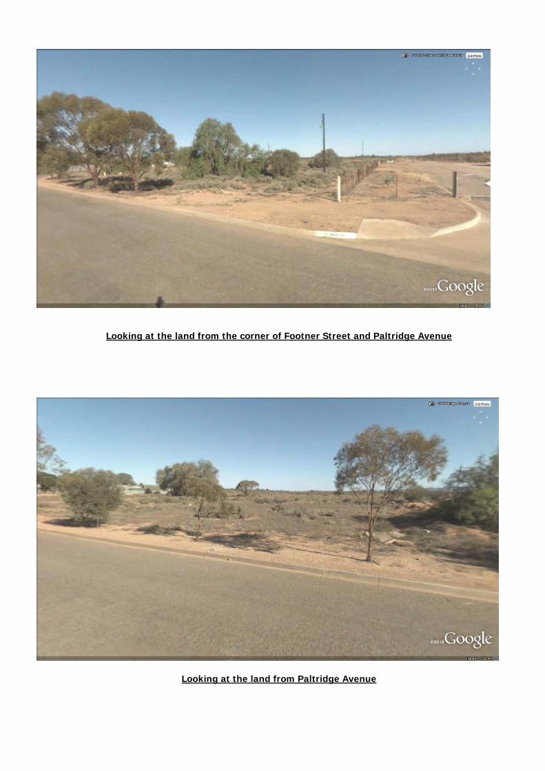
Looking at the land from the corner of Footner Street and Paltridge Avenue
Looking at the land from Paltridge Avenue


Filename: 660/270/2010
FILE REF: PROP – 24 Woodcock Street PORT AUGUSTA 5700 DATE: 6 January 2011 TO: Presiding Member & Members of the Council Development Assessment Panel FROM: Community Planner SUBJECT: Veterinary Clinic – 24 Woodcock Street PORT AUGUSTA 5700 SEC: 543
LT: 22 DP PLN: 10600 CT: 6012/979 Application Number 660/270/2010 Date Received 11/10/2010 Proposal Veterinary Clinic Subject Land 24 Woodcock Street PORT AUGUSTA 5700
SEC: 543 LT: 22 DP PLN: 10600 CT: 6012/979 Applicant R D Absalom Owner H L Oldfield & S Oldfield & H B Butts & E M Butts Zone Industry Procedure Non-Complying Agency Referrals Not Required Public Notification Category 3 (General Public) – 1 representation received Key Issues Non-complying development Delegation Issues N/A Recommendation Grant Development Plan Consent subject to conditions The proposal The applicant proposes to construct a new transportable building and establish a veterinary clinic. The new building is 4.03 in overall height and has a floor area of approximately 56 square metres which consists of a consulting room, treatment room, customer waiting area, storage and general amenity. The proposal also includes five (5) carparking spaces and an access ramp. The proposed veterinary practice would be used in conjunction with the existing dog and cat boarding kennels. The proposed development comes under the definition of “consulting room” within Schedule 1 of the Development Regulations 2008. Consulting room is a non-complying development for the Industry Zone. Subject Land & Locality The subject land is identified as 24-26 Woodcock Street within the Industry Zone of the City of Port Augusta Development Plan. The land consists of lot 21 & 22 which is currently contain dog and cat boarding kennels, dog and cat exercising yards, an existing residence, a number of other structures such as sheds and carport. All of these areas are separated by internal fences. There is a diverse range of existing land uses in the locality which includes a hardware retail outlet, a building supplies company, road transport business, refrigeration service, SES training facility, food wholesaler, ect. Agency referral Not required.

Public Notification The proposal was processed as a Category 3 application where an advert was placed in the Transcontinental newspaper and notification sent to adjacent owners. Council received one (1) representation which objected to the proposal. The representor wished to be heard in support of his representation. The representation raised a number of matters relating to the Standards of the Veterinary Surgeons Boards of South Australia (VSBSA) and the arrangements for the disposal of carcass and medical waste. These matters are not believed to be related to the Development Plan. The applicant’s response to the representation, through SK Planning, is attached to this report.
Development plan assessment All relevant information including plans and documents submitted by the applicant were considered during the assessment of the application. Information that was not considered to be relevant in the assessment of the application would not normally be mentioned; however since some of this information may impact on the transparency of the assessment process they are outlined below for clarification purposes. A letter by Council’s Human Resources Manager – Anthony McCoy dated 29 November 2010 indicated that Port Augusta City Council will utilise the services by Dr. Roger Absalom (the applicant) and in return Council will provide the removal and disposal of medical waste including animal carcasses. This information was also mentioned in the applicant’s response to the representation. The information and letter mentioned above were provided to Dr. Absalom in response to a request as to whether the services of the proposed Veterinary Clinic would be used by Council. Mr McCoy's letter has not been endorsed by the Council, nor any Council staff responsible for making such decisions and, accordingly, does not represent the Council's position. Mr McCoy was not in any position to make such representations to the applicant. Mr McCoy’s response must not be read to imply that any preference should be given to this proposal as part of the planning assessment.
Brooks Street/Woodcock Street Corner
Subject Land

Further, this letter is irrelevant to the planning assessment process and does not have anything to do with the planning merit of this application and therefore must be wholly disregarded by the Panel. The following are relevant provisions of the City of Port Augusta Development Plan in considering the proposal: Relevant Provisions of the Development Plan Comments Council Wide
General Objective 1: Orderly and economic development. Objective 5: The promotion and development of Port Augusta as an attractive regional service centre. Objective 17: The amenity of localities not impaired by the appearance of land, buildings and objects. Industrial Development Objective 66: Industrially zoned allotments and uses protected from encroachment by adjoining uses that would reduce industrial development or expansion. Interface between Land Uses Objective 75: Development located and designed to prevent adverse impact and conflict between land uses.
The co-location of the existing kennel and the veterinary service is considered to be orderly and economic. If the proposal is approved, it will be only the second veterinary service in Port Augusta which represents a contribution in enhancing the range of service available in the area. The appearance of the proposed development is not believed to impair the amenity of the locality. The proposed development is not believed to have any impact on existing industrial land use or reduce future Industrial development expansion. The development has no interface issues with more sensitive land uses as it is located within the heart of the Industry Zone. Further, the dog and cat kennel, a non-complying land use, has existed over many years without any adverse impact on the locality.
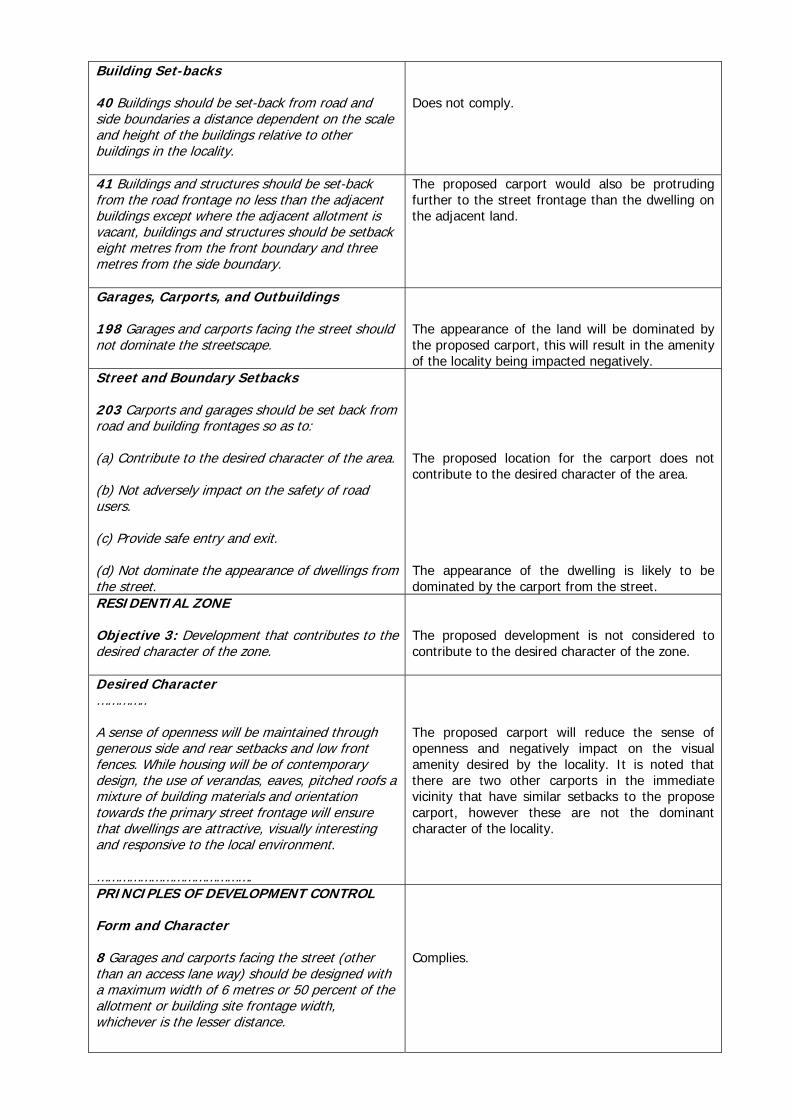
PRINCIPLES OF DEVELOPMENT CONTROL 36 Development should display a high standard of design, appearance, amenity and site layout. 38 The apparent bulk, height or scale of any large buildings which may be required for specific functional reasons should be minimised by the careful articulation and composition of building forms and facades. Building Set-backs 40 Buildings should be set-back from road and side boundaries a distance dependent on the scale and height of the buildings relative to other buildings in the locality. 41 Buildings and structures should be set-back
The layout of the proposed development is of acceptable design and standard. The proposed building has a floor area of 56 square metres and an overall height of 4.03 metres; thus unlikely to impact on the locality. The new building will be located 7.9 metres from Woodcock Street and 9.5 metres from the nearest side boundary; thus is considered to comply with these provisions.

from the road frontage no less than the adjacent buildings except where the adjacent allotment is vacant, buildings and structures should be setback eight metres from the front boundary and three metres from the side boundary. 264 Development should be sited and designed to minimise negative impact on existing and potential future land uses considered appropriate in the locality. Car Parking 276 Car parking spaces should be established on the site at the rate indicated in Table PtAu/4; but a lesser number of parking spaces may be established on the site if the balance is made up and provided on a site nearby which will be available for car parking purposes for the duration of the development and which can be used for those purposes without detriment to the amenity of the locality or the safety of the public. 277 Car parking spaces, vehicular loading spaces and associated access aisles and manoeuvring areas, should be sealed with an impervious material or paved to a suitable standard to minimise any dust and mud nuisance, be drained to the watertable of an adjacent public road, and have individual spaces linemarked and maintained thereafter. 278 Car parking areas should: (a) incorporate existing trees in the layout; and (b) be landscaped with the landscaping located and maintained in such a manner that the areas are screened to prevent a view of them from any road or abutting properties, and so that the car parking spaces have some shade. 279 Car parking spaces associated with a business should be located adjacent to a public road so that those car parking spaces are readily apparent and accessible to customers. For ease of identification by customers, a sign indicating the location and availability of such car parking spaces should be displayed at the access points to the land. 280 Development should have vehicular access which is not liable to be affected adversely by floodwaters or heavy rains. 281 The layout of access aisles and manoeuvring areas on an allotment should allow for vehicles to enter the parking area, and any public road, in a forward direction. 282 Vehicular access points to and from each allotment and the layout of car parking spaces should provide for safe vehicular movement which
The proposed development complies with this provision. The proposal includes 5 carparking spaces which complies with the carparking ratio indicated in Table PtAu/4. The carparking area will utilise gravel paving, whilst not impervious, is still considered to be appropriate. The proposed development complies with these provisions.

will not detrimentally affect traffic safety and vehicular movement on adjoining streets, or the safety of pedestrians. 283 The number of vehicle crossings should be kept to a minimum and all development should have a solid immovable barrier along road boundaries to restrict access onto and off an allotment other than by way of approved crossovers. INDUSTRY ZONE Objective 1: A zone primarily accommodating a wide range of industrial, warehouse, storage and transport land uses. Objective 2: Development that contributes to the desired character of the zone. DESIRED CHARACTER The Industry Zone will be an intensively developed, high quality, landscaped industrial area. The zone will accommodate a wide range of industrial, commercial and business activities including manufacturing, warehousing, transport and distribution. The zone will be protected from the intrusion of residential and other inappropriate uses which will reduce the land resource for industrial uses or create potential for land use conflicts. High impact industrial uses will be located well away from residential areas. Development within the Industry Zone will achieve generous set-backs from roads and residential development in adjoining zones in order to minimise visual amenity and environmental impacts. The appearance of the zone will be improved by additional tree planting and landscaping which ‘break-up’ views to buildings and structures from adjoining roads. Where industrial development is proposed adjacent to a more sensitive use, vegetated buffers will be provided within individual development sites. Industrial buildings will be designed to meet the needs of the intended use, however the mass and scale of the buildings will be located and designed to minimise the visual impact as viewed from public roads and surrounding properties. Building mass will be well articulated, using smaller building modules, variation in the facades and varying roof form and pitch. Buildings materials
The proposed development does not comply with this objective hence the non-complying classification of “consulting room”; however the existing kennel is also a non-complying development. Co-locating the kennel and a veterinary service together can be considered as commonsense. Further, the proposed veterinary service is unlikely to have any adverse impact on existing industrial land use or inhibit future industrial expansion in the locality. Notwithstanding that the proposed development is non-complying for the Industry Zone; it will actually contribute to the desired character of the zone.

and colours will reduce the apparent bulk of the buildings and will reflect the nature of the surrounding area, particularly for sites that are more publicly visible.
PRINCIPLES OF DEVELOPMENT CONTROL Land Use 1 The following forms of development are envisaged in the zone: Industry Transport distribution Warehouse. 2 Development listed as non-complying is generally inappropriate and not acceptable unless it can be demonstrated that it does not undermine the objectives and principles of the Development Plan. Form and Character 3 Development should not be undertaken unless it is consistent with the desired character for the zone. 4 Development should be set back at least 8 metres from any road frontage, except where fronting a Primary or Secondary Arterial Road in which case development should be set back at least 20 metres. 5 In areas where a uniform street setback pattern has not been established, buildings should be set back in accordance with the following criteria (subject to adequate provision of car parking spaces and landscaping between buildings and the road): (a) buildings up to a height of 6 metres should be sited at least 8 metres from the primary street alignment (b) buildings exceeding a height of 6 metres should be sited at least 10 metres from the primary street alignment (c) where an allotment has two street frontages, no building should be erected within 3 metres of the secondary street alignment. 9 Advertisements and advertising hoardings should not include any of the following: (a) flashing or animated signs (b) bunting, streamers, flags, or wind vanes (c) roof-mounted advertisements projected above the roofline (d) parapet-mounted advertisements projecting
As previously discussed the proposal is a non-complying development, however it is logical to co-locate a kennel and a veterinary service while still contribute to the desire character of the zone. The new building will be setback 7.9 metres from the front boundary, but with an overall height of 4.03 metres, the setback is considered to be appropriate. The proposed sign complies with this provision.

above the top of the parapet.
Conclusion Despite being a non-complying type of development for the Industry Zone, the proposed veterinary clinic constitutes a logical expansion of existing service that will have a net positive impact on the locality. Recommendation It is recommended the Council Development Assessment Panel: 1. Receives the report (660/270/2010) dated 6 January 2011, submitted by the Community
Planner, concerning “Veterinary Clinic – 24 Woodcock Street PORT AUGUSTA 5700 SEC: 543 LT: 22 DP PLN: 10600 CT: 6012/979”.
2. Resolves that the proposed development is NOT SERIOUSLY at variance with the Development
Plan. 3. Grants Development Plan Consent subject to the following conditions and the Development
Assessment Commission’s concurrence:
3.1 The proposed development shall be undertaken in accordance with the plans and information submitted unless otherwise specified as a condition of consent.
3.2 All medical waste including animal carcasses shall be disposed of to a suitable waste
disposal facility TUNG PHAM

Front view of the subject land

Filename: 660/319/2010
FILE REF: PROP – 2 Edwards Street PORT AUGUSTA 5700 DATE: 7 January 2011 TO: Presiding Member & Members of the Council Development Assessment Panel FROM: Community Planner SUBJECT: Carport – 2 Edwards Street PORT AUGUSTA 5700 SEC: 160 LT: 53 DP
PLN: 9537 CT: 5128/744 Application Number 660/319/2010 Date Received 01/12/2010 Proposal Carport Subject Land 2 Edwards Street PORT AUGUSTA 5700
SEC: 160 LT: 53 DP PLN: 9537 CT: 5128/744 Applicant A V O'Reilly Owner A V O'Reilly Zone Residential Procedure Consent (neither non-complying or complying) Agency Referrals Not Required Public Notification Category 1 – Not Required Key Issues Location and visual impact of carport Delegation Issues N/A Recommendation Refuse Development Plan Consent The proposal The applicant proposed to erect a gable roof carport on the subject land. The carport has the following dimensions: 6.5mL×6mW×3mH. The northern side of the carport will also be infilled. Roof cladding and wall infill materials will be prefabricated with colourbond colours. The carport is to be located, over the second driveway, at the front of the land approximately 2 metres from the front boundary. Subject Land & Locality The subject land is identified as 2 Edwards Street within the Residential Zone of the City of Port Augusta Development Plan. The land consists of an existing residence with an attached verandah, a shed with a lean-to at the back of the allotment and a small garden shed adjacent to the northern wall of the residence. The locality is characterised by established and well maintained residential developments on medium sized allotments. Agency referral Not required. Public Notification Category 1 – Not required.

Development plan assessment The following are relevant provisions of the Port Augusta Development Plan in considering the proposal: Relevant Provisions of the Development Plan Comments Council Wide
Objective 1: Orderly and economic development.
Appearance of Land and Buildings Objective 17: The amenity of localities not impaired by the appearance of land, buildings and objects.
The amenity of the locality is likely to be impaired by the appearance of the proposed carport.
PRINCIPLES OF DEVELOPMENT CONTROL General 36 Development should display a high standard of design, appearance, amenity and site layout.
The proposal is considered to be of acceptable design for a carport; however its proposed location will have adverse impacts on the subject land and locality.
37 Development should enhance the amenity of the townscape, public streets and spaces in its locality, and reflect the townscape character sought in the respective areas.
Two existing buildings in this locality have similar setback from the front boundary, the proposal does not reflect this character due to its location.
Subject Land Pistol Club
Ryan Mitchell Swim Centre
Building Set-backs 40 Buildings should be set-back from road and side boundaries a distance dependent on the scale and height of the buildings relative to other buildings in the locality.
Does not comply.
41 Buildings and structures should be set-back from the road frontage no less than the adjacent buildings except where the adjacent allotment is vacant, buildings and structures should be setback eight metres from the front boundary and three metres from the side boundary.
The proposed carport would also be protruding further to the street frontage than the dwelling on the adjacent land.
Garages, Carports, and Outbuildings 198 Garages and carports facing the street should not dominate the streetscape.
The appearance of the land will be dominated by the proposed carport, this will result in the amenity of the locality being impacted negatively.
Street and Boundary Setbacks 203 Carports and garages should be set back from road and building frontages so as to: (a) Contribute to the desired character of the area. (b) Not adversely impact on the safety of road users. (c) Provide safe entry and exit. (d) Not dominate the appearance of dwellings from the street.
The proposed location for the carport does not contribute to the desired character of the area. The appearance of the dwelling is likely to be dominated by the carport from the street.
RESIDENTIAL ZONE Objective 3: Development that contributes to the desired character of the zone.
The proposed development is not considered to contribute to the desired character of the zone.
Desired Character ………….. A sense of openness will be maintained through generous side and rear setbacks and low front fences. While housing will be of contemporary design, the use of verandas, eaves, pitched roofs a mixture of building materials and orientation towards the primary street frontage will ensure that dwellings are attractive, visually interesting and responsive to the local environment. …………………………………….
The proposed carport will reduce the sense of openness and negatively impact on the visual amenity desired by the locality. It is noted that there are two other carports in the immediate vicinity that have similar setbacks to the propose carport, however these are not the dominant character of the locality.
PRINCIPLES OF DEVELOPMENT CONTROL Form and Character 8 Garages and carports facing the street (other than an access lane way) should be designed with a maximum width of 6 metres or 50 percent of the allotment or building site frontage width, whichever is the lesser distance.
Complies.

10 Sheds, garages and similar outbuildings should be designed within the following parameters: Parameter Value
• Maximum floor area 100 square metres • Maximum building height (from natural
ground level) 4 metres • Maximum wall height (from natural ground
level) 3 metres • Minimum setback from side and rear
boundaries Either 600 millimetres or on the boundary
• Minimum setback from a public road or public open space area 2 metres
The proposal complies with this provision.
Conclusion The proposed development with the setbacks of 2 metres from the Edwards Street frontage will dominate the appearance of the land from the street and will not contribute to the desired character of the Residential Zone in this locality. Recommendation It is recommended the Council Development Assessment Panel: 1. Receives the report (660/319/2010) dated 7 January 2011, submitted by the Community
Planner, concerning “Carport – 2 Edwards Street PORT AUGUSTA 5700 SEC: 160 LT: 53 DP PLN: 9537 CT: 5128/744”.
2. Resolves that the proposed development is NOT SERIOUSLY at variance with the Development
Plan. 3. Refuse Development Plan Consent for the following reason:
3.1 The proposed development does not conform to the setback requirements of the Council Wide Principles of Development Control 198 & 203 and Residential Zone Principles of Development Control 10.
TUNG PHAM
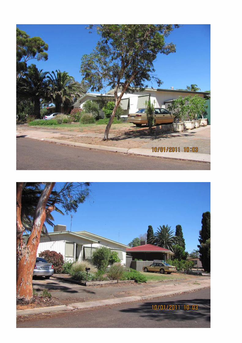

Various photos indicated the location of the proposed carport – approximately where the gold
coloured vehicle is parking.

� ���
�
�
���������
�
���� ������
�
��������� � ��� ������ ��� ������ ��
�
����������������
�
�
����������
�
����������������������������
� �
���������� � � �������� � ��� ��������������������� ����� ��� �!�
� � ��� ��������������""�#�$%#�������&������ � �������
�' �������&�(�� ������������������� �)�
� �
���� ���� �� �!!� ������� �� ���� "#$�
�
%���������� �%&'������ �
� �
()� �*�����*�+��,�-���.����+������/���0��)�
� �
�
�*��+(��
�
�
�) -�� 1��1���� �0� �-��� ��1���� ��� ��� 0���-��� �21����� ��� ���/���� �0� �-��
��3���1����� ����������� ������ �-�� 1��*���� �0� ��0�����+� �� .�3���1�����
�11��*�������������2��������+��*��0���*��������������.�*�����������**��.��*��
,��-��-����3���1������*���44(���.��-����3���1�������+��������"��!)��
�
") �� 1��3�.�� ��� �21��������� ��� �-�� �������� ,-�� .�3���1����� �11��*������
55� �(# "����,��� ��0����.� ��� �-����3����������������*��������-������ 6���7�
��.�,-���-������-�����8�����.���0�����������������������������*�������������
���1�����0��-��������������)�
�
() �..������+� ,-��� ����� *������������� *���.� /�� ��� ������ ,-��� ��������+�
.�3���1������11��*������)�
�
�
���+,,�-��./+-�
�
��������� � ��� ������ ��� ������ 0�
�
�)� ��*��3�����.��������-����1����6���� "#$7�.���.�5�-�9�������"���:���/�����.�
/�� �-�� ���������� ���������� �������� *��*�����+� ;��0������ �0� ��3���1�����
�11��*������� ��� �2������� �+��*���:� ��3���1����� �11��*������ 55� �(# "����
��.�������0����������-��������.�%������������������������<)�
�
�
�
1��23�+*-��
�
�) �������*��=����3���1����������������������������+�-��.�����$���*��/���
"����6������+�>����7�6���� ��!#57:����,���.��*����.���.���+�������
.��*������:��-���������,-���11��*������55� �(# "����-�.�����/������0����.�
/�*?�����-��1�����0���.���/���������������������+:�����-���11��*������,���
.�0����.�0�����-��1��3�����������+�-��.�����-��@� �3��/���"����6������+�>�

� �"�
447�6���� !$"47)����,��������3�.����.�0����-���11��*����������-����2��������+�
�����.���������?�*����0�*����������-����+�������0�/���.��+�����.���������.,�����+����
��A����,��-���.�*�/������.��+��0�+��������-���#@./6�7)�
�
����+����1������0���� ������B����-�������,�����-���/�������+-����.�
��*��3�.)�-����������,-���-����11��*������-�.�����/������0����.�/�*?�����-��
1���������-���$���*��/���"����������+:�,����-����-���11��*������,�����/C�*��
��������.��������0����������-����������**��.��*��,��-�%*-�.����"����.�
%*-�.����!��0��-����3���1�������+���������"��!)�
�
� -������-�����8�����.��-����..����������0���������/����11���.�/���-��
�11��*���������.��������������-���11��*�����)�
�
� -��1�����.���/�����.��-�������1����/��1��1���.���������+��-����0������1��*���:�
,-�������11��*�����������8����.����/����0����.�����-��������.������
*�������������������)�
�
�
�/(�*((/+-�
�
�) .' ����� ���������&������� � �������������&��� �4��'�( ������$%����
�' �� � ��� ���������&�(�' &� �������' �� � ��� ���� ��������
����)�
�
� B-��������11��*������0�����1��1���.�.�3���1����������/�����.��������*���0���
����������:��-������*��������8����.������*�������,-��-�����������-��
�11��*�����������8����.����/����0����.������1���*��/�.�/�.������������.����
%*-�.����!��0��-����3���1�������+��������"��!)�
�
�0��-���11��*�����������8����.����/����0��������1���*��/�.�/�.������*��������
���.��-�����*�1���0��-���11��*��������+��-���,��-���*�1���0���������3����
��0���������1��3�.�.�/���-���11��*���)�
�
-������*��������������?������.�*�������������11��*���������������-�����*��3�.�
�����1�����0�����-���1���*��/�.�/�.������������������-��������������������0���
,-�*-��-����0������,�����.�)�
�
-��1���*��/�.�/�.��������8����������..��������.�*������������0������������
�-��1���*��/�.�/�.�������������/�����8����������������-���11��*�����)�
�
-����1�����.�0������0�.�3���1�������8����.����/����0����.������1���*��/�.�
/�.�������������.����%*-�.����!��0��-����3���1�������+��������"��!)�
�
%*-�.����!���������������/���0�����:��-����1���0�.�3���1�������.�������-���
1����*����������*����.�,��-��-��.�3���1����:��-��1���*��/�.�/�.���-��
�11��*�����������8����.����/����0����.������.��-�������0������-��1���*��/�.�
/�.��-���������1��.�����-����0�����)�6���������0������%*-�.����!��0��-��
��3���1�������+���������"��!�����*-�.�0���0���-���.������7)�
�
-�������*��������1����0�.�3���1������,-�*-�����*���,���.�����������?����
��0������������D��
�
������3���1�����������-��*����E������������*�����'���.��
�
"�E����.���3�������.C�*���������������.�E���������������0�F�+-,����
�

� �(�
(�E���3���1������.C�*���������������.��E���������������0�F�+-,����
�
$�E��.3�������+�.��1������������/�����+�������������.��E���������������0����
F�+-,����
�
�) ���������������' �� ������4'��& � ��� ��������������
""�#�$%#�����4���� � �� &�����' ��������� �������� ������
���'������5���6)�
�
� ���������������0��11��*������55� �(# "����/��'�G��?-���E�%�*�"(���������
���.:��������+�����B���:�%*-�.����!�,���*-�*?�.��0��-����,�������8���������
�����0����-���11��*�����������1���*��/�.�/�.�)�
�
� �������������,����-��+-���-����-���11��*��������+-��/����8����.����/����0����.�
��.���%*-�.����!:������":�647�E����1�����61��������0������%*-�.����!�����*-�.7�
�-�����*������0��-����+�����������������-���.�3���1����������8����.����/��
��0����.��0��-�����������1�,��-����-������3������3���1�����������������.�
���1����'���.��+�F��+-��)��0��-��.�3���1��������,��-����-��������-�,������-��
��1���.�,���.��2*��.���-��+-��1���*��/�.�/���-����1:��-����-���11��*���������
��8����.����/����0����.�����-��������,����-�%�*�������0����-����1���������0�
����1������.���+������%��3�*��)�
�
-���������+��������������*�����3���1����������.��������-�3����*-�����1�
,-�*-�*�����������������������/���.��+�-��+-��)�-���11��*������,����-���0����
.����.��������/����8����.����/����0����.�����-���2��������+��*�)��
�
� %*-�.����"���0��-����3���1�������+��������"��!�.�0������-����-��
� *������*������0���.,�����+�,��-�����(?����.�����0��������+��������1����������
� �*��3�����0���3�����������%�+��0�*��*����.������/����0����.�����-��������.���
� %*-�.����!������"�6��7�E��*��3�����0���3�������������+��0�*��*�)��
��
����-�����0������,���1�*?��1��0�����-��1�����-�.���.��������������.���/�����������
�-��������+�-��.����@� �3��/���"����6������+�>�447�6���� !$"47����.�0���
�-���11��*����������-����2��������+:�����*���,����/��+���.�/���-��
��3���1������*���44(���.��-����3���1�������+���������"��!������0����-���
�11��*����������-�����)�
�
-����������-��������������0��-���11��*������.����.��-���11��*���������
*�����������00�*�������0������������*������������������������.�-���
*����8���������?�.�0����-���..����������0������������/��1��3�.�.�/���-��
�11��*���)�
�
������/����3�.��-����-��������8�������-���..����������0���������/�*�����
����.�������.�3���1��������1���������.���������.�������������3�����.����)��
�
���.�,��-�����1���������.������A�������.���+��.�0����+��*����������.�
F����*���������*��3�����:��-������1����0��*��3������������*����.�,��-�*-���*���
�������*-��������������:�����*��*�.��:���+�*�.�����.�F��/�*�.�������-��1���.�
*������.�1��,-�*-���������*����.�,��-�������0�������*:���+���*-������:�
��+���1-��1-����:�*��/������:�����-���*�1����-��.�)�
�
$) ��� ��� ��� ��� � � ��� ��� ����������� 4' �� (�� � ��������������
���&�7 �������� �
�
� ���������/�����3����0�*���������8����.�,-����-������3�������-������61��������
����-����3���1������*���44(7������������+���.�3���1������11��*�����:�,-���

� �$�
�-������3�������-������-������������������1�*���-����-����/C�*�����.�������-���
�-��1������������/��*����������.)�
�
� %����*����������������������������������,-����-������������.�����1��1��������
���.��-��������*��1���/���A���.���. ���������.��-���,������.�0�������*��3����
�����.�������-���-�3���-��1���������������������������*���������������.��1�*�0�*�
��.�������:�������*�����*��3��������.����.������,-�*-�-�3��.����������.���
+���������?���-��.��0�+�3��+���������*������������)�
�
� B-�����.�������������-���/������.���-����-�������1����������-����-��
1��1���.����������/��*����������.:������������������-�������11��*����/��
��8�����.����.���������������-������-�������-����-���������������/���0����-��
1��1���.����)�-��������������.����/��1��3�.��+��������*���������������.���
��1����/���������/���8����0��.���.�1��.������3�������������.��������%����
����������������������������.����.)��
�
� -�� �11��*������ ��� ���� ��8����.� ��� /�� ��0����.� ��� �-�� ���� ��� �� ���.������
��0������/�� �-�� ����3�������-�����)�-�� ����3�������-������,����/�� ��8����.� ���
��������-���11��*��������.�1��.��������.���8������-�����*-������*�������������
��.�����1����/����.����?�������-������3�������-�������-��?����*������)�
�
�
�
8�-.�9�1*�-(�
�((/(.�-.��+,,*-/.8��9�--���
�"#��#�����
�
������'� �����
� (�' &� ���:�� � �������&�������� �� ��������' �� � ��� ���� ��������������� (�' &� ����:��������� ����� ������� ������ �������� �������' �� � ��� ���
� ��������������
� ������ �(���;��&�������-���� �<���5(�� ��������������6�