council agenda report - santa mariaarchive.cityofsantamaria.org/councilagendas/2009/may_05/5.pdf ·...
TRANSCRIPT

•
•
For Council Meeting of May 5, 2009
COUNCIL AGENDA REPORT
May 5, 2009
TO: City Council
FROM: City Planning Commission Prepared by: Peggy Woods, Acting Community Development Director
SUBJECT: ZONE CHANGE FOR THE NKT COMMERCIAL PROJECT, 1201 EAST MAIN STREET, ASSESSOR'S PARCEL NUMBER 128-120-004, FILE NOS. Z-2009-001, E-2009-009 (0.56 ACRES)
RECOMMENDATION:
That the City Council take the following action:
1. Introduce an ordinance rezoning a 0.56 acre site FROM FS (Freeway Service) TO PD/HC (Planned Development/Highway Commercial).
SUMMARY:
This project is the first application for the new "HC" zone, which was adopted by the City Council on December 2, 2008. The Planning Commission recommends approval of this proposed zone change as compatible with the surrounding land uses, and consistent with the site's Freeway Services General Plan land use designation. Figure 1 presents the vicinity ofthe project site and Attachment 1 presents the actual area to be rezoned.
BACKGROUND:
On December 2, 2008, the City Council established the (HC) Highway Commercial zoning district (Ordinance 2008-29). The proposed rezoning is the first project to request the newly established HC (Highway Commercial) zoning district.
A one story 4,295 square foot commercial building was built on the subject site in 2007 (Attachment 2). Two of the four tenant spaces are currently occupied by a Starbucks coffee shop and Subway sandwich shop; the other two tenant spaces are currently vacant. Further background information is presented in the Planning Commission staff report (Attachment 3).
DISCUSSION:
Project Description: A rezone of the project site (Attachment 1) from a FS (Freeway Service) zoning district to a PD/HC (Planned Development! Highway Commercial) zoning district. The project site is a 0.56 acre parcel located at 1201 East Main Street.
5

City Council May 5,2009 Page 2
~
~
~ :r ~
<> en ~
~ I en ~
FIGURE 1 - VICINITY MAP
Ll~ I I Stonebridge Dr co
co -'
r '[[JJ m~ '---4< e, 1m L J
I
1
Project Site
MainSt
# 'i I ~
Surrounding Land Uses and Zoning:
l Gamet Way
l< « 'E 0 u co 0
<.)
• ... •
This proposed rezone is consistent with existing surrounding lands uses, and zoning. The project site abuts the Highway 101 North onramp to the west. To the north is a vacated automobile dealership (recently occupied by Honda of Santa Maria), in a PD/C-2 (Planned DevelopmentlGeneral Commercial) zoning district. To the east another car dealership, Home Motors, is located in a PD/C-2 (Planned Developmentl General Commercial) zoning district. A Shell service station is located in a FS (Freeway Service) zoning district across East Main Street to the south adjacent to the new Cancer Center project site.
Compatibility with surrounding land uses:
•
•
The HC (Highway Commercial) zoning district permits more uses than the FS (Freeway Service) zoning district. These uses are supportive and compatible with the surrounding commercial uses and are appropriate along the Freeway corridor. Table 1 below provides a list of the permitted and conditional uses in the HC (Highway Commercial) zoning district. •

•
•
•
City Council May 5, 2009 Page 3
Furthermore, the Department of Public Works, Engineering Division staff has indicated that the amount of traffic impact generated by these additional uses will be limited by the relatively small size of the site and the amount of parking available for each business.
TABLE -1 Uses Allowed in the HC Zoning District
HC (Highway Commercial)
Permitted Uses: Restaurants Cell Phone Sales and Repair Convenience Store Retail Vehicle Fuel Dispensing Station Hotel and Motel Furniture Sales Home Improvement Center
Conditional Uses: Beer and wine with meals Drive-in! Drive thru restaurant Car wash Bar or Cocktail Lounge Recreational Vehicle sales!rental Auto Service or repair Auto rental RV Park
Impact on the Community: The proposed rezone will not have a negative impact on the community; since the project site is a fully developed infill site. As such, the property is already being provided with City services (e,g, Police, Fire, water and sewer services), All applicable City requirements were included into the design and construction of the building during the building permit review process. The proposed rezone does not change those requirements.
The proposed rezone is expected to provide near-term support of the City's economic goals by expediting the occupancy of vacant commercial tenant space in proximity to U. S. Highway 101. Furthermore, the list of additional uses allowable under the HC (Highway Commercial) zoning district has been specifically tailored to minimize competition with the Downtown Specific Plan and other commercial zones.
On April 1, 2009, the Planning Commission recommended that the City Council approve this proposed zone change, Planning Commission Resolution No. 2542 (Attachment 4). The Planning Commission found the proposed project to be necessary for the public necessity, convenience and general welfare in that it would provide additional amenities for the motoring public; and would not significantly disrupt any of the various land uses in the vicinity.
General Plan Consistency:
The proposed PD/HC (Planned Development/Highway Commercial) zoning district is in conformance with the Freeway Service General Plan land use designation which is already applied to the site.
City Council May 5, 2009 Page 4
Fiscal Considerations: Other than the typical costs associated with providing public services to the site, no significant fiscal impacts are anticipated to occur to the City as a result of this project. The rezoning of the project site will only be a transfer from one commercial zone to another commercial zone; therefore, sales tax and revenue is approximately the same depending on the specific uses established.
Alternatives: 1. The project site can be rezoned from FS (Freeway Service) to HC (Highway
Commercial) without a PD (Planned Development) overlay. This alternative is not recommended because without a PD (Planned Development) overlay, the Planning Commission will not be able to review any future changes to this project site (increase in building footprint, reconstruction, etc).
2. If the project site is not rezoned, additional amenities needed by the motoring public along Highway 101 and the surrounding community may remain unmet.
Environmental Procedure: The project is a Class 5 Categorical Exemption based on section 15305 of the State Environmental Guidelines (Minor Alteration to Land Use Limitations). No further environmental review is required.
CONCLUSION:
The proposed zone change is compatible with the surrounding land uses, consistent with the site's Freeway Services General Plan land use designation and would potentially accommodate the applicant's goal to occupy the vacant tenant space. Staff supports Planning Commission's recommendation that the City Council approve the zone change for 1201 East Main Street from FS (Freeway Services) to PD/HC (Planned Development! Highway Commercial).
PEGGY WOODS, ACTING DIRECTOR COMMUNITY DEVELOPMENT DEPARTMENT
ATTACHMENTS:
Attachment 1 - Rezone Map Attachment 2 - Site Plan Attachment 3 - Planning Commission Staff Report Attachment 4 - Planning Commission Resolution No. 2542
•
•
•

•
•
PROJECT SITE: 1201 E, MAIN ST,
i· •
0 ... '"
fAST
....... •
® I."'M.
"
~ ~ ~
.. ...,. ~'
~ ""
>
, @
ATTACHMENT 1
NW
I
® ....... I ~ , • •
@: , @ ~'
: cil CH ST,
efI'
-- "'"'" 0: Q
A • ? > ~ CYPR£SS WAY
@
!j ,o,eo tic.
w "'" t ) l
ATTACHMENT 1

.... :~~:
-m-...,,--.....,....,- - -- - - --'''; ..... - -- - - -- - - -- - - ---f, \~~~~--~--------------~-------------*---
! !
\ !
" \ "
\ " \ "
\ ~ \
BUILDING lotalleasable area: 4295 sf.
I
\ <?
I I <? t.
\ ~ 0 10' ao'
,ITE PLAN ~-
~O1 EAST MAIN • • 40'
!
SUMMARY
TOTAL SITE AREA:
24,301,12 SF.
TOTAL LEASABLE AREA:
4,295 SF.
OUTDOOR SEATING AREA: •
207 SF.
TOTAL COMMON AREA:
20,006 SF,
• INCLUDED IN COMMON AREA,
REF N
$

ATTACHMENT 3
iii.".". PLANNING COMMISSION STAFF REPORT
• .~~. City of Santa Maria ']I,.. March 27, 2009
•
•
TO: Planning Commission
FROM: Community Development Department By: Neda Zayer, Planner I
SUBJECT: ZONE CHANGE REQUEST FOR THE NKT COMMERCIAL, FILE NO. Z-2009-001, E-2009-009, LOCATED AT 1201 EAST MAIN STREET, ASSESSOR'S PARCEL NUMBER 128-076-028 (0.56 ACRES)
RECOMMENDATION:
That the Planning Commission take the following action:
1. By resolution, recommend the City Council adopt an ordinance to rezone the 0.56 acre site FROM FS (Freeway Service) TO PD/HC (Planned Development! Highway Commercial) as shown on Exhibit A to the Planning Commission resolution .
LEGAL NOTICES:
Date Environmental Date Notice Date Notice Posted Date Notice Mailed to Document Published in Santa on Property Property Owners Distributed Maria Times within 300 ft. of
property
N/A March 20, 2009 March 20, 2009 March 19, 2009
BACKGROUND:
On December 2, 2008, the City Council passed and adopted a text amendment to Title 12 of the City of Santa Maria Municipal Code adding the HC (Highway Commercial) Zoning District, and a General Plan Text Amendment to the Freeway Services Land Use Designation (G-200B-003). City Council found the Highway Commercial Zoning District to be compatible with the purpose and intent of the Freeway Services General Plan Designation. Rezoning 1201 East Main Street is the first project to implement the new HC (Highway Commercial) zoning district (Exhibit A, Vicinity Map) .
__ • _. ___________________ ,_ u. _ woo ___ _
NKT COMMERCIAL, Z-2009-001, E-2009-009 MARCH 27, 2009 STAFF REPORT PAGE 1 OF 4 FOR PLANNING COMMISSION MEETING OF APRIL 1, 2009 ATTACHMENT 3
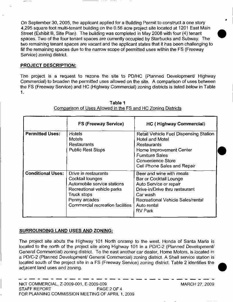
On September 30, 2005, the applicant applied for a Building Permit to construct a one story 4,295 square foot multi-tenant building on the 0.56 acre project site located at 1201 East Main • Street (Exhibit B, Site Plan). The building was completed in May 2008 with four (4) tenant spaces. Two of the four tenant spaces are currently occupied by Starbucks and Subway. The two remaining tenant spaces are vacant and the applicant states that it has been challenging to fill the remaining spaces due to the narrow scope of permitted uses within the FS (Freeway Service) zoning district.
PROJECT DESCRIPTION:
The project is a request to rezone the site to PO/He (Planned Development! Highway Commercial) to broaden the permitted uses allowed on the site. A comparison of uses between the FS (Freeway Service) and HC (Highway Commercial) zoning districts is listed below in Table 1.
Table 1 Comparison of Uses Allowed in the FS and HC Zoning Districts
FS (Freeway Service) HC ( Highway Commercial)
Permitted Uses: Hotels Retail Vehicle Fuel Dispensing Station Motels Hotel and Motel Restaurants Restaurants Public Rest Stops Home Improvement Center
Fumiture Sales Convenience Store Cell Phone Sales and Repair
Conditional Uses: Drive in restaurants Beer and wine with meals Cocktail lounges Bar or Cocktail Lounge Automobile service stations Auto Service or repair Recreational vehicle parks Drive-in/Drive thru restaurant Truck stops Car wash Penny arcades Recreational Vehicle Sales/rental Commercial recreation facilities Auto rental
RV Park
SURROUNDING LAND USES AND ZONING:
The project site abuts the Highway 101 North onramp to the west. Honda of Santa Maria is located to the north of the project site along Highway 101 in a PD/C-2 (planned Development! General Commercial) zoning district. To the east another car dealer, Home Motors, is located in
•
a PD/C-2 (Planned Development! General Commercial) zoning district. A Shell service station is located south of the project site in a FS (Freeway Service) zoning district. Table 2 identifies the • adjacent land uses and zoning.
------------------------------NKT COMMERCIAL, Z-2009-001, E-2009-009 MARCH 27, 2009 STAFF REPORT PAGE 2 OF 4 FOR PLANNING COMMISSION MEETING OF APRIL 1, 2009

•
•
•
Table 2 Surrounding Land Uses and Zoning
Direction Existing Zoning Land Uses
North Honda of Santa Maria PD/C-2
South Shell Service Station FS
East Home Motors PD/C-2
West Highway 101 N/A
STAFF ANALYSIS:
The City Council has already determined the HC (Highway Commercial) zoning district meets the intent and purpose of the Freeway Services Land Use Designation. Since the project site is currently located in the Freeway Services Land Use Designation, the use is compatible.
The proposed zone change is not expected to create a significant impact on the community. The additional penmitted uses provided by the HC (Highway Commercial) zoning district will not generate any additional traffic or parking impact as compared to the FS (Freeway Service) zoning district. The square footage of each tenant space and the amount of onsite parking provided will dictate the intensity of uses allowed on the project site. Regardless of what use is permitted to occupy the space, it must be able to accommodate its parking demands based on the City of Santa Maria Municipal Code Chapter 12.32 Off-Street Parking. Based on these requirements, no additional impact is foreseen.
The rezoning of the project site will allow the opportunity for additional uses to be established along the Highway 101 corridor and provide additional amenities to the traveling public.
GENERAL PLAN CONFORMANCE:
The rezoning of the project site from FS (Freeway Service) to PD/HC (Planned DevelopmentfHighway Commercial) does not require the General Plan to be amended. The intent of the Freeway Services Land Use Designation is maintained.
ENVIRONMENTAL PROCEDURES:
The project is a Class 5 Categorical Exemption based on section 15305 of the State Environmental Guidelines. No further environmental review is required .
- - - - - -- - - - - - - - - - '"'- .. "...- - - - - - - - - - --NKT COMMERCIAL, Z-2009-001, E-2009-009 MARCH 27, 2009 STAFF REPORT PAGE 3 OF 4 FOR PLANNING COMMISSION MEETING OF APRIL 1, 2009

STAFF RECOMMENDATION: •
Because the project site is located in the Freeway Services General Plan land use deSignation. and the City Council determined the Highway Commercial Zoning District to be compatible, staff recommends that the Planning Commission recommend City Council approval of the zone change for 1201 East Main Street from FS (Freeway Services) to PD/HC (Planned Development/Highway Commercial).
EXHIBITS
Exhibit A - Vicinity Map Exhibit 8 - Site Plan
l-r.,·!
- - - - - - - - - - _.- - - - - - - - - - - - -- - - - - --NKT COMMERCIAL, Z-2009-001. E-2009-009 MARCH 27, 2009 STAFF REPORT PAGE 4 OF 4 FOR PLANNING COMMISSION MEETING OF APRIL 1. 2009
•
•

•
•
•
ATTACHMENT 4
RESOLUTION NO. 2542
A RESOLUTION OF THE PLANNING COMMISSION OF THE CITY OF SANTA MARIA, CALIFORNIA RECOMMENDING TO CITY COUNCIL APPROVAL OF A ZONE CHANGE FOR THE NKT COMMERCIAL PROJECT, Z-2009-001, E-2009-009, LOCATED AT 1201 EAST MAIN STREET, ASSESSOR'S PARCEL NUMBER 128-120-004
WHEREAS, Brian Schwartz, applicant/agent for the property owner, Nick Tompkins, applied for a zone change for approximately 0.56 acres of property located at 1201 East Main Street, Assessor's Parcel No. 128-120-004; and
WHEREAS, the Planning Commission of the City of Santa Maria held a regularly scheduled public hearing on April 1, 2009, for the purpose of considering a zone change request for Z-2009-001; and
WHEREAS, the proposed zone change is categorical exemption based on Section 15305 of State Environmental Guidelines; and
WHEREAS, said public hearing was for the purpose of formulating and forwarding recommendations to the City Council of the City of Santa Maria regarding project Z-2009-001; and
WHEREAS, at the April 1, 2009, public hearing the Planning Commission recommended approval of the project based on the findings noted below; and
WHEREAS, notices of said public hearing was made at the time and in the manner required by law; and
WHEREAS, at the completion of said hearing, the Planning Commission duly considered all evidence presented at said hearing;
NOW, THEREFORE, BE IT RESOLVED that the Planning Commission of the City of Santa Maria recommends that the City Council approve an amendment to the zoning map of the City of Santa Maria, based on the following findings:
• The proposed project is necessary for the public necessity, convenience and general welfare in that it would provide additional amenities for the motoring public; and
• The proposed project would not significantly disrupt any of the various land uses in the vicinity.
ATTACHMENT 4
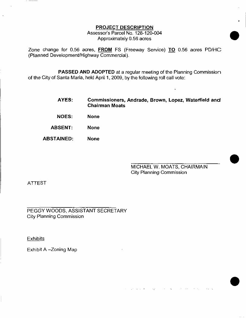
PROJECT DESCRIPTION Assessor's Parcel No. 128-120-004
Approximately 0.56 acres
Zone change for 0.56 acres, FROM FS (Freeway Service) TO 0.56 acres PD/HC (Planned Development/Highway Commercial).
PASSED AND ADOPTED at a regular meeting of the Planning Commission of the City of Santa Maria, held April 1 ,2009, by the following roll call vote:
AYES:
NOES:
ABSENT:
ABSTAINED:
ATTEST
Commissioners, Andrade, Brown, Lopez, Waterfield and Chairman Moats
None
None
None
MICHAEL W. MOATS, CHAIRMAIN City Planning Commission
PEGGY WOODS, ASSISTANT SECRETARY City Planning Commission
Exhibits
Exhibit A -Zoning Map
•
•
•

•
•
•
PROJECT SITE: 1201 1;.. MAIN ST.
...
EXHIBIT A LAND USE AND ZONING MAP
Z-2009-001 E-2009-009
03/27/09
128-120
, <ll J,.. .... t
i'i It '0 ,,! II :! LJ:-~I"f-:~='-=-""':~ of i - - - rf),i : ~·!:i-i'-T£AST~_c.:",,::t-~F-I-r~~"'_":' ... "-.. _::';'· "1-
Q-
~ @ 0 ~ .. ; Q9
:t" f ,~. ',.,.... ,~~ l "N"O;;-;;TC-;-'-C;C-<;E:--'
(Ii f i'" J -_ ... ,... ... -:::i ! } ~1~1,"':'---lI.F~""'--J I =-...::: :-'. ~.::::::-:-
"~ ,.;~ .... :~ __ eo- _~
,~-/: :~- CYPRf:SS ST . . J' ~: A@ : ;~YP-R~-~S--",AY D2/05/1955 RM. 811. 7J , Pg. 60". ! Q ~ J.<nr, '~Cl:I ... f ~ I Q
Trod rlfxoco $ubd. No. 6.3<lf ,:~r ~ I!: '(:;/I ~ 0.: I, Q!7 OJ/11/1965 R,M. Sk. 7J . Pg. /59 II)
Troel 64-12 • I
04/~:9~nd~kB~ ',%. B~_71 \.L ~ I 05/01/197.] R.M. BII. 79 • PrJ. 95 • Trod 5.095 .. d City of Sonto lIorio IO/.Z4/J975 R.M. Bk.. 92. Pg- 10-11 • Traet .5,164 f"\ ~; ; Assessor's Mop 81<,128 -Pg, 120 (),Jlzl! 1980 'UI. 81<. 97 • PrJ· 9O-9J • Troct 5.27.1 - Stonebri6goll I\!I7 Q!J I' 1.. ...... County of Sonto Barbaro. Colif. 05/JC/1988 R.AI. BIt, 153. PrJ· 57-60 • Troc! 5,501 - VI»oS" Prof. Cent,r r,::;;::;.. ... .. __ ...
~!!--EH!!!.~:

•
•
•
ORDINANCE NO. 2009-11
AN ORDINANCE OF THE CITY COUNCIL OF THE CITY OF SANTA MARIA, CALIFORNIA,
REZONING PROPERTY FOR THE NKT COMMERCIAL PROJECT LOCATED AT 1201 EAST MAIN STREET,
ASSESSOR'S PARCEL NUMBERS 128-120-004, 0.56 ACRES (FILE NO. Z-2009-001)
The City Council of the City of Santa Maria finds as follows:
Project Description
WHEREAS, the applicant, Urban Planning Concepts, acting as agent for the property owner, Nick Tompkins, has applied for a zone change for the NKT Commercial project; and
WHEREAS, the applicant requests that the City rezone a 0.56 acre property located at 1201 East Main Street, Assessor's Parcel Number 128-120-004, FROM FS (Freeway Services) zoning district TO PD/HC (Planned Development/Highway Commercial) zoning district; and
Planning Commission Actions
WHEREAS, the Planning Commission held a duly noticed public hearing on April 1, 2009, for the purpose of considering the proposed rezoning; and
WHEREAS, the Planning Commission made its recommendation in writing that the City Council rezone the project site (Resolution No. 2542); and
City Council Actions
WHEREAS, a duly noticed public hearing was held on this rezoning classification by the Santa Maria City Council on May 5, 2009; and
WHEREAS, the Santa Maria City Council made no modification of the proposed zoning classification which had not been previously considered by the Planning Commission; and
WHEREAS, the proposed NKT Commercial Project zone change is categorically exempt based on Section 15305 of the State Environmental Guidelines; and
WHEREAS, the proposed rezoning is consistent with the Freeway Service General Plan land use designation.
5

The City Council of the City of Santa Maria, State of California, does ordain as follows:
SECTION 1. The Zoning Map of the City of Santa Maria, State of California, • adopted by Ordinance 2005-016 on December 20, 2005, is hereby amended by changing the zoning classification of the 0.56 acre property described as Assessor's Parcel Number 128-120-004 FROM FS (Freeway Services) TO PD/HC (Planned DevelopmenUHighway Commercial), as shown on Exhibit A, attached hereto.
SECTION 2. The Director of Community Development is hereby authorized and directed to make corresponding changes on the official zoning map of the City of Santa Maria in conformity with this ordinance.
SECTION 3. This Ordinance shall be in full force and effect thirty (30) days after its passage. Within fifteen days following its passage, the City Clerk shall cause this Ordinance to be published in a newspaper of general circulation in accordance with State Law; or when deemed necessary due to the length or complexity or the Ordinance, cause a summary of the Ordinance to be prepared and published at least five days prior to the City Council meeting at which the proposed Ordinance is to be adopted. If a summary is published at least five days prior to the City Council meeting at which the proposed Ordinance is to be adopted, then within 15 days after adoption of the Ordinance the City Clerk shall publish a summary of the Ordinance with the names of those City Council Members voting for and against the Ordinance and shall post a certified copy of • the full text of such adopted Ordinance along with the names of those City Council Members voting for and against the Ordinance.
INTRODUCED at a regular meeting of the City Council held the 5th day of May 2009, and PASSED AND ADOPTED at a regular meeting held this 191h day of May 2009, by the following roll call vote:
AYES:
NOES:
ABSENT
ABSTAINED:
ATTEST:
Chief Deputy City Clerk
Exhibit A - Land Use and Zoning Map
Mayor
APPROVED AS TO FORM
BY1tt1~~ CWo!
CONTENTS
BY: i($'",a,;; &·t (. T:>uY' , ·1" DEPARTMENT HEAD
BY~' ANAGER
•

•
•
•
EXHIBIT A LAND USE AND ZONING MAP
Z-2009-001 E-2009-009 05/05/2009
(.ill Q!7
PROJECT SITE: 1201 E. MAIN ST
SEC. 12&lJ",TlON R34W SBB&MQ \EJ ! QV
-... :: - • _ . p" .",,~~ ... ~'--'i
... tin
Itl,! :' .. :" ... """'!!n-:,,=,"-'-'~~ '=-'---'--'=--J ___ . __
128-120
,~" ~- .--.- r~l~ ~~ : fAST •. '" .. < "".~~.. ... : :~;.; •• ;.,. A;;4
l_·, ---
~ : iT 7."'" 0 i'@'O, €9 .@: ; @. 6:/: .. @ : Il J .;! .~ .. ..: '. - . '''", NOT 1 C E
: ..! :I'l'~i ." 0 ... til ilCAH ,~~ .~,~ ~~~."" z~~:.~ "1~' 11 i i , • ";;;li~ • :.~~ .. ~,.. Q)~~
"',;:~~.: Ii ~.,~"'-_£~R.§§?-ISI . • (:) '> ~ cYPRESS-WAY r"~ - e '©'~ @ ~ ~r-------
02/05/1965 R.U. 81<. 7J , Pg. 60 ,. .. Q ~ J ,~ 'c.x,,< f ~ 0 Troc! Tt"oco $ubd. No. 6J-JI ,:i'; "Q§l e: © ~- ~ Q I Q!7
OJ/17/1965 R.i.l, St. 73. Pg. 69 j VI
O.f/08}~~~~ 6~.~.'2ek. 7J . Pg_ 81 i "8 ~ Troct H<lndco<:~ Suhd. I No. 64-71 ,L , .. ,1
05/01/ HI7J R.M. e •. 79 . Pg.95 Trocl 5,095 .. '~ City of Sonia Moric; 10/1"/1975 R.I,I, Bk 92 , Pg. 10-11 , Tract .5, Hi4 Q Q J! j Assessor's Mop BI!, 128 -Pg, 120 OJ/21/ 1980 R.M. Bk. 97 , Pg. 90-93 , Tract 5.27J - $tcr>ebriag! ~ '!Y l...~ County of Sonto 90rboro, Colif. 06/JO/lg88 R.M. Sk. 15J. Pg. 57-60 , Troct S,501 - Vi/lag! Prof. Cenle'
G0r~5f..:'!!::::
EXHIBIT A
'-----------------------------------------_._. __ ._--_ .... , .. __ ._ .. _"'-----