corridors, trade, and new development in economic...
TRANSCRIPT

Corridors, trade, and new development inEconomic Geography
Mathilde Lebrand
The World Bank
March 25, 2019

Motivation
Recent developments in Economic Geography: when trade and spatialeconomists meet again.
I New theoretical models with many asymmetric regions to study thespatial distribution of people and economic activity
I New tractable general-equilibrium modelsI Eaton and Kortum (2002)I Counterfactuals / welfare effects
I New geospatial data to model trade and migration costs acrossregions using GIS techniques
Focus on the impact of trade, transport investments and internationalcorridors on the spatial distribution of people and economic activity

Applications of these new techniques at the WB
Understand the spatial and welfare effects of:
1. the Belt and Road Initiative (BRI), a pipeline of new transportinfrastructure and trade policy reforms, led by China.
I quantitative economic geography model with regional comparativeadvantage and specialization based on Fajgelbaum & Redding (2018)
2. potential transport and logistics policies in Bangladesh and VietnamI Same + Market Access litterature (Hornbeck & Donaldson, 2016)
3. border opening and land transport investment between Egypt andJordan
I Quantitative spatial model from Redding (2016)
4. more in progress: EU integration on the Western Balkans, regionalintegration on secondary cities in Mauritania, major corridors inWestern Africa, etc.

Spatial effects of the BRI
”Who wins, who loses? Understanding the Spatially DifferentiatedEffects of the Belt and Road Initiative”, Lall & Lebrand
I What are the spatially differentiated effects of the BRI within Chinaand Central Asian countries?
I What is the role of labor mobility?
I Are there complementary policies to mediate the economy’sresponse to external integration?
Method: quantitative economic geography model based on Fajgelbaum &Redding (2018) enhanced with labor mobility frictions.
I Key elements of the model:
- Production: tradables and non-tradables / two production factors(land and mobile workers)
- Asymmetric locations (districts) in terms of productivity, amenityscores, transport costs to reach main international gateways
- Domestic labor mobility frictions (preference shocks, iceberg costs)

What is the BRI?
The BRI: 6 main corridors with the potential of influencing 65 countries,4.4 billion people, and leveraging 40 percent of global GDP.
SOURCE: Adapted from China-Britain Business Council, by A. Trubetskoy

Spatial effects of the BRI
Four main results:
1. The relative winners in terms of population and real wages aredistricts that have a comparative advantage in exporting, wouldhighly benefit from reductions in transport costs, and are attractiveplaces for workers.
2. Gains are concentrated in locations close to border entry points andin urban hubs.
3. Complementary investments in domestic transport networks andtrade facilitation can help in spatially spreading the benefits.
4. Barriers to domestic labor mobility exacerbate spatial inequality inwages whilst dampening overall welfare.
Spatial effects of the BRI at the country level
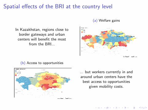
In Kazakhstan, regions close toborder gateways and urban
centers will benefit the mostfrom the BRI...
(a) Welfare gains
(b) Access to opportunities
... but workers currently in andaround urban centers have the
best access to opportunitiesgiven mobility costs.

Spatial effects of the BRI: from the ”small countryassumption” to regional trade with neighboring countries
The Belt and Road Initiative: Reshaping Economic Geography in CentralAsia?, Bird, Lebrand, Venables (forthcoming)
Objective: assess the effects of the BRI corridors considering the generalequilibrium effects on the whole region.

Future research at the intersection between trade andspatial economics: new methods and new data
1. Develop new methods:I Use of structural models: from NEG to Eaton-Kortum trade models
(Redding &Turner 2015)I Use of assignment models to understand the spatial sorting of skills
and sectors (Dingel 18)I Develop and estimate these models in regional and urban economics
(Tsivanidis 18, Gaubert 19)
2. Increase use of new data: individual-level data (people, firms), bigdata, and machine learning techniques
3. Improve the micro-foundations of the transport sector and costs

Future research at the intersection between trade andspatial economics: new questions
1. Insert the international dimension: how regions and the system ofcities interact with the rest of the world.
2. Interesting questions:I Trade, urbanization, and rising inequalityI The response of internal migration to trade shocksI Spatial specialization: understand the fragmentation of production
tasks across space between and within nationsI Impact of disruptive technologies on the spatial organziation of cities
and countries