corona satellite photography and ancient road … · corona satellite photography and ancient road...
TRANSCRIPT

CORONA Satellite Photography and Ancient Road Networks: A Northern
Mesopotamian Case Study
(Article begins on next page)
The Harvard community has made this article openly available.
Please share how this access benefits you. Your story matters.
Citation Ur, Jason A. 2003. CORONA satellite photography and ancient roadnetworks: A Northern Mesopotamian case study. Antiquity 77(295): 102-115.
Published Version http://antiquity.ac.uk/ant/077/Ant0770102.htm
Accessed June 22, 2018 6:41:20 AM EDT
Citable Link http://nrs.harvard.edu/urn-3:HUL.InstRepos:4269008
Terms of Use This article was downloaded from Harvard University's DASH repository, andis made available under the terms and conditions applicable to Other PostedMaterial, as set forth at http://nrs.harvard.edu/urn-3:HUL.InstRepos:dash.current.terms-of-use#LAA

102
CORONA Satellite Photography andAncient Road Networks: A NorthernMesopotamian Case StudyJason Ur*
Middle-eastern archaeologists are winning new information from declassified militaryphotographs taken 25 years ago. This study shows how pictures of north-eastern Syria arerevealing the routeways, and by inference the agricultural systems of Mesopotamia in theearly Bronze Age.
Keywords: satellite photography, CORONA, Early Bronze Age, Mesopotamia, routeways
IntroductionLandscape archaeology has emphasised the role of the entire landscape in ancient life, ratherthan putting an exclusive focus on those loci of intensive behaviour we call “sites.” Thebroader area of interest requires a corresponding reduction in intensity, the difference betweendigging a 100 m2 trench and surveying a 200 km2 region. In order to study entire regionsefficiently, landscape archaeologists have normally turned to remote sensing data sources. Inthe Middle East, aerial photographs have been difficult to obtain, so these sources havegenerally been limited to low resolution SPOT and LANDSAT imagery, which are sufficientfor geomorphological studies but too coarse to detect most archaeological landscape features.Archaeologists working in the Middle East are now beginning to take advantage of a newlyavailable resource, the declassified CORONA satellite program, which combines the largecoverage of the modern low resolution satellites with the high resolution of aerial photography.In this case study, I have used CORONA photographs to identify and map ancient roadsystems in north-eastern Syria (Figure 1).
Hollow waysHollow ways, also called linear hollows or sunken lanes, are broad and shallow lineardepressions in the landscape, thought to be formed by the continuous passage of human andanimal traffic (Taylor 1979, Tsoar & Yekutieli 1993, Wilkinson 1993). They occur on thedry farming plains of northern Mesopotamia and elsewhere in the Middle East, and aregenerally 60–120 m wide and 0.50–1.5 m deep. In spite of their size, these hollow ways canbe difficult to detect on the ground (Figure 2). The largest ones may be visible under certainlight conditions and oblique angles, and in the dry season, a slightly thicker scatter of weeds
*University of Chicago Oriental Institute, 1155 E. 58th St., Chicago, IL 60637 ([email protected])
Received 11 July 2002; Revised 16 January 2003.

103
Met
hod
CORONA Satellite Photography and Ancient Road Networks: A Northern Mesopotamian Case Study
may mark the position of the trough. From the air, however, hollow ways are immediatelyvisible. In northern Mesopotamia, their visibility can be explained differently in differentseasons. In the summer and autumn they are detectable as soil marks because their troughsretain moisture andpromote weed growth. Inthe spring, these moisture-retaining propertiesencourage denser growth ofgrass crops, producingdistinctive crop marks.
Hollow ways in northernMesopotamia were initiallystudied by Van Liere andLauffray in the UpperKhabur basin (Van Liereand Lauffray 1954–55, VanLiere 1963). Using low levelaerial photographs, theymapped out a basin-widepattern of small radial systems around Bronze Age tell sites and a second narrower groupassociated with Byzantine sites. They concluded from these small non-integrated systemsthat the Bronze Age landscape consisted of systems of economically independent agriculturaltowns and their satellite-settlements (Van Liere and Lauffray 1954–55: 146).
Figure 1. The Upper Khabur basin, with major urban sites of the 3rd millennium BC and intensive survey areas discussed.
Figure 2. Oblique view of a 100 m wide hollow way SW of Tell Hamoukar.

104
Jason Ur
More recently, T.J. Wilkinson has mapped hollow ways in Syria, south-eastern Turkey, andnorthern Iraq, based on aerial photography and topographic maps (Wilkinson 1993,Wilkinson and Tucker 1995). Similar radial systems were found, but the tendency for manyhollow ways to terminate without connecting with another site led Wilkinson to concludethat these roads also were used for movement to and from fields and pasture, and that animaltraffic was also involved in their formation. Furthermore, a small group of interregionalhollow ways suggested that these radial systems were more integrated than Van Liere andLauffray supposed. Finally, the modern site collection methodology applied demonstratedthe strong association of these features with sites of the 3rd Millennium BC, although theirsporadic use in other periods could not be excluded.
An alternative interpretation has seen hollow ways not as roads but as deliberately excavatedchannels in order to “harvest” runoff rainfall from the immediate hinterland of 3rd Millenniumsites into depressed areas near sites (McClellan and Porter 1995, McClellan et al. 2000).Villagers in the Hamoukar area call hollow ways “wadis” in recognition of their unintendedhydraulic function; they also claim that none of these features has been a track since the areawas resettled in the 1950’s. However, Wilkinson has demonstrated that these hollow waysrun across watersheds, and that they do not have the upcast that would be expected from thenecessary maintenance of canal features (Wilkinson and Tucker 1995: 26–27).
The antiquity of hollow ways has been questioned by several researchers who suggest thatalluvial aggradation within the basin would have covered all traces of the 3rd MillenniumBC land surface; the linear depressions must therefore be modern (Weiss and Courty 1994,Weiss 1997). It is certainly true that the Upper Khabur basin landscape has evolved since themain period of hollow way formation in the Early Bronze Age (EBA); aggradation of alluvialsediments approaches 4 m in depth in the wadi floodplains (Courty 1994). However, thebasin is not topographically flat, and alluvial aggradation is far from uniform. The wadifloodplains, where most aggradation occurs, are generally less than 100 m wide (Courty1994: 30). The watersheds and associated slopes between the wadi floodplains have remainedrelatively stable or even subject to erosion, preserving late Neolithic sites up to 1 m in height(Wilkinson 2000); it is there that hollow ways are most visible. Furthermore, it is importantto bear in mind that hollow ways are the traces of ancient roads, not the roads themselves,which have been transformed by erosion and aggradation. It is only the surface manifestationof the underlying feature, in the form of crop and soil marks, that is available for surfacestudy.
CORONA imageryGiven the difficulty of identifying and mapping hollow ways from the ground, it is notsurprising that all previous studies have made use of remote sensing data, usually aerialphotographs. Van Liere and Lauffray based their maps on over 10,000 low level aerialphotographs. Wilkinson’s maps were also based on aerial photographs and LANDSAT imagery,in association with high resolution topographic data. McClellan’s study utilised SPOT imagery.
In recent years, satellite imagery has become readily available and affordable to archaeologists,particularly SPOT and LANDSAT, but it has proven to be less useful for identification ofmost landscape features due to its relatively low resolution (Kouchoukos 2002). Whilegeomorphological features such as rivers and modern land use are easily recognisable on such
105
Met
hod
CORONA Satellite Photography and Ancient Road Networks: A Northern Mesopotamian Case Study
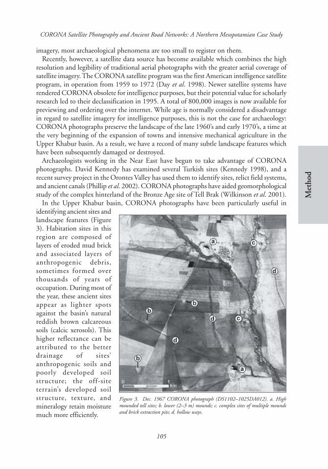
imagery, most archaeological phenomena are too small to register on them.Recently, however, a satellite data source has become available which combines the high
resolution and legibility of traditional aerial photographs with the greater aerial coverage ofsatellite imagery. The CORONA satellite program was the first American intelligence satelliteprogram, in operation from 1959 to 1972 (Day et al. 1998). Newer satellite systems haverendered CORONA obsolete for intelligence purposes, but their potential value for scholarlyresearch led to their declassification in 1995. A total of 800,000 images is now available forpreviewing and ordering over the internet. While age is normally considered a disadvantagein regard to satellite imagery for intelligence purposes, this is not the case for archaeology:CORONA photographs preserve the landscape of the late 1960’s and early 1970’s, a time atthe very beginning of the expansion of towns and intensive mechanical agriculture in theUpper Khabur basin. As a result, we have a record of many subtle landscape features whichhave been subsequently damaged or destroyed.
Archaeologists working in the Near East have begun to take advantage of CORONAphotographs. David Kennedy has examined several Turkish sites (Kennedy 1998), and arecent survey project in the Orontes Valley has used them to identify sites, relict field systems,and ancient canals (Phillip et al. 2002). CORONA photographs have aided geomorphologicalstudy of the complex hinterland of the Bronze Age site of Tell Brak (Wilkinson et al. 2001).
In the Upper Khabur basin, CORONA photographs have been particularly useful inidentifying ancient sites andlandscape features (Figure3). Habitation sites in thisregion are composed oflayers of eroded mud brickand associated layers ofanthropogenic debris,sometimes formed overthousands of years ofoccupation. During most ofthe year, these ancient sitesappear as lighter spotsagainst the basin’s naturalreddish brown calcareoussoils (calcic xerosols). Thishigher reflectance can beattributed to the betterdrainage of sites’anthropogenic soils andpoorly developed soilstructure; the off-siteterrain’s developed soilstructure, texture, andmineralogy retain moisturemuch more efficiently.
Figure 3. Dec. 1967 CORONA photograph (DS1102–1025DA012). a. Highmounded tell sites; b. lower (2–3 m) mounds; c. complex sites of multiple moundsand brick extraction pits; d. hollow ways.

106
Jason Ur
On the photographs, most hollow ways have a distinctive signature which can be easilydistinguished from modern roads and natural wadi courses. The moist soils in the trough areless reflective, producing a broad dark line on the image. The edges of the hollow way slopedown from the surrounding land surface to the trough. This increased gradient (relative tothe flatter surrounding surface) promotes drainage and thus light reflectance; therefore thedark trough of the hollow way often has two light margins on either site of it. In some cases,these margins are absent. Ground observation has demonstrated that these margin-less hollowways are in fact not depressed. When these hollow ways are related to the surrounding terrain,they almost always run perpendicular to the natural slope of the landscape, while hollowways with light margins run parallel to the slope. It appears that the former type acts tocapture eroding sediments, while the latter type probably focuses and increases runoff(Wilkinson 1993: 552–54).The infilled hollow waysstill appear dark on thephotographs because theburied compacted roadsurface still impedes themovement of moisture. Thedistinctive signatures ofhollow ways differ fromthose of modern tracks, inthat they are much broader.Even the largest asphaltroads in the region rarelyapproach a width of greaterthan 10 m, and the mosttypical dirt tracks aregenerally 3–4 m wide.Gravelled roads and recentdirt tracks are highlydisturbed by recentmovement and are alsowhitish in most seasons.Hollow ways and wadishave superficial similarities in that they are both sunken beneath the surrounding terrain andboth serve to channel runoff or even redirect the natural hydrology (Figure 4). However,wadis have a characteristic sinuous shape, whereas hollow ways are typically linear.
GIS-based mapping of hollow waysFor the Upper Khabur basin and surrounding areas of Northern Mesopotamia, the Centerfor the Archaeology of the Middle Eastern Landscape (CAMEL) of the University of ChicagoOriental Institute has begun to remap hollow ways from CORONA imagery. UsingGeographical Information Systems (GIS) software, these features are being spatially integrated
Figure 4. Nov. 1968 CORONA photograph (DS1105–1025DF058) of Tell AswadFoqani. a. Natural meandering wadi courses; b. linear hollow ways which have“captured” wadi flow; c. hollow ways which have been deepened by runoff erosion.

107
Met
hod
CORONA Satellite Photography and Ancient Road Networks: A Northern Mesopotamian Case Study
with geomorphological and environmental data (topography, geology, rainfall) as well assettlement data from archaeological survey. Our GIS database combines the results of intensivesurveys in the Iraqi North Jazira (Wilkinson and Tucker 1995), the Tell Beydar Survey (TBS;Wilkinson 2000), and the Tell Hamoukar Survey (THS; Ur 2002) with site and landscapedata extracted from CORONA photographs and other remote sensing data sources. Whencompleted, this database will facilitate the diachronic analysis of settlement patterns, landscapefeatures, and the evolving relationship between them.
The hollow way component of this multi-layered database is being constructed by meansof the scanning, rectification, and vectorisation of CORONA photographs. BecauseCORONA photographs are not available as digital products, they must be scanned andwarped into a geographic co-ordinate system. Our methods are relatively simple: thephotographic negative is scanned at a resolution of 1600 pixels per inch (ppi); the resultingdigital image is imported into the ENVI 3.5 image processing software package, where it istransformed into a geographically corrected image by reference to ortho-rectified SPOTimagery. The warped images are then projected into the UTM co-ordinate system [NationalGrid] and imported as a layer in the ArcGIS 8.2 software package, where hollow ways andother archaeological and modern features can be traced into separate vector layers (for amore elaborate method, see Phillip et al. 2002)
At the current stage of the project, we have identified 1,192 hollow ways for a total of1,712.9 km of ancient roads. Our mapping has focused initially on the areas of the plainencompassed by and immediately beyond the areas of intensive survey. In the western basin,this includes the area between Tell Beydar, Chagar Bazar and Tell Brak; in the eastern basin,our mapping extends from Hamoukar to Tell Leilan.
Dating and morphologyThe initial association of broad hollow ways with Bronze Age tells and narrower hollow wayswith Byzantine and Early Islamic sites (Van Liere and Lauffray 1954–55, Wilkinson andTucker 1995) has been confirmed by ground control in the TBS and THS areas. For example,from the large EBA town of Tell Beydar, a bifurcating hollow way departs from the easternouter city gate and runs eastward to the 15 ha EBA town of Tell Effendi (TBS 55) along itsnorthern branch, and to the small EBA village of Tell Kaferu (TBS 10) along its southern(Figure 5). Well-developed radial systems exist around most other surveyed EBA sites in thearea.
In the THS survey area (Figure 6), a series of broad hollow ways can be associated with are-entrant contour in the western edge of the 3rd millennium BC lower town, probably theremains of an ancient gate in the city wall or a point of access to the town. While the THSrecovered a continuum of hollow way widths, a class of narrower (40–60 m) hollow wayscould be distinguished; these were associated with sites of Late Byzantine-Early Islamic date.At a point of intersection between a broad and a narrow hollow way, the relative stratigraphyof these features could be discerned; the trough of the Byzantine-Islamic narrow hollow wayclearly cuts into that of the broad EBA hollow way (Figure 7).

108
Jason Ur
Figure 6. Broad (3rd millennium BC) and narrow (Byzantine–Early Islamic) hollow ways in theTHS area.
Figure 5. Dec. 1967 CORONA photograph showing hollow ways between the 3rd millennium BC towns of Tell Beydar, TellKaferu, and Tell Effendi.

109
Met
hod
CORONA Satellite Photography and Ancient Road Networks: A Northern Mesopotamian Case Study
Local radial patterns around EBA sitesAs revealed by CORONA analysis, extensive radial systems are preserved around EBA tells(Figure 8). The maps of Van Liere and Lauffray under-represent the quantity of radial lines
Figure 7. Dec. 1969 CORONA photograph (DS1108–1025DA006) showing a narrow hollow way cutting a broad hollowway SW of Hamoukar; sections are vertically exaggerated.
Figure 8. Nov. 1968 CORONA photograph (DS1105–1025DF058). Radial pattern of hollow ways around Tell Brak.

110
Jason Ur
Table 1. Comparison of quantity and aggregate length of hollow ways around major EBA sites asmapped by Van Liere and Lauffray and the CORONA-based reassessment.
Van Liere and CORONA-basedSite Lauffray 1954–55 reassessment
Hamoukar No. of Hws 10 33Total Km 57 49.4 (avg. 1497 m)
Beydar No. of Hws 5 24Total Km 29 30.3 (avg. 1262 m)
Brak No. of Hws 15 48Total Km 55 67.1 (avg. 1397 m)
Cholma Foqani No. of Hws 7 26Total Km 23 45.9 (avg. 1767 m)
around most sites as well as their lengths (Table 1). The reasons for this are uncertain, butmay be related to the ground conditions at the time that they conducted their aerial survey.Another reason may be that they focused their efforts on the areas immediately around themost prominent tells and thus under-represented the landscape between sites.
The map of route systems in the western Upper Khabur basin depicts a very busy landscape(Figure 9). In surveyed areas, almost all EBA sites have at least one directly associated hollowway, and most have elaborate spoke-like systems which frequently interconnect and evenoverlap each other. The fading hollow ways should be understood as leading human traffic to
Figure 9. Hollow ways in the western Upper Khabur basin, with TBS survey area indicated.

111
Met
hod
CORONA Satellite Photography and Ancient Road Networks: A Northern Mesopotamian Case Study
Figure 10. Hollow ways in the eastern Upper Khabur basin, with THS survey area indicated.
agricultural fields but the movement of flocks to pasture beyond the zone of cultivation wasprobably just as important, possibly more so for the formation of these features (Wilkinsonand Tucker 1995: 27–28). This is certainly the case for the hollow ways leading west fromthe EBA sites along the Wadi ‘Awayj south of Tell Beydar. In this area, a thin strip of arableland lies between the wadi and a basalt plateau covered by thin soils which probably served asan important pasture area (Courty 1994, Wilkinson 2000). The pastoral component of theBronze Age economy has admittedly been under-represented (Wilkinson 1994: 515) althoughits importance has been well argued (Hole 1991, Kouchoukos 1998) direct archaeologicaltraces of pastoralism remain ephemeral compared to agriculture.
Hollow way patterning in the eastern basin (Figure 10) is less dense, probably due topoorer conditions of preservation in three zones of aggradation. To the north, a higher annualrainfall than that of the western basin has probably resulted in local redepositing of erosionalmaterials, possibly combined with the presence of a colluvial fan from the Tur Abdin mountainsfurther north in Turkey. In the central basin, the floodplains of several wadis have left north-south voids in the hollow way pattern. To the south, there is a large area of poor drainagealong the lower reaches of these wadis. Although more fragmentary, the same pattern ofradial systems around EBA tells can be detected in the windows of landscape preservationwhich appear between these zones.
Intersite and regional routesHollow ways connected sites over greater distances within the basin, to a greater degree thanpreviously suspected. Rather than the isolated systems, the Upper Khabur pattern consists of

112
Jason Ur
dozens of interconnecting networks. Although many hollow ways do appear to “fade out,”presumably because they led into fields or pasture, a large quantity can be linked to othercontemporary sites. For example, Tell Effendi (Figures 5 and 9) has a radial pattern of fifteendiscrete hollow ways, and of these, seven can be linked to other tell sites, each with its ownassociated radial system.
These intersite routes are more than connections between towns and their immediatesatellites; when considered at a regional level, these routes emerge as segments of larger“highways” running from site to site on a generally east-west axis. In the western basin, atleast four major routes can be identified (Table 2, north to south).
In the eastern basin, the pattern is less complex: a single route connected the major urbancentres at Tell Leilan and Tell Hamoukar, with gaps where wadi alluviation has deeply coveredthe ancient surface. Almost twenty kilometres of this route, out of the total 42.7 km distance,is preserved. Southeast of Hamoukar, this route connects with an interregional route whichruns through Tell al-Samir and Tell Uwaynat toward Nineveh (Wilkinson and Tucker 1995:26, 54, Figure 24 route E).
In both areas, a few regional routes on a north-south axis can be identified as well, butthese are much less common. In the western basin, a series of discontinuous routes on a NW-SE and N-S axis appear to be associated with Tell Brak. Rather than suggesting the dominanceof east-west movement, this pattern probably resulted from the destruction of north-southroutes by alluviation, as they probably would have followed the wadi floodplains.
For the Early Bronze Age, new conclusions can be drawn about the underlying economy,which had a large role in producing this pattern of settlements and roads. The agriculturalunderpinning of these towns (Weiss 1986, Wilkinson 1994) is vividly illustrated by theabundant radial systems of hollow ways, although the interconnectedness of these systemssuggests a far more integrated agricultural economy than originally recognised. Given thetransportation technology of the time, the regional routes were too long to have borne bulkcommodities over their entire lengths; high value luxury items such as metals and textilesprobably moved over these routes. The emerging textual record appears to support thisreconstruction: administrative records from Brak, Beydar, and Ebla document trade in valuableanimals and materials within and beyond the kingdom of Nagar (Tell Brak), which includedBeydar as a dependency (Eidem et al. 2001).
Table 2. Major intersite routes in the western Upper Khabur basin. See Figure 11 for site locations.
Route Total Distance (km) Preserved Hollow Ways (km)
Tell Hanou to Chagar Bazar 24.3 16.8Tell Sekar Tahtani to Tell Gir Zil Saghir 40.1 19.4Tell Beydar to Tell Umm Hijara 39.0 23.7Tell Jamilo to Tell Brak 35.2 19.7

113
Met
hod
CORONA Satellite Photography and Ancient Road Networks: A Northern Mesopotamian Case Study
Reuse of hollow waysThe remnants of ancient roads, in the form of hollow ways, were magnets for settlement insubsequent periods, not because of their transportation function but because of theirunintended hydraulicfunction. In several places inthe THS area, small LBA(Late Bronze Age) andHellenistic settlements werelocated beside broad EBAhollow ways, which wereslightly wider and deeperimmediately adjacent to thesites (Figure 11). In thesecases, the moisture-retainingtroughs of the hollow wayswere used as a source ofmaterial for mud bricks forthe construction of theadjacent settlements. In thismanner, the landscape impact of EBA urbanism influenced settlement location hundreds orthousands of years later.
Summary and conclusionsWhen aerial photography is limited or unavailable, as is the case in north-eastern Syria,CORONA photography can be a versatile tool for the identification of ancient sites andlandscape features. Although they may prove to be less useful for wetter or more topographicallycomplex areas, these photographs are a powerful data-source for identifying and locatingsites and landscape features in semi-arid alluvial areas such as the plains of NorthernMesopotamia.
The dominant fact of life for the majority of the residents of these agricultural towns wastheir relationship with the land. If archaeologists wish to understand the organisationaldynamics of early states, we must study the archaeological manifestations of this relationship.At the time of the formation of the first urban societies of northern Mesopotamia, humanmovement across the landscape was intense. It is not revolutionary to suggest that peopleand animals moved back and forth between fields, pastures, and settlements. However, weneed not infer this movement; these actual pathways have left traces which are archaeologicallyrecoverable. We can demonstrate the intensity of ancient movement and land use through acombination of fieldwork and remote sensing of hollow way patterns in the basin. Thedeclassified CORONA satellite photographs have been instrumental in this undertaking. Asmodern human society continues on its current path of globalisation and industrialisation,the image of the landscape preserved by the CORONA mission will become an even morevaluable resource for archaeological research.
Figure 11. Reuse of hollow ways for brick material extraction in two areas nearHamoukar (DS1108–1025A005). a.) low mounded sites; b.) borrow pits.

114
Jason Ur
Note on access to CORONAThumbnail images of individual CORONA photographs can be viewed online at http://edcsns17.cr.usgs.gov/EarthExplorer/. Highly accurate SPOT images are available for download on the website of the US NationalImagery and Mapping Agency.
AcknowledgementsThis paper draws on fieldwork undertaken in north-eastern Syria in the context of two projects: the Tell BeydarSurvey, led by Tony Wilkinson (part of the Syrian-European Tell Beydar Mission, directed by Marc Lebeau), andthe Syrian-American Hamoukar Expedition, directed by McGuire Gibson and Amr al-Azm. I must thank allthese directors for allowing me to participate. I am also grateful to the former and current Directors General ofAntiquities and Museums in Damascus, Sultan Muhesen and Abd al-Razzak Moaz, as well as the Director ofExcavations, Michel Maqdisi. Geoff Emberling, Augusta McMahon, and Gil Stein read early drafts; their commentsare much appreciated. All errors are my own.
ReferencesCOURTY, M.A. 1994. Le cadre paléogéographique des
occupations humaines dans le bassin du Haut-Khabur (Syrie du nord-est). Premiers résultats,Paléorient 20/1: 21–59.
DAY, D., J. LOGSDON, & B. LATELL (eds.). 1998. Eye inthe sky: the story of the CORONA spy satellites.Washington and London: Smithsonian Institution.
EIDEM, J., I. FINKEL & M. BONECHI. 2001. The thirdmillennium inscriptions, in D. Oates et al. 2001:99–120.
HOLE, F. 1991. Middle Khabur settlement andagriculture in the Ninevite 5 period, Bulletin of theCanadian Society for Mesopotamian Studies 21: 17–29.
KENNEDY, D. 1998. Declassified satellite photographsand archaeology in the Middle East: case studiesfrom Turkey, Antiquity 72: 553–61
KOUCHOUKOS, N. 1998. Landscape and social change inlate prehistoric Mesopotamia. Unpublished Ph.D.thesis, Department of Anthropology, YaleUniversity.
KOUCHOUKOS, N. 2002. Satellite images and NearEastern landscapes, Near Eastern Archaeology 64:80–91.
MCCLELLAN, T. & A. PORTER. 1995. Jawa and NorthSyria, Studies in the History and Archaeology ofJordan 5: 49–65.
MCCLELLAN, T., R. GRAYSON & C. OGLEBY. 2000.Bronze age water harvesting in North Syria, in O.Rouault & M. Wäfler (eds.), La Djéziré etl’Euphrate Syriens de la protohistoire à la fin du IIemillénaire: 137–55. BREPOLS.
OATES, D., J. OATES & H. MCDONALD. 2001.Excavations at Tell Brak 2: Nagar in the thirdmillennium BC. Cambridge: McDonald Institutefor Archaeological Research.
PHILIP, G., D. DONOGHUE, A. BECK, & N. GALIATSATOS.2002. CORONA satellite photography: anarchaeological application from the Middle East,Antiquity 76: 109–18.
TAYLOR, C. 1979. Roads and tracks of Britain. London:Dent
TSOAR, H. & Y. YEKUTIELI. 1993. Geomorphologicalidentification of ancient roads and paths on theloess of the northern Negev, Israel Journal of EarthSciences 41: 209–16.
UR, J. 2002. Settlement and landscape in NorthernMesopotamia: the Tell Hamoukar Survey 1999–2001, Akkadica 123:57–88.
VAN LIERE, W.J. 1963. Capitals and citadels of Bronze-Iron Age Syria in their relationship to land andwater, Les Annales Archéologiques de Syrie 13: 109–22
VAN LIERE, W.J. & J. LAUFFRAY. 1954–55. Nouvelleprospection archéologique dans la haute Jezirehsyrienne, Les Annales Archéologiques de Syrie 4–5:129–48.
WEISS, H. 1986. The origins of Tell Leilan and theconquest of space in third millenniumMesopotamia, in H. Weiss (ed.), The origins ofcities in dry-farming. Syria and Mesopotamia in thethird millennium BC: 71–108. Guildford: FourQuarters.
WEISS, H. 1997. LEILAN, IN H. WEISS (ed.),Archaeology in Syria, American Journal ofArchaeology 101: 126–29.
WEISS, H. & M.A. COURTY. 1994. Comment toWilkinson 1994, Current Anthropology 35: 512–14.
WILKINSON, T.J. 1993. Linear hollows in the Jazira,Upper Mesopotamia, Antiquity 67: 548–62.
WILKINSON, T.J. 1994. The structure and dynamics ofdry-farming states in Upper Mesopotamia, CurrentAnthropology 35: 483–520.

115
Met
hod
CORONA Satellite Photography and Ancient Road Networks: A Northern Mesopotamian Case Study
WILKINSON, T.J. 2000. Archaeological survey of the TellBeydar region, Syria, 1997. A preliminary report,in K. Van Lerberghe & G. Voet (eds.), Tell Beydar.Environmental and technical studies: 1–37.Turnhaut: BREPOLS.
WILKINSON. T.J., C.A.I. FRENCH, W. MATTHEWS, & J.OATES. 2001. Geoarchaeology, landscape and theregion, in D. Oates et al. 2001: 1–14.
WILKINSON, T.J. & D. TUCKER. 1995. Settlementdevelopment in the North Jazira, Iraq. Warminster:Aris & Phillips.