cormorant road extension
TRANSCRIPT

CORMORANT ROAD EXTENSION
SCHEDULE ‘B’ MUNICIPAL CLASS ENVIRONMENTAL ASSESSMENT
PROJECT FILE REPORT
GROWTH MANAGEMENT DIVISION PLANNING & ECONOMIC DEVELOPMENT
CITY OF HAMILTON and A.J. CLARKE & ASSOCIATES LTD.
FEBRUARY 2015 (REVISED OCTOBER 2015)

Cormorant Road Extension, Schedule B, Municipal Class Environmental Assessment Project File Report
City of Hamilton & A.J. Clarke and Associates Ltd. October 2015
(This page was left black intentionally)

Cormorant Road Extension, Schedule B, Municipal Class Environmental Assessment Project File Report
City of Hamilton & A.J. Clarke and Associates Ltd. October 2015
TABLE OF CONTENTS 1.0 INTRODUCTION ___________________________________________________________________________ 5
1.1 Study Area ....................................................................................................................... 5
1.2 Background ..................................................................................................................... 6
1.3 Previous Studies ............................................................................................................. 6
1.4 Study Purpose and Objectives ....................................................................................... 6
2.0 MUNICIPAL CLASS ENVIRONMENTAL ASSESSMENT (CLASS EA) _____________________ 6
2.1 Process ............................................................................................................................. 7
2.2 Problem Statement ....................................................................................................... 10 3.0 PUBLIC AND AGENCY CONSULTATION _________________________________________________ 10
3.1 Public Consultation ....................................................................................................... 10
3.2 Agency Circulation ........................................................................................................ 11
3.3 Comments ...................................................................................................................... 13 4.0 NATURAL ENVIRONMENT _______________________________________________________________ 18
4.1 Wetlands, Forests, Wildlife .......................................................................................... 18
4.2 Contamination of Soils/Ground................................................................................... 20 5.0 ROADWAY NETWORK/SITE ACCESS/TRAFFIC ________________________________________ 13
5.1 Existing Roadways and Site Access ............................................................................. 13
5.2 Network Alternatives ................................................................................................... 14
5.3 Traffic Study .................................................................................................................. 16
5.4 Sight Lines on Trinity Road South ............................................................................... 18 6.0 CULTURAL ENVIRONMENT _____________________________________________________________ .21
6.1 General ........................................................................................................................... 21
6.2 Archaeology .................................................................................................................. 22 7.0 MUNICIPAL SERVICING __________________________________________________________________ .24
7.1 Sanitary Sewer System ................................................................................................. 25
7.2 Minor Drainage System ................................................................................................ 26
7.3 Major Drainage System ................................................................................................ 27
7.4 Stormwater Management ............................................................................................ 28
7.5 Future Pond Consideration .......................................................................................... 28
7.6 Watermain Distribution System ________________________________________ 29 8.0 ECONOMIC ENVIRONMENT ______________________________________________________________ 30
9.0 ALTERNATIVE ASSESSMENT AND EVALUATION ______________________________________ 31
10.0 PREFERRED ALTERNATIVE ______________________________________________________________ 33

Cormorant Road Extension, Schedule B, Municipal Class Environmental Assessment Project File Report
City of Hamilton & A.J. Clarke and Associates Ltd. October 2015
LIST OF TABLES
Table 1 –List of Key Agencies Circulated .................................................................................................. 12
Table 2 - Roadway Network Alternatives ................................................................................................. 16
Table 3 – Traffic Study Analysis of Roadway Alternatives ............................................................... 17
Table 4 – Analysis of Roadway Alternatives (Sight lines on Trinity Road South) .................... 18
Table 5 - Evaluation of Road Network Alternatives (Natural Environment) ............................. 21
Table 6 - Evaluation of Road Network Alternatives (Sanitary Sewer) .......................................... 26
Table 7 - Evaluation of Road Network Alternatives (Minor Drainage System) ......................... 27
Table 8 - Evaluation of Road Network Alternatives (Water Distribution) .................................. 29
Table 9 - Evaluation of Road Network Alternatives (Economic Impact) ..................................... 30
Table 10 – Evaluation of Alternatives ........................................................................................................ 32
LIST OF FIGURES
Figure 1 - Cormorant Road Extension Study Area ................................................................................... 5
Figure 2 - Municipal Class Environmental Assessment Planning and Design Process .............. 9
Figure 3 – Road Network Alternatives ...................................................................................................... 15
Figure 4 – Achaeological Study Locations ................................................................................................ 23
Figure 5 – Preferred Alternative .................................................................................................................. 34
APPENDICES
Appendix A Public Information Centre Documents
Appendix B Public Correspondence
Appendix C Traffic Study
Appendix D Environmental Mapping
Appendix E Trinity Road South, Plan and Profile for Sight Lines Appendix F City of Hamilton Contaminated Sites Management Program
Contaminant Screening Report Appendix G Archaeological Studies

Cormorant Road Extension, Schedule B, Municipal Class Environmental Assessment Project File Report
Page 5 of 34 City of Hamilton & A.J. Clarke and Associates Ltd. October 2015
1.0 INTRODUCTION Cormorant Road is a two lane collector road located within the Ancaster Industrial Park in the City of Hamilton. The City of Hamilton has completed a Schedule B Municipal Class Environmental Assessment (MCEA) for the extension of Cormorant Road. In 2006, the EA process was initiated for the extension of Cormorant Road, using the Integrated Planning Process that combines the Municipal Class EA process and the Planning Act. The project was formerly known as the “Valeri Business Park and Cormorant Road Extension Integrated Planning and Municipal Class EA (MCEA)” and was being led by the private developer of the proposed Valeri Business Park subdivision. The City took over the Environmental Assessment portion of the Cormorant Road Extension in response to the public’s concerns. Since the subdivision is not proceeding at this time, the City of Hamilton will not be using the Integrated Planning Process, but instead will only be seeking MCEA approvals for the Cormorant Road Extension. The developer for the Valeri Business Park subdivision will be required to obtain all necessary development approvals for their lands under the Planning Act. 1.1 Study Area The study limits for this project extend from Tradewind Drive to the east, Trinity Road South to the west, to north of Claybar Road, and south to the Hydro Corridor (see Figure 1). The land uses within and surrounding the study area are predominantly agricultural and industrial.
Figure 1 - Cormorant Road Extension Study Area

Cormorant Road Extension, Schedule B, Municipal Class Environmental Assessment Project File Report
Page 6 of 34 City of Hamilton & A.J. Clarke and Associates Ltd. October 2015
1.2 Background The City of Hamilton commenced with the development of the Ancaster Industrial Park in the early 1980’s. The Ministry of Transportation granted a temporary access to the lands from Wilson Street. This temporary access was removed after the construction of a permanent entrance from Wilson Street (former Highway No. 2) via Tradewind Drive in the late 1980’s. All lots in the Ancaster Industrial Park, with the exception of those which front onto Trinity Road South and Shaver Road, currently rely on the Tradewind Drive entrance for road access. The existing roadway network consists of a number of dead end roads. 1.3 Previous Studies In 2004 the City of Hamilton completed a master servicing plan for the westerly portion of the Ancaster Industrial Park (Ancaster Industrial Park – Drainage Areas 1 and 2 and Tradewind Drive, 2004). The plan looked at alternatives for the roadway network and stormwater management. In particular, in 2004 the roadway network was assessed due to:
Limited roadway access in and out of the industrial park; Public safety; Response time for emergency vehicles; and Further development of the Industrial Park.
Following the completion of the 2004 study, the City constructed the extension of Tradewind Drive from Sandhill Drive to Cormorant Road to improve the roadway access in and out of the industrial park. 1.4 Study Purpose and Objectives The purpose of this study is to assess the extension of Cormorant Road, from Tradewind Drive to Trinity Road S. The extension of Cormorant Road is key to allow further development of the Ancaster Industrial Park west of Tradewind Drive. The objective for the process is to:
Evaluate options for the extension of Cormorant Road to Trinity Road S. 2.0 MUNICIPAL CLASS ENVIRONMENTAL ASSESSMENT (CLASS EA) This Project is being conducted in accordance with the requirements of the Municipal Class EA process. The Class EA planning process allows for the integration of sound engineering judgment, prudent long-term planning, and protection of all aspects of the environment (natural, social, economic, and cultural). This includes consultation with the

Cormorant Road Extension, Schedule B, Municipal Class Environmental Assessment Project File Report
Page 7 of 34 City of Hamilton & A.J. Clarke and Associates Ltd. October 2015
public and affected agencies to obtain comments and input, ensure regulatory compliance and ultimately achieve acceptance of the preferred alternative. The Class EA process was developed as a method for planning municipal infrastructure projects (including roads, water and wastewater projects), which display the following common characteristics:
Recurring; Usually similar in nature; Generally limited in scale; Have a predictable range of environmental effects; and, Responsive to mitigating measures.
The requirements for undertaking a Class EA are described in the document Municipal Class Environmental Assessment, October 2000 as amended in 2007 and 2011, Municipal Engineers Association (MEA). A Class EA applies to a group of projects that are permitted under the Environmental Assessment Act as long as they follow the approved planning process. The specific requirements depend on the type and complexity of the project as well as the significance of potential impacts. The following three types of projects are identified:
Schedule ‘A’ and ‘A+’ Projects are limited in scale and have minimal adverse impacts. This type of project is pre-approved and may proceed to construction without further work following the Class EA process
Schedule ‘B’ Projects have the potential for some adverse environmental impacts and are approved provided they are “screened” by the public and government review agencies. This type of project requires the completion of Phases 1 and 2 of the EA planning process.
Schedule ‘C’ Projects are more complex and the potential for significant environmental impacts. These projects generally include the construction of new facilities and major expansions to existing facilities. This type of project is subject to the full Class EA process and requires the preparation of an Environmental Study Report (ESR).
2.1 Process
The Class EA process in Ontario follows a rational decision-making process and includes:
Identifying the problem or need for the project (Phase 1);
Identification and evaluation of planning options or alternative solutions to address the problem (Phase 2);
An assessment of design alternatives (Phase 3);
The completion of documentation for the public record (phase 4); and

Cormorant Road Extension, Schedule B, Municipal Class Environmental Assessment Project File Report
Page 8 of 34 City of Hamilton & A.J. Clarke and Associates Ltd. October 2015
The implementation of the project including design, with appropriate monitoring during construction (Phase 5).
This EA project is required to determine the preferred alternative for the Cormorant Road extension to ensure a reliable second roadway access into the Ancaster Industrial Park. It has been determined that this project will follow the Schedule ‘B’ process. As a Schedule ‘B’ project, Phase 1 and Phase 2 of the Class EA process are required (see Figure 2). The Schedule ‘B’ Class EA concludes with the Notice of Completion and filing of the Class EA Project File Report for a minimum 30-day public review period. The Municipal Class EA process includes an appeal provision, also referred to as a Part II Order. If concerns regarding a project cannot be resolved in discussions with the proponent (for this study, the proponent is the City of Hamilton), then members of the public, interest groups or technical agencies may request the Minister of the Environment to “bump-up” (Part II Order) a project to an individual EA. The Minister of the Environment then decides whether a “bump-up” is appropriate or necessary. If no “bump-up” (Part II Orders) requests are outstanding by the completion of the review period, the project is considered to have met the requirements of the Class EA and the proponent may complete contract drawings, proceed to tender and construct the project.

Cormorant Road Extension, Schedule B, Municipal Class Environmental Assessment Project File Report
Page 9 of 34 City of Hamilton & A.J. Clarke and Associates Ltd. October 2015
Figure 2 - Municipal Class Environmental Assessment Planning and Design Process

Cormorant Road Extension, Schedule B, Municipal Class Environmental Assessment Project File Report
Page 10 of 34 City of Hamilton & A.J. Clarke and Associates Ltd. October 2015
2.2 Problem Statement Presently, there is only one single point of ingress/egress into the Ancaster Industrial Park. The only available access is via a signalized intersection at Tradewind Drive and Wilson Street. There have been safety concerns expressed from the Ancaster Industrial Park landowners on the existing roadway network system. The lack of an alternate emergency access and the lengthy dead end road system raises the following issues:
Limited access and poor circulation of traffic; Response time for emergency services; and, Public safety.
In order to partially alleviate these concerns, Tradewind Drive was extended southerly to Cormorant Road in 2004 to create an alternative routing for drivers, and a direct connection from Wilson Street to the south portion of the industrial park. There exists significant development potential within the westerly portion of the Ancaster Industrial Park. In order to realize this potential, a second point of ingress/egress via an extension of Cormorant Road to Trinity Road South is required. The objective of the EA process is to determine the optimal location of an extension of Cormorant Road to Trinity Road South. 3.0 PUBLIC AND AGENCY CONSULTATION At the onset of the study, a list was compiled of all property owners, stakeholders, technical agencies and First Nations within the study area. This list was kept updated throughout the study and was utilized for all notices and meeting invitations. 3.1 Public Consultation The following Public/Stakeholder consultation has taken place during the course of the study: Public Information Centre No.1 The first PIC was held on Wednesday May 10, 2006 in Ancaster at the Morgan Firestone Arena. At this meeting, the problem statement, alternative solutions, and the preferred alternative were presented to the public. A notice of the Class EA was also mailed to review agencies, persons directly affected, and other interest groups. During the first PIC the project process was following the Integrated Planning and Municipal Class EA (MCEA). The meeting was attended by approximately nine (9) individuals from the study area. City staff from the Public Works and Planning and Economic Development Departments

Cormorant Road Extension, Schedule B, Municipal Class Environmental Assessment Project File Report
Page 11 of 34 City of Hamilton & A.J. Clarke and Associates Ltd. October 2015
and consultant personnel from A. J. Clarke and Associates Ltd. were on hand to receive comments and to answer questions. The PIC provided the public the opportunity to review the proposed development project and road pattern alternatives for an extension of Cormorant Road, from Tradewind Drive to Trinity Road South. A preliminary assessment of the alternatives being considered was presented as well. PIC information (notices sent, information packages provided, etc.) is included in the report as Appendix A. Public Information Centre No. 2 A second PIC was held on Thursday December 18th, 2014 in Ancaster at the Morgan Firestone Arena and the public was invited for a second time to comment on the alternative solutions and the preferred alternative. An additional PIC was held for two reasons. First, it had been eight years since the public was consulted on this project and secondly, the EA process changed from an Integrated Planning and Municipal Class EA (MCEA) to a Schedule B Class EA. At this meeting, the problem statement, change in EA approach, alternative solutions, and the preferred alternative were presented to the public. A notice of the Class EA was also mailed to review agencies, persons directly affected, and other interest groups. The meeting was attended by approximately (7) from the study area. City staff from the Planning and Economic Development Department and the project consultant (A.J. Clarke and Associates Ltd.) were on hand to answer questions from the public. Those in attendance were generally in agreement with the EA recommendations. Comments received at the PIC and information (notices sent, information packages provided, etc.) is included in Appendix A of the report. Notice of Study Commencement and Public Information Centre 1: The Notice of Commencement and Public Information Centre No. 1 was posted in the Hamilton Spectator on Friday, April 28, 2006 and Friday May 5, 2006. On Tuesday May 2, 2006 the notice was mailed to property owners and interested agencies. Public Information Centre 2: A meeting notice was advertised in the Hamilton Spectator on Saturday December 6th, 2014 and Friday December 12th, 2014 and in the Ancaster News on Thursday December 4th, 2014 and Thursday December 11th, 2014. In addition, property owners within the industrial park and surrounding it were notified directly by letter of the upcoming Public Information Centre. 3.2 Agency Circulation In addition to the PIC, a Notice of PIC for the Cormorant Rd Extension EA was circulated to specific agencies inviting their comments. A full listing of the Agencies circulated can be found in Appendix B. Table 1 below summarizes a list of the key agencies circulated.

Cormorant Road Extension, Schedule B, Municipal Class Environmental Assessment Project File Report
Page 12 of 34 City of Hamilton & A.J. Clarke and Associates Ltd. October 2015
Table 1 –List of Key Agencies Circulated
Utility Agencies
Bell Canada
Hydro One Networks Inc.
Sun Canadian Pipeline
TransCanada Pipelines
Enbridge Pipelines Inc.
Union Gas
Municipal Agencies
City of Hamilton, Emergency Services
City of Hamilton, Economic Development
Hamilton Chamber of Commerce
Provincial Agencies
Grand River Conservation Authority
Ministry of Natural Resources, Guelph District
Ministry of the Environment, Hamilton Office
Ministry of Aboriginal Affairs, Consultation Unit
Federal Agencies
Environment Canada
Canadian Centre for Inland Waters
Canadian Environmental Assessment Agency
Department of Fisheries and Oceans
Canada Post
First Nations
Huron-Wendat Nation Council
Six Nations on the Grand River
Haudenosaunee Resource Centre
Business Improvement Area (BIA) and Neighbourhood Groups
Ancaster BIA
Ancaster Community Council
Hamilton Industrial Environmental Association
Citizens at City Hall (CATCH)

Cormorant Road Extension, Schedule B, Municipal Class Environmental Assessment Project File Report
Page 13 of 34 City of Hamilton & A.J. Clarke and Associates Ltd. October 2015
3.3 Comments Through the public consultation process, comments have been received on the preferred alternative. In general, there is strong support from local businesses to have a second means of access and egress from the business park, highlighting that there is a significant delay to those leaving the business park during the AM and PM peak hours; there are a number of businesses within the park that operate working shifts, which attributes to the high influx of traffic. Comments received from both PIC’s have been included in Appendix B. 4.0 ROADWAY NETWORK/SITE ACCESS/TRAFFIC Much of the following falls under social environment as well as having technical/engineering components. The issues studied address the potential for a second point of ingress/egress that would be of benefit for all businesses located within the existing and future industrial park, as it will improve traffic mobility and accessibility to their respective businesses. Further, an extension to Trinity Road South will affect neighbouring residential/business/industry. Once its exact location is determined, the effects of this new intersection will be localized to the properties immediately neighbouring it, with the exception of the expected overall traffic increase on Trinity Road South. However, previous comments received as part of the Ancaster Industrial Park public consultation process indicate that there is some desire for this connection from neighbouring properties. Comments from that consultation process also noted concerns with recreational vehicles utilizing the lands inappropriately, and further development of the land that is in keeping with the official plan would minimize this use. 4.1 Existing Roadways and Site Access The roadways within the study area, which could be affected by the development, are as follows: Trinity Road South Trinity Road is a north-south arterial roadway with a two-lane cross section and a posted speed limit of 80 kilometers per hour. North of Wilson Street, Trinity Road becomes Regional Road 52 (former Provincial Highway 52) and has a full interchange with Highway 403. Tradewind Drive Tradewind Drive is an industrial collector roadway, which provides access to the Ancaster Industrial Park from Wilson Street. Tradewind Drive is currently an undivided roadway, single lane in each direction cross section and a posted speed limit of 50 kilometers per hour.

Cormorant Road Extension, Schedule B, Municipal Class Environmental Assessment Project File Report
Page 14 of 34 City of Hamilton & A.J. Clarke and Associates Ltd. October 2015
Cormorant Road Cormorant Road is an industrial collector roadway providing access to many light industrial buildings in the southern portion of the Ancaster Industrial Park. Currently Cormorant Road and Tradewind Drive meet at right angles to form a 90° turn in the road. 4.2 Network Alternatives The network alternatives being considered are illustrated in Figure 3, that have been documented in Table 2.

Cormorant Road Extension, Schedule B, Municipal Class Environmental Assessment Project File Report
Page 15 of 34 City of Hamilton & A.J. Clarke and Associates Ltd. October 2015
Figure 3 – Road Network Alternatives

Cormorant Road Extension, Schedule B, Municipal Class Environmental Assessment Project File Report
Page 16 of 34 City of Hamilton & A.J. Clarke and Associates Ltd. October 2015
Table 2 - Roadway Network Alternatives
Alternative Description
Alternative No. 1: Do nothing.
This alternative does not address the Problem statement.
Alternative No. 2: Extend Cormorant Road straight through to Trinity Road South.
Under this alternative, the road would provide a direct east-west route in the overall industrial park. This alternative would provide a more direct route for drivers to the southerly portion of the industrial park, and a second point of ingress/egress for the area.
Alternative No. 3: Extend Cormorant Road westerly, then to the northwest to connect to Claybar Road.
Under this alternative, the road would provide an east-west route in the overall industrial park, and a second ingress/egress point for the Industrial Park.
Alternative No. 4: Extend Cormorant Road westerly, then to Trinity Road South midway between Alternatives No. 2 and 3.
Under this alternative, the road would provide a second point of access to the industrial park, and an east-west route through the area.
Alternative No. 5: Extend Cormorant Road westerly, then to the southwest, as per the original alignment as indicated in the Ancaster Zoning By-Law.
Under this alternative, the road would provide an east-west route in the study area, and a second ingress/egress point for the Industrial Park. This alternative is the same alignment as indicated in the Ancaster Zoning By-Law.
4.3 Traffic Study A traffic study was performed by Paradigm Transportation Solutions Limited and reported as Valeri Business Park Collector Road Access Class Environmental Assessment Study Traffic Component, May 31, 2006. The report is included as Appendix C. The study was conducted to confirm the need for a second point of access in/out of the business park with any expansion west of Tradewind Drive, and to review the alternative road patterns being considered. The conclusions of the study are as follows:
The additional vehicular traffic generated by the development of the Valeri Business Park and the other adjacent undeveloped parcels of land in the Ancaster Industrial Park is estimated to be approximately 1815 trips in the AM peak hour and approximately 1860 trips in the PM peak hour.

Cormorant Road Extension, Schedule B, Municipal Class Environmental Assessment Project File Report
Page 17 of 34 City of Hamilton & A.J. Clarke and Associates Ltd. October 2015
The existing single roadway connection to Wilson Street via Tradewind Drive does not provide adequate capacity for development of the Valeri Business Park and adjacent portions of the Ancaster Industrial Park. An additional roadway connection to Trinity Road South should be considered.
A new roadway connection to Trinity Road South will provide the added capacity necessary to accommodate the additional trips that are expected to be generated by the development of the Valeri Business Park. It will also improve the access and internal traffic circulation for the area.
A southbound left turn lane with 40 meters of storage should be considered at the intersection of Trinity Road South and the future extension of Cormorant Road to handle the additional traffic estimated to use this access point. A traffic signal is not warranted based on the study data.
The report further advised that any proposed connection to Trinity Road South would function in a very similar manner, so there was no recommendation made between alternative locations for an extension.
Table 3 – Traffic Study Analysis of Roadway Alternatives
Alternative Description
Alternative No. 1: Do nothing.
Under this alternative, further development west of existing Tradewind Drive cannot occur.
Alternative No. 2: Extend Cormorant Road straight through to Trinity Road.
Any of these alternatives would act in a similar fashion from a traffic perspective.
Alternative No. 3: Extend Cormorant Road westerly, then to the northwest to connect to Claybar Road.
Alternative No. 4: Extend Cormorant Road westerly, then to Trinity Road South midway between Alternatives No. 2 and 3.
Alternative No. 5: Extend Cormorant Road westerly, then to the southwest, as per the original alignment as indicated in the Ancaster Zoning By-Law.

Cormorant Road Extension, Schedule B, Municipal Class Environmental Assessment Project File Report
Page 18 of 34 City of Hamilton & A.J. Clarke and Associates Ltd. October 2015
4.4 Sight Lines on Trinity Road South A topographical survey of Trinity Road South was carried out by A. J. Clarke and Associates Ltd. from north of Claybar Road to approximately the existing hydro corridor south of Alternative No. 5, in order to understand the impact of the alternatives when intersecting with the vertical geometry of Trinity Road South. A plan/profile of Trinity Road South based on this survey data was prepared and is included in Appendix E.
Table 4 – Analysis of Roadway Alternatives (Sight lines on Trinity Road South)
Alternative Infrastructure Required
Alternative No. 1: Do nothing.
Under this alternative, there is no impact/change to traffic on Trinity Road South.
Alternative No. 2: Extend Cormorant Road straight through to Trinity Road South.
New intersection would be located near low point in the road, with sight distances of 275m+ to the north and 250m to the south.
Alternative No. 3: Extend Cormorant Road westerly, then to the northwest to connect to Claybar Road.
New intersection is not created – utilizes existing intersection of Claybar/Trinity. This is currently at the highest point in the road from the hydro corridor, and Trinity Road South continues to increase in elevation beyond Claybar (not sectioned).
Alternative No. 4: Extend Cormorant Road westerly, then to Trinity Road South midway between Alternatives No. 2 and 3
New intersection is located along relatively flat grade, approx. 90m north of the low point, and sufficient sight lines in either direction. This alternative is closest to existing Claybar Road, with a separation of approx. 95m.
Alternative No. 5: Extend Cormorant Road westerly, then to the southwest, as per the original alignment as indicated in the Ancaster Zoning By-Law.
New intersection would be located approx. 150m north of a slight swell in Trinity Road South, limiting sight lines for northbound traffic. Sight distances of 400m+ to the north.
5.0 NATURAL ENVIRONMENT 5.1 Wetlands, Forests, Wildlife In support of the report Ancaster Industrial Park (Drainage Areas 1 and 2) and Tradewind Drive Municipal Class Environmental Assessment, February 9, 2004 by A.J. Clarke and Associates Ltd. the services of Ecoplans Limited were retained to conduct a baseline inventory of the natural environment entitled Ancaster Industrial Park Natural Environment Inventory, dated October 2003.
Cormorant Road Extension, Schedule B, Municipal Class Environmental Assessment Project File Report
Page 19 of 34 City of Hamilton & A.J. Clarke and Associates Ltd. October 2015
The inventory was performed for the entire Ancaster Industrial Park including the subject area. Accordingly it was determined that this same report would be used as reference for the current study/review, as no substantial changes would be expected since the preparation of the inventory. Ecoplans reviewed existing background material relevant to the study area and conducted field surveys of vegetation and wildlife present within the study area. The study concluded that generally the vegetation communities “are common, have a low ecological significance and sensitivity and tend to establish quickly after a disturbance event”. Only one regionally significant species, Umbrella Sedge was recorded and it is located such that it will not be affected by any of the roadway alternatives. Field survey of the wildlife did not reveal any significant wildlife habitat. The two watercourses (the NW of which falls into this subject property) “are not particularly rich in wildlife and cannot be considered as ‘significant corridors’ given the lack of continuity and woody vegetation cover”. The study by Ecoplans further recommended that the construction would have only minor impacts on existing natural areas. Examples of mitigation approaches to be considered to reduce impacts on vegetation and wildlife resources in the study include the following:
Retention of woodland/forest areas, marsh/forest associated with tributary creeks and representative cultural meadow around SWM pond
Implementation of proper construction techniques (timing, materials and equipment)
Preparation of a tree management plan, at detailed design One of the woodland/marsh areas, noted in the Ecoplans report as “Unit 2”, would be traversed by any of the roadway alternatives being considered, as would the northwest tributary of Big Creek. Comments received from the Ministry of Natural Resources from the Notice of Study Commencement included mapping that shows a portion of this same area (part of Ecoplan’s “Unit 2”) as being a wetland currently under review by their office. Based on the mapping received, Alternatives 3 and 4 would directly cross this wetland, whereas Alternatives 2 and 5 fall south of this wetland. It should be noted that there is a wetland on the west side of Trinity Road South, approximately opposite municipal address No. 769 Trinity Road South. While this wetland is outside of the study area, should one of Alternatives 2 or 4 be constructed, further review may be necessary. Traffic considerations for any new roadway would require a southbound left hand turn lane with 40m of storage (see Traffic section below), which will require widening of Trinity Road South at the selected location. The configuration of such a lane addition would have to be designed with consideration for the location of this wetland, so as to minimize any negative impact. Since 2006, environmental legislation has changed when it comes to the natural environment, in particular changes to the Endangered Species Act (ESA). In 2014, in consultation with the Ministry of Natural Resource, the City committed to assessing the natural areas impacted by the road project for the following:
Cormorant Road Extension, Schedule B, Municipal Class Environmental Assessment Project File Report
Page 20 of 34 City of Hamilton & A.J. Clarke and Associates Ltd. October 2015
To determine if suitable habitat for Bobolink and/Eastern Meadowlark is present. If suitable habitat is present, then targeted breeding surveys be completed to confirm species presence/absence; and,
That any trees that may be impacted by the project be assessed to determine if they are listed under the ESA; and,
That any trees impacted by the project be assessed to determine if it provides suitable habitat (i.e. cavities) for species at risk bats.
5.2 Contamination of Soils/Ground Due to the proximity of existing industrial uses, City of Hamilton staff assessed the various properties through which or adjacent to the roadway alternatives to determine the potential for contamination of soils. The “Contaminant Screening Report” is attached as Appendix F. Roadway construction will necessitate the need for underground watermains, storm and sanitary sewers. In the event that any contaminated soils were found, a more in depth review of the issues and new procedures for construction would have to be determined. Properties were assessed by City staff on a low/medium/high rating. Properties adjacent to or immediately containing roadway alternatives No. 3 and 4 are considered to be high risk for potential contamination. Properties adjacent to/immediately containing roadway alternatives No. 2 and 5 are considered to be of medium risk. A Phase 1 Environmental assessment and/or Record of Site Condition will be carried out on the preferred alternative during the detail design stage.

Cormorant Road Extension, Schedule B, Municipal Class Environmental Assessment Project File Report
Page 21 of 34 City of Hamilton & A.J. Clarke and Associates Ltd. October 2015
Table 5 - Evaluation of Road Network Alternatives (Natural Environment)
Alternative Evaluation
Alternative No. 1: Do nothing.
No effect on the natural environment.
Alternative No. 2: Extend Cormorant Road straight through to Trinity Road South.
Requires a crossing of the NW tributary of Big Creek. Minimizes impact to the MNR wetland as per mapping received and attached in Appendix D. Consideration required for wetland on west side of Trinity Road South when designing left hand turn lane. Area soils considered to be medium risk for potential contamination. No significant wildlife revealed that would be affected.
Alternative No. 3: Extend Cormorant Road westerly, then to the northwest to connect to Claybar Road.
Requires a crossing of the NW tributary of Big Creek. Requires a crossing of the MNR wetland as per mapping received and attached in Appendix D. Area soils considered to be high risk for potential contamination. No significant wildlife revealed that would be affected.
Alternative No. 4: Extend Cormorant Road westerly, then to Trinity Road South midway between Alternatives No. 2 and 3
Requires a crossing of the NW tributary of Big Creek. Requires a crossing the MNR wetland as per mapping received and attached in Appendix D. Consideration required for wetland on west side of Trinity Road South when designing left hand turn lane. Area soils considered to be high risk for potential contamination. No significant wildlife revealed that would be affected.
Alternative No. 5: Extend Cormorant Road westerly, then to the south west, as per the original alignment as indicated in the Ancaster Zoning By-Law.
Requires a crossing of the NW tributary of Big Creek. Minimizes impact to MNR wetland as per mapping received and attached in Appendix D. Area soils considered to be medium risk for potential contamination. No significant wildlife revealed that would be affected.
6.0 CULTURAL ENVIRONMENT 6.1 General None of the proposed alternatives pose any impact on built heritage features, as there are no existing structures within the study area.
Cormorant Road Extension, Schedule B, Municipal Class Environmental Assessment Project File Report
Page 22 of 34 City of Hamilton & A.J. Clarke and Associates Ltd. October 2015
6.2 Archaeology Archaeological Services Inc. (ASI) has conducted several Archaeological Studies within the study area. The study area can be characterized into two separate parcels of land, Valeri Business Park (east) and City Owned lands (west). Figure 4 illustrates the locations of the archaeological studies are provided in Appendix G.

Cormorant Road Extension, Schedule B, Municipal Class Environmental Assessment Project File Report
Page 23 of 34 City of Hamilton & A.J. Clarke and Associates Ltd. October 2015
Figure 4 – Achaeological Study LocationsValeri Lands

Cormorant Road Extension, Schedule B, Municipal Class Environmental Assessment Project File Report
Page 24 of 34 City of Hamilton & A.J. Clarke and Associates Ltd. October 2015
Stage 1 and 2 of ASI assessment was completed in April 2006, and reported under Stage 1 & 2 Archaeological Assessment of the Valeri Business Park (Stage 1 Parcel) Severance Applications AN/B-05:62, AN/B-05:63, Part of Lot 32, Concession 4, Town of Ancaster, City of Hamilton, Ontario, April 2006. A further study of one area of potential interest was the subject of their report entitled Stage 3 Archaeological Assessment of Site AhHa-209 Severance Application AN/B-05:63, Part of Lot 32, Concession 4, Town of Ancaster, City of Hamilton, Ontario, August 2006. With both studies completed, it was recommended that no further review of the site was warranted. Subsequent to this report, archaeological clearance for the subject property was received from the Ministry of Tourism, Culture and Sport (MTCS). A second study was performed on the balance of the business park lands by Archeological Assessments Ltd. and the report is entitled The Stage 1 – 3 Archaeological Assessment of the Valeri Business Park, Phase 2 Lands, Part of Lot 32, Concession 4, Geographic Township of Ancaster, City of Hamilton, June 2006. The results of the Stage 3 assessment indicate that two sites within the area were subject to Stage 3 study. This further assessment revealed that both sites were not significant and were no longer a planning concern. Subsequent to this report, archaeological clearance for the subject property was received from MTCS.
City Owned Lands
The City of Hamilton retained ASI to carry out a Stage 1 and 2 Archaeological assessment for the City owned lands located west of the Valeri Business Park. Stage 1 and 2 of the ASI assessment was completed in September 2015, and reported under Stage 1 & 2 Archaeological Assessment, Cormorant Road Extension, Part of Lot 31, Concession 4 (former Township of Ancaster, County of Wentworth), City of Hamilton, October 2015. The study concluded that the finding spots identified in the Stage 2 pedestrian survey are isolated and/or undiagnostic, and that no further archaeological assessment for the property is required. 7.0 MUNICIPAL SERVICING Any extension of Cormorant Road will include construction of the road as a collector road, and will include such municipal services as sanitary sewers, and watermains. An assessment of the infrastructure requirements has been completed in order to evaluate each of the roadway network alternatives. The creation of new hardened surface (i.e. asphalt) associated with the extension of the roadway; the surface runoff generated from these improved areas will require stormwater management controls. As recommended in the approved Municipal Class EA document, Ancaster Industrial Park (Drainage Areas 1 and 2) and Tradewind Drive Municipal Class Environmental Assessment, Pond 1 was identified to provide SWM control for the road and adjacent developable lands, under the ultimate build out land

Cormorant Road Extension, Schedule B, Municipal Class Environmental Assessment Project File Report
Page 25 of 34 City of Hamilton & A.J. Clarke and Associates Ltd. October 2015
use scenario; the previous EA was prepared on the basis of the ultimate land use scenario, and did not taken into consideration phasing of development. The municipal servicing strategy developed by this EA, related to stormwater, will only focus on the controls required to facilitate the construction of the Cormorant Road extension and not to support development of the surrounding business park lands. 7.1 Sanitary Sewer System Sanitary drainage in the Ancaster Industrial Park flows from the north along Tradewind Drive, Sandhill Drive and Osprey Drive to an existing pumping station (S-H14) at the south end of Osprey Drive and Cormorant Road. Sanitary sewage from the Ancaster Industrial Park is pumped up to the gravity sewer on Wilson Street and directed to the Woodward Avenue Wastewater Treatment Plant (WWTP). It is proposed to extend the existing 1050mm trunk sewer westerly along any extension of Cormorant Road to Trinity Road South, as there is sufficient depth and capacity to service future external areas to the west regardless of the alternative selected. Currently there are no sanitary sewers at Trinity Road South (nor on Claybar).

Cormorant Road Extension, Schedule B, Municipal Class Environmental Assessment Project File Report
Page 26 of 34 City of Hamilton & A.J. Clarke and Associates Ltd. October 2015
Table 6 - Evaluation of Road Network Alternatives (Sanitary Sewer)
Alternative Required Infrastructure
Alternative No. 1: Do nothing.
No sanitary sewer infrastructure improvements required.
Alternative No. 2: Extend Cormorant Road straight through to Trinity Road South.
Extension of the sanitary collection system along Cormorant Road approximately 720m to the west to Trinity Road South.
Alternative No. 3: Extend Cormorant Road westerly, then to the northwest to connect to Claybar Road.
Extension of the sanitary collection system along Cormorant Road approximately 630m to where it will meet the existing Claybar Road. Sewers do not exist on Claybar Road, and would have to be constructed below the existing pavement for approximately 185m to Trinity Road South.
Alternative No. 4: Extend Cormorant Road westerly, then to Trinity Road South midway between Alternatives No. 2 and 3.
Extension of the sanitary collection system along Cormorant Road approximately 800m to the west to Trinity Road South.
Alternative No. 5: Extend Cormorant Road westerly, then to the south west, as per the original alignment as indicated in the Ancaster Zoning By-Law.
Extension of the sanitary collection system along Cormorant Road approximately 750m to the west to Trinity Road South.
7.2 Minor Drainage System The minor conveyance system will be designed to convey the City’s 5-Year design storm, using Mt. Hope rainfall data, as per the city’s stormwater management criteria and guidelines document. The surface runoff from the roadway is proposed to be captured by a combination of catch basins and curb-cuts and conveyed to a road side swale, which shall be designed and constructed in accordance with the standards and requirements of the City of Hamilton. The majority of Valeri Business Park, and future development lands to the west along an extension of Cormorant Road, are within Drainage Area No. 1 as outlined in Ancaster Industrial Park (Drainage Areas 1 and 2) and Tradewind Drive Municipal Class Environmental Assessment and are planned to outlet into a future stormwater management facility (Pond No. 1). This pond would require construction in conjunction with future development of the lands and is discussed further below. Only the southeast

Cormorant Road Extension, Schedule B, Municipal Class Environmental Assessment Project File Report
Page 27 of 34 City of Hamilton & A.J. Clarke and Associates Ltd. October 2015
corner of the site falls within Drainage Area No. 2, and would drain into the existing pond No. 2. Currently Trinity Road South and Claybar Road are serviced by road side ditches. An assessment of the various alternatives with respect to minor drainage system is as follows:
Table 7 - Evaluation of Road Network Alternatives (Minor Drainage System)
Alternative Required Infrastructure
Alternative No. 1: Do nothing.
No storm conveyance infrastructure improvements required.
Alternative No. 2: Extend Cormorant Road straight through to Trinity Road South.
Construct road side swale(s) along Cormorant Road approximately 720m to the west.
Alternative No. 3: Extend Cormorant Road westerly, then to the northwest to connect to Claybar Road.
Construct road side swale(s) along Cormorant Road approximately 630m to where it will meet the existing Claybar Road. With the urbanization of Claybar Road, an additional 185m of swale and associated road reconstruction would also be required.
Alternative No. 4: Extend Cormorant Road westerly, then to Trinity Road South midway between Alternatives No. 2 and 3.
Construct road side swale(s) along Cormorant Road approximately 800m to the west to Trinity Road South.
Alternative No. 5: Extend Cormorant Road westerly, then to the south west, as per the original alignment as indicated in the Ancaster Zoning By-Law.
Construct road side swale(s) along Cormorant Road approximately 750m to the west to Trinity Road South.
7.3 Major Drainage System The proposed major storm drainage route, for all alternatives (excluding Alternative No. 1 – Do Nothing), is to follow the proposed road pattern that would allow runoff from less frequent events to be conveyed via overland flow into the existing conveyance channel. The overland flow routes for the roadway shall be designed and constructed in accordance with the standards and requirements of the City of Hamilton.

Cormorant Road Extension, Schedule B, Municipal Class Environmental Assessment Project File Report
Page 28 of 34 City of Hamilton & A.J. Clarke and Associates Ltd. October 2015
7.4 Stormwater Management A Municipal Class EA process was carried out for the Ancaster Industrial Park and the conclusions and recommendations of that study are documented in the Background Report: Ancaster Industrial Park (Drainage Areas 1 and 2) and Tradewind Drive, Municipal Class Environmental Assessment, dated February 9, 2004 by A.J. Clarke and Associates Ltd. Since the time of filing the Ancaster Industrial Park (Drainage Areas 1 and 2) and Tradewind Drive, Municipal Class Environmental Assessment, the City of Hamilton has established several new policies and design criteria pertaining to stormwater management. These documents are identified below:
City of Hamilton, Storm Drainage Policy, May 2004
City of Hamilton, Criteria and Guidelines for Stormwater Infrastructure Design, September 2007
City of Hamilton, Engineering Guidelines for Servicing Land Under Development Applications, December 2012
Because the majority of the roadway is located within Drainage Area 1 of the above noted Class EA document, its extension would necessitate the construction of stormwater management controls that would have to satisfy the targets outlined in the previous EA report and the City’s current criteria. The City proposes to implement low impact development (LID) practices to manage the future runoff from the roadway, which would include the use of infiltration practices and surface storage. The following table lists the practices available for use; these practices will be evaluated at the detailed design stage when more information is available pertaining to the road alignment, road profile and soil conditions.
List of Potential Low Impact Development Practices
Infiltration Trenches
Vegetative Filter Strips
Enhanced Grassed Swales
Bio-Retention / Dry Swales
7.5 Future Pond Consideration While originally intended to fall solely within an easement on Hydro One lands, south of the Cormorant Road extension, based on a preliminary review of the City’s newly established stormwater management criteria, the land requirements necessary for pond construction have increased and it has been determined that the previously allotted lands are insufficient. In order to utilize the existing conveyance channel as an outlet to the SWM facility, the future pond should be relocated upstream of the Hydro One corridor. It should be noted that the relocated pond is in conflict with roadway Alternative 5 being considered in this study.

Cormorant Road Extension, Schedule B, Municipal Class Environmental Assessment Project File Report
Page 29 of 34 City of Hamilton & A.J. Clarke and Associates Ltd. October 2015
A future study should be conducted to review the stormwater management controls that were established by the previous Ancaster Industrial Park (Drainage Areas 1 and 2) and Tradewind Drive, Municipal Class Environmental Assessment, to ensure they are adequate to address downstream constraints, including but not limited to, flood control, water quality, and erosion concerns, implementing methods that are consistent with the City’s stormwater policies and design criteria. 7.6 Watermain Distribution System The site is located in the H-18 pressure district and water is supplied to this district via a 400mm main along Rymal Road West from Reservoir H6. Water is distributed by pumping from station PS H18 located at Garner Road and Glancaster Road to the Ancaster Industrial Park. The watermains for the site shall be designed and constructed in accordance with the standards and requirement of the City of Hamilton. For the servicing of the proposed business park, watermain looping would be completed in conjunction with the road pattern selected. A 300 mm watermain exists along Trinity Road South, which once connected to, would provide a looped connection.
Table 8 - Evaluation of Road Network Alternatives (Water Distribution)
Alternative Required Infrastructure
Alternative No. 1: Do nothing.
No watermain infrastructure improvements required.
Alternative No. 2: Extend Cormorant Road straight through to Trinity Road South.
Construction of a watermain along Cormorant Road approximately 720m to the west to Trinity Road South. No extension of the watermain on Trinity Road South would be required.
Alternative No. 3: Extend Cormorant Road westerly, then to the northwest to connect to Claybar Road.
Construction of a watermain along Cormorant Road approximately 630m to the west to where it will meet the existing Claybar Road. With the urbanization of Claybar Road, an additional 185m of watermain and associated road reconstruction would also be required to Trinity Road South. No extension of the watermain on Trinity Road South would be required.
Alternative No. 4: Extend Cormorant Road westerly, then to Trinity Road South midway between Alternatives No. 2 and 3
Construction of a watermain along Cormorant Road approximately 800m to the west to Trinity Road South. No extension of the watermain on Trinity Road South would be required.
Alternative No. 5: Extend Cormorant Road westerly, then to the south west, as per the original alignment as indicated in the Ancaster Zoning By-Law.
Construction of a watermain along Cormorant Road approximately 750m to the west to Trinity Road South, extend watermain on Trinity Road South 110m to the south.
Cormorant Road Extension, Schedule B, Municipal Class Environmental Assessment Project File Report
Page 30 of 34 City of Hamilton & A.J. Clarke and Associates Ltd. October 2015
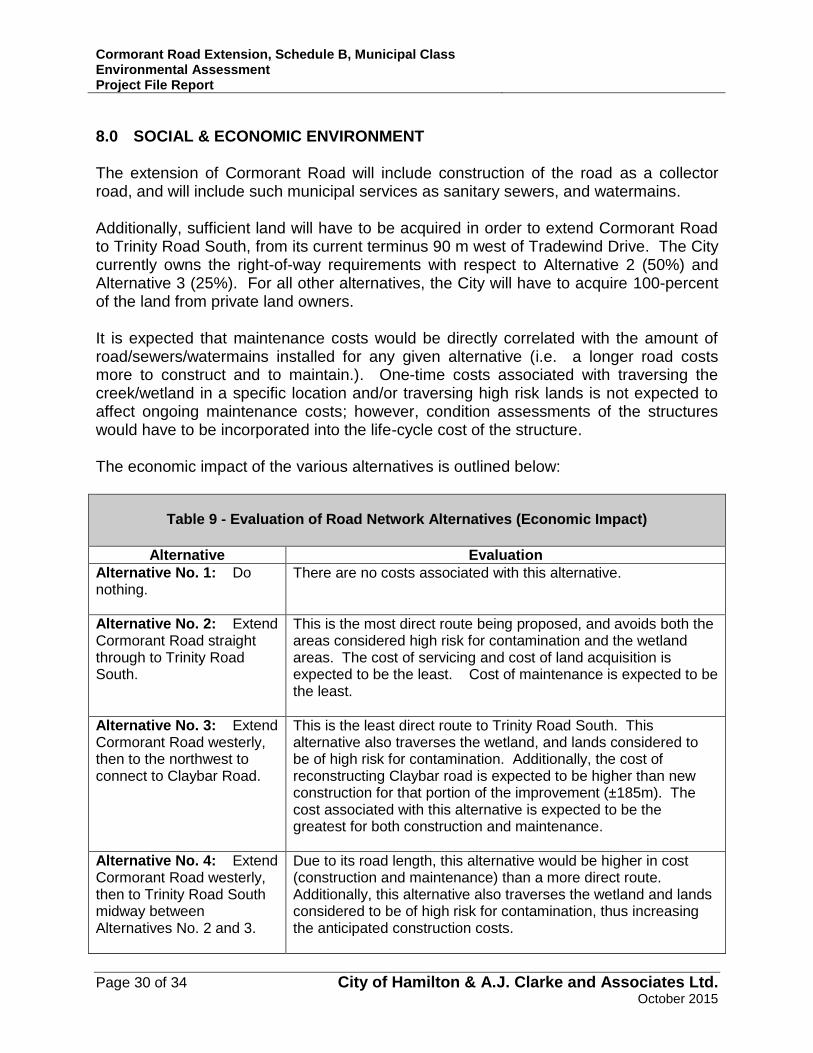
8.0 SOCIAL & ECONOMIC ENVIRONMENT The extension of Cormorant Road will include construction of the road as a collector road, and will include such municipal services as sanitary sewers, and watermains. Additionally, sufficient land will have to be acquired in order to extend Cormorant Road to Trinity Road South, from its current terminus 90 m west of Tradewind Drive. The City currently owns the right-of-way requirements with respect to Alternative 2 (50%) and Alternative 3 (25%). For all other alternatives, the City will have to acquire 100-percent of the land from private land owners. It is expected that maintenance costs would be directly correlated with the amount of road/sewers/watermains installed for any given alternative (i.e. a longer road costs more to construct and to maintain.). One-time costs associated with traversing the creek/wetland in a specific location and/or traversing high risk lands is not expected to affect ongoing maintenance costs; however, condition assessments of the structures would have to be incorporated into the life-cycle cost of the structure. The economic impact of the various alternatives is outlined below:
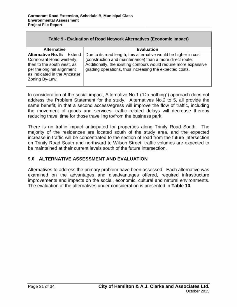
Table 9 - Evaluation of Road Network Alternatives (Economic Impact)
Alternative Evaluation
Alternative No. 1: Do nothing.
There are no costs associated with this alternative.
Alternative No. 2: Extend Cormorant Road straight through to Trinity Road South.
This is the most direct route being proposed, and avoids both the areas considered high risk for contamination and the wetland areas. The cost of servicing and cost of land acquisition is expected to be the least. Cost of maintenance is expected to be the least.
Alternative No. 3: Extend Cormorant Road westerly, then to the northwest to connect to Claybar Road.
This is the least direct route to Trinity Road South. This alternative also traverses the wetland, and lands considered to be of high risk for contamination. Additionally, the cost of reconstructing Claybar road is expected to be higher than new construction for that portion of the improvement (±185m). The cost associated with this alternative is expected to be the greatest for both construction and maintenance.
Alternative No. 4: Extend Cormorant Road westerly, then to Trinity Road South midway between Alternatives No. 2 and 3.
Due to its road length, this alternative would be higher in cost (construction and maintenance) than a more direct route. Additionally, this alternative also traverses the wetland and lands considered to be of high risk for contamination, thus increasing the anticipated construction costs.
Cormorant Road Extension, Schedule B, Municipal Class Environmental Assessment Project File Report
Page 31 of 34 City of Hamilton & A.J. Clarke and Associates Ltd. October 2015
Table 9 - Evaluation of Road Network Alternatives (Economic Impact)
Alternative Evaluation
Alternative No. 5: Extend Cormorant Road westerly, then to the south west, as per the original alignment as indicated in the Ancaster Zoning By-Law.
Due to its road length, this alternative would be higher in cost (construction and maintenance) than a more direct route. Additionally, the existing contours would require more expansive grading operations, thus increasing the expected costs.
In consideration of the social impact, Alternative No.1 (“Do nothing”) approach does not address the Problem Statement for the study. Alternatives No.2 to 5, all provide the same benefit, in that a second access/egress will improve the flow of traffic, including the movement of goods and services; traffic related delays will decrease thereby reducing travel time for those travelling to/from the business park. There is no traffic impact anticipated for properties along Trinity Road South. The majority of the residences are located south of the study area, and the expected increase in traffic will be concentrated to the section of road from the future intersection on Trinity Road South and northward to Wilson Street; traffic volumes are expected to be maintained at their current levels south of the future intersection. 9.0 ALTERNATIVE ASSESSMENT AND EVALUATION Alternatives to address the primary problem have been assessed. Each alternative was examined on the advantages and disadvantages offered, required infrastructure improvements and impacts on the social, economic, cultural and natural environments. The evaluation of the alternatives under consideration is presented in Table 10.

Cormorant Road Extension, Schedule B, Municipal Class Environmental Assessment Project File Report
Page 32 of 34 City of Hamilton & A.J. Clarke and Associates Ltd. October 2015
Table 10 – Evaluation of Alternatives
Alternative Advantages/Disadvantages Infrastructure Improvements Impact on Social, Economic, Cultural and Natural Environments
Alternative No. 1: Do nothing.
Does not address the problem statement None required No impacts
Alternative No. 2: Extend Cormorant Road straight through to Trinity Road South.
Advantages: Improves the movement of traffic within the Ancaster Industrial Park Provides alternative routing choice for drivers and emergency
vehicles Most direct route available Avoids conflict with wetland, and areas considered to be high risk for
contamination Most economical route available Disadvantages: Design of left hand turn lane must consider ex. Wetland west of
Trinity Road South to avoid negative impact.
Extension of sanitary sewers, watermain and roadways along Cormorant Road approximately 720m
Modifications to Trinity Road South to allow for southbound left turn lane with 40m storage
Construction of stormwater infrastructure to manage the water quality and quantity (i.e. low impact development practices), approximately 720m.
Requires co-operation from private landowners
Construction costs: low No anticipated impacts on cultural
environment Minor impact to the natural environment
given the existing natural features and implementing appropriate mitigation measures.
Alternative No. 3: Extend Cormorant Road westerly, then to the northwest to connect to Claybar Road.
Advantages: improve the movement of traffic within the Ancaster Industrial Park Provide alternative routing choice for drivers and emergency
vehicles No new intersection created on Trinity Road South Disadvantages: Least direct route available Will traverse both wetland and areas considered to be of high risk for
contamination Expected to have highest construction/ maintenance costs
Extension of sanitary sewers, watermains and roadway approximately 630m to the exiting Claybar Road
Additional 185m of sanitary sewers, watermains, and roadway reconstruction along existing Claybar Road required
Modifications to Trinity Road South to allow for southbound left turn lane with 40m storage
Construction of stormwater infrastructure to manage the water quality and quantity (i.e. low impact development practices), approximately 815m.
Requires co-operation from private landowners
Construction costs: high No anticipated impact on cultural
environment Direct impact to wetland identified by the
Ministry of Natural Resources Work may have to be carried out in area of
high risk for contamination Reconstruction would affect existing
businesses on Claybar Road during construction
Alternative No. 4: Extend Cormorant Road westerly, then to Trinity Road South midway between Alternatives No. 2 and 3
Advantages: Improve the movement of traffic within the Ancaster Industrial Park Provide alternative routing choice for drivers and emergency
vehicles Disadvantages: Not the most direct route available Will traverse both wetland and areas considered to be of high risk for
contamination Expected to be less economical than a more direct route Design of left hand turn lane must consider ex. Wetland west of
Trinity Road South to avoid negative impact
Extension of sanitary sewers, watermains and roadways approximately 800m
Modifications to Trinity Road South to allow for southbound left turn lane with 40m storage
Construction of stormwater infrastructure to manage the water quality and quantity (i.e. low impact development practices), approximately 800m.
Requires co-operation from private landowners
Construction costs: high No anticipated impact on cultural
environment Direct impact to wetlands identified by the
Ministry of Natural Resources Work may have to be carried out in area of
high risk for contamination
Alternative No. 5: Extend Cormorant Road westerly, then to the south west, as per the original alignment as indicated in the Ancaster Zoning By-Law.
Advantages: Improve the movement of traffic within the Ancaster Industrial Park Provide alternative routing choice for drivers and emergency
vehicles Disadvantages: Not the most direct route available Conflicts with land requirements for expanded pond as required by
current engineering standards
Extension of sanitary sewers, storm sewers, watermains, and roadways approximately 750m
Extension of watermain on Trinity Road South, approximately 110m south.
Modifications to Trinity Road South to allow for southbound left turn lane with 40m storage
Construction of stormwater infrastructure to manage the water quality and quantity (i.e. low impact development practices), approximately 750m.
Requires co-operation from private landowners
Construction costs: med No anticipated impacts on cultural
environment Minor impact to the natural environment
given the existing natural features and implementing appropriate mitigation measures
Cormorant Road Extension, Schedule B, Municipal Class Environmental Assessment Project File Report
Page 33 of 34 City of Hamilton & A.J. Clarke and Associates Ltd. October 2015
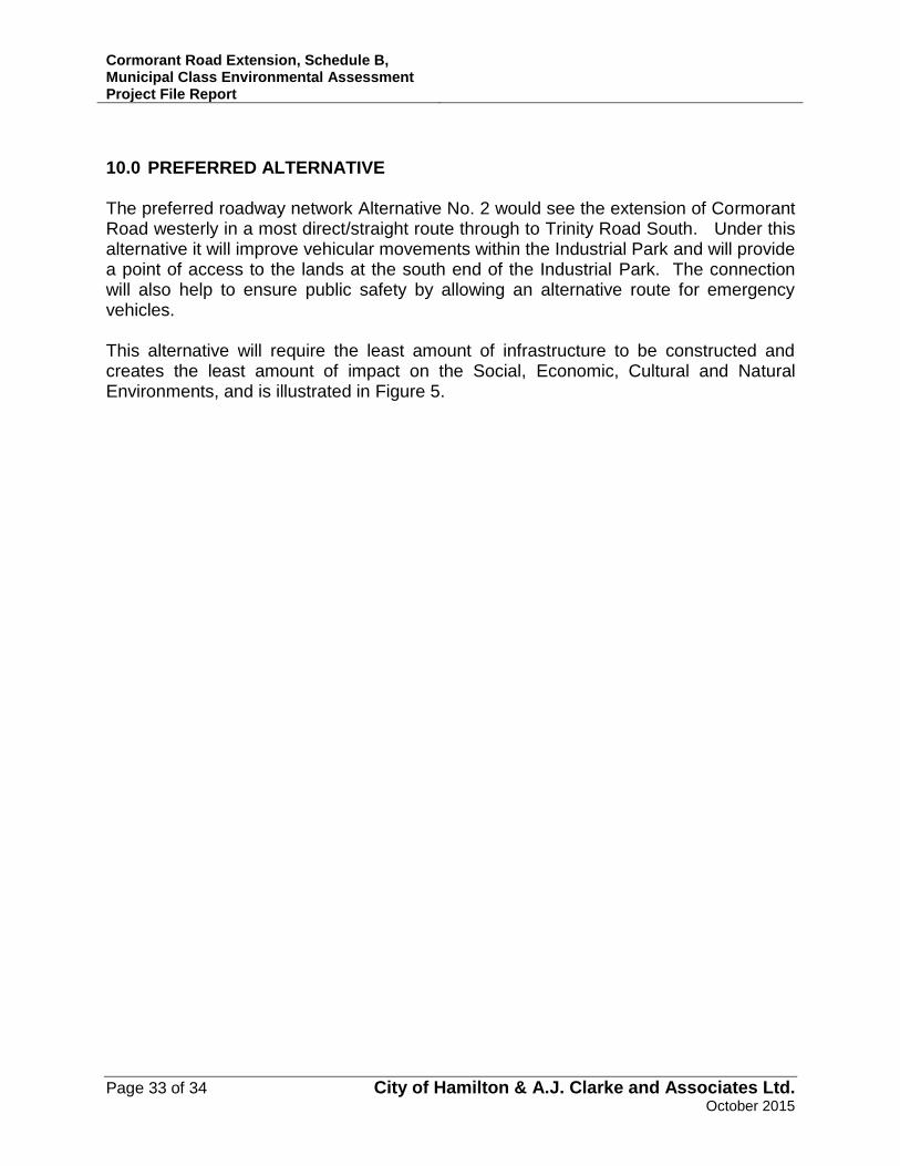
10.0 PREFERRED ALTERNATIVE The preferred roadway network Alternative No. 2 would see the extension of Cormorant Road westerly in a most direct/straight route through to Trinity Road South. Under this alternative it will improve vehicular movements within the Industrial Park and will provide a point of access to the lands at the south end of the Industrial Park. The connection will also help to ensure public safety by allowing an alternative route for emergency vehicles. This alternative will require the least amount of infrastructure to be constructed and creates the least amount of impact on the Social, Economic, Cultural and Natural Environments, and is illustrated in Figure 5.

Cormorant Road Extension, Schedule B, Municipal Class Environmental Assessment Project File Report
Page 34 of 34 City of Hamilton & A.J. Clarke and Associates Ltd. October 2015
Figure 5 – Preferred Alternative

Cormorant Road Extension, Schedule B, Municipal Class Environmental Assessment Project File Report
City of Hamilton & A.J. Clarke and Associates Ltd. October 2015
APPENDIX A
PUBLIC INFORMATION CENTRE DOCUMENTS

Cormorant Road Extension, Schedule B, Municipal Class Environmental Assessment Project File Report
City of Hamilton & A.J. Clarke and Associates Ltd. October 2015
(This page was left black intentionally)

Cormorant Road Extension, Schedule B, Municipal Class Environmental Assessment Project File Report
City of Hamilton & A.J. Clarke and Associates Ltd. October 2015
APPENDIX B
PUBLIC CORRESPONDENCE

Cormorant Road Extension, Schedule B, Municipal Class Environmental Assessment Project File Report
City of Hamilton & A.J. Clarke and Associates Ltd. October 2015
(This page was left black intentionally)

Cormorant Road Extension, Schedule B, Municipal Class Environmental Assessment Project File Report
City of Hamilton & A.J. Clarke and Associates Ltd. October 2015
Full Listing of Agencies Circulated
Utility Agencies
Bell Canada
Cogeco Cable
Fibrewired
Hamilton Utilities Corporation
Hydro One Networks Inc.
Imperial Oil Products & Chemical Division
Metrolinx
Sun Canadian Pipeline
TransCanada Pipelines
Enbridge Pipelines Inc.
Union Gas
Canadian National Railway
Southern Ontario Railway
Municipal Agencies
City of Hamilton, Emergency Services – Fire City of Hamilton, Emergency Services
City of Hamilton, Economic Development
City of Hamilton, Public Health and Community Services
City of Hamilton, Public Works
City of Hamilton, Planning and Development
City of Hamilton, Hamilton Police Services
City of Hamilton, Open Space Development
City of Hamilton, Traffic and Engineering Operations
City of Hamilton, Ward 12 Councillor
Hamilton Chamber of Commerce
Provincial Agencies
Grand River Conservation Authority
Ministry of Culture/Ministry of Tourism Recreation
Ministry of Natural Resources, Guelph District
Ministry of the Environment, Hamilton Office
Ministry of Aboriginal Affairs, Consultation Unit
Ministry of Transportation, Highway Engineering
Ministry of Agriculture, Food & Rural Affairs
Ministry of Municipal Affairs and Housing
Ontario Provincial Police, Burlington Detachment
Ministry of Tourism, Culture and Sport

Cormorant Road Extension, Schedule B, Municipal Class Environmental Assessment Project File Report
City of Hamilton & A.J. Clarke and Associates Ltd. October 2015
Full Listing of Agencies Circulated
Federal Agencies
Aboriginal Affairs and Northern Development Canada
Environment Canada
Canadian Centre for Inland Waters
Canadian Environmental Assessment Agency
Department of Fisheries and Oceans
Canada Post
Hamilton Port Authority
First Nations
Huron-Wendat Nation Council
Six Nations Eco-Centre
Six Nations on the Grand River
Haudenosaunee Resource Centre
Mississaugas of New Credit First Nation, Lands, Claims & Member Research
Centre for Topographical Information, Canadian Geographical Names Database
Non-Government Organizations
Hamilton Regional Indian Centre
The Metis Nation of Ontario
Hamilton/Wentworth Metis Council
Association of Iroquois and Allied Indians
Council of Ontario Chiefs
Assembly of First Nations
Canadian Metis Council
Hamilton Region Indian Centre
Metis National Council
Business Improvement Area (BIA) and Neighbourhood Groups
Ancaster BIA
Ancaster Community Council
Hamilton Industrial Environmental Association
Citizens at City Hall (CATCH)

Cormorant Road Extension, Schedule B, Municipal Class Environmental Assessment Project File Report
City of Hamilton & A.J. Clarke and Associates Ltd. October 2015
APPENDIX C
TRAFFIC STUDY

Cormorant Road Extension, Schedule B, Municipal Class Environmental Assessment Project File Report
City of Hamilton & A.J. Clarke and Associates Ltd. October 2015
(This page was left black intentionally)

Cormorant Road Extension, Schedule B, Municipal Class Environmental Assessment Project File Report
City of Hamilton & A.J. Clarke and Associates Ltd. October 2015
APPENDIX D
ENVIRONMENTAL MAPPING

Cormorant Road Extension, Schedule B, Municipal Class Environmental Assessment Project File Report
City of Hamilton & A.J. Clarke and Associates Ltd. October 2015
Cormorant Road Extension, Schedule B, Municipal Class Environmental Assessment Project File Report
City of Hamilton & A.J. Clarke and Associates Ltd. October 2015
APPENDIX E
TRINITY ROAD SOUTH PLAN AND PROFILE FOR SIGHT LINES
Cormorant Road Extension, Schedule B, Municipal Class Environmental Assessment Project File Report
City of Hamilton & A.J. Clarke and Associates Ltd. October 2015
(This page was left black intentionally)

Cormorant Road Extension, Schedule B, Municipal Class Environmental Assessment Project File Report
City of Hamilton & A.J. Clarke and Associates Ltd. October 2015
APPENDIX F
CITY OF HAMILTON CONTAMINATED SITES MANAGEMENT PROGRAM CONTAMINANT SCREENING REPORT

Cormorant Road Extension, Schedule B, Municipal Class Environmental Assessment Project File Report
City of Hamilton & A.J. Clarke and Associates Ltd. October 2015
(This page was left black intentionally)

Cormorant Road Extension, Schedule B, Municipal Class Environmental Assessment Project File Report
City of Hamilton & A.J. Clarke and Associates Ltd. October 2015
APPENDIX G
ARCHAEOLOGICAL STUDIES