core standard for natural resource management reporting
TRANSCRIPT

DELWP Output Data Standard
Core Standard for Natural Resource Management Reporting
March 2021

Acknowledgements
We acknowledge and respect Victorian Traditional Owners as the original custodians of Victoria’s land and waters, their unique ability to care for Country and deep spiritual connection to it. We honour Elders past and present whose knowledge and wisdom has ensured the continuation of cultural and traditional practices.
We are committed to genuinely partner, and meaningfully engage, with Victoria’s Traditional Owners and Aboriginal communities to support the broader protection of Country and its waterways in the 21st century and beyond.
© The State of Victoria Department of Environment, Land, Water and Planning 2020
This work is licensed under a Creative Commons Attribution 4.0 International licence. You are free to re-use the work under that licence, on the condition that you credit the State of Victoria as author. The licence does not apply to any images, photographs or branding, including the Victorian Coat of Arms, the Victorian Government logo and the Department of Environment, Land, Water and Planning (DELWP) logo. To view a copy of this licence, visit http://creativecommons.org/licenses/by/4.0/
Printed by Green Scribble – Brunswick.
ISBN 978-1-76105-229-3 (print)
ISBN 978-1-76105-230-9 (pdf)
DisclaimerThis publication may be of assistance to you but the State of Victoria and its employees do not guarantee that the publication is without flaw of any kind or is wholly appropriate for your specific purposes and therefore disclaims all liability for any error, loss or other consequence which may arise from you relying on any information in this publication.
AccessibilityIf you would like to receive this publication in an alternative format, please telephone the DELWP Customer Service Centre on 136186, email [email protected], or via the National Relay Service on 133 677 www.relayservice.com.au. This document is also available on the internet at www.delwp.vic.gov.au.
Cover photo credit: Martin Potts, Greening Australia

Contents
Secretary’s foreword 5
Part 1: Overview 6
Introduction 6
Who should use this Standard? 6
How to use this document 7
Key Features 8
What is an output? 8
What is output data? 8
What are management outcomes? 8
Reporting management outcomes 8
Spatial data and reporting 9
Metadata statement 9
Reporting DELWP output data 10
Data accuracy 10
Related documents 10
Monitoring, Evaluation and Reporting Framework 10
DELWP Delivery Standards Compendium 11
On-line Resources 12
Structure of the Output Data Standard 12
What does an output standard look like? 12
Part 2: Common Attributes 13
Attribute data 13
Only one funding source per output 13
Can a Project ID have more than one output in more than one year? 13
Part 3: Output Data 17
1. Structural works 17
1.1 Channel 18
1.2 Water storage 21
1.3 Pump 23
1.4 Irrigation infrastructure 25
1.5 Waterway structure 28
1.6 Terrestrial structure 31
1.7 Terrestrial feature 34
1.8 Monitoring structure 35
1.9 Fence 37
1.10 Visitor facility 41
1.11 Road 44
1.12 Crossing 47
1.13 Marine and Coastal Structure 50
2. Environmental works 53
2.1 Vegetation 56
2.2 Weed control 60
2.3 Pest animal control 63
2.4 Over-abundant wildlife control 67
2.5 Threatened species response 70
2.6 Emergency species response 73
2.7 Soil treatment 76
2.8 Earth works 79
2.9 Rubbish removal 81
3. Management services 83
3.1 Grazing 83
3.2 Agricultural practices 86
3.3 Water 89
3.4 Fire 92
4. Planning and regulation 95
4.1 Approval and advice 96
4.2 Management agreement 99
4.3 Assessment 101
4.4 Engagement event 104
4.5 Partnership 108
4.6 Plan 110
4.7 Publication 112
4.8 Information management system 114

4 DELWP Output Data Standard
Department of Environment, Land, Water and Planning
Part 4: Development, governance and control of the Standard 116
How the current Standard was developed 116
Governance 117
Control of the Standards 117
What is the Technical Working Group (TWG)? 117
What does Review of the Standard mean? 117
Triggers for Review 117
Part 5: Appendices 118
Appendix A: Glossary 118
Appendix B: Acronyms 121
Appendix C: Expected management outcomes 121
Appendix D: Metadata Statement Template 127
Appendix E: Units of Measure Table (for VWPIF projects only) 128

5Core Standard for Natural Resource Management Reporting
Department of Environment, Land, Water and Planning
Secretary’s foreword
I am pleased to endorse this revision of the Output Data Standard on behalf of the Department of Environment, Land, Water and Planning (DELWP), to promote best practice data collection and management.
This updated version brings together more than two years of collaboration across DELWP and our major delivery and reporting partners.
The Data Standard is crucial to DELWP’s ability to report against natural resource management (NRM) investment outcomes and to make informed decisions on adaptive management and program improvements.
The Data Standard is a practical guide for natural resource managers to understand how to collect and report data on DELWP-funded activities; what they did and where they did it. The Data Standard operates within DELWP and in many of our partner organisations, including Catchment Management Authorities, Parks Victoria, and Trust for Nature.
The key pillars of this approach are consistency, efficiency, transparency, and stability – all ensuring we are continually improving the way we approach our work and report outcomes.
This update supports the Victorian Government’s Water for Victoria and Biodiversity 2037. It also includes a new chapter to accommodate data collection associated with the recently released Marine and Coastal Policy (2020). It aligns with Pupangarli Marnmarnepu 'Owning Our Future', Aboriginal Self-Determination Reform Strategy (2020-2025).
The Integrated Catchment Reporting team at DELWP will continue to work with the Aboriginal Self Determination Reform Branch to include a dedicated chapter focused on Traditional Owners in the next update.
DELWP is also updating on-ground delivery standards for activities such as pest management and fencing. This improved guidance helps ensure our data collection meets the diverse monitoring, evaluation, and reporting requirements of Victoria’s natural resource management sector.
The cross-departmental collaboration with longstanding industry and agency partners on this project is an excellent example of our One-DELWP ethos.
I look forward to seeing the continued collaboration, innovation, and valuable improvements to data collection and management systems into the future.
John Bradley Secretary
6 DELWP Output Data Standard
Department of Environment, Land, Water and Planning
Part 1: Overview
Introduction
The Victorian Department of Environment, Land, Water and Planning (DELWP) Output Data Standard is one of the standards developed under the Monitoring, Evaluation and Reporting Framework (MER Framework) 2012. The Output Data Standard specifies what and how output data must be spatially reported and provides guidance for reporting outputs delivered under DELWP investment.
The Output Data Standard (the Standard) describes the minimum information requirements for reporting on the most common goods and services (i.e. outputs) that the department purchases through its range of investment programs. Specifically, they provide a consistent set of data labels linked to a point, line or area (polygon) on a map. This is important for tracking investment and management effectiveness over time.
The Standard provides descriptors for the outputs from natural resource management (NRM) investment and clarity on reporting requirements. They are the basis for consistent output data and reporting by DELWP on investment outputs and enable:
• broad and consistent public reporting, such as Budget Paper 3 reporting
• tracking of investment
• compilation of data from across NRM investors.
• accurate tracking of adaptive environmental management effectiveness over time
The Standard is periodically reviewed to encompass a broader range of outputs with the capacity to support reporting across all NRM programs and investments including other State agency and Federal NRM programs. Policy and program officers and decision makers managing reviews of the Standard should refer to Part 4 (Governance) for details of the governance arrangements underpinning the Standard.
Who should use this Standard?
The Standard applies to all DELWP programs that invest in NRM, and to the agency partners delivering those programs as described in their funding agreements. They specify the minimum standard for reporting on outputs, principally for program and financial acquittal. Where/if other spatial data requirements are needed for specific programs they will be specified and will be explicit in those programs’ agreements.
Program investment managers should be familiar with the Standard and their use in program financial acquittal and budget reporting. They should ensure that, if/where any other spatial data requirements are applied that data can be mapped/translated to this Standard.
Reporting organisations (where required under agreement) should be familiar with them and ensure the data they provide to DELWP meets the Standard as described in their funding or program agreements.
Data Managers should ensure the Standard is complied with as described in their funding or program agreements. They have been developed to specify the minimum standard for reporting on outputs.
Outputs in the current standard have been tailored to fit the needs of a range of DELWP NRM programs. The Standard is continually evolving to encompass a broader range of outputs with the capacity to support reporting across all NRM programs and investments including other State agency and Federal NRM programs.
7Core Standard for Natural Resource Management Reporting
Department of Environment, Land, Water and Planning
The following groups and organisations were involved in developing this version (v3) of the Standard, including input from each of their major reporting and/or collaborating partners:
• Environment and Climate Change Group (DELWP)
• Water and Catchments Group (DELWP)
• Victorian Catchment Management Authorities (CMAs)
• Parks Victoria (PV)
• Agriculture Victoria (Department of Jobs, Regions and Precincts - DJPR)
• Forests, Fire & Regions Group (DELWP)
• Aboriginal Self-Determination Reform Branch (DELWP)
• Trust for Nature (TfN)
How to use this document
This document is provided in five parts (Table 1). We recommend that all readers familiarise themselves with the key features of the Standard by reading Part 1 of the document and then navigate to the relevant sections as needed.
For example:
Practitioners using the Standard to collect and record output data should familiarise themselves with Part 1 (Overview) and Part 2 (Common Attributes) before applying the Standard in accordance with Part 3 (Output Data). Further guidance on their use is contained in chapter notes and in other guidance documents such as the Spatial output reporting guideline at: https://www.water.vic.gov.au/waterways-and-catchments/our-catchments/integrated-reporting
Policy and program officers and decision makers managing reviews of the Standard should refer to Part 4 (Governance) for details of the governance arrangements underpinning the Standard.
Data curators and analysts using the Standard to organise and interpret data will find initial advice in the notes at the beginning of each chapter and may also refer to external guidelines (Spatial output reporting guideline at: https://www.water.vic.gov.au/waterways-and-catchments/our-catchments/integrated-reporting) to gain an understanding of the protocols and assumptions underpinning data collected using the Standard.
Funding bodies using the Standard in the delivery of their programs should refer to Part 2 (Common Attributes) and Part 3 (Output Data Standard) for developing output data requirements associated with works programs and funding agreements. Funding bodies are also encouraged to ensure that the DELWP Delivery Standard are also referred to in the delivery of their program of works. The Delivery Standard can be located at: https://www.water.vic.gov.au/waterways-and-catchments/our-catchments/integrated-reporting
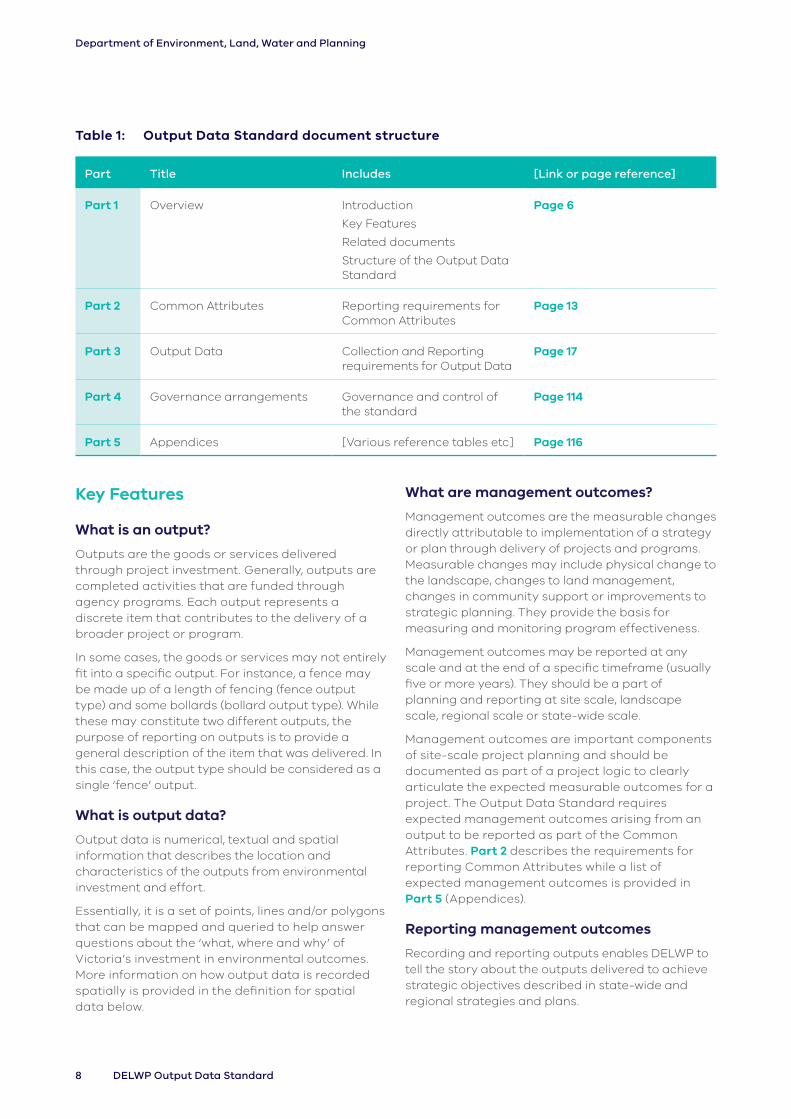
Table 1 provides a summary of the five parts of the Standard.
8 DELWP Output Data Standard
Department of Environment, Land, Water and Planning
Table 1: Output Data Standard document structure
Part Title Includes [Link or page reference]
Part 1 Overview Introduction
Key Features
Related documents
Structure of the Output Data Standard
Page 6
Part 2 Common Attributes Reporting requirements for Common Attributes
Page 13
Part 3 Output Data Collection and Reporting requirements for Output Data
Page 17
Part 4 Governance arrangements Governance and control of the standard
Page 114
Part 5 Appendices [Various reference tables etc] Page 116
Key Features
What is an output?
Outputs are the goods or services delivered through project investment. Generally, outputs are completed activities that are funded through agency programs. Each output represents a discrete item that contributes to the delivery of a broader project or program.
In some cases, the goods or services may not entirely fit into a specific output. For instance, a fence may be made up of a length of fencing (fence output type) and some bollards (bollard output type). While these may constitute two different outputs, the purpose of reporting on outputs is to provide a general description of the item that was delivered. In this case, the output type should be considered as a single ‘fence’ output.
What is output data?
Output data is numerical, textual and spatial information that describes the location and characteristics of the outputs from environmental investment and effort.
Essentially, it is a set of points, lines and/or polygons that can be mapped and queried to help answer questions about the ‘what, where and why’ of Victoria’s investment in environmental outcomes. More information on how output data is recorded spatially is provided in the definition for spatial data below.
What are management outcomes?
Management outcomes are the measurable changes directly attributable to implementation of a strategy or plan through delivery of projects and programs. Measurable changes may include physical change to the landscape, changes to land management, changes in community support or improvements to strategic planning. They provide the basis for measuring and monitoring program effectiveness.
Management outcomes may be reported at any scale and at the end of a specific timeframe (usually five or more years). They should be a part of planning and reporting at site scale, landscape scale, regional scale or state-wide scale.
Management outcomes are important components of site-scale project planning and should be documented as part of a project logic to clearly articulate the expected measurable outcomes for a project. The Output Data Standard requires expected management outcomes arising from an output to be reported as part of the Common Attributes. Part 2 describes the requirements for reporting Common Attributes while a list of expected management outcomes is provided in Part 5 (Appendices).
Reporting management outcomes
Recording and reporting outputs enables DELWP to tell the story about the outputs delivered to achieve strategic objectives described in state-wide and regional strategies and plans.

9Core Standard for Natural Resource Management Reporting
Department of Environment, Land, Water and Planning
Where there is no specific state/regional strategy or plan in place, programs and projects should report on the most relevant management outcome outlined in this Standard.
A project manager may look at a range of evidence to understand the progress of a project; however, from a strategic planning viewpoint, the crucial evidence is linked to the intent of the appropriate plan or strategy.
For example, a fence may be built to control rabbit numbers and the higher order intent may be to improve vegetation structure and diversity. However, strategically, the intent may be to protect habitat to encourage the recovery of a threatened species of bird. If the funding and planning has been provided for the recovery of the bird, and it is linked to a management outcome in a specific state or regional plan, then this is the management outcome required to be recorded as an attribute of the Standard Output.
An alternative approach, trialled in a previous iteration of this Standard, was to document the immediate management outcome of an output. This approach has been shown subsequently to limit the ability to identify how management outcomes are linked to strategic planning. Using this alternative approach in the above example, species recovery would be reported as species control – for a completely different species.
Management outcomes are important components of site-scale projects. They should be developed as part of the project logic and clearly articulate the expected measurable outcomes from a project. Only the broader, strategic management outcomes need to be provided in reported standard outputs.
Spatial data and reporting
The standard outputs need to be provided spatially to enable otherwise complex, abstract data to be interpreted by a wide range of stakeholders, without need for specialised training or software. Accurately locating outputs on a map allows DELWP subject matter experts to interpret, rationalise and project impacts of their investments, whilst concurrently allowing all stakeholders to view the scope and scale
of their work and its contributions to work across the state. The value of this interpretive ability cannot be understated for business intelligence as well as natural resource management and conservation purposes. The initial collection, collation and reporting of output data is the responsibility of delivery agencies.
Individual outputs are captured as either a polygon, line or point feature. In the Standard, each output includes a description of the appropriate spatial data feature.
Sometimes it can be difficult to use these spatial features to describe output data. For example, several outputs may not be specifically considered spatial in nature, including partnerships, publications and information management systems. It is important for these outputs to be attached to a spatial feature so that the output database can be a complete record of all outputs, rather than needing two separate databases. It also simplifies reporting by requiring agencies to report only once, rather than having to use two different reporting processes.
For convenience, each non-spatial output should be registered to a point feature located on the office of the delivery agent.
The Spatial output reporting guideline at: https://www.water.vic.gov.au/waterways-and-catchments/our-catchments/integrated-reporting provides guidelines on how to record spatial data.
Metadata statement
Spatial data submitted with the output data each year must be accompanied by a metadata statement consistent with the concepts and guidelines developed by the Australia New Zealand Land Information Council (ANZLIC). In accordance with the National Metadata Directory System, a set of mandatory core metadata elements are required. Any additional information that is deemed relevant to interpret the data supplied should also be provided in an accompanying document.
For detailed information on creating a metadata profile for your spatial data, please visit: https://www.anzlic.gov.au/resources/anzlic-metadata-profile
10 DELWP Output Data Standard
Department of Environment, Land, Water and Planning
Reporting DELWP output data
Outputs should be provided to the timeline specified by the relevant funding agreements with investment programs. Delivery Agents (see part 2, Table 1) should provide data to DELWP in an ESRI file geodatabase format (model geodatabase available on request ([email protected]), only if no alternate format is described in individual funding agreements.
If required, additional spatial data requirements specific to individual funding programs, including reporting schedules, will be described in funding agreements. This is to be discussed with the funding agency during development of project proposals and funding agreements.
The Spatial output reporting guideline at: https://www.water.vic.gov.au/waterways-and-catchments/our-catchments/integrated-reporting provides further guidance on reporting requirements.
Data accuracy
Spatial data should be as accurate as possible. For purposes of mapping, the underlying data is usually mapped at 1:25,000. Positional accuracy should provide a reasonable guide to the location of reported
outputs and clearly distinguish the location of one activity from another. For polygons the area (hectares) mapped should be a reasonable representation of the area over which the output was delivered.
Related documents
Monitoring, Evaluation and Reporting Framework
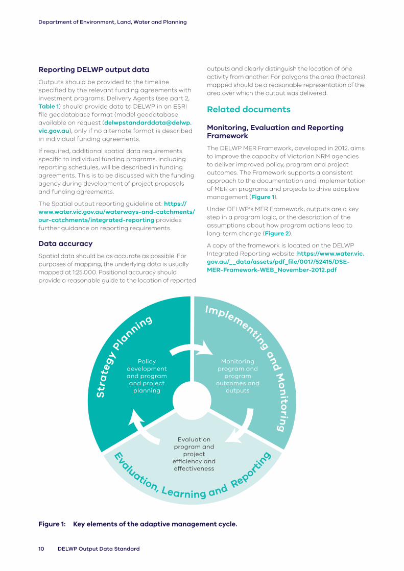
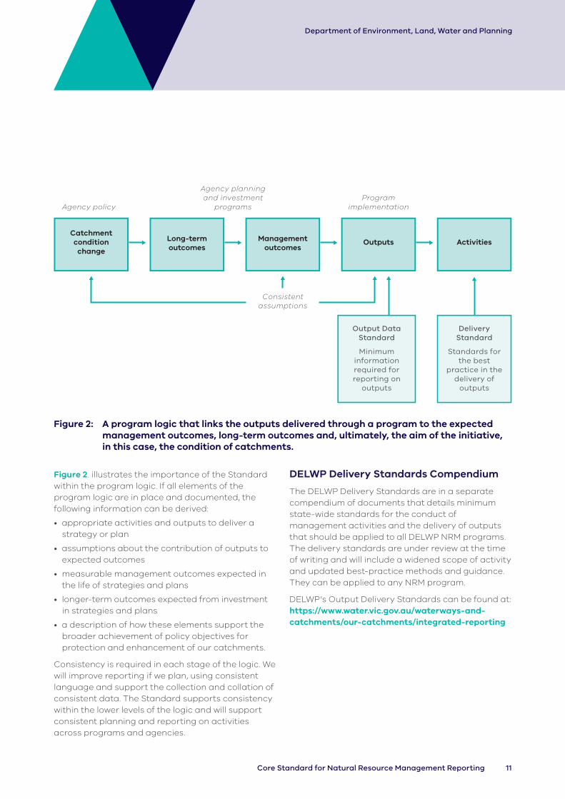
The DELWP MER Framework, developed in 2012, aims to improve the capacity of Victorian NRM agencies to deliver improved policy, program and project outcomes. The Framework supports a consistent approach to the documentation and implementation of MER on programs and projects to drive adaptive management (Figure 1).
Under DELWP’s MER Framework, outputs are a key step in a program logic, or the description of the assumptions about how program actions lead to long-term change (Figure 2).
A copy of the framework is located on the DELWP Integrated Reporting website: https://www.water.vic.gov.au/__data/assets/pdf_file/0017/52415/DSE-MER-Framework-WEB_November-2012.pdf
Policy development and program and project
planning
Monitoring program and
program outcomes and
outputs
Evaluation program and
project efficiency and effectiveness
Figure 1: Key elements of the adaptive management cycle.
11Core Standard for Natural Resource Management Reporting
Department of Environment, Land, Water and Planning
Catchment condition
change
Long-term outcomes
Agency planning and investment
programs
Consistent assumptions
Output Data Standard
Minimum information required for reporting on
outputs
Delivery Standard
Standards for the best
practice in the delivery of
outputs
Program implementationAgency policy
Management outcomes
Outputs Activities
Figure 2: A program logic that links the outputs delivered through a program to the expected management outcomes, long-term outcomes and, ultimately, the aim of the initiative, in this case, the condition of catchments.
Figure 2. illustrates the importance of the Standard within the program logic. If all elements of the program logic are in place and documented, the following information can be derived:
• appropriate activities and outputs to deliver a strategy or plan
• assumptions about the contribution of outputs to expected outcomes
• measurable management outcomes expected in the life of strategies and plans
• longer-term outcomes expected from investment in strategies and plans
• a description of how these elements support the broader achievement of policy objectives for protection and enhancement of our catchments.
Consistency is required in each stage of the logic. We will improve reporting if we plan, using consistent language and support the collection and collation of consistent data. The Standard supports consistency within the lower levels of the logic and will support consistent planning and reporting on activities across programs and agencies.
DELWP Delivery Standards Compendium
The DELWP Delivery Standards are in a separate compendium of documents that details minimum state-wide standards for the conduct of management activities and the delivery of outputs that should be applied to all DELWP NRM programs. The delivery standards are under review at the time of writing and will include a widened scope of activity and updated best-practice methods and guidance. They can be applied to any NRM program.
DELWP’s Output Delivery Standards can be found at: https://www.water.vic.gov.au/waterways-and-catchments/our-catchments/integrated-reporting
12 DELWP Output Data Standard
Department of Environment, Land, Water and Planning
On-line Resources
An on-line resource with links to a number of key reporting documents, including the current version of the Output Data Standard and Technical Guidance Documentation is available at the following DELWP webpage: https://www.water.vic.gov.au/waterways-and-catchments/our-catchments/integrated-reporting
In the future DELWP will use this page to update related information; including any additional guidance for reporting.
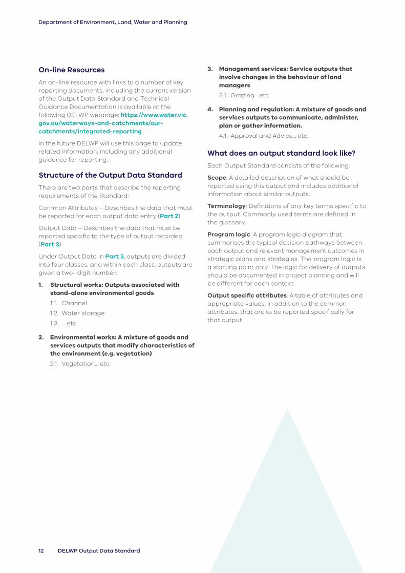
Structure of the Output Data Standard
There are two parts that describe the reporting requirements of the Standard:
Common Attributes – Describes the data that must be reported for each output data entry (Part 2)
Output Data – Describes the data that must be reported specific to the type of output recorded (Part 3)
Under Output Data in Part 3, outputs are divided into four classes, and within each class, outputs are given a two- digit number:
1. Structural works: Outputs associated with stand-alone environmental goods
1.1. Channel
1.2. Water storage
1.3. … etc.
2. Environmental works: A mixture of goods and services outputs that modify characteristics of the environment (e.g. vegetation)
2.1. Vegetation… etc.
3. Management services: Service outputs that involve changes in the behaviour of land managers
3.1. Grazing… etc.
4. Planning and regulation: A mixture of goods and services outputs to communicate, administer, plan or gather information.
4.1. Approval and Advice… etc.
What does an output standard look like?
Each Output Standard consists of the following:
Scope: A detailed description of what should be reported using this output and includes additional information about similar outputs.
Terminology: Definitions of any key terms specific to the output. Commonly used terms are defined in the glossary.
Program logic: A program logic diagram that summarises the typical decision pathways between each output and relevant management outcomes in strategic plans and strategies. The program logic is a starting point only. The logic for delivery of outputs should be documented in project planning and will be different for each context.
Output specific attributes: A table of attributes and appropriate values, in addition to the common attributes, that are to be reported specifically for that output.

13Core Standard for Natural Resource Management Reporting
Department of Environment, Land, Water and Planning
Part 2: Common Attributes
Attribute data
Each output requires the following common attribute data. For most outputs there are also additional requirements to provide ‘specific attributes’. These are described individually for each output in a table on the relevant page.
Only one funding source per output
In many cases, a single project may include the use of multiple fund sources. For example, a waterway project may deliver 5km of fence. 2.5 km of the fence is funded by the RRAP and 2.5 km of the fence is funded by On-Ground Works. The output data provided to DELWP for such a project must have two unique records - one that identifies that half of the fence was funded by the RRAP, and the other that identifies half was funded by On-Ground Works.
Can a Project ID have more than one output in more than one year?
The one Project ID may be used to relate different output types completed in relation to the one project.
For example, in the first year Fencing (1.9 Fence), or Weed control (2.2), may be used, while in a second year, revegetation (2.1 Vegetation), and additional weed control (2.2), may be undertaken. In this situation, four outputs, two recorded for each year, are used in relation to the one project, each with the same Project ID. In the case of a baiting program (2.3 Pest Animal Control), where the baiting station is revisited, and baiting reapplied each year over several years, it is appropriate to provide a separate output (for 2.3 Pest Animal Control) for each financial year active treatment was undertaken for the spatial extent identified.
Terminology Variations
Please note that definitions provided at the beginning of each chapter will vary slightly dependent on individual context, this is necessary to ensure accuracy and compatibility with established terminology between practical application contexts. For example, a waterway in the context of earthworks for irrigation drainage has a slightly different definition in the context of monitoring structures for wetland or marine environments.
Description of common attribute data required for each output.
Attribute Description Source
Output ID Unique identifier for each output delivered.
The Output ID should be composed of a two-to-six letter agency code (e.g. PV, NECMA, TFN, etc), followed by a unique number and followed by a dash, then the financial year in which it is being reported.
e.g. EGCMA000001-20/21
Where an output is composed of more than one spatial feature, the Output ID applies to both spatial features. It is crucial that each ID is unique to the output to avoid indexing conflicts in the database once received.
Provided by delivery agent as part of output reporting

14 DELWP Output Data Standard
Department of Environment, Land, Water and Planning
Attribute Description Source
Output Data Standard version
1.1, 1.2, 2.1 etc
This version of the Standard is v3.0
See Output Data Standard
Output Delivery Standard Version
DELWP V2.1
DELWP V3.0 (Level 1)
DELWP V3.0 (Level 2)
DELWP V3.0 (Level 3)
Other
See Delivery Standards
Output Title Used to simplify data collection by grouping goods and services which have similar data requirements, e.g. Channel, Assessment.
See individual outputs for relevant values
Output Type Provides a more detailed classification of outputs. See individual outputs for relevant values
Activity Type Broadly defines the changes being made to the output using terms such as: install, maintain, modify, remove, develop and review.
See individual outputs for relevant values
Year Completed Identifies the financial year in which the output was completed. Outputs are reported annually, per financial year.
Where the same output is delivered again in the following year (e.g. maintenance of vegetation) the outputs should be reported separately. The Financial year is to be expressed as a 4 digit integer with the financial years divided by a forward slash where 17/18 is used to denote the Financial year 2017/2018.
Provided by delivery agent as part of output reporting
Fund Source The name of the key fund source.
This could be a DELWP investment program or, where the investor is not DELWP, the appropriate agency title for the investment source.
This information enables the story about how the output helps deliver on the agency strategy and plans to be told. It is important that the fund source name can be traced to a specific purpose. So ‘DELWP funding’ is not sufficient but ‘DELWP Waterway Health Program’ would be.
The same applies to other fund sources such as the Australian Government.
In the case of funding from private individuals, it would be enough to identify the funding source as ‘Private landholder’.
Provided by relevant agency or investment program
Project ID An identifier used for outputs delivered under a single project E.g. a fence, weed control and rubbish control outputs are delivered as part of a single project and should have the same Project ID. The Project ID should identify the relevant investment program. Details specific to individual investment programs (Victorian Waterway Program Investment Framework (VWPIF) use of Project Information Retrieval System (PIRs) or Enquire code for example) will be contained in individual funding agreements.
Provided by relevant agency or investment program

15Core Standard for Natural Resource Management Reporting
Department of Environment, Land, Water and Planning
Attribute Description Source
Delivery agent (receiving funds)
Identify the delivery partner or relevant government agency responsible for the management, coordination and reporting of the output to DELWP.
This information identifies outputs that are delivered with significant support from community groups or are delivered through government agencies. If delivery is shared across multiple agencies, provide the major delivery partner.
This is general information, so there is no need to specify the exact name of the group – use one of the following:
Provided by delivery agent as part of output reporting
• Landcare
• Management committee
• Friends-of group
• Private land manager
• Traditional Owner
• Aboriginal Victorians
• CMA
• Parks Victoria
• DELWP
• Trust for Nature
• Coastcare
• Non-Government organisation
• Community groups
• Not for Profit organisation
• Research organisation
• Water corporation
• Local council
• Government agency
• Other
On ground works agent (carrying out works)
Identify the community partner or relevant government agency involved in the primary on-ground works delivery of the output.
This information identifies outputs that are delivered with significant support from community groups or are delivered through government agencies. If delivery is shared across multiple agencies, provide the major delivery partner.
This is general information, so there is no need to specify the exact name of the group – use one of the following:
Provided by delivery agent as part of output reporting
• Aboriginal Victorians
• CMA
• Coastcare
• Community groups
• Delivery agent staff
• DELWP
• Friends-of group
• Government agency
• Landcare
• Management committee
• Non-Government organisation
• Not for Profit organisation
• Parks Victoria
• Private land manager
• Research organisation
• Traditional Owner
• Trust for Nature
• Water corporation
• Other

16 DELWP Output Data Standard
Department of Environment, Land, Water and Planning
Attribute Description Source
Planned Management Outcome
The key management outcomes that the output is contributing to in the appropriate plan or strategy.
If there is no specific management outcome documented in a plan (or no plan exists), provide an appropriate title from the list in Appendix C.
Provided by relevant agency or investment program
Planned Management Outcome Direction of Change
Broadly defines the outcomes sought using the following categories:
• Increase
• Maintain
• Reduce
See individual outputs for relevant values
Specific Attribute #1 (e.g. Volume of water conveyed)
Specific attributes are provided within each Standard.
Provide a new tabular column for each specific attribute as required.
Unique Site ID A Unique Site ID is required for all DELWP funded on-ground outputs on sites where multiple outputs will be captured over time. This ID will be used to analyse outputs at the site scale, and to reduce substantial double counting issues for riparian metrics like ‘length area of riparian land improved or protected’, where outputs are delivered at the same work site within the same year and across multiple years (e.g. a hectare of weed control, fencing and revegetation at the same site is one hectare of land improved, not three). It will also be used to more accurately answer questions such as ‘what is the length of land improved over EC5’, particularly in a riparian context.
This ID grouping is generally not at the landholder or property scale, but at the individual on-ground works site scale, i.e. at a scale that will reduce the double counting issues described above. Many properties will have more than one site. If new on-ground works do not overlap with a current site, then give the new site a different Unique Site ID. DELWP can provide further advice as needed: [email protected].
To accommodate pre-existing Site IDs, the format of the Unique Site ID is not prescribed. Any outputs physically delivered on any DELWP Funded site must include its Unique Site ID, unless stated otherwise in program specific funding agreements. The ID is to use letters and numbers only, be no longer than 20 characters long and include no special characters (e.g. >, =, &, etc.)
These IDs are intended to be unique IDs to each Site and enable longer-term reporting.
See advice in the spatial output reporting guideline note for more detail.
https://www.water.vic.gov.au/waterways-and-catchments/our-catchments/integrated-reporting

17Core Standard for Natural Resource Management Reporting
Department of Environment, Land, Water and Planning
Part 3: Output Data
1. Structural worksStructural works are outputs associated with the management of man-made structures.
Output Title Output types
(1.1 Channel): Channel Drain
(1.2 Water storage): Constructed wetland
Dam
Reuse system
Sump
Tank
Trough
Weir
(1.3 Pump): Ground water Surface water
(1.4 Irrigation infrastructure):
Spray Irrigation Surface Irrigation Sump
(1.5 Waterway structure): Chute
Fish barrier
Fishway
Fish hotel / Lunker
Flow regulator
Groyne
Outlet
Gross pollutant trap
Rock Bank
Root Ball
Pile field
Rock Seeding
Sill
Large wood A
Large wood B
Large wood C
Large wood D
(1.6 Terrestrial structure):
Hygiene station
Sediment trap
Jute mat
Coir logs
Thatching
Revetment (not water related)
Silt fence
Straw bale
Rock bund
Check-dam
(1.7 Terrestrial feature): Man-made ground feature
Connectivity infrastructure
Artificial/Temporary Pond
Natural ground feature
Rocks
Nest box

18 DELWP Output Data Standard
Department of Environment, Land, Water and Planning
Output Title Output types
(1.8 Monitoring structure):
Bore
Hide
Trap
Measuring station
Buoy/mooring
Photo point structure
(1.9 Fence): Bollard Fence
(1.10 Visitor facility): Building Operations Recreational
(1.11 Road): Firebreak Road Trail
(1.12 Crossing): Bridge
Causeway crossing
Culvert Ford
(1.13 Marine and Coastal Structure):
Armouring
Artificial reef
Breakwater
Gross pollutant trap
Groyne
Hybrid reef
Natural reef
Sand bags
Sea wall
1.1 Channel
Scope
These data record the length of channels and drains that have been installed, maintained, modified or removed.
Related outputs: Where the output is part of an irrigation or reuse system, associated structures (e.g. dam, pump), plan/strategy (e.g. Irrigation Farm Plan), irrigation infrastructure (upgrading of existing), water storage (re- use) or assessments (survey), they should be recorded as separate outputs.
Terminology
Channel: Conveys water from one point to another, generally to irrigators from a source.
Coast – Dune: The area above the beach, from the primary (or fore) dune to the tertiary (or back/hind) dune.
Coast – Shore: Foreshore, beach.
Community drain: Initiated by landholders, who remain responsible for ongoing operation and maintenance.
Drain: Designed to carry surplus water away from an area.
Estuary: Estuaries are where rivers meet the sea and the fresh river water mixes with the salt water of the ocean. The definition of estuaries also includes coastal inlets (like Tamboon Inlet and Anderson Inlet), smaller bays (like Swan Bay and Limeburners Bay) and coastal barrier lagoons (like Jack Smith Lake and Lake Dennison). These inlets may also be classed as wetlands.
Marine – Intertidal: Area between low and high tide marks (also known as littoral zone).
Marine – Subtidal: Area which remains underwater including during low tide.
Primary drain: Owned and operated by rural water corporations or CMAs.
Stream/River: Rivers are defined here as major rivers, streams or creeks and their feeders (tributaries), and include the water, the channel and surrounding land (known as riparian land). Riparian refers to land or vegetation that adjoins a river, wetland or estuary.
Swale drain: A shallow ditch intended to drain water.
Terrestrial: Land area inland of the tertiary dune.
Wetland: Wetlands are areas whether natural, modified or artificial, subject to permanent or temporary inundation, that hold static or very slow-moving water and develop, or have the potential to develop, biota adapted to inundation and the aquatic environment. Wetlands may be formed by natural processes or human activities. Wetlands include freshwater and saline lakes, swamps and shallow waters in Victoria’s estuaries, bays and inlets.

19Core Standard for Natural Resource Management Reporting
Department of Environment, Land, Water and Planning
Soil properties Water quality Productivity
Farm waterEnvironmental
water
Soil stability
Vegetation structure &
diversity
Management outcomes in the strategies and plans
Improves
ImprovesReduces
Improves
Channel
Improves
Improves
Water levels
Legend
OutputExpected management outcome
Improves
Logic Diagram 1 (1.1 Channel): Generalised program logic that clarifies the relationship of this output with expected management outcomes (linked directly or indirectly). Conceptual models should clarify the assumptions and associated confidence in the relationships.
Data reporting
In addition to the Common Attributes detailed in Part 2 of this document, the following specific attributes must be collected and reported for each output delivered.

20 DELWP Output Data Standard
Department of Environment, Land, Water and Planning
Table 1.1: Channel specific attributes
Title Output Type
Activity Type
Environment Type
Spatial Object
Water volume
Specific Type
Description Select one from list
Select one from list
Select one from list
Location of structure
Volume of water conveyed
Select one from list
Valid values Channel Install Coast – Dune
Line ML Community
Drain Maintain Coast - Shore
Environmental Water
Modify Estuary Irrigation Supply
Remove Marine - Intertidal
Primary
Marine - Subtidal
Swale
Stream/River
Terrestrial
Wetland

21Core Standard for Natural Resource Management Reporting
Department of Environment, Land, Water and Planning
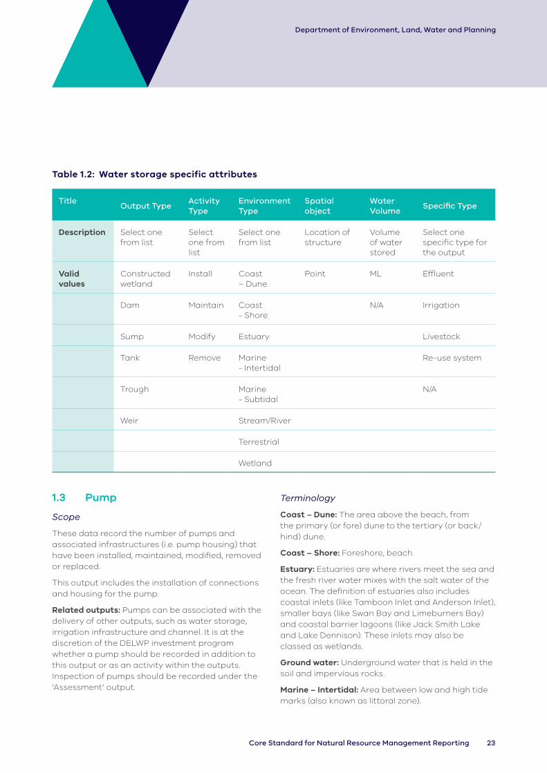
1.2 Water storage
Scope
These data record the number of structures intended to store water (e.g. dams, troughs, constructed wetlands and weirs) that have been installed, modified, maintained or removed.
These water storages serve a variety of purposes, including improving access to farm water for irrigation, re-use systems, flow and turbidity management (e.g. constructed wetlands), habitat and as off-stream watering points for livestock.
This output may relate to both natural and man-made water storages/bodies.
Related outputs: Often a water storage output is delivered in conjunction with other outputs, which should all be recorded in addition to this output. For example, fences to exclude stock or channel/pump as part of an irrigation system upgrade.
Terminology
Coast – Dune: The area above the beach, from the primary (or fore) dune to the tertiary (or back/hind) dune.
Coast – Shore: Foreshore, beach.
Constructed wetland: man-made inland, standing, shallow bodies of water, which may be permanent or temporary, fresh or saline.
Dam: A barrier constructed to hold back and store water.
Estuary: Estuaries are where rivers meet the sea and the fresh river water mixes with the salt water of the ocean. The definition of estuaries also includes coastal inlets (like Tamboon Inlet and Anderson Inlet), smaller bays (like Swan Bay and Limeburners Bay) and coastal barrier lagoons (like Jack Smith Lake and Lake Dennison). These inlets may also be classed as wetlands.
Marine – Intertidal: Area between low and high tide marks (also known as littoral zone).
Marine – Subtidal: Area which remains underwater including during low tide.
Stream/River: Rivers are defined here as major rivers, streams or creeks and their feeders (tributaries), and include the water, the channel and surrounding land (known as riparian land). Riparian refers to land or vegetation that adjoins a river, wetland or estuary.
Sump: A dam constructed for use as part of an irrigation re-use system.
Tank: A large storage chamber for water.
Terrestrial: Land area inland of the tertiary dune.
Trough: An open container for livestock to drink from.
Waterway: A natural channel in which water regularly flows, including but not limited to, a river, stream or watercourse.
Weir: A low dam built across a waterway to raise the level of water upstream or regulate its flow.
Wetland: Wetlands are areas whether natural, modified or artificial, subject to permanent or temporary inundation, that hold static or very slow-moving water and develop, or have the potential to develop, biota adapted to inundation and the aquatic environment. Wetlands may be formed by natural processes or human activities. Wetlands include freshwater and saline lakes, swamps and shallow waters in Victoria’s estuaries, bays and inlets.

22 DELWP Output Data Standard
Department of Environment, Land, Water and Planning
Improves
Improves
Improves
ImprovesImproves
Improves
Improves
Improves Improves
ImprovesImproves Improves
Improves
Management outcomes in the strategies and plans
Water quality
Productivity Soil stability
Water storage
Amenity
Farm waterEnvironmental
waterSpecies control
Vegetation structure &
diversity
Habitat available
Species recovery
Legend
OutputExpected management outcome
Logic Diagram 2 (1.2 Water storage): Generalised program logic that clarifies the relationship of this output with expected management outcomes (linked directly or indirectly). Conceptual models should clarify the assumptions and associated confidence in the relationships.
Data reporting
In addition to the Common Attributes detailed in Part 2 of this document, the following attributes must be collected and reported for each output delivered.
23Core Standard for Natural Resource Management Reporting
Department of Environment, Land, Water and Planning
Table 1.2: Water storage specific attributes
TitleOutput Type
Activity Type
Environment Type
Spatial object
Water Volume
Specific Type
Description Select one from list
Select one from list
Select one from list
Location of structure
Volume of water stored
Select one specific type for the output
Valid values
Constructed wetland
Install Coast – Dune
Point ML Effluent
Dam Maintain Coast - Shore
N/A Irrigation
Sump Modify Estuary Livestock
Tank Remove Marine - Intertidal
Re-use system
Trough Marine - Subtidal
N/A
Weir Stream/River
Terrestrial
Wetland
1.3 Pump
Scope
These data record the number of pumps and associated infrastructures (i.e. pump housing) that have been installed, maintained, modified, removed or replaced.
This output includes the installation of connections and housing for the pump.
Related outputs: Pumps can be associated with the delivery of other outputs, such as water storage, irrigation infrastructure and channel. It is at the discretion of the DELWP investment program whether a pump should be recorded in addition to this output or as an activity within the outputs. Inspection of pumps should be recorded under the ‘Assessment’ output.
Terminology
Coast – Dune: The area above the beach, from the primary (or fore) dune to the tertiary (or back/hind) dune.
Coast – Shore: Foreshore, beach.
Estuary: Estuaries are where rivers meet the sea and the fresh river water mixes with the salt water of the ocean. The definition of estuaries also includes coastal inlets (like Tamboon Inlet and Anderson Inlet), smaller bays (like Swan Bay and Limeburners Bay) and coastal barrier lagoons (like Jack Smith Lake and Lake Dennison). These inlets may also be classed as wetlands.
Ground water: Underground water that is held in the soil and impervious rocks.
Marine – Intertidal: Area between low and high tide marks (also known as littoral zone).

24 DELWP Output Data Standard
Department of Environment, Land, Water and Planning
Marine – Subtidal: Area which remains underwater including during low tide.
Pump: A device that moves water by mechanical action.
Stream/River: Rivers are defined here as major rivers, streams or creeks and their feeders (tributaries), and include the water, the channel and surrounding land (known as riparian land). Riparian refers to land or vegetation that adjoins a river, wetland or estuary.
Surface water: Water that collects on the surface of the ground.
Terrestrial: Land area inland of the tertiary dune.
Wetland: Wetlands are areas whether natural, modified or artificial, subject to permanent or temporary inundation, that hold static or very slow-moving water and develop, or have the potential to develop, biota adapted to inundation and the aquatic environment. Wetlands may be formed by natural processes or human activities. Wetlands include freshwater and saline lakes, swamps and shallow waters in Victoria’s estuaries, bays and inlets.
Improves Improves
ImprovesImproves
Improves
Reduces
Management outcomes in the strategies and plans
Species recovery
Vegetation structure &
diversityWater quality
Environmental water
Groundwater
Pump
Farm water
Productivity
Legend
OutputExpected management outcome
Improves Improves
Logic Diagram 3 (1.3 Pump): Generalised program logic that clarifies the relationship of this output with expected management outcomes (linked directly or indirectly). Conceptual models should clarify the assumptions and associated confidence in the relationships.
Data reporting
In addition to the Common Attributes detailed in Part 2 of this document, the following attributes must be collected and reported for each output delivered.

25Core Standard for Natural Resource Management Reporting
Department of Environment, Land, Water and Planning
Table 1.3: Pump specific attributes
Title Output Type Activity Type Environment Type Spatial object Tenure
Description Select one from list
Select one from list
Select one from list
Location of structure
Land manager
Valid values Ground water Install Coast – Dune Point Private
Surface water Maintain Coast - Shore Public
Modify Estuary
Remove Marine - Intertidal
Marine - Subtidal
Stream/River
Terrestrial
Wetland
1.4 Irrigation infrastructure
Scope
These data record the area where irrigation infrastructure has been installed, modified or maintained.
This includes land-forming or laser levelling to improve the efficiency of irrigation systems.
This output relates to irrigation improvements rather than irrigation structures.
This output should be used in combination with other outputs (such as 1.1 Channel, 1.2 Water storage, or 1.3 Pump) to describe overall irrigation infrastructure improvements.
Related outputs: Any associated structures covered by other outputs (e.g. water storage, channel or pump) should be recorded in addition to this output.
Terminology
Gravity irrigation system: irrigation method that applies irrigation water to paddocks by letting it flow from a higher level of supply through to fields at a lower level.
Pressurised irrigation system: irrigation method that applies irrigation water to paddocks using a pressurised system to transport water.
For an example of how this Standard can be applied in relation to works undertaken under the Sustainable Irrigation Programs, see Case Study 3 – Sustainable Irrigation - Spatial output reporting guideline at: https://www.water.vic.gov.au/waterways-and-catchments/our-catchments/integrated-reporting.

26 DELWP Output Data Standard
Department of Environment, Land, Water and Planning
Groundwater
Irrigation infrastructure
Farm water
Soil properties Water quality Productivity
Management outcomes in the strategies and plans
Legend
OutputExpected management outcome
Reduces Improves
Improves Improves
Improves Improves
Logic Diagram 4 (1.4 Irrigation infrastructure): Generalised program logic that clarifies the relationship of this output with expected management outcomes (linked directly or indirectly). Conceptual models should clarify the assumptions and associated confidence in the relationships.
Data reporting
In addition to the Common Attributes detailed in Part 2 of this document, the following attributes must be collected and reported for each output delivered.

27Core Standard for Natural Resource Management Reporting
Department of Environment, Land, Water and Planning
Table 1.4: Irrigation infrastructure specific attributes
TitleOutput type
Activity type
Spatial object
Previous typeSpecific activities
Water savings
Description Select one from list
Select one from list
Location of irrigation structure
Select the previous type of infrastructure where there was some
List the activities
Estimate the water savings
Valid values Spray Irrigation
Maintain Polygon Flood/furrow Automated Flood
ML
Sump Modify Drip Automation
Surface Irrigation
Install Other Centre Pivot
Remove N/A Fixed Sprays
Lateral
Laser levelling
Laying pipe
Linear Move
Pipe & Riser
Re-Use

28 DELWP Output Data Standard
Department of Environment, Land, Water and Planning
1.5 Waterway structure
Scope
These data record the number of waterway structures that have been installed, replaced, modified, removed or maintained.
Related outputs: Any associated agreement or plan/strategy (e.g. seasonal watering plan, environmental water management plan or species management plan) should be recorded as a separate output. The management of culverts should be recorded within the ‘Crossing’ output. Earth works done within a waterway must be recorded under the ‘Earth works’ output.
Terminology
Chute: Short channel that cuts across the neck of land separating the two ends of a river oxbow.
Coast – Dune: The area above the beach, from the primary (or fore) dune to the tertiary (or back/hind) dune.
Coast – Shore: Foreshore, beach.
Estuary: Estuaries are where rivers meet the sea and the fresh river water mixes with the salt water of the ocean. The definition of estuaries also includes coastal inlets (like Tamboon Inlet and Anderson Inlet), smaller bays (like Swan Bay and Limeburners Bay) and coastal barrier lagoons (like Jack Smith Lake and Lake Dennison). These inlets may also be classed as wetlands.
Fish barrier: An obstruction that prevents fish moving along a waterway.
Fish hotel / Lunker: Crib-like, wooden structures installed along the toe of a stream bank to create overhead cover and resting areas for fish.
Fishway: A structure that allows fish to swim upstream past a waterway barrier (e.g. a weir).
Flow regulator: A device located in a waterway that restricts the rate at which water is released.
Gross Pollutant Trap: A structure that uses physical processes to trap solid waste such as litter and coarse sediment.
Groyne: A protective structure that extends from the edge of the water to most often change flow, trap sediment and prevent erosion of the waterway.
Large wood: Single or multiple pieces of timber deliberately placed in a waterway for habitat.
The complexity of Large Wood installations:
a. Single trunkb. 2 trunksc. 3 trunksd. More than 3 trunks or complex.
Guidance can be located at (https://www.ari.vic.gov.au/__data/assets/pdf_file/0021/436710/recording-info-reintroduced-aquatic-habitat-fact-sheet.pdf)
Marine – Intertidal: Area between low and high tide marks (also known as littoral zone).
Marine – Subtidal: Area which remains underwater including during low tide.
Outlet: A pipe or hole through which water may be released.
Pile field: Lines of timber logs generally driven vertically into the waterway.
Pile: A heavy beam or post driven vertically into the bed of a waterway or ground.
River Related Works: Identifies if the output occurred on the left, right or both sides of the river (when facing downstream)
Rock seeding: Boulders placed in the waterway bed to obstruct flow and create localised scour and related habitat.
Sill: A structure placed perpendicular to flow and across the channel to create habitat, assist fish migration and control bed erosion.
Stream/River: Rivers are defined here as major rivers, streams or creeks and their feeders (tributaries), and include the water, the channel and surrounding land (known as riparian land). Riparian refers to land or vegetation that adjoins a river, wetland or estuary.
Terrestrial: Land area inland of the tertiary dune.
Waterway: A river, wetland or estuary.
Wetland: Wetlands are areas whether natural, modified or artificial, subject to permanent or temporary inundation, that hold static or very slow-moving water and develop, or have the potential to develop, biota adapted to inundation and the aquatic environment. Wetlands may be formed by natural processes or human activities. Wetlands include freshwater and saline lakes, swamps and shallow waters in Victoria’s estuaries, bays and inlets.

29Core Standard for Natural Resource Management Reporting
Department of Environment, Land, Water and Planning
Improves
ImprovesImproves
Improves
Management outcomes in the strategies and plans
Water qualityVegetation structure &
diversity
Species recovery
Amenity
Soil stabilityEnvironmental
water
Waterway structure
Habitat available
Species control
Improves
Improves
Improves
Improves
Improves Improves Improves
Legend
OutputExpected management outcome
Logic Diagram 5 (1.5 Waterway structure): Generalised program logic that clarifies the relationship of this output with expected management outcomes (linked directly or indirectly). Conceptual models should clarify the assumptions and associated confidence in the relationships.
Data reporting
In addition to the Common Attributes detailed in Part 2 of this document, the following attributes must be collected and reported for each output delivered.

30 DELWP Output Data Standard
Department of Environment, Land, Water and Planning
Table 1.5: Waterway structure specific attributes
Output Title Output TypeActivity Type
Environment Type
River Related Works (when facing downstream)
Spatial Object
Area/Size
Description Select one from list
Select one from list
Select one from list
Select one from list
Location of structure
Select one from list
Valid values Chute Install Coast – Dune Left Bank Point 1-5m
Fish Barrier Maintain Coast - Shore Right Bank 5-10m
Fish Hotel / Lunker
Modify Estuary Both Banks 10-20m
Fishway Remove Marine - Intertidal
N/A more than 20m
Flow regulator Replace Marine - Subtidal
1-5m2
Gross Pollutant Trap
Stream/River 5-10m2
Groyne Terrestrial 10-20m2
Large wood A Wetland more than 20m2
Large wood B N/A
Large wood C
Large wood D
Outlet
Pile field
Rock seeding
Rockbank
Root ball
Sill

31Core Standard for Natural Resource Management Reporting
Department of Environment, Land, Water and Planning
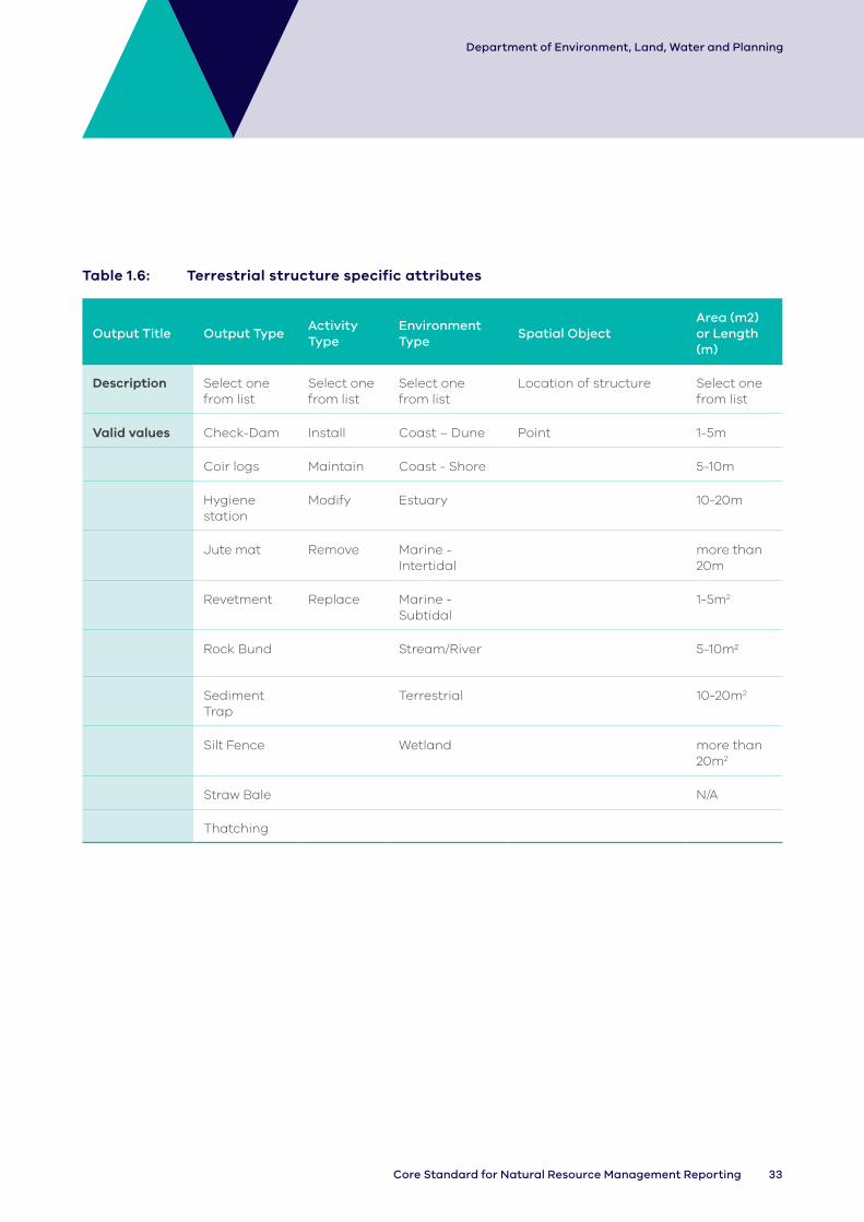
1.6 Terrestrial structure
Scope
These data record the number of terrestrial structures that have been installed, maintained, modified or removed.
This output includes sediment traps, the establishment of hygiene stations for managing pathogens (in specific Phytophthora cinnamomi) and temporary erosion control structures (e.g. hay bales or coir logs).
Related outputs: Any associated agreement, plan or inspection (i.e. assessment) associated with the structure should be recorded as a separate output. Silt fence is also related to activities under Marine and Coastal Structure and Fence outputs, though is to be recorded here, under terrestrial structure.
Terminology
Check Dam: A small, sometimes temporary, dam constructed across a swale, drainage ditch, or waterway to counteract erosion by reducing water flow velocity. Sandbag check dams are typically used in drains less than 500 mm deep, with a gradient less than 10% (1 in 10).
Coast – Dune: The area above the beach, from the primary (or fore) dune to the tertiary (or back/hind) dune.
Coast – Shore: Foreshore, beach.
Coir Logs: Fibre rolls consisting of small-diameter (150– 200 mm) biodegradable straw-filled logs. Geo logs have a larger diameter (approx. 300 mm) compared to fibre rolls. They can be used as check dams in wide, shallow drains so long as the logs can be anchored to prevent movement.
Estuary: Estuaries are where rivers meet the sea and the fresh river water mixes with the salt water of the ocean. The definition of estuaries also includes coastal inlets (like Tamboon Inlet and Anderson Inlet), smaller bays (like Swan Bay and Limeburners Bay) and coastal barrier lagoons (like Jack Smith Lake and Lake Dennison). These inlets may also be classed as wetlands.
Jute Mat: Jute or coir mesh is a form of erosion control mat used to provide temporary scour protection in low to medium velocity drains.
Marine – Intertidal: Area between low and high tide marks (also known as littoral zone).
Marine – Subtidal: Area which remains underwater including during low tide.
Pathogen: a bacterium, virus, or other microorganism that can cause disease.
Revetment: Sloping structures placed on banks or cliffs in such a way as to absorb the energy of incoming water. An underlying geotextile or rock filter layer is generally required unless all voids are filled with soil and vegetated.
River Related Works: Identifies if the output occurred on the left, right or both sides of the river (when facing downstream)
Rock Bund: A permeable bund constructed from geo-textile encasing rock and are predominately used in areas of concentrated flow. They are sometimes used as an in-stream measure, however removal of the bund from the stream often resuspends sediment. Rock bunds are most effective in removing coarse particulates.
Sediment trap: a temporary containment area that allows sediment in collected storm water to settle out during infiltration.
Silt Fence: Temporary, permeable barriers of geo-textile installed in a trench and supported by star pickets or wooden posts.
Straw Bale: Straw bales can be used to form temporary flow diversion banks to protect exposed soils and excavations from imminent storms.
Stream/River: Rivers are defined here as major rivers, streams or creeks and their feeders (tributaries), and include the water, the channel and surrounding land (known as riparian land). Riparian refers to land or vegetation that adjoins a river, wetland or estuary.
Terrestrial: Land area inland of the tertiary dune.

32 DELWP Output Data Standard
Department of Environment, Land, Water and Planning
Thatching: Temporary erosion control mats containing an organic mulch reinforced with a synthetic mesh that will eventually breakdown under direct sunlight.
Waterway: A river, wetland or estuary.
Wetland: Wetlands are areas whether natural, modified or artificial, subject to permanent or
temporary inundation, that hold static or very slow-moving water and develop, or have the potential to develop, biota adapted to inundation and the aquatic environment. Wetlands may be formed by natural processes or human activities. Wetlands include freshwater and saline lakes, swamps and shallow waters in Victoria’s estuaries, bays and inlets.
Improves
Terrestrial structure
AmenitySpecies
recovery
Soil stabilityVegetation structure &
diversity
ImprovesImproves
Improves
Management outcomes in the strategies and plans
Improves Improves
Legend
OutputExpected management outcome
Logic Diagram 6 (1.6 Terrestrial structure): Generalised program logic that clarifies the relationship of this output with expected management outcomes (linked directly or indirectly). Conceptual models should clarify the assumptions and associated confidence in the relationships.
Data reporting
In addition to the Common Attributes detailed in Part 2 of this document, the following attributes must be collected and reported for each output delivered.
33Core Standard for Natural Resource Management Reporting
Department of Environment, Land, Water and Planning
Table 1.6: Terrestrial structure specific attributes
Output Title Output TypeActivity Type
Environment Type
Spatial ObjectArea (m2) or Length (m)
Description Select one from list
Select one from list
Select one from list
Location of structure Select one from list
Valid values Check-Dam Install Coast – Dune Point 1-5m
Coir logs Maintain Coast - Shore 5-10m
Hygiene station
Modify Estuary 10-20m
Jute mat Remove Marine - Intertidal
more than 20m
Revetment Replace Marine - Subtidal
1-5m2
Rock Bund Stream/River 5-10m2
Sediment Trap
Terrestrial 10-20m2
Silt Fence Wetland more than 20m2
Straw Bale N/A
Thatching

34 DELWP Output Data Standard
Department of Environment, Land, Water and Planning
1.7 Terrestrial feature
Scope
These data record the number of terrestrial-related habitat features that have been installed, maintained, modified or replaced.
Related outputs: Water-related habitat features (e.g. large wood) should be recorded under the ‘Waterway structure’ output. Inspection of terrestrial habitat features should be recorded under the ‘Assessment’ output and any associated agreement, plan/strategy or assessment should be recorded as a separate output.
Terminology
Artificial/temporary pond: pond replicating aquatic habitat in species usual range.
Connectivity Infrastructure: Structures re-connecting habitat severed by roads e.g. possum/koala rope bridges, glider poles, possum tunnels.
Habitat feature: A structure that is suitable for fauna habitat.
Man-made ground feature: A constructed structure that is suitable for fauna habitat.
Natural ground feature: A naturally formed structure used as habitat.
Nest box: A man-made enclosure provided for animals to nest. This includes Artificial Tree Hollow, Bee Hotel and Bat Box.
Improves
Improves
Management outcomes in the strategies and plans
Species recovery
Habitat available
Terrestrial feature
Legend
OutputExpected management outcome
Logic Diagram 7 (1.7 Terrestrial feature): Generalised program logic that clarifies the relationship of this output with expected management outcomes (linked directly or indirectly). Conceptual models should clarify the assumptions and associated confidence in the relationships.
Data reporting
In addition to the Common Attributes detailed in Part 2 of this document, the following attributes must be collected and reported for each output delivered.

35Core Standard for Natural Resource Management Reporting
Department of Environment, Land, Water and Planning
Table 1.7: Terrestrial feature specific attributes
Output Title Output Type Activity Type Spatial Object Target Species
Description Select one from list
Select one from list
Location of structure
Enter taxon ID from Victorian Biodiversity Atlas
Valid Values Artificial/Temporary Pond
Install Point
Connectivity infrastructure
Maintain
Man-made ground feature
Modify
Natural ground feature
Replace
Nest box
Rocks
1.8 Monitoring structure
Scope
These data record the number of monitoring structures that have been installed, maintained, modified or removed.
Related outputs: Use of monitoring structures for the assessment of fauna behaviour or reports generated from the structure should be recorded under separate outputs. The output does not include the establishment of locations for monitoring that do not require a permanent structure (e.g. transects, quadrats).
Terminology
Bore: A pipe installed vertically in the ground through which groundwater is pumped and/or monitored.
Buoy/Mooring: A float moored or anchored in water. In this context, for the purpose of anchoring or marking a site or as a witness point for recording observation data.
Coast – Dune: The area above the beach, from the primary (or fore) dune to the tertiary (or back/hind) dune.
Coast – Shore: Foreshore, beach.
Estuary: Estuaries are where rivers meet the sea and the fresh river water mixes with the salt water of the ocean. The definition of estuaries also includes coastal inlets (like Tamboon Inlet and Anderson Inlet), smaller bays (like Swan Bay and Limeburners Bay) and coastal barrier lagoons (like Jack Smith Lake and Lake Dennison). These inlets may also be classed as wetlands.
Hide: A camouflaged shelter used to get a close view of wildlife.
Marine – Intertidal: Area between low and high tide marks (also known as littoral zone).
Marine – Subtidal: Area which remains underwater including during low tide.
Measuring station: A place set up for recording, observing or measuring information, data or phenomena in the local environment or from a specific vantage point. The information may come from natural or man-made sources.

36 DELWP Output Data Standard
Department of Environment, Land, Water and Planning
Photo point structure: A permanent structure installed as a housing for a remote or motion activated camera, or as a permanent witness point (Fluker Post) for locating a photo point objective
Stream/River: Rivers are defined here as major rivers, streams or creeks and their feeders (tributaries), and include the water, the channel and surrounding land (known as riparian land). Riparian refers to land or vegetation that adjoins a river, wetland or estuary.
Terrestrial: Land area inland of the tertiary dune.
Trap: A device or enclosure designed to catch and keep animals.
Wetland: Wetlands are areas whether natural, modified or artificial, subject to permanent or temporary inundation, that hold static or very slow-moving water and develop, or have the potential to develop, biota adapted to inundation and the aquatic environment. Wetlands may be formed by natural processes or human activities. Wetlands include freshwater and saline lakes, swamps and shallow waters in Victoria’s estuaries, bays and inlets.
Management outcomes in the strategies and plans
Skills Awareness
Knowledge, improvement, development
and management
Governance
Monitoring structureImproves
Improves
Improves
Improves
Improves
Legend
OutputExpected management outcome
Logic Diagram 8 (1.8 Monitoring structure): Generalised program logic that clarifies the relationship of this output with expected management outcomes (linked directly or indirectly). Conceptual models should clarify the assumptions and associated confidence in the relationships.
Data reporting
In addition to the Common Attributes detailed in Part 2 of this document, the following attributes must be collected and reported for each output delivered.

37Core Standard for Natural Resource Management Reporting
Department of Environment, Land, Water and Planning
Table 1.8: Monitoring structure specific attributes
Title Output TypeActivity Type
Environment Type
Spatial Object Description
Description Select one from list
Select one from list
Select one from list
Location of structure
Identify what the structure is intended to monitor
Valid values Bore Install Coast – Dune Point Depth
Buoy/Mooring
Maintain Coast - Shore Fauna
Hide Modify Estuary Flora
Measuring Station
Remove Marine - Intertidal
Flow
Photo point structure
Replace Marine - Subtidal
Groundwater
Trap Stream/River Soil
Terrestrial Surface Water
Wetland Water quality
Wave
Weather
1.9 Fence
Scope
These data record the length of fences and bollards installed, replaced (i.e. full replacement of wire and posts), modified, removed or maintained (e.g. rewiring).
Associated access points (e.g. cattle grids, gates) should be considered a feature of the fence/barrier and not recorded separately.
The fence output must be recorded as a line in all circumstances (install, maintain, remove, modify, replace).
A polygon is also required when the fence leads to a new area of land that is protected or improved.
This is applicable to all new fence installations (i.e. where ‘install’ is selected as the activity type in the specific attributes). There may also be times when other fence activity types (e.g. replace, modify, or maintain) lead to a new area protected/improved in which case a polygon (representing only the newly protected and improved area) must be recorded. More often these activities will simply enclose a pre-existing fenced area and in this case no polygon is to be recorded, e.g. a replacement fence after a flood. In this case, the area protected/improved attribute should be left blank because the purpose of this activity is to continue to protect an area that was fenced, not an activity to protect/improve a new area.

38 DELWP Output Data Standard
Department of Environment, Land, Water and Planning
Lines and polygons for the same output are to be linked by using the same Unique Site ID and Project ID (Common Attributes).
Related outputs: Plans and agreements, and outputs such as vegetation and weed management that may be associated with the delivery of fencing should be recorded as separate polygons in addition to the fence polygon. However, changes to grazing regimes are not to be recorded as an output associated with fencing. Grazing regime change should be recorded in accordance with Chapter 3.1 – Grazing.
Note: Silt Fence is captured under Terrestrial Structure Outputs, with other erosion and sediment control devices.
No longer used – ‘A Waterway Fence’
The terms 'Waterway' or 'Waterway fence' must not be used in the 'Specific Type' attribute for fence outputs.
A waterway fence is a description for a flood-proof fence. In this version of the standard (v3), the specific type attribute has been changed to ‘Flood Fence’, to assist with clarifying its purpose. The principle applies to previous versions of the standard.
River Related Works
When reporting fence, you must always specify ‘Left Bank’, ‘Right Bank’, ‘Both Banks’ or ‘not applicable’ in the ‘River-related works’ specific attribute. This enables DELWP to identify whether the fence is associated with a waterway and is therefore a riparian output. Fences installed for purposes other than riparian outputs must specify ‘not applicable’ in the ‘River-related works’ specific attribute.
Terminology
Area Protected/Improved: The area constrained/excluded by construction of the fence. In a waterway context this is the enclosed area up to the edge of the waterway.
Bollards: One of a series of posts preventing vehicles entering an area.
Coast – Dune: The area above the beach, from the primary (or fore) dune to the tertiary (or back/hind) dune.
Coast – Shore: Foreshore, beach.
Conventional fence: Standard post and wire fencing, typical on many rural properties.
Electric fence: A fence through which an electric current can be passed.
Estuary: Estuaries are where rivers meet the sea and the fresh river water mixes with the salt water of the ocean. The definition of estuaries also includes coastal inlets (like Tamboon Inlet and Anderson Inlet), smaller bays (like Swan Bay and Limeburners Bay) and coastal barrier lagoons (like Jack Smith Lake and Lake Dennison).
Fence: A barrier or other upright structure enclosing an area of ground to mark a boundary or control access.
Flood fence: Fencing designed to exclude stock but remain resistant to floodwater, including suspended fences and hinged flood gates.
Marine – Intertidal: Area between low and high tide marks (also known as littoral zone).
Marine – Subtidal: Area which remains underwater including during low tide.
Mesh fence: Prefabricated wire fencing often used for sheep (e.g. ring-lock, hinge joint).
River Related Works: Identifies if the output occurred on the left, right or both sides of the river (when facing downstream)
Stream/River: Rivers are defined here as major rivers, streams or creeks and their feeders (tributaries), and include the water, the channel and surrounding land (known as riparian land). Riparian refers to land or vegetation that adjoins a river, wetland or estuary.
Terrestrial: Land area inland of the tertiary dune.
Wetland: Wetlands are areas whether natural, modified or artificial, subject to permanent or temporary inundation, that hold static or very slow-moving water and develop, or have the potential to develop, biota adapted to inundation and the aquatic environment. Wetlands may be formed by natural processes or human activities. Wetlands include freshwater and saline lakes, swamps and shallow waters in Victoria’s estuaries, bays and inlets.

39Core Standard for Natural Resource Management Reporting
Department of Environment, Land, Water and Planning
Management outcomes in the strategies and plans
Water quality
Accessibility
Amenity
Soil stability
Vegetation structure &
diversity
Species control
Fence
Species recovery
Vegetation extent
Cultural heritage
ImprovesImproves
Improves
Improves
Improves
Improves
Improves
Improves
Improves
Reduces Improves
Improves
Legend
OutputExpected management outcome
Logic Diagram 9 (1.9 Fence): Generalised program logic that clarifies the relationship of this output with expected management outcomes (linked directly or indirectly). Conceptual models should clarify the assumptions and associated confidence in the relationships.
Data reporting
In addition to the Common Attributes detailed in Part 2 of this document, the following attributes must be collected and reported for each output delivered.

40 DELWP Output Data Standard
Department of Environment, Land, Water and Planning
Tab
le 1
.9:
F
en
ce
sp
ec
ific
att
rib
ute
s
Tit
leO
utp
ut
Typ
e
Ac
tivi
ty
Typ
e
En
viro
nm
en
t
Typ
e
Riv
er
Re
late
d
Wo
rks
(wh
en
faci
ng
do
wn
stre
am
)
Sp
ati
al
Ob
jec
t
Ch
an
ge
in
Ac
ce
ssS
pe
cifi
c Ty
pe
Targ
et
Gro
up
Are
a
Pro
tec
ted
/
Imp
rove
d
Tota
l
Vo
lun
tee
r
Nu
mb
er
Tota
l
Vo
lun
tee
r
Ho
urs
Des
crip
tio
nS
ele
ct
on
e
fro
m li
st
Se
lect
on
e f
rom
list
Se
lect
on
e
fro
m li
st
Se
lect
on
e
fro
m li
st
Lo
cati
on
of
stru
ctu
re.
Wh
ere
sect
ion
s o
f
fen
ce a
re
>10
m a
pa
rt
they
sh
ou
ld
be
reco
rde
d
sep
ara
tely
.
(se
lect
eit
he
r o
r
bo
th, a
s
de
scri
be
d
in g
uid
an
ce
ab
ove
)
Ide
nti
fy
wh
eth
er
the
ma
na
ge
me
nt
ou
tco
me
are
a
rep
rese
nts
th
e
con
tain
me
nt
or
exc
lusi
on
of
the
dis
turb
an
ce
Se
lect
on
e
fro
m li
st
Se
lect
an
ima
ls
no
t w
an
ted
on
site
Ca
lcu
late
th
e
are
a
con
tain
ed
/
exc
lud
ed
by
con
stru
ctio
n
of
fen
ce (
Als
o
to b
e
rep
rese
nte
d
by
a p
oly
go
n
fea
ture
, lin
ked
to li
ne
fe
atu
re
by
Un
iqu
e S
ite
ID c
om
mo
n
att
rib
ute
)
En
ter
nu
mb
er
or
sele
ct N
/A
En
ter
nu
mb
er
or
sele
ct N
/A
Va
lid v
alu
esB
olla
rdIn
sta
llC
oa
st -
Du
ne
Le
ft B
an
kL
ine
Co
nta
inm
en
tC
om
bin
ati
on
Do
me
stic
Sto
ckH
ect
are
sN
um
be
rN
um
be
r
Fen
ceM
ain
tain
Co
ast
- S
ho
re
Rig
ht
Ba
nk
Po
lyg
on
Exc
lusi
on
Co
nve
nti
on
al
En
viro
nm
en
tal
Pe
st A
nim
als
N/A
N/A
Mo
dif
yE
stu
ary
Bo
th B
an
ksE
lect
ric
Na
tive
Sp
eci
es
Re
mo
veM
ari
ne
- In
tert
ida
l
N/A
Flo
od
Pu
blic
Re
pla
ceM
ari
ne
- S
ub
tid
al
Me
sh
Str
ea
m/R
ive
rO
the
r
Terr
est
ria
l
We
tla
nd

41Core Standard for Natural Resource Management Reporting
Department of Environment, Land, Water and Planning
1.10 Visitor facility
Scope
These data record the number of visitor facilities (e.g. picnic area, camping ground, toilet or viewing platform) that have been installed, maintained, modified, removed or replaced.
Related outputs: Associated agreements or plans (e.g. site design/plan) and roads or trails should be recorded as separate outputs.
Terminology
Building facilities: Includes a range of buildings, such as picnic shelter, information shelter, hut or toilet block.
Coast – Dune: The area above the beach, from the primary (or fore) dune to the tertiary (or back/hind) dune.
Coast – Shore: Foreshore, beach.
Estuary: Estuaries are where rivers meet the sea and the fresh river water mixes with the salt water of the ocean. The definition of estuaries also includes coastal inlets (like Tamboon Inlet and Anderson Inlet), smaller bays (like Swan Bay and Limeburners Bay) and coastal barrier lagoons (like Jack Smith Lake and Lake Dennison). These inlets may also be classed as wetlands.
Marine – Intertidal: Area between low and high tide marks (also known as littoral zone).
Marine – Subtidal: Area which remains underwater including during low tide.
Operations facilities: Facilities to support day-to-day operations, such as a payment point, rubbish bin or car park.
Recreation facilities: Facilities directly targeted at visitor recreation, such as a horse yard, hang gliding launch, trail bike prop or jetty.
Stream/River: Rivers are defined here as major rivers, streams or creeks and their feeders (tributaries), and include the water, the channel and surrounding land (known as riparian land). Riparian refers to land or vegetation that adjoins a river, wetland or estuary.
Terrestrial: Land area inland of the tertiary dune.
Wetland: Wetlands are areas whether natural, modified or artificial, subject to permanent or temporary inundation, that hold static or very slow-moving water and develop, or have the potential to develop, biota adapted to inundation and the aquatic environment. Wetlands may be formed by natural processes or human activities. Wetlands include freshwater and saline lakes, swamps and shallow waters in Victoria’s estuaries, bays and inlets.

42 DELWP Output Data Standard
Department of Environment, Land, Water and Planning
Management outcomes in the strategies and plans
Soil stability
Accessibility
Vegetation structure &
diversity
Visitor facility
Amenity
Awareness
Increases
Increases
Increases
Increases
Increases
Alters
Legend
OutputExpected management outcome
Logic Diagram 10 (1.10 Visitor facility): Generalised program logic that clarifies the relationship of this output with expected management outcomes (linked directly or indirectly). Conceptual models should clarify the assumptions and associated confidence in the relationships.
Data reporting
In addition to the Common Attributes detailed in Part 2 of this document, the following attributes must be collected and reported for each output delivered.
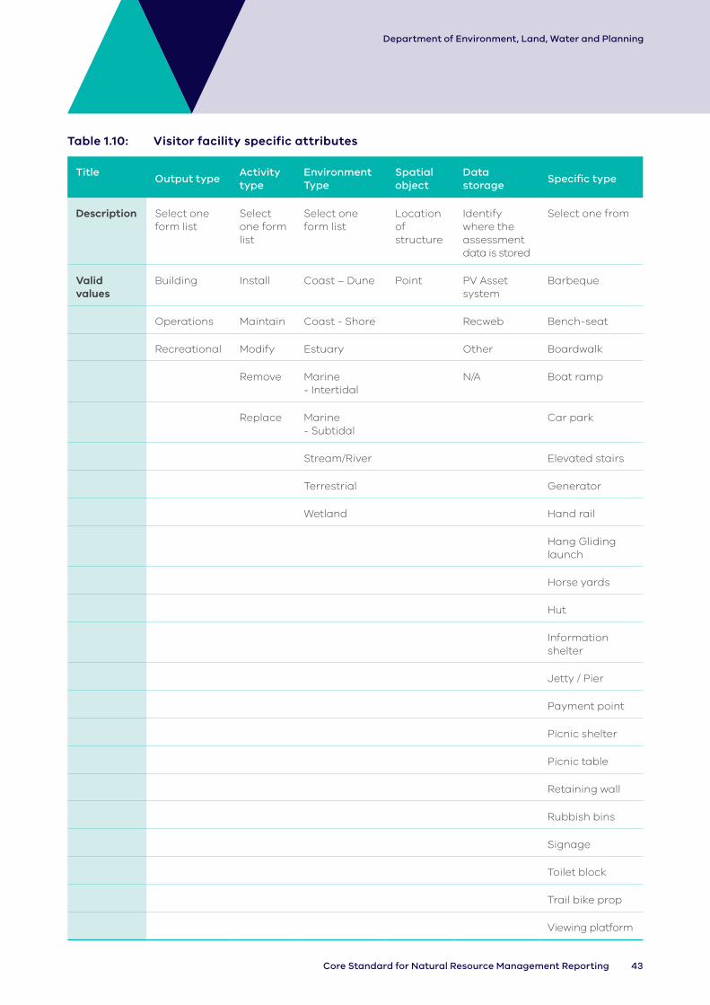
43Core Standard for Natural Resource Management Reporting
Department of Environment, Land, Water and Planning
Table 1.10: Visitor facility specific attributes
TitleOutput type
Activity type
Environment Type
Spatial object
Data storage
Specific type
Description Select one form list
Select one form list
Select one form list
Location of structure
Identify where the assessment data is stored
Select one from
Valid values
Building Install Coast – Dune Point PV Asset system
Barbeque
Operations Maintain Coast - Shore Recweb Bench-seat
Recreational Modify Estuary Other Boardwalk
Remove Marine - Intertidal
N/A Boat ramp
Replace Marine - Subtidal
Car park
Stream/River Elevated stairs
Terrestrial Generator
Wetland Hand rail
Hang Gliding launch
Horse yards
Hut
Information shelter
Jetty / Pier
Payment point
Picnic shelter
Picnic table
Retaining wall
Rubbish bins
Signage
Toilet block
Trail bike prop
Viewing platform

44 DELWP Output Data Standard
Department of Environment, Land, Water and Planning
1.11 Road
Scope
These data record the length of roads, trails and firebreaks that have been installed, maintained, modified or removed.
Related outputs: Inspection of roads should be recorded under the ‘Assessment’ output.
Terminology
Coast – Dune: The area above the beach, from the primary (or fore) dune to the tertiary (or back/hind) dune.
Coast – Shore: Foreshore, beach.
Estuary: Estuaries are where rivers meet the sea and the fresh river water mixes with the salt water of the ocean. The definition of estuaries also includes coastal inlets (like Tamboon Inlet and Anderson Inlet), smaller bays (like Swan Bay and Limeburners Bay) and coastal barrier lagoons (like Jack Smith Lake and Lake Dennison). These inlets may also be classed as wetlands.
Firebreak: An obstacle to the spread of fire.
Marine – Intertidal: Area between low and high tide marks (also known as littoral zone).
Marine – Subtidal: Area which remains underwater including during low tide.
Operational road: Roads used for management purposes, including fire prevention and suppression activities, that are not public roads. These may be available for public use but road conditions cannot be guaranteed.
Private road: Roads established for private use only.
Public road: Roads primarily used to provide access for the general public and listed in the Register of Public Roads.
Road: A wide way leading from one place to another, primarily used for motorised transport. Roads are defined by categories and class and can be used for public or operational purposes.
Stream/River: Rivers are defined here as major rivers, streams or creeks and their feeders (tributaries), and include the water, the channel and surrounding land (known as riparian land). Riparian refers to land or vegetation that adjoins a river, wetland or estuary.
Terrestrial: Land area inland of the tertiary dune.
Trail: A rough path primarily used for non-motorised transportation.
Wetland: Wetlands are areas whether natural, modified or artificial, subject to permanent or temporary inundation, that hold static or very slow-moving water and develop, or have the potential to develop, biota adapted to inundation and the aquatic environment. Wetlands may be formed by natural processes or human activities. Wetlands include freshwater and saline lakes, swamps and shallow waters in Victoria’s estuaries, bays and inlets.

45Core Standard for Natural Resource Management Reporting
Department of Environment, Land, Water and Planning
Management outcomes in the strategies and plans
Extreme event preparedness
Soil stability
Cultural heritage
Accessibility
Road
Amenity
Vegetation structure &
diversity
Improves Increases
Increases
Increases
IncreasesIncreases
Increases
Increases
Increases
Legend
OutputExpected management outcome
Logic Diagram 11 (1.11 Road): Generalised program logic that clarifies the relationship of this output with expected management outcomes (linked directly or indirectly). Conceptual models should clarify the assumptions and associated confidence in the relationships.
Data reporting
In addition to the Common Attributes detailed in Part 2 of this document, the following attributes must be collected and reported for each output delivered.

46 DELWP Output Data Standard
Department of Environment, Land, Water and Planning
Table 1.11: Road specific attributes
TitleOutput type
Activity typeEnvironment Type
Spatial object
Data storage
Specific type
Description Select one from list
Select one from list
Select one from list
Select one from list
Select one from list
Select one from list
Valid values
Firebreak Install Coast – Dune Line PV asset system
Operational
Road Maintain Coast - Shore Recweb Private
Trail Modify Estuary Other Public
Remove Marine - Intertidal
N/A N/A
Marine - Subtidal
Stream/River
Terrestrial
Wetland
47Core Standard for Natural Resource Management Reporting
Department of Environment, Land, Water and Planning
1.12 Crossing
Scope
These data record the number of bridges, culverts, causeway crossings and fords that have been installed, maintained, modified or removed.
Related outputs: Where the crossing functionality is associated with the delivery of other outputs, these outputs should be recorded in addition to this output (e.g. fire regime, visitor facility, road).
Terminology
Bridge: A structure carrying a road, trail, railroad, or canal across a waterway, ravine, road, railroad or other obstacle.
Causeway crossing: A raised road or trail across low or wet ground.
Coast – Dune: The area above the beach, from the primary (or fore) dune to the tertiary (or back/hind) dune.
Coast – Shore: Foreshore, beach.
Culvert: A tunnel carrying a waterway or open drain under a road or railroad.
Estuary: Estuaries are where rivers meet the sea and the fresh river water mixes with the salt water of the ocean. The definition of estuaries also includes coastal inlets (like Tamboon Inlet and Anderson Inlet), smaller bays (like Swan Bay and Limeburners Bay) and coastal barrier lagoons (like Jack Smith Lake and Lake Dennison). These inlets may also be classed as wetlands.
Ford: A shallow place in a waterway allowing people to walk or drive across.
Marine – Intertidal: Area between low and high tide marks (also known as littoral zone).
Marine – Subtidal: Area which remains underwater including during low tide.
Stream/River: Rivers are defined here as major rivers, streams or creeks and their feeders (tributaries), and include the water, the channel and surrounding land (known as riparian land). Riparian refers to land or vegetation that adjoins a river, wetland or estuary.
Terrestrial: Land area inland of the tertiary dune.
Wetland: Wetlands are areas whether natural, modified or artificial, subject to permanent or temporary inundation, that hold static or very slow-moving water and develop, or have the potential to develop, biota adapted to inundation and the aquatic environment. Wetlands may be formed by natural processes or human activities. Wetlands include freshwater and saline lakes, swamps and shallow waters in Victoria’s estuaries, bays and inlets.

48 DELWP Output Data Standard
Department of Environment, Land, Water and Planning
Management outcomes in the strategies and plans
Extreme event preparedness
Soil stability
Accessibility
Crossing
Amenity
Vegetation structure &
diversity
Increases
Increases
IncreasesIncreases
Increases
Increases
Increases
Legend
OutputExpected management outcome
Logic Diagram 12 (1.12 Crossing): Generalised program logic that clarifies the relationship of this output with expected management outcomes (linked directly or indirectly). Conceptual models should clarify the assumptions and associated confidence in the relationships.
Data reporting
In addition to the Common Attributes detailed in Part 2 of this document, the following attributes must be collected and reported for each output delivered.

49Core Standard for Natural Resource Management Reporting
Department of Environment, Land, Water and Planning
Table 1.12: Crossing Specific attributes
Title Output type
Activity type
Environment Type
Spatial object
Data storageSpecific type
Description Select one from list
Select one from list
Select one from list
Location of structure
Identify where the assessment data is stored
Select one from list
Valid values Bridge Install Coast – Dune Point PV asset system 900-1,200 mm
Causeway crossing
Maintain Coast - Shore Recweb 900-1800 mm
Culvert Modify Estuary N/A 1,500-1,800 mm
Ford Remove Marine - Intertidal
2,100- 2,400 mm
Marine - Subtidal
2,100-2,700 mm
Stream/River 3,000- 3,600 mm
Terrestrial Concrete
Wetland Concrete/steel
Concrete/steel/timber
Concrete/timber
Log earth fill
Log fill
Steel
Unknown

50 DELWP Output Data Standard
Department of Environment, Land, Water and Planning
1.13 Marine and Coastal Structure
Scope
These data record the number of marine and coastal structures that have been installed, replaced, modified, removed or maintained. For the purposes of this standard, the marine and coast environment includes marine subtidal and intertidal areas and coastal shore and dunes. The legislated definition of the marine and coastal environment is much broader as described in the Marine and Coastal Act, 2018.
Related outputs: Any associated agreement or plan/strategy (e.g. regional coastal plans or species management plan) should be recorded as a separate output. Earth works done in a marine and coastal context (e.g. dredging and beach renourishment) must be recorded under the ‘Earth works’ output. The management of visitor facilities (e.g. jetty) should be recorded within the ‘Visitor facility’ output. Silt fence is captured under the ‘Terrestrial structure’ output.
Terminology
Artificial reef: A man-made structure that may mimic some characteristics of a natural reef typically built to provide a hard surface for marine life to attach.
Breakwater: A barrier built out into the sea to protect a coast or harbor from the force of waves.
Dune: The area above the beach, from the primary (or fore) dune to the tertiary (or back/hind) dune.
Gross pollutant trap: Structures using physical processes to trap solid waste such as litter.
Groyne: A protective structure that extends from the edge of the water to most often change flow, trap sediment and prevent erosion of the waterway.
Hybrid reef: A combination of a natural and artificial reef.
Intertidal: Area between low and high tide marks (also known as littoral zone).
Natural reef: A ridge of natural material at or near the surface of the ocean.
Revetment: Sloping structures placed on banks or cliffs in such a way as to absorb the energy of incoming water. Often constructed to be permeable using stones or concrete blocks.
Sand bags: Sand-filled cloth or geotextile bags that can be stacked to form temporary marine and coastal structures including, but not limited to, breakwaters, groynes and revetments.
Sea wall: A wall or embankment erected to prevent the sea encroaching on or eroding an area of land.
Shore: Foreshore, beach.
Stream/River: Rivers are defined here as major rivers, streams or creeks and their feeders (tributaries), and include the water, the channel and surrounding land (known as riparian land). Riparian refers to land or vegetation that adjoins a river, wetland or estuary.
Subtidal: Area which remains underwater including during low tide.
Terrestrial: Land area inland of the tertiary dune.
Wetland: Wetlands are areas whether natural, modified or artificial, subject to permanent or temporary inundation, that hold static or very slow-moving water and develop, or have the potential to develop, biota adapted to inundation and the aquatic environment. Wetlands may be formed by natural processes or human activities. Wetlands include freshwater and saline lakes, swamps and shallow waters in Victoria’s estuaries, bays and inlets.

51Core Standard for Natural Resource Management Reporting
Department of Environment, Land, Water and Planning
Improves
ImprovesImproves
Improves
Management outcomes in the strategies and plans
Water quality
Accessibility
Dune and shoreline stability
Marine and coastal
structure
Natural landscape
features
AmenityClimate change
adaptation
Productivity (Fisheries)
Cultural heritage Site
Protection
Coastal hazard risk reduction
Extreme event
preparedness
Species recovery
Habitat available
Carbon storage
Improves
Improves
ImprovesImproves
Improves
ImprovesImproves
Legend
OutputExpected management outcome
Logic Diagram 13 (1.13 Marine and Coastal Structure): Generalised program logic that clarifies the relationship of this output with expected management outcomes (linked directly or indirectly). Conceptual models should clarify the assumptions and associated confidence in the relationships.
Data reporting
In addition to the Common Attributes detailed in Part 2 of this document, the following attributes must be collected and reported for each output delivered.

52 DELWP Output Data Standard
Department of Environment, Land, Water and Planning
Table 1.13: Marine and Coastal Structure Specific attributes
Title Output Type Activity Type Environment Type Spatial Object
Description Select one from list
Select one from list
Select one from list Location of structure
Valid values Artificial reef Install/ Establish
Estuary Polygon
Armouring Maintain Coast – Dune
Breakwater Modify Coast - Shore
Gross pollutant trap
Remove Marine - Intertidal
Groyne Replace Marine - Subtidal
Hybrid reef Stream/River
Natural reef Terrestrial
Sand bags Wetland
Sea wall

53Core Standard for Natural Resource Management Reporting
Department of Environment, Land, Water and Planning
2. Environmental worksEnvironmental works outputs are a mixture of goods and services outputs involving the modification of environmental characteristics (e.g soil, water, vegetation).
Output title Output types
(2.1 Vegetation): Biotope structure and diverstiy
Biotope overstory
EVC structure and diversity
EVC multi strata
EVC overstory
Mixed
Mixed species
Native indigenous
Native non-indigenous
Non-native
(2.2 Weed control): Non-woody Woody
(2.3 Pest animal control): Herbivore Pathogen Predator
(2.4 Over-abundant wildlife control):
Herbivore Nuisance Predator
(2.5 Threatened species response):
Restore ecological community
Restore individual species
(2.6 Emergency species response):
Ecological community
Fauna/animal
Flora/plant
(2.7 Soil treatment): Biological
Chemical
Temperature
Mechanical
(2.8 Earth works): Armouring Battering
Barrier
Dredging
Levee
Levelling
(2.9 Rubbish removal): Commercial
Chemical
Domestic
Litter trap
Mixed

54 DELWP Output Data Standard
Department of Environment, Land, Water and Planning
Environmental works outputs are a mixture of goods and services outputs involving the modification of environmental characteristics (e.g soil, water, vegetation).
The Spatial object should apply the terms controlled and treated in accordance with the guidance provided in the Spatial Output Reporting Guideline at: https://www.water.vic.gov.au/waterways-and-catchments/our-catchments/integrated-reporting.
Application of these terms is specifically applicable when capturing the spatial location of Environmental Works, specifically:
(2.2 Weed control): (2.3 Pest animal control): (2.4 Over-abundant wildlife control): (2.7 Soil treatment):
What’s the difference between treated versus controlled extent?
Many of the outputs identified under the Environmental Works section of the DELWP Output Data Standard require the identification of the ‘Treated’ or ‘Treatment area’ attribute as either an area or as a percentage of the total ‘controlled’, ‘gross area’, or as defined by the ‘Spatial object’. This spatial object may be a polygon feature, as in the case of 2.2 Weed control output, or a point feature, as in the case of 2.6 Emergency species response output.
The term ‘controlled’ area is the ‘gross area’ over which works are effectively performed or looked over for a particular threat. This may be a property or paddock, or section of these, or it may be a section of a river reach or wetland. It is often the area identified in contracts that depict or define the area over which works are to be performed. The area controlled is the area that the spatial object should represent.
The term ‘treated’ is a sub-unit of the ‘controlled’ area for which particular treatments such as the spraying of targeted weeds were undertaken. Hence, ‘treated’ will be smaller than, and expressed as a portion, or percentage of, the ‘controlled’ area. The area treated is a specific attribute of the output and should be represented as a text description, not a spatial object.
In summary, for weed control the controlled area can also be thought of as the area over which contractors are required to walk and look over or around for the threat of weeds, whether they are spraying or not. The treated area is the percentage of the controlled area they actually spray (or treat).
Figure 3 provides a sketch showing the relationship between the ‘controlled’ or gross area for which treatments, such as the spraying of targeted weeds, are performed, and the area identified by use of the term ‘treated’.
The figure on the left shows how the ‘controlled’ area should be a fair depiction of the area over which works are performed, whereas the depiction of the ‘controlled’ area on the right shows a large area to the bottom that is realistically outside the area of effective control. A pragmatic approach must be applied to estimating the polygon size for the spatial object. DELWP will provide feedback to CMAs in cases where the spatial object for controlled is unrealistic for the area treated.
Figure 3 shows a graphical representation of the difference between ‘controlled’ vs ‘treated extents'

55Core Standard for Natural Resource Management Reporting
Department of Environment, Land, Water and Planning
Scenario 1Treatment = 50%
(of the output polygon that was treated)
Scenario 2Treatment = 25%
(of the output polygon that was treated)
‘Treated’ area
Controlled area
Output polygon representing reasonable
estimation of area of works
Output polygon representing
over-estimation of area of works
(Unless this area was surveyed and no
weeds were found)
YES NO
over-estimation
Figure 3: Sketch showing the area identified by use of the term 'treated', which is defined as a sub-unit of the controlled or gross area for which treatments, such as spraying of the targeted weeds, are effectively performed.

56 DELWP Output Data Standard
Department of Environment, Land, Water and Planning
2.1 Vegetation
Scope
These data record the area where vegetation has been established (e.g. revegetation, buffers), modified (e.g. supplementary planting) or maintained (e.g. thinning, slashing or mulching).
The output covers native and non-native species. While not frequently used, non-native species may be planted to manage soil stability in agricultural areas (e.g. grasslands). This output does not cover agricultural crops or pasture for the purpose of agricultural productivity, it may only be used in conjunction with agricultural practice change where a clear environmental outcome is achieved.
Natural regeneration is a management outcome (i.e. improved vegetation structure and diversity) and therefore cannot be recorded as an output. Regeneration may be encouraged by the delivery of this vegetation output and/or other outputs (e.g. fence, grazing regime, management agreement, fire regime), which must be recorded in addition to this output.
Related outputs: Other than thinning of native vegetation, which should be recorded here, removal of vegetation (native or non-native) is to be recorded under the ‘Weed control’ output. Site preparation outputs (e.g. weed control) should also be recorded in addition to this output.
The vegetation output can be used in combination with the agricultural practice output (3.2) to identify changes to land cover where this is viewed to have significant environmental benefits. Hence, the vegetation output can be used to identify the establishment of native vegetation (e.g. native pasture, saltbush), and non-native vegetation (e.g. legumes, crop types).
Terminology
Biotope overstory: CBiCS which provides a unified way to classify all marine habitats and biotopes from the littoral (intertidal) zone to the deep sea (Edmunds and Flynn 2018). The biotic (plants and animals) component is the core classification component, and centres around the idea of a biotope; a community of species in a defined habitat. See: http://www.veac.vic.gov.au/documents/VEAC%20Marine%20Environment%20ATLAS.pdf.
Biotope structure and diversity: Combined Biotope Classification Scheme (CBiCS), which provides a unified way to classify all marine habitats and biotopes from the littoral (intertidal) zone to the deep sea (Edmunds and Flynn 2018). The biotic (plants and animals) component is the core classification component, and centres around the idea of a biotope; a community of species in a defined habitat. See: http://www.veac.vic.gov.au/documents/VEAC%20Marine%20Environment%20ATLAS.pdf
Buffer: Either a) an area of land revegetated or maintained to assist in the mitigation of threats to soil and water quality; or b) a zone between an area being managed for biodiversity values and areas being managed for other means, to limit the impact of outside activities within the biodiversity-managed zone or to stop fire and smoke from within remnant.
Coast – Dune: The area above the beach, from the primary (or fore) dune to the tertiary (or back/hind) dune.
Coast – Shore: Foreshore, beach.
Ecological Vegetation Class (EVC) structure and diversity: EVC is a classification of plant communities defined by a combination of floristics, lifeform, position in the landscape, and an inferred fidelity to specific environments. About 300 EVCs have been described for Victoria.
Establish: Establishment of vegetation to a minimum standard in formerly cleared areas, outside a remnant patch. Commonly termed revegetation.

57Core Standard for Natural Resource Management Reporting
Department of Environment, Land, Water and Planning
Estuary: Estuaries are where rivers meet the sea and the fresh river water mixes with the salt water of the ocean. The definition of estuaries also includes coastal inlets (like Tamboon Inlet and Anderson Inlet), smaller bays (like Swan Bay and Limeburners Bay) and coastal barrier lagoons (like Jack Smith Lake and Lake Dennison). These inlets may also be classed as wetlands.
EVC multi strata: See Table 3-1: Planting standard for various project objectives. DELWP Output Delivery Standard, Ch:3 – Vegetation.
EVC overstory: See Table 3-1: Planting standard for various project objectives. DELWP Output Delivery Standard, Ch:3 – Vegetation.
Indigenous: Originating or occurring naturally in a specific place.
Marine – Intertidal: Area between low and high tide marks (also known as littoral zone).
Marine – Subtidal: Area which remains underwater including during low tide.
Mixed: A mixture of indigenous and/or non-indigenous native species.
Native vegetation: Plants native to Victoria, including trees, shrubs, herbs and grasses.
Remnant: Native vegetation established or regenerated on a largely natural landform. The species present are those normally expected in that vegetation community. Largely natural landforms may have been subject to some past surface disturbance, such as some clearing or cultivation, but do not include man-made structures, such as dam walls and quarry floors.
Revegetation: Establishment of native vegetation to a minimum standard in formerly cleared areas outside a remnant patch.
River Related Works: Identifies if the output occurred on the left, right or both sides of the river (when facing downstream)
Stream/River: Rivers are defined here as major rivers, streams or creeks and their feeders (tributaries), and include the water, the channel and surrounding land (known as riparian land). Riparian refers to land or vegetation that adjoins a river, wetland or estuary.
Supplementary planting: Establishment of plants within a remnant patch of native vegetation. Typically includes the planting or direct seeding of understorey life forms.
Terrestrial: Land area inland of the tertiary dune.
Wetland: Wetlands are areas whether natural, modified or artificial, subject to permanent or temporary inundation, that hold static or very slow-moving water and develop, or have the potential to develop, biota adapted to inundation and the aquatic environment. Wetlands may be formed by natural processes or human activities. Wetlands include freshwater and saline lakes, swamps and shallow waters in Victoria’s estuaries, bays and inlets.

58 DELWP Output Data Standard
Department of Environment, Land, Water and Planning
Management outcomes in the strategies and plans
Productivity GroundwaterExtreme
event preparedness
Vegetation
Soil stability
Vegetation structure &
diversity
Species recovery
Water quality
AmenityHabitat
available
Vegetation extent
Improves
IncreasesIncreasesIncreasesIncreases
Increases
Increases IncreasesIncreasesIncreases or decreases
IncreasesIncreases
Increases
Legend
OutputExpected management outcome
Improves
Logic Diagram 14 (2.1 Vegetation): Generalised program logic that clarifies the relationship of this output with expected management outcomes (linked directly or indirectly). Conceptual models should clarify the assumptions and associated confidence in the relationships.
Data reporting
In addition to the Common Attributes detailed in Part 2 of this document, the following attributes must be collected and reported for each output delivered.
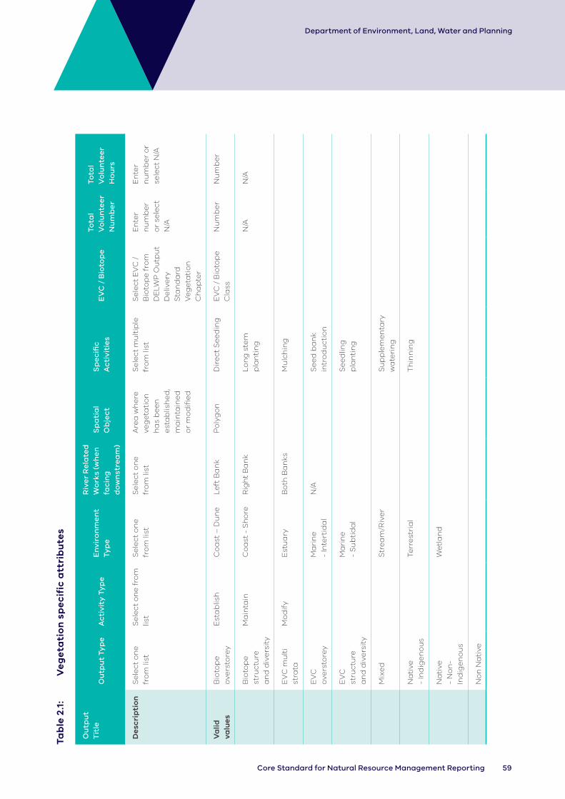
59Core Standard for Natural Resource Management Reporting
Department of Environment, Land, Water and Planning
Tab
le 2
.1:
V
eg
eta
tio
n s
pe
cif
ic a
ttri
bu
tes
Ou
tpu
t T
itle
Ou
tpu
t Ty
pe
Ac
tivi
ty T
yp
eE
nvi
ron
me
nt
Typ
e
Riv
er
Re
late
d
Wo
rks
(wh
en
fa
cin
g
do
wn
stre
am
)
Sp
ati
al
Ob
jec
tS
pe
cifi
c A
cti
viti
es
EV
C /
Bio
top
eTo
tal
Vo
lun
tee
r N
um
be
r
Tota
l V
olu
nte
er
Ho
urs
Des
crip
tio
nS
ele
ct o
ne
fr
om
list
Se
lect
on
e f
rom
lis
tS
ele
ct o
ne
fr
om
list
Se
lect
on
e
fro
m li
stA
rea
wh
ere
ve
ge
tati
on
h
as
be
en
e
sta
blis
he
d,
ma
inta
ine
d
or
mo
difi
ed
Se
lect
mu
ltip
le
fro
m li
stS
ele
ct E
VC
/
Bio
top
e f
rom
D
ELW
P O
utp
ut
De
live
ry
Sta
nd
ard
V
eg
eta
tio
n
Ch
ap
ter
En
ter
nu
mb
er
or
sele
ct
N/A
En
ter
nu
mb
er
or
sele
ct N
/A
Va
lid
valu
esB
ioto
pe
o
vers
tore
yE
sta
blis
hC
oa
st –
Du
ne
Le
ft B
an
kP
oly
go
nD
ire
ct S
ee
din
gE
VC
/ B
ioto
pe
C
lass
Nu
mb
er
Nu
mb
er
Bio
top
e
stru
ctu
re
an
d d
ive
rsit
y
Ma
inta
inC
oa
st -
Sh
ore
R
igh
t B
an
kL
on
g s
tem
p
lan
tin
gN
/AN
/A
EV
C m
ult
i st
rata
Mo
dif
yE
stu
ary
Bo
th B
an
ksM
ulc
hin
g
EV
C
ove
rsto
rey
Ma
rin
e
- In
tert
ida
l N
/AS
ee
d b
an
k in
tro
du
ctio
n
EV
C
stru
ctu
re
an
d d
ive
rsit
y
Ma
rin
e
- S
ub
tid
al
Se
ed
ling
p
lan
tin
g
Mix
ed
Str
ea
m/R
ive
rS
up
ple
me
nta
ry
wa
teri
ng
Na
tive
-
Ind
ige
no
us
Terr
est
ria
lT
hin
nin
g
Na
tive
-
No
n-
Ind
ige
no
us
We
tla
nd
No
n N
ati
ve

60 DELWP Output Data Standard
Department of Environment, Land, Water and Planning
2.2 Weed control
Scope
These data record the gross area over which weeds were controlled by killing, removing or restricting them. It recognises that weed control generally involves a combination of searching for and treating target weed species within the area designated for control. The proportion of the gross output area where actual weed treatment occurred is indicated by the treatment attribute.
Where two or more target species of the same output type (woody or non-woody) are controlled over the same gross area, one output may be used. However, if the control targets weeds of both types, it is encouraged that a separate output is recorded for each (e.g. one for treatment of (woody) willows; another for treatment of non-woody weeds). The decision to amalgamate or separate the output is best determined by the on-ground practitioner or will be determined by the investment program.
Related outputs: Where weed survey is conducted without simultaneous treatment action, this should be recorded as an ‘Assessment’ output.
Weed control conducted as part of site preparation for revegetation is regarded as being separate and should be recorded under this output.
This output should not be used for methods captured by other outputs (e.g. fire, grazing, watering, fence), which should be recorded in addition to this output.
Terminology
Aquatic weeds: Non-woody aquatic species that pose a serious threat to fisheries, the aquatic environment or human health and are declared under Section 75 of the Fisheries Act 1995 (e.g. Spartina, alligator weed, reed sweet grass). Some plants may be treated as weeds in certain locations irrespective of their declared status.
Asset-based protection: This approach is used to manage a species only where reducing its adverse effects provides the greatest benefits by achieving protection and restoration outcomes for specific, highly valued assets. This approach is used for widespread weeds.
Coast – Dune: The area above the beach, from the primary (or fore) dune to the tertiary (or back/hind) dune.
Coast – Shore: Foreshore, beach.
Containment: The application of measures in and around an infested area to prevent the spread of an invasive plant species. This may include reduction of the density or area of the infestation where
appropriate. A containment program may include eradication of satellite infestations.
Eradication: When a species (including plant propagules) has been removed or killed and no longer occurs at that site. In practice, this means it is no longer detected by recommended methods of survey for a defined period.
Estuary: Estuaries are where rivers meet the sea and the fresh river water mixes with the salt water of the ocean. The definition of estuaries also includes coastal inlets (like Tamboon Inlet and Anderson Inlet), smaller bays (like Swan Bay and Limeburners Bay) and coastal barrier lagoons (like Jack Smith Lake and Lake Dennison). These inlets may also be classed as wetlands.
Marine – Intertidal: Area between low and high tide marks (also known as littoral zone).
Marine – Subtidal: Area which remains underwater including during low tide.
Native vegetation: Plants native to Victoria, including trees, shrubs, herbs and grasses.
Non-woody: Includes ground cover, herbs, vine cacti/succulent and aquatic weeds.
Prevention: Preventing high-risk invasive species from establishing (at a defined site).
River Related Works: Identifies if the output occurred on the left, right or both sides of the river (when facing downstream)
Specific activities: The treatment methods used to manage weeds.
Stream/River: Rivers are defined here as major rivers, streams or creeks and their feeders (tributaries), and include the water, the channel and surrounding land (known as riparian land). Riparian refers to land or vegetation that adjoins a river, wetland or estuary.
Terrestrial: Land area inland of the tertiary dune.
Weed: A plant that requires some form of treatment to reduce its effects on the economy, the environment, human health and/or amenity.
Wetland: Wetlands are areas whether natural, modified or artificial, subject to permanent or temporary inundation, that hold static or very slow-moving water and develop, or have the potential to develop, biota adapted to inundation and the aquatic environment. Wetlands may be formed by natural processes or human activities. Wetlands include freshwater and saline lakes, swamps and shallow waters in Victoria’s estuaries, bays and inlets.
Woody: Plants that have wood as the main substance of the trunk or branches, such as a tree or shrub.

61Core Standard for Natural Resource Management Reporting
Department of Environment, Land, Water and Planning
Improves
Improves
Improves
Improves
Improves
Reduces
Improves
Improves
Management outcomes in the strategies and plans
Soil stabilityVegetation structure &
diversity
Amenity
Habitat available
Species recovery
Productivity
Species control Cultural heritage
Weed control
ImprovesImproves
Legend
OutputExpected management outcome
Logic Diagram 15 (2.2 Weed control): Generalised program logic that clarifies the relationship of this output with expected management outcomes (linked directly or indirectly). Conceptual models should clarify the assumptions and associated confidence in the relationships.
Data reporting
In addition to the Common Attributes detailed in Part 2 of this document, the following attributes must be collected and reported for each output delivered.

62 DELWP Output Data Standard
Department of Environment, Land, Water and Planning
Tab
le 2
.2:
We
ed
co
ntr
ol s
pe
cif
ic a
ttri
bu
tes
Tit
leO
utp
ut
Typ
eA
cti
vity
Ty
pe
En
viro
nm
en
t Ty
pe
Riv
er
Re
late
d
Wo
rks
(wh
en
fa
cin
g
do
wn
stre
am
) (w
he
n f
aci
ng
d
ow
nst
rea
m)
Sp
ati
al
Ob
jec
tS
pe
cifi
c A
cti
vity
Ma
na
ge
me
nt
Aim
Tre
atm
en
tTa
rge
t sp
eci
es
Arr
an
ge
me
nt
Targ
et
Sp
eci
es
Tota
l V
olu
nte
er
Nu
mb
er
Tota
l V
olu
nte
er
Ho
urs
Des
crip
tio
nS
ele
ct
on
e
fro
m li
st
Se
lect
o
ne
fro
m
list
Se
lect
on
e
fro
m li
stS
ele
ct o
ne
fr
om
list
Th
e g
ross
a
rea
ove
r w
hic
h
we
ed
s w
ere
co
ntr
olle
d,
incl
ud
ing
th
e a
rea
se
arc
he
d
for
targ
et
we
ed
s a
nd
tr
ea
ted
w
he
re
pre
sen
t
Se
lect
p
rim
ary
tr
ea
tme
nt
me
tho
d
fro
m li
st
Se
lect
on
e
fro
m li
stE
stim
ate
p
erc
en
tag
e
(ne
are
st
10%
) o
f th
e
ou
tpu
t p
oly
go
n
tha
t w
as
tre
ate
d
Se
lect
on
e
fro
m li
st
ide
nti
fyin
g
the
a
rra
ng
em
en
t o
f th
e t
arg
et
spe
cie
s w
ith
in o
utp
ut
po
lyg
on
Se
lect
sp
eci
es
ID
fro
m
Vic
tori
an
B
iod
ive
rsit
y A
tla
s (A
pp
en
dix
7)
Va
lid
valu
esN
on
-w
oo
dy
Est
ab
lish
Co
ast
– D
un
eB
oth
Ba
nks
Po
lyg
on
Bio
log
ica
lA
sse
t b
ase
d
pro
tect
ion
Pe
rce
nta
ge
Co
mp
lete
co
vera
ge
Nu
mb
er
Nu
mb
er
Wo
od
yM
ain
tain
Co
ast
-
Sh
ore
L
eft
Ba
nk
Ch
em
ica
lC
on
tain
me
nt
La
rge
p
atc
he
sN
/AN
/A
Mo
dif
yE
stu
ary
Rig
ht
Ba
nk
Fir
eE
rad
ica
tio
nM
ajo
rity
co
vera
ge
Ma
rin
e
- In
tert
ida
l N
/AH
ea
tP
reve
nti
on
Sca
tte
red
in
div
idu
als
Ma
rin
e
- S
ub
tid
al
Ma
nu
al
Sm
all
pa
tch
es
Str
ea
m/R
ive
rM
ech
an
ica
l
Terr
est
ria
l
We
tla
nd
63Core Standard for Natural Resource Management Reporting
Department of Environment, Land, Water and Planning
2.3 Pest animal control
Scope
These data record the gross area over which pest animals were controlled by killing, removing or restricting them.
It recognises that pest animal control generally involves a combination of searching for and treating target species within the area designated for control. The proportion of the gross output area where actual pest animal treatment occurred is indicated by the treatment coverage attribute.
Animal control activities (pest animal control (including exotic wildlife such as deer) must be reported as a polygon representing the area in which the actual control method was delivered. It should be mapped as accurately as possible to the locations of control, including searching (unless searching is not accompanied by control activities, whereby searching becomes an 'assessment' and should be recorded as a 4.3 Assessment output).
Activities that are delivered at multiple points, such as fox baiting, should have the extent/ boundary of the bait stations mapped. Information about the number and density of bait stations within the polygon is required.
Like animal control activities E.g. rabbit management, that are delivered at different locations over a wide area should be mapped at their separate locations but can be considered as a single control and have the delivery information to report attributed to it.
Native animal management should be recorded under either the ‘Over-abundant wildlife control’, ‘Threatened species response’ or ‘Emergency species response’ outputs.
Pest animal control conducted as part of site preparation for revegetation should be recorded under this output (2.3).
As a general rule, based on current research advice, the following standard buffers should be applied when spatially depicting the gross area controlled using baits for pest animal control:
Species Buffer point by….
Deer – 2 kilometres
Fox – 1 kilometre
Goat – 1 kilometre
Over abundant marine wildlife or pests – 5 metres
Pig – 5 kilometres
Rabbit – 200 metres
Feral cat – 1 kilometre
Feral horse – 5 kilometres
Feral cattle – 5 kilometres
Related outputs: This output focuses on activities associated directly with the pest animals, however, the output will often be completed in close association with the delivery of other outputs. These should be recorded as separate outputs, e.g. grazing, fence, harbour removal (i.e. rubbish dumped on site or weeds) or the establishment of management agreements or management plans.

64 DELWP Output Data Standard
Department of Environment, Land, Water and Planning
Terminology
Asset-based protection: The approach used to manage a species only where reducing its adverse effects provides the greatest benefits by achieving protection and restoration outcomes for specific highly valued assets. This approach is used for established pest animals.
Coast – Dune: The area above the beach, from the primary (or fore) dune to the tertiary (or back/hind) dune.
Coast – Shore: Foreshore, beach.
Containment: The application of measures in and around an invaded area to prevent the spread of an invasive animal species. This generally applies to the species being confined within an area and may include reducing the density of the population or area that the species occupies, where appropriate.
Eradication: When a species has been removed or killed and no longer occurs at that site. In practice, this means it is no longer detected by recommended methods of survey for a defined period.
Estuary: Estuaries are where rivers meet the sea and the fresh river water mixes with the salt water of the ocean. The definition of estuaries also includes coastal inlets (like Tamboon Inlet and Anderson Inlet), smaller bays (like Swan Bay and Limeburners Bay) and coastal barrier lagoons (like Jack Smith Lake and Lake Dennison). These inlets may also be classed as wetlands.
Marine – Intertidal: Area between low and high tide marks (also known as littoral zone).
Marine – Subtidal: Area which remains underwater including during low tide.
Pest animal: An animal species declared or able to be declared by the Minister under the Catchment and Land Protection Act 1994 in one of four pest animal classes: Prohibited Pest Animal, Controlled Pest Animal, Regulated Pest Animal and Established Pest Animal.
Poisoning: This includes baiting.
Prevention: Preventing high-risk invasive species from establishing at a defined site.
Remnant: Native vegetation that is established or has regenerated on a largely natural landform. The species present are those normally expected in that vegetation community. Largely natural landforms may have been subject to some past surface disturbance, such as some clearing or cultivation, but do not include man-made structures such as dam walls and quarry floors.
Specific activities: The treatment methods used to manage pest animals.
Stream/River: Rivers are defined here as major rivers, streams or creeks and their feeders (tributaries), and include the water, the channel and surrounding land (known as riparian land). Riparian refers to land or vegetation that adjoins a river, wetland or estuary.
Terrestrial: Land area inland of the tertiary dune.
Wetland: Wetlands are areas whether natural, modified or artificial, subject to permanent or temporary inundation, that hold static or very slow-moving water and develop, or have the potential to develop, biota adapted to inundation and the aquatic environment. Wetlands may be formed by natural processes or human activities. Wetlands include freshwater and saline lakes, swamps and shallow waters in Victoria’s estuaries, bays and inlets.
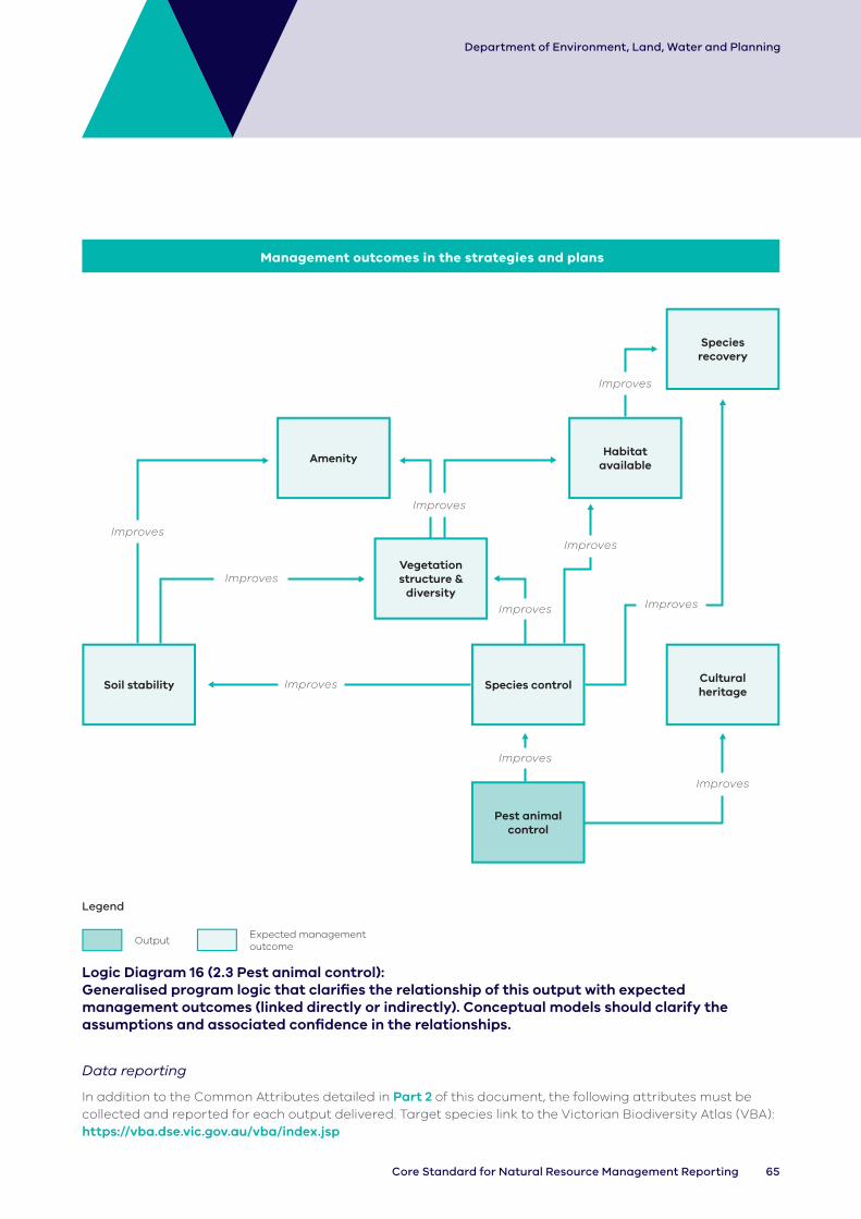
65Core Standard for Natural Resource Management Reporting
Department of Environment, Land, Water and Planning
Management outcomes in the strategies and plans
AmenityHabitat
available
Vegetation structure &
diversity
Soil stability Species controlCultural heritage
Pest animal control
Species recovery
Improves
Improves
Improves
Improves
Improves
Improves
Improves
Improves
Improves
Improves
Legend
OutputExpected management outcome
Logic Diagram 16 (2.3 Pest animal control): Generalised program logic that clarifies the relationship of this output with expected management outcomes (linked directly or indirectly). Conceptual models should clarify the assumptions and associated confidence in the relationships.
Data reporting
In addition to the Common Attributes detailed in Part 2 of this document, the following attributes must be collected and reported for each output delivered. Target species link to the Victorian Biodiversity Atlas (VBA): https://vba.dse.vic.gov.au/vba/index.jsp

66 DELWP Output Data Standard
Department of Environment, Land, Water and Planning
Tab
le 2
.3:
Pe
st a
nim
al c
on
tro
l sp
ec
ific
att
rib
ute
s
Tit
leO
utp
ut
Typ
eA
cti
vity
Ty
pe
En
viro
nm
en
t Ty
pe
Ma
na
ge
me
nt
Aim
(O
bje
cti
ve o
f c
on
tro
l)
Sp
eci
fic
Ac
tivi
tie
sTa
rge
t S
pe
cie
sS
pa
tia
l O
bje
ct
Nu
mb
er
of
An
ima
ls
Tre
ate
d
No
. of
ba
it
sta
tio
ns
wit
hin
su
rvey
ed
a
rea
p
oly
go
n
Targ
et
Tre
atm
en
t C
ove
rag
e
Tota
l V
olu
nte
er
Nu
mb
er
Tota
l V
olu
nte
er
Ho
urs
Des
crip
tio
nS
ele
ct
on
e f
rom
lis
t
Se
lect
on
e
fro
m li
stS
ele
ct o
ne
fr
om
list
Se
lect
on
e
fro
m li
stS
ele
ct o
ne
fr
om
list
En
ter
spe
cie
s ID
fr
om
V
icto
ria
n
Bio
div
ers
ity
Atl
as
Th
e g
ross
a
rea
ove
r w
hic
h p
est
s w
ere
co
ntr
olle
d,
incl
ud
ing
th
e
are
a
sea
rch
ed
fo
r ta
rge
t p
est
s a
nd
tre
ate
d
wh
ere
p
rese
nt
En
ter
nu
mb
er
or
sele
ct N
/A
(ba
it t
ake
, ca
rca
sse
s e
tc)
En
ter
nu
mb
er
or
sele
ct
N/A
Est
ima
te t
he
p
erc
en
tag
e
(ne
are
st
10%
) o
f th
e
ou
tpu
t p
oly
go
n t
ha
t w
as
tre
ate
d
Va
lid
valu
esH
erb
ivo
reE
sta
blis
hC
oa
st
– D
un
eA
sse
t B
ase
d
Pro
tect
ion
Ba
itP
oly
go
nN
um
be
rN
um
be
rP
erc
en
tag
eN
um
be
rN
um
be
r
Pa
tho
ge
nM
ain
tain
Co
ast
-
Sh
ore
C
on
tain
me
nt
Bio
log
ica
lN
/AN
/AN
/AN
/A
Pre
da
tor
Mo
dif
yE
stu
ary
Era
dic
ati
on
De
stro
y in
si
tu
Ma
rin
e
- In
tert
ida
l P
reve
nti
on
Fert
ility
C
on
tro
l
Ma
rin
e
- S
ub
tid
al
Fu
mig
ate
Str
ea
m/R
ive
rG
rou
nd
S
ho
ot
Terr
est
ria
lH
arb
ou
r D
est
ruct
ion
We
tla
nd
He
li S
ho
ot
Ma
nu
al
rem
ova
l
Mu
ste
r
Tra
p

67Core Standard for Natural Resource Management Reporting
Department of Environment, Land, Water and Planning
2.4 Over-abundant wildlife control
Scope
These data record the gross area over which populations of over-abundant wildlife were restricted, removed, maintained or translocated.
It recognises that wildlife control generally involves a combination of searching for and treating target species within the area designated for control. The proportion of the gross output area where actual treatment occurred is indicated by the treatment coverage attribute.
Where a wildlife survey is conducted without simultaneous treatment action, it should be recorded as an ‘Assessment’ output.
Related outputs: Pest animal control activities should be recorded under the pest animal output.
Terminology
Coast – Dune: The area above the beach, from the primary (or fore) dune to the tertiary (or back/hind) dune.
Coast – Shore: Foreshore, beach.
Estuary: Estuaries are where rivers meet the sea and the fresh river water mixes with the salt water of the ocean. The definition of estuaries also includes coastal inlets (like Tamboon Inlet and Anderson Inlet), smaller bays (like Swan Bay and Limeburners Bay) and coastal barrier lagoons (like Jack Smith Lake and Lake Dennison). These inlets may also be classed as wetlands.
Manual removal: Includes the removal phase of translocate activities as well as manual removal for other purposes.
Marine – Intertidal: Area between low and high tide marks (also known as littoral zone).
Marine – Subtidal: Area which remains underwater including during low tide.
Nuisance: In this standard ‘nuisance’ describes the type of impact an animal may have on people or in the environment and the reason for management. For example, Over-abundant flying foxes or large parrots may be encouraged to leave a specific area using approved disturbance methods. NOTE: In Victoria, all wildlife is protected under the Wildlife Act 1975. It is illegal to destroy or interfere with wildlife. An Authority to Control Wildlife (ATCW) is required for managing wildlife.
Over-abundant: A greater number of individuals within a population than is sustainable.
Specific activities: The methods used to control over- abundant wildlife.
Stream/River: Rivers are defined here as major rivers, streams or creeks and their feeders (tributaries), and include the water, the channel and surrounding land (known as riparian land). Riparian refers to land or vegetation that adjoins a river, wetland or estuary.
Terrestrial: Land area inland of the tertiary dune.
Translocate (Release): Indicates the release phase/site of previously removed wildlife in a new location as part of abundance control.
Wetland: Wetlands are areas whether natural, modified or artificial, subject to permanent or temporary inundation, that hold static or very slow-moving water and develop, or have the potential to develop, biota adapted to inundation and the aquatic environment. Wetlands may be formed by natural processes or human activities. Wetlands include freshwater and saline lakes, swamps and shallow waters in Victoria’s estuaries, bays and inlets.
Wildlife: Native to Victoria or designated as wildlife under the Wildlife Act 1975 – includes exotic deer (e.g. Sambar, Red, Fallow and Hog).

68 DELWP Output Data Standard
Department of Environment, Land, Water and Planning
Improves
Improves
Improves
Improves
Management outcomes in the strategies and plans
Vegetation structure &
diversity
AmenityHabitat
available
Species control
Over-abundant wildlife
Species recovery
Improves
Improves
Reduces
Habitat available
Legend
OutputExpected management outcome
Logic Diagram 17 (2.4 Over-abundant wildlife control): Generalised program logic that clarifies the relationship of this output with expected management outcomes (linked directly or indirectly). Conceptual models should clarify the assumptions and associated confidence in the relationships.
Data reporting
In addition to the Common Attributes detailed in Part 2 of this document, the following attributes must be collected and reported for each output delivered. Target species link to VBA: https://vba.dse.vic.gov.au/vba/index.jsp

69Core Standard for Natural Resource Management Reporting
Department of Environment, Land, Water and Planning
Tab
le 2
.4:
Ov
er-
ab
un
da
nt
wil
dli
fe c
on
tro
l sp
ec
ific
att
rib
ute
s
Tit
leO
utp
ut
Typ
eA
cti
vity
Ty
pe
En
viro
nm
en
t Ty
pe
Ma
na
ge
me
nt
Aim
(O
bje
cti
ve o
f c
on
tro
l)
Sp
eci
fic
Ac
tivi
tie
sTa
rge
t S
pe
cie
sS
pa
tia
l Ob
jec
t
No
. of
ba
it
sta
tio
ns
wit
hin
su
rvey
ed
a
rea
p
oly
go
n
Targ
et
Tre
atm
en
t C
ove
rag
e
Tota
l V
olu
nte
er
Nu
mb
er
Tota
l V
olu
nte
er
Ho
urs
Des
crip
tio
nS
ele
ct o
ne
fr
om
list
Se
lect
on
e
fro
m li
stS
ele
ct o
ne
fr
om
list
Se
lect
on
fro
m
list
Se
lect
on
e
fro
m li
stS
ele
ct
spe
cie
s ID
fr
om
V
icto
ria
n
Bio
div
ers
ity
Atl
as
(Ap
pe
nd
ix
7)
Th
e g
ross
are
a o
ver
wh
ich
ove
r-
ab
un
da
nt
wild
life
w
as
con
tro
lled
, in
clu
din
g t
he
are
a
sea
rch
ed
fo
r ta
rge
t sp
eci
es
an
d t
rea
ted
w
he
re p
rese
nt.
Du
e
to t
he
dif
fuse
na
ture
o
f a
nim
al t
rea
tme
nt
this
will
be
an
e
stim
ate
En
ter
nu
mb
er
or
sele
ct N
/A
Est
ima
te t
he
p
erc
en
tag
e
(ne
are
st 1
0%
) o
f th
e o
utp
ut
po
lyg
on
th
at
wa
s tr
ea
ted
En
ter
nu
mb
er
or
sele
ct
N/A
En
ter
nu
mb
er
or
sele
ct
N/A
Va
lid v
alu
esH
erb
ivo
reE
sta
blis
hC
oa
st
– D
un
eA
sse
t B
ase
d
Pro
tect
ion
Ae
ria
l Sh
oo
tP
oly
go
nN
um
be
rP
erc
en
tag
eN
um
be
rN
um
be
r
Nu
isa
nce
Ma
inta
inC
oa
st
- S
ho
re
Co
nta
inm
en
tB
ait
N/A
N/A
N/A
Pre
da
tor
Mo
dif
yE
stu
ary
Era
dic
ati
on
De
stro
y in
si
tu
Ma
rin
e
- In
tert
ida
l P
reve
nti
on
Dis
turb
Ma
rin
e
- S
ub
tid
al
Fert
ility
C
on
tro
l
Str
ea
m/R
ive
rG
rou
nd
S
ho
ot
Terr
est
ria
lM
an
ua
l re
mo
val
We
tla
nd
Mu
ste
r
Tra
nsl
oca
te
(re
lea
se)
Tra
p

70 DELWP Output Data Standard
Department of Environment, Land, Water and Planning
2.5 Threatened species response
Scope
These data record the number of threatened species populations that were established, maintained or modified.
This output is for long-term activities targeted to specific threatened species or communities not already captured by existing outputs (e.g. fence, emergency species recovery). It is largely about captive breeding/ propagation and reintroduction.
An element of searching is generally required and should be considered part of the output. However, where the effort to complete a search is considered important to the management outcome, it should be recorded as an ‘Assessment’ output.
Terminology
Coast – Dune: The area above the beach, from the primary (or fore) dune to the tertiary (or back/hind) dune.
Coast – Shore: Foreshore, beach.
Estuary: Estuaries are where rivers meet the sea and the fresh river water mixes with the salt water of the ocean. The definition of estuaries also includes coastal inlets (like Tamboon Inlet and Anderson Inlet), smaller bays (like Swan Bay and Limeburners Bay) and coastal barrier lagoons (like Jack Smith Lake and Lake Dennison). These inlets may also be classed as wetlands.
Marine – Intertidal: Area between low and high tide marks (also known as littoral zone).
Marine – Subtidal: Area which remains underwater including during low tide.
Recovery: A return to a normal or target state of health.
Restore ecological community: Targeted works aimed at returning to a normal or target state of health a naturally occurring group of native plants, animals and other organisms that are interacting in a unique habitat. Types of ecological communities listed under national environmental law include woodlands, grasslands, shrublands, forests, wetlands, marine, ground springs and cave communities.
Restore individual species: Targeted works aimed at returning to a normal or target state of health an Individual species.
Stream/River: Rivers are defined here as major rivers, streams or creeks and their feeders (tributaries), and include the water, the channel and surrounding land (known as riparian land). Riparian refers to land or vegetation that adjoins a river, wetland or estuary.
Terrestrial: Land area inland of the tertiary dune.
Threatened species: Any fauna and flora species and ecological communities that are listed as threatened under Victorian legislation (Flora and Fauna Guarantee Act 1988) or included in DELWP’s Threatened Species Advisory Lists.
Wetland: Wetlands are areas whether natural, modified or artificial, subject to permanent or temporary inundation, that hold static or very slow-moving water and develop, or have the potential to develop, biota adapted to inundation and the aquatic environment. Wetlands may be formed by natural processes or human activities. Wetlands include freshwater and saline lakes, swamps and shallow waters in Victoria’s estuaries, bays and inlets.
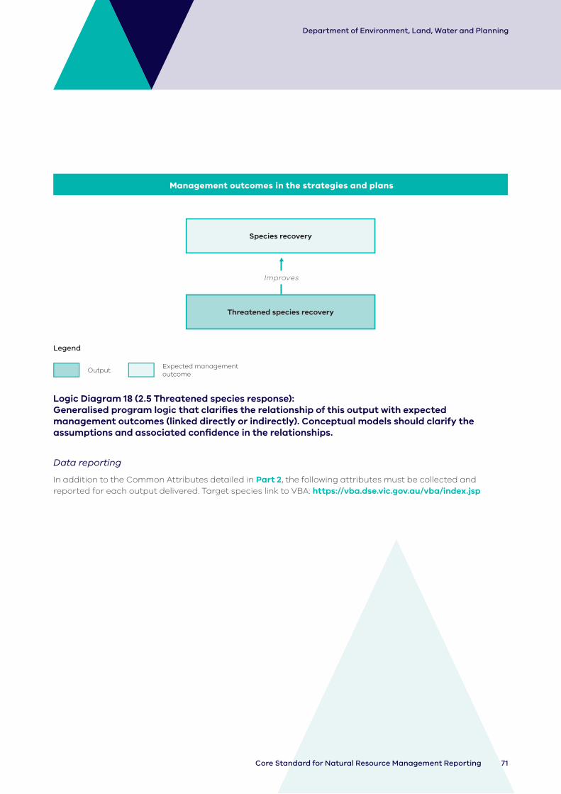
71Core Standard for Natural Resource Management Reporting
Department of Environment, Land, Water and Planning
Management outcomes in the strategies and plans
Improves
Species recovery
Threatened species recovery
Legend
OutputExpected management outcome
Logic Diagram 18 (2.5 Threatened species response): Generalised program logic that clarifies the relationship of this output with expected management outcomes (linked directly or indirectly). Conceptual models should clarify the assumptions and associated confidence in the relationships.
Data reporting
In addition to the Common Attributes detailed in Part 2 , the following attributes must be collected and reported for each output delivered. Target species link to VBA: https://vba.dse.vic.gov.au/vba/index.jsp
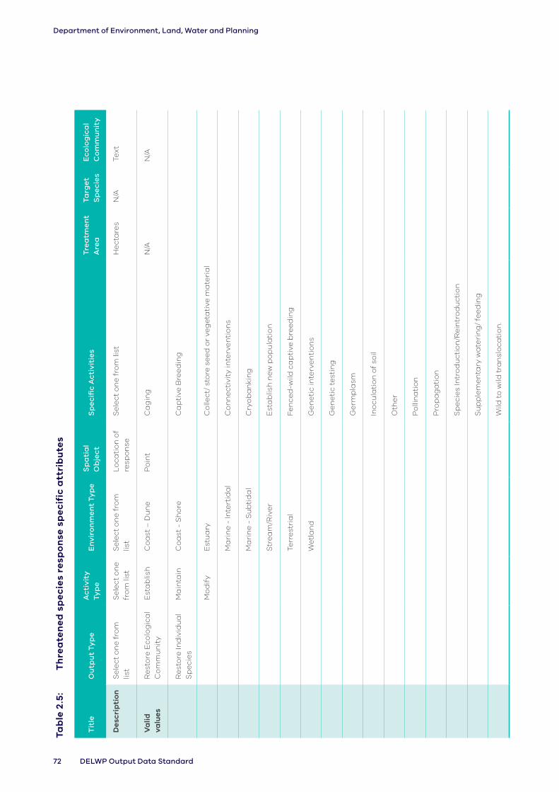
72 DELWP Output Data Standard
Department of Environment, Land, Water and Planning
Tab
le 2
.5:
Th
rea
ten
ed
sp
ec
ies
resp
on
se s
pe
cif
ic a
ttri
bu
tes
Tit
leO
utp
ut
Typ
eA
cti
vity
Ty
pe
En
viro
nm
en
t Ty
pe
Sp
ati
al
Ob
jec
tS
pe
cifi
c A
cti
viti
es
Tre
atm
en
t A
rea
Targ
et
Sp
eci
es
Ec
olo
gic
al
Co
mm
un
ity
Des
crip
tio
nS
ele
ct o
ne
fro
m
list
Se
lect
on
e
fro
m li
stS
ele
ct o
ne
fro
m
list
Lo
cati
on
of
resp
on
seS
ele
ct o
ne
fro
m li
stH
ect
are
sN
/ATe
xt
Va
lid
valu
esR
est
ore
Eco
log
ica
l C
om
mu
nit
yE
sta
blis
hC
oa
st –
Du
ne
Po
int
Ca
gin
gN
/AN
/A
Re
sto
re In
div
idu
al
Sp
eci
es
Ma
inta
inC
oa
st -
Sh
ore
C
ap
tive
Bre
ed
ing
Mo
dif
yE
stu
ary
Co
llect
/ st
ore
se
ed
or
veg
eta
tive
ma
teri
al
Ma
rin
e -
Inte
rtid
al
Co
nn
ect
ivit
y in
terv
en
tio
ns
Ma
rin
e -
Su
bti
da
l C
ryo
ba
nki
ng
Str
ea
m/R
ive
rE
sta
blis
h n
ew
po
pu
lati
on
Terr
est
ria
lFe
nce
d-w
ild c
ap
tive
bre
ed
ing
We
tla
nd
Ge
ne
tic
inte
rve
nti
on
s
Ge
ne
tic
test
ing
Ge
rmp
lasm
Ino
cula
tio
n o
f so
il
Oth
er
Po
llin
ati
on
Pro
pa
ga
tio
n
Sp
eci
es
Intr
od
uct
ion
/Re
intr
od
uct
ion
Su
pp
lem
en
tary
wa
teri
ng
/ fe
ed
ing
Wild
to
wild
tra
nsl
oca
tio
n.

73Core Standard for Natural Resource Management Reporting
Department of Environment, Land, Water and Planning
2.6 Emergency species response
Scope
These data record the number of incidents in which an emergency response is undertaken to treat wildlife affected by events such as chemical spills, bushfire, entanglement, strandings, etc.
Searching for threatened species may be required and should be considered part of the output. However, where the effort to complete a search is of importance to the management outcome this should be recorded as an ‘Assessment’ output.
Related outputs: This output is intended for the short-term activities targeted to specific emergency recovery of wildlife. Longer-term threatened species’ related activities should be recorded under the ‘Threatened species recovery’ output.
Terminology
Coast – Dune: The area above the beach, from the primary (or fore) dune to the tertiary (or back/hind) dune.
Coast – Shore: Foreshore, beach.
Ecological community: A naturally occurring group of native plants, animals and other organisms that are interacting in a unique habitat. Its structure, composition and distribution are determined by environmental factors such as soil type, position in the landscape, altitude, climate and water availability. Types of ecological communities listed under national environmental law include woodlands, grasslands, shrublands, forests, wetlands, marine, ground springs and cave communities.
Estuary: Estuaries are where rivers meet the sea and the fresh river water mixes with the salt water of the ocean. The definition of estuaries also includes coastal inlets (like Tamboon Inlet and Anderson Inlet), smaller bays (like Swan Bay and Limeburners Bay) and coastal barrier lagoons (like Jack Smith Lake and Lake Dennison). These inlets may also be classed as wetlands.
Fauna: Any animal-life which is indigenous to Victoria, whether vertebrate or invertebrate, and in any stage of biological development, and includes fish and any other living thing generally classified as fauna but does not include humans
Flora: Any plant-life which is indigenous to Victoria, whether vascular or non-vascular, and in any stage of biological development, and includes any other living thing generally classified as flora.
Marine – Intertidal: Area between low and high tide marks (also known as littoral zone).
Marine – Subtidal: Area which remains underwater including during low tide.
Recovery / Rehabilitation: A return to a normal or target state of health. Includes “temporary care and release” as well as “Extraction to temporary housing”.
Stream/River: Rivers are defined here as major rivers, streams or creeks and their feeders (tributaries), and include the water, the channel and surrounding land (known as riparian land). Riparian refers to land or vegetation that adjoins a river, wetland or estuary.
Terrestrial: Land area inland of the tertiary dune.

74 DELWP Output Data Standard
Department of Environment, Land, Water and Planning
Translocation: Includes extraction and wild to wild translocation
Wetland: Wetlands are areas whether natural, modified or artificial, subject to permanent or temporary inundation, that hold static or very slow-moving water and develop, or have the potential to develop, biota adapted to inundation and the aquatic environment. Wetlands may be
formed by natural processes or human activities. Wetlands include freshwater and saline lakes, swamps and shallow waters in Victoria’s estuaries, bays and inlets.
Wildlife emergency: Human-induced or natural events that result in harm to individuals or groups of animals.
Management outcomes in the strategies and plans
Species response
Emergency species response
Animal welfare
Improves Improves
Legend
OutputExpected management outcome
Logic Diagram 19 (2.6 Emergency species response): Generalised program logic that clarifies the relationship of this output with expected management outcomes (linked directly or indirectly). Conceptual models should clarify the assumptions and associated confidence in the relationships.
Data reporting
In addition to the Common Attributes detailed in Part 2 of this document, the following attributes must be collected and reported for each output delivered. Target species link to VBA: https://vba.dse.vic.gov.au/vba/index.jsp

75Core Standard for Natural Resource Management Reporting
Department of Environment, Land, Water and Planning
Tab
le 2
.6:
Em
erg
en
cy
sp
ec
ies
resp
on
se s
pe
cif
ic a
ttri
bu
tes
Tit
leO
utp
ut
Typ
eA
cti
vity
Ty
pe
En
viro
nm
en
t Ty
pe
Sp
ati
al
Ob
jec
tS
pe
cifi
c A
cti
viti
es
Tre
atm
en
t A
rea
Targ
et
Sp
eci
es
Eve
nt
Typ
e
Des
crip
tio
nS
ele
ct o
ne
fr
om
list
Se
lect
on
e f
rom
lis
tS
ele
ct o
ne
fr
om
list
Lo
cati
on
o
f re
spo
nse
Se
lect
on
e o
r m
ore
fro
m li
stE
stim
ate
th
e a
re
ove
r w
hic
h
resp
on
se
un
de
rta
ken
En
ter
spe
cie
s ID
fr
om
V
icto
ria
n
Bio
div
ers
ity
Atl
as
Se
lect
on
e o
r m
ore
fro
m li
st
Va
lid
valu
esE
colo
gic
al
com
mu
nit
yE
sta
blis
hC
oa
st
– D
un
eP
oin
tD
e-o
ilin
gH
ect
are
sN
/AC
he
mic
al
Sp
ills
Fau
na
/a
nim
al
Ma
inta
inC
oa
st
- S
ho
re
Dis
en
tan
gle
me
nt
N/A
Dis
ea
se
Flo
ra/p
lan
tM
od
ify
Est
ua
ryE
xtr
act
ion
an
d
wild
to
wild
tr
an
slo
cati
on
En
tan
gle
me
nt
Ma
rin
e
- In
tert
ida
l E
xtr
act
ion
to
te
mp
ora
ry
ho
usi
ng
Fir
e
Ma
rin
e
- S
ub
tid
al
Re
ha
bili
tati
on
Flo
od
Str
ea
m/R
ive
rTr
an
slo
cati
on
Str
an
din
g
Terr
est
ria
lV
ete
rin
ary
Tr
ea
tme
nt
Oth
er
We
tla
nd
Wh
ale
/ D
olp
hin
R
eco
very
Oth
er
76 DELWP Output Data Standard
Department of Environment, Land, Water and Planning
2.7 Soil treatment
Scope
These data record the area where soil has been treated through application or removal of a chemical, biological, mechanical or temperate-related input.
The activities in this output focus on treating soil acidification and reducing the impacts of salinity.
Related outputs: Any activities associated with soil treatment in a waterway, channel or along the coast should be recorded under the Earth Works (2.8) output. The delivery of associated outputs (e.g. assessment, plan) should be recorded in addition to this output.
Terminology
Biological: Introduction of flora or fauna to the soil to improve soil condition.
Clay topping/ripping: Incorporating clay into the soil.
Coast – Dune: The area above the beach, from the primary (or fore) dune to the tertiary (or back/hind) dune.
Coast – Shore: Foreshore, beach.
Estuary: Estuaries are where rivers meet the sea and the fresh river water mixes with the salt water of the ocean. The definition of estuaries also includes coastal inlets (like Tamboon Inlet and Anderson Inlet), smaller bays (like Swan Bay and Limeburners Bay) and coastal barrier lagoons (like Jack Smith Lake and Lake Dennison). These inlets may also be classed as wetlands.
Marine – Intertidal: Area between low and high tide marks (also known as littoral zone).
Marine – Subtidal: Area which remains underwater including during low tide.
Salinity: Accumulation of salt in the soil profile that adversely affects plant growth.
Soil acidification: The process by which soil pH decreases over time.
Stream/River: Rivers are defined here as major rivers, streams or creeks and their feeders (tributaries), and include the water, the channel and surrounding land (known as riparian land). Riparian refers to land or vegetation that adjoins a river, wetland or estuary.
Temperature: heating or cooling of the soil.
Terrestrial: Land area inland of the tertiary dune.
Wetland: Wetlands are areas whether natural, modified or artificial, subject to permanent or temporary inundation, that hold static or very slow-moving water and develop, or have the potential to develop, biota adapted to inundation and the aquatic environment. Wetlands may be formed by natural processes or human activities. Wetlands include freshwater and saline lakes, swamps and shallow waters in Victoria’s estuaries, bays and inlets.
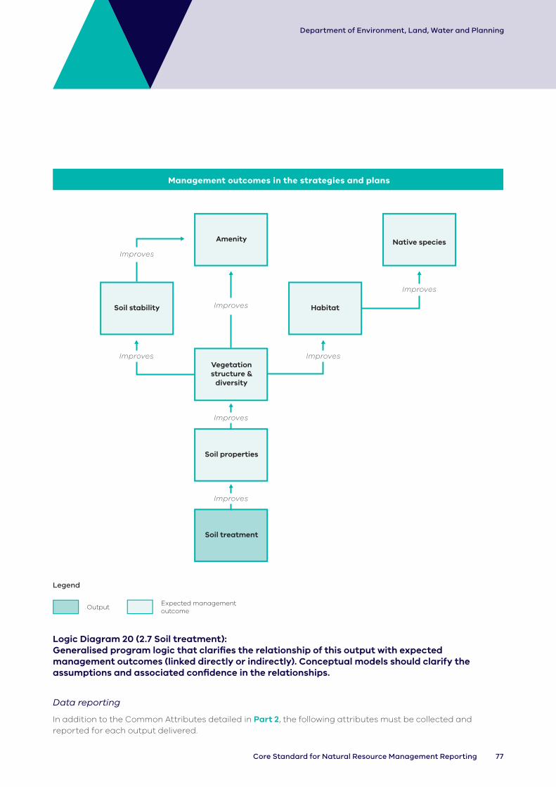
77Core Standard for Natural Resource Management Reporting
Department of Environment, Land, Water and Planning
Improves
ImprovesImproves
Management outcomes in the strategies and plans
Soil stability
Amenity
Vegetation structure &
diversity
Soil properties
Soil treatment
Habitat
Native species
Improves
Improves
Improves
Improves
Legend
OutputExpected management outcome
Logic Diagram 20 (2.7 Soil treatment): Generalised program logic that clarifies the relationship of this output with expected management outcomes (linked directly or indirectly). Conceptual models should clarify the assumptions and associated confidence in the relationships.
Data reporting
In addition to the Common Attributes detailed in Part 2 , the following attributes must be collected and reported for each output delivered.

78 DELWP Output Data Standard
Department of Environment, Land, Water and Planning
Table 2.7: Soil treatment specific attributes
Output TitleOutput Type
Activity Type
Environment Type
Spatial Object Specific Activities
Description Select one from list
Select one from list
Select one from list
Location where soil treatment was done
Select one from list
Valid values Biological Establish Coast – Dune Polygon Biological Additive
Chemical Maintain Coast - Shore Chemical Ameliorant
Mechanical Modify Estuary Clay Topping
Temperature Remove Marine - Intertidal
Drying
Marine - Subtidal
Liming
Stream/River Organic Matter
Terrestrial Ripping
Wetland Scraping

79Core Standard for Natural Resource Management Reporting
Department of Environment, Land, Water and Planning
2.8 Earth works
Scope
These data record the area of earth that has been altered through the establishment, maintenance, modification or removal of earth (soil, sand, silt and rocks). It includes activities for estuary opening.
Related outputs: The construction of waterway structures (e.g. pile fields, fishways), channels, water storages and upgrading irrigation infrastructure (e.g. laser levelling) should be recorded separately. Activities associated with conducting assessments or developing plans should also be recorded separately.
Terminology
Armouring: The protection of a waterway bed via a coarse surface layer over finer sediment.
Battering: Modification of the waterway/gully to a designed bank angle.
Coast – Dune: The area above the beach, from the primary (or fore) dune to the tertiary (or back/hind) dune.
Coast – Shore: Foreshore, beach.
Dredging: The process of removing bed sediment from a waterway/estuary using a dredge.
Earth works: The process of moving earth.
Estuary: Estuaries are where rivers meet the sea and the fresh river water mixes with the salt water of the ocean. The definition of estuaries also includes coastal inlets (like Tamboon Inlet and Anderson Inlet), smaller bays (like Swan Bay and Limeburners Bay) and coastal barrier lagoons (like Jack Smith Lake and Lake Dennison). These inlets may also be classed as wetlands.
Levee: An embankment built to prevent the overflow of a river.
Marine – Intertidal: Area between low and high tide marks (also known as littoral zone).
Marine – Subtidal: Area which remains underwater including during low tide.
River Related Works: Identifies if the output occurred on the left, right or both sides of the river (when facing downstream)
Stream/River: Rivers are defined here as major rivers, streams or creeks and their feeders (tributaries), and include the water, the channel and surrounding land (known as riparian land). Riparian refers to land or vegetation that adjoins a river, wetland or estuary.
Terrestrial: Land area inland of the tertiary dune.
Waterway: A river, wetland or estuary.
Wetland: Wetlands are areas whether natural, modified or artificial, subject to permanent or temporary inundation, that hold static or very slow-moving water and develop, or have the potential to develop, biota adapted to inundation and the aquatic environment. Wetlands may be formed by natural processes or human activities. Wetlands include freshwater and saline lakes, swamps and shallow waters in Victoria’s estuaries, bays and inlets.
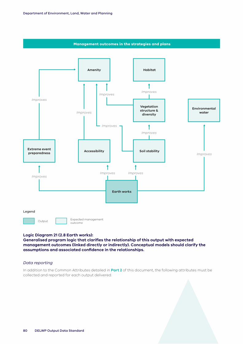
80 DELWP Output Data Standard
Department of Environment, Land, Water and Planning
Improves
Improves
Management outcomes in the strategies and plans
Habitat
Extreme event preparedness
Accessibility
Amenity
Vegetation structure &
diversity
Soil stability
Earth works
Environmental water
ImprovesImproves
Improves
Improves
Improves ImprovesImproves
Improves
Legend
OutputExpected management outcome
Logic Diagram 21 (2.8 Earth works): Generalised program logic that clarifies the relationship of this output with expected management outcomes (linked directly or indirectly). Conceptual models should clarify the assumptions and associated confidence in the relationships.
Data reporting
In addition to the Common Attributes detailed in Part 2 of this document, the following attributes must be collected and reported for each output delivered.

81Core Standard for Natural Resource Management Reporting
Department of Environment, Land, Water and Planning
Table 2.8: Earth works specific attributes
TitleOutput Type
Activity Type
Environment Type
River Related Works (when facing downstream)
Spatial Object
Specific Activities
Treatment Area
Description Select one from list
Select one from list
Select one from list
Select one from list
Location where earth work was altered
Select one from list
Calculate area over which works undertaken
Valid values Armouring Establish Coast – Dune Both Banks Point Beach Renourishment
Hectares
Battering Maintain Coast - Shore Left Bank Estuary Closing N/A
Barrier Modify Estuary Right Bank Estuary Opening
Dredging Remove Marine - Intertidal
N/A Flood Protection
Levee Marine - Subtidal
Land Reclamation
Levelling Stream/River Wetland Reclamation
Terrestrial Other
Wetland
2.9 Rubbish removal
Scope
These data record the area over which rubbish or litter removal has been established, maintained or modified.
The output generally involves a combination of searching for and removing rubbish within the area designated for management. The proportion of the gross output area where removal occurred is indicated by the treatment coverage attribute.
A survey conducted without simultaneous treatment action should be recorded as an ‘Assessment’ output.
Related outputs: This output should not be used for the removal of rubbish from existing structures (e.g. fences) as a result of a flood, etc. Such activities should be captured under the ‘Maintain’ activity type for that output.
Terminology
Coast – Dune: The area above the beach, from the primary (or fore) dune to the tertiary (or back/hind) dune.
Coast – Shore: Foreshore, beach.
Estuary: Estuaries are where rivers meet the sea and the fresh river water mixes with the salt water of the ocean. The definition of estuaries also includes coastal inlets (like Tamboon Inlet and Anderson Inlet), smaller bays (like Swan Bay and Limeburners Bay) and coastal barrier lagoons (like Jack Smith Lake and Lake Dennison). These inlets may also be classed as wetlands.
Marine – Intertidal: Area between low and high tide marks (also known as littoral zone).
Marine – Subtidal: Area which remains underwater including during low tide.

82 DELWP Output Data Standard
Department of Environment, Land, Water and Planning
Stream/River: Rivers are defined here as major rivers, streams or creeks and their feeders (tributaries), and include the water, the channel and surrounding land (known as riparian land). Riparian refers to land or vegetation that adjoins a river, wetland or estuary.
Terrestrial: Land area inland of the tertiary dune.
Wetland: Wetlands are areas whether natural, modified or artificial, subject to permanent or temporary inundation, that hold static or very slow-moving water and develop, or have the
potential to develop, biota adapted to inundation and the aquatic environment. Wetlands may be formed by natural processes or human activities. Wetlands include freshwater and saline lakes, swamps and shallow waters in Victoria’s estuaries, bays and inlets.
Data reporting
In addition to the Common Attributes detailed in Part 2 of this document, the following attributes must be collected and reported for each output delivered.
Table 2.9: Rubbish removal specific attributes
Output Title Output TypeActivity Type
Environment Type
Spatial ObjectSpecific Activities
Treatment Coverage
Description Select one from list
Select one from list
Select one from list
The gross area over which rubbish was removed, including the area searched for rubbish and treated where present.
Select primary treatment method from list
Estimate the percentage (nearest 10%) of the output polygon that was treated’.
Valid values Chemical Establish Coast – Dune Polygon Manual Percentage
Commercial Maintain Coast - Shore Mechanical
Domestic Modify Estuary
Litter trap Marine - Intertidal
Mixed Marine - Subtidal
Stream/River
Terrestrial
Wetland

83Core Standard for Natural Resource Management Reporting
Department of Environment, Land, Water and Planning
3. Management servicesManagement services outputs involve the modification of land management, generally described as behaviour or practice change. Often associated with a management agreement, such changes may be delivered immediately (e.g. planned burning) or across the year (e.g. controlled grazing).
Output title Output types
(3.1 Grazing): Access management
Agronomic / Pastoral
Biomass reduction
Fuel load management
Native vegetation protection
Revegetation
Species control
Weed control
(3.2 Agricultural practices):
Dryland Irrigation
(3.3 Water): Consumptive
Cultural Water Holdings
Environmental Water Holdings
Mixed
Unregulated flow
(3.4 Fire): Cultural
Ecological
Fuel reduction
Weed control
3.1 Grazing
Scope
These data record the area over which grazing by livestock has been established, maintained, modified or removed.
The grazing output should only be reported when we specifically invest in stock management. It should not be reported when grazing regime is changed due to investment in other outputs, such as fencing or a management plan.
Outputs that represent the benefits/outcomes of the investment, but have no specific investment activities associated, must not be reported.
Related outputs: This output should not be used for the establishment of structures to control stock access (e.g. fence) or the establishment of management agreements or management plans, which should be recorded in addition to this output. It should only be used where grazing management is a direct output of investment, not where it is a result of other outputs such as fencing.
Terminology
Coast – Dune: The area above the beach, from the primary (or fore) dune to the tertiary (or back/hind) dune.
Coast – Shore: Foreshore, beach.
Continuous: Livestock have ongoing and uncontrolled access to defined area.
Controlled: Livestock grazing occurs in a controlled manner based on specified times, livestock density and grazing duration.
Estuary: Estuaries are where rivers meet the sea and the fresh river water mixes with the salt water of the ocean. The definition of estuaries also includes coastal inlets (like Tamboon Inlet and Anderson Inlet), smaller bays (like Swan Bay and Limeburners Bay) and coastal barrier lagoons (like Jack Smith Lake and Lake Dennison). These inlets may also be classed as wetlands.
Exclusion: Complete removal of livestock from a defined area.
Marine – Intertidal: Area between low and high tide marks (also known as littoral zone).
Marine – Subtidal: Area which remains underwater including during low tide.
River Related Works: Identifies if the output occurred on the left, right or both sides of the river (when facing downstream)
Stream/River: Rivers are defined here as major rivers, streams or creeks and their feeders (tributaries), and include the water, the channel and surrounding land (known as riparian land). Riparian refers to land or vegetation that adjoins a river, wetland or estuary.
Terrestrial: Land area inland of the tertiary dune.

84 DELWP Output Data Standard
Department of Environment, Land, Water and Planning
Wetland: Wetlands are areas whether natural, modified or artificial, subject to permanent or temporary inundation, that hold static or very slow-moving water and develop, or have the potential to develop, biota adapted to inundation
and the aquatic environment. Wetlands may be formed by natural processes or human activities. Wetlands include freshwater and saline lakes, swamps and shallow waters in Victoria’s estuaries, bays and inlets.
Improves
Improves
Management outcomes in the strategies and plans
Vegetation structure &
diversity
Species control
Grazing regime
Water quality
Amenity
Soil stability
Habitat available
Improves
Improves
Improves
Improves
Improves
Improves
Legend
OutputExpected management outcome
Logic Diagram 22 (3.1 Grazing): Generalised program logic that clarifies the relationship of this output with expected management outcomes (linked directly or indirectly). Conceptual models should clarify the assumptions and associated confidence in the relationships.
Data reporting
In addition to the Common Attributes detailed in Part 2 of this document, the following attributes must be collected and reported for each output delivered.

85Core Standard for Natural Resource Management Reporting
Department of Environment, Land, Water and Planning
Tab
le 3
.1:
G
razi
ng
sp
ec
ific
att
rib
ute
s
Tit
le
Ou
tpu
t Ty
pe
Ac
tivi
ty
Typ
eE
nvi
ron
me
nt
Typ
e
Riv
er
Re
late
d
Wo
rks
(wh
en
fa
cin
g
do
wn
stre
am
)
Sp
ati
al
Ob
jec
tS
pe
cifi
c A
cti
viti
es
Tim
ing
Inte
nsi
ty
Des
crip
tio
nS
ele
ct o
ne
fr
om
list
Se
lect
o
ne
fro
m
list
Se
lect
on
e
fro
m li
stS
ele
ct o
ne
fr
om
list
Are
a o
ver
wh
ich
g
razi
ng
o
utp
ut
ha
s o
ccu
rre
d
Se
lect
on
e
fro
m li
stS
ele
ct
on
e f
rom
lis
t
Se
lect
on
e
fro
m li
st
Va
lid v
alu
esA
cce
ss
ma
na
ge
me
nt
Est
ab
lish
Co
ast
–
Du
ne
Bo
th B
an
ksP
oly
go
nC
on
tin
uo
us
Au
tum
nH
igh
Ag
ron
om
ic /
P
ast
ora
lM
ain
tain
Co
ast
-
Sh
ore
L
eft
Ba
nk
Co
ntr
olle
dS
pri
ng
Me
diu
m
Bio
ma
ss
red
uct
ion
Mo
dif
yE
stu
ary
Rig
ht
Ba
nk
Exc
lusi
on
Su
mm
er
Lo
w
Fu
el l
oa
d
ma
na
ge
me
nt
Re
mo
veM
ari
ne
-
Inte
rtid
al
N/A
Win
ter
N/A
Na
tive
ve
ge
tati
on
p
rote
ctio
n
Ma
rin
e
- S
ub
tid
al
N/A
Re
veg
eta
tio
nS
tre
am
/Riv
er
Sp
eci
es
Co
ntr
ol
Terr
est
ria
l
We
ed
Co
ntr
ol
We
tla
nd

86 DELWP Output Data Standard
Department of Environment, Land, Water and Planning
3.2 Agricultural practices
Scope
These data record the area over which agricultural practices have been established, modified, maintained or removed. This may include retaining groundcover, changes in cropping practices or nutrient management.
The focus of this output should be to improve or support environmental and/or productivity outcomes.
Related outputs: This output is specific to practices associated with agricultural land use or land management. It should not cover grazing activities. It should only be used where the agricultural practice is a direct output of investment, not where it is a result of other outputs such as engagement events or other capacity building focused activities.
Terminology
Biomass / groundcover retained: Retention of organic matter (e.g. stubble).
Coast – Dune: The area above the beach, from the primary (or fore) dune to the tertiary (or back/hind) dune.
Coast – Shore: Foreshore, beach.
Estuary: Estuaries are where rivers meet the sea and the fresh river water mixes with the salt water of the ocean. The definition of estuaries also includes coastal inlets (like Tamboon Inlet and Anderson Inlet), smaller bays (like Swan Bay and Limeburners Bay) and coastal barrier lagoons (like Jack Smith Lake and Lake Dennison). These inlets may also be classed as wetlands.
Land use: The management and/or modification of natural environment.
Marine – Intertidal: Area between low and high tide marks (also known as littoral zone).
Marine – Subtidal: Area which remains underwater including during low tide.
Nutrient management: A system used to manage the amount, form, placement, and timing of the application of nutrients to plants.
Stream/River: Rivers are defined here as major rivers, streams or creeks and their feeders (tributaries), and include the water, the channel and surrounding land (known as riparian land). Riparian refers to land or vegetation that adjoins a river, wetland or estuary.
Terrestrial: Land area inland of the tertiary dune.
Wetland: Wetlands are areas whether natural, modified or artificial, subject to permanent or temporary inundation, that hold static or very slow-moving water and develop, or have the potential to develop, biota adapted to inundation and the aquatic environment. Wetlands may be formed by natural processes or human activities. Wetlands include freshwater and saline lakes, swamps and shallow waters in Victoria’s estuaries, bays and inlets.
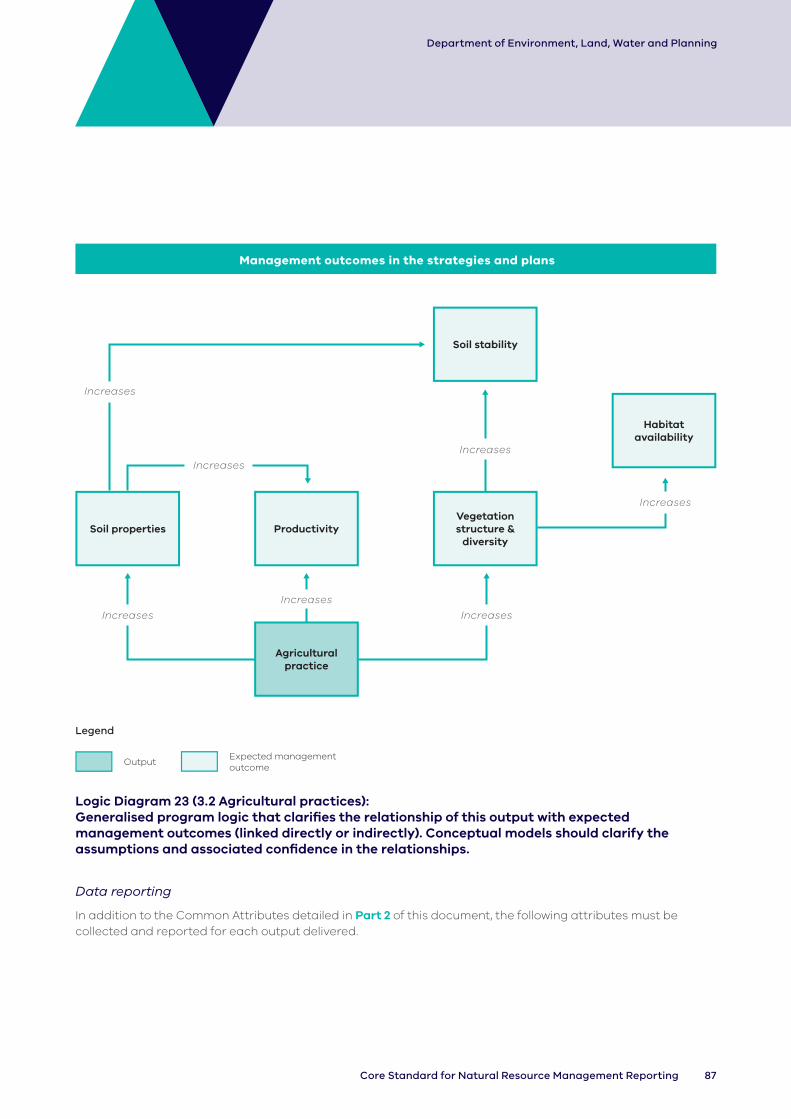
87Core Standard for Natural Resource Management Reporting
Department of Environment, Land, Water and Planning
Increases
IncreasesIncreases
Management outcomes in the strategies and plans
Soil stability
Soil properties Productivity
Agricultural practice
Vegetation structure &
diversity
Habitat availability
Increases
Increases
Increases
Increases
Legend
OutputExpected management outcome
Logic Diagram 23 (3.2 Agricultural practices): Generalised program logic that clarifies the relationship of this output with expected management outcomes (linked directly or indirectly). Conceptual models should clarify the assumptions and associated confidence in the relationships.
Data reporting
In addition to the Common Attributes detailed in Part 2 of this document, the following attributes must be collected and reported for each output delivered.

88 DELWP Output Data Standard
Department of Environment, Land, Water and Planning
Table 3.2: Agricultural practices specific attributes
Output TitleOutput Type Activity Type
Environment Type
Spatial ObjectSpecific Activities
Description Select one from list
Select one from list
Select one from list
Area over which agricultural practice output has occurred
Select one from list
Valid values Dryland Establish Coast – Dune Polygon Biomass/groundcover Retained
Irrigation Modify Coast - Shore Chemicals
Maintain Estuary Cropping
Remove Marine - Intertidal
Horticulture
Marine - Subtidal
Irrigation Management
Stream/River Nutrient Management
Terrestrial Other
Wetland
89Core Standard for Natural Resource Management Reporting
Department of Environment, Land, Water and Planning
3.3 Water
Scope
These data record the number of sites and area over which water has been delivered or removed.
As a general rule, the polygon for a section of a watercourse will developed by buffering the section of the watercourse between the point where the release of water commenced to where the release effectively stops impacting the section of watercourse. This includes the delivery of water into wetlands, where the source of water released to the delivery point into the wetland, is to be identified.
A buffer distance of 20m is typically applied.
Related outputs: Associated plans (e.g. seasonal watering plan, environmental water management plan), management agreements, the establishment of structures (e.g. dam, pump) or monitoring sites should be recorded in addition to this output.
Terminology
Coast – Dune: The area above the beach, from the primary (or fore) dune to the tertiary (or back/hind) dune.
Coast – Shore: Foreshore, beach.
Consumptive: Consumptive uses include the supply of urban drinking water, irrigation, industrial uses and power generation.
Cultural flows: The Victorian Water Accounts definition library does not presently have a definition for cultural water holdings. DELWP uses the term ‘cultural flows’ as defined by the Echuca Declaration and Share Benefits (water for the environment/urban that also is delivered to support other uses/values). https://www.mldrin.org.au/what-we-do/cultural-flows/
Delivery: Allocate or direct water to site.
Dewatering: Put into effect flow regime by removing water from site.
Environmental water holdings: Water held by the Victorian Environmental Water Holder (VEWH) and delivered to sites downstream to support environmental values.
Estuary: Estuaries are where rivers meet the sea and the fresh river water mixes with the salt water of the ocean. The definition of estuaries also includes coastal inlets (like Tamboon Inlet and Anderson Inlet), smaller bays (like Swan Bay and Limeburners Bay) and coastal barrier lagoons (like Jack Smith Lake and Lake Dennison). These inlets may also be classed as wetlands.
Manage: Put into effect flow regime through management of flows at priority sites.
Marine – Intertidal: Area between low and high tide marks (also known as littoral zone).
Marine – Subtidal: Area which remains underwater including during low tide.
Mixed: A water flow comprising more than one of any of the described flow types from this chapter.
Stream/River: Rivers are defined here as major rivers, streams or creeks and their feeders (tributaries), and include the water, the channel and surrounding land (known as riparian land). Riparian refers to land or vegetation that adjoins a river, wetland or estuary.
Terrestrial: Land area inland of the tertiary dune.
Unregulated flow: Natural flows along a river that cannot be captured, held and released from major weirs, reservoirs or storages.
Wetland: Wetlands are areas whether natural, modified or artificial, subject to permanent or temporary inundation, that hold static or very slow-moving water and develop, or have the potential to develop, biota adapted to inundation and the aquatic environment. Wetlands may be formed by natural processes or human activities. Wetlands include freshwater and saline lakes, swamps and shallow waters in Victoria’s estuaries, bays and inlets.

90 DELWP Output Data Standard
Department of Environment, Land, Water and Planning
Management outcomes in the strategies and plans
Amenity
Vegetation structure &
diversity
Environmental water
Water regime
Soil stabilityHabitat
availability
Species recovery
Increases
Increases
Increases
Alters
Increases
Increases
Increases
IncreasesIncreases
Legend
OutputExpected management outcome
Logic Diagram 24 (3.3 Water): Generalised program logic that clarifies the relationship of this output with expected management outcomes (linked directly or indirectly). Conceptual models should clarify the assumptions and associated confidence in the relationships.
Data reporting
In addition to the Common Attributes detailed in Part 2 of this document, the following attributes must be collected and reported for each output delivered.

91Core Standard for Natural Resource Management Reporting
Department of Environment, Land, Water and Planning
Tab
le 3
.3:
Wa
ter
spe
cif
ic a
ttri
bu
tes
Tit
leO
utp
ut
Typ
eA
cti
vity
Ty
pe
En
viro
nm
en
t Ty
pe
Sp
ati
al
Ob
jec
tT
imin
gV
olu
me
o
f w
ate
rTy
pe
of
flo
w
Flo
w
sta
rt
da
te
Flo
w
en
d
da
te
Des
crip
tio
nS
ele
ct o
ne
fr
om
list
Se
lect
o
ne
fro
m
list
Se
lect
on
e
fro
m li
stA
rea
ove
r w
hic
h
wa
ter
ou
tpu
t h
as
occ
urr
ed
Tim
ing
of
wa
ter
rele
ase
d/
wit
hh
eld
Ide
nti
fy
the
to
tal
volu
me
o
f w
ate
r d
eliv
ere
d
Se
lect
on
e
or
mo
re
fro
m li
st
Se
lect
D
ate
Se
lect
D
ate
Va
lid v
alu
esC
on
sum
pti
veE
sta
blis
hC
oa
st –
Du
ne
Po
lyg
on
Au
tum
nM
LB
an
k F
ull
Da
teD
ate
Cu
ltu
ral
Wa
ter-
Ho
ldin
gs
Ma
inta
inC
oa
st -
Sh
ore
S
pri
ng
N/A
Ba
se F
low
En
viro
nm
en
tal
Wa
ter-
Ho
ldin
gs
Mo
dif
yE
stu
ary
Su
mm
er
Ce
ase
to
F
low
Mix
ed
Re
mo
veM
ari
ne
-
Inte
rtid
al
Win
ter
Dry
ing
Un
reg
ula
ted
F
low
Ma
rin
e
- S
ub
tid
al
Fill
Str
ea
m/R
ive
rF
loo
din
g
Te
rre
stri
al
Fre
sh
We
tla
nd
Lo
w F
low
Ove
rba
nk
Flo
w
Pa
rtia
l Fill
Top
-up

92 DELWP Output Data Standard
Department of Environment, Land, Water and Planning
3.4 Fire
Scope
These data record the area over which fire has been applied to manage risks and/or ecological resilience.
Terminology
Cultural Fire: Fire deliberately put in to the landscape authorized and led by Traditional Owners of that Country, for a variety of purposes, including but not limited to: ceremony, protection of cultural and natural assets, fuel reduction, regeneration and management of food, fibre and medicines, flora regeneration, fauna habitat protection and healing Country’s spirit.
(Source: Traditional Owner Cultural Fire Strategy, FFR)
Planned Burning: Deliberate introduction of fire into the landscape to modify fuel hazard and contribute to ecological objectives
(Source: Code for Bushfire Management, FFR)
Fuel: Living and dead vegetation that can be ignited. It is often classified as dead or alive and as natural fuels or activity fuels (resulting from human actions, usually logging operations). Fuel components refer to such items as downed dead woody material by various size classes, litter, duff, herbaceous vegetation, live foliage, etc.
Weed control: The use of controlled burning activities to reduce fuel loads and improve herbicide use efficiency and targeting of weeds in the landscape. Fire can be used to control and suppress weeds, however, should only be used as a last resort because of the inherent risk of using fire. It generally does not kill the targeted weed but is primarily used to reduce the overall cover of weeds and the need for large amounts of chemical.

93Core Standard for Natural Resource Management Reporting
Department of Environment, Land, Water and Planning
Alters
Increases
Management outcomes in the strategies and plans
Vegetation structure &
diversity
Fire regime
Extreme event preparedness
Species recovery
Habitat availability
Increases
Increases
Legend
OutputExpected management outcome
Logic Diagram 25 (3.4 Fire): Generalised program logic that clarifies the relationship of this output with expected management outcomes (linked directly or indirectly). Conceptual models should clarify the assumptions and associated confidence in the relationships.
Data reporting
In addition to the Common Attributes detailed in Part 2 of this document, the following attributes must be collected and reported for each output delivered.

94 DELWP Output Data Standard
Department of Environment, Land, Water and Planning
Table 3.4: Fire specific attributes
Title Output Type Activity Type Spatial Object
Description Select one from list Select one from list Area over which fire output occurred
Valid values Cultural Establish Polygon
Ecological Maintain
Fuel Reduction
Weed control
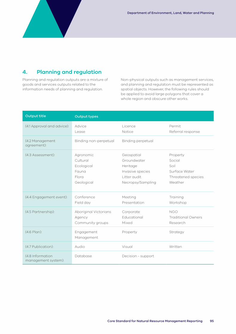
95Core Standard for Natural Resource Management Reporting
Department of Environment, Land, Water and Planning
4. Planning and regulationPlanning and regulation outputs are a mixture of goods and services outputs related to the information needs of planning and regulation.
Non-physical outputs such as management services, and planning and regulation must be represented as spatial objects. However, the following rules should be applied to avoid large polygons that cover a whole region and obscure other works.
Output title Output types
(4.1 Approval and advice): Advice
Lease
Licence
Notice
Permit
Referral response
(4.2 Management agreement):
Binding non-perpetual Binding perpetual
(4.3 Assessment): Agronomic
Cultural
Ecological
Fauna
Flora
Geological
Geospatial
Groundwater
Heritage
Invasive species
Litter audit
Necropsy/Sampling
Property
Social
Soil
Surface Water
Threatened species
Weather
(4.4 Engagement event): Conference
Field day
Meeting
Presentation
Training
Workshop
(4.5 Partnership): Aboriginal Victorians
Agency
Community groups
Corporate
Educational
Mixed
NGO
Traditional Owners
Research
(4.6 Plan): Engagement
Management
Property Strategy
(4.7 Publication): Audio Visual Written
(4.8 Information management system):
Database Decision - support

96 DELWP Output Data Standard
Department of Environment, Land, Water and Planning
4.1 Approval and advice
Scope
These data record the number of decisions made in regard to permits, licences, leases and planning referrals, as well as advice provided to another agency or individual.
Approvals include permits processed for the regulation of works on waterways and responses made as a referral authority to planning scheme referrals relating to matters including floodplain management, irrigation development guidelines, soil protection, salinity management and native vegetation.
Note: Advice should only be used where:
• it is considered to make a noteworthy contribution towards a desired management outcome (e.g. input to stream flow management plans); or
• significant effort is required to meet compliance with regulatory requirements such as 1080 baiting or advice (neighbour notification).
It is noted that the details contained in the Approval and Advice output are typically sourced from the Integrated Planning and Works System (IPAWS) for statutory referrals, advice and permits where statutory approvals and advice (such as floodplain statutory approvals and advice) are exported from IPAWS and used to populate information into this output. IPAWS is being used by all CMAs and the data is typically exported once a year.
Terminology
Coast – Dune: The area above the beach, from the primary (or fore) dune to the tertiary (or back/hind) dune.
Coast – Shore: Foreshore, beach.
Estuary: Estuaries are where rivers meet the sea and the fresh river water mixes with the salt water of the ocean. The definition of estuaries also includes coastal inlets (like Tamboon Inlet and Anderson Inlet), smaller bays (like Swan Bay and Limeburners Bay) and coastal barrier lagoons (like Jack Smith Lake and Lake Dennison). These inlets may also be classed as wetlands.
Irrigation Development Guidelines (IDG) referrals: IDG provide guidance to both irrigation developers and government agencies on the process, matters for consideration, conditions and approvals required to obtain or modify a Water Use Licence (WUL) or Take and Use Licence (T&UL).
IDG are regionally based and implemented by the relevant CMA(s) and Rural Water Corporation(s) (RWC).
Lease: Permission for exclusive use and possession of a parcel of land or a building for a defined term.
Licence: Permission for non-exclusive use of a parcel of land for a defined period.
Marine – Intertidal: Area between low and high tide marks (also known as littoral zone).
Marine – Subtidal: Area which remains underwater including during low tide.
Permit: A document or certificate that gives permission to do or not do something as governed by the Waterway Protection By-law, which is a legislative instrument under the Water Act 1989.
Referrals: Section 55 of the Planning and Environment Act 1987 and Section 202 of the Water Act 1989 require referral to Floodplain Management Authorities (FMAs) for specific decisions. In addition to this, councils, other agencies or individuals may seek advice or guidance from FMAs on flooding related issues.
Stream/River: Rivers are defined here as major rivers, streams or creeks and their feeders (tributaries), and include the water, the channel and surrounding land (known as riparian land). Riparian refers to land or vegetation that adjoins a river, wetland or estuary.
T&UL: A water licence under section 51 of the Water Act that grants the holder the right to take and use water from waterways (both regulated and unregulated), dams (both on-stream and off-stream), springs and soaks, and works of an authority or groundwater.
Terrestrial: Land area inland of the tertiary dune.
Works on waterway (WOW) permit: To undertake works or activities in, on or over a designated waterway, a permit or written authorisation from the Authority is required by law.
The permit process is designed to provide common and best practice guidance for ensuring works or activities have appropriately addressed hydraulic, physical and environmental impacts on the ‘health’ of our important waterways.
Waterway: A river, wetland or estuary.
Wetland: Wetlands are areas whether natural, modified or artificial, subject to permanent or temporary inundation, that hold static or very slow-moving water and develop, or have the potential to develop, biota adapted to inundation and the aquatic environment. Wetlands may be formed by natural processes or human activities. Wetlands include freshwater and saline lakes, swamps and shallow waters in Victoria’s estuaries, bays and inlets.

97Core Standard for Natural Resource Management Reporting
Department of Environment, Land, Water and Planning
Management outcomes in the strategies and plans
Skills
Awareness
Approval and advice
Governance
Improves Improves
Improves
Improves
Legend
OutputExpected management outcome
Logic Diagram 26 (4.1 Approval and advice): Generalised program logic that clarifies the relationship of this output with expected management outcomes (linked directly or indirectly). Conceptual models should clarify the assumptions and associated confidence in the relationships.
Data reporting
In addition to the Common Attributes detailed in Part 2 of this document, the following attributes must be collected and reported for each output delivered.
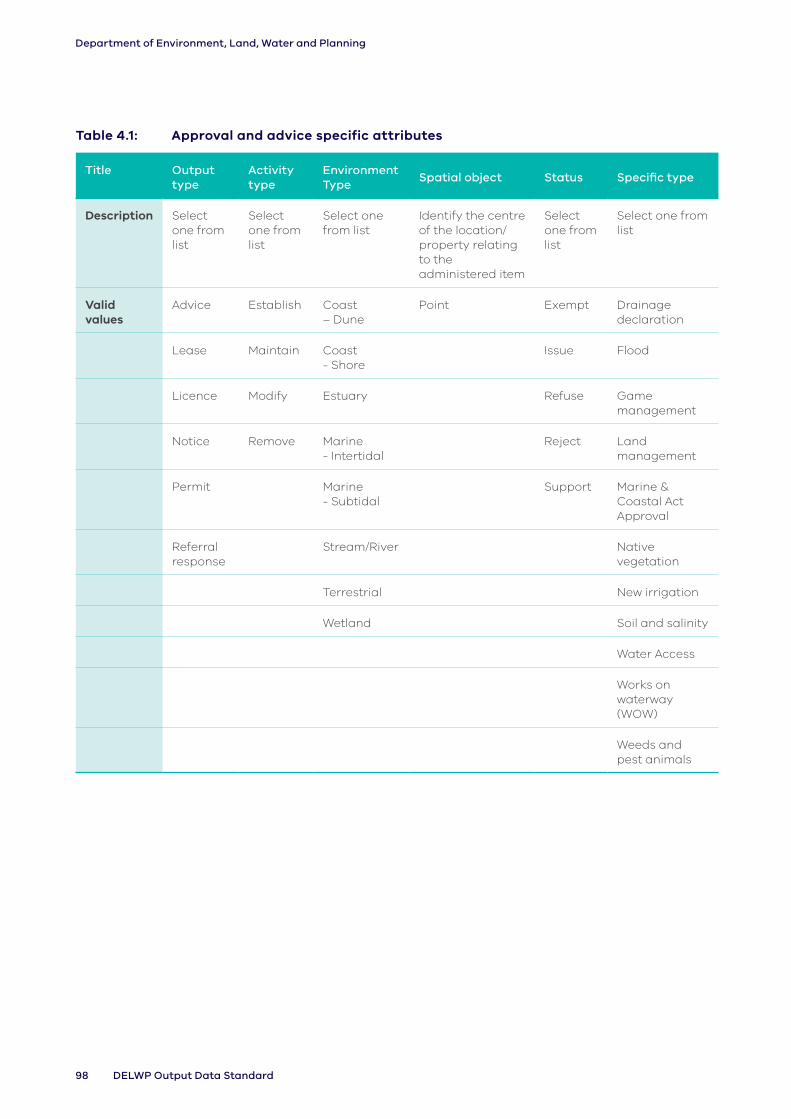
98 DELWP Output Data Standard
Department of Environment, Land, Water and Planning
Table 4.1: Approval and advice specific attributes
Title Output type
Activity type
Environment Type
Spatial object Status Specific type
Description Select one from list
Select one from list
Select one from list
Identify the centre of the location/ property relating to the administered item
Select one from list
Select one from list
Valid values
Advice Establish Coast – Dune
Point Exempt Drainage declaration
Lease Maintain Coast - Shore
Issue Flood
Licence Modify Estuary Refuse Game management
Notice Remove Marine - Intertidal
Reject Land management
Permit Marine - Subtidal
Support Marine & Coastal Act Approval
Referral response
Stream/River Native vegetation
Terrestrial New irrigation
Wetland Soil and salinity
Water Access
Works on waterway (WOW)
Weeds and pest animals

99Core Standard for Natural Resource Management Reporting
Department of Environment, Land, Water and Planning
4.2 Management agreement
Scope
These data record the number of agreements that have been developed or reviewed in relation to the management of a specific location (e.g. landholder property).
This output includes agreements attached to title, legal conservation covenants or agreements placed on the property title for a parcel of land.
Where the agreement includes the restriction of access/use for native vegetation outcomes (e.g. through covenanting), the vegetation structure and diversity expected management outcome should be selected.
This output should be used when the expected management outcome is achieved through the establishment of a management agreement, including in situations where the works associated with the management agreement are recorded under other outputs. In this instance, the management agreement is recorded as an output (including the management agreement area (ha)) in addition to the works delivered, which are each recorded as separate outputs, and linked by the use of a Unique site ID and Project ID (common attributes).
Where a management agreement output relates to an individual property, or a wetland, a polygon describing the area to which the plan relates is appropriate.
Where a management agreement output relates to a collection of properties, the point location for the partner head office should be used, and a calculated area of each location covered by the output should be entered in the ‘Area’ attribute, expressed in Hectares (Ha).
Where the output relates to a single area that is less than a quarter of an agency area (for example, a sub-catchment or smaller) a polygon must be used.
Where a management agreement output relates to the agency area as a whole, the point location for the agency head office should be used.
Related outputs: Outputs delivered in association (e.g. assessments, plans) or those described in the agreement (e.g. grazing, fencing) should be recorded separately. Memorandums of understanding or service level agreements governing the allocation of resources or funding should be captured under the ‘Partnership’ output.
Terminology
Agreements: Documented agreements to formalise a partnership or arrangement between two or more
Binding: Agreement imposing a legal obligation (e.g. agreement on title).
Coast – Dune: The area above the beach, from the primary (or fore) dune to the tertiary (or back/hind) dune.
Coast – Shore: Foreshore, beach.
Estuary: Estuaries are where rivers meet the sea and the fresh river water mixes with the salt water of the ocean. The definition of estuaries also includes coastal inlets (like Tamboon Inlet and Anderson Inlet), smaller bays (like Swan Bay and Limeburners Bay) and coastal barrier lagoons (like Jack Smith Lake and Lake Dennison). These inlets may also be classed as wetlands.
Marine – Intertidal: Area between low and high tide marks (also known as littoral zone).
Marine – Subtidal: Area which remains underwater including during low tide.
Non-perpetual: Lapse of agreement at the end of a fixed term or when the land changes ownership.
Parties. This may be the result of developing a plan or going through a planning process.
Perpetual: An agreement that is binding on future landowners as well as the current landowner.
Stream/River: Rivers are defined here as major rivers, streams or creeks and their feeders (tributaries), and include the water, the channel and surrounding land (known as riparian land). Riparian refers to land or vegetation that adjoins a river, wetland or estuary.

100 DELWP Output Data Standard
Department of Environment, Land, Water and Planning
Terrestrial: Land area inland of the tertiary dune.
Wetland: Wetlands are areas whether natural, modified or artificial, subject to permanent or temporary inundation, that hold static or very slow-moving water and develop, or have the potential to develop, biota adapted to inundation and the aquatic environment. Wetlands may be formed by natural processes or human activities. Wetlands include freshwater and saline lakes, swamps and shallow waters in Victoria’s estuaries, bays and inlets.
Long-term agreements
It is noted that where the duration for an agreement is either long-term or perpetual, such as in the case of many riparian agreements and Trust for Nature Covenants, a value of 99 years should be used. ‘Long-term’ for riparian agreements refers to those agreements which are binding on the existing landholder for the time of their ownership of the property (which could be for several decades) but they are not on title, so are not binding on future owners.
ImprovesImproves
Management outcomes in the strategies and plans
Vegetation structure &
diversity
Habitat available
Awareness
Management agreement
Skills
Improves
Improves
Legend
OutputExpected management outcome
Logic Diagram 27 (4.2 Management agreement): Generalised program logic that clarifies the relationship of this output with expected management outcomes (linked directly or indirectly). Conceptual models should clarify the assumptions and associated confidence in the relationships.
Data reporting
In addition to the Common Attributes detailed in Part 2 of this document, the following attributes must be collected and reported for each output delivered.

101Core Standard for Natural Resource Management Reporting
Department of Environment, Land, Water and Planning
Table 4.2: Management agreement specific attributes
Output Title
Output Type
Activity Type
Environment Type
Spatial Object
Area under agreement
Party Duration
Description Select one from list
Select one from list
Select one from list
Area/s covered by the agreement (select either/or, not both) in accordance with guidance above
Calculate area under agreement
Identify the status of the party entering into the agreement
Duration of the agreement where relevant. Agreements on property title are considered permanent (99 years should be used
Valid values
Binding Non-Perpetual
Establish Coast – Dune
Point Ha Private Landholder
Years
Binding Perpetual
Maintain Coast - Shore
Polygon Public Landholder
Modify Estuary
Remove Marine - Intertidal
Marine - Subtidal
Stream/River
Terrestrial
Wetland
4.3 Assessment
Scope
These data record the application of assessments of social, land, water and biodiversity characteristics.
It includes monitoring activities done to ensure compliance with policy and regulation and new and emerging weeds and pest animals.
Related outputs: The installation of a monitoring structure or plan associated with the assessment should be recorded as a separate output. The output does not refer to the ‘assessment’ of reports or applications, which should be recorded under the ‘Advice and approvals output’. Nor should it be used to record ‘sighting’ the data produced from the assessment (e.g. presence/absence), which should be recorded in the appropriate DELWP database (i.e. Victorian Biodiversity Atlas, https://vba.dse.vic.gov.au/vba/index.jsp).

102 DELWP Output Data Standard
Department of Environment, Land, Water and Planning
Terminology
Assessment: Site-specific assessment of condition, outcomes or management issues present. This information is used to inform future decision-making and activity at that site.
Litter Audit: To survey and/or assess any solid or liquid domestic or commercial waste, refuse, debris or rubbish and without limiting the generality of the above, includes any waste glass, metal, plastic, paper, fabric, wood, food, soil, sand, concrete or rocks, abandoned vehicles, abandoned vehicle parts and garden remnants and clippings, but does not include any gases, dust or smoke, or any waste that is produced or emitted during, or as a result of, any of the normal operations of the mining, building or manufacturing industry or of any primary industry.
Necropsy / Sampling: Involves dissection of the deceased animal (carcass) for the purpose of determining cause of death. An experienced veterinarian and/or veterinary pathologist must be involved.
Specific activities: The method used to conduct the assessment.
Threatened Species: Any fauna and flora species and ecological communities that are listed as threatened under Victorian legislation (Flora and Fauna Guarantee Act 1988) or included in DELWP’s Threatened Species Advisory Lists.
Management outcomes in the strategies and plans
Awareness
Assessment
Cultural heritage
Collaboration Skills
Improves
Improves
Improves
Improves Improves
Legend
OutputExpected management outcome
Logic Diagram 28 (4.3 Assessment): Generalised program logic that clarifies the relationship of this output with expected management outcomes (linked directly or indirectly). Conceptual models should clarify the assumptions and associated confidence in the relationships.
Data reporting
In addition to the Common Attributes detailed in Part 2 of this document, the following attributes must be collected and reported for each output delivered.

103Core Standard for Natural Resource Management Reporting
Department of Environment, Land, Water and Planning
Tab
le 4
.3:
Ass
ess
me
nt
spe
cif
ic a
ttri
bu
tes
Ou
tpu
t T
itle
Ou
tpu
t Ty
pe
Ac
tivi
ty
Typ
e
Sp
ati
al
Ob
jec
tD
ata
sto
rag
eD
ata
ba
se ID
Sp
eci
fic
Ac
tivi
tie
sA
cti
vity
Sta
ge
Tota
l
Vo
lun
tee
r
Nu
mb
er
Tota
l
Vo
lun
tee
r
Ho
urs
Des
crip
tio
nS
ele
ct o
ne
fro
m li
stS
ele
ct o
ne
fro
m li
st
Are
a w
he
re
ass
ess
me
nt
wa
s
con
du
cte
d
Ide
nti
fy w
he
re t
he
ass
ess
me
nt
da
ta is
sto
red
. In
clu
din
g D
ELW
P
da
tab
ase
s w
he
re a
pp
rop
ria
te
Ide
nti
fy t
he
ID
for
the
en
trie
s
into
th
e
da
tab
ase
Se
lect
on
e
fro
m li
st
Se
lect
on
e
fro
m li
st
En
ter
nu
mb
er
or
sele
ct N
/A
En
ter
nu
mb
er
or
sele
ct N
/A
Va
lid v
alu
esA
gro
no
mic
Est
ab
lish
Po
lyg
on
Ag
en
cy d
ata
ba
seV
BA
IDIn
spe
ctio
nP
re t
rea
tme
nt
Nu
mb
er
Nu
mb
er
Cu
ltu
ral
Ma
inta
inA
LA
Mo
de
lP
ost
tre
atm
en
tN
/AN
/A
Eco
log
ica
lM
od
ify
Bir
dlif
e A
ust
ralia
Bir
d D
ata
Atl
as
Re
mo
teN
/A
Fau
na
Co
ast
kit
Su
rve
y
Flo
raiN
atu
ralis
tV
isu
al
Ge
olo
gic
al
Lit
terw
atc
hO
the
r
Ge
osp
ati
al
Mo
nit
ori
ng
sit
es
da
tab
ase
Gro
un
dw
ate
rN
VIM
He
rita
ge
Sa
linit
y re
gis
ter
Inva
sive
sp
eci
es
ST
AR
Lit
ter
Au
dit
VB
A
Ne
cro
psy
/
Sa
mp
ling
Vic
tori
a W
ate
r d
ata
wa
reh
ou
se
Pro
pe
rty
Wa
terw
atc
h/
est
ua
ry w
atc
h
da
ta w
are
ho
use
So
cia
lO
the
r
So
ilN
/A
Su
rfa
ce w
ate
r
Th
rea
ten
ed
Sp
eci
es
We
ath
er

104 DELWP Output Data Standard
Department of Environment, Land, Water and Planning
4.4 Engagement event
Scope
These data record the number of engagement events held with members of the community and/or agency staff that were coordinated, attended, established, sponsored and/or supported, or where displays were presented. It also records the number of volunteers and total volunteer hours to track active participation rates.
This includes a wide range of engagement events including those to raise awareness or provide skills and training about an NRM issue for potential and active members of the NRM volunteer community.
Note: This output is not intended to capture every engagement event, only those that are considered to make a noteworthy contribution towards a desired management outcome.
The spatial location should show where the engagement event occurred.
Where an engagement event (4.4) is held at an office location remote from the actual project area, the spatial location assigned should be that of where the engagement event was held. The ‘Name/Title’ attribute should identify the location to which the overall project relates.
Related outputs: Engagement events often lead to and/or support the delivery of additional outputs. Where other outputs are delivered as part of the event these should be recorded in addition to this output (e.g. vegetation, pest treatment).
Terminology
Awareness raising: Proactively sharing knowledge with the public in order to alert them and potentially gain their future participation in NRM and community activities.
Community-based NRM (CBNRM) group: For example, Panyyabyr Landcare Group – (GHCMA).
Field day: An event devoted to specific location(s) to discuss a specific topic(s).
Target audience: The audience for the engagement event. It may be geographically defined, based on group/organisation membership or be a sector of the community.
Training: Structured activities designed to improve or refresh existing skills or develop new ones.
Workshop: An educational event or series of meetings emphasising interaction and exchange of information among a (usually) small number of participants.

105Core Standard for Natural Resource Management Reporting
Department of Environment, Land, Water and Planning
Improves
Management outcomes in the strategies and plans
ImprovesImproves
Skills Awareness
Engagement event
Collaboration
Improves
Legend
OutputExpected management outcome
Logic Diagram 29 (4.4 Engagement event): Generalised program logic that clarifies the relationship of this output with expected management outcomes (linked directly or indirectly). Conceptual models should clarify the assumptions and associated confidence in the relationships.
Data reporting
In addition to the Common Attributes detailed in Part 2 of this document, the following attributes must be collected and reported for each output delivered.

106 DELWP Output Data Standard
Department of Environment, Land, Water and Planning
Table 4.4: Engagement event specific attributes
Title Output Type Activity TypeEngagement
Level
Spatial
ObjectName/title Participants Event length Number of events Target Audience Focus
Total Volunteer
Number
Total Volunteer
Hours
Description Select one from list Select one from list Select one from
list
Location
where the
event was
held
Provide the
name of
event
Total
number of
participants
who
attended
Length of the
event, to the
nearest hour
Where events have
identical values for all other
attributes (e.g. location,
type, year completed) they
can be captured together
Select multiple
from list
Record the primary
focus for the event
Enter number
or select N/A
Enter number
or select N/A
Valid values Conference Attend Inform Point Text Field Number Hours Events Aboriginal
Victorians
Conservation
Awareness
Number Number
Field Day Coordinate Consult Catchment
Management
Authority
Conservation
management/
techniques
N/A N/A
Meeting Establish Involve Coastcare Cultural Awareness
Presentation Sponsor Collaborate Community
Groups
Cultural Safety
Training Support Empower DELWP Data management
and reporting
Workshop Friends-of Group General
occupational health
and safety
Government
Agency
Planning
Landcare Recruitment
Local Council Survey and
monitoring
Management
Committee
Non Government
Organisation
Not For Profit
Parks Victoria
Private Land
Manager
Research
Organisation
Traditional Owner
Trust For Nature
Water Corporation
Other

107Core Standard for Natural Resource Management Reporting
Department of Environment, Land, Water and Planning
Table 4.4: Engagement event specific attributes
Title Output Type Activity TypeEngagement
Level
Spatial
ObjectName/title Participants Event length Number of events Target Audience Focus
Total Volunteer
Number
Total Volunteer
Hours
Description Select one from list Select one from list Select one from
list
Location
where the
event was
held
Provide the
name of
event
Total
number of
participants
who
attended
Length of the
event, to the
nearest hour
Where events have
identical values for all other
attributes (e.g. location,
type, year completed) they
can be captured together
Select multiple
from list
Record the primary
focus for the event
Enter number
or select N/A
Enter number
or select N/A
Valid values Conference Attend Inform Point Text Field Number Hours Events Aboriginal
Victorians
Conservation
Awareness
Number Number
Field Day Coordinate Consult Catchment
Management
Authority
Conservation
management/
techniques
N/A N/A
Meeting Establish Involve Coastcare Cultural Awareness
Presentation Sponsor Collaborate Community
Groups
Cultural Safety
Training Support Empower DELWP Data management
and reporting
Workshop Friends-of Group General
occupational health
and safety
Government
Agency
Planning
Landcare Recruitment
Local Council Survey and
monitoring
Management
Committee
Non Government
Organisation
Not For Profit
Parks Victoria
Private Land
Manager
Research
Organisation
Traditional Owner
Trust For Nature
Water Corporation
Other

108 DELWP Output Data Standard
Department of Environment, Land, Water and Planning
4.5 Partnership
Scope
These data record the number of formal partnerships established between organisations and/or individuals that are established, maintained or modified.
These partnerships can provide an opportunity to engage with industry and the community to support the achievement of both short-term outputs and long-term condition change objectives.
Partnerships should be based on the agreement documentation (e.g. memorandum of understanding, or equivalent) that may be legally binding, or may not be binding but which identifies commitment, and is signed by all partners to the agreement.
There is one partnership for each such agreement, which may comprise two or more partners. Where there is separate agreement documentation with each partner, each agreement may be viewed as a separate partnership.
Terminology
Aboriginal Victorian: Aboriginal Victorian refers to both Aboriginal and Torres Strait Islander peoples. They may have connections in and outside of Victoria. The use of the term Indigenous is retained in the names of programs, initiatives and publication titles and, unless otherwise noted, is inclusive of both Aboriginal and Torres Strait Islander peoples.
Letter of agreement: A letter outlining the conditions of a partnership.
Memorandum of Understanding: Document that formalises a partnership or arrangement between two or more parties but is not legally binding.
Partnership: An association of two or more organisations that has been formalised through arrangements such as a memorandum of understanding or committee/working group terms of reference.
Traditional Owner: An Aboriginal person who has traditional connection(s) to an identified geographical area of Country.
Management outcomes in the strategies and plans
Collaboration
Partnership
Skills
Increases Increases
Legend
OutputExpected management outcome
Logic Diagram 30 (4.5 Partnership): Generalised program logic that clarifies the relationship of this output with expected management outcomes (linked directly or indirectly). Conceptual models should clarify the assumptions and associated confidence in the relationships.
Data reporting
In addition to the Common Attributes detailed in Part 2 of this document, the following attributes must be collected and reported for each output delivered.

109Core Standard for Natural Resource Management Reporting
Department of Environment, Land, Water and Planning
Table 4.5: Partnership specific attributes
Title Output TypeActivity Type
Spatial Object Parties Duration
Description Select one from list
Select one from list
Identify a location to ‘represent’ partnership operations
Identify the organisations or individuals who are parties to the partnership
Duration of the partnership, where considered permanent 99 years should be used
Valid values
Aboriginal Victorians
Establish Point List Years
Agency Maintain
Community groups
Modify
Corporate
Educational
Mixed
NGO
Research
Traditional
Owners

110 DELWP Output Data Standard
Department of Environment, Land, Water and Planning
4.6 Plan
Scope
These data record the number of plans or strategies (e.g. management plan, strategy, engagement) that have been developed or reviewed.
Plans and strategies must be for a defined location. The scale, however, may vary ranging from individual property management plans or site designs through to regional strategies and plans (e.g. stream flow management plan, environmental watering plan, seasonal watering plans). The content may also vary from plans dealing with a specific topic (e.g. irrigation) to plans and strategies dealing with social and cultural themes that impact on or are impacted by environmental values.
Related outputs: Assessments conducted or agreements developed in association with the plan or strategy should be recorded as a separate output.
Terminology
Community-based NRM (CBNRM) group: For example, Panyyabyr Landcare Group – (GHCMA).
Engagement plan: A plan for engagement with stakeholders.
Property: A plan associated with a landowner’s property for the management of that land (e.g. whole farm plan, irrigation or dry-land).
Management plan: A plan guiding overall management of an area (e.g. wetland or environmental watering plan).
Strategy: A plan defining an agency’s strategy or direction, and the allocation of resources to pursue this strategy.
Management outcomes in the strategies and plans
Increases
Increases
Skills
AwarenessCultural Heritage
Plan
Increases
Legend
OutputExpected management outcome
Logic Diagram 31 (4.6 Plan): Generalised program logic that clarifies the relationship of this output with expected management outcomes (linked directly or indirectly). Conceptual models should clarify the assumptions and associated confidence in the relationships.
Data reporting
In addition to the Common Attributes detailed in Part 2 of this document, the following attributes must be collected and reported for each output delivered.

111Core Standard for Natural Resource Management Reporting
Department of Environment, Land, Water and Planning
Tab
le 4
.6:
Pla
n s
pe
cif
ic a
ttri
bu
tes
Tit
leO
utp
ut
Typ
eA
cti
vity
Ty
pe
Sp
ati
al
Ob
jec
tN
am
e/t
itle
Ye
ar
Co
mm
en
ce
dD
ura
tio
nF
ocu
sTa
rge
t A
ud
ien
ce
Des
crip
tio
nS
ele
ct o
ne
fr
om
list
Se
lect
on
e
fro
m li
stA
rea
co
vere
d b
y th
e p
lan
Un
iqu
e id
en
tifi
er
for
pla
n/s
tra
teg
y re
cord
ed
in t
he
o
utp
uts
Co
mm
en
cem
en
t d
ate
(m
on
th/
yea
r)
Du
rati
on
of
the
pla
n
(ye
ars
)
Se
lect
mu
ltip
le
fro
m li
stA
bro
rig
ina
l Vic
tori
an
s
Va
lid v
alu
esE
ng
ag
em
en
tE
sta
blis
hP
oly
go
nF
ull
titl
e o
f p
lan
/st
rate
gy
Mo
nth
/ye
ar
Yea
rsC
on
serv
ati
on
Ca
tch
me
nt
Ma
na
ge
me
nt
Au
tho
rity
Ma
na
ge
me
nt
Mo
dif
yC
ult
ure
/he
rita
ge
Co
ast
care
Pro
pe
rty
Re
vie
wF
ire
Co
mm
un
ity
Gro
up
s
Str
ate
gy
Fis
hD
ELW
P
Flo
raF
rie
nd
s-o
f G
rou
p
Irri
ga
tio
nG
ove
rnm
en
t A
ge
ncy
Ma
na
ge
me
nt
pra
ctic
es
La
nd
care
Fau
na
Lo
cal C
ou
nci
l
Oth
er
Ma
na
ge
me
nt
Co
mm
itte
e
No
n G
ove
rnm
en
t O
rga
nis
ati
on
No
t Fo
r P
rofi
t
Pa
rks
Vic
tori
a
Pri
vate
La
nd
Ma
na
ge
r
Re
sea
rch
Org
an
isa
tio
n
Sch
oo
ls
Tra
dit
ion
al O
wn
er
Tru
st F
or
Na
ture
Wa
ter
Co
rpo
rati
on
You
th
Oth
er

112 DELWP Output Data Standard
Department of Environment, Land, Water and Planning
4.7 Publication
Scope
These data record the number of publications established, maintained or modified (e.g. standards, flyers, newsletters). It includes visual and audio-based communication material.
This output is not intended to capture every publication that an organisation may deliver, only those that are considered to make a noteworthy contribution towards a desired management outcome.
Terminology
Audio: Material disseminated through radio, podcasts, etc.
Publication: The preparation and issuing of a material or other work for public consumption.
Visual: Material disseminated through television, online videos, DVDs, etc.
Written: Printed or online publications.
Management outcomes in the strategies and plans
Increases
Increases
Skills
Awareness
Publication
Legend
OutputExpected management outcome
Logic Diagram 32 (4.7 Publication): Generalised program logic that clarifies the relationship of this output with expected management outcomes (linked directly or indirectly). Conceptual models should clarify the assumptions and associated confidence in the relationships.
Data reporting
In addition to the Common Attributes detailed in Part 2 of this document, the following attributes must be collected and reported for each output delivered.

113Core Standard for Natural Resource Management Reporting
Department of Environment, Land, Water and Planning
Table 4.7: Publication specific attributes
Title Output Type
Activity Type
Spatial Object Specific Type Frequency Target Audience
Description Select one from list
Select one from list
Identify a location to ‘represent’ publication’s target audience
Select one from list
Select one from list
Select multiple from list
Valid values
Audio Establish Point Booklet Ad Hoc Abroriginal Victorians
Visual Maintain DVD Annually Catchment Management Authority
Written Modify Fact Sheet Fortnightly Coastcare
Flyer/Pamphlet Monthly Community Groups
Journal Article Once DELWP
Media Release Quarterly Friends-of Group
Newsletter Weekly Government Agency
Newspaper Landcare
Podcast Local Council
Radio Management Committee
Report Non Government Organisation
Research Article
Not For Profit
Social Media Parks Victoria
Standard Private Land Manager
Television Research Organisation
Video Schools
Website Traditional Owners
Other Trust For Nature
Water Corporation
Youth
Other

114 DELWP Output Data Standard
Department of Environment, Land, Water and Planning
4.8 Information management system
Scope
These data record the number of information management systems or applications that are established, maintained or modified.
Information management systems are used to store and disseminate output/outcome-related data to assist with planning and other decision-based activities.
Terminology
Database: Any collection of data, or information, that is specially organized for rapid search and retrieval by a computer. Databases are structured to facilitate the storage, retrieval, modification, and deletion of data in conjunction with various data-processing operations.
Decision Support System: An interactive computerized system that gathers and presents data from a wide range of sources for business or strategic planning purposes. (eg. NatureKit).
Note: This output is not intended to capture every database or decision support system, only those that are considered to make a noteworthy contribution towards a desired management outcome.
Management outcomes in the strategies and plans
Skills Awareness
Information management system
Increases
Increases
Increases
Legend
OutputExpected management outcome
Logic Diagram 33 (4.8 Information management system): Generalised program logic that clarifies the relationship of this output with expected management outcomes (linked directly or indirectly). Conceptual models should clarify the assumptions and associated confidence in the relationships.
Data reporting
In addition to the Common Attributes detailed in Part 2 of this document, the following attributes must be collected and reported for each output delivered.

115Core Standard for Natural Resource Management Reporting
Department of Environment, Land, Water and Planning
Table 4.8: Information management system specific attributes
Title Output type Activity type Spatial object Name/title Owner
Description Select one from list
Select one from list
Identify a location that ‘represents’ the output’s application
Provide the name of the system
List who will own and maintain the system
Valid values Database Establish Point Text Text
Decision support system
Maintain
Modify

116 DELWP Output Data Standard
Department of Environment, Land, Water and Planning
Part 4: Development, governance and control of the Standard
How the current Standard was developed
The Data Standard has been used for over a decade and its development has included periodic improvement with considerable consultation and review.
After an independent review was completed in 2012, the Standard was trialled by Victoria’s 10 CMAs in 2013/14. The data received for the 2013/14 year was much improved over previous years, but a further review, conducted by the Mallee CMA on behalf of DELWP, found opportunities for further improvement.
In 2017, DELWP’s Biodiversity division led a comprehensive review of the Data Standard against the requirements of the newly released Victorian Biodiversity Plan, Protecting Victoria’s Environment - Biodiversity 2037 (Biodiversity 2037). The resulting report completed in 2019, found that significant changes would need to be made to the Data Standard in order to accurately report against the objectives of Biodiversity 2037.
In response to the Biodiversity 2037 review results, DELWP engaged its Integrated Catchment Management (ICM) team to conduct a wide-ranging review to improve alignment to a broader range of current Victorian Government policy and programs including Water for Victoria and the new Marine and Coastal policy.
The following groups and organisations were involved in developing the latest version of the Data Standard, including input from each of their major reporting and/or collaborating partners:
• Environment and Climate Change Group (DELWP)
• Water and Catchments Group (DELWP)
• Victorian Catchment Management Authorities (CMAs)
• Parks Victoria (PV)
• Agriculture Victoria (Department of Jobs, Regions and Precincts - DJPR)
• Forests, Fire & Regions Group (DELWP)
• Aboriginal Self-Determination Reform Branch (DELWP)
• Trust for Nature
The ICM Team coordinated a Technical Working Group (TWG) comprised of representatives from the partners listed above. The TWG met regularly over 18 months to test, justify and rationalise a comprehensive list of proposed changes to the Data Standard. In addition to reviewing the current user needs and suitability of the Standard, the TWG developed a governance framework for managing future changes to the Data Standard and charted a strategy for improvements to data management, improved Aboriginal inclusion and structured tiering of the Data Standard for use in applications where the terms and needs were too specific and/or resource intensive to be of value to a majority of current users.
Key changes from the 2019/20 review included:
• development of governance arrangements for changes to the data standard
• inclusion of a new output for Marine and Coastal Structure
• inclusion of volunteer numbers and hours to several outputs
• amendments to the common attributes (on ground works agent, delivery standards version)
• development of a Unique Site ID code common attribute
• improved reference to Traditional Owner involvement (further work is planned to include specific outputs related to Aboriginal self determination)
Together, the Output Data Standard and the Delivery Standards represent key components of the DELWP MER Framework. The Delivery Standards provide guidance for consistent management activities and outputs; the Output Data Standard provide guidance on reporting those management activities and outputs.

117Core Standard for Natural Resource Management Reporting
Department of Environment, Land, Water and Planning
Governance
Governance and control arrangements are a necessary component of establishing and managing foundational documents such as policies, plans, standards and procedures. The key rationale for establishing a governance framework for the Output Data Standard and Output Delivery Standards includes;
a. Consistency – Setting consistent guidelines around data collection, management and storage across funding streams, departments and partners
b. Efficiency – Reducing replication of reporting outputs across multiple departments and agencies
c. Transparency – Providing confidence and provenance behind the rationale for requirements described in the Standard, specifically where significant costs are associated with changes
d. Stability - Providing a set of guidelines for future management of the standard, regardless of structural, policy or funding changes
Control of the Standards
The Standards Custodian has primary responsibility for overseeing the governance, maintenance and distribution of the standards.
The Standards Custodian is a Director-level appointment within DELWP to ensure authority and oversight of administration related to the Output Data Standard and Delivery Standards. The Standards Custodian is nominally the Chair of the DELWP NRM Directors’ Group (NRMDG) – currently the Director, Environmental Policy and Community Partnerships branch.
The Standards Custodian seeks authority from the NRMDG as the Standards Control Board (SCB) for decisions related to management, maintenance and governance of the standards.
What is the Technical Working Group (TWG)?
The TWG is a technically competent group of industry stakeholder representatives who have been identified by the SCB as being significant users of the Output Standard or Delivery Standards.
The role of the TWG is to make recommendations of actions for approval by the SCB, based on technical review of any requested changes to the current published standards.
What does Review of the Standard mean?
A review of the Standard may involve a complete technical investigation and formal update of the scope, terms, attributes and applications of the Output Data Standard and the Delivery Standards and subsequent republishing with a new major version number and ISBN.
However, a review request does not always need to constitute a full review of all applicable standards. A request may be as simple as a terminology update or addition/deletion of an output attribute. In this case, the affected standard will be published under a minor version number, likely in electronic, online format only until a subsequent major review is conducted.
The scope and scale of a Standard review, and the appropriate administration, will be determined by the SCB in consultation with the TWG.
Triggers for Review
Review requests will be referred to the TWG and SCB as required. Reasons for review should be significant, for example:
a. Significant policy and/or program change.
b. Significant changes to MER methodology or development of a new delivery method (e.g. – to account for a major advance in available technology or adaptation pathways for climate change).
c. A significant number of pending change requests for the current published standards.

118 DELWP Output Data Standard
Department of Environment, Land, Water and Planning
Part 5: Appendices
Appendix A: Glossary
These proposed terms and definitions are the current agreed definitions which have been based on the (DSE) DELWP MER Framework.
Planning term Preferred definition
Aboriginal Victorian Aboriginal Victorian refers to both Aboriginal and Torres Strait Islander peoples. They may have connections in and outside of Victoria. The use of the term Indigenous is retained in the names of programs, initiatives and publication titles and, unless otherwise noted, is inclusive of both Aboriginal and Torres Strait Islander peoples
Activity/Action The process of using labour and materials to produce outputs. In specific outputs related to planned outcomes.
Adaptive Management Adaptive management is a systematic approach for improving resource management by learning from management outcomes.
Catchment An area which, through run-off or percolation, contributes to the water in a stream or stream system (as defined in the Catchment and Land Protection (CaLP) Act 1994).
Catchment management The co-ordinated management of land and water resources, using catchments as a basis (CaLP Act).
Condition/Quality/Health The qualitative state of something described using specific criteria. In the program logics in this Standard the word ‘condition’ describes the qualitative endpoint for environmental policy. These condition outcomes may also include social and economic criteria.
Delivery Agent The responsible entity administrating delivery of services under a funding agreement with DELWP. In the majority of cases, this will be an external partner, eg. CMA. However, this may also be a DELWP agency, administrating the agreement on behalf of an ‘On-Ground Works Agent’ – see definition below.
Effectiveness Achievement of desired management outputs and resource condition. Where efficiency refers to value of the process, effectiveness refers the quality of the result.
Efficiency Value of return from effort and investment.
Environment The air, water, and land in or on which people, animals, and plants live, especially as affected by human activity (as defined by Cambridge Dictionaries <https://dictionary.cambridge.org/dictionary/english/environment>).
Foundational Used as a conditional statement to identify activity that supports the capacity to deliver outcomes, but is not attributed to specific outputs.

119Core Standard for Natural Resource Management Reporting
Department of Environment, Land, Water and Planning
Planning term Preferred definition
Goal/Objective A qualitative description of what is desired in the long term. Goal and Objective are synonyms.
Immediate outcome The impact of planned outputs measured during the timeframe described by a specific plan or strategy at 1–3 years. Short term is a synonym for immediate.
Indicator A quantitative or qualitative factor or variable that provides a simple and reliable basis for assessing achievement, change or performance. It is a unit of information measured over time that can help show changes in a specific condition. A given goal or objective can have multiple indicators.
Input Effort, materials, equipment and funds put into natural resource management to deliver outputs and, in the longer term, achieve management outcomes and resource condition change.
Intermediate outcome The impact of planned outputs measured at a midpoint between immediate outcomes and longer- term outcomes (usually 5+ years). A specific timeframe may be proposed e.g. at the end of a 5 year strategy. In this standard, this role is filled by management outcomes.
Intervention monitoring Systematic tactical observation of natural resources which seeks to identify the impact of specific policy, programs and activities.
Land Soil, water, vegetation and fauna on land (derived from the CaLP Act but excludes a mineral within the meaning of the Mineral Resources (Sustainable Development) Act 1990 and petroleum). This term is also variously used to refer to everything that is not water, an agricultural area or, simply, ground. The Planning and Environment Act 1987 refers to land as buildings and other structures permanently fixed to land and land covered with water as well as any estate, interest, easement, servitude, privilege or right in or over land.
Due to this complexity, use the term ‘land’ with care and always clarify the meaning.
Land, water and biodiversity A subset of the environment that refers to land, water in the environment, and plants and animals. A synonym for land and water resources and a synonym for natural resources
Long term A period of time – usually 5 to 20+ years.
Longer term outcome The proposed impact of planned outputs in the long term; beyond that measurable within the timeframe for activities related to a specific plan or strategy (see long term).
Management Activities conducted as part of specific plans or strategies.
Management effectiveness The degree to which natural resource activities and outputs contribute to management outcomes and objectives.

120 DELWP Output Data Standard
Department of Environment, Land, Water and Planning
Planning term Preferred definition
Management outcomes The impact of planned outputs that will be measured at the end of the timeframe described by a specific plan or strategy (usually 5+ years).
Natural resource/s A subset of the environment that describes soil, water in the environment, plants and animals. A synonym for land, water and biodiversity, and land and water resources (derived from the CaLP Act, and excludes a mineral within the meaning of the Mineral Resources (Sustainable Development) Act and petroleum).
Natural resource condition The qualitative state of a natural resource at a specific time covering a defined spatial area and described using specific criteria.
Natural resources management
Any activity relating to the management, use, development or conservation of natural resources.
On-Ground Works Agent The entity or individuals responsible for undertaking the physical on ground works elements of output delivery under a DELWP funding agreement. This may be a sub-contractor, delivering services to a DELWP funded Delivery Agent (see definition above), employees of a DELWP funded delivery agent or DELWP Agency staff. The important distinction is to define who actually completed the physical work on-ground.
Output The measurable result (good or service) of activity over a fixed period of time delivered to a standard.
Performance A quantitative or qualitative description of progress toward defined outcomes.
Performance measure Quantifiable units of measurement that can be used to determine and assess progress toward outcomes.
Program logic A conceptual model that shows the rationale behind a program/ project or strategy – what are understood to be the cause-and-effect relationships between activities, outputs, management outcomes and resource condition change.
Standard Output An output that is part of an agreed list of outputs that form the basis for investment and planning purposes e.g. a list of standard outputs are used by the Victorian Waterway Programs Investment Framework.
Surveillance monitoring Systematic strategic observation of natural resources which seeks to identify changes in condition and threatening processes. These are often outside the direct influence of natural resource management, but can help provide important contextual information. Also referred to as condition monitoring.
Target Quantitative description of desired outcome over a defined period.
Traditional Owner An Aboriginal person who has traditional connection(s) to an identified geographical area of Country.
Water resources The quality, quantity, or rate of flow, of water (derived from the CaLP Act).

121Core Standard for Natural Resource Management Reporting
Department of Environment, Land, Water and Planning
Appendix B: Acronyms
Abbreviation Description
CMA Catchment Management Authority
DELWP Department of Environment, Land, Water and Planning (previously DSE)
DJPR Department of Jobs, Precincts and Regions
DSE Department of Sustainability and Environment (now DELWP)
LGA Local Government Area
MER Monitoring, evaluation and reporting
NRM Natural resource management
PIRS Project Information Retrieval System
PV Parks Victoria
VEPP Victorian Environmental Partnerships Program
Appendix C: Expected management outcomes
Expected management outcome title
Description
Accessibility • Changes to the ease with which people can access a specific location or facility safely
• Achieved directly through the strategic delivery of appropriate visitor facilities, roads, crossings and dredging and marine and coastal structures (i.e. to retain recreational and commercial access in marine environments)
• Does not include non-human accessibility
• Direction of change – increase or maintain accessibility

122 DELWP Output Data Standard
Department of Environment, Land, Water and Planning
Expected management outcome title
Description
Amenity • Influence the desirability or functionality of a feature or facility of a building or place including for liveability
• Achieved directly through the strategic delivery of safe and sustainable visitor facilities and roads, and indirectly through the management of aesthetic environmental characteristics (e.g. vegetation, waterway structures, marine and coastal structures, rubbish removal)
• Direction of change – increase or maintain amenity
Awareness • Influence the awareness and understanding by the target audience through the provision of information
• Achieved directly through events, publications, plans, agreements, information management systems and/or signs aimed at raising awareness and assessments which provide information for decision-making
• Direction of change – increase or maintain awareness of target audience
Carbon storage • Influence the carbon storage potential of a landscape
• Achieve directly through establishment or maintenance of vegetation or indirectly through installing, modifying or removing marine and coastal structures that enhance carbon sequestering in marine and coastal environments (e.g. coastal wetlands, mangroves)
• Direction of change – increase carbon storage
Connection to Country/ Traditional Owner knowledge, rights and aspirations
• Influences embedding of Traditional Owner knowledge, rights and aspirations in planning and decision making
• Achieved through giving effect to Country plans and taking a self-determination model to Traditional Owner engagement and partnership
• Direction of change – increase role and capability of Traditional Owners in planning and decision making
Cultural heritage • Changes to management, access or impacts to protect and avoid damage to cultural heritage values
• Achieved directly through fencing, pest plant and animal control, track rationalisation, erosion control, assessments and cultural heritage management plans
• Direction of change – maintain or increase cultural heritage
Climate change adaptation • Influence the adaptation of ecological, built and social systems to climate change
• Achieved directly through installing, modifying, maintaining and removing structures and establishing or maintaining climate adapted vegetation and indirectly through increasing awareness, skills and collaborations via engagement events, partnerships, plans, agreements, assessments and publications.
• Direction of change – increase adaptation
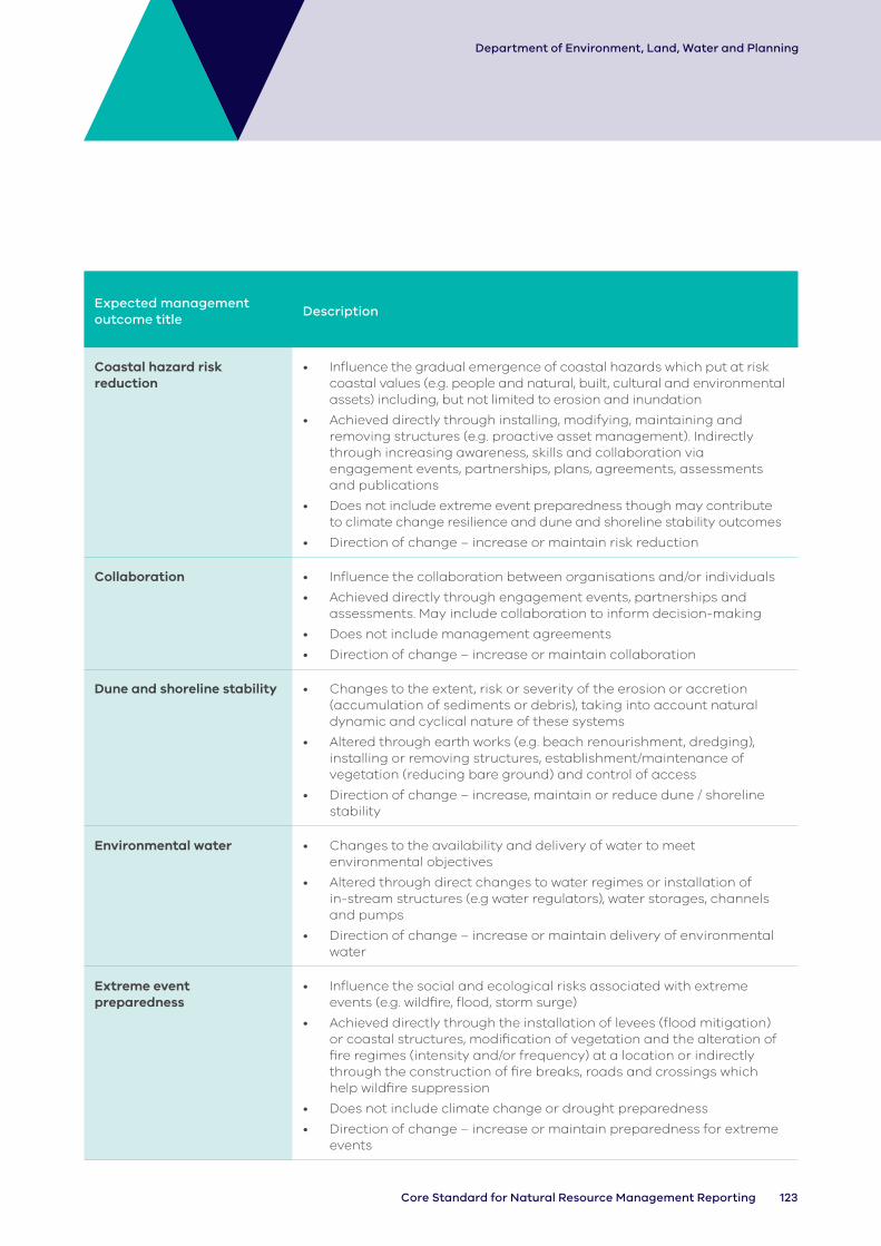
123Core Standard for Natural Resource Management Reporting
Department of Environment, Land, Water and Planning
Expected management outcome title
Description
Coastal hazard risk reduction
• Influence the gradual emergence of coastal hazards which put at risk coastal values (e.g. people and natural, built, cultural and environmental assets) including, but not limited to erosion and inundation
• Achieved directly through installing, modifying, maintaining and removing structures (e.g. proactive asset management). Indirectly through increasing awareness, skills and collaboration via engagement events, partnerships, plans, agreements, assessments and publications
• Does not include extreme event preparedness though may contribute to climate change resilience and dune and shoreline stability outcomes
• Direction of change – increase or maintain risk reduction
Collaboration • Influence the collaboration between organisations and/or individuals
• Achieved directly through engagement events, partnerships and assessments. May include collaboration to inform decision-making
• Does not include management agreements
• Direction of change – increase or maintain collaboration
Dune and shoreline stability • Changes to the extent, risk or severity of the erosion or accretion (accumulation of sediments or debris), taking into account natural dynamic and cyclical nature of these systems
• Altered through earth works (e.g. beach renourishment, dredging), installing or removing structures, establishment/maintenance of vegetation (reducing bare ground) and control of access
• Direction of change – increase, maintain or reduce dune / shoreline stability
Environmental water • Changes to the availability and delivery of water to meet environmental objectives
• Altered through direct changes to water regimes or installation of in-stream structures (e.g water regulators), water storages, channels and pumps
• Direction of change – increase or maintain delivery of environmental water
Extreme event preparedness
• Influence the social and ecological risks associated with extreme events (e.g. wildfire, flood, storm surge)
• Achieved directly through the installation of levees (flood mitigation) or coastal structures, modification of vegetation and the alteration of fire regimes (intensity and/or frequency) at a location or indirectly through the construction of fire breaks, roads and crossings which help wildfire suppression
• Does not include climate change or drought preparedness
• Direction of change – increase or maintain preparedness for extreme events

124 DELWP Output Data Standard
Department of Environment, Land, Water and Planning
Expected management outcome title
Description
Farm water use efficiency • Influence the efficient use of farm water
• Achieved directly through the installation of more efficient systems for irrigation (water storage, irrigation infrastructure, channel, pump)
• Does not include outputs delivered to influence groundwater (i.e. water logging)
• Direction of change – increase or maintain availability of farm water
Governance • Influence the formal governance structures and processes surrounding natural resource management (between parties). This includes ecologically sustainable use and development of natural resources.
• Achieved directly through clearer definition of expectations and priorities and regulatory approaches such as leases, advice and approvals, partnerships, management plans
• Direction of change – increase or maintain governance
Groundwater • Influence the depth to groundwater
• Achieved directly through the installation of pumps and drains and indirectly through the establishment of vegetation
• It should be noted that the depth to groundwater can be both a threat and a value depending on the landscape context
• Direction of change – increase, maintain or reduce depth to groundwater
Habitat available • Changes in the immediate availability of habitat features for targeted species
• Altered through the changes to the natural and man-made features that directly provide or enhance habitat (e.g. logs, reefs, nest boxes) or through changes to the existing habitat features (e.g. removal of fish barriers). Can be indirectly influenced through stabilisation of soil, dunes or shoreline (e.g. pile fields, marine and coastal structures)
• Direction of change – increase or maintain availability of habitat
Knowledge improvement, development and management
• Increases knowledge and understanding regarding conservation principles and related information
• Achieved directly through engagement events, publications, agreements, assessments
• Supported through improved data management and decision systems
• Direction of change – maintain or improve knowledge development and management systems
Natural landscape features • Influence the maintenance and enhancement of natural landscape features
• Achieved indirectly through plans, assessments, approvals, partnerships and management agreements
• Direction of change – maintain and improve natural landscape features
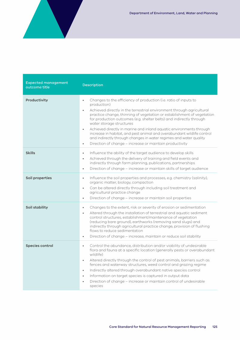
125Core Standard for Natural Resource Management Reporting
Department of Environment, Land, Water and Planning
Expected management outcome title
Description
Productivity • Changes to the efficiency of production (i.e. ratio of inputs to production)
• Achieved directly in the terrestrial environment through agricultural practice change, thinning of vegetation or establishment of vegetation for production outcomes (e.g. shelter belts) and indirectly through water storage structures
• Achieved directly in marine and inland aquatic environments through increase in habitat, and pest animal and overabundant wildlife control and indirectly through changes in water regimes and water quality
• Direction of change – increase or maintain productivity
Skills • Influence the ability of the target audience to develop skills
• Achieved through the delivery of training and field events and indirectly through farm planning, publications, partnerships
• Direction of change – increase or maintain skills of target audience
Soil properties • Influence the soil properties and processes, e.g. chemistry (salinity), organic matter, biology, compaction
• Can be altered directly through including soil treatment and agricultural practice change
• Direction of change – increase or maintain soil properties
Soil stability • Changes to the extent, risk or severity of erosion or sedimentation
• Altered through the installation of terrestrial and aquatic sediment control structures, establishment/maintenance of vegetation (reducing bare ground), earthworks (removing sand slugs) and indirectly through agricultural practice change, provision of flushing flows to reduce sedimentation
• Direction of change – increase, maintain or reduce soil stability
Species control • Control the abundance, distribution and/or viability of undesirable flora and fauna at a specific location (generally pests or overabundant wildlife)
• Altered directly through the control of pest animals, barriers such as fences and waterway structures, weed control and grazing regime
• Indirectly altered through overabundant native species control
• Information on target species is captured in output data
• Direction of change – increase or maintain control of undesirable species

126 DELWP Output Data Standard
Department of Environment, Land, Water and Planning
Expected management outcome title
Description
Species recovery • Influence the distribution and/or viability of desirable flora and fauna (generally native species)
• Altered directly through captive breeding, capture/release and propagation. Indirectly altered through weed control to reduce competition and pest animal control to reduce predation/ competition or rubbish removal to reduce threats
• Information on target species captured in output data
• Direction of change – increase or maintain desirable species
Stewardship • Influence the commitment of individuals and organisations to be involved in the maintenance or improvement of natural and cultural landscapes
• Achieved directly through partnerships and management agreements and indirectly through engagement events, plans, publications, information management systems (e.g. citizen science databases) and/or signs aimed at raising awareness
• Direction of change – increase or maintain stewardship
Vegetation extent • Influence the extent of native indigenous vegetation outside remnant patches
• Directly influenced through the establishment of native vegetation (revegetation or regeneration) or indirectly through fencing or grazing regime change
• The focus of this management outcome is on extent; vegetation structure and diversity will also be affected but does not need to be recorded separately
• Does not include non-native vegetation (e.g. pasture established to improve soil composition or plantations for productivity outcomes)
• Direction of change – increase vegetation extent
Vegetation structure and diversity
• Influence the structure and diversity of remnant native indigenous vegetation
• Directly influenced through supplementary planting or thinning, a change in protection status, fire regime change and indirectly through weed control, fencing, grazing regime and animal or over abundant wildlife control, or through outputs which encourage regeneration
• Does not include non-native vegetation (e.g. pasture established to improve soil stability or plantations for productivity)
• Direction of change – increase or maintain vegetation structure or diversity
Water quality • Influence characteristics of water quality (e.g. chemical, temperature, biota, turbidity)
• Altered directly through the modification of water storages to influence temperature profiles (e.g. dams, weirs), installation of reuse systems or sediment transport (e.g. constructed wetland) or direct removal of pollutants including litter. Altered indirectly through the provision of flushing flows or sediment traps
• Does not include vegetation (use with caution as water quality changes are usually longer- term condition change)
• Direction of change – increase or maintain water quality

127Core Standard for Natural Resource Management Reporting
Department of Environment, Land, Water and Planning
Appendix D: Metadata Statement Template
The following metadata template has been copied from the ANZLIC website to ensure consistency with national minimum standards. DELWP-funded delivery agents may develop their own template, though it must contain equivalent information to that listed below. Logical substitutions are acceptable where doing so improves accuracy. Eg – substituting the ‘geographic extents box’ with ‘PPWCMA Boundary, CMA_100 layer’ – which is a DELWP published layer.
1. Minimum metadata for a geographic dataset (https://www.anzlic.gov.au/sites/default/files/files/anzlicmetadataprofileguidelines_v1-2.pdf)
Example: Locality polygons dataset.
This example shows the minimum metadata for a geographic dataset called “Localities in Victoria”. It provides a brief description of the basic characteristics of the dataset. The example shows that a metadata record for a geographic dataset can be quickly and easily completed. Usually the Metadata File Identifier will be generated and automatically populated by the metadata entry tool.
Note: To enable the loading of three discrete records into the Metadata tool, the file identifier and title is slightly different for each of the three following sample ‘locality polygon’ metadata records. In a normal environment, the record will be stored only once but presented many different ways with the same file identifier and title.
Identification info
Title Localities in Victoria (VMADMIN.LOCALITY_POLYGON)
-Minimum elements
Date 2006-09-11 (publication)
Language Eng
Abstract This dataset is the definitive set of locality boundaries for the state of Victoria as defined by Local Government and registered by the Registrar of Geographic Names. The boundaries are aligned to Vicmap Property. This dataset is part of the Vicmap Admin dataset series.
Topic category Boundaries
Extent Geographic box
West bound longitude
141
North bound latitude
-34
East bound longitude
150
South bound latitude
-39

128 DELWP Output Data Standard
Department of Environment, Land, Water and Planning
Metadata
File identifier 388fab80-4f71-11db-8a85-000f2 07026dc
Hierarchy level Dataset
Date stamp 2007-08-13
Metadata author
Organisation name
Department of Sustainability and Environment
Role Custodian
Appendix E: Units of Measure Table (for VWPIF projects only)
Order Category (area) Code Value Uom
1 1. Structural Works 1.1 1.1 Channel - Channel Km
2 1. Structural Works 1.2 1.1 Channel - Drain Km
3 1. Structural Works 1.2 1.2 Water storage - Trough Number
4 1. Structural Works 1.2 1.2 Water Storage - Constructed Wetland Number
5 1. Structural Works 1.2 1.2 Water Storage - Dam Number
6 1. Structural Works 1.2 1.2 Water Storage - Sump Number
7 1. Structural Works 1.2 1.2 Water Storage - Tank Number
8 1. Structural Works 1.2 1.2 Water Storage - Weir Number
9 1. Structural Works 1.3 1.3 Pump - Ground Water Number
10 1. Structural Works 1.3 1.3 Pump - Surface Water Number
11 1. Structural Works 1.4 1.4 Irrigation Infrastructure - Spray Irrigation
Number
12 1. Structural Works 1.4 1.4 Irrigation Infrastructure - Sump Number
13 1. Structural Works 1.4 1.4 Irrigation Infrastructure - Surface Irrigation
Number
14 1. Structural Works 1.5 1.5 Waterway Structure - Chute Number
15 1. Structural Works 1.5 1.5 Waterway Structure - Fish Barrier Number
16 1. Structural Works 1.5 1.5 Waterway Structure - Fish Hotel/Lunker
Number

129Core Standard for Natural Resource Management Reporting
Department of Environment, Land, Water and Planning
Order Category (area) Code Value Uom
17 1. Structural Works 1.5 1.5 Waterway Structure - Fishway Number
18 1. Structural Works 1.5 1.5 Waterway Structure - Flow Regulator Number
19 1. Structural Works 1.5 1.5 Waterway Structure - Gross Pollutant Trap
Number
20 1. Structural Works 1.5 1.5 Waterway Structure - Groyne Number
21 1. Structural Works 1.5 1.5 Waterway Structure - Large Wood A Number
22 1. Structural Works 1.5 1.5 Waterway Structure - Large Wood B Number
23 1. Structural Works 1.5 1.5 Waterway Structure - Large Wood C Number
24 1. Structural Works 1.5 1.5 Waterway Structure - Large Wood D Number
25 1. Structural Works 1.5 1.5 Waterway Structure - Outlet Number
26 1. Structural Works 1.5 1.5 Waterway Structure - Pile Field Number
27 1. Structural Works 1.5 1.5 Waterway Structure - Rock Seeding Number
28 1. Structural Works 1.5 1.5 Waterway Structure - Rockbank Number
29 1. Structural Works 1.5 1.5 Waterway Structure - Root Ball Number
30 1. Structural Works 1.5 1.5 Waterway Structure - Sill Number
31 1. Structural Works 1.6 1.6 Terrestrial Structure - Check-Dam Number
32 1. Structural Works 1.6 1.6 Terrestrial Structure - Coir Logs Number
33 1. Structural Works 1.6 1.6 Terrestrial Structure - Hygiene Station
Number
34 1. Structural Works 1.6 1.6 Terrestrial Structure - Jute Mat Number
35 1. Structural Works 1.6 1.6 Terrestrial Structure - Revetment Number
36 1. Structural Works 1.6 1.6 Terrestrial Structure - Rock Bund Number
37 1. Structural Works 1.6 1.6 Terrestrial Structure - Sediment Trap Number
38 1. Structural Works 1.6 1.6 Terrestrial Structure - Silt Fence Number
39 1. Structural Works 1.6 1.6 Terrestrial Structure - Straw Bale Number
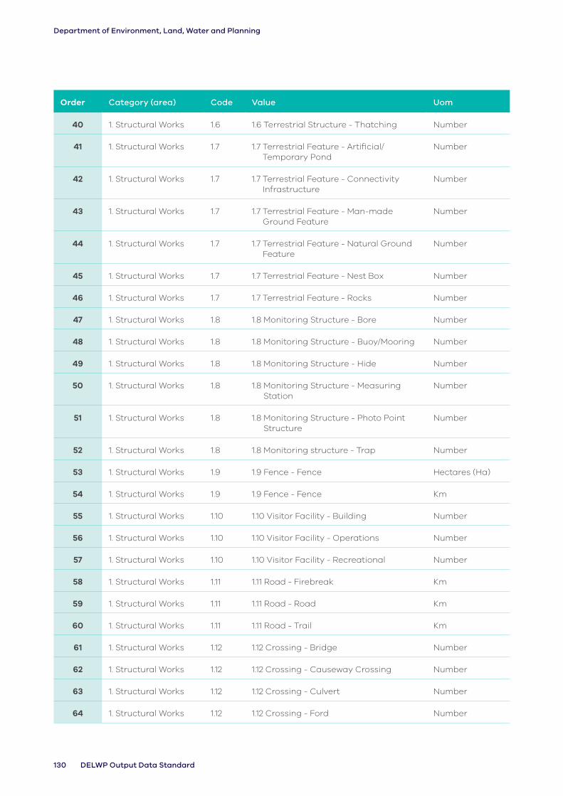
130 DELWP Output Data Standard
Department of Environment, Land, Water and Planning
Order Category (area) Code Value Uom
40 1. Structural Works 1.6 1.6 Terrestrial Structure - Thatching Number
41 1. Structural Works 1.7 1.7 Terrestrial Feature - Artificial/Temporary Pond
Number
42 1. Structural Works 1.7 1.7 Terrestrial Feature - Connectivity Infrastructure
Number
43 1. Structural Works 1.7 1.7 Terrestrial Feature - Man-made Ground Feature
Number
44 1. Structural Works 1.7 1.7 Terrestrial Feature - Natural Ground Feature
Number
45 1. Structural Works 1.7 1.7 Terrestrial Feature - Nest Box Number
46 1. Structural Works 1.7 1.7 Terrestrial Feature - Rocks Number
47 1. Structural Works 1.8 1.8 Monitoring Structure - Bore Number
48 1. Structural Works 1.8 1.8 Monitoring Structure - Buoy/Mooring Number
49 1. Structural Works 1.8 1.8 Monitoring Structure - Hide Number
50 1. Structural Works 1.8 1.8 Monitoring Structure - Measuring Station
Number
51 1. Structural Works 1.8 1.8 Monitoring Structure - Photo Point Structure
Number
52 1. Structural Works 1.8 1.8 Monitoring structure - Trap Number
53 1. Structural Works 1.9 1.9 Fence - Fence Hectares (Ha)
54 1. Structural Works 1.9 1.9 Fence - Fence Km
55 1. Structural Works 1.10 1.10 Visitor Facility - Building Number
56 1. Structural Works 1.10 1.10 Visitor Facility - Operations Number
57 1. Structural Works 1.10 1.10 Visitor Facility - Recreational Number
58 1. Structural Works 1.11 1.11 Road - Firebreak Km
59 1. Structural Works 1.11 1.11 Road - Road Km
60 1. Structural Works 1.11 1.11 Road - Trail Km
61 1. Structural Works 1.12 1.12 Crossing - Bridge Number
62 1. Structural Works 1.12 1.12 Crossing - Causeway Crossing Number
63 1. Structural Works 1.12 1.12 Crossing - Culvert Number
64 1. Structural Works 1.12 1.12 Crossing - Ford Number

131Core Standard for Natural Resource Management Reporting
Department of Environment, Land, Water and Planning
Order Category (area) Code Value Uom
65 1. Structural Works 1.13 1.13 Marine and Coastal Structure - Artificial Reef
Number
66 1. Structural Works 1.13 1.13 Marine and Coastal Structure - Armouring
Number
67 1. Structural Works 1.13 1.13 Marine and Coastal Structure - Breakwater
Number
68 1. Structural Works 1.13 1.13 Marine and Coastal Structure - Gross Pollutant Trap
Number
69 1. Structural Works 1.13 1.13 Marine and Coastal Structure - Groyne
Number
70 1. Structural Works 1.13 1.13 Marine and Coastal Structure - Hybrid Reef
Number
71 1. Structural Works 1.13 1.13 Marine and Coastal Structure - Natural Reef
Number
72 1. Structural Works 1.13 1.13 Marine and Coastal Structure - Sand Bags
Number
73 1. Structural Works 1.13 1.13 Marine and Coastal Structure - Sea Wall
Number
74 2. Environmental Works
2.1 2.1 Vegetation - Biotope Overstorey Hectares (Ha)
75 2. Environmental Works
2.1 2.1 Vegetation - Biotope Structure and Diversity
Hectares (Ha)
76 2. Environmental Works
2.1 2.1 Vegetation - EVC Multi Strata Hectares (Ha)
77 2. Environmental Works
2.1 2.1 Vegetation - EVC Overstorey Hectares (Ha)
78 2. Environmental Works
2.1 2.1 V egetation - EVC Structure and Diversity
Hectares (Ha)
79 2. Environmental Works
2.1 2.1 Vegetation - Mixed Hectares (Ha)
80 2. Environmental Works
2.1 2.1 Vegetation - Native Non-Indigenous Hectares (Ha)

132 DELWP Output Data Standard
Department of Environment, Land, Water and Planning
Order Category (area) Code Value Uom
81 2. Environmental Works
2.1 2.1 Vegetation - Native Indigenous Hectares (Ha)
82 2. Environmental Works
2.1 2.1 Vegetation - Non Native Hectares (Ha)
83 2. Environmental Works
2.2 2.2 Weed Control - Non-Woody Hectares (Ha)
84 2. Environmental Works
2.2 2.2 Weed Control - Woody Hectares (Ha)
85 2. Environmental Works
2.3 2.3 Pest Animal Control - Herbivore Hectares (Ha)
86 2. Environmental Works
2.3 2.3 Pest Animal Control - Pathogen Hectares (Ha)
87 2. Environmental Works
2.3 2.3 Pest Animal Control - Predator Hectares (Ha)
88 2. Environmental Works
2.4 2.4 Over-abundant Wildlife Control - Herbivore
Hectares (Ha)
89 2. Environmental Works
2.4 2.4 Over-abundant Wildlife Control - Nuisance
Hectares (Ha)
90 2. Environmental Works
2.4 2.4 Over-abundant Wildlife Control - Predator
Hectares (Ha)
91 2. Environmental Works
2.5 2.5 Threatened Species Response - Restore Ecological Community
Number
92 2. Environmental Works
2.5 2.5 Threatened Species Response - Restore Individual Species
Number
93 2. Environmental Works
2.6 2.6 Emergency Species Response - Ecological Community
Number
94 2. Environmental Works
2.6 2.6 Emergency Species Response - Fauna/Animal
Number
95 2. Environmental Works
2.6 2.6 Emergency Species Response - Flora/Plant
Number
96 2. Environmental Works
2.7 2.7 Soil Treatment - Biological Hectares (Ha)
97 2. Environmental Works
2.7 2.7 Soil Treatment - Chemical Hectares (Ha)
98 2. Environmental Works
2.7 2.7 Soil Treatment - Mechanical Hectares (Ha)
99 2. Environmental Works
2.7 2.7 Soil Treatment - Temperature Hectares (Ha)

133Core Standard for Natural Resource Management Reporting
Department of Environment, Land, Water and Planning
Order Category (area) Code Value Uom
100 2. Environmental Works
2.8 2.8 Earth Works - Armouring Hectares (Ha)
101 2. Environmental Works
2.8 2.8 Earth Works - Battering Hectares (Ha)
102 2. Environmental Works
2.8 2.8 Earth Works - Barrier Hectares (Ha)
103 2. Environmental Works
2.8 2.8 Earth Works - Dredging Hectares (Ha)
104 2. Environmental Works
2.8 2.8 Earth Works - Levee Hectares (Ha)
105 2. Environmental Works
2.8 2.8 Earth Works - Levelling Hectares (Ha)
106 2. Environmental Works
2.9 2.9 Rubbish Removal - Chemical Hectares (Ha)
107 2. Environmental Works
2.9 2.9 Rubbish Removal - Commercial Hectares (Ha)
108 2. Environmental Works
2.9 2.9 Rubbish Removal - Domestic Hectares (Ha)
109 2. Environmental Works
2.9 2.9 Rubbish Removal - Litter Trap Hectares (Ha)
110 2. Environmental Works
2.9 2.9 Rubbish Removal - Mixed Hectares (Ha)
111 3. Management Services
3.1 3.1 Grazing - Access Management Hectares (Ha)
112 3. Management Services
3.1 3.1 Grazing - Agronomic/Pastoral Hectares (Ha)
113 3. Management Services
3.1 3.1 Grazing - Biomass Reduction Hectares (Ha)
114 3. Management Services
3.1 3.1 Grazing - Fuel Load Management Hectares (Ha)
115 3. Management Services
3.1 3.1 Grazing - Native Vegetation Protection
Hectares (Ha)
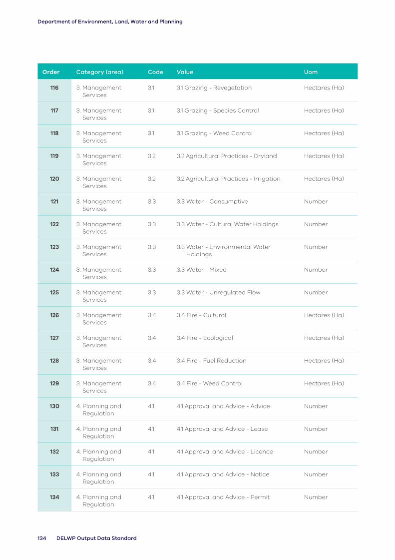
134 DELWP Output Data Standard
Department of Environment, Land, Water and Planning
Order Category (area) Code Value Uom
116 3. Management Services
3.1 3.1 Grazing - Revegetation Hectares (Ha)
117 3. Management Services
3.1 3.1 Grazing - Species Control Hectares (Ha)
118 3. Management Services
3.1 3.1 Grazing - Weed Control Hectares (Ha)
119 3. Management Services
3.2 3.2 Agricultural Practices - Dryland Hectares (Ha)
120 3. Management Services
3.2 3.2 Agricultural Practices - Irrigation Hectares (Ha)
121 3. Management Services
3.3 3.3 Water - Consumptive Number
122 3. Management Services
3.3 3.3 Water - Cultural Water Holdings Number
123 3. Management Services
3.3 3.3 Water - Environmental Water Holdings
Number
124 3. Management Services
3.3 3.3 Water - Mixed Number
125 3. Management Services
3.3 3.3 Water - Unregulated Flow Number
126 3. Management Services
3.4 3.4 Fire - Cultural Hectares (Ha)
127 3. Management Services
3.4 3.4 Fire - Ecological Hectares (Ha)
128 3. Management Services
3.4 3.4 Fire - Fuel Reduction Hectares (Ha)
129 3. Management Services
3.4 3.4 Fire - Weed Control Hectares (Ha)
130 4. Planning and Regulation
4.1 4.1 Approval and Advice - Advice Number
131 4. Planning and Regulation
4.1 4.1 Approval and Advice - Lease Number
132 4. Planning and Regulation
4.1 4.1 Approval and Advice - Licence Number
133 4. Planning and Regulation
4.1 4.1 Approval and Advice - Notice Number
134 4. Planning and Regulation
4.1 4.1 Approval and Advice - Permit Number
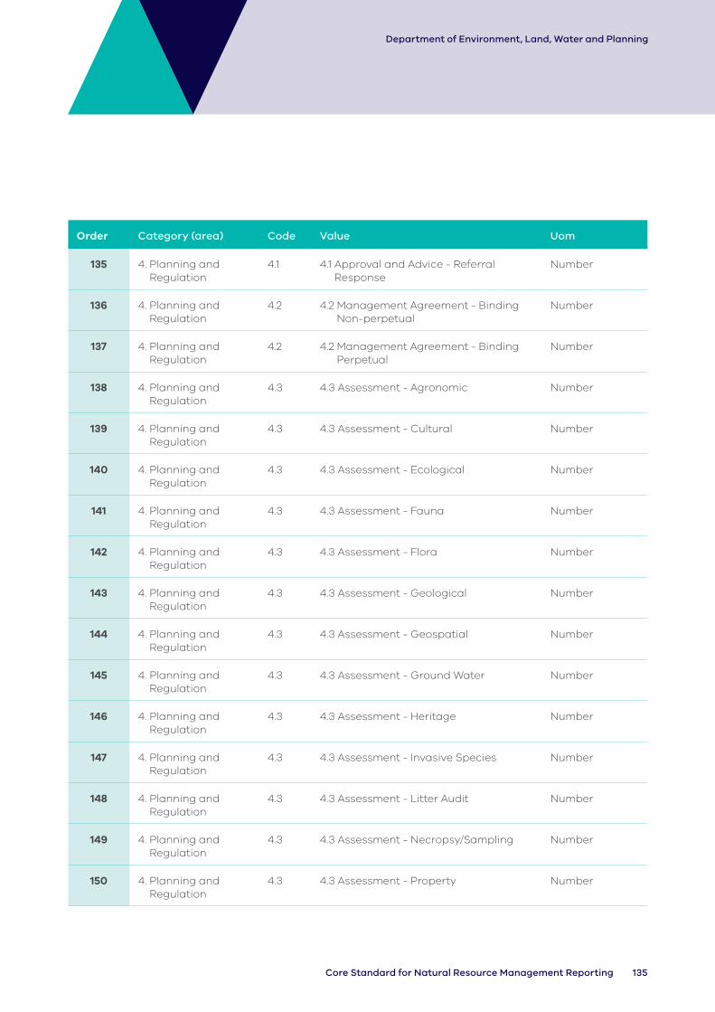
135Core Standard for Natural Resource Management Reporting
Department of Environment, Land, Water and Planning
Order Category (area) Code Value Uom
135 4. Planning and Regulation
4.1 4.1 Approval and Advice - Referral Response
Number
136 4. Planning and Regulation
4.2 4.2 Management Agreement - Binding Non-perpetual
Number
137 4. Planning and Regulation
4.2 4.2 Management Agreement - Binding Perpetual
Number
138 4. Planning and Regulation
4.3 4.3 Assessment - Agronomic Number
139 4. Planning and Regulation
4.3 4.3 Assessment - Cultural Number
140 4. Planning and Regulation
4.3 4.3 Assessment - Ecological Number
141 4. Planning and Regulation
4.3 4.3 Assessment - Fauna Number
142 4. Planning and Regulation
4.3 4.3 Assessment - Flora Number
143 4. Planning and Regulation
4.3 4.3 Assessment - Geological Number
144 4. Planning and Regulation
4.3 4.3 Assessment - Geospatial Number
145 4. Planning and Regulation
4.3 4.3 Assessment - Ground Water Number
146 4. Planning and Regulation
4.3 4.3 Assessment - Heritage Number
147 4. Planning and Regulation
4.3 4.3 Assessment - Invasive Species Number
148 4. Planning and Regulation
4.3 4.3 Assessment - Litter Audit Number
149 4. Planning and Regulation
4.3 4.3 Assessment - Necropsy/Sampling Number
150 4. Planning and Regulation
4.3 4.3 Assessment - Property Number

136 DELWP Output Data Standard
Department of Environment, Land, Water and Planning
Order Category (area) Code Value Uom
151 4. Planning and Regulation
4.3 4.3 Assessment - Social Number
152 4. Planning and Regulation
4.3 4.3 Assessment - Soil Number
153 4. Planning and Regulation
4.3 4.3 Assessment - Surface water Number
154 4. Planning and Regulation
4.3 4.3 Assessment - Threatened Species Number
155 4. Planning and Regulation
4.3 4.3 Assessment - Weather Number
156 4. Planning and Regulation
4.4 4.4 Engagement Event - Conference - Number of Participants
157 4. Planning and Regulation
4.4 4.4 Engagement Event - Field Day Number of Participants
158 4. Planning and Regulation
4.4 4.4 Engagement Event - Meeting Number of Participants
159 4. Planning and Regulation
4.4 4.4 Engagement Event - Presentation Number of Participants
160 4. Planning and Regulation
4.4 4.4 Engagement Event - Training Number of Participants
161 4. Planning and Regulation
4.4 4.4 Engagement Event - Workshop Number of Participants
162 4. Planning and Regulation
4.5 4.5 Partnership - Aboriginal Victorians Number
163 4. Planning and Regulation
4.5 4.5 Partnership - Agency Number
164 4. Planning and Regulation
4.5 4.5 Partnership - Corporate Number
165 4. Planning and Regulation
4.5 4.5 Partnership - Educational Number
166 4. Planning and Regulation
4.5 4.5 Partnership - Community Groups Number
167 4. Planning and Regulation
4.5 4.5 Partnership - Mixed Number
168 4. Planning and Regulation
4.5 4.5 Partnership - NGO Number
169 4. Planning and Regulation
4.5 4.5 Partnership - Research Number

137Core Standard for Natural Resource Management Reporting
Department of Environment, Land, Water and Planning
Order Category (area) Code Value Uom
170 4. Planning and Regulation
4.5 4.5 Partnership - Traditional Owners Number
171 4. Planning and Regulation
4.6 4.6 Plan - Engagement Number
172 4. Planning and Regulation
4.6 4.6 Plan - Management Number
173 4. Planning and Regulation
4.6 4.6 Plan - Property Number
174 4. Planning and Regulation
4.6 4.6 Plan - Strategy Number
175 4. Planning and Regulation
4.7 4.7 Publication - Audio Number
176 4. Planning and Regulation
4.7 4.7 Publication - Visual Number
177 4. Planning and Regulation
4.7 4.7 Publication - Written Number
178 4. Planning and Regulation
4.8 4.8 Information Management System - Database
Number
179 4. Planning and Regulation
4.8 4.8 Information Management System - Decision Support
Number

delwp.vic.gov.au