cooper, victoria - managing heritage impacts - digital data and dogger bankjjjg
DESCRIPTION
nbmbn,bn,bn,,TRANSCRIPT
'IAIA15 Conference Proceedings' Impact Assessment in the Digital Era
35th Annual Conference of the International Association for Impact Assessment 20 - 23 April 2015 | Firenze Fiera Congress & Exhibition Center | Florence | Italy | www.iaia.org
Managing Heritage Impacts: Digital Data and Dogger Bank
Victoria Cooper Senior Marine Heritage Consultant, Royal HaskoningDHV
This paper was produced with thanks to Forewind and in particular Gareth Lewis, Head of Offshore Development.
Project Background
In the UK, the main part of the seabed out to the 12 nautical mile limit of territorial waters is owned by The Crown Estate with additional rights to renewable energy generation within a designated Renewable Energy Zone beyond the UK territorial sea. In 2008, The Crown Estate identified nine Zones for offshore wind development and, following a tender round with bids submitted in March 2009, Zone Development Agreements were signed with developers.
Dogger Bank is the UK’s largest offshore wind Zone, awarded for development to Forewind, a consortium of four leading international energy companies. Royal HaskoningDHV was appointed by Forewind to co-ordinate the Environmental Impact Assessment (EIA) and applications for the first four wind farms within the zone; Dogger Bank Creyke Beck A & B and Dogger Bank Teesside A & B. The assessment of offshore archaeology and cultural history for the four wind farms was undertaken by Wessex Archaeology.
This paper demonstrates how spatial representation of digital data was crucial to assessing heritage impacts and how risk to the project has been reduced through the early dissemination of data allowing for clear visualisation and appreciation of the archaeological resource from the outset.
Archaeology of Dogger bank
The area occupied by the Dogger Bank Zone once formed part of an expansive low lying landscape in what is now the Southern North Sea, often known as Doggerland (Coles, 1998). At the height of the last ice age c. 18,000 BP the majority of Britain was covered by ice but, as the climate warmed, Doggerland offered an increasingly attractive environment for human settlement. Temperate grassland replaced the periglacial tundra and big game animals such as mammoth, aurochs and red deer attracted Late Palaeolithic hunters to the region.
As global climate continued to warm, sea levels rose and Doggerland became imbued with rivers and inlets, archipelagos, lagoons, wetlands and marshlands. As woodlands and other flora flourished so did the range of mammals, fish and birds that supported Mesolithic communities, ‘probably the richest hunting and fishing grounds in the whole of Europe’ (Val Baker et al, 2007: 208). Human artefacts, mammal remains and peat deposits have long been recovered from the area by fishermen, dredged or trawled up in their nets.
The Dogger Bank itself is located between 125 and 290 kilometres off the east coast of Yorkshire. As Doggerland became an increasingly marine environment, Britain was eventually cut off from the continent at c. 9,500 BP, although Dogger Bank remained as a high point in the landscape until c. 7,000 to 6,000 BP (Wessex Archaeology, 2012, 2013, 2014).

2
Following inundation, the shallow depth and shoaling effect of the Dogger Bank, have represented a hazard to shipping which, together with severe North Sea storms, accidents, collisions and wartime activity have all contributed to the presence of wrecks. From the 20th century onwards, losses of aircraft also occurred over this area, particularly during the Second World War.
Managing Impacts, Reducing Risk
In terms of EIA, gaining consent and constructing a proposed development is inextricably linked to the question of how much work needs to be done and when. The balance of cost versus risk inevitably guides decision making from the early stages of a project, including consideration of heritage. The earlier in a project that advice on heritage is sought, the lower the risk to the project from unexpected discoveries and the easier it is to manage the long term cost of mitigation.
A reluctance to address heritage early on can often lead to difficulties for a project. For example, in 2009, the National Board of Antiquities in Finland was informed that the wreck of a wooden hulled ship had been found by a local maritime history enthusiast in waters off the Port of Pori (Mattika, 2014). At the same time they were informed that that a construction project to expand the Port was to begin at the end of 2009. The wreck was confirmed as an ancient monument under Finnish law and the Port quickly became concerned about the possible difficulties they faced in dealing with the wreck.
As it was not possible to avoid the wreck, a strategy to excavate was agreed (Mattika, 2014). Due to the poor visibility the wreck could not be recorded underwater. A basin around the wreck was drained and the wreck was excavated in near dry-land conditions, with two pumps in action throughout. If the Port had undertaken full assessment earlier in the process, it may have been possible to avoid the wreck and, even if this had not proved possible, they could have avoided a strategy that did not rely on emergency actions that caused immense concern to the project.
In comparison, the considerable potential for archaeology to be present within the Dogger Bank Zone was identified very early in the project life cycle and formed a key component of characterisation of the Zone as part of the ZAP (Zone Appraisal and Planning) process in advance of site selection (Emu, 2010). From the outset, Forewind stated its intention that significant impacts would not be allowed to occur if mitigation was possible.
The key strategy for offshore archaeology was to avoid impacts to heritage assets through embedding mitigation into the project design which, for heritage, comprised the use of Archaeological Exclusion Zones (AEZs) and avoidance wherever possible.
Digital Data and Archaeology on the Dogger Bank
Due to the large size of the Dogger Bank Zone, a strategy was agreed with English Heritage that allowed for greater resolution of assessment at each stage, postponing ground-level, site-specific assessment until the design is refined, post-consent.
At the ZAP stage, data was collated from existing archaeological studies and combined with records from the United Kingdom Hydrographic Office (UKHO) wrecks and obstructions database to provide a characterisation of heritage within the zone (EMU, 2010) (Figure 1). Using GIS to analyse this high-
3
level assessment alongside other environmental considerations, areas within the Zone were then identified for targeted EIA.
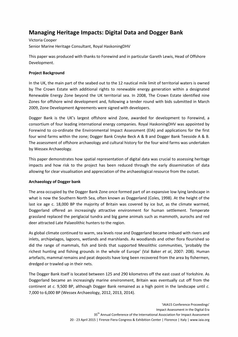
As demonstrated through the ZAP assessment, heritage datasets in the UK demonstrate a decrease in the number of known archaeological sites and findspots with increased distance offshore (Figure 1). This is partially explained by the maintenance of records held by local Historic Environment Records (HER) and the National Record of the Historic Environment (NRHE) to the 12nm limit only. Losses of wrecks and aircraft are also, however, less likely to have been previously recorded, partially due to the reduced visibility of events occurring offshore in historic times, but also due to
the lack of previous investigation in comparison to areas within territorial waters. Additional data would, therefore, be required to fully assess the heritage resource within proposed development areas.
Geophysical data for the proposed wind farms and export cable corridors were acquired for engineering and environmental assessment objectives between 2010 and 2012. Wessex Archaeology was contracted to undertake specialist archaeological review of this data (Royal HaskoningDHV, 2013, 2014). A strategy was agreed with English Heritage to review a representative sample of data at this stage, to gain an overview of heritage assets across a wide area. This would subsequently inform targeted, site-specific assessment once the development footprint had been refined post-consent.
Sidescan sonar was processed by Wessex Archaeology (2014) using Coda Geosurvey software which allowed the data to be replayed with various gain settings in order to optimise the quality of the images for archaeological assessment. Similarly, sub-bottom profiler data were processed using Coda Seismic+ software in order to optimise the appearance of the data for interpretation. The magnetometer data were processed using Geometrics MagPick software to identify any discreet magnetic contacts which could represent buried metallic debris or structures such as wrecks. Multibeam bathymetry data were gridded and analysed using Fledermaus software, which enables 3-D visualisation of the acquired data and geo-picking of seabed anomalies.
Seabed anomalies of archaeological interest were tagged and spatially compared with existing records and previous studies using ESRI ArcGIS (Wessex Archaeology, 2013, 2014). Anomalies representing the same sites or features were grouped and allocated an individual ID number to produce a gazetteer of heritage assets.
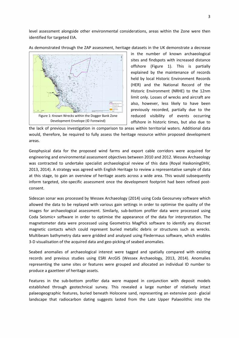
Features in the sub-bottom profiler data were mapped in conjunction with deposit models established through geotechnical survey. This revealed a large number of relatively intact palaeogeographic features, buried beneath Holocene sand, representing an extensive post- glacial landscape that radiocarbon dating suggests lasted from the Late Upper Palaeolithic into the
Figure 1: Known Wrecks within the Dogger Bank Zone Development Envelope (© Forewind)
4
Mesolithic (Wessex Archaeology 2013, 2014) (Figure 2). The landscape is interpreted to have resembled Northern Canada at the present day, and could have been characterised by rivers, kettle lakes, wetlands and isolated pingo hills (Figure 3). Prior to inundation, this landscape would have been attractive to human populations and the features and deposits identified by the data assessment, represent the greatest potential for prehistoric archaeological material relating to this activity to be found. Further investigations are currently ongoing.
With regard to maritime and aviation
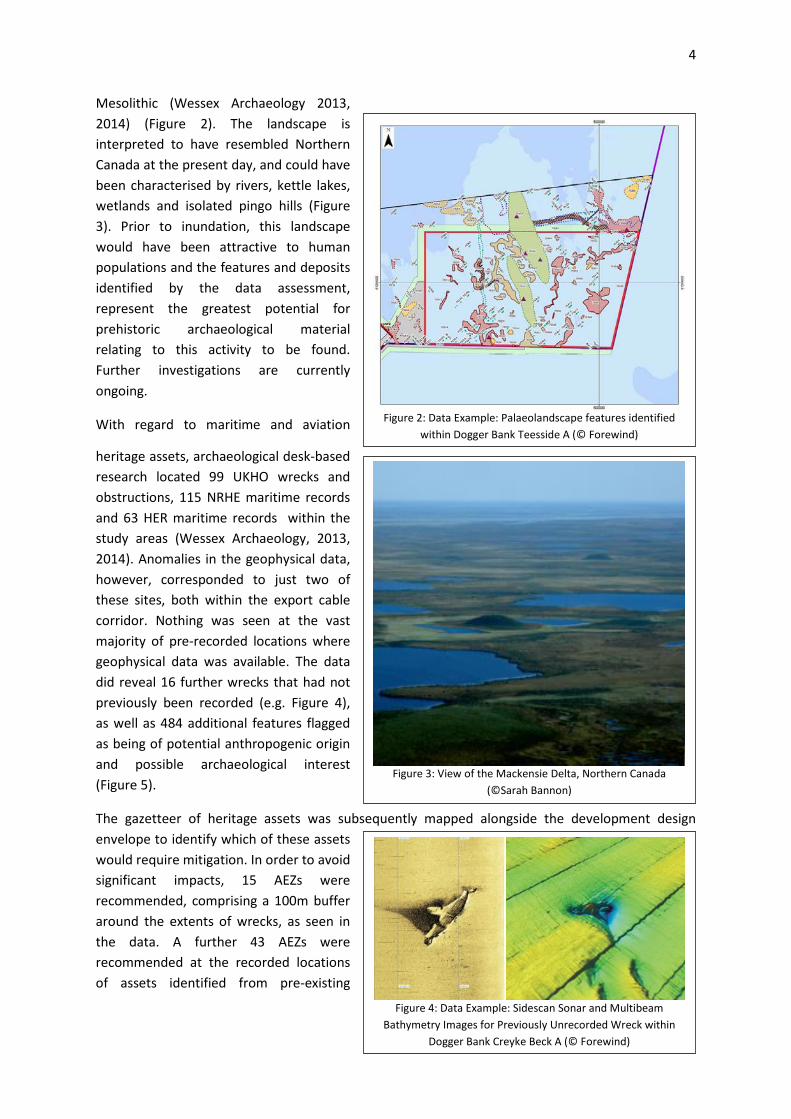
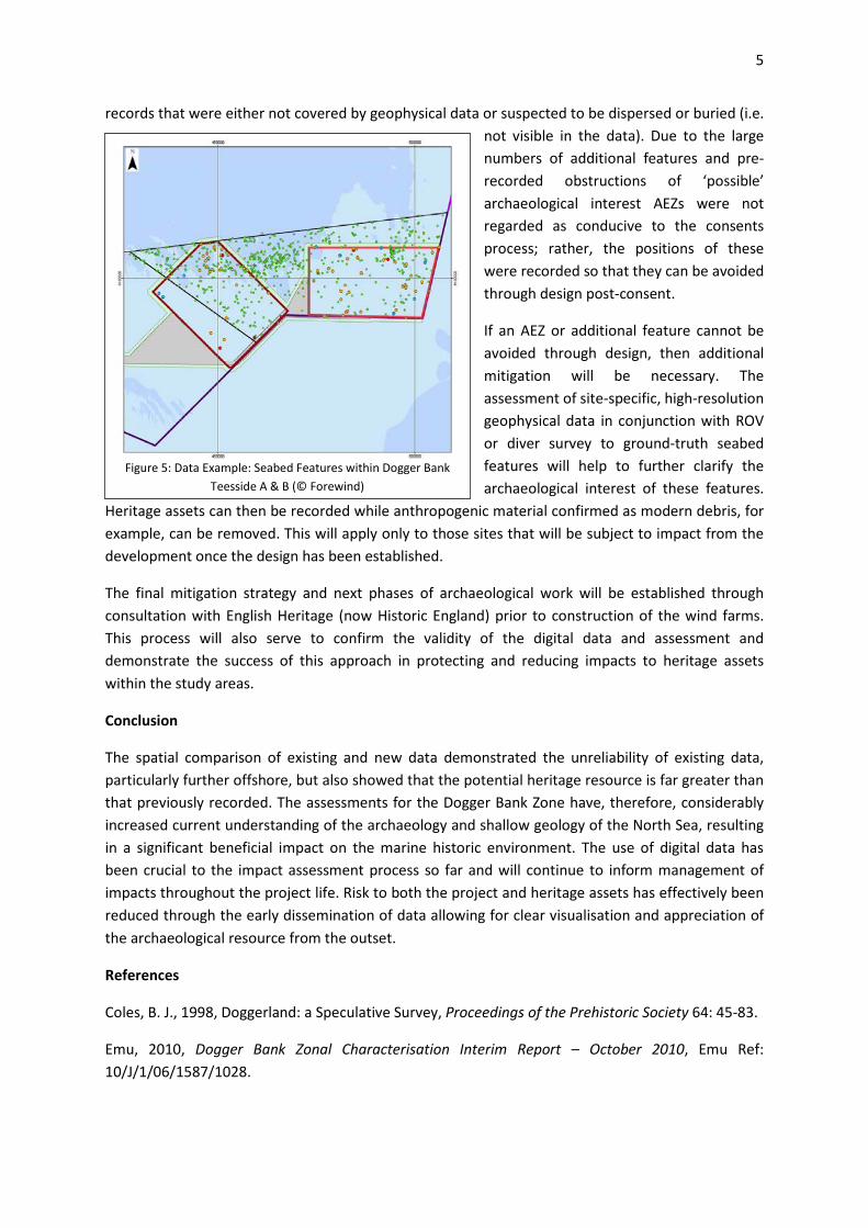
heritage assets, archaeological desk-based research located 99 UKHO wrecks and obstructions, 115 NRHE maritime records and 63 HER maritime records within the study areas (Wessex Archaeology, 2013, 2014). Anomalies in the geophysical data, however, corresponded to just two of these sites, both within the export cable corridor. Nothing was seen at the vast majority of pre-recorded locations where geophysical data was available. The data did reveal 16 further wrecks that had not previously been recorded (e.g. Figure 4), as well as 484 additional features flagged as being of potential anthropogenic origin and possible archaeological interest (Figure 5).
The gazetteer of heritage assets was subsequently mapped alongside the development design envelope to identify which of these assets would require mitigation. In order to avoid significant impacts, 15 AEZs were recommended, comprising a 100m buffer around the extents of wrecks, as seen in the data. A further 43 AEZs were recommended at the recorded locations of assets identified from pre-existing
Figure 2: Data Example: Palaeolandscape features identified within Dogger Bank Teesside A (© Forewind)
Figure 4: Data Example: Sidescan Sonar and Multibeam Bathymetry Images for Previously Unrecorded Wreck within
Dogger Bank Creyke Beck A (© Forewind)
Figure 3: View of the Mackensie Delta, Northern Canada (©Sarah Bannon)
5
records that were either not covered by geophysical data or suspected to be dispersed or buried (i.e. not visible in the data). Due to the large numbers of additional features and pre-recorded obstructions of ‘possible’ archaeological interest AEZs were not regarded as conducive to the consents process; rather, the positions of these were recorded so that they can be avoided through design post-consent.
If an AEZ or additional feature cannot be avoided through design, then additional mitigation will be necessary. The assessment of site-specific, high-resolution geophysical data in conjunction with ROV or diver survey to ground-truth seabed features will help to further clarify the archaeological interest of these features.
Heritage assets can then be recorded while anthropogenic material confirmed as modern debris, for example, can be removed. This will apply only to those sites that will be subject to impact from the development once the design has been established.
The final mitigation strategy and next phases of archaeological work will be established through consultation with English Heritage (now Historic England) prior to construction of the wind farms. This process will also serve to confirm the validity of the digital data and assessment and demonstrate the success of this approach in protecting and reducing impacts to heritage assets within the study areas.
Conclusion
The spatial comparison of existing and new data demonstrated the unreliability of existing data, particularly further offshore, but also showed that the potential heritage resource is far greater than that previously recorded. The assessments for the Dogger Bank Zone have, therefore, considerably increased current understanding of the archaeology and shallow geology of the North Sea, resulting in a significant beneficial impact on the marine historic environment. The use of digital data has been crucial to the impact assessment process so far and will continue to inform management of impacts throughout the project life. Risk to both the project and heritage assets has effectively been reduced through the early dissemination of data allowing for clear visualisation and appreciation of the archaeological resource from the outset.
References
Coles, B. J., 1998, Doggerland: a Speculative Survey, Proceedings of the Prehistoric Society 64: 45-83.
Emu, 2010, Dogger Bank Zonal Characterisation Interim Report – October 2010, Emu Ref: 10/J/1/06/1587/1028.
Figure 5: Data Example: Seabed Features within Dogger Bank Teesside A & B (© Forewind)
6
GEMS Survey Ltd, 2012, Geophysics Results Report Volume 4 of 9, Dogger Bank Tranche A Acoustic and Geophysical Survey, Document Ref: GSL10109-GPH-OF008
Matikka, Maija, 2014, Shipwreck Investigation in the Port of Pori, Finland, in, PIANC, Dredging and Port Construction: Interactions with Feature of Archaeological or Heritage Interest, PIANC Guidance Document no. 124, Environmental Navigation Commission: 65-72.
Royal HaskoningDHV, 2013, Dogger Bank Creyke Beck Environmental Statement Chapter 18 Marine and Coastal Archaeology, Forewind Ref: F-OFC-CH-018 Issue 5.
Royal HaskoningDHV, 2014, Dogger Bank Teesside A & B Environmental Statement Chapter 18 Marine and Coastal Archaeology, Forewind Ref: F-OFC-CH-018 Issue 4.1.
Val Baker, M. V., Tapper, B., Johns, C., and Herring, P., 2007. England’s Historic Seascapes, Scarborough to Hartlepool and Adjacent Maritime Zone. Historic Environment Service, Cornwall County Council for English Heritage Ref: 2007R021
Wessex Archaeology, 2012, Dogger Bank Offshore Wind Project Tranche A – Archaeological Stage 3 Sample Assessment, Wessex Archaeology Ref: 78040.04
Wessex Archaeology, 2013, Dogger Bank Tranche A Environmental Impact Assessment. Archaeology and Cultural History Technical Report, Wessex Archaeology Ref: 78040.05.
Wessex Archaeology, 2014, Dogger Bank Teesside A & B Marine and Coastal Archaeology Environmental Impact Assessment Technical Report, Wessex Archaeology Ref: 78041.04