construction of storm water drains in...
TRANSCRIPT

Public Health Engineering Department, Government of Haryana
Construction of Storm Water Drains in Sonepat
Draft Initial Environmental Examination (IEE) Report
May 2013

i
Abbreviations
ADB : Asian Development Bank BSNL : Bharat Sanchar Nigam Limited BOD : Biochemical Oxygen Demand CMA : Counter Magnet Areas DA : Development Authority DFR : Draft Final Report DPR : Detailed Project Report EC : Environmental Clearance EIA : Environmental Impact Assessment EMP : Environmental Management Plan FGD : Focus Group Discussions HUDA : Haryana Urban Development Authority SM : Sonepat Municipaltu GoH : Government of Haryana GoI : Government of India IA : Implementing Agencies IEE : Initial Environmental Examination IPT : Intermediate Public Transport NCR : National Capital Region NCRPB : National Capital Region Planning Board NCT : National Capital Territory NEERI : National Environment Engineering Research Institute NGO : Non-governmental Organizations NH : National Highway O & M : Operation and Maintenance PHED : Public Health Engineering Department PWD WSSD : Public Works Department – Water Supply & Sanitation Department CC : Cement Concrete RCC : Reinforced Cement Concrete ROW : Right of Way SH : State Highway TA : Technical Assistance SS : Suspended Solids

ii
Contents
1. INTRODUCTION ....................................................................................................................................... 1
A. BACKGROUND ............................................................................................................................................ 1B. EXTENT OF IEE STUDY .............................................................................................................................. 1C. GOVERNMENT LAW AND POLICIES ............................................................................................................. 3D. ENVIRONMENTAL AND SOCIAL MANAGEMENT SYSTEM OF NCRPB .......................................................... 3
1. Environmental Policy ............................................................................................................................ 32. Environmental Assessment Requirements ............................................................................................. 4
2. DESCRIPTION OF PROJECT .................................................................................................................. 6
A. PROPOSED WORKS ..................................................................................................................................... 6
3. DESCRIPTION OF ENVIRONMENT ...................................................................................................... 3
A. PHYSICAL RESOURCES ............................................................................................................................... 31. Location ................................................................................................................................................ 32. Topography, Soil and Geology .............................................................................................................. 33. Climate .................................................................................................................................................. 34. Air Quality ............................................................................................................................................. 45. Surface Water ........................................................................................................................................ 56. Groundwater ......................................................................................................................................... 6
B. ECOLOGICAL RESOURCES .......................................................................................................................... 6C. ECONOMIC DEVELOPMENT ......................................................................................................................... 7
1. Land Use ............................................................................................................................................... 72. Industry & Agriculture .......................................................................................................................... 83. Infrastructure ........................................................................................................................................ 84. Transportation ...................................................................................................................................... 9
D. SOCIAL AND CULTURAL RESOURCES ......................................................................................................... 91. Demography .......................................................................................................................................... 92. Health & Education Facilities ............................................................................................................ 103. History Culture and Tourism .............................................................................................................. 11
E. DESCRIPTION OF PROPOSED DRAIN ALIGNMENT ...................................................................................... 11
4. ENVIRONMENTAL IMPACTS & MITIGATION MEASURES ........................................................ 17
A. OVERVIEW ............................................................................................................................................... 17B. CONSTRUCTION IMPACTS ......................................................................................................................... 17
1. Impacts on Physical Resources ........................................................................................................... 182. Ecological Resources .......................................................................................................................... 203. Economic Development ....................................................................................................................... 204. Social and Cultural Resources ............................................................................................................ 22
C. OPERATION STAGE IMPACTS .................................................................................................................... 23D. LOCATION AND DESIGN IMPACTS ............................................................................................................. 24
5. INSTITUTIONAL ARRANGEMENTS .................................................................................................. 25
A. INSTITUTIONS INVOLVED ......................................................................................................................... 25
6. GRIEVANCE REDRESS MECHANISM ............................................................................................... 26
7. ENVIRONEMNTAL MANAGEMENT PLAN ...................................................................................... 27
A. ENVIRONMENTAL MANAGEMENT PLAN ................................................................................................... 27B. ENVIRONMENTAL MONITORING PLAN ..................................................................................................... 27C. ENVIRONMENTAL MANAGEMENT COSTS ................................................................................................. 35
8. PUBLIC CONSULTATION AND INFORMATION DISCLOSURE .................................................. 36
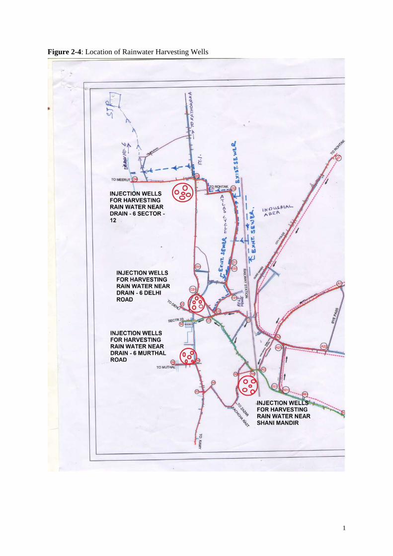
A. PROJECT STAKEHOLDERS ......................................................................................................................... 36B. CONSULTATION AND DISCLOSURE ........................................................................................................... 36
9. RECOMMENDATION AND CONCLUSION ....................................................................................... 37
iii
A. RECOMMENDATION .................................................................................................................................. 37B. CONCLUSION ............................................................................................................................................ 39
List of Tables
Table 2-1: Environmental Category ....................................................................................................... 4Table 3-1: Design Details of Proposed Drain Sections .......................................................................... 6Table 4-1: Ambient Air Quality in Panipat ............................................................................................ 4Table 4-2: National Ambient Air Quality Standards .............................................................................. 4Table 4-3: Water Quality of Drain No.6, Sonepat (April 2009) ............................................................ 5Table 4-4: Proposed Land Use Sonepat 2021 ........................................................................................ 7Table 4-5: Population Growth of Sonepat Town ................................................................................... 9Table 4-6: Description of Subproject Sites .......................................................................................... 11Table 5-1: Design Details of Proposed Drain Sections ........................................................................ 20Table 7-1: Environmental Management Plan ....................................................................................... 28Table 7-2: Environmental Monitoring Plan ......................................................................................... 32
List of Figures
Figure 1-1: Location of Sonepat in NCR ............................................................................................... 2Figure 3-1: Proposed Drain Network ..................................................................................................... 1Figure 3-2: Typical Cross Section of Proposed Drains .......................................................................... 2Figure 3-3: Typical Cross Section of Proposed Box Culvert ................................................................. 3Figure 3-4: Location of Rainwater Harvesting Wells ............................................................................ 1Figure 3-5: Layout and Cross Section of Rainwater Harvesting Well (3 m diameter) .......................... 2Figure 4-1: Proposed Land Use, Sonepat 2021 ...................................................................................... 7Figure 4-2: Occupational Structure ...................................................................................................... 10

iv
Executive Summary 1. It is proposed to construct new storm water drains in Sonepat Town of Haryana State.
Public Health Engineering Department (PHED) of Government of Haryana is the Implementing Agency (IA) of the Project. The Office of the Executive Engineer, PHED, Sonepat will implement the project. National Capital Regional Planning Board (NCRPB) is the funding agency for the project.
2. NCRPB requires the consideration of environmental issues in all of its operations and
project financing, and established an Environmental and Social Management System (ESMS), and Environmental and Social Policy. ESMS requires conducting environmental assessment for all funded projects. The level of environmental assessment required for project depends on the environmental category of the project.
3. The project of construction storm water drains in Sonepat is classified as Category E2
(category B as per ADB safeguard policy statement). Accordingly this Initial Environmental Examination (IEE) has been prepared for the Construction of Drains in Sonepat Project, specifically for the (i) construction of open drains of total length 7.85 km (15.7 km considering both sides) and (ii) closed circular drains 5.09 km.
4. An Environmental Management Plan (EMP) is proposed as part of this report which
includes (i) mitigation measures for significant environmental impacts during implementation, (ii) environmental monitoring program, and the responsible entities for mitigation, monitoring, and reporting; (iii) public consultation and information disclosure; and grievance redress mechanism.
5. The detailed design of project is completed and presently bid preparation/approval is under
process. Bids are likely to be invited in June 2013, and construction will start in December 2013 and completed in 24 months, by the end of 2015.
6. The subproject components are located in the built-up area of Sonepat. Situated in central
eastern part of Haryana State, Sonepat is part of vast upland plain region, and is part of Yamuna River basin. Topography is plain and almost flat. There are no water bodies within the town. Roads with in the centre of the town are narrow, and congested with traffic, activities and pedestrians. Roads in outer areas are relatively wider. Due to flat topography and poor drainage facilities, water logging in some areas is common during rains. There are no protected areas, wetlands, mangroves, or estuaries in or near the subproject location. There are no forest areas. There are trees (local species) along the roads, and there is no need to cut for the construction drains by slightly changing the alignment of drains. There are no historically-, culturally-, archaeologically- or architecturally-significant or tourists areas in the town or near the project locations.
7. Potential negative impacts were identified in relation to construction and operation of the
infrastructure. A number of impacts and their significance have already been reduced by amending the designs thus no impacts were identified as being due to the project design or location. Mitigation measures have been developed to reduce all negative impacts to acceptable levels.

v
8. During the construction phase, impacts mainly arise from the need to dispose of moderate
quantities of waste soil; and from the disturbance of residents, businesses, and traffic. These are common impacts of construction in urban areas, and there are well developed methods for their mitigation. Once constructed, drains will operate with routine maintenance involving cleaning of drains. There is a risk of contamination of drain water due to entry of wastewater and also due to disposal solid waste into drains. As this project involves rainwater harvesting facilities, contamination of drain water may lead to contamination of groundwater as well. The Sewerage system, including a sewage treatment facility, which is presently under construction in Sonepat by the PHED, will prevent the possible entry of wastewater into drains. Besides, it is suggested to create awareness among general public to prevent disposal of solid/liquid waste into drains, open defecation, and encroachment of drains.
9. The main impacts of the storm water drains will be beneficial to the citizens of Sonepat.
Drains will help clear the rainwater in a short time preventing the flooding. The rainwater harvesting facilities will improve the groundwater recharge. The project in general will improve the quality of life of people as well as benefit individual and public health with improvements in hygiene. This will also lead to economic gains as people will be less away from work and indirectly increase their income.
10. There were limited opportunities to provide environmental enhancements, but certain
measures were included. For example it is proposed that the project will employ in the workforce people who live in the vicinity of construction sites to provide them with a short-term economic gain; and ensure that people employed in the longer term to maintain and operate the drains are residents of nearby communities.
11. Mitigation will be assured by a program of environmental monitoring conducted during
construction and operation to ensure that all measures in the EMP are implemented and to determine whether the environment is protected as intended. This will include observations on- and off-site, document checks, and interviews with workers and beneficiaries, and any requirements for remedial action will be reported to the IA and NCRPB.
12. The stakeholders were involved in developing the IEE, after which views expressed were
incorporated into the IEE and the planning and development of the project. The IEE will be made available at public locations in the city and will be disclosed to a wider audience via the NCRPB website. The consultation process will be continued and expanded during project implementation.
13. Therefore the subproject is unlikely to cause significant adverse impacts. The potential
adverse impacts that are associated with design, construction, and operation can be mitigated to standard levels without difficulty through proper engineering design and the incorporation or application of recommended mitigation measures and procedures. Based on the findings of the IEE, the classification of the Project as Category “E2” is confirmed, and no further special study or detailed EIA needs to be undertaken to comply with NCRPB ESMS or GoI EIA Notification (2006).
1
1. INTRODUCTION
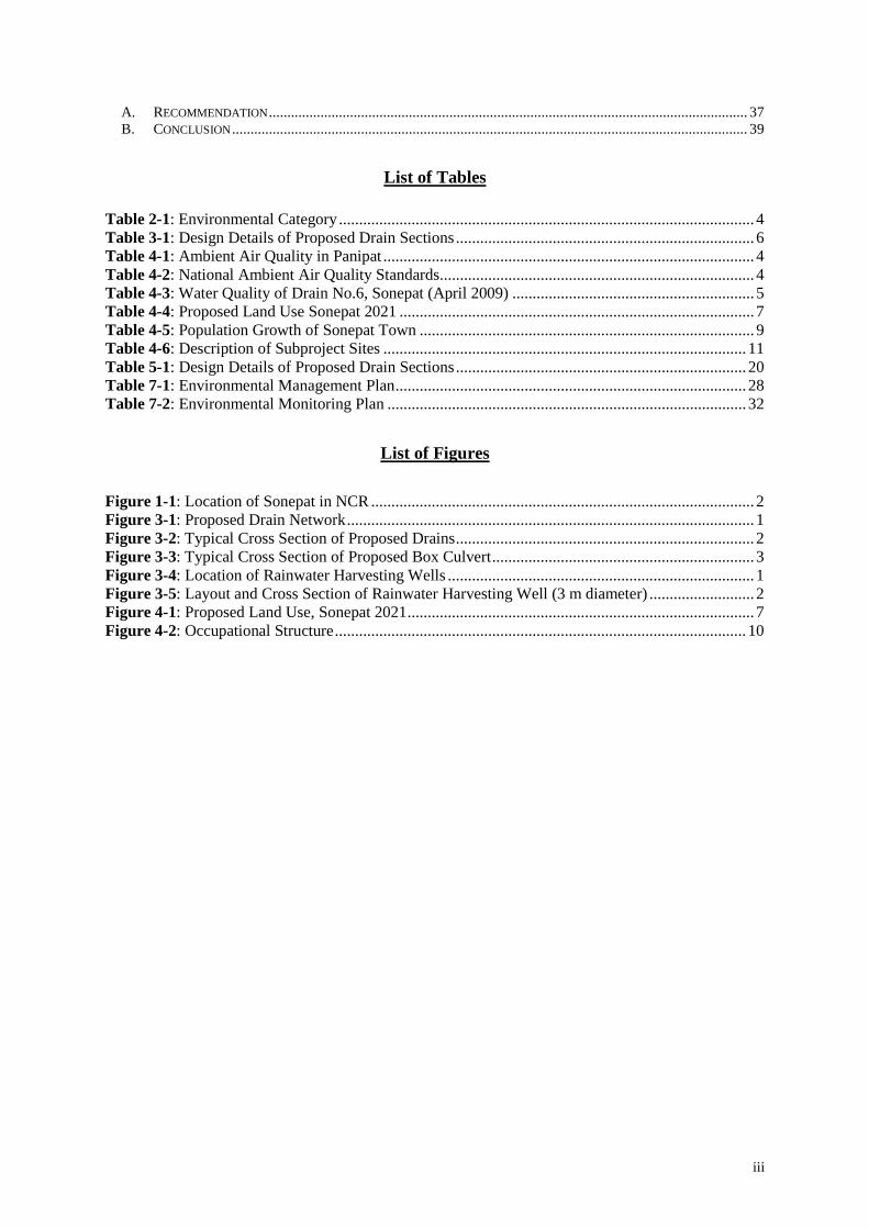
A. Background 14. Located close to the National Capital, Delhi, at about 30 km north, Sonepat is an important
town in Haryana. It is the district headquarter of Sonepat District. The town is well connected by both roads and railways. National Highway 1 (NH 1) connecting Delhi and Wagah Border in Punjab, and connecting many important cities passes near the town. Location of Sonepat is depicted in Figure 1-1. The population of the town as per 2001 census is 214,974 and the area under the municipal limits if 18.25 sq. km.
15. In Sonepat, at present there is no proper storm water drainage system. Due to flat
topography, there is no proper natural drainage system developed in the town. Except a major drain (Drain No.6) constructed and maintained by Irrigation Department, and a 1.5 m dia RCC pipe drain along Gohana Road that serves some part of the town and disposes storm water in Drain No.6, there are no storm water drains in the town. Flooding and water accumulation during monsoon is therefore very common in some localities.
16. It is proposed to construct major drains in Sonepat with the financial assistance of NCR
Planning Board, a statutory body of Ministry of Urban Development, Government of India. Public Health Engineering Department, Government of Haryana, is the implementing agency of the subproject.
17. This Initial Environmental Examination (IEE) is prepared in accordance with NCRPB
Environmental and Social Management System (ESMS) and Policy for project funding.
B. Extent of IEE Study 18. The subproject implementation shall comply with the policies of Government of India
(GoI), Government of Haryana (GoH) and ESMS and Policy of NCRPB. Government regulations and the NCRPB policy require that impacts of the development projects have to be identified at the beginning and mitigation measures be incorporated in the project to reduce those impacts to acceptable levels. This is generally done through the process of environmental impact assessment.

2
Figure 1-1: Location of Sonepat in NCR
3
C. Government Law and Policies 19. The GoI EIA Notification of 2006 (replacing the EIA Notification of 1994), sets out the
requirement for Environmental Assessment in India. This states that Environmental Clearance (EC) is required for specified activities/projects, and this must be obtained before any construction work or land preparation (except land acquisition) may commence. Projects are categorized as A or B depending on the scale of the project and the nature of its impacts.
20. Category A projects require EC from the national Ministry of Environment and Forests
(MoEF). The proponent is required to provide preliminary details of the project in the prescribed manner with all requisite details, after which an Expert Appraisal Committee (EAC) of the MoEF prepares comprehensive Terms of Reference (ToR) for the EIA study. On completion of the study and review of the report by the EAC, MoEF considers the recommendation of the EAC and provides the EC if appropriate.
21. Category B projects require environmental clearance from the State Environment Impact
Assessment Authority (SEIAA). The State level EAC categorises the project as either B1 (requiring EIA study) or B2 (no EIA study), and prepares ToR for B1 projects within 60 days. On completion of the study and review of the report by the EAC, the SEIAA issues the EC based on the EAC recommendation. The Notification also provides that any project or activity classified as category B will be treated as category A if it is located in whole or in part within 10 km from the boundary of protected areas, notified areas or inter-state or international boundaries.
22. This subproject of ‘construction of major drains’ do not fall under the ambit of the EIA
Notification, and, therefore EC is thus not required.
D. Environmental and Social Management System of NCRPB 23. Recognizing the importance of environmental and social issues that can arise in
infrastructure projects, NCRPB has formulated an Environmental and Social Management Systems (ESMS) in line with Government and other multilateral agencies like ADB safeguard requirements for Financial Intermediaries (FIs). The ESMS provides an overall management system to NCRPB to identify, assess, and mitigate environmental and social issues that are likely to arise in projects funded by NCRPB. The ESMS outlines the policies, methods of assessments and procedures that will enable NCRPB to ensure that a project that it funds is developed in accordance with ESMS and is adequately protected from associated risks. Implementing Agencies (IAs) will have to comply with the ESMS and Policy.
1. Environmental Policy 24. Policy Statement. “National Capital Regional Planning Board (NCRPB) will continually
4
strive to ensure and enhance effective environmental management practices in all its operations”. This is aimed to achieve through:
• Minimizing negative environmental (including health & safety) impacts in its
operations and risks to the environment (particularly eco-sensitive areas and culturally important areas) and people who may be affected through formulating and implementing commensurate plans
• Ensuring that environmental safeguards - defined as requirements of applicable Indian environmental legislation and multilateral / bilateral funding agencies - are being adequately integrated by the project proponent / IA in the planning, design, construction prior to its financing and in its implementation during the operational phase.
• Ensuring that compliance to all applicable national and local environmental legislation.
• Encouraging that public and stakeholder consultation be carried out by the project proponent / IA and disclosing the required information in all stages of the project cycle.
• Integrating environmental risk into its overall internal risk management analysis. • Including environmental management considerations in all aspects of operations and
interactions with the project proponent / IAs in all stages of the project cycle. 25. This policy statement emphasizes NCRPB's sensitivity, concern and commitment to
environmental safeguards. NCRPB will strive to ensure that the projects that it supports meets government policies and as well as of the bilateral/multilateral agencies such as ADB.
2. Environmental Assessment Requirements 26. The nature of the assessment required for a project depends on the significance of its likely
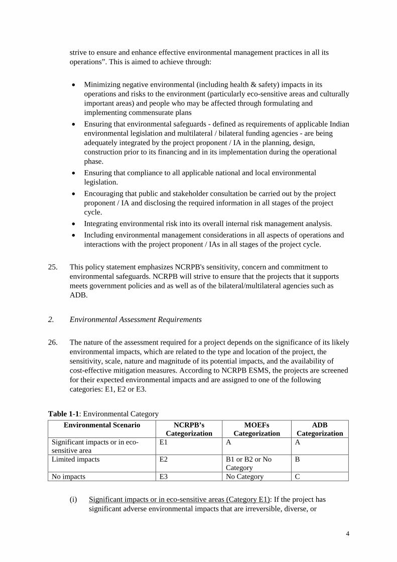
environmental impacts, which are related to the type and location of the project, the sensitivity, scale, nature and magnitude of its potential impacts, and the availability of cost-effective mitigation measures. According to NCRPB ESMS, the projects are screened for their expected environmental impacts and are assigned to one of the following categories: E1, E2 or E3.
Table 1-1: Environmental Category Environmental Scenario NCRPB’s
Categorization MOEFs
Categorization ADB
Categorization Significant impacts or in eco-sensitive area
E1 A A
Limited impacts E2 B1 or B2 or No Category
B
No impacts E3 No Category C
(i) Significant impacts or in eco-sensitive areas (Category E1): If the project has significant adverse environmental impacts that are irreversible, diverse, or

5
unprecedented, then it is regarded to have environmental scenario. These impacts may affect an area larger than the sites or facilities subject to physical works. These impacts will be considered significant if these are in eco-sensitive areas.
(ii) Limited environmental impacts (Category E2)
: If the project has impacts that are site-specific, few if any of them are irreversible, and in most cases mitigation measures can be designed.
(iii) No environmental impacts
(Category E3): If the project is likely to have minimal or no adverse environmental impacts, then it is regarded to have this environmental scenario.
27. The proposed subproject of construction of major drains in Sonepat is unlikely to have significant impacts. The project site is also not located or near any eco-sensitive area. The subproject is however likely to have typical impacts associated with the construction activity in urban areas and therefore classified as Category E2.
28. According to ESMS, E2 projects require carrying out Initial Environmental Examination
(IEE) and preparation of IEE Report. This IEE report is prepared accordingly.

6
2. DESCRIPTION OF PROJECT
A. Proposed Works 29. Based on the detail topographical investigations along the major roads, a skeleton path of
the storm water drains consisting of new primary and secondary drains was formulated. The objective of this is to transport storm water from various localities to the main drain of the town (i.e. Drain No. 6) for further disposal. The proposed storm water drains are shown in Figure 2-1. It is also proposed to construct rainwater harvesting structures in the town as part of the subproject.
30. Details of the proposed drain sections are presented in the following Table 2-1. The
proposal involves construction of two types of new drains – rectangular open drain and closed pipe drains. Under the subproject, it is proposed to construction open drains of total length 7.85 km (15.7 km considering both sides) and closed circular drains 5.09 km. Figure 2-2 shows the typical cross section of proposed drains.
Table 2-1: Design Details of Proposed Drain Sections S.No. Drain Chainage Length Type of Drain Width Depth/Dia 1 A A22-A2 810 CC Rectangular drain with
covers on both sides of road 1 m 1 m
2 A A'21-A2 1,410 Same as above 1 m 1 m 3 A A1-A2 1,260 Same as above 1 m 1 m 4 A A211-A21 720 Same as above 1 m 1 m 5 A A2-A9 2,730 RCC pipe on one side of road - 1.5 m 6 C C22-C21-
C2 2,070 RCC pipe on one side of road - 1.2 m
7 C C31-C2 330 RCC pipe on one side of road - 0.9 m 8 C C1-C2-
C3-C4 960 RCC pipe on one side of road - 0.9 m
9 D D1-D2-D3-D4
2,070 CC Rectangular drain with covers on both sides of road
1 m 1m
10 D D31-D3 1,580 CC Rectangular drain with covers
1 m 1m
CC – Cement Concrete; m – metre; RCC – Reinforced Cement Concrete 31. These new drains will be constructed within the available ROW of the roads. Rectangular
open drains will be constructed in the vacant unused land strip available between the road carriageway and the building line. On narrower roads, where there is no sufficient space to accommodate open drains, RCC closed circular drains will be laid underground into the road carriageway. No land acquisition/resettlement impacts envisaged; however there may be temporary impacts during construction. Resettlement plan will address the resettlement impacts due to construction of drains in narrow roads.
32. Four rain water harvesting structures are proposed in the project. These will be constructed
on government owned lands. Surface runoff collected through storm water drains will be diverted into the rainwater harvesting wells. Indicative location of these are shown in

7
Figure 2-4 and layout and cross section are presented in Figure 2-5. 33. Implementation Schedule. The detailed project report has been approved, and presently
bid preparation and approval is under process. Bids are likely to be invited in June 2013, and construction will start in December 2013. The construction work will take about 24 months, so the work will be completed by the end of 2015.

1
Figure 2-1: Proposed Drain Network

2
Figure 2-2: Typical Cross Section of Proposed Drains

3
Figure 2-3: Typical Cross Section of Proposed Box Culvert
1
Figure 2-4: Location of Rainwater Harvesting Wells

2
Figure 2-5: Layout and Cross Section of Rainwater Harvesting Well (3 m diameter)

3
3. DESCRIPTION OF ENVIRONMENT
A. Physical Resources
1. Location 34. Sonepat is located in the central eastern part of Haryana State in north India.
Geographically, Sonepat is located at 280 59’ north latitude and 77o
01’ east longitude. With the formation of Sonepat region as a separate district in 1972 dividing the then Rohtak District, Sonepat became the headquarter of Sonepat District. The town is located at about 225 km south of State Capital Chandigarh, and about 22 km north of National Capital Delhi. Town is well connected with other parts of the State and Country. National Highway 1 (NH 1/ Grand Trunk Road) connecting Delhi and Wagah Border in Punjab, connecting many important cities passes near the town. Sonepat is also well connected to various towns of Haryana State and its hinterland with three State Highways (SH-11, SH-14 and SH-20) and other major and minor roads.
2. Topography, Soil and Geology 35. Entire Sonepat District is a part of the Punjab Plains although some parts of the district
have undulating terrain. District is divided broadly into three regions: Khader, Upland Plain and Sandy Regions. Sonepat falls under Upland Plain Region, which is most extensive and occupies majority area of the district. These Upland Plains are covered with highly fertile old alluvium, because of which the district is agriculturally rich. Extensive farming of food crops, oil seeds, horticultural plants, vegetables and flowers, is practiced in the district.
36. River Yamuna, which borders the district in the east, is the main and only perennial river
that traverses Haryana State. Probably due to flat topography and limited rainfall, natural drainage system is not very well developed. The district is drained by Drain No.8, which was constructed to take out excess monsoon runoff from uplands to River Yamuna. The general slope of Sonepat Town is towards south and west. Almost entire town drains into Drain No.6 that flows north-south and meets Drain No. 8 in the south, that ultimately flows east to meet River Yamuna. The average ground level of the town is 225.15 m.
3. Climate 37. Climate of the district is generally dry with intensely hot summers and cold winters.
Summer starts early April and peaks in May. The weather becomes comparatively mild during the monsoon period of July to September. The district experiences high humidity during the monsoon period. The cold season starts by mid/late November and extends upto middle of March. It is followed by hot season. The average temperature ranges from a

4
minimum of 1.8oC to a maximum of 44.9oC. January is the coldest month with mean daily maximum temperature of 21.3o C. and mean daily minimum temperature of 7.3oC. May is the hottest month with mean daily maximum temperature of 46.6oC. In May and June, the maximum temperature sometimes reaches about 47o
C.
38. Sonepat experiences predominant winds are from north, northwest and west, followed by east and southeast. Winds are stronger during monsoon lighter during the remaining parts of the year. The annual average rainfall of the district is 625 mm. About 76 percent of the annual rainfall is recorded during the southwest monsoon season from June-September. July is the wettest month of the year.
4. Air Quality 39. No ambient air quality data of Sonepat is available. Ambient air quality of Panipat Town,
located in the north of the town (65 km) and possess similar characteristics are presented in the following table as representative data. Data shows that particulate matter is high because of the dry atmosphere, dusty roads and surrounding land, and Suspended Particulate Matter (SPM) exceeds National Ambient Air Quality Standards (NAAQS) at most of the monitoring locations. Levels of chemical pollutants (oxides of sulphur and nitrogen) are below national standards except at one location.
Table 3-1: Ambient Air Quality in Panipat Location Land Use Monitoring
Date SOx NOx SPM
SD Senior Secondary School Sensitive 16-Mar-09 12.4 41.1 312.9 ESI Hospital Sensitive 18-Mar-09 15.7 14.6 195.8 HUDA Sector 17 Residential 10-Apr-09 8.0 33.0 139.8 HUDA Sector 13 Residential 10-Apr-09 14.0 27.0 362.0 STP, Jatal Road Residential/Rural 21-Mar-09 13.0 8.0 119.9 Near Ghohana Railway Crossing Mixed/Residential 10-Mar-09 6.1 33.2 335.2 HP Petrol Pump, Jatal Road Mixed/Residential 21-Mar-09 6.1 23.3 325.6 All values are in µg/m3
; all values are presented in 24 hours average
Table 3-2: National Ambient Air Quality Standards Land Use Average SPM NOx SOx
Industrial Areas Annual Average 360 80 80 24 hours Average 500 120 120 Residential, Rural & other Areas Annual Average 140 60 60 24 hours Average 200 80 80 Sensitive Area Annual Average 70 15 15 24 hours Average 100 30 30 All values are in µg/mSource: Haryana State Pollution Control Board
3

5
5. Surface Water 40. River Yamuna is an important river in India. It is the major tributary of Ganges River.
Yamuna flows at about 20 km east of Sonepat Town in north-south direction and forms border of Sonepat District as well as of Haryana State. There are no other notable water bodies in or near Sonepat Town. A main drain – known as Drain No. 6, flows across the town in north- south direction, and meets Drain No. 8 at about 10 km down south. Drain No.8, which was constructed to take out excess monsoon runoff from uplands to River Yamun, flows from west to east and meet River Yamuna at Baoipur
41. Drain No. 6 enters the town in the north and flows through the town. This drain is about 4-
6 m wide, and carries mainly, except during the rains, domestic wastewater and as well as industrial wastewater (partially treated/untreated), which enters into it illegally (see photographs of Drain 6 below). Almost the entire town drains into Drain No.6. Due to encroachments, the drain size is not uniform through its length. Solid waste disposal into the drain is prevalent (See Photographs below).
42. The water quality of Drain No. 6 is presented in the following Table. In Sonepat, most of
industries are engineering based units followed by food and agro-based industries. No industrial effluent is generated by engineering units, while food industries generated wastewater that is very high in BOD. The water shows the presence of BOD and Oil & Grease, indicating the polluted nature.
Table 3-3: Water Quality of Drain No.6, Sonepat (April 2009) S. No Parameter, units Value 1 pH 7.46 2 B. O. D. mg/l for 3 days at 27°C 16.90 3 Oil & Grease, mg/l 15 4 Suspended Solids, mg/l 36 5 Dissolved Solids, mg/l 1,006 6 Chlorides (as Cl) mg/l 150 7 Conductivity, Micro. S/cm 2,190 Source: Haryana State Pollution Control Board

6
6. Groundwater 43. In Sonepat region, ground water occurs in alluvial sand, silt, kankar and gravel, which
form potential aquifer zones. The groundwater occurs predominantly in two aquifers: Aquifer group-I, which was in unconfined state and extends from water table down to 70m depth, and Aquifer group-II, which is under semi-confined/confined state occurs in the depth range of 90 to 200 m. The depth to water level lies within 10 m below ground level in most parts of the district including Sonepat Town and the general ground water flow is from northwest to southeast, towards River Yamuna. In the post-monsoon season, the depth of groundwater table is about 5 m.
44. The ground water development (extraction) in the town has exceeded the available
recharge (about 134 percent in Sonepat) and categorized as over exploited, while the overall development in the district is about 114 percent. The depth of bore wells normally is deeper than 30 m and discharge ranges from 600 – 720 liters per minute. During past decade the district has recorded a fall of less than 1m to 7m .The decline was 2 to 4m in most parts of the district including Sonepat.
45. In general, the quality of ground water in shallow dug well zones is fresh. The deep zones
below 150m depth contain brackish / saline ground water.
B. Ecological Resources 46. Haryana is predominantly an agricultural economy based State. Forestry activities in the
state are dispersed over the rugged Shivalik Hills in the North, Aravalli Hills in the South, sand dunes in the South-West, other wastelands and water-logged, saline and alkaline soils in the Central part of the State. Only 3.52 percent of the total geographical area in the State has been notified as forest area. About 3.5 percent of the area in Sonepat District is under forests.
47. Haryana Forest Department has taken a massive afforestation programme Community,
Panchayat and Farm lands to increase the forest cover and tree cover of the state is said to become 6.6 percent. Department has set a goal to bring 10% of area under forest and tree cover by 2010. In Sonepat District, afforestation is mainly undertaken along the roads and canals.
48. There are no forests or any other environmental sensitive locations in or near Sonepat.
Sonepat Town is an urban area surrounded by land that was converted for agricultural use many years ago. There is no remaining natural habitat in the town, and the flora is limited to artificially planted trees and shrubs, and the fauna comprises domesticated animals. Most of the wide roads in the town have road side trees. The tree species observed here include: Keekar (Acacia karoo); Neem (Azadirachta indica); Peepal (Ficus religiosa); Honge (Pongamia Pinnata); and eucalyptus (Eucalyptus cinerea).

7
C. Economic Development
1. Land Use 49. Due to its proximity to Delhi and good connectivity, Sonepat is growing rapidly. Total
area of the town in municipal limits is 18.25 sq. km (1,825 ha) and the population according to 2001 census was 214,974. Considering the fast phase of development, and put land use and development controls, Sonepat Development Plan 2021 was prepared by Government and Haryana. Anticipating the large scale expansion and development of the town, this plan has been prepared for entire Sonepat Urban Area covering 118.71 ha. As shown in the following Table 3-4 and Figure 4-1, 38 percent of the land is available for residential use. Significantly, 19 percent of the area is provided for industrial and 9 percent for commercial use.
Table 3-4: Proposed Land Use Sonepat 2021 Land Use Classification Proposed Area Ha Residential 4,505 Commercial 1,019 Industrial 2,254 Public & Semi-Public 1,295 Transport & Communication 114 Public Utility 174 Open Spaces 2,510 Total 11,871 Source: Sonepat Development Plan 2021
Figure 3-1: Proposed Land Use, Sonepat 2021

8
2. Industry & Agriculture 50. Situated within the National Capita Region and being close to Delhi, Sonepat is an
important and fast developing town. Sonepat is a noted industrial centre of Haryana. Industries in and around the town are mostly medium and small scale related to general engineering, cycle parts, dairy products and agro-based industries. The present area under industrial use is 6.4 percent of the municipal area, while the proposed as per the Development Plan 2021 is about 19 percent of the total urban area by 2021. Well known industries -Atlas Cycles and ECE industries, are situated here.
51. Agriculture constitutes the main economy of the region, major factor being the fertile
lands and irrigation. Wheat, paddy, sugarcane are the major crops while pulses, oilseeds, vegetables etc, are also grown as minor crops. Irrigation of the district is mostly done by canals (West Jamuna Canal System) and tube wells. However, in Sonepat Town, due to large scale real estate development for various uses most of agricultural lands are already converted into other purposes and therefore agricultural activity in the town limits is very limited.
3. Infrastructure 52. Water Supply and Sewerage. There are two water and wastewater service providers in
Panipat town - Public Works Department (Water Supply and Sanitation department) (PWD-WSSD) and the Haryana Urban Development Authority (HUDA). These agencies provide all the basic services pertaining to water supply and sewerage facilities in Sonepat Town. PWD-WSSD is a state government department and is primarily responsible for providing water supply and sewerage services. HUDA is an autonomous government body and functions as the land developer in Haryana. HUDA is responsible for providing services only to areas developed by it, which are called as HUDA “Sectors”.
53. Groundwater is the main source of water supply in Sonepat. Groundwater is extracted
through a number of bore wells drilled in various parts of the town by PWD-WSSD and by HUDA in its Sectors. Water is supplied through underground pipelines and house service connections are provided to each consumer at household level. In the areas uncovered with this system, people depend mostly on groundwater through individual hand pumps and tube wells.
54. At present, execution of underground sewerage system in Sonepat is under implementation
under National River Conservation Program (NRCP) of Government of India. This project is likely to be completed, and put into operation by the end of 2014. Due to lack of proper system, wastewater mostly enters Drain No. 6 and flows further down to Drain No. 8. Once sewerage system operation commences, entering of wastewater into Drain No. 6 will be restricted (Details are given in Appendix 1).

9
4. Transportation 55. Sonepat is located very advantageously – proximity to national capital Delhi and its
location along a very important national road transport corridor – NH 1. Sonepat is well connected with other parts of the State and Country. NH 1 - from Delhi to Wagah Border (with Pakistan) in Punjab near the town; it connects to all important cities and hinterland in Haryana and as well in Punjab State. It is also well connected to various towns of Haryana State and its hinterland with three State Highways (SH-11, SH-14 and SH-20) and other major and minor roads.
56. The town is also well connected by national rail network. The Delhi-Ambala railway line
passes through the town. There are regular and frequent train services from Sonepat Railway Junction connecting various parts of the country. Nearest Airport is at Delhi, about 45 km south of Sonepat.
76. Sonepat is provided with a relatively good road network, particularly in the sectors
developed HUDA, where streets are wide and not heavily utilized by traffic. The situation however is different in the old town where roads are narrower and more congested (with both traffic and pedestrians), and the roads are not well maintained.
77. There are regular bus services to Delhi and other towns and cities and hinterland in
Haryana and as well as in neighboring states operated both by state-run and private transport services. Within the town, commuters mainly depend on IPT modes of Auto Rickhwas and Cycle Rishwas, besides the private vehicles for intra-city travel.
D. Social and Cultural Resources
1. Demography 57. The population of Sonepat Town as per census 2001 was 214,974 increasing from 143,992
in 1991 with a decadal growth rate of 50.2 percent over 1991-2001. Expanding to an area of 1,825 ha, the gross population density of the town was 119 persons per hectare. Table 3-5 shows the population growth of the town from 1971-2001. As per the Development Plan 2021 the projected population of 2021 is 374,344.
Table 3-5: Population Growth of Sonepat Town Year Population Decadal Growth Rate (%) 1971 62,393 1981 109,369 75.3 1991 143,922 31.6 2001 214,974 49.4
Source: Census of India

10
58. Overall literacy is 82.1 %, reported at 88.3% for males and 74.8 % for females, which is considerably better than literacy in the state as a whole, which is 67.1% overall, and 78.5% for males and 55.7 % for females. The sex ratio is however significantly below the natural 1:1 ratio, being 837 females per 1000 males, which is considerably less than both the state and national averages (861 and 933 respectively). About 13.5 percent of the total population belongs to Scheduled Castes.
59. According to 2001 census, the workforce participation rate (WPR) in Sonepat was 29.4
percent. As shown in the following figure, nearly 94 percent of the total workforce was engaged in service sector (formal, informal, trade, commerce, industry etc). Contribution of other sectors is very minimal – about 3 percent are engaged in household industries the remaining 3 percent of population are engaged in primary sector activities.
Figure 3-2: Occupational Structure
60. Majority of people in Sonepat District are Hindus and the remainder are mainly Muslims, Sikhs, Jains, Christians and Bhudhists. Over 90 percent of people speak Hindi followed by Punjabi and Urdu and the reminder speak other languages. Locally, people prefer to converse in Hariyanvi – a local dialect. A few also speak English.
2. Health & Education Facilities 61. Being the district headquarter and important agricultural, commercial and industrial centre
in the region, the town is provided with good educational and healthcare facilities. There are a number of schools, colleges and technical institutes in the town, provided by both government and as well private sector. The town also has good health care facilities.

11
3. History Culture and Tourism 62. As per the history it is said that the name of the town has changed gradually from
Suvarnaprastha (meaning Golden City) to Sonprastha and finally to Sonepat (or Sonepat) as it is known today. People say that the history of town dates back to the days of Mahabharata and that Sonepat was one of the five patas or prasthas (villages) which Pandavas demanded from Kauravas in the peace deal. As per a school of thought, the Pandava brothers established this town and called as Suvrnaprastha. As per another school of thought, King Raja Soni, the thirteenth descendant of Arjuna (one of the Pandava brothers), established this town. The first documented history relates the town with the great Sanskrit grammarian Panini and his Book Astyadhyayi.
63. The following monuments are situated in Sonepat. However, these are of little importance
in terms of tourism. These are presently not in good condition and formed part of surrounding built up area with developments all around the structures.
(i) Kos Minars/Pillars: In 1619 AD, Mughal Emperor Jahangir order to erect these
Minars (tall pillars of brick structures stand on low square plotform and covered with plaster) at every Kos – (a running length of about 4.5 km) along the ancient imperial route from Agra to Lahore. There are three Kos Minars in Sonepat.
(ii) Tomb of Khwaza Khizer. This is the tomb of local saint, Khwaza Khizer, son of
Darya Khan Sarwani and flourished during the era of Ibrahim Lodi. This tomb was constructed in 1522-24.
64. Tourism importance of Sonepat is almost negligible. Also, the town is not also identified
as historically or archeologically important.
E. Description of Proposed Drain Alignment
65. The following Table 3-6 presents the description of proposed drain alignments.
Table 3-6: Description of Subproject Sites Drain Chainage Type of Drain Site Remarks A A22-A2 CC Rectangular drain of 1m
x1m of length 810 m on both sides of the road; drain will be constructed adjacent to building line in the earthen shoulder of the road within the available ROW
Drain along Mehlana Road from SD School; existing carriageway 7.5; earthen shoulder 3 m wide on either side. Land use along the part of the road from SD school to bypass is commercial and the remaining part is mostly vacant. There are no encroachments, squatter or vendors on ROW. There are trees along the road.
A A’21-A2 CC Rectangular drain of 1m x1m of length 1,410 m on both sides of the road; drain will be constructed adjacent
Drain along Rohtak Road from SD School; existing carriageway 10 m; earthen shoulders or foot path of 2-4 m wide on either side. This is one
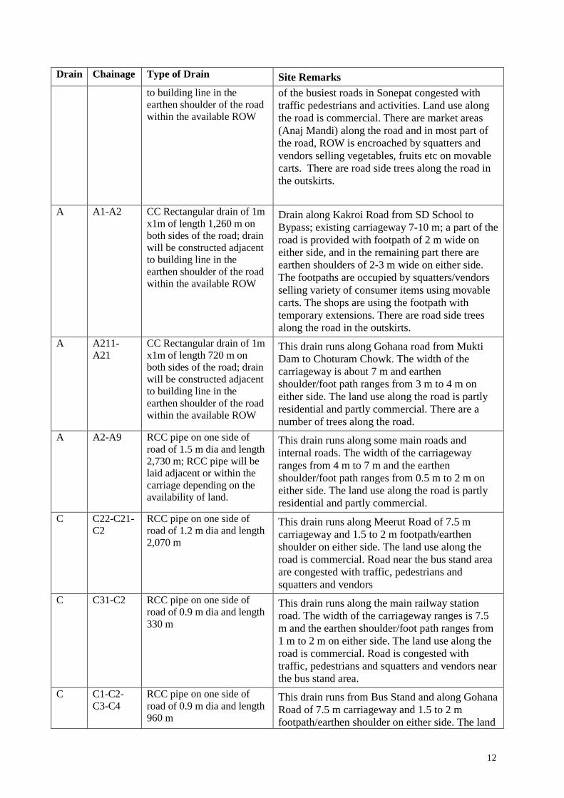
12
Drain Chainage Type of Drain Site Remarks to building line in the earthen shoulder of the road within the available ROW
of the busiest roads in Sonepat congested with traffic pedestrians and activities. Land use along the road is commercial. There are market areas (Anaj Mandi) along the road and in most part of the road, ROW is encroached by squatters and vendors selling vegetables, fruits etc on movable carts. There are road side trees along the road in the outskirts.
A A1-A2 CC Rectangular drain of 1m x1m of length 1,260 m on both sides of the road; drain will be constructed adjacent to building line in the earthen shoulder of the road within the available ROW
Drain along Kakroi Road from SD School to Bypass; existing carriageway 7-10 m; a part of the road is provided with footpath of 2 m wide on either side, and in the remaining part there are earthen shoulders of 2-3 m wide on either side. The footpaths are occupied by squatters/vendors selling variety of consumer items using movable carts. The shops are using the footpath with temporary extensions. There are road side trees along the road in the outskirts.
A A211-A21
CC Rectangular drain of 1m x1m of length 720 m on both sides of the road; drain will be constructed adjacent to building line in the earthen shoulder of the road within the available ROW
This drain runs along Gohana road from Mukti Dam to Choturam Chowk. The width of the carriageway is about 7 m and earthen shoulder/foot path ranges from 3 m to 4 m on either side. The land use along the road is partly residential and partly commercial. There are a number of trees along the road.
A A2-A9 RCC pipe on one side of road of 1.5 m dia and length 2,730 m; RCC pipe will be laid adjacent or within the carriage depending on the availability of land.
This drain runs along some main roads and internal roads. The width of the carriageway ranges from 4 m to 7 m and the earthen shoulder/foot path ranges from 0.5 m to 2 m on either side. The land use along the road is partly residential and partly commercial.
C C22-C21-C2
RCC pipe on one side of road of 1.2 m dia and length 2,070 m
This drain runs along Meerut Road of 7.5 m carriageway and 1.5 to 2 m footpath/earthen shoulder on either side. The land use along the road is commercial. Road near the bus stand area are congested with traffic, pedestrians and squatters and vendors
C C31-C2 RCC pipe on one side of road of 0.9 m dia and length 330 m
This drain runs along the main railway station road. The width of the carriageway ranges is 7.5 m and the earthen shoulder/foot path ranges from 1 m to 2 m on either side. The land use along the road is commercial. Road is congested with traffic, pedestrians and squatters and vendors near the bus stand area.
C C1-C2-C3-C4
RCC pipe on one side of road of 0.9 m dia and length 960 m
This drain runs from Bus Stand and along Gohana Road of 7.5 m carriageway and 1.5 to 2 m footpath/earthen shoulder on either side. The land

13
Drain Chainage Type of Drain Site Remarks use along the road is commercial. The road is congested with traffic, pedestrians and squatters and vendors near Bus Stand
D D1-D2-D3-D4
CC Rectangular drain of 1m x1m of length 2,070 m on both sides of the road
This drain runs along Meerut Road The width of the carriageway ranges from 6 m to 9 m and the earthen shoulder/foot path ranges from 0.5 m to 2 m on either side. The land use along the road is partly residential and partly commercial. There are trees along the road.
D D31-D3 CC Rectangular drain of 1m x1m of length 1,580 m on both sides of the road
This drain runs along Meerut-Delhi Road The width of the carriageway ranges from 7 m to 10 m and the earthen shoulder/foot path ranges from 2 m to 3 m on either side. The land use along the road is partly residential and partly commercial.
Rainwater harvesting structures: 4 numbers
Site 1 is located near Drain no. 6, in Sector 12, in the northern part of the town Site 2 is located in the central part of the town, near Drain no.6, at Delhi Road Site 3 is located in the southern part of the town, near Drain no.6, at Murthal Road Site 4 is located in southern part of the town near the railway line (near Shanti Mandir)

14
Photographs: Photo 1: Mehlana Road (A22-A2) Photo 2: Mehlana Road (A22-A2)
Photo 3: Rohtak Road (A’21-A2) Photo 4: Rohtak Road (A’21-A2)
Photo 5: Kakroi Road (A1-A2) Photo 6: Drain Alignment (A2-A9)

15
Photo 7: Drain Alignment (A2-A9) Photo 8: Drain Alignment (A2-A9)
Photo 9: Drain Alignment (A211-A21) Photo 10: Drain Alignment (A211-A21)
Photo 11: Drain Alignment (C22-C21-C2) Photo 12: Drain Alignment (C22-C21-C2)

16
Photo 13: Drain Alignment (C2-C31) Photo 14: Drain Alignment (C2-C31)
Photo 15: Drain Alignment (C1-C4) Photo 16: Drain Alignment (C1-C4)
Photo 17: Drain Alignment (D1-D4) Photo 18: Drain Alignment (D31-D3)

17
4. ENVIRONMENTAL IMPACTS & MITIGATION MEASURES
A. Overview 66. As a general practice, an IEE should evaluate impacts due to the location, design,
construction and operation of the project. Construction and operation are the two activities in which the project interacts physically with the environment, so they are the two activities during which the environmental impacts occur. In assessing the effects of these processes therefore, all potential impacts of the project should be identified, and mitigation is devised for any negative impacts. Following sections evaluate impacts of the proposed storm water drains subproject in Sonepat.
B. Construction Impacts 67. This subproject will involve construction of the following elements:
(i) Construction of Open Drains
o Excavating a trench of 1.4 m wide and 1.4 m deep to accommodate the construction of drain;
. Construction of open drains of 1 m wide and 1 m deep in cement concrete (CC) over a total length of 15.7 km involving the following activities:
o Preparation of plain cement concrete bed of 100 mm in the bottom of trench o Construction of drain in RCC by fixing of reinforcement rods and pouring of
concrete to form bottom (150 mm thick) and walls (200 mm thick) of drain o Placing a RCC pre-fabricated covers of 150 mm over the drain
(ii) Construction of Closed Piped Drains (New)
o Excavating a trench of 1.5 m to 2.1 m wide and 1.5 m to 2.5 m deep
. Underground closed drains will be laid over a total length of 5.09 km by laying RCC pipes of diameter ranging from 0.9 m to 1.5 m. This will involve:
o Preparation of a bed (225–375 mm thick) with the excavated soil and compacting to required level o Laying of RCC pipes and joints o Road restoration
(iii) Construction of box culverts at road crossings
: This will involve site clearance & formation of base; laying of base in RCC; construction of retaining walls in RCC; construction of upper slab in RCC.
(iv) Construction of rainwater harvesting structures: This will involve excavation for construction of 3 m diameter trench, construction masonry walls, arranging filter media at bottom, drilling of 5 bore holes around the structure, fixing connection pipes from bottom of filter media to the bore holes and construction of upper slab in

18
RCC with manhole for operation and maintenance. 68. Typical cross sections of drains are shown in Figure 2-2. Cross section of rain water
harvesting structure is shown in Figure 2-5. 69. Trench for drain construction will be excavated manually or using mechanical excavators,
depending on the site conditions and width of the road. Construction material such as sand and aggregate, procured from local mines, and pipes will be brought to site on a truck and stored on a nearby site. Concrete will be mixed on site using small mixers. RCC pipes will be placed in the trench using small hoisting cranes, or manually if the site doesn’t permit mechanical operation. Once the construction is over, the road surface will be restored to its original position, where it is distributed due to construction work. The construction work will be conducted by small teams of 10-15 workers, comprising masons, labourers, and truck drivers, surveyors and supervisors.
70. Total quantity of earthwork excavation for the subproject has been estimated as 68,906 m3
• Reuse as much excavated material in the subproject as possible
, of which 27,562 m3 will utilized in the construction and the remaining 41,343 m3 will be generated as surplus soil which needs to be disposed off Solid waste and other accumulated materials in the drains will require proper disposal. Construction materials like sand and aggregate will be sourced from quarries approved by the Mines & Geology Department of Government of Haryana. Normally, construction material for Sonepat is procured from mines - sand from Panchkula (Yamuna River), and aggregate from Panchkula and Bhiwani Districts in the State. Following mitigation measures to be carried out for excavated materials:
• Recyclable materials should be recycled when possible. If recycling is not an option then the materials must be properly disposed of at a permitted landfill or taken to a transfer station.
• If contaminated soil is discovered, workers should withdraw to a safe distance and notify their manager before proceeding.
1. Impacts on Physical Resources 71. This work will involve straightforward construction, alongside relatively short lengths of
road, so if appropriate precautions are taken, physical impacts should not be greatly significant. Since all the drains are to be constructed are now, this will involve significant and invasive excavation to create trenches. As the construction work is being carried out in an urban area and along the major roads, most of which are congested with traffic, pedestrians and activities, the work is expected have typical impacts associated with construction like impacts due to disposal of waste/surplus soil, disturbance to traffic and activities, dust and noise, etc.
72. As stated above, the construction work is expected to generate significant quantities of
surplus waste soil, which needs to be disposed off without any impacts. The contractor shall implement the following measures:

19
• Utilize the waste soil in construction work; • Provide surplus soil to HUDA/private agencies for utilizing in land development and
formation of housing/industrial areas in and around Sonepat; Significant quantities of soil is required for formation of new areas/residential layouts which is under full swing in Sonepat
73. The other physical impact commonly associated with large-scale excavation (effects on surface and groundwater drainage) should again be minimal by the fact that this work will be conducted in the dry season. As the maximum depth of excavation will be about 2.5 m, considering the depth of groundwater 10 m below ground level (5 m post monsoon level), there is no possibility of accumulation of groundwater in trenches during excavation.
74. As the work will be conducted in the dry season, there is a lot of potential for the creation
of dust, from the excavation of dry soil and its storage, and leveling on the ground. Action will therefore be needed to reduce physical impacts at both the construction and disposal sites, by controlling dust and reducing the amount of material to be dumped. Similarly, the activities like loading, unloading and transport of loose construction material is also likely to create dust. Excavation and use of heavy construction equipment for various activities would generate noise and may create nuisance to the surrounding people. The Contractor should therefore be required to:
• Cover or damp down by water spray on the excavated mounds of soil to control dust
generation; • Bring the material (aggregate) as and when required; • Ensure speedy completion of work – trench excavation, drain constriction and
refilling, to remove surplus soil as soon as possible; • Use tarpaulins to cover loose material/soil that is transported to and from the site by
truck • Damp down soil sufficiently while using for leveling the ground • Control dust generation while unloading the material (particularly aggregate) at the
site by sprinkling water and unloading an a barricaded area • Sprinkle water in truck after downloading material; or cover it with tarpaulin to avoid
dust raging from the truck while it is moving • Do not conduct noise generating activities in the night or sensitive times • In case of high noise generating activities, for instance while road breaking activities,
inform public in advance about the nature of work and schedule the work in most appropriate timings
• Avoid usage of heavy noise generating equipment near sensitive areas
75. Large quantities of construction material like sand and aggregate will be required for drain construction work. There could be impacts due to mining of materials if the mining activities are not conducted properly. Therefore to ensure that there are no impacts due to mining, the contractor should procure construction materials only from quarries licensed by the Directorate of Geology and Mining.

20
2. Ecological Resources 76. There are no protected areas in or around Sonepat Town, and no known areas of ecological
interest. The new drains are proposed to be constructed either along the roads in the space available between road carriage way and the building line (for open drains) or within the road (underground closed drains). There are road side trees along most of the major and wide roads in Sonepat. The trees, which fall in the drain alignment will be saved by changing the alignment slightly near the tree and need not to be cut off for construction of drains. The roads are lined with following tree species of different sizes: Keekar (Acacia karoo); Babul (Acacia arabica) Neem (Azadirachta indica); Peepal (Ficus religiosa); Honge (Pongamia Pinnata) Sesame (Sesamum indicum) and Eucalyptus.
77. As shown in the following Table, there are 122 trees along the proposed alignment.
However, no tree will be cut off while constructing the drains. Based on site observation, the engineering team explained that during the construction, rectangular drains may be realigned at particular location for protecting the trees. Trees falling under piped drains alignment are very zero. There is no tree cutting involved in the constructing activity of drains.
Table 4-1: Design Details of Proposed Drain Sections S. No. Drain Chainage Length No. of trees in the
alignment 1 A A22-A2 810 m 13 2 A A’21-A2 1,410 m 30 3 A A1-A2 1,260 m 27 4 A A211-A21 720 m 33 5 A A2-A9 2,730 m 3 6 C C22-C21-C2 1,070 m 4 7 C C31-C3 330 m - 8 C C1-C2-C3-C4 960 m - 9 D D1-D2-D3-D4 2,070 m 19 10 D D31-D3 1,580 m 3 122
78. There are no protected forests along the alignment of drains. Therefore as stated above, it
is important to minimize the tree cutting by the following measures:
• Fine tune the alignment during construction to avoid tree cutting
3. Economic Development 79. The work will be conducted within the available ROW and therefore no land acquisition is
envisaged. However, in many roads the space between the road carriageway and building line is encroached by road side vendors and squatters, who are likely to be disturbed by construction work and may lead to temporary loss of livelihood. All the vendors/squatters

21
run small business like selling fruits, vegetables, eatables, household items, etc, mostly using movable carts and few squat on the ground using plastic sheets to spread the items on ground for selling. They have no fixed assets – permanent or temporary, but generally have a fixed location on ROW, which they occupy every morning and do the business and vacate in the evening at the end of day business. Therefore the project will not involve acquisition of land or structures. However, during the construction work, there may be temporary disturbance for continuation of business and may lead to loss of income. NCRPB Environmental and Social Management System (ESMS) and Policy provide that these squatters and vendors do not suffer economically as a result of the project, and therefore the following measures shall be undertaken:
• Inform well in advance all the squatters and vendors about the work schedule and the
need to move out of ROW temporarily • Provide an alternative temporary site in the vicinity to squatters/vendors to continue
their business during the construction work at that stretch/road • Provide prior public information about the work and site of temporary relocation of
squatters and vendors 80. Similarly, shops and other premises along the road may lose business income because the
access will be impeded by excavation of trenches and due to the presence of material and equipment. Resettlement plan has been developed in accordance with NCRPB ESMS. Implementation of the following best construction measures will reduce the impact:
• Inform all residents and businesses about the nature and duration of work well in
advance so that they can make preparations if necessary; • Leave spaces for access between mounds of excavated soil and other stored materials
and machinery, and provide footbridges so that people can cross open trenches • Control dust generation • Increasing workforce to complete the work in a short period, especially in commercial
areas like bus stand road, railway road, Kakroi Road, Meerut and Rohtak Road. • Provide compensatory measures as suggested by the Resettlement Plan
81. Transportation is the principal activity that will be impeded by this work. The impact is
likely to be minimal as the work will mostly be conducted in the vacant strip of land along the roads. However, in some roads, where this vacant land is unavailable, closed drains are proposed, which will be laid with the carriageway on side by breaking open the road surface. Also, during the construction of box culverts at road crossings, there will be disturbance to the traffic. The following measures therefore shall be implemented to minimize the disturbance:
• Conduct work during light traffic; explore night working schedule ensuring workers
and public safety • Do not close the road completely; conduct the work in minimum possible area and
allow the traffic to move on the remaining carriageway • Provide alternative traffic arrangement/detours and ensure that public is informed

22
about such traffic diversions • Allow smooth traffic movement by confining and barricading the construction area; • Provide necessary personnel to guide and control the traffic • Provide information to the public through media – daily news papers and local cable
television (TV) services, about the need and schedule of work, and alternative routes • At work site, public information/caution boards shall be provided - information shall
inter-alia include: project name, cost and schedule; executing agency and contractor details; nature and schedule of work at that road/locality; traffic diversion details, if any; entry restriction information; competent official’s name and contact for public complaints
• Control & regulate the movement of vehicles and pedestrian near the site; avoid accidental entry of traffic (pedestrian/vehicular) into site
82. The proposed construction work could disturb the existing water supply lines, sewers,
telephone cables and power supply lines, which are located within the project site. It is therefore required to implement following measures to avoid or minimize the impact during construction:
• Notify the respective agencies (PHED, SM, BSNL and HSEB) in advance about
the construction work and if there is any need for shifting • Coordinate with respective agencies and provide prior information to public about
the disruption in services during construction; this can be announced via mass communication systems like local/vernacular news papers.
• Provide alternative arrangement for disrupted services such as water supply based on the necessity and duration of disruption
83. Since the subproject is located in an urban area with presence of large scale commercial,
residential and other establishments, the disturbance and nuisance due to construction work in the vicinity will be significant. Following measures shall be implemented:
• Consultation with the local community to inform them of the nature, duration and
likely effects of the construction work, and the mitigation measures in place, as formulated in this IEE
• Proper planning of the work programme so that any noisy or otherwise invasive activities can be scheduled to avoid sensitive times;
• Avoiding noise-generating activities at night; • Implementing the measures to reduce dust; • Utilising modern vehicles and machinery with the requisite adaptations to limit noise
and exhaust emissions, and ensuring that these are maintained to manufacturers’ specifications at all times.
4. Social and Cultural Resources 84. There are no historical or cultural heritage sites in Sonepat in general or at the project site

23
in particular. Therefore there are no likely impacts. 85. There are schools, colleges, hospitals, cinema halls and religious places located along the
roads. The work could disturb these modern-day social and cultural resources. Impacts will include noise, dust, and interrupted access for pedestrians and vehicles. Mitigation will therefore be needed to protect these resources and to enable usage by local people and visitors to continue throughout the construction work. This will be achieved through several of the measures including:
• Avoiding working at sensitive times, • Dust control measures as suggested above; • Providing wooden bridges for pedestrians and metal sheets for vehicles to allow
access across open trenches where required (including access to houses); • Using modern vehicles and machinery with standard adaptations to reduce noise
and exhaust emissions, and ensuring they are maintained to manufacturers’ specifications.
86. There is invariably a safety risk when substantial construction such as this is conducted in
an urban area, and precautions will thus be needed to ensure the safety of both workers and citizens. The measures such as the following should be implemented:
• Following standard and safe construction practices • Excluding the public from the site – enclosing and regulating the construction area,
providing warning boards and sign boards • Ensuring that all workers are provided with and use appropriate Personal Protective
Equipment (helmet, hand gloves, boots, masks, etc); • Follow standard practices of safety checks as prescribed before use of equipments; • Report accidents to the authorities promptly, and maintain records
87. There could again be some short-term socio-economic benefits from the construction work
if local people gain employment in the workforce. To ensure that these benefits are directed to local people, the Contractor should be required to employ as much of his labour force as possible from the local communities in the vicinity of construction sites. Drawing of majority of workforce from local communities will avoid problems that can occur if workers are imported, including social conflicts and issues of health and sanitation due to labour camps. If temporary labour camps are to be provided; Contractor should ensure that they are maintained well with proper water supply and sanitation facilities.
C. Operation Stage Impacts 88. The drains will not function without maintenance, as silt inevitably collects in areas of low
flow over time. The project will therefore provide equipment for cleaning/desilting of drains, including buckets and winches to remove silt.

24
89. Construction of storm water drains will improve the drainage system of Sonepat, through quick disposal of rainwater from the localities. However, since there is no proper sewerage system in the town, there is a risk of wastewater entering the new drains illegally. Therefore it is important that sewerage system of the town needs to be improved on priority to maximize the benefits of the drainage system. Implementation of the following measures will avoid any risk on health and environment that may result from malfunction of system due to (i) entry of wastewater into drains; and (ii) blocking/choking due to accumulation of silt, and solid waste:
• Prevent entry of wastewater into drains; this requires improvement of sewerage
system in the town • Ensure regular cleaning and desilting of drains; project shall include provision of
necessary maintenance equipment • Prevent encroachment of drains • Prevent dumping of solid waste in drains; create public awareness
D. Location and Design Impacts 90. In the case of this subproject there are no major impacts that can clearly be said to result
from either the design or location. This is because
• The project is located and designed within vacant and unused land available in the ROW
• The project location is not especially sensitive 91. Planning principles and design considerations have been reviewed and incorporated into
the site planning process whenever possible; thus, environmental impacts due to the project design or location were not significant. There is no impact in cutting of trees located in the alignment. Necessary measures to guide the construction to avoid tree cutting are already suggested in the previous section. No tree will be cut off during construction of the drains.
92. The sites for proposed rainwater harvesting structures are on government owned land
parcels. The rain water harvesting structures are designed with the objective to increase the groundwater recharge. Rapid infiltration and percolation in low lying areas through rainwater harvesting structure will improve clearance of accumulated rain water.

25
5. INSTITUTIONAL ARRANGEMENTS
A. Institutions Involved 93. Following agencies will be involved in implementing this Storm Water Drainage
subproject in Sonepat:
(i) NCRPB
: National Capital Region Planning Board is the likely funding agency for the project.
(ii) Implementing Agency (IA)
: Implementing Agency of the Project will be Sonepat Municipality. IA will be responsible for the project implementation. Operation & maintenance will also be the responsibility of the IA.
(iii) Design and Supervision Consultants
: Implementing Agency will be assisted by Design and Supervision Consultants (DSC) in tendering, and reviewing and revising designs during the construction and supervising the construction to ensure quality.
(iv) Construction Contractors
: IA will appoint Construction Contractors (CC) to build the infrastructure elements.
94. Implementing the project according to and incompliance with the policies the funding agency, NCRPB, will be the responsibility of the Implementing Agency (IA). The Environmental and Social Management Cell (ESMC) of NCRPB will deal with environmental and social safeguard issues. ESMC would guide and monitor IA in complying with its ESMS and Policy.
95. ESMC will review and approve IEE, oversee disclosure and consultations, and will
monitor the implementation of environmental monitoring plan and environmental management plan where required. The Construction Contractor (CC) will implement mitigation measures in construction. IA or DSC will monitor the implementation of mitigation measures by the CC. ESMC will oversee the implementation of EMP. Implementation of mitigation and monitoring measures during the operation and maintenance (O&M) stage will be the responsibility of the implementing agency.

26
6. GRIEVANCE REDRESS MECHANISM 96. As the work is being done along inhabited areas and areas with various human activities,
and most of the impacts are construction-related, and therefore it is anticipated that improper or inadequate implementation of EMP may lead to disturbance and inconvenience to local people and traffic. In order to provide a direct channel to the affected persons for approaching project authorities and have their grievance recorded and redressed in an appropriate time frame, PHED will establish a Grievance Redress Mechanism, which will be functioned throughout the construction period.
64. A Complaint receiving system will be put in place at the project office of PHED in
Sonepat. A complaint register and complaint forms will be made available at the site office of each contractor, with a display board indicating availability of such facility. This will accept complaints regarding the environment safeguard issues in implementation of the project. The grievances received and actions taken will be included into the environmental monitoring reports submitted to NCRB.
65. HSRDC will constitute a three-member Grievance Redressal Committee (GRC)
comprising of the Superintending Engineer (SE), PHED, Sonepat, the elected member of the project area and one member from the public who is known to be persons of integrity, good judgment and commands respect among the community. The existence of the GRC will be disseminated to the villagers through printed handouts providing details of the structure and process in redressing grievances. Any aggrieved person (whose complaint to the complaint cell is not redressed to his/her satisfaction) can approach GRC, chaired by the SE, PHED and if the grievance is not addressed, the aggrieved person will be directed to approach the District Collector. The aggrieved person will have the right to approach the court of law, if he/she is still unsatisfied with the decisions taken by the GRC and the Collector.
66. The GRC will meet every month, determine the merit of each grievance, and resolve
grievances within a month of receiving the complaint; failing which the grievance will be addressed by the District Collector. If not satisfied, the affected households will have the option of approaching the appropriate courts of law. Records will be kept of all grievances received including: contact details of complainant, date that the complaint was received, nature of grievance, agreed corrective actions and the date these were affected, and final outcome.

27
7. ENVIRONEMNTAL MANAGEMENT PLAN
A. Environmental Management Plan 97. The proposed subproject and its components, the baseline environmental profile of the
subproject area, the anticipated environmental impacts and appropriate mitigation measures to avoid/ reduce/ mitigate/compensate for the identified impacts have been discussed in detailed in earlier sections.
98. An Environmental Management Plan is developed for implementation listing the impacts,
appropriate mitigation measures, delegating the responsibility of implementation to concerned agencies. This is shown in the following Table 7-1.
B. Environmental Monitoring Plan 99. A program of monitoring will be conducted to ensure that all parties take the specified
action to provide the required mitigation, to assess whether the action has adequately protected the environment, and to determine whether any additional measures may be necessary. Regular monitoring of implementation measures by construction contractors will be conducted by the Implementing Agency. Periodic monitoring and overseeing of implementation of mitigation measures will be conducted by the ESMC of NCRPB. Monitoring during operation stage will be conducted by the Operating Agency.
100. Most of the mitigation measures are fairly standard methods of minimizing disturbance
from building in urban areas (public inconvenience and traffic disruptions). Monitoring of such measures normally involves making observations in the course of site visits, although some require more formal checking of records and other aspects.
106. Table 12 shows the proposed Environmental Monitoring Plan (EMP) for this Project,
which specifies the various monitoring activities to be conducted during different phases of the project. The EMP describes: (i) mitigation measures, (ii) location, (iii) measurement method, (iv) frequency of monitoring and (v) responsibility (for both mitigation and monitoring).

28
Table 7-1: Environmental Management Plan Potential Negative Impacts Mitigation measures Responsibility Location Cost Preconstruction Involuntary resettlement Description: Temporary displacement of squatters/vendors on the ROW
• Inform well in advance squatters/ vendors about the work schedule and the need to move out of ROW temporarily
• Provide an alternative temporary site in the vicinity during construction at that stretch
• Provide prior public information about the work & alternative site for squatters/vendors
Sonepat Municipality/Public Health Engineering
Department
Work sites Part of RP Cost
Construction Tree Cutting Description: 122 trees are falling in the alignment of drains. However, no tree will be cut off during construction of drains.
• Fine tune the alignment during construction to avoid tree cutting
•
Construction Contractor Work sites Part of project
cost
Excavation will produce large quantity of waste soil, which needs proper disposal. Description. Excavation for drain construction will produce an estimated 41,343 m3 of waste soil.
• Utilize waste soil in construction work; Provide surplus soil to HUDA for utilizing in land development and formation of housing/industrial areas in and around Sonepat; HUDA requires significant quantities of soilfor formation of new areas (called as Sectors), which is under full swing in Sonepat.
Construction Contractor Work sites Part of standard contract
Dust nuisance due to construction Description. Due to dry weather conditions dust generation from construction activities will be significant. Since the project is located within an urban area with large scale development, the impact due to dust could be significant.
• Cover or damp down by water spray on the excavated mounds of soil to control dust generation;
• Bring the material (aggregate) as and when required; • Ensure speedy completion of work – trench
excavation, drain constriction and refilling, to remove surplus soil as soon as possible;
• Use tarpaulins to cover loose material/soil that is transported to and from the site by truck
• Soil shall be damped down sufficiently while using for leveling the ground
Construction Contractor Work site & material and
waste transport
routes
Part of standard contract

29
Potential Negative Impacts Mitigation measures Responsibility Location Cost .
• Control dust generation while unloading the material (particularly aggregate) at the site by sprinkling water and unloading an a barricaded area
• Sprinkle water in truck after downloading material; or cover it with tarpaulin to avoid dust raging from the truck while it is moving
Generation of noise and other construction related disturbances Description. Since the project is located within an urban area with large scale development, the nuisance and disturbance to community may be considerable.
• Consult the local community to inform them of the nature, duration and likely effects of the construction work, and the mitigation measures in place
• Proper planning of the work programme; schedule noisy or otherwise invasive activities to avoid sensitive times;
• Avoid noise-generating activities at night; • Implementing the measures to reduce dust; • Utilizing modern vehicles and equipment with the
requisite adaptations to limit noise and exhaust emissions
Construction Contractor Work sites Part of standard contract
Impacts due to improper mining for construction materials Description. Large quantities of construction material like sand and aggregate will be required for construction work. Souce of material is: Sand - Panchkula (Yamuna River), and aggregate Panchkula and Bhiwani District
• Ensure that construction materials (sand, aggregate and gravel) are obtained from quarries licensed by Geology and Mining Department of Government Haryana
Construction Contractor NA Part of standard contract

30
Potential Negative Impacts Mitigation measures Responsibility Location Cost Shops and other business may loose income if costumer’s access is impeded Description. Presence of trenches in front of shops and establishments, and construction work may affect the business activity
• Inform all residents and businesses about the nature and duration of any work well in advance to make preparations if necessary;
• Leave spaces for access between mounds of excavated soil and other stored materials and machinery, and provide footbridges so that people can cross open trenches
• Control dust generation • Increase workforce to complete the work in a short
period, especially in commercial areas like bus stand road, railway road, Kakroi Road, Meerut and and JhajjarRohtak Road
Construction Contractor Work sites Part of standard contract
Hindrance to traffic due to construction work Description. Construction work on narrow roads where the piped drains are proposed to be laid within the carriage way and construction of box culverts at road crossing will disturb the traffic
• Conduct work during light traffic; explore night working schedule ensuring workers and public safety
• Do not close the road completely; conduct the work in minimum possible area and allow the traffic to move on the remaining carriageway
• Provide alternative traffic arrangement/detours and ensure that public is informed about such traffic diversions
• Allow smooth traffic movement by confining and barricading the construction area;
• Provide necessary personnel to guide and control the traffic
• Provide information to the public through media – daily news papers and local cable television (TV) services, about the need and schedule of work, and alternative routes
• At work site, public information/caution boards shall be provided - information shall inter-alia include: project name, cost and schedule; executing agency

31
Potential Negative Impacts Mitigation measures Responsibility Location Cost and contractor details; nature and schedule of work at that road/locality; traffic diversion details, if any; entry restriction information; competent official’s name and contact for public complaints
• Control & regulate the movement of vehicles and pedestrian Barricade the site near the siteproperly; avoid accidental entry of traffic (pedestrian/vehicular) into site
Excavation could damage existing infrastructure/utilities Description. There are various utilities (electric poles, transformers, telephone cables, water lines and sewers) within the ROW. Depending on the finalized alignment, the need for relocation may occur, however it appears minimal
• Notify the respective agencies (Public Health Engineering Department, Sonepat Municipality, BSNL and Haryana State Electricity Board) in advance
• Coordinate with respective agencies and provide prior information to public about the disruption in services during construction
• Alternative arrangement for disrupted services such as water supply based on the necessity and duration of disruption
Construction Contractor and respective agency (BSNL, UP Electricity
Board, GNN)
Work sites Part of standard contract
Increase in traffic due to trucks carrying construction material and heavy equipment
• Plan routes to avoid narrow streets, congested roads, and places of religious importance
• Plan work to avoid peak traffic hours
Construction Contractor NA Part of standard contract
Workers and public at risk from accidents on site Description. Excavation of trenches in busy roads may enhance the risk of accidents
• Follow standard and safe construction practices • Exclude the public from the site – enclosing and
regulating the construction area, providing warning boards and sign boards
• Ensure that all workers are provided with and use appropriate Personal Protective Equipment (helmet, hand gloves, boots, masks, etc);
• Follow standard practices of safety checks as prescribed before use of equipments;
• Report accidents to the authorities promptly, and
Construction Contractor Work sites Part of standard contract

32
Potential Negative Impacts Mitigation measures Responsibility Location Cost maintain records
Economic benefits for people employed in workforce
• Ensure that most of the unskilled workforce is from local communities
Construction Contractor NA NA
Operation and Maintenance Pollution and health risk due to entry of wastewater and improper maintenance of drains
• Prevent entry of wastewater into drains; this requires improvement of sewerage system in the town
• Ensure regular cleaning and desilting of drains; project shall include provision of necessary maintenance equipment
• Prevent encroachment of drains • Prevent dumping of solid waste in drains; create
public awareness
Sonepat Municipality/ Public Health Engineering
Department
Entire town -
Rainwater Harvesting Facilities • Clearing debris from the catchment area periodically and using the collected rainwater as soon as possible after each rain event to prevent bacteria growth and provide capacity for capturing the next rain event
• Reducing sedimentation in tanks with proper maintenance
• Maintaining the cleaner surface to minimize strain on treatment equipment
Public Health Engineering Department
At all the proposed locations
-
Table 7-2: Environmental Monitoring Plan Mitigation measures Responsible
for Mitigation
Monitoring Method & Parameters
Monitoring
Frequency
Responsible for monitoring
Cost
Pre-Construction • Inform squatters/vendors about work & temporary
relocation Sonepat
Municipality/PHED
Records review; interview with APs
As needed Environment Social
Monitoring Cell
Part of project management cost

33
Mitigation measures Responsible for
Mitigation
Monitoring Method & Parameters
Monitoring
Frequency
Responsible for monitoring
Cost
• Provide an alternative temporary site in the vicinity • Provide prior public information • Fine tune the alignment to avoid tree cutting •
Construction Contractor
Records review; on site-observation
As needed Sonepat Municipality/PH
ED
Part of construction supervision cost
• Notify the respective agencies for shifting of utilities • Inform public about the likely disruption of services • Ensure alternate arrangements during the relocation
Construction Contractor &
respective agency (BSNL, PHED, Sonepat
Municipality/PHED)
Observations on- -site; CC records; consult respective agencies; informal public interviews
Weekly Sonepat Municipality/PH
ED
Part of construction supervision cost
• Procure construction material only from licensed quarries Construction Contractor
Records review As needed Sonepat Municipality/PH
ED
Part of construction supervision cost
Construction • Utilize the waste soil in construction work • Provide surplus soil to HUDA • Cover or damp down by water spray control dust • Bring the material (aggregate, sand) as & when required • Ensure speedy completion of work • Use tarpaulins to cover loose material/soil in transport • Damp down soil while using for ground leveling • Control dust generation while unloading the material • Sprinkle water in truck after downloading material • Consult the local community and inform about the work
Construction Contractor
Observations on-site/off-site; CC records; informal public interviews
Weekly Sonepat Municipality/PH
ED
Part of construction supervision cost
• Avoid scheduling noisy activities in sensitive times Construction Contractor
Observations on-site/off-site; CC
Weekly Public Health Engineering
Part of construction supervision cost

34
Mitigation measures Responsible for
Mitigation
Monitoring Method & Parameters
Monitoring
Frequency
Responsible for monitoring
Cost
• Avoid noise-generating activities at night • Implement measures to reduce dust • Utilize modern vehicles and equipment • Ensure construction materials obtained licensed quarries • Inform all residents and businesses about the work • Leave spaces for access and provide footbridges • Control dust generation • Increase workforce to complete the work quickly • Do not close the road completely • Provide alternative traffic arrangement/detours • Allow smooth traffic movement • Provide personnel to guide and control the traffic • Provide information to the public through media • Provide public information/caution boards at site • Notify & coordinate with other agencies • Provide alternative arrangements for disrupted services • Plan routes to avoid sensitive roads • Plan work to avoid peak traffic hours • Follow standard and safe construction practices • Exclude the public from the site • Ensure that all workers are provided with and use PPE • Follow standard practices of safety checks • Report accidents to the authorities, and maintain records • Ensure that most of the unskilled workforce is from local
records; informal public interviews
Department
Ambient air quality and monitoring Construction Contractor
3 locations in the town SPM, and RSPM, NOx, CO
Quarterly Contractor Part of construction supervision cost

35
C. Environmental Management Costs 101. The subproject is assessed to have no major design or location impacts. There were many
construction stage impacts but these are typical for the construction activity and mitigation provided is mainly in terms of good construction practices like water sprinkling to arrest dust generation, clearing of excess soil, which will be incorporated into the construction contractor’s contractual agreements, which will be binding on him for implementation. Therefore there will be no additional costs of environmental management.
102. The monitoring proposed mainly includes site inspections and informal discussions with
workers and local people and this will be the responsibility of PHED with the assistance of Supervision Consultant. The environmental management and monitoring costs are summarized in the table below. The costs of environmental management and monitoring costs are estimates as INR 139,200 during the implementation.
Item Quantity Unit
Cost INR
Total Cost INR
Source of Fund
Implementation of EMP (24 months)
A. Environmental Management Specialist
6 months - - Part of supervision
consultant team B. Environmental monitoring survey expenses during construction
I Ambient air quality during construction
24 samples 4,400 1,05,600 Contractor
Ii Noise quality during construction
24 samples 1,400 33,600 Contractor
Total (B) 1,39,200

36
8. PUBLIC CONSULTATION AND INFORMATION DISCLOSURE
A. Project Stakeholders 103. Most of the main stakeholders have already been identified and consulted during
preparation of this IEE, and any others that are identified during project implementation will be brought into the process in the future. Primary stakeholders are:
• People near the proposed sites; • Public representatives and prominent citizens; • Sonepat Municipality; • Haryana Urban Development Authority
104. Secondary stakeholders are:
• Other concerned government institutions (utilities, regulators, etc) • NGOs and CBOs working local area; • Other community representatives (prominent citizens, religious leaders, elders,
women’s groups); • The beneficiary community in general • NCRPB as the Funding Agency
B. Consultation and Disclosure 105. A series of public consultation meetings were conducted during project preparation.
Various forms of public consultations (consultation through household surveys, ad hoc discussions on site) have been used to discuss the project and involve the community in planning the project and mitigation measures.
106. IEE will be disclosed to the public. Draft IEE will be placed in the Funding Agency web-
site to allow larger public consultation. A town level stakeholder disclosure workshop will also be conducted.

Public Consultation Consultations were held with the elected representatives, the community residing and doing business along the alignment of the proposed drains in Sonepat town. Public consultation was carried out during the transect walk exercise as well. Information about the proposed drainage scheme, its key features and the probable impacts were discussed. The transect walk and assessment was done in the month of May 2013. Details of the drainage project and the alignment explained. The estimated time taken for construction, the compensation mechanism and the temporary disruption during construction of drains was also explained. The community has handed over two letters addressed to the Executive Engineer, PHED, Division- 2 voicing their consent for the implementation and cooperation during the implementation. Two minutes of meeting (i) Atlas Road and (ii) Old D.C. Road has been attached below. The queries and concerns of the participants and the response and proposed remedial measures for each of the query/concern are presented below.
Sl. No
Query / Concern Response
1 When shall the work start? Is it possible to start the work before this rainy season?
It was explained that the residents that start of work is expected to be during the last quarter of this year i.e. 2013.
2 If this proposed will be able solve the problem of water stagnation in our locality.
The problem of water stagnation will surely be mitigated in Sonepat. This subproject is principally designed to solve the issue of water stagnation in the town.
3 If it is possible to start construction activity avoiding busy hours of the day.
It was informed that when the contractor is mobilized arrangements will be made to start full-fledged construction activities avoiding the busy working hours so as to cause minimum inconveniences to the general public.
4 How the drains will be constructed where there is very limited space between the road and buildings?
The provision of piped drains was explained to the residents. The name of the areas where piped drains will be laid was shared.
5 After construction of drains if the blockages will be cleared regularly.
It was informed O&M activities will be taken care of by the Municipality especially in the lanes.

Shop operators at Old D.C. Road during Public consultation about the proposed drainage subproject in Sonepat.
Residents of Atlas Road during Public consultation about the proposed drainage subproject in Sonepat.

37
9. RECOMMENDATION AND CONCLUSION
A. Recommendation 107. The process described in this document has assessed the environmental impacts of the
proposed storm water drains sub-project in Sonepat. Potential negative impacts were identified in relation to design, location, construction and operation. Mitigation measures have been developed to reduce all negative impacts to acceptable levels. These were discussed with specialists responsible for the engineering aspects, and measures have been included in the designs for the infrastructure. This means that the number of impacts and their significance has already been reduced by amending the design. These include:
• Construction of drains in the vacant land available between building line and road
carriageway within the ROW to avoid the need to acquire land or relocate people • Construction of underground piped drains within the carriage way where there is
no vacant strip of land available • Fine tuning the drain alignment during construction to minimize tree cutting • Construction of rainwater harvesting structures on government owned land parcels
108. Regardless of these and various other actions taken during the IEE process and in
developing the project, there will still be impacts on the environment when the construction work is taken up. This is mainly because of the large-scale construction located in a busy urban area congested with activities (presence of squatter and vendors on ROW), business, traffic and pedestrians. During the construction, impacts mainly arise from generation of dust; and from the disturbance to residents, businesses, and traffic by the construction work. These are common impacts of construction in urban areas, and there are well developed methods for their mitigation. Important measures suggested include:
• Dust control measures such as water sprinkling and cover the material during
transport; proper planning and scheduling of noise generating activities; providing alternative traffic routes/detours and informing public
• Providing public information boards at site (project details, traffic arrangements, executing agency and contractor details; safety and contact information)
• Following standard and safe construction practices 109. There were limited opportunities to provide environmental enhancements, but certain
measures such as the following were included: employing local people in the workforce as much as possible.

38
110. During the operation, the drains would require regular maintenance such as cleaning and desilting. The project will therefore provide equipment for cleaning/desilting of drains, including buckets and winches to remove silt. Certain measures such as the following are suggested to enhance the benefits of proposed drainage system:
• Preventing entry of wastewater into drains; this requires improvement of sewerage
system in the town • Regular cleaning and desilting of drains; preventing encroachment of drains, and
prevention of solid waste dumping into drains by creating public awareness
111. The main beneficiaries of the improved system will be the citizens of Sonepat, who will be provided with a new drainage system which serves all sections of the population, including urban poor. This will improve the quality of life of people as well as raising standards of both individual and public health as the improvements in hygiene should reduce the incidence of disease associated with poor sanitation. This should lead to economic gains as people will be away from work less and will spend less on healthcare, so their incomes should increase.
112. Mitigation will be assured by a program of environmental monitoring conducted to ensure
that all measures are provided as intended, and to determine whether the environment is protected as envisaged. This will include observations on and off site, document checks, and interviews with workers and beneficiaries.
. 113. Stakeholders were involved in developing the IEE, after which views expressed were
incorporated into the IEE and the planning and development of the project. The IEE will be made available to the public.
114. Since the project doest involve land acquisition or resettlement, there were no issues
related to involuntary resettlement in the subproject (Social Safeguards Categorization and Initial Poverty and Social Assessment forms are attached to Main Report as Appendix 3 and Appendix 4). Temporary disturbances to squatters and vendors on the ROW were considered in this IEE and appropriate measures such as the following were formulated.
• Informing well in advance squatters/ vendors about the work schedule and the
need to move out of ROW temporarily; providing an alternative site temporarily for continuation of business; and providing prior public information about the work & alternative site allotted for squatters/vendors
115. Following are the essential recommendations that need to be followed to ensure that the
environmental impacts of the project are successfully mitigated:
• All mitigation, compensation and enhancement measures proposed in this IEE report are implemented in full;
• The Environmental Monitoring Plan proposed in this report is also implemented in full

39
B. Conclusion 116. The environmental impacts of the proposed storm water drainage subproject in Sonepat
have been assessed by the Initial Environmental Examination reported in this document, conducted according to NCRPB ESMS. There were no issues related to involuntary resettlement as the project involves neither land acquisition nor displacement. Temporary disturbances to squatters and vendors on the ROW are taken care off in the IEE and were presented in the earlier section of this report.
117. The overall conclusion is that providing the mitigation and enhancement measures are
implemented in full, there should be no significant negative environmental impacts as a result of location, design, construction or operation of the subproject.
118. There are no uncertainties in the analysis, and no additional work is required to comply
with NCRPB procedure or national law. There is thus no need for further study or Environmental Assessment.

40
Appendix 1: Details of location of Sewer line and Rain Water Harvesting Structures near Drain No. 6
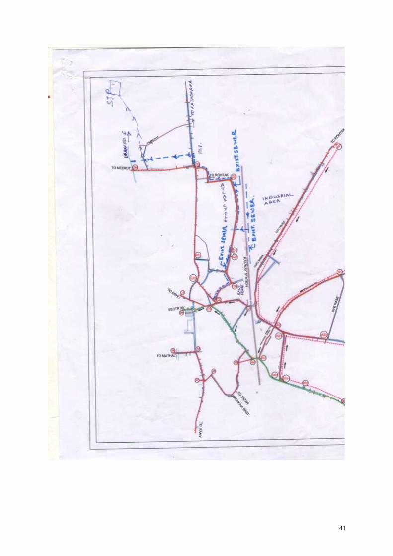
41

42